

The global industry leader in critical information and insight, IHS continues to invest in the progress of the Canadian energy market so you can get from discovery to drilling in record time. By updating, improving and streamlining our Canadian products and services, we have delivered workflow integration between IHS PETRA® and IHS AccuMap®; created solutions for better access to global resources, from well log databases to subject matter experts; and continued to provide transparency and insight to Canadian energy businesses that need actionable information.
See how IHS is investing in Canada at www.followihs.com.


CSPG OFFICE
#110, 333 – 5th Avenue SW Calgary, Alberta, Canada T2P 3B6
Tel: 403-264-5610
Web: www.cspg.org
Office hours: Monday to Friday, 8:30am to 4:00pm
Executive Director: Lis Bjeld
Tel: 403-513-1235, Email: lis.bjeld@cspg.org
Member Services: Dayna Rhoads
Tel: 403-513-1225, Email: dayna.rhoads@cspg.org
Communications and Publications: Caitlin Young
Tel: 403-513-1230, Email: caitlin.young@cspg.org
Accounting and Office Administration: Kasandra Klein
Tel: 403-513-1233, Email: kasandra.klein@cspg.org
Programs Development: Aileen Lozie
Tel: 403-513-1227, Email: aileen.lozie@cspg.org
Member Liaison: Bea McDowell
Tel: 403-513-1226, Email: bea.mcdowell@cspg.org
Corporate Sponsorship: Lis Bjeld
Tel: 403-513-1232, Email: lis.bjeld@cspg.org
EDITORS/AUTHORS
Please submit RESERVOIR articles to the CSPG office. Submission deadline is the 23rd day of the month, two months prior to issue date. (e.g., January 23 for the March issue).
To publish an article, the CSPG requires digital copies of the document. Text should be in Microsoft Word format and illustrations should be in TIFF format at 300 dpi., at final size. For additional information on manuscript preparation, refer to the Guidelines for Authors published in the CSPG Bulletin or contact the editor.
Technical Editors
Ben McKenzie Colin Yeo (Assistant Tech. Editor) Tarheel Exploration EnCana Corporation Tel: 403-277-4496 Tel: 403-645-7724 Email: bjmck@live.com Email: colin.yeo@encana.com
Coordinating Editor
Caitlin Young, Publications Coordinator, CSPG Tel: 403-513-1230, Email: caitlin.young@cspg.org, ADVERTISING
Advertising inquiries should be directed to Caitlin Young, email: caitlin.young@cspg.org. The deadline to reserve advertising space is the 23rd day of the month, two months prior to issue date.


CSPG EXECUTIVE
PRESIDENT
Kirk Osadetz • Geological Survey of Canada, Calgary kosadetz@nrcan.gc.ca Tel: (403) 292-7022
VICE PRESIDENT
Robin Mann • AJM Petroleum Consultants rcmann@ajmpc.com Tel: (403) 648-3210
PAST PRESIDENT
John Varsek • Cenovus Energy john.varsek@cenovus.com Tel: (403) 645-5417
FINANCE DIRECTOR
Darren Aldridge • Baker Hughes Incorporated darren.aldridge@bakerhughes.com Tel: (403) 537-3400
ASSISTANT FINANCE DIRECTOR
Andrea Hood • geoLOGIC systems ltd. ahood@geologic.com Tel: (403) 262-1992
PROGRAM DIRECTOR
Brett Norris • TransGlobe Energy Corp. brettn@trans-globe.com Tel: (403) 264-9896
ASSISTANT PROGRAM DIRECTOR
Jon Noad • Murphy Oil Corporation jon_noad@murphyoilcorp.com Tel: (403) 294-8829
SERVICES DIRECTOR
Chris Seibel • Nexen Inc. chris_seibel@nexeninc.com Tel: (403) 699-4558
ASSISTANT SERVICES DIRECTOR
Michelle Hawke • Apache Canada Ltd. Michelle.Hawke@apachecorp.com Tel: (403) 261-1200
COMMUNICATIONS DIRECTOR
Jim Barclay • ConocoPhillips Canada Jim.E.Barclay@conocophillips.com Tel: (403) 532-3889
ASSISTANT COMMUNICATIONS DIRECTOR
Stephen Hubbard • University of Calgary steve.hubbard@ucalgary.ca Tel: (403) 220-6236
OUTREACH DIRECTOR
Steve Dryer • Whiskey Jack Resources Inc. whiskeyjackresources@telus.net Tel: (403) 969-2292
ASSISTANT OUTREACH DIRECTOR
Simon Haynes • Statoil Canada Ltd. sihay@statoil.com Tel: (403) 724-0364
EXECUTIVE DIRECTOR
Lis Bjeld • CSPG lis.bjeld@cspg.org Tel: (403) 264-5610
A message from Assistant Services Director Michelle Hawke
Change is the only constant
I’m sitting inthe airport departures lounge, waiting for my plane to board. I glance around, and notice that the young woman sitting to my right is busily typing away on a smartphone. The older couple sitting next to my left are surfing the net on an iPad. The woman and two schoolage children sitting across from me each have either a smartphone or an iPad. In fact, a quick glance around shows that the vast majority of people are busily engaged with an electronic communications device of some sort.
So what’s my point? Only a very short time ago, this technology simply wasn’t available to the average person, or it didn’t exist at all. A few years ago, it would have been unthinkable to be able to carry such a powerful device in your pocket or purse, but now its commonplace. Change happens quickly, and with change comes the need to learn new skills, rethink old ideas, and adapt. So what does that mean for the CSPG?
By now, everyone has heard about the demographic shift that our industry is going through, as the baby boomers ready for retirement over thenext decade or so, and the large influxof recent graduates establish their careers. As a volunteerbased professional organization, the CSPG’s activities should always be a direct reflection of the professional interests, aspirations and needs of the membership. The only way to ensure that we accomplish that goal is to have a representative population of the membership activelyinvolved in running the CSPG. And right now, that means encouraging more young geoscientists to become involved, bringing with them fresh ideas and perspectives, and helping to ensure that the Society remains relevant to all members at all career stages.
By the time this column is published, the second annual Future Prospects event for young geoscientists will have taken place. This year, the event was held at Belgo Brasserie on October 13th. This event gave geology students and early career geoscientists an opportunity to network with their peers and senior CSPG volunteers whilelearning more about the Society, what it does, and how it can their support career development. By reaching out to our younger, and even to future members, we hope to encourage them to bring their energy and ideas to the table and help us to keep the CSPG a vital and thriving scientific society in the years to come. A big thank you goes out to the volunteers and sponsors who made this event possible.
Speaking of volunteering, if you’ve ever thought about volunteering for the CSPG, but didn’t know what might be involved or who to contact, wonder no further! As part of the Volunteer Management System initiative, committee chairs are now being asked on a regular basis to provide a list of volunteer opportunities that are currently available within their committee, along with a briefjob description, so that potential volunteers can make an informed decision about whetherthe role is right for them before making a commitment. The Volunteer Management System initiative was brought about to rectify a communication disconnect that had existed between CSPG support staff, committees, and the general membership at large, regarding what roles were available and how to go about volunteering for them. VMS will act as a communications facilitator between these groups, and will hopefully result in faster and better volunteer placement. These opportunities (Continued on page 7...)


CORPORATE SPONSORS
DIAMOND
are being posted online, so if you are interested in becoming more involved with your CSPG, please have a look and see if your ideal role is waiting for you.
on the website in the near future, and please consider nominating an outstanding colleague for recognition.
As for future initiatives, the Member Services Directors are in the process of putting together another Membership Survey. The last survey was conducted in 2009 and provided a wealth of information that has helped to guide the direction of the CSPG, but as was noted at the beginning of this column, change happens quickly and constantly, and it is important to ke ep up! So when the survey comes out, please take the time to participate and make your voice heard. We are looking forward to hearing from you.
IHS
GEOLOGIC SYSTEMS LTD.
SCHLUMBERGER CANADA LTD.
PLATINUM
AGAT LABORATORIES
CENOVUS
CONOCOPHILLIPS
In other news, the Member Services directors, along with the Awards Committee Chairs and the Past President, have been busy reviewing the CSPG Awards. Awards are important to the CSPG – they are the vehicle through which we honour outstanding contributions to advancing petroleum geoscience knowledge, and show appreciation for the valuable efforts of our volunteers. It was decided that the slate of awards that we currently have generally does a good job of recognizing excellence within the membership, but could use some minor tweaking and clarification with regards to eligibility and selection criteria. It was also decided that we could do a better job of providing information on the history of the awards and the people for whom they are named. So, look for the revamped descriptions and criteria for the awards
NEXEN INC.
TALISMAN ENERGY
POGGENPOHL
GOLD
APEGGA
CSPG EDUCATIONAL TRUST FUND
DEVON CANADA
ENCANA
IMPERIAL OIL
SHELL
WEATHERFORD LABORATORIES
SILVER
ARC FINANCIAL CORPORATION
JEWELSUITE
ROXAR
BRONZE
BLUEBACK RESERVOIR
PARADIGM
GEOVARIANCES
CSEG FOUNDATION
RPS BOYD PETROSEARCH
HALLIBURTON ENERGY SERVICES
SUNCOR ENERGY
SUNDOG PRINTING
TUCKER WIRELINE SERVICES
AS OF OCTOBER 10, 2011


John Suter Professor of Geology University of Toronto
11:30 am Tuesday, November 8, 2011 Calgary, TELUS Convention Centre Calgary, Alberta
Please note: The cut-off date for ticket sales is 1:00 pm, Thursday, November 3, 2011. CSPG Member Ticket Price: $42.00 + GST. Non-Member Ticket Price: $45.00 + GST.
Each CSPG Technical Luncheon is 1 APEGGA PDH credit. Tickets may be purchased online at www.cspg.org.
Please check the CSPG website periodically for the abstract for this Technical Luncheon.
John R. Suter is a Principal Stratigrapher with the Oil Sands Business Unit of ConocoPhillips Canada. He is primarily responsible for the regional assessment and interpretation of oil sands deposits within the Athabasca Basin, as well as coordinating and conducting technical studies on individual properties. Prior to coming to the Oil Sands, Suter toiled in the Subsurface Technology Division of ConocoPhillips in Houston, TX. His primary expertise is in clastic facies and sequence stratigraphy. John has over thirty years of domestic and international experience, having worked projects involving source, seal, and reservoir for conventional and non-conventional deposits at exploration, appraisal, development, and production scales in multiple basins. Other than Oil Sands, he has most recently worked in the North Sea, eastern Greenland, Canadian Arctic, Lower 48 USA, and Venezuela. He has published numerous papers, organized multiple research conferences, and has taught a variety of short course, field schools, and core workshops, both internally, for various national oil companies, and for scientific societies and universities.
Webcasts sponsored by
Suter obtained Bachelor’s degrees in chemistry and geology, and a Master’s degree in geology from the University of Texas at Austin, followed by a Ph.D. in geology from Louisiana State University. John’s early geologic experience was as a marine geologist working the Quaternary of the northern Gulf of Mexico for the USGS and the Louisiana Geological Survey. From 1981 to 1988, working with high-resolution seismic and vibracore data, he mapped and developed sequence stratigraphic models for incised valleys, shelf-phase and shelf-margin deltas, and shelf and shoreline deposits. While in Louisiana, Suter was deeply involved in coastal geology issues concerning the Mississippi Delta and associated shorelines, including shoreline erosion and hurricane impact assessment. During this time he served as the North American VicePresident of the INQUA Shoreline commission, and represented the United States on several UNESCO-IGCP sea level and coastal evolution projects. Suter joined Exxon Production Research in 1988 and Conoco, Inc. in 1994, and was “merged” into ConocoPhillips in 2002. He transferred to ConocoPhillips Canada in 2009. He was named an AAPG Distinguished Lecturer for 2001-2002 and was the SEPM Councilor for Research in 2002-2004.

Tuesday, December 6, 2011
Social Networking 10:30 –11:30 am Technical Luncheon 11:30 –1:00 pm

Book your Corporate Table TODAY

This is a sellout social event that you don’t want to miss! Tickets are available at www.CSPG.org Canada’s Energy Geoscientists
SPEAKER
Laurence Andriashek ERCB
11:30 am
Tuesday, November 28, 2011 Calgary, TELUS Convention Centre Calgary, Alberta
Please note: The cut-off date for ticket sales is 1:00 pm, Thursday, November 23, 2011. CSPG Member Ticket Price: $42.00 + GST. Non-Member Ticket Price: $45.00 + GST.
Each CSPG Technical Luncheon is 1 APEGGA PDH credit. Tickets may be purchased online at www.cspg.org.
The Paskapoo Formation is one of the largest and most intensely used bedrock aquifer systems in Alberta, yet little is known about the internal architecture of the major hydrostratigraphic units contained within. This study applies a computer-based geostatistical analysis of more than 35,000 borehole logs from the petroleum and water well industries to define the internal geometry of sandstone bodies that can be considered regional aquifers. Sand abundance was determined by cut-offs on digital gamma-ray logs and from an expert-based classification of sandiness from drillers’ lithologs, and averaged in a series of 25 metrethick slices extending through 750 m of sediment within the Paskapoo Formation. Analysis of this set of three-dimensional sand data reveals information on the relative abundance of sand found in splay and channel depositional settings.
Webcasts sponsored by
The definition of two regional aquifers and one aquitard emerged from the application the aquifer-aquitard cut-off criteria. The lowermost unit is correlative to sandstone of the Haynes Member (Demchuk and Hills, 1991) and we refer to it as the Haynes aquifer. Overlying the Haynes aquifer is a regionally extensive mudstoneand siltstone-dominated unit correlative to the Lacombe Member (Demchuk and Hills, 1991), which we refer to as the Lacombe aquitard. The uppermost unit is a sand-dominated complex, which we herein name the Sunchild aquifer. Planimetric maps have been constructed showing approximate lateral distributions and structural and erosional surfaces of each of these hydrostratigraphic units. Recently collected airborne resistivity data helped to both define and confirm the subcrop geometries of each of these units.
♦ ♦
♦
♦
A 3D variogram analysis of the sand-slice data enabled the construction of a regional 3D model of the subsurface distribution of sand and mud in the Paskapoo Formation. An analysis of the thickness of sand intervals in boreholes, and a workflow using minimodels, were used to determine the geometry of channel and splay sand bodies at a local scale within the Paskapoo Formation. To delineate those parts of the sand distribution model that would constitute an aquifer, we first derived horizontal and vertical permeabilities from the minimodels, and determined that sand bodies in the Paskapoo Formation likely become hydraulically connected in horizontal and vertical dimensions when sand abundances exceed 55% of the volume. Applying the >55% sand abundance cut-off as the criteria that defines an aquifer, we tested our model to see what shape and volume of rock was represented by this sand-abundance value. We similarly determined that vertical permeability is significantly reduced when sand abundances fall below 35%, and used this criterion to define our clay, or aquitard, units.
The combination of isopach and structural surface maps for each of the hydrostratigraphic units provides insights into the tectonic history and evolution of sedimentation of the Paskapoo Formation. The relatively uniformly thick but deformed surface of the Haynes aquifer indicates deposition prior to a reactivated phase of mountain-building to the west. The Lacombe aquitard, which forms the bulk of the Paskapoo Formation occupies the foreland accommodation space created during maximum tectonic activity. An apparent vertical propagation of sand from the Haynes Member upward into the Lacombe Member along the eastern edge of the foothills possibly marks the focus of sedimentation eastward from the rising Cordilllera. The undeformed upper Sunchild aquifer onlaps the Lacombe aquitard and extends as a wedge east into the plains. Subsequent erosion during the mid to late Paleogene results in all three units subcropping beneath a Quaternary sedimentary cover.
SPEAKER
Andrew D. Miall, FRSC Professor of Geology, University of Toronto
Tuesday, December 6, 2011
10:30 am, Annual Holiday Social presented by geoLOGIC systems ltd.
11:30 am, Technical Luncheon presentation Calgary TELUS Convention Centre Calgary, Alberta
Join us for this year’s CSPG Annual Holiday Social. This is a sellout social event that you don’t want to miss. Buy your tickets early!
Please note: The cut-off date for ticket sales is 1:00 pm, Wednesday, November 30, 2011. CSPG Member Ticket Price: $45.00 + GST. Non-Member Ticket Price: $45.00 + GST.
Each CSPG Technical Luncheon is 1 APEGGA PDH credit. Tickets may be purchased online at www.cspg.org.
There have been repeated environmental protests in the US and Europe about “Canada’s dirty oil.” Recent protests in Washington and elsewhere have been aimed at not only
shutting down the oil sands industry, but preventing the building of pipelines to serve Canada’s export market.
In the summer of 2010, protests of a similar nature were accompanied by the release of a disturbing research report by respected environmentalist David Schindler (University of Alberta) demonstrating that water pollution studies being carried out at the behest of the Government of Alberta and the oil sands industry were not accurately reporting the presence of pollutants that may be responsible for deformities in the freshwater fish population. There were also continuing fears about unusual cancers in the First Nations population at Fort Chipewyan, which is downstream from the oil sands development area.
In response to these concerns, federal Environment Minister, The Hon. Jim Prentice established the Oil Sands Advisory Panel in October 2010. The completion of studies by this panel coincided with the release of an independent report on the “Environmental and health impacts of Canada’s oil sands industry” by the Royal Society of Canada in December 2010. Both the federal study and the RSC study concluded that many of the environmental concerns being voiced by activists were overstated, but that considerable further research was necessary, that existing regulation and management methods were inadequate, and that much more extensive and more sophisticated scientific monitoring of the industry was required.
In January 2011, Alberta Environment Minister, The Hon. Rob Renner established the Alberta Environmental Monitoring Panel, which built on these earlier studies
Webcasts
and delivered a report in June 2011 containing twenty recommendations, most of them centred on the establishment of an independent Environmental Monitoring Commission. The government appears to have accepted these recommendations, but the current state of political uncertainty in Alberta (as of late September 2011) has so far prevented any specific government actions to implement the recommendations.
Environment Canada scientists were instructed by the Minister in December 2010 to start developing a science plan for a full-scale environmental monitoring program to deal with air, water, groundwater, and all other related environmental issues. The details of this plan were released by current Environment Minister, The Hon. Peter Kent, in two stages, in March and in July 2011. It remains to be determined how the federal and provincial governments integrate their environmental work. While the Alberta government is responsible for managing the environmental impact of the oil sands projects, the federal government has responsibility for the health and welfare of Aboriginal communities, for the health of Canada’s fisheries, and for trans-boundary pollution issues, such as the air pollution thought to be causing acid-rain problems in Saskatchewan. At this time, Alberta does not have the fully trained scientists and well-equipped laboratories that still exist at Environment Canada (despite years of cutbacks), and so a significant degree of federal-provincial cooperation will be required to answer the legitimate environmental concerns.
Studies indicate that air and water pollution can be managed effectively as long as the (Continued on page 12...)
(...Continued from page 11)


necessary, properly planned field sampling is carried out first. It is the poor quality of the initial field work, plus the lack of high-quality analytical laboratory standards that has, to this point, inhibited proper environmental management. The massive disruption caused by surface mining can be managed by appropriate restoration work, but up to this time, investment in restoration has been inadequate. Increasing efficiencies in energy and water use are steadily reducing the environmental footprint of oil sands projects, although the total footprint continues to expand with each new project. Suncor has developed a new treatment protocol for the mine tailings that promises to considerably speed up the process of drying out and restoring tailings ponds. Meanwhile, considerable research is still required to understand the possible environmental implications of new in-situ extraction procedures.
Contrary to claims by the protesters in Washington and elsewhere, effective environmental management by industry and government can be achieved, but industry spokespersons have made it clear that they want proper direction and leadership. Millions of dollars are already being spent in this area, but it has not been spent well, and it is to be hoped, with the appropriate political response to the two major government panel studies and the RSC report, that this world-class energy resource can be managed in a way that will place Alberta and Canada in a leadership position with regard to the administration of one of the world’s remaining large fossil-fuel energy resources.
Andrew D. Miall, B.Sc., Ph.D., D.Sc., FRSC, is Professor of Geology at the University of Toronto, and the inaugural incumbent of the Gordon Stollery Chair in Basin Analysis and Petroleum Geology. He was educated in London (UK) and Ottawa, and has worked for Shell Canada and J. C. Sproule and Associates. From 1972-1979 he was a Research Scientist with the Geological Survey of Canada, Calgary, carrying out regional basin studies in the Arctic Islands. He is the holder of a Higher Doctorate (D.Sc.) from University of London and an Honorary Doctorate from the University of Pretoria. He was inducted into the Royal Society of Canada in 1995 and has served terms as Vice-President (2005-2007) and President (20072009) of the Academy of Science. Andrew is the author of Principles of Sedimentary Basin Analysis, The Geology of Fluvial Deposits, and The Geology of Stratigraphic Sequences. He is the co-author (with Nick Eyles) of Canada Rocks: the Geologic Journey. He is currently devoting much of his time to speaking and writing about issues at the nexus of energy and the environment. He was a member of the federal Oil Sands Advisory Panel (OctoberDecember 2010) and the Alberta Environmental Monitoring Panel (January-June 2011).
SPEAKER
Jeff Tooth Exploration Advisor, KNOC
12:00 Noon
Wednesday November 9th, 2011 Nexen Plus 15 Conference Centre Nexen Annex Building 7th Ave. and 7th Street SW Calgary, Alberta
KNOC has a 50% working interest in Savia S.A. Peru. The company’s assets located both onshore and offshore in northwest Peru, consist of one operational block (Block Z-2B) and an additional ten exploration blocks. As shown in Figure 1, there are six fields on production within Block Z-2B producing 15,000 bopd with cumulative production of 341 MMstb as of May 2011.
OOIP for Block Z-2B was recently estimated to be at 3.836 billion barrels and is the subject of further petrophysical study (Jan. 2011). The Pena Negra field, which includes both onshore and offshore blocks, is the largest field in Block Z-2B. The Mogollon Formation is the major productive unit in the field with estimated reserves of 763 [MMBO] and a RF of 10%. This is a worldclass reservoir from a storage capacity point of view but the relatively low recovery factor is a result of the poor primary permeability in the producing zone. This reservoir is currently being modeled and preliminary results are presented for a horizontal drilling program, which forms part of the future recovery optimization scheme.
The Mogollon reservoir has a number of productive layers within the thick sand package, which range from 600 to 1,400 feet in the Pena Negra field. Presently, several informal layers are recognized, and reservoir level, integrated geological, petrophysical, and engineering mapping of these sand
Sponsored by
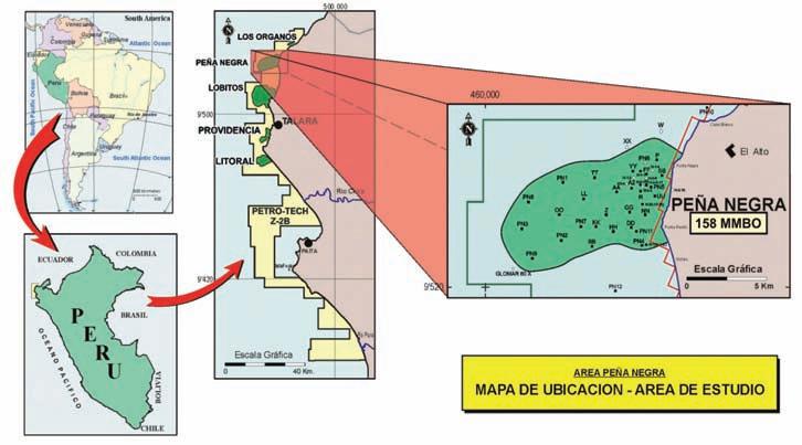
layers is underway. Sedimentological studies of outcrop and subsurface facies have determined that the Mogollon Formation belongs to a submarine canyon system, where the preferential direction of sedimentation is from north to south, with a secondary east to west source. Offshore, the Mogollon is present from the Máncora area in the north to Sechura in the south, covering approximately ninety square kilometres.
The Mogollon reservoir has strong depositional and structural controls that influence reservoir quality and productivity.
Structurally, the Pena Negra field is a complex fault-bounded anticline with the axis aligned NE-SW. Internal normal faults with throws of several hundred feet divide the field into distinct pressure regimes, which are currently being studied for water-flooding and other pressure maintenance schemes. The stresses caused by the active subduction of the Pacific plate greatly influence the orientation of the proposed horizontal wells as does the bedding inclination within fault blocks. A pilot program of three long-reach wells is proposed to test improved primary recovery methods.
Comparisons with North American fields and their developments are made as working geological and engineering models for the Pena Negra field.
Jeff Tooth graduated with B.Sc. Honors Geology and M.Sc. Petrology from QMC, University of London. He started his career doing field and
wellsite geology in South America and the Middle East before moving to Canada where he joined Diamond Shamrock, later Maxus and KerrMcGee, as a geologist. Over the next 14 years, he held various positions within the company including exploration manager and international new ventures lead. He ultimately became Vice President of Kerr-McGee Canada.
Jeff joined Husky Oil as VP Exploration, moved to JM Huber Canada as Vice President Exploration, then moving into the role of President to lead the sale of the company. After a career with major companies, Jeff joined with colleagues start several small independent oil companies, including Canstar Exploration and Trigger Resources. He joined KNOC GTRC in January 2011 as Exploration Advisor for International Projects.
There is no charge. Please bring your lunch. The facilities for the talk are provided complimentary of Nexen, coffee by IHS, and refreshments by Geochemtech Inc. For further information or if you would like to give a talk, please contact Bob Potter at (403) 863-9738 or ropotter@ telusplanet.net or Trent Rehill at (403) 606-6717 or trehill@kulczykoil.ca. Or visit our new Face Book page (“CSPG International Division”).
Determining the truth from circumstantial evidence: techniques for incorporating and preserving more geological information and data in reservoir models
SPEAKER
Oluwaseyi Fatoke, Ph.D., P.Geol. ConocoPhillips Canada
12:00 Noon
Wednesday, November 16, 2011
TBD (Check the CSPG website for updated information.)
Reservoir modeling (geomodeling) is gaining more acceptance and popularity currently amongst geologists compared to the 1980s and ‘90s when it was the remit of specialized geologists. The field grew out of the recognition that more oil and gas can be extracted economically from existing reservoirs if the geology can be quantified adequately for reservoir simulation purposes. However, the deliverables expected from reservoir modeling work
has expanded beyond just as an input to the simulator. Key deliverables now include resource estimate, well planning, field development planning, and uncertainty analysis and management. Increased popularity has led to development of newer tools for reservoir modeling work and has also brought newer challenges. One of the critical challenges we face in reservoir modeling work today is the incorporation of more geology into geomodels. This is especially true of geomodels designed to assess reservoir behavior and performance in the simulator or uncertainties associated with reservoir architecture and heterogeneities. Reasons for this range from the difficulty of doing so, time constraints, improper definition of modeling objective, and skill level of the modeler.
Classical indicator simulation techniques cannot produce realistic geological outcome that shows genetic linkage between facies. Such models cannot adequately represent the complex nature of the facies geometry and architecture, and the dynamic behavior in the modeled reservoir is therefore not a highly confident assessment of potential geological reality but rather a “virtual reality” that has no impact on fluid flow. To better assess reservoir uncertainty, plan targeted wells, assess reservoir behavior and performance, as we ll as predict hydrocarbon recovery during field development planning, reservoir models need to capture appropriate geological information at as many scales as possible within the limits of the chosen grid resolution. The basic data for reservoir modeling work is structure and well data. Well data is at best limited and often biased. There is, therefore, the need to incorporate additional circumstantial data

like seismic, outcrop analogue, production data, etc. into reservoir modeling work.
The key to incorporating more geology into reservoir models is by interpolating reservoir properties fieldwide with an appropriate facies model(s). Facies modeling is the means by which critical reservoir architecture and heterogeneity can be captured in a geomodel. This talk will use Petrel (publicly available geomodeling software) to illustrate some of the techniques that can be used to create complex reservoir architectures for different depositional systems. Additional data requirements will also be discussed. Advantages and limitations of the methods will be discussed. Issues of layering and uncertainty analysis and management will also be raised.
Seyi Fatoke obtained his B.Sc. and M.Sc. in geology from Obafemi Awolowo University, Nigeria and a Ph.D. in geology from the University of Houston. He started his oil and gas career in 1992 as a Sedimentologist involved in core and sidewall samples description and interpretation. He joined Shell Nigeria in 1994 as a production geologist responsible for well planning, well operations, and field development study and planning for several fields and wells in the Niger Delta. He transferred to Shell Research Centre, Rijswijk, The Netherlands in 1997, where he was involved in reservoir modeling for Niger Delta and North Sea fields, development of workflows and methods for modeling inclined/ growth faults as well as methodology for uncertainty analysis a nd management. He continued with reservoir modeling work in Shell Nigeria and Shell Deepwater Centre in Houston as one of the specialists involved in the development of modeling techniques for incorporating seismic and outcrop data in reservoir modeling workflow. Since 2008, he has been a geomodeling specialist in ConocoPhillips Canada, providing reservoir modeling solutions for conventional and unconventional reservoirs, as well as coaching and mentoring geomodelers.
There is no charge for the Division talk and we welcome non-members of the CSPG. Please bring your lunch. For details or to present a talk in the future, please contact Weishan Ren at (403) 724-0325, e-mail: wren@statoil.com.
SPEAKER
Tetsuto Miyashita
University of Alberta Graduate Student
7:30 PM
Friday, January 20th, 2012
Mount Royal University, Room B108
The origin and early evolution of vertebrates is undoubtedly one of the final frontiers in vertebrate paleontology. The past decade has seen several breakthroughs in the ancestry of vertebrates and that of jawed vertebrates. Curiously, though, each of these major discoveries provides little answer to the lingering questions about the ancestries of these animals, but seems to only complicate the questions further. For example, it is now a consensus that sea squirts, not amphioxus, are the closest relatives of vertebrates. This significant finding knocks off amphioxus from the model of the vertebrate ancestor. That is, it is unlikely that the first vertebrate looked like an amphioxus. But how is it possible to reconstruct the vertebrate ancestor using fish and sea squirts, two animals with such disparate body plans?
A major obstacle to the origin and early evolution of vertebrates is the fact that too few vertebrate lineages survived to today. Aside from unhelpful, dissimilar relatives such as sea squirts, a huge gap exists within vertebrates between the jawed-vertebrate lineage and the hagfishlamprey lineage. This gap is only sparsely filled in with rare, exceptional fossils of extinct jawless vertebrates. But these fossil jawless vertebrates suggest that the missing morphological diversity could equal the morphological diversity of living jawed vertebrates! Understandably, finding a place for each of these lineages in a phylogenetic tree (so that the tree predicts an evolutionary scenario) is not an easy task: the diversity is so great that every single combination of the lineages presents a number of improbable character distributions, and one phylogenetic
hypothesis is as likely as a dozen others. There are potential solutions. Comparative anatomy and embryology of living jawed and jawless vertebrates offer a wealth of information to identify evolutionarily shared, but extensively modified, structures among these animals. This information feeds into interpretation of fossils of extinct jawless vertebrates, which in turn maps distribution of the character across the tree of vertebrates. I take this approach using the deep-sea dwelling, slimy hagfishes as a model. The greatest challenge lying ahead is in getting the hagfishes to spawn in captivity so that their development can be documented. I will introduce efforts undertaken at a marine station on the West Coast to obtain elusive hagfish embryos.
Tetsuto Miyashita is M.Sc. student at the University of Alberta. A book by the prominent Canadian dinosaur paleontologist Philip Currie – a Christmas gift from parents when he was ten – sparked his dream of becoming a paleontologist. He moved to Drumheller, Alberta, at age 16 to volunteer for Royal Tyrrell Museum of Palaeontology. Subsequently, during
four years of undergraduate and two years of graduate work at the University of Alberta, he has been under the caring supervision of Philip Currie, invertebrate zoologist Rich Palmer, developmental biologist Sally Leys, ichthyologist Alison Murray, and marine ecologist Richard Strathmann. In their labs, he was involved in various projects, including anatomy of early vertebrates, systematics of tyrannosaurs, soft tissues in ankylosaurs, biomechanics of marine invertebrate larvae, ecology of intertidal snails, and development of fishes. He has spent the last two field seasons leading a team of students and collecting Daspletosaurus from the Milk River Natural Area.
This event is jointly presented by the Alberta Palaeontological Society, Mount Royal University, and the CSPG Palaeontology Division. For details or to present a talk in the future please contact CSPG Paleo Division Chair Philip Benham at 403-691-3343 or APS Coordinator Harold Whittaker at 403-2860349 or contact programs@albertapaleo. org. Visit the APS website for confirmation of event times and upcoming speakers: http:// www.albertapaleo.org/


| By Colin Yeo, P.Geol. and Lionel Derochie, P.Eng.
So far, we have addressed the Petroleum Resources Management System and been focused on distinguishing between reserves and resources. Now we will turn our attention to that part of the resource spectrum that has a profound impact on any oil and gas company, that being reserves. As geoscientists, we consider reserves to be volumes of crude oil, natural gas and associated by-products but it is the cash flow over time generated from the sale of these reserves that is crucial to company management, lenders and investors. We won’t go into great detail about the mechanics of generating a cash-flow forecast (please see the Reservoir series “Petroleum Economics for Geologists” for details) but we will address the many considerations that must be taken into account when forecasting a cash flow stream.
Before leaving resources to focus on reserves, we should remember that reserves are finite volumes of hydrocarbons that will be depleted to generate a cash flow. The accuracy of the reserve estimate is a function of where we are in the life cycle of the producing entity. The natural progression is to produce the proven reserve, convert the contingent resource, and discover the prospective resource.
By definition, reserves must be economic and “being economic” means that the net present value of the cash flow stream generated from the sale of the hydrocarbon volume from the accumulation must be greater than zero. Annual production forecasts are linked with estimated product prices to generate an annual gross revenue forecast. Crown or Lessor royalties as well as gross overriding royalties are deducted from the revenue stream. Operating costs are also deducted. Capital costs required to support predicted production (wells, recompletions, facilities, etc.) are also subtracted from the revenue stream. The residual is the before-tax annual cash flow. Calculating and subtracting federal and provincial income tax generates an aftertax cash flow. The future annual after-tax cash flow is discounted and summed up to the point where the property becomes uneconomic and, as such, an after-tax net present value is determined. The sum of the annually produced volumes is the reserve.
Those accumulations that do not yield a positive after-tax net present value are deemed to be uneconomic and classified as contingent resource.
There are five methods for estimating the size of a hydrocarbon accumulation:
• analogous pools or wells,
• volumetric calculation,
• production decline analysis,
• material balance,
• statistical.
The analogous pool methodology is based on
(Continued on page 18...)
Paul MacKay
Shale Exploration and Adjunct Professor, University of Calgary
the assumption that those accumulations that have characteristics and attributes in common will show similar production behaviour. These pools may have been deposited at the same time by common processes; have the same constituent mineralogy, grain size, and pore structure; have undergone similar diagenetic histories; and received the same petroleum charge. Such similarities would imply that areal extent, initial volumes, initial productivity, decline rates, recovery factor, and producing hydrocarbon-water ratios will be similar. This technique is useful if other reserve data is not available or production is in early stages. It also provides a good reality check against the other methods.
Volumetric calculations of originalhydrocarbon-in-place are made by determining the pore volume available to hold hydrocarbons using geological, petrophysical, and engineering data. Several factors enter into this calculation. First, net pay cutoffs must be defined by using regionally appropriate and formation-specific porosity-permeability crossplots from core data. A minimum permeability value is chosen based on the characteristics of the fluid being
produced and an associated porosity value to that permeability is determined from the crossplot. Correlative well log porosity and a maximum water saturation (often defined by relative permeability measurements) will define net pay thickness from well logs. Pressure, temperature, gas compressibility, and formation volume factor can be directly measured or inferred from offset well data. Drainage area and pool size is determined from mapping, well log correlations, and facies analysis.
Production decline analysis is the preferred method for determining reserves but is only possible after a well has been on production for a reasonable length of time and a decline trend has been established. Production decline occurs due to pressure depletion or replacement by another fluid as hydrocarbons are removed from the reservoir. The trend of declining production is extrapolated to an economic limit (operating cash flow = 0) and this trend is used to forecast future production that provides the basis for an economic evaluation. Curve fitting (bestfit line through historical production) is the most common technique but type curve matching has application in low permeability reservoirs.

Material balance is an estimation technique that utilizes reservoir pressures that are measured as fluids are progressively withdrawn from the reservoir. A common technique for gas wells is plotting P/Z (the value of pressure divided by the gas compressibility at that pressure) against the volume of cumulative gas produced. The best-fit straight-line trend through the P/Z data points intersects with the cumulative produced gas volume axis (pressure = 0) and establishes the original-gas-in-place of the accumulation.
And then there is the statistical method, which is commonly used in resourcetype plays such as CBM, shallow gas, and shale gas. With a large number of wells producing within a small geographical area, a mean or average well can be generated by time-normalizing actual production and comparing the variance between wells. If the standard deviation is low, reserves from the type well can be applied to each well drilled without the necessity of evaluating each well individually.
Within each of the five estimation techniques above, there is uncertainty


around the actual value of each factor used in the reserve determination. For example, in the volumetric technique that relies primarily on wellbore data, inputs such as pay thickness, porosity, water saturation, and drainage area must be extrapolated between wells even though it is well understood that these variables can change rapidly, and sometimes dramatically, between control points. Applying the principles discussed previously, it is understood that at the proven reserve (1P) level there is a 90% probability that the actual reserves recovered will meet or exceed the reserve volume booked for that category. Similarly, at the proved plus probable (2P) level there is a 50% probability and at the proved plus probable plus possible (3P) level there is only a 10% probability. Because there is uncertainty, it is advisable that the range of the reserve estimate be stated and, if possible, the estimates from two or more techniques should be used to support the reserve booking.
To illustrate this point, consider a single section, Section 26, penetrated by two producing wells. For simplicity, this will be considered to be a single producing entity on 640 acres. We will be addressing producing proven, probable, and possible reserve categories.
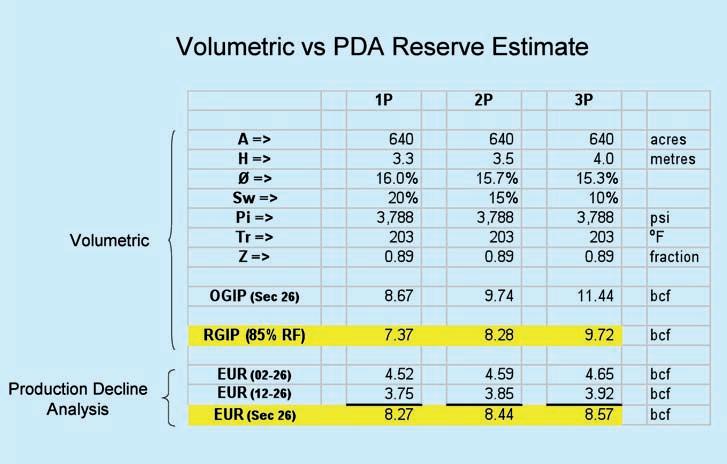
The discovery well, 02-26, was drilled and placed onstream in early 1999. At that time, a volumetric estimate of OGIP was made. Based on regional core data, a high degree of confidence was placed on using
a 12% porosity cutoff to define reservoir quality rock and a resistivity cutoff of 5 ohm-meters was deemed to be reservoir. As such, both these criteria were used in the proven (1P) volumetric calculation. However, regional analogue data indicated that rock with porosity as low as 6% could flow gas at economic rates. Given this information, it was decided that a 9% porosity cutoff would be used to define the probable (2P) reserves level and 6% cutoff would be used for the possible (3P) reserves level. There was also additional uncertainty pertaining to the value for the initial water saturation for the pool. Based on analogue data, there was a high degree of confidence that the value for
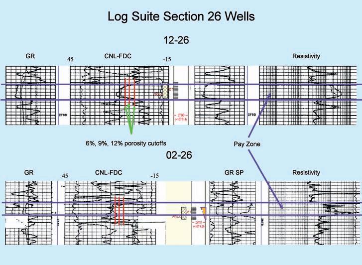
water saturation was 20% or less and therefore a value of 20% was used for the proven (1P) volumetric calculation. Water saturation calculations from the logs at 02-26 indicated that the water saturation could be as low as 10%. Therefore, a value of 15% was used for the proven plus probable (2P) volumetric calculation and a value of 10% was used for the proven plus probable plus possible (3P) calculation. Using the different porosity cutoffs lead to different pay thicknesses for the volumetric calculations for the 1P, 2P, and 3P reserve categories. Figure 1 contains the log suite for 02-26.
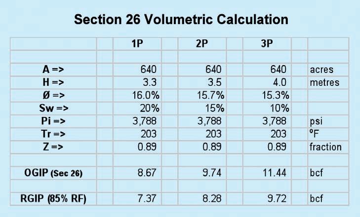
Figure 2 is the input table for volumetric calculations and the corresponding OGIP calculated from the inputs. These were the estimates made in 1999 following the drilling of the 02-26 well. As shown, the OGIP for the Section ranged from a value of 8.67 Bcf for the 1P level to a value of 11.44 Bcf for the 3P level. Assuming an ultimate recovery factor of 85%, the corresponding RGIP’s range from 7.37 bcf at the proven 1P level to 9.72 bcf at the possible 3P level. In 2001, 12-26 was drilled as an infill well and the wellbore parameters from 12-26 did not materially change OGIP volumes for Section 26.
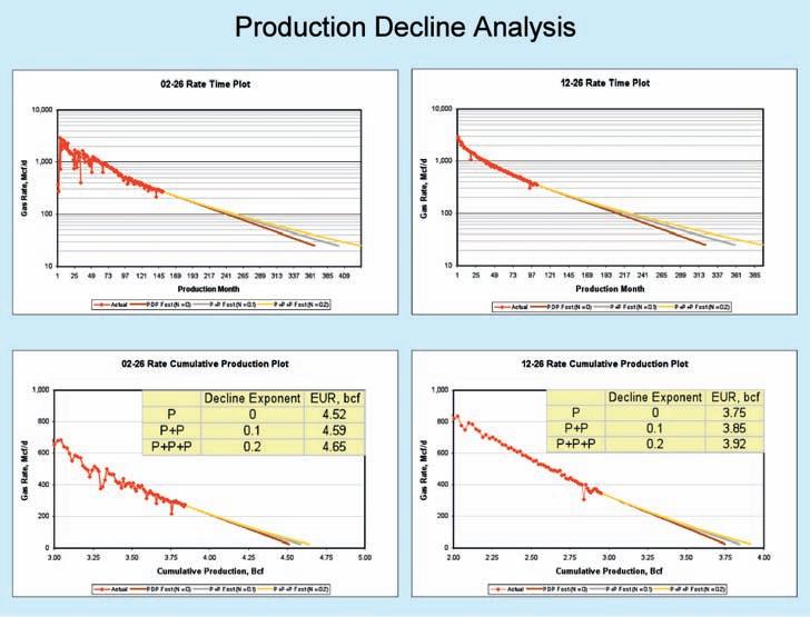
The purpose of the exercise now is to compare the current reserve estimates that are derived from production decline analysis using twelve years of production history to the volumetric estimates that were made at the time the pool was discovered. Figure 3 (page 20) shows a rate-time plot and a rate-cumulative plot for both wells. In both cases, the wells
(Continued on page 20...)
have exhibited very good decline trends that were easily extrapolated to provide a production forecast. Although there are very good trends established for these wells, there still remains some uncertainty as to what trend-line the wells will actually follow in the future. Knowing that a decline exponent (n) of 0 would predict the most conservative estimate of estimated ultimate recovery (EUR), it was decided that an n of 0 would be used for the 1P reserve level, whereas an n of 0.1 would be used for 2P reserves and an n of 0.2 for 3P reserves. In Figure 4, the current EUR reserves estimated from decline analysis are being compared to the volumetric estimates that were made at the time of discovery. The decline analysis is indicating that the proven 1P EUR’s for the two wells on Section 26 are on track to ultimately produce 8.27 Bcf, which is a volume that actually exceeds the 7.37 bcf RGIP volumetric estimate that was initially made for the proven 1P reserves calculation. In fact, the 1P decline analysis estimate is actually better aligned with the 2P volumetric estimate that was made 12 years ago. The 1P volumetric reserves are now shown to be too conservative compared to the projected EUR for Section 26. This is not unexpected given that there was a 90% probability that the actual EUR was going to meet or exceed the 1P estimate at that time. It should also be noted that the 3P volumetric estimate of 9.72 bcf is higher than the 3P decline analysis EUR of 8.57 bcf. The wider range in volumetric reserve estimates is the result of much higher uncertainties with geological parameters.
The fact that the 3P reserve estimate from decline analysis is lower than the 3P volumetric estimate made at discovery would suggest that it would have been a mistake at that time to have used a 6% porosity cut-off even though there were examples of wells in the area that were producing from 6% porosity rock. Similarly, it would have equally have been a mistake to have used a value of 10% for the initial water saturation even though S w calculations from the 2-26 well were indicating 10%. As such, the original 1P and 2P volumetric estimates using more conservative assumptions have turned out to be very good estimates of the EUR that Section 26 is likely to ultimately attain.
In the life cycle of a producing entity, the reserves are reviewed and updated regularly and therefore it is prudent on the part of the evaluator to make reasonable
and conservative estimates of the input values and to modify them as more data becomes available. It would be risky to take the most optimistic values for the inputs in the early stages of a property development.
Within the resource spectrum, reserves must meet very specific conditions because they carry implied monetary value that establishes the net asset value of a company, provides collateral for lenders and provides the basis of share value for investors. Much care needs to be taken by evaluators to establish those volumes
with the appropriate confidence level while providing a sense of how big these reserves could ultimately be.
Society of Petroleum Evaluation Engineers (Calgary Chapter). 2007. Canadian Oil and Gas Evaluation Handbook. Calgary, Alberta: Society of Petroleum Evaluation Engineers (Calgary Chapter) and Canadian Institute of Mining, Metallurgy & Petroleum (Petroleum So ciety).


Get the full picture with comprehensive integration of IHS PETRA®, IHS PetraSeis® and IHS GeoSyn™.


When these three solutions seamlessly connect, geological and seismic workflows are streamlined with easy-to-interpret data and modeling tools. This integrated bundle allows you to access, view and manipulate information within the same project; create multidimensional seismic models and synthetics; improve workflow collaboration; and deliver comprehensive proposals for new prospects. Get to the field faster with seismic, well, production, log and economic data at your fingertips.
See more solutions at www.ihs.com/cspg-1

Courses include:
• Deepwater Sedimentation
• Exploration for Deep-Water Sands Using Seismic Sequence Methodology
• Carbonate Reservoir Geology
• Seismic Imaging of Carbonates
• Carbonate Depositional Systems
• Quick Guide to Carbonate Well Log Analysis
• Interpretation of 3D Seismic Data
• Seismic Amplitude Interpretation
• Seismic Stratigraphy and Seismic Geomorphology
• Evaluation and Quantitative Modeling of Fractured Reservoirs
• Hydraulic Fracturing of Shales
• Surface Geochemical Exploration For Oil And Gas
(Four concurrent sessions each day – mix and match according to your interests and training needs. Buffet lunch and refreshments included each day.)
Small AAPG Bookstore open during breaks each day
Hosted by the Norris Conference Center:
803 Town & Country Lane
Houston, TX 77024
Phone: 713-590-0950
Fax: 713-590-0961
Special group rate at nearby Hotel Sorella
Registration and information:
Toll-free (U.S. and Canada) 888-338-3387, or 918-560-2650
Fax: 918-560-2678
E-mail: educate@aapg.org
Download a registration form at: www.aapg.org/education/wec.cfm
(Your five-day badge can be transferred to a friend or colleague if you can't attend all five days.)
| By Tom Sneddon, Manager of Geoscience Affairs, APEGGA Calgary
Compulsory Professional Development (CPD) continues to be a somewhat controversial topic in Professional Geology. It is hard to do all that stuff and still have time to do the work one was hired to do.
The argument is somewhat circular in that to keep the work one was hired to do, the working professional must stay at the bleeding edge of geoscience. That means a fair amount of time invested in finding out what is new in the geoscience world and fulfilling obligations to presenting results, techniques, and so forth to one’s professional peers to keep the ball rolling. Professional development is an investment of time and, like most investments, the dollar payoff is sometime in the future.
Further, once a year APEGGA wants to know what you have been up to, CPD-wise. For instance, my report goes in November, and October is rapidly approaching (October? I’m not finished with June yet!) However, with all the events that contribute to making Alberta geoscience the most exciting in the country, it does make earning CPD hours that much
easier. The near-term “Big Ones” are the Gussow Conference in Banff (October 3, 4, and 5; it will be over by the time you read this) and the Honourary Address November 2. The Honourary Address will appear in Edmonton for the first time this November 1 as Geo Day 2011. A pilot presentation featuring Susan Eaton, P.Geol. P.Geoph. to science teachers and other interested people last year suggested a significant event was needed in that city.
While I am revealing my personal choices for CPD events, please remember that APEGGA doesn’t endorse any particular event or PD provider, as each Professional should have a PD plan that addresses her or his personal scope of practice and professional interests. As a regulator, APEGGA must not appear to be promoting third parties in any way that might be construed as favouring one provider, event or course over any other. If in doubt, call. We can discuss your options.
First the Gussow: David Garner, P.Geoph., and his outstanding team have attracted delegates to Banff from a number of
countries, including France and Norway. The topic is a hot one in the geoscience community: “Closing the Gap – Advances in Applied Geomodelling for Hydrocarbon Reservoirs.”
The rise of the Asset Team in the oil and gas business has changed the way geologists, geophysicists, and engineers work in a fundamental way. All three must now work together to get the best guess at how much of what kind of fluids exist in both conventional geometric reservoirs and the numerous categories of unconventional plays. Historically, while geologists had their contribution to make to reservoir evaluation and drainage design, those areas were considered to be the petroleum engineers’ turf. Geologists and geophysicists worked somewhat closer together, but usually squabbled over whether a particular pick was real or not, from a stratigraphic perspective.
Times have changed. Now the Asset Team takes collegial responsibility for predicting reservoir performance and finding ways
(Continued on page 24...)
Western Canada: Slave Point, Swan Hills, Leduc, Grosmont, Jean Marie, Horn River Shales, Elkton, Shunda, Pekisko, Banff, Mississippian subcrops and anhydrite barriers in SE Sask., Bakken, Three Forks, Montney, Halfway, Charlie Lake, Rock Creek, Shaunavon, BQ/Gething, Bluesky, Glauconitic, Lloyd, Sparky, Colony, Viking, Cardium, Horseshoe Canyon and Mannville CBM, Oilsands Areas, Outcrops
US Rockies & Williston: Red River, Mississippian subcrops & anhydrite barriers (Bluell, Sherwood, Rival, etc), Bakken, Three Forks, Cutbank, Sunburst, Tyler, Heath, Muddy, Dakota, Sussex, Shannon, Parkman, Almond, Lewis, Frontier, Niobrara, Mesaverde shorelines, Minnelusa, Gothic, Hovenweep, Ismay, Desert Creek, Field Outlines, Outcrops
North American Shales: Shale plays characterized by O&G fields, formation limit, outcrop, subcrop, structure, isopach, maturity, stratigraphic cross-sections. Includes: Marcellus, Rhinestreet, Huron, New Albany, Antrim, Utica-Collingwood, Barnett, Eagleford, Niobrara, Gothic, Hovenweep, Mowry, Bakken, Three Forks, Monterey, Montney, Horn River, Colorado
Appalachian Basin: PreCambrian, Trenton, Utica-Collingwood, Medina-Clinton, Tuscarora, Marcellus, Onondaga Structure, Geneseo, Huron, Antrim, New Albny, Rhinestreet, Sonyea, Cleveland, Venango, Bradford, Elk, Berea, Weir, Big Injun, Formation limits, Outcrops, Allegheny Thrust, Cincinatti Arch, Field outlines
Deliverables include:
-Shapefiles and AccuMap map features
-hard copy maps, manual, pdf cross-sections
-Petra Thematic Map projects, GeoGraphix projects, ArcView map and layers files
-bi-annual updates and additions to mapping
-technical support
of producing petroleum and/or natural gas that previous generations didn’t even know was there. It requires a high level of team work and respect for the other guy’s expertise.
Much of the credit for ensuring team work pays is derived from the Canadian Securities Administrators policy called National Instrument 51-101 and its companion document, the Canadian Oil and Gas Evaluation Handbook. Correct classification of a company’s resources and evaluation of their economic potential over a range of possible product prices can only be
achieved with input from the whole range of exploration and production specialists. It also means that geologists must become more adept at geostatistics and geodynamics than heretofore. Do I hear shuddering from the math-phobic folks out there? The place to learn about all these topics will be the Gussow, October 3 through 5 (all counting as CPD hours in my diary).
The various Divisions of CSPG will have a number of brown-bag presentations over the winter that should also help (more CPD hours). Ignorance is a disease that can be cured, or at least treated with a weekly dose of brown baggers.

November 2 will see the annual Honourary Address sponsored by CSPG, CSEG, and APEGGA. As usual, the public portion of the event will come off in the evening at the Southern Alberta Jubilee Auditorium, with doors opening at 7:30PM. The topic this year will be “Fire and Ice – Adapting to Planetary Change,” starring geologists Jeff Bond of the Yukon Geological Survey and Dr. Catherine Hickson.
Jeff is a Pleistocene specialist (the cool professional) and Catherine is a volcanologist (the fire-side professional) who is presently a principal in a geothermal energy company based in Vancouver. Details are available on the CSPG website. Tickets can be obtained on the CSPG website for members, the APEGGA website for everyone, or at the door. Prices: Adults $15 advance, $20 at the door; Students $5 in advance, $10 at the door; Children 12 & under free. More enjoyable CPD hours and you get to be a hero to offspring/nephews/nieces/neighbourhood kids at the same time.
The Edmonton version of the event will be held November 1 at the Northern Alberta Jubilee Auditorium, and will be free for school children, but this year there will not be a public presentation. It will be sponsored by APEGGA, with acknowledgements to CSPG and CSEG. The Edmonton Geological Society will provide volunteers (CPD hours for volunteering).
All CSPG and Edmonton Geological Society events are potential earners for CPD hours, easing the time demand issues somewhat and allowing some important socializing and fun in the process. Your local APEGGA branch activities fall into the same categories.
The serious side of CPD is rooted in the need for all technical professionals to keep their intellectual tools sharp and to be innovative in their scope of practice. The Canadian economy depends upon geoscientists and engineers to continue to deliver the energy and mineral products it needs to remain competitive in the world. The economy is also becoming more reliant on our ability to export our intellectual resources through exploring foreign lands and consulting with fellow professionals abroad to find the most effective solutions to resource development and environmental challenges. It is interesting to note that other jurisdictions, notably British Columbia, have adopted the Alberta CPD model. It seems to work and the outcomes are pretty impressive.

We must be competent in our science, be able to lead, to solve technical and business problems, and to communicate effectively on the global stage. The alternative is to be out of business.
| By Mark Rabin, Aaron Grimeau, Sandra Rosenthal
The air has cooled, the leaves are turning, summer is a fading memory, and the fall semester is well underway. Students are back into the swing of things navigating their scholastic duties, social lives, and job hunting. They have been facing the daunting fall recruitment campaigns and the stress of starting their careers, whether with summer or full-time jobs, in a few short months.
The CSPG University Outreach Committee is also back in full force and hard at work reaching out to geoscience students across Canada and engaging them in meaningful ways. We too were bright-eyed students not so long ago and we fully understand the range of decisions and opportunities students are faced with. Like many industries in Canada and around the globe, the petroleum industry is facing a talent shortfall that will need to be filled by new, keen grads. These graduates will require training and mentoring by the more experienced generation. The CSPG University Outreach Committee stands at the crossroads of this generational gap and the heart of our approach is to place ourselves in the shoes of Geology students of all ages from first year to soon-to-be grads and help in that transition, using what we ourselves have learned in industry.
Our biggest challenge lies in finding the best ways to communicate the Society’s message to our student members. Over the course of the academic year, our committee comes in contact with hundreds of students whom we meet face to face at the three conferences we help sponsor and attend (AUGC on the east coast in October, AESRC in central Canada in March, and WIUGC in Western Canada in January). We also attend career fairs, organize lecture tours in all regions of Canada, and support student events and field trips.
The CSPG has approximately 500 student members and we communicate with them through our monthly newsletter, CSPG website, online student surveys, and regular e-mails with student-focused content such as sponsorship and scholarships, events, and conferences. We are always willing to listen and learn from our student members on what they would like to see and expect from our committee.
This committee is one of the unique things about our Society because there aren’t many non-profit groups like us that are
bridging the student/industry gap with our message of opportunity, learning and continuing education, getting dirty in the field, mentorship, scholarships, conferences, networking, and of course the value of volunteering; true volunteer spirit is what has made the CSPG what it is today. We also feel that contact with students is one of the most important pillars of our society, as they will be the new membership base that will carry the CSPG forward for the next 75 years. We can all learn from this experience.
The University Outreach Committee’s flagship program is the Lecture Tour series. We send industry professionals and academic gurus, who graciously volunteer their time, on a lecture tour of interested universities in a particular region of Canada, to present their work and interests to keen geology students. This is an opportunity for students to come in direct contact with the faces of the oil and gas industry and see the high quality of scientific work that is produced on a daily basis. With projects ranging from carbonate
plays in Alberta to deepwater, subsalt plays in the Gulf of Mexico to Geological Survey of Canada research on methane hydrates, no two presentations are the same, and this may be the first time that students are exposed to the oil and gas industry. This is an exciting program that is well received by lecturers, geology departments, and students alike. We are always looking for industry professionals who would be interested in participating in these lecture tours (hint, hint) so please don’t hesitate to get in touch with us if you are interested in participating (as a lecturer or as a school). Lecture tours happen in the fall and winter semesters of every school year.
Change is happening everywhere around us, and the University Outreach Committee’s dedicated and motivated group of young industry professionals takes on this challenge with an enthusiasm for the geosciences, intent on communicating our passion to postsecondary students from British Columbia to Newfoundland.
| By David Caldwell
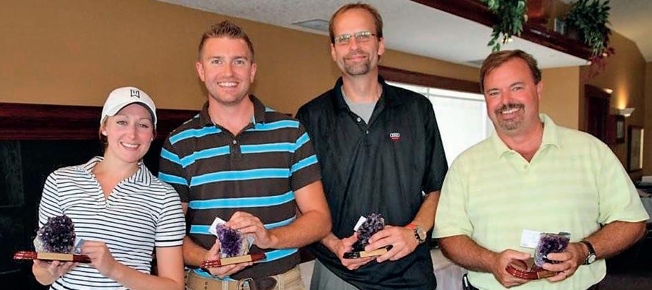
Despite the poor Calgary weather all summer long, we still managed to get in a decent round of golf at the 22nd annual CSPG Mixed Golf Tournament this year. Once again, Lynx Ridge hosted a great tournament and the course conditions were exceptional. This made it easier for more of the hackers out on the course. That is why we are known as the fun tournament, although there is still a bit of competitive edge with some teams.
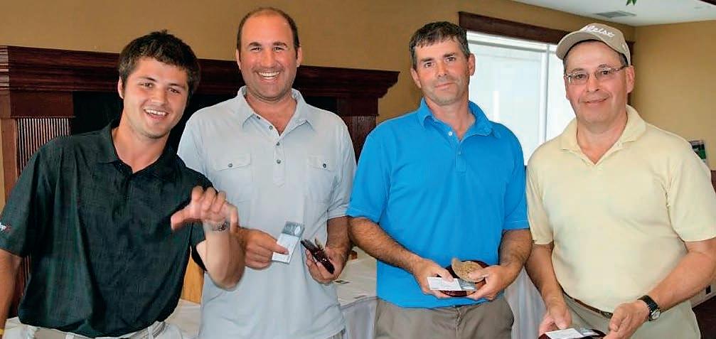
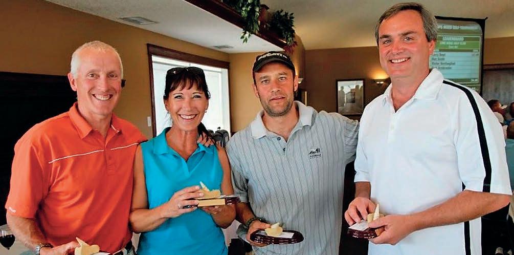
The winning team for gross score was the team of David Caldwell, Jimmy Dowhaniuk, Mike Newton, and Dan Krpan. The winning team for best Net Score was Bob Septhon, Jordan Biss, Joerg Wittenberg, and Brittany Muys.
The most honest team this year went to Norm Hopkins, Robert Paul, Lisa Stickle, and Luis Leote.
A huge thanks to IHS Energy for stepping up as the Tournament Sponsor. Thanks again to Canada Brokerlink who has been our tournament sponsor for the past 21 years. It is great to still have them involved at a Silver level. Other big sponsors who returned to the event again this year were Tucker Wireline and GLJ Petroleum Consultants. Without big sponsors like these, the tournament would not be a huge success. We had the most sponsors ever on Par 3’s this past year as well. IHS sat on Hole 5 and greeted players with drinks and snacks. Roke Technologies and Cougar Consultants had a BBQ and drinks for golfers on Hole 8. On the back nine, Sensor Geophysical served beverages for golfers on Hole 12 while Energy Navigator sponsored Hole 14 and AGAT Laboratories had drinks and snacks for golfers on hole number 17.
Schlumberger was the official scoring system sponsor who posted scores and results at the banquet. CL Consultants sponsored all of the golf carts while Rigsat Gas Detection sponsored the Driving Range. Exova once again stepped forward to sponsor the breakfast while MJ Systems helped cosponsor the banquet meal.
A huge thanks to the golf committee for helping out with their time and efforts again this year. Assisting as Chairpersons were Brenda Pearson from Birchcliff Energy and David Caldwell from Command Equipment. David Middleton from Suncor created all of the signs for the tournament and Penny Christensen from Schlumberger organized all of the prizes for every hole competition, teams, and random prize giveaways. Norm Hopkins bought all of the trophies for each winning team. Darin Brazel from IHS Energy Systems helped out tremendously with the sponsorship drive.
Thanks to Dayna Rhoads at the CSPG office for being instrumental in helping out the committee with registration and anything else we needed.
Hope to see everyone again next year. It was sold out again this year, so make sure you register early.


October’s Reservoir notified you of plans to amend the CSPG’s by-laws, in conjunction with elections this November. These amendments are proposed to ensure appropriate practices are used to preserve our members’ best interest (see: Article II, http://www.cspg.org/about/governancebylaws.cfm). The goal is to ensure the “Good Governance” of the CSPG.
Proposed by-law amendments seek to achieve five outcomes:
1. Broaden the Mission of the Society and adopt a trade name to better reflect and recognize the diverse practice of current and future members engaged in “Energy Geoscience” in sedimentary basins.
2. Simplify individual voting membership classes.
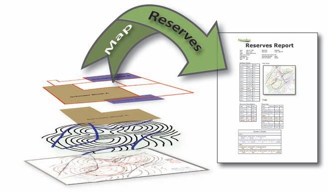
No need to have that old digitizing table getting in the way. Let NeuraMap do your digitizing, volumetrics and reserves on your computer whether you are using hand-drawn maps or digital maps. Take advantage of auto-tracing technology and make your workflow easier with NeuraMap.
• Automated tracing
• Automated shot-point capture
• Interactive editing and reporting
• Geo-Reference and re-project maps
• Calculate Volumetrics and Reserves


3. Address Executive Committee workload and effectiveness issues.
4. Attempt, as is possible legally, to protect Society assets for the benefit of the Membership into the future.
5. Strengthen democratic values and provide foresight for future CSPG success and “good governance.”
Proposed amendments affect five of sixteen by-laws articles. Minor changes affect another three articles. Eight by-law articles remain unchanged.
Major proposals affect:
• ARTICLE I: NAME
• ARTICLE II: MISSIO N AND GOALS
• ARTICLE III: MEMBERSHIP
• ARTICLE VI: OFFICERS
• ARTICLE VII: COMMITTEES
Minor changes including the provision of clarity and gender-inclusive language are:
• ARTICLE X: DUES AND FINANCE
• ARTICLE XI: SEAL AND CERTIFICATION OF DOCUMENTS
• ARTICLE XVI: DISPOSITION OF ASSETS
In Article I the legal name “Canadian Society of Petroleum Geologists” and the standard abbreviation CSPG remain unchanged. The device of the CSPG remains unchanged. It proposed that we adopt additionally the trade name “CSPG: Canada’s Energy Geoscientists.” This change will make us more inclusive of members’ scientific practise, while recognizing the diverse aspects of members’ current employment and our Divisional structure. This proposal is akin to the adoption by the American Association of Petroleum Geologists of the trade name “AAPG: An International Organization.” It reflects a growing awareness and recognition that the pore space and rocks in sedimentary basins contain many additional energy assets, including storage, geothermal energy, and coal resources. Many employers view themselves as “Energy Companies” with a diversified energy resource portfolio. The term Geoscientist similarly portrays the irreversible trend toward our use of diverse geoscientific tools. Since the beginning of the Society we have employed geological, geophysical, and engineering tools to accomplish our work. Wireline logs and drillstem tests are prominent examples of where geologists employ non-geological techniques.
This leads to Article II where the Missions and Goals of the Society are proposed to change from “geology” and “petroleum geology” to “Energy Geoscience”. This is consistent with impending changes of Provincial professional organizations, such as APEGGA. It is also reflects the range of scientific practise of our members. The use of the word Canadian reflects our continuing commitment to be a national scientific society that strives to maintain its position as the best national geoscientific society globally.
Currently almost half our regular members are women. Regardless, our by-laws should be gender inclusive. Likewise, we will continue to recognize, appreciate, and celebrate the efforts of our Long-Time Members, but our membership structure should not discriminate based on members’ age or length of membership. This leads to changes affecting Article III, and the introduction of gender-inclusive language throughout. This will reduce the number of voting membership classes, as it is both fair and democratic that all voting members receive similar basic benefits. Already many emeritus members pay regular dues. By consolidating regular and emeritus members as a single class of voting regular members, we seek to create an inclusive and equitable membership structure. It remains important to considering students as prospective future voting members, associates as valued, but non-scientist, non-voting members, and voting honorary membership as a recognition award. The AAPG is also considering a reduction of its membership classes following similar lines.
Changes to Articles III and VI affect the Executive, the Directors, and their work. Competition among CSPG duties, work, and family responsibilities can be overwhelmingly challenging when Directors are assigned individual portfolio responsibilities. Our own experience, in Convention, Divisions, and Events, shows that we achieve more when we work collectively using committee structure.
The most successful non-profit organizations are often those whose directors approach the organization as a business. … The key lies in developing a clear picture of the needs of the organization, recruiting the leadership who meets these needs, ensuring they understand what is expected of them, and holding them accountable for the responsibilities. Through these endeavours, non-profit organizations stand a much better chance of surviving and flourishing.
(from, Creating an Effective Board of Directors;Pacific Continental Bank, http://www.therightbank.com/home/ fiFiles/static/documents/resources_ white_board_developmentL.pdf
We believe in elected Officers and Directors, while preserving business continuity. Following a modern corporate governance model we propose a limited number of Officers, essential for business continuity, assisted by an annually revitalized Directorate. In reality we use such a governance model currently, but the ByLaws and certain titles are aligned to neither current practise nor a modern governance philosophy.
The proposed Officers are: President, President-elect, Past-President, Finance Director, and Finance Director-Elect. We propose that, each year, the Membership elect both a President-elect, to serve three years successively in the Presidential roles, and a Finance Director-elect who will serve two years successively in the Financial roles.
Directors must take an interest in both specific aspects and the general good of the Society. To strengthen Director roles we propose that the Membership elect by preferential ballot, each year, about half the Directors-at-Large for a two-year term. One addition we propose is that Directors not work in individual portfolios, but that they work collaboratively as chairs and members of standing committees that will replace and augment the four current portfolios (Program, Services, Outreach, Communications).
Currently we have seven Directors, excluding the Officers. We propose that the Directors-at-Large each year be at least five but not more than 16 depending on anticipated workload as identified prior to the call for nominations. Subsequent to each election the President will populate Standing Committees with the returning and newly elected Directors. Through these committees, the Directors will both pursue their personal passionate interests while advancing the general work of the Society.
We propose the following Board of Director Standing Committees:
1. Governance, chaired by the President.
2. Nominations and Elections, chaired by the Past President.
3. Staff Compensation and Benefits, chaired by the Past President.
4. Volunteer Management, chaired by the President-elect.
5. Finance, chaired by the Finance Director.
6. Planning and Priorities, chaired by the Finance Director-elect.
7. Scientific and Technical Programs.
8. Membership and Member Services.
9. Communications and Publications.
10. Outreach and Public Awareness.
We propose to change Article X to align our by-laws with the long-established CSPG practise of placing financial assets with “subsidiaries” of “Chartered Banks and Trust Companies.” Likewise, assuming that the CSPG Education Trust could be the likely recipient of residual CSPG assets, we propose to change Article XVI such that in the event of our dissolution, the recipient of CSPG assets would not be the “profession of geology” but that it will be a registered charity or non-profit organization working for the “promotion of Geoscience or Geoscience Education.” A final resolution will request that you give approval to minor, non-consequential changes that may be required by the federal regulator once we make application to register the amended by-laws.
Again, I recommend you reacquaint yourself with the by-laws (http://www.cspg.org/ about/governance-bylaws.cfm). A “redline” of the proposed changes was posted on the CSPG website in October. You now have the opportunity to consider and vote for these changes in conjunction with elections. Even once you have voted for and approved some or all of the approved by-law amendments the changes will not come into effect until they are vetted by government regulators and legally registered.
Thanks again for your interest and patience. The process of changing our by-laws is neither simple nor easy. With your help and support we can provide a future framework for the continuing success, impact, and value of the CSPG.
| By Mike Cardell, Committee Chair
On a perfect fall afternoon September 14th, 2011 the annual CSPG/CSEG roadrace and fun run took place along the Bow River Pathway. The temperature was ideal for running, and a very enthusiastic group of 170 runners bolted from the start line. This year marked our fourth year for the 5K, and again we saw an increase in participants to 59 runners. This should be the last year that both 5 and 10 Km racers have to maneuver through the construction detours for the long-awaited Peace Bridge. I know our race volunteers, decked out in their bright orange safety vests, aided the runners in negotiating the route. Once again, to assist, or perhaps confuse the runners, distances were marked uniquely in geologic time. Like every year, it’s great to see a mix of competitive and firsttime runners. Winning Time provided a new format for chip timing with the chip mounted on the runners’ race bib. We returned to The Calgary Curling Club for the post-race awards party, where the mix of racers and volunteers enjoyed plenty of cold beverages and tasty pizza. The evening was topped off with door prizes, awards, and of course our now famous sock-toss. Through great sponsorship and strong participation, we are once again able to contribute to the CSPG educational trust fund, and to the YMCA strong kids foundation!
I would like to thank all the volunteers and sponsors who helped make this event a success! We have acknowledged our sponsors on a separate page. Thank you also to all the runners. It was a pleasure cheering you in at the finish line.
Finally a huge thank-you to our group on the committee that made this all work: Mike Cardell, Kathy Waters, Jocelyn Frankow, Carol Laws, Kathy Taerum, Greg Hayden, Tim Burk, Armin Schafer, and Dayna Rhoads at the CSPG office. As well, thanks to Nick Wiggins and the staff at the Eau Claire YMCA for their hospitality.
For more information on run times and placement, please see www.winningtime.ca. We look forward to seeing you next year for the 24th annual; race date will be September 12, 2012. Thank you. Mike Cardell Race Director (mcardell@arcis.com).


Office of Publication: Canadian Society of Petroleum Geologists 600, 640 - 8th Avenue SW, Calgary, Alberta, Canada T2P1G7
Canadian Publications Mail Product Sales Agreement No. 40070050 Return postage guaranteed.
J.F. LERBEKMO and N. LEHTOLA
G.R. DIX and C. JOLICOEUR Tectonostratigraphic framework of Upper Ordovician source rocks, Ottawa Embayment (eastern Ontario)
R.T.
Sedimentological,

CORPORATE MEMBERS
APACHE CANADA LTD.
APEGGA
BAKER ATLAS
BDO CANADA LLP
CANADIAN NATURAL RESOURCES LTD.
CASEY & ASSOCIATES
CONOCOPHILLIPS CANADA LIMITED
DEVON CANADA CORPORATION
ENERPLUS CORPORATION
EXXON MOBIL UPSTREAM RESEARCH COMPANY
GEOLOGIC SYSTEMS LTD.
GEOSTRATA RESOURCES INC.
HUNT OIL COMPANY OF CANADA
HUSKY ENERGY INC.
IHS
IMPERIAL OIL RESOURCES
JEWELSUITE
KKD OIL SANDS PARTNERSHIP
LITTLE ROCK DOCUMENT SYSTEMS
MJ SYSTEMS
MURPHY OIL COMPANY
NEXEN INC.
PENN WEST PETROLEUM LTD.
PETROCRAFT PRODUCTS LTD.
PLUSPETROL S.A
ROXAR
RPS ENERGY CANADA LTD.
SCHLUMBERGER
SHELL CANADA LIMITED
SPROULE ASSOCIATES LIMITED
SUNCOR ENERGY INC.
TALISMAN ENERGY INC.
TOTAL E&P CANADA LTD.
TOURMALINE OIL CORP.
AS OF OCTOBER 10, 2011
CSPG welcomes our 2011 Corporate Members!
The benefits of being a corporate member include:
• Recognition in the monthly Reservoir and quarterly Bulletin
• One associate membership
• Reserved tables at the technical luncheons with your company logo
• One free pass to the CSPG Core Conference
…and more! Contact Kasandra Klein at Kasandra. klein@cspg.org to be a corporate member today!
| By Markus Ebner, Calendar Committee Chair
This November issue of the Reservoir, you will be receiving a copy of the CSPG’s 2012 Geological Calendar, distributed to our members. As always, the calendar displays a diverse variety of impressive geological images from around the globe, as photographed by our members.
Reviewing the calendar, some of the highlights this year are a shot by Colin Martindale of the Khoman Chalk in Egypt’s White Desert of wind-sculpted blocks or ‘hoodoos’, which compares nicely to Derrick Midwinters’s shot of Sandstone hoodoos on Ellef Ringnes Island, Nunavut. A number of winning entrants this year are photographs from Australia and New Zealand – apparently a hotspot for our members. A great aerial shot of the Twelve Apostles in Port Campbell National Park, Australia is taken by Steve Metzger.
As with previous years, a panel of judges selects 14 images (14 for this year, as we started a 16-month calendar this year) for publication and also chose the winners of our photo contest for the Best Photo, as well as our subcategory this year of Best Structural Geology Photo.
Winner of the Best Photo this year goes to Michael Lam for his great shot of Mammoth Hot Springs in Yellowstone National Park, Wyoming. The photograph is taken with excellent lighting, which perfectly highlights the travertine terraces. It was chosen for the amazing image and is something that is rarely seen as an entry subject to the committee. This is Michael’s second year in a row taking the best shot, but the tally from the judging
panel was unanimous in the decision for award.
For the Best Structural Geology
Peggy Hodgkins wins for her shot Whaleback Ridge in Yoho National Park, The photograph nicely captures a beautiful fold in the Cambrian Sullivan and Waterfowl formations, which is backdropped by a and blue skies. As a runner-up to structural photo, a calendar regular, Benham entered a shot of a tight, anticlinal fold in the Nikanassin Formation, Grande Cache, AB.
Congratulations again to both Michael Peggy, who will both receive prize money of $200. Also, congratulations to our other photographers that made into the 2012 calendar. All of the calendar photographs will be available on the website as downloadable wallpapers.
I would like to thank everyone who took time to enter photographs for submission in this year’s calendar. Thanks also go to Darin McBeath, Aaron Grimeau, Mark Radomski, Mark Taylor, Steve Metzger, Ryan MacCauley, and Phil Benham for lending their geological and photographic knowledge to the judging panel and making this year’s selection process as exciting as always. Thanks to Caitlin Young at the CSPG office for making the calendar organizationally successful and keeping things running smoothly.
Thank-you to the sponsors of the CSPG calendar as well as our members, who help make this project possible.
Want sealed frameworks from geological and geophysical data in minutes, not weeks?
DecisionSpace® Desktop software automatically generates accurate sealed frameworks in about a minute.
As geoscientists interpret data, Landmark’s new unified DecisionSpace® Desktop software automatically constructs fault networks, seals horizons against the fault network and generates a sealed framework. When geologists make picks or geophysicists interpret sections, watch live updates ripple through the framework and then create accurate, report-quality maps instantly. What once took hours, or even days, now takes just a minute. So speed up your cycle time. Get better answers faster. Visit halliburton.com/decisionspacedesktop.

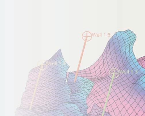
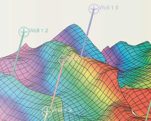


The Blueback Toolbox suite of Petrel* plug-ins contains Petrel functionality features that are not available in standard Petrel. The Blueback Toolbox contains 4 modules where all features has been developed based on request from Petrel users around the world.
GEOLOGY TOOLBOX
- Facies proportion maps
- 3D grid QC
- Fault info
GEOPHYSICS TOOLBOX
- Merge 3D cubes
- Dip indicator
- Frequency spectrum
PROJECT MANAGEMENT TOOLBOX
- Project report
- Project scanner
- Import interpretation
RESERVOIR ENGINEERING TOOLBOX
- Sw modeling
- Interactive well picker
- Contact back calculation