


The global industry leader in critical information and insight, IHS continues to invest in the progress of the Canadian energy market so you can get from discovery to drilling in record time. By updating, improving and streamlining our Canadian products and services, we have delivered workflow integration between IHS PETRA® and IHS AccuMap®; created solutions for better access to global resources, from well log databases to subject matter experts; and continued to provide transparency and insight to Canadian energy businesses that need actionable information.
See how IHS is investing in Canada at www.followihs.com.


CSPG OFFICE
#110, 333 – 5th Avenue SW
Calgary, Alberta, Canada T2P 3B6
Tel: 403-264-5610
Web: www.cspg.org
Office hours: Monday to Friday, 8:30am to 4:00pm
Executive Director: Lis Bjeld
Tel: 403-513-1235, Email: lis.bjeld@cspg.org
Registration Coordinator: Dayna Rhoads
Tel: 403-513-1225, Email: dayna.rhoads@cspg.org
Publications Coordinator: Caitlin Young
Tel: 403-513-1230, Email: caitlin.young@cspg.org
Member Services Coordinator: Kasandra Klein
Tel: 403-513-1233, Email: kasandra.klein@cspg.org
Corporate Sponsorship: Lis Bjeld
Tel: 403-513-1232, Email: lis.bjeld@cspg.org
Business Development: Aileen Lozie
Tel: 403-513-1227, Email: aileen.lozie@cspg.org
EDITORS/AUTHORS
Please submit RESERVOIR articles to the CSPG office. Submission deadline is the 23rd day of the month, two months prior to issue date. (e.g., January 23 for the March issue).
To publish an article, the CSPG requires digital copies of the document. Text should be in Microsoft Word format and illustrations should be in TIFF format at 300 dpi., at final size. For additional information on manuscript preparation, refer to the Guidelines for Authors published in the CSPG Bulletin or contact the editor.
Technical Editors
Ben McKenzie Colin Yeo (Assistant Tech. Editor)
Tarheel Exploration EnCana Corporation
Tel: 403-277-4496 Tel: 403-645-7724
Email: bjmck28@shaw.ca Email: colin.yeo@encana.com
Coordinating Editor
Caitlin Young, Publications Coordinator, CSPG
Tel: 403-513-1230, Email: caitlin.young@cspg.org,
ADVERTISING
Advertising inquiries should be directed to Caitlin Young, email: caitlin.young@cspg.org. The deadline to reserve advertising space is the 23rd day of the month, two months prior to issue date.


CSPG EXECUTIVE


President Kirk Osadetz • Geological Survey of Canada, Calgary kosadetz@nrcan.gc.ca Tel: (403) 292-7022
Vice President
Robin Mann • AJM Petroleum Consultants rcmann@ajmpc.com Tel: (403) 648-3210
Past President
John Varsek • Cenovus Energy john.varsek@cenovus.com Tel: (403) 645-5417
Finance director
Darren Aldridge • Baker Hughes Incorporated darren.aldridge@bakerhughes.com Tel: (403) 537-3400
assistant Finance director
Andrea Hood • geoLOGIC systems ltd. ahood@geologic.com Tel: (403) 262-1992
Program director
Brett Norris • TransGlobe Energy Corp. brettn@trans-globe.com Tel: (403) 264-9896
assistant Program director
Jon Noad • Murphy Oil Corporation jon_noad@murphyoilcorp.com Tel: (403) 294-8829
serVices director
Chris Seibel • Nexen Inc. chris_seibel@nexeninc.com Tel: (403) 699-4558
assistant serVices director
Michelle Hawke • Apache Canada Ltd. Michelle.Hawke@apachecorp.com Tel: (403) 261-1200
communications director
Jim Barclay • ConocoPhillips Canada
Jim.E.Barclay@conocophillips.com Tel: (403) 532-3889
assistant communications director
Stephen Hubbard • University of Calgary steve.hubbard@ucalgary.ca Tel: (403) 220-6236
outreach director
Steve Dryer • Whiskey Jack Resources Inc. whiskeyjackresources@telus.net Tel: (403) 969-2292
assistant outreach director
Simon Haynes • Statoil Canada Ltd. sihay@statoil.com Tel: (403) 724-0364
executiVe director
Lis Bjeld • CSPG lis.bjeld@cspg.org Tel: (403) 264-5610
A message from CSPG Past President John Varsek
Every organization needs a context for making important decisions about which business plans and strategic initiatives to undertake. These decisions, if they are to be coherent and aligned, require consideration of the long-term aspirations of the organization. In essence, the CSPG’s mandate is to be the hub for Canadian Petroleum Geoscience, though questions linger as to the desired destination and performance standard. Based on the progress made by the Society to revitalize its technical, financial, operational, and volunteer base, I believe that this aspiration should be, ‘to become the best regional geological Society on Earth’.
The purpose of this column is to illustrate why I believe this aspiration is reasonable.
In the last decade, three market-changing petroleum resources have become economic:
• Oil Sands
• Shale Gas, and
• Tight Conventional Oils.
These play types are all anchored in Canada or shared with the United States, and given their relatively advanced state, will become global analogs. Supporting this market view is the ongoing multi-billion dollar global investment rush to gain a foothold in Canadian petroleum resources. In short, what we learn here will be of interest elsewhere and it will become the basis for continued internationalization of our E&P sector.
You are no doubt familiar with the concept that ingenuity clusters where there are dense interconnections between numerous experts along with a competitive ecosystem of business, research, and financial institutions. Calgary’s ten-square city blocks, with some 3,000 geologists, of which 10% volunteer for the Society, fits the criterion. In addition to vast publicly accessible and close to real-time databases, we have core and sample collections, and representative outcrops within a day’s drive or heli-
tour. We also have a ca. $100 B per year Canadian Industry behind us. These physical, organizational, and intellectual assets need to be effectively stewarded for the CSPG to realize a more prominent global standing. This calls for us to raise our game. By way of example this means:
• Elevating the relevance and delivery modes of our educational, research, and conference programs, especially pertaining to these emerging resources.
• Timely and relevant publications. The recent clamour for the Horn River Shale Gas volume and Economic Geology and Shale Gas series by educational institutions and universities as far away as China indicate the pertinence of our Society’s output. Increasing demand, though still very modest, for digital downloads indicates that we are on the right track.
• Providing effective subject matter delivery, such as geo-spatial links, to our 50 years of literature. Think also of the core conference and field trip guidebooks, special publications, and conference abstracts, in addition to the Bulletin and Reservoir. Good geological observations don’t become dated, unlike interpretations.
The Executive team has been implementing foundational changes to enable development of more creative programs at reasonable cost, while maintaining the character of the Society as individual member focussed, technically driven, and volunteer-based. These include the following:
• Bylaw changes to allow for a more adaptable leadership structure.
• Continuing professionalization of the Office relative to communication and branding, digital services provision, and legal skills (especially in the area of copyright).
(Continued


They can copy us. They just can’t be us. If imitation is the sincerest form of flattery, we’re one flattered group. Drawing on a quarter century of oil and gas experience, geoLOGIC continues to be the market leader in data, software solutions and support. And while we lead the way, our competitors desperately create parity products, sometimes years after us. For details on how geoLOGIC leads the way, visit www.geoLOGIC.com
Leading the way with customer-driven data, integrated software and services for your upstream decision-making needs.
geoSCOUT | gDC | petroCUBE at www.geoLOGIC.com
DiamonD
IHS
geoLogIC SyStemS Ltd.
SCHLumberger Canada Ltd.
Platinum
agat LaboratorIeS
CenovuS
ConoCoPHILLIPS
nexen InC.
taLISman energy
PoggenPoHL
GolD
aPegga
CSPg eduCatIonaL truSt Fund devon Canada
enCana
ImPerIaL oIL
SHeLL
WeatHerFord LaboratorIeS
Silver
arC FInanCIaL CorPoratIon
JeWeLSuIte
roxar
Bronze
bLuebaCk reServoIr
ParadIgm
geovarIanCeS
CSeg FoundatIon
rPS boyd PetroSearCH
HaLLIburton energy ServICeS
SunCor energy
Sundog PrIntIng
tuCker WIreLIne ServICeS
(...Continued from page 5)
• Conventions that engage and connect more closely with what we are working on daily.
• Involving Industry leadership to build partnerships that recognize the essential services the Society provides.
We are looking broadly at the future role of our members and believe that this will require the Society to broaden its scope to energy geoscience and pore space management – more on this from President Osadetz in future columns. Extending this line of thinking further, I believe that energy geoscience is a Canadian core competency and that the role of the CSPG is to ensure that we maintain this leading capability by continuing to facilitate the learning curve.
We will know that we are on a successful track when we see – and these are measurable:
• Membership increasingly participating in CSPG programs to enhance career knowledge and adaptability.
• The world’s geologists, Canadian investment advisories, and policy makers increasingly requesting our literature, courses, and fieldtrips – as indicated by citations and attendance.
• Increasing international participation at the annual geoConvention.
• Increasing presence of Canadian petroleum geologists in international projects and the use of analog data published by the CSPG.
• Growth in requests for guidance and partnerships from geological societies across Canada and around the world.
• Recognition of the importance of energy geo-science at Canadian universities as reflected in greater utilization of CSPG resources.
• Increasing recognition of Canadian energy geoscientists and the CSPG as experts in pore space and sequestration management as part of sustainable resource development.
I welcome you to review the direction and services offered by your Society. Participate as a volunteer and extend your professional capability by gaining exposure and satisfaction from more ideas, colleagues, and meaningful projects than is otherwise available from your employer.
began this journey in the darkest hours of the economy in 2009 and now, with three successive teams of Directors, have made progress on all three strategic pillars:
• Technical revitalization - for relevance and timeliness.
• Support for our volunteers –resourcing and assignment progression.
• Communications – visible value for all stakeholders.
We have added a fourth, namely internal capacity building (see my Executive Comment in the December 2010 issue of the Reservoir). From this vantage point, I believe we are now in a strong position to assume a greater role in the global energy geo-science community.
I thank my employer Cenovus Energy for supporting my efforts and for their generous support of various CSPG programs.
With gratitude to all Directors, Chairs, and Office staff that I’ve had the pleasure of serving the CSPG with, John
The September Executive Comment was co-written by Jim Barclay and Stephen Hubbard.


AS OF SEPTEMBER 10, 2011
With this column I end my three-year cycle serving the CSPG as Vice President, President, and Past President. The mandate I was given, and which I and my fellow Directors fully accepted, was to begin the renewal and re-energizing of the Society. We
CONNECT with your peers and future employers, and learn how the CSPG’s services and technical development programs can aid your professional development!
Join us for drinks and appetizers on October 13 to NETWORK with your peers, CSPG volunteers, and CSPG committee members. Come and see what we are all about!
Thursday, October 13, 2011 Belgo Brasserie, 501 – 8th Ave SW Food and Refreshments included... FREE! Register for this event at www.cspg.org
Don’t forget to bring your business card for a chance to win!
Courses include:
• Deepwater Sedimentation
• Exploration for Deep-Water Sands Using Seismic Sequence Methodology
• Carbonate Reservoir Geology
• Seismic Imaging of Carbonates
• Carbonate Depositional Systems
• Quick Guide to Carbonate Well Log Analysis
• Interpretation of 3D Seismic Data
• Seismic Amplitude Interpretation
• Seismic Stratigraphy and Seismic Geomorphology
• Evaluation and Quantitative Modeling of Fractured Reservoirs
• Hydraulic Fracturing of Shales
• Surface Geochemical Exploration For Oil And Gas
(Four concurrent sessions each day – mix and match according to your interests and training needs. Buffet lunch and refreshments included each day.)
Small AAPG Bookstore open during breaks each day
Hosted by the Norris Conference Center:
803 Town & Country Lane
Houston, TX 77024
Phone: 713-590-0950
Fax: 713-590-0961
Special group rate at nearby Hotel Sorella
Registration and information:
Toll-free (U.S. and Canada) 888-338-3387, or 918-560-2650
Fax: 918-560-2678
E-mail: educate@aapg.org
Download a registration form at: www.aapg.org/education/wec.cfm
(Your five-day badge can be transferred to a friend or colleague if you can't attend all five days.)
SPEAKER
r oger m. Slatt
Director, Institute of Reservoir Characterization and Gungoll Chair Professor of petroleum Geology and Geophysics, University of Oklahoma
11:30 am tuesday, o ctober 18, 2011 c algary, te L us c onvention c entre c algary, a lberta
Please note: the cut-off date for ticket sales is 1:00 pm, thursday, october 13, 2011 csPg member ticket Price: $42.00 + gst non- member ticket Price: $45.00 + gst.
Each CSPG Technical Luncheon is 1 APEGGA PDH credit. Tickets may be purchased online at www.cspg.org.
The revelation of vast global quantities of potentially gas- (and oil-) productive shales has paved the way for rapid advancements in the application of geological, geophysical, geochemical, petrophysical, and geomechanical characterization for exploration and production. The Shale Characterization Group at the University of Oklahoma has developed and applied a workflow for multi-scale, multi-disciplinary characterization. This workflow was developed initially during research on the Barnett and Woodford shales, but has since been extended to the Horn River, Fayetteville, Caney, Lewis, and Longmaxi (China) shales.
In the geological realm, conventional sequence stratigraphic principles have proven viable to establishing a regionalto local-correlation strategy, but building a workable sequence stratigraphic framework that can differentiate most favorable intervals for drilling and completion requires detailed SE m, thinsection, mineralogic, sedimentologic, and even outcrop studies.
In the geophysical realm, seismic inversion and attribute analysis continue to improve the resolution and imaging of subtle structural and stratigraphic features within shale strata both locally and regionally. Seismic attribute analyses have also revealed positive relations between shale stratigraphy and the u nderlying unconformity surfaces upon which resource shales usually sit.
In the geochemical realm, parameters that can define areas for best production
Webcasts sponsored by
within a shale sequence include TOC, HI, Ro, biomarkers, and isotopes. Ethane reversals seem to be particularly well correlated to areas of best shale gas production.
In the geomechanical realm, it has become possible to identify brittle-ductile couplets from the sequence stratigraphic down to the bed/laminae scales based upon a variety of characteristics, and further insights have been gained into
(Continued on page 10...)


Well Data Management
- Store headers, locations, tops, deviation surveys, production & more - Access data through web, GIS and desktop applications
Corporate Log Database
- Store, manage and deliver raster and digital well logs
- Physical inventory system for cataloging paper and film logs
Document Management
- Manage well reports, maps, cross sections and seismic sections
- Integrate with external document management systems
Data Certification
- Implement data quality improvement programs
- Setup quality control processes to ensure data accuracy

understanding the complexities of hydraulically induced, microseismic events within shale reservoirs.
In the petrophysical realm, much attention has been paid to nano-scale, organoporosity as significant storage areas for free and adsorbed gas. However, other work has identified a variety of other pore types that may be in shales that also contribute to the storage, and possibly flow of reservoir fluids.
In summary, an ever-evolving integrated, multi-scale, multi-disciplinary approach to understanding shales can lead to enhanced exploration and production success.
Roger M. Slatt currently holds the Gungoll Family Chair Professor in Petroleum Geology and Geophysics at University of Oklahoma and Director of the Institute of Reservoir Characterization in the Sarkeys Energy Center at OU. He was Director of the School of Geology and Geophysics and Eberly Family Chair Professor at University of Oklahoma from 2000-2006, and the Gungoll Chair Professor of Petroleum Geology and Geophysics in 2006-07. He formerly was Head of the Department of Geology and Geological Engineering at Colorado School of Mines (1992-2000) and Director of the Rocky Mountain Region Petroleum Technology Transfer Council (1995-2000).
After receiving his Ph.D. in 1970 from the University of Alaska, he taught geology for eight years at Memorial University of Newfoundland and Arizona State University. He then spent 14 years in the petroleum

industry with Cities Service Research, ARCO Research, and ARCO International Oil and Gas. Co. before joining Colorado School of Mines in 1992. He has published over 100 papers and abstracts, and has made numerous presentations on the subjects of petroleum geology, reservoir geology, seismic and sequence stratigraphy, shallow marine and turbidite depositional systems, geology of shale, glacial and Pleistocene-Quaternary geology, and geochemical exploration. He sits on various professional society committees, has organized technical conferences for American Association of Petroleum Geologists (AAPG), and teaches short courses for industry and AAPG on the “Introduction to the petroleum geology of deep-water (turbidite) depositional systems” and on “Principles of geologic reservoir characterization.” He also offers a global, web-based course on “Introduction to geologic reservoir characterization” to people from many different countries. He has taught his two courses in many places in the U.S., as well as in many countries, including Colombia, Mexico, Indonesia, Malaysia, Australia, Angola, India, New Zealand, Scotland, and England.
While employed in the international oil and gas industry, he had the opportunity, as Director of Reservoir Evaluation, to study numerous oil and gas fields and exploration prospects worldwide, and to make recommendations to senior management for international investment. Many of Dr. Slatt’s publications have dealt with the subject of exploration for, and development of deepwater submarine fan (turbidite, basin-floor fan) oil and gas reservoirs. He is considered an expert on deepwater submarine fan exploration and development, and has worked in both industry and as a consultant on many such reservoirs
globally. In late 2006 he completed coauthoring a book titled: Introduction to the Petroleum Geology of Deepwater Settings, published by the American Association of Petroleum Geologists. He also completed a book in late 2006 titled Stratigraphic Reservoir Characterization for Petroleum Geologists, Geophysicists, and Engineers, published by Elsevier. Also in 2006, he organized the 26th Annual Gulf Coast Assoc. Sedimentary Geologists (GCSSEPM) conference, titled Reservoir Characterization: Integrating Technology and Business Practices, and was chief editor of a CD book comprised of papers from that conference. Since 2002, he has taught a web-based course semiannually for AAPG titled Introduction to Geologic Reservoir Characterization.
In 1996 he received the AAPG Distinguished Service Award. In 1999 he was the Esso Australia Distinguished Lecturer in Petroleum Geology. In 2001-2002, he was an AAPG Distinguished Lecturer, giving a presentation titled “Outcrop/behind outcrop characterization of deepwater (turbidite) petroleum reservoir analogs: why and how.” He offered the same presentation as an SPE Distinguished Lecturer in 2003. In 2003, he was awarded with AAPG Honorary Membership. In 2006 he received the AAPG Grover Murray Distinguished Educator Award. In 2007 he received the Society of Exploration Geophysicists (SEG) Special Commendation Award “in recognition of meritorious service rendered the scientific community, the earth sciences and exploration geophysics”.

SPEAKER
l uis a. Buatois
Department of Geological Sciences, University of Saskatchewan
11:30 am
t hursday, o ctober 27, 2011 c algary, te L us c onvention c entre c algary, a lberta
Please note: the cut-off date for ticket sales is 1:00 pm, monday, october 24, 2011 csPg member ticket Price: $42.00 + gst. non- member ticket Price: $45.00 + gst.
Each CSPG Technical Luncheon is 1 APEGGA PDH credit. Tickets may be purchased online at www.cspg.org.
The applications of ichnology to facies analysis and sequence stratigraphy have been at the forefront of the discipline during the last twenty years. Nevertheless, advances have been uneven. marine clastic ichnology has been the main focus of most research. Continental ichnology has recently become the centre of considerable attention, and exciting advances have been made in this field also. A smaller number of studies have dealt with carbonates and volcaniclastics, while mixed carbonate-siliciclastic environments have been hardly explored. Even so, not all areas of marine clastic ichnology have been studied to the same level.
Both shallow- and deep-marine ichnofaunas have received similar attention, but studies in shallow-marine environments have attained better integration with sedimentologic data. In turn, the ichnology of wave-dominated, shallow-marine environments has been explored in more detail than their tidedominated counterparts, resulting in the so-called “shoreface model.” However, recent research is providing insights into
the ichnology of tidal flats and subtidal sandbodies. The ichnologic content of sandy shores is much better known than that of muddy coasts. In fact, some specific types of muddy shorelines (e.g., chenier plains) remain essentially unrecognized in the geologic record. End-members with respect to wave and tidal dominance are better understood than mixed systems (i.e., wave-dominated tidal flats and tidal beaches).
Recent work on the ichnology of deepmarine systems based on both modern and ancient examples has provided a wealth of information (e.g., recognition of hyperpycnal flows, episodic turbidity currents, bottom currents). In marginal-marine environments, studies resulted in the “brackish-water model” in the 1990s. This was followed by a shift to the ichnology of deltaic systems. However, river- and wave-dominated deltas are better known than tide-dominated ones. In addition, shelf deltas have been explored from an ichnologic perspective, but little is known on shelf-edge deltas. The increased recognition that some brackish-water suites do not occur, neither in estuarine systems nor in the proximal portion of deltas, promoted further research on the ichnology of bays in an attempt to search for an alternative model. The ichnology of marginalmarine systems in high latitudes remains poorly explored, although progress has been attained particularly in connection with the late Paleozoic glaciation in Gondwana.
In the carbonate system, significant work has been done on the ichnology of Bahamian-type carbonates, reefs, chalks, and rocky shorelines, but little has been done on carbonate
turbidites. Continental ichnology has experienced much focus during the last fifteen years, which has resulted in a dramatically changed appreciation of the ichnology of lakes, fluvial systems, paleosols, and eolian deposits. The fields of invertebrate and vertebrate ichnology have evolved independently, with research involving two separate scientific communities to a great extent. The need for integrating vertebrate and invertebrate datasets has long been recognized, and future efforts will lead to considerable insight.
With respect to sequence-stratigraphic applications, the focus has also been on marine clastic successions. However, recent progress has been made on the use of ichnology in lacustrine and carbonate sequence stratigraphy. Promising lines of research in this field include the use of paleosol ichnofacies in the recognition of sequence boundaries, increasing our database on trace fossils and discontinuity surfaces in carbonates, distinction between autogenic and allogenic examples of the Glossifungites ichnofacies, and elucidation of stratal stacking patterns in mixed tide- and wave-influenced settings.
Available trace-fossil models tend to overlook the fact that biogenic structures, although an evidence of behavior controlled by environmental factors, are in fact a historical product of evolution. As such, ichnofaunas display remarkable variability through geologic time. Temporal calibration of tracefossil models is essential to understand the imprint of macroevolution, increasing their applicability to solve problems in sedimentology and stratigraphy.
Please check the CSPG website www.cspg.org for more information on the upcoming November Technical Luncheons: Tuesday, November 8, 2011 and Monday, November 28, 2011
Detailed and accurate geology at your fingertips in Petra, GeoGraphix, ArcGIS, AccuMap, GeoScout and other applications for information contact: Joel Harding at 403 870 8122 email joelharding@geoedges.com www.geoedges.com
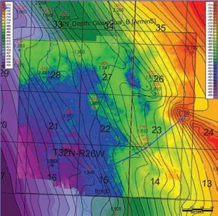
Western Canada: Slave Point, Swan Hills, Leduc, Grosmont, Jean Marie, Horn River Shales, Elkton, Shunda, Pekisko, Banff, Mississippian subcrops and anhydrite barriers in SE Sask., Bakken, Three Forks, Montney, Halfway, Charlie Lake, Rock Creek, Shaunavon, BQ/Gething, Bluesky, Glauconitic, Lloyd, Sparky, Colony, Viking, Cardium, Horseshoe Canyon and Mannville CBM, Oilsands Areas, Outcrops
Northern US Rockies & Williston Basin Geological Edge Set
Western Canada Geological Edge Set
Appalachian Basin Geological Edge Set
North American Shales Geological Edge Set
US Rockies & Williston: Red River, Mississippian subcrops & anhydrite barriers (Bluell, Sherwood, Rival, etc), Bakken, Three Forks, Cutbank, Sunburst, Tyler, Heath, Muddy, Dakota, Sussex, Shannon, Parkman, Almond, Lewis, Frontier, Niobrara, Mesaverde shorelines, Minnelusa, Gothic, Hovenweep, Ismay, Desert Creek, Field Outlines, Outcrops
North American Shales: Shale plays characterized by O&G fields, formation limit, outcrop, subcrop, structure, isopach, maturity, stratigraphic cross-sections. Includes: Marcellus, Rhinestreet, Huron, New Albany, Antrim, Utica-Collingwood, Barnett, Eagleford, Niobrara, Gothic, Hovenweep, Mowry, Bakken, Three Forks, Monterey, Montney, Horn River, Colorado
Appalachian Basin: PreCambrian, Trenton, Utica-Collingwood, Medina-Clinton, Tuscarora, Marcellus, Onondaga Structure, Geneseo, Huron, Antrim, New Albny, Rhinestreet, Sonyea, Cleveland, Venango, Bradford, Elk, Berea, Weir, Big Injun, Formation limits, Outcrops, Allegheny Thrust, Cincinatti Arch, Field outlines
Deliverables include:
-Shapefiles and AccuMap map features
-hard copy maps, manual, pdf cross-sections
-Petra Thematic Map projects, GeoGraphix projects, ArcView map and layers files
-bi-annual updates and additions to mapping
-technical support
SPEAKERS
m ark Cooper1 and m arian J. Warren2
1Sherwood Geoconsulting Inc., Calgary, Alberta
2Jenner GeoConsulting, Calgary, Alberta
12 noon to 1pm t hursday, o ctober 6, 2011
l ocation: Conference Centre r oom a, +30 level, Western Canadian Place (Husky e nergy), 707-8th avenue S.W.
Inversion structures are now recognized in most orogenic belts and in many other tectonic settings, however, this has not always been the case. For many years the thin-skinned paradigm dominated
the interpretation of thrust belts, which resulted in many inversion structures being erroneously interpreted as thin-skinned thrusts. In rift basins, intra-cratonic basins, and on passive margins inversion structures were often interpreted as having alternative origins, for example, strike-slip deformation. The classic paper of Bally described the geometric characteristics of inversion structures, in which he identified the extensional fault geometry and subsequent compressional reactivation as essential requirements of an inversion structure. The increased recognition of inversion structures in a wide variety of tectonic settings is illustrated by four hydrocarbon exploration case studies. The geometric characteristics of inversion structures are remarkably consistent irrespective of the tectonic setting, and by applying a few simple criteria they can easily be identified. The impact of inversion on hydrocarbon prospectivity is a function of the control on the petroleum system elements from the initial extensional tectonic history and of the later compressional tectonic history that commonly creates new, or modifies old trap configurations.
Sponsored by
INFORMATION
Structural Division talks are monthly and cover a diversity of structural themes. All are welcome and no registration is required. For additional information, to be placed on the Division e-mail list or to present a talk, please contact Darcie Greggs, Darcie.Greggs@Huskyenergy.com
YOU… for your patience during our move
CSPG is now located at 110, 333 – 5 Avenue SW Calgary, AB T2P 3B6
Phone: 403-264-5610 Fax: 403-264-5898
Join us for our OPEN HOUSE in October

SPEAKER
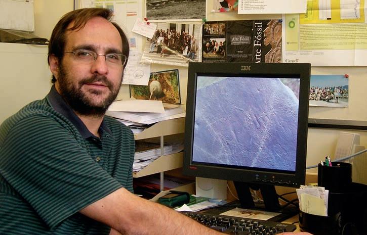
Jon Noad Exploration m anager, murphy Oil Co. Ltd, Canada
12:00 Noon
Wednesday october 12th, 2011
Nexen Plus 15 Conference Centre Nexen a nnex Building 7th ave. & 7th Street SW Calgary, a lberta
ABSTRACT
This presentation will introduce the petroleum geology of Iran. I will go into the history of Iran’s petroleum industry, before discussing the geology and why the middle East, and Iran in particular, is a “Goldilocks story” when it comes to petroleum. A broad outline of the major fields and provinces will be provided. I will then present overviews of several studies undertaken in Iran, both in the field and on the workstation, that help to demonstrate from both the technical and political fronts why doing business in Iran is something of a challenge for our industry.
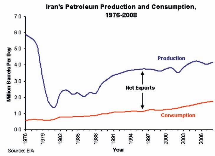
Iran has the third largest oil reserves by country, with 138 billion barrels, following Saudi Arabia (263 billion bbl) and Canada (179 billion barrels) (CIA World Factbook). Iran produces more than 4 million barrels of oil a day from 27 onshore and 13 offshore oil fields, and is the fourth largest producer in the world after Russia, Saudi Arabia, and the USA.
Iran’s national oil company, NIOC, is the second largest oil company in the world. With reserves of 138 billion barrels, and 1,000 Tcf of gas, NIOC produces more than 4 million barrels of oil a day. much of the oil is produced from a series of giant oil fields in huge anticlines forming the Zagros mountains. The largest of these is the Ahwaz field, with initial oil in place of 65.5 billion barrels, and daily production of 70,000 barrels.
Two thirds of the gas is associated gas, and one third non-associated. much of the gas lies in the southeastern portion of the country. With respect to the gas, the South
Pars field is the largest gas field, with 500 Tcf of gas in place. Officials estimate that by 2015 Iran’s annual oil and gas revenues could reach $250 Billion.
Oil was first discovered in Iran in 1908, leading to the formation of the AngloPersian Oil Company (APOC). However it is clear that hydrocarbons had been recognized thousands of years prior to this. Naft Safid, a region and Zagros oil field, translates as white springs, a reference to naptha springs. Several references to “eternal flames” were probably initiated by gas seeps being ignited by lightning strikes.
The British government purchased the majority of shares in APOC and controlled the Iranian oil industry for 37 years. After 1937 APOC changed its name to the AngloIranian Oil Company (AIOC). In 1950 the Iranian government nationalized the oil industry, and the following year they formed NIOC. Following a coup d’etat in 1954, this was superseded by an agreement splitting profits equally between a multinational consortium (consisting of 40% AngloIranian, five US companies holding 40%, and Shell and CFP holding 10% each) and NIOC.
The Islamic Revolution occurred in 1978-9, and the industry was once again nationalized. After the Iran-Iraq war an aggressive approach to production saw
accelerated economic growth, and this continued through k hatami’s presidency (1997 to 2004). The law forbade foreign ownership and hence buy-back agreements, where NIOC reimbursed expenses while retaining complete ownership of an oil field, became common.
In the early 2000s, leading international firms from China, France, India, Italy, the Netherlands, Norway, Russia, Spain, and the U k had agreements to develop Iran’s hydrocarbon resources.
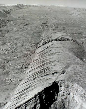
Iran can be divided into ten lithotectonic dom ains. The vast majority of hydrocarbons are hosted in the Zagros fold belt, which extends NW to SE for 2,000 km from the East Anatolian Fault in eastern Turkey to the Oman Line in southern Iran. The Zagros m ountains formed when the neo-Tethys oceanic crust was subducted beneath the Iranian Plate, and is made up of sediments from late Precambrian to Recent in age, overlying a high-grade metamorphic Precambrian basement.
The northwest-southeast structural trend of the Zagros fold belt resulted from compressive folding during the Upper Pliocene. This Alpine orogeny masks and modifies earlier patterns of structural deformation. Three structural belts have been defined: the Simply Folded Belt lies to the southwest, and passes over into the
Lower miocene to Pliocene Thin-bedded clastics, overlain by conglomerates 3,000 m
Upper Cretaceous to Oligocene Shales and limestones, capped by the Asmari limestone and Gachsaran evaporites 1,000 m
Permian to Upper Cretaceous Carbonates
3,000-4,000 m
Cambrian to Carboniferous Shales and sandstones 2,000 m
Imbricated Belt in the High Zagros, while further to the northeast the Crush Zone has generally been considered to represent the suture zone between the Iranian and Arabian Plates. The major oil fields extend from the outer Simply Folded Belt to the mountain front, which marks the appearance of surface exposures of the Asmari Limestone and older formations. There is a relatively sharp boundary between the Abadan Plains, and their gentle structural undulations (Pejudesh 1973) and the Zagros folds. The high relief, elongate anticlinal folds of the inner belt contrast with the low relief badlands of the outer belt. The Asmari reservoirs lie beneath a thick m io-Pliocene cover of evaporites ( m cQuillan 1991).
The geological history from the late proterozoic to mid-Tertiary is one of remarkable stability, punctuated by episodes of extension in the PermoTriassic and brief convergence in the late Cretaceous. The mid-Tertiary continental collision leading to the Zagros orogen imposed a dominantly northwest/ southeast fold trend (the so-called Zagros trend) that contrasts with the dominant north/south pattern (Arabian trend) developed prior to this time. This contrast can be seen in the orientation of the oil fields.
To summarise, the Zagros folded belt has been a steadily subsiding trough since the Triassic. It is filled with a conformable marine succession of mesozoic to Cenozoic sediments, several thousand metres thick. These have been deformed and uplifted almost continuously since the Eocene.
Oil production is dominantly from the m iocene Asmari Formation and Cretaceous Bangestan Formation, both made up almost exclusively of carbonates. These limestones typically have relatively low permeability, but have been fractured and then charged by oil from the world class k azhdumi source rock of the Cretaceous. However it is important to note that many other intervals of the stratigraphic succession are proven oil reservoirs, and
as many as 14 separate formations have been recorded as producing in one Iranian oil field.
m any wells have been drilled across the Zagros. The striking whaleback anticlines provide a very obvious target, and a series of detachment levels deeper in the succession mean that secondary targets may be located in what are apparent synclines at surface. The overall fold geometry, with common broad anticlines separated by tight synclines, has also enhanced the likelihood of encountering pay.
In such an environment it is not always clear where to start in terms of exploration.
(Continued on page 16...)


Western companies are busy undertaking field studies in some fields to ingratiate themselves with NIOC, while others have taken on relatively risky exploration programs to drill in marginal areas. A bid round in 2004 included 16 blocks, all outside the Zagros fold belt, save three blocks adjacent to the Kurdestan region of Iraq. m any of these received no bids. At present the somewhat strained political situation makes active exploration very difficult.
However some varied explorationrelated work has been undertaken. In this presentation I will present the results of fieldwork undertaken within the Zagros fold belt. The work examined the Asmari stratigraphy in two incised valleys, in order to build up a sequence stratigraphic framework that was later integrated with structural mapping. The aim was to identify whether certain intervals were more prone to particular types of fracturing (previously presented at the CSPG Structural Division by Ben Stephens of Shell Canada). I will concentrate on the sedimentology of the Asmari Formation, and how the field data was used to build a three-dimensional model
of the Asmari Limestone throughout the Zagros, which is more than 1,000 km long.
Another project examined the Lorestan Province, which lies at the western end of the Iranian Zagros mountains. Only three fields have been discovered in Lorestan, in contrast to the area immediately to the southeast, and hence a dry-well analysis was undertaken on 29 wells in the region. The target reservoir interval is the Bangestan Group, comprising three formations. Two productive platform limestones, the Sarvak and the Ilam, are separated by the Surgah Shale. Porosities in the Sarvak average around 3%, and in the Ilam around 8%, enhanced by fracturing.
The initial results of the dry-well analysis showed that several of the wells produced gas in the ranges of 1-10 million standard cubic feet per day ( mmscf/d), and most of the wells had shows of oil and/or gas. Three fields had producible hydrocarbons, two gas fields with an oil rim, and one oil field with a gas cap. Plotting the producing wells (with a cutoff of 1 mmscf/d) against depth of burial, a striking pattern emerged. The wells only produced significantly where the top reservoir was more than 500 m below sea level. Further work led to a surprising interpretation.
Another study examined the super giant Azedegan Field. This field has a somewhat checkered history with the initial agreement between NIOC and Japan leading to political complications that eventually led Japan to pull out of the deal. Hosting an estimated 33 billion barrels, the first six wells ALL showed differing oil/water contacts. This was to say the least surprising, as seismic lines showed a tram-line stratigraphy. The sedimentology of the oil-prone Cretaceous kazhdumi sands and Sarvak Limestone does not show any major change, and it was only when a perceptive geophysicist asked the right question that the answer became apparent.
Iran is without doubt one of the most prospective hydrocarbon provinces of the world, with a fascinating geological and cultural history. Circumstances have conspired to provide a “Goldilocks” setting in terms of unarguably world-class source rocks, traps, reservoirs, and seals. A variety of studies have significantly added to our understanding of the petroleum geology. Despite this, the political climate leaves us with the question: how would a western company access some of this treasure chest of hydrocarbons?
Jon graduated from Imperial College, London in 1985, and started work as a mining geologist on gold mines in South Africa. He moved to the Bushveld in 1988 to work on a shaft-sinking platinum mine, also looking after the geological aspects of the world’s largest chromite and vanadium mines. Jon returned to the UK in 1990 and joined BT as their marine geologist, responsible for analyzing subsea cable routes. At this time he also completed an M.Sc. in Sedimentology at night school, with his thesis examining the fluvial sequence stratigraphy of Dinosaur Provincial Park here in Alberta.
Jon then returned to London University full time in 1995 to complete a Ph.D. on the Sedimentary Evolution of eastern Borneo, where he developed a love of fossil mangroves and hot chilies. He was then recruited by Shell in 1998, and worked mainly on Middle Eastern exploration before moving to Shell Canada in 2006. He worked Orphan Basin and Tight Gas exploration for Shell before moving to Murphy Oil as Exploration Manager, Canada in 2010. Outside the office he loves running, skiing, playing soccer, and hiking.
There is no charge. Please bring your lunch. The facilities for the talk are provided complimentary of Nexen, coffee by IHS, and refreshments by Geochemtech Inc. For further information or if you would like to give a talk, please contact Bob Potter at (403) 863-9738 or ropotter@ telusplanet.net or Trent Rehill at (403) 6066717 or trehill@kulczykoil.ca. Or visit our new Face Book page (“CSPG International Division”).
SPEAKER
Philip Benham
Shell Canada Limited
Co-AuthoR:
Ulla Lohmann
National Geographic Society
7:30 PM
Friday, October 21, 2011
Mount Royal University, Room B108
Ab St RAC t:
When Alfred Wegner first proposed the Theory of Continental Drift in 1912, it was widely rejected because there was no strong evidence for the mechanism behind the movement of continents. It was only in the 1960s as the concept of plate tectonics evolved with the accumulation of seismic and geomagnetic evidence that it began to be largely accepted. This all-encompassing theory today allows us to understand how and why continents drift, earthquakes and tsunamis occur, and why volcanoes erupt where they do. Imagine witnessing these dramatic events, without the context of “modern” science, and trying to explain why they occur.
The South Pacific Island nations of Tonga, Vanuatu, and the Solomons offer some of the most unique cultural practices in the world. These include land diving, cargo cults, widespread ingestion of the narcotic root kava, and, in the not too distant past, cannibalism. This region is also one of the most tectonically active in the world. Frequent earthquakes, islands appearing and disappearing, volcanic eruptions, and tsunamis punctuate the lives of these remote Melanesian peoples. Passed down in their oral legends are observations of dramatic geological events and their explanations for why and how they occur.
This talk is about a five-week expedition undertaken to observe the submarine
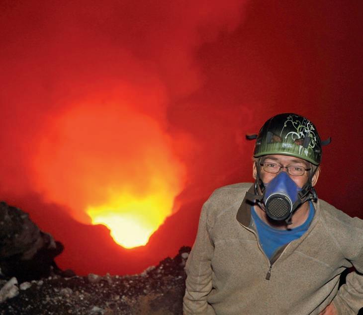
volcano at Kavachi, in the Solomon Islands, the remote and rarely accessed double lava lakes of Marum and Benbow on Ambrym Island a nd the spectacular Strombolian-style eruption of Yasur, Tanna Island, Vanuatu. In all three places the local people live with and have adapted to the dramatic geology that affects their lives. Their observations and oral histories provide fascinating insight not only into the geological events of the past and present but also how humans struggle to explain the natural world around them.
biogRAPhy:
Philip Benham is Regional Discipline Advisor of Production Geology for Shell Canada Limited. He is also Chair of the Paleontology Division for the CSPG and is the past Technical Program Coordinator for the Alberta Palaeontological Society. He is an active board member of the Burgess Shale Geoscience Foundation. He has given numerous talks on his travels in the high Arctic, Indonesia, Madagascar, and East Africa. He defines his life by adventure, fulfilling his passion for knowledge and hopefully turning others on to the natural and cultural wonders of the world.
Ulla Lohmann is a photojournalist, documentary film maker, and TV presenter. She specializes in volcanoes and indigenous cultures. She works regularly for National Geographic, GEO, Discovery, and BBC. Visit her site at http://www.ullalohmann.de/ for information on expedition opportunities.
ADApTING TO pLANETARY CHANGE
Join us for a night of earthly extremes with volcanic sleuth Dr. Catherine Hickson and glacial historian Mr. Jeffrey Bond. Discover nature’s most powerful opposing forces and the stories buried deep within them.
ONE NIGHT ONLY CALGARY JUBILEE AUDITORIUM NOVEMBER 2, 2011 - 7PM
GENERAL ADMISSION: $15 advance, $20 at the door STuDENTS $5 advance, $10 at the door. All ages welcome. Kids under 12 free. cspg.org

| By Colin Yeo, P.Geol. and Lionel Derochie, P.Eng.
Last month, we discussed the Petroleum Resources m anagement System (PR m S), developed and endorsed by the SPE, WPC, and AAPG. PR mS provides the geoscientist with a means of communicating how big a petroleum accumulation could be and how much of the accumulation has been commercially developed in the form of reserves. This provides management and investors with a sense of growth potential, current net asset value of the accumulation, and the required capital that is necessary for optimal development. In this installment, we will discuss the defining characteristics of reserves and resources, both contingent and prospective, and consider some of the ambiguities inherent in this classification system. The geoscientist should understand the requirements necessary to book reserves and also understand what steps need to be taken to move an accumulation from resource to reserve.
Table 1 summarizes the differences between reserves, contingent resources, and prospective resources. The distinguishing criteria are the commerciality of, knowledge about, and commitment to the development of the accumulation. Commerciality, which goes beyond economics, is less certain with contingent resources and much less certain with prospective resources compared to reserves. Reserves are already discovered and are commercial but there is still uncertainty about the volume of petroleum that ultimately will be produced. Because reserves are being produced, there is also considerable geotechnical, petrophysical, and engineering data available. Contingent resources have also been discovered by a wellbore penetration but, by definition, there are usually other factors or conditions (contingencies) that must first be addressed before the accumulation can be booked as reserves and geological risk is not considered to be a contingency. Data is generally sparse with contingent resources. Prospective resources, on the other hand, have not yet been penetrated by a we llbore. With prospective resources, there is always a risk that the accumulation might not be present, which is simply considered “discovery risk.” Even if the accumulation is proven to be present, it might not be commercial. By definition,
known accumulation
• Penetrated by a wellbore, flow tested, and has engineering and geoscientific data
must be economic
• NPV > 0
known accumulation
• Penetrated by a wellbore with log and/or core data and analogous to a nearby producing well
may be economic
• NPV > 0
Undiscovered accumulation
• Not penetrated by a wellbore
Cannot tell if economic
must be an existing market may be an existing market may be an existing market
Produced with known technology
Legal and regulatory clearance obtained
Environmental approval granted
Government permits issued
Reasonable development schedule (3 – 5 years)
Uncertainty as to size
Produced with known technology or technology under development
Legal and regulatory clearance might be obtained
Environmental approval may be granted
Government permits may be issued
Technology may be known, under development, or speculative
Legal and/or regulatory situation unclear
Environmental approval unclear
Application for government permits not made
Development schedule vague or greater than 5 years in the future Development schedule uncertain both in size and time
Risk of not being commercial Uncertainty as to size
Table 1.
there is effectively no hard data available about the accumulation for prospective reserves.
Reserves will be discussed more fully in subsequent articles but for now reserves are considered to be discovered and economic. Because there is often sufficient engineering, geotechnical, and petrophysical data associated with a producing well, reserve size can be estimated using volumetric calculations, decline analysis, material balance algorithms or simulation, or a combination of two or more. However, there is still uncertainty as to the ultimate size of the reserve and this is reflected by assigning reserves as proven (1P), proven + probable (2P) and proven + probable + possible (3P) with each reserve category having its respective level of confidence. It has been defined that there is 90% confidence that actual production
Risk of discovery and risk of not being commercial; Uncertainty as to size
will exceed the proven reserve estimate, 50% confidence that actual production will exceed the proven plus probable estimate and only a 10% chance that actual production will exceed the proven plus probable plus possible estimate.
Reserves are the summation of forecasted annual production volumes. This production profile is multiplied by a forecasted price to calculate annual gross revenues from which lessor and overriding royalties are subtracted, as are operating costs, future capital costs and federal and provincial income taxes. Of course, an adjustment for working interest is also made. With an appropriate discount factor applied, the net present value of the cash flow profile must be greater than or equal to zero. Hence, the volume yet to be produced is considered to be economic and as such is a reserve.
(Continued on page 20...)
(...Continued from
When determining reserves, other criteria are also important. A market and infrastructure must be in place to produce and sell the hydrocarbons. Further reserve development must use existing technology and there should be no reliance on technology under development. All legal, environmental, and regulatory approvals will have been granted and are in force.
A very important consideration in assigning reserves is the commitment of the workinginterest owners to further develop the accumulation. The timeframe should not extend beyond five years and preferably should be within three. A company’s historical capital expenditures and current ability to finance future development is usually considered when deciding if a reserve status should be conferred. If there is a very long development time horizon, much of the accumulation may be placed in contingent resources simply because the longer the development plan, the more opportunity there is for a contingency to arise.
Contingent resources are hydrocarbon volumes that may be recoverable from known accumulations but the development plans are at an early stage and therefore there may be outstanding issues that prevent the discovered volumes from being classified as reserves. Even though a wellbore has penetrated the accumulation providing some data such as well logs, cores, cutting samples, and mud logs, the accumulation is considered to be a contingent resource until there is a confirmatory flow test with pressure information. Without a flow test, it is difficult to estimate an accurate production forecast, which in turn, renders the economic evaluation suspect. m arkets and gathering-system infrastructure may not exist and development costs are likely unknown. Current technology m ay be incapable of bringing production to market in a cost effective manner.
Political, environmental, regulatory, and legal challenges might be forthcoming. All of these unresolved issues, separately or in aggregate, could put the commerciality of the accumulation in question.
m ost importantly, contingent resources may not have the commitment of working-interest owners to develop the accumulation within the acceptable three- to five-year timeframe. With all the contingencies listed above, investors and financiers may hesitate to provide the necessary capital to proceed with development. Owners would be required to deploy their own capital and, depending on their free-cash flow, they may choose to invest in other projects in their portfolio that provide immediate cash flow. Ability to finance development within a reasonable timeframe is a critical difference separating reserves from contingent resources.
Prospective resources have all the limitations of contingent resources and then some because these resources are in accumulations that have not yet been penetrated by a wellbore and therefore are unproven. A conventional reservoir example would be a sandstone on-lapping an unconformity highland. Existing well control shows a down-dip, reservoirquality sandstone that looks wet on logs and has tested water. The same sand is absent up-dip in a well that has penetrated the unconformity high and other elements of the petroleum system are unknown. This postulated accumulation is defined as unknown and classed as a prospective resource.
The critical difference between a prospective resource and a contingent resource is that a prospective resource has both a risk of discovery (is it there) and a risk of commerciality (if it is there, can it be developed and meet the criteria of a reserve).
Reserves, contingent resource, and prospective resource are parts of a spectrum from data-rich, economic with a timely, committed development plan (reserves) to postulated exploration concepts based on regional trends (prospective resources). It becomes a judgment call as to how far away from a productive well can reserves be extrapolated before the accumulation is deemed to be contingent resource. Questions arise as to the appropriateness of declaring massive, basin-wide “resource plays” contingent resource based on one well with limited geotechnical information. The tendency for independent evaluators is to place more volumes into the resource categories rather than the reserve category because reserves are used as a proxy for future cash flow and net asset value and, therefore, reserves are a form of collateral for debt instruments. Evaluators set stringent criteria for the reserve category to protect lenders, investors, and financiers.
Table 2 was taken from an Annual Report for a Canadian oil and gas company and shows how reserves and resources might be used to portray the current value and growth potential of their holdings in the m ontney Resource Play.
This table breaks down the company’s m ontney play into three separate areas, each at a different phase of development. For each area, Discovered Gas Initially In Place (DGIIP), cumulative production, reserves, and economic contingent resource are listed and reported in Bcf and Bcfe. The uncertainty as to ultimate volumes in reserves is dealt with by showing 1P, 2P, and 3P reserves and the uncertainty related to resources is handled by low, best, and high estimates. To first get a sense of how mature an accumulation is , the higher the volume of produced gas
(cumulative production) to DGIIP should give a higher confidence of estimating ultimate recoverable hydrocarbons. Parkland has the highest percentage at 8%, followed by Dawson at 3%, while West Montney has the lowest at 0.1%. Focusing on West Montney, there has not been a lot of production from this asset and, as a consequence, we see a greater uncertainty of reserve size reflected in the range between 1P and 3P reserves. The ratio of 3P to 1P reserves is 1.6, 1.6, and 2.8 for Parkland, Dawson, and West Montney respectively.
As development continues on each asset, you should expect to see the ratio of Best Estimate Contingent Resource to Proved + Probable Reserves drop as contingencies are removed from Contingent Resource and these volumes move into reserves category. The ratio of Best Estimate Contingent Resource to 2P reserves is .08, .42 and 1.3 and for Parkland, Dawson and West Montney respectively. This is correlative to the cumulative production to DGIIP ratio above which is an indicator of asset maturity and reserve estimate confidence. From this simple example, we can see that as production continues, reserve ranges tighten and resource is converted to reserves.
These, and other analyses, provide a simple and accurate picture of where the assets are in their life cycle, the uncertainty around estimated volumes and how big the growth potential could be.
Summary
The distinction between reserves and resources is very important to all the stakeholders and for internal portfolio management. Care should be taken to properly analyze and document the rationale for categorizing an accumulation as reserve, contingent resource and prospective resource.
In the next article, we will review how reserves are evaluated.


| By E. R. (Ross) Crain, P.Eng.
A log is a record of some observation versus time or distance, presented on an x-Y coordinate graph, a written narrative, or an audio or video report. Pilots, truckers. taxi-drivers, and tourists all keep logs. So do oilwell drillers and other intrepid explorers who walk the m oon or operate robots on or near other planets. We even have logs from interstellar space. The Voyager 1 spacecraft, launched in Sept 1977, has recorded logs over the longest distances yet measured.
The documented geological record of the Earth is the longest time-based record so far, unless you want to count the less well-documented history of the Universe beginning before the Big Bang.
The longest distance-based log is that of Voyager I. As of February 1, 2009, Voyager I is about 108.60 AU (16.247 billion km, or 10.095 billion miles) from the Sun (add 0.32 billion mi or 0.52 billion km per year). It has passed the termination shock, entering the heliosheath, with the current goal of reaching and studying the heliopause, the boundary of the solar system (Figure 1).
To celebrate the 40th Anniversary of the Apollo 11 moon-walk by Buzz Aldrin in July 1969, let’s look at the Lunar logs run two years after that famous “Giant Leap for m ankind”.
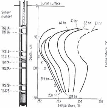
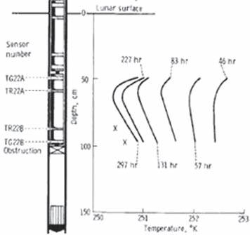
Lord kelvin’s temperature / heat flow experiments in 1846 (and onward) were duplicated by Apollo 15 astronauts on the lunar surface in June 1971 (Figure 2). The holes were only 1.5 to 3.2 meters deep and the logging tool was stationary, but the results were recorded versus depth, so these surveys are the first petrophysical logs recorded off planet Earth.
Apollo 17 astronauts repeated these temperature surveys and Apollo 16 and 17 crews also ran surface resistivity (E m -style) surveys, similar to Conrad Schlumberger’s early work in France (Figure 3). The lunar results: “The m oon is very dry”. Golly, w ho would have guessed that? But don’t despair. The moon has been mapped for neutron absorption and some areas absorb neutrons better than others. Hydrogen, hydrocarbon, or water? Or some other
(Continued on page 24...)


rocks were returned to Earth and subjected to myriad tests, much as we have done for many years on Earth in the oil and mineral business. Sample lunar cores are illustrated in Figure 7.
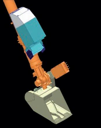
The Thermal and Electrical Conductivity Probe (TECP) on the m ars Phoenix Lander was designed to measure petrophysical properties on and near the surface of m ars. Physical properties of the near-surface of m ars were recorded during a five-month period from June to October 2008.
Phoenix was equipped with a miniature back-hoe (called the Robotic Arm or RA for short) to dig trenches and deliver soil samples to other experiments inside the spacecraft. The TECP probe was mounted on the pivot at the RA scoop so it could be pressed into the surface soil or the wall of a trench (Figures 8, 9, and 10).
The primary purpose of the TECP was to measure the concentration and nature of water in m ar tian soils in solid, “nonfrozen,” liquid, and vapor states. Other objectives were to determine changes in the reservoirs of water when soil is freshly exposed and to characterize the movement of water in and out of the soil by measuring atmospheric humidity, temperature, and wind speed above the surface. Sounds a lot like reservoir evaluation and monitoring.
There are hundreds of ASCII data files available with the results of the TECP
(...Continued from page 23)
absorber (like iron, for example)? Who knows?
Figure 4 (page 23) shows samples of the temperature logs taken during Apollo 15 in 1971.
Shallow cores were taken during Apollo 15, 16, and 17 missions (Figures 5 and 6). Rocks were also analyzed in-situ with x-Ray fluorescence and photography. Samples of
The TECP is adapted from the commercial k D-2 multi-purpose probe made by Decagon Devices. The four-pin probe determines electrical conductivity by a twopin LC (dielectric constant) approach and a redundant four-pin van der Pauw technique. The four-pin EC method is similar to the Schlumberger four-electrode AmNB surface resistivity electrode arrangement from the early 1900s. Thermal conductivity is measured by a pulse-decay method using a heater and a thermocouple pair embedded in the pins.

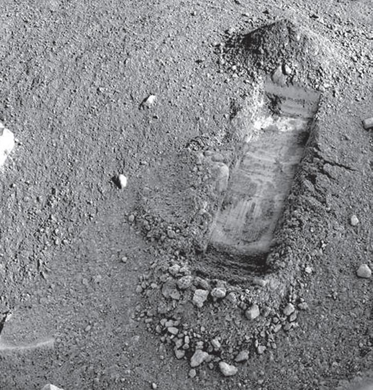
measurements, recorded versus time and day of acquisition. None appear to have been plotted versus depth in the trenches that were dug by the robotic arm (Figure 11). However there are lots of images that are strikingly similar to resistivity microscanner images.
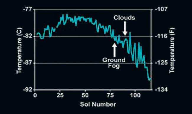
Phoenix was purposely placed on the m artian Arctic Plain. It is cold there (Figure 12, page 26), but not impossibly so – a mere 70°C colder than the Canadian Arctic Islands, where we have found more than 17 Tcf of natural gas. So, who is ready to drill on mars?
The meteorological station on Phoenix was designed to monitor changes in water abundance, dust, temperature, and other variables in the m artian atmosphere. The Canadian Space Agency, York University, University of Alberta, Dalhousie University, Optech, and the Geological Survey of Canada designed and monitored the science operations of the station, which was built by Canadarm-maker m acDonald Dettwiler and Associates Ltd. of Richmond, B.C.
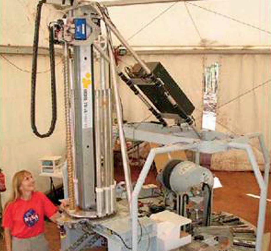
After Phoenix comes m ARTE, a proposed stratigraphic-drilling program for m ars. m ars Astrobiology Research and Technology Experiment ( mARTE) performed a field test simulating a robotic drilling mission on m ars in September 2005. The experiment took place in minas de Rio Tinto in southwestern Spain, a highly relevant m ars analog site. The experiment utilized a 10 m dry auger coring drill, a robotic core sample handling system, onboard science and life detection instruments, and a borehole inspection probe – all of which were mounted to a simulated lander platform (Figure 13, page 26).
The prototype robot drilling/coring/logging machine reached 10 meters. Plans for 100 meter capability are in the works. The

objective is to advance the search for life on m ars, but where there is life, there is a possibility of hydrocarbons. There is methane in the m artian atmosphere and spectroscopy mapping indicates carbonate rocks, as well as the more obvious lava, dust, and other sediments. Interested parties can apply to ross@spec2000.net for drilling concessions.
m ARTE can drill, core, and run neutron and fluorescence logs. Neutron logs see water
and ice; fluorescence logs see bacteria. The Ames tool is so sensitive, it can see a single bacterium. The core samples can be analyzed on the drilling platform, then stacked for future examination. The remote sensing core analyzer can face or saw core samples, run spectrography, and prepare powder samples.
The borehole inspection system (BHIS) runs the neutron probe, a panoramic
(Continued on page 26...)
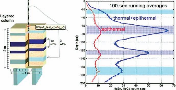
microscopic imager, and spectrometer. The borehole neutron log (BneuP) measures both thermal and epithermal neutron count rates (Figure 14). A surface version of the tool, to be carried on a m ars rover, is called (you guessed it) SneuP. It is intended as a dowsing machine, looking for hidden near-surface water or ice deposits.
It’s all real and working (almost). We just have to get it there and get to work.
All image credits: NASA/JPL http://www.jpl. nasa.gov/
Moon Logs
http://history.nasa.gov/alsj/a15/as15psr.pdf http://history.nasa.gov/alsj/a16/as16psr.pdf http://history.nasa.gov/alsj/a17/as17psr.pdf
Mars Logs
http://an.rsl.wustl.edu/phx/psearch.htm http://www.nasa.gov/mission_pages/phoenix/ main/index.html
Future Mars Logs www.nasa.gov/centers/ames/research/ exploringtheuniverse/marsdrill.html www.nasa.gov/centers/ames/multimedia/ images/2005/martedrill.html www.lpi.usra.edu/meetings/leagilewg2008/ presentations/oct31am/Stoker4010.pdf

E. R. (Ross) Crain, P.Eng. is a Consulting Petrophysicist and a Professional Engineer with over 45 years of worlswide experience in integrated petrophysical analysis
Ross is an Honourary Member and Past President of the Canadian Well Logging Society (CWLS), a Member of Society of Professional Well Log Analysts (SPWLA), and a Registered Professional Engineer with Alberta Professional Engineers, Geologists and Geophysicists (APEGGA).
This article is reprinted with permission from the May 2010 Insite magazine of the CWLS.
Without volunteers, the CSPG would not be able to provide its members with the numerous programs it offers. Volunteering with CSPG has numerous benefits including: learning or developing a new skill, being a part of the geoscience community, boosting career options and gaining new experiences. Various committees have new volunteer opportunities as outlined below.
CSPG offers an integrated education program to help in the professional development of its membership. All education curricula are designed for professional members in various stages of their technical careers (junior, intermediate, senior, and expert). The committee is looking for volunteers to fill the following positions:
a ssistant Chair
This is a leadership role transitioning into Committee Chair for 2012. Time commitment is approximately 12 to 15 hours plus one to two lunch meetings per month, increasing during the month leading up to and throughout the annual geoConvention.
Field Seminar Coordinator
Help bring the latest and greatest field seminars to the CSPG membership!
Time commitment is eight to ten hours plus one to two lunch meetings per month, increasing during the month leading up to
and throughout the annual geoConvention. Short Course Coordinator –e ducation Week/geoConvention Support the CSPG membership by working with professional instructors to offer the latest industry-related courses.
Time commitment is eight to ten hours plus one to two lunch meetings per month, increasing during the month leading up to and throughout Professional Development Week and/or the annual geoConvention.
The SIFT experience is a once in a lifetime opportunity offering an intense, informative and interactive two week long adventure that includes seminars, lectures, field trips, an exploration game, and a lot of fun. One lucky student from each of the C anadian universities offering degrees in geoscience is chosen to fly to Calgary to take part in this comprehensive introduction to the petroleum industry.
The SIFT committee is looking for two to three members to add to the committee. Volunteers must have more than five years’ experience working in the Oil and Gas industry.
The m edal of m erit Award is awarded annually for the best paper on a subject related to the petroleum geology of Canada.
Two more members are needed to fill the committee. Volunteers must have at least five years of industry experience, a m asters or PhD and expertise in structural geology or unconventional plays.
The Squash committee helps organize one of the many successful social events the CSPG puts on every year; a committee Chair is needed to run this vibrant group.
Time commitment is approximately eight to ten hours plus one to two lunch meetings per month, increasing during the week leading up to and including the event.
The primary task of the Advertising committee is to coordinate advertising at CSPG Technical Luncheons which consists of PowerPoint presentations and table-top brochures/postcards.
Responsibilities of this role include the following:
1. Schedule advertisers for all Technical Luncheons (18-19 luncheons per year).
2. m erge PowerPoint files sent by advertisers into one or two final presentations to be shown at the luncheons.

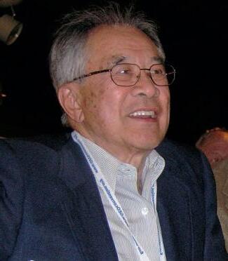
It is with great regret that CSPG announces the passing of long-time member Mr. George Fong. He passed away on August 20, 2011 at the age of 85.
George had a long history with CSPG and was a member since 1949. During his career he received the prestigious CSPG Stanley Slipper Gold Medal (1995) for his contributions to petroleum exploration and the CSPG Link Award (1959) for the best Technical Luncheon presentation.
CSPG wishes to express its sincerest condolences to George’s wife Ruby and their entire family; he will be missed, greatly.
Professional Development Week Short Courses
•Fault failure mechanisms, fracture development, and resource plays –Analysis and the role of fluid pressure – Paul MacKay
•Log Analysis of Unconventional Reservoirs - Ross Crain
•Rock Creek Stratigraphy, Sedimentology, and Petroleum Geology - Doug Cant
•The Architecture of Fluvial Reservoirs - Andrew Miall
•Writing for Earth Scientists: A One-day Clinic - Matt Hall
•Basic Core Logging with Integrated Ichnological Techniques - Kerrie Bann
•Sequence Stratigraphy: Principles and Applications - Octavian Catuneanu
• Optimization of Fractured Well Performance of Horizontal Wells - Ruhul Amin
•Petroleum Geomechanics for Developing Unconventional Resources - Pat McLellan
(...Continued from page 27)
3. Create and/or merge scripts for advertisers; providing the final script to the luncheon coordinator a few days prior to the luncheon.
4. Load the final PowerPoint files onto a CSPG laptop.
5. Set up and tear down the laptop at each luncheon
6. Assist with the distribution of any table advertisements (flyers, postcards, etc.)
7. Summarize billing information for each luncheon and provide the summary to the CSPG office staff for processing
8. Meetings with other committees as required.
Time commitment averages approximately five to seven hours per month. Most of the work can be performed outside of normal work hours except for set up and tear down at the luncheons (one to two hours outside of the noon hour every couple of weeks). Note that volunteers are expected to purchase tickets for the luncheons that they attend.
If you are interested in filling any of these positions please contact Kasandra Klein at kklein@cspg.org or 403-513-1233.
•Mannville Stratigraphy, Sedimentology, and Petroleum Geology - Doug Cant
•The Stratigraphic Setting of Lower and Middle Triassic Strata - Jim Dixon
•Subsurface Methods - Core Work and Log Correlation in Clastic Sediments - Doug Cant


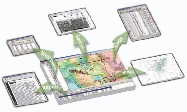
Get the full picture with comprehensive integration of IHS PETRA®, IHS PetraSeis® and IHS GeoSyn™.


When these three solutions seamlessly connect, geological and seismic workflows are streamlined with easy-to-interpret data and modeling tools. This integrated bundle allows you to access, view and manipulate information within the same project; create multidimensional seismic models and synthetics; improve workflow collaboration; and deliver comprehensive proposals for new prospects. Get to the field faster with seismic, well, production, log and economic data at your fingertips.
See more solutions at www.ihs.com/cspg-1

The Executive Committee has approved the following list of Honors and Awards for 2012. The awards will be presented at the
Sidney Powers m emorial award
koenraad J. Weber (Europe)
m ichel t. Halbouty o utstanding l eadership award
Robbie R. Gries (Rocky m ountain)
Honorary m ember award
Adekunle A. Adesida (Africa)
Ibrahim A. Al-Jallal ( m iddle East)
Lee T. Billingsley (Gulf Coast)
Dudley W. Bolyard (Rocky m ountain)
Paul m. Harris (Pacific)
Phillip H. Stark (Rocky m ountain)
Norman H. Foster o utstanding e xplorer award
Dan A. Hughes (Gulf Coast)
r obert r. Berg for o utstanding r esearch award
Henry W. Posamentier (Gulf Coast)
Distinguished Service award
Edith C. Allison (Eastern)
Susan m. Cunningham (Gulf Coast)
David A. Dolph (Canada)
Paul F. Hoffman (Gulf Coast)
Alain-Yves Huc (Europe)
William A. m organ (Gulf Coast)
Adedoja R. Ojelabi (Africa)
Victor H. Vega (Latin America)
m ark L. Wilson (Pacific)
Grover e. m urray m emorial
Distinguished e ducator award
Andrew Hurst (Europe)
Howard D. Johnson (Europe)
Harrison Schmitt award
Jill Stevens (Asia/Pacific)
Public Service award No Awardees
Pioneer award
Tim T. Schowalter (Rocky m ountain)
Publication awards
Wallace e. Pratt m emorial award
Robert H. Lander and Linda m. Bonnell


r obert H. Dott, Sr. m emorial award
m. Pöppelreiter, C. García-Carballido and M. A. Kraaijveld
J. C. “Cam” Sproule memorial award
Alexei V. m ilkov
John W. Shelton Search and Discovery award k atherine Giles
George C. m atson award
Lars Wensaas
Co-Authors: m arita Gading, Helge Loseth and m ichael Springer
(Co-Authors are not recipients of the George C. Matson Award)
Jules Braunstein m emorial award
Roger m. Slatt and Younane Abousleiman
Geosciences in the m edia award
Nick Eyles (Non-member)
President Paul Weimer has notified the honorees. At this time, the names of the honorees are considered public information. A comprehensive press release will be issued at a later date.


| By CSPG President Kirk Osadetz.
Governments and the public now pay close attention to corporate governance, especially since the early 2000s, when many industrial conglomerates collapsed, but also more recently following the 2008 global crisis in financial markets. Many jurisdictions and organizations are currently considering more stringent corporate oversight to ensure that corporations operate using appropriate legal and fiduciary practices on behalf of their members’ best interest.
The CSPG Executive Committee is responsible for the governance, management, and operations of the CSPG to achieve our objectives. As a “not for-profit” organization, the CSPG Executive Committee (Board), Committees, Divisions, and Programs are accountable both to our members and the general public as our mission includes scientific outreach and public awareness. We also have an obligation to our predecessors, who conceived and built one of the world’s finest regional geoscience societies. “Governance” comprises the structures and processes the CSPG uses to direct and manage its operations, programs, and activities. Yet, Governance is not necessarily “Good Governance.” “Good Governance” means that we achieve our desired goals in the right way. Specifically, in ways that are rational and scientific as well as consistent with our Canadian democratic and social values.
In 1997, the United Nations enunciated the characteristics “Good Governance” including:
1. Participatory decision making and consensus building in the best interest of the organization.
2. Accountability and transparency.
3. Responsive, effective, and efficient performance.
4. Equity and sound rule of law.
5. Strategic planning.
Good governance includes the “structures, functions (responsibilities), processes (practices) and traditions that we all use to ensure the accomplishment of our goals and mission.” Two years ago the Executive
Committee revitalized our strategic planning functions. Last year the Executive Committee adopted the “Committee Approval Request Form” to strengthen financial and program accountability for decision making within CSPG. Part of this year’s governance initiative has included a review and adjustment of our financial assets to improve member value, minimize risks, and ensure financial performance. We meet regularly with our Geoconventions partners to improve the delivery and performance of our annual convention.
Another part of our Governance initiative includes the review and, as required, the proposal of amendment to our by-laws, which were last amended in 2003. Based on this review we are preparing detailed by-law amendments for approval by the membership during the 2011 elections, as is required.
We are preparing by-law amendments that will attempt to do five things:
1. Broaden the mission of the Society and adopt a trade name to better reflect and recognize the diverse practice of current and future members engaged in “Energy Geoscience” in sedimentary basins. Such changes are aligned to similar changes at APEGGA that recognize the convergence within the Geosciences.
2. Simplify individual membership and encourage all regular individual members to support the Society appropriately. Currently, we have about 400 emeritus members within an aging membership. To remain viable and strong our demographic projections require all voting members to pay our modest annual membership dues. In fact many “Long-time” and Emeritus members voluntarily continue to pay fees like regular members. The AAPG is also considering simplification of its membership classes.
3. Address Executive Committee workload and effectiveness issues by increasing the number of Directors and moving from an individual portfolio directorate structure to a flexible standing committee-based model of
Executive Committee function and performance.
4. Attempt, so far as is possible legally, to ensure that Society assets remain at the disposal of the membership should the Society decide, in the future, to reorganize, or otherwise change its structure and incorporation to better serve its members.
5. Strengthen democratic values and provide foresight for future CSPG success and “good governance.”
It remains our intention to post the proposed changes in detail, with explanations and rationales, on the CSPG website once they are endorsed by the Executive Committee. As required by our by-laws and Government Agencies all voting members will consider and vote on the proposed changes during this year’s Executive Committee Election in December. Voting will be on each article. Hence the proposed number of changes will be modest.
Now might be a good time for you to visit the CSPG website and reacquaint yourself with the by-laws. Following the voting, the approved changes will not come into effect until they are vetted by government regulators and legally registered. The process of changing our by-laws is neither simple nor easy. Still, it will be worth the effort, if we can provide a future framework for the continuing success, impact, and value of the CSPG on behalf of its current and future members. ( more information will follow in the November issue.)
In the September Reservoir issue (page 53), the date of the Honorary Address was incorrectly published as November 3, 2011.
Please note that the correct date is Wednesday, November 2, 2011.
| By Philip Benham and Yingchun Guan
Dedicated to Ted Danner, who inspired so many to become geologists. The Reservoir Committee welcomes contributions from our readership to this series. If you wish to offer a submission to Go Take a Hike on your favourite hike of geological interest, email the Reservoir at caitlin. young@cspg.org for more information.
trailhead: From the US border in Tsawwassen proceed south on Tyee Drive and then turn left (east ) on APA road. Park (P) at the cemetery and follow the trail leading to Lily Point marine Reserve. The path is flat and easy until it turns left and down the slope. In the grass at the bottom of the slope and on the shore are the remains of a cannery. Proceed left to the sea cliffs.
Distance: ~4 km return. First leg is maintained trail, second leg is gravel beach. Lower levels of sea cliff at end of trail are easily accessible, upper levels are a tricky scramble.
elevation Gain: 60m relief in return from beach to top of cliff.
Not far from Vancouver lies the US enclave of Point Roberts. The curve of Boundary Bay swings north of the 49th parallel isolating this small peninsula from the rest of Washington State. Lily Point marine Reserve is a popular destination to hike and explore the remains of the Alaska Packers Association Salmon cannery, which went out of business in 1917. It is also home to a spectacular sea cliff which exposes Ice Age strata.
The sediment was primarily deposited in the late Pleistocene during the Vashon Stade when the glaciers pushed offshore into Puget Sound about 15,000 BP (Armstrong et al., 1965). The ice retreated around 13,500 BP and Tsawwassen stood as an island until about 3,000 years ago when the growing Fraser delta reconnected it with the mainland ( mathews, 2005). Archaeological excavations reveal fishing camps dating back 5,000 years or more and First Nations’ legends recount the use of a rope to pull Tsawwassen onto land during battle with a giant octopus, an ancestral observation of the geological processes at work! Those processes continue today and you may notice landslips (such as at red dot) with tilted blocks and “drunken” trees as the ocean inevitably erodes the coastline.
The strata exposed in the sea cliffs consists primarily of laminated sands but also contains minor clay and silt beds. Look for angular erosional surfaces with lags of rip-up clasts and granitic cobbles. The sediment appears to be deposited fairly rapidly in proximity to the glacial ice front, which terminated in the ocean. meltwater from underneath the ice would have the capacity for rapid delivery of sediment. Clastic dikes are a common feature of the cliffs; these may have been triggered by sediment loading or earthquakes. The dikes consist of muds and silts and exhibit complex patterns of lateral and vertical migration.
reference: Mathews. 2005. Vancouver Is. Transmission Reinforcement Project: Archaeological Overview, millennia Res. Ltd. (available as online PDF). Armstrong, J., Crandell, D., Easterbrook, D., and Noble, J. 1965. GSA Bulletin, v. 76, no. 3, p. 321-330. Danner, W.R. 1969. GSA Abstracts with program, part 3, p.14.
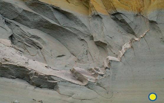

by
Coarse rip-up clast lag, the scour cuts into laminated sandstones

View from cliffs south to Lily Point, where the remains of the turn-of- the-century salmon cannery litter the shore. Numerous Coast Plutonic Complex granite erratics rest on the beach. They have washed out from the cliffs and are left behind as shoreline erosion winnows out the finer sediment
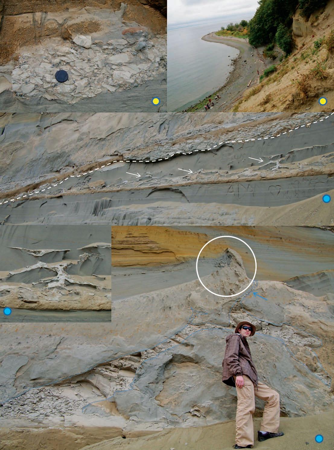
Much of the exposure consists of laminated or low-angle cross-bedded sands with occasional floating pebbles. Thin clay beds are deposited during periods of relative quiescence. These deform as coarser sediment is deposited on top. Note the clast-filled scour surface cutting down to the left (white dashed line). This deposit may be the trigger for the complicated reticulate injection patterns of the clay bed (arrows). See detail of injection below left; what appear to be isolated pods are connected in 3D.
In this case, the volume of fine-grained sediment injected in the dikes (outlined by dashed line) is large. Sediment has flowed at least 8 metres laterally and has uplifted the bed it flowed into. The dike appears to have broken through to the active depositional surface (see small branch indicated by blue arrow). The uplift created relief on the injected bed, it has been bent and partially eroded by current flow from right to left (see circle). The lee side of the sediment spike contains a lag of pebbles. Any relief created by the injection is rapidly covered by laminated and cross-bedded sands.

CORPORATE MEMBERS
APACHE C ANADA LTD
APEGGA
BAkER ATLAS
BDO C ANADA LLP
C ANADIAN NATURAL RESOURCES LTD
C ASEY & ASSOCIATES
CONOCOPHILLIPS C ANADA LImITED
DEVON C ANADA CORPORATION
E NERPLUS CORPORATION
E xxON mOBIL UPSTREAm RESEARCH COm PANY
GEOLOGIC SYSTE mS LTD
GEOSTRATA RESOURCES INC.
H UNT OIL COm PANY OF C ANADA
HUS kY ENERGY INC.
IHS
Im PERIAL OIL RESOURCES
JEWELSUITE
kkD OIL SANDS PARTNERSHIP
LITTLE ROCk DOCU m ENT SYSTE mS
mJ SYSTE mS
m URPHY OIL COm PANY
NExEN INC .
PENN WEST PETROLEU m LTD
PETROCRAFT PRODUCTS LTD
PLUSPETROL S.A
ROx AR
RPS E NERGY C ANADA LTD
SCHLU m BERGER
S HELL C ANADA LImITED
S PROULE ASSOCIATES LImITED
SUNCOR E NERGY INC .
TALIS mAN ENERGY INC
TOTAL E&P CANADA LTD.
TOURmALINE OIL CORP
AS OF SEPTEMBER 10, 2011
CSPG welcomes our 2011 Corporate Members! The benefits of being a corporate member include:
• Recognition in the monthly Reservoir and quarterly Bulletin
• One associate membership
• Reserved tables at the technical luncheons with your company logo
• One free pass to the CSPG Core Conference
…and more! Contact Kasandra Klein at Kasandra. klein@cspg.org to be a corporate member today!
| By Tannis McCartney
In the Fall of 2010, the University Outreach Committee conducted a survey of our student members to find out how the committee, and the Society, could serve them better. 95 students responded, representing approximately twenty percent of the student membership at the time of the survey.
An overarching theme in the requests from students was for more direct communication between the University Outreach Committee and students. In fact, 91% of the respondents said they would read an electronic newsletter specifically for students, with most of them preferring that it be delivered monthly. A student newsletter is something that members of the University Outreach Committee have considered in the past, but until the CSPG changed the format of student memberships (in 2009) this wasn’t feasible.
The CSPG Student Newsletter launched in late 2010, with four PDF issues delivered to student members (via e-mail) during that year. The content is generated by members of the University Outreach Committee, and now serves as our primary means of informing students about upcoming events and deadlines. This doesn’t replace our contributions to the Reservoir—we still recognize that this is the best way to report to the membership at large about the work our committee does.
The newsletter will continue in the upcoming school year, with the goal of
producing no less than six issues. The University Outreach Committee uses the newsletter to make announcements about upcoming events, programs, and deadlines of interest to students, but it also has room for student submissions and fun stuff.
One of the regular features will be a “get to know members of the University Outreach Committee” section. We started this section last year, with members of the committee answering questions about their geology background and a few fun questions, such as “What is your favourite meal,” “What is your favourite rock and/ or mineral,” and “What was the last music album you listened to all the way through?” Hopefully this section will give our student members insight into just how cool the CSPG volunteers dedicated to them are.
The newsletter isn’t the only new initiative of the University Outreach Committee. We’re revamping the Student Chapter program and turning it into grants for student group activities (such as field trips and attendance at conferences, to name just two examples). Committee members are also hard at work developing the Undergraduate Awards and planning more Lecture Tours for the 2011-2012 school year.


Landmark’s new DecisionSpace® Desktop software accelerates seismic interpretation with geomodel-enabled workflows.
The geophysics and geology modules in Landmark’s new unified DecisionSpace® Desktop software share the same topology engine. This gives geophysicists easy access to framework construction tools that combine well picks and horizons to produce a high resolution, accurate geomodel. The geomodel uses conformance technology to produce well-based surfaces at the same resolution as seismic data, enabling a model that truly represents your reservoir. Get better answers faster. Visit halliburton.com/decisionspacedesktop