


Focus, quality and value. We don’t build our reputation on volumes—instead, we earn it on the quality of the information we extract from that data. For more than 75 years, IHS has processed and analyzed vast amounts of raw data, concentrating it into the in-depth, actionable information that is used today to advance energy-critical business decisions. Energy information, refined.
ihs.com/refined-information/cspg


CSPG OFFICE
#600, 640 - 8th Avenue SW
Calgary, Alberta, Canada T2P 1G7
Tel: 403-264-5610 Fax: 403-264-5898
Web: www.cspg.org
Office hours: Monday to Friday, 8:30am to 4:00pm
Executive Director: Lis Bjeld
Email: lis.bjeld@cspg.org
Advertising & Sponsorship Coordinator: Alyssa Middleton
Email: alyssa.middleton@cspg.org
Publications Coordinator: Caitlin Young
Email: caitlin.young@cspg.org
Member Services Coordinator: Kasandra Klein
Email: kasandra.klein@cspg.org
Registration Coordinator: Dayna Rhoads
Email: dayna.rhoads@cspg.org
Convention Contacts
Convention Manager: Aileen Lozie
Email: aileen.lozie@cspg.org
EDITORS/AUTHORS
Please submit RESERVOIR articles to the CSPG office. Submission deadline is the 23rd day of the month, two months prior to issue date. (e.g., January 23 for the March issue).
To publish an article, the CSPG requires digital copies of the document. Text should be in Microsoft Word format and illustrations should be in TIFF format at 300 dpi., at final size. For additional information on manuscript preparation, refer to the Guidelines for Authors published in the CSPG Bulletin or contact the editor.
Technical Editors
Ben McKenzie Colin Yeo (Assistant Tech. Editor) Tarheel Exploration EnCana Corporation
Tel: 403-277-4496 Tel: 403-645-7724 Email: bjmck@telusplanet.net Email: colin.yeo@encana.com
Coordinating Editor
Caitlin Young, Publications Coordinator, CSPG Tel: 403-513-1227, Email: caitlin.young@cspg.org
ADVERTISING
Advertising inquiries should be directed to Alyssa Middleton, Tel: 403-513-1233, email: alyssa.middleton@cspg.org. The deadline to reserve advertising space is the 23rd day of the month, two months prior to issue date.
The RESERVOIR is published 11 times per year by the Canadian Society of Petroleum Geologists. This includes a combined issue for the months of July and August. The purpose of the RESERVOIR is to publicize the Society’s many activities and to promote the geosciences. We look for both technical and non-technical material to publish. Additional information on the RESERVOIR’s submission guidelines can be found at http://www.cspg.
Glenbow Archives nd_3_4155a (detail).
For more information or to apply for a ConocoPhillips Glen Ruby Memorial Scholarship, visit: www.cspg.org or www.conocophillips.ca Application Deadline is October 31st, 2010
ConocoPhillips Canada is proud to continue the ConocoPhillips Glen Ruby Memorial Scholarships in Geosciences. These scholarships are presented each year to second, third, and fourth years students to promote excellence in petroleum GEOLOGY and GEOPHYSICS.
$2,000 $3,000 $5,000 2nd year geoscience student 3rd year geoscience student 4th year geoscience student
ConocoPhillips Canada is pleased to recognize and honour a pioneer who has had a lasting influence on the Canadian Oil and Gas industry. From 1926 to 1929, Glen Ruby was Vice President and General Manager of Marland Oil’s Canadian partnership, Hudson’s Bay Oil and Gas. While in Alberta he was a driving force behind the inaugural meeting and formation of the Alberta Society of Petroleum Geologists (renamed Canadian Society of Petroleum Geologists in 1972).
Glen Ruby dedicated his life to exploration and has been recognized as one of the great pioneers in the global search for oil and gas. In addition to Canada, he successfully explored for oil in Chile, Alaska, and the US Rocky Mountain basins. At one time he was credited with having made the most northerly and southerly oil discoveries in the world.
Since inception, the Canadian Society of Petroleum Geologists has been a forum for sharing ideas and knowledge about the geology of Western Canada and the Canadian frontiers. This knowledge exchange has played a fundamental role in the successful development of the Canadian oil industry. Glen Ruby’s legacy thrives three-quarters of a century later.
ConocoPhillips has been active in Canada since 1880 through the activities of heritage companies including Continental Oil Company, Marland Oil/ Hudson’s Bay Oil and Gas, British American, Royalite, Asamera, Pennzoil, Stampeder, Mannville, Crestar, Gulf Canada Resources, Poco, Canadian Hunter, Burlington Resources, Conoco Canada, and Phillips Petroleum. We proudly honour Glen Ruby as a pioneer and industry leader and we are pleased that the memorial scholarships will assist in the development of future geoscientists.
Geoscientists for our future


CSPG
EXECUTIVE
PRESIDENT
John Varsek • Cenovus Energy john.varsek@cenovus.com Tel: (403) 645-5417
VICE PRESIDENT
Kirk Osadetz • Geological Survey of Canada, Calgary kosadetz@nrcan.gc.ca Tel: (403) 292-7022
PAST PRESIDENT
Graeme Bloy • Canada Capital Energy Corporation gbloy@capitalenergy.ca Tel: (403) 975-5784
FINANCE DIRECTOR
Greg Lynch • Shell Canada Ltd. greg.lynch@shell.com Tel: (403) 691-3111
ASSISTANT FINANCE DIRECTOR
Darren Aldridge • Baker Hughes darren.aldridge@bakerhughes.com Tel: (403) 537-3505
PROGRAM DIRECTOR
Scott Leroux • EnCana Corporation scott.leroux@encana.com Tel: (403) 645-2000
ASSISTANT PROGRAM DIRECTOR
Brett Norris • TransGlobe Energy Corp. brettn@trans-globe.com Tel: (403) 264-9896
SERVICE DIRECTOR
Ayaz Gulamhussein • NuVista Energy Ltd. ayaz.gulamhussein@nuvistaenergy.com Tel: (403) 538-8510
ASSISTANT SERVICE DIRECTOR
Richard Thom • Core Laboratories Canada Ltd. richard.thom@corelab.com Tel: (403) 250-4052
OUTREACH DIRECTOR
Mike DesRoches • Talisman Energy Inc. mdesroches@talisman-energy.com Tel: (403) 513-6843
ASSISTANT OUTREACH DIRECTOR
Steve Dryer • Consultant whiskeyjackresources@telus.net Tel: (403) 969-2292
COMMUNICATIONS DIRECTOR
Stephen Hubbard • University of Calgary steve.hubbard@ucalgary.ca Tel: (403) 220-6236
ASSISTANT COMMUNICATIONS DIRECTOR
Jim Barclay • ConocoPhillips
Jim.E.Barclay@conocophillips.com Tel: (403) 532-3889
EXECUTIVE DIRECTOR
Lis Bjeld • CSPG lis.bjeld@cspg.org Tel: (403) 513-1228
A message from the CSPG Past President, Graeme Bloy
Over the past two and one-half years, the CSPG has undergone significant change and reorganization on its business-side under the guidance of the past three executives. The significant business changes that took place are as follows:
Financial accountability:
From book-keeping and accounts payable/ receivable to budgeting, the Society and Executive now can access up-to-date numbers immediately.
Agreements, Contracts, Memorandum Of Understanding:
The Society has entered into numerous renegotiated joint agreements/contracts with the CSEG, CSPG Education Trust Fund, CWLS, Joint Annual Convention Committee, AAPG, and CSPG office staff; ensuring that there is transparency and a clear understanding of these contracts; plus ensuring they do not create further legal and/or economic liabilities to the Society.
Creating the position of Executive Director:
The CSPG Executive has, under contract, hired Lis Bjeld to fill this position. Lis has extensive experience h aving both a Bachelor of Education and being a Certified Management Accountant (CMA) and a Fellow of CMA. With this experience and support for the Directors, the Society is now a “professionally run” not-forprofit society that is readily accountable to the numerous regulatory agencies, the Executive, and CSPG members.
The CSPG Executive and the Executive Director have ensured that there is dedicated, competent, professional office staff to replace the Society’s waning and over-taxed volunteer base. They are fairly compensated (salary and benefits) and are supported and evaluated yearly by
the compensation and benefits committee (C.B.C.) and the Executive.
So why so much change? Why not let the Society run as it has done for the past two decades? Believe me, it would have been so much easier to do so. Past and present Executives have had a difficult time implementing strategic plans (initially set out in 2005) that were necessary to keep the Society relevant to the membership by providing, improving, and achieving continued excellence in technical programs, education, publications, and outreach; the core activities of the Society. Now, with financial stability in the Society (to be reported at the close of the fiscal year) the Executive is focused on the core essence of the Society.
Of course, with the changes over the past two-plus years, there have been miscommunications and misperceptions with some of the more “invested and passionate” CSPG members. For that I apologize, mea culpa, for not ensuring some clarity for all these changes.
The actions of the past three Executives will strengthen the Society and hopefully this will be apparent as the Society rolls out the revitalized programs; using the strategic vision that President John Varsek has articulated throughout the past year, whether it is publications, the website, continuing education, or outreach programs.
Stay tuned and please get involved.


CORPORATE
MEMBERS
AGAT LABORATORIES
APACHE CANADA LTD.
BAKER ATLAS
CANADIAN NATURAL RESOURCES LIMITED
CASEY & ASSOCIATES
CENOVUS ENERGY INC.
CONOCOPHILLIPS CANADA LIMITED
DEVON CANADA CORPORATION
FUGRO AIRBORNE SURVEYS CORP.
geoLOGIC systems ltd.
GEOSTRATA RESOURCES INC.
HUSKY ENERGY INC.
IHS
IMPERIAL OIL RESOURCES
LARIO OIL & GAS COMPANY
LITTLE ROCK DOCUMENT SERVICES
MJ SYSTEMS
MURPHY OIL COMPANY
NEXEN INC.
PETROCRAFT PRODUCTS LTD.
PLUSPETROL
PROVIDENT ENERGY LTD.
RPS ENERGY
SHELL CANADA LIMITED
SPROULE ASSOCIATES LIMITED
SUNCOR ENERGY INC.
TOTAL E&P CANADA LIMITED
TOURMALINE OIL CORP.


MultifrequenCy dieleCtriC diSperSiOn ServiCe and Oil Sands,


about Carbonates, Shaly Sands, and Heavy Oil

High-resolution radial measurements accurately determine weight percent bitumen in Canadian oil sands with shale intervals and variable formation water resistivity.
Get the full story about this and other case studies at www.slb.com/ds
403-509-4000
Global Expertise Innovative Technology Measurable impact
SPEAKER
Michael J. Melchin Department of Earth Sciences, St. Francis Xavier University
11:30 am
Thursday, October 14, 2010 Calgary TELUS Convention Centre Calgary, Alberta
Please note:
The cut-off date for ticket sales is 1:00 pm, Friday, October 8, 2010.
CSPG Member Ticket Price: $42.00 + GST. Non-Member Ticket Price: $45.00 + GST.
Each CSPG Technical Luncheon is 1 APEGGA PDH credit. To book your tickets or table, visit http:// www.cspg.org/events/events-luncheons.cfm.
The latest Ordovician, Hirnantian Mass Extinction Event (HME) was the second largest extinction event in the Phanerozoic, and it coincided with a period of profound changes in climate, ocean circulation, and sea level. Sedimentological evidence shows that the beginning of the Hirnantian (ca. 446 Ma) was a time of dramatic expansion of continental ice sheets in southern polar regions of Gondwana, and that this event was marked by a significant global sea level fall and increased circulation and oxygenation in the deep oceans. Globally recognized shifts in oxygen isotopes through the glacial interval are interpreted to represent a combination of climatic cooling and changes in ocean salinity. Significant positive shifts in carbon isotopes are more controversial, but are widely considered to be the result of some combination of changes in
biological productivity and increased rates of carbonate weathering resulting from sea level fall and exposure of widespread, late Ordovician carbonate platforms.
The HME occurred in two main phases; one at the beginning and the other at the end of the period of peak glaciation. Graptolites, the most abundantly preserved group of zooplankton in the Ordovician-Silurian seas, were most profoundly affected by the first phase of the HME, and all but one of the major graptolite groups became extinct in this event. High-resolution global analysis of graptolite biodiversity and abundance data, however, show that the patterns of graptolite turnover varied geographically. In most paleotropical regions, particularly those surrounding Laurentia, the faunal turnover was abrupt and coincided with the time of onset of peak glaciation. Although many areas show a few pre-extinction survivors into the Hirnantian, their abundance and diversity were both dramatically and abruptly reduced. In paleotropical South China, the faunal turnover is much more gradual, spanning the whole of the Hirnantian, suggesting that the ecological changes that triggered the extinction were slow to penetrate that region. On the other hand, high-paleolatitude regions show lowdiversity graptolite faunas both before and after the onset of glaciation. In addition, the graptolite species that dominate the post-extinction faunas globally appear to have originated prior to the Hirnantian in high paleolatitudes. Current evidence suggests that their spread into the tropics accompanied the movement of cooler, oxygenated waters into lower latitudes as the Gondwana glaciers expanded and their influence on global climate and ocean circulation intensified.
New nitrogen isotope evidence suggests that, at least in some regions, a change from graptolitic black shales to more oxic facies at the beginning of the Hirnantian was marked by a fundamental change in the community of primary producers, from cyanobacterialdominated to more algal-dominated. This change in the base of the food web may have triggered a cascading ecological crisis that resulted in the first phase of the HME, which is most strongly seen in low-latitude, planktonic and deeper-marine assemblages.
The end of the glaciation was marked by a period of significant eustatic rise and the widespread deposition of organic-rich, black shales in many deep shelf, slope, and
Webcasts sponsored by
basinal settings around the world. It has been widely suggested that this spread of anoxic waters into many shelf regions was an important factor in the second phase of the HME. N-isotope data indicate that this episode may have also seen another shift in the predominant communities of primary producers.
Michael Melchin received his B.Sc. (honours) and M.Sc. from University of Waterloo in 1980 and 1982 and his Ph.D. from University of Western Ontario in 1987. He was an Assistant Professor at University of Waterloo (1989-1991), he is Honorary Adjunct Professor at Dalhousie University (1992-present), and is currently a Professor at St. Francis Xavier University.
Melchin’s academic awards include Best Paper Award in the Journal of Paleontology (2006), the Geological Association of Canada’s Past Presidents’ Medal (May 2003), and St. Francis Xavier University’s President’s Research Award (May 2003).
Melchin’s areas of research interest include graptolite biostratigraphy, phylogeny, biogeography, and paleobiology; OrdovicianSilurian biodiversity studies and the Late Ordovician Mass Extinction; stratigraphy, lithostratigraphy, and chemostratigraphy of Ordovician and Silurian strata, especially deepwater carbonate and black shale successions; and origin and depositional environment of Paleozoic black shales.
SPEAKER
E. C. Dahlberg
ECD Geological Specialists/Saskatchewan Petroleum Ventures
11:30 am Thursday, October 28, 2010 Calgary TELUS Convention Centre Calgary, Alberta
Please note:
The cut-off date for ticket sales is 1:00 pm, Monday, October 25, 2010.
CSPG Member Ticket Price: $42.00 + GST. Non-Member Ticket Price: $45.00 + GST.
Each CSPG Technical Luncheon is 1 APEGGA PDH credit. Did you know that you can book a table for the Technical Luncheon? To book your company’s table or to buy tickets, visit http:// www.cspg.org/events/events-luncheons.cfm.
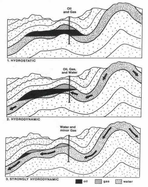
The behavior in terms of migration paths and accumulation sites of oil and gas in the subsurface is closely related to the behavior of formation waters in the units through which the waters are circulating, as well as the nature of the enclosing lithologies and the physical properties of the hydrocarbons. One of the major effects of moving water is to create tilted contacts between oil accumulations and the underlying bottom water as shown in the above figure.
Dozens of documented cases exist in which oil pools exhibit significant dips of up to eighthundred feet per mile. The direction of the tilt reflects the flow direction of the water, which is usually from the topographically high margins of sedimentary basins down toward the interior of the basin (gravity-induced water flow) or from the elevated edge of a unit towards the lower edge or a truncated unconformity.
Vertical variation in oil-water contact elevations within a given pool are the result of a serendipitous sequence of normal faults. Not likely!
In structural traps, under sufficiently intense hydrodynamic conditions:
1) The pool shapes are distorted so that the pool boundaries are not conformable with the structures – the boundaries actually cross the structural contours. The thickest oil columns are not located within the local structural highs or the reservoir isopach thicks.
2) The oil-water contacts are tilted (nonhorizontal).
3) The locations of the pools are displaced from the structures by amounts proportional to the water flow intensity relative to the structures that contain them. The OWC’s are encountered at elevations higher on the up-flow side and lower on the down-flow sides of the reservoirs.
The results are that:
4) Disappointingly THIN oil columns and excessive water cuts are encountered in wells drilled high on structurally attractive hot spots, due to higher-than-expected OWC’s and GWC’s
5) Anomalously THICK oil columns are encountered in wells drilled off-structure (but in the proper direction!) with OWC’s at significantly lower elevations than expected. Often this unanticipated production is encountered outside of the mapped pool boundaries, based on conventional horizontal contacts.
Pools in the North Sea, Central Africa, the Western United States, South America, the Middle East, and New Guinea illustrate the consequences of tilted oil-water contacts.
The effects of subsurface hydraulics impact reserves estimation, risk accommodation, production levels, and development strategies such as waterflooding. The world’s largest oil
Webcasts sponsored by
pool, Ghawar in Saudi Arabia, displays all the attributes of a hydrodynamically influenced oil accumulation with a prominently tilted OWC.
Eric Dahlberg is a Calgary petroleum geologist and silversmith/jewelry designer. He has served in almost every sector of the petroleum industry for the past forty years, consulted for both the U.S. and the Canadian Geological Surveys, and held visiting professorships at four Canadian and U.S. universities. From 2000 to 2004, he taught Structural Geology at Mount Royal College (now University) in Calgary.
Since 1979 he has presented over 390 industry training courses in Subsurface Mapping, Petroleum Hydrogeology, and related subjects to over five-thousand industry professionals in North America and over a dozen foreign countries, with his next coming up in Saudi Arabia in late 2010.
Over the years he has carried out regional oil and gas evaluation studies in Alberta and Saskatchewan and completed over three dozen petroleum hydrogeology studies in locales that include the Dead Sea Graben, the Doba Basin in Chad, Africa, the Norwegian sector of the North Sea, the Canadian Atlantic, the Railroad Valley of Nevada, the Oriente Basin in Ecuador, and the Central Highlands of New Guinea.
Dahlberg is the author of two editions of “Applied Hydrodynamics in Petroleum Exploration” published by Springer Verlag.
In 1978 he received the CSPG Link Award and in 2002 was honored by the CSPG with a Lifetime Achievement Award.
Dahlberg is presently CEO of Saskatchewan Petroleum Ventures Ltd. with oil and gas interests in the Totnes, SK. area, President of the Calgary Rock, Gem and Mineral Club, and currently presents industry training courses in domestic and foreign venues.
New geologists, engineers, geophysicists and landmen, as well as summer students entering the industry for the first time will find the courses a very beneficial introduction to the petroleum industry. These courses will be extremely useful to nonprofessional and support staff in the oil and gas industry, as well as accountants, lawyers, brokerage and financial personnel working primarily alongside the oil and gas industry.
To register or to obtain additional information regarding in-house and upcoming courses, please contact:
Ayrton Exploration Consulting Ltd.
Tel: (403) 262-5440
Email: ayrtonex@telusplanet.net
Or visit our website: www.ayrtonexploration.com
Date: October 26th and 27th, 2010
Cost: $945 (includes GST)
Instructor: Bill Ayrton
Effective for personnel just joining the oil patch, or for financial, accounting, and information systems personnel.
• Learn about the many facets of the industry.
• Oil finding, land acquisition, drilling, seismic, well completion, jargon and terminology.
Date: November 23rd and 24th, 2010
Cost: $945 (includes GST)
Instructor: Bill Ayrton
Effective for geological technicians or administrative staff, or for those who just want a better understanding of geology to appreciate the world around us.
• Learn about earth structure, geologic time-scale and processes, Western Canada geology, and interesting nearby locations.
• Participate in a rock identification exercise, cross-section project and a mini-field trip in downtown Calgary.
Date: November 30th, December 1st and December 2nd, 2010
Cost: $1365 (includes GST)
Instructor: Bill Ayrton
Ideal for those who wish to improve their geological understanding of where and how we look for oil and gas fields in Western Canada.
• To visualize what Western Canada looked like throughout the stages of history, for example, the position of the sea versus land, what sediments were deposited, and what type of life that existed and evolved.
• To review the importance of each major stratigraphic unit, i.e. Devonian, Mississippian, Cretaceous, etc.
• Discuss the geological and seismic expression of typical oil and gas fields in each unit.
one-way ticket from Antarctica to the Tasman Abyssal Plain via the Great Barrier Reef – sediment dispersal on the eastern Australian Margin
SPEAKER
Ron Boyd
ConocoPhillips, AAPG Distinguished Lecturer
11:30 am
Tuesday, November 9, 2010
Calgary TELUS Convention Centre
Calgary, Alberta
Please note: The cut-off date for ticket sales is 1:00 pm, three business days before event. Wednesday, November 3, 2010. CSPG Member Ticket Price: $42.00 + GST. NonMember Ticket Price: $45.00 + GST.
Each CSPG Technical Luncheon is 1 APEGGA PDH credit. Tickets may be purchased online at https:// www.cspg.org/eSeries/source/Events/index.cfm.
The modern coastal sediment dispersal system of eastern Australia operates from sources in the Sydney Basin 1,000 km northward to sinks on the coastline of southeast Queensland and the adjacent Tasman Sea abyssal plain. Individual sand reservoirs of over 203 km3 have accumulated in less than one million years,
Webcasts sponsored by
from longshore transport rates averaging 500,000 m 3 per year. Zircon-dating techniques enable the tracing of this entire sediment dispersal system from its original source in Antarctica to its final sink on the floor of the Tasman Sea. Igneous rocks with a characteristic age of around 600 Ma produced zircons and associated source rocks on the current northern margin of Antarctica prior to continental breakup with Australia. Triassic uplift shed sediments and associated zircons 1,000 km northward in a braided river before intermediate deposition in the Sydney Basin of eastern Australia. Continental rifting in the late Cretaceous produced the modern Tasman Sea and an uplifted escarpment along eastern Australia, including the Sydney Basin. Escarpment erosion of the 600 Ma zircons and associated quartz sands by river processes feeds the modern Tasman Sea longshore transport system,
(Continued on page 12...)

Instructors: Saad Ibrahim, P.Eng. and C.M. Ruhul Amin, P.Eng., Petro Management Group Ltd.
Date: November 10, 2010
Price: $550
Description: The technologies of completing Hz wells with multi-stage fracing has been growing exponentially and bringing life to reservoirs that were once uneconomic to exploit. For the first time ever, it is predicted that the number of Hz wells with multi-stage fracs will exceed the number of vertical wells in Canada!!! Review of some Hz well drilling and fracing will be presented. New analytical and numerical tools have become available to predict the performance and help optimize the design of the Hz wells with multi-stage fracs using the following criteria:
1. Drilling and Completion of Hz wells
2. Application of Mini-Fracs to optimize frac design
3. Optimization of Hz well design including:
a) the spacing between Hz wells
b) the number of fracs or frac spacing, and the size of fracs
c) open-hole vs. cased-hole completions
d) where to place the fracs
4. Prediction of potential production for Hz wells
Interesting 3D visualization/animation output from numerical modeling will be displayed to emphasize the concepts above.
For more information on this Short Course please see: www.cspg.org/education/education-courses.cfm tinadave@telusplanet.net For additional information, contact Tina Donkers at:
delivering reservoir-quality sand 1,000 km north for storage on the southeast Queensland shelf. In the Holocene, at sea-level highstand, this sand river has intersected the shelf edge and is currently supplying the east Australian longshore transport sands directly to the floor of the Tasman Sea via a network of wave-, tide- and gravity-driven flows through a four km-deep network of submarine gullies and canyons. Elsewhere the margin is dominated by mass transport processes, including slab slides, box canyons, and retrogressive linear canyons. Holocene submarine landslides range in volume up to 20 km3 and represent potential tsunami geohazards, as well as an alternative mechanism to transfer sediment to deep water on the southeast Australian continental slope and Tasman Abyssal Plain. Eastern Australia provides an important example of a margin characterized by high wave energy, low subsidence, and coupled gravity mass transport and longshore transport processes.
Coasts occur at the critical interface between land and sea. Coastal sedimentation can be categorized as occurring mainly under either transgressive or regressive conditions, based
on the balance between sediment flux and relative sea level change. Further subdivision results from the dominant marine processes operating at the shoreline, mainly either waves or tides, and the influence of river systems. Transgression produces eroding linear coastlines, barrier-lagoon shorelines occupying embayments with little fluvial input, and estuaries at the mouths of river valleys and deltas. Shelf shoals and ridges consisting of reworked shoreline deposits lie seaward of transgressing coastlines. Landward of transgressing coastlines, major clastic deposition is typically constrained to river valleys. On regressing coasts, sediment is supplied by rivers to deltas that range from tide- to wave- and river-dominated forms. Sediment is also supplied from deltas, offshore areas, and eroding updrift coasts to deposits in strandplains and shorefaces in wavedominated regions, and tidal flats where tidal processes prevail. Transgressive coastlines record a lower rate of sediment input compared to their rate of relative sea level rise. The resulting stratigraphy is composed of more seaward facies overlying more landward facies and details are determined by the presence of incised valleys, the accumulation of estuarine and coastal barrier sediments, and the trajectories of the major wave and tidal ravinement surfaces. Styles of
modern and ancient stratigraphy range from low accommodation and low trajectories in which only the lowest incised valley and estuarine deposits are preserved, to complex transgressions with higher accommodation and higher trajectories and stacked transgressive/regressive parasequences. Regressive coastal sedimentation results in more landward facies overlying more seaward facies. It has been extensively documented in strandplain/shorefaces, river-dominated deltas, and to a lesser extent in wavedominated deltas, but is only at an early stage in tide-dominated deltas. Here, extensive shore-normal sediment transport, high mud contents, and low gradients result in facies and facies models that contrast with their river- and wave-dominated counterparts. By combining the principles of sediment flux and relative sea level change together with the major controlling processes of rivers, waves, and tides, a suite of facies models can be constructed that synthesizes the major depositional features of each coastal environment.
Ron Boyd is currently a Principal Geologist for the Stratigraphy and Quantitative Modeling Group in ConocoPhillips’ Subsurface Technology organization. Prior to taking up this position in 2008, he was a university professor, most recently at the University of Newcastle from 1992-2008, where he still holds the honorary position of Conjoint Associate Professor.
Boyd received his B.Sc. (Hons) and Ph.D. from the University of Sydney, Australia. He has worked as a university professor at Louisiana State University, USA and Dalhousie University, Canada. He has also been an Alexander von Humboldt fellow at Geomar Institute in Kiel, Germany working on ODP drilling results, a technical advisor to PanCanadian Petroleum on incised valleys in western Canada while on study leave, and a visiting research fellow at the Centre for Coastal and Ocean Mapping at the University of New Hampshire working on seabed mapping.
Boyd’s interests are mainly in the area of sedimentology and stratigraphy where he has specialized in a range of subjects including marine geology, estuary deltas and incised valleys, deepwater sediment transport, terrestrial sequence stratigraphy, seabed multibeam mapping, and fluvial geomodels for petroleum exploration. He has authored over 100 publications on these topics, received a number of best paper awards and best presentation awards, and has given a range of professional short courses to industry and the AAPG, SEPM, and CSPG.
SPEAKER
Dr. Hasley Vincent CSPG 2009 Ph.D. Graduate Thesis Award Winner
11:30 am
Thursday, November 23, 2010 Calgary TELUS Convention Centre Calgary, Alberta
Please note: The cut-off date for ticket sales is 1:00 pm, three business days before event. Thursday, November 18, 2010. CSPG Member Ticket Price: $42.00 + GST. Non-Member Ticket Price: $45.00 + GST.
Each CSPG Technical Luncheon is 1 APEGGA PDH credit. Tickets may be purchased online at https://www.cspg.org/eSeries/source/Events/ index.cfm.
An integrated sedimentological approach examining facies (physical and biogenic) and sandstone mineralogy is needed to elucidate the palaeogeography and changing sediment sources in complex and poorly exposed areas. The island of Trinidad, located at the northeastern coast of South America, lies at the transition between a deformed continental margin to the west and a relatively undeformed margin to the south that continues to Brazil. The island is structurally complex and contains the most easterly exposures associated with the deformed continental margin. In addition, a major river system, the Orinoco River, debouches at this transition zone and was a major source of the sediments now exposed on the island. The study of litho- and ichnofacies variation throughout the Trinidad Cenozoic in combination with sandstone
framework and heavy mineral stratigraphy provided key insights into stages of basin morphology and fill, sediment provenance, and overall impact of tectonism on the sedimentary record.
Trinidad sandstones form part of a recognizable ‘family’ of northern South American sediments sourced from three large-scale sedimentary domains. PreCenozoic arkoses (Early Cretaceous) were derived directly from the Guyana Shield. By the late Cretaceous and Early Cenozoic, passive-margin, deepwater environments persisted, dominated by mature, first-cycle s ands derived from lowland plains such as the Llanos. By the Late Oligocene to Early Miocene, changes in sandstone lithic fraction and heavy mineral assemblage record the onset of active tectonism and deformation of the passive continental margin. The similarity with Andean-derived sands across northern South America link the Late Oligocene provenance to this major tectonic domain. Deepwater turbiditic environments persisted in the deforming basin, and it was not until the Early Pliocene that shelf and deltaic sandstones became dominant, sourced from the uplifted Caribbean-Northern Range mountain belts. The changing sedimentary record in the Trinidad area was similar to changing compositions of modern and ancient sands from northwest Brazil and Venezuela and demonstrates a gradual, diachronous deformation front across the continental margin.
The results encourage a re-examination of the simplistic south-derived “Orinoco” watershed, as the significant majority of Pliocene reservoirs were likely deposited by east- and south-flowing depositional systems. Paleogeographic models based on this integrated dataset also provide a useful framework to assess local and analogue reservoir setting, extent, and geometry. In spite of the complex tectonic-sedimentary setting, the variety of depositional systems (ranging from basin-floor turbidites to oil-saturated estuarine sands), combined with an extensive database of source and reservoir data, makes Trinidad an exciting study area, still relatively underutilized for international developments.
BIOGRAPHY
Dr. Hasley Vincent is currently a petroleum geologist with BG Trinidad & Tobago. He received his B.Sc. degree in geology from the
Webcasts sponsored by
University of the West Indies, M.Sc. from Imperial College, London (2001), and Ph.D. from Dalhousie University, Nova Scotia. Prior to his current post, he has been involved in petroleum exploration and development activities in the Petroleum C ompany of Trinidad and Tobago and the Ministry of Energy, Trinidad. Hasley’s academic interests lie in the understanding of the stratigraphy and architecture of depositional systems as they relate to hydrocarbon exploration and development. He has done extensive research on the Plio-Pleistocene to Paleogene successions around Trinidad, for which he gained recognition by the Geological Society of Trinidad & Tobago. Hasley and his wife, Wendy, have two children, ages three and one.
Oct. 18-21, 2010
Other Courses Below:
(Oil & Gas Finding Aspects) November 1-4, 2010 (4 days)
courses
SPEAKERS
Zeev Berger, Michelle Boast, and Martin Mushayandebvu Image Interpretation Technologies Inc.
12:00 Noon
Part 1: Thursday, October 7, 2010 Part 2: Thursday, November 4, 2010 Room LPW-910
Livingston Place West 250 2nd St SW Calgary, Alberta
The Deep Basin and the southern edge of the Peace River Arch have seen an unprecedented increase in drilling activities that are focused primarily on the development of the following unconventional oil plays: the tight carbonate section of the Swan Hills reef complex; hydrothermal dolomite (HTD) reservoirs in the Wabamun and Debolt at the southern edge of the Peace River Arch; fractured carbonate along the Debolt and Pekisko Mississippian subcrop edges; the fractured shale play of the Nordegg; and tight reservoir sand of the Viking and Cardium formations.
An integrated structural/tectonic study of the Deep Basin and the southern edge of the Peace River Arch area has demonstrated that basement features have exerted significant control on the development of ‘sweet spots’ within many of these plays. For example, all the known oil shows in the Nordegg shale play are located at the intersection of basement faults with Devonian reef edges, such as: Simonette, Sturgeon Lake, Ante Creek,
Sponsored by
Figure 1. Examples of structural control on active oil plays in the Deep Basin and Southern Peace River Arch (Figure 1a). Basement structures which are interpreted from magnetic data and Devonian reef edges which have been mapped from well and seismic data clearly appear to exert a significant control on the location of known conventional Nordegg gas pools, such as Whitecourt and Greencourt (Figure 1b), as well as key oil shows in the emerging Nordegg shale play (Figure 1c). Basement structure and topography also appear to exert control on the development of the Cardium oil play in the Pembina area (Figure 1d).
and the Leduc Fringing Reef of the Peace River Arch. Recent exploration activities on the southern edge of the Peace River Arch are largely focused on exploitation of northwest-trending faults that are known to cause the development of HTD reservoir in the Devonian and Mississippian formations.
The methods used to establish the structural framework of the study area, and to identify the location of ‘sweet spots’ for each of the plays, will be demonstrated in two luncheon talks of the C SPG Structural Division. The October talk will focus on the emerging Nordegg oil shale play, and the Cardium tight oil sand play of Pembina. The November talk will cover exploration activities of the Wabamun and Debolt plays of the Peace River Arch, the Mississippian
subcrop edge plays, and the development of the Swan Hills Reef Complex.
Each presentation will be limited to 40 minutes and will be followed by an open discussion. Participants are encouraged to bring PowerPoint examples to illustrate their views on the subject matter.
SPEAKER
Dr. L.V. Hills University of Calgary
CO-AUTHORS
B. Kooyman, University of Calgary
S. Tolman, Cardston
P. Mcneil, Steppe Consulting
7:30 PM, Friday, Oct 15th, 2010 Mount Royal University, Room B108 Calgary, Alberta
ABSTRACT:
The Wally’s Beach Site (DhPg8), near Cardston, Alberta, contains a diversity of palaeofauna and artifacts. This talk will focus on the pre-11,000 years rcbp aspects of the site.
Geology and wind played a significant role in the preservation, and ultimately exposing the site to the view of archaeologists and paleontologists. A Laurentide till which overlies sandstones of the St. Mary’s River Formation extended westward from the site into the foothills of Alberta. As the ice retreated, a thick sequence of rhythmites was deposited in a proglacial lake. A readvance of the ice into the area created an end-moraine system with outwash sands and gravels in the area. With recession of the second ice sheet, the St. Mary’s River reestablished itself on the glacio-lacustrine sediments. Initially a meander loop to the south, followed by a cutoff, produced a large island in the river. This island became the focus for food and water for the palaeofauna.
When the river cut down to the resistant sandstones of the St. Mary’s River Formation, incision slowed and the river cut laterally in the soft lake sediments, producing a broad floodplain west of the site and a west-facing scarp to the island. It was at this point that the palaeofauna, followed by paleo-Indians, entered the area.
During wet intervals, the palaeofauna moved across the area leaving tracks and trackways that were covered by a veneer of silt and sand, preserving them for later
exposure. The palaeofauna attracted the Paleo-Indians and the skeletal elements of their successful hunts were rapidly encased in sands, preserving them from scavengers such as wolves and foxes.
The palaeofauna is comprised of mammoth, western camel, Mexican horse, ancient bison, caribou, wolves, foxes, Scimitar cats, and rodents. Evidence of paleo-Indian activity in the area includes Clovis points, butchered horses and camels, and a collection of cast caribou antlers. The use of protein residue on Clovis points provided the first use of this technique on samples 11,000 years old. Butchering of Mexican horse and camel is documented for the first time. The archaeological, biological, and geological significance of the tracks and trackways as they reflect animal behavior will be reviewed.
Dr. Len Hills was born and raised on a farm at Judah, Alberta. On completion of high school, he joined Socony Vacuum (later Mobil Oil, Exxon Mobil). He left to attend university in 1956, receiving his B.SC. and M.SC. from UBC by 1962 and his Ph.D. from University of Alberta in 1965. He worked briefly for Shell Canada before
Sponsored by
entering into the Department of Geosciences at the University of Calgary where he became an Emeritus Professor in 1996.
In 1979, he was President of the CSPG and has edited the Bulletin of Canadian Petroleum Geologists, Arctic (Journal of the Arctic Institute), Occasional Papers in Archaeology, and several CSPG Memoirs. His work is in about 150 publications on sedimentary geology, stratigraphy, palynology, archaeology, and biology. He supervised 48 graduate students and was member of 260 committees. His interests include natural history, plants, animals, geomorphology, and public education. Dr Hills’ honours include: Fellow of the Arctic Institute of North America, Honorary Member of the CSPG, and Order of the University of Calgary.
This event is jointly presented by the Alberta Palaeontological Society, Mount Royal University, and the CSPG Palaeontology Division. For details or to present a talk in the future please contact CSPG Paleo Division Chair Philip Benham at 403-691-3343 or programs@albertapaleo. org. Visit the APS website for confirmation of event times and upcoming speakers: http://www. albertapaleo.org/.
► Identify Opportunities
► Generate Ideas
► Capture the Best Lands
► Overcome Technical Challenges
Resource Play Micro-Studies is an ongoing geoscience project that tracks the evolution of major resource plays across Western Canada. Keep your company up-to-date and technically informed.
Contact Cheryl Wright to subscribe today.


► One Play-by-Play Comparative Review ► Two Feature Play Micro-Studies (403) 269-3644, info@canadiandiscovery.com www.canadiandiscovery.com


| by Philip Benham and Yingchun Guan
Trailhead: Take Spray Lakes road (Hwy 742) out of Canmore, trail access is from parking lot, first left after the Nordic Centre.
Distance: 4.5km return on a loop trail, and a lazy four hours with picnic, or two hours for those in a hurry.
Elevation Gain: 275 m
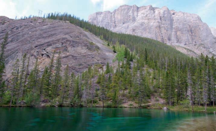
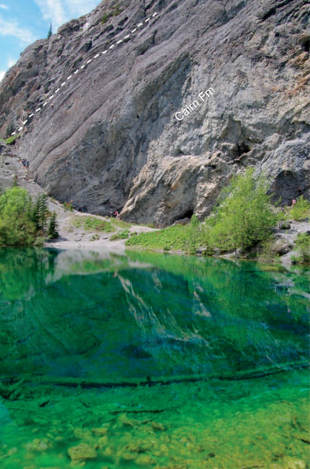
Grassi Lakes is one of the most popular trails due to its proximity to Canmore, variety of scenery and numerous routes for practicing climbers to test their mettle. It is also a classic geological stop for those wishing to view exposures of the Late Devonian Cairn Formation; the surface equivalent of the prolific Leduc Formation.
From the parking lot, follow the Transalta access road a short distance. To see the waterfall, choose the signposted “difficult” route, a forest trail that forks left off the road. It winds its way up-slope to good views of Canmore across the valley, a scenic waterfall, and the triangular form of Ha Ling Peak looming overhead. Ha Ling Peak is named after a Chinese cook who won a $50 bet in 1896 in being the first to climb the mountain. After a series of steep stone steps the trail levels out and you reach Lower Grassi Lake. Its clear water and rich blues and greens immediately catch your

1992). Figures of men with a hoop or drum and game wildlife are discernable.
At Grassi Lakes, see the vuggy cliff exposures of the Cairn Formation consisting of darkand light-grey-weathering dolomite, with chert bands. Present, but not easily observed are bulbous stromatoporoids (often surfaceleached to fist-sized or larger vugs), sticklike Amphipora and atrypid brachiopods. Stromatoporoid bioherms can be seen best from across the lake, but take the opportunity to explore the massive vugs that have formed from surface weathering. Upslope, beyond the pictographs is the Southesk Formation. These light grey, laminated argillaceous carbonates contain stromatoporoids, tabulate corals, and gastropods. Complete the loop by returning on the easy-access road.
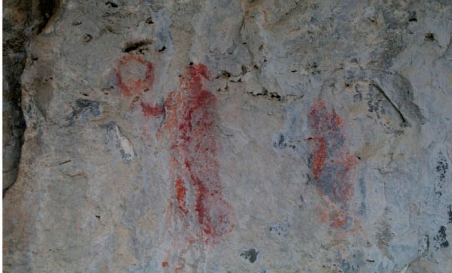
eye but then you are drawn to the more distant wall of rock covered with climbers on a summer weekend. The trail passes quickly to Upper Grassi Lake with even richer colours. There are plenty of places to sit and contemplate or pull out a picnic lunch. The cliffs are steep and there are plenty of warnings to be aware of rockfall (often climber-generated). The official trail ends at the lakes but it takes only a short scramble up the slope to a roped-off area with finger-painted red-ochre pictographs dating back perhaps 1,000 years (Keyser,
Keyser, James D. 1992. Introduction to Rock Art. Indian Rock Art of the Columbian Plateau. University of Washington Press.
The Reservoir Committee welcomes contributions from our readership to this series. If you wish to offer a submission to Go Take a Hike on your favourite hike of geological interest, email the Reservoir at heather.tyminksi@cspg.org for more information.


| By Colin Yeo
PAUL MACKAY NAMED 2011 CONVENTION GENERAL CO-CHAIR
Long-time Society volunteer Paul Mackay has assumed the role of General Co-Chair for the 2011 Annual Convention. Paul is best known for his structural field trips in Alberta and Wyoming, leading more than 1,000 participants during the last 20 years. Paul was a major contributor and driving force behind the Triangle Zone Special CSPG Bulletin. Paul also served as Program Director on the CSPG Executive in 1998 and 1999. He has always been active in the very successful and very active Structural Division.
Paul received his Ph.D. from the University of Calgary in 1991. He had taken a leave of absence from Amoco Canada where he worked as one of Amoco’s first cross-trained geophysicists. Paul moved to Morrison Petroleums and, through acquisition, to Northstar and Devon Energy. Following Devon, Paul provided consulting services to both domestic and international oil and gas companies before
launching several start-ups. Currently, Paul is the Vice President, Exploration, of Barron Energy.
Paul has set three ambitious goals for the 2011 Convention. First, he wants to establish the Annual Convention as a significant conference within North America, garnering interest internationally and reflecting Calgary’s status as an international oil and gas centre. Second, the structure of the convention will reflect the way most of us do our work: integrated work teams. Most of us operate in some form of the land; geology; geophysics; and reservoir, drilling, completion and production engineering work model. The convention sessions will focus on the emergence of resource plays and be structured like our work teams. There will be presentations on geology and geophysics, reservoir engineering, drilling and completion techniques, and production optimization all in one session. And finally, the selection of session chairs is of great importance. Session chairs should be
industry leaders and will take a leadership role in their session. The chair will set up the session by placing it within a business and technical context and will wrap up by drawing key conclusions and providing insights for delegates.
This innovative approach is designed to increase the relevance and depth of technical content and broaden the perspectives of delegates. Paul feels that pursuing this convention strategy could improve attendance by attracting more geoscientists from the US and appealing to reservoir engineers who are our closest relatives within the engineering profession. Growth in delegates leads to bigger conventions and this will no doubt attract attention globally.
Paul has established a measure of success: your VP Exploration or Chief Geologist will tell you to be sure to attend the Convention and you will say you are already registered.

4th Annual Education Week
October 25 - October 29, 2010
www.cspg.org/education/education-week.cfm

Instructor: Dr. Basim Faraj, Unconventional Gas Specialist at Talisman Energy
Price: Member $675 Non-member $780 Date: Oct. 27, 2010
Description: This one-day course will introduce the fundamental differences between conventional, hybrid, and shale gas plays. Source and reservoir rock attributes of shale gas plays will be discussed as well as GIP calculations, water, oil and gas saturations, essential laboratory analysis, and optimum geochemical and mineralogical parameters. Slickwater completion lessons learned from the US will be detailed. Canadian plays will be highlighted and discussed.
Instructor: Andrew Miall, Professor of Geology, University of Toronto
Price: Member $850 Non-member $955 Date: Oct. 25-26, 2010
Description: The focus of this 2-day lecture course will be on the reservoir architecture and sequence stratigraphy of fluvial systems and will contain descriptions of fundamental basinal controls on fluvial systems. Information and ideas presented in the course will contribute to the development of fluvial sandstone production and exploration models.
Instructor: Dr. James Dixon
Price: Member $375 Non-member $480 Date: Oct. 25, 2010
Description: The objective of this half-day course is to help explorationists understand the regional stratigraphic setting of Triassic rocks and how this can be used in a more local exploration program. The course consists of two lectures, some correlation exercises and an examination of several cores that illustrate various facies types and/or significant stratigraphic surfaces.
Instructor: Dr. Octavian Catuneanu, Professor in the Department of Earth and Atmospheric Sciences at the University of Alberta
Price: Member $975 Non-member $1,080 Date: Oct. 25-27, 2010
Description: This workshop presents the concepts and practical applications of sequence stratigraphy for petroleum exploration and production. All concepts are illustrated with field examples of seismic, well-log, core, and outcrop data. In-class exercises emphasize the recognition of sequence stratigraphy surfaces and systems tracts on well-log cross-sections, seismic lines, and outcrop profiles.
Instructor: Andrew Miall, Professor of Geology, University of Toronto
Price: Member $850 Non-member $955 Date: Oct. 27-28, 2010
Description: A practical course designed to assist the petroleum geologist in the identification of different types of sequence, based on the generating mechanisms. The sequence architecture in a given basin may reflect the action of several simultaneous processes interacting locally to globally over a wide range of time scales.
Instructor: Dr. Kerrie Bann, Ichnofacies Analysis Inc. and Dr. Stuart Tye, Husky Energy
Price: Member $1,500 Non-member $1,605 Date: Oct 26-28, 2010
Description: This short course has been designed to teach the basics of logging core clastic intervals, with the inclusion of fundamental introductory ichnological techniques. Identification of facies through the integration of sedimentology and ichnology is crucial in building better stratigraphic and palaeogeographic models of reservoirs.
For more information and to keep up to date with added


The CSPG is a Technical Society run by Volunteers. Volunteering with CSPG leads to networking opportunities, new friends in the industry, knowledge in an area outside your current job and qualifies you for PDH credits. Here is your opportunity for professional growth.


VolunteerMembershipManagement
H.M. Hunter Award

We require the following Chair positions to be filled; Tracks Award


Programs and Technical Divisions
Short Course / Field Trip Development Coordinator
Emerging Petroleum
Resources Technical Division Chair


Reservoir Sedimentology


Convention Needs You!
Positions available on various committees such as Sponsorship, Finance & Special Events.
A CSPG Joint Annual Convention Representative is also needed.


Technical Division Chair
Technical Division Chair


| By R. J. Spencer1,3 , P. K. Pedersen1, C. R. Clarkson1, R. Aguilera2
Department of Geoscience, University of Calgary,
Shale gas plays are currently the hottest unconventional reservoir targets in North America, with a combination of technological advances and proximity to market being key drivers in the success of these plays. However, shale gas production has occurred in some form since the early 19th century, generally at a modest scale and in close proximity to markets in the eastern USA.
In this article, we review the history of shale gas production in the U.S. and Canada, with an emphasis on technological advances that have led to commercial development. Our focus will be on the progressive development of the Barnett Shale in the Fort Worth Basin and how development of this play has triggered recent “shale gas mania” in the U.S. and Canada.
Lest we forget, shale gas development did not begin with the recent success of the Barnett Shale. In fact, shale gas production initiated nearly 200 years (!) ago in the eastern U.S. The first well was drilled in 1821 in Fredonia, New York at “Canadaway Creek” in the Devonian Dunkirk shale, by William Aaron Hart (Hill and Lombardi, 2002). Hart, a gunsmith, was successful on his third attempt, and in 1830, he gauged the well’s flow rate at 1.76 mcf/d. The well supplied gas to the local town through 1858. Additional concerted efforts by a local gas company, Fredonia Gas Light Company, led to more drilling in this shallow gas play. Producing wells required dewatering through pump, and produced saltwater. These shallow gas
wells typically cost about $1/ft to drill, or generally less than $2,000, a far-cry from the multi-million-dollar wells being drilled to produce shale gas from deeper targets today.
In the late 19th century, hundreds of shallow gas wells were drilled in the region along the shores of Lake Erie and southeastward, with several gas fields such as Lakeshore, Naples, and Dansville being established. The Devonian black shales of the Dunkirk, Rhinestreet, and Marcellus were the initial primary targets in New York State – a summary of those initial fields in New York is given in Table 1.
The Devonian shale of the Appalachian Basin became the largest natural gas field in the world by 1926 – to this
(...Continued from page 21)
day, the Appalachian Basin still contains the largest number of shale-gas producing wells (Canadian Discovery Digest, 2006). The 1920s saw initial development of the Big Sandy Field (Ohio Shale) in Kentucky and by the 1930s, initial development of Devonian-aged Antrim Shale in the Michigan Basin (U.S. Department of Energy, 2009). Proximity to gas markets was clearly a key driver in the success of this “1st wave” of shale gas production. The 2nd wave of shale gas activity in the U.S. was kickstarted by an incentive provided by the U.S. government (see below).
In the Canadian Plains, several of the Cretaceous shallow gas reservoirs hosted within Colorado Group shales (e.g., Second White Specks, Medicine Hat [Shurr and Ridgley, 2002] and the shaly part of the Milk River [Pedersen, 2003]) bear many similarities with reservoirs included today in the broad range of shale gas reservoirs. Thus, the shallow gas fields developed since the early part of the 1900s, with their abundant well log and core data, provide good long-term reservoir
of a laterally continuous unconventional gas play.
Shale gas activity waned in the late 1970s until the Section 29 Tax Credit was introduced in 1980 by the U.S. federal government to motivate operators to exploit unconventional resources (Bustin, 2005). This tax credit applied to (unconventional) gas wells placed on production after 1979 and before January 1, 1993 and to gas produced and sold until December 31, 2002. The incentive worked, resulting in the drilling of 1,000s of new shale gas wells.
Significant targets for shale gas drilling in the 1980s included the Devonian Antrim, New Albany, and Ohio shales. Typically, shales that were being targeted in the 1980s and early 1990s – as exemplified by the Antrim Shale – were relatively shallow and thermally immature (low Ro), had high organic matter (TOC) and adsorbed gas content, were naturally fractured, and often had significant water production.
shales had much in common. Toward the end of the 1990s, however, deeper, hotter, thermogenic, low TOC “shale” plays began to be developed, such as the Cretaceous Lewis Shale of the San Juan Basin and the Mississippian Barnett Shale of the Fort Worth Basin. The Lewis, in places, is actually more of a fractured, fine-grained sand-siltstone reservoir, rather than a true shale. These plays generally have very low matrix permeability (nanodarcies to 100s of nanodarcies), making them subcommercial (at the time, more on this later!) if natural fractures are absent.
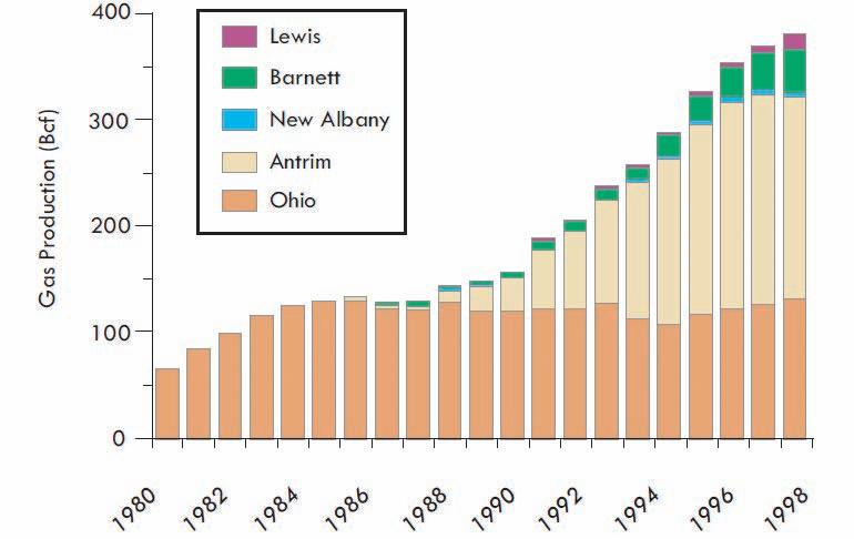
At the end of the 1990s shale gas production had become a significant source of gas supply in the U.S. (approximately 3% of total gas production), with production approaching 400 Bcf/year by the end of 1998 (Figure 1).
An important outcome of this era of shale gas development was significant progression of our understanding of shale gas reservoir properties due to significant research by Gas Research Institute (GRI, Institute), Holditch and service a (non-
Helping you achieve greater recoveries with fewer wells.
By utilizing proven tools and strategies that integrate geological, geophysical and engineering data in Windows® and Linux® platforms. We can determine the distribution of hydrocarbons in your reservoirs with greater precision to maximize profitability. There’s more to Fugro-Jason than just inversion.

exhaustive) list of significant advances (and associated representative publications) in reservoir understanding made during this period of shale-gas development (19802000):
• Material balance methodologies for shale gas (e.g., King, 1993)
• Shale core analysis (e.g., Luffel and Guidry, 1992; Luffel and others, 1992; Luffel, 1993)
• Shale gas welltest analysis (e.g., Bumb and McKee, 1988)
• Reservoir simulation and shale gas forecasting (e.g., Watson and others, 1990; Carlson and Mercer, 1991; Zuber and others, 1994; Spivey and Semmelbeck, 1995)
• Shale gas production analysis (e.g., Gatens and others, 1989; Frantz and others, 1996)
• Reservoir characterization of shales (e.g., Hopkins and others, 1995; Frantz and others, 1999; Dube and others, 2000; Zuber and others, 2002)
In addition to the above reservoir studies, several shale play comparisons have been done (e.g., Hill and Nelson, 2000) allowing operators to rank their shale plays effectively. An example of such a comparison of reservoir properties is provided in Figure 2. It is clear that not all shale plays are alike (e.g., the low TOC of the Lewis shales versus the high TOC characteristic of the Antrim shales).
Even though significant knowledge of shale gas reservoir characteristics was gained through this period, shale gas wells were
still significantly less productive (and more expensive) than many of the conventional plays of the day. It was not until significant advancement in drilling, completion, and stimulation methodology (as applied to shale gas) had been made that shale gas plays began to achieve their potential. The Barnett Shale play (Fort Worth Basin) was the site of a lot of experimentation with these technologies. In the following, we now provide a brief history of drilling and completion technology in that play.
THE STANDARD BY WHICH ALL FUTURE SHALE PLAYS WILL BE JUDGED: THE BARNETT
More than any other shale gas play, the success of the Barnett Shale in the Fort


Worth Basin, has inspired “shale gas mania” in the current decade. The location of the play relative to infrastructure, the amenable geologic setting, reservoir characteristics, and vision of certain operators, not to mention lots of experimentation with technology, made this play what it is today. As of a couple of years ago, the Barnett Shale alone produced ~ 6% of the natural gas from the U.S. (U.S. Department of Energy, 2009). The key technologies being used today that have lent to its success include multi-fractured (multiple stimulation stages) horizontal wells, high rate / high water volume (low-viscosity) “slickwater” hydraulic fracturing for each stage, combined with new surveillance methods, such as microseismic, that have allowed operators to understand how to optimize hydraulic fracture treatments in the play.
Still, the play was slow to develop, and it took the persistence of certain operators, and one in particular, Mitchell Energy Corporation (MEC), to make the play work. In 1981, MEC attempted their first Barnett completion and followed it up with 36 deep test wells (Martineau, 2007). Hydraulic fracture experiments were performed on the first well (MEC1), including an initial nitrogen foam frac, followed by a large gel frac, and finally a large water frac (light sand). This kind of experimentation allowed operators to optimize the stimulation treatments using vertical wells. Some later tests by MEC were done with aid of GRI, who helped improve reservoir characterization of the play.
(Continued on page 24...)


Table 2.
play comparison (source of the above numbers provided in U.S. Department of Energy, 2009).
(...Continued from page 23)
According to Martineau (2007), five stages of development of the play occurred, including:
1. 1980-1985: Vertical well drilling and completion in the lower Barnett only, hydraulically fractured zone using foam (150,000-300,000 gallons, N 2 assisted, with 300,000500,000 lb of 20/40 sand) pumped at typically 40 bbl/min.
2. 1985-1997: Vertical well drilling and completion in the lower Barnett only, hydraulically fractured zone using cross-linked gel with
larger fluid volumes than before (400,000 – 600,000 gallons) and more sand (1,000,000-1,500,000 lb). Experimentation with fluidloss additives, clay stabilizers, and surfactants also occurred.
3. 1998-present: Vertical well drilling and completion in both upper and lower Barnett; hydraulically fractured separately, using even larger fluid volumes (900,000 gallons for lower, 500,000 gallons for upper) and a total of 200,000 lb sand. Jobs were pumped at 50-70 bbls/min and use of surfactants and clay stabilizers diminished.
These “light sand” fracs, which are relatively inexpensive, became more popular than gel fracs and remain so today.
4. 1999-present: Refracturing of originally gel-frac’d wells with water, after some depletion. This resulted in large production rate increases.
5. 2003-present: Long lateral horizontal well drilling, hydraulicallyfractured in multiple stages using 2,000,000 – 6,000,000 gallons of water and 400,000 – 1,000,000 sand, pumped at 50-100 bbl/min. “Simulfracs”, in which parallel laterals are frac’d simultaneously (see Cramer, 2008), have recently gained favor. Operators went to horizontal wells initially to reduce the risk of frac’ing into the waterbearing Ellenburger.
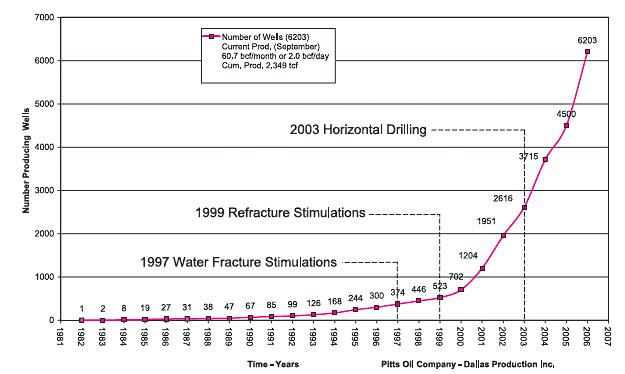
A summary of drilling/completion activity in the Newark East field is provided in Figure 3.
Ultimately large, water-based, lowviscosity (“slickwater”) fracs, which are relatively inexpensive (at least in this basin) became the stimulation of choice for the Barnett – this combined with multi-stage hydraulic fracturing in horizontal wells, have led to the current success of the Barnett. It was determined later that the success of these fracs was related to the complex fracture geometry that they created, which in turn allowed the wells to contact more of the low matrix-permeability
reservoir. This observation was made possible with the use of microseismic imaging techniques. Operators have used microseismic and other surveillance technology (e.g., temperature surveys) to optimize hydraulic fracture treatments and maximize the “Stimulated Reservoir Volume (SRV)” (Mayerhofer and others, 2008) around the wells, which in turn has led to increased productivity of the wells. The creation of complex fracture geometry or SRV is related to the rock mechanical properties, fabric, in-situ stress environment (orientation, magnitude, and level of differential stress), as well as the stimulation treatment.
This model of wellbore architecture, completion and stimulation style, and development planning created in the Barnett is currently being used (with some variation) in other shale plays in North America, including our own Horn River Basin.
The success of the Barnett Shale play has inspired much activity in other shale basins
in North America. Figure 4 (page 26) shows the current shale gas plays in the U.S. and Canada:
Shale gas plays that have received attention in recent years include the Haynesville/Bossier Shale (Louisiana/ Texas), Fayetteville (Arkansas), Woodford (Oklahoma), and Marcellus (primarily Pennsylvania). A summary of these plays was recently provided by the U.S. DOE (U.S. Department of Energy, 2009). A comparison of the shale plays, obtained from that document, is provided in table 2.
Three of the hottest shale plays in North America are in Canada, and include the Devonian shales of the Horn River Basin (Muskwa, Otter Park, Evie), the Triassic Montney of the WCSB, and the Ordovician Utica in Quebec (Figure 4). Technology similar to that used to unlock the Barnett is currently being used in Western Canada. Faraj and others (2004) provide a review of other shale plays of interest in Canada. An excellent summary of the Horn River Basin play is provided in Reynolds and Munn (2010); completion technology currently used in the Montney tight gas play is summarized in Thompson and others
(2009). Unlike many of the continental U.S. plays, the Horn River Basin and portions of the Montney play are challenged by location (remoteness), topography, and lack of infrastructure. Operators in the Horn River are using very large well pads, designed for up to 28 wells/pad with stacked laterals completed in multiple shale horizons. Up to 20 frac stages per well are being used. These plays are currently pushing the limit of what can be done with completion technology, and we look forward to future successes.
Parts of the work presented in this series were funded by the NSERC, AERI, ConocoPhillips, EnCana, Nexen, ExxonMobile, Lundin, and the University of Calgary. Their contributions are gratefully acknowledged.
Bumb, A.C., and McKee, C.R. 1988. Gas-Well Testing in the Presence of Desorption for Coalbed Methane and Devonian Shale. SPEFE (March 1988), p. 179-185.
Bustin, R.M. 2005. Gas Shale Tapped for Big Pay. AAPG Explorer, February 2005. (Continued on page 27...)
Figure 4. Shale gas plays of Canada and the continental U.S. (compiled by Canadian Discovery Ltd. From GSC OF5384 [data provided by Tony Hamblin and Elizabeth Macey – GSC (Calgary)], USGS [http://energy.cr.usgs.gov/oilgas/wep/products/ dds60/export.htm], EIA [http://www.eia.doe.gov/pub/oil gas/natural gas/analysis publications/maps/maps.htm#geodata].
Figure1.ShaleGasPlaysofCanadaandtheUnitedStates(compiledbyCanadianDiscoveryLtd.fromGSCOF5384[dataprovided byTonyHamblinandElizabethMacey-GSC(Calgary)],USGS[http://energy.cr.usgs.gov/oilgas/wep/products/dds60/export.htm], EIA[http://www.eia.doe.gov/pub/oil_gas/natural_gas/analysis_publications/maps/maps.htm#geoscripts]).
Canadian Discovery Ltd. 2006. Shale Gas in North America – New Life for an Old Resource. Canadian Discovery Digest, Vol. 6.
Carlson, E.S., and Mercer, J.C. 1991. Devonian Shale Gas Production: Mechanisms and Simple Models. Journal of Petroleum Technology, v. 43, no. 4, p.476-482.
Cramer, D.D. 2008. Stimulating Unconventional Reservoirs: Lessons Learned, Successful Practices, Areas for Improvement. Paper SPE 114172 presented at the Society of Petroleum Engineers Unconventional Reservoirs Conference held in Keystone, Colorado, 10-12 February.
Dube, H.G., Christianson, G.E., Frantz Jr., J.H., Fairchild Jr., N.R., Olszewski, A.J., Sawyer, W.K., and Williamson, J.R. 2000. The Lewis Shale, San Juan Basin: What We Know Now. Paper SPE 63091 presented at the Society of Petroleum Engineers Annual Technical Conference and Exhibition held in Dallas, Texas, 1-4 October.
Faraj, B., Williams, H., Addison, G., McKinstry, B. 2004. Gas Potential of Selected Shale Formations in the Western Canadian Sedimentary Basin. GasTIPS, Winter 2004, v. 10, no. 1, p. 21-25.
Frantz Jr., J.H., Spivey, J.P., Voneiff, G.W. and Jacot, H. 1996. Practical Production Data Analysis for Appalachian Basin. Paper SPE 37347 presented at the Society of Petroleum Engineers Eastern Regional Meeting held in Columbus, Ohio, 23-25 October.
Frantz Jr., J.H., Fairchild Jr., N.R., Dube, H.G., Campbell, S.M., Christianson, G.E., and Olszewski, A.J., 1999. Evaluation Reservoir Production Mechanisms and Hydraulic Fracture Geometry in the Lewis Shale, San Juan Basin. Paper SPE 56552 presented at the Society of Petroleum Engineers Annual Technical Conference and Exhibition held in Houston, Texas, 3-6 October.
Gatens III, J.M., Lee, W.J., Lane, H.S., Watson, A.T., Stanley, D.K., and Lancaster, D.E. 1989. Analysis of Eastern Devonian Gas Shales Production Data. Journal of Petroleum Technology, v. 41, no. 5, p. 519-525.
Hill, D.G., and Nelson, C.R. 2000. Gas Productive Fractured Shales: An Overview and Update. GasTIPS, v. 6, no. 2, p. 4-13.
Hill. D.G. and Lombardi, T.E. 2002. Fractured Gas Shale Potential in New York. New York State Research and Development Authority, December 2002.
Hopkins, C.W., Frantz, J.H. and Hill, D.G. 1995. Estimating Fracture Geometry in the Naturally Fractured Antrim Shale. Paper SPE 30483 presented at the Society of Petroleum Engineers Annual Technical Conference and Exhibition held in Dallas, Texas, 22-25 October.
Luffel, D.L., and Guidry, F.K. 1992. New Core Analysis Methods for Measuring Reservoir Rock Properties of Devonian Shale. Journal of Petroleum Technology, v. 44, no. 11, p. 11841190.
Luffel, D.L., Guidry, F.K., and Curtis, J.B. 1992. Evaluation of Devonian Shale With New Core and Log Analysis Methods. Journal of Petroleum Technology, v, 44, no. 11, p. 11921197.
Luffel, D.L., Hopkins, C.W. and Schettler Jr., P.D. 1993. Matrix Permeability Measurement of Gas Productive Shales. Paper SPE 26633 presented at the 68th Society of Petroleum Engineers Annual Technical Conference and Exhibition held in Houston, Texas, 3-6 October.
(Continued on page 28...)


Let TGS complete the picture


Canada Well Data is now available online, backed by TGS’ high quality standards and customer support.
• Standard curve LAS and LAS+ for bulk workstation loading
• Trustworthy data, meticulously QC’d to save you time
• Proprietary LAS and LAS+ digitizing to complete your project
• Complete standardized directional surveys ready for mapping
www.tgsnopec.com/welldata | WellData@tgsnopec.com
King, G.R. 1993. Material-Balance Techniques for Coal-Seam and Devonian Shale Gas Reservoirs with Limited Water Influx. Society of Petroleum Engineers Reservoir Engineering, v. 8, no. 1, p. 67-72.
Martineau, D.F. 2007. History of the Newark East Field and the Barnett Shale as a Gas Reservoir. AAPG Bulletin, v. 9, no. 4, p. 399-403.
Mayerhofer, M.J., Lolon, E.J., Warpinski, N.R., Cipolla, C.L. and Walser D. 2008. What is Stimulated Reservoir Volume? Paper SPE 119890 presented at the Society of Petroleum


Engineers Shale Gas Production Conference, Fort Worth, TX, 16-18 November.
Pedersen, P.K. 2003. Stratigraphic relationship of Alderson (Milk River) strata between the Hatton and Abbey-Lacadena Pools, southwestern Saskatchewan – preliminary observations. Summary of Investigations 2003, Volume 1, Saskatchewan Geological Survey, Sask. Industry Resources, Misc. Rep. 2003-4.1, CD-ROM, Paper A-11, 11p.
Reynolds, M.M., and Munn, D.L. 2010. Development Update for an Emerging Shale Gas Giant Field – Horn River Basin, British


Columbia, Canada. Paper SPE 130103 presented at the Society of Petroleum Engineers Unconventional Gas Conference held in Pittsburgh, Pennsylvania, 23-25 February.
Shurr, G.W. and Ridgley, J.L. 2002. Unconventional Shallow Biogenic Gas Systems. AAPG Bulletin, v. 86, p. 1939-1969.
Spivey, J.P. and Semmelbeck, M.E. 1995. Forecasting Long-Term Gas Production of Dewatered Coal Seams and Fractured Shales. Paper SPE 29580 presented at the Society of Petroleum Engineers Rocky Mountain/LowPermeability Reservoirs Symposium held in Denver, Colorado, 20-22 March.


Watson, A.T., Gatens III, J.M., Lee, W.J., and Rahim, Z. 1990. An Analytical Model for History Matching Naturally Fractured Reservoir Production. Society of Petroleum Engineers Reservoir Engineering, v. 5, no. 3, p. 384-388.


Zuber, M.D., Frantz, J.H., and Gatens III, J.M. 1994. Reservoir Characterization and Production Forecasting for Antrim Shale Wells: An Integrated Reservoir Analysis Methodology. Paper SPE 28606 presented at the 69th Society of Petroleum Engineers Annual Technical Conference and Exhibition held in New Orleans, LA, 25-28 September.


Thompson, D., Rispler, K., Stadnyk, S., Hoch, O., and McDaniel, B.W. 2009. Operators Evaluate Various Stimulation Methods for Multizone Stimulation of Horizontals in Northeast British Columbia. Paper SPE 119620 presented at the Society of Petroleum Engineers Hydraulic Fracturing Technology Conference held in The Woodlands, Texas, 19-21 January.


U.S. Department of Energy, Office of Fossil Energy, National Energy Technology Laboratory. 2009. Modern Shale Gas Development in the United States: A Primer.


Zuber, M.D., Williamson, J.R., Hill, D.G., Sawyer, W.K., and Frantz, J.H. 2002. A Comprehensive Reservoir Evaluation of a Shale Reservoir – The New Albany Shale. Paper SPE 77469 presented at the Society of Petroleum Engineers Annual Technical Conference and Exhibition held in San Antonio, Texas, 29 September - 2 October.


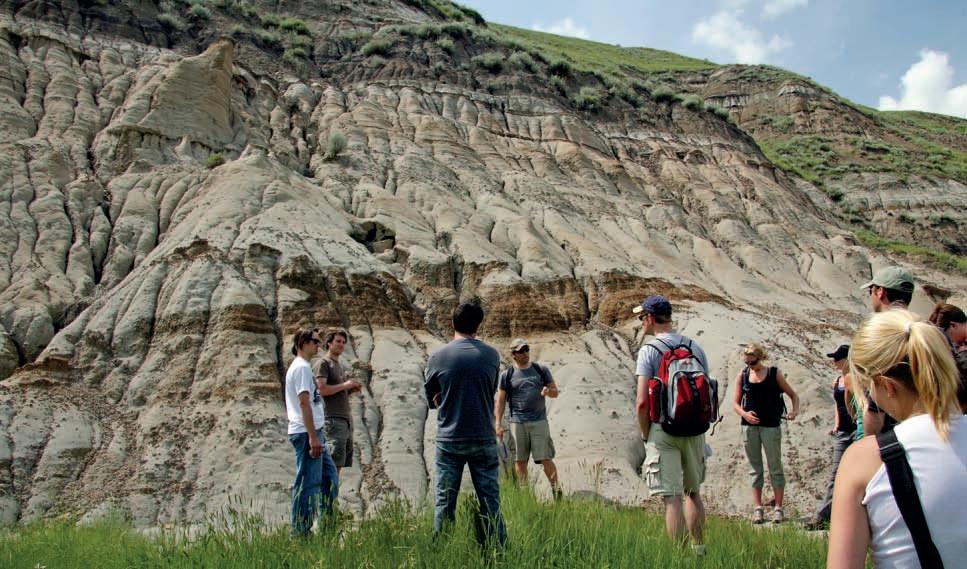
| By Tannis McCartney
The 2010 CSPG Summer Student Field Trip, organized by members of the University Outreach Committee, got off to an exciting start on June 23, 2010. Thirty students participated, spending a sunny day learning about the Horseshoe Canyon Formation from trip leader Jason Lavigne of Bergschrund Integrated Sedimentological Solutions.
The field trip, entitled “Marginal marine depositional environments of the BearpawHorseshoe Canyon Formation Transition, Drumheller, Alberta,” took the participants to several outcrops in the Red Deer River Valley. After a brief stop overlooking the valley to make introductions and discuss the geologic framework of the valley sediments, the bus descended into the Red Deer River Valley and out to East Coulee. This was the first major stop on the field trip, where the participants had the chance to get up
close and personal with several trace fossils. After boxed lunches at the hoodoos, the next stop was Willow Creek to look at
the tidal-influenced deposits there. Two brief stops followed, where the participants could observe stacking patterns of channel deposits in the area. The final stop in the Drumheller area was to pick up pizza for the bus ride home. It goes without saying that the discussions continued at a pub back in Calgary, and many of the students took at advantage of Jason’s willingness to share his knowledge and experience.
Thank you to Jane Marzetti and Mark Radomski for their work organizing the field trip, Talisman Energy for sponsoring dinner, Cory MacNeill for contributing his knowledge about production in the Horseshoe Canyon Formation, Dayna Rhoads for coordinating registrations, and of course Jason Lavigne for his expertise and enthusiasm leading the field trip.
Courses include:
• Essentials of Subsurface Mapping
• Reservoir Characterization and Production Properties of Gas Shales
• Risk and Uncertainty in the Unconventional Realm
• Image Log Interpretation
• Principles of Reservoir Characterization
• Understanding Heterogeneity in U.S. Shale Plays
• "Old" (pre 1958) Electric Logs: A Quick Review
• Formation Evaluation of Thinly-Bedded Reservoirs
• Tight Gas Sands
• Regional Stress and Reservoir Geomechanics
• Quick Guide to Carbonate Well Log Analysis
(Four concurrent sessions each day – mix and match according to your interests and training needs. Buffet Lunch and refreshments included each day.)
Hosted by the Norris Conference Center: 803 Town & Country Lane Houston, TX 77024
Phone: 713-590-0950
Fax: 713-590-0961
Special AAPG group rates at nearby hotels.
Registration and information:
Toll-free (U.S. and Canada) 888-338-3387, or 918-560-2650
Fax: 918-560-2678
E-mail: educate@aapg.org
Download a registration form at: www.aapg.org/education/wec.cfm
Tuition for the week:
(Your five-day badge can be transferred to a friend or colleague if you can't attend all five days.)
| By Vinay K. Sahay1 and Staffan Kristian Van Dyke2
1 Maheshwari Mining Pvt. Ltd.; India (email: geo_vinay@yahoo.co.in) 2 Nexen Petroleum U.S.A., Inc.; Dallas, U.S.A.
ABSTRACT
The objective of this paper is to evaluate tight gas sandstones in relation to conventional reservoirs (sandstones/ carbonates) as well as unconventional reservoirs (coalbed methane / shale gas), with reference to its constituent petroleum system parameters: source, trap, seal, reservoir properties (porosity and permeability), and time factors (timing of charge and migration). Our study indicates significant differences between tight gas sandstones as compared to coalbed methane and / or gas shales. Evaluation of geological evidences indicates that tight gas sandstones, as a reservoir, are closer to conventional type reservoirs than unconventional type reservoirs, like coalbed methane and shale gas. Utilizing the framework described in this paper, tight gas sandstone reservoirs should then be considered as a sub-type category within the overall conventional reservoir definition, as the majority of its geological properties fall within this definition, and not that of an unconventional reservoir. Characterizing tight gas sandstones as an unconventional reservoir is not appropriate, as the geological setting / petroleum system is different in comparison to coalbed methane and shale gas. Tight sandstone is only a reservoir rock whereas coal and shale is source as well as reservoir rock.
INTRODUCTION
Unconventional reservoirs are ones that
cannot be produced at economic flow rates or that do not produce economic volumes of oil and gas without assistance from massive stimulation treatments, such as hydraulic fracturing (frac’ing) or special recovery processes and technologies, such as steam injection. Typically unconventional reservoirs have been described as tightgas sands, coalbed methane, and gas shales (Holditch, 2003; 2006). However it is an economic definition and does not take into account geological processes. It is also important to understand that a conventional (sandstone/carbonate) reservoir with low natural pressure that depletes very quickly (in the order of weeks to months) and requires artificial hydrocarbon recovery techniques to maintain or increase its economic viability is very similar to the economic definition of an unconventional reservoir given above. But such reservoirs are still categorized as conventional. On the other hand, since tight gas sandstones must be artificially stimulated (frac’ed) in order to produce its gas, it would then seem that this is the only criterion in place required to categorize it as an unconventional reservoir. The objective of this paper is to evaluate tight gas sandstones in relation to conventional reservoirs (sandstones/carbonates) as well as unconventional reservoirs (coalbed methane / shale gas), with reference to its constituent petroleum system parameters: source, trap, seal, reservoir properties (porosity and permeability), and time factors (timing of charge and migration).


COMPARISON OF CONVENTIONAL AND UNCONVENTIONAL RESERVOIRS
In the United States, the tight gas sandstone definition is applied to reservoirs with less than 0.1 mD of permeability (Meckel and Thomasson, 2008). Our investigation indicates that tight gas sandstones have significantly different characteristics in comparison to coal bed methane and shale gas. They are:
1. Tight gas sandstones act purely as a reservoir, whereas coal and shale act as a source rock, as well as a reservoir.
2. Shanley and others (2004) found that the low permeability reservoirs in the Greater Green River Basin of Southwest Wyoming were not part of a continuoustype g as accumulation but were lowpermeability rocks in conventional structural, stratigraphic, or combination traps. Earlier, Berry (1959) and Hill and others (1961) proposed that in the San Juan Basin, the gas within the sandstone reservoir was localized in a potentiometric sink associated with down-dip flow of water. In other words, it is a hydrodynamic type trap, thus like conventional trap settings.
3. Gas migrates into tight sandstones from the nearby source rock and the charged gas may be housed within the reservoir due to high capillary pressure (Continued on page 32...)


acts as a source rock and reservoir rock
Entrapment by adsorption in coal matrix (trap not necessary)
Time Factor (Timing and Migration)
Essential for generation and migration from source and entrapment of oil and gas by trap and/or seal
Essential for generation and migration from source and entrapment of oil and gas by trap and/or seal
Time not essential. Time is significant only in context of maturity and generation of gas from organic matter
acts as a source rock as well as reservoir rock
Entrapment by adsorption in matrix of organic matter (trap not necessary)
by adsorption in matrix of organic matter (seal not necessary)
Initially due to natural reservoir pressure (primary drive mechanism); secondary/tertiary recovery methods to follow
(...Continued from page 31)
conditions by virtue of low porosity and permeability, and up-dip presence of water due to regional or local hydrodynamic conditions, whereas in coal and shale gas, it is adsorbed into the matrix of organic matter (Bustin and others, 2009).

Fracturing, flooding (water, steam), acidization
Dewatering and fracturing to decrease water pressure in coal seams to release and flow gas
4. Many conventional reservoirs are porous and permeable but do not have enough primary energy to support hydrocarbon production unaided at an economic level, but are still categorized as conventional reservoirs. According to the unconventional reservoir definition given above, this quality should then define these reservoirs as unconventional, primarily
because enhanced recovery techniques are required for them to be economically producible. Similarly, tight gas sandstone reservoirs need enhanced recovery techniques like fracturing, flooding, and acidization to make them economically viable. However, instead of categorizing these low primary-energy conventional reservoirs as unconventional, it is the

Dates: Every second and fourth Thursday each month from September – December, 2010
Time: 8:00 – 17:00
Instructor: Dr. Greg Hu, Loring Tarcore Labs Ltd.
Fees: $375 + 5% GST, including, lunches, materials, use of computer and core logging software
Location: Loring Tarcore Labs Ltd., Bay 2 – 666 Goddard Ave NE, Calgary
This one-day short course is refined and shorten from a popular, in-house workshop that is offered to some oil sands companies. It emphasizes “hand-on” and “practical”. Any one will find it informative, inspiring, and practical: whether you are a geological adviser, project geologist, or core logging geologist.
Topics include:
Typical depth markers: marker types and their core and log expressions
Principles of core depth correction
Common oil sands facies and their core and log signatures
Identification of common ichnofacies on core and their significance in facies interpreation
Wabiskaw-McMurray Stratigraphy and their depositional model evolution
Common core sample types for lab testings and general sample selection guidelines
Core depth correction: core-based vs image-based with software assistance
For more information and registration, please call 403-874-4588 or visit: http://www.tarcore.com/training/
authors’ opinion that they should remain classified as conventional reservoirs, and that tight gas sandstones should be classified as a sub-type within the overall conventional reservoir petroleum system.
5. The only correlatable property of tight sandstones to coal and shale is their low porosity and permeability similarity, unlike the higher porosities and permeabilities typically seen in conventional sandstone / carbonate reservoirs.
The geological aspects discussed above suggest that tight gas sandstone as a reservoir is closer to conventional reservoirs (sandstone / carbonates) than to coalbed methane and shale gas reservoirs. Table 1 summarizes the petroleum system and other parameters with respect to tight gas sandstones, coalbed methane, shale gas, and conventional reservoirs to elucidate the similarities between these reservoir types.
Evaluation of the above geological aspects suggests that tight gas sandstones, as a reservoir, are closer to conventional type reservoirs than to unconventional type reservoirs, like coalbed methane and shale gas. It is clear that tight gas sandstones
act simply as a reservoir, whereas coal and shale act as a source rock as well as a reservoir for the gas. Tight sandstones may become a hydrocarbon reservoir only when a potential source rock is available within the basin, or a nearby region, capable of charging the reservoir. Utilizing the framework described in this paper, tight gas sandstone reservoirs should be considered as a sub-type conventional reservoir, as the majority of its geological and petroleum system parameters fall within this definition, and not that of an unconventional reservoir.
Berry, F. A. F. 1959. Hydrodynamics and chemistry of the Jurassic and Cretaceous systems in the San Juan Basin, northwestern New Mexico and southwestern Colorado. Stanford University, Ph.D. thesis, 269 p.
Bustin, R. M., Bustin, A., Ross, D., Chalmers, G., Murthy, V., Laxmi, C., and Cui, X. 2009. Shale gas opportunities and challenges. Search and Discovery Article 40382. http://www.searchanddiscovery.net/ documents/2009/40382bustin/ndx_bustin.pdf
Hill, G. A., Colburn, W. A., and Knight, J. W. 1961. Reducing oil finding costs by use of hydrodynamic evaluations, in petroleum
exploration, gambling game or business venture. Institute of Economic Petroleum Exploration, Development, and Property Evaluation. Englewood, New Jersey, Prentice-Hall, p. 38-69
Holditch, S. A. 2003. The increasing role of unconventional reservoirs in the future of the oil and gas business. Society of Petroleum Engineers. http://www.spe.org/jpt/print/archives/2003/11/ JPT2003_11_management.pdf
Holditch, S. A. 2006. Tight gas sands (SPE Paper 103356). Journal of Petroleum Technology, v. 58, no. 6, p. 86-94.
Meckel, L. D. and Thomasson, M. R. 2008. Pervasive tight-gas sandstone reservoirs: An overview. In: S. P. Cumella, K. W. Shanley, and W. K. Camp (eds.). Understanding, exploring, and developing tight-gas sands. 2005 Vail Hedberg Conference. American Association of Petroleum Geologists. Hedberg Series, no. 3, p. 13-27.
Shanley, K. W., Cluff, R. M., and Robinson, J. W. 2004. Factors controlling prolific gas production from low-permeability sandstone reservoirs: Implications for resource assessment, prospect development, and risk analysis. American Association of Petroleum Geologist Bulletin, v. 88, p. 1083-1121.

| By Colin Yeo
While most of us gear down for the summer, your Executive was hard at work. After spending the first half of the year generating a strategic direction for the Society centered on technical rejuvenation, encouraging and helping Society volunteers, and marketing the CSPG, the Executive is now focused on strategy implementation. Usually, the Executive doesn’t formally meet in July and August but this rebuilding year is an exception and they wanted to get a jump-start on a busy balance of their term in office.
At the meeting, each Director spoke to their strategic plan milestones, what they are doing, and what members will see as a result. Directors are also busy defining their roles and responsibilities so that incoming directors will know what is expected of them and allow them to be more effective in a shorter time frame. Additionally, current directors will offer ideas about training and orienting new directors on the Executive Committee. Directors also discussed the process and timeline of the 2009-2010 annual report. They are going to be very busy and potentially distracted by day-to-day tasks but they are also disciplined and will concentrate on the most important issue rather the most urgent.
The business of the Society never ceases and this past summer was no exception. President Varsek and Society Historian Clint Tippet met with Alberta Community and Culture to discuss a possible contribution to the Turner Valley Gas Plant Historic Site. Contributions are always a delicate and sensitive issue especially when the Society is under constant pressure to practice financial discipline.
The presidents of the CSPG, CSEG, and CWLS reviewed convention registration data and began to gather data in preparation for a presentation by the 2010 Convention Organizing Committee later in the f all. Further intersociety discussion centered on the scope and intent of the Joint Annual Convention, including some legal issues. We have to remember that the Annual Convention is big business and is bound to attract different opinions and views from each of the three principal societies. But at the same time, the overarching goal of the convention is to provide our members with high-quality technical sessions and collaboration and networking opportunities. Of course, the reality is that all three societies rely on convention profit to provide member services that cost more than members’ annual dues. This is also a balancing act. By the way, the CSPG and CSEG have

FARHATHYDERI,P.Geol
President
226CopperfieldBlvd.S.E. Calgary,ABT2Z4R6
Tel 4037260666
Fax4034515380
Cell4038192516
farhat@sableconsultants.com
SABLECONSULTANTS.COM

decided to hold the 2011 convention at the Telus Convention Centre.
President Varsek attended AAPG’s Leadership Days where he will participate in discussions on the future of technical geological publications and the direction of AAPG over the next 35 years. We are closely associated with the AAPG; almost one third of CSPG members are also AAPG members. We have held joint annual conventions about every 10 years with the AAPG and recently participated in their International Convention and Exhibition in September. Their global scientific scope is a benefit to geoscientists and CSPG members have benefited from this association.
The Executive is looking at recognizing volunteers from the last decade, holding them up as examples of dedicated service to other members. The Society needs to thank them while encouraging others to get involved. For now, this is just an idea and requires a full discussion amongst the Executive. The Volunteer Management Committee, which has been dormant for some time, is a much bigger issue. The Executive is very aware of this and is making every attempt to recruit key people to this committee, which will be charged with finding, placing, and rotating volunteers.


Because the Society relies almost exclusively on its volunteers to provide technical input into programs and services, member engagement is of the utmost importance.
The Past Presidents’ Dinner has been scheduled for October 28. This annual event is an opportunity for the current president to brief past presidents on the strategic direction, operations, and financial situation of the Society. Their advice and comments are solicited as many current issues have roots in the past or are variations of problems that have been seen and dealt with previously. Advice from the past presidents is always welcomed.
The fall strategy session will be held on October 30. Current Vice President Kirk Osadetz will be leading this session as he begins the transition to President of the Society next year. The strategy session provides an opportunity for all Directors to help shape events in the next year and beyond.
If this wasn’t enough, Directors were called upon to provide updates on each of their areas.
Services updated the Executive on the Under 35 Future Prospects Event and the level of sponsorship received to date. CSPG committee chair vacancies were reviewed, including a vacancy on the successful Earth Science for Society Committee. Potential new CSPG awards were addressed.
Programs discussed proposed fee structures for short-course instructors. An analysis of the AAPG ICE Conference short course attrition rate was presented and it was concluded that the Continuing Education Committee should have a position dedicated to determining what courses should be offered, which ones should be retired, and which ones should be created. The CSPG also needs to nominate a new member to the Joint Annual Convention Committee.
The Past President informed the Executive that nominations for the 2011 Executive have been completed. Registration numbers for AAPG’s ICE conference were disclosed. The President’s Advisory Group will hold an inaugural meeting in the last week of August.
Finance reports that the 2011 budget meeting has been set.
Communications spoke about the possibility of attending the Association of Earth Science Editors. A business plan around converting the Atlas to an electronic version was discussed. A replacement for the CSPG Communications Coordinator, who recently resigned, was also discussed.
Outreach provided an update on the Honorary Address.
As you will agree, this Executive is making things happen. No summer break for them; much work remains to be done. And the Society greatly appreciates their efforts.
Boyd PetroSearch is now RPS Boyd PetroSearch.
The game has changed – to our clients’ advantage.
Boyd PetroSearch is pleased to announce we have been acquired by RPS Energy Canada. RPS is a leading consultancy, with Global and Canadian offices, offering energy services in Petroleum Engineering, Seismic Operations, Wellsite Operations, Geology and Geophysics.
By joining expertise and resources we have greatly expanded our service offering. To learn more visit www.boydpetro.com or www.rpsgroup.com/canada
rpsgroup.com
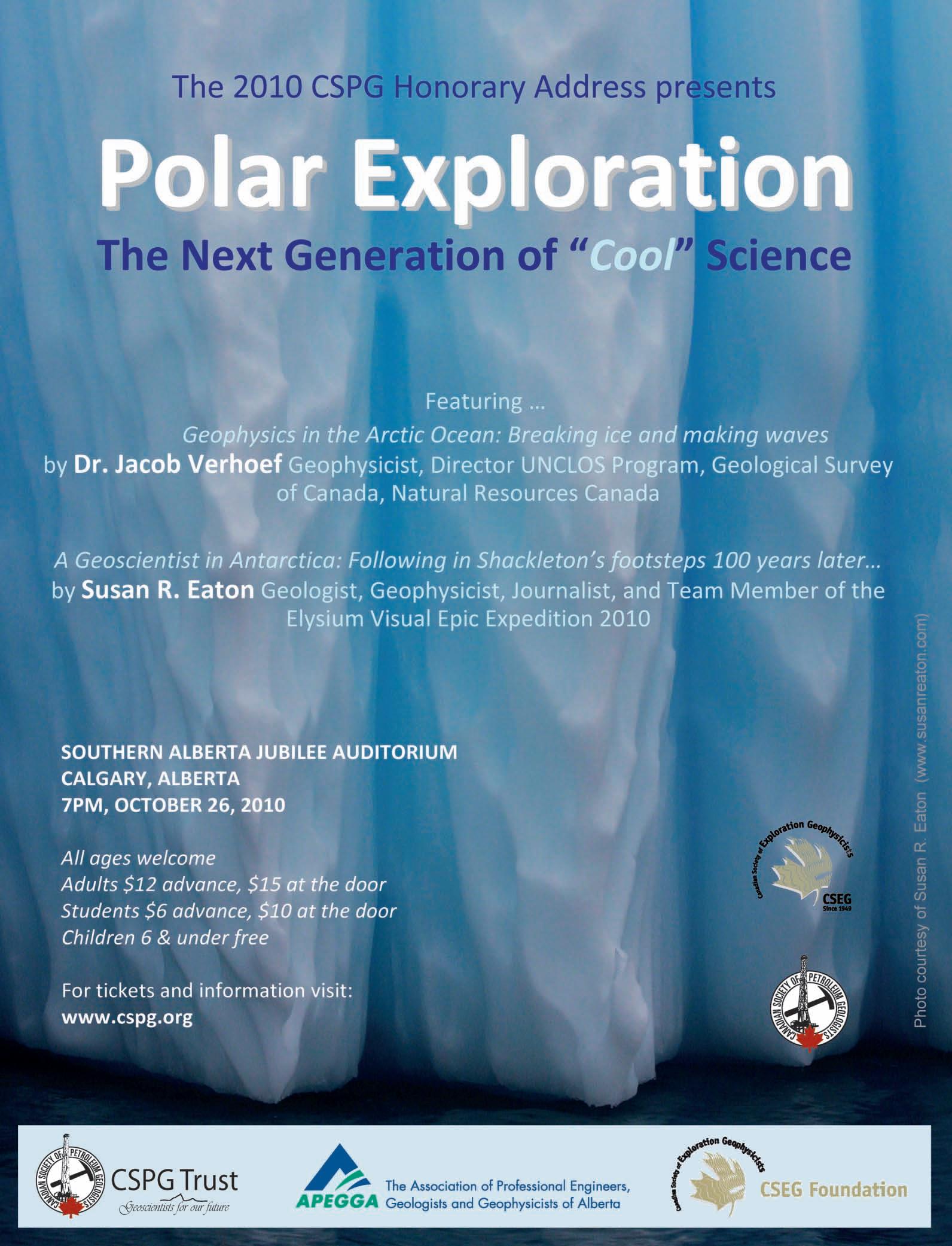
| By Susan R. Eaton
I began packing by assembling the basics for my geology field trip: surface geology maps, topographic maps, hiking boots, wool socks, a backpack and two digital cameras. My gear list soon ballooned to include a hydrophone, an Iridium satellite phone, a laptop computer, an Arctic-rated dry suit (which doubles as a survival suit), flares, a underwater camera housing, long underwear, a parka, mitts, hats, and knee-high rubber boots. Three hundred and fifty pounds of equipment later, I was rigged for a modern-day geology field trip to Antarctica and South Georgia.
In February and March 2010, I joined the scientific crew of the Elysium Visual Epic Expedition (the “Elysium Expedition”), participating in an historical voyage of exploration and discovery to the Bottom of the World. For nineteen days, the Elysium Team – comprised of 57 Explorers from 19 nations – retraced the route of Sir Ernest Shackleton’s Imperial Trans-Antarctic Expedition of 1914-17, a journey that went horribly sideways when the Endurance was crushed by ice and sank, precipitating one of the greatest survival stories of the twentieth century.
During my audition for a coveted spot in the Elysium Expedition – a chance-of-a-lifetime opportunity for me – I waxed poetically about the ground-breaking science conducted by geologists and geophysicists who had played key roles in Shackleton’s numerous polar expeditions. And, I pitched my vision of recreating the role of the ship’s geoscientist, one hundred years later, providing a unique perspective to the discussions of climate change, glaciology, and oceanography. I was joined during the Elysium Expedition by Dr. Toni Williamson, a Toronto-based, Australian geologist, whose doctorate studies involved a paleoenvironmental assessment of climate change during the Early Cretaceous System of Australia.
Just as in Shackleton’s era, mounting an expedition to Antarctica and South Georgia was an incredibly expensive undertaking –in fact, Shackleton continued to fundraise even after the Endurance had sailed from England. My vision to participate in the Elysium Expedition was widely supported through corporate partnerships and by generous individual donors. I also received crucial financial support from geoscience organizations, including the Canadian Society of Exploration Geophysicists, the American Association of Petroleum Geologists, the Association of Professional Engineers, Geologists and Geophysicists of Alberta, and the Canmore Museum and Geoscience Centre. My Antarctic dispatches were published by the Calgary Herald, my supporting geoscience associations,
and the earth science departments of Dalhousie University (my alma mater) and the University of Calgary, enabling readers to explore Antarctica and South Georgia with me.
As a member of the Elysium Expedition’s scientific crew, I worked alongside the world’s preeminent scientists from the Australian Antarctic Division and the Woods Hole Oceanographic Institution, movie makers, photographers, artists, musicians, scuba divers and explorers, including National Geographic’s Photographersin-Residence Emory Kristof and David Doubilet. Kristof is famous for discovering the Titanic with National Geographic’s Explorer-in-Residence Robert Ballard.
During our voyage of exploration and discovery, we visited Grytviken, an abandoned Norwegian whaling station in South Georgia that is littered with whale vertebrae and rusting rendering tanks. Home to the British Antarctic Survey, Grytviken is linked to the outside world by the Internet, and is populated by thirteen Britons and countless King Penguins, Fur Seals, and Elephant Seals.
On January 5, 1922, Shackleton died in Grytviken – of a heart attack at age 47 – shortly after the start of the Quest Expedition. We visited Shackleton’s gravesite in a small cemetery enclosed by a white picket fence and patrolled by King Penguins, enthusiastically toasting this Irishman’s great accomplishments with Jameson Irish
Whiskey. Respectfully, I poured the last dram of my whisky on his grave.
Running the gauntlet of Antarctic Fur Seals – who lunged at us from hiding places in hummocky grass tussocks – we made the pilgrimage to Shackleton’s memorial cairn and cross situated on an exposed hilltop at the entrance to Grytviken Harbour. In the lead was Jonathan Shackleton, an Irish organic farmer, author, and cousin to Sir Ernest. Erected in 1922 by George Vibert Douglas, a Canadian geologist and the Quest Expedition’s chief scientist, the memorial cross faces Magnetic South Pole which was discovered during Shackleton’s Nimrod Expedition of 1909.
Secreted inside the cairn was a scroll bearing the stamp of the Royal Geographical Society. Jonathan Shackleton unfurled the scroll and, with an historical sense of place and purpose, read aloud the names of the Quest Expedition’s crew to our team of twenty-first century Explorers who had been humbled by following in Shackleton’s footsteps one hundred years later...
Join us at the 2010 CSPG Honorary Address, on October 26th at 7:00pm at the Southern Alberta Jubilee Auditorium, to hear Susan R. Eaton present “A Geoscientist in Antarctica: Following in Shackleton’s footsteps 100 years later...”
Susan R. Eaton is a geologist, geophysicist, freelance writer, and an “extreme” snorkeler who lives in Calgary, Alberta.
| Reviewed by Albert Jacobs

Repcheck’s book is not the first biography of the man we know as the Father of Modern Geology. But the title and the subtitle of the book (“the discovery of the earth’s antiquity”) point to his specific emphasis and to the reasons why Geology was a Johnny-come-lately among the sciences.
Hutton (1726-1797) grew up in Edinburgh and – having an inquiring mind – developed a curiosity in various aspects of “natural philosophy”, as science was known in those days. Minerals and chemistry led to an interest in geology, but as it was not taught in Edinburgh, he pursued a medical education, which he completed in Paris and Leyden. Back in Scotland, he did not start a practice, but went to work in agriculture, eventually developing his own farm near Berwick. Meanwhile he continued his pursuit of earth science and made numerous forays to outcrops all over Scotland.
Geology in those days was dominated by the biblical dogma that the earth was 6,000 years old. A theory had been developed in the 1770s and taught by Abraham Gottlob Werner, which held that a universal ocean had blanketed the earth and that all geology that one could see had been the result of this flood. This theory explained igneous dikes as cracks filled by sediment and volcanoes as shallow pimples. Werner and his many followers fitted well within the
accepted limits of creation, as laid out in the first verses of Genesis 1, but they had to wring themselves through rather absurd contortions of logic to do so.
Hutton saw things differently: intrusions, unconformities, tilted, folded, even vertical bedding. He came to the conclusion that a great heat source in the earth caused uplifts and downwarps and that the earth had to be much, much older than 6,000 years. He stated: “In the economy of the world, I can find no traces of a beginning, no prospect of an end.”
One must understand the power of the church in those days to appreciate the vehement opposition that resulted from this concept. The establishment, which apart from Werner included Kirwan, De Luc, and Jameson, kept the upper hand over Hutton, who was not a very good communicator and had towards the end of his days only completed two of the three sections of his “Theory of the Earth.”
What eventually won the day after Hutton’s death were his friends at the Royal Society of Edinburgh, which embodied the Scottish Enlightenment, a truly remarkable intellectual movement in the arts and sciences. His old friend John Playfair summarised Hutton’s work in 1802 by extending the “Theory of the Earth” and Charles Lyell, using Hutton and Playfair as starting points, published his standard reference work “Principles of Geology” between 1830 and 1832.
Modern geology as a science was born. James Hutton had been the man with the insight and author Repcheck consequently classifies him with Copernicus, Gallileo, and Darwin “as the key figures in the freeing of science from the straightjacket of religious orthodoxy.”

Every unconventional gas project is unique—and mandates a customized, reservoir-specific solution. Around the world, the experts from Halliburton are there when you need them, providing proven solutions along with unequalled customer commitment.
What’s your tight gas challenge?For solutions, go to Halliburton.com/unconventional.


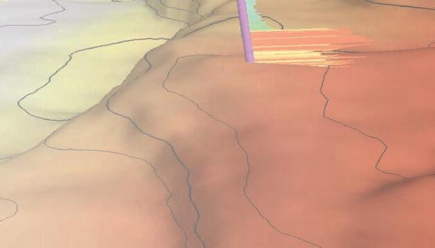
Geomodeling Consulting Services
Onsite
Remote
Customized
Training
Software Products The
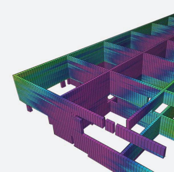
Software Development Services
Development
Development of Petrel plug-in applications
Development services as consultancy