Follow the Leader.
The global industry leader in critical information and insight, IHS continues to invest in the progress of the Canadian energy market so you can get from discovery to drilling in record time. By updating, improving and streamlining our Canadian products and services, we have delivered workflow integration between IHS PETRA® and IHS AccuMap®; created solutions for better access to global resources, from well log databases to subject matter experts; and continued to provide transparency and insight to Canadian energy businesses that need actionable information.
See how IHS is investing in Canada at www.followihs.com.


CSPG OFFICE
#110, 333 – 5th Avenue SW
Calgary, Alberta, Canada T2P 3B6
Tel: 403-264-5610
Web: www.cspg.org
Office hours: Monday to Friday, 8:30am to 4:00pm
Executive Director: Lis Bjeld
Email: lis.bjeld@cspg.org
Registration Coordinator: Dayna Rhoads
Email: dayna.rhoads@cspg.org
Publications Coordinator: Caitlin Young
Email: caitlin.young@cspg.org
Member Services Coordinator: Kasandra Klein
Email: kasandra.klein@cspg.org
Outreach Coordinator: Alyssa Middleton
Email: alyssa.middleton@cspg.org
Corporate Sponsorship: Lis Bjeld
Email: lis.bjeld@cspg.org
Business Development: Aileen Lozie
Email: aileen.lozie@cspg.org
EDITORS/AUTHORS
Please submit RESERVOIR articles to the CSPG office. Submission deadline is the 23rd day of the month, two months prior to issue date. (e.g., January 23 for the March issue).
To publish an article, the CSPG requires digital copies of the document. Text should be in Microsoft Word format and illustrations should be in TIFF format at 300 dpi., at final size. For additional information on manuscript preparation, refer to the Guidelines for Authors published in the CSPG Bulletin or contact the editor.
Technical Editors
Ben McKenzie Colin Yeo (Assistant Tech. Editor) Tarheel Exploration EnCana Corporation
Tel: 403-277-4496 Tel: 403-645-7724
Email: bjmck28@shaw.ca Email: colin.yeo@encana.com
Coordinating Editor
Caitlin Young, Publications Coordinator, CSPG
Email: caitlin.young@cspg.org
ADVERTISING
Advertising inquiries should be directed to Caitlin Young, email: caitlin.young@cspg.org. The deadline to reserve advertising space is the 23rd day of the month, two months prior to issue date.
The RESERVOIR is published 11 times per year by the Canadian Society of Petroleum Geologists. This includes a combined issue for the months of July and August. The purpose of the RESERVOIR is to publicize the Society’s many activities and to promote the geosciences. We look for both technical and non-technical material to publish. Additional information on the RESERVOIR’s submission guidelines can be found at http://www.cspg. org/publications/pubs-reservoir-submissions.cfm. The contents of this publication may not be reproduced either in part or in full without the consent of the publisher. Additional copies of the RESERVOIR are available at the CSPG office. No official endorsement or sponsorship by the CSPG is implied for any advertisement, insert, or article that appears in the Reservoir unless otherwise noted. All submitted materials are reviewed by the editor. We reserve the right to edit all submissions, including letters to the Editor. Submissions must include your name, address, and membership number (if applicable). The material contained in this publication is intended for informational use only. While reasonable care has been taken, authors and the CSPG make no guarantees that any of the equations, schematics, or devices discussed will perform as expected or that they will give the
FRONT COVER
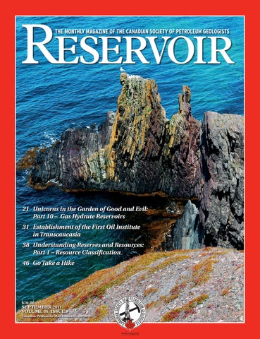
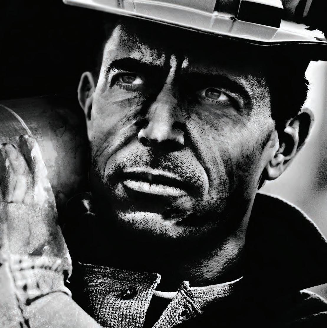
Grand Banks, Newfoundland, steeply dipping red beds of Rencontre Formation.
Photo by Erlangga Septama.
Ian a. Mc Ilreath, P.Geol., PhD
2011 Geoscientists Canada: Canadian Professional Geoscientist Award

The 2011 recipient of the Canadian Professional Geoscientist Award is The Association of Professional Engineers, Geologists and Geophysicists Member Dr. Ian McIlreath, P.Geol. Presented annually, the award is given by Geoscientists Canada to a Professional Geoscientist who has made an outstanding contribution to the development and practice of geoscience, and who has increased public recognition of the geoscience profession in Canada.
An elected Member of APEGGA Council from 2002–2005, he also served as the Association’s Director on the Canadian Council of Professional Geoscientists (now Geoscientists Canada) in 2007. He has actively served on numerous APEGGA committees including the Geoscience, Audit, Strategic Planning and Governance Model Review. For his valuable contributions to the Association he was awarded the APEGGA L.C. Charlesworth Professional Service Summit Award® in 2009.
Dr. McIlreath’s involvement in many technical and professional societies has helped shape the direction of both APEGGA and the broader geoscience community. He is the only person to have served as President of both the Canadian Society of Petroleum Geologists (1983) and the Geological Association of Canada (1992). He has shared his experiences and technical knowledge with his colleagues around the world by authoring or co-authoring more than 60 scientific publications, and through talks and public presentations.
Devoting more than 30 years of his career to active participation in Canada’s leading earth science organizations, Dr. McIlreath has made, and continues to make, truly outstanding contributions to the field of geology on both a national and international level. In addition to his involvement with the geoscience community, he has mentored a generation of Earth Sciences students by promoting technical excellence and high achievement. His ongoing dedication to improving the professional standards in the geoscience community has been exceptional and unflagging.
Since 1927...


CSPG EXECUTIVE
President Kirk Osadetz • Geological Survey of Canada, Calgary kosadetz@nrcan.gc.ca Tel: (403) 292-7022
Vice President
Robin Mann • AJM Petroleum Consultants rcmann@ajmpc.com Tel: (403) 648-3210
Past President
John Varsek • Cenovus Energy john.varsek@cenovus.com Tel: (403) 645-5417
Finance director
Darren Aldridge • Baker Hughes Incorporated darren.aldridge@bakerhughes.com Tel: (403) 537-3400
assistant Finance director
Andrea Hood • geoLOGIC systems ltd. ahood@geologic.com Tel: (403) 262-1992
Program director
Brett Norris • TransGlobe Energy Corp. brettn@trans-globe.com Tel: (403) 264-9896
assistant Program director
Jon Noad • Murphy Oil Corporation jon_noad@murphyoilcorp.com Tel: (403) 294-8829
serVices director
Chris Seibel • Nexen Inc. chris_seibel@nexeninc.com Tel: (403) 699-4558
assistant serVices director
Michelle Hawke • Apache Canada Ltd. Michelle.Hawke@apachecorp.com Tel: (403) 261-1200
communications director
Jim Barclay • ConocoPhillips Canada
Jim.E.Barclay@conocophillips.com Tel: (403) 532-3889
assistant communications director
Stephen Hubbard • University of Calgary steve.hubbard@ucalgary.ca Tel: (403) 220-6236
outreach director
Steve Dryer • Whiskey Jack Resources Inc. whiskeyjackresources@telus.net Tel: (403) 969-2292
assistant outreach director
Simon Haynes • Statoil Canada Ltd. sihay@statoil.com Tel: (403) 724-0364
executiVe director
Lis Bjeld • CSPG lis.bjeld@cspg.org Tel: (403) 264-5610
EXECUTIVE COMMENT
A message from the CSPG Communication Director, Jim Barclay

Dear Diary,
Are you feeling revitalised yet?
It is summer. Finally. Thoughts are of the outdoors, golf, the lawn, cool drinks. The deadline for an “Executive Comment” leapt out, startling those thoughts. There is no better time to reflect on this than towards the end of summer.
Between time at the office, fieldwork, personal activities, and the CSPG convention, your communication directors have not had much time recently to act on CSPG initiatives and tasks. Excuses, excuses... So then, what has been achieved over the last year?
I n a nutshell, not as much as we promised in the September 2010 Reservoir – but then we didn’t do too badly either. Over the last year we’ve been focused on revitalisation, or renewal as a Society.
We had promised a new and revitalised CSPG website, a “virtual CSPG.” Do we have that yet? – You bet! We’re proud of the work Jeremy Sherry has completed with input from members and the Executive and CSPG office staff, notably Caitlin Young and Lis Bjeld.
The new website rollout was ready before this year’s May convention but we couldn’t afford to let a rollout interfere with the rush of pre-Convention activity (inviting disaster). And over the later part of the summer, our servers were out of action until the move to the new CSPG office. A September rollout of the new improved website made the most sense.
Last year in our “Comment” we talked about considering ideas for the Bulletin –those ideas are still being kicked around but, truth be told, we volunteers have found it extremely difficult to make time to create a plan and begin its execution. Volunteer time is obviously precious
and this year, volunteer efforts had to compete with significant work and family demands for all concerned. Thankfully, the Society has been able to rely on the tireless efforts of the Bulletin editors and associate editors whose great work ensures the publication maintains its high standing. Did you know that in 2012 the 60th volume of the Bulletin will be published? To consider the number of volunteers that have helped to make this possible over the decades is truly mindboggling!
Ben McKenzie and the dedicated “Digital Atlas” team have been working hard to push this game-changing task along. The project is in a scoping phase. Along with considering the awesome potential benefits and func tionality that are possible, the team is wrestling with creating a business plan that can cover aspects of producing, hosting, costs, sponsorship, in-kind work, and other important aspects.
A book commemorating Cindy Riediger’s life featuring “Go Take a Hike” contributions to the Reservoir is well underway, spearheaded by Phil Benham and a dedicated volunteer team. Although important details concerning book preparation and publication remain to be resolved, this effort will definitely be worth it, based as always on the hard work of volunteers.
One of us (JB) became distracted from Communications tasks from December until May, becoming involved with the Horn River Basin sessions, along with Dale Leckie, for our CSPG Convention. We’re happy to report that we filled five ½-day sessions with top-notch speakers from all over North America. We also compiled and produced the first-ever book on the Horn River Basin shale play. What was our learning from these sessions? Again, our (Continued on page 7...)
Since 1927...

CORPORATE SPONSORS
DiamonD
IHS
geoLogIC SyStemS Ltd.
SCHLumberger Canada Ltd.
Platinum agat LaboratorIeS CenovuS
ConoCoPHILLIPS
nexen InC.
taLISman energy
PoggenPoHL
GolD
aPegga
CSPg eduCatIonaL truSt Fund devon Canada
enCana
ImPerIaL oIL
SHeLL
WeatHerFord LaboratorIeS
Silver
arC FInanCIaL CorPoratIon roxar
Bronze ParadIgm
geovarIanCeS
CSeg FoundatIon
rPS boyd PetroSearCH
HaLLIburton energy ServICeS
tuCker WIreLIne ServICeS
(...Continued from page 5)
members want as m uch technical material as possible – always – it is our default stance. a nd, a shameless plug: copies of the book are still available at the office for $20!
Well, dear d i ary, as our terms on the e xecutive wind down, it surely feels as though the last two years have flown by. o n e of our wise predecessors advised us new e xecutives in late 2009 to “Pick one thing to accomplish, and you have a CH a n C e at doing that one.” We didn’t follow that advice too well, picked more than one initiative, got one done for sure. With that said, we think we took a few good chops out of some of the other initiatives as well. o n e thing is certain –there is still lots to do. We look forward to volunteering with the CSP g for many years to come.
What do we expect for the next couple of years for incoming Communications d irectors?
• Website rollout and future augmentation to deliver as full a technical content as we can. m a ke
it the premiere geological website in n o rth a m erica. Period.
• C ontinued evolution of our flagship publication, the b u lletin.
• C ontinued development of its sister publication, the re servoir.
• S coping and rollout of the “Digital at las” with all its potential.
• P ublication of the “Go Take a Hike” volume.
• A renewal of our Special Publications format, as well as other technical publications.
We are very pleased with the momentum that has developed that will surely revitalise Communications aspects of the CSP g over the next years. o n e thing is certain – there is still lots to do.
AS OF AUGUST 10, 2011
technicaL Luncheons SEPTEMBER LUNCHEON
Drumheller
revisited: Insights into reservoir architecture and compartmentalization prediction in marginal marine systems
SPEAKER
Professor Bruce a in sworth Australian School of Petroleum, University of Adelaide
11:30 am, tue sday, s eptember 13, 2011 c algary, te L us convention cent re c alg ary, a lb erta
Please note: t he c ut-off date for ticket sales is 1:00 pm, t hu rsday, s eptember 8, 2011 cs P g m em ber t ic ket Price: $42.00 + g st. n on - m em ber t ic ket Price: $45.00 + g st.
Each CSPG Technical Luncheon is 1 APEGGA PDH credit. Tickets may be purchased online at https://www.cspg.org/eSeries/source/Events/ index.cfm.
Stratigraphic architecture at a subparasequence scale controls fluid flow and compartmentalization in many marginal marine reservoirs. However, this scale falls below the resolution of current sequence stratigraphic techniques and, as such, there is no rigorous methodology or classification to describe these deposits. To address this issue, new concepts have been developed for the classification of depositional processes and stratigraphic architecture in both modern and ancient marginal marine systems. This methodology facilitates collation and cross-applicability of geometrical data from modern to ancient systems, and viceversa. The new architectural classification system is hierarchical in nature and works on five different spatial levels. The levels correspond to different scales of observation and are required to describe properly the stratigraphic variability in the subsurface.
Webcasts sponsored by
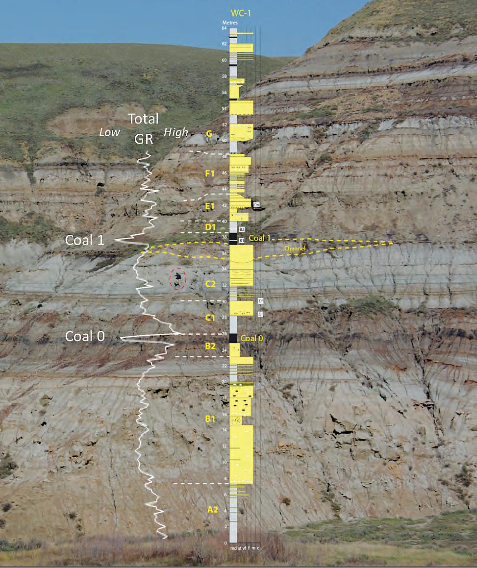
The new classification schemes have direct applicability to complex, mixed-process marginal marine systems – shorelines where the interactions of wave, tide, and fluvial processes are significant factors in determining sand body architecture. The Campanian Bearpaw to Horseshoe Canyon Formation transition in the Drumheller area, Alberta, is a classic example of a mixed-process marginal marine system. Outcrop sedimentary logging along the Red Deer River Valley (Figure 1) has been combined with core descriptions from four wells close to the outcrop.
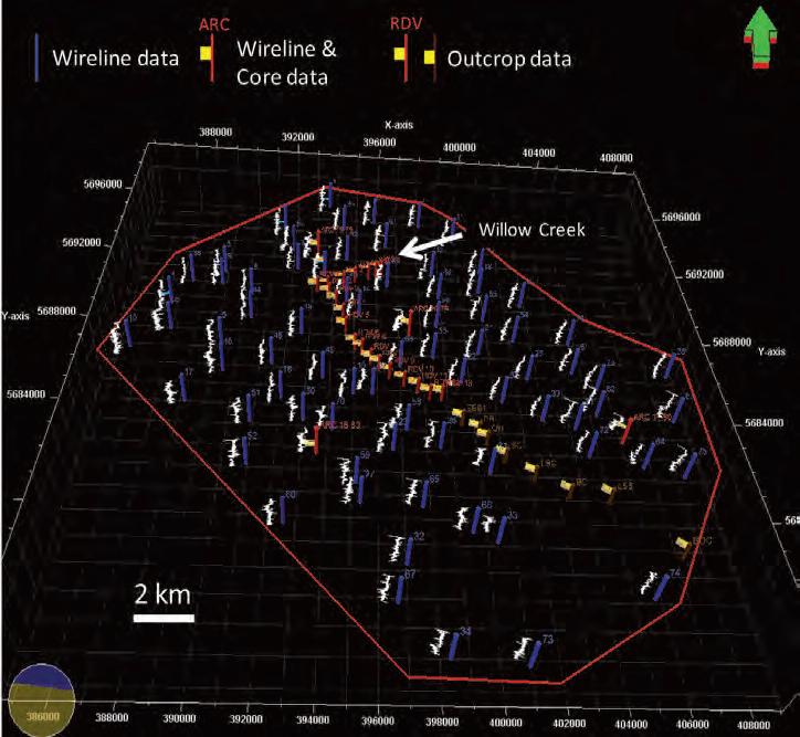
The outcrop sedimentary log data has been calibrated to the core data and then the core data to the wireline log data acquired in the cored wells. Spectral
gamma ray data have also been gathered from outcrop locations (Figure 1). This permitted interpretation of over 70 well log suites around the outcrop belt and the generation of outcrop, core, and wireline log-constrained, three-dimensional (3D) reservoir models of the area surrounding the outcrops (Figure 2).
The Drumheller study has been utilised as a test case for the new classification techniques. The talk will demonstrate how the application of these new methodologies can result in improved selection of depositional analogues and geometrical data for 3D reservoir modelling studies, and improved prediction of stratigraphic compartmentalization potential in marginal marine reservoirs.
Figure 1. Willow Creek sedimentary log (64 metres thick) and associated outcrop total gamma log (GR). Person circled in red for scale. Bearpaw to Horseshoe Canyon transition, near Drumheller, Alberta. See Figure 2 for Willow Creek location.
BIOGRAPHY
Bruce Ainsworth holds the South Australian State Government Chair of Petroleum Geology at the Australian School of Petroleum, University of Adelaide. He re-joined academia in 2007 following fifteen years of industry experience with Shell International Exploration and Production Company. Bruce worked for five years in Shell Research Laboratories in the
Netherlands and gained ten years practical experience in exploration and production companies around the globe. He has work experience of geological systems from fourteen countries and has niche expertise in sedimentology, seismic and sequence stratigraphy, and the application of the inherent uncertainties in these data and interpretations to multiple-scenario three-dimensional
reservoir modelling. Bruce is currently the leader of the Reservoir Analogues Research Group (RARG; http://www.asprg.adelaide. edu.au/RARGwww/rarg_index.html) and the leader of the WAVE Consortium (http://www. asprg.adelaide.edu.au/WAVE/index.htm), an industry-sponsored research collective that focuses on reservoir heterogeneities in mixed-process (wave/fluvial/tidal) sandbodies.
Bruce has a B.Sc. from Imperial College, UK, an M.Sc. from McMaster University, Canada, and a Ph.D. from the University of Liverpool, UK. He is a member of the American Association of Petroleum Geologists (AAPG); the International Association of Sedimentologists (IAS); the Society for Sedimentary Geology (SEPM); The Geological Society, London; and the Petroleum Exploration Society of Australia (PESA).
Figure 2. 3D visualization of well, core, and outcrop data utilized for 3D geocellular modelling of the Bearpaw to Horseshoe Canyon transition area in the Red Deer Valley, Drumheller, Alberta. Gamma Ray logs in white. Image courtesy of Changhwan Lee. Well log data courtesy of IHS and AccuMap.
technicaL Luncheons SEPTEMBER LUNCHEON
Canadian Broadcasting Corporation’s Geologic Journey – World: bringing geology to the nation’s living room
SPEAKER
Nick e yl es University of Toronto
11:30 am
m on day, s ep tember 26, 2011
c al gary, t e L us c onvention c ent re c alg ary, a lb erta
Please note: the cut-off date for ticket sales is 1:00 pm, Wednesday, september 21, 2011. csPg member tic ket Price: $42.00 + g st. non - member tic ket Price: $45.00 + g st.
Each CSPG Technical Luncheon is 1 APEGGA PDH credit. Tickets may be purchased online at https:// www.cspg.org/eSeries/source/Events/index.cfm.
This talk will explore the scientific and logistical challenges of bringing the story of ‘How planet Earth works’ to a wide public television audience. The story of Geologic Journey – World is organized around the life cycles of oceans and supercontinents; the basic cycle of Earth’s long history. It commences in the East African Rift and Red Sea areas, which are examples of incipient and young oceans, respectively, travels on to Iceland where the spreading centre of a mature ocean can be walked over, and examines the tectonically troubled Pacific Rim where oceanic crust is being subducted below encroaching land masses as the next supercontinent (Pangea II) begins to form. The Himalayas are the remains of a dead
Webcasts sponsored by
ocean. The talk also touches on the peoples that live in tectonically active areas and the tectonic threat to the world’s emerging megacities.
BIOGRAPHY
Nick Eyles, Ph.D., D.Sc., P.Geo., is Professor of Geology at the University of Toronto and completed graduate work in glaciology and glacial geology at Memorial University in Newfoundland, and at East Anglia in UK. His subsequent research career has taken him across Canada, around the world, and also back in time through Earth’s 4-billion-year history exploring its glacial climates. His other interest is in urban environmental issues. He is a prolific award-winning author of best-selling books such as ‘Ontario Rocks’ and ‘Canada Rocks’ (with Andrew Miall) and Canadian Shield: The Rocks that made Canada. He was chief scientific advisor to the Canadian Broadcasting Corporation’s highly successful series ‘Geologic Journey-Canada’ in 2007 and the host of the five-part ‘Geologic Journey – World,’ which aired on ‘The Nature of Things’ in 2010, CBC’s most widely viewed documentary series to date.
Western Canada: Slave Point, Swan Hills, Leduc, Grosmont, Jean Marie, Horn River Shales, Elkton, Shunda, Pekisko, Banff, Mississippian subcrops and anhydrite barriers in SE Sask., Bakken, Three Forks, Montney, Halfway, Charlie Lake, Rock Creek, Shaunavon, BQ/Gething, Bluesky, Glauconitic, Lloyd, Sparky, Colony, Viking, Cardium, Horseshoe Canyon and Mannville CBM, Oilsands Areas, Outcrops
US Rockies & Williston: Red River, Mississippian subcrops & anhydrite barriers (Bluell, Sherwood, Rival, etc), Bakken, Three Forks, Cutbank, Sunburst, Tyler, Heath, Muddy, Dakota, Sussex, Shannon, Parkman, Almond, Lewis, Frontier, Niobrara, Mesaverde shorelines, Minnelusa, Gothic, Hovenweep, Ismay, Desert Creek, Field Outlines, Outcrops
North American Shales: Shale plays characterized by O&G fields, formation limit, outcrop, subcrop, structure, isopach, maturity, stratigraphic cross-sections. Includes: Marcellus, Rhinestreet, Huron, New Albany, Antrim, Utica-Collingwood, Barnett, Eagleford, Niobrara, Gothic, Hovenweep, Mowry, Bakken, Three Forks, Monterey, Montney, Horn River, Colorado
Appalachian Basin: PreCambrian, Trenton, Utica-Collingwood, Medina-Clinton, Tuscarora, Marcellus, Onondaga Structure, Geneseo, Huron, Antrim, New Albny, Rhinestreet, Sonyea, Cleveland, Venango, Bradford, Elk, Berea, Weir, Big Injun, Formation limits, Outcrops, Allegheny Thrust, Cincinatti Arch, Field outlines
Deliverables include:
-Shapefiles and AccuMap map features -hard copy maps, manual, pdf cross-sections -Petra Thematic Map projects, GeoGraphix projects, ArcView map and layers files -bi-annual updates and additions to mapping -technical support
technicaL Luncheons OCTOBER LUNCHEON
Recent advances in characterization of shale resources for exploration and production
SPEAKER
r og er m . Sl att
Director, Institute of Reservior Characterization and Gungoll Chair Professor of petroleum Geology and Geophysics, University of Oklahoma
11:30 am
t hu rsday, o ct ober 13, 2011 c al gary, t e L us c onvention c ent re c alg ary, a lb erta
Please note: the cut-off date for ticket sales is 1:00 pm, monday, october 10, 2011 csPg member ticket Price: $42.00 + gst non - member ticket Price: $45.00 + gst.
Each CSPG Technical Luncheon is 1 APEGGA PDH credit. Tickets may be purchased online at https:// www.cspg.org/eSeries/source/Events/index.cfm.
The revelation of vast global quantities of potentially gas- (and oil-) productive shales has paved the way for rapid advancements in the application of geological, geophysical, geochemical, petrophysical, and geomechanical characterization for exploration and production. The Shale Characterization Group at the University of Oklahoma has developed and applied a workflow for multi-scale, multi-disciplinary characterization. This workflow was developed initially during research on the Barnett and Woodford shales, but has since been extended to the Horn River, Fayetteville, Caney, Lewis, and Longmaxi (China) shales.
In the geological realm, conventional sequence stratigraphic principles have proven viable to establishing a regionalto local-correlation strategy, but building a workable sequence stratigraphic framework that can differentiate most favorable intervals for drilling and completion requires detailed SEM, thinsection, mineralogic, sedimentologic, and even outcrop studies.
In the geophysical realm, seismic inversion and attribute analysis continue to improve the resolution and imaging of subtle structural and stratigraphic features within shale strata both locally and regionally. Seismic attribute analyses have also revealed positive relations between shale stratigraphy and the underlying unconformity surfaces upon which resource shales usually sit.
In the geochemical realm, parameters
Webcasts sponsored by
that can define areas for best production within a shale sequence include TOC, HI, Ro, biomarkers, and isotopes. Ethane reversals seem to be particularly well correlated to areas of best shale gas production.
In the geomechanical realm, it has become possible to identify brittle-ductile couplets from the sequence stratigraphic down to the bed/laminae scales based
(Continued on page 12...)
NeuraJet17
Quality Log Printing up to 17” Wide
Spend more time focused on analysis and less time printing. Top of form loading, printing and stacking combine to make an automated printing solution. See why the NeuraJet17 is the ideal choice for you and your organization.
• Designed for continuous fanfold paper
• Top of form log prints
• Automatic paper handling
• Stacker and stand included
• First year warranty included
For more information call 1.281.240.2525
www.NeuraJet17.com

upon a variety of characteristics, and further insights have been gained into understanding the complexities of hydraulically induced, microseismic events within shale reservoirs.
In the petrophysical realm, much attention has been paid to nano-scale, organoporosity as significant storage areas for free and adsorbed gas. However, other work has identified a variety of other pore types that may be in shales that also contribute to the storage, and possibly flow of reservoir fluids.
In summary, an ever-evolving integrated, multi-scale, multi-disciplinary approach to understanding shales can lead to enhanced exploration and production success.
BIOGRAPHY
Roger M. Slatt currently holds the Gungoll Family Chair Professor in Petroleum Geology and Geophysics at University of Oklahoma and Director of the Institute of Reservoir Characterization in the Sarkeys Energy Center at OU. He was Director of the School of Geology and Geophysics and Eberly Family Chair Professor at University of Oklahoma from 2000-2006, and the Gungoll Chair Professor of Petroleum Geology and Geophysics in 2006-07. He formerly was Head of the Department of Geology and Geological Engineering at Colorado School of Mines (1992-2000) and Director of the Rocky Mountain Region Petroleum Technology Transfer Council (1995-2000).
After receiving his Ph.D. in 1970 from the University of Alaska, he taught geology for eight years at Memorial University of
ROCK SHOP
Newfoundland and Arizona State University. He then spent 14 years in the petroleum industry with Cities Service Research, ARCO Research, and ARCO International Oil and Gas. Co. before joining Colorado School of Mines in 1992. He has published over 100 papers and abstracts, and has made numerous presentations on the subjects of petroleum geology, reservoir geology, seismic and sequence stratigraphy, shallow marine and turbidite depositional systems, geology of shale, glacial and Pleistocene-Quaternary geology, and geochemical exploration. He sits on various professional society committees, has organized technical conferences for American Association of Petroleum Geologists (AAPG), and teaches short courses for industry and AAPG on the “Introduction to the petroleum geology of deep-water (turbidite) depositional systems” and on “Principles of geologic reservoir characterization.” He also offers a global, web-based course on “Introduction to geologic reservoir characterization” to people from many different countries. He has taught his two courses in many places in the U.S., as well as in many countries, including Colombia, Mexico, Indonesia, Malaysia, Australia, Angola, India, New Zealand, Scotland, and England.
While employed in the international oil and gas industry, he had the opportunity, as Director of Reservoir Evaluation, to study numerous oil and gas fields and exploration prospects worldwide, and to make recommendations to senior management for international investment. Many of Dr. Slatt’s publications have dealt with the subject of exploration for, and development of deepwater submarine fan (turbidite, basin floor fan) oil and gas reservoirs. He is considered an expert on deepwater submarine fan exploration and
development, and has worked in both industry and as a consultant on many such reservoirs globally. In late 2006 he completed coauthoring a book titled: Introduction to the Petroleum Geology of Deepwater Settings, published by the American Association of Petroleum Geologists. He also completed a book in late 2006 titled Stratigraphic Reservoir Characterization for Petroleum Geologists, Geophysicists, and Engineers, published by Elsevier. Also in 2006, he organized the 26th Annual Gulf Coast Assoc. Sedimentary Geologists (GCSSEPM) conference, titled Reservoir Characterization: Integrating Technology and Business Practices, and was chief editor of a CD book comprised of papers from that conference. Since 2002, he has taught a web-based course semiannually for AAPG titled Introduction to Geologic Reservoir Characterization.
In 1996 he received the AAPG Distinguished Service Award. In 1999 he was the Esso Australia Distinguished Lecturer in Petroleum Geology. In 2001-2002, he was an AAPG Distinguished Lecturer, giving a presentation titled “Outcrop/behind outcrop characterization of deepwater (turbidite) petroleum reservoir analogs: why and how.” He offered the same presentation as an SPE Distinguished Lecturer in 2003. In 2003, he was awarded with AAPG Honorary Membership. In 2006 he received the AAPG Grover Murray Distinguished Educator Award. In 2007 he received the Society of Exploration Geophysicists (SEG) Special Commendation Award “in recognition of meritorious service rendered the scientific community, the earth sciences and exploration geophysics”.
PRACTICAL QUANTITATIVE LOG ANALYSIS COURSES

technicaL Luncheons OCTOBER LUNCHEON
Applications of ichnology in facies analysis and sequence stratigraphy: The state of the art, trends, and perspectives
SPEAKER
l uis a . Buatois
Department of Geological Sciences, University of Saskatchewan
11:30 am
t hursday, o ctober 27, 2011
c algary, te L us c onvention c entre c algary, a lberta
Please note: the cut-off date for ticket sales is 1:00 pm, monday, october 24, 2011 csPg member ticket Price: $42.00 + gst. non- member ticket Price: $45.00 + gst.
Each CSPG Technical Luncheon is 1 APEGGA PDH credit. Tickets may be purchased online at https://www.cspg.org/eSeries/source/ Events/index.cfm.
The applications of ichnology to facies analysis and sequence stratigraphy have
(Continued on page 14...)
Webcasts sponsored by
CSPG Continuing Education
Education Week Short Courses
www.cspg.org/education/education-week.cfm
•Fault failure mechanisms, fracture development, and resource plays – Analysis and the - Paul MacKay
•Log Analysis of Unconventional Reservoirs - Ross Crain
•Rock Creek Stratigraphy, Sedimentology, and Petroleum Geology - Doug Cant
•The Architecture of Fluvial Reservoirs - Andrew Miall
Upcoming Short Courses
www.cspg.org/education/education-courses.cfm
•Technology of Multi-Stage Fracing of Horizontal Wells
- Saad Ibrahim
Petroleum Geology Strata role of uid pressure
•Writing for Earth Scientists: a One-day Clinic - Matt Hall
•Basic Core Logging with Integrated Ichnological Techniques - Kerrie Bann
•Sequence Stratigraphy: Principles and Applications - Octavian Catuneanu
•Optimization of Fractured Well Performance of Horizontal Wells - Ruhul Amin
•Petroleum Geomechanics for Developing Unconventional Resources - Pat McLellan
•Subsurface Methods - Core Work and Log Correlation in Clastic Sediments - Doug Cant
•Mannville Stratigraphy, Sedimentology, and - Doug Cant
•The Stratigraphic Setting of Lower and Middle Triassic - Jim Dixon
Register NOW! Please visit www.cspg.org/education/education.cfm to register today
been at the forefront of the discipline during the last twenty years. Nevertheless, advances have been uneven. Marine clastic ichnology has been the main focus of most research. Continental ichnology has recently become the centre of considerable attention, and exciting advances have been made in this field also. A smaller number of studies have dealt with carbonates and volcaniclastics, and mixed carbonatesiliciclastic environments have been hardly explored. Even so, not all areas of marine clastic ichnology have been studied to the same level.
Both shallow- and deep-marine ichnofaunas have received similar attention, but studies in shallow-marine environments have attained better integration with sedimentologic data. In turn, the ichnology of wave-dominated, shallow-marine environments has been explored in more detail than their tidedominated counterparts, resulting in the so-called “shoreface model.” However, recent research is providing insights into the ichnology of tidal flats and subtidal sandbodies. The ichnologic content of sandy shores is much better known than that of muddy coasts. In fact, some specific types of muddy shorelines (e.g., chenier plains) remain essentially unrecognized in the geologic record. End-members with respect to wave and tidal dominance are better understood than mixed systems (i.e., wave-dominated tidal flats and tidal beaches).
Recent work on the ichnology of deepmarine systems based on both modern and ancient examples has provided a wealth of information (e.g., recognition of hyperpycnal flows, episodic turbidity currents, bottom currents). In marginalmarine environments, studies resulted in the “brackish-water model” in the 1990s. This was followed by a shift to the ichnology of deltaic systems. However, river- and wave-dominated deltas are better known than tide-dominated ones. In addition, shelf deltas have been explored from an ichnologic perspective, but little is known on shelf-edge deltas. The increased recognition that some brackish-water suites do not occur, neither in estuarine systems nor in the proximal portion of deltas, promoted further research on the ichnology of bays in an attempt to search for an alternative model. The ichnology of marginal-marine systems in high latitudes remains poorly explored, although progress has been attained particularly in connection with the late Paleozoic glaciation in Gondwana.
In the carbonate system, significant work has been done on the ichnology of Bahamian-type carbonates, reefs, chalks, and rocky shorelines, but little has been done on carbonate turbidites. Continental ichnology has experienced much focus during the last fifteen years, which has resulted in a dramatically changed appreciation of the ichnology of lakes, fluvial systems, paleosols, and eolian deposits. The fields of invertebrate
and vertebrate ichnology have evolved independently, with research involving two separate scientific communities to a great extent. The need for integrating vertebrate and invertebrate datasets has long been recognized, and future efforts will lead to considerable insight.
With respect to sequence-stratigraphic applications, the focus has also been on marine clastic successions. However, recent progress has been made on the use of ichnology in lacustrine and carbonate sequence stratigraphy. Promising lines of research in this field include the use of paleosol ichnofacies in the recognition of sequence boundaries, increasing our database on trace fossils and discontinuity surfaces in carbonates, distinction between autogenic and allogenic examples of the Glossifungites ichnofacies, and elucidation of stratal stacking patterns in mixed tideand wave-influenced settings.
Available trace-fossil models tend to overlook the fact that biogenic structures, although an evidence of behavior controlled by environmental factors, are in fact a historical product of evolution. As such, ichnofaunas display remarkable variability through geologic time. Temporal calibration of trace-fossil models is essential to understand the imprint of macroevolution, increasing their applicability to solve problems in sedimentology and stratigraphy.
(...Continued from page 13)

With the launch of Paradigm 2011, we’re raising the bar once again, redefining performance, integration, ease of use and scientific integrity from seismic to simulation, on Windows® and on Linux® Prepare to be amazed! See it live at the Paradigm Canada Launch Event October 13 – The Metropolitan Center, Calgary, Alberta For more information, email Ashley.Millar@pdgm.com
diVision taLKs INTERNATIONAL DIVISION
Venezuela: A country evaluation –structural development, hydrocarbon habitat, and production challenges
SPEAKER
C.D. (Sam) Johnston Johnston Seismic Consulting Ltd. E xGEO -CGGVeritas
12:00 Noon
Wednesday, September 14th, 2011 Nexen Plus 15 Conference Centre Nexen a nnex Building 7th ave . & 7th Street SW Calgary, a lberta
For a large or small oil or gas company, a service company, or an independent geoscience consultant, working in Venezuela is a challenge. One has to evaluate whether the problems are worth the rewards. The hydrocarbon rewards are certainly large on both a present day and a future basis for oil, heavy oil, and gas. The challenges are geotechnical, political, and economic!
ARE YOU UNDER THE AGE OF 35?
On Thursday, October 13th, 2011, CSPG will be holding its second annual Future Prospects event at Belgo Brasserie. This event will serve as a social networking and learning opportunity, catering to geologists or geology students that are 35 years of age or younger. Graduate students and young professionals from the industry are invited to showcase posters of their latest research in an informal environment. More details to follow soon!
This summary talk will first outline the history and present-day status of the Venezuelan upstream petroleum industry. It will then quickly look at political risk, financial risk, and personal risk. Then it will concentrate on the structural development and hydrocarbon habitat of the two main producing basins in South America - the Maracaibo Basin in the northwest and the Eastern Venezuelan Basin. The major conclusions are that the main risks in attempting to work in Venezuela are not of a geoscience nature, but that deep pockets are necessary. Thus attempting to work in Venezuela can only be a long-term project.
Exploration in Eastern Venezuela started in 1890, and discoveries were made in 1912, 1928, and 1934, but the first important commercial oil development was in 1937. The Maracaibo Basin provided its first major discovery in 1914 and first exported oil in 1918. A world-changing major discovery in 1922 resulted in increased production and made Venezuela the largest oil exporter in the world from 1929 to 1970. The major producers were Exxon and Shell affiliates. As the lease expiries approached, foreign investment slowed and a negotiated takeover by the national oil company PDVSA resulted in 1976. From the beginning to the present, Venezuela has followed a strategy of assertive, flexible experimentation in its attempt to manage this hydrocarbon dependence and “sow the oil.”
The Maracaibo Basin is the second most (medium gravity) petroliferous basin in the world. About 17,000 wells have produced 37B bbls since 1914. Remaining recoverable reserves are near 20B bbls, and estimated original total oil and gas in place is as high as 320B bbls and 90TCF. The area evolved through time from a Cretaceous passive margin to a foreland basin. In the Eocene the Caribbean Plate slid dextrally past the Maracaibo sub-plate and initially created accommodation space for the tidedominated deltaic Misoa Formation. Further local transpression and transtension in the late Eocene led to differential uplift and erosion or collapse and preservation. Later, two differently oriented foreland basins in the Miocene and Pliocene developed. Hydrocarbons, mainly from the U. Cretaceous source rock, are now found in fractured Cretaceous carbonates (6%), Eocene clastics (50%), and Miocene clastics (44%). Most oil fields in the west and northwest of the basin are in fractured carbonates that are related to faulted anticlines. In the east, structures are generally homoclinal and accumulations
are largely due to truncation and lenticularity of the fluvial Miocene reservoir beds and a tar seal at the Miocene outcrop. Throughout the basin-center late Eocene transpressive movement has trapped oil in the faulted Eocene deltaic-estuarine Misoa Formation.
The Eastern Venezuela Basin – one of the three most petroliferous basins in the world - was a passive margin in the Cretaceous. A diachronous foreland basin formed after the Eocene as the Caribbean plate started its oblique slide past South America, influencing reservoirs and later creating traps. In the northern thrust plays reservoirs are in upper Cretaceous to Miocene clastics. In the south, the Oligocene-Miocene clastics of the Oficina Formation are composed of a complex mix of fluvial, estuarine, incised valley, and deltaic facies. In general, trapping mechanisms change north to south from thrusted hanging-wall anticlines, folded transpressive traps, transtensional structures, and normal faults, to combination-stratigraphic traps. The characteristics and hydrocarbon habitat of seven major producing trends will be outlined: the thrusted El Furrial/Quiriquire trend, the folded Greater Anoco trend, the Las Mercedes trend, the Temblador trend, the Greater Oficina trend, and the Orinoco Heavy Oil Belt.
The present and possible future Orinoco Heavy Oil Belt projects and the offshore Deltan Platform, Marischal Sucre, and Cardon IV Perla gas projects will be discussed.
Venezuela’s challenge in the present and the future is to maintain and increase production within the political environment of Hugo Chavez’s Venezuela.
The work of PDVSA and many oil and service companies and individuals is acknowledged. A series of Maracaibo Basin and Eastern Venezuela Basin references can be found at: http://www.cuug.ab.ca/~johnstos/mara caibo.html
BIOGRAPHY:
Since 1972 C.D. (Sam) Johnston has worked on a diverse set of exploration or development seismic interpretation and integration projects with Mobil, Gulf, Davitt Consultants, Norcen, and, for the last sixteen years, Johnston Seismic Consulting Ltd. He has lived and worked on six continents and worked and/or traveled in over fifty countries. Sam has completed eleven projects in Venezuela and lived in Maracaibo or Puerto la Cruz during six of them.
diVision taLKs PALEONTOLOGY DIVISION
Latest Cretaceous dinosaur faunas from Russia and northeastern China
SPEAKER
Pascal Godefroit
Royal Belgian Institute of Natural Sciences
7:30 Pm , Fr iday, September 16th, 2011 m ou nt r oy al u ni versity, r oo m B108 Calgary, a lbe rta
Four main dinosaur-bearing sites have been investigated in late Cretaceous deposits from the Amur/Heilongjiang Region: Jiayin and Wulaga in China (Yuliangze Formation), and in Blagoveschensk and Kundur, Russia (Udurchukan Formation). More than 90% of the bones discovered in these localities belong to hollow-crested lambeosaurine hadrosaurids. Flat-headed hadrosaurine hadrosaurids are much less numerous, but appear well diversified as well. Theropods are represented by shed teeth and isolated bones; isolated scutes and teeth discovered at Kundur are tentatively attributed to nodosaurids. Palynological studies suggest that these sites are probably synchronous with the ‘Lancian’ vertebrate localities of western North America, which represent the youngest dinosaur faunas in this area. However, the latest Cretaceous dinosaur assemblages are completely different in the Amur/Heilongjiang region (lambeosaurines abundant, ceratopsids absent) and in western North America (ceratopsids abundant, lambeosaurines extremely rare or absent). This probably reflects some kind of geographical barrier between both areas by Maastrichtian time rather than strong differences in palaeoecological conditions.
A new Late Maastrichtian dinosaur fauna was also recently described in Chukotka region (northeastern Russia), close to the Bering Strait, which demonstrates that polar dinosaurs were still highly diversified
just before the Cretaceous-Tertiary mass extinction event. Dinosaur eggshell fragments, belonging to hadrosaurids and non-avian theropods, indicate that several latest Cretaceous dinosaur taxa could reproduce in a polar region and were probably year-round residents of high latitudes. Palaeobotanical data suggest that these polar dinosaurs lived in a temperate climate (mean annual temperature about 10°C), but the climate was apparently too cold for ectothermic tetrapods. The high diversity of Late Maastrichtian dinosaurs in high latitudes, where ectotherms are absent, indicates that dinosaur extinction was not a result of temperature decline, caused or not by the Chicxulub impact.
BIOGRAPHY
Pascal Godefroit is a palaeontologist at the Royal Belgian Institute of Natural Sciences in Brussels. He has previously studied Jurassic marine reptiles and late Triassic terrestrial ecosystems. For more than ten years, his research has mainly focused on the anatomy, relationships, and evolution of ornithopod
Sponsored by
dinosaurs and on the biodiversity of late Cretaceous vertebrate faunas in Europe and Asia. He has collected dinosaurs in Belgium, France, Romania, Russia, and China.
INFORMATION
This event is jointly presented by the Alberta Palaeontological Society, Mount Royal University and the CSPG Palaeontology Division. For details or to present a talk in the future, please contact CSPG Paleo Division Chair Phillip Benham at 403-691-3343 or APS Program Coordinator Harold Whittaker at 403-286-0349, or contact Programs@ albertapaleo.org. Visit the APS website for confirmation of event times and upcoming speakers: http://www.albertapaleo.org/
Seismic Data Room Rental Service (two secure private data rooms)
Divestiture Seismic Data Room Support (four portable workstations)
Seismic Project Conversions (between interpretation software)
Seismic Data Loading Service
Synthetic and 2D Model Generation
Georeference Service (Coordinate Transformation of Raster Images)
Geographic Coordinate Conversion Service
Well Location Plat Generation
Seismic Data Management Service
Professional Montage Display
diVision taLKs GEOMODELING DIVISION
Integrating 3D seismic into an earth model: Case study from the Mannville Group in the Western Canada Sedimentary Basin
SPEAKER
Damien thenin RPS Boyd PetroSearch damient@boydpetro.com
12:00 Noon tuesday, September 27, 2011 Husky Conference room a +30 South tower 707 8th ave SW Calgary t2P 3G7
ABSTRACT
Exploring for a sandstone reservoir deposited in a fluvial environment carries a high risk when the only available source of subsurface information is a few sparsely drilled wells. The uncertainty of the exploration success increases quickly as you step away from the existing wells. 3D seismic adds tremendous information to better characterize reservoir properties away from well control.
This case study, from the Mannville Group in the Western Canada Sedimentary Basin, will show how a 3D seismic volume was integrated with the well data in an earth model using SKUA® to better delineate the reservoir and to optimize the exploration drilling program.
The 3D seismic was interpreted for regional stratigraphic horizons and local stratigraphic anomalies to delineate the sand channels. The interpreters used the amplitude and several instantaneous and geometric attributes, as well as an acoustic impedance volume. This interpretation gave a first estimation of the potential reservoir extent.
A velocity model, based on the key interpreted stratigraphic horizons and the
well formation tops, was used to convert all the seismic volumes and the interpreted horizons and anomalies from the time domain to the depth domain. Working in the depth domain gives the advantage of having access to all the available well information, regardless of the presence of sonic logs or not. The geophysical interpretation was then cross-validated against all the available well information in order to better understand the reservoir dimension and properties.
Such deterministic interpretation alone was not enough to maximize the success of a reservoir delineation drilling campaign. The geomodeller assessed the structural and stratigraphic uncertainties of the different components of the earth model and their impact on the local reservoir uncertainties (e.g., what is the probability of hitting a 20m oil column in the reservoir?) and on the global reservoir uncertainties (e.g., what is the uncertainty of the estimated gross and net rock volumes?).
The methodology used to estimate and integrate the uncertainties of the seismic horizon picking, the velocity model, and the calibration between the seismic attributes and the well data will be discussed. Examples of post-processing used for well planning and resources assessment will be shown.
BIOGRAPHY
Damien Thenin graduated from the Nancy School of Geology in France in 2003 with a Master’s degree in Geosciences. During his three years in Nancy he specialized in Petroleum Geology and worked on geomodeling projects with the GOCAD Research Group. Damien previously worked with Earth Decision and Paradigm in the Middle East and Canada. He joined Boyd PetroSearch in 2008 (now part of RPS Energy Canada) to launch and develop the new Earth Modeling Division, providing geomodeling consulting services with GOCAD and SKUA in the oil and gas, mining, and gas storage industries. Damien has 10 years of geomodeling experience. He worked on a variety of conventional and unconventional resource plays in West Africa, Middle East, North and South America, and Asia.
I NFORMATION
There is no charge for the division talk and we welcome non-members of the CSPG. Please bring your lunch. For details or to present a talk in the future, please contact Weishan Ren at (403) 233-3308, e-mail: weishan.ren@ conocophillips.com.
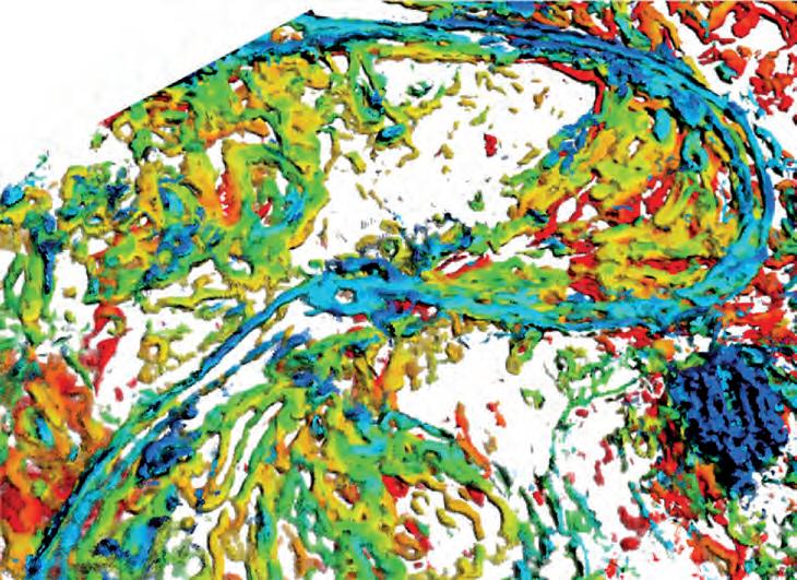
Figure 1. 3D perspective view showing a meandering channel interpreted from multiple seismic attributes, colorcoded by stratigraphic time of deposition.

Thousands of landmen, engineers & geologists use geoSCOUT oil and gas mapping and analysis software every day, to make more efficient, informed decisions. Give us an hour for a demo – we know you’ll see the value. Call 403.262.1992 Email info@geoscout.com | Online www.geoscout.com/demo If you want easy-to-use
– there’s only one direction to go
geoSCOUT™ uses a Windows-based platform that makes it easy for you to get the oil and gas data you need to make smarter decisions faster and to maximize the return on your oilfield investments. And, our solution provides you with a complete package that all your departments can use.
industry-leading customer service easy & efficient migration of existing data helping clients increase productivity
Another powerful suite of tools from
All great explorers have a starting point.


Access.
Access the same project data and all your best datasets from a shared central location. Streamline. Host multiple sources and share data without converting or maintaining multiple data repositories.
GeoCarta
Make Better Decisions. The best data produces the best results. Make better decisions when your teams are working within the same data environment.
Ph. 587 952 8000
sales@divestco.com www.divestco.com/geocarta

UNICORNS IN THE GARDEN OF GOOD AND EVIL: Part 10 – Gas Hydrate Reservoirs
| By E. R. (Ross) Crain, P.Eng.
Unicorns are beautiful, mythical beasts, much sought after by us mere mortals. The same is true for petrophysical models for unconventional reservoirs. This is the tenth in a series of review articles outlining the simple beauty of some practical methods for log analysis of the unusual.
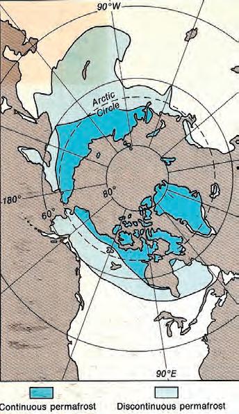
PERMAFROST B ASICS
Permafrost is defined as soil or rock that is permanently frozen in all seasons for more than two consecutive years. Permafrost covers much of the northern latitudes above 60° and most of Antarctica (Figure 1).
Water in pore space freezes when the temperature of the rock is below 0° C (32° F), A phenomenon called freezing point depression (FPD) causes the actual freezing temperature to be somewhat lower than 0° C. FPD is a function of pressure, salinity, and pore size, and is usually about -1° to -2° C in clean coarse-grained sandstones. It can be as much as -8° C in very finegrained silts and shales.
Clay-bound water in shale does not freeze, so shale properties change only slightly, depending on the amount of free water
in the effective porosity of the shale. Silty shales have more porosity than pure shale and are more strongly affected by freezing.
Studies designed to locate the base of permafrost were sponsored by the Geological Survey of Canada in the 1960s and 1970s, and again in the early 1980s as more log data became available. Permanent temperature recording systems using thermistors equally spaced along a cable were installed in numerous observation wells throughout the Arctic. These surveys form the basis for static temperature data that is still relied upon today.
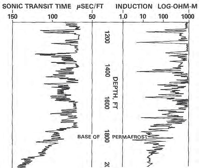
Freezing alters the physical properties of the composite rock. Ice has a very high resistivity and high acoustic velocity compared to water, thus resistivity and acoustic travel time logs are changed significantly (Figure 2). Many other physical properties are much less affected.
In a sandstone interval, the base of permafrost is easy to pick on the resistivity log. In shales, it is much more difficult. The
base of permafrost is often picked at the base of a frozen sandstone; this depth is called the base of ice-bearing permafrost (IBPF).
The depth to the base of permafrost varies considerably by location and may reach 1,500 meters or more. The base of permafrost is often assumed to be the depth below which the formation temperature exceeds 0° C. However freezing point depression can cause confusion since some rocks remain unfrozen well below 0° C. As well, gas hydrates remain frozen well above 0° C, so “base of permafrost” is a bit of a moving target.
G AS H YDRATE B ASICS
Gas hydrates are found in or below permafrost, as well as under deepwater coastal regions. Gas hydrates are reported to be a huge source of natural gas, although the technically producible quantity is much smaller. Gas hydrate production was reported by the Russians in 1970 at a rate of more than 10 mmcf/d
(Continued on page 22...)
Figure 2. Long-spaced sonic log (left) and deep resistivity log (right) are used to identify the base of frozen rocks, around 1,800 feet in this example, based on reduction in resistivity and increase in sonic travel time. Frozen rock may contain water-ice (permafrost) or gas hydrates (solid gas) or both.
Figure 1. Permafrost in the northern latitudes.

(...Continued from page 21)
in Siberia. This type of hydrocarbon was called “solid gas” when Canadian exploration wells encountered them in the early 1970s. Difficulties in drilling and testing such intervals were also reported at that time.
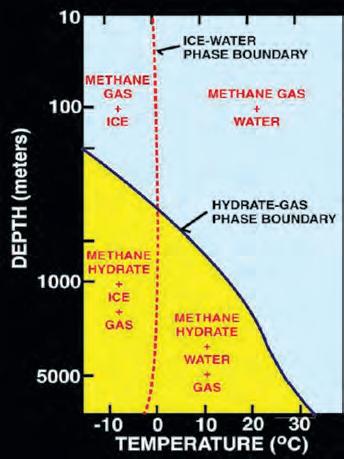
Gas hydrates, also called clathrates, are mechanical mixtures of natural gas and water, forming a crystalline solid in cold environments. These mixtures are called “inclusion compounds”. The water molecules surround the gas molecules to form “cages” that trap the gas into the crystals. There is no chemical bond between the water and the gas, so the crystal is not a chemical compound (Figures 3 and 4).
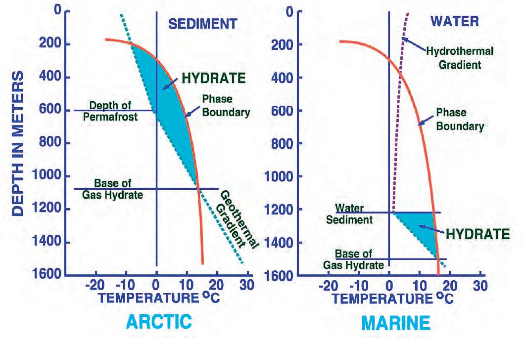
Gas hydrates are often found in or below permafrost zones on land, or in deep water along continental margins. They can extend below the base of permafrost, even though formation temperature is above 0° C.
6
Phase diagram for on-shore situation where temperature is low enough to permit hydrate formation (blue
Note base of permafrost at 0° C isotherm. Figure 6 (right). Deep water offshore has distinctly different temperature profile, so hydrates can form near seafloor in very recent sediments (blue shaded area). Higher specific gravity and higher salinity will move the hydrate phase boundary (red line) to the right, increasing the depth at which hydrates may form (USGS image).
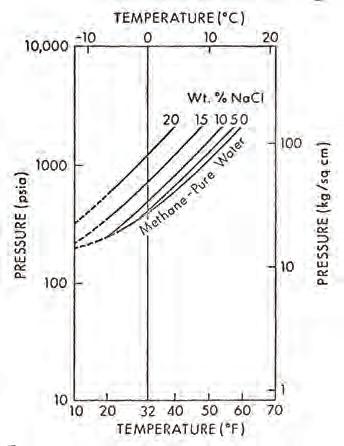
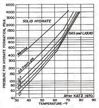
Figure 5 (left). Schematic phase diagram for water, water-ice, gas hydrates, and free gas. Figure 5 (right). Phase diagram with temperature log, showing a situation where temperature is too high to permit hydrate formation (USGS images).
Figure
(left).
shading).
Figure 7 (left). Graph showing effect of salinity on hydrate phase. Figure 7 (right). Effect of gas specific gravity on hydrate phase (source: Natural Gas Engineering Handbook, D.Katz, 1959).
Figure 4. Gas hydrate crystal with water molecules (red), trapping methane molecules (grey) (USGS image). A good description of gas hydrates is contained in “Naturally Occurring Gas Hydrates in the Mackenzie Delta” (C. Bily and J. W. L. Dick, CSPG Bulletin, 1974).
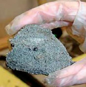
Figure 3. Macro-photo of a gas hydrate sample from a core (USGS image).
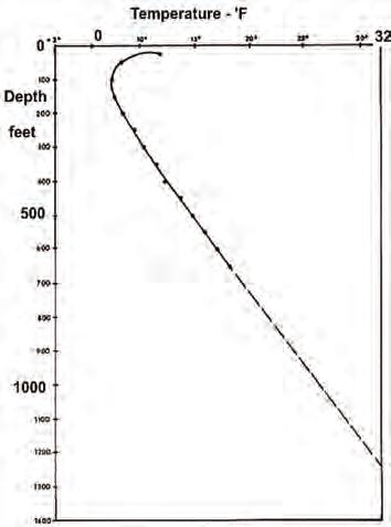
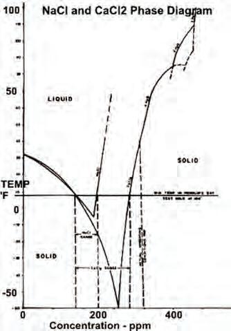
Figure 8 (left). Permanent temperature survey in observation well #20 at Resolute Bay, Nunavut showing base of permafrost at about 1,200 feet at 32° F. Figure 8 (right). Phase diagram for NaCl and CaCL2 showing salt concentration “window” for the coldest wellbore temperature at Resolute Bay (and similar latitudes). Getting stuck in the hole with oversaturated salt mud is really embarrassing (Source: Marshall and Crain, AIME, 1970).
Hydrates have been discovered or inferred along the coastlines of all continents, even at temperate latitudes, and in deep water trenches in the Pacific.
The quantity of gas in a hydrate does not depend on the depth, pressure, or temperature of the reservoir, as is normally the case for natural gas. Hydrates can contain far more gas at shallow depths than a conventional reservoir at the same depth. This can result in unexpectedly high pressure in the wellbore as the hydrate thaws, with all the dangers of blowouts and damaged equipment that this suggests.
The various phases of water, water-ice, hydrates, and free gas are shown by phase diagrams, which illustrate the relationship between the specific gravity of the gas, salinity of the water, temperature, and pressure. The latter two factors are
functions of depth, so the phase diagrams are often plotted versus depth, using assumed pressure and temperature gradients. Some examples are shown in Figures 5 through 7.
An increase in temperature increases the pressure required to form hydrates, while small percentages of ethane or propane lower the hydrating pressure considerably. Hydrogen sulfide and carbon dioxide also decrease the required pressure.
DRI LLING A ND PRODUCTION
H A z AR DS I N G AS H YDRATES
Drilling into permafrost and gas hydrates, or to deeper targets below them, is fraught with problems. Thawing of permafrost in otherwise unconsolidated sediments will generally mean a large, washed-out borehole, with poor logs. Drilling with a chilled mud system has been attempted,
but this has its own hazards – if NaCl or CaCl2 are used to prevent freezing of the mud, it may still freeze if borehole temperature falls outside the liquid phase diagram for the mixture (Figure 8).
Thawing of gas hydrates generates gas at pressures well above those expected at these shallow depths. It may be impossible to raise mud weight sufficiently to prevent a blowout, so chilled mud and a quick casing job are recommended. As a well is cased and cemented, that gas pressure may cause wormholes in the cement, leading to a permanent leak to surface as long as borehole temperature is higher than the hydrate stabilization temperature. Highquality cement jobs in large, cold boreholes are notoriously difficult.
Continued thawing may cause casing collapse or rock subsidence, with loss of wellbore integrity. Successive thawfreeze cycles aggravate these conditions and may cause vertical expansion of the rocks during refreezing.
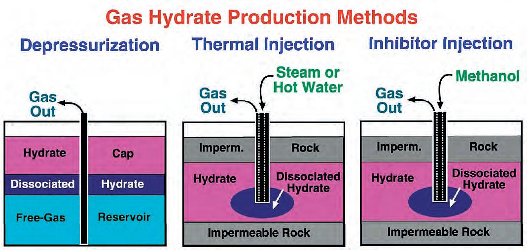
The typical production scheme proposed for gas hydrate wells is by depressurization or heating (Figure 9). During production, wellhead control is difficult to maintain due to the high pressure and cold temperatures. Hydrates may reform in the plumbing and produced water must be lifted and disposed of before it refreezes. Thawing allows fines migration, which is detrimental to pumping and compression equipment. Some experimental production methods involve the addition of heat or methanol to release the gas. Heat may affect non-gasbearing intervals in the permafrost, leading to casing collapse or movement.
Deepwater offshore hydrate production has its own issues, and although a huge resource is postulated, I am not aware of any intentional attempts to produce it. No wonder shale gas is so popular!
L OG GING A ND L OG A NA LYSIS I N G AS H YDR ATES
Th e excess hydrogen in gas hydrates compared to water or water ice should make neutron logs read too high. The lower density of ice and hydrate (900 kg/ m3 versus 1,000 kg/m3 ) makes the density porosity read too high also. However, thawing near the borehole will reduce this effect and it is seldom seen. Instead the zone often looks like a normal waterinvaded gas sand. If thawing is deep enough, gas crossover could occur.
(Continued on page 25...)
Figure 9. Proposed methods for gas hydrate production (USGS image).
ROCK SHOP

Conventional Wells
• Horizontal Wells - Spearfish - Viking - Bakken - Cardium
- Horn River Shale Gas Email: afran@telusplanet.net www.serpaconsulting.com


Wellsite Geological Supervision
*Conventional Wells-Heavy Oil/SAGD
Jocelyn Lampron, P. Geol. President & CEO
ph: 403.266.3132 cell: 403.818.8549
*Coal Bed Methane Wells www.hopewellpetroleum.com info@hopewellpetroleum.com
*On & Offshore Geological Supervision
*Domestic & International Supervision 906, 505 6 St. SW Calgary, AB T2P-1X5
Tel4037260666
Fax4034515380
Cell4038192516 farhat@sableconsultants.com SABLECONSULTANTS.COM
RockWell Consulting

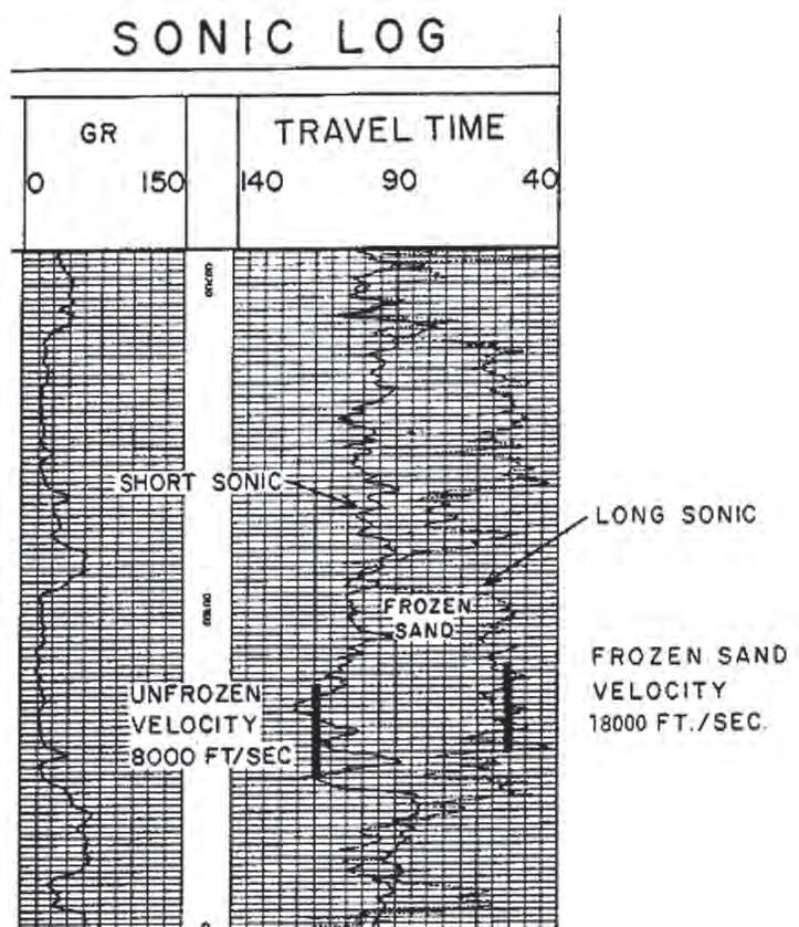
Figure 10: This log clearly illustrates a severe case of rock alteration due to permafrost. In this case, the shortspaced sonic sees the thawed zone and the long-spaced tool see the frozen zone. Porosity is derived from the short-spaced log, with appropriate shale and compaction corrections, but seismic velocity must be taken from the long-spaced log.
(...Continued from page 23)
Short-spaced sonic logs reading the thawed zone can be used to calculate porosity, but compaction and gas corrections will be required. Long-spaced sonic logs reading the frozen zone are difficult to analyze for porosity due to an unknown amount of excess (unfrozen) water along with the ice or hydrate. A long-spaced sonic will read the frozen rock velocity (or travel time) but short-spaced sonics will see the thawed zone velocity (Figure 10).
Freezing of water causes salt rejection, leaving some excess unfrozen water with moderately high salinity. Higher-salinity water tends to increase the SP deflection but the higher resistivity of the ice tends to reduce SP deflection. The net result is low SP deflection in frozen intervals. SP in the unfrozen intervals behaves normally. Resistivity will read high values in both water ice and gas hydrate in
sand sequences; shales will show typically low resistivity with moderate gamma ray values.
Many hydrate zones are poorly consolidated, so caliper logs may show large washouts as the rock thaws. In large or rough boreholes, both density and sonic logs may show large spikes or noise.
Neither resistivity nor porosity logs are very helpful in distinguishing gas hydrates from water ice. The best indicator is the gas mud log because large quantities of disassociated gas are released as the hydrate is thawed. No significant gas is released from water ice. Free gas and even oil are also possible and gas mud logs will show less than in a hydrate zone.
Quantitative log analysis is complicated by the inability of standard models to differentiate between water-ice and gas
hydrates. Free gas and gas hydrate (if thawed deeply enough) can be distinguished by gas crossover in cleaner sands.
By treating ice and hydrates as if they were hydrocarbons, standard porosity and Archie-type saturation models can give an estimate of ice plus hydrate content (black shading in Track 3, Figure 11, page 26) and free water (white shading). In this model:
1: Shydr = 1 - Sw provided zone is hydrate bearing and not water-ice.
Standard deterministic or probabilistic multi-mineral models using quartz, clay, ice (water-ice or hydrates), and free water will also work. In these models:
2: PHIe = Vice + Vwtr
3: Shydr = Vice / PHie provided the zone is hydrate bearing and not water-ice.
If a nuclear magnetic resonance log is run, the effective porosity from this log is the water-filled porosity. Ice and hydrates are not seen. Thus:
4: PHInmr = BVI + BVM
5: SWnmr = PHInmr / PHIe
6: Shydr = 1 – SWnmr
Where:
BVI = bulk volume irreducible from NMR (fractional)
BVM = bulk volume moveable from NMR (fractional)
PHIe = effective porosity from conventional logs (fractional)
PHInmr = effective porosity from NMR (fractional)
Shydr = hydrate saturation (fractional)
Sw = water saturation (fractional)
Vice = volume of ice or hydrate (fractional)
Vwtr = volume of water (fractional)
The base of permafrost is chosen by a nearby permanent temperature log (around 1,110 feet in this example). Black shading below this depth is gas hydrate and there may be gas hydrates in the permafrost zone. Since salt rejection increases water salinity in the excess water, the water resistivity is unknown and variable, so the quantities of ice, hydrate, and excess water are not very accurate. The mud gas log is vital.
In older wells, the sonic log was often very noisy and seismic reference surveys were used to determine acoustic velocity. The beginning of low velocity would indicate the base of permafrost or base of gas hydrates, or shales.
(Continued on page 27...)
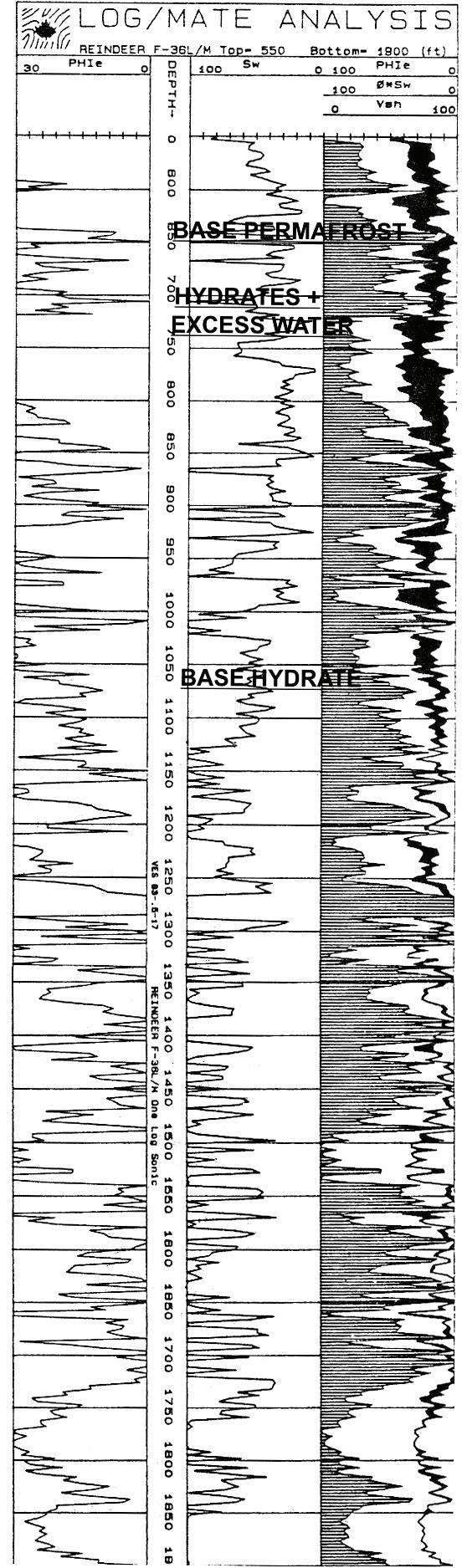
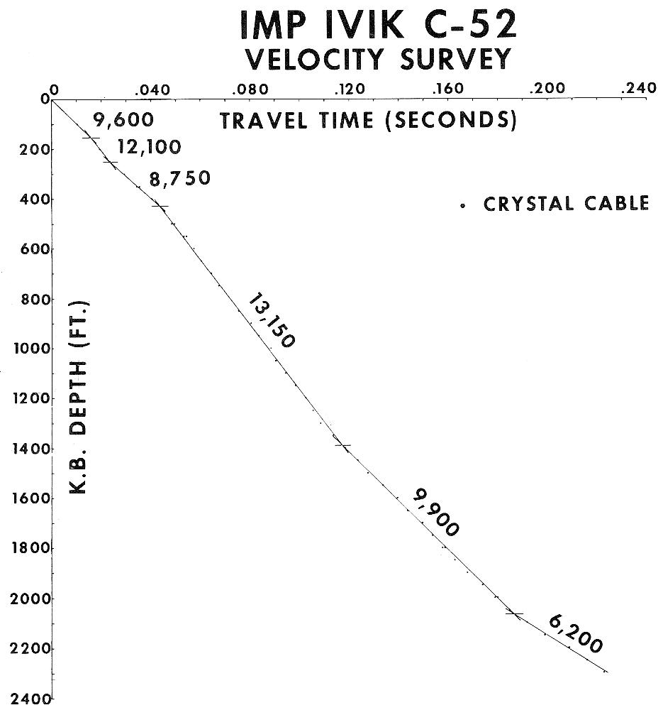
Figure 12. Crystal cable survey time vs. depth plot with interpreted velocity values. Base of permafrost could be as shallow as 1,400 feet or as deep as 2,000 feet.
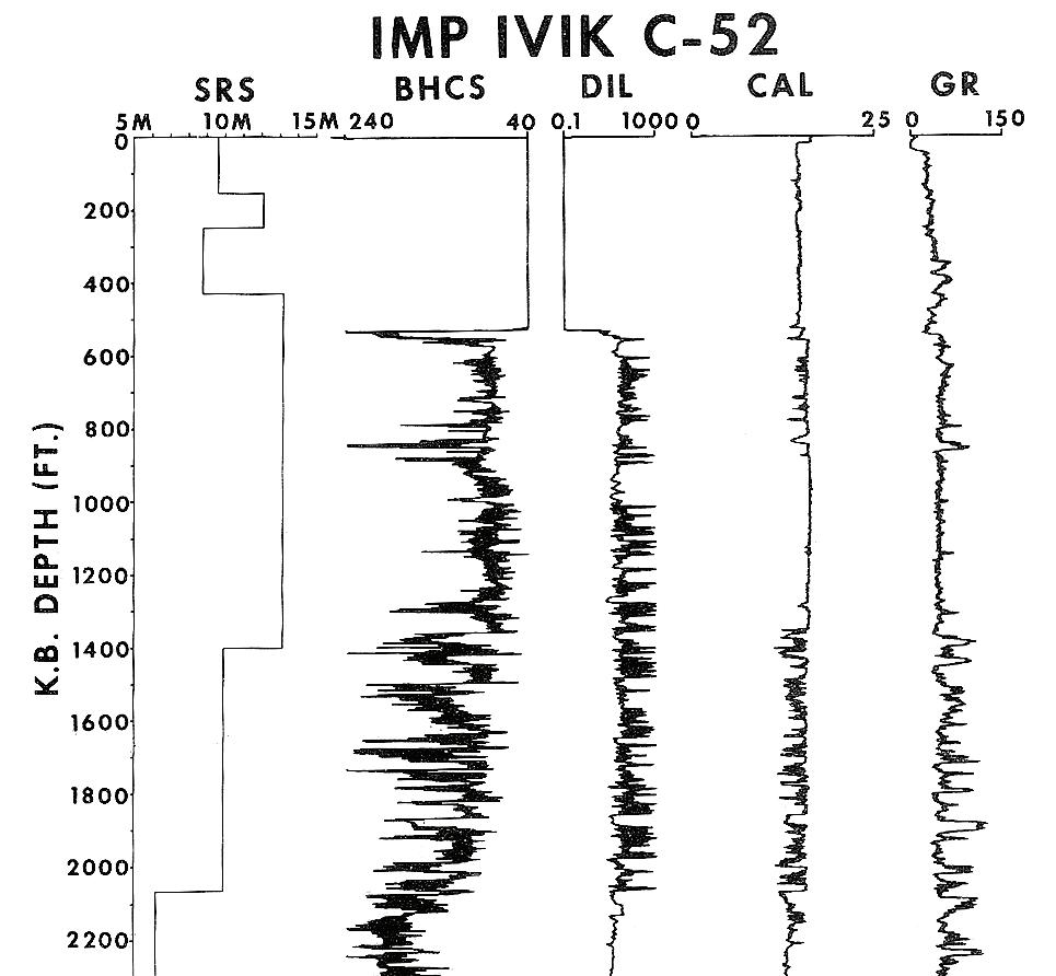
Figure 13. Crystal cable survey vs. depth with other log data. Base of permafrost is still unclear due to large, washed-out borehole. Gamma ray needs borehole corrections to make shales stand out better. Sonic is in general agreement with SRS velocities but induction log does not show continuous high resistivity expected for a sand interval, so much of the interval is probably shale or shaly sand. Permafrost base is probably near 2,000 feet because there is only low resistivity below this depth.
Figure 11. Quantitative log analysis of permafrost -gas hydrate interval in Mackenzie Delta, run in 1983 using standard porosity and Archie saturation models.
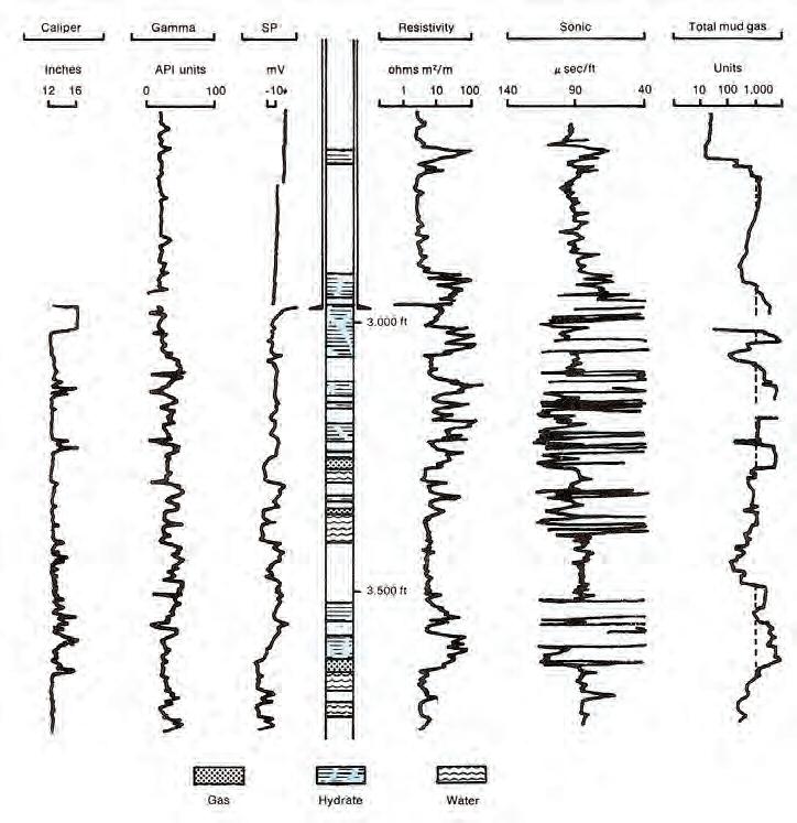
Figure 14. Original wireline logs and gas log for Mallik L-38. Compare location of hydrate zones with log response and gas log showing gas hydrates and free gas below 3,000 feet. Permafrost base is around 1,900 feet, well above this log segment (USGS image, redrawn from Bily and Dick, 1974).
(...Continued from page 25)
These surveys were superseded by crystal cable surveys (Figures 12 and 13), the forerunner of the vertical seismic profile, which would be used today for this purpose. VSPs and their predecessors can be run in cased holes, provided the shotpoint is far enough from the wellbore, otherwise the velocity derived from the survey will be that of the casing. A good description of the use of this tool is “Permafrost Investigation by Crystal Cable Surveys, Mackenzie Deltas” (I. H. Wallace and A. J. Stuart, CSEG, 1975), from which Figures 12 and 13 were taken.
G AS H YDRATE VOLUME I N PLACE
Em pirically, the ratio of water to gas necessary to form a hydrate is as follows:
Excess Hydrogen
1. Methane (CH4.6H20) 4/12 = 33%
2. Ethane (C2H6.8H20) 6/16 = 37%
3. Propane (C3H8.17H20) 8/ 34 = 23%
The volume of hydrocarbon in a gas hydrate is a function of the hydrocarbon type only. Water saturation is meaningless.
The ratio of gas to water would range from 433 scf/bbl for propane to 1,230 scf/ bbl for methane. This is equivalent to 170 cubic feet of methane per cubic foot of pore space at standard temperature and pressure and 60 cubic feet of propane per cubic foot of pore space, regardless of depth of burial.
Convert pore volume to gas volume:
7: PV = SUM (PHIe * THICK)
8: HPV = PV * Shydr * KG0
9: GIPhydr = KV3 * HPV * AREA
Where:
AREA = reservoir area (acres or m2)
HPV = hydrocarbon volume (feet or meters)
PHUe = effective porosity (fractional)
PV = pore volume (feet or meters)
Shydr = hydrate saturation (fractional)
Sw = water saturation (fractional)
GIPhydr = ga s in place as hydrates (mcf or m3)
KV3 = 43.56 for English units
KV3 = 1 for Metric units
KG0 =164 for methane
KG0 = 60 for propane
Numerical Example:
Assume the following data:
PHIe = 0.35
Sw = 0.20
Hydrate is methane
THICK = 300 feet
KV3 = 43.56
KG0 = 164 scf/scf
AREA = 640 acres
Then:
HPV = 0. 35 * 300 * (1 - 0.20) * 164 = 13,776 ft
GHIP = 43.56 * 13776 * 640 / 1 000 000 = 384 Bcf/section
Gas Hydrates e xa mple
This example shows logs from the original 1972 well (Figure 14) and one of the new 2002 wells (Figure 15, page 28) for comparison. Numerous other logs, including NMR, C/O, and through-casing resistivity have been run. Numerous petrophysical and thaw diameter models have been run, as described in GSC Bulletin 585 (2005) and elsewhere.
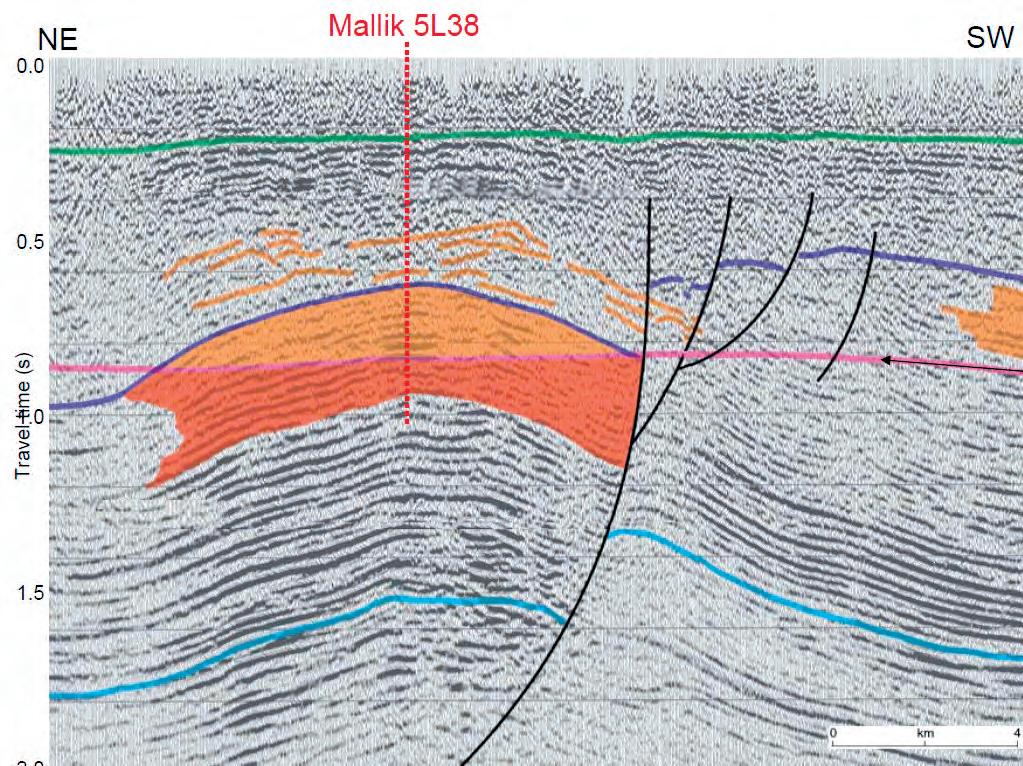
The original Mallik L-38 well in the Mackenzie Delta was drilled in 1972 and discovered a major gas hydrate and free gas interval. The well sits on a large structure (Figure 16, page 29) and was suspended pending construction of the Mackenzie Valley Pipeline. In 2002, an international joint government, industry, and academic consortium (Mallik 2002 Gas Hydrate Production Research Well Program) was formed to investigate alternate methods of producing gas hydrates, using this structure as a test platform. Observation wells were drilled and various production schemes have been tested. A 34 Gb dataset can be downloaded from the National Research Council (Canada) website as Geological Survey of Canada Bulletin 585.
ABOUT THE AUTHOR
E. R. (Ross) Crain, P.Eng. is a Consulting
15. Raw logs and computed results for
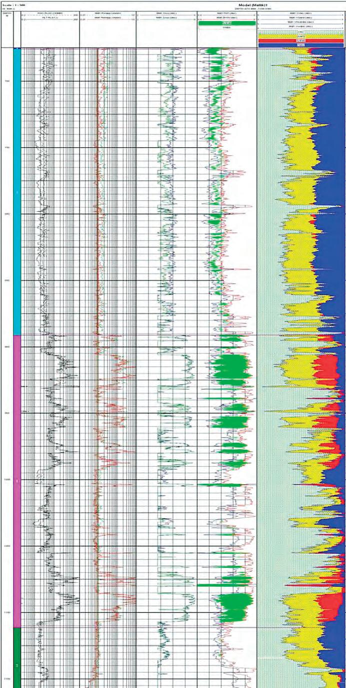
drilled in 2002. Logs are (from left to right) array laterolog; array induction; shear and compressional sonic; density and neutron with gas crossover shaded green; and computed results with clay, quartz (yellow), hydrate (red), and water (blue). Note depths are in meters and cover approximately the same interval as the Mallik L-38 logs shown above. Figure 15 is from “Formation Evaluation of Gas Hydrate-bearing Sediments” by Frank
Figure
Mallik 5L-38
Williams, Mike Lovell, Tim Brewer, Christian Buecker, Peter Jackson, and Ameena Camps, SPWLA, 2008.
(...Continued
Petrophysicist and a Professional Engineer with over 45 years of experience in reservoir description, petrophysical analysis, and management. He has been a specialist in the integration of well log analysis and petrophysics with geophysical, geological, engineering, and simulation phases of oil and gas exploration and exploitation, with widespread Canadian and overseas experience.
His textbook, “Crain’s Petrophysical Handbook on CD-ROM” is widely used as a reference to practical log analysis. Mr. Crain is an Honourary Member and Past President of the Canadian Well Logging Society (CWLS), a Member of Society of Petrophysicists and Well Log Analysts (SPWLA), and a Registered Professional Engineer with Alberta Professional Engineers, Geologists and Geophysicists (APEGGA).
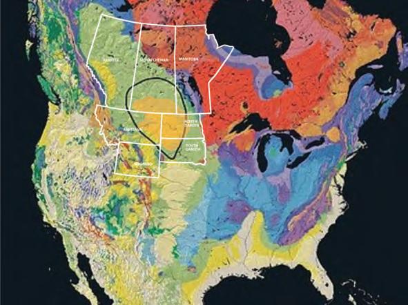


Figure 16. Seismic section on Mallik structure, shaded area shows gas hydrate over free gas (USGS image).
2011 Ph.D. and M.Sc. CALL foR Th ESES
Ph.D. AWARD
Win $2,500.00 and a framed certificate; and a one-year membership with the CSPG for: the Doctoral thesis that makes the most significant contribution to Canadian sedimentary geology in 2011.
M.Sc. AWARD
Win $2,000.00 and a framed certificate; and a one-year membership with the CSPG for: the Master’s thesis that makes the most significant contribution to Canadian sedimentary geology in 2011.
Winning thesis topics in recent years have included: detailed integrated studies of the Falher, Paddy, and Dunvegan; a stratigraphic reinterpretation of the Alexandra Reef Complex,
which has led to new insights into the nature of Devonian reefs; new thoughts about the classic Carboniferous section at Joggins, Nova Scotia; structural re-interpretation of the Livingston Range anticlinorium; detailed sedimentologic study of the Cenozoic geology in Trinidad; Biogenic shale gas potential of the Upper Colorado Group; and evaporite diapirism in the Canadian Arctic Archipelago.
Deadline for submissions is September 19, 2011.
For submission, an electronic copy (PDF format if possible) of the thesis is preferred but a hard copy if properly bound will be accepted. Submitted hard copy theses will be returned in late January 2012 after judging.
Eligible theses are either produced in a Canadian university, regardless of project location, or deal with a Canadian sedimentary/petroleum geology topic, regardless of the university of origin. Theses entered for the 2011 awards must have been submitted to a recognized university inside or outside Canada, and must have formed part of the requirements for degrees awarded at the Fall 2010 or Spring 2011 convocations. Candidate theses must be well written, and clearly and adequately illustrated.
ESTABLISHMENT OF THE FIRST OIL INSTITUTE IN TRANSCAUCASIA
| By Mir-Yusif Mir-Babayev
The origin of this unique academy goes back to the nineteenth century, when the Baku Duma, on 10 November 1887, decided to establish the first technical school in Baku, which was approved by the Caucasus Education Division, on 26 October 1888. According to the regulations, the school consisted of four classes and workshops: carpentry, joinery, forge, and fitting shops. In the curriculum, on a daily basis, three hours were allocated to general subjects and seven hours to learning the handicraft.
The handicraft school in 1896 was transformed into Baku Lower Technical School, which had 124 students by the end of 1900 (A.A. Nikishin, On the right path. Baku, 1931, p. 11). During that period (18991901), a growing oil industry needed new technical personnel.
In 1901, almost 11.4 million tons of oil
was produced in Azerbaijan, while overall production of oil in Russia was 11.9 millions tons. In other words, Azerbaijan’s share constituted 95 % of oil production in Russia, and more than 50 % of the world production at the time.
This eventually led to a decision by the Russian Ministry of Public Education to transform, in July 1903, the Lower Technical School into the Secondary level, which started functioning in January 1905. In 1910, the mechanic department of the school consisted of technical-oil and electromechanical divisions. As well, lower-level industrial education institutions were functioning within the school, such as the lower handicraft school with fitter-turning and embossed divisions, and sculpturestonemason training workshops. In 1912, the electric division was established in the handicraft school.
In 1916, there were 494 students (20 Azerbaijanis) studying in this school. By the middle of 1918, the technical school was renamed the Polytechnic School, and had 188 students (36 Azerbaijanis) studying in its three departments: oil industry, electromechanical, and architectural-construction.
A special session considering the establishment of the first technical university in the republic took place in May 1920 on the initiative and under the leadership of Dadash Buniatzade, People’s Commissar on Education. Later, on 12 November 1920, Buniatzade addressed the Azerbaijani Revolutionary Committee (Azrevcom) with a memorandum on the establishment of a polytechnic institute in Baku. The document included the following justification: “The necessity to have a high technical education institution is so obvious that there is no
(Continued on page 32...)

need to prove it. Baku is an industrial centre, which needs highly qualified human resources.” The decree “On establishment of the polytechnic institute in the city of Baku” was signed by Nariman Narimanov on 16 November 1920.
This decree had a significant impact on the lives of the Azerbaijani people, as this development for the first time opened for them, on a state level, the opportunity to access a higher technical education. This document is described below:
Decree of the Azrevcom on establishment of Polytechnic institute:
Baku Polytechnic School is transforming into the high education institution under the following name “Azizbekov Baku Polytechnic Institute” with five faculties: oil industry, electro-mechanical, engineeringconstruction, agricultural, and economic.
Premises and inventory of the Baku Polytechnic School, as well as of the the Russian Technical Society’s chemical laboratory (Baku branch of the Russian Imperial Technical Society – M.M.) are delivered to the authority of Polytechnic Institute.
During the admission of the students to the Polytechnic Institute, the students of the Baku Polytechnic School are taken in order of: those who have sufficient general education are admitted to the first semester; special classes on general education subjects organized for those who do not have such education; and, eventually, special classes organized for the pupils of senior forms, which would give them an opportunity to obtain a technical education sufficient for engineers of the relevant professions.
The students of the Polytechnic institute are equal to the students of the State University in terms of rights for social care security and all types of food.
Those from the professors and teachers of the University, as well as from servicemen working in other institutions, who will be involved in fulfillment of professor and teacher positions in the Polytechnic Institute, should get, in spite of second employment, full payment conforming to their positions in the Polytechnic Institute.
Professors and teachers of the Institute are equal to the teaching staff of the State University in terms of their payment and ration.
FRAC DATABASE
Optimize Your Completion Success
» Reliable & Value-Added: We database and summarize the entire completion operation.
» Analysis Ready: Sortable table and report views, graphing capabilities, fully exportable.
» Expanding Dataset: Growing rapidly, driven by client requests.
Contact us for a live demonstration 403.269.3644 info@canadiandiscovery.com www.fracdatabase.com

Organization of the Polytechnic Institute and drawing up the Institute’s regulations are entrusted to the committee on professional-technical education.
Chairman of the Azrevcom – N. Narimanov People’s Commissar on Education – D. Buniatzade, 14 November 1920, Baku
(Party archive of the Azerbaijani branch of the Institute of Marxism and Leninism (IML) under the Central Committee of the Communist Party of the Soviet Union (CC CPSU), f.2, in.76, lists 1-4).
A temporary organizational commission under the Baku Polytechnic Institute (BPI) was established for implementation of the Azrevcom’s decree. The commission’s composition was the following: Professor L. Ishkov (chairperson), mining engineer M. Abramovich, former director of the reorganized Baku polytechnic school L. Brzhostovsky, communication lines’ engineer S. Vekilov, electrical engineer L. Grishpun, construction engineers F. Nikulin and A. Shusherov, engineer F. Rustambekov and Professor N. Dubrovsky (Communist newspaper, 22 November 1920). This commission drafted a final project of the decree on “On establishment of the Baku Polytechnic Institute and on appointment of the first professor-teaching staff and the Institute’s Scientific Council,” and set a deadline for the preparatory works and start of education year in the Institute as 1 January 1921.
Typical of that period was the Admission Commission, organized by the decree, which had to complete admission of the students by 1 January. The Admission Commission was guided by the following norms:
“the pupils of the Baku Polytechnic School and the students of the special high education institutions are admitted first; secondly – the candidates speaking Turkish (Azerbaijani – M.M.); thirdly –labors; fourthly – officials from the CC and BC ACP (b); fifthly – Red Army soldiers; soviet officials in the sixth place; and seventhly – other citizens.” (10 years of the Azerbaijan Oil Institute (AOI), 1921-1931, “Izvestiya Azerbaijan Polytechnic Institute (API),” Baku, 1931, p. 9-16).
According to the decree, professors N.A. Dubrovsky, P.K. Zhuze, and L.G. Gurvich; associate professor A.S. Shepotyev; and engineer D.D. Gadaskin were appointed the professors of the Institute; agronomist N.A. Lebedev, engineers S.A. Vekilov, A.I. Kozlov, A.M. Shusherov, and M.V. Abramovich were
(Continued on page 34...)
More Petro. Less Physics.
Traditional Gas-in-Place Log Analysis requires:
❑ Wellsite planning & contracts
❑ LWD/wireline operations
❑ Data processing & corrections
❑ Log analysis software
❑ Petrophysical model assumptions
❑ Mineralogical presumptions
❑ Fm water TDS presumptions
❑ Electrical properties / SCAL
❑ Presumptions for m, n, & A
❑ Capillary pressure / presumptions
❑ Reservoir identification threshold
❑ Crossover and gas effect
❑ ΔlogR calculations
❑ Vshale, Vclay, Vorganic/TOC, etc.
❑ Porosity calculations
❑ Modeling of multiple porosities
❑ Saturation model assumptions
❑ Water saturation calculations
❑ Net reservoir, net pay calculations
❑ Fluid storage – porosities model
❑ ± Coring & handling program
❑ ± Long-term desorption runs
❑ ± Lost gas corrections
❑ ± Reservoir pressure test(s)
❑ ± Desorption data analysis
❑ Volumetric presumptions
❑ Distribution of properties
❑ Gas-in-Place calculations
Traditional Pore/Fracture Analysis requires:
❑ Wellsite planning & contracts
❑ LWD/wireline operations
❑ Reservoir interval threshold
❑ Crossover and gas effect
❑ ΔlogR calculations
❑ ± Porosity calculations, modeling
❑ Organic matter porosity model
❑ ± Image log runs and processing
❑ ± High-temperature correction(s)
❑ ± Fracture occurrence analysis
❑ ± Interpretation of fracture quality
❑ Wellsite coring & sampling
❑ Vitrinite microscopy
❑ ± RockEval, Leco TOC analyses
❑ ± Ion milling sample prep
❑ ± Advanced electron microscopy
❑ ± Interpreted pore character
❑ Simple, 1-D or full basin modeling
❑ Thermal maturity assessment
❑ ± Microseismic imaging program
❑ ± Thermal arrays & acquisition
❑ ± Anisotropy model, processing
❑ ± Imaged vs. inferred fractures
❑ ± Borehole strain data collection
❑ ± Rock strength model(s)
❑ ± Geomechanical modeling
❑ ± Inferred fracture density
❑ Modeled fracture probability
Now you can simply use this:
Traditional HC Fluid Typing requires:
❑ Play Type fluid presumptions
❑ ± Extrapolations, offset well fluids
❑ Sampling program & contracts
❑ ± Coring & handling program
❑ ± Fluid extracts from core
❑ ± Geochemical analyses of fluids
❑ ± Migrated vs. local fluid models
❑ ± RockEval, Leco TOC analyses
❑ ± HC System fluid interpretation
❑ ± Advanced seismic fluid-typing
❑ Borehole & completions planning
❑ ± LWD/wireline operations
❑ ± Reservoir interval determination
❑ ± Crossover and gas effect
❑ Formation pressure testing
❑ Hydraulic head & loading models
❑ Fluid gradient analysis
❑ Fluid type and storage modeling
❑ Production resource assessment
❑ Completions operations, flowback
❑ ± Short-term well test(s)
❑ ± Fm fluid sampling & analysis
❑ Turn the well on
❑ Initial production fluid(s) sampling
❑ ± Regulatory wellhead sampling
❑ Compositional fluid analysis
❑ Reservoir fluid type determination
❑ Re-assessment of HC Resources
Now you can simply use this:
Now you can simply use this:
• Know in advance full-scale hydrocarbon recovery and pore-system trends controlling resource productivity.
• Find fractures, sweet spots with accuracy.
• Know how dry, how wet, or how liquid your hydrocarbons will be.
It’s time to upgrade efficiency at the wellsite. Reap the rewards of proper and technologically capable analysis just-in-time for completions.

appointed as professional staff members in various departments conforming to their specialties and previous teaching activities. Professor N.A. Dubrovsky was appointed a director of the BPI until 1 September 1921.
During the first session of the BPI’s Scientific Council, which took place on 15 December 1920 under the chairmanship of the first Director of the Institute, N.A. Dubrovsky, the engineer S.A. Vekilov was elected a secretary of the Scientific Council. During the second session of the Scientific Council (18 December 1920), the first deans of the faculties were elected: mining engineer
B. Dombrovsky was elected a dean of oil industry faculty, electrical engineer A. Sizov a dean of the electro-mechanical faculty, civil construction engineer A. Shusherov of the construction engineering faculty, agronomist N. Lebedev of the agricultural faculty, and N. Dubrovsky of the economic faculty.
The first class bell, announcing the birth of the BPI, was made on 2 January 1921 at 09.30. The first lecture in the history of this institute was delivered by the communication lines engineer S.A. Vekilov on higher mathematics. Total number of the students studying in the first year of BPI was 1,135.


In order to understand the conditions in which the Institute was forming and developing we have to remember the grim times existing in the young republic – a time of constant enemy threats, internal diversions, hunger, and destruction. After foundation of “Azneft” (the largest Soviet association in that period) certain positive developments had been noticed in the work of Azerbaijan’s oil industry: a number of new oil fields were discovered as a result of the geologic research in Absheron – Ilyich bay (currently Bayil port), Zikh, Lokbatan, Gala, Garachukhur, Buzovna, Sulutepe, Korgez, Pirsaat, and so on; more modern methods (rotary and downhole turbine motor drilling) started replacing the outdated ones (bailer method of production and impact method of well drilling). The first successful test of the turbo-drill, invented by M.A. Kapelyushnikov, was carried out in 1923 under the leadership of Azneft’s technical director F.A. Rustambekov.
The committee for construction of the factory facility for thermal cracking (under direction of engineer S.K. Kvitko) was established in May 1924 in “Azneft”. Chairman of the committee was the wellknown oil-chemist V.F. Herr (first laureate of the Baku Nobel prize named after Emmanuel Nobel in 1909). In the same year, F.A. Rustambekov published a work about “Azneft’s suggestions on technical rationalization of oil production by five-year program (1923/24 – 1927/28),” which for the first time presented ways to adopt new well designs and methods of their mounting, improvement of transportation systems, and oil storage, as well as the foundations of the gas industry.
Azerbaijan as part of the USSR attained a number of achievements in the beginning of the first five-year plan (1928-1932). However, the 45,000 members of the “Azneft” were in great need of technical and engineering staff – at that time, the number of technical and engineering personnel of “Azneft” constituted only 218. Leadership of the association had repeatedly reported to Azrevcom: “Lack of the technical and engineering personnel has a painful impact on oil industry in Azerbaijan.”

The BPI’s task consisted of preparing the oil specialists, with the professor-teaching staff consisting of the engineers working at that time in Baku and the qualified teachers sent to Azerbaijan from Russia. There were 66 teachers in the Institute in 1921, consisting of six professors, 54 teachers, two assistants, and four lectors (Azizbekov Industrial Institute of Azerbaijan. Baku: AzII publication, 1940, p. 7-47). Professors
N.A. Dubrovsky, L.G. Gurvich, P.K. Zhuze, A.S. Shepotyev, and D.D. Gadaskin, and teachers S.A. Vekilov, M.V. Abramovich, Kh.B. Melik-Aslanov, A.M. Shusherov, L.S. Leybenzon, I.V. Kurchatov, K.A. Krasussky, A.A. Akhundov, I.G. Yesman, Y.N. Dunin, P.I. Kuznetsov, S.N. Usaty, V.I. Tikhomirov, T.G. Guliyev, M.G. Aliyev, M.M. Skvortsov, B.P. Albitsky, N.L. Vannikov and others can be noted among them.
First graduation of the engineers-specialists took place in 1923, with three graduates, while the following graduation (1924/25) gave 13 specialists to Azerbaijan, the third one (1925/26) – 46, and in 1926/27 almost 289 specialists with high education were graduated from the institute for the republic (“Izvestiya ANI” (News of Azerbaijan Oil Institute), Baku, 1936, № 9, p. 10). During the industrialization of the USSR (1929), the Institute was instructed to prepare for the upcoming five years 430 specialists for the oil industry: 151 for oil production, 199 for its refining, and 80 for exploratory drilling field. The plan was fully implemented and by the end of the first five-year plan (1932) the number of oil specialists in “Azneft” were increased by three times. Oil production in the USSR in 1932 was 22.2 million tons (against the planned 21.7 million tons); the share provided by “Azneft” made up 12.2 million tons, or 55 %.
First Rectors of the Institute also have to be recognized. They were founders and led the Institute in the most complicated conditions of its development: J.G. Yesman, M.V. Barinov, and A.A. Nikishin.
Josef Gavrilovich Yesman (1869-1955) was rector of the BPI from 1922 to 1928 (Archive of the Azizbekov AzIOILCHEM, f.1, inv.3, issue 83). Thanks to his extensive knowledge, experience, and energy, Yesman did a lot to organization the institute and increase the preparation quality of the graduated specialists. He combined a teaching ability with the theoretical knowledge of the scientist and activity of the public figure. From 1922, Yesman was delivering courses on hydraulic, hydraulic motors, pumps, machine details, and hoisting devices. He was elected a chairman of the former Russian Imperial Technical Society’s Baku branch in 1923 (later renamed as Azerbaijan Technical Society). From 1926, he was a member of the State Scientific Council and member of the board in the AzSSR’s People’s Commissariat on Education; from 1924 till 1933 he served as a consultant in “Azneft”. As a consultant, Yesman suggested establishing the special laboratory to study oil, as well as the hydraulic laboratory, which started working in the field of centrifugal
pump application for viscous liquids, research of mud solutions, and principles for the bottomhole exploitation of oil stratums. He was awarded the eminent title Azerbaijan’s Hero of Labor.
Mikhail Vasilyevich Barinov (1888-1937) was Rector of the Institute from 1928 to 1929 (the first Rector of the Institute from among its graduates). He graduated from the BPI in 1925 as engineer-technologist on mechanical specialty (Archive of the Azizbekov AzIOILCHEM, f.1, in.16, issue 3). Barinov was a professional revolutionary and the head of “Azneft.” He played a crucial role in the realization of the idea to transfer the Institute to the authority of Central Administration for high and secondary technical schools under the Supreme Council of National Economy (SCNE), which gave an opportunity to thoroughly strengthen a resource base of the Institute and to carry out a normal teaching process in direct relation with industry (Baku, “Izvestiya ANI,” 1936, № 9, p. 8).
Alexander Alekseevich Nikishin (18951939) was Rector of the institute from 1929 to 1932. Nikishin was a professional revolutionary. The whole burden of works regarding the reorganization of the institute, faculties, and departments had fallen on Nikishin’s shoulders, who graduated from the technological faculty of the BPI. The major goal of the reorganization was to more closely meet the needs of the oil industry. The Presidium of the USSR’s SCNE, by its resolution of 29 May 1920, had transferred the BPI under the authority of Soyuzneft and reorganized it to the Azerbaijan Oil Institute (AOI) with its further transfer under the competence of staff sector within the People’s Commissariat on heavy industry. New faculties had been established in the AOI under Nikishin’s leadership: mechanical, oil development, geologicexploratory, petrochemical, construction, transportation, industrial-economic, and hydropower. His book “Black gold. Overtake and surpass.” was published in 1930 in Baku. He described in detail the events in Absheron during the early 1920s and documented the deeds of Baku oilmen in the restoration of Azerbaijan’s oil industry. Nikishin’s work on establishment of the first oil high education institution in the republic and his timely actions for its development was recognized with the Order of the Labor Red Banner.
It is important to point out that the reorganization of the API into the AOI laid down the foundations in the 1930s for (Continued on page 37...)


www.csug.ca www.spe.org

UPCOMING EDUCATION SCHEDULE
Field Seminars
Short Courses Last Chance

the development of higher education in Azerbaijan. Following the reorganization of the API into the AOI, the hydro-economic faculty of the API was transferred to the newly organized South Caucasus (TransCaucasian) Cotton Institute in Baku, while the hydropower faculty remained in the Oil Institute. The new industrial-economic faculty in the AOI grew from the economic faculty that preceded it. Eventually, the former BPI separated into the Azerbaijani Agricultural Institute (organized on the basis of agricultural faculty of the AOI), the Azerbaijani Construction Institute, and the AOI.
The Physics Department was established in the Institute during its very first days. Professors L.S. Leybenzon and S.N. Usaty actively participated in this process. It is symbolical that a “father of the hydrogen bomb” I.V. Kurchatov made his first steps towards to big science in this department during the 1924/25 academic year.
Scientific work in physics and colloid chemistry was substantial during the early years of the Department. Its staff member, Professor V.I. Tikhomirov had managed to discover a new phenomena – the “abnormal polarization” of platinum electrodes under a silent electric discharge between them in the air and hydrogen. Professor of physical chemistry in the Leningrad Polytechnic Institute, academician V.A. Kistyakovsky called this research the “Tikhomirov’s polarization” and it gained recognition in the world literature. The AOI’s publishing house issued in Baku two books written
by Professor Tikhomirov in 1931: “Physical chemistry for the students-oil technologists” and “Colloidal chemistry for oilmen”.
World-level research was carried out by the Organic Chemistry Department starting in 1929, when the well-known Professor K.A. Krasusky led the unit. He supervised the scientific works until his death in 1937 and was a major factor in the development of organic chemistry in the young republic. In 1911, he formulated a rule (which carries his name) on epoxy ring break in organic compounds, which is recognized by organic chemists all over the world. Krasusky was awarded the “Honored Science Worker of Azerbaijan SSR.”
Professor M.M. Skvortsov (who led the BPI oil industry department established in 1927) designed the first device for automatic drill feed – “an automatic driller” – in 1925. He also had a hand in the creation of the first USSR electrical dewaxing unit, which was one of the main achievements of this department during World War II.
Fate of the first graduates of the institute was typical: they, as a rule, were going to work in oil and other industry branches of the Republic. Obviously, the young Azerbaijan Soviet Republic desperately needed young specialists with higher education. This is why most of the graduates stayed to work in the Republic up to 1931.
However, starting from 1932, following the development of the oil industry in the USSR and exploration of the new oiland gas-bearing regions, more and more
graduates of the institute started leaving Azerbaijan. For instance, in 1932, 117 out of 274 graduates had been sent to “Azneft,” while the remaining graduates were assigned to other oil associations of the USSR: “Maykopneft,” “Gruzneft,” “Sredazneft” (Central Asia oil), “Embaneft,” “Grozneft,” “Turkmenneft,” “Vostokneft,” “Sakhalinneft,” as well as to oil factories and bases in Moscow, Saratov, and others. Only 109 out of 254 graduates in 1933 and 299 out of 415 graduates in 1935 stayed in Azerbaijan, while the remaining ones were assigned to various republics of the Union (Archive of the Azizbekov AzIOILCHEM, f.1, inv.1, issue 82, list 1).
In conclusion, it should be noted that during its more than 90-year existence, this institution has had various names (the last one – Azerbaijan State Oil Academy), but it has always concentrated on developing the nation’s oil industry. In 1981, the Institute, then named the Azerbaijan’s Azizbekov Institute of Oil and Chemistry, was preparing more than 15,000 students, including 1,200 students from 55 foreign countries, for work in 31 engineering professions. We should also remember that this “forge of specialists” was the first institute in Europe and Asia to train technical and engineering specialists for all branches of the oil and chemical industry.
ERCB CRC STA KEHOLDERS NOT ICE
| By Doug Hayden
An ad hoc group of geoscientists (the Stakeholders Group) has recently formed to act as a liaison between ERCB Core Research Centre users and ERCB Core Research management. Since its inception in 1962, the ERCB Core Research Centre has established a reputation as the premier core, sample, and drilling information storage facility in the world. The services it has provided over the past 49 years have benefitted the energy industry, higher education, and the research community. However, ongoing changes and new practices driven
principally by technological advances, redefined management approaches, and shifting geoscience demographics, have now created new challenges.
The goal of the Stakeholders Group is to both review existing services and identify needed additional services that fall within the capability and extensive resources of the ERCB Core Research Centre. Input from interested users is welcomed so that a comprehensive discussion can be held with ERCB managers and staff. It is our hope that by creating an active and
ongoing channel of communication with management of the Core Research Centre the 21st century needs of all users will continue to be fully met.
Our first meeting is scheduled for September 21, 2011. If you would like to attend or provide input to the meeting please contact Doug Hayden, Chair, CSPG Core and Sample Division via haydengeo@ telus.net.
U NDERSTANDING R ESERVES A ND R ESOURCES Part 1 – Resource Classification
| By Colin Yeo, P.Geol. and Lionel Derochie, P.Eng.
INTRODUCTION
As geologists, we know that scale is important. Company management and investors want to know how big a new play could be but, at the same time, they also want to know how many reserves can be added to the corporate ledger and how much are those reserves worth. Geologists are accustomed to working both ends of the reserve / resource spectrum because they know that the oil and gas industry is focused on growth potential, but is anchored by operational, financial, and regulatory requirements. At one end of the spectrum, the geoscientist is talking mmcf’s and at the other end, Tcf’s.
How, then, can a geologist present a clear and accurate assessment of the potential of a play internally to the exploration manager, to the production manager, to the reservoir engineer, and to the accountants, as well as externally to financial analysts? Each wants to know a different aspect of the same discovery well. The exploration manager wants to know how big the new play might be to ensure that the exploration portfolio is aligned with corporate objectives with regards to play type and materiality and whether exploration targets can be met. The production manager wants to know the rate at which reserves can be depleted from the reservoir in order to better forecast cash flow. The reservoir engineer will be interested in an estimate of total reserves recoverable, including probable and possible reserves in order to prepare an optimal depletion plan that maximizes net present value. Accountants use booked reserves to calculate DD&A (Depletion, Depreciation, and Amortization) when preparing corporate income statements. Financial analysts will use reserve and resource estimates to assess how robust the play is and to determine the net asset value (NAV) of a company.
Reserve and resource nomenclature has been confused by the cavalier use of technical terminology by both professional and peripheral practitioners. The terms reserve and resource have been used interchangeably, are sometimes added together (or not) and sometimes include unrecoverable components (and sometimes not). To confuse matters further, other associated terms are often used: RGIP (recoverable gas in place), NGIP (natural gas
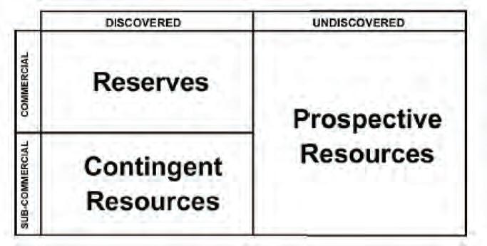
in place), and resource endowment. Without a list of caveats, assumptions, and conditions, it is difficult to know exactly what is being measured, how meaningful these numbers are, and how these numbers compare.
Several industry groups collaborated in an effort to clarify this language. The Society of Petroleum Engineers (SPE), the World Petroleum Congress (WPC), the American Association of Petroleum Geologists (AAPG), and the Society of Petroleum Evaluation Engineers (SPEE) have devised a well defined and rigorous classification system that will enable the geologist (and others) to accurately convey the volume of petroleum in an accumulation, the amount that is recoverable using available technology under current economic conditions, the amount that would be recoverable if certain contingencies were lifted, and the amount that has not yet been discovered. Adherence to this system will allow the geoscientist to speak to the “upside”, define reserve volumes that can be “booked”, enable proper field development and ensure that financial statements are clear and transparent.
This series is designed to provide the geoscientist with an awareness of the Petroleum Resource Management System, how reserves and resources differ, and how they are determined. To do so, this series will address several topics:
• Resource Classification
• Determining Reserves
• Current Economic Condition
• Probabilistic Estimation
• Aggregation
• Geostatistics
It is hoped that by being well versed in the terminology and definitions of different types of reserve and resource classification, the geoscientist can communicate simply and accurately with others and, as such, can manage expectations around size, risk, uncertainty, and value.
R ESOURCE CLA SSIFICATION
It is important to recognize that reserves are only part of the whole resource picture. In 2000, the Society of Petroleum Engineers (SPE), the World Petroleum Congress (WPC), and the American Association of Petroleum Geologists agreed on a comprehensive resource classification system that was designed to place the more familiar “reserves” category within the context of the larger resource base. Such a classification system would preserve the highly valuable but relatively small reserve volume while at the same time providing a sense of how large and economic the resource base is. By allowing the resource size to be initially defined, it was argued that reserve definition would become more consistent. This is particularly useful when addressing unconventional plays where a discovery well may have a very modest reserve volume but may have a very large resource size.
The fundamental basis for this classification system is the McKelvey Box (Figure 1), developed in 1972 by V. E. McKelvey, a Director of the United States Geological Survey.
Figure 1. Modified McKelvey Box encompassing the entire resource base, both discovered and undiscovered as well as commercial and sub-commercial components.
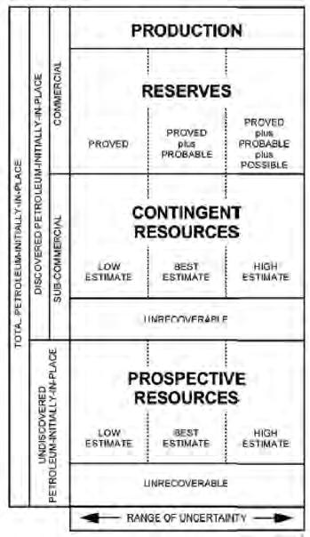
The McKelvey Box has been rearranged slightly and is shown in Figure 2.
This diagram can be best understood by viewing it from left to right. On the extreme left, “Total Petroleum Initially In Place” (TPIIP) for a given hydrocarbon accumulation is defined as all the estimated petroleum in the subsurface, which includes Discovered Petroleum Initially In Place (PIIP) and Undiscovered PIIP (Figure 2, second division from left). Discovered PIIP is defined as a resource that is associated with a “known accumulation” of petroleum that has been penetrated by a wellbore and has been evaluated using engineering and geotechnical information such as well logs, core data, and a production test.
Conversely, Undiscovered PIIP has not been penetrated by a wellbore and therefore cannot demonstrate flow capability, well log data, or core measurements. Undiscovered PIIP is estimated from basin and geological trends; geophysical remote sensing, such as gravity and magnetic surveys; or field size distribution analyses. Undiscovered PIIP is also called Prospective Resources.
Both Discovered and Undiscovered PIIP include a recoverable and unrecoverable quantity of petroleum.
Discovered PIIP is further subdivided into commercial and sub-commercial discovered
PIIP. Commerciality should not be confused with economics. To be commercial, an accumulation must be economic, but there are other non-economic factors that influence commerciality. The definition of commerciality is very important for consistency in reporting reserve and resource figures. First, the accumulation must be assessed as commercial before it can be assigned as reserves and all reserves must be commercial. Proved reserves must be economic under current conditions and using reasonable assumptions, and there must be a commitment to develop these reserves and place them on production within an acceptable timeframe. To be economic, production must generate a positive cash flow and provide an acceptable return to the company (equal to or greater than the corporate cost of capital).
Sub-commercial, discovered, and recoverable PIIP is considered to be a Contingent Resource and not a bookable reserve as specific events must occur for this type of resource to be reclassified as a reserve. For example, an obvious contingency is the capability of the accumulation to generate a positive cash flow, but other contingencies could include regulatory, environmental, and market risks that might delay or prohibit development in a timely fashion.
The various categories that make up TPIIP must be clearly defined so as to avoid confusion. The following definitions are taken from the Canadian Oil and Gas Evaluation Handbook (COGEH) and appear in italics (words not in italics have been paraphrased).
Production is the cumulative quantity of petroleum that has been recovered at a given date.
Reserves are estimated remaining quantities of oil and natural gas and related substances anticipated to be recoverable from known accumulations, as of a given date, based on engineering and geoscience data and analysis, the use of established technology, and specified reasonable economic conditions. Reserves have an associated chance of commerciality.
Contingent Resources are those quantities of petroleum estimated, as of a given date, to be potentially recoverable from known accumulations using established technology or technology under development, but which are not currently considered to be commercially recoverable due to one or more contingencies. Contingencies may include factors such as economic, legal, environmental, political, and regulatory
matters, or a lack of markets. It is also appropriate to classify as contingent resources the estimated discovered recoverable quantities associated with a project in the early evaluation stage. Contingent Resources have a chance of development and a chance of commerciality.
Prospective Resources are those quantities of petroleum estimated, as of a given date, to be potentially recoverable from undiscovered accumulations by application of future development projects. Prospective Resources have both an associated chance of discovery, a chance of development, and a chance of commerciality.
Unrecoverable is that portion of Discovered or Undiscovered PIIP quantities that is estimated, as of a given date, not to be recoverable by future development projects. A portion of these quantities may become recoverable in the future as commercial circumstances change or technological developments occur. The remaining portion may never be recovered due to the physical and chemical constraints represented by subsurface interaction of fluids and reservoir rocks.
Now that production, reserves, contingent resources, and prospective resources have been defined, the right-hand division on Figure 2 introduces the element of uncertainty. Because the data used to calculate reserves and resources is not a direct measurement of a physical property, a range or distribution of the property is often more appropriate than a single value. Uncertainty around porosity, thickness, fluid saturation, and pressure values and the chemical and physical properties of the petroleum combine to generate a minimum to a maximum volume. If production decline analysis or material balance techniques are used, they too involve extrapolation and interpretation assumptions that are best described as a minimum and maximum value. Conveying this sense of uncertainty as to the reserve or resource size is very important. It provides management and investors an idea of what they should expect and helps greatly with the decision-making process. Managing expectations is a critical role for the geoscientist and it also provides a reality check on reserve and resource size.
The “Low Estimate” is conservative with at least a 90% probability (confidence level) that the quantities actually recovered will exceed the estimate. Similarly, the “Best Estimate” has an equal probability that the volume actually produced will have an equal
(Continued on page 41...)
Figure 2. Rearranging the McKelvey Box conceptually aligns with a geological understanding of resources.

chance of being greater or less than the estimate. The “High Estimate” is considered to be optimistic and only has a 10% chance of exceeding the produced volumes. This will be discussed in subsequent articles in this series. There is one last consideration in using this classification system and that is the concept of the project status or maturity of the category. The basis of maturity is that as an accumulation becomes more mature, there is a higher probability that the accumulation will achieve commercial production. Figure 3 illustrates how uncertainty around what the actual reserve size is diminishes as production continues.
Project status is independent of the uncertainty in reserve or resource size. Using project status categories is also a way to manage reserve development. Using the nomenclature shown in Figure 4, managers have a sense of where an accumulation is in its development plan and how one accumulation compares and integrates with another. Capital allocation decisions relating to each accumulation can then be made objectively to achieve corporate goals.
This resource classification system, when properly used, can accurately describe both the reserve volume and the resource potential of a petroleum accumulation. Furthermore, it can describe resource levels that are yet to be discovered. It conveys both size and value.
However, it is very important that geoscientists adhere to the strict definition of each category and document their reasoning carefully. Consistency within and between companies, Independent Qualified Reserve Evaluators (IQRE), and regulatory bodies is of the utmost importance if this system is to remain credible. Press releases and other important communiqués need to quote reserve levels with the correct descriptors (i.e., proven developed producing, total proved, proved plus probable, etc.) and resource volumes (i.e., contingent resource, development on hold). Reserves and resources must not be added together and quoted as something like “total resource”. Precision, accuracy, and consistency are critical.
As this series continues, we will look at several other aspects of reserves and resources:
• determination of reserves and resources
• the meaning of current economic condition
• using probabilistic estimation techniques
• the phenomenon of reserve aggregation and confidence levels
• the application of geostatistics in determining reserves and resources. Understanding reserves and resources is a core competency for all geoscientists.
RefeR ences
Society of Petroleum Engineers. 2001. Guidelines for the Evaluation of Petroleum Reserves
and Resources. Richardson, Texas. Society of Petroleum Engineers.
Society of Petroleum Evaluation Engineers (Calgary Chapter). 2007. Canadian Oil and Gas Evaluation Handbook. Calgary, Alberta: Society of Petroleum Evaluation Engineers (Calagry Chapter) and Canadian Institute of Mining, Metallurgy & Petroleum (Petroleum Society).
Figure 3. Reserve size uncertainty is reduced as development and production of an accumulation continues.
Figure 4. The resource classification system with project status added to the right. Using consistent, well defined categories lends itself to simple and accurate information exchanges.
INTO THE FORELAND
The 2011 CSPG Summer Student Field Trip, organized by members of the University Outreach Committee, took place on a sunny day in June. Twenty-nine students participated, spending the day learning about some key stratigraphy of the Bow Valley from trip leader Doug Cant of Doug Cant Geological Consulting.
The field trip went from Calgary to Banff with three major stops. Doug started the day by giving an overview of the foreland basin and its relation to the Front Ranges from inside the Triangle Zone. After a brief stop to discuss the McConnell Thrust on Mount Yamnuska, the first major stop was the “Seebe” Dam. Although there was too much water to head down and have a good look at the rocks, there were some great discussions about the Cardium and its prolific reservoirs.
The second major stop was a great one for enjoying the beautiful day; the group hiked up to Grassi Lakes to explore the Southesk Formation. Following a relaxing lunch at the trailhead, the final outcrop visited on the trip was at the Banff “Traffic Circle,” where the participants were able to walk the section and see the Fernie-Kootenay transition close at hand.
All of the participants enjoyed a day out of the office and in the field. Highlights for some people were getting up-close and personal with the Devonian rocks that are so important to the heritage of the petroleum industry in Calgary, and seeing fossilized tree stumps in the Kootenay Group.
One of the things that made Doug Cant such a great leader for this field trip was his ability to emphasize the link between not only the geology of the Bow Valley with the petroleum industry, but also the relevance of the regional tectonics to industry. One participant, Adam Fraser, a graduate student at the University of Calgary, noted that this was one of the best aspects of the field trip.
Thank you to Jane Marzetti and Jacey Seebach for their work organizing the field trip, Dayna Rhoads and Alyssa Middleton for coordinating registrations, and, of course, Doug Cant for his expertise and leadership on the field trip.
Students at the base of the Southesk exposure at Grassi Lakes.
Studying the Fernie-Kootenay exposure at the Banff “Traffic Circle.”
Too much water below the dam at Seebe.
An Integrated Workflow Solution
Get the full picture with comprehensive integration of IHS PETRA®, IHS PetraSeis® and IHS GeoSyn™.


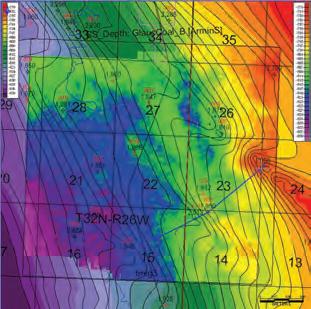

When these three solutions seamlessly connect, geological and seismic workflows are streamlined with easy-to-interpret data and modeling tools. This integrated bundle allows you to access, view and manipulate information within the same project; create multidimensional seismic models and synthetics; improve workflow collaboration; and deliver comprehensive proposals for new prospects. Get to the field faster with seismic, well, production, log and economic data at your fingertips.
See more solutions at www.ihs.com/cspg-1

ADApTING TO pLANETARY CHANGE
Join
for a
ONE NIGHT ONLY CALGARY JUBILEE AUDITORIUM NOVEMBER 2, 2011 - 7PM
GENERAL ADMISSION: $15 advance, $20 at the door STuDENTS $5 advance, $10 at the door. All ages welcome. Kids under 12 free. cspg.org

us
night of earthly extremes with volcanic sleuth Dr. Catherine Hickson and glacial historian Mr. Jeffrey Bond. Discover nature’s most powerful opposing forces and the stories buried deep within them.
NEWS FROM ASTM Reflectance measurement for dispersed vitrinite
| By Paul Hackley
A new American Society for Testing and Materials (ASTM) standard test method for measurement of the reflectance of vitrinite dispersed in sedimentary rocks has been developed by an international committee of technical experts from government agencies, academia, industry, and consultancies. This product grew from the efforts of the International Committee for Coal and Organic Petrology (ICCP) Identification of Primary Vitrinite Working Group, and is the result of an international partnership between members of ICCP, ASTM, The American Association of Petroleum Geologists, and TSOP. The new consensus standard is available for purchase from http://www.astm.org/Standards/D7708.htm and is included in the 2011 Annual Book of ASTM Standards, v. 05.06, Gaseous Fuels; Coal and Coke, which can be obtained as a free yearly benefit to ASTM members.
Development of the new test method (ASTM D7708-11) began in 2008 with a survey of common practices used in laboratories that routinely measure the reflectance of dispersed vitrinite in shales. The test method writing committee was identified from among the survey respondents, and the existing ASTM coal vitrinite reflectance standard (ASTM D2798) was used as an outline for the new test method. Significant changes from the coal standard include:
1) specialized terminology to include recycled vitrinite, zooclasts, solid bitumens, and marine algae;
2) discussion of potential for vitrinite suppression and retardation in certain conditions;
3) inclusion of fluorescence observation and resulting changes to equipment description and procedure; and 4) addition of reporting requirements, including type and quality of sample preparation, observation of fluorescence, and consideration of supporting data and information.
The new standard was successfully balloted through the subcommittee and D05 main committee levels of the ASTM vetting process with no negative votes received. However, users of the standard and other interested parties can bring comments and concerns to the attention of ASTM subcommittee D05.28, Petrography
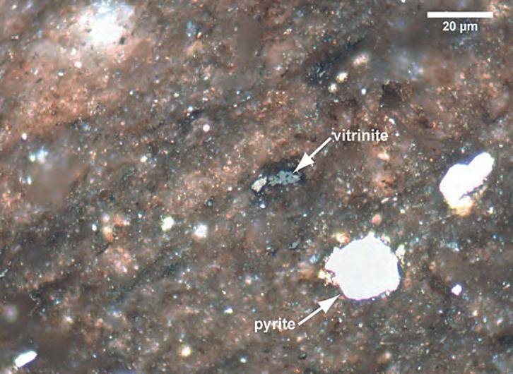
of Coal and Coke, which is responsible for the maintenance and revision of this and other ASTM petrography standards. Interested CSPG members who would like to contribute to consensus standards development within subcommittee D05.28 are encouraged to contact Paul Hackley, U.S. Geological Survey (phackley@usgs. gov), for additional information.
Anticipated users of the new D7708-11 standard include government, academic, and service laboratories. The standard will be used as the prescribed method for the dispersed vitrinite reflectance accreditation program of the ICCP, which currently includes approximately forty laboratories worldwide. The test method is predicted to be most relevant for shale gas plays where precise information concerning thermal maturity is considered key to successful basin analysis. Anticipated future improvements to the standard include the creation of quantified reproducibility and repeatability values through inter-laboratory roundrobin exercises, and the development of a supplemental online image atlas of dispersed organic matter in sedimentary rocks to aid in the identification of indigenous vitrinite.
Example of dispersed vitrinite in the Upper Cretaceous Eagle Ford Shale, Maverick Basin, south Texas.
GO TAKE A HIKE
Grassy Mountain, Crowsnest Pass Area, Alberta
| By Mona Marsovsky, Keith Mychaluk and Vaclav Marsovsky

Above: Long march up to the abandoned Grassy Mountain mine workings afford spectacular views.
Bottom Right: Pterophyllum rectangulare, a member of the cycad family. Cycads exist today but were much more common in the Mesozoic. The early Cretaceous saw the rise of the angiosperms, though little evidence of their presence is seen here.
trailhead: From the town of Blairmore, off Highway 3, drive north 7.6 km on the gravelled Grassy Mountain Road, starting just east of the Golf Course. Turn left onto a 4-wheel-drive road at the base of Grassy Mountain and drive until the road becomes impassable. Park at the side of the road (white “P” on map). Trail is in red.
Distance 12.2km return full day hike: The route up takes 2.5 hours whether by the gentle 4-wheel-drive road or via the steep and difficult ascent following the coal seam. Descent takes 1.5 hours either route. Elevation Gain: 488 m.
Grassy mountain offers spectacular scenery in both the outstanding views of the surroundings (including Crowsnest Mountain) and in the dramatically coloured sediments. Follow the winding and gently ascending old mine road (Ross and Tracy, 1992) roughly NNE until it crosses the exposed seam, and then follow that back to the SSW. The route is marked in white on the map. At the southern end of the pit, another large exposure is revealed by a challenging descent of the steep slope which lets you rejoin the road near its start or you may return along the original route.
Between 1947 and 1960 West Canadian Collieries extracted medium volatile coal from the Mist Mountain Formation of the Late Jurassic to early Cretaceous Kootenay Group. Although the latitude was similar to today’s (50° North), climate at the time of deposition was semi-tropical with a mean temperature of about 15° C. The ~125m of Kootenay strata consist of coastal plain deposits of sandstone, siltstone, shale, and thick coals. The conditions conducive to coal accumulation also preserved numerous compression and impression plant fossils. The Kootenay overlays the shales of the Jurassic Fernie Group and is unconformably overlain by the conglomerates of the Cadomin Formation.
Grassy Mountain is within the Foreland Fold and Thrust Belt, characterized by west-dipping thrust faults and associated folds. In the core of the folds the normally 6m thick coal seams have deformed and thickened up to 30 m. The steeply dipping strata exposed at the mine lies just west of the surface expression of the Turtle Mountain Fault (TMF on map). This thrust dies out northeast into a series of minor faults and folds before displacement is again taken up by the McConnell Thrust which extends another 300 km to the north.
In addition to the normal safety concerns associated with a mountain area (ticks, cougars, bears, and loose rocks), avoid the old equipment, buildings, and open shafts of the former mine.
References: Ross, Jane and Tracy, William. 1992. Hiking the Historic Crowsnest Pass. Rocky Mountain Books. Gibson, D.W., 1977. BCPG V.25, #4, p767-791. Hughes, J.D., 1978. Grassy Mountain, Blairmore. Field Guide to Rock Formations of Southern Alberta, CSPG Publication.
Photo
Crowsnest Mountain is in view at the top of the trail. The Mountain is comprised of Devonian Palliser (PA) limestone, Mississippian Banff (BA), and Livingstone Group (LV) shales and carbonates thrust overtop of Late Cretaceous Belly river Group (BR) sandstones and shales. The Lewis Thrust can be mapped from Montana over 300 km to the latitude of Calgary in the Foothills. The blue line marks the plane of the fault and the arrow the direction of movement for the hanging wall (overlying) strata.
Crowsnest Mountain is a Klippe; erosion has isolated this pod of Paleozoic strata sitting atop the fault plane.

Reclining on some inclined bedding in the Mist Mountain Formation. Note the ripples.
The abandoned mine working expose thick coals, thinly bedded sandstone, siltstone and shale with abundant plant remains. Occasionally channels with lateral accretion surfaces cut the coastal plain deposits. In this picture the base of the channel is outlined with a dotted line.
Podozamites leaf fossil.
Mule deer favour the grassy slopes for which the mountain is named.
The end of the long pit reveals a very thick coal seam. Numerous remains from the coal mining era scatter the locale.
23rd Annual CSPG/CSEG 10K/5K Road Race and Fun Run
Wednesday, September 14, 2011
The race begins at the Eau Claire YMCA , and is an out and back route along the Bow River pathway. There is a 75-minute cut-o time
Entry Deadline: 12:00 PM, September 9, 2011 Maximum 200 participants
Categories and awards (awards for 10K only) 10K 5K Yes, I will be attending the pizza party after the Road Race
Age: 29 and under 30-39 40-49 50-59 60 and above Age on race day
T-Shirt Size: Small Medium Large Extra Large Ladies Mens
Membership: CSPG CSEG CAPL Membership number: Non Member:
Name:
Company:
Address:
Phone: (daytime) (evening)
Email: Male Female
Please note: A participation waiver MUST be signed by all participants one day prior to the race. The waiver form will be distributed to you when your registration has been processed. If the waiver form is not signed by at least one day prior to the race, your registration will be removed from the race and you will not be allowed to participate.
Photographs: Photos are taken during the Road Race and are sometimes used for promotional purposes in CSPG publications. Your consent is needed to publish a photo where you are identi able in the picture. Do you consent to your photo being used by the CSPG for promotional purposes and in future CSPG publications? Yes No
All registrations must be accompanied by full payment. Registration is accepted on a rst-come, rst-serve basis until the regisration deadline of September 9, 2011. All registrations are non-refundable and non-transferable.
$40.00 Member (CSPG, CSEG, CAPL)
$25.00 Student (CSPG, CSEG)
$50.00 Non Member
$20.00 Extra Meal Ticket
TOTAL: $ (GST Included, GST #118836295)
Visa Mastercard Cheque (payable to CSPG)
Card Number: Expiry: Name on Card:
Signature:
Please send all registrations to: Canadian Society of Petroleum Geologists ATTN: 10K/5K Road Race & Fun run 600, 640 8 Avenue SW Calgary, AB T3R 1K7
23RD A NNUAL CSPG-CSEG 10KM /5KM
Ro ad Race and Fun Run

On your mark! Once again, the CSPGCSEG will be running its annual Road Race and Fun Run this September. Building on last year’s format, the event promises to be better than ever!
We will be offering both a 10km and a 5km race. We have secured Winning Time to provide chip timing and Events-on-Line will provide easy on-line registration.
The run will take place on Wednesday, September 14, 2011. Start time 6:00pm just north of the Eau Claire YMCA. The route will take you on an out-and-back course along the beautiful Bow River pathway, finishing at the Eau Claire YMCA. Following the race, all racers, volunteers, and guests are invited to gather at the Calgary Curling Club, just north of Prince’s Island for awards, draw prizes, refreshments, and some friendly camaraderie. So if you are looking for a competitive race or just want to have fun, come join us!
The race is open to all members of the CSPG, CSEG, and CAPL, and the general public, however, space is limited to 200 participants. So register early to avoid disappointment! There will be NO race day registration. For more information or to register, visit our website www.cspg. org\events. For sponsorship opportunities please contact Mike Cardell at 403-781-1426 or mcardell@arcis.com
To help you prepare, Gord Hobbins of Gord’s Running Store has developed a 10km race training guide for novice runners. Try it out and benefit from some expert advice, you may be surprised how easy it can be
to gently get yourself in condition for your first race.
G OR D ’ S 12 W EE K T RA INING GUI DE FOR NOVICE RU NNERS
Guidance/Tips: For novice runners who wish a do-it-yourself program at your leisure.
• Ru n for short durations between three and five times per week according to schedule, with your long-run days being the key to your training program.
• If your running shoes are giving you some problems, get some that fit and match your gait.
• Guide allows for a gradual increase to a comfortable load; your legs may need some conditioning at first.
• Ye s, times are in minutes. The secret is to be regular and not beat yourself up.
• We ar a hat and cool shades. Keep well hydrated. It really helps.
• Ge ntly stretch those calves and quads afterwards.
• Ta ke along a friend and convince them to sign up for CSPG, CSEG, and the Road Race as well.
Many thanks go out to our sponsors and volunteers who make this event possible each year!
We hope to see you there! Mike Cardell, Race Director.
The following are gratefully acknowledged as sponsors of SIFT:
Platinum Sponsors:
Prime Sponsors:
Silver Sponsors:
Canadian Centre for Energy Information
Cenovus Energy
Crescent Point Energy
Enerplus Resources Fund
Golder Associates Ltd.
Husky Energy
IHS Energy
Bronze Sponsors:
Ayrton Exploration Consulting Ltd.
BJ Services Company Canada
Canadian Forest Oil Ltd.
CSUG
Drivet Geological Consulting
Ember Resources
Jenner GeoConsulting
Legacy Oil & Gas
MacPhail School of Energy
Gold Sponsors:
Rigstar Communications Inc.
Sundog Printing
University of Calgary
Weatherford Canada
Whiskey Jack Resources Inc.
Marian Hanna – Consultant
MGM Energy Corporation
NAL Energy
Nexen Inc.
Palliser Oil & Gas Corporation
Pengrowth Corp.
Peters & CO
Royal Tyrrell Museum
CSPG SIFT 2011
| By 2011 Chair: Dawn Hodgins; Committee Members: Alyssa Middleton, Andrea Marsh, Andrew Cook, Debbie Cook, Denise Hodder, Geoff Speers, Heather Slavinksi, Ian DeWolfe, Indy Raychaudhuri, Keith Yaxley, Kate McCutcheon, Meghan Speers, Melanie Regehr, Nate Kreiger, Noel DevereBennett, Steve Dryer.
The 2011 edition of the CSPG SIFT program, which ran from May 1st to 13th, was a tremendous success. The SIFT program has phenomenal volunteer and industry support with 18 committee members involved in planning and organizing and 22 industry professionals providing lectures and field trips. In addition to an outstanding volunteer base, financial support from our industry sponsors allows the CSPG to continue to offer this flagship program every year. Our major industry sponsors for 2011 were: ConocoPhillips Canada, Imperial Oil Limited, Shell Canada Limited, EnCana Corporation, Devon Energy, and Talisman Energy. SIFT was also fortunate to receive in kind donations by Whisky Jack Resources Inc., Enerplus Corp, Crescent Point Energy, Golder Associates, Weatherford Canada, Husky Energy, Cenovus Canada, University of Calgary, Canadian Centre of Energy Information, RigStar Communications, and Sundog Printing. On behalf of the entire SIFT committee and the CSPG, I want to thank all the individuals and companies for their continued support of this incredible program.
The CSPG SIFT 2011 committee hosted 32 undergraduate students enrolled in geoscience programs from across Canada. These 32 budding geoscientists came to Calgary for a twoweek introduction to the Canadian petroleum industry through classroom lectures, core workshops, an exploration game, field trips, and many opportunities to talk to professionals working in our industry. Throughout the two weeks, students attended lectures presented by industry experts with topics including well logging and log interpretation, carbonate and clastic reservoirs, geophysics, well-site operations, heavy oil, and more. To keep up with current activity in the industry, we also held an Environmental Talk, Unconventional Resources and Global Energy Outlook. In
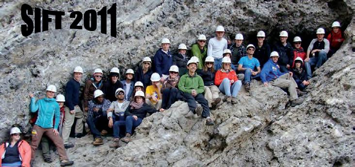
addition to the lectures, students were able to tour the demonstration rig at SAIT and did a Behind-the-Scenes tour of the Royal Tyrrell Museum in addition to a few field trips, including the legendary four-day trip through the Rockies and a trip to Dinosaur Provincial Park. A large component of the SIFT trip is having the students apply concepts learned on the trip to an intense, hands-on exploration game. The game teaches students some of the realities of the oil and gas business. Teams of four form a company and are given a small land base and seed capital to start exploring and building their company. They use real well log data to make interpretations of the geology and identify “sweet spots,” which they use to bid on additional land, drill wells, and structure business partnerships. At the end of the program an experienced industry panel judges the interpretations and success of the individual companies and awards the Bill Ayrton Technical Award (Tim Peters, Simon Fraser; Rabi Nizami, University of Toronto; Matthew Brzozowski, Windsor; Kevin MacRae, St. F.x) and the Larry Strong Financial Award (Naomi Miles, University of Calgary; Judy Lam, Carleton; Brent Perrin, Brandon University;

Chinemerem Dennar, Dalhousie University).
Each year, the SIFT Committee complements the two-week SIFT program with a Summer Job Program. The goal of this component of SIFT is to place newly trained SIFT graduates with oil and gas companies in Calgary so that they can continue the learning experience. This year, four students found summer positions. Each year, we continue to look for companies willing to hire our SIFT graduates. If your company is able to offer a position, please contact the CSPG office for more information.
I have had the great privilege of leading this program for the past two years and I’ve thoroughly loved this opportunity. But it’s now time to step aside to let someone else enjoy this experience and Debbie Cook from Cenovus Canada has volunteered to step forward to lead the SIFT program in 2012. Many thanks to all the SIFT committee members that have worked on the committee over the past 33 years. The organizing committee puts in a huge effort every year and it is a result of their hard work that SIFT is such a success.
Larry Strong Financial Award: Left to right: Naomi Miles, University of Calgary; Chinemerem Dennar, Dalhousie University; Brent Perrin, Brandon University; Judy Lam, Carleton.
Bill Ayrton Technical Award, Left to Right; Kevin MacRae, St. F.X.' Matthew Brzozowski, Windsor; Tim Peters, Simon Fraser; Rabi Nizami, University of Toronto.

ROAD T O R EC OVERY re covery 2011 Final Update
| By Aileen Lozie, Paul MacKay, Rob McGrory, and Satyaki Ray
With another convention successfully completed, the general co-chairs of recovery 2011 thought you might be interested to know how things shaped up this year.
With several new changes being introduced this year, including a new venue, a new technical program format and a new exhibit floor, this year’s organizing committee did an amazing job ensuring these new changes worked in the conventions favor.
The decision to move the convention back to the Calgary TELUS Convention Centre was determined in 2009 and the move to a new venue proved successful. The Convention Centre staff was extremely helpful and the central location was appreciated by delegates in attendance.
The exhibit floor was bustling and exceeded budget, sponsorship dollars exceeded budget, and delegate registration numbers rivaled that of last year’s GeoCanada convention with 4,400 registered attendees at recovery 2011.
Looking at the numbers, this year’s convention saw 366 technical presentations, including 83 posters, 16 core conference presentations, and 267 technical talks spread out through 31 sessions over three full days. Total revenue (unaudited) was $2,022,541.36, total expenses (unaudited) were $1,120,628,62 leaving a profit (unaudited) of $901,912,74 to be distributed to the participating societies.
This year’s special events included two keynote luncheons from Dr. Michael Economides and John Furlong. Both were extremely well received and well attended. The Monday Night Icebreaker, which marked the opening of the exhibition floor was well attended and the Tuesday Night Networking Reception took place at the Hyatt Regency and featured amazing food and marked the close of the Silent Auction in support of Light Up the World that raised over $13,000! The Core Meltdown at the Core Research Facility was a great way to close the convention and was well attended.
Earth Science for Society (ESfS) took place again this year and was an overwhelming success. Over 2,200 students perused the exhibits, which included Gold Panning with Yukon Dan and Fossil Finding with Burgess Shale over two days; over 2,000 people attended the general public day on Sunday.
Of course, the success of the convention wouldn’t have been possible without the help of our dedicated organizing committee, session chairs, and volunteers. On behalf of myself, Paul MacKay, Rob McGrory, and Satyaki Ray, we’d like to thank each of you for your hard work, dedication, and enthusiasm shown at the convention and in the days and months leading up to the convention. Our success wouldn’t have been possible without each of you.
awa rd r ec ipients – recovery 2011
We would like to congratulate the following recovery 2011 presenters and award winners:
Be S t S tu D e N t C ore
Pre S e N tatio N
Ros s Kukulski
Stratigraphic Architecture of the Monach Formation (Nikanassin/Minnes Group)
Be S t r u NN e r- uP St u D e N t C ore Pre S e N tatio N
Ju lianne Fic
Reservoir Architecture of the Cardium Formation in East Pembina, Alberta
Be S t C ore Pre S e N tatio N
Denn is Meloche
How Deep is Shallow? Re-evaluation of Depositional Models for the Jurassic Nordegg and Rock Creek Members of the Fernie Group
Be S t G eolo G i C al
Stu D e N t Po S te r
Julianne Fic
Reservoir Characterization of a Tight Oil Play of the Middle Jurassic Upper Shaunavon Formation Member in the Whitemud and Eastbrook Pools - SW Saskatchewan
r u NN e r- uP Ge olo G i C al
Stu D e N t Po S te r
Dallin Laycock
Clinoform architecture of a shaledominated succession in the Cretaceous Colorado Group, Central Alberta
Be S t G eo P H y S i C al
Stu D e N t Po S te r
Karol Rohraff
Application of the signal correlation for the construction of age models of Lake Baikal sedimentary records
r u NN e r- uP Ge o PH y S i C al
Stu D e N t Po S te r
Winnie Pun
Geophysical time series data from a stressed environment
Be S t G eolo G i C al Po S te r
Tiffani Fraser
Preliminary results from a diamond drill hole study to assess shale gas potential of Devonian strata, Eagle Plain, Yukon
r u NN e r- uP Ge olo G i C al
Po S ter
D r. Chris Schneider
Effects of Prairie Evaporite Formation Salt Dissolution on the overlying Waterways Formation in Northeastern Alberta
Be S t G eo P H y S i C al Po S te r
Khalid Miah
Fractional Fourier Transform in Coherent Noise Attenuation
r u NN e r- uP Ge o PH y S i C al
Po S ter
A zer Mustaqeem
Unraveling Cardium Tight Sand
Paleo-depositional Trends and Subtle Structural Features using Seismic Reservoir Characterization
Be S t P etro P H y S i C al Po S te r
Kris Vickerman
Measuring Minor Structures in Borehole Image Logs

Best Geolo G i cal o ral Presentation
Dr. Juergen Schieber
Shifting Paradigms in Shale Sedimentology
- The Implications of Recent Flume Studies for Interpreting Shale fabrics and Depositional Environments
Best s t udent Geolo G i cal o r al Presentation
Norka Marcano Using Produced Oil Molecular Composition to Monitor In Situ Upgrading Operations in Oil Sands and Heavy Oil Reservoirs
r unne r- u P s t udent
Geolo G i cal o ral Presentation
Sean Fletcher
Characterizing Depositional Elements of a Deep Water Channel Complex using Quantitative Metrics, Tres Pasos Formation, Southern Chile
Best Geo P hy sical o ral Presentation
Chris Kennett
The Sleipner CO 2 4D Story: 15 Years of CO 2 Storage and Seismic Monitoring
Best s t udent Geo P hy sical o r al Presentation
Helen Yam
CO 2 Rock Physics: A Laboratory Study
r unne r- u P s t udent
Geo P h ysical o r al Presentation
Nadia Kreimer
Evaluation of a New 5D Seismic Volume Reconstruction Method: Tensor Completion versus Fourier Reconstruction
Best Petro P hy sical o ral Presentation
Dr. Joel Walls
Eagle Ford Shale Reservoir Properties from Digital Rock Physics
HONORARY ADDRESS: Fire and Ice
Some say the world will end in fire, Some say in ice.
From what I’ve tasted of desire I hold with those who favor fire. But if it had to perish twice, I think I know enough of hate To say that for destruction ice Is also great And would suffice.
-Robert Frost Harper’s Magazine, December, 1920 edition
Will the world end in fireworks (in the manner described in “The Restaurant at the End of the Universe” by Douglas Adams, Book 2 in the Hitchhiker’s Guide to the Galaxy trilogy of 5 books) or in another, more profound, ice age as it nearly did in the Paleoproterozoic Era? Ask a Geoscientist or two!
The Canadian Society of Petroleum Geologists (CSPG), the Canadian Society of Exploration Geophysicists (CSEG) and the Association of Professional Engineers, Geologists and Geophysicists of Alberta (APEGGA) will present the annual public geoscience lecture at the Southern Jubilee Auditorium on that very topic. Middle school students will have a chance to ask deeply probing questions on November 3, 2011 in Calgary. The Calgary presentation will include an evening session and question period that will be open to the general public. Information booths for the Calgary-area geoscience societies and a silent auction will be available to the public before the performance and during intermission.
Dr. Catherine Hickson, P.Geo., Vice President of Exploration and Chief Geoscientist for Alterra Power
Best s tudent Petro P h ysical o r al Presentation
Andrew Wiseman
The Montney Formation: Mineralology, What Shall it Be?
Best i n te G r ated o r al Presentation
Jerome Biollo and Jeff Allison Cracking the CubeUnderstanding of Frac Barriers in Horn River Basin Shales, Horn River Shale Play
Corporation; and Jeff Bond, Surficial Geologist with the Yukon Geological Survey will present their view of fire and ice in the geoscience context. Both are Alberta natives and are enthusiastic about presenting the results of their research in Canada and abroad.
Tickets to the Calgary presentation are available from the CSPG offices or online through the APEGGA website. CSPG members may purchase tickets on-line through the members-only area on the CSPG website. Doors at the Southern Alberta Jubilee Auditorium will open at 6 PM on November 3 with the talk starting at 7 PM. Ticket prices are: Adults $15 advance, $20 at the door; Students $5 advance, $10 at the door; and Children 12 and under free.
Since 1927...
CORPORATE MEMBERS
APACHE CANADA LTD
BAKER ATL AS
CANADIAN NATURAL RESOURCES LTD
CASEY & ASSOCIATES
CONOCOPHILLIPS CANADA LIMITED
DEVON CANADA CORPORATION
ENERPLUS CORPORATION
GEOLOGIC SYSTEMS LTD
GEOSTRATA RESOURCES INC.
H UNT OIL COM PANY OF CANADA
HU SKY ENERGY INC.
IHS
IMPERIAL OIL RESOU RCES
KKD OIL SANDS PARTNERSHIP
LITTLE ROCK DOCUMENT SYSTEMS
MJ SYSTEMS
MU RPHY OIL COMPANY
NE xEN INC
PENN WEST PETROLEUM LTD
PETROCRAFT PRODUCTS LTD.
PLUSPETROL S.A
RPS ENERGY CANADA LTD.
SHELL CANADA LIMITED
S PROULE ASSOCIATES LIMITED
SUNCOR ENERGY INC
TALISMAN ENERGY INC
TOTAL E&P CANADA LTD.
TOURMALINE OIL CORP
AS OF AUGUST 10, 2011
CSPG welcomes our 2011 Corporate Members! The benefits of being a corporate member include:
• Recognition in the monthly Reservoir and quarterly Bulletin
• One associate membership
• Reserved tables at the technical luncheons with your company logo
• One free pass to the CSPG Core Conference …and more! Contact Kasandra Klein at Kasandra. klein@cspg.org to be a corporate member today!
AAPG N EW E XECUTIVE OF FICERS
President David Rensink has announced the results of the AAPG election of officers as follows:
m r. edward a . Be aumont, President- e lect ( ter m: President- e lect, 2011-12) Senior Geologist SM Energy Company 7060 S. Yale, Suite 800 Tulsa, OK 74136-5741 918.488.7618
ted.beaumont@aapg.org
Dr. Stuart D. Harker, regions vice President ( term: 2011-13) 40 Newlands Crescent Aberdeen AB10 6LH Scotland 44.11.8973.5406 harker.abz@googlemail.com
m s. Denise m . Cox, S ecretary ( ter m: 2011-13) Storm Energy 702 Bunkers Cove Road Panama City, FL 32401 850.257.5070 denisemcox@msn.com
The above new officers will take office on July 1, 2011, joining:
Dr. Paul Weimer, President ( ter m: 2011-12) University of Colorado Dept. of Geological Sciences - CB 399 2200 Colorado Avenue, Benson Building Boulder, CO 80309-0399 303.492.3809 paul.weimer@colorado.edu
m r. m ar vin D. Brittenham, Sections v ice President ( ter m: 2010-12) EnCana Oil and Gas (USA) Inc. Republic Plaza 370 17th Street, Suite 1700 Denver, CO 80202 720.876.3526
marvin.brittenham@encana.com
m r. J ames S. m cG hay, tre asurer ( term : 2010-12) Mid-Con Energy Corporation 2431 East 61st Street, Suite 850 Tulsa, OK 74136 918.743.7575 jmcghay@aol.com
Dr. Stephen e . l aubach, editor ( ter m: 2010-13) Texas Bureau of Economic Geology The University of Texas at Austin University Station, Box x Austin, T x 78713-7508 512.471.6303
steve.laubach@beg.utexas.edu
m r. J effrey W. lund, Chair, House of Delegates ( ter m: 2011-12) 5127 Tangle Lane Houston, T x 77056 713.253.7481
jeff.lund@corridoroilandgas.com
The final results include 5,267 returned ballots from 15,457 eligible members with an election participate rate of 34.1%. By comparison, 5,584 voters participated in the 2010 election for a participation rate of 35.4%.

Need a solution that will take you to oil faster?
Accelerate

Introducing the DecisionSpace® Desktop unified workspace
Now your entire asset team can collaborate in real time using one unified workspace.
Accelerate analysis and interpretation by sharing a common subsurface framework. Reduce cycle time and improve accuracy by examining more scenarios faster.
Improve your returns in the field and in the office with industry-leading science and unmatched usability. Learn more at halliburton.com/decisionspacedesktop.
High Science Simplified®