


Focus, quality and value. We don’t build our reputation on volumes—instead, we earn it on the quality of the information we extract from that data. For more than 75 years, IHS has processed and analyzed vast amounts of raw data, concentrating it into the in-depth, actionable information that is used today to advance energy-critical business decisions. Energy information, refined.
ihs.com/refined-information/cspg


#600, 640 - 8th Avenue SW Calgary, Alberta, Canada T2P 1G7
Tel: 403-264-5610 Fax: 403-264-5898
Web: www.cspg.org
Office hours: Monday to Friday, 8:30am to 4:00pm
Executive Director: Lis Bjeld
Email: lis.bjeld@cspg.org
Advertising & Sponsorship Coordinator: Alyssa Middleton
Email: alyssa.middleton@cspg.org
Communications Coordinator: Heather Tyminski
Email: heather.tyminski@cspg.org
Member Services Coordinator: Kasandra Klein
Email: kasandra.klein@cspg.org
Registration Coordinator: Dayna Rhoads
Email: dayna.rhoads@cspg.org
Convention Contacts
Convention Manager: Shauna Carson
Email: scarson@geoconvention.org
Convention Coordinator: Tanya Santry
Email: tsantry@geoconvention.org
EDITORS/AUTHORS
Please submit RESERVOIR articles to the CSPG office. Submission deadline is the 23rd day of the month, two months prior to issue date. (e.g., January 23 for the March issue).
To publish an article, the CSPG requires digital copies of the document. Text should be in Microsoft Word format and illustrations should be in TIFF format at 300 dpi., at final size. For additional information on manuscript preparation, refer to the Guidelines for Authors published in the CSPG Bulletin or contact the editor.
Technical Editors
Ben McKenzie Colin Yeo (Assistant Tech. Editor) Tarheel Exploration EnCana Corporation Tel: 403-277-4496 Tel: 403-645-7724 Email: bjmck@telusplanet.net Email: colin.yeo@encana.com
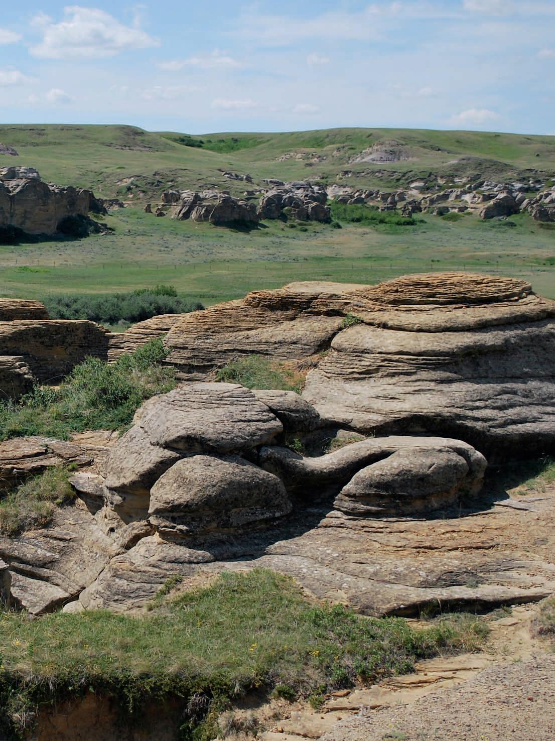
Coordinating Editor
Heather Tyminski, Comunications Coordinator, CSPG Tel: 403-513-1227, Email: heather.tyminski@cspg.org
ADVERTISING
Advertising inquiries should be directed to Alyssa Middleton, Tel: 403-513-1233, email: alyssa.middleton@cspg.org. The deadline to reserve advertising space is the 23rd day of the month, two months prior to issue date.
The RESERVOIR is published 11 times per year by the Canadian Society of Petroleum Geologists. This includes a combined issue for the months of July and August. The purpose of the RESERVOIR is to publicize the Society’s many activities and to promote the geosciences. We look for both technical and non-technical material to publish. Additional information on the RESERVOIR’s submission guidelines can be found at http://www.cspg. org/publications/pubs-reservoir-submissions.cfm.
or
Make plans to attend the CSPG/AAPG Unconventionals Day at ICE, Tuesday, 14 September. Learn more about the importance, future and development of these resources at presentations including:
Unconventionals Day Topical Luncheon: • Global Challenges in Shale Reservoir Development: Moving Beyond a Statistical Approach Business Forum: • Unconventional Exploration and Development Geoscientists Toolbox
• Management Forum — E&P Challenges in Complex Environments: From the Arctic to Deep Water Special Lecture
• — Geology of a Major SAGD Bitumen Development — A Case Study from Long Lake, Northeastern Alberta Choose from numerous technical presentations and posters
• related to unconventionals in Tuesday’s lineup, including two EMD sessions on oil sands/heavy oil, both regional and Alberta case studies and two EMD sessions on the Bakken Shale


President John Varsek • Cenovus Energy john.varsek@cenovus.com Tel: (403) 645-5417
Vice President
Kirk Osadetz • Geological Survey of Canada, Calgary kosadetz@nrcan.gc.ca Tel: (403) 292-7022
Past President
Graeme Bloy • Canada Capital Energy Corporation gbloy@capitalenergy.ca Tel: (403) 975-5784
Finance director
Greg Lynch • Shell Canada Ltd. greg.lynch@shell.com Tel: (403) 691-3111
assistant Finance director
Darren Aldridge • Baker Hughes darren.aldridge@bakerhughes.com Tel: (403) 537-3505
Program director
Scott Leroux • EnCana Corporation scott.leroux@encana.com Tel: (403) 645-2000
assistant Program director
Brett Norris • TransGlobe Energy Corp. brettn@trans-globe.com Tel: (403) 264-9896
serVice director
Ayaz Gulamhussein • NuVista Energy Ltd. ayaz.gulamhussein@nuvistaenergy.com Tel: (403) 538-8510
assistant serVice director
Richard Thom • Core Laboratories Canada Ltd. richard.thom@corelab.com Tel: (403) 250-4052
outreach director
Mike DesRoches • Talisman Energy Inc. mdesroches@talisman-energy.com Tel: (403) 513-6843
assistant outreach director
Steve Dryer • Consultant whiskeyjackresources@telus.net Tel: (403) 969-2292
communications director
Stephen Hubbard • University of Calgary steve.hubbard@ucalgary.ca Tel: (403) 220-6236
assistant communications director
Jim Barclay • ConocoPhillips
Jim.E.Barclay@conocophillips.com Tel: (403) 532-3889
executiVe director
Lis Bjeld • CSPG lis.bjeld@cspg.org Tel: (403) 513-1228
A message from Communications Directors, Steve Hubbard and Jim Barclay
Results of the 2009 CSPG member survey were quite positive overall, but the Executive realized the membership observed significant renewal challenges and opportunities. As the Communications Directors, we are charged with responsibilities associated with such CSPG cornerstones as the website, the Reservoir, and the Bulletin. These entities, which we often take for granted, are what make the CSPG function, as well as give us local and international visibility and credibility. They provide value to CSPG membership, financial stability for the Society through revenue, and are some of the main avenues for communicating geoscience information and news. We are a scientific society, and through effective communication we need to foster the dissemination of technical information to our members. Members indicated in the survey that the website could be augmented with a number of new features and that the Bulletin was verging on irrelevant as it does not feature enough articles that contribute to our understanding of active plays in our sedimentary basins. Conversely, survey participants praised the Reservoir, and considered it an excellent means of communication. With the Reservoir in great shape, our Communications mandate for 2010 was clear: to explore the website and Bulletin operations, determine ways to improve them, and then devise and implement a plan to revitalize each of them. Easy, right?
Our Communications mandate rests under the umbrella of three major revitalization initiatives currently underway at CSPG: technical, volunteer management, and marketing. From the Communications perspective, our designated initiatives are closely aligned with the technical revitalization of our Society. Without question, our website is the main line of communication between the Society and its members. Our current website is five years old and due for an update. Our vision is to turn the website into the
‘virtual CSPG’. We believe that the website can feature content that members and stakeholders will want to visit regularly, if not daily. Digital communication is evolving rapidly, with Facebook, blogs, and the like dominating the time many of us spend on the internet. We need to embrace this as a Society, developing an interactive space anchored in technical information and links that will aim to add tremendous value to a CSPG membership.
Publications - increased access to digital journals (e.g., Geoscienceworld)
Video Podcasts
Software Reviews
Interaction
- chat rooms and blogs on controversial topics
Additional Webcasts - division and convention talks
Virtual Tours of Outcrops
Web Courses
As always, a plan is only as good as the group of volunteers available to implement it. We are very fortunate to have Astrid Arts committed to chairing our Website Revitalization Committee. Astrid was the driving force behind launching our current website and her enthusiasm and experience are exactly what is needed in order to see our vision for the website come together. Her committee includes Kyle Durocher (ConocoPhillips), and Jeremy Sherry (Enter the Mind Media, IT consultant for the CSPG website). We are very appreciative for the efforts of this committee and anxiously anticipating their first results. The development of a new website concept is already underway and a holistic plan will be set by September 1, 2010. For all involved, this work represents an exciting

ApAche cAnAdA Ltd.
BAker AtLAs
cAnAdiAn nAturAL resources Limited
cAsey & AssociAtes
cenoVus enerGy inc.
conocophiLLips cAnAdA Limited
deVon cAnAdA corporAtion
FuGro AirBorne surVeys corp.
geoLoGic systems ltd.
GeostrAtA resources inc.
husky enerGy inc.
ihs
imperiAL oiL resources
LArio oiL & GAs compAny
LittLe rock document serVices
mJ systems
murphy oiL compAny
nexen inc.
petrocrAFt products Ltd
pLuspetroL
proVident enerGy Ltd.
rps enerGy
sheLL cAnAdA Limited
sprouLe AssociAtes Limited
suncor enerGy inc.
totAL e&p cAnAdA Limited
tourmALine oiL corp.
(...Continued from page 5)
opportunity to shape the future of our s ociety!
the Bulletin, of course, has a much longer history than our website, with the first volume published in the early 1950s.

Like anything that has been around for many years, once in a while a shake-up is necessary. the world of publishing and disseminating peer-reviewed scientific information has changed tremendously over the last decade, with the transition to digital publishing common, and seen by most as inevitable. And for many good reasons; in the member survey more than 80% of the membership no longer wanted to receive the Bulletin in paper format, preferring to receive pdFs of the papers. most concerning to us as we took over the communications portfolio, was the perception that the Bulletin has become outdated and irrelevant. Why is that and how can we change that perception?
After some research, we found that the biggest issues concerning the Bulletin were the low numbers of papers being published each year, and the lack of papers featuring topics that emphasize the areas where we are looking for, and developing, our natural resources. there has been, for example, only a small number of shale gas or tight gas papers lately in the Bulletin. these are not new problems, and not easy to overcome.
Working closely with Bulletin editors denis Lavoie and rob m acnaughton, we agreed that publishing five to six papers each issue (up from four) was a realistic goal and possibility. the reality though, is that if we plan to publish more papers, we need more submissions. Furthermore, if we want to
feature more content relevant to the oil and gas industry, we need the participation of industry geoscientists. A new committee has been formed, led by former Bulletin Associate editor Gerry reinson (reinson consultants), and haley nielsen (encana). the initial task of this committee will be to start a practice of paper solicitation (so, if you’ve given a well received division, conference, or Luncheon talk, expect to see an invitation to submit your results to the Bulletin!) and the development of a new, short paper format that we hope will encourage more submissions. these short format papers could feature field studies, outcrop characterizations, modern sedimentological analogues for producing fields, and other relevant topics to the members of the cspG. our society is built on a membership with superior technical skills, with a history of publishing cuttingedge science. We’ve drifted from that latter practice over the last decade and everyone would like to see it become a cspG strength again in the near future.
With your help and a willingness to embrace changes intended to revitalize and regenerate our society, we anticipate nothing but success for cspG!
SPEAKERS
Kirk G. Osadetz and Zhuoheng Chen natural Resources Canada, Earth Sciences Sector, Geological Survey of Canada: Calgary
11:30 am Friday, september 10, 2010 calgary teLus convention centre calgary, alberta
Please note:
the cut-off date for ticket sales is 1:00 pm, tuesday, september 7, 2010. csPg member ticket Price: $42.00 + gst. non-member ticket Price: $45.00 + gst.
Each CSPG Technical Luncheon session is 1 APEGGA PDH credit. Did you know that you can book a table for the Technical Luncheon? To book your company’s table or to buy tickets, visit http:// www.cspg.org/events/events-luncheons.cfm.
Technological developments, particular horizontal drilling combined with hydraulic fracturing have made it possible to commercially extract natural gas from
‘shales’. This has transformed both north American natural gas resource potential and supply, decoupling crude oil and natural gas and prices. yet, some of these ‘new’ Shale Gas technologies were applied early to crude oil plays, most notably Upper Devonian and lower Carboniferous Bakken Formation in the Williston Basin, where shale oil exploration and exploitation continues. Recognizing the potential of these technological developments we re-evaluate Colorado Group crude oil potential, by combining a probabilistic conventional crude oil resource model for the coarse clastic parts of the succession with mapped crude oil content in ‘shalier’ parts of the succession. Our work indicates that the anhydrous pyrolysis yield at 300°C (RockEval/TOC S1 peak) can be employed to quantify shale oil content and identify exploratory leads with improved reservoir porosity. Accurate formation pressure data might also help with the identification of the best targets for technology application and development. The resulting map of Colorado shale crude oil content is both well correlated with existing production and a leading indicator for other regions where Colorado shale should be tested and evaluated.
Our analysis suggests that Colorado Group sources generated ~3.5 x 10¹¹m3 of oil, of which ~95% was expelled. Commercial conventional plays contain ~2.3 billion m3 IOIP in 1,095 pools. The conventional plays are inferred to also have additional potential for 601 x 106m3 IOIP. In addition, we recognize and classify a Colorado Group shale oil resource that includes:
• 8 x 10⁶m3 IOIP in rocks with porosity
Webcasts sponsored by
between 5% and 6% that may be currently commercial,
• 680 x 106m3 IOIP in rocks with porosity between 3% and 4% that are probably technologically accessible and which may be commercial currently, as well as,
• 17.6 x 10¹⁰m3 IOIP in rocks with less than 2% porosity that are currently neither accessible nor commercial, but which could be the target of technological development.
Kirk Gordon Osadetz is a graduate of the University of Toronto (B.Sc. (Geology), 1978; M.Sc., 1983). Osadetz is the Head, Energy Geoscience Subdivision at the Geological Survey of Canada (GSC) in Calgary. Osadetz is currently the CSPG Vice President and he has previously contributed to a number of CSPG activities. He has received two Tracks Awards, as well as CSPG Service and Volunteer Awards primarily for his convention, committee, and editorial contributions.
In addition to his research management appointment, Osadetz is an active scientist. Before joining the GSC he worked in the exploration departments of Gulf Canada Resources Inc. and Petro-Canada Exploration Inc. Osadetz has numerous journal publications and other contributions related to his research in petroleum geoscience, natural gas hydrates, and Arctic geoscience. He has been a volunteer contributor to both the Canadian Gas Potential Committee’s national gas resource assessment and to the Petroleum Technology Alliance of Canada’s Unconventional Gas Technology Roadmap. He is active in his community and he has been a volunteer Director of the Brentwood Community Association for more than twenty years.

SPEAKER
Dr.Stephen Grasby
Geological Survey of Canada, Calgary
Adjunct Professor, Department of Geoscience, University of Calgary
11:30 am
Thursday, September 23, 2010 Calgary TELUS Convention Centre Calgary, Alberta
Please note:
The cut-off date for ticket sales is 1:00 pm, Monday, September 20, 2010.
CSPG Member Ticket Price: $42.00 + GST. Non-Member Ticket Price: $45.00 + GST.
Each CSPG Technical Luncheon session is 1 APEGGA PDH credit. Did you know that you can book a table for the Technical Luncheon? To book your company’s table or to buy tickets, visit http:// www.cspg.org/events/events-luncheons.cfm.


New work in the Sverdrup Basin in Canada’s High Arctic is helping understand the major changes in global ocean geochemistry that led up to, and occurred across the worst extinction event in Earth History. Carboniferous to Early Triassic rocks record a remarkable transition from carbonate to silica-dominated, shallow-shelf ecosystems. The near complete Late Permian eradication of carbonate producers in a clastic-starved sedimentary basin created a void filled by siliceous sponges. Previous explanations for the inhibition of carbonate producers, invoking cold water and nutrient limitations, are not supported by field observations. A new conceptual model suggests Sverdrup Basin waters became progressively more acidic in response to build-up of atmospheric CO 2 through the Late Permian. Ocean acidification was initiated in response to amalgamation of the Pangea supercontinent, which inhibited the silicate weatheringresponse through development of thick protective soil blankets, leading to runaway greenhouse conditions.
Around the same time deep-water anoxia
Webcasts sponsored by
initiated after the shelf was flooded by the Late Permian Transgression in mid to late Changhsingian time, requiring a much more rapid, and much greater vertical, rise in the chemocline than that associated with relative sea level. Euxinic (H2S-rich seawater) conditions developed just prior to the main extinction event, that was associated with a significant pyrite rain-out event that stripped crucial bio-essential nutrients from anoxic seawater prior to the main disruption of the global carbon cycle. Eruption of the largest igneous provinces in Earth History led to massive CO2 injection into the atmosphere and runaway greenhouse warming and overheating of the world oceans. This tipped the ocean geochemical systems back to a ‘recovery mode’ that allowed the Earth’s ecosystem to begin a long protracted recovery.
BiogRAPhy
Dr. Stephen Grasby has been a Research Scientist at the Geological Survey of Canada since completing his Ph.D. in 1997. He is also an Adjunct Professor in the Department of Geoscience at the University of Calgary.

The Stanley Slipper Medal is the CSPG’s highest Honour
“this pioneer and explorer in geology, engineering and natural gas technology bequeathed a fundamental knowledge, years ahead of his time and was considered by many a virtual Leonardo da Vinci of the petroleum Industry. slipper, our first president, deserved the honour (unbeknownst to him) of our highest award in the c anadian society of petroleum Geologists” (Aubrey Kerr).
the medal is presented annually by cspG for outstanding contributions to oil and gas exploration in c anada. the contributions of the winner of this award should encompass a number of activities related to aspects of petroleum exploration. such activities include: initiating and/or leading exploration programs, significant discoveries on new or existing exploration trends,
teaching and/or training of explorationists, and involvement in and leadership within geological societies and professional organizations.
the committee is currently calling on the cspG membership to provide additional nominations for this prestigious award. the Award winner must be a cspG member and should be able to attend the awards presentation to be held in 2011.
please include an updated bibliography and letters in support of your nominee.
nominations should be mailed, faxed or emailed before thursday, september 30, 2010 to: cspG stanley slipper committee 600, 640 – 8th Avenue sW c algary, Ab c anada t2p 1G7 email: kklein@cspg.org phone: 403.513.1229 Fax: 403.264.5898
SPEAKER
Michael J.
Melchin
Department of Earth Sciences, St. Francis x avier University
11:30 am
t hursday, o ctober 14, 2010 c algary te L us convention centre c algary, a lberta
Please note:
t he cut-off date for ticket sales is 1:00 pm, Friday, o ctober 8, 2010. csPg member ticket Price: $42.00 + gst. n on- m ember t icket Price: $45.00 + gst.
Each CSPG Technical Luncheon is 1 APEGGA PDH credit. To book your tickets or table, visit http:// www.cspg.org/events/events-luncheons.cfm.
The latest Ordovician, Hirnantian Mass Extinction Event (HME) was the second largest extinction event in the Phanerozoic, and it coincided with a period of profound changes in climate, ocean circulation, and sea level. Sedimentological evidence shows that the beginning of the Hirnantian (ca. 446 Ma) was a time of dramatic expansion of continental ice sheets in southern polar regions of Gondwana, and that this event was marked by a significant global sea level fall and increased circulation and oxygenation in the deep oceans. Globally recognized shifts in oxygen isotopes through the glacial interval are interpreted to represent a combination of climatic cooling and changes in ocean salinity. Significant positive shifts in carbon isotopes are more controversial, but are widely considered to be the result of some combination of changes in
biological productivity and increased rates of carbonate weathering resulting from sea level fall and exposure of widespread, late Ordovician carbonate platforms.
The HME occurred in two main phases; one at the beginning and the other at the end of the period of peak glaciation. Graptolites, the most abundantly preserved group of zooplankton in the Ordovician-Silurian seas, were most profoundly affected by the first phase of the HME, and all but one of the major graptolite groups became extinct in this event. High-resolution global analysis of graptolite biodiversity and abundance data, however, show that the patterns of graptolite turnover varied geographically. In most paleotropical regions, particularly those surrounding Laurentia, the faunal turnover was abrupt and coincided with the time of onset of peak glaciation. Although many areas show a few pre-extinction survivors into the Hirnantian, their abundance and diversity were both dramatically and abruptly reduced. In paleotropical South China, the faunal turnover is much more gradual, spanning the whole of the Hirnantian, suggesting that the ecological changes that triggered the extinction were slow to penetrate that region. On the other hand, high paleolatitude regions show low diversity graptolite faunas both before and after the onset of glaciation. In addition, the graptolite species that dominate the post-extinction faunas globally appear to have originated prior to the Hirnantian in high paleolatitudes. Current evidence suggests that their spread into the tropics accompanied the movement of cooler, oxygenated waters into lower latitudes as the Gondwana glaciers expanded and their influence on global climate and ocean circulation intensified.
new nitrogen isotope evidence suggests that, at least in some regions, a change from graptolitic black shales to more oxic facies at the beginning of the Hirnantian was marked by a fundamental change in the community of primary producers, from cyanobacterialdominated to more algal-dominated. This change in the base of the food web may have triggered a cascading ecological crisis that resulted in the first phase of the HME, which is most strongly seen in low-latitude, planktonic and deeper marine assemblages.
The end of the glaciation was marked by a period of significant eustatic rise and the widespread deposition of organic-rich, black shales in many deep shelf, slope, and
Webcasts sponsored by
basinal settings around the world. It has been widely suggested that this spread of anoxic waters into many shelf regions was an important factor in the second phase of the HME. n-isotope data indicate that this episode may have also seen another shift in the predominant communities of primary producers.
Michael Melchin received his B.Sc. (honours) and M.Sc. from University of Waterloo in 1980 and 1982 and his Ph.D. from University of Western Ontario in 1987. He was an Assistant Professor at University of Waterloo (1989-1991), he is Honorary Adjunct Professor at Dalhousie University (1992-present), and is currently a Professor at St. Francis Xavier University.
Melchin’s academic awards include Best Paper Award in the Journal of Paleontology (2006), the Geological Association of Canada’s Past Presidents’ Medal (May 2003), and St. Francis Xavier University’s President’s Research Award (May 2003).
Melchin’s areas of research interest include graptolite biostratigraphy, phylogeny, biogeography, and paleobiology; OrdovicianSilurian biodiversity studies and the Late Ordovician Mass Extinction; stratigraphy, lithostratigraphy, and chemostratigraphy of Ordovician and Silurian strata, especially deepwater carbonate and black shale successions; and origin and depositional environment of Paleozoic black shales.
SPEAKER
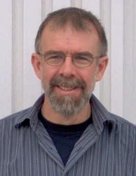
E. C. Dahlberg
ECD Geological Specialists/Saskatchewan Petroleum Ventures
11:30 am
t hursday, o ctober 28, 2010 c algary te L us convention centre c algary, a lberta
Please note:
t he cut-off date for ticket sales is 1:00 pm, m onday, o ctober 25, 2010. csPg member ticket Price: $42.00 + gst. n on- m ember t icket Price: $45.00 + gst.
Each CSPG Technical Luncheon is 1 APEGGA PDH credit. Did you know that you can book a table for the Technical Luncheon? To book your company’s table or to buy tickets, visit http:// www.cspg.org/events/events-luncheons.cfm.
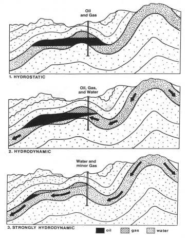
The behavior in terms of migration paths and accumulation sites of oil and gas in the subsurface is closely related to the behavior of formation waters in the units through which the waters are circulating, as well as the nature of the enclosing lithologies and the physical properties of the hydrocarbons. One of the major effects of moving water is to create tilted contacts between oil accumulations and the underlying bottom water as shown in the above figure.
Dozens of documented cases exist in which oil pools exhibit significant dips of up to eighthundred feet per mile. The direction of the tilt reflects the flow direction of the water which is usually from the topographically high margins of sedimentary basins down toward the interior of the basin (gravity-induced water flow) or from the elevated edge of a unit towards the lower edge or a truncated unconformity.
Vertical variation in oil-water contact elevations within a given pool are the result of a serendipitous sequence of normal faults. not likely!
In structural traps, under sufficiently intense hydrodynamic conditions:
1) The pool shapes are distorted so that the pool boundaries are not conformable with the structures – the boundaries actually cross the structural contours. The thickest oil columns are not located within the local structural highs or the reservoir isopach thicks.
2) The oil-water contacts are tilted (nonhorizontal).
3) The locations of the pools are displaced from the structures by amounts proportional to the water flow intensity relative to the structures that contain them. The OWC’s are encountered at elevations higher on the up flow side and lower on the down flow sides of the reservoirs.
The results are that:
4) Disappointingly THIn oil columns and excessive water cuts are encountered in wells drilled high on structurally attractive hot spots, due to higher-than-expected OWC’s and GWC’s
5) Anomalously THICK oil columns are encountered in wells drilled off-structure (but in the proper direction!) with OWC’s at significantly lower elevations than expected. Often this unanticipated production is encountered outside of the mapped pool boundaries, based on conventional horizontal contacts.
Pools in the north Sea, Central Africa, the Western United States, South America, the Middle East, and new Guinea illustrate the consequences of tilted oil-water contacts.
The effects of subsurface hydraulics impact reserves estimation, risk accommodation, production levels, and development strategies
Webcasts sponsored by
such as waterflooding. The world’s largest oil pool, Ghawar in Saudi Arabia, displays all the attributes of a hydrodynamically influenced oil accumulation with a prominently tilted OWC.
BIOGRAPH y
Eric Dahlberg is a Calgary petroleum geologist and silversmith/jewelry designer. He has served in almost every sector of the petroleum industry for the past forty years, consulted for both the U.S. and the Canadian Geological Surveys, and held visiting professorships at four Canadian and U.S. universities. From 2000 to 2004, he taught Structural Geology at Mount Royal College (now University) in Calgary.
Since 1979 he has presented over 390 industry training courses in Subsurface Mapping, Petroleum Hydrogeology, and related subjects to over five-thousand industry professionals in North America and over a dozen foreign countries, with his next coming up in Saudi Arabia in late 2010.
Over the years he has carried out regional oil and gas evaluation studies in Alberta and Saskatchewan and completed over three dozen petroleum hydrogeology studies in locales which include the Dead Sea Graben, the Doba Basin in Chad, Africa, the Norwegian sector of the North Sea, the Canadian Atlantic, The Railroad Valley of Nevada, the Oriente Basin in Ecuador, and the Central Highlands of New Guinea.
Dahlberg is the author of two editions of “Applied Hydrodynamics in Petroleum Exploration” published by Springer Verlag.
In 1978 he received the CSPG Link Award and in 2002 was honored by the CSPG with a Lifetime Achievement Award.
Dahlberg is presently CEO of Saskatchewan Petroleum Ventures Ltd. with oil and gas interests in the Totnes, SK. area, President of the Calgary Rock, Gem and Mineral Club, and currently presents industry training courses in domestic and foreign venues.
October 25 - October 29, 2010
www.cspg.org/education/education-week.cfm

Instructor: Dr. Basim Faraj, Unconventional Gas Specialist at Talisman Energy
Price: Member $675 Non-member $780 Date: Oct. 27, 2010
Description: This one day course will introduce the fundamental differences between conventional hybrid and shale gas plays. Source and reservoir rock attributes of shale gas plays will be discussed as well as GIP calculations, water, oil and gas saturations, essential laboratory analysis, and optimum geochemical and mineralogical parameters. Slickwater completion lessons learned from the US will be detailed. Canadian plays will be highlighted and discussed.
Instructor: Andrew Miall, Professor of Geology, University of Toronto
Price: Member $850 Non-member $955 Date: Oct. 25-26, 2010
Description: The focus of this 2-day lecture course will be on the reservoir architecture and sequence stratigraphy of fluvial systems and will contain descriptions of fundamental basinal controls on fluvial systems. Information and ideas presented in the course will contribute to the development of fluvial sandstone production and exploration models.
Stratigraphic Setting of Lower and Middle Triassic Strata
Instructor: Dr. James Dixon
Price: Member $375 Non-member $480 Date: Oct. 25, 2010
Description: The objective of this half day course is to help explorationists understand the regional stratigraphic setting of Triassic rocks and how this can be used in a more local exploration program. The course consists of two lectures, some correlation exercises, and an examination of several cores that illustrate various facies types and/or significant stratigraphic surfaces.
Instructor: Dr. Octavian Catuneanu, Professor in the Department of Earth and Atmospheric Sciences at the University of Alberta
Price: Member $975 Non-member $1080 Date: Oct. 25-27, 2010
Description: This workshop presents the concepts and practical applications of sequence stratigraphy for petroleum exploration and production. All concepts are illustrated with field examples of seismic, well-log, core, and outcrop data. In-class exercises emphasize the recognition of sequence stratigraphy surfaces and systems tracts on well-log cross-sections, seismic lines, and outcrop profiles.
Instructor: Andrew Miall, Professor of Geology, University of Toronto
Price: Member $850 Non-member $955 Date: Oct. 27-28, 2010
Description: A practical course designed to assist the petroleum geologist in the identification of different types of sequence, based on the generating mechanisms. The sequence architecture in a given basin may reflect the action of several simultaneous processes interacting locally to globally over a wide range of time scales.
Instructors: Dr. Kerrie Bann, Ichnofacies Analysis Inc. and Dr. Stuart Tye, Husky Energy
Price: Member $1500 Non-member $1605 Date: Oct 26-28, 2010
Description: This short course has been designed to teach the basics of logging core clastic intervals, with the inclusion of fundamental introductory ichnological techniques. Identification of facies through the integration of sedimentology and ichnology is crucial in building better stratigraphic and palaeogeographic models of reservoirs.
SPEAKER
David Garner
Statoil Canada Ltd., davga@statoil.com
12:00 Noon
Tuesday, September 7, 2010
ConocoPhillips Auditorium
3rd Floor- above Plus 15+ level 401 9th Ave SW, Calgary, Alberta
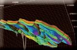
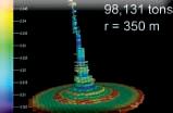
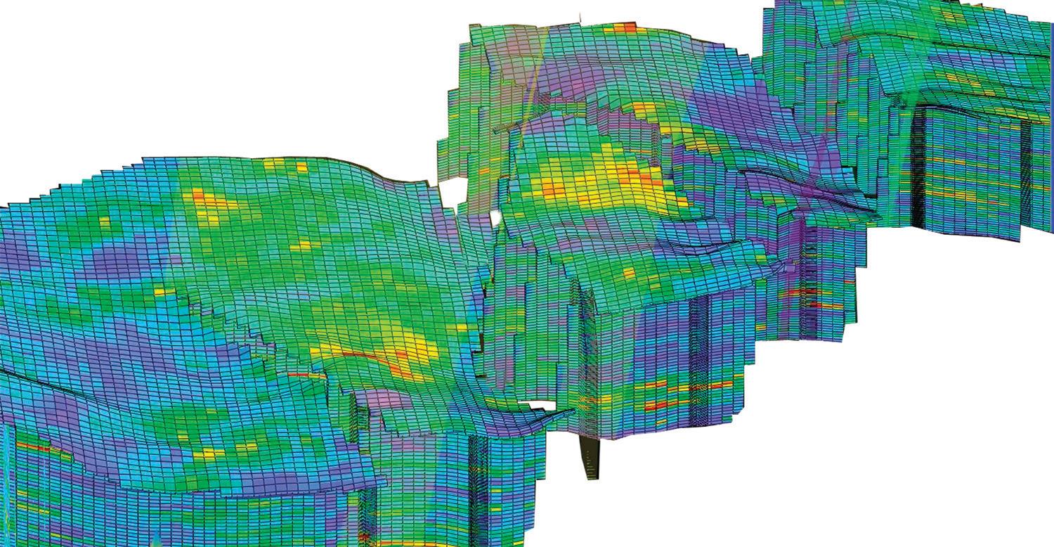
The growth in use of geomodeling for subsurface reservoir characterization has accelerated rapidly over the last decade. The 3D geomodels help build a bridge between geology, geophysics, petrophysics and reservoir engineering. There is a general acknowledgement of the strength of integration as a positive impact on characterizing petroleum reservoirs for exploration or development. Geomodels can be built without geostatistics by relying on sound geological concepts, the data, and the interpretations. As new data, are introduced, conceptual models take on added complexity. Uncertainty exists. Geostatistics provides a means to simulate geological variability early – as early as possible.
Interpolations using mapping algorithms or kriging yield smooth, best estimates of reservoir parameters. In reservoir property models, flow path distances may be underestimated. Reservoir connectivity may be overestimated or barriers are interpolated to become overly continuous. Geostatistical simulations are the only methods that yield parameter estimates honouring variability, and heterogeneity, and thus provide reasonable flow distances. The impact can be significant for reservoir simulation studies, for production forecasting, and for assessing the uncertainties when developing operational strategies or mitigation plans over the development life cycle.
The general workflow for geostatistical modeling involves three main elements: the spatial model, the estimation or simulation of parameters, and the statistical postprocessing. The spatial model accounts for the correlateablility of the parameters such as facies or petrophysics. The spatial model
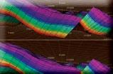
Figure 1. Geostatistics is used to quantify spatial relationships. For example, these two map images have the same histogram, but a very different look. Classical statistics does not account for these types of differences. We need additional tools to quantify the spatial continuity and heterogeneity of the phenomenon. Use spatial statistics.
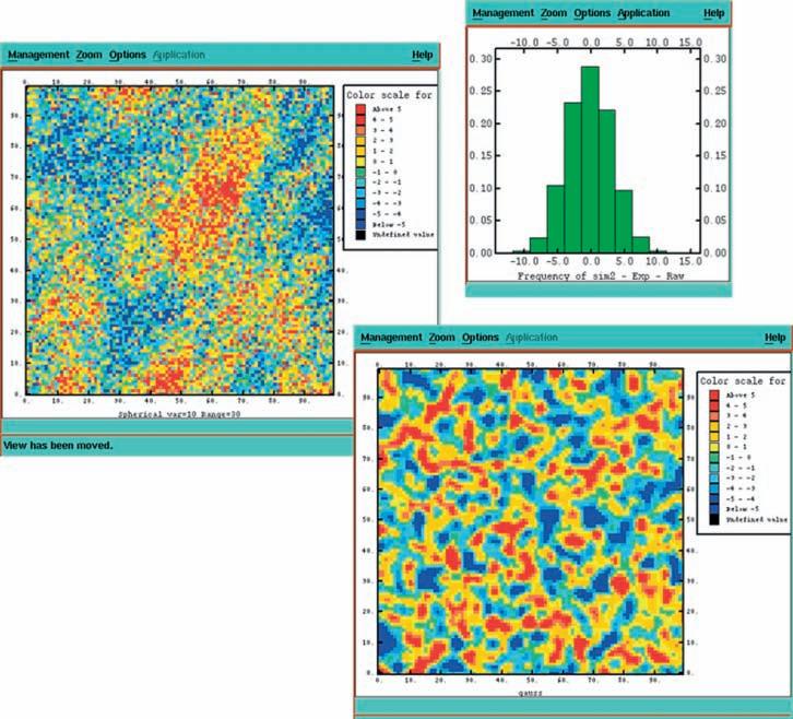
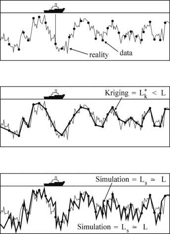
Figure 2. Interpolations give smooth, best estimates, e.g. Kriging; however, the length, L k, is too short! Stochastic simulations yield estimates honouring variability. The length, L s , is reasonable for each realization. The analogy to reservoir property models is flow path distances and reservoir connectivity. The impact is significant for reservoir simulation and production forecasting.
can describe the relationships between facies, between petrophysical parameters, and can include soft data as trends, all in the structural and stratigraphic framework.
The simulation methods are designed to reproduce the spatial, statistical models with a geologically relevant image, and are conditioned to the input data. Postprocessing is a catch-all phrase to say the many realizations are summarized into useful results. Examples of this are probability distributions of the modelevaluated resource, and ranking models to select P10, P50, P90 connectivity cases for reservoir simulation and forecasting.
The entire geostatistical workflow is based on sound geological concepts! The geomodel is a focal point for the integrated subsurface team; it is a direct product of the quality effort to supply the interpretations, of the engagement in feedback, and of the team work as a whole. Today, the experience level of practitioners of fundamental geostatistics in reservoir characterization is diverse and growing. The cumulative modeling experience within the working teams may be a potential ceiling on the whole process as is the incomplete technical capability provided by the commercial geomodeling software we use. Gaps exist and are growing between the well-known academic theories and the technical implementations in commercial software. The main gap is in the lack of
(Continued on page 14...)

(...Continued from page 13)
focused development by software vendors to provide the tools to efficiently implement best practice workflows for the ongoing problems subsurface development teams are tasked to address.


SAGD-based recovery in the Athabasca oilsands has risks associated with geological heterogeneities. The key objectives of the static geological model are to quantitatively simulate and display in 3D the reservoir lithological and petrophysical properties within the structural and stratigraphic framework while honouring the conceptual geological model. The digital model provides images of the reservoir that have similar heterogeneity or variability as the geological phenomenon. The geostatistical approach to reservoir characterization provides the best tools for the integration of diverse data, deterministic and stochastic, for the prediction of spatial reservoir properties and for calculation of post-processed statistics. The static model is used as a rendering of the image into a digital format suitable for input to reservoir engineering simulation software, well placement, and forecasting.

David Garner is Principal Geomodeler for the Heavy Oil Technology Center in Statoil’s Calgary office. Before joining Statoil, Garner held the position of Senior Advisor Geologic Modeling for Chevron Canada Resources on the Ells River project. Prior to that, he was with ConocoPhillips Canada on Surmont. He worked on a variety of international reservoir studies applying Geostatistics through TerraMod Consulting over several years.
One major oil company has written over 60 Ocean* plug-ins extending Petrel* workflows—to meet specific reservoir challenges and distribute proprietary intellectual property globally across their organization.
With the Ocean framework, software developers can focus on the domain logic of their applications, without worrying about infrastructure code. Apps have been created in as little as one hour. The freedom to innovate is here now.
Dive in.
403-294-4300
www.slb.com/ocean
Garner holds two geophysics degrees, a B.Sc. from Washington and Lee University and a M.Sc. from Cornell University. In 2006 he received a Citation in Geostatistics from the University of Alberta. Garner has actively presented papers at conferences throughout his career. He is an active member of the Canadian Society of Petroleum Geologists where he previously served on the board of directors. He currently serves as a co-chair for the Geomodeling Technical Division Committee and is general chair for the proposed Gussow 2011 conference, “Advances in Applied Geomodeling for Hydrocarbon Reservoirs: Closing the Gap”.
There is no charge for the division talk and we welcome non-members of the CSPG. Please bring your lunch. For details or to present a talk in the future, please contact Weishan Ren at (403) 233-3428, e-mail: weishan.ren@ conocophillips.com.
John Moreland, Dr. Trent Rehill, and Robert Potter
12:00 Noon
Thursday, September 16, 2010 Strand / Tivoli Room
The Metropolitan Conference Centre 333 – 4th Avenue SW, Calgary, AB
An invited selection of Canadian high-level executive speakers share their success stories and discuss ways to leverage leadership into E&P business success – the Canadian experience.
PANEL INCLUDES KE y REPRESENTATIVES FROM
• Parex Resources
• Petrominerales
• Suroco Energy
• Gran Tierra Energy
The demand for global energy is on the rise and the need to meet this demand has forced E&P companies of all sizes to pursue opportunities in new frontiers around the world. A growing number of Canadian operators have taken to the challenge and succeeded internationally.
However for every one success there are handfuls of failures as the overseas hunt for reserves and production frequently results in encountering big technical challenges, big foreign ‘governmental’ challenges, and big cultural challenges, which can either make or break a company. However the potential rewards are tremendous. Take for instance Latin America, which has been a huge success story for a number of Canadian companies. With a 2004 USGS estimate of 105 billion barrels of oil and 487 trillion cubic feet of gas of undiscovered resources in the region, it is not surprising that in recent years many of the largest discoveries worldwide have taken place in Latin America.
Despite its large hydrocarbon potential, Latin America continues to have numerous challenges when it comes to developing its hydrocarbon resources. Those issues are the ability to attract much needed investment funds, technological resources, and knowhow. This is a niche the Canadians have successfully filled in Latin America and continue to drive in many other parts of the world. Thus as Canadian companies continue to improve their abilities to operate in these overseas environments, international resources are quickly becoming a more viable alternative and commercially more attractive than chasing domestic activities.
Attendees of this panel will hear from a selection of internationally experienced, Canadian oil company executives on how to successfully build an international portfolio. An active panel/audience format will open the floor to topics such as: how to handle technical issues (at home, abroad), cultural challenges (staffing, landowners, negotiations), international joint venture partner relationships, and foreign government state / state oil company interactions.
The ‘Season Opener’ International Panel is a
Sponsored by
free-of-charge event generously sponsored by Schlumberger, IHS Energy, Gore Surveys, and Geochemtech.
We have a growing vibrant division and have planned an excellent series of monthly talks for the new 2010/2011 season.
UPCOMING EVENTS
October 13, 2010
Rock Shots – TBA
Main Event – Ruikun Liu “The Putumayo Basin of SW Colombia: A Foreland Basin Sitting on Top of a Rifted Terrane”.
INFORMATION
For further information or if you would like to give a talk, please contact Bob Potter at (403) 863-9738 or ropotter@telusplanet. net, or Trent Rehill at (403) 606-6717 or trehill@kulczykoil.ca.
The International Division maintains a Facebook page (CSPG International Division) to post upcoming talks, discussions and networking forums. you can contact us via cspginternational@yahoo.ca for more info.


SPEAKERS
Zeev Berger, Michelle Boast, and Martin Mushayandebvu Image Interpretation Technologies Inc.
12:00 Noon
Part 1: Thursday, October 7, 2010 Part 2: Thursday, November 4, 2010 Room LPW-910
Livingston Place West 250 2nd St SW Calgary, Alberta
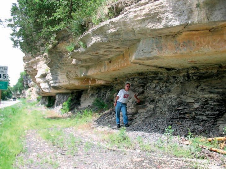
The Deep Basin and the southern edge of the Peace River Arch have seen an unprecedented increase in drilling activities that are focused primarily on the development of the following unconventional oil plays: the tight carbonate section of the Swan Hills reef complex; hydrothermal dolomite (HTD) reservoirs in the Wabamun and Debolt at the southern edge of the Peace River Arch; fractured carbonate along the Debolt and Pekisko Mississippian subcrop edges; the fractured shale play of the nordegg ; and tight reservoir sand of the Viking and Cardium formations.
An integrated structural/tectonic study of the Deep Basin and the southern edge of the Peace River Arch area has demonstrated that basement features have exerted significant control on the development of ‘sweet spots’ within many of these plays. For example, all the known oil shows in the nordegg shale play are located at the intersection of basement faults with Devonian reef edges, such as: Simonette, Sturgeon Lake, Ante Creek, and the Leduc Fringing Reef of
Sponsored by
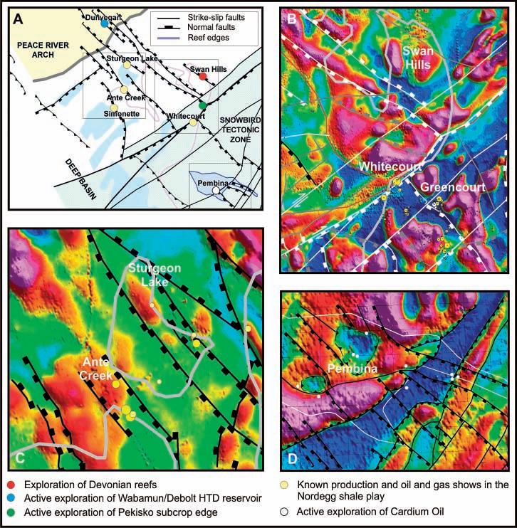
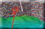
Figure 1. Examples of structural control on active oil plays in the Deep Basin and Southern Peace River Arch (Figure 1a). Basement structures which are interpreted from magnetic data and Devonian reef edges which have been mapped from well and seismic data clearly appear to exert a significant control on the location of known conventional Nordegg gas pools, such as Whitecourt and Greencourt (Figure 1b), as well as key oil shows in the emerging Nordegg shale play (Figure 1c). Basement structure and topography also appear to exert control on the development of the Cardium oil play in the Pembina area (Figure 1d).
the Peace River Arch. Recent exploration activities on the southern edge of the Peace River Arch are largely focused on exploitation of northwest-trending faults which are known to cause the development of HTD reservoir in the Devonian and Mississippian formations.
The methods used to establish the structural framework of the study area, and to identify the location of ‘sweet spots’ for each of the plays, will be demonstrated in two luncheon talks of the CSPG Structural Division. The October talk will focus on the emerging nordegg oil shale play, and the Cardium tight oil sand play of Pembina. The november talk will cover exploration activities of the Wabamun and Debolt plays of the Peace River Arch, the Mississippian
subcrop edge plays, and the development of the Swan Hills Reef Complex. Each presentation will be limited to 40 minutes and will be followed by an open discussion. Participants are encouraged to bring PowerPoint examples to illustrate their views on the subject matter.
AUTHORS Freddy Corredor and Fernando Munar
(1) Harvard University, International Consultant; (2) Independent Consultant Bogotá D. C, Colombia; and (3) Independent Consultant, Calgary
12:00 Noon
Thursday, September 9, 2010
Room LPW-910, Livingston Place West 250 2nd St SW, Calgary, Alberta
The neiva sub-basin, Upper Magdalena Basin, Colombia is a mature petroleum province located between the Central and Eastern Cordilleras in the northern Andes. A new detailed kinematic analysis based on the quantitative structural interpretation of a large high-quality 3D seismic survey across the northern portion of the neiva subbasin reveals the complexities of the eastverging fold-and-thrust belt that form this region, as well as multiple new opportunities for petroleum exploration across this basin. The neiva sub-basin offers an extraordinary opportunity to study fold-and-thrust belts in active margins, as the structures are extremely well imaged at deep levels in a 3D seismic reflection volume and because they preserve growth strata that record fold kinematics. Using the patterns of growth
the sequential restoration of two regional depth-converted seismic sections across this thrust system, we resolve the structural styles and the timing and sequences of thrusting, as well as the regional amounts of shortening, all of which have important implications for hydrocarbon maturation and charge in the Upper Magdalena Basin. Based on the patterns of growth sedimentation, a model of continuous shortening and imbrication across the neiva sub-basin throughout the Tertiary is preferred over the generally accepted models of episodic deformation.
Fernando Munar is a graduate of the University of Colombia and has over 15 years of experience in seismic 2D and 3D interpretation in both structural and stratigraphic plays in clastic and carbonate depositional systems. He has extensive experience in Colombian basin evaluations including the Llanos foreland basin and the upper Magdalena thrust belt basin. His geological experience includes oil and gas evaluations for areas of complex reservoirs and formations in the Magdalena basin

F IELD T RIP L EADER
Melissa Newton University of Calgary
September 25, 2010
Grotto Canyon, Alberta
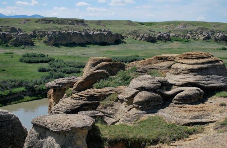
A September field trip to Grotto Canyon will be led by Melissa newton from the University of Calgary.
The Grotto Canyon area, located between
Exshaw and Canmore, Alberta, is a well exposed example of internal deformation within the McConnell Thrust Sheet. The area is located in the hanging wall of the Lac des Arcs Thrust within the upper Devonian Palliser Formation and illustrates many structurally complex features and fracture systems.
The field trip is a one-day excursion up the Steven and Grotto Canyon creeks to observe a number of different structures, fractures, and fabrics in the rock from both the brittle and ductile regimes. The hike will be approximately six kilometres long (round trip) with an elevation gain of approximately 160 metres; there is loose rock in the creek
bottoms and there will be a few creek crossings that could get your feet wet if water levels are high. If there is time at the end of the day, we will head into Canmore to visit a highly deformed coal and siliciclastics outcrop at the T-intersection near the nordic Center.
Participants should bring a daypack, water, sturdy hiking boots, and layered clothing appropriate for the weather conditions. The field trip is free and transport will be with the participants’ vehicles.
If you are interested, please contact the trip organizer Jean-yves Chatellier at jeanch@ usa.net.
| By Colin Yeo, Reservoir correspondent and former CSPG president
Over the past few years, there have been periodic attempts to capture in the Reservoir key issues, decisions and options that face the Society’s Executive Committee throughout the year. The current Executive is committed to transparency and full disclosure within the limits of privacy legislation and legal requirements and has asked Reservoir volunteers to write summaries of Executive meetings to keep members informed of important developments throughout the year. In this, the inaugural 2010 article, we look at what the current Executive has been trying to achieve on behalf of members and how they have been doing so far.
For the last three years the Society has been undergoing significant change to increase efficiency while trying to deliver the highest quality programs to members. This year, President John Varsek embarked on his goal to provide visible renewal and growth in programs for the membership and he was going to do it through:
• Technical program re-vitalization and relevancy
• new programs and delivery formats for changing industry priorities
• Volunteer management system
• Improved marketing of the Society
We are a society of volunteers. To grow, we need technical, volunteer, and financial support from members, employers, and affiliates.
The Executive has observed that members are quickly adopting new communication technologies and want CSPG technical information available on their computer screens and hand-held devices. The key is rapid and easy links to our technical information library. They have also noted the dramatic shift to resource style exploitation and the new skill set needed to be an effective and efficient geoscientist in the WCSB. Programs will focus on this new reality by identifying and recruiting speakers who are at the forefront of resource play technology and their presentations will be captured and archived digitally so that members will have access to these presentations in the future.
The Executive is fully aware of the importance of Society volunteers. Simply put, the Society would collapse if not for the dedication and support of its volunteer base. The Executive is committed to implementing the volunteer management system that is designed to track existing and new volunteers ensuring there is a good match between their skills, competencies and preferences and the myriad opportunities to serve the Society.
Although we are 83 years old, the CSPG is but one of many technical societies within the
petroleum industry and geological community. The Executive is determined to ensure that the Society is recognized for its deep technical roots and the tangible value it brings to both members and companies locally and globally. The goal of making the CSPG indispensable to the practitioner or company is a focal point for this Executive.
The first half of this year has been one of strategizing and planning. The second half will be one of implementation. In Programs, Continuing Education will offer new courses throughout the year and in a variety of settings; Technical Divisions will soon have a Coordinator to assist Division Chairs. In Communications, the website is being restructured, the Bulletin revitalized, a Digital Atlas planned, and this article established as a regular feature in the Reservoir. In Services, an ‘Under 35’ event is being planned, an Awards night was successfully launched at the May Convention, new awards are being evaluated, and securing a Volunteer Management System chair is top priority. Finance has completed a 10-year look back and generated a multi-year forecast, while developing a Rainy Day Fund strategy remains to be done before yearend. In Outreach, integrating the Earth Science for Society initiative into the annual convention is the task at hand. Along with all these portfolio-specific actions, all members of the Executive are also dealing with the Society’s marketing strategy, bylaw renewal, establishing a President’s Advisory Council, and setting the 2011 budget, to name only a few items. The President’s Advisory Council is designed to provide continuity by engaging the last three Past Presidents (Reimer, yeo, and Griffith) so that current decisions can be placed in context with what had transpired in the past. Many issues that now face the Executive have arisen from past decisions and it is often helpful to get a perspective from those that sat in the President’s chair in previous years.
This Executive has a lot on its plate and has to be given credit for setting the bar high and bringing a lot of energy to the job. It has created the vision, set goals and strategy, and now is implementing. Their dedication and focus is admirable and all members will greatly benefit if they are successful. But they will only be successful if volunteers step up, take ownership, and execute according to the plan. To be honest, many of these initiatives are just beginning and this is where previous attempts have failed. It is crucial that committed volunteers buy into the plan to make it work. If not, the Society will be poorer for it.
Stay tuned.

| By Colin Yeo
The Communications portfolio has been very busy of late and has initiated two new committees: the Website Committee and the Bulletin Revitalization Committee. Astrid Arts, Geological Consultant and former CSPG Services Director, will lead the Website Redesign effort with Kyle Durocher of ConocoPhillips. They intend to break the task into three phases. First, the existing website header and footer will be cleaned up, the site map modified, redundancies reduced, and better menu navigation created, amongst other things. The second phase will be linked to the iMIS (the CSPG’s membership database and commercial centre) version 15.3 upgrade. This will only be noticeable in the Members Only section of the website and will use more graphics and be more user-friendly.
The third phase is growth and much is planned here. This will be where members can access all the technical information they need in one place and can do it quickly and easily. We welcome back Astrid as she was the architect of our current website and branding which has served us well over the years.
The Bulletin Revitalization Committee has recruited two key volunteers. Past CSPG President and geological consultant Gerry Reinson is joining with Encana geologist Haley nielsen to work with Bulletin Editors in soliciting more, and more diverse, papers from the geological community.
Tony Cadrin’s term of office as Chairman of the Joint Annual Convention Committee
(JACC) has expired and Tony resigned June 30, 2010. Tony succeeded Ian McIlreath on July 1, 2008, and as the second Chairman of JACC, Tony led the effort in identifying future convention themes and recruiting organizing committee members to actually run the convention. Tony left his post after establishing convention themes until 2013 and recruiting organizing committees for 2011 and 2012. Under his direction, convention execution was standardized with a focus on continuous improvement and efficiency. n o doubt, his greatest achievement had to be working with over ten societies that made up GeoCanada 2010. The Society thanks Tony for his significant efforts and achievements.

www.cspg.org/education/education-courses.cfm
Instructors: Saad Ibrahim, P.Eng. and C.M. Ruhul Amin, P.Eng., Petro Management Group Ltd.
Date: November 10, 2010
Price: $550
Description: The technologies of applying Hz wells with multi-stage fracing has been growing exponentially and bringing life to reservoirs that were once uneconomic to exploit. For the first time ever, it is predicted that the number of Hz wells with multi-stage fracs will exceed the number of vertical wells in Canada!!! Review of some Hz well drilling and fracing will be presented. New analytical and numerical tools have become available to predict the performance and help optimize the design of the Hz wells with multi-stage fracs using the following criterion:
1. Drilling and Completion of Hz wells
2. Application of Mini Fracs to optimize frac design
3. Optimization of Hz well design including:
a) the spacing between Hz wells
b) the number of fracs or frac spacing, and the size of fracs
c) open hole vs. cased hole completions
d) where to place the fracs
4. Prediction of potential production for Hz wells
Interesting 3D visualization/animation output from numerical modeling will be displayed to emphasize the concepts above.
For additional information, contact Tina Donkers at:
For more information on this Short Course, please see: www.cspg.org/education/education-courses.cfm tinadave@telusplanet.net
| R. E. (Gene) Ballay
Figure 1
Nonvuggy carbonates
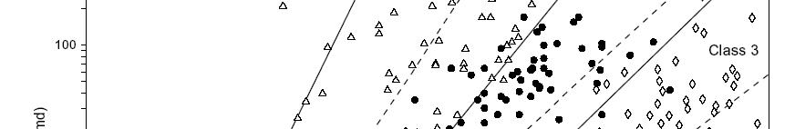
Particle size related to mercury capillary displacement pressure in rockhavingmorethan01mD rock having more than 0.1 mD permeability
Displacement pressure determined by extrapolation
Observe different displacement fiil(21 22 15 pressures for similar (,16) porosity
Behaviorboundaries notedat Behavior boundaries noted at about 20 and 100 μm
Annotated with porosity
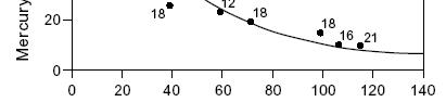
Larger Particles correspond to LowerDisplacementPressure Lower Displacement Pressure
The foundation of Lucia petrophysical classification is the concept that poresize distribution controls permeability and saturation, and that pore-size distribution is related to rock fabric. The focus is on petrophysical properties and not genesis; carbonate pore space is divided into three categories: inter-particle, separate-vug, and touching-vug porosity.
Inter-particle porosity includes inter-grain and inter-crystal and is described in terms of particle size, sorting, and inter-particle porosity. Vuggy pore space is everything that is not inter-particle and includes vugs, molds, and fractures, and is divided into separate and touching.
you have your preferences and we have ours. But being pragmatic, if our first choice is not available, we’ll usually go with the second.
There is something of a parallel when it comes to pore system classification. According to Archie “In discussing the petrophysics of limestones, it is necessary first to classify them in a manner to portray as much as possible the essential pore characteristics of a reservoir”.
Without meaning to disparage anyone’s preferences, and also recognizing that each protocol has its specific strengths, we sometimes find that the available data lends itself to a particular approach. Recognizing the value of a quantitative (as opposed to qualitative) methodology, it then makes sense to use the framework for which the required data is available.
There are two general situations. First, we are on location looking at cuttings, or in the core barn looking at the core, and so a system that can be invoked with visual observations is attractive. The second scenario arises when, perhaps many years later, a field study is being conducted and what we now have to work with are routine and special core analyses reports, along with (hopefully) core photos.
Regardless of the situation, it behooves the petrophysicist to consider a quantitative
pore system classification scheme, because: 1) suspect data is more likely to be identified, 2) domains in need of additional measurements will be recognized, and 3) comparisons to analogue reservoirs become possible.
In selecting a protocol, it’s desirable (if possible) to work with one that is generally well known, for obvious reasons. Of the several protocols then possible, two come to mind which satisfy the above end points: Lucia and Winland.
Figure 2
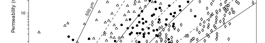
Particle size related to ill mercury cap ary displacement pressure
As particlesize decreases particle size , displacement pressure increases
Larger Particles correspond to Lower Displacement Pressure
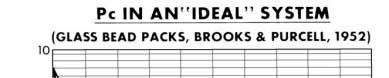
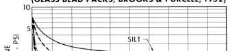
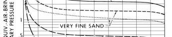
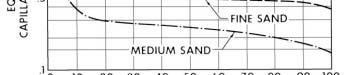
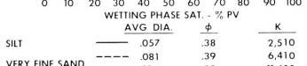
Check out the http://strata.geol.sc.edu/ website thereismchmoreof , there is much more of interest than just this bead pack illustration
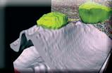
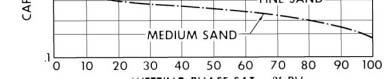
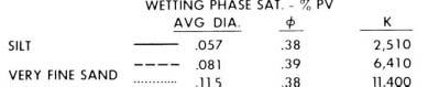
Lucia observed that in the case of non-vuggy carbonates, there is a relationship between particle size and capillary displacement pressure (Figure 1). As particle size decreases, the displacement pressure increases along a well defined trend, which exhibits two ‘behavior boundaries’ at 20 m and 100 m.
Within the context of a bead pack (Figure 2), one observes the physically expected relation. As the size of the beads diminishes, an ever-increasing pressure is required for the non-wetting phase to achieve entry, and the permeability decreases uniformly even as porosity remains essentially constant.
There will, in general, be a distribution of
(Continued on page 22...)
pore sizes present (see Holtz and others for an example illustration), and the displacement pressure will characterize the larger pores.
The two ‘behavior boundaries’ break the corresponding (non-vuggy) porositypermeability crossplot into three domains (Figure 3) and we now have a classification system that can be invoked by visual observation. At a specific (visual observation of) porosity and particle size, one is able to estimate the permeability and (from the capillary pressure data) further develop a generic Saturation-to-Height relation.
Class 1
S w = 0.02219 * H –0.316 * ip –1.745 k = (45.35 * 10 8 ) * ip 8.537
Class 2
S w = 0.1404 * H –0.407 * ip –1.440 k = (2.040 * 106) * ip 6.38
Class 3
S
Take care to note the ‘ip’ subscript, reminding us that this is the inter-particle porosity.
The Lucia system has its roots in laboratory capillary pressure measurements (Figure 4), but is formulated in a manner that allows it to be applied visually, on location or in the core barn.
Our objective herein is to offer a general overview of the Lucia methodology, while recognizing there are details that come into play. Jerry has authored many publications and offers a course on the application. The BEG website includes much reference material, including the following link: http://www.beg.utexas. edu/indassoc/rcrl/rckfabpublic/rckfabindex.htm
The link offers four paths that include 1) a rock fabric classification scheme for carbonates using inter-particle pore space (IPS) criteria, along with petrophysical data and figures useful for distinguishing IPS classes, and 2) a rock fabric classification scheme for carbonates based on vuggy pore space (VPS), along with petrophysical data and figures useful for distinguishing VPS classes.
It is not unusual to find ourselves doing a field study long after the wells have been
Figure 3
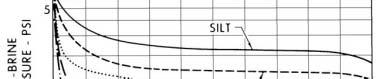
Nonvuggy limestone
Various particle sizes
Displacement pressureparticlesize also establishes particle size two boundaries on Phi -Perm crossplot
Small displacement pressure => large particles => relatively largepermeability large permeability
Relatively independent of porosity

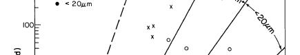


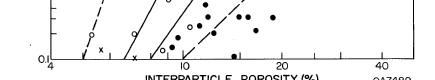
Figure 4
• Pore-throat sizes decrease from 1 => 2 => 3
The visual Porosity-Particle Size “view” is directly linked to Pc and Pore-Throat Radii Distributions 2 3

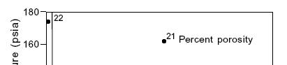
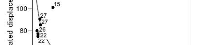
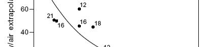
drilled, and the core cut and analyzed. In this situation, we may have core photos to examine, but no (or very little) actual rock to study. Recognizing the merits of a quantitative classification scheme, and the relation between capillary pressure and pore throat radii, Dale Winland and Ed Pittman examined correlations of porosity, permeability, and the porethroat radii at specific non-wetting phase saturations. That is, with measured porosity and permeability, and Pc across a range of pressures (pore-throat radii), they identified which specific Pc (and pore throat radii, where Pc = 2 s cos( )/rc ] yielded the highest correlation coefficient.
The best correlation was found at r35, the pore-throat radii being ‘touched’ when the
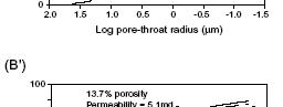
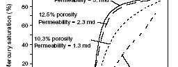

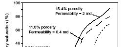
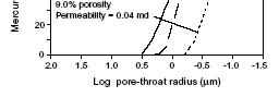
non-wetting phase saturation is 35%.
log r35 = 0.732 + 0.588 log K – 0.864 log
At the simplest level, there is a parallel between r35 and the plateau pressure (and corresponding pore throat radii) (Figure 5). This is the pore-throat radii at which ‘breakthrough of the non-wetting phase’ happens, and one then expects that this segment of the pore-throat distribution will be a dominant issue in the rock quality.
At a specific r35, there is a fixed relationship between permeability and porosity, analogous to (but not the
Figure 5
If the SCAL report includes capillary hi i ihi pressure, pore throat size s inherent in the various capillary pressure curves
At the simplest level (and if appropriate),
http://strata.geol.sc.edu/ one would like to focus on a single attribute of the cap pressure curve (pore throat distribution)
Plateau pressure (and corresponding pore throat radii) is an option
As the plateau pressure drops, grain size and pore throat radii increase, and permeability improves
Figure 6
Contours of constant K/Φ ratio divide the plot into areas of similar pore types. Ui Wild’ 35 itdfthK/Φ ti fhtiiklitf
Using Winland’sr instead of the K/Φ ratio for characterizing rock quality of water-wet rocks has advantages:
r35is anunderstandablerock
Dan Hartmann and Edward Beaumont. Predicting Reservoir System Quality and Performance. wwwsearchanddiscoverynet/documents/beaumont/indexhtm
Porosity - Perm Relations
Contours of constant Ka/Φ ratio and Winland r35 grids, on same graphic
r35 is an understandable rock attribute while K/Φ is only a ratio, r35canbe determinedfrom www searchanddiscovery net/documents/beaumont/index htm
r35 can be determined from capillary pressure analysis and related to K/Φ values.
Read Hartmann for a more detailed discussion
same as) the boundaries on the Lucia crossplot, which divide the pore system into categories.
It is interesting to note that fixed values of the perm/porosity ratio (a perhaps more common way to segregate the crossplot) divide the crossplot into similar domains, but thinking in terms of Winland’s r35 has advantages (Figure 6).
• r35 is an understandable rock attribute while K/ is only a ratio,
• r35 can be determined from capillary pressure analysis and related to K/ values.
Regardless of which protocol is being used,
it is always advisable to cross-check the results. In the case of Lucia, one would note the particle size, porosity, and permeability, and ensure that the three are consistent, within that framework.
In the case of Winland, porosity and permeability are usually measured on the capillary pressure plugs, which then allows a comparison of the actual measured r35, and that calculated from the above generic r35 relation (Figure 7, page 24).
There are a number of good articles dealing with the Winland approach, with an excellent reference being Hartmann and Beaumont’s “Predicting Reservoir System Quality and Performance” (www.searchanddiscovery. net/documents/beaumont/index.htm).
There are several good reasons for the petrophysicist to move into a quantitative classification scheme at the earliest opportunity, with one being the ability to reference analogue data. Ross Crain provides us with an example at www.Spec2000.net, where he examines “Myth: High Water Saturation Means Water Production”.
Ross tells us “Sometimes this is true, but often it is not. Pore geometry changes with depth can fool the best analyst. Vuggy porosity, very fine-grained texture, open fractures, and micro-porosity are possible causes of high water saturation.” And he illustrates his point with a bulk volume water crossplot of a dolomite reef for which high water saturations of a specific pore type do not infer water production.
Both Lucia and Winland also take the question of ‘cutoffs’ to an elevated, more physically realistic level (Jones and Lucia, 2003 for Lucia; Spearing and others, 2001 for Winland).
SUMMARy
If at all possible, it behooves the petrophysicist to cast the evaluation into the framework of a generally recognized classification protocol at the earliest opportunity.
How does one characterize, at the simplest level, one pore system (rock quality) relative to another? The ‘appropriate’ or ‘possible’ pore system classification methodology is, in a practical sense, dependent upon what information is available.
At the well site, or in the core shed, an obvious attribute to observe is porosity and grain size. Larger particles (usually) infer larger pores and pore throats, improved permeability, and increased non-wetting phase (hydrocarbon) content.
If the Study is being done long after the wells were originally drilled, there may be very little core to examine, but we will hopefully have routine and special core analyses. If the SCAL report includes capillary pressure, pore-throat size is inherent in the various capillary pressure curves.
At the simplest level (and if appropriate), one would like to focus on a single attribute of the cap pressure curve (pore-throat distribution). Displacement pressure (and corresponding pore-throat radii) is one option. As the displacement pressure drops, grain size and pore-throat radii increase and permeability improves.
Figure 7
Winland: r35 = 10 ^ (0.732 + 0.588 log K –0.864 log Φ)
Md Rdi(i)2*Si*C(Tht)/P(i)1076/P(i) : Radius(microns) = 2*Sigma*Cos(Theta)/Pc(psi) = 107 6 / Pc (psi)
Winland’s relation can be ‘tested’ on any specific reservoir Winland’s calculated r35 vs HgInjection measured r35
K = Air perm, md
Φ =Porosity% . Hg Injection = Porosity, %
QC of Winland Correlation
Pittman, E. D. 1992. Relationship of porosity and permeability to various parameters derived from mercury injection-capillary pressure curves for sandstone. American Association of Petroleum Geologists. Bulletin, v. 76.
R. E. (Gene) Ballay’s 32 years in petrophysics include research and operations assignments in Houston (Shell Research), Texas; Anchorage (ARCO), Alaska; Dallas (Arco Research), Texas; Jakarta (Huffco), Indonesia; Bakersfield (ARCO), California; and Dhahran, Saudi Arabia. His carbonate experience ranges from individual Niagaran reefs in Michigan to the Lisburne in Alaska to Ghawar, Saudi Arabia (the largest oilfield in the world).
He holds a Ph.D. in Theoretical Physics w and Mathematics, has taught physics in two universities, mentored Nationals in Indonesia and Saudi Arabia, published numerous technical articles and been designated co-inventor on both American and European patents.
Spearing, M., Allen, T., and McAulay, G. 2001.
K and φ φφmeasured, r35 calculated and compared tomeasuredvalue
8 10 ) Winland r35 compares favorably with the independently measured porethroatradii to measured value
(r35 pore throat radii
Pc(psi) is the capillary pressure corresponding to 35%tti
35% mercury saturation
In this non-vuggy limestone, Winland r35 fblith
Hg Inj compares favorably with the independently measured pore throat radii
(...Continued from page 23)
At retirement from the Saudi Arabian Oil Company he wastheseniortechnicalpetrophysicistintheReservoir was the senior technical petrophysicist Description Division and had represented petrophysics in three multi-discipline teams bringing on-line three (oneclastictwocarbonate)multi (one clastic, two carbonate) increments. Subsequent to retirement from Saudi Aramco he established Robert E Ballay LLC, which provides physics - petrophy
Plateau pressure (and corresponding pore-throat radii) is another option. As the plateau pressure drops, grain size and pore-throat radii increase and permeability improves. Winland’s r35 is a kind of simple representation of the plateau pressure and has the advantage relative to a perm/porosity ratio of representing a physically meaningful attribute of the rock itself – the pore-throat radius.
reservoir system quality and performance. www. searchanddiscovery.net/documents/beaumont/ index/htm.
shale ppy ppy g
He served in the U.S. Army as a Microwave Repairman and in the U.S. Navy as an Electronics Technician, and he is a USPA Parachutist and a PADI Dive Master.
Holtz, M. H. and Major, R. P. 2002. Petrophysical characterization of Permian shallow-water dolostone. Society of Petroleum Engineers / Department of Energy Improved Oil Recovery Symposium. Tulsa, Oklahoma. April 2002. SPE 75214.
Be aware that sorting is an important, additional element of rock quality, and that vuggy pore systems require additional consideration. And finally, never lose sight of the fact that the 3D static model construction will be most realistically accomplished when there is a link between rock types and depositional / diagenetic processes (i.e., link the classification to geology – depositional and diagenetic).
There are a number of good pore system classification schemes to be considered, of varying complexity. Here we have discussed two, at the simplest level. Our pragmatic approach is to work with whichever the available data favors, according to the preferences of the local geosciences environment. Be your preference tea or coffee, a quantitative classification protocol will add an additional dimension to your petrophysical evaluation.
Archie, G. E. 1952. Classification of carbonate reservoir rocks and petrophysical considerations. AAPG, v. 36, no. 2.
Hartmann, D. and Beaumont, E. 2000. Predicting
James, J. and Lucia, J. 2001. Predicting permeability from well logs in carbonates with a link to geology for interwell permeability mapping. Society of Petroleum Engineers. Annual Technical Conference and Exhibition, New Orleans, Louisiana, 30 September - October 2001.
Jones, R. H. and Lucia, J. 2003. Better than a porosity cut-off: the rock fabric approach to understanding porosity and permeability in the Lower Clearfork and Wichita. Bureau of Economic Geology. Petroleum Technology Transfer Council. May 2003 Workshop.
Lucia, J., Jennings, J., Rahnis, M. and Meyer, F. 2001. Permeability and rock fabric from wireline logs, Arab-D reservoir, Ghawar Field, Saudi Arabia. GeoArabia v. 6, no. 4.
Lucia, J. 2000. The Oilfield Review. Winter.
Lucia, J. 1995. Rock fabric / petrophysical classification of carbonate pore space for reservoir characterization. American Association of Petroleum Geologists. Bulletin, v. 79, no. 9.
Lucia, J. 1983. Petrophysical parameters estimated from visual description of carbonate rocks: a field classification of carbonate pore space. Journal of Petroleum Technology, March, 1983.
Jakarta (Huffco), Indonesia; Bakersfield (ARCO), California; and Dhahran, Saudi Arabia. His carbonate experience ranges from individual Niagaran reefs in Michigan to the Lisburne in Alaska to Ghawar, Saudi Arabia (the largest oilfield in the world).
He holds a Ph.D. in Theoretical Physics with double minors in Electrical Engineering and Mathematics, has taught physics in two universities, mentored Nationals in Indonesia and Saudi Arabia, published numerous technical articles and been designated co-inventor on both American and European patents.
At retirement from the Saudi Arabian Oil Company he was the senior technical petrophysicist in the Reservoir Description Division and had represented petrophysics in three multi-discipline teams bringing on-line three (one clastic, two carbonate) multi-billion barrel increments. Subsequent to retirement from Saudi Aramco he established Robert E Ballay LLC, which provides physics - petrophysics consulting services.
He served in the U.S. Army as a Microwave Repairman and in the U.S. Navy as an Electronics Technician, and he is a USPA Parachutist and a PADI Dive Master.

WWW.CSPG.ORG
www.cspg.org/education/education-trips.cfm

CSPG Continuing Education Committee is proud to offer the Summer/Fall Field Trip Seminar Series. Offering local one - to three - day field trips running in and around Calgary.
Contrasting the Reservoirs of Braided vs. Meandering Depositional Systems
Instructor: Jon Noad
Date: September 23rd to 24th, 2010
Price: Member $550 Non-Member $600
Fluvial Architecture and Reservoir Considerations of Anastomosed and Meander River Deposits (Lower Tertiary Porcupine Hills and Upper Cretaceous Dinosaur Park Park Formations), Southern Alberta
Instructors: Derald Smith and Peter Putnam
Date: October 22nd to 23rd, 2010
Price: Member $850 Non-member $900
Structure and Hydrocarbon Occurrence, Rocky Mountain Foothills and Front Ranges
Instructors: K.G. Osadetz, G.S. Stockmal, and D.K. Kisilevsky
Date: September 23rd to 24th, 2010
Price: Member $750 Non-Member $800
For additional information please see the website at: or contact: www.cspg.org/education/education-trips.cfm Erik Parker at eparker@petrelrob.com
| By Rudi Meyer
In the Alberta summer and fall, attracted by the mountains, more often than not we head west for geological field trips perhaps combined with camping and other outdoor activities. However, unique geological attractions are hidden in the prairies, among them the superbly exposed outcrops of the Upper Cretaceous Milk River Formation little more than one-hour’s drive southeast of Lethbridge in south-central Alberta. In and around Writing-on-Stone Provincial Park (WOS-PP), the Milk river valley exposes Virgelle Member sandstones and the overlying mud-dominated Deadhorse Coulee Member of Upper Santonian/Lower Campanian age. These very accessible outcrops commonly have multiple orientations of exposure, enabling the 3D-visualization of geometry and continuity of marginal marine, shoreface-to-estuarine deposits that commonly make-up subsurface siliciclastic reservoirs. This article presents a brief description and selected Virgelle Member outcrop locations to serve both as incentive and as an overview guide for a visit to this area.
Road access to WOS-PP is shown on Figure 1. Driving east from Milk River, the road is straight and flat until you cross Verdigris Coulee, a broad, shallow valley carved by a proglacial meltwater stream and occupied by the present-day Milk River further south. The park’s campground is open all year but as it is located near river-level it is subject to occasional springtime flooding events.
The park is a national Historic Site named after what is thought to be the largest concentration of ancient rock art on the great plains of north America. Ranging from simple scratch marks used to count wildlife to elaborate depictions of historical events, petroglyphs document activities and beliefs of native people dating several hundred years back, most recently Blackfoot. Guided tours to petroglyphs in a restricted area along the north side of the river are available between the May long weekend and Thanksgiving.
Approaching from the north a typical regional view includes the Sweetgrass Hills, a group of Eocene-age igneous stocks outcropping across the border in Montana
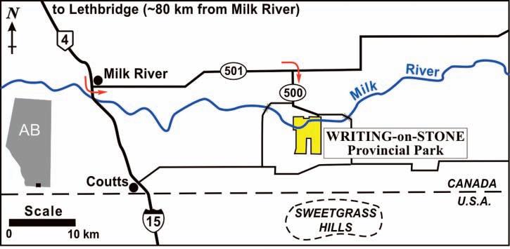
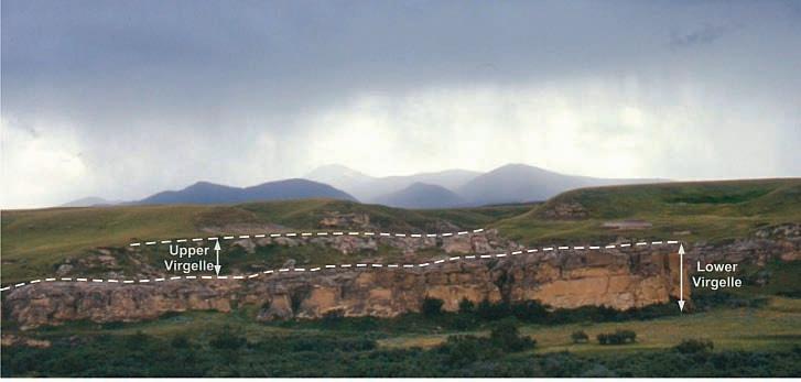
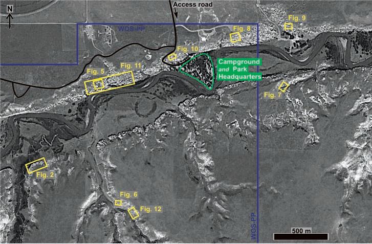
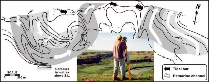
Structural map at the top of the middle shoreface. Contours illustrate the curved, locally steep erosional base of overlapping meandering channels compared to relatively flat, subhorizontal surfaces at the base of tidal bars. Outlines of inferred channel complexes are highlighted and arrows represent general flow directions. Inset: mapping using a theodolite.
(Figure 2; see Figure 3 for location of outcrop photos featured herein). The Milk River valley and its tributaries are considered to be the type area for the Milk River Formation, particularly for the middle part, the Virgelle Member (Tovell, 1956). Except for Police Coulee, which requires a permit to visit, other outcrops in WOS-PP are readily accessible.
Massive-appearing, often subvertical cliffs of the lower unit of the Virgelle sandstone (Figure 2) represent a storm-dominated middle shoreface characterized by very fineto fine-grain size, hummocky and swaley cross-beds, microbioturbated intervals, and an assemblage of robust dwelling burrows (e.g., Ophiomorpha isp., Rosselia isp., Cylindrichnus isp.). Calcareous-cemented intervals are common and particularly distinct around concentrations of burrows or as ellipsoidal concretions up to ~ 1.5m in width. The basal contact with the underlying Telegraph Creek Member, corresponding to increasingly mud-rich lithofacies of a lower shoreface and offshore transition, is poorly exposed at WOS-PP. While the ‘hunt’ for well preserved hummocks or Ophiomorpha in the lower unit can be rewarding, the upper unit of the Virgelle Member is more interesting because it contains a variety of lithofacies successions in a relatively thin interval (~10 m), reflecting depositional settings within a dominantly estuarine depositional system.
In contrast to the rusty brown-coloured cliffs of the lower unit, the upper unit of the Virgelle Member can be distinguished from a distance by the usually light grey, recessively weathering sandstones, locally separated by low-sloping covered sections (Figure 2). Meijer-Drees and Mhyr (1981) interpreted this unit as possibly meandering, intertidal or fluviatile channels and lagoonal washover deposits of a barrier bar coastline. Based on data along the north side of WOS-PP, McCrory and Walker (1986) interpreted upper unit sandstones as nW-SE trending tidal inlets or distal fluvio-estuarine channels. Cheel and Leckie (1990) further recognized multi-scale sedimentary structures thought to arise from tidal processes (e.g., tidal bundles, reactivation surfaces, flood tidal ramps), and used measurements on both sides of the valley in the WOS-PP area to propose a nn E-SSW-directed tidal-inlet complex eroded into a prograding WnWoriented paleoshoreline.
Meyer (1998) interpreted a west-to-eastdirected estuarine depositional system based on sedimentological descriptions
(Continued on page 28...)
and measurements of current and barform orientations, theodolite mapping of the middle shoreface top (Figure 4, page 27), and integration of equivalent outcrops at a regional scale, from near Coutts to about 2 km east of WOS-PP. The overall depositional system is progradational as demonstrated by stacked and erosive relationships between progressively more landward successions of (i) wave-dominated upper shoreface, (ii) subtidal/intertidal distal tidal bars, (iii) meandering estuarine channels with active coarse-grained deposits as well as fine-grained abandoned channel fill, followed by muddy paleosols of the overlying Deadhorse Coulee Member. The sedimentological model, summarized by Meyer et al. (1998), forms the basis for a reservoir analogue study that includes four shallow cores ( ≤ 40 m) drilled behind outcrop edges (Figure 5, page 27), which provide the bulk of an extensive database of multi-directional permeabilities (Meyer and Krause, 2006).
Low-angle cross-bedded and planar parallellaminated sandstones of wave-influenced upper shoreface-foreshore successions are relatively rare in WOS-PP, commonly exposed as thin, 2-4 m-thick erosional remnants below channel lithofacies (Figure 6, page 27). Tidal sand bar successions truncate the underlying middle shoreface in a sharp, regionally planar unconformity (Figure 7). They are characterized by planar-bound, herringbone cross-bedded dunes, absence of deep infaunal burrowers and common dinoflagellates, consistent with deposition from strong, marine-influenced tidal currents within an outer estuary. Tidal sand bar outcrops along the Milk River at WOS-PP are truncated by overlying channels (Figure 8); complete successions are only present in Police Coulee and on private ranches just east of the park (Figure 9).
Estuarine channel successions are typified by inclined lateral accretion surfaces bounding fine- to coarse-grained crossbedded sandstones, dunes of mudstone clast conglomerate, and current-rippled sandstones at the top, often incipiently weathered (e.g., mottled, rooted). Rare but locally abundant Skolithos isp. is also characteristic, as is the presence of Teredolites isp. Occasional subordinate, oppositely directed dunes and tidal couplets complete a picture of estuarine channels variably eroded into the underlying, more distal lithofacies. Good examples of channel sandstones are present near the entrance of the park (Figure 10), along the north side of the valley (Figure 11),
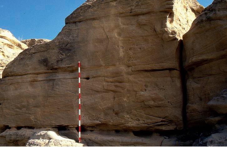
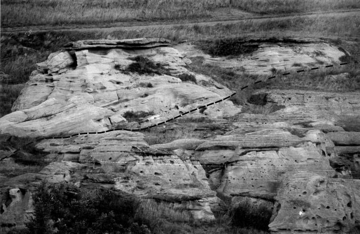
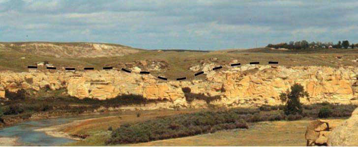
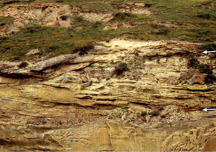
and in Davis Coulee (Figure 12). Based on the subjacent topography of the top of the middle shoreface and orientation data, individual outcrops can be linked to form coalescing, overlapping channels of an E-Wdirected meander belt, coincident with the orientation of tidal bars of the associated estuary mouth (Figure 4).
A BOUT THE AUTHOR
Dr. Rudi Meyer is Senior Instructor in the Department of Geoscience at University of Calgary. For further information he can be reached at rmeyer@ucalgary.ca.
Cheel, R. J. and Leckie, D. A. 1990. A tidalinlet complex in the Cretaceous epeiric sea of North America: Virgelle Member, Milk River Formation, southern Alberta, Canada. Sedimentology, v. 37, p. 67-81.
McCrory, V. L. C., and Walker, R.G. 1986. A storm and tidally-influenced prograding shoreline – Upper Cretaceous Milk River Formation of southern Alberta. Sedimentology, v. 33, p. 47-60.
Meijer-Drees, N. C. and Mhyr, D. W. 1981. The Upper Cretaceous Milk River and Lea Park Formations in southeastern Alberta. Bulletin of Canadian Petroleum Geology, v. 29, p. 42-74.
Meyer, R. 1998. Sedimentology, petrology and permeability characterization of the Upper Cretaceous Virgelle Member, Milk River Formation, Writing-on-Stone Provincial Park, Alberta, Canada. University of Calgary Doctoral Dissertation, 456 p.
Meyer, R., Krause, F. F., and Braman, D. R. 1998. Unconformities within a progradational estuarine system: the Upper Santonian Virgelle Member, Milk River Formation, Writing-onStone Provincial Park, Alberta, Canada. In: Tidalites: Processes and Products. C. Alexander, R. Davis, and V. Henry (eds.). Society for Sedimentary Geology Special Publication No. 61, p. 129-141.
Meyer, R. and Krause, F. F. 2006. Permeability anisotropy and heterogeneity of a sandstone reservoir analogue: An estuarine to shoreface depositional system in the Virgelle Member, Milk River Formation, Writing-on-Stone Provincial Park, southern Alberta. Bulletin of Canadian Petroleum Geology, v. 54, p. 301-318.
Tovell, W. M. 1956. Some aspects of the geology of the Milk River and Pakowki Formations (southern Alberta). Doctoral Dissertation, University of Toronto, 129 p.

Win $2,500.00 and a framed certificate; and a one-year membership with the CSPG for: the Doctoral thesis that makes the most significant contribution to Canadian sedimentary geology in 2010.
Win $2,000.00 and a framed certificate; and a one-year membership with the CSPG for: the Master’s thesis that makes the most significant contribution to Canadian sedimentary geology in 2010.
Winning thesis topics in recent years have included: detailed integrated studies of the Falher, Paddy, and
Dunvegan; structural re-interpretation of the Livingston Range anticlinorium; a stratigraphic re-interpretation of the Alexandra Reef Complex, which has led to new insights into the nature of Devonian reefs; new thoughts about the classic Carboniferous section at Joggins, Nova Scotia; and a detailed sedimentologic study on the Upper Kaza group of the Windermere Supergroup.
Deadline for submissions is September 15, 2010. Submitted theses will be returned in late January 2011 after judging.

Eligible theses are either produced in a Canadian university, regardless of project location, or deal with a Canadian sedimentary/petroleum geology topic, regardless of the university of origin. Theses entered for the 2010 awards must have been submitted to a recognized university inside or outside Canada, and must have formed part of the requirements for degrees awarded at the Fall 2009 or Spring 2010 convocations. Candidate theses must be well written, clearly and adequately illustrated, and properly bound.
PLEASE SEND ThESiSSubmiSSioNS for juDgiNg To: Canadian Society of Petroleum Geologists (CSPG) Graduate Thesis Awards Committee c/o Andre Chow Pengrowth Corporation 2100, 222 – 3rd Avenue SW Calgary, AB T2P 0S4
Phone: (403) 213-3713 • Fax: (403) 234-6886
Email: Andre.Chow@pengrowth.com
| By Anne Hargreaves
The recent AAPG annual convention in n ew Orleans was a great opportunity to view the recovery from Hurricane Katrina, a category 3 hurricane that hit land August 29, 2005. This massive storm resulted in over 1,000 fatalities and $19 billion dollars in damage. I was fortunate to attend a fieldtrip to the area offered by the AAPG on April 10, 2010 led by Dr. Stephen A. n elson of Tulane University (Figure 1).
First, a brief synopsis of the geology in the n ew Orleans area. The Gulf of Mexico opened in Triassic time due to tectonic forces, creating a shallow sea of saltwater that dried up from time to time, leaving thick layers of salt, anhydrite, and gypsum. Accumulating through the Jurassic, this formation today is known as the Luann Salt. By the Cretaceous, the Gulf of Mexico had opened up enough to be a proper ocean and sedimentation now consisted of alluvial and deltaic sediments alternating with marine limestone as sea level rose and fell. Steady deposition of sediments and associated subsidence since the Cretaceous has created basin deposits approximately 40,000 feet thick on the coast and 60,000 feet thick offshore. Salt domes and diapirs of the Gulf Coast Salt Dome Basin resulting from this overburden on the Luann Salt and their associated traps have created the oil deposits eagerly sought after in the Gulf.
When the Gulf of Mexico opened in the Triassic, some theorize that the Mississippi River relocated itself to a failed rift angling north from the Gulf, meaning the Mississippi river has been draining the area for over 200 million years. Others think it could be more than 500 million years old, as some geological maps show a river flowing from as far north as Canada in the same area during the Ordovician. It is estimated that deposits from the Mississippi have pushed the coastline out 250 miles into the Gulf of Mexico. After the last ice age retreat, the north American drainage changed so that areas, which formerly drained north to the Atlantic via the Gulf of St Lawrence or to the Arctic via Hudson’s Bay now drained south to the Gulf of Mexico via the Mississippi. Presently the Mississippi River drains approximately 1 million square miles from 32 US states and 2 Canadian provinces.
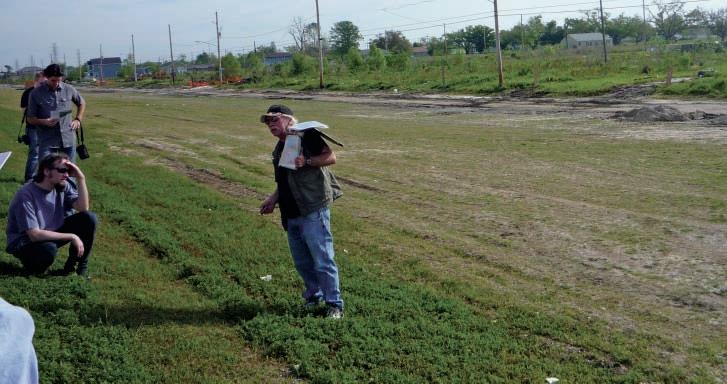
In the 1700s, n ew Orleans was founded along the banks of the Mississippi River and it grew and prospered as a very important shipping port. After a particularly bad flood in 1927, large earthen levees were built along the banks to prevent future flooding and ensure that shipping and transport could carry on uninterrupted. One of the side effects of this action was that it contributed to the disappearance of the wetlands! n ormal intermittent flooding is good for an area from nature’s point of view. With each flood, an initial dump of sediment is deposited on the banks of the river, creating a natural levee of elevated land with lesser deposition occurring the farther the water travels from the riverbank. The flood waters
themselves supply water and sediment to the outlying area. With artificially higher levees, there is not a fresh supply of sediment and water, so the land tends to compact, resulting in a lower elevation than would normally be there (Figure 2). As the land sinks, the ocean water moves in resulting in net loss of freshwater wetlands, which are so necessary for bird and animal life. Of equal importance is the fact that the wetlands serve as a nursery area for the fishing industry. One can scarcely imagine n ew Orleans without oysters on the half shell or barbecue shrimp! As the wetlands disappear, the city also loses the buffer zone between itself and the Gulf. Storm surges from (Continued on page 32...)
(...Continued from page 31)
hurricanes and tropical storms hit landfall closer to the city and nearer to full force, resulting is a higher level of destruction.
Another important point to understand when analyzing the effects of Hurricane Katrina in n ew Orleans is that in addition to building up the levees, the city also built canals to drain excess water from the city during heavy rains. With the addition of pumping stations around 1913, these canals allowed swamp area to be drained to create more habitable land in the city. Many neighborhoods now exist on land that was originally swamp, but is now
drained. The result of the drainage has caused the land to compact and sink to a level below sea level and below the level of the existing river and drainage canals.
Water from these drainage canals is pumped down the canals into Lake Pontchartrain, which is a large natural shallow lake lying just to the north of n ew Orleans. Some geologists theorize that Lake Pontchartrain and the lakes to the west and south, Lakes Maurepas and Borgne, were created due to collapse faulting associated with underlying salt domes. These lakes are shallow with a depth of only seven or eight feet.
About 3,000-4,000 years ago, the nearby Pearl River on the border of Louisiana and Mississippi delta fed into the Gulf and deposited sands at the river mouth. Longshore drift dragged and winnowed the sands, resulting in the Pine Island beach sands being deposited (Figure 3). These clean sands eventually reached the Bernard delta lobe deposited by the Mississippi River (Figure 4) and Lake Pontchartrain was born. These clean sands underlie n ew Orleans in the area of the above-mentioned drainage canals, sometimes only 30 feet below the surface (Figures 5, 6).
The most common misconception about the flooding during Hurricane Katrina was that the Mississippi River levees breached. This was not the case. As the hurricane approached the coast, an enormous storm surge of high water whipped up by the winds led the way. When this 15-20 foot storm surge from Katrina hit land, water was channeled to Lake Pontchartrain. From here the water surged into the drainage canals allowing the water easy access into the city. The water rose against the levee walls, overtopping in some cases, but the end result was the failure of the levee walls (Figure 7).
Although there were few eye witnesses during the storm itself, the levee breaches were probably caused by failure of the footings. In some cases the levees were mistakenly built several feet too low and in other cases water overtopping the levee dug in at the foot of the wall, eroding the
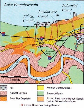
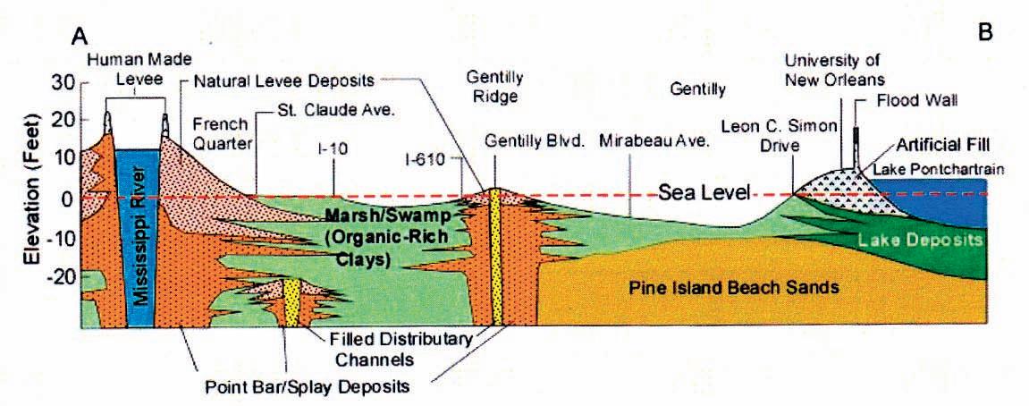
used with permission).
base and allowing the levee and foundation to push outward and collapse.
Of major importance during Hurricane Katrina, the drainage canal levees in some locations had their foundation walls buried in the porous and permeable Pine Island sands. With the maximum volume of water in the canals exerting a critical pressure, water was pushed through the sands passing under the levee footing, most likely undercutting and weakening it to point of collapse. Sand erupted as a massive sand boil, which resulted in a crevasse splay deposit through the neighborhood next to the London Avenue Canal breach. Dr. n elson of Tulane University mapped these sands in detail prior to their removal during cleanup.
Well known districts such as the French Quarter and the Garden District were fortunately built on higher ground nearer to the river. During Hurricane Katrina, they avoided the extensive flooding that wiped out many areas, largely residential, that were built on the drained swamp land.
The Lower 9th Ward suffered particularly and rebuilding has been very slow (Figures 8, 9, page 34). A poor neighborhood, the area had a high level of home ownership, where homes were passed down from one generation to the next. Many owners were not high wage earners but their houses were paid for. Because they did not have mortgages, many did not have obligatory flood insurance. House insurance if they had it would cover wind damage, but flood insurance was always under a separate policy held with the US government. Many insurance companies are delaying payment
(Continued on page 34...)
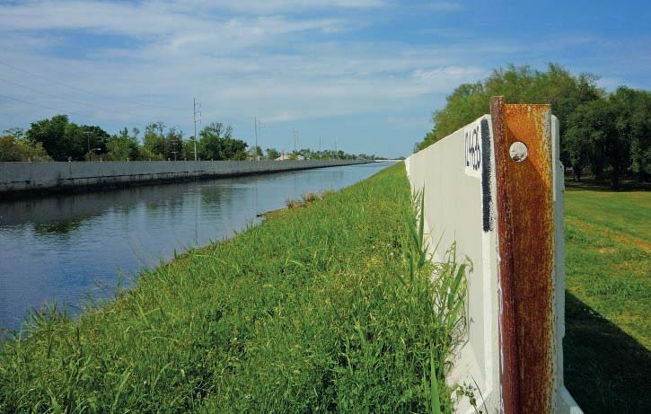
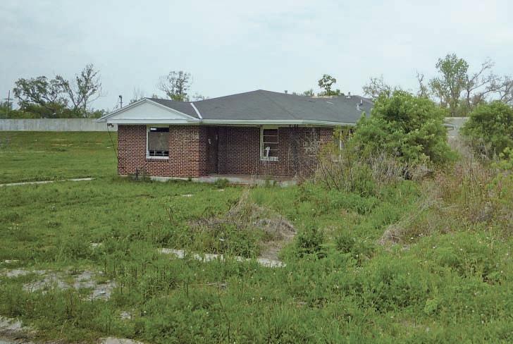
arguing on wind versus water damage. Meanwhile homeowners have relocated elsewhere to cities such as Atlanta or Houston and are paying property tax for a lot on which they cannot afford to rebuild. It is still very helpful when organized groups send teams down to n ew Orleans to build houses; their help is sorely needed.
R EFERENCES :
McCulloh, Richard P., Heinrich, Paul V., and Good, Bill. 2006. Geology and HurricaneProtection Strategies in the Greater New Orleans Area. Public Information Series No. 11, Baton Rouge, Summer 2006, Louisiana Geological Survey. 30 p.
Nelson, Stephen A. 2010. Hurricane Katrina –What Happened? The Geology of Hurricane Katrina Disaster in New Orleans – Field Trip Guide, April 10, 2010. 56 p.
Spearing, Darwin. 2007. Roadside Geology of Louisiana. Mountain Press Publishing, Missoula, MT. 225 p.


• 2D, 3D and 4D processing
• Multi-component processing
• PP and PS modeling
• PP and PS registration
• Joint PP and PS inversion
• Stochastic inversion
• AVO/LMR analysis
• Fracture detection

| By Tannis McCartney
The 2009-2010 school year was the first year that free student membership to the CSPG was available. This resulted in an unprecedented number of student members. Student membership numbers are now in the hundreds, and we’d like to see that number climb even higher over the next year. The University Outreach committee works hard year-round to plan activities and events that will benefit students and the best way to keep informed about these events is by becoming a student member.
The free student membership is not a replacement for the Student Chapter Program. This program continues to run, and is an excellent way to get funding for projects in your department. At least five members, in second year or higher, are needed to form a Student Chapter. The funding received can be used for a variety of projects – to plan field trips for your department, provide snacks at student seminars, and host a department pizza party – to name just a few.
If you are a student, or know of a student, interested in starting a CSPG Student Chapter at your college or university, here are the people you can contact for more information:
Western Canada:
Mark Radomski, Talisman Energy, mradomski@talisman-energy.com Ontario: Cole Webster, EnCana, Cole.Webster@encana.com
Eastern Canada:
Denise Hodder, Imperial Oil Resources Ltd., denise.n.hodder@exxonmobil.com Québec:
Marianne Molgat, Talisman Energy, mmolgat@talisman-energy.com
University Outreach sponsors Lecture Tours, bringing oil and gas professionals to campuses to speak to geology departments during the fall and winter semesters. This is an excellent opportunity for both the students and staff in your department to learn about some of the work that CSPG members do. To request a Lecture Tour stop at your university or college, or if you are interested in giving an interesting and informative talk on any aspect of petroleum geology, please contact one of the following people:
Chad Glemser, Shell Canada Limited, C.Glemser@shell.com
Jonathan Cribb, Shell Canada, J.Cribb@shell.com
If you are attending a student geological conference in the next year, stop by and visit us at our CSPG booth. Members of the University Outreach Committee, together with our counterparts from the Canadian Society of Exploration Geophysicists, travel to the Advances in Earth Science Research Conference (AESRC), the Atlantic Universities Geological Conference (AUGC), and the Western Inter-University Geosciences Conference (WIUGC). By doing this, we get a chance to meet the student members and present awards for student presentations.
The events for students don’t stop when the school ends in April. University Outreach has a presence at the annual convention, with a booth (and the ever-popular foosball table) and a student pub night. This is an excellent opportunity to meet other likeminded geosciences students and to get to know some industry professionals as well.
Each summer, the University Outreach committee also organizes a summer student field trip out of Calgary. In June 2010, it was a day exploring the Horseshoe Canyon Formation in the Drumheller area, led by Jason Lavigne. Watch for an article about this field trip to appear in an upcoming issue of the Reservoir.
The CSPG recognizes the importance of students to the future of our society, which is why the University Outreach Program is so important. These programs would not be possible without the dedicated volunteers who serve on the committee and the companies who sponsor our events. Thank you to all of you!
For general inquiries about the University Outreach Program, including sponsoring any of our programs, please contact Simon Haynes, Shell Canada Limited, simon. haynes@shell.com.
To join the CSPG as a student member, go to the Student section of the Society’s website (www.cspg.org), and remember, it is free.


Dates: Thursday, 16 September - Friday, 17 September
Time: 8:00 – 16:00 and 8:00 – 12:00
Location: Alberta Energy and Resource Conservation Board (ERCB) Core Research Centre, Calgary, Alberta
Co-Chairs: Nathan Bruder and John Cody (Statoil Canada Ltd., Calgary, AB, Canada)
fee: $130 + 5% GST
Includes: Refreshments and a barbecue luncheon sponsored by Weatherford International Ltd.
Limit: 1,500 people maximum
Content: 8 PDH
register: www.cspg.org
Following the AAPG International Conference & Exhibition (ICE) will be a two-day Core Conference held at the ERCB Core Research Centre, the world’s largest and most functional facility of its kind. The Core Conference will showcase up to 20 integrated core and poster displays and will be focused on unconventional, frontier and international hydrocarbon systems.
The Core Conference will include unique and interesting core displays ranging from unconventional exploration in tight oil sandstones of western Canada, tight gas sandstones and shales of Canada and the United States and conventional frontier exploration such as the Canadian Arctic, the North Sea, the Barents Sea and countries such as Peru and Yemen.
This event will afford all attendees the opportunity to examine the rocks in detail, while interacting with the authors. Take this opportunity to reconnect with the rocks and remember what geology is really about.


diaMond $40,000 + titaniuM $25,000 +
PlatinuM $15,000 +

Gold $10,000 +
Silver $5,000 +

Bronze $2,000 + Patron $1,000 +
Absolute Imaging Inc.
Advanced Safety Paramedics Inc.
Canadian Society for Unconventional Gas
Core Laboratories
Fekete
Little Rock Document Services
MicroSeismic Inc.
MJ Systems
Pro Geo Consultants
Roxar
The Burgess Shale Geoscience Foundation
CSEG T-Wave Golf Tournament
Parks Canada – Yoho National Park
Stephanie Geology Jewellery
Synterra Technologies Ltd.
Media SponSor
| By Mark Cooper, GeoCanada 2010 General Co-Chair (CSPG)

The GeoCanada 2010 Convention “Working with the Earth,” held at the Calgary Stampede Roundup Centre from May 10 to 14, 2010, was a success both in terms of attendance and finances. This convention was a follow-up to the GeoCanada 2000 millennium convention held at the University of Calgary and again involved a wide spectrum of the geosciences organizations in Canada including CSPG, CSEG, CWLS, Geological Association of Canada, Mineralogical Association of Canada, Canadian Chapter of the International Association of Hydrogeologists, Canadian Federation of Earth Sciences, and Geoscientists Canada. The result was a highly diverse and stimulating technical programme and the opportunity to network with geosciences colleagues that would not normally attend the joint annual conventions.
More than 4,600 delegates came out to hear new ideas, meet their peers, challenge new concepts, and to prepare themselves for new ways of exploring and working in an ever changing environment. The delegates enjoyed the over 500 oral presentations, 300 poster presentations, 140 exhibitors, a two-day Core Conference, public outreach initiatives, and much more. The committee was able to meet the commitments to the societies that participated in the funding and profit-share of the convention by careful monitoring of the revenues and expenditures. This is of great importance to the societies, including CSPG, who rely on conference revenues. Details of the budget audit will be in society reports at year end.
The outreach activities especially were stellar with more than 2,000 high school students from 19 schools flooding the Corral during the week for the Earth Science for Society event. Another 500 conference delegates and 500 citizens also came to see this spectacular exhibition. The other major outreach activity was Foundations: The Science beneath the Art, the purpose of which was to explore the
confluence of art and science, using iconic and/ or significant Canadian landscape art pieces as a vehicle. The exhibit was a collaboration with the Glenbow Museum and their website still has an excellent write-up (www.glenbow.org/ about/behind/geosciece.cfm). Twelve 8x4 ft posters were put on display in the Glenbow Museum, at the Convention, and on Stephen Avenue in Calgary during the week of the convention, mounted on custom-made poster boards.
Luncheon talks by Ray Zahab and Brent Butt were respectively inspiring and amusing and created a good contrast with the technical content. The convention concluded with the traditional Core Meltdown at the ERCB Core Research Centre, which was one of the most memorable of recent years with pleasant temperatures and no rain or hail!
The Technical Programme was distinctly different to those at the regular JACC conventions with a depth and breadth that reflected the broad spectrum of topics covered by the participating geosciences organizations. Plenary keynote sessions that started each day offered delegates an extremely strong slate of speakers who delivered some exceptional talks. Panel sessions were also a feature of the convention and these were well attended and created much discussion. The quantity, quality, and variety of the posters were impressive
and attracted a lot of traffic to their locations on the Exhibit Floor. The Core Conference was also a notable success with over 20 presentations and more than 1,000 attendees.
The Convention had an outstanding Exhibit Floor with a number of new Exhibitors taking booths that broadened the range of services being displayed. Traffic flow through the floor was improved by allowing direct access from the temporary lecture theatres to the floor and into the Boyce Theatre and the Corral where the outreach activities were being held.
The early evening and lunchtime events on the Exhibit Floor were well attended by delegates and featured great food and networking opportunities. CSPG also held the 9th Annual Long-Time Members Reception as well as an onsite Awards Reception.
The various committees that organized the convention deserve a lot of credit for the success of the convention. The Steering Committee on which I represented the CSPG oversaw the organizing structure and liaised closely with the office staff, who made the entire convention run like clockwork. Reporting to the Steering Committee was the Organizing Committee, which looked after Exhibits, Sponsorship, Field Trips/Short Courses, Finance, Marketing (Media), Public Outreach, Society Meetings, Special Events, and Volunteers. Also reporting to the Steering Committee was the Technical Committee who was responsible for the Oral and Poster Technical Programmes, the Core Conference, and for Awards and Judging. I would like to thank all of the committee and sub-committee members for their dedication, hard work, efficiency, and camaraderie, which made the whole process a very enjoyable one. The heart and soul of the CSPG are our volunteers and there is nothing more rewarding than working with such a talented and dedicated group!
| By 2010 Chair, Dawn Hodgins
2010 Committee Members: Allan Carswell, Alyssa Middleton, Andrea Marsh, Andrew Cook, Dayna Rhoads, Debbie Legaspi, Denise Hodder, Heather Slavinksi, Ian DeWolfe, Indy Raychaudhuri, John Lefebure, Keith yaxley, Meghan O’Reilly, Melanie Regehr, Michael DesRoches, Mitch Allison, Steve Dryer.
The 2010 edition of the CSPG SIFT program, which ran from May 2nd to 14th, was a tremendous success. The SIFT program has phenomenal volunteer and industry support with 18 committee members involved in planning and organizing and 26 industry professionals providing lectures and field trips. In addition to an outstanding volunteer base, financial support from our industry sponsors allows the CSPG to continue to offer this flagship program every year. Our major industry sponsors for 2010 were: ConocoPhillips Canada, EnCana Corporation, Shell Canada Limited, Imperial Oil Limited, Devon Energy, and Talisman Energy. SIFT was also fortunate to receive in kind donations by Enerplus, Crescent Point, Golder Associates, Weatherford Canada, Suncor Energy, and

The CSPG
31 undergraduate students enrolled in geosciences programs from across Canada. This year, we are pleased to welcome Mount Royal University into the program and look forward to having them participate in years to come. The 31 budding geoscientists came
to Calgary for a two-week introduction to the Canadian petroleum industry through classroom lectures, core workshops, an exploration game, field trips, and many opportunities to talk to professionals working in our industry. Throughout the two weeks, students attended lectures presented by industry experts with topics including well logging and log interpretation, carbonate and clastic reservoirs, geophysics, well site operations, heavy oil, and more. To reflect the current hot topics in the industry, we added three new talks this year; an Environmental Talk, Unconventional Resources, and Global Energy Outlook. In addition to the lectures, students were able to tour the demonstration rig at SAIT, attend the CSPG Convention for a day and had time for a few field trips, including the legendary four-day trip through the Rockies and a tour of the Atlas Coal Mine in East Coulee Alberta and a Behind the Scenes Tour at the Royal Tyrrell Museum (due to weather and safety conditions, the field trip to Dinosaur Provincial Park was cancelled and with quick impromptu planning by the committee, we were able to make alternate arrangements. Plan B was a success and the students loved the tours of the coal mine and museum). With all this activity, students still found time to work on the exploration game and attend a Student-Industry Wine and Cheese Reception. Each year, the SIFT Committee complements the two-week SIFT program with a Summer Job Program. The goal of this component of SIFT is to place newly trained SIFT graduates with oil and gas companies in Calgary so that they can continue the learning experience. This year, eight students found summer positions. Each year, we continue to look for companies willing to hire our SIFT graduates. If your company is able to offer a position, please contact the CSPG office for more information.
A large component of the SIFT trip is having the students apply concepts learned on the trip to an intense, hands-on exploration game. The game teaches students some of the realities of the oil and gas business. Teams of three to four students form a company and are given a small land base and seed capital to start exploring and building their company. They use real well log data to make interpretations of the geology and identify “sweet spots” which they use to bid on additional land, drill wells and structure business partnerships. At the end of the program an experienced industry panel judges the interpretations and success of the individual companies and awards the “Best Technical” company and the “Most Financially Successful” company.
The SIFT Committee kept the students very busy throughout the two weeks but they also had time to bond with one another and share their many new experiences. As with years passed, many of the students have formed friendships and connections that will last for the rest of their lives and hopefully, a significant number of them will find jobs in Canada’s petroleum industry. The SIFT Facebook page continues to grow with 100 members and counting. If you are a former SIFTee, we encourage you to join the growing list of names on the SIFT Facebook page. The CSPG and SIFT committee would like to host a SIFT Reunion in 2011 and we need to build our guest list! See http://www.cspg.
org/students/students-sift.cfm to view the Facebook Group link.
In closing, many thanks to all the SIFT committee members that have worked on the committee over the past 32 years. The organizing committee puts in a huge effort every year and SIFT is such a success as a result of their hard work. As a committee we strive to maintain the integrity of SIFT and we continue to evolve and improve on this CSPG/ETF flagship program. We look forward to planning and welcoming the next group of students in 2011, who will join the growing ranks of SIFT graduates.
ivestco has built a solid foundation of focused geo-services for our customers in the oil and gas industry. The strength of that foundation is our people who provide their experience, knowledge, and technical expertise. No matter what ups and downs face the industry, Divestco will be there striving to provide excellent service for our customers.
HOUSTON, TX • OCTOBER 4-8, 2010
Hosted by the Norris Conference Center 803 Town & Country Lane Houston, TX 77024
p(713)590.0950 • f(713)490.0961
Special AAPG Group Rates at Nearby Hotels!
Courses will include:
• Reservoir Characterization and Production Properties of Gas Shales
• Origins of Heavy Oil & Biogenic Gas
• Risk, Uncertainty and Decision-Making in Unconventional Resource Plays
• Organic Facies, Maturity and 3D Modeling in Unconventionals
• Log Analysis of Shaly Sands
• The Varying Role of Natural Fractures in Unconventional Reservoirs
• The Application of Geomechanics in Unconventional Resources
• Recognizing Unconventional Pay from Wireline Logs: Case Studies
• Source Rocks 101: What Geoscientists & Engineers Need to Know about Petroleum Source Rocks
• Seismic Attributes for Shale Plays – Application to the Niobrara Shale
Tuition for the week is only $1595 for AAPG Members or $1695 for Non-members* or $400/day for individual courses
*(price increases to $1695/1795 respectively after September 6, 2010; individual course prices increase by $50/course day after Sept. 6. 2010) Registration and Information: Toll-free (U.S. and Canada) (888) 338.3387, or (918) 560.2650 • Fax: (918) 560.2678 • email: educate@aapg.org Download a registration form at http://www.aapg.org/education/fec.cfm
| By Michael A. LaBerge, Classic Golf Chair
Rain could not dampen the successful 50th anniversary celebration at Elbow Springs Golf Club that hosted 160 geologists and geophysicists and 56 service company sponsors. Contestants from 20 flights competed for three days pursuing the coveted trophies and associated bragging rights until next year. Congratulations to the flight winners and especially to Daniel Gee who emerged as the 50th Anniversary Champion. On Friday the chuck wagon of Dean Duncan, George Bowley, Foon Der, and Gareth Martin topped a field of 30 teams. The awards banquet was held at the Sheraton Eau Claire Hotel where dinner, dancing, trophies, and draw prizes filled the evening. The audience was enraptured by the always-entertaining Bill Mooney and the auctioneering of Tom Kelly who demonstrated his hobby by conducting a live auction for Flames tickets, the proceeds of which were donated to Agape Hospice. Jim Kirker who was President of the ASPG (predecessor of the CSPG) in 1960 related how he helped initiate the first tournament in 1961. Howard Stafford brought along his 1985 – 25th Anniversary winning golf bag for posterity. Guess what, he won a golf bag cover this year. Karma! Bob Earle, Bob Sephton, and Fred Turner were winners of the vacation trips to Mexico, new york, and Maui, respectively.


The CSPG golf tournament committee extends our sincere thanks and appreciation to each and every one of the 56 sponsors whose valued support made this a truly commemorative event. Special thanks are extended to our Diamond sponsors – geoLOGIC systems ltd., who supplied the warm commemorative jackets, Little Rock Document Services, and especially Schlumberger Canada who jointly celebrated 50 years of participation with this tournament. Thank you.
Our charity partner, the Salvation Army Agape Hospice, benefited from draw prize contributions throughout the tournament. A memorial plaque for Chuck Boreski was placed on the trophy that he won in 2009. Chuck was a long-time supporter of the tournament and was a guest of Agape Hospice late last year. Again the committee thanks all sponsors and participants for making this a memorable golden anniversary. next year is the start of another fifty.


| By Raymond A. Price, Professor Emeritus, Queen’s University
Eric Mountjoy, distinguished Canadian geologist, explorer, university professor, and scientific research mentor, died peacefully at his home in Montreal on Friday, June 18, 2010 with his beloved wife Anita and some dear friends at his side.
Eric was a truly remarkable and memorable person. He had an important impact on the lives of many people. I am one of those people.
Eric was an internationally acclaimed, highly productive, kind, humble, generous, and considerate gentleman scientist. Firm and resolute in his own personal scientific observations and interpretations, he was, nevertheless, graciously considerate of the contrary views of others. He enthusiastically shared his scientific information and ideas with others; was quick to offer assistance and advice to visiting scientific colleagues, to new students, and to interested members of the general public; and he was patient and persevering in sharing his knowledge and wisdom with others. Eric’s personal conduct as a scientist and as a human being set an outstanding example for his students and his colleagues. This is an important part of his legacy.
Eric’s fascination with natural history was stimulated as a youth in Calgary by Boy Scouts of Canada camping and other outdoor activities that took him into the nearby Rocky Mountains. He was a loyal supporter of the Boy Scouts of Canada throughout his life. In 1950, as a highschool graduate, Eric had the good fortune to be hired by the Mobil Oil Company as
a laboratory assistant to a petroleum geologist, Dr. A. J. (Jack) Goodman. Jack Goodman soon recognized Eric’s talents, became his mentor, and nurtured his interest in a career as a geologist. With Jack Goodman’s encouragement and assistance Eric went to the University of British Columbia (UBC), where he graduated with a Bachelor of Applied Science degree in Geological Engineering in 1955. It was at UBC that Eric met Anita Cheyne, the nursing student, who was to become his beloved wife and partner in life. While he was a university student Eric spent the summers working in the Rocky
CSPG Presents: Future Prospects
An under 35 Social Networking and Learning Event
Who: Geologists and Geology Students under the age of 35
When: Thursday, September 30th, 2010; 4:30pm - 8:30pm
Where: Art Central, 100 - 7th Ave SW, Calgary
Cost: $20.00
Order your tickets online at www.cspg.org or by calling (403)264-5610
If you are interested in sponsoring this event, please contact Ayaz Gulamhussein at (403)538-8510
Mountain Foothills and Front Ranges as a student assistant on geological field parties of Mobil Oil, California Standard Oil, and the Geological Survey of Canada (GSC). Those five summers of geological fieldwork experience were excellent preparation for his Ph.D. thesis mapping project for the GSC, in the Miette area, east of Jasper. His University of Toronto Ph.D. thesis won the annual best thesis award of the Alberta Society of Petroleum Geologists (which later because the Canadian Society of Petroleum Geologists); and it launched his remarkable career as a sedimentologist, stratigrapher, and structural geologist.
Eric and I first met in 1956, fifty-four years ago, when he was the senior field assistant on a GSC field party in southwestern Alberta, and I was occupied with my first summer of fieldwork on a GSC Ph.D. thesis mapping project in a nearby area. For several years, starting in September 1958, when Eric was employed by the GSC to complete the report for his Ph.D. thesis mapping project, and I was working as a permanent employee of the GSC, we shared office space in downtown Ottawa with several other GSC employees. Eric’s Ph.D. thesis research project was in the Rocky Mountain Front Ranges east of
Jasper; my Ph.D. thesis research project and my new GSC research project were also in the southern Canadian Rocky Mountain Front Ranges, but some 400 km to the south, near the international boundary with the U.S.A. Eric and I were both fascinated by the beauty and the mystery of the origins of the Canadian Rockies. We shared geological observations and ideas, participated in many enthusiastic discussions, and soon became supportive scientific colleagues and good friends. In the early 1960s, before and after Eric moved to McGill, we collaborated very closely as participants in two major GSC exploratory geological mapping projects: Operation Porcupine, in northern yukon and adjacent District of Mackenzie; and Operation BowAthabasca, in the southern Canadian Rocky Mountains between Jasper and Banff. We continued to collaborate on the production of the Operation BowAthabasca geological maps and sections of the southern Canadian Rockies until very recently.
Eric’s research was multifaceted, but he was first and foremost a consummate and indefatigable field geologist. He had the agility, strength, and stamina of a mountain goat, and was driven by an insatiable urge to “read the rocks”, wherever he could gain access to them. His pioneering exploration and geological mapping in the southern Canadian Rockies, which was done mainly with the GSC, began more than fifty years ago, using packhorses. After Eric left the GSC in 1963 to become a professor at McGill, he continued with his part-time summer employment as a participant in Operation Bow-Athabasca and other GSC field projects, and then with helicopter-supported graduate thesis research projects of his M.Sc. and Ph.D. students. It was still underway just a few years ago with his stratigraphic and sedimentologic field studies of the late n eoproterozoic strata in the Mount Robson area that contain an Ediacaran fauna; but was curtailed by his declining health. A scientific paper about these late n eoproterozoic rocks and fossils, coauthored by the late Hans Hofmann and Eric Mountjoy, is in press.
Eric is best known internationally for his contributions to the understanding of the deposition and subsequent alteration of sedimentary carbonate rocks, particularly the Devonian reef complexes that are exposed locally in the Front Ranges of the Canadian Rockies, and are lateral equivalents of the reef complexes that
formed reservoirs for large accumulations of oil under Central Alberta. Eric augmented his research on the Devonian reef complexes of the Front Ranges with comparative studies of Devonian reefs in Europe and Australia, and also with studies of modern sedimentary carbonate deposits in the Caribbean. His pioneering scientific papers on carbonate reef development are classics. Because of Eric’s insightful interpretations and careful documentation of the sedimentary and stratigraphic relationships along the margins of reefs that are exquisitely exposed locally in the Front Ranges, these localities have become a “must visit” destination for geologists who study carbonate reefs in other parts of the
world, and also for those who seek to understand the relationships along the margins of the oil-bearing reefs that are hidden at depth beneath central Alberta. Eric is also internationally renowned for the results of his extensive body of collaborative multi-disciplinary research on the chemical and physical processes that modified the carbonate reef rocks during and after their burial, particularly his research on dolomitization.
Eric’s international reputation as a structural geologist is based on his pioneering geological exploration and his geological maps and cross sections of the southern Canadian Rockies, particularly (Continued on page 46...)
in the region of Jasper n ational Park and Mount Robson. His regional geological reconnaissance investigation of the Mount Robson area resulted in one of the first carefully documented geological crosssections extending across the entire southern Canadian Rockies from the eastern edge of the Foothills in Alberta to the Rocky Mountain Trench in British Columbia. It also provided a wealth of important new stratigraphic information relating to the history of development of the mountain belt. Eric’s many carefully prepared more detailed geological maps and sections document important basic aspects of the thrust faulting and related folding and of the physical processes involved in the development of the Canadian Rockies and of other similar mountain belts elsewhere. His careful integration of structural and stratigraphic data in retro-deformable balanced crosssections is an important contribution to the regional tectonic framework for palinspastic restoration of the thrust sheets and for reconstruction of the paleogeographic evolution of the foreland thrust and fold belt. Eric, with some of his
graduate students, unraveled complexly superimposed thrust duplexes involving multiple detachments within Upper Jurassic to Upper Cretaceous rocks of the Foothills; with other graduate students, he documented the importance of thrust duplex structures within metamorphosed n eoproterozoic rocks of the western Main Ranges. His contributions to the elucidation of the geological structure span the breadth and depth of the southern Canadian Rockies.
Eric was a nurturing and inspiring professor at McGill University, and an influential mentor to more than fifty graduate research students and postdoctoral fellows. Many have assumed important roles in industry, universities, and government research organizations. They also are part of Eric’s legacy.
Eric Mountjoy’s scientific accomplishments have been acclaimed with many awards and appointments. He was elected a Fellow of the Royal Society of Canada and was made an Honourary Member of the Canadian Society of Petroleum Geologists. He received the Pettijohn

Medal from the Society for Sedimentary Geology, the Logan Medal from the Geological Association of Canada, and the Douglas Medal from the Canadian Society of Petroleum Geologists. Twice, the Canadian Society of Petroleum Geologists awarded him its annual Medal of Merit for the best paper on Canadian petroleum geology.
Eric Mountjoy will be remembered in Canada and internationally for his accomplishments as a geologist, explorer, and professor, and also for the example that he set, for all his friends and acquaintances, as a gentleman scientist. We who have been enriched by having known Eric can be truly grateful for that gift.
16
Horizontal/Foothills/Alberta/British Columbia/
Francis Chan, P. Eng. & Associates (403)816-0143
Email: fchan143@telus.net


| By R. J. Spencer1,3 , P. K. Pedersen1, C. R. Clarkson1, R. Aguilera2
1 Department of Geoscience, University of Calgary, 2 Department of Chemical and Petroleum engineering,
Shale gas plays are currently the hottest unconventional reservoir targets in north America, with a combination of technological advances and proximity to market being key drivers in the success of most of these plays. This is the first in a series of articles in which we will discuss various aspects of the shale gas resource. The authors include both geoscientists and engineers. We all firmly believe that successful exploitation of this vast resource requires an integrated geoscience and engineering team approach to understanding the reservoirs.
Future articles will look into different aspects of the shale gas resource. The history of shale gas development in north America will be discussed in the second article. This will be followed by articles on rock properties of shale and then petrophysical log analyses. We will look at where ‘shale gas’ reservoirs fit in the context of ‘tight gas’ and conventional gas reservoirs. Technologic advances are of paramount importance in the exploitation of the resource and these will be discussed. Additional articles will address aspects of decline analysis and reserve forecasting, the scale of development and comparison of some shale basins. This first article focuses on some fundamentals, such as definition of terms used in relation to shale gas.
wHAT IS SHALE ?
Shale is by far the most abundant sedimentary rock; comprising roughly two thirds of the sedimentary rock in the Earth’s crust (we have found estimates that range from as low as 50% to as high as 80%). Although shale is the most abundant sedimentary rock, far less attention has been given to the study of shale than other rock types such as sandstone and limestone. Pettijohn (1975) in his textbook on Sedimentary Rocks states “Shales, unlike sandstones and limestones, have never been classified in a comprehensive and rational manner.” Boggs (2001) in his textbook also states that “Historically, shales have been understudied as a group of rocks.”
Definitions and usage for the term ‘shale’ vary somewhat. Grammatically shale is both singular and plural; however, the word ‘shales’ is used by numerous authors such as Pettijohn and Boggs above. However, when I type ‘shales’ in my word processor it is always underlined in red. All definitions include a distinction by particle size. Shale is defined as a class of fine-grained sedimentary
rocks with a grain size of less than 0.0625 mm (0.0025 in.). Even the use of ‘grain size’ differs in definitions; some use a mean grain size, while others require a percentage of grains (50% in some and up to 90% in others) to be less than 0.0625 mm (0.0025 in.). In some definitions shale includes siltstone, mudstone, and claystone; other classifications

place shale as a particular type of mudstone.
A few examples of definitions or classification schemes for shale are given below:
Tucker (1991) in his textbook on Sedimentary Petrology chooses to classify fine grained


Canada Well Data is now available online, backed by TGS’ high quality standards and customer support.
• Standard curve LAS and LAS+ for bulk workstation loading
• Trustworthy data, meticulously QC’d to save you time
• Proprietary LAS and LAS+ digitizing to complete your project
• Complete standardized directional surveys ready for mapping
Visit TGS booth 711 at AAPG ICE in Calgary, Sept 12-15
rocks as mudstones, referring to shale as a type of “mudstone” adding “shale is usually laminated and fissile.”
Boggs (2001) in his textbook states that “shales are siliciclastic sedimentary rocks composed of mud-sized particles” but uses the term shale “for all sedimentary rocks composed dominantly of mud-size (<0.06 mm) particles.”
Potter (2003) classifies shale as a type of “mudrock.” According to this classification “mudrocks” are sediments with >50% terrigenous material of which >50% is less than 63 microns (0.063 mm or 0.0025 in.). Potter further requires the rock to be lithified and fissile (fissility is the property of delaminating or splitting into sheets along the bedding plane of the rock). In this classification scheme rock with >67% silt are “siltshale”; those with >67% clay are “clayshale” and between these are “mudshale.”
Blatt (1982) may have the best explanation for the term shale, stating “There is no uniform usage of the many terms that refer to detrital sediment finer than sand size.”
Shale definitions also vary in terms of mineralogy. The most restrictive definitions consider shale to have a siliciclastic composition: “Shale is a fine-grained

sedimentary rock whose original constituents were clay minerals.” Less restrictive definitions include quartz, feldspar, and clay minerals as components of shale. Some definitions have no mineralogy restrictions “any of a group of fine-grained, laminated sedimentary rocks consisting of silt- and claysized particles.”
The reason for different usages and definitions for shale may stem from the origin of the term. According to the online Etymology Dictionary the term appears to have originated in 1747 possibly from the Middle English ‘schale’ or the Old English ‘scealu’, which refers to “thing that divides or separates”, in geologic context this refers to the way the rock breaks apart in layers. The geologic use may also have been influenced by the German terms ‘Schalstein’, which refers to laminated limestone, and ‘Schalgebirge’, which is a layer of stone in a stratified rock.
The lack of a widely accepted, comprehensive, and rational classification for shale results in a lack of consistency and confusion in just what a shale rock is. For instance, the Eocene ‘oil shale’ deposits of Colorado, Utah, and Wyoming are largely limestone and dolostone. The use of more restrictive mineralogical definitions, which require shale to contain a high proportion of quartz and/or clay minerals, would not classify these rocks as shale. Several of the more prominent
‘shale gas’ plays in Canada also fail to meet some of the more restrictive definitions for shale.
In summary, we do not intend to offer a new definition or classification scheme for shale here. However, we agree with Blatt (1982) that “Such terms as “shale,” “argillaceous” and “clayey” mean different things to different people.” It is important to remember that when you read, or talk to someone, about shale that your understanding of the term may be quite different from theirs!
Another term that is commonly used with respect to shale gas plays is the ‘maturity’ of the shale. Maturity has two widespread geologic usages; as a textural term describing the degree of sorting in a sedimentary rock as a function of grain size and mineralogy; and as measure of the degree of thermal alteration a rock has undergone. Both aspects are important and we will try to distinguish which context we are using in future articles. The use of maturity here is in the thermal context. Thermal maturity is commonly used as a measure of the alteration of organic matter in a rock which is a function of the time-temperature history of the rock. In this series we refer to ‘immature shale’ as a rock that has not generated liquid or gaseous hydrocarbons by thermal processes.
The mineralogy of a sedimentary rock is a

Dates: Every second and fourth Thursday each month from September – December, 2010
Time: 8:00 – 17:00
Instructor: Dr. Greg Hu, Loring Tarcore Labs Ltd.
Fees: $375 + 5% GST, including, lunches, materials, use of computer and core logging software
Location: Loring Tarcore Labs Ltd., Bay 2 – 666 Goddard Ave NE, Calgary
This one-day short course is refined and shorten from a popular, in-house workshop that is offered to some oil sands companies. It emphasizes “hand-on” and “practical”. Any one will find it informative, inspiring, and practical: whether you are a geological adviser, project geologist, or core logging geologist.
Topics include:
Typical depth markers: marker types and their core and log expressions
Principles of core depth correction
Common oil sands facies and their core and log signatures
Identification of common ichnofacies on core and their significance in facies interpreation
Wabiskaw-McMurray Stratigraphy and their depositional model evolution
Common core sample types for lab testings and general sample selection guidelines
Core depth correction: core-based vs image-based with software assistance
For more information and registration, please call 403-874-4588 or visit: http://www.tarcore.com/training/
function of both the original sedimentary components and diagenetic alteration of these components. As with the alteration of organic matter, mineral alteration also occurs as a result of thermal processes. This is especially true for the diagenetic alteration of clay minerals. Of particular interest is the dewatering of smectitic clays in rocks where these were deposited and the conversion of the smectite to illite. This conversion appears to occur at temperatures near or above 100 °C, and in part coincides with generation of liquid or gaseous hydrocarbons by thermal processes. Therefore, we expect immature shale to contain higher proportions of smectite or swelling clays than the equivalent mature shale. The mineralogic nature of immature shale poses problems with both drilling and completion technology. Immature shale is more susceptible to damage from reactions between aqueous fluids and swelling clays and also tends to be less consolidated and poorly cemented thus they are more ductile – less brittle – than mature shale.
For the purposes of this series, discussion of immature shale is directed to units that have not generated liquid or gaseous hydrocarbons thermally. This covers the majority of units identified by the ERCB in Alberta as having shale gas potential as well as those globally that have not been buried to substantial depths. We do not necessarily exclude carbonate units, however, drilling and completion problems differ substantially in these units from those in clay-rich siliciclastic units. Discussion of ‘mature’ shale is directed toward units that have generated oil and/or gas through thermal processes.
The thermal maturity definition in terms of organic matter is also significant in terms of the mineralogy. For instance, units with shale gas potential are often compared to the Barnett Shale because of the relatively long history and successful exploitation of this unit. At first glance, the mineralogy of the Barnett shale and portions of the Upper Colorado Group Shale in eastern Alberta are quite similar. Both contain 30 to 40 percent quartz and 30 to 40 percent clay plus other minor components. The dominant clay mineral in both is described as a mixed-layer illite-smectite. However, illite accounts for about 90 percent and smectite 10 percent of the mixed-layer clay in the Barnett Shale, whereas smectite is dominant over illite in the Colorado Group Shale in eastern Alberta. As a result, Colorado Group Shale in this area is far more sensitive to aqueous fluids. Drilling and completion strategies that are successful in the Barnett Shale do not work in the Colorado Group Shale.
The Alberta Energy Resources Conservation Board (ERCB) have addressed the definition of shale in a series of bulletins over the past several years from a regulatory point of view as part of the shale gas development in the province. We rely on Bulletin 2009-23, issued July 9, 2009, Shale Gas Development— Definition of Shale and Identification of Geological Strata: “The purpose of this bulletin is to clarify the definition of shale for shale gas development and to identify the geological strata from which any gas production will be considered by the ERCB to be shale gas. Each well producing gas from shale must have ERCB-designated control wells as specified in Sections 1.020, 7.025, and 11.145 of the Oil and Gas Conservation Regulations (OGCR).”
The ERCB definition of shale is “a lithostratigraphic unit having less than 50% by weight organic matter, with less than 10% of the sedimentary clasts having a grain size greater than 62.5 micrometres (0.0025 in.) and more than 10% of the sedimentary clasts having a grain size less than 4 micrometres (0.00016 in.).” The distinction of having less than 10% of the grains greater than 62.5 micrometres (0.0625 mm; 0.0025 in) is consistent with many other definitions. However, the requirement that at least 10% of the grains be less than 4 micrometres
(0.00016 in.) appears more restrictive than many other definitions. The ERCB definition of shale is not restrictive of mineralogy.
The ERCB has produced a list of formations, members, and informal strata listed in Table 1 (page 51) considered to be shale gas units, or units with shale gas potential. The ERCB has periodically updated this list and further updates are anticipated as more data become available. Units with shale gas potential are also marked on the ERCB Table of Formations. (The Table of Formations is available on the ERCB Web site http://ercb. ca under Publications: Publications Available: Maps and Shapefiles.)
The ERCB excludes production from localized sandstones or porous carbonate intervals within strata identified in Table 1 as production from these intervals is deemed conventional gas production. The ERCB also excludes the Colorado Group Strata in Southeast Alberta “Within Townships 1 to 35 for all ranges between the 4th and 5th Meridian.” All strata between the top of the Milk River Formation and the Base of Fish Scales marker are currently designated as conventional gas. While some of these zones meet the definition for shale, because of the long history of gas production in this area and for administrative efficiency, the gas produced from these strata will not be
(Continued on page 51...)
The short course is designed to bring exploration, development and production geologists and engineers up to the current state of practice and discuss new challenges and opportunities in the rapidly developing field of gas and oil shales.

Figure 1. Shale Gas Plays of Canada and the United States (compiled by Canadian Discovery Ltd. from GSC OF5384 [data provided by Tony Hamblin and Elizabeth Macey - GSC (Calgary)], USGS [http://energy.cr.usgs.gov/oilgas/wep/products/dds60/ export.htm], EIA [http://www.eia.doe.gov/pub/oil_gas/natural_gas/analysis_publications/maps/maps.htm#geoscripts]).
Figure1.ShaleGasPlaysofCanadaandtheUnitedStates(compiledbyCanadianDiscoveryLtd.fromGSCOF5384[dataprovided byTonyHamblinandElizabethMacey-GSC(Calgary)],USGS[http://energy.cr.usgs.gov/oilgas/wep/products/dds60/export.htm], EIA[http://www.eia.doe.gov/pub/oil_gas/natural_gas/analysis_publications/maps/maps.htm#geoscripts]).
Upper Cretaceousa Lower Cretaceous Triassic/Jurassic Paleozoic
Battle Formation Westgate Memberb
Unnamed Fernie shaleb Exshaw Formation
Bearpaw Formation Joli Fou Formation Fernie Shale with dark Ireton Formation
La Biche Formationb Harmon Member Reddish-brown bandsb Fort Simpson Formation
Lea Park Formation
Moosebar Formation Rierdon Formation Duvernay Formation
nomad Member Wilrich Member Grey Bedsb Muskwa Formation
Pakowki Formation Bantry Shale Member Pigeon Creek Member
Wapiabi Formation
Poker Chip Shale
Puskwaskau Formation nordegg Member
Colorado Shaleb Doig Phosphatesb
First White Speckled Shale
Hanson Member
Thistle Member
Dowling Member
Badheart Memberb
Muskiki Member
Muskiki Formation
Blackstone Formation
Kaskapau Formation
Unnamed shale b
Second White Speckled Shale
Undifferentiated shaleb
Shaftesbury Formation
Belle Fourche Shale Memberb
Fish Scaleb
Table 1. Shale gas strata (from ERCB Bulletin 2009-23). aThe columns are arranged by listing the strata from youngest to oldest. bThese names are used informally in Alberta.
(...Continued from page 49)
redesignated as shale gas.” While the ERCB decision not to redesignate these units for “administrative efficiency” is certainly valid, on the basis of discussions with industry we can also speculate that there is no industry consensus as to where the gas produced from these units originates. Well production history in this area tends to show an initial decline, followed by a prolonged period (decades) of relatively constant, but low, production. Results of production history matching are ambiguous. Some companies model the production to be entirely from the thin sand/silt units interbedded with shale, while others model a component of the production to come from the shale.
Although the ERCB does not restrict shale to having a high siliciclastic component, the only non-sliciclastic units recognized as having shale gas potential are the nordegg, which is classified as a carbonate unit, and the Doig Phosphates. The vast majority of units recognized by the ERCB as having shale gas potential are clay-rich shale units.
The second article in this series will focus on the history of shale gas development in north America. The first known shale gas well was drilled in 1821 in Chautauqua County, new york, and probably produced gas for local uses through natural fractures (Salvador, 2005). Today there are several major shale gas basins that have been identified (Figure 1). These plays vary significantly from one
another; Canadian examples displayed in Figure 1 range from the immature shale of the shallow Colorado to the mature shale
of the Devonian-Mississippian Fairway and Horn River. In terms of a practical definition for shale that fits these units – they are (mostly) fine-grained rocks.
ACKNOw LEDGEMENT
Parts of the work presented in this series were funded by the nSERC, AERI, ConocoPhillips, Encana, nexen, ExxonMobile, Lundin, and the University of Calgary. Their contributions are gratefully acknowledged.
R EFERENCES
Blatt, H. 1982. Sedimentary Petrology. W.H. Freeman.
Boggs, S. 2001. Principles of Sedimentology and Stratigraphy. 3rd edition. Prentice Hall.
Pettijohn, F.J. 1975. Sedimentary Rocks. 3rd edition. Harper & Row.
Potter, P.E. 2003. Mudrocks. In: Encyclopedia of Sediments and Sedimentary Rocks. G.V. Middleton (ed.). Springer.
Salvador, A. 2005. Studies in Geology, no. 54.
Tucker, M.E. 1991. Sedimentary Petrology: An Introduction to the Origin of Sedimentary Rocks. Blackwell.
► Identify Opportunities
► Generate Ideas
► Capture the Best Lands
► Overcome Technical Challenges
Resource Play Micro-Studies is an ongoing geoscience project that tracks the evolution of major resource plays across Western Canada. Keep your company up-to-date and technically informed. Contact Cheryl Wright to subscribe today.


► One Play-by-Play Comparative Review ► Two Feature Play Micro-Studies (403) 269-3644, info@canadiandiscovery.com www.canadiandiscovery.com


Thank you for making Earth Science for Society a success!


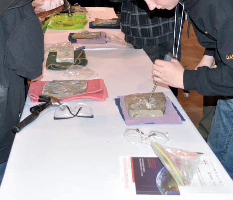


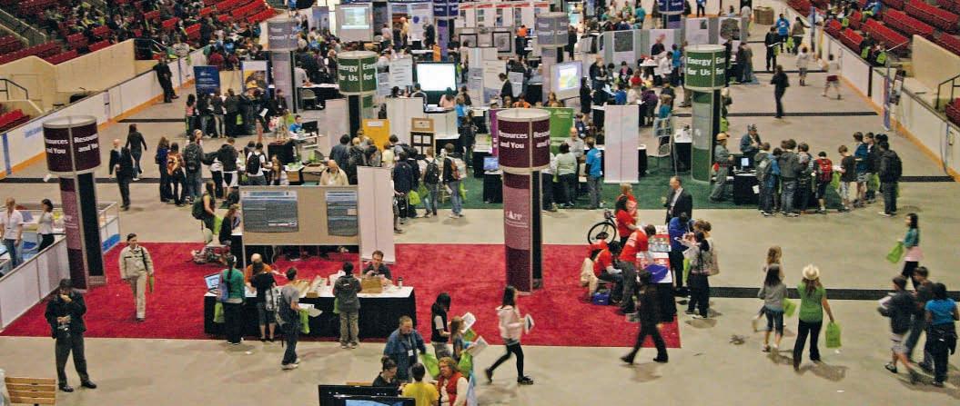


Burgess Shale Geoscience Foundation
Canadian Society for Unconventional Gas
Parks Canada
Pengrowth Energy Trust

Alberta Environment
CSEG T-Wave Golf Tournament
Daylight Energy
Mining Industry Human Resources Council
University of Regina and the International Performance Assessment Centre for the Geological Storage of CO2
University of Saskatchewan
| By Kyla Poelzer

On May 10-11, 2010, the Earth Science for Society Exhibition (ESfS) transformed the BMO Corral into a centre of Earth Science discovery. While thousands of geoscientists gathered for GeoCanada 2010, a once-adecade conference sponsored by geosciences organizations from across Canada, over 3,000 Calgary and area junior high school students, teachers, parents, conference delegates, and the general public explored the interactive exhibits at five pavilions: Energy for Us, Resources and you, One Dynamic Earth, your Career?, and Our Future!
Each pavilion contained several exhibits offering hands-on opportunities to see and experience Earth Science in a unique way. Visitors smashed rocks with hammers to find delicate trilobite fossils; compared the weight of a meteorite to an ordinary Earth rock; or peered down special microscopes at diamonds, fossils and minerals. Many visitors were captivated by the simulated coal dust explosion. The exhibitors were dynamic and the exhibits mesmerizing.
The main objective of Earth Science for Society the exhibition was to show students and the general public, through the use of interactive and dynamic exhibits, how Earth Science impacts our daily life. The ESfS exhibition is designed to supplement Alberta Education’s curriculum so as to allow teachers to bring students on a field trip. The exhibition offers a rare opportunity for students to get their hands dirty and to learn about the wide impact of Earth Sciences. Last May, many gained a new appreciation for how Earth Science integrates many sciences. Visitors learned what earth scientists do and how important their contribution is to the things we use every day. Students were also encouraged to explore career options.
It is important that geoscientists pass along
our enthusiasm about our discipline and educate students and the public about the invaluable contribution to society made by earth scientists.
The organizing committee arranged the buses and schedules for 2,000 junior high school students and teachers. Each student was given a goody bag that included a scavenger hunt booklet and each teacher had an educators’ handout with the answers to the questions in the booklet. 80 keen volunteer guides met the buses and escorted the students to the exhibit floor.
This program would not have been possible without the help of 20 generous sponsors, 20 volunteer organizing committee members, 80 volunteer guides, and 27 exhibitors. We have received enthusiastic feedback and interest
in running this successful program again next year but can only do so with additional help to organize it. If you are interested in volunteering please email outreach@cseg.ca
Thanks very much to our valued sponsors:
• Government of Alberta
• Canadian Association of Petroleum Producers
• Tourmaline Oil Corp.
• Canadian Society of Exploration Geophysicists & CSEG Foundation
• Canadian Society of Petroleum Geologists & CSPG Educational Trust
• Association of Professional Engineers, Geologists, and Geophysicists of Alberta
• Canadian Institute of Mining, Metallurgy and Petroleum
• Devon Canada Corporation
• Prospectors & Developers Association of Canada
• Petroleum Society 50th Anniversary Educational Trust Fund with SPE
• Burgess Shale Geoscience Foundation
• Canadian Society for Unconventional Gas
• Parks Canada
• Pengrowth Energy Trust
• Alberta Environment
• CSEG T-Wave Golf Tournament
• Daylight Energy
• Mining Industry Human Resources Council
• University of Regina and the International Performance Assessment Centre for the Geological Storage of CO2
• University of Saskatchewan
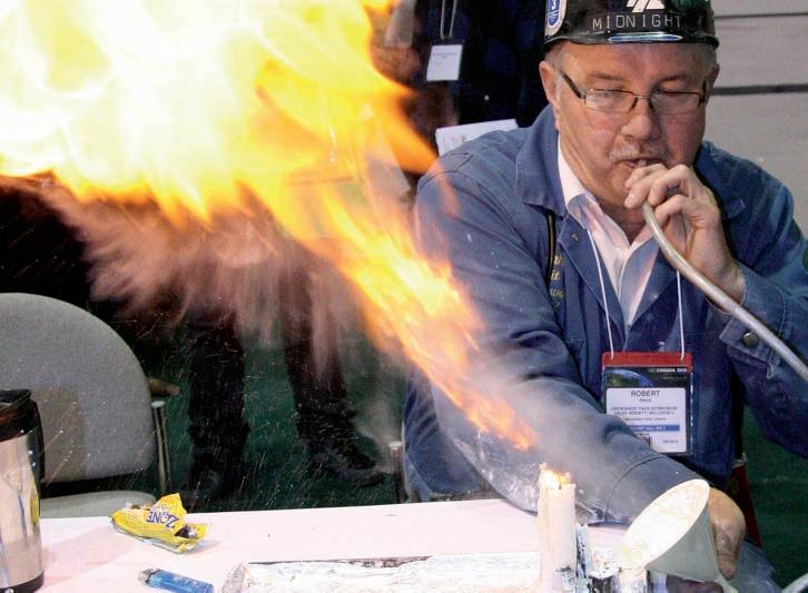
| By Tom Sneddon
Go south, you young people – opportunity abounds in the United States for qualified petroleum geologists. According to a 2005 poll, only 9% of the 45,000 or so geologists included petroleum exploration and development as within their scope of practice, which amounts to about the same number who practice the same profession in Canada. Many APEGGA members are already in the US oil patch, living and working in Texas, Louisiana, and the tight-gas-trend states. Others are Canadian residents, developing plays in US territory.
Many Reservoir readers likely are puzzled over the need to license in the US and how to go about it. On the other hand, some foreign-trained geologists are reluctant to apply for Professional Geoscientist status in Alberta because they have heard they may be assigned many ‘confirmatory’ technical exams to confirm their undergraduate education.
QUESTiON : What do all three groups have in common?
A NSWER : They should write and pass the Fundamentals of Geology Examination (FG)
administered by the national Association of State Boards of Geology (ASBOG).
Currently, 31 of 50 States of the Union require a passing grade (which is normally 70%, but varies by jurisdiction) in the FG and the Practice of Geology (PG) examinations to qualify for a licence to practice in those jurisdictions. Insofar as petroleum geoscience is concerned, all the oil-producing states except Oklahoma, nevada, new Mexico, Colorado, Montana, the two Dakotas, and Louisiana have licensing laws.
If you recently completed a degree in geoscience and may want to work in the Great Republic at some time in the future, now is the time to get FG credit since the exam is only offered twice a year and opportunities do not necessarily allow enough time do the exam before you need the license. All that hard-won information is still fresh, and the time to act is nOW while you have the time and knowledge available. The Board adoption is for one experimental year to see if there is enough interest in writing it to justify permanent adoption of the FG.
If you are currently practicing geoscience in the United States, check the ASBOG website to see if you should be licensed in the state(s) you are working in as you may already need a License to Practice (see http://www.asbog.org to find out for sure).
If you do, apply to write the FG immediately and then apply for the necessary credential. Every state is different when it comes to requirements, but all 31 will want to see a successful FG exam result if you are a foreign national. Incidentally, the Canadian Society of Professional Geoscientists (Geoscientists Canada) is an International Member of ASBOG.
APEGGA has agreed to offer and proctor the FG exam for the March 2011 and September 2011 sittings to see if there is enough interest in writing it to justify permanent adoption of the FG exam. The APEGGA Board of Examiners also agreed to offer the FG exam as an alternative to the three confirmatory APEGGA technical exams that may be assigned to internationally trained geologists to confirm that the quality of their degree meets the standards required for registration as a professional geologist in Alberta.
Do you need any help on
Do you need any help on you need any you need any
Defining Organic Facies, Maturation of Source Rock and Petroleum Systems Modelling for Shale Gas or Deepwater Hydrocarbon Evaluation?
Do you need any help on you any Defining Organic Facies, Maturation of Source Rock and Petroleum Systems Modelling for Shale Gas or Deepwater Hydrocarbon Evaluation?
Contact: Dr. Muki Mukhopadhyay, President
Global Geoenergy Research Limited of Canada, a World Expert on Maturity (both vitrinite Reflectance and chemical maturity paramters), and Source Rock Geochemistry yp) y
Contact: Dr. Muki Mukhopadhyay, President Global Geoenergy Research Limited of Canada, a World Expert on Maturity (both vitrinite Reflectance and chemical maturity paramters), and Source Rock Geochemistry yp) y
Joinme(Muki&Hantschel/Rottke) Joinme(Muki&Hantschel/Rottke) Joinme(Muki&Hantschel/Rottke) Joinme(Muki&Hantschel/Rottke)
SpecialShaleGasandModellingAAPGShortCourseatthe2010October 7 7 7--8 8 8 inHouston,Texas inHouston,Texas
Joinme(Muki&Hantschel/Rottke) Joinme(Muki&Hantschel/Rottke) SpecialShaleGasandModellingAAPGShortCourseatthe2010October 7 7--8 8 8 8 inHouston,Texas inHouston,Texas
Contact Information
Geoenergy Research Limited
Global Geoenergy Research Limited
What is the FG all about? Details about the examination and the rules surrounding it can be found in the Professional Geologists Candidate Handbook, which is available at the ASBOG website (www.asbog.org) for downloading.
Will ASBOG members accept Canadian degrees? They will: all Canadian Universities offering degrees in geoscience are found on pages 36 through 38 of the Institutions Code List (including the Southern Alberta Institute of Technology) that can also be downloaded from the website.
Barrington Street, Suite 427 (P.O. Box 9469, Station A, B3J 5S3)
1657 Barrington Street, Suite 427 (P.O. Box 9469, Station A, B3J 5S3)
Nova Scotia, Canada B3J 2A1; Tel: 902-453-0061; 902-401-0061
Information muki@global-geoenergy.com; muki@ns.sympatico.ca
Halifax, Nova Scotia, Canada B3J 2A1; Tel: 902-453-0061; 902-401-0061
Webpage: www. global-geoenergy.com
E-mail: muki@global-geoenergy.com; muki@ns.sympatico.ca Webpage: www. global-geoenergy.com

Who should you contact if you want to write the exam? Call the APEGGA Registration Department at 1-800-661-7020 (780-4263990 in Edmonton) for forms and details. If you wish to apply to take the FG in lieu of confirmatory examinations, ask for the Registration Department and if you wish to apply to take the FG for any other purpose, ask for Carolyn Deets.

industry-leading customer service
Want to find all the potential in your reservoir quickly?
Introducing new DecisionSpace® Earth Modeling software.
Combine proven science with intuitive usability with the Earth Modeling module of the unified DecisionSpace® Desktop software. Collaborate more closely and efficiently by sharing a common subsurface framework. Improve understanding of reservoir potential and uncertainty with 3D reservoir characterization. Discover more of your reservoir’s potential with user-created workflows, industry-leading algorithms and intelligent defaults. To get better answers faster, visit halliburton.com/landmark/desktop
High Science Simplifiedsm