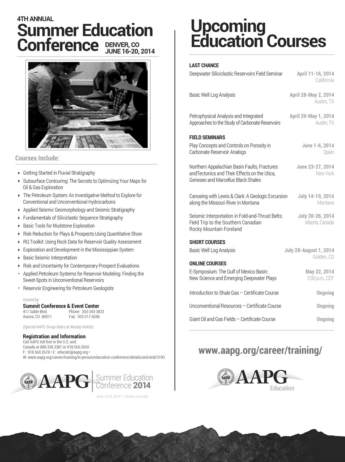
20 Go Take a Hike 30 GeoConvention 2014: Focus 34 A 12-Step Program to Reduce Uncertainty in Kerogen-Rich Reservoirs: Part 2 – Getting the Right Hydrocarbon Volume $10.00 APRIL 2014 VOLUME 41, ISSUE 04 Canadian Publication Mail Contract – 40070050


As the most dynamic data aggregator in the industry, Petrosys keeps your workflow moving.
Only Petrosys’ powerful suite of software effortlessly navigates the overflow of data from multiple sources and disciplines. Our industry-leading dynamic data aggregation, integration and surface modeling capabilities enable you to identify, refi ne and resolve issues more quickly. Dedicated technical support and service offer expert solutions when needed. And with our clear, logical interface, even getting started is smooth sailing. Start achieving exploration and production targets at a lower cost and in a shorter time frame with Petrosys. To learn more go to www.petrosys.com.au/transcend


CSPG OFFICE
#110, 333 – 5th Avenue SW Calgary, Alberta, Canada T2P 3B6
Tel: 403-264-5610
Web: www.cspg.org
Office hours: Monday to Friday, 8:30am to 4:00pm
Executive Director: Lis Bjeld
Tel: 403-513-1235, Email: lis.bjeld@cspg.org
Event Coordinator: Kristy Casebeer
Tel: 403-513-1226, Email: kristy.casebeer@cspg.org
Geoscience Coordinator: Kelsey Green
Tel: 403-513-1225, Email: kelsey.green@cspg.org
Member Services:
Tel: 403-264-5610, Email: membership@cspg.org
Publications and Website: Emma MacPherson
Email: emma.macpherson@cspg.org, Tel: 403-513-1230
Database Administrator and Accounting: Kasandra Amaro
Tel: 403-264-5610, Email: kasandra.amaro@cspg.org
Technical Programs: Biljana Popovic
Tel: 403-513-1225, Email: biljana.popovic@cspg.org
Corporate Sponsorship: Lis Bjeld
Tel: 403-513-1235, Email: lis.bjeld@cspg.org
Controller: Eric Tang
Tel: 403-513-1232, Email: eric.tang@cspg.org
EDITORS/AUTHORS
Please submit RESERVOIR articles to the CSPG office. Submission deadline is the 23rd day of the month, two months prior to issue date. (e.g., January 23 for the March issue).
To publish an article, the CSPG requires digital copies of the document. Text should be in Microsoft Word format and illustrations should be in TIFF format at 300 dpi., at final size. For additional information on manuscript preparation, refer to the Guidelines for Authors published in the CSPG Bulletin or contact the editor.
Technical Editors
Hugh S. Mosher Colin Yeo (Assistant Tech. Editor) Nunaga Resources Ltd. Encana Corporation M.: 403-809-9997 Tel: 403-645-7724
Email: hsmosher@telus.net Email: colin.yeo@encana.com
Coordinating Editor
Emma MacPherson, Publications Coordinator, CSPG Tel: 403-513-1230, emma.macpherson@cspg.org,
ADVERTISING
Advertising inquiries should be directed to Emma MacPherson, Tel: 403-513-1230 email: emma.macpherson@cspg.org. The deadline to reserve advertising space is the 23rd day of the month, two months prior to issue date.
(You may never return to the office)

Now, get geoLOGIC’s value-added data almost any place, any time, any way you want it. Available through gDCweb on your tablet, smartphone or computer.
With 30 years of data experience behind it, gDC is the source for high quality, value-added well and land data from across Western Canada and the Northern United States. Another plus – our data is accessible through an expanding range of industry software utilizing our own easy-to-use gDC GIS and our geoSCOUT software.
View, search, import and export well, land and production data, documents, logs and more from almost anywhere. For more information visit our website at www.geoLOGIC.com
Leading the way with customer-driven data, integrated software and services for your upstream decision-making needs.
geoSCOUT | gDC | petroCUBE at www.geoLOGIC.com


PAST PRESIDENT
Paul MacKay • Shale Petroleum Ltd. paul.mackay@shalepetroleum.com Tel: 403.457.3930
PRESIDENT
Dale Leckie • Nexen Energy ULC daleleckie@nexencnoocltd.com Tel: 403.613.0458
PRESIDENT ELECT
Tony Cadrin • Journey Energy Inc. tony.cadrin@journeyenergy.ca Tel: 403.303.3493
FINANCE DIRECTOR
Gord Stabb • Durando Resources Corp. gstabb@durando.ca Tel: 403.819.8778
FINANCE DIRECTOR ELECT
Astrid Arts • Cenovus Energy aarts@barrick-energy.com Tel: 403.766.5862
DIRECTOR
Alexis Anastas • Nexen Energy ULC alexis_anastas@nexencnoocltd.com Tel: 403.699.4965
DIRECTOR
Andrew Fox • MEG Energy Corp. andrew.fox@megenergy.com Tel: 403.770.5345
DIRECTOR
Milovan Fustic • Statoil Canada Ltd. MFUS@statoil.com Tel: 403.724.3307
DIRECTOR
Michael Laberge • Channel Energy Inc. mlaberge@surgeenergy.ca Tel: 403.301.3739
DIRECTOR
Robert Mummery • Almandine Resources Inc. mummery1@telus.net Tel: 403.651.4917
DIRECTOR
Weishan Ren • Statoil Canada Ltd. wren@statoil.com Tel: 403.724.0325
DIRECTOR
Darren Roblin • Endurance Energy snowice@telus.net Tel: 587.233.0784
EXECUTIVE DIRECTOR
Lis Bjeld • CSPG lis.bjeld@cspg.org Tel: 403.513.1235
A message from 2014 Director, Milovan Fustic
YOU are invited to publish with CSPG !
With a record number of technical abstracts (550) submitted for the upcoming GeoConvention, I know that many of our members are working on oral presentations, posters, and core displays. I also know, based on contributing to the GeoConvention technical program over the last decade, that everyone involved in the technical program is excited. This excitement is not only caused by the thrill of sharing and testing your work, ideas and concepts with colleagues outside of your company, but also knowing that advancements you, your team, and your company have made and are proud of are promoting the geosciences.
In addition to developing your initial concepts, you have taken the extra effort to organize the flow of your presentation and to create clear and concise figures. At the end of your presentation, after the audience applause, you will walk from the stage with feeling of relief and pride. By all means, both the applause and pride are well-deserved.
But what happens after your presentation at GeoConvention? Some of the audience will go through notes taken during your talk and make time to apply it in their work; passing time will take care that the echo of applause you received at the end of your talk will weaken, your day to day duties will suppress the pride you had, colors of your diagrams will fade in minds of the people in your audience. In other words, your idea(s), concept(s) and many hours of hard work are in danger of being forgotten and lost! And what you are going to do?
As a CSPG volunteer and member, I hope you will start thinking about another piece of work that you may want to share at the next GeoConvention. I certainly encourage you to keep doing that, but I also encourage you to consider an easy
and in many ways rewarding alternative – to publish your already presented work as a peer-reviewed article in your own CSPG’s Bulletin of Canadian Petroleum Geology. You have already have developed the story, concept, diagrams, photos, tables, established the flow of ideas and written the introduction, methodology, summary, conclusions. Now, expand the text, add cited references and perhaps reduce the number of, or combine, figures and data. If you wonder why you should publish, here are few reasons you should consider:
• This is good for your employer: through your publication, your organization does not only demonstrate their technical competency and resources, but frequently this is the most elegant way for protecting IP (intellectual property) rights. Technical publication commonly allows a company to evaluate potential patenting resulting from the work for a period of time following publication and ensures their freedom to operate.
• Because this is good for you: from peer-review comments and citations to your work in a follow up publications you and your co-authors will expand knowledge on the topic; your article becomes accessible through various worldwide geoscience search engines; you qualify for APEGA’s PDH credits; your diagrams will never fade; your publication is a nice edition to your CV and technical portfolio; publishing, is the best recipe for protecting (your) geoscience work(s) from perishing and/or being abused.
• Because we owe it to people we learned from: Canada is not only the second largest country in
(Continued on page 7...)

SAMARIUM
geoLOGIC systems ltd.
DIAMOND
Cenovus Energy Inc.
Shell Canada Limited
Nexen ULC
Imperial Oil Resources
Laboratories
GOLD
Schlumberger Canada Limited
ConocoPhillips
Devon Canada Corporation
Enerplus Corporation
MEG Energy Corp.
Tourmaline
Canadian Natural Resources Ltd
Statoil Canada
SILVER
MJ Systems
Baker Hughes Inteq
CGG Services (Canada) Inc.
Suncor Energy
Encana Corporation
Husky Energy Inc.
Athabasca Oil Corporation
ION Geophysical
Petrosys
BRONZE
Olympic Seismic Ltd.
Talisman Energy
Roke Technologies Ltd.
SeisWare International Inc.
Sensor Geophysical Ltd.
Arcis Seismic Solutions
Loring Tarcore
PGS
Saudi Aramco
Tucker Energy Services Canada Inc
Pro Geo Consultants
Belloy Petroleum Consulting
ARC Financial Corporation
Hunt Oil
Tesla TGS
CL Consultants
Earth Signal Processing Ltd
Casey & Associates
Explor
GLJ Petroleum Consultants Ltd.
Paradigm Geophysical (Canada) Corp.
PLS Inc
As of March 2014 A
(...Continued from page 5)
the world, fifth largest hydrocarbon producer and the third largest oil exporter in the world, and a home of various energy resources including globally-important oil-sands, conventional and unconventional oil and gas and gas-hydrates, but also the place where many geoscience concepts were developed and ideas tested. The latter happened because of people like you, people who had ideas and courage to share it with others and made time to publish it. Can you imagine where our industry would be today if W. C. Gussow in his 1954 paper on “differential entrapment of oil and gas” had not paved the way for petroleum system analysis nowadays routinely applied worldwide? How many more dry holes would have been drilled? Simple and obvious today, his concept was controversial and contrary to accepted ideas at the time when he published. But, he had idea and courage. Today, CSPG celebrates him through annual Gussow Conferences. In addition to the 60th anniversary to his paper, this year, we also celebrate the 100 year anniversary of Sydney Ells’ report on the bituminous sands of Northern Alberta (https://archive. org/details/preliminaryrepor00cana). Many people subsequently built on Ells’ work and with integrated geoscience and engineering technology advancements, the oil-sands now drives the Canada’s economy.
For my tenure as a board member of CSPG, my mission is to attempt to increase the number of technical publications from
the industry and academia. I would like to count on all of our members for their help and support. Fellow GeoConvention presenters: you are my first choice – just because I know that you have already shown courage to share your ideas and you are half-way done. You can do a full research style paper, a case study, or simply a short note with a couple of figures and up to four pages of text. I encourage you to follow the steps of Sydney Ells, W. C. Gussow, and many of your professors, mentors, and colleagues who made time for it … With your contributions I am sure that BCPG will become a prestigious geoscience journal that all of us will continue to be proud of !
I invite all CSPG members, and especially those who have already made the effort to submit the abstract for GeoConvention, to take a moment and think beyond GeoConvention – how much more time and effort would you need to turn it into a peer-reviewed paper? Put your fingers to the keyboard and expand stories you already have – many rewards are you waiting for your effort!
I welcome any comments, thoughts or ideas you may have as how else to increase the number of technical publications while keeping the high quality ensured through a rigorous review process BCPG already has. I also welcome your suggestions for Memoirs and Special Publications. Feel free to contact me at mfustic@statoil.com

SPEAKER
Howard
Wheater11:30 am
Tuesday, April 8, 2014
Calgary, TELUS Convention Centre
Macleod Hall C/D
Calgary, Alberta
Please note: The cut-off date for ticket sales is 1:00 pm, three business days before event. (Thursday, April 3, 2014). CSPG Member Ticket Price: $45.00 + GST. Non-Member Ticket Price: $47.50 + GST.
Each CSPG Technical Luncheon is 1 APEGA PDH credit. Tickets may be purchased online at https://www.cspg.org/eSeries/source/ Events/index.cfm.
The water environment faces unprecedented challenges world-wide, and water security is increasingly seen as one of the major issues for the 21st century. While floods and droughts remain some of the world’s most damaging and costly natural hazards, water resources
and water quality are under pressure, through population growth and movement, economic development, pollution and environmental change.
Despite the perception that Canada is water-rich, all of these issues are now being experienced, particularly in the Prairie Provinces. These are illustrated for the 336,000 km2 Saskatchewan River Basin, which is drained by one of the world’s larger rivers. Management concerns include: provision of water resources to more than three million inhabitants, including indigenous communities; balancing competing needs for water between different uses, such as urban centres, industry, agriculture, hydropower and environmental flows; issues of water allocation between upstream and downstream users in the three prairie provinces; managing the risks of flood and droughts; and assessing water quality impacts of discharges from major cities, industry and intensive agricultural production. Superimposed on these issues is the need to understand and manage uncertain water futures, including effects of economic growth and environmental change, in the face of highly fragmented water governance.
The talk addresses the science and management challenges for surface water and groundwater resources, including the roles of vulnerability assessment, risk-based analysis and the needs for stakeholder engagement and user-focussed decision support tools..
Webcasts sponsored by

Professor Howard Wheater is Canada Excellence Research Chair in Water Security and Director of the Global Institute for Water Security at the University of Saskatchewan. A leading expert in hydrological science, he has extensive international experience of flood, water resource and surface and groundwater quality management. He is a Fellow of the Royal Academy of Engineering and the American Geophysical Union and winner of the Prince Sultan bin Abdulaziz International Prize for Water. He was vice-chair of the World Climate Research Programme’s Global Energy and Water Cycle Exchange (GEWEX) project, leads UNESCO’s GWADI arid zone water resources program, and was recently the engineer member of an International Court of Arbitration concerning the Indus Waters Treaty. He is advisor to the state of Nevada concerning the proposed Yucca Mountain high level nuclear waste repository and was advisor to the UK government concerning site criteria for deep disposal of intermediate level nuclear waste. He was a member of Alberta’s Provincial Environmental Monitoring Panel, and his role as Chair of the Council of Canadian Academies Expert Panel on Sustainable Management of Water in the Agricultural Landscapes of Canada saw release of a report in February 2013 entitled Water and Agriculture in Canada: Towards Sustainable Management of Water Resources.

SPEAKER
Tim McHargue
11:30 am
Wednesday, April 23, 2014 Calgary, TELUS Convention Centre Macleod Hall C/D, Calgary, Alberta
Please note: The cut-off date for ticket sales is 1:00 pm, three business days before event. (Friday, April 18, 2014.) CSPG Member Ticket Price: $45.00 + GST. Non-Member Ticket Price: $47.50 + GST.
Each CSPG Technical Luncheon is 1 APEGA PDH credit. Tickets may be purchased online at https://www.cspg.org/eSeries/source/ Events/index.cfm.
ABSTRACT
Petroleum exploration in deep water settings is resulting in the discovery of many giant fields in reservoirs that accumulated in large channel systems on the continental slope. The architecture of these reservoirs is exceedingly complex. In the face of multi-billion dollar costs, it is more important than ever before to accurately characterize these reservoirs.
Based on detailed examination of turbidite channel analogs as revealed in 3D seismic data, exposed in outcrops, or preserved on the modern sea floor, two principal models of channel architecture have emerged: a cut-and-fill model, and a lateral accretion model. Both models are appropriate in at least some cases, but debate continues as to which model is most applicable in any specific case. Furthermore, it is not apparent how to reconcile the preserved facies distributions of turbidite channel deposits and prevailing concepts of turbulent flow behavior. For example, when high levees are present, we know that flows are thick. Concentration of sand within sinuous channel elements confirms that turbulent flows are highly stratified. However, these architectures seem to require that the lower and upper portions of a single flow follow paths with markedly different sinuosities and divergent, even opposing, trajectories. How can that happen? Further debate concerns the transition from channel to fan architectures. Some high resolution 3D seismic images suggest the presence of distinct distributary systems on some submarine fans while others do not. Outcrop examples with the best continuous lateral exposures appear to be incompatible with seismic images of distributary systems. The few excellent outcrop examples of lobes arguably are strongly biased. Are our best images from 3D seismic also biased? High resolution images of modern submarine fans calibrated to sediment cores might provide the answer, but such data are lacking. This quandary is not just academic. It has become clear from recent drilling in the Gulf of Mexico
Webcasts sponsored by
that reservoir quality in submarine fans is highly variable, often containing good permeability within channels in contrast to abundant argillaceous sands with low permeability in the lobes.
With continued research, the issues discussed above will be resolved, but the path forward, like the channels themselves, will be long and sinuous.
Tim McHargue went to the University of Missouri for his Bachelor’s and Master’s degrees with a thesis on Ordovician conodonts. A couple of months before graduation in 1974 came the Oil Embargo and a job offer from Phillips Petroleum. Thus began a career in the petroleum industry. A seismic interpretation project on the Indus Fan started Tim’s interest in turbidite architecture. Next, Tim returned to school at the U. of Iowa. After completing a PhD in carbonates in 1981, he accepted a position at Chevron. During the next 28 years, Tim spent about equal time in exploration and research. He returned to research in turbidite reservoirs in 1997 and eventually assembled a team to work on characterization of new discoveries in West Africa until retirement in 2009. Tim’s position as Consulting Professor at Stanford University began in 2002 where he collaborates on research on turbidite depositional systems and teaches courses on turbidite architecture and clastic sequence stratigraphy. Tim also is an Adjunct Professor at the University of Missouri.

SPEAKER
Clinton Tippett
11:30 am
Wednesday, May 21, 2014
Calgary, TELUS Convention Centre Macleod Hall C/D Calgary, Alberta
Please note: The cut-off date for ticket sales is 1:00 pm, three business days before event. [Friday, May 16, 2014]. CSPG Member Ticket Price: $45.00 + GST. Non-Member Ticket Price: $47.50 + GST.
Each CSPG Technical Luncheon is 1 APEGA PDH credit. Tickets may be purchased online
May 13th, 2014
5:30-7:30pm
Fairmont Palliser (Invitation only)
Webcasts sponsored by
at https://www.cspg.org/eSeries/source/Events/ index.cfm.
May 14, 2014 marks the 100th anniversary of the initial petroleum discovery at Turner Valley. The field sits at the leading edge of the Foothills Belt of the Rocky Mountains, just to the southwest of Calgary, Alberta. The relatively simple structure of the field features a massive thrust sheet carrying Mississippian carbonates at its base and the full Mesozoic section above them. The related surface anticline in Late Cretaceous strata, forming the crest of the Triangle Zone at this latitude, is related to the cut-out of the carbonates above the sole fault. This understanding of the subsurface was incomplete during much of the life of the field and multiple theories for its geometry have been proposed over the last century. It was only once modern seismic techniques were brought to bear to complement the extensive drilling record that the true nature of the structure became apparent. The nature and variability of the Mississippian reservoir also hold important lessons for other carbonate fields.
Early exploration was triggered by surface seeps of natural gas combined with an understanding of the anticlinal theory
of hydrocarbon accumulation. Drilling at the discovery well, Calgary Petroleum Products No. 1, started in January 1913 and the well finally came in on May 14, 1914. It flowed 4 mmcf/d of wet natural gas from a depth of 828m in the sandstones of the Lower Cretaceous section. Delineation in this part of the section was slow and hampered by WWI. On October 14, 1924 Royalite No. 4, drilled by a subsidiary of Imperial Oil that had taken over CPP’s operations, deepened a northern step-out well into the underlying Paleozoic section in the up dip part of thrust sheet and intersected the natural gas accumulation hosted in these Mississippian strata. The well blew out and is estimated to have flowed at over 20 mmcf/d with 500-600 bbl/d of condensate. This pool is now recognized as having had 1.5 TCF OGIP. Its pursuit occupied the industry from 1924 through to 1936. Exploitation primarily involved production of the natural gas for its condensate and NGL contents. Sales of the residual gas were made when possible but significant volumes were often flared when production exceeded demand. This wasteful practice reached its peak in 1931 when more than 400 mmcf/d was often flared throughout the field.
The next chapter of the field’s life was
ushered in by the testing on June 16, 1936 of Turner Valley Royalties No. 1, a downdip crude oil discovery in the Mississippian that kicked off at 850 bbl/d of 39 degree crude oil. This deeper flank pool had 1 billion barrels OOIP and 1.36 TCF of solution gas but recoverable oil volumes of only 156 mmbbl. due to the depressuring of the field during the earlier aggressive production of the associated gas cap. Oil production peaked at about 27,000 bbl/d in 1942 at which point the field was providing approximately 97% of Canada’s domestic production.
The history of Turner Valley is rich in detail. Although relatively small by global standards, it brought significant economic activity, employment and financial rewards to individuals, companies and governments. The field was also important in other ways because of the timing of its life relative to global events. Its main period of exploration and production occurred in part during the Depression and brought much needed relief to southern Alberta. During the Second World War, the refining of crude oil production from Turner Valley was critical in the establishment and capacity of the British Commonwealth Air Training Program that was vital to the Allied war
efforts. Finally, as the home of the first full scale commercial petroleum production facilities in Alberta, it positioned both the industry and the government for the rapid pursuit, beginning in 1947, of Leduc and other world class discoveries. Human, physical and capital resources were all quickly re-deployed from Turner Valley in the declining years of its life. Indeed the C.S.P.G. owes its establishment in 1927 to the activity generated by the 1924
natural gas discovery. Likewise Alberta’s regulatory regime for the industry became firmly established in 1938 in recognition of the fact that conservation measures were required to combat wasteful approaches so as to achieve optimal recovery efficiencies of subsurface resources, a need reinforced by the 1936 crude oil discovery.
It is important to examine Turner Valley in its broader societal context as well. In 1912 there was so little petroleum in western Canada that the City of Calgary could not afford to purchase oil to keep down the dust on its streets. As a result, the 1914 discovery of the first commercial accumulation in the West bearing liquid hydrocarbons changed our local society forever. One century later, our society is firmly based on petroleum.
Clinton Tippett is a petroleum geologist employed by Shell Canada currently working as Project Coordinator in the Central Mackenzie Valley, NWT. He has a B.Sc. and an M.Sc. from Carleton University in Ottawa, Ontario and a Ph.D. from Queen’s University in Kingston, Ontario. Clint is President of the Petroleum History Society and Chair of the C.S.P.G. History and Archives Committee.


SPEAKER
Janok P. Bhattacharya McMaster University
11:30 am
Tuesday, June 3rd, 2014 Calgary, TELUS Convention Centre Macleod Hall C/D Calgary, Alberta
Please note: The cut-off date for ticket sales is 1:00 pm, three business days before event. [Thursday, May 29, 2013]. CSPG Member Ticket Price: $45.00 + GST.
Non-Member Ticket Price: $47.50 + GST.
Each CSPG Technical Luncheon is 1 APEGA PDH credit. Tickets may be purchased online at https://www.cspg.org/eSeries/source/Events/ index.cfm.
ABSTRACT
A common observation in many ancient clastic wedges is that shoreline deposits are
commonly significantly finer than associated fluvial deposits. Abrupt downstream fining in rivers, and increase in tidal or marine influence, may mark the backwater and bayline limits, which are controlled primarily by slope, tidal range, and river discharge. The backwater distance, from the shoreline, is defined as the ratio of river depth versus slope, whereas the bayline is the tidal range divided by the slope. In Modern continentalscale low slope river systems (i.e. Slope < 0.0001), such as the Mississippi and Amazon, backwaters may reach many hundreds of kilometers upstream, whereas they may be on the order of a few kilometers in steeper gradient systems.
Ancient deltaic systems of the Cretaceous interior seaway of North America, including the micro-tidal Turonian Ferron Sandstone Member in Utah, show coarse-grained pebbly-sandstone bedload river deposits that feed medium-to fine-grained sandy shorelines. Cross-sections allow estimates of channel depth and width, which can used to calculate the cross-sectional area of a channel. Grain size and bedforms can be used to estimate flow velocity. When multiplied by the channel area, the velocity can be used to estimate discharge. Ferron trunk channels are on the order of 5-9 m deep with discharge (Qw) of less than about 1500 m3/s. This suggests moderate size upstream drainage basins and a propensity for downstream, distributary channels to produce hyperpycnal deltaic deposits.
Within the Ferron clastic wedge, the pebble-to sand transition lies several kilometers from co-eval shoreline deposits,
Webcasts sponsored by
suggesting a short backwater length. Slope estimates can also be made based on onlap distances of associated coastal prisms, as expressed in stratigraphic cross sections. For the Ferron, slopes > 0.001, are an order-of-magnitude steeper than for the low-gradient continental scale systems, like the Mississippi. This explains the position of the transition from pebble- to sand in the fluvial systems, at a few versus hundreds of kilometers from the shoreline, as well as the lack of pebbles in co-eval shorelines. Onlap limits of bay and lagoon deposits, of several tens of kilometers, mark the bayline and suggest an average tidal range of < 2m.
The Cenomanian Dunvegan Formation, in Alberta, contains trunk streams on the order of 10-28 m deep. Discharge estimates are correspondingly about 3 times larger that the Ferron sandstone. Brackish water indicators have been found several tens of kilometers inland, suggesting the bayline was about 30km from the shoreline. Previous estimates of Dunvegan valley slopes are on the order of 0.0004, higher than the Mississippi, but lower than the Ferron. The gravel-sand transition lies considerably farther landward as well, suggesting backwater distances might have been on the order of 100 km.
Estimation of slope and discharge thus can be made in ancient clastic systems and allow prediction of the partitioning of coarse versus fine-grained facies at choke-points, as defined by the backwater and bayline limits.

Monday, May 12, 2014 5:30pm – 7:00pm
HYATT Regency Calgary, Imperial Ballroom 5
Join us in honoring the 2013 CSPG award recipients.
Everyone is welcome to attend.
SPEAKER
Kathleen
Dorey Chief Geophysicist, Petrel Robertson Consulting Ltd.12:00 Noon
Wednesday April 16th, 2014
Nexen Plus 15 Conference Centre Nexen Annex Building 7th Ave. & 7th Street SW Calgary, Alberta
ABSTRACT SUMMARY
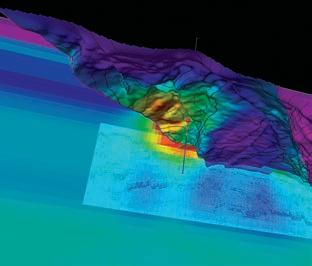
This talk presents a geophysical evaluation of the offshore Kakapo Miocene Prospect in the Taranaki Basin, New Zealand. The relevant regional geology, stratigraphy and paleogeography are presented as a backdrop to the geophysical mapping and analysis of the prospect within the basin. The 2D seismic mapping is discussed and AVO analysis presented which specifically addresses issues
SPEAKER
Peter Jones - Consultant, International Tectonic Consultants Ltd. .
(SAME TIME AND LOCATION AS INTERNATIONAL DIVISION TALK, APRIL 16TH, 2014)
of areal extent of the prospect, hydrocarbon presence and trapping mechanisms. This talk demonstrates the challenge of defining these play elements using multiple seismic techniques in a high potential high reward environment.
The Kakapo prospect lies southeast of the giant Maui Field (gas), west of the recently developed Kupe South Field (oil and gas), and east of the recently developed Maari Field (oil). In water depths ranging from 30 to >120 m, a total 137 2D seismic lines, covering 3200 km, were integrated into the seismic interpretation and mapping.
There are no wells drilled on the prospect currently but the seismic grid ties to the Motueka-1 well, drilled in 1990, 70 km southwest of the prospect. The Motueka-1 well encountered fairly clean very-fine-to fine-grained Motueka sandstone beds up to 37 m in thickness as defined by sidewall core analysis and sample cuttings. The Motueka sandstone member is an informal stratigraphic unit which occurs in the middle part of the Middle Miocene Manganui Formation. (Morrison and Rivers, 1991) It is this well and the extensive seismic database that is key to the mapping and defining the Kakapo prospect to the north.
Wells and seismic from the adjacent Maari oil field were used in the AVO analysis as a template for the Kakapo prospect. The Maari Field oil production is also from a Miocene aged formation with similar thicknesses and petrophysical properties as expected in the Kakapo prospect.
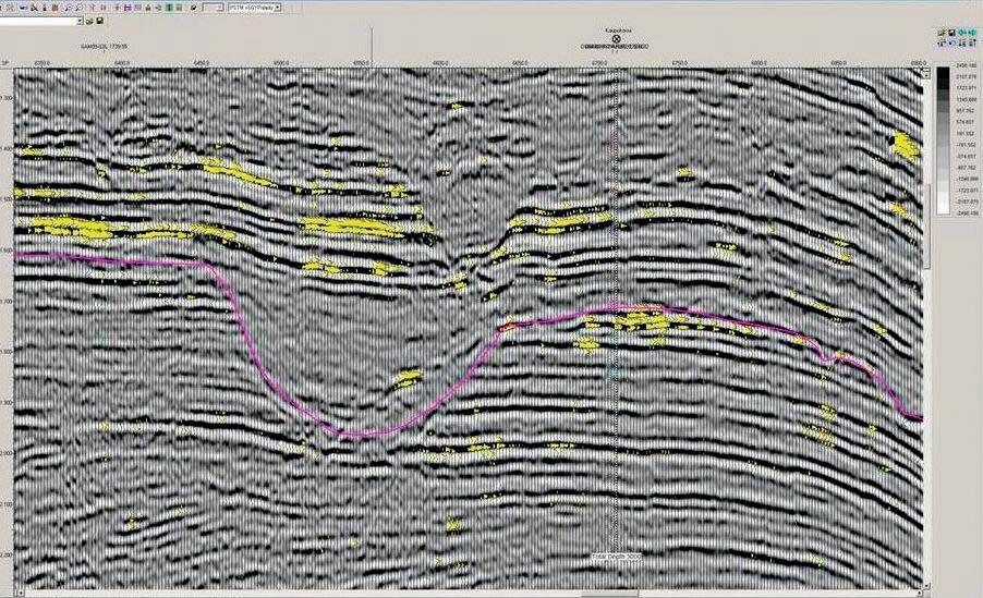
A key south-north seismic line tying the Moteka-1 well to the remainder of the dataset and the prospect as well as a key west-east dip seismic line through the prospect will be shown.
The synthetic tie to the south-north seismic line formed the basis for the interpretation of the horizons over the seismic dataset. The key horizons of interest were the Motueka SS Top and Base and Top Canyon 1 and 2 surfaces. The Motueka synthetic tie was used as a basis for phase and bulk shift corrections where necessary, to the remainder of the seismic lines in the database. The data was fair to good quality data and had been recently reworked by Fugro in 2009.
Maps will be discussed that show the
Sponsored by
closure of the Miocene aged sands against large scale erosional features present in the basin, at variable times throughout the stratigraphic column. The concept of vertical seal is addressed and demonstrated with well control.
The challenge with a stratigraphic play is that the trapping mechanism is more difficult and subtle to define as compared to structural prospects. Historically in the basin, most of the significant hydrocarbon discoveries to date have been defined by structural traps. The use of seismic AVO (Amplitude Versus Offset) analysis was therefore a key tool used to provide a direct indication of hydrocarbon presence and type in the Kakapo prospect.
Some of the examples shown are results of the AVO analysis within the proposed trap versus outside the proposed trap, at a consistent stratigraphic level (Figure 1). This analysis supports the premise that there is a gas cap present in the trapped portion of the reservoir. Likewise, fluid substitution modelling using well control from the offsetting Maari Oil Field is also is used to support the presence of gas in the trapped updip portion of the reservoir.
The lateral seal for the Motueka sandstones is defined by the presence of the crosscutting Canyon 1 sequence, which has been mapped extensively with a dense grid of 2D seismic over the prospect. Due to this large 2D seismic grid, the areal extent of the prospect is definable.
In order for this to be an effective lateral seal the canyon sediments would have to be filled with relatively impermeable strata. As there is no well control on the Kakapo license block, there is a risk that the Canyon 1 sequence would also contain some sands and silts which would provide an inadequate lateral seal.
The risk of an inadequate lateral seal was tested by the AVO analysis performed on the seismic lines over the Kakapo prospect. It was concluded that the AVO anomally present on the prospect is probably caused by a gas leg just below the Base Canyon-1 unconformity. Furthermore, the lack of an AVO anomaly below the apparent gas cap at Kakapo neither confirms nor denies the possibility of an oil leg.
The author would like to thank Mac Beggs, Exploration Manager with New Zealand Oil and Gas, for the opportunity to present this paper.
Isis Petroleum Consultants, 2010. Technical Evaluation, Kaupokonui Prospect PEP 51311. Consulting report, prepared for Peak Oil & Gas Ltd.
King, P.R., and G.P. Thrasher, 1996. Cretaceous-Cenozoic geology and petroleum systems of the Taranaki Basin, New Zealand. Institute of Geological and Nuclear
Sciences Monograph 13, 243 p.
Morrison, W.K., and T.L. Rivers, 1991. Final Geological Report, Motueka-1, PPL 38406. Report submitted to New Zealand Crown Minerals.
New Zealand Oil & Gas (NZOG), 2010. PEP 51311 Offshore Taranaki Basin, New Zealand. Powerpoint presentation.
Kathleen is a Professional Geophysicist and a member of the CSEG, SEG, CSUR and APEGA.
Kathleen has over 25 yrs experience as a Geophysicist in major operating companies such as Texaco and Conoco, and as an independent geophysical consultant for many junior oil and gas companies. She has been Chief Geophysicist for the Petrel Robertson Consulting Ltd for the last 3 years focusing Canadian and International geophysical projects. She is a past member of the CSEG Executive, served as Session Chair for the 2013 Geoconvention on Unconventional Geophysical applications, Past SEG Convention Technical Program editor, Past Editor of the Canadian Heavy Oil Association Handbook and currently a Mentor for the CSEG Foundation Mentorship Program.
There is no charge. Please bring your lunch. The facilities for the talk are provided complimentary of Nexen, coffee by IHS and refreshments by Geochemtech Inc. The speakers are provided with gifts by Drilling Information and Quad Operations. For further
information or if you would like to give a talk, please contact Bob Potter at (403) 8639738 (ropotter@geochemtech.com), Kevin Morrison at (403) 536-3788 (morrison@ antrimenergy.com), Jűrgen Kraus at (403) 808 5086 (jkraus@me.com), Jon Noad (403) 513 7541 (jon.noad@huskyenergy.com) or visit our Linkedin page (“CSPG International Division”).
SPEAKER
Dr. Keith Dewing Geological Survey of Canada
12:00 Noon
Thursday, April 17th, 2014 ConocoPhillips Auditorium, Gulf Canada Square, 401 - 9th Ave. S.W. Calgary, AB
The two largest conventional gas fields in Canada are located on Sabine Peninsula of Melville Island in the central Canadian

Arctic Islands. The Drake gas field was drilled on the closure on an anticline defined both by surface mapping and subsurface seismic data. The field is hosted in Jurassic-aged sandstones of the Heiberg Group. Ultimate recoverable reserves are estimated at 5.3 Tcf. Exploration stopped in 1985 and the fields have never been produced.
Modern processing and interpretation methods were applied to more than 3400 line-kilometres of legacy seismic data from onshore Sabine Peninsula. The success of the reprocessing improved the imaging and hence the interpretation of the Devonian through Cretaceous succession. Processing consisted of three main steps: 1) Principal component decomposition was used to remove both coherent and random noise, 2) data were migrated following the principals of Kirchhoff migration through the use of a 3-D geostatistical velocity model and 3) seismic bandwidth extension was conducted in order to increase vertical resolution.
The north-south oriented Sabine Peninsula has three tectono-stratigraphic assemblages:
1) thrust-faulted and folded lower Paleozoic strata in the lower part; 2) normally-faulted upper Paleozoic carbonate and clastic strata in the middle;
3) folded Mesozoic to Tertiary clastic strata in the upper part of the succession. Cretaceous sills and dykes locally intrude the succession.
The central part of Sabine Peninsula is underlain by a graben containing upper Paleozoic sediments. The graben fill is only intersected once by drilling but the graben likely contains Upper Carboniferous to Lower Permian sediments. The two largest conventional gas fields in Canada (Drake and Hecla) are located within a low amplitude anticline in the Mesozoic succession that partially overlies the graben. Previously, the Drake anticline was interpreted to be formed during Eocene time. We propose that 280 m of the 430 m of structural relief on the Drake Anticline formed in response to uplift at the axis of the anticline in the Early Cretaceous, as shown by thinning of the Lower Cretaceous Christopher Formation over the Drake Anticline. The remaining 150 m of structural relief has formed by subsidence in the Marryatt Point Syncline.
Sponsored by
These conclusions permit a re-evaluation of petroleum systems on Sabine Peninsula. The Early Cretaceous age of the Drake anticline means it was present at the time of maximum hydrocarbon generation in the Late Cretaceous. This type of low amplitude fold is more likely to be filled than Eocene-aged, high amplitude folds elsewhere in the basin. Low amplitude folds should be considered a separate play type from the high amplitude (typically underfilled) anticlines in the northeast part of the Sverdrup Basin.
Keith Dewing is a research scientist at the Geological Survey of Canada, where he works on the stratigraphy, mineral deposits, and hydrocarbon potential of the Canadian Arctic Islands. Prior to joining the GSC in 1999, Keith worked for Cominco Ltd. at the Polaris Mine in Nunavut. Keith has a B.Sc. from Queen’s University, an M.Sc. from Laurentian University and a Ph.D. from the University of Western Ontario
Keith Dewing, Geological Survey of Canada, Calgary, kdewing@nrcan.gc.ca
Virginia Brake, Geological Survey of Canada, Québec
Mathieu J. Duchesne, Geological Survey of Canada, Québec
Tom Brent, Geological Survey of Canada, Calgary
BASS Division talks are free. Please bring your lunch. For further information about the division, joining our mailing list, a list of upcoming talks, or if you wish to present a talk or lead a field trip, please contact either Steve Donaldson at 403-766-5534, email: Steve. Donaldson@cenovus.com or Mark Caplan at 403-532-7701, email: mcaplan@atha.com or visit our web page on the CSPG website at http://www.cspg.org.
SPEAKER
Terry Brazzoni (AER)
12:00 Noon
Wednesday April 23, 2014
Bow Glacier Room
Centennial Place Conference Centre 3rd floor.
300, 250 5th St SW Calgary, AB
With increasing interest and investment in unconventional resources there has been a great increase in the amount of reservoir and geological evaluations being conducted. This has increased the demand for sampling of AER required submissions of core and drill cuttings. Due to this increased demand for material and data, the AER has introduced a procedure for sampling of AER core and drill cuttings, which includes revised requirements for submission of data generated from analysis of these materials.
This meeting will be an opportunity for those who use the facilities at the Core Research Centre to ask questions and obtain clarification on the new Material Sampling Procedure and the related forms.
Sponsored by
Subject matter experts will be on hand to explain and answer any questions related to this procedure.
Lunch will be provided, therefore please contact Doug Hayden, Chair, CSPG Core and Sample Division via haydengeo@telus. net if you wish to attend.

Heavy
Geology
Petrophysics
BD
Canadian


SPEAKER
Afshin Fathi
Petro Basin Soft
12:00 Noon
Wednesday, April 30th, 2014
Place: TBA Calgary, Alberta
ABSTRACT
Basin modeling is the term applied to a group of geological modeling process that can be used to analyze the formation and evolution of sedimentary basins, often but not exclusively to aid evaluation of potential hydrocarbon reserves. In this process, the essential elements and process in a petroleum system will be studied and analyzed to understand the burial history of the basin, the thermal history of the basin, and the maturity history of the source rocks, the expulsion, migration and trapping of hydrocarbons.
In this study, basin modeling approaches is applied in south of Iran called the Central Persian Gulf basin.
Central Persian Gulf basin has a generally simple structure. In this basin, the natural gas in the super-giant accumulations in PermoTriassic reservoirs is thought to have been derived from Silurian “hot shale” source rocks, whereas the oil Mesozoic reservoirs is probably sourced from Mesozoic source rocks. In this study, a 3D basin model has been established for the Iranian part of the Central Persian Gulf in order to improve understanding of the petroleum systems in the area. Sensitivity analyses consider different heat flow scenarios, differences in the timing of Cenozoic uplift and erosion, and different thicknesses of the presumed Silurian source rocks.
Present-day heat flow is in the order of 65 mW/m² and heat flow during Cenozoic maximum burial was probably about 60 to 68 mW/m². However, because of wide scatter in vitrinite reflectance data, a timeconstant heat flow of 65 mW/m² in the entire study cannot be ruled out. Oil and gas
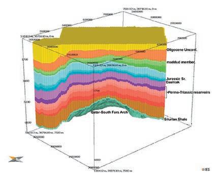
generation commenced during Jurassic and Late Cretaceous time, respectively, and gas generation continued till Neogene time. In difference to Cenozoic erosion (“Oligocene” or “Neogene”) different heat flow scenarios have had a significant influence on the timing of hydrocarbon generation.
Models with 50 m thick Silurian “hot shales” (TOC 8 %; HI 470 mg HC / g TOC) successfully predict the gas accumulations in the study area (e.g. South Pars, Golshan and Balal fields). The calculated volume of hydrocarbons accumulated in the model is comparable to the volume of predicted and proven hydrocarbons in the Central Persian Gulf. By contrast, scenarios with thinner “hot shales” and models without the Sarchahan Formation along the Qatar-South Fars Arch are not capable of predicting the known accumulations. This suggests that prolific Silurian source rocks must be present in the study area, although lateral gas migration from the south (e.g. from the Qatari portion of the South Pars/North Dome field) may have filled the reservoirs.
This study shows that the Jurassic (and
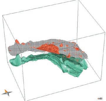
Cretaceous) source units in the study area are not sufficiently mature to have generated significant volumes of oil. This result supports previous suggestions of lateral migration of the oil present in Mesozoic reservoirs.
BIOGRAPHY
Afshin Fathi graduated from the Montan Leoben University in Austria in 2012. He has a Master degree of petroleum engineering from Petroleum University of technology (PUT). During his study in Leoben he specialized in Petroleum System Modeling and worked on Basin modeling projects with OMV and RIPI (research institute of petroleum industry). Afshin has more than 10 years’ experience of technology and software development in basin modeling area in RIPI. He also has modeling experiences in the Middle East (Iran, Iraq, Persian Gulf and Yemen) and European basins.
INFORMATION
There is no charge for the division talk and we welcome non-members of the CSPG. Please bring your lunch. For details or to present a geomodeling talk in the future, please contact Weishan Ren at (403) 724-0325, e-mail: wren@ statoil.com.
Dr. James MacEachern and Dr. Shahin Dashtgard are pleased to offer the course:
June 16-19, 2014 at the Core Research Centre
Email sdashtgard@gmail.com or phone 778-782-5492 for more details
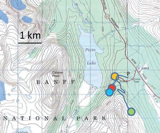
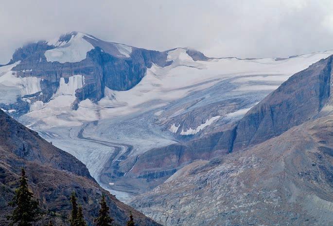
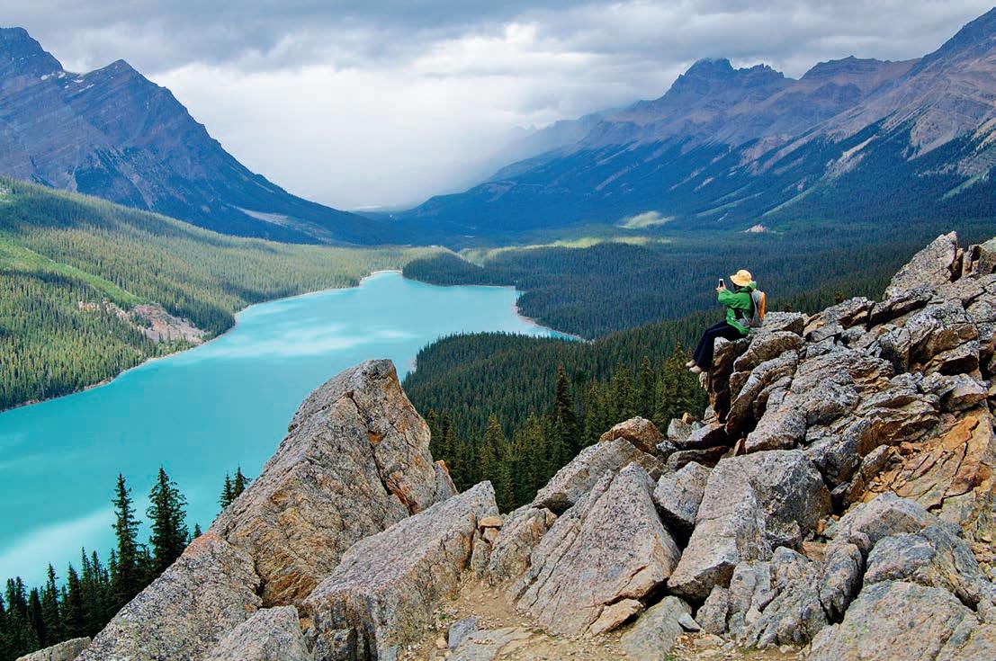
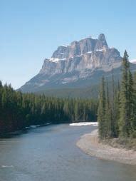
Trailhead: Proceed north on Highway 93, 40 km north of the Lake Louise junction to the Peyto Lake parking lot.
Distance: The trail to Peyto Lake viewpoint is on paved and heavily travelled trail with a return length of 1200m. It is a 6.2 km return trail and 230 m elevation gain to Bow Summit Lookout. To reach the lookout, head uphill from the viewing platform and stay right when the paved trail forks. You will come to a three way junction at an interpretive sign; continue straight ahead along an old road. The old road rises over a hill and then turns to the Southeast. It climbs steadily up the mountain slope then dips down at the foot of a rockslide only to rise again and end at Bow Summit, where a fire lookout once stood.
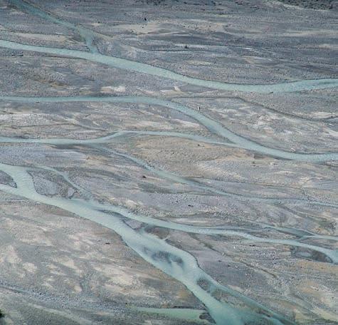
The Icefields Parkway is considered one of the most scenic highways in the world and Peyto Lake certainly offers one of the most beautiful views in the Rockies. If you just take the short stroll to the viewpoint you will have to contend with the crowds disgorged from the tour buses, but the trail that leads beyond this quickly grows quiet and the views are just as spectacular. If you go beyond the Peyto Lake viewpoint to Bow Summit, there are numerous side trails with exceptional and changing views of Peyto Lake. Take care not to get lost and don’t cut across the fragile terrain to create new trails. While not described on this hike, a side trail also leads 300m below to the
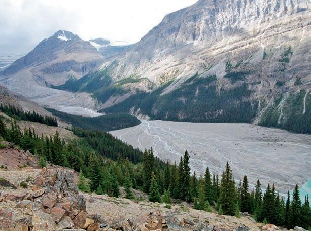
braid plain of Peyto Creek which carries the meltwaters of the Peyto Glacier to the lake.
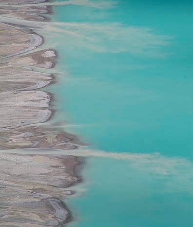
Peyto Lake changes from a deep blue in the spring to a milky turquoise in the summer. The colour is due to suspended very fine grained sediment (rock flour-mostly dolomite with minor calcite, quartz and mica), brought by glacier fed streams, which remains in the water column until it eventually settles on the floor. Obviously, the warmer months of summer are peak melt time and the lake takes on a milky aspect. Even over the short period of an afternoon the increased stream flow on the braid plain below extends the pale fingers of sediment laden water further into the lake. Given the fine nature of the particles and slow settling rate it has been observed that most of the suspended fines should be carried out of the lake by Mistaya River at the lakes north outlet. However, the flour is abundant on the lake floor in the form of fecal pellets produced by a free swimming copepod, perhaps Diaptomus arcticus or its cousins (Smith and Syvitski, 1982). The conversion of the glacial flour to pellets allow the sediment to settle on the lake floor (less than 50m) in a single day.
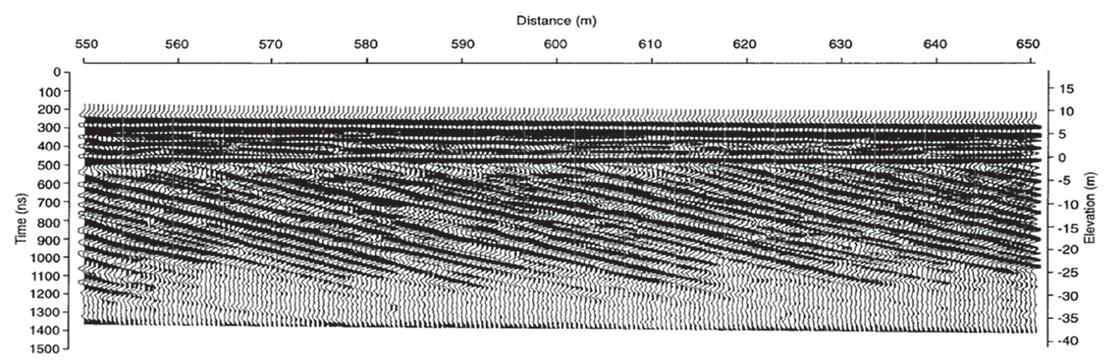
The lake occupies a valley that 13,000 years ago was full of ice during the Wisconsinan Glaciation. Sine the lake was established at the end of the Ice Age about one third of its 3 km length has been filled by a Gilbert Style delta. These kinds of deltas, characterized by steeply dipping foresets, are common in lake settings where coarse material is transported along the channel base and dumped down the delta front. A tremendous amount of material (both coarse and fine) is carried from Peyto Glacier via constantly shifting braided river channels. About 1437 m3 of gravel and other sediment is thought to be transported to the delta every year. The delta itself progrades (builds out) at about 7 cm/year and the braid plain aggrades about 1.4 mm/year (Smith and Jol, 1997). An intriguing study using ground penetrating radar (GPR) proved that this lake did contain a Gilbert style delta. Nine GPR profiles exhibited flat lying “topset” beds capping the delta and steep foreset beds dripping at 25° (the underwater angle of repose) (Smith and Jol, 1997). The foresets form as gravel carried by the streams avalanches down the slope. Instability and subsequent slumping of the foresets near the lake bottom is suggested by a switch from parallel dipping reflectors to concave or bulging patterns. The final component of the delta front is the bottomset beds, these flat lying finer grained beds sit out front of the foresets, which build over them.
References:
Smith, D.G., and Jol, H.M., 1997. Radar Structure of a Gilbert Type delta, Peyto Lake, Banff National Park, Canada. Sedimentary Geology, V.113 , No. 3-4, 195-209.
Smith, N.D., and Syvitski, J.P.M., 1982. Sedimentation in a Glacier Fed Lake: The role of Pelletization on Deposition of Fine Grained Suspensates. Journal Of Sedimentary Petrology, Vo., 52, No.2, p.503-513.
Wallace, A.L., 1995 “The volumetric change of the Peyto Glacier, Alberta, Canada, 1896-1966” (1995). Theses and Dissertations (Comprehensive). Paper 330. http://scholars.wlu.ca/etd/330.

though no topography like this graces the

lack of vegetation is evidence both of the shifting nature of the streams and also the coarse sediment on which vegetation has difficulty establishing.

The Reservoir Committee welcomes contributions from our readership to this series. If you wish to offer a submission to Go Take a Hike on your favourite hike of geological interest, email the Reservoir at Emma.MacPherson@cspg.org for more information.
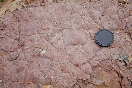
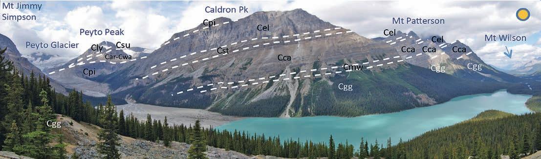
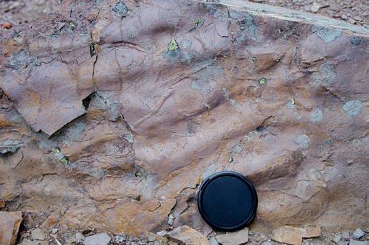
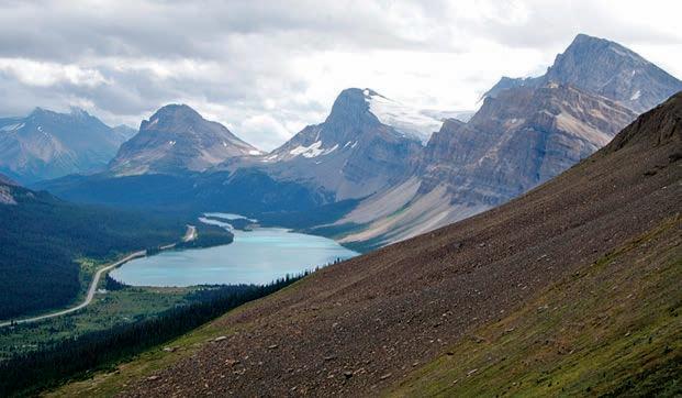
Top Left: There are multiple viewpoints of Peyto Lake if one follows the trails uphill from the main viewpoint. At your feet are the uppermost strata of the Gog Group, including the inner shelf to shallow subtidal sandstones and siltstones of the St. Piran Formation and the mixed carbonates and clastics of the Peyto Formation. The occurrence of carbonate in the Peyto Fm signals the transition to middle Cambrian carbonate platforms as the various parts of the Cambrian supercontinent Rodinia finished rifting and then began drifting apart. The outcrops of St Piran Formation along the trail exhibit evidence both of exposure (mudcrack breccias on middle left picture) and more commonly shallow water to shelf setting (ripples, burrows and spindle shaped syneresis cracks displayed in figure on middle right). Bottom Right: The reward for reaching Bow Summit is a view of Bow Lake from the flanks of Mount Jimmy Simpson. From this lake Bow River flows south and far east through the city of Calgary. Jimmy Simpson was the expedition outfitter and guide who established and ran the Num Ti Jah Lodge on the shore of Bow Lake in 1922 until his death in 1972 at the age of 95.
 by: Bill Ayrton
New geologists, engineers, geophysicists and landmen, as well as summer students entering the industr y for the first time will find the courses a very beneficial introduction to the petroleu m industry . These courses will be extremely useful to nonprofessional and support staff in the oi l and gas industry, as w ell as accountants, lawyers, brokerage and financial personnel working primarily alongside the oil and gas industry.
To register or to obtain additional information regarding in-house and upcoming courses, please contact:
Ayrton Exploration Consulting Ltd.
Tel: (403) 262-5440
Email: ayrtonex@shaw.c a
Or visit our website: www.ayrtonexploration.com
Date: April 30th and May 1st, 2014
Cost: $1050 (includes GST)
Instructor: Bill Ayrton
Effective for personnel just joining the oil patch, or for financial, accounting, and information systems personnel.
• Learn about the many facets of the industry.
• Oil finding, land acquisition, drilling, seismic, well completion, jargon and terminology.
Date: June 4th and 5th, 2014
Cost: $1050 (includes GST)
Instructor: Bill Ayrton
Effective for geological technicians or administrative staff, or for those who just want a better understanding of geology to appreciate the world around us.
• Learn about earth structure, geologic time-scale and processes, Western Canada geology, and interesting nearby locations.
• Participate in a r ock identification exercise , cross-section project and a mini-field trip in downtown Calgary.
Date: June 10th, 11th, and 12th, 2014
Cost: $1575 (includes GST)
Instructor: Bill Ayrton
Ideal for those who wish to improve their geological understanding of where and how we look for oil and gas fields in Western Canada.
• To visualize what Western Canada looked like throughout the stages of history, for example, the position of the sea versus land, what sediments were deposited, and what type of life that existed and evolved.
• To review the importance of each major stratigraphic unit, i.e. Devonian, Mississippian, Cretaceous, etc.
• Discuss the geological and seismic expression of typical oil and gas fields in each unit.
And now for something completely different…
This May, the AAPG Canada Region Young Professional Committee will be co-hosting a young professional (YP)/student-focused session with the Canadian Society of Petroleum Geologists (CSPG) and the Canadian Society of Exploration Geophysicists (CSEG) at GeoConvention 2014. The 2014 theme of GeoConvention is ‘FOCUS’ and, for the very first time, GeoConvention will put that focus on its young members during a forum entitled On Belay – FOCUSing on the Climb that is a Career in Geoscience.
On Belay will consist of two components: a morning session with presentations from senior Canadian energy industry professionals—many of which are CSPG, CSEG and AAPG leaders—and an afternoon session where young professionals from across the country will take the stage.
“If you are a student or a professional just beginning a career in geoscience, this is not to be missed!”
The concept for this session was based on

conversations with the students and YPs whom the session seeks to inform. The presentations are tailored to answer the common questions these demographics have about the industry while at the same time providing insights for senior professionals on the mindset the next generation has regarding their industry. Some of the questions include:
• What are the current and future technical requirements of the energy industry?
• What steps can I take to gain employment in the competitive Canadian job environment?
• Where/how do I fit in with a professional society?
• Is active membership in a professional society beneficial to my current and future success?
• What are human resources (HR) and what does HR they really look for in a resume?
• What can I expect in my first few years of work in the energy industry?
• How important is a network? How does one network?
On Belay ’s morning talks will provide students and young professionals with the opportunity to hear from an experienced multidisciplinary panel of speakers that
(Continued on page 26 ...)

represent all geoscience organizations in Canada. They include:
• Ron Bailey – Senior Vice President, Gas and Tight Oil, Nexen Energy ULC
• John Hogg – Candidate for AAPG President-Elect, MGM Energy
• Dale Leckie –CSPG President, Nexen Energy ULC
• Ron Larson – CSEG President, RPS Boyd PetroSearch
• Tom Sneddon – APEGA Director of Geoscience and Outreach
The On Belay session will begin with opening remarks from Dale Leckie. Following Mr. Leckie, a keynote presentation by Ron Bailey will discuss his career path and one of the hot topics in the Canadian energy industry: LNG – liquefied natural gas. Mr. Bailey’s talk is sure to draw a big crowd as he highlights Nexen Energy ULC’s LNG strategy and what LNG may mean for the future of Canada. Next, Ron Larson will present his thoughts on industry cycles, emerging economies, the technical skills required in the pursuit of tight and self-sourced hydrocarbons and finally, environmental stewardship. Tom Sneddon will present on the importance of professionalism. John Hogg will discuss energy industry demographics and, in particular, its

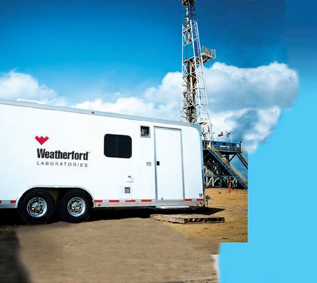
When time is money, Wellsite Geoscience is money well spent.
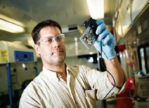
Whether you’re exploring a basin, producing a well or completing a shale play, time is money. That’s why Weatherford Laboratories brings a suite of formation evaluation technologies right to the wellsite. Utilizing mud gas and cuttings, these technologies provide detailed data on gas composition, organic richness, mineralogy and chemostratigraphy in near real time. As a result, operators now have an invaluable tool to assist with sweet spot identification, wellbore positioning, completion design and hydraulic fracturing. We call it Science At the Wellsite. You’ll call it money well spent.
SCIENCE AT THE WELLSITE ™
bimodality. Astrid Arts will provide “A Girl’s Guide to The Oil Patch.” Finally, have you ever wondered what HR really looks for when reviewing resumes? Holly Ivanko and Nancy Eaton-Doke will provide resume tips and shed light on the important considerations students should make when applying for a job.
Are you excited yet?
On Belay’s afternoon talks will highlight six young professionals. The YPs will speak to their experience working in the energy industry, discuss training programs at large companies, compare and contrast roles in E&P and service companies, touch on the finer points of networking and inform students on what they can expect as they transition (or “bridge”) from student to YP.
The YP speakers include:
• Jesse Schoengut – Canadian Natural Resources Ltd.
• Frank Ryan – Chevron
• Tiffany Yaxley – Roke Technologies Ltd.
• Marc Enter – SGS Canada Inc.
• Ryan Lemiski – Nexen Energy ULC
• Greg Baniak – BP Canada
Please note that these talks are not solely for the benefit of YPs and students. Our senior geoscience colleagues are encouraged to attend as we hope to initiate a dialogue on some of the important issues facing YPs and students. It is only by engaging our senior colleagues that we can begin to address concerns such as the impending ‘great crew change’ and how to properly capture the wealth knowledge and experience of the individuals that have worked in this industry for 30+ years.
On Belay ’s program has something for everyone and highlights growing collaboration among CSPG, CSEG and AAPG. Presentations from senior professionals and YPs will provide those in attendance with a perspective on the different benefits professional organizations offer their members and evidence that being an active member in (hopefully) more than one of these organizations can lead to a large support network and a long successful career in geoscience.
If you would like more information on this session or would like to volunteer please contact Ryan Lemiski (Ryan.Lemiski@ nexencnoocltd.com) or Marc Enter (Marc. Enter@sgs.com).


Stratigraphy of the Bad Heart Formation, Clear Hills and Smoky River areas, Alberta
B. Kafle, R.A. Olson and O. Catuneanu
Natural thermogenic gas seeps at the front of the Richardson Mountains: Indications for a petroleum system in Peel Plateau, Yukon, Canada
T.L. Allen and K.G. Osadetz
Allostratigraphy of the Peace River Formation (Albian) in north -western Alberta and adjacent British Columbia
Robin A. Buckley and A. Guy Plint
Revised stratigraphy, regional correlations and new bentonite radiometric ages for the Albian Loon River Formation, Fort St. John Group, northwestern Alberta
B. Hathway, G. Dolby, D.H. McNeil, S.L. Kamo, M.T. Heizler and N. Joyce
31th annual CSPG Squash Tournament held on Feb. 6th, 7th and 8th at the World Health Edgemont Club was a great success this year. 2014 may have been the best year yet! From
Men’s A
Men’s A Consolation
Men’s B
Men’s B Consolation
Men’s C
Men’s C Consolation
Men’s D
Men’s D Consolation
Men’s E
Men’s E Consolation
Women’s A
Women’s B
Women’s C
Women’s D
Women’s E
Women’s E Consolation
Doubles Competitive
Doubles Competitive Consolation
Doubles Rec
Doubles Rec Consolation
beginners to pros, everyone had a good time and there were some impressive skills on the court. This year’s winners were:
Trevor Slaughter
Mike Hiller
Derek Shtand
Travis Nicolle
Daniel Sharp
Chris Doyle
Zac Colbran
Trevor Dufresne
James Tsubone
Josh Doiron
Solana Jear
Sandra Deren
Jill Knebel
Alana Humphreys
Tracy Hendsbee
Jane Condie
Gord Copp/Mike Hiller
Jackie Moss/Trevor Slaughter
Thomas Weedmark/Shawn Lafleur
Cory Honstein/Luc Gravel
Yellow Team:
Sandy Bunko
Teams Tourney Winner
Teams Tourney Most Honest
Gary Bugdon
Jaycee Neumann
Tyson Frantz
Black Team:
Tina Chow
Liam Plunkett
Darin McCollum
Dawn Hodgins
Mellissa Williams
A big thank you to the prize sponsors as well:
• Escoba
• Belgo
• Local 522
• The Unicorn
• The Libertine
• Below Deck
• Core Labs
• Global Energy Services
• SeisWare
• McLeay
• Escoba
Looking forward to next year!!!
2014, www.geoconvention.com
| By David Finch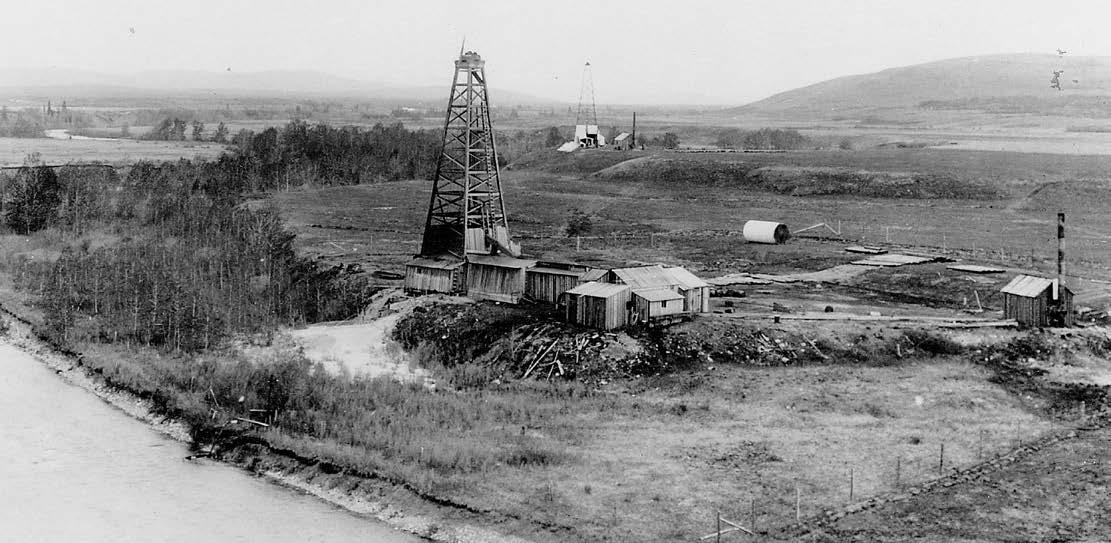
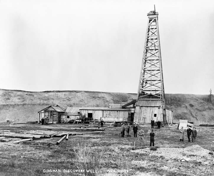
Almost lost in history, the Turner Valley oilfield story is worth revisiting. Especially this year, as GeoConvention 2014 helps celebrate the centennial of the discovery of Western Canada’s First Commercial Oilfield.
On May 14, 1914, an Alberta-based company called Calgary Petroleum Products Co. Ltd declared its first well a discovery. CPP No. 1 is also known as Dingman No. 1 – named by the news media of the day after general manager Archie Dingman.
The Discovery Well began drilling on January 25, 1913 and hit gas and condensate at many levels on its way to the 2718-foot level –on May 14, 1914. Drilling continued and final depth was 3924 feet when completed on July 1, 1916. Production was from the Home Sandstone formation. The well was successfully abandoned on June 4, 1968 and a monument to this discovery resides within the Turner Valley Gas Plant Historic Site near downtown Turner Valley.
In addition to its academic geological importance, the Turner Valley oilfield discovery was the incident that set the foundation for the development of the oil industry in Western Canada.
Calgary is the centre of the Canadian petroleum industry because of Turner Valley. It was Canada’s first 100 million barrel field. It boasted Canada’s first scrubbing plant, first high-pressure gasoline plant, first propane plant and second sulfur plant, and a gas plant that supported pilot training and explosives manufacturing during World War II. Energy pipelining in Canada also got its start here as well as oil gas banking and petroleum law... the list goes on. The CSPG also got its start, in 1927, as the Alberta Society of Petroleum Geologists, because non hard-rock explorers were working in Turner Valley and formed a society in Calgary that year.
At the centre of the Turner Valley oilfield, the Turner Valley Gas Plant historic site is the location for Centennial Celebrations planned for May 14, 2014. Plans call for the development of interpretive programs
at the historic site. Close to Calgary, it can inform school and Polytechnic and university students about the evolution of the oil industry. Visitors to Alberta can learn about oil here too along with the rest of society – even oil company employees! Visit turnervalleygasplant.org for information.
A session at GeoConvention 2014 will review the history, geology, production and greater implications of the discovery of the Turner Valley oilfield 100 years ago. Watch for details in the GeoConvention program, the mobile app and at www. geoconvention.com.
David Finch is a Calgary historian and author of the history of the CSPG.


Facies Architecture and Sequence and Stratigraphy of Delta System: From Exploration to Reservoir Performance
Janok P. Bhattacharya
Clastic Facies and Depositional Environments in Core
Bill Arnott
Evaluating Source Rocks in a Risk Analysis Framework
Nicholas B. Harris
SAGD Fundamentals - Application of Core, Geology, Geophysics and Geochemistry
Rudy Strobl, Milovan Fustic and Daryl Wightman
Dynamics of Subsurface Flow of Water and Hydrocarbons
Udo K. Weyer
Mannville Stratigraphy, Sedimentology and Petroleum Geology
Doug Cant
SAGD - Reservoir Engineering for Geoscientists & Non Reservoir Engineers
Hussain Sheikha
Turner Valley’s Centennial, A Field Trip through Changing Interpretations and Unchanging Rocks
Paul MacKay, Clinton Tippett
SAGD Fundamentals - Field Seminar in Fort McMurray, Alberta
Rudy Strobl, Milovan Fustic and Daryl Wightman
Geology of the Mount Stephen Trilobite
Beds and Adjacent Strata
Allen Kimmel
More to come…
The tournament would like to thank the following 2012 Sponsors:
Diamond Sponsors
Schlumberger of Canada geoLOGIC Systems
Little Rock Document Services
Emerald Sponsors
Weatherford Canada
Partnership
RECON Petrotechnologies Ltd.
RBC Dominion Securities
ProGeo Consultants
MJ Systems
AGAT Laboratories IHS
Platinum Sponsors
ZIPCASH
West Canadian
Paradigm Geophysical
ATB Financial
GLJ Petroleum Consultants
Gold Sponsors
Arcis Corporation
Canadian Discovery Ltd.
ConocoPhillips Canada
Continental Laboratories
Datalog Technology Inc.
Frank Pogubila
Greystone Resources Ltd.
Knowledge Energy Ltd.
Total Gas Detection Ltd.
Seismic Brokerage Services
Silver Sponsors
Cambria Business Services
Gabel Energy Inc.
Bronze Sponsors
Canadian Stratigraphic Services
Fekete Associates
Sponsorship
Halliburton Group Canada
GeoStrata Resources Inc.
Energy Navigator
Divestco Inc.
Baker Hughes
Belloy Petroleum Consulting
Belgo Brasserie
LXL Consulting
Pason Systems Corp.
McLeay Geological Consulting
National Oilwell Varco
Painted Pony Petroleum Corp.
Pajak Engineering Ltd.
Rigsat Communications
Rockwell Consulting
Sample Pro Ltd.
Sproule Associates Ltd.
Typhoon Energy Ltd.
Global Energy Services
Martin Quinn
Hydro-Fax Resources Ltd.
San Dago Resources Ltd.
Register Online at cspg.org
Go to Events/ Sporting Events/ Classic Golf.
To complete registration login to the website with your CSPG member ID.
Please call (403) 513-1233 for assistance.
2 rounds of golf at Elbow Springs
Power Cart
Driving Range
Golf Shirt
Steak Dinner at Elbow Springs
Breakfast at Elbow Springs
Awards Banquet at The Petroleum Club (for you and your guest)
Draw Prizes
Daily Skill Prizes
Sponsorship Tents, prizes and gifts AND
Chance to win two separate draw prizes to any North American Destination
Tournament
*All prices include GST
*Discounts for students, first time players and previous players who refer a first time player.
Social events cancellation or additions require 72 hours notice before the event. Please contact Scott Thain (403) 262-9229, cell (403) 999– 8558 or email: cspgclassicgolf@gmail.com
Last day for refunds Friday June 13, 2014
The Canadian Society of Petroleum Geology President’s Award is granted to individuals who have made significant contributions to the Society. It is the highest volunteer award presented annually. Often the award is presented to individuals for an activity that has been highly visible to the membership such as the running of an annual convention, dedication to the Bulletin of Canadian Petroleum Geology or some other special effort. The 2013 President’s Award is granted to Robin Mann , for his selfless work behind the scenes on projects that the membership would not be generally aware of.
Robin graduated with a B.Sc. (Honours) Geology from Dalhousie University and a M.Sc. in Geology and Geophysics from Carlton University. He began his career with Amoco Canada and worked for a series of different companies in a variety of roles in both technical and executive positions. In 1984 he established a consulting practice which eventually became AJM Petroleum Consultants where he served as CEO until its take-over by Deloitte Canada, where he still serves. Robin has been active on numerous Boards (both non-profit and for profit organizations) and is a generous volunteer with many different groups.
Robin has donated the last three years to the running of the CSPG as Vice President, President and Past President. This alone is a significant effort on behalf of the membership, howeverthis award is granted to Robin for three significant efforts he made throughout his executive term. Robin’s first major contribution during his tenure on the executive was to steer the Society through an exceptionally difficult transition and office move. Robin held the Society’s employees together as the office had to transition from one location to a temporary location and then to the final destination at its present site. This may seem a minor issue but the Society was particularly vulnerable without an established home that the members could identify. Robin sacrificed much of his own comfort to make room for the Society in his own place of business. This act of generosity was not expected or anticipated but was freely given and allowed the office staff to maintain services to the membership on an uninterrupted basis. During this time Robin provided nearly daily leadership to the Society and was a source of stability.
Another major effort by Robin was to solidify the branding of the CSPG. Again,
branding may seem a trivial issue to many of the members but branding to the Society is an integral part of the CSPG’s ability to seek sponsorship and corporate identity in a very competitive market. The CSPG brand is a successful, well recognised brand and is solidified by many of Robin’s initiatives.
The third major achievement that Robin provided that would not be immediately recognised by the membership was the successful steering of the Society to be compliant with the new federal Not-forrofit Corporations Act. This is a major change for non-profit societies in Canada. The CSPG was one of the first non-profits to adapt to the change and is fully compliant. Failure to meet this challenge was a serious threat to the status of the CSPG and its future.
Robin provided abundant advice and suggestions through his time on the executive. His help in forming the new structure for GeoConvention was extremely valuable as was his sense of how the Society needed to behave in the future to ensure that the CSPG was a leading voice for Canadian geology.
Robin Mann is a deserving recipient of the President’s Award and it is through his strong foundational leadership that our future is bright and expanding.


In Part 1 of this article, we described the workflow for a deterministic model that allows step by step calibration of the petrophysical analysis results leading to values for clay volume, kerogen volume, and effective porosity. The basis of this workflow was the shale and kerogen corrected densityneutron complex lithology crossplot model.
Part 2 below shows the remaining steps for lithology, saturation, and gas or oil in place estimates. None of these techniques are novel or new, but a review seems in order to demonstrate the importance of accuracy in the clay, kerogen, and porosity calculations.
Step 5: Lithology
Lithology is calculated with a kerogen and shale corrected 2-mineral PE model or a 3-mineral model using kerogen-and shale corrected PE, density, and neutron data. Calibrate results to XRD data. Modify mineral selection or mineral end points to achieve a reasonable match.
Some people use a multi-mineral or probabilistic software package to solve for all minerals, including porosity and kerogen, treating the latter two as “minerals.” In the case of rough borehole conditions, this method gives silly results unless a badhole discriminator curve is also used. These models are more difficult to tune because it is not possible to calibrate shale volume, TOC weight fraction, effective porosity, and mineralogy in a step-by-step sequence, as can be done with the deterministic model described here. Changing parameters in the multi-mineral model, to strive for a better match to ground truth, often gives unexpected results. It is a multi-dimensional jigsaw puzzle and some of the pieces just won’t fit unless you trim them in the correct sequence.
To reduce this problem, calibrate shale volume kerogen volume and effective porosity by the deterministic method shown earlier, then use these as input curves as constraints in the multi-mineral model. Recently, we have seen excellent examples
of elemental capture spectroscopy inversions that produce TOC, clay, and mineral weight fractions. TOC and XRD lab data are still used to drive the inversion in the correct direction.
From here onward, petrophysical analysis follows normal procedures. Water saturation is best done with the Simandoux equation, which is better behaved in low porosity than most other models. Dual water models may also work, but may give silly results when shale volume is high or porosity is very low.
In many cases, the electrical properties must be varied from world average values to get Sw to match lab data. Typically A = 1.0 with M = N = 1.5 to 1.8. Lab measurement of electrical properties is essential. Skipping this step is the worst form of false economy. The wrong M and N values can give zero OGIP!
Calibration can be done with core water saturation or capillary pressure data. Both pose tricky problems in unconventional reservoirs, especially those with thin porosity laminations, so common sense may have to prevail over “facts”.
Permeability from the Wyllie-Rose equation works extremely well even in low porosity reservoirs. We generally assume that the calculated water saturation is also the irreducible water saturation for this model, although this assumption may be incorrect in a few cases. The calibration constant in the Wyllie-Rose equation can range between 100,000 to 150,000 and beyond, and is adjusted to get a good match to conventional core permeability.
An alternative is the exponential equation derived from regression of core permeability against core porosity. The equation takes the form Perm = 10^(A1 * PHIe + A2). Typical values for A1 and A2 are 20.0 and –3.0 respectively. This model will match conventional core permeability quite well, but will probably not match the permeability derived from crushed samples using the GRI protocol. High perm data points caused by microor macro fractures should be eliminated before performing the regression.
Reconstructed or synthetic logs have become an important part of a competent petrophysical workflow. We go to
some pains to use only valid data in our petrophysical analysis, omitting bad data from our models. Reconstructed logs are generated from those results using the Log Response Equation.
There are two reasons for reconstructing the well logs. The first is to verify that the parameters used in all steps are reasonable. In good borehole conditions, the reconstructed logs should be close overlays of the original logs. If they are not, possibly some bad data snuck in, or some parameters in the overall model are wrong. You will need to use your CSI skills to chase down the guilty party and rectify the problem. A good match between reconstructed and original logs is not a guarantee of success, but it is one more piece of evidence pointing in that direction.
The second reason for reconstruction is to prepare a strong foundation for calculating rock mechanical properties. Mechanical properties developed from raw logs often contain spikes and noise, or worse, that destroys the stimulation design results. We strongly recommend that stimulation design should ALWAYS
(Continued on page 36 ...)
Work on Canadian Discovery and partners’ Duvernay Project is well underway. This study evaluates the Geomechanics, Hydrocarbon Systems and Geological Setting of the Devonian Duvernay Formation in the Kaybob to Willesden Green Area.
Results to date indicate:
» Variable lithology and a well-defined facies/ lithology dependent fracture fabric
» Stratigraphy shows a possible extension to the current play areas
» Geochemistry shows source rock maturity is strongly related to heat flow variations
A geomechanical
detailed geochemistry, hydrogeology and reservoir mapping will be completed prior to study delivery.
Contact Cheryl Wright
use edited or reconstructed logs, which presupposes that sufficient time and talent be allowed by management for this step to take place.
During reconstruction, we can also create missing logs, such as the shear sonic curve, for use in the mechanical properties calculation or for comparison to other wells in the project.
All well completions in unconventional reservoirs involve expensive stimulation programs. Hydraulic fracture design depends on an accurate evaluation of rock mechanical properties based, in turn, on an advanced petrophysical analysis. Most frac design programs have only a rudimentary capacity to perform petrophysical analysis. Worse still, frac design software uses the raw, unedited log data with all its problems. Nothing good can come from this. So it is better to do the work outside the frac software and import the mechanical property curves.
The first step to accurate mechanical properties is a reconstruction of the sonic shear and compressional and density
data to remove the effects of bad hole and light hydrocarbons. The frac design programs need the water filled case so the reconstruction is always needed in gas zones. More information on how to do this can be found at www.spec2000. net/10-mechsyn.htm.
The usual outputs from this step are shear modulus, velocity ratio, Poisson’s ratio, bulk modulus, Young’s modulus (both dynamic and static), Lame’s constant, and a brittleness coefficient. The original and reconstructed log curves, and the lithology track, are displayed with the mechanical properties results.
Triaxial (static) and dynamic lab measurements can be used to help calibrate the mechanical properties calculated from the petrophysical model. In the absence of lab data, most of these results must fit within known ranges, depending on lithology. If values are out of range, we must suspect the input data and check the log reconstruction procedure. This in turn depends on the current state of the petrophysical results, leading us to double check all parameters and calibration steps. This kind of manual iteration is a normal part of a petrophysicist’s daily grind.
Once all these checks and balances are satisfied, we can get on with finding the “real” answers. Unfortunately, this is where the world gets a little fuzzier.
In many shale gas and some shale oil plays, typical porosity cutoffs for net reservoir are as low as 2 or 3% for those with an optimistic view, and between 4 and 5% for the pessimistic view.
The water saturation cutoff for net pay is quite variable. Some unconventional reservoirs have very little water in the free porosity so the SW cutoff is not too important. Others have higher apparent water saturation than might be expected for a productive reservoir. However, they do produce, so the SW cutoff must be quite liberal; cutoffs between 50 and 80% SW are common.
Shale volume cutoffs are usually set above the 50% mark. Multiple cutoff sets help assess the sensitivity to arbitrary choices and give an indication of the risk or variability in OGIP or OOIP calculations.
Now we move into the reservoir

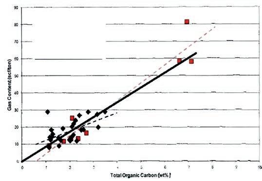
Figure 5: Crossplots of TOC versus adsorbed gas (Gc) for Tight Gas / Shale Gas examples. Note the large variation in Gc versus TOC for different rocks, and that the correlations are not always very strong. These data sets are from core samples. Cuttings give much worse correlations. The fact that some best fit lines do not pass through the origin suggests systematic errors in measurement or recovery and preservation techniques.
engineer’s territory, but it doesn’t hurt to know where our petrophysical results end up. If you have never done the math before, it can be quite instructive – it is much easier to compare zones or wells on the basis of OOIP or OGIP instead of average porosity, net pay, or gross thickness.
Free gas in place is calculated from the usual volumetric equation:
1: Bg = (Ps * (Tf + KT2)) / (Pf * (Ts + KT2)) * ZF
2: OGIPfree = KV4 * PHIe * (1 - Sw) * THICK * AREA / Bg
For oil reservoirs:
3: OOIP = KV3 * PHIe * (1 - Sw) * THICK * AREA / Bo
Where:
• Bg = gas formation volume factor (fractional)
• Bo = oil formation volume factor (fractional)
• Pf = formation pressure (psi)
• Ps = surface pressure (psi)
• Tf = formation temperature (‘F)
• Ts = surface temperature (‘F)
• ZF = gas compressibility factor (fractional)
• KT2 = 460’F
• KV3 = 7758
• KV4 = 0.000 043 560
If AREA = 640 acres and THICK is in feet, then OGIP = Bcf/Section (= Bcf/sq.mile).
OOIP is in barrels per square mile. Multiply meters by 3.281 to obtain thickness in feet.
Step 12: Adsorbed Gas In Place TOC is widely used as a guide to the quality of shale gas plays. This only pertains
to adsorbed gas content and has no bearing on free gas or oil. Some deep hot shale gas plays have little adsorbed gas even though they have moderate TOC content. Using correlations of lab measured TOC and gas content (Gc), we can use log derived TOC values to predict Gc, which can then be summed over the interval and converted to adsorbed gas in place. Sample correlations are shown in Figure 5.
Gas content from a best fit line versus TOC can be applied to log derived TOC:
4: Gc = KG11 * TOC%
Where:
• Gc = gas content (scf/ton)
• TOC% = total organic carbon (percent)
• KG11 = gas conversion factor range = 5 to 15, default = 9
Adsorbed gas in place is derived from:
5: OGIPadsorb = KG6 * Gc * DENS * THICK * AREA
Where:
• DENS = layer density from log or lab measurement (g/cc)
• KG6 = 1.3597*10^-6
If AREA = 640 acres and THICK is in feet, then OGIP = Bcf/Section (= Bcf/sq.mile)
• Multiply meters by 3.281 to obtain thickness in feet.
• Multiply Gc in cc/gram by 32.18 to get Gc in scf/ton.
A more sophisticated approach uses the Langmuir adsorption curve which can be
derived from reservoir temperature and pressure. The correlation of Gc wth TOC seems to be adequate but the Langmuir method would be a useful calibration step.
A full suite of TOC and XRD mineralogy from samples, along with core porosity and saturation data, are needed to calibrate results from any petrophysical analysis of unconventional reservoirs. The deterministic shale and kerogen corrected workflow allows all available ground truth data to be used in a logical and consistent manner at each step to calibrate and refine results.
From our experience, we have found that net pay and gas or oil in place estimates are very sensitive to small errors in effective porosity caused by poorly calibrated clay and kerogen volume. An error of as little as 0.5% porosity can make or break a play. This is why over-simplified methods are inappropriate, even dangerous, because some of the answers derived from petrophysical analysis now appear in public, in the form of investor information handouts and quarterly reports.
Petrophysical analysis results travel well beyond the initial need to know porosity and water saturation. Oil and gas in place, reservoir stimulation, and placement of horizontal wells are impacted. Shortcuts are not acceptable. In the end, the cost of the full analysis is trivial compared to the cost of completion, or worse, the cost of an unsuccessful or unnecessary completion.
(Continued on page 38 ...)
Cabra Consulting Ltd.
Cougar Consultants, Inc.
RIGSAT Communications
Total Gas Detection Ltd.
Apache Canada Ltd.
Continental Laboratories (1985) Ltd.
Advanced Flow Technologies
Crescent Point Energy
EV Cam Canada Inc.
Serpa Petroleum Consulting Ltd.
RPS Energy Canada Ltd.
Canada Brokerlink Inc.
Energy Navigator
Exova Canada Inc
GranTierra Energy Inc.
Sigma Explorations Inc.
Pason System Corp.
Pulse Seismic Inc
Serpa Petroleum Consulting Ltd.
Compass Directional Services
Fekete
Core Laboratories
Edge Technologies Inc.
BDO Canada LLP
Birchcliff Energy Ltd.
Datalog Technology Inc.
GeoSpace Technologies
Knowledge Reservoir
Sproule Associates Limited
Geotir
Glacier Exploration Surveys
Matrix Solutions Inc.
McDaniel & Associates Consultants Ltd.
Mcleay Geological Consultants Ltd.
National Oilwell Varco
Statcom Ltd.
Matrix Geoservices Ltd.
Maxam Seismic Explosives
SAExploration
Trident Exploration Corp.
Sourcex
Regent Resources
Nickpoint Environmental Services
AS
CSPG
(...Continued from page 37)
E. R. (Ross) Crain, P.Eng. is a Consulting Petrophysicist and Professional Engineer, with over 50 years of experience in reservoir description, petrophysical analysis, and management. He is a specialist in the integration of well log analysis and petrophysics with geophysical, geological, engineering, stimulation, and simulation phases of the oil and gas industry, with widespread Canadian and Overseas experience. He has authored more than 60 articles and technical papers. His online shareware textbook, Crain’s Petrophysical Handbook, is widely used as a reference for practical petrophysical analysis methods. Mr. Crain is an Honourary Member and Past President of the Canadian Well Logging Society (CWLS), a Member of SPWLA, and a Registered Professional Engineer with APEGA ross@spec2000.net
Dorian Holgate is the principal consultant of Aptian Technical Limited, an independent petrophysical consulting practice. He graduated from the University of Calgary with a B.Sc. in Geology in 2000 and completed the Applied Geostatistics Citation program from the University of Alberta in 2007. After graduation, he began working in the field for BJ Services (now Baker Hughes) and completed BJ’s Associate Engineer Program. Later, he joined BJ’s Reservoir Services Group, applying the analysis of well logs to rock mechanics to optimize hydraulic fracturing programs. In 2005, Dorian joined Husky Energy as a Petrophysicist and progressed to an Area Geologist role. He completed a number of petrophysical studies and built 3-D geological models for carbonate and clastic reservoirs. Dorian holds membership in APEGA, CSPG, SPE, SPWLA, and CWLS. dorian@aptianpetrophysics.com
to be a corporate member today!


www.apega.ca
The Association of Professional Engineers and Geoscientists of Alberta invites its Members to help shape their Association and their professions.
Online polls open at 9 a.m., Monday, March 3 and close 12 p.m., Sunday, April 6.
Visit apega.ca to learn more.