RETURN UNDELIVERABLE CANADIAN ADDRESSES TO: CSPG – 150, 540 – 5th Ave SW Calgary, AB, T2P 0M2 $7.00 MARCH/APRIL 2017 VOLUME 44, ISSUE 2 Canadian Publication Mail Contract – 40070050 Challenging Doctrine In This Issue... How Deep Is Shallow? An Examination of Paradigms Governing Interpretation of the Cretaceous Cardium Formation in Alberta The Argument for Tidal and Brackish Water Influence in the McMurray Formation Reservoirs The McMurray Conundrum Salt, Oil, Gas & Metals: What Drives the Link?

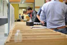
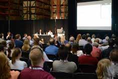
If you haven’t been to a Core Conference before, you are in for a treat! The conference will be held in the world -class AER Core Research Centre. This facility houses 1.55 million boxes of well core. Posters also enhance the Core Conference experience. Exhibitors provide scheduled talks summarizing their displays and remain with their core to discuss concepts and features.
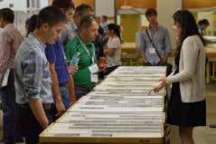
Displays will include both conventional and unconventional plays; siliciclastics, carbonates and evaporates, shales, oil san ds, as well as some di splays relating to carbon capture technology. We hope you will extend your stay in Calgary to attend this two-day post GeoConvention 2017 on May 18th & 19th, 2017!
Registration Now Open
General Delegate Registration: $175.00
Core Presenter Registration: $150.00
Bulk Registration
3 x General Registration $ 375.00 ($50 savings per person)
5 x General Registration $ 500.00 ($75 savings per person)
Core Meltdown Ticket*: $ 25.00
*One Core Meltdown Ticket is included with general and presenter registrations.

Visit www.cspg.org to Register Today!
BOARD OF DIRECTORS 2017
CSPG OFFICE
#150, 540 - 5th Ave SW
Calgary, Alberta, Canada T2P 0M2
Tel: 403-264-5610
Web: www.cspg.org
Please visit our website for all tickets sales and event/course registrations Office hours: Monday to Friday, 8:30am to 4:00pm
The CSPG Office is Closed the 1st and 3rd Friday of every month.
OFFICE CONTACTS
Membership Inquiries
Tel: 403-264-5610
Email: membership@cspg.org
Advertising Inquiries: Emma MacPherson
Tel: 403-513-1230
Email: emma.macpherson@cspg.org
Sponsorship Opportunities: Lis Bjeld
Tel: 403-513-1235
Email: lis.bjeld@cspg.org
Conference Inquiries: Kristy Casebeer
Tel: 403-513-1233
Email: kristy.casebeer@cspg.org
Accounting Inquiries: Nancy Mosher
Tel: 403-513-1232
Email: nancy.mosher@cspg.org
Executive Director: Lis Bjeld
Tel: 403-513-1235, Email: lis.bjeld@cspg.org
EDITORS/AUTHORS
Please submit RESERVOIR articles to the CSPG office.
Submission deadline is the 23rd day of the month, two months prior to issue date. (e.g. January 23 for the March/April issue)
To publish an article, the CSPG requires digital copies of the document. Text should be in Microsoft Word format and illustrations should be in TIFF format at 300 dpi., at final size.
CSPG COORDINATING EDITOR
Emma MacPherson, Programs Coordinator, Canadian Society of Petroleum Geologists
Tel: 403-513-1230, emma.macpherson@cspg.org
The RESERVOIR is published 6 times per year by the Canadian Society of Petroleum Geologists. The purpose of the RESERVOIR is to publicize the Society’s many activities and to promote the geosciences. We look for both technical and non-technical material to publish.
The contents of this publication may not be reproduced either in part or in full without the consent of the publisher. Additional copies of the RESERVOIR are available at the CSPG office.
No official endorsement or sponsorship by the CSPG is implied for any advertisement, insert, or article that appears in the Reservoir unless otherwise noted. All submitted materials are reviewed by the editor. We reserve the right to edit all submissions, including letters to the Editor. Submissions must include your name, address, and membership number (if applicable).The material contained in this publication is intended for informational use only.
While reasonable care has been taken, authors and the CSPG make no guarantees that any of the equations, schematics, or devices discussed will perform as expected or that they will give the desired results. Some information contained herein may be inaccurate or may vary from standard measurements. The CSPG expressly disclaims any and all liability for the acts, omissions, or conduct of any third-party user of information contained in this publication. Under no circumstances shall the CSPG and its officers, directors, employees, and agents be liable for any injury, loss, damage, or expense arising in any manner whatsoever from the acts, omissions, or conduct of any third-party user.
Printed by CBN Commercial Services, Calgary, Alberta.


PRESIDENT
Mark Cooper
Sherwood Geoconsulting Inc. presidentelect@cspg.org
PAST PRESIDENT
Greg Lynch
Shell Canada Ltd. pastpresident@cspg.org
FINANCE DIRECTOR ELECT
Jim Barclay
directorfinanceelect@cspg.org
DIRECTOR
John Cody
Statoil Canada Ltd. industryrelations@cspg.org
DIRECTOR
Kevin Parks
Alberta Energy Regulator kevin.parks@aer.ca
EXECUTIVE DIRECTOR
Lis Bjeld
CSPG lis.bjeld@cspg.org


PRESIDENT ELECT
Clint Tippett presidentelect@cspg.org
FINANCE DIRECTOR
Shelley Leggett
NAL Resources Ltd. directorfinance@cspg.org
DIRECTOR
Mark Caplan conferences@cspg.org
DIRECTOR
Alex MacNeil
Osum Oil Sands Corp. AMacNeil@osumcorp.com
DIRECTOR
Michael Webb
Suncor Energy mwebb@suncor.com
RESERVOIR ISSUE 2 • MARCH/APRIL 2017 3

THANK-YOU TO ALL OF OUR SPONSORS


SAMARIUM SPONSOR


DIAMOND SPONSORS


TITANIUM SPONSORS


SILVER SPONSORS PLATINUM SPONSORS


BRONZE SPONSORS


CORPORATE SUPPORTERS
IHS Markit
XRF Solutions Ltd
Husky Energy Inc.
RIGSAT Communications
Bannatyne Wealth Advisory Group
RPS Energy Canada Ltd.
Canadian Global Exploration Forum
CMC Research Institutes, Inc.
Encana
Halliburton


LXL Consulting Ltd.
Mount Royal University
RS Energy Group
Schlumberger Canada Limited
Birchcliff Energy Ltd.
Pulse Seismic Inc
CAPL
ConocoPhillips
Earth Signal Processing Ltd.


McDaniel & Associates Consultants Ltd.

T. Cadrin Holdings Ltd.
MEG Energy Corp.
Valeura Energy
Midwest Surveys
Navigator Resource Consulting
Synterra Technologies
Baker Hughes Calgary
Roke Technologies Ltd.
Signature Seismic Processing Inc.
Tectonic Energy Consulting Inc.
*As of January 31st
4 RESERVOIR ISSUE 2 • MARCH/APRIL 2017 CORPORATE SPONSORS/SUPPORTERS
 Thomas
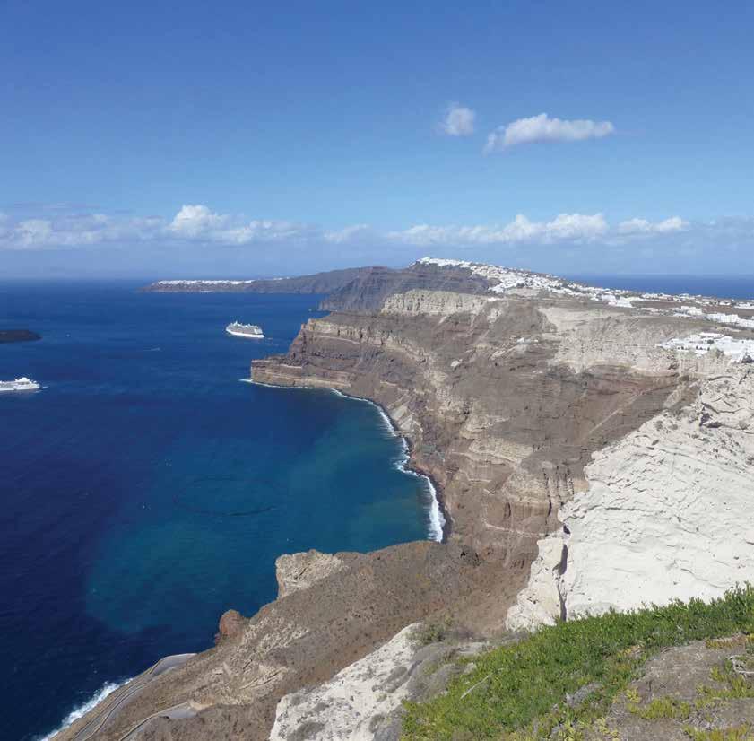
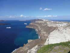
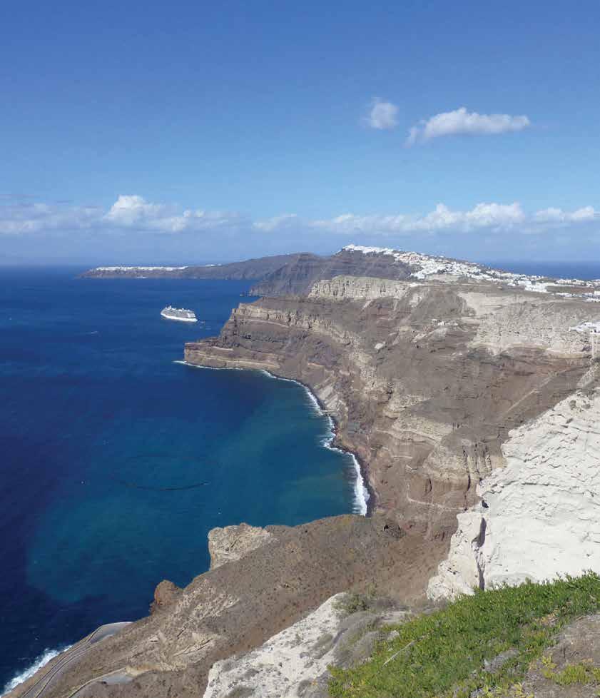
RESERVOIR ISSUE 2 • MARCH/APRIL 2017 5 TABLE OF CONTENTS FRONT COVER Santorini, Aegean Sea. The Greek Mediterranean island of Santorini is formed from the 300m high eastern caldera wall of the Thera volcano. The white rock in the foreground is the product of a cataclysmic eruption that is thought to have destroyed the Minoan civilization on nearby Crete around 1613 B.C. The water depth in the caldera is up to 400m. Although the volcano is considered to be dormant, minor activity associated with volcanism has occurred in recent times.
Frisch MARCH/APRIL 2017 – VOLUME 44, ISSUE 2 MONTHLY SPONSORS 4 MESSAGE FROM THE BOARD ............................................................................6 MESSAGE FROM THE EDITORS ........................................................................7 TALKING WITH ARCHITECTS ............................................................................9 CHALLENGING DOCTRINE THEME ARTICLES How Deep Is Shallow? An Examination of Paradigms Governing Interpretation of the Cretaceous Cardium Formation in Alberta 13 The argument for tidal and brackish water influence in the McMurray Formation Reservoirs .............................................................................................21 The McMurray Conundrum ...................................................................................25 Salt, Oil, Gas & Metals: What Drives the Link? 30 UPCOMING EVENTS Technical Luncheons 41 Division Talks 44 SOCIETY NEWS Medal of Merit 2016 50 GeoConvention 2017 ..............................................................................................52 2017 Core Conference ............................................................................................54 FROM THE ARCHIVES .........................................................................................55

CSPG EDUCATION: SHAPING OUR FUTURE
By Mark Caplan (Education Director), Amy Fox (Spring Education Chair), Kristy Casebeer (CSPG Events Coordinator)
The great Greek philosopher Aristotle once said about education, “The roots of education are bitter, but the fruit is sweet”. He also said “It is the mark of an educated mind to be able to entertain a thought without accepting it”. The quest for knowledge should be neverending. In fact, with the technological improvements in software and new concepts being developed in academia and industry, it is becoming increasingly difficult, yet critical for professionals of most industries to keep up with such changes. Geologists are no exception to this phenomenon. With a reduction in the number of courses being offered by some training organisations this year, the CSPG is stepping up to offer a wide array of courses at all levels from junior to advanced.
Welcome! I am your new Education Director, and I am looking forward to contributing to the education portfolio. Continuing education will aid members fulfil educational training requirements, expedite professional duties, and obtain the necessary credits to maintain APEGA professional designation. I am taking over from Eric Street who laid the groundwork for changes to the education program. Thank you Eric for all your hard work! I am looking forward to instigating and building the education portfolio.
The CSPG is aiming to provide geologists with the necessary knowledge to succeed at our jobs by offering a comprehensive series of high-quality educational applied training options. We aim to achieve this by offering two education weeks each year: one in May and one in October. They will be aptly referred to as “Spring Forward to Education” and “Fall Back to Education”, respectively.
These education plans will be accomplished
through two dedicated and talented committees. A very strong committee has already been established for the May Spring Forward to Education week chaired by Amy Fox and comprising George Pinckney and Ryan Brenner. Geological education would be incomplete without field trips. Our field trip chair is Jenni Scott of Mount Royal University.
None of these ideas would work without the tireless assistance of Kristy Casebeer and other staff from the CSPG office. We are proud of these individuals and thank them for their valuable contributions. That being said, we are looking for additional help to chair and organise the Fall Back to Education week, and require a committee for the field trips as well. If anyone would be interested in volunteering a few hours of their time per month to this great cause, please contact Kristy Casebeer at the CSPG office.
For the Spring Forward to Education Week, which will be held from May 5th to May 12th, 2017, the CSPG is taking a slightly different approach to Education. There will be an assortment of courses being offered with up to four concurrent courses being run each day. CSPG members and non-members will be able to choose from a broad range of half-day, one-day and two-day courses; all at very affordable rates. In reflection of the difficult economic climate, this event is made possible thanks to many generous companies and instructors who are donating time and resources. We are also fortunate to have access to the geoLOGIC Classroom on the second floor of the Aquitaine Tower, as well as use of Halliburton’s classroom. At the time of writing this article, we have 19 confirmed courses as well as 2 field trips planned. What’s more, most
of the courses should qualify for APEGA Professional Development Hour (PDH) credits. Courses are organised into a series of themes that include, environmental geology, core analysis, structural geology, sedimentology, geomechanics, geological exploration, oil sands geological methods and geomodelling.
Check out these courses online at www. cspg.org
We are also pushing forward with a “Fall Back to Education Week” in October and hope to have some excellent new courses on offer for you to take. I am excited by the changes that are taking place to the education portfolio. The breadth of these courses will allow you to find something applicable to learn whether you work in unconventional shale plays, conventional plays, oil sands plays or other areas. There should be something for everyone.
Should you have any ideas for educational courses that the CSPG could offer in the future, please contact Kristy Casebeer at the CSPG. We would be very happy to hear your suggestions and discuss them with you. Moreover, if you are interested in volunteering on an education committee please reach out to Kristy Casebeer. Lastly, please do visit the education page at the CSPG website for more details and to register for this event. Don’t delay as these courses will surely fill up quickly!
As Benjamin Franklin once said, “An investment in knowledge pays the best interest”. The CSPG is committed to offering great educational opportunities to everyone, and firmly believes that education is the foundation to success. We look forward to seeing you at one of these events.
6 RESERVOIR ISSUE 2 • MARCH/APRIL 2017
MESSAGE FROM THE BOARD

Jason Frank is a Professional Geologist who holds a B.Sc. and M.Sc. from the University of Alberta. He has over 16 years of experience in oil and gas including technical and leadership positions in exploration and development both on and offshore. Past experience includes Shell Canada Ltd., Burlington Resources Ltd., ConocoPhillips Canada Ltd., and Talisman Energy Inc. Jason has volunteered for the Society in the past, most recently chairing the Duvernay session at the Society’s annual convention (2014) and the Honourary Address Committee.

Travis Hobbs is an undergraduate from University of Calgary with a graduates degree from Simon Fraser University in Geology. Professionally has worked both domestically and internationally for 19 years in the Oil & Gas industry, and is currently celebrating 15 years with Encana. Industry roles have included development, exploration, management and business development. Prior to the Reservoir, Travis has held previous roles on convention committees and six years as the Chair of Continuing Education. As free time permits Travis enjoys cycling, cross-country skiing and teaching his two daughters violin.
CHALLENGING DOCTRINE RESERVOIR ISSUE
Welcome to the second themed edition of the Reservoir, “Challenging Doctrine.” Have you ever followed along with something, just because it was done that way in the past? Never questioning why you are doing it? Just going along with the accepted? We have collected a series of papers in this edition that will cause you to pause, and to relook at what you thought was “known,” and potentially come away with a different point of view, or at least a different frame of reference.
An interesting point we’d like to mention, is that the majority of the papers presented in the edition were all the product of conferences held in Calgary over the last year. Conferences are vital to airing new ideas, and generating discussion. At times we may get push back with respect to attending a conference or a talk, but it should go without saying that these are the venues for new ideas, or concepts. To stay current, it is imperative that one attends and is actively involved. We will be highlighting material from the 2017 GeoConvention in the upcoming May/ June edition.
The papers within this edition are all observationally based, taking what we Geoscientists are good at, and offering different views on ‘the established.’ In Mike Blum’s paper, “the McMurray Conundrum” his work in the modern environment is used to question how we view fluvial/incised valley architectures
in the Fort McMurray Formation. As a follow up, Murray Gingras and Dale Leckie have also offered their thoughts on potential reinterpretations of the McMurray Formation. Denis Meloche presents interesting ideas on the roles of water depth and its impact on regional Cardium deposition, challenging some of the paradigms that were developed for clastic deposition. Lastly, John Warren presents a very interesting linkage between salt and its association with elevated levels of economic hydrocarbon and metal occurrences in the rock record.
A conversation with Brain Tuffs, CEO Sinopec Canada, in “Talking with Architects” garners insights into a very impactful geologist who through his career has pushed the preverbal envelope. Specifically, Brian Tuff’s early “unconventional” Montney exploration helped paved the way for this world class resources into fruition. The tight sandstones of the Montney at the moment is arguably the strongest economic gas/ condensate play in Western Canada.
We hope this edition of the Reservoir makes you question what is considered the “accepted.” Even the simplest observation is a powerful ally in aiding this change in view.
In closing, we’d like to leave you with this quote, “somewhere, something incredible is just waiting to be known” - Carl Sagan
RESERVOIR ISSUE 2 • MARCH/APRIL 2017 7
Jason Frank
Technical Editor for the CSPG Reservoir Sr. Geologist at Athabasca Oil Corporation
Travis Hobbs
Technical Editor for the Reservoir Professional Geologist at Encana
MESSAGE FROM THE EDITORS
would like to thank the following 2016 sponsors:
Diamond Sponsors
AGAT Laboratories
Cambria Business Services
geoLOGIC Systems
Little Rock Printing Schlumberger of Canada
Emerald Sponsors
Chinook Consulting Services
Gold Sponsors
Belloy Petroleum Consulting
Loring Tarco Labs Ltd.
M J Systems
Pason Systems Corp.
RBC Dominion Securities Trimble Engineering Associates Ltd.
Silver Sponsors
Pro
Typhoon Energy Ltd.
Sponsorship Welcome, Contact Randy Smith
(403) 968-9222 or email: drrock@shaw.ca
Tournament Information
Schedule: Thursday June 22, 2017
6:00am Breakfast
7:30am Shotgun Start
12:30pm Lunch Break
4:30pm 19th hole
5:30pm Awards BBQ
Where: Elbow Springs Golf Club
Format: 2-person teams - Enter with partner of any skill level for three 9-hole matches against other teams of equitable skill level
Cost: Member’s Price - $179 +GST
Non-member’s Price - $199 +GST
Online registration and payment only.
To register, go to CSPG.org and select the following tabs: “Events,” “Sporting Events,” and “Classic Golf.” or Classic Golf on the home page. Registration limited to 64 players, please register early.
27 holes of golf with powercart, driving range & awards BBQ, golf shirt, skill prizes door prizes, on-course refreshments
Shirt Size: Ladies: XS/S/M Men: S/M/L/XL/XXL Partner’s info if registering individually:
Shirt Size: Ladies: XS/S/M
Men: S/M/L/XL/XXL
56thCLASSIC2017 56th A NNU AL C SPG CLA SSI C El bow S pr i ngs G o lf Cl ub • T hursday June 22 , 201 7 cspg.org
What you get:
Geo Consultants
For 2017, the charity selected is the CSPG Foundation. Call
to starting registration please have the following information: Name/Company/Phone/ Business Email/Personal Email
Scott ain for more information 403-262-9229 Prior
Handicap: HCP/Index/Score
Partner’s
Name/Company/Phone/ Business Email/Personal Email
TALKING WITH ARCHITECTS
Interview with Brian Tuffs
By Travis Hobbs
Brian Tuffs joined Sinopec Canada in February 2012 as Chief Executive Officer in October 2014, and had previously served as Executive Vice President, Business Development and Exploration. Prior positions include: Principal and Head of Acquisitions and Divestitures at Peters & Co. Limited, management positions of increasing responsibility at Encana and predecessor Alberta Energy Corporation (notably the Team Lead for Swan Lake for the first Montney horizontal and multistage fracturing) and senior technical professional and manager at Norcen Energy Limited. Brian Tuffs holds a Bachelor of Science degree from the University of Newcastle upon-Tyne and a Master’s Degree in Geology from the University of Saskatchewan. And to steal a quote from Jeremy Clarkson “he is also very tall”.
Questions more on a technical background:
1) Who were the influences on your work during your early education/training? Is there a seminal experience you feel every Geologist should have to call themselves a “Geologist?”
(i). Throughout both my academic and professional careers, I’ve had fantastic opportunities to work with and learn from some peers who were not only great geoscientists, but overall, great role models. For example, as a graduate student working
at Shell, my first supervisor (Johannes Thiessen) enriched my career direction and opened my mind to the world of upstream energy industry. He was one of the many enthusiastic industry and academic mentors who stressed the importance of marrying detailed geologic understanding with practical business application. Without his influence and direction, I’m not sure that I would have even entered into the upstream energy industry.
(ii). In my opinion (I’m a little old school), to call yourself a Geologist you need field experience. Whatever we may end up doing professionally, having spent time doing field work and really examining the rocks in person will always be valuable. From an academic standpoint, I was fortunate enough to be able to do extensive field work both for my Bachelor’s degree (honours thesis doing solo geologic mapping in the French Alps) and as a part of my Master’s research (depositional analysis of upper Cambrian strata in the Canadian Rockies).
2) What is your best field memory (hike/ field work/looking at rocks)?
I’ve had numerous field experiences that I reflect fondly on, however, there are two memories that stand out. I was lucky enough to grow up on the north-east coast of England. I was right next to some of the classic Jurassic and Cretaceous strata and had an enthusiastic father who took the

family out fossil hunting and exploring abandoned iron ore mines (Jurassic Oolitic ironstone). My first ‘real’ field work was for my honours thesis, comprised of individual field mapping in the internal Alps of France. This was a major shock to the system having previously only experienced the familiar stratigraphy and structural geology of the UK. Being faced with ‘real’ mountains, new stratigraphy, low grade metamorphics and structural complexity really challenged my preconceptions to a point where I thought it would be an impossible task. Like many challenges, slow and steady progress was made by chipping away at the unknown: gathering data, building up, breaking down


RESERVOIR ISSUE 2 • MARCH/APRIL 2017 9 J. Douglas Uffen, P.Geoph (APEGA), P.Geo (APEGBC) Over 30 years of experience in Seismic Interpretation Coordinate Geoscience Project Management / Business Development Initiatives Domestic (Plains & Foothills) / International Conventional / Unconventional Exploratory / Exploitation / Development Modes With Software Licenses to: Seisware Kingdom Suite GeoSyn WINPICS
TALKING WITH ARCHITECTS
and rebuilding hypotheses.
3) How much have you worked in western Canada vs. other geographic areas? And how has this influenced you as a Scientist?
Although the majority of my professional career has been spent in Western Canada my formative years were spent studying and working in the UK, Middle East and Australia. More recently, I’ve spent time working on US, South American and Chinese projects and have had the great privilege to work with colleagues from many different cultures including those from China, Malaysia and India. I think working overseas is a real ‘eye-opener’. Not only do you get to see different aspects of the geology, you have the opportunity to work and understand different cultures. Like many things, I think a broad base provides a solid foundation and for me, a global perspective has really helped to provide that foundation.
4) When faced with the challenge of finding the next big play (resource play if we were using the term at that time?) at Encana, what was your approach?
How did you direct the Geologists working for you?
It’s clichéd I know, but don’t be afraid to challenge the norm and don’t believe all of the established preconceptions. I think that holds true for exploration in general, but even more so for unconventional reservoirs. It’s important to look at lots of diverse data (and not just geologic but engineering and pressure data too), you need to put all the little pieces together in order to see the overall picture. Also, a critical aspect for unconventional reservoirs is the rule of never ignoring the anomalous data. For certain, you need to first confirm the quality of your data, but once you’ve established data integrity, the anomalous data often becomes the most important information that you have. It’s convenient to ignore anomalous data that doesn’t fit the theory, however the results are telling you that you have the wrong theory; so back to work you go!
From a practical perspective, I’ve always viewed ‘exploring’ for new resource plays as being a bit of a bi-polar exercise: at one
level you need to have a grasp of the entire play, looking at broad trends, sometimes across tens or hundreds of kilometers as this is the scale required to see true changes in stratigraphy, reservoir quality and pore fluids. At the other end of the spectrum, you need to look at minute details, grain size, sorting, cements, pore throats and relative permeability to name just a few to really begin to grasp the ‘within reservoir’ controls on hydrocarbon distribution and deliverability. I also think that there were (and still are) many myths surrounding unconventional reservoirs: ‘they’re geologically easy’ ‘they’re full of hydrocarbons’ there’s ‘no water risk’, ‘we just drill the same well over and over again’. In reality, I think unconventional reservoirs are much more geologically complex than their conventional predecessors, miniscule changes in a variety of reservoir parameters can create orders of magnitude changes in well performance, especially when these small changes interact with each other.
5) What were the biggest changes/ challenges you personally noticed transitioning from a conventional oil and gas focus to an unconventional one? Perhaps a few comments on the state of basin, the evolution which it has gone through, and the future that it might hold. Working for a company that has operations throughout the world, wondering if you could share some of your perspectives.
The WCSB has followed the same route as many North American basins, starting with structural traps, moving to stratigraphic plays. As these good quality reservoirs have been exploited, out of necessity, we have continued to move down the resource pyramid, exchanging quality for quantity. I think during that evolution, we have come to realize that there is an almost unquantifiable bounty of resource in the ground however, when viewed through the prism of economics we realize that it is only a small fraction of this resource base that can be commercially developed by current technologies. Similar to in the US, the WCSB has charted an evolutionary path characterized by beginning with a handful of early pioneering unconventional plays which were then followed by a ‘me too’ phase, generating an explosion of seemingly similar resource plays. I feel that
as we learn more about these reservoirs and gain more data, we are now in a shrinking or contracting phase where only the strongest few resource plays will survive.
Questions focused on career development:
1) What attracted you to the Earth Science discipline, and when did you realize you wanted to focus on the field of Geology?
I always liked being outdoors growing up; hiking and camping were my favourite activities. I was fortunate to grow up in an area with some great local geology which was also deeply tied to the local history and socio-economic fabric of northeast England. This early enjoyment of the outdoors and fossil collecting led me into the academic side through my Bachelor’s degree. During those undergraduate days, I was hoping I’d maybe get a job working outdoors in a quarry or some such – little did I know what the future would hold!
After graduating and working as a mudlogger/wellsite geologist for a few years the decision to return to university and pursue a Master’s degree was also fundamental in my career and it was during this time that I grew as a technical geologist and developed a much greater appreciation for geology as an ‘applied science’.
2) Generally speaking, it is a rare (and some would argue a nearly impossible feat) for a Geologist to rise up through the ranks of a corporation and become CEO. If any of our readers have similar aspirations, do you have any advice? What qualities / abilities would you suggest honing / mastering? Or if you’d like to share some pearls of wisdom on how you have achieved success in the oil and gas industry (i.e. what skill-sets would you recommend having).
I sometimes ponder on the strange coincidences and luck that have guided my career and broadly speaking, I wouldn’t hold my career up as a mirror for career planning or efficiency! With reflection, I’d like to think there are a couple of common themes that have served me well: always be willing to work hard and always strive to deliver top quality work, no matter what it is, or how personally excited you might be
10 RESERVOIR ISSUE 2 • MARCH/APRIL 2017 TALKING WITH ARCHITECTS
about doing the job at hand. Always look for ways to add value to an organization and for every problem bring forward multiple potential solutions. In short, make the best of any opportunity that comes your way.
I am also a great believer in being a generalist – the more that you can know and understand about multiple aspects of our business the better prepared you will be to make good commercial decisions. I think this is what has driven me from being involved in exploration, development, management, business development and ultimately senior leadership. Treat subjects like economics, reservoir engineering and operations the same as you would new geologic concepts, seek to understand them, become involved and grasp the key drivers – all of this will help you to make better business decisions.
3) What were the biggest changes and/ or challenges you were faced with transitioning from the technical side to a management/business side? How can students/professionals today best prepare for this? Or would your advice be to “stay technical?”
I’d say be careful what you might wish for, generally speaking, rocks are much easier to deal with than people!
Again, look for opportunities within organizations to continue to grow and develop, this may be technically or it may be in management. There’s a great Chinese proverb that I learned recently that I like: “do not be afraid of growing slowly, be only afraid of standing still.” Having said that though, don’t be afraid to stay on the technical side if that’s what makes you happy. I think too many people make the switch to management because they no longer see the potential for further technical career progression. That technical career path is one of the things here at Sinopec Canada that we’re trying to build.
4) How has being the CEO of Sinopec changed your perspective of the oil and gas industry, especially as a Geologist? I assume that your focus must shift away from the rocks a little, but are there certain aspects of this industry that keep you focused technically?
It strikes me that some things stay the same while others evolve - excellent technical work and reservoir understanding still underpin investment decisions at the operational level, however, it’s clear that these operational decisions need to be taken within the broader framework of corporate strategy and financial well-being. The shortcomings of even the best technical analysis will be laid bare without a long term strategic plan and sound financial analysis. And yes, I still do enjoy rare moments of technical work, although I occasionally have to restrain myself from wanting to re-correlate an errant cross section that is being presented at an approval meeting!
5) What are some key messages you would like to share with the industry professional just starting their careers? (Starting to collect, analyze and apply geologic/exploration data)?
You can never underestimate the value of actually looking at the rocks. These days, it’s too easy to stay in the office spending your time looking at petrophysical logs, core photos and reading ‘expert reports’. As geologists, we need to be intimately familiar with the reservoir and that means the rocks. We should also fight the tendency to ‘farm-out’ technical work to consultants or ‘industry experts’ especially when it comes to things like core descriptions, field work and thin section analysis. Stick to the basic rules: observe, record, analyze and interpret. Also, although I am not a great fan of deep and meaningful quotes (or motivational feline posters for that matter) there is a photocopied quote from British biologist Thomas Huxley that has followed me for the last 27 years and has kept me out of trouble many times: “Perhaps the greatest result of all education is the ability to make yourself do the thing you have to do, when it ought to be done, whether you like it or not; it is the first lesson that ought to be learned, and however early a man’s training begins, it is probably the last lesson he learns thoroughly.”
6) Can you describe some major achievements or favourite projects over your industry career?
It’s difficult to pick specific highlights as I’ve been very fortunate in my career to have been able to work for some very progressive
companies on fantastic projects with great people. One that does stand out would be the early days of the unconventional Montney play (in northeast BC and northwest Alberta), both from a technical and business perspective. Although only 10 or 15 years ago, at that time the unconventional ‘play book’ had not yet been written in Canada so we were trying a lot of things for the first time both from a technical and operational perspective.
The most interesting technical project, was using palaeomagnetic data to orient core from the Triassic Doig Formation in Northwest Alberta (Sinclair field) to build a new stratigraphic and structural model – the palaeomag. data illustrated that the reservoir comprised discrete fault-bounded compartments which were not recognized by the reservoir model at that time and kicked off a vertical infill development project that more than doubled field production and reserves.
7) Your career shifted into the A&D world – what motivated that change? What career learnings did you glean from it? Would you recommend it?
I found I was getting a little stale in my role on the upstream side of the business and finance represented a whole different facet of our industry that I had never experienced. I considered completing an MBA, but my personality tends to lean towards ‘experiential learning’. I thought what better way to learn than to do. It certainly was a learning experience and I think it offered exactly the kick that I needed, though I do joke that although I was looking to get out of my ‘comfort zone’ it would have been nice if I could still have at least seen that ‘comfort zone’ somewhere on the horizon! Seriously though, it was a great learning opportunity with some fantastic colleagues and taught me the value of not only the financial aspects of our business but also the tremendous value of relationships. Would I recommend it? I think that all depends upon personal drive, goals and a willingness to challenge your daily routine, I certainly have no regrets.
Questions centered on more general / personal items:
1) Tell us something about the personal side of Brian Tuffs. What are your
RESERVOIR ISSUE 2 • MARCH/APRIL 2017 11
TALKING WITH ARCHITECTS
(Continued on page 12...)
(Continued from page 11...)
interests outside of work?
I have a very active family with four young kids and an extremely supportive spouse. We all enjoy spending time in the outdoors and we’re fortunate enough to live in such a great city as Calgary, surrounded by Mother Nature at her finest. I’m also a somewhat challenged, though none the less avid mountain biker - a pursuit that seems to demand a more rigorous attention to training and fitness as I get older than it did in my younger days!
2) What are your plans/goals for the next 3 to 5 years outside of work?
A lot of personal goals surround my family, I want my kids to grow up with a sense of wonder and appreciation of the world around them. I think if I can instill a sense of inquisitiveness in them, then I will have succeeded as a parent!
On the personal front there are a few epic bike races and rides that I’d like to do before
I get too old and slow!
3) As a father of 4 – are your holidays spent visiting outcrops or famous geological sites? Are you encouraging your children to look at the oil and gas industry as a viable career?
As my long suffering spouse will attest to, yes, we do spend quite a bit of time looking at rocks and it’s probably true that there are times when I overestimate the rest of the family’s commitment. For example, I didn’t quite anticipate the level of disappointment from some family members when having survived the cliff scramble down to view ‘Hutton’s Unconformity’ at Siccar Point (UK northeast coast) all they saw were “some red rocks overlying grey rocks.” My cries of how this had formed the very basis of the principle of uniformitarianism seemed to fall on deaf ears!
Having said that, a favourite pastime for all of the kids is fossil hunting as can be attested to by the sheer volume of ‘must
keep’ specimens which find their way back to our home!
NEW ISSUE OF THE BULLETIN


Facies, well-log patterns, geometries and sequence stratigraphy of a wave-dominated margin: insight from the Montney Formation (Alberta, British Columbia, Canada) V. Crombez, S. Rohais, F. Baudin and T. Euzen
Sedimentology and ichnology of an Early-Middle Cambrian storm-influenced barred shoreface succession, Colville Hills, Northwest Territories
Issue Contents:
E.S. Petrie and J.P. Evans
professor: the
of
F.R.S.C.,
S.G.
MacEachern
M.K. Gingras
Modeling strain across mechanical sedimentary lithologic interfaces: geomechanical models derived from outcrop analysis
An iconic
life
Charles Richard Stelck O.C., Ph.D.,
P. Geol. (May 20, 1917–May 14, 2016)
Pemberton, J.A.
and
Check out the newest issue of the CSPG Bulletin of Canadian Petroleum Geology online today at www.cspg.org 12 RESERVOIR ISSUE 2 • MARCH/APRIL 2017 TALKING WITH ARCHITECTS
D.S. Herbers, R.B. MacNaughton, E.R. Timmer and M.K. Gingras
HOW DEEP IS SHALLOW?
An Examination of Paradigms Governing Interpretation of the Cretaceous Cardium Formation in Alberta
By Dennis Meloche, j.dennis.meloche@gmail.com
Introduction
Theories developed by a handful of highly persuasive Canadian geologists in western Canada have established paradigms in clastic sedimentology and stratigraphy that influence geologic interpretations worldwide. In practise, a geologic theory evolves into a working paradigm when our geologic community no longer subjects the theory to critical review.
Paradigms are a necessary evil. On one hand, they provide a framework and direction for day-to-day practice by setting criteria for the collection and interpretation of our data. On the other hand, they limit options and constrain creativity in every aspect of our business. Geoscience paradigms force our interpretations into preformed and relatively inflexible boxes that we maintain by our professional practice. If little effort is made to invoke new phenomena and develop new theory, paradigms ultimately lead to complacency, with geologists neglecting first principles and critical examination in day to day practice.
Our primary function as geologists in industry is to minimize risk and maximize profit. We do this by interpreting geologic data based upon our observations, education and experience. The interpretations that we produce are invariably influenced by existing geologic paradigms. As such, any credible challenge to the current geologic wisdom can have huge implications.
Paradigm shifts create opportunity. Our first step to challenging a paradigm is to understand its origin, construct and limitations. This requires a broad enough knowledge base to understand competing theories as potential alternatives. In the case of linked paradigms, this requires at least some degree of expertise in
several areas to assess and challenge the connection between them. We need to be mindful of the paradox of ‘Occam’s Razor’. Perceived simplicity of any geoscience theory depends on one’s depth and breadth of knowledge. The geologic community might tend to prefer an overly-simplified explanation that contains numerous inherent ‘inconsistencies’ and errors above a stronger competing theory that invokes largely unfamiliar phenomena.
Since the discovery of oil at Pembina in 1953, more than 150 theses, papers, articles, abstracts and independent studies have been published on the Cardium Formation. No single institution has had a more profound influence on our understanding of the Cardium Formation than McMaster University. Dr. Roger Walker, his 1984 postdoctoral research assistant Dr. Guy Plint (now at Western University), their students, and their students students account for ~ 40% of the published literature on the Cardium Formation. The Lexicon of Canadian Stratigraphy (Glass, 1990)
lists 22 formal members for the Cardium Formation of which 60% originate from this intellectual collective. Freidman (2001) asserted that “in spite of its intensive study, the Turonian Cardium Formation remains one of the least understood sedimentary formations in the Western Interior Seaway in terms of its depositional history, environments of deposition, and correlation of subsurface to outcrop units”. Notwithstanding significant refinements in age dating and stratigraphic correlation, his comment remains true today. Space does not afford a detailed review of Cardium literature. Instead, this article will discuss large-scale attributes of the architecture and regional setting of the Cardium Formation. The focus is on paradigms that influenced early Cardium interpretations and those that subsequently evolved from these interpretations. An alternative interpretation for Cardium deposition is offered for consideration.
Cardium Stratigraphy
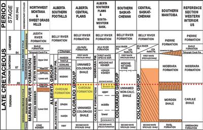
The Cenomanian-Turonian Greenhorn
RESERVOIR ISSUE 2 • MARCH/APRIL 2017 13 CHALLENGING DOCTRINE ARTICLES
Figure 1 - Stratigraphic correlation chart of the Greenhorn and Niobrara cyclothems in western Canada showing correlation of the Cardium Fm in Alberta (yellow) with a late Turonian to Coniacian-age lacuna to the south and east (orange) (modified from Neilson et al, 2008).
(Continued on page 14...)
CHALLENGING DOCTRINE ARTICLES
(Continued from page 13...)
cyclothem of the Cretaceous seaway in North America is regarded as a model for eustatically-driven, third-order, cyclic sedimentation in epicontinental settings. In western Canada, the Cardium Formation marks the end of the Greenhorn Cyclothem at the Turonian–Coniacian boundary (Fig. 1) and is overlain by transgressive strata of the Niobrara Cyclothem. Notably, the Cardium Formation in Alberta is laterally correlative with a sub-Coniacian lacuna developed in Saskatchewan, Manitoba and Montana. This lacuna extends into the USA as the regional hiatus that separates open marine mudstone of the regressive Turonian-age Carlile Formation from open marine pelagic carbonate of the transgressive Coniacian-age Niobrara Formation. Duration of this sub-Coniacian hiatus increases eastward (Hattin, 1975; Merewether et al., 2007) and, more importantly, it is recognized along the eastern margins of USA and Canada, throughout the North Atlantic Ocean, and along the western margin of Europe (Arthur, 1979, Sugarman et al., 2004).
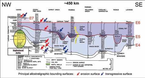
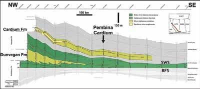
The current stratigraphic framework for the Cardium Formation was established by Plint et al., 1986. It comprises several allomembers bounded by erosional unconformities (E1–E7) and flooding surfaces (T1-T7) that subdivide the Cardium Formation into a third (?) order regressive systems track comprising the Musreau-
Kakwa delta and its basinal equivalents, and an overlying, third (?) order transgressive systems tract (TST) composed entirely of marine mudstone, siltstone, sandstone and conglomerate (Fig. 2). Paleoshorelines for the TST are not preserved, but would lie somewhere to the west within the disturbed belt. The late Turonian E4 submarine unconformity separates the regressive fluvio-deltaic systems tract from the open marine transgressive systems tract. Refined biostratigraphic analyses by Walaszczyk et al. (2014) correlate the E4 surface in outcrop at Seebe, Alberta with the regional sub-Coniacian hiatus at the base of the Niobrara Formation in Colorado. The subConiacian E5 submarine unconformity that separates the Raven River and Dismal Rat allomembers at Seebe correlates with a younger Coniacian-age submarine hiatus within the lower Niobrara Formation (ibid). Braunberger (1994, 2010) demonstrated that not all unconformities within the Cardium Formation represent significant erosional events or chronostratigraphic horizons, and that deposition of the Cardium Formation was diachronous in both west-east and north-south directions. Regardless of how the bounding surfaces are correlated and interpreted, it is evident that they record periods of prolonged depositional hiatus and exposure of the sea floor. The single E5 (or E5.5) depositional hiatus at Seebe, Alberta likely exceeds 0.5 Ma (Krause and Braunberger, 2016).
Amalgamation of the E4-E7 surfaces toward the east at Cold Lake, Alberta, produced a compound hiatus of ~4.7 Ma duration (Schroeder-Adams et al., 2012).
Allomembers comprising the Cardium TST contain multiple ‘parasequences’ (Fig. 2) that can be traced on logs for >300 km basinward of the underlying highstand Kakwa delta. Parasequences within the Raven River allomember comprise heterolithic, flat to swaley cross-stratified, massive/structureless and weakly bioturbated, fine-grained sandstone. The beds are typically sharp-based, laterally extensive, and up to several metres thick. Bedforms within these reservoirs can be mostly attributed to current traction deposition and erosion. Vertical facies associations demonstrate an overall upward increase in current strength culminating in upper flow regime parallel lamination and hummocky cross-stratification (Duke, 1985; Walker and Eyles, 1988; Dashtgard et al., 2008). Flaser bedding, lenticular bedding and mud couplets indicate tidal influence. Intraclastic lags and erosional scours associated with the HCS sands depict oscillating flow conditions and an abrupt change in process from that which produced the underlying mud-dominated facies. This upward-coarsening vertical facies association in the Raven River is interpreted conventionally as a shallowingupward shelf succession (Plint et al, 1988).
In all cases, vertical aggradation of the parasequences within the Cardium TST terminates with an omission surface. Where these omission surfaces are regionally correlative, they have been assigned the status of a ‘bounding disconformity’. These surfaces of sediment by-pass and erosion are associated with slope-parallel, erosional bevels (steps) and terraces (Bergman and Walker, 1987; McLean, 1987; Wadsworth, 1989; Leggitt, Walker and Eyles, 1990; Wadsworth and Walker, 1991; Walker and Eyles, 1991; Hart and Plint 1993; Pattison and Walker, 1992). The bevels are asymmetrical one-sided scours with up to 25 m relief that backstep upslope to the NW for more than 170 km. The planation surfaces are mantled by coarse-grained lag deposits consisting of chert pebbles, mud clasts, sand clasts, reworked hardground clasts, Inoceramus shells, fish bones,
14 RESERVOIR ISSUE 2 • MARCH/APRIL 2017
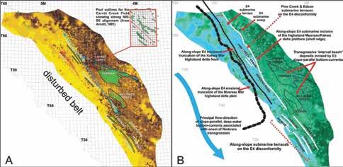
Figure 2 – A NW-SE allostratigraphic cross-section through producing Cardium reservoirs (modified from Plint et al, 1986) that illustrates the key bounding surfaces. It depicts the regressive highstand Musreau/ Kakwa delta plain (yellow) overlain by transgressive marine strata of the Raven River and younger allomembers (blue). Upward-coarsening parasequences in the Raven River Mbr extend > 300 km from Pembina westward into the disturbed belt.
CHALLENGING DOCTRINE ARTICLES
shark teeth and glauconite. Notably, they are devoid of shallow-water bivalves and gastropods and any significant amount of woody detritus. Complex sideritic and phosphatic hardgrounds below the lag deposits attest to prolonged periods of seafloor exposure.
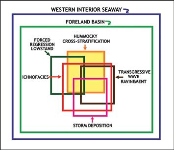
Cardium paradigms
Current depositional and stratigraphic interpretations for the Cardium Formation in Alberta are influenced by a number of working paradigms. Over the past 40 years, several shallow-water working paradigms have evolved from study of the Cardium Formation. These paradigms
concept of codependent paradigms that evolved from models for deposition of the Cardium Formation. These paradigms nest within earlier, broader paradigms that relate to the origin of the basin itself.
Formation and links nested depositional and stratigraphic paradigms. The ‘hummocky cross-stratification’ paradigm regards low angle cross-stratification in marine sandstones as the product of storm-wave reworking of sandy substrate. Notwithstanding the facts it has never been observed in the process of formation on marine shelves, has never been recognized unequivocally from any recent marine sediment, and has never been formed experimentally (Duke, 1985, Walker, 1986), HCS is adopted ‘a priori’ as a proxy for shallow-water deposition above storm wave-base,
nest within broader paradigms that have a longer history of development (Fig. 3). Many of the nested paradigms are codependent and lack external corroboration. Instead they are endorsed by, and provide endorsement to each other. Consequently, their validity depends upon confirmation of the broader paradigms. Basic tenants of these paradigms are accepted 'a priori' as fact and form unchallenged fundamental assumptions behind our day-to-day practice.
The hummocky cross-stratification (HCS) bedform anchors the shallowwater interpretations for the Cardium
The presence of HCS within laterally extensive marine sandstone beds of the Cardium Formation form the basis for the ‘storm deposition’ paradigm for offshore sand transport and deposition (Wright and Walker, 1981; Krause and Nelson, 1984; Walker, 1984; Walker, 1986; Plint, 2010). This concept invokes long distance offshore transfer of sand by storm surge ebb flow during and after hurricane-scale storms. Yet, when compared with modern hurricane-generated tempestites, the HCS beds in the Cardium Formation are commonly more than 50 times thicker and occur at more than 5 times the distance offshore. Regardless of a lack of modern analogues, the storm model remains popular as an explanation for thick HCS beds.
Recognising the scalar inconsistencies
RESERVOIR ISSUE 2 • MARCH/APRIL 2017 15
(Continued on page 16...)
Figure 3 – Schematic diagram illustrating the
Figure 4 – Compilation of paleogeographic maps for the Late Cretaceous of North America from the first map by Willis (1909) (4A), to the first formal recognition of the Western Interior Seaway by Kauffman, 1969 (4B), to the recent K85 rendition of Blakey (2015) (4D).The early maps are coloured to highlight landmasses in yellow and paralic environments in pink.The distribution of Cretaceous strata in North America is shown as dark blue in 4C.The eastern erosional edge (red line) is juxtaposed onto Blakey’s map in 4D.
CHALLENGING DOCTRINE ARTICLES
(Continued from page 15...)
with earlier storm-deposition models, various lowstand depositional models were developed for the Cardium Formation to account for the widespread occurrence of shoreline-detached HCS-bearing sandstone (e.g., Plint, 1988; Plint and Nummedal, 2000). Notwithstanding a complete absence of unequivocal evidence to support these lowstand interpretations (e.g., roots, paleosols, coal, etc.), this notion evolved with time into the ‘forced regression lowstand’ paradigm. The absence of supportive evidence has been attributed to basin-wide shoreface wave ravinement during transgression (e.g., Plint, Walker, and Bergman, 1986; Bergman and Walker, 1987; Pattison and Walker, 1992). With time this notion evolved into the ‘transgressive wave ravinement’ paradigm.
Ichnologic studies of the Cardium Formation that endorse shallow-water storm deposition (e.g., Pemberton and Frey, 1984; Vossler and Pemberton, 1988, 1989; Pemberton et al. 1992; MacEachern and Pemberton, 1992; Pemberton and MacEachern, 1997) led to development of the ‘integrated ichnological/ sedimentological model for shoreface settings’ of Pemberton et al. (2012). All ichnofacies within this model, with exception of Nereites, are assigned to the depositional shelf. This model is derived in part from the integration of a refined depth-related ichnofacies zonation with existing HCS-grounded, lowstand Cardium shoreface interpretations, and forms the
basis of the depth-related ‘ichnofacies’ paradigm.
Lastly, there are two less structured working paradigms that influence Cardium interpretation that relate to the previous. These encompass more perceptions than actual theories or models. The first is a ‘shoreface’ paradigm that views an upwardcleaning gamma ray log motif as indicative of a shallowing-upward, prograding shoreline (parasequence). Abrupt vertical shift back to mudstone is viewed as a transgressive, marine deepening event. The second, more subtle working paradigm considers deep-water settings (i.e. > 200 m) to be passive, low-energy, low-oxygen environments characterized by hemipelagic mud deposition, bottom water anoxia, a Nereites ichnofacies and an absence of significant current action.
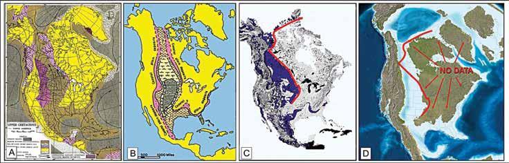
Depositional, ichnologic and stratigraphic paradigms arising from interpretation of the Cardium Formation nest within a ‘foreland basin’ paradigm that depicts the Cretaceous seaway in North America as an intracratonic basin formed by downward flexure of the lithosphere in front of the advancing cordillera. The foreland sag model was conceived by Price (1973) to relate the origin of the Western Interior Seaway to the evolution of the Canadian Cordillera. He hypothesized “The foredeep trough...must have been an isostatically induced peripheral depression that developed in response to the load
imposed on the lithosphere by the north and easterly flow of supracrustal rocks up onto the flank of the craton.” His concept of crustal loading was subsequently modelled by Beaumont (1981) and others using measurements of basin width, sediment age, stratal thickness and estimates of erosion from the Canadian ‘Western Interior Seaway’ as input variables. These models form the basis for the ‘foreland basin’ paradigm worldwide regardless of age, position, geometry and depositional fill.
The ideas of Ray Price intimately linked the ‘foreland basin’ paradigm to the ‘Western Interior Seaway’ paradigm (WIS). The WIS paradigm views the Cretaceous seaway in North America as a narrow, shallow, intracratonic marine ‘shelf’ that was subjected to high frequency fluctuations in sea level. The concept of an interior seaway began with the publication of a paleogeographic map for the late Cretaceous in North America by Willis (1909) (Fig. 4a). His map depicts a narrow intracratonic seaway, shallow shelf water depths, bilateral symmetry of depositional environments, and a broad eastern cratonic highland. A half century later, Kauffman (1969) published a comparable map for Turonian paleogeography (Fig. 4b) that subdivided the interior seaway into inner and outer shelf environments based upon lithology. Advancing 106 years through countless paleogeographic renderings for the late Cretaceous, we conclude with
16 RESERVOIR ISSUE 2 • MARCH/APRIL 2017
Figure 5 – Compilation of paleogeographic maps for the Western Interior Seaway that shows all Cretaceous strata above the Early Albian deepening toward the eastern erosional edge shown in Fig. 4D (modified from Miall et al., 2008).
internal waves on the seafloor results in sediment erosion, transport and deposition. The region on the seafloor subject to prolonged impact by internal waves can be likened to an ‘internal coastline’ and the breaker zone likened to an ‘internal beach’ (Bourgault et al, 2008).
Blakey’s (2015) graphically-embellished K85my map (Fig. 4d) that is practically identical to Willis’ with exception of a slight deepening in the west to accommodate the ‘foreland basin’ paradigm. Juxtaposing the eastern limit for Cretaceous strata in North America (red line in Fig. 4c) onto Blakey’s map we see that the WIS concept is a construct stemming from an absence of data caused by erosional truncation. This century-old paradigm has virtually no control to two-thirds of the map, yet Willis’ interior seaway concept remains unchallenged.
Miall et al. (2008) published a compilation of paleogeographic maps for strata within the Cretaceous seaway of North America that in contrast to most was limited to the preserved strata (figure 5). They made no attempt to extrapolate beyond the limits of data control. There are three key points to take way for their compilation:1) every stratal unit above the Early Albian deepens eastward; 2) the deepest ‘paleobathymetry’ coincides with the Turonian-Coniacian, the time of the Niobrara transgression and deposition of the Cardium TST; and 3) no evidence exists for an eastern shoreline to the Cretaceous seaway. It is conceivable the seaway in western North America was open all the way to Eurasia for most of Late
Cretaceous time.
There is little or no unequivocal evidence for a significant sea level fall anywhere within the Late Cretaceous seaway of North America. The Late Cretaceous basin in western North America records relatively continuous subsidence at variable rates for at least 30 Ma. Contrary to popular belief, existing data do not constrain the width of the Cretaceous ‘seaway’; do not validate a shallow shelf paradigm; do not tightly constrain Cretaceous paleobathymetric depths; do not confirm the sequence stratigraphic paradigm for high frequency oscillations in sea level; show no evidence for development of a hingline, forebulge and backbulge in North America; and thus do not corroborate the foreland basin paradigm where it all began.
The current focus on unconventional shale and offshore deep-water plays is catalyzing cross-disciplinary communication of ideas. ‘Deep-water’ explanations exist as alternatives to all of the nested paradigms that collectively define the current shallowwater view of the Cretaceous seaway in North America. Most of these involve the transport, deposition and reworking of sediment by well-oxygenated, energetic, deep-water, bottom currents at and beyond
the shelf edge margin.
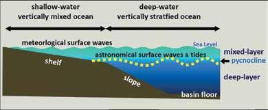
How deep is shallow? – The influence of internal waves at the shelf edge
The term ‘deep-water’ normally denotes environments that occur exclusively below storm wave base and generally seaward of the continental shelf break at water depths >200 m (Pickering et al., 1989). According to Shanmugan (2012), the shelf edge is the defining boundary between shallowmarine and deep-marine environments regardless of the absolute water depth (Figure 6). He considers the shelf edge to be the boundary between the vertically mixed and vertically stratified water columns regardless of whether this coincides exactly with the underlying break in slope. Most of the ocean in deep-water environments (i.e. beyond the shelf edge) is vertically stratified with an upper, low-density mixed layer and a lower, high-density layer separated by a pycnocline. The shelf edge is essentially where the pycnocline intersects the seafloor.
Since its formal recognition as a unique bedform, various mechanisms have been suggested for the origin for hummocky cross-stratification (Duke, 1985). Two feasible alternatives to storm generation that occur in both shallow- and deepwater settings include internal waves and
RESERVOIR ISSUE 2 • MARCH/APRIL 2017 17 (Continued on page 18...)
Figure 6 - Schematic diagram showing meteorological surface waves in shallow-water shelf settings and astronomical internal waves and tides in deep-water slope and basinal settings modified from Shanmugan (2012). Deep-water essentially begins where the pycnocline intersects the sea floor regardless of water depth or position of the shelf break.
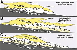
Figure 7 - Schematic depicting the breaking of internal waves on a sloping surface (modified from Pomar et al, 2012) that incorporates concepts from Morsilli and Pomar, 2012. (A) Sediment is moved upslope by the swash run-up. (B) The compensating backwash mixes the fluid between breakers and moves the sediment downslope under upper flow regime conditions. (C) Repetitive, high-energy breaking of
CHALLENGING DOCTRINE ARTICLES
CHALLENGING DOCTRINE ARTICLES
(Continued from page 17...)
Second White Specs Fm. Renewed regression of the overlying Cardium deltaic complex prograded sand-rich delta front deposits of the Kakwa Mbr close to the prodelta depositional limit of the Dunvegan delta complex. The Fish Scale-DunveganSecond White Specs interval comprises the Dunvegan clinoform and like the Cardium Fm contains a regressive and transgressive systems tract.
standing waves (antidunes). These are unrelated phenomena, but linked where the shoaling of internal waves has the potential to set up conditions necessary for standing wave development (Pomar et al., 2012). Combined, these two proffer an explanation for the vertical persistence of upper flow regime conditions characteristic of thick successions of HCS sandstone.
Antidunes are in-phase bedforms associated with 'standing waves' that form on a sandy substrate beneath super-critical (fast), unidirectional flows in shallow water. Nevertheless, they are commonly associated with deep-water 'stratified underflows' where the thickness (or height) of the underflow defines the effective water depth. Because of the inherent instability of standing waves, low angle antidune stratification is typically associated with the more dominant upper flow plane bed stratification. Interpretation of HCS as an antidune bedform simplifies depositional models. Its presence requires only a single waxing-waning flow cycle and removes restrictions of water depth and proximity to a paleoshoreline. The process is independent of water depth and extends the conditions for HCS development from the delta front across the shelf to the basin floor.
In contrast to standing waves, internal
Marine sandstone reservoirs of the Cardium Formation (white) occur in a mid-slope position on the Dunvegan delta clinoform. (B) True-scale juxtaposition of a satellite image (from NASA/Global Ocean Associates) showing deep-water internal waves in the South China Sea onto the SWS-BFS isopach
waves are large-scale gravity waves that oscillate and propagate along the interface (pycnocline) between two layers of water with different densities moving at different relative velocities (Figure 6). Internal waves are commonly generated near the shelf edge (i.e., 100–200 m water depth). They have much lower frequencies and much higher amplitudes than surface waves. Large internal waves can have wavelengths of several km and amplitudes >200 m, without influencing the orientation of the surface gravity waves.
Internal waves transport both mass and momentum and can propagate over several hundred kilometers. Analogous to surface waves, internal waves shoal and break where the pycnocline intersects the seafloor, transferring kinetic energy into a series of strong, short-period, bottomcurrent pulses that trigger up-slope surges of dense, sediment-laden fluid (Figure 7, modified from Morsilli and Pomar, 2012). These surges can be regarded as high density underflows that mobilize bottom sediment under upper flow regime conditions, and produce oscillation wave, antidune and planar types of stratification (Pomar et al., 2012). Breaking of 'internal waves' on the sea floor produces sandrich deposits (sand waves) by separating out silt and mud entrained within the
return flow (Zenk 2008, Bourgault et al., 2014). The region on the seafloor that is repeatedly impacted by internal waves can be likened to an ‘internal coastline’ and the breaker zone likened to an ‘internal beach’ (Bourgault et al., 2008).
The Role of Deep-Water Marine Currents in Submarine Deposition and Erosion
Modern oceanographic studies challenge common perceptions for deep-water. They establish that all types of deepwater currents are capable of submarine deposition and erosion along the shelf margin and continental slope to depths exceeding a few thousand metres. The resultant bedforms and structures are strongly dependent on current velocity and sediment availability. Consequently, recognition in the rock record of deepwater, bottom-current reworked deposits relies upon larger scale criteria (Howe, 2008) including:
• Regional distribution of bottom-current reworked deposits;
• Regional trends in facies, current/ paleocurrent orientation, texture, etc.;
• Shape and geometry of the sand body, indicating an along-slope trend; and
• Unconformities, condensed sequences, regional variation in thickness, etc..
18 RESERVOIR ISSUE 2 • MARCH/APRIL 2017
Figure 8 - Regional NW-SE stratigraphic cross-section flattened on the Base Fish Scales (BFS) submarine disconformity (modified from Leckie et al, 1994). Very finegrained prodelta deposits of the regressive Dunvegan delta downlap (clinoform) onto condensed Fish Scales mudstone and in turn are overlain by transgressive mudstone of the
Figure 9 – (A) Regional isopach map for the Second White Specs to Base Fish Scales interval in Fig. 8 that contains the SWS-Dunvegan delta complex. The spacing and colouring of the isopach contours depicts downlapping of the Dunvegan delta clinoform onto the BFS.
map.
The form that deep-water erosion takes is influenced by the nature and type of bottom current, slope gradient, bathymetric relief and sediment supply. Where the velocity of a slope-parallel bottom-current is maintained above the threshold for sediment resuspension, large scale submarine erosion produces terraces, planar abrasive surfaces, channels, moats, marginal valleys, furrows and resistant hardgrounds (Stow, 2008).
Elongate, shoreline-detached sandbodies and associated erosive elements throughout the Late Cretaceous in western Canada and the USA commonly exhibit a slopeparallel, NW-SE orientation. Paleocurrent indicators found within the same strata indicate a persistent NW to SE current direction. In a late Cretaceous scenario where the seaway in North America was open to Eurasia from the Boreal Sea to the North Atlantic, deep-water thermohaline and wind-driven currents would have likely acted upon the entire eastern shelf bordering the Cordillera.
Examination of the Cardium Formation in regional context
In clastic depositional systems there are no unequivocal proxies for deep-water. The interpretation of depositional complexes that comprise both shallow- and deepwater strata is strongly influenced by the choice of datum used in stratigraphic correlation. Choice of the wrong datum can produce artifactual subsidence or uplift. Regional and stratigraphic context and scale are fundamental to every geologic interpretation. Depositional systems that produce stratigraphic entities are affected by underlying strata and in turn affect deposition of the overlying strata. All deltaic complexes create clinoforms that thin basinward into deeper-water and downlap onto condensed intervals. There is no necessity to invoke differential subsidence within the Cretaceous seaway to explain thickening of deltaic successions toward the Cordillera.
In western Canada, the late Cenomanian to Turonian-age Dunvegan and Cardium formations comprise the regressive part of the Greenhorn Cyclothem (Figure 1). Each formation represents a fluvio-deltaic complex that prograded a shelf/slope wedge eastward into the basin. Marine sheet sands and elongate, shoreline-
CHALLENGING DOCTRINE ARTICLES
detached sandbodies were deposited during subsequent transgression of the drowned delta platforms. These two formations are vertically juxtaposed and probably shared a common ancestral watershed. Regardless of the cause of marine transgressions of the Cenomanian-Turonian seaway, it is likely that bathymetric relief created by the Dunvegan delta clinoform would have been inherited by the following Cardium regression.
The Base Fish Scales Marker (BFS) in Alberta demarcates the Albian-Cenomanian boundary and coincides with maximum transgression of the Greenhorn Cyclothem. The actual onset of Greenhorn transgression in this region likely coincided with deposition of the late Albian Viking and Joli Fou formations. Figure 8 shows a dip-oriented stratigraphic cross-section for the Dunvegan and Cardium formations that is hung on the BFS. This cross-section illustrates basinal downlap of the Dunvegan clinoform onto condensed beds above the BFS. More notably, the section illustrates a somewhat conformable relationship of the overlying Cardium and Blackstone formations.
A regional isopach map of the Second White Specs (SWS) to Base Fish Scales (BFS) interval in Alberta (figure 9a) demonstrates
the NW to SE thinning of the DunveganSWS delta complex onto the Fish Scales condensed zone depicted in Figure 8. Assuming a very low depositional gradient for the BFS marker at maximum Greenhorn transgression, spacing of the contour lines would reflect the offshore bathymetric profile that existed at the onset of Turonian Cardium-Blackstone regression. All Cardium oil reservoirs, irrespective of whether they are associated with the E4 or the E5 bounding disconformities, occur in a middle slope position on the underlying Dunvegan clinoform, at a similar paleobathymetric level a few hundred kilometers or more from the coeval delta front that sourced them.
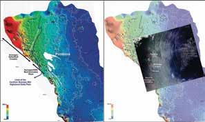
The role of internal waves in the modification of the shelf margin can be demonstrated with an example from the South China Sea. Episodic shoaling of deep-water internal waves along the upper continental slope has generated a midslope subaqueous sandwave field that extends for more than 40 km downslope of the shelf edge. This fine to medium grained sandwave field, with amplitudes of >10m and wavelengths >300m (Reeder et al., 2010), proffers a modern analogue for an ‘internal beach’. Figure 9b shows a
Cardium Sand (and equivalents) to Base Fish Scales derived from the same raw IPL data set. The map removes any ambiguity with the top Blackstone pick, and accentuates observations for 10A. Blue is thickest and dark green is thinnest. The total difference from thickest to thinnest is approximately 315 m. An alternative deep-water interpretation for the architecture of the Cardium Fm is suggested that accommodates published observations ranging from regional stratigraphic setting down to paleocurrent orientations.
RESERVOIR ISSUE 2 • MARCH/APRIL 2017 19 (Continued on page 20...)
Figure 10 – (A) Gross isopach map of the top Cardium Sand (and equivalents) to top Blackstone Fm. interval derived from a raw IPL data set of all wells in the area. Isopach contours have been colour transformed for easy viewing; yellow is thickest and dark brown is thinnest. Cardium reservoirs and isopachs show a strong NW-SE trend. Of particular note is the pronounced 450 km linear step in thickness. (B) Gross isopach map of top
CHALLENGING DOCTRINE ARTICLES
(Continued from page 19...)
true-scale juxtaposition of a satellite image of the deep-water internal waves in the South China Sea onto the SWS-BFS isopach map. These internal waves exhibit extreme wavelengths of several kms and amplitudes exceeding 150 m. When compared with the Cardium field outlines in Figure 9a, this image underscores the potential impact of internal waves on the shelf margin during the late Turonian.
The 3-D architecture of the Cardium Formation is not easily explained by processes associated with shoreline erosion and deposition. NW-SE oriented features in the Cardium exhibit fractal distribution ranging from regional-scale allomember geometry down to small-scale erosional scours. The bounding disconformities, particularly the E5 surface, comprise a series of erosional steps (bevels) and low gradient terraces that backstep to the southwest (upslope) from Carrot Creek through Pembina and Willesden Green to Ferrier (Bergam and Walker, 1987; McLean, 1987; Walker and Eyles, 1988, 1991; Leggitt et al., 1990). Erosional relief ranges from a few to more than 25 m and plays a key role in hydrocarbon trapping along this surface.
Regional isopach contours (Figure 10a) reflect this strong NW-SE (~320⁰) fabric. The most significant structure is a pronounced NW-SE oriented erosional ‘step’ and series of ‘terraces’ beneath the E4 unconformity that extends for more than 450 km. This ‘step’ is attributed to submarine erosion of the Kakwa delta platform and parallels published erosional edges for both the Kakwa and Musreau members (figure 10b). Shoreline-detached reservoirs of the Edson, Pine Creek, Brazeau River, Garrington, Caroline, Crossfield, and Lochend fields comprise subtle linear isopach ‘thicks’ developed on the broad E4 terrace and aligned more or less with the orientation of this erosional ‘step’. Cardium reservoirs east of the erosional ‘step’ are associated with the E5 unconformity. Reservoirs in the Carrot Creek area coincides with some of the thinnest isopach values (dark brown in Fig, 10a) while the Pembina and Willisden Green fields flank an area of thicker isopach values. The eastern edge of the Pembina field is a pronounced linear margin rotated ~30⁰ to the principal trend of the E4 step.
There is no unequivocal evidence to
support teeter-totter tectonics or oscillating base level in the Cretaceous Seaway in western North America. In context of what is known of the Turonian-Coniacian boundary, the geometry of the Cardium Formation as a whole is best explained by erosional sculpting of the highstand delta platform by NW-SE oriented, slope-parallel bottom-currents (e.g. contour currents) during the Niobrara transgression. Setting aside shallow-water biases and considering the possibility of an open connection to the Boreal Sea and North Atlantic Ocean at Turonian time, all aspects of the Cardium Formation can be rationalized by a simple process continuum that involves:
1) Marine transgression and gradual drowning of the Musreau/Kakwa delta platform.
2) Interaction between internal waves and the depositional slope with development of an ‘internal beach’;
3) Progressive drowning of the shelf and shelf margin by sea level rise resulting in landward migration of the ‘internal beach’;
4) Initiation of slope-parallel, bottomcurrent erosion of the depositional slope and terracing of ‘internal beach’ deposits;
5) Truncation of the highstand delta platform by a combination of internal wave erosion and bottom-current incision as the positions of the shelf margin and slope migrate west;
6) Interaction of a long-slope bottomcurrents with down-slope debris flows producing a gravel-rich submarine deflation lag by current winnowing and traction transport; and
7) Traction transport and deposition of thickened accumulation of sand and gravel in areas where bottom-current flow was amplified.
Upward-coarsening facies associations within the Cardium TST are better explained as products of a backstepping ‘internal beach’ created by shoaling of internal waves on the depositional slope during transgression. ‘Parasequences' within the
TST would become signatures of basin deepening. The Cardium allomembers of the TST are defined by multiple laterally correlative omission surfaces created by bottom-current erosion. In a stratified ocean, multiple deep-water ocean currents can be active at the same time, but at different depths, and each current can be associated with internal waves. The entire architecture of the Cardium TST could be the product of a westward migrating depositional slope acted upon by overlapping deep-water currents during the Niobrara transgression.
Summary
Current models of every kind that involve Cretaceous strata in North America invariably hang upon a flawed century old paradigm of a shallow interior seaway. Process sedimentology provides the means to re-interpret depositional settings for marine reservoirs in western North America. In spite of conflicting theories and models, published literature contains enough information to suggest that most conventional and unconventional Cretaceous marine reservoirs in western North America were deposited in deeperwater settings. An open, deep-water perspective of the Cretaceous seaway in North America proffers the means to map and explore for fine-grained unconventional reservoirs at a scale beyond conventional perspectives. Alternate deep-water interpretations for conventional marine sandstone reservoirs impart a higher degree of freedom in describing and mapping facies distributions, porosity trends, reservoir variability, etc.. Paradigm shifts create opportunity. In the words of the late Dr. Wayne Dyer, “When you change the way you look at things, the things you look at change”
Acknowledgements
I would like to thank the Devon Canada Corporation for indulging my critical thinking on the Cardium Formation for 15 years, and particularly Dave Loney my friend and colleague who created the isopach maps that made regional extrapolation of my ideas possible.
References
“A full List of references is available on the CSPG website under Reservoir – Current Issue”
20 RESERVOIR ISSUE 2 • MARCH/APRIL 2017
THE ARGUMENT FOR TIDAL AND BRACKISH WATER INFLUENCE IN THE MCMURRAY FORMATION RESERVOIRS
Murray Gingras (Department of Earth and Atmospheric Sciences, University of Alberta) and Dale A. Leckie (Department of Geoscience, University of Calgary)
Introduction
The Cretaceous Athabasca oil sands in western Canada are the third largest hydrocarbon resource on earth. Most of that resource is located in the deposits of the McMurray Formation, in multi-storey, channel and point-bar deposits having highly variable lithology and morphology. In spite of the economic significance of the resource, there is still considerable debate about the depositional setting of the reservoir unit.
The McMurray Formation has been studied by geologists for more than a century. Much of the original sedimentological work was conducted in the 1960’s through to the 1980’s based on outcrop studies along the Athabasca and Steepbank Rivers. Those studies conferred a range of sedimentary environments to the McMurray. Carrigy (1971), for example, suggested that the inclined heterolithic bedsets exposed in river cuts represent the foresets of a delta. A deltaic model was also supported by later studies, notably that of Nelson and Glaister (1978). Although it is often assumed that Pemberton et al. (1982) was the first to suggest an estuary sedimentary environment, it was in fact Stewart and McCallum (1978) who suggested that, based on grain-size distributions and the abundance of heterolithic media, the “middle” McMurray Formation strata were relict of a Cretaceous estuary. Notably, it was Stewart and McCallum who suggested that the lower and upper McMurray corresponded to fluvial and comparably marine conditions respectively, a general interpretation that still holds today. Flach and Mossop (1985) were the first to recognize that the dominant architectural element of the McMurray Formation were point-bar deposits. This was an exceedingly important interpretation that transformed the view of the McMurray Formation into what we think is correct today; that is –multiple stacked sets of valleys and channel
belts. In the 1980’s, the channels and the sand-rich reservoir facies were ascribed to anastamosing fluvial channels (Mossop, 1980; Mossop and Flach, 1983; Flach, 1984; Flach and Mossop, 1985). Working with Flach and Mossop, Pemberton identified the bioturbation within the IHS as indicative of brackish-water conditions. The integration of the sedimentological and the ichnological data led to the general acceptance that the McMurray Formation indeed represented a fossil estuary and that view held until 2009.
More recent interpretations of the McMurray Formation are derived from interpretations of very high-quality 3-D geophysical datasets, which show that the plan-view morphology of the channels is consistent with fluvial depositional systems (Smith et al., 2009; Hubbard et al., 2011; Labrecque et al., 2011). What is interesting about this revelation is that in spite of the clear geomorphological representation of the seismic data, core-scale sedimentary facies analyses persistently lead to the conclusion that the sedimentary facies are convincingly estuarine with evidence of tidal deposition. There has been much awkward debate around this conundrum and the conclusions are not presently compatible. The purpose of this paper is simply to review many of the observations and derivative interpretations for our community in the interest of promoting cogent discussion and to encourage needed avenues of future research.
Summary of Several Geophysical Observations and Sedimentologic Interpretation of the McMurray Formation
There are numerous depositional styles of point bars found in the Athabasca oil sands. The voluminous number of data sets include high-resolution horizontal seismic slices and cross sections, detailed core measurements, and wire line and
image logs. Sedimentological, ichnological associations and palynological recovery are interpreted, in this case, to indicate that deposition occurred in a zone of the tidalfluvial transition. Tidal indicators, which are rare to common, are quite convincing.
The best interpretation of the seismic morphology is that it is fluvial
High-resolution seismic imagery shows that the rivers that deposited these point bars had variable sinuosity of 1.6 to 2.5. The point bars migrate both by lateral accretion and by downstream translation. Core and log data show single channel deposits or storeys up to 48 m thick. The rivers, as indicated by well-preserved and seismically well-imaged channel-abandonment mud plugs, were up to 600 m wide.
Several point bar morphological elements are observed from several published seismic data sets or their descriptions. Sand-dominated side bars were deposited along the inner edge of, but detached from, the point bar. Preservation of these side bars appears to be enhanced by channel abandonment, whereby the side bar is draped by and onlapped by silts of the mud plug. Counter point bars, characterized by high silt content, occur downstream of sandy point bars. These counter point bars are most easily identified morphologically and by their relationship to point bars using seismic imagery. Elsewhere, abandoned, migratory point bars become re-occupied through the process of chute-channel capture. Upon subsequent abandonment, the chute channel then becomes mudfilled. In some cases, channels filled with reservoir quality sand, rather than mud, upon abandonment; the mechanism for this latter type of deposition is not well understood. The depositional fabric in these features appears to be dominated by unidirectional dune-scale bed forms preserving the direction of paleoflow.
(Continued on page 22...)
RESERVOIR ISSUE 2 • MARCH/APRIL 2017 21 CHALLENGING DOCTRINE ARTICLES
CHALLENGING DOCTRINE ARTICLES
(Continued from page 21...)
That the geomorphological evaluation of the seismic datasets are best interpreted as representing fluvial architecture, is an understatement. Based on what is presently known of meandering fluvial systems, no other sedimentary analogues come close to explaining the plan view proffered in the seismic image. This includes consideration of delta, estuary and even turbidite channel. As the header to this section states, the best interpretation of the seismic morphology is that fluvial sedimentation prevailed in sedimentation of the middle McMurray Formation.
Sedimentological Evidence for Fluvially Dominated Sedimentation
The point bars of the McMurray Formation were deposited within a highly dynamic and migratory, low accommodation depositional system. Fluctuating relative sea level resulted in multiple incised valley systems within which there were highly migratory stacked channels. Subsequent valley fill resulted in a vertical stacking pattern of multiple depositional units or storeys. Facies relationships, depositional elements and paleontology (ichnology and palynology) variably suggest diurnal, spring to neap cyclicity and seasonality effects on the sediments. It is likely that many features now interpreted as incised valleys may well turnout to be channel belts. The incised valleys can be more confidently interpreted when thick paleosols have been created on adjacent interludes.
Generally, there is minimal evidence of levees or conventional overbank deposits. Roots and paleosols are not common; where the latter do occur, they tend to be well developed and associated with the interfluves of incised valleys.
Mud beds are continuous to discontinuous, likely seasonally deposited mudstone layers within inclined heterolithic stratification (IHS) packages; thinner centimeter-scale muds associated with spring to neap cyclicity; and millimeter-scale slack water deposits. Channel bottom muds may be fluid in origin. Abandoned channel mud plugs associated with chute and neck cutoffs are an integral part of the deposition system as are alternating, low angle IHS.
Erosional surfaces, found at the base and within point bar successions, may be the
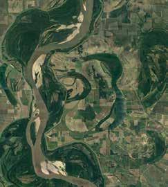
result of channel readjustment associated with high-energy flood events or other perturbations within the system. Elsewhere they are the result of avulsion and migration processes, again characteristic of fluvial sedimentation.
In these point bars, sand concentrations seem to be concentrated at various positions in the point bars. Downstream fining is common; counter point bars are silty; some point bars are muddier at their apex. Sand size is generally fine grained, although lower channels and channel bases may reach pebble size.
Mud clast breccias are ubiquitous in the McMurray Formation. Clasts are well rounded to angular and from centimeter to metre in diameter within beds of variable thickness. The breccias typically have an oil saturated fine-grained sand matrix, although in some instances, this matrix is absent. The breccias are the result of bank collapse, erosion of mud layers on point bar surfaces and possibly on chute-channel surfaces. Breccia beds are highly variable and are difficult to resolve seismically.
Palynological Evidence for Fluvial Transport
There is a dominance of nonmarine palynomorphs within the mudstones of
the McMurrary Formation. However, it is the pervasive occurrence, although in low numbers, of marine dynocysts that suggest a connection with and contribution from salt water. In a fluvial depositional setting, the dinoflagellates present in the mudstones are interpreted to have been introduced during likely-seasonal times of low fluvial discharge. It is at this time that salt water penetrates further upstream.
Summary of Estuary Interpretation of the McMurray Formation Was Brackish-Water Present?
Owing in large part to Pemberton’s legacy to Alberta geoscience, the main evidence used against a strictly fluvial interpretation has been ichnological in nature, supported by the sometimes pervasive presence of marine dynocysts. Although the lower McMurray possesses little in the way of bioturbation, the middle and the upper McMurray commonly display bioturbated units. The middle McMurray is typically bioturbated, particularly the IHS components and it contains good examples of brackish-water trace-fossil assemblages; these are discussed below. Parasequences of the upper McMurray are identified as more marine in their nature, an interpretation that was initially based on ichnofossil data. Paradoxically, this latter interpretation has never been at issue, in spite of the fact
22 RESERVOIR ISSUE 2 • MARCH/APRIL 2017
Sedimentological models for the McMurray Formation mostly vary from fluvial to estuary. At left is the Mississippi River (671500 m E 3663200 m N) and at right is the Ogeechee River Estuary (481200 m E 3529900 m N). The scale bar in each image is 5 km. The images were acquired from Google Earth on January 30, 2017.
that the trace fossil assemblage and the presence of syneresis cracks indicate the presence of fresh to brackish water (Caplin and Ranger, 2001) with marine ichna only evident in the overlying Wabiskaw Member of the Clearwater Formation.
Presently, the ichnological conundrum really applies to IHS bearing channels of the middle and upper McMurray, and so we limit this discussion to those units. Within the channels, sporadically burrowed sandstones are overlain by, or laterally adjacent to, persistently burrowed IHS (laterally accreted bar), which are in turn overlain by heavily bioturbated media (accreted bartop). The tracefossil assemblages in the three facies associations show numerous features characteristic of somewhat stressed brackish-water environments: 1) suites are of low diversities; 2) suites contain marinederived ichnogenera (i.e., PlanolitesTeichichnus - Cylindrichnus - Skolithos assemblages, and monospecific Gyrolithesdominated facies); and 3) ichnogenera characterized by size diminution. Other characteristics consistent with brackishwater assemblages are omitted here for brevity, but fully described by Gingras et al. (2016).
These assemblages strongly support the notion that during McMurray time, brackish water environments were common in the McMurray Formation. Brackish-water influenced point, bar, and bar-top units, which are consistently devoid of pedogenic alteration and root traces, can only be explained by: (1) the presence of brackish water throughout the channel; (2) the presence of tides to facilitate the landward transport of marine-derived larvae; and, (3) the presence of tides to establish heavily burrowed bar-top intertidal zone. All of these interpretations are incompatible with sedimentation in a strictly fluviallydominated setting.
Do the distributions of bioturbation within IHS suggest that fluvial influence was subordinate to tidal influence?
Fluvial IHS should result from twostage event sedimentation: 1) sand beds representing fluvial high-stage sand deposition mainly as bedload in the winter or as seasonal to aseasonal floods; and
CHALLENGING DOCTRINE ARTICLES
2) mud beds produced by waning floodstage release of the remaining suspended load to produce a silt-dominated, normally graded, variably laminated, organic-rich deposit (Sisulak and Dashtgard, 2012). Ignoring the fact that burrows in fluvial settings are generally rare below the water line, colonization of fluvial IHS would occur only from the top of mud-beds, because the paired sand-mud lithosome together represent a single event bed. Alternatively, both sand and mud beds would remain unburrowed, with the exception of limited infaunal disturbance towards the tops of mud beds only. Of these predicted fluvial characteristics, the only observation in McMurray IHS that is consistent with the aforementioned expectations is that mud beds are silt dominated and that normal grading is observed locally. What cannot be explained by strictly fluvial IHS models include: (1) the locally pervasive distribution of burrows particularly in the mud beds of the McMurray IHS, which suggest much more gradual accumulation of sediment; (2) the local colonization of sandstone beds that are subsequently capped by massive, unburrowed mud beds; (3) the common occurrence of sharp-based massive-appearing muds that lack grading (interpreted as fluid muds); and (4) the presence in some IHS datasets of rhythmic lamination attributable to tidal influence (e.g., Timmer et al. 2016). Some of the bed to bed and individual point bar variability that is seen is likely due to seasonal and decadal or longer variations in riverine discharge.
Is there sedimentological evidence for tidal sedimentation?
Evidence for tidally influenced sedimentation is also presented in the fluvial section above. Additionally, at four outcrop locales and many subsurface cored intervals —Fort MacKay, Athabasca Type Section, Christina River, and High Hill — sedimentary structures, widely regarded as tidal in origin, are observed. These include reactivation surfaces, sigmoidal bedding, rhythmic thinning and thickening of foreset laminae (neap-spring cycles), and apparent current reversals. The core datasets are less clear, but Timmer et al. (2016) report rhythmic bedding in silt-dominated IHS with frequencies that correspond to tidal rhythms.
Although breccia and sand distributions have been used to present a case for fluvial geometries, a strong case can be presented for an alternative interpretation of breccias. In many examples, sedimentological characteristics of the breccia such as the presence of bladed clasts, and that their thickness and lithology correspond to underlying and overlaying IHS support the notion that the breccias are commonly the result of tidal cannibalization of the laterally accreting bar. This is a common feature of bars in tidal settings that are characterized by strong tidal currents and is owing to the constantly changing current vectors in tidal environments. In McMurray examples, the breccias are demonstrably on lateral accretion surfaces and are not strongly associated with thalweg deposits, which one might expect with bank erosion. Importantly tidal bars have been documented that show grain size variation around channel bends for reasons similar to fluvial bars: the current energy, be it tidal or fluvial varies around the bend. The presence of channel-abandonment plugs has also been (logically) used as evidence of a fluvial geomorphology. But even these mudstones are commonly bioturbated (with a brackish-water fauna) and rarely contain rhythmic lamination that correspond to tidal frequencies.
Palynology agrees with the ichnology.
Most palynological analyses of middle McMurray channel/IHS successions show very low proportions of marine dinocystson the order of 1 to 3% (e.g., Demchuk et al., 2008; Hubbard et al., 2011; Hein et al., 2012; Dolby et al., 2013). Yet, the dinoflagellates seem to occur in most of the mudstones.
In order to properly interpret the palynological datasets derived from the rock record, Czarnecki et al., 2014 studied modern systems where tidal influence and salinity conditions in the channels and channel margins can be directly measured. In their study of the modern Fraser River of Vancouver, British Columbia, Canada, Czarnecki et al. (2014) showed that dinocyst abundances are typically < 1% of palynological assemblages, despite both tidal flux and brackish-water conditions within the channel. Czarnecki et al. (2014) cautioned that in marginal-marine settings, low abundances and reduced species
RESERVOIR ISSUE 2 • MARCH/APRIL 2017 23 (Continued on page 24...)
CHALLENGING DOCTRINE ARTICLES
(Continued from page 23...)
diversity of dinocysts do not indicate deposition in a terrestrial environment. The low values are indicative of overwhelming river-derived sediment deposition, and the presence of any marine dinocysts in IHS may constitute the only palynological indicator of tidal and/or brackish-water influence. Interestingly, IHS units of bars in Fraser River distributaries within the zone of saltwater influence contain ichnological evidence of brackish-water conditions that is comparable (but less bioturbated in general) to that routinely encountered in the channel-IHS successions of the McMurray Formation (e.g., Sisulak and Dashtgard, 2012; La Croix and Dashtgard, 2015; La Croix et al., 2015). IHS in bars landward of saltwater influence in the Fraser River are mainly unbioturbated and contain very little mud (La Croix and Dashtgard, 2014).
Conclusions
DL: What do we need to do to better understand the conundrum of the McMurray point bars? In general, existing fluvial studies and models do not take into account tidal influence, nor do those studying the coastal zone commonly penetrate landward 50 to 100 km or more to study the tidal-fluvial transition. What is required is a better understanding of the mixing of tidal and fluvial processes, in addition to the importance of seasonality and longer-term climate cyclicity in this setting. Currently, there is not a solid comprehension of the fluid and sediment dynamics in tidal-fluvial transitional systems. We are still looking for appropriate analogs that represent the McMurray Formation. What are the most prevalent mixed tidal and fluvial depositional processes and which impart the strongest control on sediment variability, both laterally and vertically?
MG: The presence of brackish-water bioturbation and persistent evidence for tidal sediment transport are best explained by the presence of tides. Some workers have suggested that salt-water discharging from the underlying Devonian strata might have provided the brackish-water environ for the burrowing infauna evidenced by the trace fossils. However, that thinking neglects that larval colonization comes from the marine basin and a tidal connection is crucial for the advection of larvae and food
into these settings. Two key observations take the McMurray bars out of the fluvial realm: (1) bioturbated sand and mud lithosomes in the IHS that show there is no strong freshette phase of the inferred river; and (2) the presence of bioturbation throughout the accreting bar culminating in a bioturbated top that is best interpreted as an intertidal flat deposit.
Although workers are looking for “sweet spots” in the fluvial-tidal transition wherein the conditions that promote bioturbation occur, it is not clear that those conditions can be met. Large rivers (e.g. Fly River, Mississippi River) show little in the way of bioturbation near the ocean; it is unclear why this would increase in the landward direction. In as much as we would benefit from more research in fluvial tidal transition zones, the present database clearly indicates that fluvial tidal zones are normally impoverished in their ichnology.
The correspondence of the seismic image to fluvial geomorphology cannot be denied. But, the interpretation of the 3D seismic is based on our knowledge of present-day fluvial and tidal systems and their morphologies at high-stand sea level: i.e. normally modern rivers are associated with progradational shorelines. Channel form-behaviour during rising sea level and the variability of estuary geomorphology are less well understood and as such we should not discount the possibility that the interpretation of the seismic datasets as fluvial or fluvio-tidal is flawed.
Notwithstanding the above assertions, it is likely that fluvial point-bar deposits are indeed present in the McMurray Formation. However, based on the weight of ichnological and sedimentological data, bioturbated IHS should normally be taken out of the fluvial equation.
References
“A full List of references is available on the CSPG website under Reservoir – Current Issue”
24 RESERVOIR ISSUE 2 • MARCH/APRIL 2017
THE MCMURRAY CONUNDRUM
Mike Blum, Department of Geology, University of Kansas. Lawrence, Kansas 66045 USA. mblum@ku.edua
Introduction
The Lower Cretaceous McMurray Formation is located within the northeastern part of the Mesozoic Alberta foreland basin, in the Cold Lake and Athabasca Oil Sands Areas, and the area in between (Fig. 1). In recent years, two seemingly irreconcilable interpretations have emerged for middle McMurray environments of deposition (EODs), which merit further investigation. This discussion outlines what has been referred to as the McMurray conundrum, and is based on presentations at the 2015 and 2016 AAPG ACE in Denver and Calgary (Blum, 2015; Blum and Jennings, 2016a; 2016b).
The McMurray as an Estuarine Channel System
Within Athabasca, the McMurray is commonly divided into (a) a lower unit, which rests on Devonian bedrock, and is widely regarded as fluvial in origin (see Hein et al., 2013), (b) a middle unit that is notable for giant sets of sand-rich inclined strata that either rest directly on bedrock, or on top of the lower McMurray, and (c) an upper unit that is widely regarded as marine influenced, and to represent retrogradation of the shoreline. In the early 1980’s the giant sets of sand-rich inclined strata of the middle McMurray, exposed in cut banks along the Athabasca River and elsewhere, were considered by Mossop and Flach (1983) and Flach and Mossup (1985) to represent fining-upwards fluvial point bars, with cross-bed orientations that were orthogonal to the dip of large-scale inclined strata (their epsilon cross strata), and meander-belt widths that were 15-20 times that of channel width.
Also in the 1980s through 1990’s, with developments in ichnology (e.g. Pemberton et al., 1982) and emergence of estuarine facies models (e.g. Dalrymple et al., 1992), the middle McMurray within Athabasca was commonly reinterpreted to represent tidally-influenced, brackishwater estuarine channel facies that were deposited proximal to a coeval shoreline. A brackish-water interpretation is supported
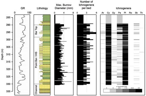
1AA/13-08-084-06
in 3d seismic by (Hubbard et al., 2011). As shown, almost every bed
bioturbation (generally Bioturbation Index 2 to 5). (Ar = Arenicolites, Cy, Pa and Ro = different expressions of Cylindrichnus, Gy = Gyrolithes, Pl = Planolites, Sk = Skolithos). Modified from Gingras et al. (2016).
by modern examples that demonstrate trace fossil assemblages in brackishwater environments are low diversity and can be high abundance, and burrows are diminutive in size (Pemberton and Wightman, 1992; Buatois et al., 2005;
MacEachern and Gingras, 2007; Gingras et al., 2012). Recent papers by Shchepetkina et al. (2016) and Gingras et al. (2016) recognize brackish-water ichnogenera in basal thalweg, IHS, and bar-top facies (Fig. 2), and note that bar tops are typically
(Continued on page 26..) RESERVOIR ISSUE 2 • MARCH/APRIL 2017 25
Figure 1. Location map for the Alberta Oil Sands.
Figure 2. Lithology, gamma-ray log, and ichnological data from a Nexen well,
W4M, in the center of a point bar studied
contains
CHALLENGING DOCTRINE ARTICLES
CHALLENGING DOCTRINE ARTICLES
(Continued from page 25...)
highly bioturbated and devoid of pedogenic alteration and root traces. Additionally, palynological signatures reported from middle McMurray reservoirs (e.g. Hein et al., 2013) show high levels of marine dinocysts when compared to modern counterparts (e.g. Czarnecki et al., 2014), which are interpreted to represent tidalinfluence and saltwater incursion.
Collectively, these observations are interpreted to indicate that brackish water was present in the depositional setting, tides facilitated landward transport of marine-derived larvae into the estuarine channel, and there was an established bar-top tidally-influenced and brackish environment of deposition within an estuarine channel.
The McMurray as a Giant River System
Acquisition of 3d seismic in 20072011 promoted a rethink of the middle McMurray, because of similarities in planview geometries between McMurray sand bodies and modern-day meandering river systems (Fig. 3). Early interpretations of 3d data stressed large meandering river systems influenced by tidal processes and brackish conditions, so as to honor the ubiquitous presence of brackish-water trace fossils assemblages (e.g. Hubbard et al., 2011; LaBrecque et al., 2011; Musial et al., 2012). Interpretations from 3d seismic, accompanied by associated core and well logs, demonstrated the middle McMurray river system was comparable in scale to the modern Mississippi River, by measuring the thicknesses of point bars and abandoned channel fills, and calculating paleodischarge values from the scales and geometries of inclined strata and abandoned channel fill cross-sectional area. Parallel, detailed studies of extensive and often 3-dimensional mine exposures during this same time period reconstructed the scale and sinuosity of point bars, as well as their complex, multi-directional lateral accretion patterns and resultant facies distributions (e.g. Nardin et al., 2013), even though interpretations continued to favor estuarine settings.
Recent detrital zircon (DZ) provenance studies of the lower and middle McMurray at Cold Lake and Athabasca, as well as the upper Mannville at Cold Lake, support
meaning that bars formed and grew, then the overall direction of bar growth was reoriented. (C) Line drawing of different storeys, illustrating changes in direction of bar accretion, and distribution of lithology in each storey, with grain size decreasing in the downstream direction for each storey (hot colors represent sand-rich facies, grays represent mud-rich facies.
the view of a giant river system (Blum and Pecha, 2014; Benyon et al., 2014; 2016). These data are interpreted to indicate the McMurray at Cold Lake was deposited by the axial river of a continental-scale system with headwaters that stretched from the SE US Appalachians to the SW US Western Cordillera, the Mississippi or Amazon of its time. This axial river then accrued tributaries from the Canadian shield by the time it reached the Athabasca region (Fig. 4a): detrital zircons therefore confirm previous mapping (e.g. Ranger, 2006; Hein, 2006; Fustic et al., 2012; Hein et al., 2013) that suggests Ft. McMurray was located in an area of confluence between, and mixing of, two large river systems through lower to middle McMurray deposition (Blum and Jennings, 2016a). Although the McMurray represents a continental-scale system, the low concentration of syndepositional volcanogenic zircons in McMurray sediments indicates its headwaters did not yet extend into the area of arc magmatism associated with the US and Canadian Western Cordillera. The overlying upper Mannville at Cold Lake, by contrast, contains a large influx of syndepositional volcanogenic zircons, indicating this continental-scale drainage had accrued west-derived tributaries with headwaters in arc-dominated terrains in the northwestern US and British Columbia (Blum and Pecha,
2014; Blum and Jennings, 2016a; Fig. 4b).
The McMurray as part of a giant river system with tributaries is not, in itself, inherently irreconcilable with brackish estuarine conditions inferred from the trace fossil record. However, modern rivers undergo inherent morphological changes as they move downstream and approach the shoreline (Blum et al., 2013; Fernandes et al., 2016; Fig. 5). For example, rates of lateral migration and widths of channel-belt sands decrease significantly downstream through their hydraulic backwater reach, and channels become avulsive, with an overall distributive pattern, and with minimal lateral amalgamation of sand bodies. By contrast, McMurray point bars demonstrate significant lateral migration (e.g. Hubbard et al., 2011; Labrecque et al., 2011; Fustic et al., 2012; Moreton and Carter, 2015; Blum, 2015; Blum and Jennings, 2016b; Durkin, 2016): the study by Durkin (2016) uses 3d seismic to reconstruct the kinematics of McMurray channel-belt evolution, showing development from a narrow single-storey channel belt, to a complex multi-storey amalgamated channel belt more than 15 km wide, with numerous cutoff meander loops that are now represented by abandoned channel fills (Fig. 6). As reconstructed, the McMurray was not an avulsive, distributive system with limited lateral migration:
26 RESERVOIR ISSUE 2 • MARCH/APRIL 2017
Figure 3. 3d seismic data published from Nexen Long Lake (A) (see Hubbard et al., 2011), and an unidentified locality (B) published by Moreton and Carter (2013). In each case, the interpreted point bars have migrated laterally considerable distances, and point bars are multi-storey,
Blum
McMurray,
the US Appalachians, the SW US, and the Canadian shield. At this time, the McMurray River was not draining arc terrain (pink blobs) of the Canadian and US Western Cordillera. (B) Paleodrainage for the upper Mannville (Clearwater and Grand Rapids Formation), when the ancestral McMurray River had accreted tributaries from the arc terrain, and therefore had large populations of syndepositional volcanogenic grains. Black dots represent areas sampled by Blum and Pecha (2014), with the southern locality being Imperial Cold Lake, and the northern locality being Imperial Aspen. Red arrows are paleocurrents or other paleoflow indicators (see Blum and Pecha, 2014).
hence, from 3d seismic, outcrop studies (e.g. Flach and Mossup, 1985) and studies of mine exposures (e.g. Nardin et al., 2013), the McMurray river was a highly migratory channel, which produced high width-tothickness point bars within a continuous wide and amalgamated channel belt.
The conflict of interpretations arises because backwater lengths scale to the position in the river channel where the bed goes below sea level, which in turn scales to the size of the river system, and are therefore very long for large rivers (Fig. 7). For example, the Mississippi River’s backwater reach is >500 km, and high width-to-thickness point bars within continuous wide and amalgamated channel belts occur >400 km from the river mouth and shoreline. Farther downstream, channels traverse the alluvial-deltaic plain through low width-to-thickness channel belts that are flanked by crevasse splays and
CHALLENGING DOCTRINE ARTICLES
modern lower Mississippi River (from Nittrouer et al., 2012). (B) Meander-bend migration rates (after Hudson and Kesel, 2000), and resultant channel-belt width: thickness (Wcb:Tcb; after Blum et al., 2013) relative to backwater length (defined here as the point where the river channel goes below sea level, according to scaling relations where backwater length is approximated by flow depth divided by bed slope). Also shown is the maximum observed upstream limits of the Mississippi salt wedge (from Schubel and Meade, 1977). (C) Lidar high-resolution digital elevation model for Mississippi River channel belts near river kilometer 700 (see Fig. 5a for approximate location), illustrating highly migratory, high Wcb:Tcb channel belts, with individual point bars showing multiple storeys (multiple accretion directions), and numerous abandoned channel fills. (D) Lidar digital elevation model for the Mississippi River channel belts near river kilometer 320, illustrating narrow Wcb:Tcb channel belts characteristic of the lower backwater reach (limits shown by red lines), where migration is limited, channel belts tend to be single storey with only one migration direction prior to avulsion, and channel belts are flanked by muddy flood-plain environments with crevasse splays.
encased in organicrich flood-plain muds. The distances over which the morphological transformations described above occur therefore scale to the size of the river system as well (Blum et al., 2013; Bentley et al., 2016; Fernandes et al., 2016): observations of McMurray channel-belt characteristics are inconsistent with a paleogeographic position proximal to a coeval shoreline, within the lower backwater reach where distributive systems occur, and instead imply that the coeval shoreline must have been hundreds of kilometers to the north. Only in steep-gradient river systems with shallow flow depths, can migratory point bars form within a continuous channel belt within a few km or even a few 10’s of km of a coeval shoreline.
For rivers like that which produced the middle McMurray in Athabasca, there is
an additional, acute limiting condition for interpretations of brackish conditions from trace-fossil assemblages. Brackish conditions do not extend as far upstream as tidal influences (e.g. Dalrymple et al., 1992), saltwater penetrates upstream into river channels only during periods of low flow, and if freshwater inflow from upstream exceeds tidal volume, the water column is density-stratified with a bottom-hugging saltwater wedge (Schubel and Meade, 1977; Dolgopolova and Isupova, 2010; Geyer and MacCready, 2013). Brackish conditions can extend over the full thickness of bar deposits in the lowermost reaches only: middle bar to bar-top deposits farther upstream must represent freshwater flood deposition, with subaerial exposure during low flow. Even if the McMurray river was highly seasonal (e.g. Jablonski and Dalrymple, 2016), and freshwater river inflow decreased to zero, ocean-derived
(Continued on page 28...) RESERVOIR ISSUE 2 • MARCH/APRIL 2017 27
Figure 4. Paleodrainage reconstruction for the Mannville Group from detrital zircons (from
and Pecha, 2014 and Blum and Jennings, 2016). (A) Paleodrainage for the
showing primary source regions in
Figure 5. (A) Water surface (low flow and flood stage) and bed-surface profiles for the
CHALLENGING DOCTRINE ARTICLES
(Continued from page 27...)
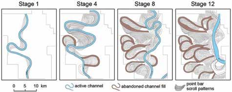
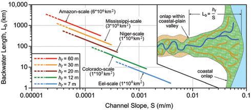
storeys within each point bar (multiple cross-cutting directions of lateral accretion), development of numerous abandoned channels and channel fills, and resultant development of a broad amalgamated channel-belt sand body. After Durkin (2016), with only 4 of his 12 stages included here. Original work of Durkin (2016) also contains metrics for channel sinuosity, and channel-belt width-to-thickness.
brackish water could not have occurred in the water column at an elevation higher than sea level at high tide, and could not have penetrated upstream beyond the point where the river channel base intersects that elevation. Fig. 8 summarizes a simple model for downstream morphological transformations in channel belts, within the context of the backwater reach and saltwater penetration.
The McMurray Conundrum
Neither of the above two interpretations of middle McMurray EODs are inconsistent with a giant river system, as revealed by detrital zircons and the scales of interpreted point bars and abandoned
channel fills. Moreover, each is grounded on solid observations. However, their paleogeographic positions and EODs are seemingly irreconcilable given our present state of knowledge, which defines the conundrum as referred to here.
On one hand, the presence of trace-fossil assemblages from the base of middle McMurray point bars to the top are welldocumented, and interpretations of brackish conditions are grounded on observations in modern environments: they are consistent with a paleogeographic position that is very proximal to the shoreline, and an EOD that reflects a vertically-mixed brackish-water column
in an estuarine setting. For this reason, a number of authors have concluded that interpretation of McMurray Formation channels as purely fluvial in origin is not tenable. However, an additional paleogeographic implication of the brackish-water interpretation is that the middle McMurray, from Township 74 to 98 or more (see Lettley et al., 2007) where these trace-fossil assemblages occur, was always deposited within a few kilometers to a few tens of kilometers of a coeval shoreline: did the shoreline regress over that distance as well?
On the other hand, evidence for migratory point bars from outcrop and 3D seismic in this same part of the system is equally real, although seismic observations are not as well documented in the peer-reviewed literature because it is not public-domain, and has not been widely released. However, many people work, or have worked, the oil sands and have seen these data. 3D seismic displays a morphology that is consistent with interpretation of a giant river system, whereas physical sedimentary structures are consistent with a fluvial environment with minor tidal influence (e.g. Martinius et al., 2013), but one that is upstream from any plausible marine-derived brackish water, especially in the upper part of the water column. The paleogeographic implications of this interpretation are that the McMurray, at least as far north as Township 98, was deposited when the coeval shoreline was still several hundreds of kilometers or more to the north. The obvious problem with the fluvial model is where did the brackish water signal come from? Perhaps something out-of-the-box is required to reconcile these alternative observation-based interpretive models?
The McMurray conundrum may be perceived to have limited practical significance for Oil Sands production, because companies calibrate practices to outcrop, seismic, well-log, and core-based observational data. This is clearly the case to some extent, however, process-based understanding of EODs can (a) increase predictability of properties away from known data points, (b) improve static and dynamic reservoir models, and (c) improve recovery efficiency. Moreover, to the extent that regulators mandate that drilling plans are justified by a defensible depositional
TECHNICAL ARTICLE 28 RESERVOIR ISSUE 2 • MARCH/APRIL 2017
Figure 6. Scaling relationships for backwater lengths, illustrating range of backwater lengths for rivers with different flow depths and slopes (after Blum et al., 2013). Inset shows the relationship between backwater length, and different types of river morphologies in plan view, and illustrates the view that avulsion locations scale to backwater length (see Jerolmack and Swenson, 2007).
Figure 7. Line drawings from 3d seismic, illustrating reconstructed kinematic evolution of a middle McMurray channel belt. Stage 1 (left) shows an initial channel with single-storey point bars, whereas subsequent stages show increased lateral migration, development of multiple
model, increased predictability from such a model may reduce the need to collect dense networks of well logs and cores.
The Mannville Group represents a significant period of North American history, a story of continental-scale drainage organization and sediment routing, climatic history, tectono-stratigraphic evolution, and paleogeography: it is therefore a matter of significant curiosity and interest. Thanks to detrital zircons, we know where the Mannville came from, but where did it go? Regardless of the McMurray conundrum, viewing the Mannville as the deposits of a giant river system, the Mississippi or Amazon of its time, begs the question of where the mass of sediment that would normally be discharged from such a system was initially deposited and now resides. Assume such a river system would, over a 10 Myr period, discharge >100 million tons per year from its mouth, similar to modern rivers of this scale (Syvitski and Milliman, 2007). The volume of missing sediment is roughly equivalent to covering Alberta (area of ~661,000 km2) to a depth of >1 kilometre.
Acknowledgements
Many people inspired thoughts expressed in this discussion, including attendees at the 2015 and 2016 AAPG ACE Meetings in Denver and Calgary. M. Blum thanks former colleagues at Imperial Oil (Friends of the Mannville) and ExxonMobil Upstream Research. We also thank Shahin Dashtgard (Simon Fraser University) for a critical review and helpful comments, and the CSPG Reservoir for the opportunity to outline the views above.
References
“A full List of references is available on the CSPG website under Reservoir – Current Issue”
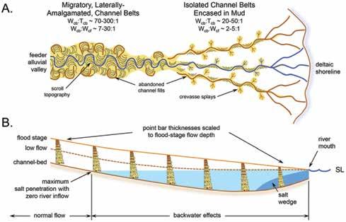
of
to position within the backwater reach. (A) Plan-view illustration of downstream changes, with characteristic metrics (Wcb:Tcb from Blum et al., 2013 and Wcb:Wcf from Fernandes et al., 2016; note that Fernandes et al., 2016 use channel width, translated here to abandoned channel-fill width,Wcf, as that is what will be preserved in the stratigraphic record). (B) Model illustrating relationships between backwater reach, saltwater penetration, and point bars formed within this reach. Assumption is that point-bar thicknesses scale to flood depths. Also shown are the salt wedge, and the maximum inland penetration of saltwater if river inflow were to reach zero.
TECHNICAL ARTICLE RESERVOIR ISSUE 2 • MARCH/APRIL 2017 29
DOCTRINE
Figure 8. Cartoon model for downstream changes in channel-belt plan-view morphology and associated environments
deposition, relative
CHALLENGING
ARTICLES
SALT, OIL, GAS & METALS: WHAT DRIVES THE LINK?
John Warren, Saltwork Consultants®, Adelaide, Australia 5049, jkwarren@saltworkconsultants.com.au
Introduction
This article endeavors to give an up-todate synopsis of how and why ancient salty basins tend to contain elevated levels of oil, gas and metals. It begins with an overview of hydrologies, then places ancient salt bodies in their climatic and tectonic context, and lastly looks at industrial associations and predictors. For brevity, details of many regions, deposits and references are summarised as tables (sans references), so feel free to contact me (jkwarren@ saltworkconsultants.com or via www. saltworkconsultants.com) with requests for more comprehensive documentation of particular examples.
Evaporite styles and reflect intrabasin brine hydrology
If we accept the definition of an evaporite as “A salt rock originally precipitated from a saturated surface or near-surface brine in hydrologies driven by solar evaporation,” then the greater volume of saline mineral salts in the earth’s sedimen-tary realm are the product of solar heating of brine. There are other sets of mineral salts in the depositional and diagenetic realm with the same mineral composition as evaporite salts, but these salts result from cryogenic, hy-drothermal or burial re-equilibration processes (Warren, 2016). For a water molecule to escape into the vapour phase in an evaporitic setting, and so increase the salinity of an enduring brine body or pore water in the capillary zone of a sabkha, the water molecule must; 1) absorb heat energy, 2) be located near the liquid surface ,3) be moving in the proper direction, 4) have sufficient energy to overcome liquid-phase intermolecular forces and, 5) pass through the surface tension interface (Figure 1).
Simple physics of molecular escape (rate and intensity) during solar evaporation essentially controls the potency of remaining brine. Bed textures and mineralogies entomb evidence of concentration levels in the brine and its hydrolog-ical setting/ stability (Figures 2, 3). This makes evaporites excellent gauges of climate present and past. In combination, relative brine density
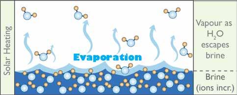
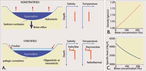
C) Relationship between brine concentration and specific heat;
and specific heat capacity of adjacent brine masses control density and thermal stratification in saline brine bodies located at or near the earth’s surface (Figure 2). Subsequent burial alteration controls later textural evolution by interactions with regional shallow and deep phreatic crossflows (Warren, 2016).
Specific heat is the amount of heat needed to raise one gramme of a substance by 1 °C. For a given amount of heat in-put, a unit volume of hypersaline water will show a greater increase in temperature than a less salty
water (Figure 2c). Given the same degree of insolation, this means density-stratified water bodies tend to be heliothermic, with the low-er, denser bottom brine layer being warmer than the somewhat less saline, less dense, upper water layer (Figure 2a). The level in any water column where a marked change in temperature occurs is the thermocline, and in a density-stratified brine mass corresponds to the halocline, also termed a chemocline (Figure 3a). The combination of high temperature, high salinity and lower oxygen levels in the lower brine mass in a heliothermal brine system
30 RESERVOIR ISSUE 2 • MARCH/APRIL 2017
Figure 1. Brine formation by the loss of liquid water volume and can occur via solar heating at any liquid water surface, either at the surface of a standing water body or in a pore. A series of salts dropout from an increasingly saline brine.
CHALLENGING DOCTRINE ARTICLES
Figure 2. Brine stratification and its causes. A) Terminology and causes of water mass zonation in a perennial brine lake or seaway. B) Relationship between brine concentration and brine density; as concentration increases, density increases.
as concentration increases, density increases specific heat decreases.
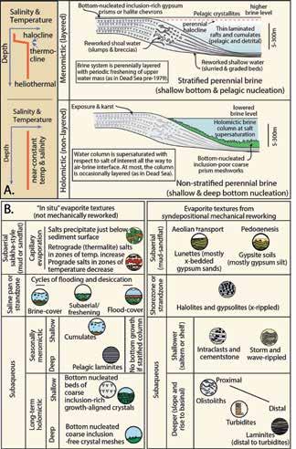
to shallower areas,
means only a specialised bio-ta can survive there, often with specialised bacterial populations living in waters just above a saline thermocline. A modern example is the purple sulphur-oxidising community flourishing immediately above the halocline in Lake Mahoney, British Columbia. Fluctuating salinity and nutrient levels endemic to many evaporite depositing regions encourage preservation of elevated levels of organic matter in a variety of hypersaline settings past and pre-sent (“feast and famine” associations; Warren, 2011).
As any brine concentrates, its density increases (Figure 2b). The overlying water body must be holomictic for bottomnucleated salts to accumulate across
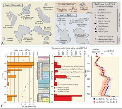
the subaqueous floor of a brine mass and for dense, saturated brine to sink into underlying sediments (Figure 3a). Holomixis means a near homogenous distribution of brine density, temperature, and salinity throughout the brine mass, with internal mixing being ongoing and mostly maintained by wind movement. In contrast, a meromictic brine body is internally stratified, with a lower moresaline, denser, warmer water mass separated across a halocline from an upper, less saline, less-dense, cooler water mass. A longterm halocline hinders chemical or physical changes in the underlying denser waters, so shutting down bottom nucleation, as well as slowing and ultimately stopping brine reflux. A permanently stratified system
is ectogenic, while a brine column that is tempo-rarily stratified is endogenic.
Over decades, saline water masses can change from ectogenic to endogenic. In February 1979, salinity equalisation drove the mixing of upper and lower water masses in the Dead Sea, resulting in a holomictic water body. Since then, aside from short episodes of storm-flooddriven freshening of the upper water mass in 1980 and 1994 (meromixis), the Dead Sea has been holomictic, and halite has been accumulating on the deep lake floor (Gertman and Hecht, 2002). Before 1979, the Dead Sea had been a stratified system for at least 400 years and only pelagic carbonate lam-inites with minor gypsum, not halite,
(Continued on page 32...) RESERVOIR ISSUE 2 • MARCH/APRIL 2017 31
Figure 3. Inter-relationships between brine stratification, stability and depositional texture (After Warren, 2016). A) When stratified, bottom nucleation is restricted
when holomictic, bottom nucleated growth possible over whole basin floor. B) Significance of primary evaporite depositional textures as indicators of brine hydrology.
Figure 4. Ancient evaporites. A) Comparison in depositional extent of modern and ancient evaporites. B) Variable development of basinwide evaporites in time showing importance of proximity of tectonic plate edges (after Warren 2016). Also shows how deposition and dissolution of saline giant salt masses influence Phanerozoic ocean salinity (Hay et al., 2006).
CHALLENGING DOCTRINE ARTICLES
CHALLENGING DOCTRINE ARTICLES
(Continued from page 31...)
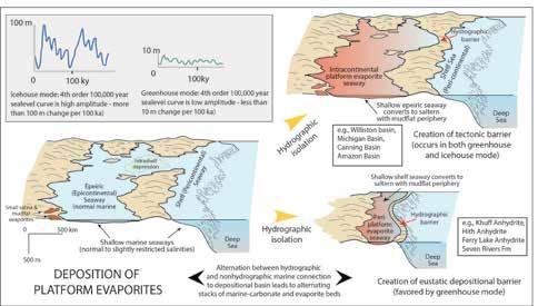
very shallow over areas that were hundreds to thousands of kilometres across. Neither setting has a modern counterpart; pericontinental seaways that evolve into salterns and or evaporitic mudflats are more typical of marinemargin eustatic styles on the earth in greenhouse climate mode, when the lack of permanent polar icecaps, especially coupled with higher rates of seafloor spreading, meant the continental freeboard
Warren, 2010).
accumulated on the deep lake floor, beneath a 370-380 m deep brine column.
Holomixis permits deposition of a coherent salt layer across the whole basin floor, beneath both shallow and deep brine columns. Density stratification allows evaporitic salts to crystallise only in the upper water mass or at the brine-brine interface, so bottom nucleation tends to occur on the shallower lake floor, where it lies above the halocline (Fig-ure 3a). That is, long-term (ectogenic) column stratification mean bottom nucleation of salts can only occur where the upper salt-saturated brinemass intersects the sediment bottom, with a pelagic settling of salts occurring deeper out in the depositional basin, as in the Dead Sea prior to February 1979 (Figure 3a). The bottom growth of crystals cannot occur on a deep bottom located beneath a densitystratified system, as there is no mechanism to drive ongoing su-persaturation in the lower water mass. For the same reason, constant brine reflux driving sinking of a dense brine into sediments beneath the floor of the evaporite basin can only proceed if significant regions of the overlying brine mass are holomictic. Deposition of capillary salts (sabkha deposits) occurs in subaerial settings, wherever the saline capillary zone
intersects the land surface (Figure 3b).
When salts are accumulating beneath a holomictic brine mass, textures in bottom nucleates is controlled by the stabil-ity of the overlying brine column (Figure 3b). When the overlying column is deep (>30-100m) then, other than areas on the deep bottom of local phreatic spring-fed outflows, there is no general hydrochemical mechanism to drive fluc-tuations in bottom-brine chemistry. The resulting deep bottom precipitates tend to be monomineralogic crystal clusters, possibly encased by re-transported material washed in from the shallower surrounds (Figure 3a, 3b). In contrast, when the overlying brine column is shallow (<30m and typically <5-10m) then the chemistry and stability of the brine varies on a shorter term (daily-weekly) basis, so more layered bi-mineralogic bottom-nucleates can accumulate as lay-ered to laminated salt beds. In addition, all evaporite sediments can be reworked by bottom currents, with similar tex-tures to those that characterise siliciclastic and mechanically-modified carbonate sediments (Figure 3b).
"Now" versus "then" in evaporite deposition
Uniformitarianism is an essential tenet
of geological understanding. Yet, when we look at evaporite volumes and depositional settings across deep time, we see that the diversity of modern evaporite analogues is constrained by a deficit in two conditions, specifically; 1) the current lack of greenhouse eustasy; contemporaneous atmospheric conditions and sea levels are controlled by the earth’s current icehouse climate mode and have been for the last 10-12 million years, and 2) the current lack at the plate-edge scale of marine seepage into large hydrographically-isolated oceanic sump basins (Warren, 2010). Both situations circumscribe different hydrologies and eustasies compared to continen-tal-fed inflows that typify the world's current larger evaporite basins. Today, and across the Quaternary, the largest and thickest salt stacks, with areal extents up to 10,000 km2 and thickness up to 900 m, tend to precipitate in the low-er parts of suprasealevel intermontane lacustrine sumps located in tectonically active parts of continental interiors, such as Salar Atacama and Salar di Uyuni in the Andean Altiplano (Figure 4a). Most ancient evaporites are marine-fed and were deposited in huge hydrographicallyisolated subsealevel marine-seepage sumps located in intracratonic ba-sins or within rifts or compressional sutures. Often, the areal extents of these ancient systems were more than 250,000 km2, this is more than two orders of magnitude larger than any Quaternary evaporite deposit. Bedded (prehalokinetic) thicknesses could be more than a kilometre.
Ancient marine saline giants (megahalites and megasulphates) accrued in either of two plate-scale settings, which at times merged into one another, namely; 1) Platform evaporites (Figure 5) and 2) Basinwide evaporites (Figure 6). The first major contrast with nonmarine continental dominance in Quaternary evaporite settings is the fact that platform evaporites require greenhouse eustasy, the second is that basinwide evaporites require tectonicallyand hydrograph-ically-isolated widespread subsealevel depressions, typically found along plate edges with continent-continent proxim-ity (Figure 5).
Neither condition is present on the current earth surface. For basinwides, suitable hydrologic conditions were last pre-sent during the Messinian Salinity Crisis in
32 RESERVOIR ISSUE 2 • MARCH/APRIL 2017
Figure 5. Epeiric (epicontinental) seaways that covered large areas of the continental interior with shallow marine waters are known as intracratonic basins, while epeiric seaways that formed as very wide shelf edges along the continental margin as known as pericontinental seaways.Waters were
was much larger than it is today (after
CHALLENGING DOCTRINE ARTICLES
Platform successions Age Comments
Rus Fm., Arabian Basin, Qatar, Saudi Arabia Eocene, Lower Has a total thickness of about 100 m, composed of limestones and dolomitic limestones (often argillaceous) passing upward into massive 10m thick saltern anhydrite
Ferry Lake Anhydrite, NE Gulf coast, USA Cretaceous, Lower Divided in 9 individual saltern anhydrites that are traceable from southern Mississippi to southern Florida and intercalated with normal marine bioclastic limestones
Smackover/Buckner Fm., N Gulf Coast, USA Cretaceous, Lower Buckner Anhydrite made up of intercalated 2-6m thick saltern anhydrites and marine limestones. It extends from Florida Panhandle to South Texas
Hith Anhydrite, Arabian Basin, Middle East Jurassic, Upper Hith anhydrite is a regional seal that extends across much of the Arabian Peninsula and locally reaches 170 m in thickness. It is composed of bluish-gray to alternating bands of blue and white anhydrite with two internal carbonates and separates marine carbonates of underlying Arab Fm from overlying Yamama (unconformable base).
Middle Anhydrite Marker, Khuff Fm., Middle East Permian, Upper
San Andres Fm., Northern Delaware Basin margin, USA Permian, Upper
Middle Anhydrite can be traced from eastern Saudi Arabia to offshore UAE, and reaches the onshore Fars Province of Iran. This anhydrite is some 12–17 m (20–39 ft) thick and consists of massive saltern anhydrite with minor thin interbeds of dolomite
Anhydrite occurs as widespread saltern units composed of massive nodular mosaic anhydrite beds up to 5m thick capping cyclic shoaling variably-dolomitised platform carbonates. Individual anhydrite beds (P1-P5) that can be traced from Palo Duro basin into shelf edge of the Slaughter-Levelland trend Cadjebut Fm., Canning Basin margin, Australia Devonian, Middle
Cool Creek Fm., Arbuckle platform, USA Ordovician, Lower
Red Heart Dolomite, Georgina Basin, Australia Cambrian, Lower-Middle
Saltern anhydrites up to 5m thick extend across a Devonian platform embayment pass and pass laterally into the sulphide mineralised ore horizons of the Cadjebut Mine region. Saltern sulphates capped shoaling oncolitic and bioclastic muds that overlie normal marine grainstones and wackestones
At least three 1-2 m thick breccias, interpreted to be of solution collapse origin, are present in the Cool Creek and define the presence of former widespread saltern anhydrite units that capped restricted marine stromatolitic carbonate platform sediments
Red Heart Dolomite which extends across much of Central Australia is a completely dolomitised 100m-thick platform carbonate deposited in an evaporitic shallow-water epeiric seaway It is characterized by at least four shallowing-upwards saltern anhydrite-capped cycles. Many of the surface and near-surface anhydrites caps are now leached and represented by collapse breccias
Intracratonic platform evaporite successions Neoproterozoic to Eocene North Sahara Basin, Africa; Canning Basin, Australia; Muschelkalk and Paris Basins, SW Germany and Spain; Amazonas Basin, South America; West Siberian Basin, Russia; Michigan Basin and Williston Basin, USA (see Table 2)
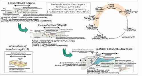
Figure 6. Tectonic and hydrographically isolated (marine endorheic) continent-margin situations where basinwide evaporites tend to accumulate (evaporite beds are shaded pink). Positions are largely tied to world-scale times of continent-continent proximity and so can be tied to the various stages of the Wilson Cycle (After Warren, 2010)
the Mediterranean region, and platform evaporite settings were last pre-sent on earth across large parts of the Middle East carbnate platform during the Eocene (Tables 1, 2). There is a third group of ancient evaporite deposits; it encompasses all nonmarine lacustrine beds past and present (Table 3). This group has same-scale modernancient counterparts, unlike ancient marine platform and basinwide evaporites (Figure 4a; Warren, 2010, 2016).
Platform evaporites
Are made up of stratiform beds, usually <50 m thick and composed of stacked <1 to 5 m thick parasequences or evap-orite cycles, with a variably-present restricted-marine carbonate unit at a cycle base (Table 1).
Salts were deposited as mixed evaporitic mudflat and saltern evaporites, sometimes with local accumulations of bittern salts. Typically, plat-form salts were deposited in laterally extensive (>50-100 km wide), hydrographically-isolated, subsealevel marine-seepage lagoons (salterns) or evaporitic mudflats (sabkhas and salinas). These regions had no same-scale modern counterparts and extended as widespread depositional sheets across large portions of hydrographically isolated ma-rine platform areas, which passed seaward across a subaerial seepage barrier into open marine sediments (Figure 5). In marine margin epeiric settings, such as the Jurassic Arab/ Hith and Permian Khuff cycles of the Middle East or the Cretaceous Ferry Lake Anhydrite
in the Gulf of Mexico, these platform evaporites are intercalated with shoalwater marine-influenced carbonate shelf/ramp sediments, which in turn pass basinward across a subaerial sill into open ma-rine carbonates. Landward they pass into arid zone continental siliciclastics or carbonate mudflats.
Platform evaporite deposition occurred in both pericontinental and epicontinental settings, at times of low-amplitude 4th and 5th order sealevel changes, which typify greenhouse eustasy (Figure 5; Warren, 2010). Platform evaporites also typify the saline stages of some intracratonic basins. Platform evaporites cannot form in the highamplitude, high-frequency sealevel changes of icehouse eustasy. The 100m+ amplitude oscillations of icehouse times mean sealevel falls off the shelf edge every 100,000 years, so any evaporite that had formed on the platform is subaerially exposed and leached. Fourth order high-amplitude icehouse eustatic cycles also tend to prevent laterallycontinuous carbonate sediment barriers forming at the top of the shelf to slope break and so icehouse evaporite systems tend not to be hy-drographically isolated (drawdown) at the platform scale. Rather icehouse eustasy favours nonmarine evaporites as the dominant style, along with small ephemeral marine-margin salt bodies, as seen today in the bedded Holocene hal-ites and gypsums of Lake Macleod in coastal West Australia.
Ancient platform evaporite successions may contain halite beds, especially in intracratonic basinwide settings, but periplatform settings, outside of intracratonic basins, are typically dominated by 5–40 m thick Ca-sulphate beds inter-calated with normal-marine platform carbonates (Table
(Continued on page 34...) RESERVOIR ISSUE 2 • MARCH/APRIL 2017 33
Table 1. Selected platform evaporite examples (see Warren 2016; Chapter 5 for deposit details and listing of relevant citations)
CHALLENGING DOCTRINE ARTICLES
(Continued from page 33...)
1). The lateral extent of these epeiric platform sulphate bod-ies, like the Middle Anhydrite Member of the Permian Khuff Fm. of Saudi Arabia and the UAE, with a current area of more than 1,206,700 km2, constitute some of the most aerially-extensive evaporite beds ever deposited.
Basinwide evaporites
Are made up of thick evaporite units >50–100 m thick made up of varying combinations of deepwater and shallow water evaporites (Table 2). They retain textural evidence of different but synchronous local depositional settings, in-cluding mudflat, saltern, slope and basin (Figures 6). When basinwide evaporite deposition occurs, the whole basin hydrology is evaporitic, holomictic, and typically saturated with the same mineral
phase across vast areas of the basin floor, as in the Dead Sea basin today. The Dead Sea has a more limited lateral scale than ancient basinwides but cur-rently has halite forming simultaneously as; 1) decimeter-thick chevron-dominated beds on the saline-pan floor of the shallow parts around the basin edge in waters typically less than 1-10 metres deep, and 2) as coarse inclusion-poor crystal meshworks of halite on the deep basin floor that sits below a halite-saturated brine column up to hundreds of metres deep (Figure 3a). Ancient basinwide successions are usually dominated by thick massive salt beds, generally more than 100-500 m thick. Deposits are made up of stacked thick halite beds, but can also contain substantial vol-umes of thick-bedded Ca-sulphate and evaporitic carbonate, as in the intracratonic
Gypsiferous Blanchetown Formation Palaeolake Bungunnia Murray Basin, Australia Neogene
halite of Salar
basinwide accumulations of the Delaware and Otto Fiord Basins (Table 2).
Owing to inherent purity and thickness of the deposited halite, many halite-dominant basinwide beds are also remobi-lized, via loading or tectonics, into various halokinetic geometries (Hudec and Jackson, 2007).
34 RESERVOIR ISSUE 2 • MARCH/APRIL 2017
Sequence of interest Basin/setting and Location Age Basin style Tectonic event Messinian Evaporites Lago-Mare (“lake sea”), Mediterranean Miocene, Upper Flexure Convergent foreland, Alpine orogeny Belayim and Gharib formations Gulf of Suez - Red Sea, Middle East Miocene, Middle - Upper Extension Red Sea Breakup and the formation of the Red Sea/Suez Rift Gachsaran Formation Mesopotamian Basin, Middle East Miocene, Middle Flexure Convergent foreland Zagros-Taurus Maha Sarakham Formation Khorat Basin, Thailand Cretaceous, Upper Flexure Convergent foreland Cretaceous inversion and thrust loading Todilto Formation Todilto Basin, New Mexico, USA Jurassic, Middle Flexure Convergent foreland Ancestral Rockies Louann Salt Gulf of Mexico Basin, Gulf Coast Jurassic, Middle Extension Incipient Gulf of Mexico- Atlantic rift Argo Formation & Osprey Evaporites Scotian Basin, and Grand Banks, Canada Upper Triassic-Lower Jurassic Extension Incipient Atlantic rifting Northwich Halite Cheshire Basin, United Kingdom Triassic Extension Incipient Atlantic rifting Halite (S1-S4, Las and Dogger Anhydrite units) Oued Mya Basin, Algeria, Northern Sahara Upper Triassic-Lower Jurassic (Liassic) Extension Intraplate sag basin atop grabens created by incipient Atlantic and Tethyan rifting Saliferous units Ghadames (Berkine) Basin, Algeria Triassic, Upper Jurassic, Lower Extension Intraplate sag basin atop grabens created by incipient Atlantic and Tethyan rifting Argiles d’Argana Essaouria Basin, Morocco Triassic, Upper Flexure Intraplate sag basin atop grabens created by incipient Atlantic and Tethyan rifting Formation Salifere Saharan Atlas, Algeria Triassic, Upper Flexure Intraplate sag basin; incipient Atlantic and Tethyan rifting Salina d’Ourgla Northern Sahara Salt Basin, Algeria Triassic, Upper Flexure Intraplate sag basin; incipient Atlantic and Tethyan rifting Nikitov, Slavyan, and Kramatov Formations Dnieper-Donets Basin, Ukraine and Russia Permian, Lower (Kungurian salt) Flexure Post-rift sag reactivated by Uralian Orogeny (Hercynian) Rotliegende Group Dniepr-Donets Basin, Eastern Europe Permian, Lower Flexure Foreland Variscan Orogeny Zechstein Basin, NW Europe NW European Basin, NW Europe Permian, Upper Flexure Post Variscan Orogeny collapse Castile Formation Delaware Basin, West Texas Permian, Upper Flexure Marathon-Ouchita Iren Horizon Kungurian evaporites North Caspian Basin (aka Pri- or PeriCaspian), Khazakhstan and Russia Permian, Lower Flexure Foreland, Uralian Orogeny. Collision of Russian Platform with the Siberia/Kazakhstan block Otto Fiord Formation Sverdrup Basin, Canadian Arctic Islands Carboniferous Extension Synrift stage of post-Caledonian intracontinental rifting Paradox Formation Paradox Basin, Colorado-Utah USA Carboniferous, Upper Flexure Ancestral Rockies Caurauri Formation Amazonas Basin, South America Carboniferous, Upper Flexure Distal effect of Marathon-Ouchita orogeny Windsor Group Magdalen Basin, Eastern Canada Carboniferous, Lower Extension Cabot fault-Belle Isle transtensional system Liven Horizon Dniepr-donets Basin, Ukraine and Russia Devonian, Upper Frasnian and Famennian Extension Synrift via crustal stretching (passive margin) Prairie Evaporite Elk Point Basin, Western Canada Plains Devonian, Middle Flexure Intracratonic sag; a distal effect of thrust-loaded compression of the western Laurasian plate Salina Group Michigan Basin, USA Silurian, Middle-Upper Flexure Intracratonic sag during Taconian thrust loading, sits atop Mesoproterozoic Midcontinent rift basin Mallowa Salt (Carribuddy Formation) Canning Basin, Northwest Australia Ord. -Silurian Extension Pre-rift to Synrift stage of intracratonic sag Chandler Formation Amadeus Basin, Central Australia Cambrian, Lower Flexure Petermann Range Orogeny Gondwana Accretion Lower and upper Usolye Group Turukhan Irkutsk - Olekmin salt basin, SE Siberian Craton Late Neoproterozoic (Vendian)early Cambrian Flexure Intracratonic Sag- Gondwana assembly Hormuz Formation Arabian Basin, Middle East Late Neoproterozoic- early Cambrian (550 Ma) Compression Collision flexure - Pan African Orogeny; Gondwana Accretion Ara Salt, Oman Fahud, Gaba and South Oman Salt Basins, Oman Late Neoproterozoic- early Cambrian (550 Ma) Compression Collision flexure - Pan African Orogeny; Gondwana Accretion Bitter Springs Formation Amadeus Basin, Central Australia Early Neoproterozoic (≈ 800 Ma) Extension- intracratonic sag Rift - Rodinia breakup Callana Formation Adelaide Geosyncline, South Australia Early Neoproterozoic (≈ 800 Ma) Extension- intracratonic sag Rift - Rodinia breakup
Fm Officer Basin, West Australia Early Neoproterozoic (≈ 800 Ma) Extension- intracratonic sag Rift - Rodinia breakup
Browne
Beds
Sequence of interest Basin/setting Locality Age
of displacive borates Bigadic, Emet and Kirka basins Turkey Neogene
Massive
Grande
Chile Neogene Bed and Bed II Olduvai Gorge, East African Rift Tanzania Pliocene Furnace Creek Fm. (borate beds) Extensional half-graben Death Valley, USA Pliocene-Miocene Gypsum as beds and fracture-fills Sivrihisar/Sultancayir/Cank iri basins Anatolia, Turkey Miocene Lacustrine carbonates Ries-impact-crater Southern Germany Miocene Lacustrine halite, 2.5 km thick Hualapai basin NW Arizona Miocene Kirmir Fm. Beypazari Basin NW Turkey Miocene, MiddleUpper Juncalito Fm. Puna Plateau - intra-arc basin NW Argentina Miocene, MiddleUpper Bedded and nodular gypsum (glauberite) Calatayud Basin Spain Miocene, Lower Bedded and nodular gypsum (glauberite) Ebro Basin - foreland basin Spain Miocene, Lower Creede Fm. Ancient Lake Creede Colorado, USA Oligocene, Upper Potash beds of Couche Inferieure Mulhouse Basin Rhine Graben, Europe Oligocene, Lower Green River Fm. Uinta and Piceance basins Utah and Colorado Eocene Bembridge Limestone Fm. Isle of Wight Southern England Eocene, Upper Taleh Fm. Somalia El Bur Plateau Eocene, LowerMiddle La Tinaja del Oso (colemanite) Magdalena extension basin Mexico Mid-Tertiary Uhangri Fm. Yucheon Group SW Korea Cretaceous Mmashoro Fm. Basal Kalahari Group Botswana Cretaceous, Upper El Molino Fm. Potosi Basin Bolivia Cretaceous, UpperTertiary, Lower Lagoa Feia Fm. Campos Basin Brazil Cretaceous, Lower Codocedo Limestone Member Atacama region Northern Chile Jurassic, UpperCretaceous, Lower Drakensberg Group Intercalated in Karoo basalts Southern Namibia Jurassic, Lower Kalkrand Fm. Karoo flood basalt province Namibia Jurassic, Lower Mercia Mudstone Group North Atlantic rift basins Southern Britain Triassic, Upper Passaic and Lockatong Fms. Newark Basin Eastern North America Triassic, Upper Blomiden redbeds Fundy Basin Nova Scotia Triassic, Upper Buntsandstein Helgoland Basin East Greenland Triassic, Middle Pingdiquan Fm. Junggar Basin NW China Permian, Upper Groden Fm. Intermontane basins, Alps Tyrol, Austria Permian, Upper Opeche Shale Williston Basin North Dakota, USA Permian, Middle Nippewalla Group Continental interior sag basins Kansas, USA Permian, Middle Rotliegende sediments Muhlhausen and Ilfeld basins Germany Late CarboniferousPermian Old Red Sandstone (middle) Orcadian Basin Scotland Devonian, Lower Parakeelya Alkali Member Officer Basin Australia Cambrian
Cordillera de la Costa forearc Central Andes,
Table 2. Selected basinwide evaporite examples classified by age and tectonic setting (see Warren 2016; Chapter 5 for deposit details and listing of relevant citations)
Table 3. Selected pre-Quaternary lacustrine evaporite examples classified by age and tectonic setting (see Warren 2016; Chapter 5 for deposit details and listing of relevant citations)
CHALLENGING DOCTRINE ARTICLES
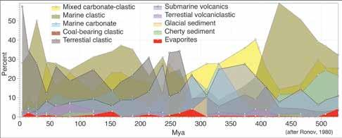
Some basinwide systems (mostly marinefed intracratonic settings) entrain significant accumulations of marine-fed potash salts, as in the Devo-nian Prairie Evaporite of western Canada. In contrast, all Quaternary examples of commercial potash deposits are ac-cumulating in continental lacustrine systems (Warren 2016; Chapter 11).
Basinwide evaporite deposits are the result of a combination of tectonic and hydrological circumstances that are not currently active on the world’s surface (Figure 4b). They were last active in the Late Miocene (Messinian), in associa-tion with soft-suture collision basins tied to the Alpine-Himalaya orogenic belt, and in Middle Miocene (Badenian) ba-sins developed in the early rift stages of the Red Sea. Basinwide systems will be active again in the future at sites and times of appropriate plate-plate interaction, when two continental plate edges are nearby, and the intervening sea-floor is in or near a plateedge rift or suture and is both subsealevel and hydrographically isolated (Figure 6).
Lacustrine (nonmarine) evaporites
Quaternary continental playa/lacustrine are constructed of stratiform salt units, with the greater volume of saline sediment accumulating in lower, more-saline portions of the lacustrine landscape. Beds are usually dominated by nodular gypsum and displacive halite, deposited in extensive evaporitic mudflats and saltpans with textures heavily overprint-ed by capillary wicking, rather than as bedded bottomnucleated layers on the subaqueous floors of perennial brine lakes (Figure 3b; Ruch et al., 2012). In ancient counterparts, the total saline lacustrine thickness ranged from meters to hundreds of meters, with lateral extents measured in tens to hundreds of
kilometres (Table 3; Figure 4a). Lacustrine salt beds are separated vertically, and usually surrounded by, deposits of lacustrine muds, alluvial fans, ephem-eral streams, sheet floods, eolian sands, and redbeds. As today, ancient lacustrine salts accumulated in endorheic or highly restricted discharge basins, with perennial saline water masses tending to occur in the drainage sumps of steep-sided drainage basins (Warren, 2010, 2016). Saline lake basins accumulating gypsum, or more saline salts like halite or glauberite, typically have a shallow water table in peripheral saline mudflat areas and so are dominated by continental sabkha textures. Nearby is the lowermost part of the lacustrine depression or sump where deposition is typified by ephemeral ponded brine pan deposits, rather than permanent saline waters.
Saline lacustrine mineralogies depend on compositions of inflowing waters, so depositional sumps in regions with nonmarine ionic proportions in the feeder inflow, accumulate thick sequences of nonmarine bedded salts dominated by trona, glauberite, and thenardite. In contrast, nonmarine areas with thalassic (seawater-like) inflows tend to accu-mulate more typical sequences of halite, gypsum, and anhydrite.
Across the Quaternary, less-saline perennial saline-lake beds tend to occur during more humid climate periods in the same continental-lacustrine depressions where saline-pan beds form (e.g., Lake Magadi, Great Salt Lake, Lake Urmia). On a smaller scale, in some modern saline lake basins, parts of the lake floor can be permanently located below the water surface (Northern Basin in the Dead Sea or Lake Asal). In
some modern saline sumps dominated by mudflats, a perennial saline lake water mass is located toward the edge of a more central salt-flat zone, forming a perennial water filled “moat” facies surrounding a seasonally desiccated saline pan (as in Salar, de Atacama, Salar de Uyuni, Lake Magadi, Lake Natron). These permanent to nearpermanent saline water “moat” regions are typically created where fresher inflows encounter saltier beds of the lake centre, dissolve them, and so form water-filled peripheral depres-sions. Bottom sediment in the moats tend to be mesohaline carbonate laminites, which can contain TOC levels as high as 12%.
High-water stage perennial saline lacustrine sediments tend to be carbonate-rich or silica-rich (diatomaceous) lam-inites. Ancient examples of large saline lacustrine deposits made up of alternating humid and desiccated lacustrine units include the Eocene Green River Formation of Wyoming and the Permian Pingdiquan Formation of the Junggar Basin, China (Table 4). Evaporites deposited in a suprasealevel lacustrine basin (especially Neogene deposits) have numerous same-scale Quaternary analogues, unlike the more voluminous ancient marine platform and basinwide evaporites (Figure 4a).
Salt punches above its weight, but why? (facilitator for economic accumu-lations of oil, gas and metals)
In terms of total mass in sedimentary basins, the proportion of evaporite across the world’s Phanerozoic basins is rarely more than 2% (Figure 7; Ronov, 1980). Today we have comprehensive documentation that salt horizons, their brines, associated dissolution and alteration conduits control significant economic associations of oil, gas and metals (Warren, 2016):
• 50% of world’s carbonate reservoirs (seals, traps and source rocks)
• All the world’s supergiant oil and gas fields in thrusts (seals and structural traps).
• All supergiant sedimentary copper deposits (halokinetic brine focus)
• 50% of world’s giant SedEx deposits (halokinetic brine focus).
(Continued on page 36...) RESERVOIR ISSUE 2 • MARCH/APRIL 2017 35
Figure 7. Relative proportion of Phanerozoic sediments (replotted from tables in Ronov, 1980)
CHALLENGING DOCTRINE ARTICLES
(Continued from page 35...)
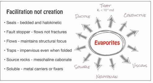
• 80% of giant MVT deposits (sulphate-fixer & brine interface)
• World’s largest Phanerozoic Ni deposit (meta-igneous – Noril’sk).
• Many larger IOCG deposits (metaevaporite, brine and hydrothermal).
This enrichment runs counter to a proportion of 2% of the world's Phanerozoic sediments. The exact why or how of these association is still not well understood. Most geologists working with oil, gas or metal buildups in a salt-rich ba-sin will come to have a suspicion, and for some, the conviction, that salt or its subsurface alteration plays a role in de-fining the position or enrichment level of the commodity of interest. Evaporite masses in the subsurface, especially if halite-dominant, enable both physical and chemical alterations, which tend to improve economic prospectivity. The unique properties of salt in the diagenetic realm tend to facilitate, focus and stabilise processes that lead to elevated levels of accumulations of various commodities (Figure 8). That is, evaporites in a basin tend to enhance the volume of oil gas or metals in an accumulation, but are not necessarily the direct cause of the accumulation/ precipitation.
When the reservoired hydrocarbon below a salt seal is oil, little or no leakage can take place through a laterally con-tinuous evaporite. Even when the reservoired
hydrocarbon is methane, little or no loss occurs, even by diffusion (Eh-gartner et al., 1998). The much greater efficiency of evaporite seals, compared to shales, is clearly seen in the total hydrocarbon volumes held back by the two lithologies. Total worldwide shale sediment volume in the Earth's sedi-mentary crust is more that an order of magnitude greater than that of evaporites, yet the split between reservoired hydrocarbons below a shale or an evaporite seal is roughly 50:50 (Grunau, 1987). Likewise, typical volumes of salt-sealed giant fields dis-covered in the last decade are much grander than that held in mudrocksealed systems (Bai and Yu, 2014).
Of the 120 giant oil and gas fields discovered in the period 2000 - 2012 some 54.6 % are hosted in marine carbonates and 12% in lacustrine carbonates, meaning less than a third of new giant discoveries are in siliciclastic reservoirs (Fig-ure 9a). Some 56% of these oil and gas giants have an evaporite seal, with 82% of the marine carbonates having an evaporite seal and 91% of the lacustrine carbonates having an evaporite seal (Figure 9b, c). Clearly, carbonate reservoirs with evaporite seals constitute most the giant oil and gas discoveries across the period 2000-2012, and the pro-portions of this association are likely to increase in conventional discoveries across the next decades (Bai and Yu, 2014).
Of these 120 oil and gas giants, one is a megagiant field with a recoverable reserve
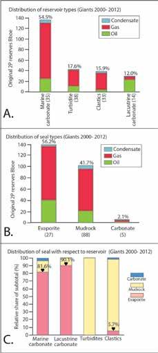
in the period 2000-2012. A) Dominant reservoirs for oil and hydrocarbon type. B) Seal mineralogy. C) Relations of reservoir to seal mineralogy (after Bai and Yu, 2014)
of 50 Bboe (Billion barrels oil equivalent) or more, and 6 are supergiant fields with recoverable reserves of 5 Bboe or more. The seven largest fields are: Galkynysh (aka Yolotan or Osman) gas field in the Ama-Darya Basin of Turkmenistan with an original 2P reserve of 67.1 Bboe, making it likely the second largest known gas field in the world; Kashagan oil field (18.1 Bboe) in the North Caspian basin; Kish 2 gas field in the Arabian Basin (Iran): Lula (previously known as Tupi), Franco and Libra oil fields in the Santos Basin of offshore Brazil; and Sulige gas field (5.7 Bboe) in the Ordos Basin, China. In this listing, the geology of Galkynysh is not yet reliably published, but of the remaining 6, only Sulige does not have an evaporite association.
36 RESERVOIR ISSUE 2 • MARCH/APRIL 2017
Figure 8. Subsurface evaporites (especially if halite-dominant) possess a set of unusual physical and chemical properties, compared to siliciclastics and carbonate sediments, these unusual properties facilitate economic accumulations of oil, gas and metals.
Figure 9. Evaporite seals to giant fields discovered
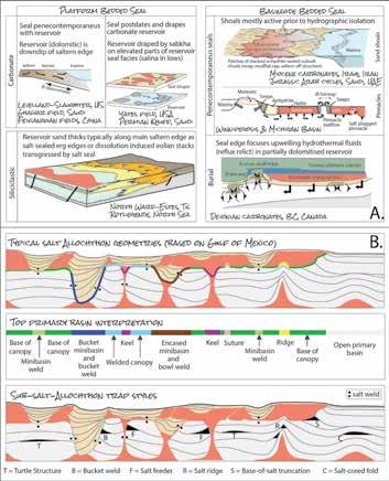
Warren, 2016; Chapter 10). B) Halokinetic structuration and sealing based on sub-allochthon traps in the Gulf of Mexico (after Pilcher et al., 2011).
Typical bedded evaporite seals, especially beds composed of monomineralogic assemblages such as massive nodular anhydrite or massive halite and have measured entry pressures more than 3000 psi. Most impure evaporite beds have entry pressures greater than 1000 psi, as do many evaporite-plugged reflux dolomites. Contrast this with most shales, which tend to be water-bearing (mostly bound and structural water) and having typical entry pressures between 900 and 1500 psi (Sneider et al., 1997). Although such shales are respectable seals, over time shale allows substantial diffusive leakage of methane and even liquid hydrocarbons via inherent microporosity, less so if the shales are organic-rich. Even ignoring halite's ability to reanneal under stress, any evaporite seal has much lower intrinsic permeability than shale, and this helps maintain its seal integrity. With
CHALLENGING DOCTRINE ARTICLES
permeabilities of 10-7 md, a hydraulic gradient of 0.01, and a porosity of 0.01, a brine would take somewhere between 3 and 30 million years to flow 1 metre into an unfractured halite seal. For anhydrite, which has permeability some 100 times higher than halite, a brine would take between 30,000 and 300,000 years to flow 1 metre into the seal (Beauheim and Roberts, 2002).
Evaporites are excellent longterm seals to substantial hydrocarbon columns. This applies to any siliciclastic and carbonate reservoirs adjacent to bedded or halokinetic salty seals (Figure 10). The exemplary ability of bedded evaporites to act as seals holding back massive hydrocarbon columns is clearly seen in the Middle East, where Ghawar, the world’s largest oil field, is sealed by bedded anhydrites of the Jurassic Arab D Formation and the overlying Hith Anhy-drite seal. This evaporite seal association in Ghawar holds back an estimated remaining reserve of more than 100-200 billion barrels. Bedded platform anhydrites also seal Safaniya, the world’s largest offshore field, also in Saudi Arabia, with estimated reserves of more than 25-30 billion barrels of oil and 5 billion cubic feet of natural gas. Likewise, Per-mian platform anhydrites are the regional seal to North Field in offshore Qatar, the world’s largest single gas field (non-associated gas) with more than 500 tcf of reserves (Alsharhan and Nairn, 1997). This gas is reservoired and sealed in the evaporitic dolomites of the Permian Khuff Formation and recent
announcements by the Qatari Government have postulated more than 900 tcf of certified non-associated gas sealed in the North Field structure.
In terms of physical processes, buried near-pure halite beds and masses (rock salt) in the sedimentary realm are rheologically unusual compared to other nearby sediments, in that at geological time scales rock salt can set up defor-mation responses that mimic Newtonian fluid responses. At the same time, intercrystalline textures in the flowing salt mass maintain seal integrity, even as local crystals dissolve and reprecipitate. That is, down to depths of 6-8 km rock salt flows and maintains seal integrity, while adjacent non-salt sediments tend to fault and fracture. The ability of bedded salt to seal (Figure 10a) and of flowing salt to create and seal supra-, intraand sub-salt reservoirs is well doc-umented (Figure 10b).
Dense evaporitic brines can pass through adjacent or underlying sediments both at the time the bedded salts are ac-cumulating or later as a subsurface salt mass dissolve. For example, chemical responses, created within the set-up hydrology of widespread salt deposition and early burial, drives brine reflux, moving magnesium-rich modified sea-water brine into and through the underlying carbonate sediments. This hydrology crafts broad reflux dolomite haloes, with local burial anhydrite patches and overall improve intercrystalline connectivity, at least until the dolomite reser-voir become overdolomitised (Figure 11). Once this happens, all effective polyhedral porosity is lost in the dolomite and the reservoir potential is destroyed. Later dissolution brines can create hydrothermal waters capable of leaching and burial dolomitization, as in the burialdolomite reservoirs of the Western Canada Sedimentary Basin (Davies and Smith, 2006).
As long ago as the middle of last century, Weeks (1961) emphasised the importance of evaporites as seals to many of the world's major hydrocarbon accumulations. He also pointed out that many of the cycles of deposition that involve organic-rich carbonate marls or muds also end with evaporites. Clearly, in evaporitic settings, there is an association with Type I-II
(Continued on page 38...) RESERVOIR ISSUE 2 • MARCH/APRIL 2017 37
Figure 10. Examples of salt-hydrocarbon associations. A) Summary of the various ancient platform and basinwide bedded evaporite settings where a combination of evaporite sealing, dolomitisation (both early and late) and focused evaporite-related fluid flow creates a variety of hydrocarbon traps (after
CHALLENGING DOCTRINE ARTICLES
(Continued from page 37...)
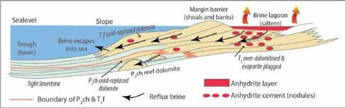
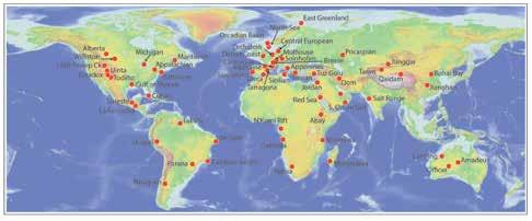
hydrogen-prone kerogens in mesohaline source rocks, and this is related to the ability of halotolerant photosynthetic algae and cyanobacteria to flourish in periodically mesohaline waters. Such kerogens tend to be oil-prone rather than gas prone and typified by long-chain hydrocarbons (Warren, 2011).
Much of the mesohaline organic matter preserved in evaporitic carbonates, and the resulting source rocks, originated as planktonic blooms (pelagic “rain from heaven”) or from the benthic biomass (“in situ” accumulations). Such organ-ics typically settled out as seriate pulses of organic matter (often pelleted) that sank to the bottom of a layered brine column. Each pulse was tied to a short period when surface brines were diluted and halotolerant producers (mostly cyanobacteria and algae) flourished in the freshened lit zone. That is, laminated mesohaline mudstones that consti-tute most evaporitic source rocks reflect biological responses to conditions of “feast or famine” in vacillatingly-layered brine bodies (Figure 12; Warren, 1986, 2011).
Worldwide, studies of schizohaline evaporitic basins have shown that organicrich mesohaline sediments can accumulate beneath ephemeral surface brines in salterns, or in basin and slope settings in both marine and continental set-tings (Figure 12; Kirkland and Evans, 1981; Oehler, 1984; Warren, 1986, 2011; Rouchy, 1988; Busson, 1992). The most prolific accumulations of organics in ancient evaporitic settings tend to be laminated micritic carbonates deposited beneath intermittently stratified moderately-saline (mesohaline) anoxic water columns of varying brine depth.
There are three, possibly four, major mesohaline density-stratified settings where organic-rich laminites (source rocks) accumulate in saline environments that are also associated with, or evolve into, evaporite deposits (Warren, 2011):
1) Basin-centre lows in marine-fed evaporitic drawdown basins (basinwide salts).
2) Mesohaline intrashelf lows atop epeiric
evaporitic platforms.
3) Saline-bottomed lows in perennial underfilled saline lacustrine basins.
4) Closed seafloor depressions in halokinetic deepwater marine slope and rise terrains.
In addition to the evaporite hydrocarbon association, there is an association of evaporite settings with the larger of the known MVT, Sedex, Stratiform Sedimentary Copper and some IOCG associations (Figure 13; see Warren 2016, Chapter 15 and 16 for detailed case histories and models). The role of evaporites in focusing metalliferous ore accu-mulations is two-fold; 1) In solution (halite-dominant precursor) they can act as chloride-rich metal carriers and 2) Lo-cally, as beds or masses (especially of CaSO4), their dissolution products, especially if trapped, can supply sulphur (mostly as bacteriogenic or thermogenic H2S) and also set up chemical interfaces that act as foci in the setup of brine mixing conditions suitable for precipitation of metal sulphides or native elements. Hence, most evaporite-associated ore systems tend to be epigenetic, rather than syngenetic. Subsurface salt beds and masses are merely the solid part of a large ionic recycling system; dissolved metals are another part, and zones of mixing between the two are typically sites where ores tend to accumulate. Halokinesis steadies the position of a redox interface, tied to a salt dissolution brine halo, and enables an extended phase of focus to a metal precipitative (redox) interface at a stable location in subsurface earth-space (Warren, 2016).
At the world-scale, evaporite-associated metalliferous systems are driven by plate tectonics. Halite-dominated se-quences, deposited in the drawdown basin centres, tend to dissolve in burial, and so supply chloride ions to the brine system. Salt beds that are thick enough tend to flow and so focus the upward, and centripetal passage of basinal and hydrothermal fluid flows. Dissolving gypsum or anhydrite beds, typically deposited higher on the basin platform or diagenetically accumulated along salt dissolution edges and touchdowns can supply sulphur, via bacterial or thermochemical sulphate reduction, while simultaneously focusing metalliferous brine flows into the precipitation interface.
38 RESERVOIR ISSUE 2 • MARCH/APRIL 2017
Figure 11. Model of reservoir creation via saltern brine reflux, based on dolomite distribution in the Upper Permian Changxing Formation (P3ch) and the Lower Triassic Feixianguan Formation (T1f), NE Sichuan Basin, China (after Jiang et al., 2013).
Figure 12.Worldwide distribution of evaporite-related source rocks named with respect to hosting basins (replotted from SaltWork GIS database version 1.7).
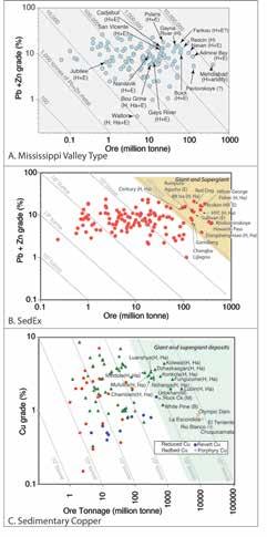
centred on the fol-lowing evaporite facts:
1) The distribution of evaporite depositional textures maps paleotopography across the underlying carbonates and siliciclastics. So, depositional signatures preserved in the seal can be used to map reservoir quality trends in terms of reflux dolomite intensity, anhydrite cement-patch distributions and zones of subaerial diagenesis
2) Thick beds of halite tend to accumulate in particular plate tectonic settings. Beds deposited in plate-edge saline sumps tend to flow via sediment loading and extension, without later super-imposed tectonic stresses. In contrast, bed deposited in intracratonic settings tend to require later externally-imposed tectonic stress in order to flow. Hy-drocarbon trapping geometries are tied to particular styles of salt tectonics
3) Mesohaline source rock distribution is related to evaporite basin architecture and likely fluid escape pathways, which in turn are related to seal type and timing of salt dissolution or halokinetic withdrawal.
4) Potash ore quality controls are related to the timing of various brine crossflows generated during deposition, meso-genesis and telogenesis.
Geologie de la France, v. 1, p. 15-64.
Davies, G. R., and L. B. Smith, 2006, Structurally controlled hydrothermal dolomite reservoir facies: An overview: Bulle-tin American Association Petroleum Geologists, v. 90, p. 1641-1690.
Ehgartner, B. L., J. T. Neal, and T. E. Hinkebein, 1998, Gas Releases from Salt: SAND98-1354, Sandia National Laboratories, Albuquerque, NM, June 1998.
Gertman, I., and A. Hecht, 2002, The Dead Sea hydrography from 1992 to 2000: Journal of Marine Systems, v. 35, p. 169-181.
Grunau, H. R., 1987, A worldwide look at the cap-rock problem: Journal of Petroleum Geology, v. 10, p. 245-266.
Hay, W. W., A. Migdisov, A. N. Balukhovsky, C. N. Wold, S. Flogel, and E. Soding, 2006, Evaporites and the salinity of the ocean during the Phanerozoic: Implications for climate, ocean circulation and life: Palaeogeography, Palaeoclima-tology, Palaeoecology, v. 240, p. 3-46.
When the chemistries of the dissolving salt beds and the metal carriers interact so that redox fronts, salinity contrasts, and other precipitative interfaces are set up, an ore deposit can form. Thus, in base and precious metal exploration within evaporitic terranes, we are ultimately searching for those parts of a subsurface ionic cycling system where the salt dissolution, salt beds and metal systems have interacted to create economic levels of metalliferous precipitates.
If salt is more than a seal, then......
From a time in the 1950's and 1960's when evaporites were mostly seen as seals, knowledge systems developed over the next five decades now allow us to do much more with respect to predictive industrial geology,
5) Positions of likely base metal and copper accumulations relate to set-ups of dissolution-related of redox interfaces, mesogenetic cross-flows, and in some cases, halokinetic geometries. At the plate tectonic scale, these accumulations occur at particular hydrological interfaces within the basin architecture.
References
Alsharhan, A. S., and A. E. M. Nairn, 1997, Sedimentary Basins and Petroleum Geology of the Middle East: Amsterdam, The Netherlands, Elsevier Science B. V., 942 p.
Bai, G., and Y. Xu, 2014, Giant fields retain dominance in reserves growth: Oil & Gas Journal, v. 112, p. 44-.
Busson, G., and et al., 1992, Basins paleogenes saliferes de l'Est de la France (Valence, Bresse et Haute-Alsace) Translated Title: Paleogene salt basins of eastern France, Valence, Bresse and Haute-Alsace:
Jiang, L., C. F. Cai, R. H. Worden, K. K. Li, and L. Xiang, 2013, Reflux dolomitization of the Upper Permian Changxing Formation and the Lower Triassic Feixianguan Formation, NE Sichuan Basin, China: Geofluids, v. 13, p. 232-245.
Kirkland, D. W., and R. Evans, 1981, Sourcerock potential of an evaporitic environment: Bulletin American Association of Petroleum Geologists, v. 65, p. 181-190.
Oehler, J. H., 1984, Carbonate source rocks in the Jurassic Smackover trend of Mississippi, Alabama, and Florida, in J. G. Palacas, ed., Petroleum geochemistry and source rock potential of carbonate rocks, v. 18: Tulsa, Oklahoma, Ameri-can Association of Petroleum Geologists, Studies in Geology, p. 63-69.
Pilcher, R. S., B. Kilsdonk, and J. Trude, 2011, Primary basins and their boundaries in the deep-water northern Gulf of Mexico: Origin, trap types, and petroleum system implications: Bulletin American Association Petroleum Geologists, v. 95, p. 219-240.
(Continued on page 40...) RESERVOIR ISSUE 2 • MARCH/APRIL 2017 39
Figure 13. Resource plots for various metal accumulations showing those with evaporite associations. H indicates hypersaline ore fluids, E indicates evaporites or indications of its former presence, Ha= halokinetic, B = bedded, M = meta-evaporite (replotted from SaltWork GIS database version 1.7).
CHALLENGING DOCTRINE ARTICLES
CHALLENGING DOCTRINE ARTICLES
(Continued from page 39...)
Ronov, A. B., V. E. Khain, A. N. Balukhovsky, and K. B. Seslavinsky, 1980, Quantitative analysis of Phanerozoic sedimen-tation: Sedimentary Geology, v. 25, p. 311-325.
Rouchy, J. M., 1988, Relations évaporiteshydrocarbures:l'association laminitesrécifes-évaporites dans le Messinien de Mediterranée et ses enseignements, in G. Busson, ed., Evaporites et hydrocarbures, v. 55, Mémoires du Muséum na-tional d'Historie naturelle, (C), p. 15-18.
Ruch, J., J. K. Warren, F. Risacher, T. R. Walter, and R. Lanari, 2012, Salt lake deformation detected from space: Earth and Planetary Science Letters, v. 331-332, p. 120-127.
Sneider, R. M., J. S. Sneider, G. W. Bolger, and J. W. Neasham, 1997, Comparison of Seal Capacity Determinations: Con-ventional Cores vs. Cuttings, in R. C. Surdam, ed., AAPG Memoir 67: Seals, Traps, and the Petroleum System.
Warren, J. K., 1986, Shallow water evaporitic environments and their source rock potential: Journal Sedimentary Pe-trology, v. 56, p. 442-454.
Warren, J. K., 2010, Evaporites through time: Tectonic, climatic and eustatic controls in marine and nonmarine depos-its: EarthScience Reviews, v. 98, p. 217-268.
Warren, J. K., 2011, Evaporitic source rocks: mesohaline responses to cycles of “famine or feast” in layered brines, Doug Shearman Memorial Volume, (Wiley-Blackwell) IAS Special Publication Number 43, p. 315-392.
Warren, J. K., 2016, Evaporites: A Compendium (ISBN 978-3-319-13511-3) Berlin, Springer, 1854 p.
Weeks, L. G., 1961, Chapter 5, Origin, migration and occurrence of petroleum, in G. B. Moody, ed., Petroleum Explora-tion Handbook: New York, McGraw-Hill.

Medal of Merit
Call For Nominations
Each year the CSPG awards the Medal of Merit to authors of the best peer-reviewed paper published during the previous year on a subject related to the petroleum geology of Canada. A sterling silver medal is presented to each of the authors. The list of previous winners can be seen under awards on the CSPG website.
The Medal of Merit Committee searches the literature for potential candidates and selects the best paper, favouring well written and illustrated papers with novel ideas that have relevance to Canadian petroleum geology and/or the broader practice of petroleum geology. The committee will be evaluating papers published during the calendar year 2016 for the 2017 award. In addition to papers from academic journals, papers which form part of a special publication are also eligible. If you know of a 2016 peer -reviewed paper that the committee should consider, please submit the details by July 31, 2017 to:
Ross Kukulski, Chair Medal of Merit Committee
Ross.kukulski@chevron.com
(403) 234-5450

40 RESERVOIR ISSUE 2 • MARCH/APRIL 2017
Applied Political (geo)Science: The History, Context and Technical Basis Behind Central European Petroleum's Guhlen Discovery, Brandenburg State, Eastern Germany
SPEAKER
Peter Putnam, Central European Petroleum Ltd. Alula Damte, Central European Petroleum Ltd.
11:45 am
Tuesday, March 14th, 2017
Marriott Hotel, Kensington Ballroom Calgary, Alberta
Please note: The cut-off date for ticket sales is 1:00 pm, five business days before event. Tuesday March 07, 2017]. CSPG Member Ticket Price: $45.00 including GST. NonMember Ticket Price: $55.00 including GST.
Each CSPG Technical Luncheon is 1 APEGA PDH credit. Tickets may be purchased online at www.cspg.org
ABSTRACT
Germany sits astride the North European Plain, one of the world's great geopolitical corridors that also rests upon much of a large sedimentary basin known as the 'Southern Permian Basin' that stretches from the southern North Sea into western Ukraine. As well as being a well-trod invasion route, this region is also the location of many pipelines that carry exported petroleum from Russia to central and western Europe which makes this area one embodying much actual and potential geopolitical conflict.
Commercial hydrocarbon accumulations found within Permian Rotliegend sandstone and Zechstein carbonate reservoirs form a near-continuous chain extending from the British sector of the North Sea eastwards through the Netherlands, Germany, and into western Poland. Giant gas fields in this trend include the Rotliegend-hosted Groningen (100 Tcf; Netherlands and western Germany) and Altmark-Salzwedel (7 Tcf; westernmost portion of the former communist German Democratic Republic ('GDR')) accumulations whereas
substantial oil and liquid-rich gas deposits are known from the Zechstein-hosted LMG (70 mmbo) and BMB (135 mmboe) fields of western Poland. A prominent gap between significant accumulations is found within the easternmost German state of Brandenburg. Central European Petroleum ('CEP') posted and acquired the Lubben exploration license in the gap and the Guhlen discovery resides within this acreage.
Beyond being on the regional trend, CEP targeted Brandenburg acreage because:
I. The state is one of the poorest in Germany but has a resource economy based mainly on lignite mining.
II. Historic petroleum exploration and development activity was carried out by the former national communist petroleum company 'EEG' (i.e., only one competitor has ever worked in the area).
III. The availability of, and ease of access to, much open acreage at favorable terms.
IV. The limited availability of subsurface data which historically limited competition for acreage,
V. The proximity to large markets reliant to a significant degree on Russian imported petroleum.
VI. Stable regulatory and legal regime based on German mining law.
Since German re-unification in 1990, exploration in this region has been hindered by the following challenges, all of which have been overcome by CEP:
I. German mining law stipulates that, under certain conditions, subsurface data can be held confidential in perpetuity. As there has historically been only one operator that created virtually all subsurface data prior
to CEP, the former communist national petroleum company, it and its successor own all historic well and seismic information. CEP has overcome the challenge of data access by acquiring its own seismic and well data, acquiring legacy data from the owner under a range of commercial conditions, and forensic investigations of museums and government agencies. As an example, after the ownership of the communist national petroleum company passed to Gaz de France-Suez (now 'Engie') in 1994, several thousand employees lost their jobs. Several of these former employees subsequently created a museum dedicated to the petroleum industry of the former GDR. Within this museum CEP staff found a significant amount of data otherwise unavailable to the public and also uncovered those approaches and techniques used during GDR operations. The museum also provided insight into the limitations of EEG's activities (see next point).
II. An absence of modern subsurface information and approaches. As an example, most wells were drilled by EEG before seismic was acquired. Prior to CEP operating activities there was only one small 3D seismic data set in the state. CEP acquired the largest (275 km2) 3D seismic data set found to date east of the Elbe River in Germany; acquisition of this data set included a significant area covering a large recreational lake.
III. The exploration trend upon which CEP's Guhlen discovery sits extends through a very large former military area that is plagued by contamination by unexploded ordnance dating back to World War II and the Cold War. To provide surface access CEP has conducted unexploded ordnance surveys, one of which resulted in the controlled explosion of 4.5 tons of munitions.
(Continued on page 42...) RESERVOIR ISSUE 2 • MARCH/APRIL 2017 41 TECHNICAL LUNCHEON
TECHNICAL LUNCHEON
(Continued from page 41...)
The Guhlen-1a well provided one of the largest test results harvested from any well onshore northwestern Europe over the past several years. The evolution of the Guhlen prospect included the following steps:
I. Acquisition of gravity data along hiking trails and roads surrounding the Guhlen1a location. Interpretation of this data suggested the presence of an untested structural high.
II. Acquisition of a regional 2D seismic grid confirmed the presence of the structural high.
III. A vertical well, Guhlen-1, was drilled with a sub-commercial hydrocarbon gas flow obtained on test from a porous but tight Zechstein grainstone pervasively cemented by anhydrite, halite and carbonate. The reservoir was 40 meters thick with 20 net meters deemed hydrocarbon-bearing. No bottom water was measured on well logs and no aquifer water was recovered on test.
IV. Acquisition of 275 km2 of 3D seismic data surrounding the Guhlen well which represented the largest data set of its kind ever acquired in the state. The data was subsequently inverted in a way similar to that employed by the Polish national petroleum company in its discovery of large Zechstein-hosted accumulations in western Poland.
V. A sidetrack well, Guhlen-1a, was subsequently drilled from the original Guhlen-1 well into a seismic anomaly located about 700 meters to the southwest of the original bottom hole location. The sidetrack location was drilled low on the structural flank in order to avoid gas as the initial play concept was focused on oil. The sidetrack discovered 46 meters of highly fractured oolitic grainstone with variable matrix porosity and virtually no anhydrite or halite cement. The reservoir displays an 8 meter gas cap resting upon a 38 meter oil leg with no bottom water, based on log analysis.
The test of Guhlen-1a resulted in a recovery of 1,692 boepd formed of the following constituents:
I. 17 mmcf/d of raw gas, with rate limited by tubular size, formed of 5.2 mmcf/d of hydrocarbon gas and the rest was mostly nitrogen with minor amounts of carbon dioxide and hydrogen sulfide.
II. 509 b/d of natural gas liquids formed mostly of butane and pentane.
III. 293 b/d of condensate and 23 b/d of oil.
The following was also measured during the test:
I. Flowing well head tubing pressure of 3,035 psi/207 bar.
II. Maximum drawdown was 7%.
III. No reservoir depletion was measured.
IV. No formation water was recovered.
The runway created by a combination of the Guhlen-1a test result with the well location low on a large regional structure, that extends at least through a previously 'no-go' region covered by one of the largest former military bases in Europe, results in a prospective fairway up to 50 km long and covering an area of several hundred km2. It may turn out that, with successful appraisal and additional exploration, the Guhlen discovery will be the largest German find in a generation and may open up a large conventional play type within the eastern German borderlands. The immense geopolitical upsets of 20th century Europe echo today within the realms of energy supply, competing national interests and, at least for CEP's purposes, the creation of substantial commercial opportunities.
Biography
Peter Putnam is a geologist with 37 years of varied global experience at both technical and executive levels. His endeavors have covered the areas of exploration, development (inclusive of primary, secondary and thermal recovery), operations, reserves assessments, research and training. Over his career he has been, at various times, an employee, an advisor to technical and management teams as well as boards of directors, a board member, and a founder of new companies. Early stage companies started by Peter have raised over $1 billion in equity from investors inclusive
of large private equity firms, sovereign wealth funds, pension funds and family offices. With experience on six continents, he is currently the Chair and Chief Executive Officer of Central European Petroleum Ltd., a private petroleum company focused on eastern Germany. Peter holds a Ph.D. from the University of Calgary and is a past-President of the Canadian Society of Petroleum Geologists, a former adjunct professor at the University of Calgary, and a former councilor of the Association of Professional Engineers and Geoscientists of Alberta (APEGA). He has published widely as an author of scientific articles dealing with various facets of petroleum geology and is a regular guest lecturer at Canadian universities.
Alula Damte is a structural geologist with over 24 years of petroleum industry and teaching experience. He has worked in evaluating petroleum systems in varied structural styles including intracratonic rift basins, convergent plate margins and offshore coupled shelf extensional and basinward toe thrust systems. He has provided exploration and business development advice and led exploration ventures in geographically diverse areas that include onshore and offshore frontier basins of Canada, North and East Africa, the Middle East, the Gulf of Mexico, South America, Australia and onshore Europe. He is currently the President and COO of Central European Petroleum Ltd (CEP), the Geschäftsführer of CEP's German subsidiary, and he also serves as Chairman of Petrel Robertson Consulting Ltd. Alula is a Fulbright Scholar and holds a PhD from University of California, Santa Barbara.
42 RESERVOIR ISSUE 2 • MARCH/APRIL 2017
Fracture Size and Intensity Scaling from Core to DFN Model
SPEAKER
Doug Bearinger, Nexen Energy ULC
11:45 am
Tuesday, April 4, 2017
Marriot Hotel, Kensington Ballroom Calgary, Alberta
Please note: The cut-off date for ticket sales is 1:00 pm, five business days before event. [Tuesday, March 28, 2017]. CSPG Member
Ticket Price: $45.00 including GST. NonMember Ticket Price: $55.00 including GST.
Each CSPG Technical Luncheon is 1 APEGA PDH credit. Tickets may be purchased online at www.cspg.org
Geomodeling of naturally fractured reservoirs involves scale-up challenges that are not faced in conventional reservoirs. Matrix properties can be reasonably well measured at the core scale and applied to the reservoir scale, whereas the distributions of the fracture properties observed in cored and imaged wells must be scaled to account for the larger features that dominate flow in fractured reservoirs.
Fractures described in core and those interpreted in image logs allow the identification of fracture sets and their properties. Often the most important flow features are too sparsely distributed to be sampled in a single well. Even if one of these larger features is intersected by a well, the size of the fracture cannot be determined. For reservoirs with mainly vertical fractures, deviated and horizontal wells can provide good estimates of fracture intensities after accounting for sampling bias. In wells oriented to cross fractures, the aperture is only fracture dimension that can be measured directly from core or estimated from wellbore images. Vertical wells have the possibility of drilling parallel to many fractures allowing fracture heights to be measured as well.
To build a Discrete Fracture Network model (DFN) both the fracture sizes and intensities must be scaled to obtain the truncated size distribution relevant to flow modelling. The extreme sample bias of a vertical well
requires a robust correction to determine fracture intensities. It is helpful to have fracture measurements from inclined or horizontal wells to ensure that the fracture intensities obtained from vertical cores are reasonable. Core provides the highest resolution from the smallest sample allowing description of smaller fractures not resolved by the image log. Fracture observations suffer from two factors that limit the useful size distribution, truncation (minimum size detected or measured) and censoring (inability to adequately sample large features). Care must be taken to use the appropriate distribution function by fitting curves within the region that is not impacted by truncation or censoring.
This presentation describes the process used to scale vertical core observations to the inputs needed for a realistic DFN model of a shale reservoir. The impact of the fracture size-intensity scaling is demonstrated with model results that are able to match other observations.
Citiations
Ortega, O. J., Marrett, R. A., & Laubach, S. E. (2006). A scale-independent approach to fracture intensity and average spacing measurement. AAPG bulletin, 90(2), 193208.
THE EFFECT OF FRACTURE AND BOREHOLE ORIENTATION ON FRACTURE FREQUENCY AND DENSITY
Copyright © 2012 by Charles R. Berg
Narr, W., 1996, “Estimating average fracture spacing in subsurface rock”, AAPG Bulletin, 80(10): 1565-1586.
Terzaghi, R.D., 1965 “Sources of errors in joint surveys”, Geotechnique. 15: 287-304.
Biography
Doug Bearinger is a Geology Advisor with Nexen Energy ULC. Since 2000 he has developed, characterized and modelled fractured granite reservoirs in Yemen, Mannville Coal Bed methane in Alberta, Horn River Shales in NE British Columbia, and Carbonate reservoirs in Iraq. His areas of focus include natural fracture network description, stimulated fracture network
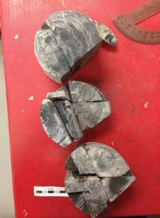
characterization and modelling, fracture growth modelling, geochemical fluid behaviour and fluid clean-up modelling. He graduated in 1982 with a BSc in Applied Earth Science-Geotechnical Option from the University of Waterloo. Bearinger has served on SPE workshop committees for Hydraulic Fracture Flowback, Horizontal Completions in Shales, and Characterizing Unconventional Reservoirs Using In-Situ Tests.
RESERVOIR ISSUE 2 • MARCH/APRIL 2017 43 TECHNICAL LUNCHEON
HEAVY OIL DIVISION TALK
Oil Sands Pioneers: How Scientists and Entrepreneurs
Made the Unconventional More “Conventional”
SPEAKER
Fran Hein, Alberta Energy Regulator
Time: 8:00am – 9:00am
Date: March 1, 2017
Location: Halliburton Training Room (Room 1830)
645 – 7th Ave SW Calgary AB
ABSTRACT
The vast oil sands of Alberta have become one of the major unconventional energy resources in the World, and an integral part of the global energy mix. Origins of the oilsands/heavy-oil industry are a Canadian technology and entrepreneurial success story- one, of which, is often ignored.
By the late 1800s/early 1900s a number of unsuccessful drilling seasons finally resulted in 1910 with the establishment of the first Athabasca Oil and Asphalt Co. Founding of the Alberta Research Council and later hiring of Dr. Karl Clark resulted in the 1929 patenting of a hot-water
separation process to extract bitumen from the oil sands. About 30 years ago, cyclic steam stimulation (CSS) projects were started at Primrose and Peace River, AB, followed by targeted Alberta government (AOSTRA) funding to test the feasibility of Steam-Assisted Gravity Drainage (or SAGD) for in-situ recovery of bitumen. The SAGD process, invented by Dr. Roger Butler, was field tested as the AOSTRA Underground Test Facility near Dover, AB. At this time, well delineation of the oil sands was sparse, and databases consisted (at most) of ~4 wells/township.
Through the decades, government, industry, and academia have collaborated to bring the science and technology together for effective, efficient, safe, and environmentally-responsible development of the oil sands/heavy oil. This collaboration made what many considered (at best) an experimental design(s), to be the backbone of the Alberta present and future of the energy industry.
BIOGRAPHY
Fran Hein received her B.Sc. from University of Illinois at Chicago, M.Sc. and Ph.D. at McMaster University in Hamilton, Ontario, all in geology. Fran is with the Alberta Geological Survey (Alberta Energy Regulator) where she worked on oil sands for about 19 years. Fran was co-editor of the AAPG Studies in Geology 64 on Oil sands and heavy oil; and in 2014, received the Canadian Provincial and Territorial Geologists’ national award for her work on oil sands and other unconventionals. She has recently co-edited a volume of the Bulletin of Canadian Petroleum Geology on bitumen and heavy oil.
Division Sponsor:
44 RESERVOIR ISSUE 2 • MARCH/APRIL 2017 DIVISION TALKS
HEAVY OIL/OIL SANDS DIVISION TALK
Rethinking tidal deposits: The role of mudstone layers in the interpretation & exploration of a tide-dominated heavy-oil reservoir.
SPEAKER
Fran Hein, Alberta Energy Regulator
Time: 8:00am – 9:00am
Date: April 5, 2017
Location: Halliburton Training Room (Room 1830)
645 – 7th Ave SW Calgary AB
ABSTRACT
Studies of tide-dominated deposits have typically employed relatively large and complex facies schemes in order to adequately interpret depositional processes and environments (e.g., early studies of the Cretaceous heavy oil deposits in Alberta were commonly described with more than 15 facies). Recently, heavyoil producers have gravitated towards simpler classification schemes that are based on the abundance of hydrocarbonbearing reservoir (sandstone) relative to non-hydrocarbon-bearing reservoir (mudstone): these schemes are wellsuited to economic evaluations (i.e., calculations of oil in-place) and for the generation of 3D earth models for reservoir simulation. Recent academic advances in our understanding of tidal deposits suggest, however, that in order to maximize our understanding of steam/production pathways and reservoir heterogeneity, the value of these classification schemes should be re-examined, particularly with respect to the significance of mudstonelayer characteristics for in-situ recovery projects.
The tidally dominated Bluesky Formation (“Peace River oil sands”, west-central Alberta) is a pervasively heterolithic deposit that provides an ideal core-based case study for the critical evaluation of facies classification schemes. For all tidally influenced deposits it is important recognize that there are three particular challenges for defining a relatively
simple and standard facies scheme that also provides robust interpretations of depositional processes and depositional environments: (1) tidal successions consist of complexly interbedded sandstone and mudstone layers at a wide range of scales, which makes the delineation of simple facies very difficult; (2) spatial and temporal variations in the interplay of tidal, wave and fluvial energy are typically not unique to particular sub-environments; and (3) the morphology of tide-dominated environments is complicated, which makes it difficult to link facies and facies successions with the morphological elements and locations within the system.
Using well logs and core, the Bluesky Formation is divided into two valleybounded sequences, informally referred to in this study as the “lower Bluesky unit” and the “upper Bluesky unit”. The lower Bluesky unit is composed of tide-dominated deltaic deposits. The upper Bluesky unit is composed of tide-dominated estuarine deposits. The lower Bluesky unit has abundant fluid-mud layers (comprising 5-40% of most facies), many of which are interpreted to have been deposited under conditions of moderate to high suspendedsediment concentration (1-1000 g L-1) and appreciable current speeds (> 0.2 ms-1). The upper Bluesky unit, by contrast, has more sparsely distributed mudstone layers (comprising 0-15% of most facies) deposited primarily during slackwater and under conditions of relatively low suspendedsediment concentrations (< 1 g L-1). Both units are composed predominantly of subtidal and lower intertidal channelbar and tidal-flat deposits. However, the most seaward deposits of the deltaic lower Bluesky unit contain sandstonedominated heterolithic delta-front and mouth-bar deposits, whereas the most seaward environments of the estuarine upper Bluesky unit contain monolithic tidal sand-ridge deposits. The continuity
and architecture of the mudstone layers depend on: (1) bathymetric position on these various geomorphic elements; (2) proximal-distal position within the fluvialto-marine transition; and (3) whether or not the system is deltaic (regressive) or estuarine (transgressive).
A new and robust method for interpreting tidal facies is presented in this study. The approach uses a broadly applicable process-driven facies classification scheme that ensures a manageable number of facies (nine). Recent improvements in the understanding of tidal systems and their facies models are incorporated into the method, most significantly highlighting the importance of mud, as well as the realization that the set of geomorphic elements that comprise tidal systems is relatively small in number despite their complex lithofacies.
RESERVOIR ISSUE 2 • MARCH/APRIL 2017 45 DIVISION TALKS
Saturday and Sunday
March 18 and 19, 2017
Watch our website www.albertapaleo.org for our lecture series and workshops as information becomes available


Join us Saturday for a day full of educational even ts and activities for all ages. Bring in your fossils for identification by the Alberta Palaeontological Society.
* Sunday workshops require a pre-registration.
Are you interested in presenting a poster, display, giving a talk, or attending workshops?

46 RESERVOIR ISSUE 2 • MARCH/APRIL 2017 DIVISION TALKS
FREE ADMISSION
R c h d Rd SW RichardsonWaySW MRU 37 St. SW Sarcee Trail SW Crowchild Trail SW 29 St. SW 14 St. SW 15 St. SW 17 Ave. SW 33 Ave. SW Bow Trail SW Glenmore Trail SW Flanders Ave. SW RichmondRd.SW Sarcee Rd.SW 50 Ave. SW Mount Royal 46 Ave. SW Gate SW
PALAEONTOLOGY DIVSION TALK
The Fossils, Fauna and Flora of Ellesmere Island
SPEAKER
Lisa Bohach, Ph. D., P. Geol., Stantec Consulting Ltd.
Time: 7:30 pm
Date: April 21, 2017
Location: Mount Royal University, Room B108
ABSTRACT
The high arctic ecosystem of Ellesmere Island is a place of extremes. With 24 hours of daylight in the summer followed by 24 hours of darkness in the winter, average daytime temperatures over the year range from a high of 9°C in July to a low of -33°C in January. Annual precipitation is low, creating a high arctic desert. Limited areas of vegetation grow, bloom and seed out within the short spring and summer, which is compressed into a six-week period. This is an ideal landscape for fossil hunting.
Past ecosystems were vastly different. Much of Ellesmere Island was covered by the ocean during the Cretaceous, leaving behind marine reptile and invertebrate fossils. Ocean levels dropped during the Paleocene along the Fosheim Peninsula, creating barrier island and estuarine environments, followed by delta plains. These strata contain an abundance of plant fossils, including fields of petrified/coalified stumps and compressed, mummified layers of leaf litter. The fossils indicate that a rich, high-arctic forest existed in the Paleocene and Eocene, which persisted through to the late Pliocene. Evidence of Tertiary animal life is extremely sparse along the Fosheim Peninsula with a better, although still sparse, record farther south in the Strathcona Fiord area.
During the peak of the Quaternary glacial advances, all of Ellesmere Island was covered by ice. The remnants of this continental ice sheet still occur in central portions of Ellesmere Island. Thick regressional sequences of sediment were deposited along the margins of the island
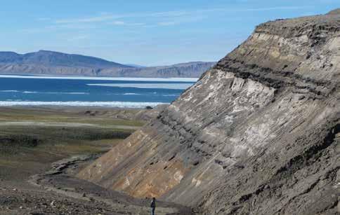
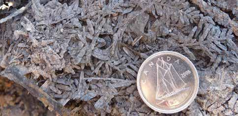
during the Holocene. Isostatic rebound lifted the land surface during the early Holocene leaving the oldest shoreline fossil and archaeological assemblages at higher elevations than their more recent counterparts.
BIOGRAPHY
Lisa Bohach has a B.Sc. degree from the University of Alberta and a Ph.D. degree from the University of Victoria. Since 2001, and she has worked as a palaeontological consultant in Canada, providing assessment and construction monitoring services for industrial development.
Information:
This event is presented jointly by the Alberta Palaeontological Society, the Department of Earth and Environmental Sciences at Mount Royal University, and the Palaeontology Division of the Canadian Society of Petroleum Geologists. For details or to present a talk in the future, please contact CSPG Palaeontology Division Chair Jon Noad at jonnoad@hotmail.com or APS Coordinator Harold Whittaker at 403-2860349 or contact programs1@albertapaleo. org. Visit the APS website for confirmation of event times and upcoming speakers: http://www.albertapaleo.org.
RESERVOIR ISSUE 2 • MARCH/APRIL 2017 47 DIVISION TALKS
STRUCTURAL DIVISION
A discussion of Folds in the Southern Canadian Rockies
SPEAKER
Paul MacKay, GeoConsultants Ltd. & Shale Petroleum Ltd.
Time: 12:00 noon
Date: March 9th, 2017
Location: ??
ABSTRACT
The Southern Canadian Rockies are one of the best studied thrust belts in the world due to their easy accessibility, good general access to data, excellent exposure, and a long history of observations. Folds in the Rockies have also been described but are generally discounted in importance to the regional structural deformation due to the fact that the amount of strain represented in the folding is minor compared to the exceedingly large displacement strain on the thrust faults. However, the folding gives great insight into the kinematics of the system. Close observations of the fold bring up issues with palinspastic restorations, timing of thrusts, thrust linkage, and accepted models of fold propagation.
The classic folds observed at Mt Kidd and other areas are related to thrust failure.
These folds can be considered as the creep prior to reaching the yield point and catastrophic failure in mechanics. These types of folds form prior to fault failure. In general the failure does not migrate from depth to surface but is a series of minor tears that coalesce into one continuous failure surface. Thus, the concept of fault propagation fold model representing a fault migrating to surface is likely kinematically problematic although it will fit some geometry scenarios. Reliance on seismic data to map the broad structure is useful but seismic is unable to image the vertical surfaces that are characteristic of these folds so that the folds are often over looked when relying solely on subsurface data.
Folds associated with faulting have a remarkably consistent fold style. There is a tight hanging wall anticline (interlimb angle less than 90 degrees), which has an over-thickened hinge and a thin forelimb. There is also a corresponding tight footwall syncline with and over-thickened hinge and a thinned backlimb. The cut-offs angles are high averaging approximately 90 degrees. The fundamental anisotropy of the bedding contributes substantially to the fold style and is likely one of the controlling influences
on the fold. This style of fold is observed at different scales from hand samples to the sides of mountains. These folds appear to be fixed hinge model, which will have implication to fracture distribution and style.
BIOGRAPHY
Paul MacKay received a B.Sc.(honours, geological sciences) from Queen’s University in 1980 and a Ph.D. from the University of Calgary (1991). He initially worked for Amoco Canada then moved to Morrison Petroleums, Northstar Energy, and Devon Canada before beginning an international consulting practice. He is currently President of Shale Petroleum Ltd. a private oil company based in Calgary, Alberta. His expertise is in fracture systems, petroleum exploration and development in structurally complex reservoirs. He teaches field courses in Structural Geology/ Geophysics in the Canadian Rockies and field seminars on Fractured Reservoirs in Wyoming. He is an Adjunct Professor in the Department of Geology and Geophysics at the University of Calgary and is the Past-President of the Canadian Society of Petroleum Geologists. He is a member or the CSPG, CSEG, AAPG, and APEGA.
48 RESERVOIR ISSUE 2 • MARCH/APRIL 2017 DIVISION TALKS
SAVE THE DATE October 10-12, 2017 | Banff, AB SUBSURFACE HYDROCARBON MOVEMENT: FROM CONVENTIONAL TO UNCONVENTIONAL
STRUCTURAL DIVISION
Fold and Cleavage Forming Mechanisms, Illusions, and Deceptions in the Rocky Mountains (and Other Fold-Thrust Belts): A Discussion
SPEAKERS
Jürgen Kraus & Paul F. Williams
Time: 12:00 Noon
Date: April 6, 2017
Location: Schlumberger, Second Floor of the Palliser One Building, 125 9th Ave. Calgary T2G 0P6
ABSTRACT
Based on discussions with colleagues and reviewing the latest literature, inconsistent views of deformation in fold-and-thrust belts exist. There is also a discrepancy between published geometrical/kinematic models and observation.
For example, most representative foldthrust models do not account for a footwall syncline, the only one that does is trishear fold-propagation folding according to Wallace and Homza (2004). Trishear involves ductile deformation, however deformation in the Rockies is perceived to be brittle. Is ductile deformation really limited to highergrade metamorphic terranes such as the Monashees? Is the strain in the Rockies penetrative or not? Is flexural slip a brittle or a ductile mechanism and is it really the general folding mechanism in a multilayer sequence? Why should folds be parallel when parallel folding does not produce the fold profiles observed? How does cleavage form and how does it get refracted, as seen in the Mississippian? How is cleavage formation related to folding? How do mesoscale structures such as parasitic folds relate to large structures? How can they be used in fold-thrust models? Do folds really form as asymmetrical structures and how can this be proven?
We dig into the structural toolbox to address these and other fundamental questions. We further compare the most recent published accounts of geometrical and kinematic fold-thrust models with our own observations and interpretations.
We conclude that many of the accepted models are possible however rare in nature, and we integrate them into unifying, generally applicable models.
BIOGRAPHY
Jürgen Kraus is a structural geologist and international exploration geologist with his own consulting company, Franconia Geoscience Ltd. He held his first petroleumrelated position in 1987. Jürgen received an M.Sc in Structural Geology and Geophysics from Göttingen University in 1991 and a Ph.D. in Structural Geology from the University of New Brunswick in 1998.
After assignments with the Geological Survey of Canada, Aachen Technical University, and the Saskatchewan Geological Survey, he joined Shell Canada in 2001 and created drilled prospects in the Foothills at Waterton and Pincher Creek. Jürgen established his consultancy in 2003 and has worked on international oil and gas projects for various companies since.
Apart from the Foothills, Jürgen’s experience in fold-and-thrust belts goes back to the 1980s (Rhenish massif as the central European extension of the Appalachians), his M.Sc. mapping in the Moine thrust belt in the Scottish Caledonides, and the Longmenshan in Sichuan Province of China.
Paul F. Williams, Professor Emeritus at the University of New Brunswick, is an internationally acclaimed structural geologist who has influenced his subject tremendously for more than 45 years. He has published over 80 peer-reviewed scientific papers, and 'An Outline of Structural Geology', co-authored by Paul, is regarded as one of the most influential structural geology textbooks of the 20th century. He mentored over 50 graduate students and post-doctoral fellows.
In 1980, Paul established the Canadian Tectonics Group, which will hold their 36th
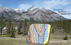
annual workshop in Muskoka in October. The Journal of Structural Geology has dedicated two special volumes to Paul's lifetime achievements, one in recognition of his contributions as a scientist, the other for his contributions as a mentor.
In 2013, Paul won the inaugural Henk Zwart Medal in structural geology for his outstanding contribution to the advancement of science in the field of rock deformation.
REFERENCES
McMechan, M.E., 1995, Rocky Mountain Foothills and Front Ranges in Kananaskis County, West of Fifth Meridian: Geological Survey of Canada “A” Series Map 1865A. Wallace, W.K, and Homza, T.X., 2004, Detachment Folds versus Faultpropagation Folds, and Their Truncation by Thrust Faults, in K. R. McClay, 2004, Thrust tectonics and hydrocarbon systems: AAPG Memoir 82, p. 324-355.
RESERVOIR ISSUE 2 • MARCH/APRIL 2017 49 DIVISION TALKS
Paul Williams and Jürgen Kraus.
Truncated footwall syncline: view from the Kananaskis Highway (Hwy 40), near Porcupine Creek, toward Mount Lorette. Photo by Tim Hartel. Map snippet from McMechan (1995).
2016 C.S.P.G. STANLEY SLIPPER GOLD MEDAL CITATION for Dr. Edward W. (Ted) Bogle
The Stanley Slipper Gold Medal is the Canadian Society of Petroleum Geologists’ most prestigious award. It was established in 1989 to honour individuals who have made outstanding contributions to the science of petroleum geology and to petroleum exploration in Canada.
The 2016 Stanley Slipper Gold Medal recipient is Dr. Edward W. (Ted) Bogle.
Ted Bogle was born in 1951, in Peterborough, Ontario and grew up in Toronto. His interest in the earth sciences was kindled at a young age by listening to his father’s stories about growing up at Britannia Mining and Smelting’s Britannia copper mine, north of Vancouver, British Columbia. He received his B.Sc. and M.Sc. degrees, both in Geological Engineering, from Queen’s University at Kingston, Ontario. While his early graduate work focused on applied research for the mining industry, he moved into the realm of exploration geochemistry in carbonate terrains as a Ph.D. student. Dr. Ray Price, then Department Head at Queen’s, felt that all graduate students should attend his courses on the structural and geotectonic evolution of the Earth. This exposure was instrumental in increasing Ted’s awareness of the breadth of the geosciences and in kindling a desire to move into the petroleum industry. Ted received his Ph.D. in Geology
from Queen’s University in 1980.
With a young family and knowledge that working in the mining industry involved extensive field time, Ted set his focus on oil and gas. Only later would he understand that he was embarking on a global career. In 1980 he joined BP Canada and over the next few years gained experience working in both the Paleozoic and Cretaceous playsystems of central and southern Alberta. In 1984 he moved to become project leader of BP Canada’s Frontier Exploration Program responsible for basin analysis, generation of new opportunities, prospect definition and review as well as both offshore and onshore geological well operations. During this period BP Canada drilled the Baie Verte well off the East Coast but chose to move away from the region due to the impacts of the National Energy Program. Ted then assumed responsibility for BP Canada’s exploration programs in northern Alberta and British Columbia.
At this point Ted’s career shifted. He became the Coordinator of Oil and Gas Planning, responsible for integrating all aspects the company’s operating, development and strategic plans. The role exposed him to the executive workings of the company and allowed him to participate in the preparation of a range of assessments for the Executive and the Board, including the approval of BP Canada’s Wolf Lake 2 Bitumen Steam Flood project. Ted then returned to his technical roots by becoming Manager of Development Geology and later Manager, Development. The role involved managing a multi-disciplinary team whose operational duties included infill drilling, property unitization, step-out drilling, shallow gas exploration, reservoir analysis, property optimization, economic analysis and reserve assessments. The experience was transformational. In 1990 Ted became responsible for BP Canada’s Foothills exploration and development team. Ted was tasked with developing and implementing BP Canada’s Foothills strategy, with particular emphasis on the Triassic of northeastern British Columbia.
This was a special time in Ted’s career as he had the opportunity to work with a group of highly specialized professionals, all focused on expanding the company’s presence in the area while limiting its environmental footprint.
In early 1992, British Petroleum sold its controlling interest in BP Canada and Ted was appointed Vice President, Exploration overseeing the transition of BP Canada from a subsidiary of British Petroleum to the independent oil and gas producer Talisman Energy Inc. The Monkman area of B.C. became the key focus for Talisman’s exploration investments.
As Executive Vice President, Exploration with Talisman, Ted coordinated the Company’s worldwide exploration and land portfolio. He oversaw the integration and growth of the company’s exploration and geoscience activities through ten corporate and five major asset acquisitions. Under his direction, Talisman’s exploration and exploitation portfolio expanded from the Western Canadian Basin to include activities in five core regions worldwide: North America, the North Sea, Southeast Asia, North Africa and Latin America. Through these efforts, the company grew into one of the largest independent upstream oil and gas companies in the world. Talisman’s global exploration program expanded from that of a small Canadian-based operation with a
50 RESERVOIR ISSUE 2 • MARCH/APRIL 2017
SOCIETY NEWS
budget of $15 million in 1992 to a diversified worldwide portfolio with expenditures of over $600 million per year a decade later. Ted is proud to say that with all the acquisition activity, Talisman maintained exceptional ongoing reserve replacement, growing production through new exploration discoveries and ongoing development success and exceeding production targets, all at one of the lowest finding and development costs in the industry. During his tenure he was responsible for the development and implementation of successful ground floor exploration programs in Canada, Appalachia, Alaska, Trinidad, Colombia, Algeria, Indonesia, Malaysia and Vietnam. During this period he also oversaw development of Talisman’s worldwide geoscience technical capabilities including the creation and implementation of its geotechnical peer review system and the application of new technologies.
In 2004, Ted joined Nexen International with responsibilities for exploration, business development, economics and strategic planning with the expressed purpose of growing Nexen’s international presence. As Chief Strategic Officer of
Nexen International, he facilitated 2005 Nexen’s 2005 purchase of EnCana’s U.K. assets for US$2.1 billion. The acquisition of these properties, including the Buzzard Field development, was a defining event for the company. It became the second largest oil producer in the United Kingdom with the Buzzard facility ultimately adding 85,000 barrels per day of net oil production. Under Ted’s direction, Nexen further expanded its European activity to include an entry into Norway and the acquisition of exploration acreage along the Atlantic margin of the U.K. continental shelf. Externally, he was the primary international contact for Nexen, responsible for building relationships and new partnerships with host governments, peers and industry partners. Ted retired from Nexen in July 2010.
In 2011, his career took another turn when he was asked to become the Executivein-Residence and Special Advisor to the Alberta Department of Energy, providing advice and guidance to the Department and its management on energy related issues, ensuring that the Government’s oil and gas policy analysis and deliberations developed results that would lead to Alberta’s long term
economic success.
Ted joined the Board of Compton Petroleum in August 2011 and was named C.E.O. in February of 2012. He undertook this role at the request of the Board, to manage the Company’s operations through a period of declining North American natural gas prices and reduced liquidity. Compton was a 12,500 boe/d oil and gas producer with extensive holdings in the Niton and High River areas of the Western Canadian Sedimentary Basin. Ted worked with the shareholders and creditors to assess Compton’s further opportunities and led a review of strategic alternatives that resulted in the successful sale of that company in September 2012.
Ted is a long time member of the C.S.P.G. and was a recipient of the C.S.P.G. Tracks Award in 1984.
Dr. Edward W. Bogle is a worthy recipient of the Stanley Slipper Gold Medal in recognition of his exemplary roles in exploration leadership, exploration success and mentorship.


RESERVOIR ISSUE 2 • MARCH/APRIL 2017 51
SOCIETY NEWS It’s Tax
Printing your official tax receipt/membership card for 2016 and previous years is easy! 1. Sign in to the CSPG website (www.cspg.org) 2. Click My Account at the top of the screen 3. Click Membership Card on the blue menu bar 4. Click the red Membership Card button 5. Click the Print Card/Receipt link for the year you would like to print the receipt 6. A new window will pop up with the receipt 7. Click the Adobe icon in the top left -hand corner to export as a PDF file for printing
Season!
GEOCONVENTION 2017
GeoConvention: May 15 – 17, 2017, Core Conference May 18-19 – Registration now open!
Greetings from GeoConvention 2017!
In the rapidly changing landscape of the oil and gas industry, both regionally and globally, it is more crucial than ever to share ideas about technical innovations and business strategies to help shape our future. GeoConvention 2017 will provide learning, networking, and promotional opportunities for geoscientists and executives from E&P companies, service companies, academia and government agencies.
Thanks to the CSEG, CSPG, CWLS and our generous sponsors, every year the GeoConvention provides an opportunity for several thousand delegates and exhibitors to benefit from technical sessions, special events and the exhibit floor. Going beyond the traditional technical sessions, GeoConvention 2017 will take a holistic approach with a large spectrum of topics, including financial markets and long term strategy, infrastructure, regulations, safety and environmental protection, among others.
In a complex and uncertain global environment, we promote collaborative approaches and multidisciplinary integration to help optimize the efficient and responsible development of oil and gas resources. Join us at the GeoConvention 2017 and contribute to make it an important milestone in this endeavour!
Technical
In the third convention held under the formal partnership agreement between the Canadian Society of Petroleum Geologists, the Canadian Society of Exploration Geophysicists and the Canadian Well Logging Society, GeoConvention 2017 will boast the largest technical program in recent memory, with 30% more technical talks, panel sessions, and posters than in the previous several years.
Under the guidance of the GeoConvention Board, the volunteer committee specifically tasked their session chairs with soliciting key geoscience content instead of simply allocating talks as they were submitted. This resulted in 50% more submissions than in 2016, most of which were exceptional fits within the program prompting the committee to increase our footprint to ensure as many high-quality talks as possible could be integrated into the Convention. In addition to the best-in-class integrated geoscience content, GeoConvention 2017 will also host discussions on the diversification of the energy industry, global carbon management and utilization and workplace and culture diversity, in addition to content hosted in collaboration with external groups, including: ENFORM, the Society of Petroleum Engineers, Canadian Society for Unconventional Resources, Calgary Mineral Exploration Group, the University of Calgary and Higher Landing, a career transformation Company. The diversification of the program was a focus of the 2017 planning committee as the role of a modern Geoscientist extends well beyond scientific knowledge and includes the many other hats that industry professionals are asked to wear to be successful. GeoConvention 2017 promises to position you and your team for greater success by introducing in-depth discussions on the complete roles that all Geoscientists need to understand and integrate into their work.
Networking and Luncheons
In addition to the technical program, GeoConvention 2017 will continue to offer networking opportunities throughout the conference – through luncheons, coffee breaks and the Monday and Tuesday networking with the exhibitors, GeoConvention continues to provide all of our attendees with the opportunity to reconnect with past colleagues and meet new ones.
The luncheon lineup for the conference will consist of the following:
Monday May 15th: Mark LaCour and James Hahn II
Pulling Ahead in the Midst of Change
The Oil and Gas market is changing. What does this new world look like for the Oil and Gas industry? What do you need to do to remain competitive and how does your sales approach need to evolve to keep pace? What's going on with the digital land grab? Just like the old west, there is a land grab going on and you need to stake your claim before your competitors do. Join the hosts of “Oil and Gas This Week”, the #1 podcast in Oil and Gas as they break it down and give you the answers.
Tuesday May 16th: Jürgen Kraus
The Geology of Beer
Being safer than water, beer has been an important staple of health since the middle ages. For the producers, it has been recession proof as sales are inversely correlated to the oil price.
Two of the main historical factors of beer, water and natural refrigeration, are geological in that they rely on bedrock and faulting. Four anions are particularly responsible for a beer’s characteristic taste: Ca, Mg, Na, and K.
Two regional case studies are presented that link beer to large-scale geological processes: (1) Laurentia (USA) and (2) the former passive continental margin of Laurussia (northern Europe). A generalized beer system from source to trap is introduced in analogy to petroleum. Finally, the role of beer in hydraulic fracturing and other geological applications is discussed.
It is concluded that there are presently no Friday evening alternatives to beer.
52 RESERVOIR ISSUE 2 • MARCH/APRIL 2017
SOCIETY NEWS
Wednesday May 17th:
Tom Feuchtwanger
Chasing Adventure; Circumnavigating Africa Overland
Thomas Feuchtwanger and his wife Janet set off alone in 2005 in a Land Cruiser to drive 85,000 kilometers around the continent of Africa. What they witnessed, who they met and what they discovered on this incredible journey both shocked and awed them. For over 500 days, venturing off the beaten track, they travelled through the world’s second largest rainforest, crossed the Sahara, explored the African Rift Valley and witnessed savannas bursting with wildlife. They hiked the Virunga Volcanic Mountains in search of gorillas, camped alongside exploding lakes and experienced many diverse cultures, languages, customs and beliefs. They were welcomed into stranger’s homes and lives with unconditional generosity that they had never experienced before. There were exciting adventures, heart wrenching experiences and fascinating discoveries. This journey taught them to overcome their fears, to question their stereotypes and to work effectively as a team. It affected them deeply and changed them forever.
The presentation will give you new insights into the world’s second largest continent which has 54 countries, over a billion inhabitants, more than 2000 spoken languages, and a tumultuous history. You will be inspired to go and see it with your own eyes. Tom will also briefly describe the recent East African hydrocarbon discoveries and will share some of the current challenges associated with developing them.
New Initiatives
In addition to the advances with the technical program and to help insure the best return for our exhibitors and sponsors, we will be making a few changes to the flow of the event and the exhibit floor. We will be integrating an on-site concession to promote further networking opportunities and to give attendees a convenient lunch option should they not be joining us at one of the luncheons. We will also be bringing the posters back onto the exhibit floor and hosting a Showcase area where our supporters will be able to address an
audience with the latest developments their companies have been working on, new technologies and applications of upgraded workflows.
There are also discussions of expanding the scope of the GeoConvention mobile app, website and social media presence to make it a year-round resource for students and industry alike. A resource where members and attendees go to get the latest calendar of events from our partner societies, stay on top of new initiatives within the industry, message with peers, access technical resources provided by our industry partners, and of course, access all the abstracts and technical content GeoConvention has to offer.
Sponsorship and Exhibits
GeoConvention will continue to focus on the return our supporters get from joining us – be it sponsorship, exhibits, or both, we are committed to build on the positive results of 2016 and continue to work with all of our supporters to build the brand, market their technology or introduce their workflows to our expected 3,500 attendees. While the GeoConvention 2016 Exhibit floor was smaller than in past years, the feedback was overwhelmingly positive with many indicating GeoConvention was one of the best events they had ever attended:
geoLOGIC systems has been a proud supporter of the GeoConvention for over 10 years and we continue to see it’s benefits pay dividends within industry. Each year geoLOGIC maintains its’ investment in this joint effort we see increased sales opportunities, training interactions and interest in our software solutions. Lauren Parker, geoLOGIC Systems
interact with operators across all of Canada ‘s basins is exceptionally well served through the exposure we attain when participating in GeoConvention Eric Ruygrok, Seitel Canada
The GeoConvention Partnership recognizes the industry’s challenges and creates a rightsize solution allowing Seitel to maximize every corporate dollar we put into our participation. Our ability to meaningfully
GeoConvention has given us a great opportunity to showcase Paradigm software and services to new and existing clients. This has been of value to both Paradigm, and our clients who wish to be aware of our latest technologies. Matt Williams, Paradigm

Partner Society Return
Through new initiatives, program diversification, cooperation with affiliate societies and a focus on the benefits our supporters can gain from being a part of GeoConvention, the GeoConvention team, from the board to the committee are focused on ensuring profitability of then event so that the proceeds may be used to help support the partner society education and outreach efforts. The team will continue to work tirelessly to keep bringing the best integrated geoscience content to Canada with a razor-sharp focus on highquality technical content, meaningful networking opportunities, supporter return and education.
RESERVOIR ISSUE 2 • MARCH/APRIL 2017 53
SOCIETY NEWS
2017 CORE CONFERENCE
By Kelty Latos, ConocoPhillips
Since oil prices went into freefall in late November 2014, our industry has been challenged to find the most creative and economic ways to develop our rocks and reservoirs, using the most innovative ideas and integrated technology to create value in a realm of uncertainty. Drillers and operators have been challenged to cut costs, companies have been challenged to cut staff, and geotechnical staff have been challenged to find and preserve the best plays. Despite this rollercoaster of price and geopolitical uncertainty, the one thing we as geoscientists must return to over and over again is the rock. Without understanding the rock, no play will ever work.
The 2017 CSPG Core Conference will present a wide variety of play types and new ideas. Clastic displays will include shallow clastic formations and oil sands displays including post-steam core. Unconventional reservoirs will be well represented with displays on Montney, Canol and more. The displays will be rounded off with a generous selection of carbonate cores. With over 25 short abstracts submitted so far, there will be plenty of opportunities to engage with new ideas and new interpretations, or revisit old ideas, or investigate new technology and new frontiers.
Once again, the AER is generously allowing the CSPG to use its entire facility for the Core Conference. The AER Core Labs is a one of a kind, world class facility, the existence of
which has led to so many innovations in the Western Canada Sedimentary Basin and beyond. Geoscientists in Alberta are very fortunate to have such a wealth of core data available to us at a reasonable price.
Presenters this year include representatives from the best geoscience university programs in Canada as well as industry personnel who have seen the evolution of the basin over decades. As always, there will be plenty of opportunity to network with friends and colleagues at the Weatherford sponsored luncheons. The entire GeoConvention and Core Conference will be capped off with the not-to-miss AGAT Laboratories Core Meltdown, which will take place at the MacEwan Hall Ballroom on the University of Calgary campus this year, so as to avoid inclement weather.
Please make the time on your calendar to attend this world-class event, where you
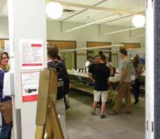
can see hundreds of meters of core, network and enjoy the company of colleagues, and celebrate the never-ending puzzles our industry gives us to solve. Stay tuned for news regarding student, group, and intransition rates.
As Wallace Pratt wrote: "Gold is where you find it, according to an old adage, but judging from the record of our experience, oil must be sought first of all in our minds."

54 RESERVOIR ISSUE 2 • MARCH/APRIL 2017 SOCIETY NEWS

Like all of the Presidents, past, present and future, T. A. Link. was both an outstanding geoscientist, and a dedicated volunteer. He was the Society’s first Secretary -Treasurer and the second President, and the award for best oral presentation by a CSPG Member at one of the Society's Technical Luncheon meetings is named after him.

In 1992, Alice Payne broke another glass ceiling and became the first female president of CSPG. Alice started working in geology in the 1960s when women we only allowed to be lab technicians, and it took many years and much hard work for her to break through the conventions of the time.

During a Beer & Bull session almost 45 years after the ASPG founding, the regional scope of ASPG became an issue, and before long, a motion to change the name to Canadian Society of Petroleum Geology was put forth. On January 18, 1973, the ASPG officially became the CSPG.
 Figure 1 ASPG Founding Members
Figure 2 1929 President T.A. Link
Figure 3 1973 President C. R. Evans
Figure 5 1992 President Alice Payne
Each year, the Past President’s gather to celebrate and reminiscence over their years of service together, and to talk to the current and incoming presidents about their experience and suggestions.
Figure 1 ASPG Founding Members
Figure 2 1929 President T.A. Link
Figure 3 1973 President C. R. Evans
Figure 5 1992 President Alice Payne
Each year, the Past President’s gather to celebrate and reminiscence over their years of service together, and to talk to the current and incoming presidents about their experience and suggestions.


OVER 20 COURSES AND FIELD TRIPS ARE BEING OFFERED BY THE CSPG FOR SPRING FORWARD
TOPICS INCLUDE:
Environmental
Exploration Sedimentology
Heavy oil
Geomechanics
Geomodelling
Structural
Core
VISIT WWW.CSPG.ORG/SPRINGFORWARD FOR FULL COURSE DESCRIPTIONS AND TO REGISTER TODAY!
SPRING FORWARD
