50
50
“As a geologist and PETRA product manager, it’s my job to understand your challenges and make sure PETRA helps you meet them. Connecting directly to IHS data is one of those ways. It’s fast and simple, so you spend more time analyzing data, not loading it.”
Dana Codding Subsurface Product Manager
PETRA provides multi-discipline reservoir management teams with the analysis tools needed for today’s exploration, exploitation and acquisition challenges.


#600, 640 - 8th Avenue SW Calgary, Alberta, Canada T2P 1G7
Tel: 403-264-5610 Fax: 403-264-5898
Web: www.cspg.org
Office hours: Monday to Friday, 8:30am to 4:00pm
Business Manager: Tim Howard
Email: tim.howard@cspg.org
Communications & Public Affairs: Heather Tyminski
Email: heather.tyminski@cspg.org
Conventions & Conferences: Shauna Carson
Email: shauna.carson@cspg.org
Conventions & Conferences Assistant: Tanya Santry
Email: tanya.santry@cspg.org
Corporate Relations Manager: Alyssa Middleton
Email: reservoir@cspg.org
Membership Services: Dayna Rhoads
Email: dayna.rhoads@cspg.org
Programs & Services Manager: Lori Humphrey Clements
Email: lori.humphreyclements@cspg.org
Reception:
Email: reception@cspg.org
EDITORS/AUTHORS
Please submit RESERVOIR articles to the CSPG office. Submission deadline is the 23rd day of the month, two months prior to issue date. (e.g., January 23 for the March issue).
To publish an article, the CSPG requires digital copies of the document. Text should be in Microsoft Word format and illustrations should be in TIFF format at 300 dpi., at final size. For additional information on manuscript preparation, refer to the Guidelines for Authors published in the CSPG Bulletin or contact the editor.
Technical Editors
Ben McKenzie Colin Yeo (Assistant Tech. Editor) Tarheel Exploration Encana Corporation Tel: 403-277-4496 Tel: 403-645-7724 Email: bjmck@telusplanet.net Email: colin.yeo@encana.com
Coordinating Editor
Heather Tyminski
Comunications and Public Affairs, CSPG
Tel: 403-513-1227, Email: heather.tyminski@cspg.org
Advertising inquiries should be directed to Alyssa Middleton, Tel: 264-5610, Email: reservoir@cspg.org. The deadline to reserve advertising space is the 23rd day of the month, two months prior to issue date.
The RESERVOIR is published 11 times per year by the Canadian Society of Petroleum Geologists. This includes a combined issue for the months of July/August.
Advertisements, as well as inserts, mailed with the publication are paid advertisements. No endorsement or sponsorship by the Canadian Society of Petroleum Geologists is implied.
The contents of this publication may not be reproduced either in part or in full without the consent of the publisher.
—
(Oral & Poster Presentations)
Margin Evolution & Development
Basin Petroleum Systems | Productive Fields & Analogues IN ADDITION TO THE CONFERENCE SESSIONS,ALSO FEATURED WILL BE:
FIELD TRIPS
Nova Scotia (Pre-Meeting)
• Permian to Jurassic Rift Successions
• Classic Carboniferous Sections
• Onshore Cretaceous Reservoir Equivalents
Morocco (Post-Meeting)
• Triassic Synrift Reservoir Facies & Architecture
Portugal (Post-Meeting)
• Jurassic Carbonates & Fluvio-deltaic Successions
PROGRAM INFORMATION
David E.Brown dbr own@cnsopb.ns.ca
Grant D.Wach grant.wach@dal.ca
SPONSORS / ENDORSEMENTS
COURSES
Practical Salt Tectonics Petroleum Systems Modelling
CORE WORKSHOP
Offshore Nova Scotia Reservoirs, Facies & Sequences
SEISMIC DATA ROOM Latest Central Atlantic Programs & Profiles
LOGISTICAL INFORMATION Trudy D.Lewis trudy.lewis@ns.sympatico.ca
WEBSITE & ON-LINE REGISTRATION www.conjugatemargins.com

President
Lisa Griffith • Griffith Geoconsulting Inc. lgriffith@griffithgeoconsulting.com Tel: (403) 669-7494
Vice President
Graeme Bloy • West Energy Ltd. gbloy@westenergy.ca Tel: (403) 716-3468
Past President
Colin Yeo • EnCana Corporation colin.yeo@encana.com Tel: (403) 645-7724
Finance director
James Donnelly • ConocoPhillips Canada james.donnelly@conocophillips.com Tel: (403) 260-8000
assistant Finance director
David Garner • Chevron Canada Resources davidgarner@chevron.com Tel: (403) 234-5875
Program director
Randy Rice • Suncor Energy Inc. rjrice@suncor.com Tel: (403) 205-6723
serVice director
Jen Vèzina • Devon Canada Corporation jen.vezina@devoncanada.com Tel: (403) 232-5079
assistant serVice director
Ayaz Gulamhussein • NuVista Energy Ltd. Ayaz.gulamhussein@nuvistaenergy.com Tel: (403) 538-8510
outreach director
Greg Lynch • Shell Canada Limited greg.lynch@shell.com Tel: (403) 691-2052
assistant outreach director
Mike DesRoches • DesRoches Consulting Inc. mdesroch@shaw.ca Tel: (403) 828-0210
communications director
Peggy Hodgkins • CGGVeritas peggy.hodgkins@cggveritas.com Tel: (403) 266-3225
corPorate relations director
Monty Ravlich • Sanjel Corporation mravlich@sanjel.com
A message from the Services Director, Jen Vèzina
When I was asked to volunteer my time on the CSPG Executive Committee ...
...in the fall of 2006 as the incoming Services Director, the first question I had was “What is Services?” That question is eloquently answered by the two previous Services Directors in their Reservoir commentaries, and I direct you to those (see issues May 2007, page 5 and May 2006, page 5 at http://www.cspg.org/publications/pubsreservoir-archive.cfm) for the specifics of the position. In general, the items that fall under the Services portfolio include Membership, Photographic, Archives and History, Volunteer Management, Awards, and Social Activities.
At the time I was asked, I had a growing disappointment with the quality of the CSPG Conventions, and I felt that the CSPG was out of touch with the younger batch of new geologists in the industry, as well as changes in industry business practices. Since I tend to have a limited respect for people who do a lot of complaining but don’t ever get involved, I said yes. The not-quite-sodiplomatic phrase for the previous sentence is “put up or shut up.”
I have since had my eyes opened: regarding the convention, the CSPG Executive and the Convention organizers know full well what the membership thinks, and the reality is that the technical contributions that used to come from E&P companies has dried up. That’s right: the same folks who complain about the technical content are often the ones who don’t contribute to it. Where do they think the material will come from? Where do they think it came from in the past?
As for the idea that they were out of touch with the recent changes in the industry, I had to eat some humble pie on that one as well. As an example, the Programs group is developing a training matrix for geologists (juniors in particular) in recognition that there has been a lapse in company-led training programs, more young geologists
are being hired into smaller companies right out of school, the increasing dearth of 20-year+ folks to provide mentorship, and staffing levels that are significantly decreased from what we saw 15 years ago. The CSPG is working towards filling this need.
What, you may be asking yourself at this point, do these things have to do with the Services Director? The answer is nothing directly; but it does put some onus on me to make sure that the items in my portfolio are also advancing with the times and the business climate, particularly before I go pointing fingers at others.
I have three main goals this year: the first is to examine the items under Services to assess their applicability to members across the country, and develop inclusive strategies for those that don’t. That’s right, folks: that first “C” in CSPG stands for “Canadian,” not “Calgary.”
The second goal is the re-vamping of the Awards. A full review of the CSPG awards was undertaken in the fall of 2007 by past-president and long-time member, Ian McIlreath. This comprehensive look identified the good, the bad, and the ugly. One of the more obvious issues is the almost complete lack of alignment of the Awards with the Society’s mandate, mission statements, or strategic goals (http://www.cspg.org/about/mandate.cfm). To this end, several of the awards will have their definitions and terms of reference updated. The nomination process will be clearly laid out, and an electronic form created to simplify nomination. Several new awards are proposed (subject to Executive approval) which would encourage and reward younger people to participate in a number of different ways in our Society, as well as recognizing those who contribute to the success of the Canadian Petroleum (Continued on page 62...)


CORPORATE MEMBERS
ABU DHABI OIL CO., LTD. (JAPAN)
APACHE CANADA LTD.
BAKER ATLAS
BG CANADA ExPLORATION & PRODUCTION, INC
BP CANADA ENERGy COMPANy
CANADIAN FOREST OIL LTD.
CANETIC RESOURCES TRUST
CONOCOPHILLIPS CANADA
CORE LABORATORIES CANADA LTD
DEVON CANADA CORPORATION
DOMINION ExPLORATION CANADA LTD
DUVERNAy OIL CORP
ENERPLUS RESOURCES FUND
FUGRO AIRBORNE SURVEyS
geoLOGIC systems ltd.
GRIZZLy RESOURCES LTD
HUNT OIL COMPANy OF CANADA, INC
HUSKy ENERGy INC.
IHS
IMPERIAL OIL RESOURCES LIMITED
LARIO OIL & GAS COMPANy
MJ SySTEMS
MURPHy OIL COMPANy LTD.
NExEN INC
PENN WEST PETROLEUM LTD
PETRO-CANADA OIL AND GAS
PETROCRAFT PRODUCTS LTD.
PROVIDENT ENERGy LTD
RPS ENERGy CANADA LTD.
SHELL CANADA LIMITED
SPROULE
SUNCOR ENERGy INC
TALISMAN ENERGy INC
TAQA NORTH LTD
TOTAL E&P CANADA LIMITED
WEATHERFORD CANADA PARTNERSHIP
AS OF MARCH 29, 2008
A message from the Bruce McIntyre, CSPG Trust Chair
The Trust raises money to fund educational programs to inspire individuals to pursue a career in petroleum geoscience. The Trust is a Registered Charity with the Canada Revenue Agency.
I have been involved with the CSPG organization since the mid 1970s and have served on several Committees and the on the CSPG Executive as Business Manager and President. My current role with the CSPG is as Chairman of the CSPG Trust. I would like to take this opportunity to clarify the role of the CSPG Trust within the CSPG organization.
The CSPG Trust was started as the CSPG 50th Anniversary Fund whose primary role was to fund and operate the Student Industry Field Trip (SIFT). The CSPG Trust was setup as a registered charity to allow it to issue charitable receipts to individual donors.
In order to obtain and maintain Registered Charity status the Canada Revenue Agency (CRA) requires that the Board of the CSPG Trust must be independent of the CSPG Executive. The Board of the CSPG Trust, however, is appointed by the CSPG Executive and two members of the CSPG Executive sit on the Board of the CSPG Trust. The Trust by its Charter is charged with financially supporting educational initiatives across Canada that promotes Earth Sciences at all levels. A detailed summary of the programs the CSPG Trust has historically supported can be found in the October 2004 Reservoir, a copy of which can be found in the Reservoir archives on the CSPG website.
When the CSPG Trust was initially conceived, its responsibility was to determine which programs to support and to operate those programs on behalf of the CSPG and the CSPG Trust. Within the last two years, the CSPG Trust has changed from an operational entity into strictly a fundraising entity. Responsibility for operating the initiatives funded by the CSPG Trust has been turned over to the CSPG Executive, under the guidance of the Outreach Director.
The CSPG Executive is responsible for the funding of the CSPG Outreach programs. The CSPG Trust looks to the CSPG Executive for guidance on which programs the CSPG Trust will fund on an ongoing basis. The CSPG Trust must remain an independent organization
and it must review funding requests from the CSPG Executive within its educational mandate. Programs such as SIFT, EdGeo, 100 Student Jobs, and the Honorary Address are funded in part by the CSPG Trust, Corporate and Individual sponsorships, and the CSPG Executive acting on behalf of the CSPG Membership.
In order to help fund the CSPG’s Outreach initiatives, the CSPG Trust currently has approximately $1 million dollars which is managed by the Calgary Foundation. The Trust is mandated by the CRA to distribute 80% of the funds donated annually (unless those funds are specifically directed to the Endowment) and 3.5% of the balance of the endowed funds on an annual basis. The CSPG Executive has at its disposal approximately $1 million dollars in its “rainy day fund” and the funds generated by membership renewals, conventions, and other sources of income to help fund its Outreach initiatives.
The CSPG Executive has an ambitious budget for Outreach programs over the next several years and has requested the financial support of the CSPG Trust. The CSPG Trust is supportive of those programs as they fit within the mandate of it charter.
In order to realize on these programs the CSPG Executive and the CSPG Trust, working in concert, will be seeking funding from both Corporate and Individual sponsors. The funds raised can be directed to general Outreach in initiatives, individual programs, or directed to the CSPG Trust’s Endowment fund.
Please consider supporting the CSPG Trust in its efforts to raise funds to support the CSPG’s Outreach initiatives. you can make a difference to our profession by helping to educate the next generation of geoscientists.
To make a donation online go to Canada Helps at www.canadahelps.org/DonationDetails.aspx. Mail or drop off your donation to: Treasurer, CSPG Trust 600-640 8 Ave SW Calgary, AB T2P 1G7
SPEAKER
Jonathan Bujak Bujak Research Limited
11:30 am tuesday, may 6, 2008
telus convention centre calgary, alberta
Please note: the cut-off date for ticket sales is 1:00 pm, thursday, may 1, 2008. ticket Price: $34.00 + gst
Due to the recent popularity of talks, we strongly suggest purchasing tickets early, as we cannot guarantee seats will be available on the cut-off date.
The modern icehouse world is characterised by bipolar glaciation, which results from relatively low levels of atmospheric CO 2

and thermal isolation of the poles from lower latitude warm oceanic currents. In contrast, the Mesozoic greenhouse world had no permanent glaciation at either pole, with the greenhouse state continuing through the K/T boundary into the Paleocene.
At the end of the Paleocene, the PETM (1) was triggered by extreme levels of greenhouse gases due to extensive volcanism and the expulsion of submarine methane hydrates. This resulted in the highest temperatures known for the Cenozoic, characterising a super greenhouse state that persisted through the Early Eocene. It is therefore surprising that various independent parameters indicate that the super greenhouse was truncated in the earliest Middle Eocene by the initial shift towards modern icehouse. Estimates of atmospheric CO 2 values show a major decrease at this time, but this cannot be explained by ‘normal’ sequestration processes. Instead, a unique geological event is proposed to explain this fall, centred on processes within the Arctic Ocean Basin.
“The Azolla Model” is based on ACE x (2) cores from Lomonosov Ridge plus unpublished data from 65 Arctic petroleum exploration wells. (3) The model combines oceanographic reconstructions for the basin with a major decrease in greenhouse gases during the middle Eocene. The Arctic Ocean Basin was largely enclosed following uplift of the Greenland Mantle Plume, with elevated temperatures, evaporation, and precipitation leading to increased runoff and the development of extensive surface freshwater plumes. These were colonized by floating mats of the opportunistic freshwater fern Azolla, which persisted for up to 800,000 years as a series of repeated cyclical events.
Modern Azolla is one of the fastest-growing plants on the planet and draws down large quantities of carbon and nitrogen. Calculations of carbon drawdown combined with the large potential areas of Azolla development in the Arctic, plus the 800,000 year time-frame indicate levels of CO 2 sequestration that are easily sufficient to shift the world from Mesozoic – Early Eocene greenhouse towards the modern icehouse world. The model also indicates the deposition of potentially widespread petroleum source rocks across the Arctic due to the massive carbon drawdown. It is currently being tested by multidisciplinary teams at ACE x and various universities
worldwide, and it has already attracted considerable attention including articles in the New york Times (November 20, 2004), National Geographic (May 2005), and Nature (June 1, 2006).
(1) Paleocene Eocene Thermal Maximum (2) Arctic Coring Expedition (3) Bujak Research non-exclusive well studies
BIOGRAPHY
Jonathon Bujak received his B.Sc. (Honours) in 1969 from the University of Sheffield where he later completed his Ph.D. in Palynology. His thesis title was “Microplankton from the Barton Beds of the Hampshire Basin, southern England.” He was elected a Fellow of the Geological Society of London in 1988.
Dr. Bujak has worked in both industry and research, applying his palynological expertise at Robertson Research in Calgary and Dartmouth (Canada), Mobil Oil Corp. in Dallas, and the GSC’s Bedford Institute of Oceanography, also in Dartmouth. His time with the GSC involved several concurrent projects that were also associated with both the Hydrocarbon Assessment Group and the Atlantic Geoscience Centre.
Most recently, Dr. Bujak has been consulting for industry and governments through his company, Bujak Research International Ltd, specializing in the biostratigraphy of NW Europe, the North Sea, and surrounds. He is involved in teaching courses on biostratigraphy worldwide and has authored over 80 publications and abstracts.
SPEAKER
Bill Gunter
Alberta Research Council
11:30 am tuesday, may 20, 2008 telus convention centre calgary, alberta
Please note: the cut-off date for ticket sales is 1:00 pm, Wednesday, may 14, 2008. ticket Price: $34.00 + gst.
Due to the recent popularity of talks, we strongly suggest purchasing tickets early, as we cannot guarantee seats will be available on the cut-off date.
oil and gas reservoirs, in which case both may be used for CO 2 storage.
The identification of early opportunities for geological storage is based on five criteria:
1) Capacity,
2) Injectivity,
3) Containment,
4) Resource protection, and 5) Economics.
Based on the five criteria listed above, one of the more attractive formations suitable for geological storage in the Alberta Basin are the Leduc reef complexes of the Devonian Woodbend Group. The Leduc reef complexes in central Alberta are underlain by the platformal carbonates of the Cooking Lake Formation that form an extensive aquifer which provides support to these oil and gas reservoirs. One example of this is the Devonian Redwater Leduc Reef and the underlying Cooking Lake Aquifer in the Heartland Industrial region of Alberta, northeast of Edmonton.
The Redwater Leduc Reef has a total areal extent of nearly 600 square kilometers. It is
more than 1,000 meters deep and is up to 275 meters thick. The original oil zone was only 50 meters, confined to the Northeast edge of the reef, and is one of the largest oil reservoirs in Canada. The reef is bounded at the top and on its flanks by the Ireton shale and is hydraulically connected to the underlying Cooking Lake aquifer.
Based on the high water injectivity in the Redwater Leduc Reef, the potential exists to inject sustainably in excess of 1,000 tonnes of CO2 per day per well in the aquifer portion of the reef. While the top of the reef offers the potential for CO 2 enhanced oil recovery, the rest of the Redwater Reef offers a very large capacity for CO 2 storage. Preliminary storage capacity estimates for the aquifer are in the order of one gigatonne (i.e., one billion tonnes) of CO2
The Redwater Reef could be part of an integrated system that combines both CO2 storage opportunities with CO 2 supply, as the access point to the system is located in the Heartland Industrial region, a major potential source of CO2 . Due to the booming industrial expansion in the
(Continued on page 10...)

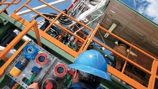
Designed for use on land-based drilling and service rigs, our accuate and easy-to-use technology maximizes rig uptime, improves the efficiency of rig operations, and minimizes operating costs. Come see our new mud analyzer and hazardous gas alarm system at this year's CSPG CSEG CWLS Convention.
Oil and gas reservoirs and deep saline aquifers in the Western Canada Sedimentary Basin have CO 2 storage capacities that span several orders of magnitude, respectively. The smallest capacity is in oil reservoirs, including enhanced oil recovery (EOR), estimated to be in the order of a few hundred million tonnes (Mt), compared to Alberta’s annual emissions from large final emitters in the order of 160 Mt. The storage capacity in gas reservoirs is one order of magnitude larger, estimated to be in the order of 8-10 Gt CO 2 yet the largest capacity, at least one order of magnitude higher than in gas reservoirs, is in deep saline aquifers. In many cases, deep saline aquifers underlie

at booth #914 at
at
Heartland Region connected with oil sands processing, the area will become one of the biggest emitters of CO 2 in western Canada and in the country. The fact that most of the oil sands processing plants being built in the Heartland area are relying on gasification to supply the hydrogen for upgrading offers an attractive high-purity CO 2 waste stream to be captured for storage.
The Redwater Reef may have the potential

to store all the current and future CO2 emissions from the east Edmonton – Fort McMurray region for a few decades during which an integrated CO2 infrastructure can develop in the province. A more detailed assessment of the Redwater Reef storage opportunity is currently underway.
Dr. William D. Gunter received his B.Sc. and M.Sc. in geology from the University of New Brunswick and his Ph.D. in geochemistry from
The University of Calgary invites applications for its graduate program entitled
This innovative course-based Master’s degree, open to graduate engineers, geologists and geophysicists, is offered jointly by the Department of Chemical and Petroleum Engineering and the Department of Geoscience.
The program integrates reservoir engineering, geology, and geophysics. Students will have the opportunity to take courses outside their main discipline, study geostatistics and reservoir simulation, and undertake a field development planning exercise in multi-disciplinary teams. A team-building course is also a part of the program.
Graduates will have the expertise to work effectively on multidisciplinary teams to address the diverse challenges involved in the exploration, development, and production of petroleum resources.
September 2008 Admission - June 15 for Canadian students - April 1 for International students
the Johns Hopkins University. He taught Igneous and Metamorphic Petrology at the University of Wyoming and was a Research Fellow in Hydrothermal Geochemistry at ETH in Zurich, Switzerland.
He currently is a professional geologist practicing in Alberta, and a Distinguished Scientist at the Alberta Research Council located in Edmonton, Alberta, Canada where he has spent over 25 years of his career. He has served terms as an Adjunct Professor at the Universities of Alberta and Calgary.
His expertise is in geochemical processes (stressing use of field data, experiments, and modelling) as they impact on the environment and on the oil and gas industry. Over the past ten years, he has been leading combined industry-government funded projects for geological storage of CO 2 and H 2S in aquifers, oil reservoirs, and coal beds. As a result of this, more than 70 publications are available in the public domain on geological storage of CO 2 , a contributor to greenhouse gas (GHG) emissions.
In 1999, he served as a member of the Canadian Federal “Technology Issues” Table on GHG emissions. He co-chaired the Canadian Capture and Geological Storage Roadmapping task which led to two reports, CANiSTORE and CANiCAP (addressing planning options for technology development in Geological Storage and CO2 Capture in Canada). Both are downloadable from www.co2network.gc.ca and together they contain the elements of a plan for commercialization of CCS [CO2 Capture and geological Storage] in Canada, and form part of the basis for the Canadian Roadmap for CCS).
Dr. Gunter also was a Lead Author on the IPCC (Intergovernmental Panel on Climate Change) special report on CO2 Capture and Storage, released in December 2005. During 2007, he was a member of the FederalProvincial ecoENERGY task force’s Technology working group.
He currently serves as a member of the Alberta Government’s “Capture and Geological Storage of GHG Emissions” working group.
Rely on CGGVeritas to maximize your exploration accuracy. You’ll have access to leading seismic imaging technologies, highly sought 3D and 2D data, the most advanced acquisition capabilities and a staff dedicated to helping you succeed.
Focus on Performance. Passion for Innovation. Powered by People. Delivered with Integrity.
AUTHOR Stephen L. Bend Department of Geology
The University of Regina 11:30 am Wednesday, June 4th, 2008 telus c onvention c entre c algary, a lberta
Please note: t he cut-off date for ticket sales is 1:00 pm, Friday, m ay 30th, 2008. t icket Price: $34.00 + gst.
Due to the recent popularity of talks, we strongly suggest purchasing tickets early, as we cannot guarantee seats will be available on the cut-off date.
During this talk I will present and demonstrate my eTextbook in Petroleum Geology, recently published by the American Association of Petroleum Geology (AAPG) in December 2007.
Widely acknowledged as the first peer-reviewed electronic textbook in geoscience, this CD-Rom based publication is a significant departure from the traditional textbook and previous web-based eText experiments because of the depth, breadth, and scope of material that is contained within this CD-based publication.
For the first time, an introductory textbook in geology is able to combine the traditional look of a textbook with a very large number of colour images, animations, video clips, and immersive images (e.g., virtual microscope); but also include an interlinked ‘library’ of classic, peer-reviewed, journal articles, book chapters, and contributions by
professionals within the industry. This eTextbook also contains many of the petrophysical logging charts that are so frequently used by the professional petroleum geologist, and demonstrates the utility of such charts and diagrams by including several worked examples.
From a teaching and pedagogical perspective, this publication platform enables the presentation of concepts and instructional material in a variety of possible ways that I believe presents concepts in a much more accessible way. This, of course, readily suits the teaching of geology, which is a highly visual discipline. The ability to include limitless full colour graphics, or use various forms of multimedia that facilitate the learning process, without the limitation of cost, is especially appealing where traditional texts have either suffered from high cost or the exclusion of colour.
Is this publication platform a mere publication oddity? It would appear not, since the AAPG already has two other similar electronic publication projects in various states of preparation and others in the planning stage. The relatively low cost of publication, a high degree of portability, the freedom from bandwidth restrictions, and an independence from the internet and browser quirkiness are giving other publishers reasons to take this publication platform seriously.
Stephen Bend has a Bachelor’s Degree from the University of Keele, England, a Master’s Degree in Organic Petrology and Organic Geochemistry from the Organic Geochemistry Unit (now NRG), the University of Newcastle upon Tyne, and a Ph.D. from the Northern Carbon Research Labs., School of Chemistry, also at the University of Newcastle upon Tyne. He was employed by Exlog as a petroleum geologist for over five and half years during that time he was contracted to the following oil/gas fields or locations: Beryl Oil Field, Statfjord Field, North Sea; Gulf of Suez, Egypt; Gaijuira Peninsular, Columbia; B.C./ Alberta Foothills, Hibernia Field, and Scotia Shelf, Canada; Dutch North Sea; N.W Dome, Qatar, and the Troms-1 Field, Norwegian Arctic. In 1984 he operated and managed a commercial Geochemistry Laboratory in Halifax, Nova Scotia for Exlog Canada, which prompted a return to graduate school in 1985. In 1990 he joined the Department of Geology at the University of Regina where he
has served as both a faculty member and is a former Head of Department.
Ongoing research interests include the petrographic and geochemical study of crustal organic matter, specifically related to the correlation and modeling of crude oils and source rocks within the Williston Basin and the characterisation of coal, coal bed methane, CO2 sequestration, coal oxidation, the fluorescence characteristics of coal macerals, and the origin and correlative relationship of lower Palaeozoic oils. Bend was instrumental in creating a new Modeling/ GIS laboratory within the Department of Geology at the University of Regina.
He has published extensively in the AAPG Bulletin, Canadian Journal of Earth Sciences, the Journal of Sedimentary Research, and the international journals of Coal Geology, Fuel and Organic Geochemistry. He has also served, and presently serves, on numerous international and national professional committees and societies, such as the United Nations Committee for Europe, the International Committee for Coal Petrology, the Society for Organic Petrology, and the American Association of Petroleum Geologists. His expertise has also been utilized as an Expert Witness in both civil and Crown prosecutions both at home and internationally.
AUTHOR Mark S. Caldwell
Klabzuba Oil & Gas Inc., Denver, CO
11:30 am
t hursday, June 19, 2008 telus c onvention c entre c algary, a lberta
Please note: the cut-off date for ticket sales is 1:00 pm, monday, June 16, 2008. ticket Price: $34.00 + gst
Due to the recent popularity of talks, we strongly suggest purchasing tickets early, as we cannot guarantee seats will be available on the cut-off date.
The Bearpaw Uplift of north-central Montana hosts a world-class example of gravity-induced faulting within Upper Cretaceous marine sedimentary rocks and their overlying Tertiary volcanic and sedimentary cover. Seismic exploration, mostly for shallow (less than 640 metres, 2,100 foot depth) Upper Cretaceous biogenic gas reservoirs, has yielded highquality 2D and 3D datasets. Mapping this seismic data reveals a complex pattern of faulting hidden beneath a glacial veneer north of the Bearpaw Mountains and into Canada. This fault pattern is very similar in geometry and origin to that mapped at the surface south of the Bearpaw Mountains.
Laramide basement-involved uplift of the Bearpaw Arch was accompanied by extensive outpouring of surface lava flows and volcaniclastics and the emplacement of a wide variety of intrusive bodies in the middle Eocene (53-42 mya). Thrust sheets loaded with thick volcanic and sedimentary cover moved off the flanks of the Bearpaw Arch along over-pressured organic-rich shale decollements. Rocks beneath the decollements are mostly
undeformed with dips of 1 to 3 degrees away from the arch. The headward or updip portion of the thrust sheets is dominated by extensional structures in a chaotic fault array of normal faults and grabens, while the basinward downdip portion is characterized by compressional thrust-faulted structures.
The detailed study area, located in northern Hill and Blaine Counties, is dominated by north-directed compressional structures that trap biogenic gas in a variety of structural traps well imaged with 2D and 3D seismic. Two principal decollements have been identified and mapped in the study area. The older, upper 1WS decollement is rooted in an organic-rich shale within the uppermost Colorado Shale (First White Specks). Regional gentle NE structural dip on this thrust sheet is punctuated by regularly spaced fault-bounded horsts or “popup” structures that are up to 8 km (5 miles) long. These structures were then faulted and folded by deformation associated with the lower, younger 2WS decollement, located in organic-rich shale just above the Greenhorn (Second White Specks). Several long (up to 64 km, 40 mi.) strike-slip faults offset earlier formed pop-ups with roughly 1,500 m (5,000 feet) right-lateral displacement as measured by piercing points at mapped fault intersections
Historically, the primary exploration objective around the Bearpaw Uplift has been the Upper Cretaceous (Campanian) Eagle Sandstone. Much of the Eagle gas in the study area is found in structures associated with the (older) 1WS decollement. Structural traps include north-vergent fault-bend fold traps, backthrusts (south-vergent thrusts), popup blocks, blind thrusts, and footwall cutoffs. Several one-well Eagle fields have produced between 1 and 2 Bcf from very high-quality marine shoreface reservoirs (30% porosity, 200-1,000 mD perm). The largest Eagle gas accumulation in the study area has produced over 6 Bcf from a dome formed above a blind thrust.
Recent exploration has led to the discovery of shallow gas reserves in the underlying Niobrara (Santonian Medicine Hat) Sandstones. Klabzuba’s St. Joe Road field, discovered in 2001, covers 40 sq. mi. and has produced over 11 Bcf from 74 wells in the Niobrara Sandstone. Current
daily production for the field is over 10 mmcf/d. Niobrara gas is trapped downdip of a major right-lateral strike slip fault that formed above the 2WS decollement.
Mark Caldwell received his B.Sc. degree in Geology from the University of Michigan and a M.Sc. degree in Geology from Western Michigan University. Mark began his career with Northern Michigan Oil & Gas in Traverse City, Michigan exploring the Michigan Basin. Mark has been employed as a geologist for Klabzuba Oil & Gas, Inc. since 1988 and has been actively working both the subsurface geology and geophysics of the Bearpaw Uplift since 1994.


SPEAKER
Steve Rogers
Golder Associates Ltd.
12:00 noon thursday, may 8, 2008 Petro- canada
West tower, room 17B/ c (17th floor) 150 6 ave sW calgary, alberta
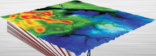
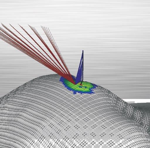
The difficulties in characterizing fractured reservoirs are numerous. The conversion of structural data into meaningful reservoir properties has been particularly troublesome. The main source of fracture geometric data for static models is image log data, which address mainly fracture intensity and orientation. The emphasis of these parameters in the static model helps perpetuate the belief that “all fractures are equal.” However, we know that fracture conductivity tends to follow highly skewed statistical distributions where most of the fracture population is weighted to smaller values.
Thus flow in fractures tends to concentrate in a relatively small number of fractures in the high-end tail of the conductance (or aperture) distribution. This explains why flow in the wellbore in fractured formations is often controlled by relatively few features. In order to adequately capture the scale of these important features within fracture network models we require direct flow indicators, such as production logs, mudloss records, and well tests as well as other geometric data.
Expertise in heavy oil & deep basin reservoirs
• Time Lapse (4D) Processing
• 4D Cross Equalization
• Multicomponent (3C, 4C) Processing
• 3D Merging
• PSTM with Common Offset Vector Binning
Hart Janssen
B.Sc., Manager, Seismic Processing
Direct: 403-260-3372 Main: 403-237-7711
www.sensorgeo.com

Of these hydraulic measures, only well testing provides information about how the natural fracture network extends away from the well bore. The well test pressure derivative is a valuable source of information on the conducting network geometry, but it requires insights from fracture network models that go well beyond standard well-response models. Discrete Fracture Network tools provide the link between the wellbore static and dynamic data to produce simulations that honor both.
Examples will be presented from both fractured and faulted reservoir studies to illustrate how static fracture information and pressure transients can be integrated together to help identify the features that control production, reduce uncertainty in scenario modeling, and derive accurate reservoir model input parameters for fractured reservoir models.
Steve Rogers is a Senior Geoscientist with Golder Associates Ltd. based in Vancouver, BC. He holds a Geology & Management Science degree from Keele University, UK (1987) and a Ph.D. from Nottingham University in rock mass characterization and rock mechanics (1991).
Rogers initially worked for the British Geological Survey and was heavily involved with a wide variety of fracture characterization efforts of the UK and European Radioactive Waste Disposal investigations. Between 1996 and 1998 he was seconded to the Government of the Republic of Vanuatu to help manage their national Geology Department.
In 2000 he joined Golder Associates (UK) Ltd. to help develop their fractured reservoir services business and in 2005 moved to Western Canada with Golder Associates Ltd. During his time with Golder Associates he has worked on a variety of fractured reservoir projects around the world, specializing in the conceptualization and modeling of fractured reservoirs.
Talks are free and do not require pre-registration. Please bring your lunch. Refreshments are provided by HEF Petrophysical Consulting, and the room is provided by Petro-Canada. If you would like to be on the Structural Division e-mail list, or if you’d like to give a talk, please contact Jamie Jamison at (403) 269-3158 or jamie@ hef.com.


Dave Watt
Rocky Mountain Adventure Medicine
7:30-9:00 Pm
Friday, may 9, 2008 room B108
mount royal college
The last session of the year before field season will focus on wilderness safety and first aid. The focus will be on the likely types of situations we may find ourselves in during field trips.
Dave Watt is the director of Rocky Mountain Adventure Medicine, safety consultants that specialize in Remote Work Sites and Extreme Environments.
This event is jointly presented by the Alberta Palaeontological Society, Mount Royal College,
and the CSPG Palaeontology Division. For information or to present a talk in the future please contact CSPG Paleo Division Chair Philip Benham at 403-691-3343 or programs@ albertapaleo.org. Visit the APS website for confirmation of event times and upcoming speakers: http:11www.albertapaleo.org/


SPEAKER
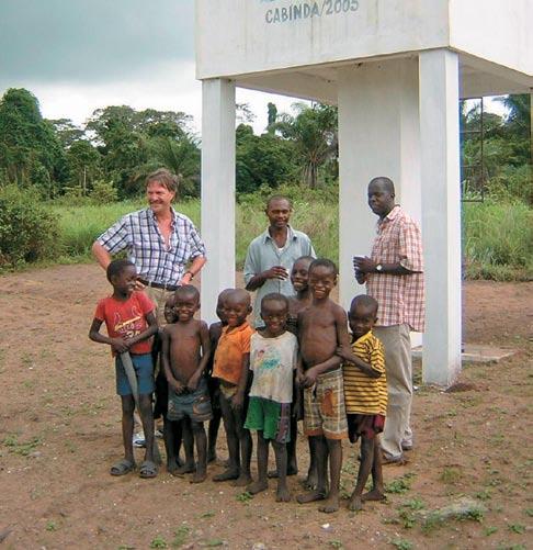
Tako Koning
Advisor – Tullow Oil Angola and Residential Representative, yme Foundation Luanda, Angola
12:00 noon thursday, may 22, 2008 encana amphitheatre
2nd floor, east end of the calgary tower complex,
1st street and 9th avenue s.e . calgary, alberta
The oil-and-gas producing area of West Africa extends from Mauritania down to Angola. This area currently produces approximately 5.2 million barrels of oil per day. Nigeria continues to dominate the area’s oil production with current production of 2.1 million barrels of oil per day and Angola is close behind with production of 1.9 million barrels of oil per day.
The geology of this important oil-producing area is typical of a passive margin environment. Nigeria’s petroleum geology is primarily related to the sediments deposited during the Tertiary in the deltaic environment of the ancestral Niger River. Angola’s oil production is related, in part, to the rift and drift tectonics which occurred in the Southern Atlantic during the late Jurassic and Early Cretaceous. In addition, the highly prolific Oligocene and Miocene reservoirs in the deepwater Congo Basin are turbidites which were deposited seaward from the ancestral Congo River. In addition to a regional overview of West Africa, this presentation will give an update on the exploration successes and significantly increased oil production which is occurring in Angola.
Other important oil-and-gas producing countries in West Africa include Equatorial Guinea, which is currently producing about 380,000 barrels of oil per day, and Gabon, with production of 250,000 barrels of oil per day. The very important Jubilee oil and gas field discovered in 2007 in the deepwater of Ghana serves as a reminder that large parts of West Africa are still minimally evaluated by the drill bit.
West Africa is also becoming an increasingly important gas-producing area. Nigeria is currently exporting about 14 million tonnes of LNG per year. Equatorial Guinea is now exporting 3.4 million tonnes per year of LNG. Angola is presently building an $8 billion LNG plant in Soyo, Zaire province and will produce 5.2 million tonnes of LNG per year, beginning in 2012.
The oil fields in West Africa have advantage over other producing areas such as the Middle East since the oil is low-sulphur and is predominantly light to medium gravity. Furthermore, the crude from West Africa is easily transported by tanker to refineries on the USA’s East and Gulf coasts. About 17% of the USA’s oil imports currently come from West Africa but the USA’s National Intelligence Council projects that this will increase to 25% by 2015 thereby eclipsing even the Persian Gulf.
Tako is Holland-born but Canada-raised with a B.Sc. in Geology from the University of Alberta
and a B.A. in Resource Economics from the University of Calgary. He worked worldwide as a geologist and manager for Texaco for 29 years. Tako has lived and worked for the past 16 years in West Africa including three years in Lagos, Nigeria and the past 13 years in Luanda, Angola.
After early-retiring from ChevronTexaco in 2002, he stayed in Angola and has been working as a part-time consultant for Irish-English explorer and producer, Tullow Oil. At the same time he is involved with a Norwegian NGO, Yme Foundation (www.yme.no) which is drilling for water (drinking water) and implementing water and sanitation projects in rural parts of Cabinda province near the border with Democratic Republic of Congo (DRC).
INFORMATION
There is no charge. Please bring your lunch. The facilities for the talk are provided complimentary of EnCana and refreshments by Geochemtech Inc. For further information or if you would like to give a talk, please contact Bob Potter at (403) 863-9738 or ropotter@telusplanet.net.
SPEAKER
Kevin Zhang
Roxar Canada Ltd. Calgary, Canada
12:00 n oon
Wednesday, m ay 28th, 2008 e n c ana a mphitheatre, 2nd Floor e ast e nd of the c algary tower complex 1st street and 9th avenue se c algary, a lberta
The inaccessibility of deepwater environments and complicated spatial structures result in a high degree of uncertainty. Therefore, an accurate geological model is important due to the high exploration and development costs. Traditional geostatistical tools are limited to the construction of models by pixels or by stochastically placed geometric objects. Stochastic surface-based modeling is a novel geostatistical approach that allows for improved integration of geological information in deep-marine clastic turbidite reservoir models.
Surface-based methods which model by stratigraphic layers fill available accommodation sequentially and allow for the reproduction of stacking patterns, and hierarchies of trends related to sedimentary processes. The uncertainty of the geometry may be quantified. Therefore, the intrinsic nature of these systems (volumetrics, stacking patterns,
etc.) may be better understood; the built surface model may be applied to guide for reservoir properties simulation.
The development of surface-based modeling techniques has been important targets for many years. yet, deepwater surface-based methods are in their infancy. There are many limitations that have been identified. To overcome many of the limitations and the enthusiasm to apply surface modeling techniques to more environments, some sequence stratigraphy concepts are introduced into stochastic surface simulation, such as global and local base levels, to mimic the depositional process. New developments, such as surface auto-picking, deterministic and stochastic surface placement, improved well conditioning, and global and local erosion events simulation, result in more practical workflows and greater integration of deepwater geologic information (Figure 1).
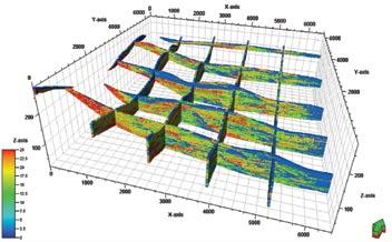
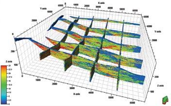
The result is improved numerical reservoir models of deepwater systems and, therefore, an expectation of improved reservoir performance forecasting and management (Figures 2 and 3).
Kevin Zhang is a geostatistician with Roxar Canada Ltd. He is currently providing consulting services on geological and geostatistical reservoir modeling with RMS.
He holds a Master’s degree in Mining Engineering (Geostatistics) from the University of Alberta (2007), a Master’s degree in Oil and Gas Development Engineering from the China University of Geosciences (Beijing, 2002) and a B.Sc. in Reservoir Engineering from the China University of Geosciences (Wuhan, 1995). Before joining Roxar, he worked for seven years as a petroleum geologist and geomodeler with CNPC, China University of Petroleum (Beijing) and Golden
Century Technology Ltd. He currently holds memberships with AAPG, CSPG, SPE, and IAMG.
There is no charge for the division talk and we welcome non-members of the CSPG. Please bring your lunch. For details or to present a talk in the future, please contact Weishan Ren at (403) 233-3428, e-mail: weishan. ren@conocophillips.com.
| by Heather Tyminski
BRUCE SHULT z, GENERAL CO -C HAIR OF THE 2008 CSPG CSEG CWLS CONVENTION
Employer: Huron Energy Corp.
What are your responsibilities as General Co-Chair?
The first job of a convention Co-chair is to come up with a convention theme. Our theme this year came as a result of our Federal Government’s changes to the tax treatment of royalty trusts. The phase-out of this business structure combined with the Alberta Government Royalty review and chronically weak Natural Gas prices is forcing our industry “Back to Exploration.” At this year’s convention, we will explore the many ways our industry can re-invent itself.
The second and most critical task of the General Co-Chair is to build the convention’s organizing committee. This requires committed volunteers from our three participating societies. We cover so much territory at these conventions; (technical papers, field trips, core conference, short courses, exhibits, special events, and publications). As a result, the revenues are large and it becomes a business unto itself. This means finding motivated reliable volunteers is a key task for us. It is however, also one of the most rewarding challenges we face. A successful convention comes from the hard work of our staff and volunteers.
Why did you decide to take on this role?
Although I run a small exploration company I consider myself first and foremost a geologist. I find that my day-to-day responsibilities take me away from my technical roots and pull me further into the financial realm. Being involved in the convention allows me to get “Back to Exploration” in my own way, and stay more involved in the science that I love.
What I also like about participating in our conventions are the people you meet. I find that our volunteers love what they do – at work and with the convention. It’s a great energy boost just being around them. It’s also a way for me to get caught up with younger scientists who are entering our business. I’m able to get a glimpse of people I think will make a difference in our industry’s future.
Have you been involved in organizing other conventions?
In 1984, I was Entertainment Chair of the CSPG/CSEG Joint Convention. We organized a New Orleans Extravaganza for the conference icebreaker that year. We involved a number of the city High Schools in planning and decorating that event. We turned the old downtown Convention Centre into a New Orleans street scene complete with a French Quarter, Paddle Wheeler, and a Street Car Named Desire. To get everyone into the spirit of New Orleans, we gave everyone barbershop quartet hats. Even the bartenders were in period costume. The bars served “hurricanes” as beverages. There’s nothing like throwing a party for 2,500 geologists, geophysicists, and their spouses!
In 1989 I was CSPG/CSEG Convention Co-Chair with Neil Rutherford of the CSEG. I have many fond memories of that convention but certainly one highlight was our luncheon guest speaker Scott Adams of Dilbert fame. you must understand the time period; downtown Calgary was awash in “Mission Statements,” “Continuous Improvement,” and “Strategy Definitions.” Scott Adams captured that downtown culture in such a humorous way that he was considered an icon. At the luncheon, our organizing committee attached wire coat hangers to their ties so they could flip them up like Dilbert’s!
After taking a break from volunteering with the CSPG for a while, I got involved in the 2005 AAPG/CSPG convention. Brian Zaitlin convinced me to act as sponsorship chair for the SEPM that year.
What has prepared you for the position of General Co-Chair of the convention?
Certainly volunteering for other committees and conventions within the CSPG prepares you for the step to General Co-Chair. I have also authored and co-authored technical papers, presented technical papers, and presented core displays at conferences. I’ve had the privilege of working with some truly exceptional geologists and geophysicists over my career, which has had a huge impact on my own technical background in geology. I later worked at a major oil company as manager of an exploration team, which developed some management skills. Also, through my tenure as president of Huron Energy Corp., I’ve had “on the job training” in financial gymnastics. All these things can to be applied in running a convention.
Volunteering in the community is also great training. I initially started my volunteering on a student council at my high school many years ago. That’s what probably got me started. I volunteered for the 1988 Winter Olympic Games here in Calgary as Chief of Distance Measuring at the Ski Jumping Venue. I also volunteered in various capacities in the public school system as my three daughters were involved in extracurricular activities. These are all great ways to learn about volunteering and get to know what is expected of volunteers.
What innovations can delegates look forward to at the 2008 convention?
I’m really excited about a number of innovations at the convention this year. Our technical committee has put together a program that has something for everyone. We have excellent technical talks on conventional earth science themes, but we’ve tried to address the low permeability reservoirs as well. These formations have recently been getting a lot of press from financial analysts. The core conference will also feature cores from the Bakken and Montney, two of the reservoirs that are
having a huge impact on exploration activity in Saskatchewan and British Columbia at the moment.
Our delegates can definitely look forward to our business sessions. As a result of last year’s change to the tax structure for royalty trusts, we’re finding that the model that has been driving the junior industry is changing; the business session will then look at the business cycle of our industry from discovery to maturity. One of our presenters in that session is Debra yedlin, a columnist with the Calgary Herald. She is well-known for her thought -provoking editorials on issues that impact our business. We’ve also been able to attract Paul Colbourne, a very successful entrepreneur, to that session as well.
Environmental issues and ways to reduce our carbon footprint will be more prominent at this year’s convention. We have an entire day set aside to celebrate International year of Planet Earth (I y PE). Groundwater, Climate Change, Earth, and Health are just some of the issues to be addressed in that session.
We also have two excellent lunches planned this year. First, on Monday, Rick Mercer, will provide a more humorous view of the political landscape affecting our oil and gas business. Then, on Tuesday, Peter Tertzakian (P.Geoph), the Chief Energy Economist at ARC Financial Corporation, will give a view into the future through his thoughtful look at global trends affecting our business.
And most important of all is our exhibit floor. We have our usual line-up of great exhibitors, but this year we think we can expand the floor to showcase some of the bigger equipment that helps us in our search for hydrocarbons. We’d also like to place some additional emphasis on applications for low permeability reservoirs. We hope to display some of the packer systems used in horizontal wells for multiple “Frac” applications as an example.
What our delegates will find convenient on our Exhibit Floor is our “Free Lunch.” It’s always been a bit of a hassle leaving Stampede Park to find lunch. We thought it would be more convenient to provide our delegates with an alternative right at the convention. Now people can take in a few posters, talk to a couple of exhibitors and network right on the convention floor over lunch.
How is the 2008 convention going to reach out to students?
We want to get students engaged in the convention, which means finding ways over the financial hurdle of the registration fee. This year, students who present papers, put on a poster session, or provide a core display will not pay convention registration. Also, those who volunteer will get convention passes. New this year, student best paper, best poster, and best core display will receive a monetary award.
We also have events that specifically reach out to students. Our Student/ Industry Gala provides an opportunity for industry people and students to interact. It’s being held in the Boyce Theatre on Tuesday as a wind-up session. It should be quite fun as it is being held in conjunction with Brian Russell’s Challenge Bowl. Brian has organized a game show that challenges students to answer earth sciences questions in a fun competitive environment. The grand prize is a free trip to the SEG conference in Las Vegas later this year. So here is an opportunity for students to network with industry folks and for members of our industry to see how smart some of our young students are. It should be a lot of fun.
What are some memorable moments you have had as a volunteer?
Every volunteer experience has its memorable moments. In 1984 it was probably the afternoon I sat with four high school Drama Teachers and sketched out ways to create a New Orleans feel in a large downtown Calgary Convention Hall. In 1988 at the Winter Olympics I got to spend some time with “Eddie the Eagle.” He never could figure out why he became such a celebrity, but he sure likes Calgarians! In 1989 it was having coffee at a hotel with Scott Adams and talking about material in one of his up-coming books and how applicable it was to life in downtown Calgary. Last year I was passed the “convention torch” by John Varsek and John Townsley, which I hope Tooney, Brian and I can do again this year. Every volunteer experience has its memorable moments and we can never predict when they will happen. It’s why volunteers keep on volunteering.
| Glen Stockmal, Editor-in-Chief
I am pleased to announce that as of January 15, manuscript submission to the Bulletin of Canadian Petroleum Geology, and the peerreview process, are on-line using Editorial Manager,® marketed by Aries Systems. Authors can submit papers at http://bcpg. edmgr.com, or through a link off of the Bulletin’s webpage at the CSPG website (http://www.cspg.org/publications/pubsbulletin.cfm). On the production side, we are now using Preprint Manager,® also marketed by Aries Systems. This combined workflow allows us to virtually do away with paper, regular mail, couriers, etc., and also track manuscripts efficiently from submission through to final publication.
I am also pleased to announce that Dr. Denis Lavoie and Dr. Robert MacNaughton have agreed to join me as Co-Editors-in-Chief, beginning May 1. I will continue in my current position until May of next year, assisting them in assuming their new duties. Dividing the workload between them will allow Denis and
June 9 – 13, 2008
*Revised and updated April 2008
New microscopes
More samples
New instructor
Roberta Peach, B.Sc.
For complete course outline, please refer to our website www.canstrat.com/courses or phone (403) 284-1112
Rob to focus on issues such as improving the Bulletin’s international profile, and increasing the number of high-quality manuscript submissions.
Dr. Denis Lavoie received a Ph.D. in carbonate sedimentology and geochemistry from Laval University in 1988. He joined the Québec office of the Geological Survey of Canada as a research scientist in 1989, where he has conducted hydrocarbon-oriented research in all the Paleozoic sedimentary belts of eastern Canada. His main research activities are focussed on the evaluation of the hydrocarbon potential of Cambrian to Permian successions, with a specific interest in fundamental processes leading to the formation of hydrothermal dolomite. In 2001 he co-edited, for the Bulletin of Canadian Petroleum Geology, the first synthesis of the hydrocarbon potential of the Silurian-Devonian Gaspé Belt in eastern Québec. In 2003 and 2004, he co-edited two special issues of the Canadian Journal of Earth Sciences that dealt with the current understanding of the Cambrian-Ordovician and Silurian-Devonian successions in eastern Canada. He also serves as associate editor for the Canadian Journal of Earth Sciences and Geoscience Canada.
Dr. Robert (Rob) MacNaughton holds a B.Sc. (Hons.) in geology from the University of New Brunswick (1990) and a Ph.D. in sedimentary geology from Queen’s University (1998). He spent two years as a Postdoctoral Fellow at Queen’s University. In 2000, he joined the Calgary office of the Geological Survey of Canada as a research scientist. Since then, he has worked on several GSC projects in northwestern Canada in disciplines that include regional mapping, stratigraphy, and paleontology. He is active in local science outreach, having done numerous presentations to school classes and served as Secretary to the Board of the Calgary Science Network.
Denis and Rob share my strong commitment to maintaining the high peer-review standards of the Bulletin, and continuing to increase its standing in the international community of scientific publications. In the March issue of the Reservoir, the new Communications Director, Peggy Hodgkins, in consultation with Past-President Colin yeo, provided some speculative ideas for increasing submissions

to the Bulletin. Some of these ideas may have given readers the impression that the Bulletin was about to deviate from its half-centuryold editorial policy of maintaining a rigorously peer-reviewed journal. Colin has since made it clear to Denis, Rob, and me that the suggestions in the Reservoir were intended only to stimulate discussion about how to increase submission numbers. As Editorsin-Chief, we share that concern but we also want to assure the Society’s membership and potential authors that the Bulletin’s scientific standards will not be compromised for the sake of increased submissions.
Remember that CSPG members have on-line access to Bulletin articles through the CSPG website (click on “Member Login” near the upper right-hand corner). Once logged-in, you can choose either of two links on the lefthand options bar: one to GeoScienceWorld, and one to Datapages (AAPG). The GSW site has full, searchable articles from 2000 to the present, and abstracts back to 1965; GSW provides the Bulletin with additional international exposure. The Datapages site provides access to articles all the way back to the Bulletin’s roots in 1953, when our publication was the News Bulletin of the Alberta Society of Petroleum Geologists. A name change in 1955 to the Journal of the ASPG was followed by another in 1964 to the Bulletin of Canadian Petroleum Geology. All CSPG members can be proud of this heritage of contribution to the science of geology, and the editorial board will continue to pursue the Bulletin’s flagship role as the preferred medium for dissemination of peer-reviewed Canadian hydrocarbon-oriented or related geosciences.
Vision for Energy

> Strategic consulting
> Seismic imaging
> Velocity analysis
> Structural interpretation
> Stratigraphic delineation
> Formation evaluation
> Reservoir modeling
> Pore pressure prediction

> Well planning and drilling

Vision is Certainty
Leading science, breakthrough innovation and exceptional people. Providing customers with the intelligence to minimize risk and optimize subsurface asset management. Paradigm. Unconflicted, unsurpassed. www.pdgm.com
| by Louis Mattar, P. Eng., Ray Mireault, P. Eng., and Lisa Dean, P. Geol., Fekete Associates Inc..
While a well is producing, a lot of information can be deduced about the well or the reservoir without having to shut it in for a well test. Analysis of production data can give us significant information in several areas:
1. Reserves – This is an estimate of the recoverable hydrocarbons, and is usually determined by traditional production decline analysis methods, as described in Article #4 in this series (Dean, L. and Mireault, R., 2008).
2. Reservoir Characteristics –
2. Permeability, well completion efficiency (skin), and some reservoir characteristics can be obtained from production data by methods of analysis that are extensions of well testing (Mattar, L. and Dean, L., 2008)
3. Oil- or Gas-In-Place – The modern methods of production data analysis (Rate Transient Analysis) can give the OriginalOil-In-Place (OOIP) or Original-Gas-InPlace (OGIP), if the flowing pressure is known in addition to the flow rate.
The principles and methods discussed in this article are equally applicable to oil and gas reservoirs, but – for brevity – will only be presented in terms of gas.
1. TRADITIONAL METHODS: RESERVES
From an economic perspective, it is not what is in the reservoir that is important,
but rather what is recoverable. The industry term for this recoverable gas is “Reserves.” There are several ways of predicting reserves. One of these methods, traditional decline analysis (exponential, hyperbolic, harmonic) has already been discussed in Article #4. The method is used daily for forecasting production and for economic evaluations. Generally, the results are meaningful, but they can sometimes be unrealistic (optimistic or pessimistic), as will be illustrated by the following examples.
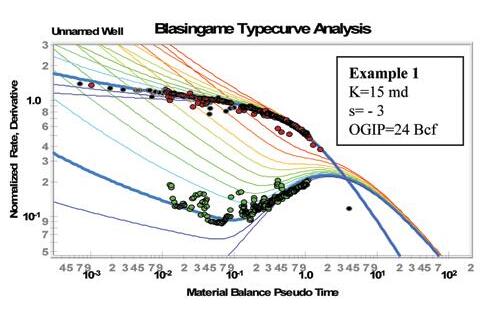
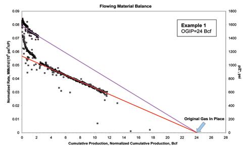
Example 1, shown in Figure 1, clearly exhibits an exponential decline. It is obvious from this Figure that the recoverable reserves are 2.9 Bcf. Typically this type of gas well has a recovery factor of 80% (0.8), and one can thereby conclude that the originalgas-in-place (OGIP) = 2.9/0.8 = 3.6 Bcf. By using the modern rate transient analysis described later in this article, it will be shown that this value of OGIP is grossly pessimistic .
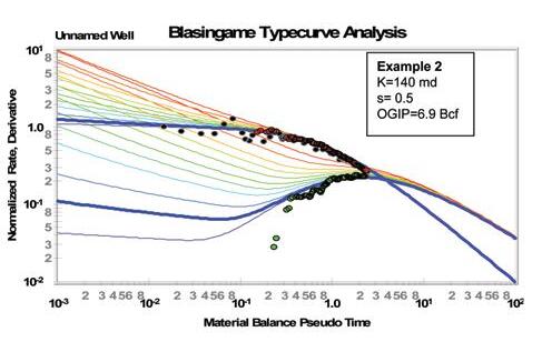
Example 2, shown in Figure 2, also exhibits an exponential decline. It can be seen from this Figure that the recoverable reserves are 10 Bcf. Assuming a recovery factor of 80% (0.8), the OGIP = 10/0.8 = 12.5 Bcf. By using the modern rate transient analysis described later in this article, it will be shown that this value of OGIP is optimistic
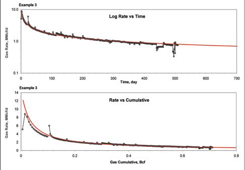
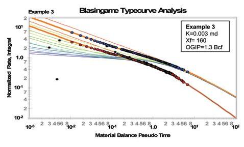
Example 3, shown in Figure 3 is a tight gas well and has been analyzed using hyperbolic decline. The reserves are 5.0 Bcf which (using a recovery factor of 50% for tight gas) translates to an OGIP equal to 10 Bcf. By using the modern rate transient analysis described later in this article, it will be shown that this value of OGIP is overly optimistic .
Typically, the traditional methods of determining reserves do not work well when the operating conditions are variable, or in the case of tight gas. The above three
examples fall into these categories, and while the results appear to be reasonable, it will be shown using the modern methods described below, that they are in error; sometimes by a significant amount.
2. MODERN M ETHODS: H YDROCARBONS -IN-PLACE AND R ESERVOIR CHARACTERISTICS
There are two significant differences between the traditional methods and the modern methods:
a. The traditional methods are empirical, whereas the modern methods are mechanistic, in that they are derived from reservoir engineering fundamentals.
b. The traditional methods only analyze the flow rate, whereas the modern methods utilize both the flow rates and the flowing pressures.
The modern methods are known as rate transient analysis. They are an extension of well testing (Mattar, L. and Dean, L., 2008). They combine Darcy’s law with the equation of state and material balance to obtain a differential equation, which is then solved analytically (Anderson, D. 2004; Mattar, L. 2004). The solution is usually presented as a “dimensionless type curve,” one curve for each of the different boundary conditions, such as: vertical well, horizontal well, hydraulically fractured well, stimulated or damaged well, bounded reservoir, etc.
To analyze production data using rate transient analysis, the instantaneous flow rate (q) and the corresponding flowing pressure (p wf ) are combined into a single variable called the normalized rate (= q/(p) and this is graphed against a time function called material-balance time. As in well testing (Mattar, L. and Dean, L., 2008), a derivative is also calculated. The resulting data set is plotted on a log-log plot of the same scale as the type curve, and the data moved vertically and horizontally until a match is obtained with one set of curves. Figure 4 shows the type curve match for the data of Example 1. This procedure is known as type curve matching, and the match point is used to calculate reservoir characteristics such as permeability, completion (fracture) effectiveness, and original-gas-in-place.
The data sets of Examples 2 and 3 have been analyzed in the same way, and the type curve matches are shown in Figures 5 and 6. Note that the type curves for each of these examples have different shapes because they represent different
Material Balance Pseudo Time
(...Continued from page 25)
well/reservoir configurations. Figures 4 and 5 represent a damaged or acidized well in radial flow, whereas Figure 6 represents a hydraulically fractured well in linear flow.
In addition to the type curve matching procedure described above, another useful method of analysis is known as the flowing material balance (Mattar, L. and Anderson, D. M., 2005). The flow rates and the flowing pressures are manipulated in such a way that the flowing pressure at any time (while the well is producing) is converted mathematically into the average reservoir pressure that exists at that time. This calculated reservoir pressure is then analyzed by material balance methods (Mireault, R. and Dean, L., 2008), and the original-gas-in-place determined. The flowing material balance plot for the data set of Example 1 is shown in Figure 6, and the results are consistent with those of the type curve matching of Figure 4.
When Examples 1, 2, and 3 are analyzed using modern Rate Transient Analysis, and the results compared to those from the traditional methods, the following volumes are obtained:
In rate transient analysis, once the reservoir characteristics have been determined, a reservoir model is constructed to historymatch the measured data. The model is then used to forecast future production scenarios, such as different operating pressures, different completions, or well drilling density.
A word of caution is warranted. Data quality can range from good to bad. Multiphase flow, liquid loading in the wellbore, wellhead to bottomhole pressure conversions, interference from infill wells, multiwell pools, rate allocations, re-completions, and multilayer effects can all compromise data quality and complicate the analysis. Notwithstanding these potential complications, it has been our experience that significant knowledge has been gained by analyzing production data using the modern methods of rate transient analysis.
:
Anderson, D. 2004. Modern Production Decline Analysis, Getting the Most Out of Your Production Data. Technical Video 2. http://www. fekete.com/aboutus/techlibrary.asp.
Dean, L. and Mireault, R. 2008. Reservoir Engineering For Geologists, Part 4: Production Decline Analysis. Canadian Society of Petroleum Geologists Reservoir, Vol. 35, Issue 1. p. 20-22.
Mattar, L. 2004. Evaluating Gas-In-Place, Case Studies Using Flowing and Shut-In Data. Technical Video 4. http://www.fekete.com/ aboutus/techlibrary.asp.
Mattar, L. and Anderson, D. M. 2005. Dynamic Material Balance (Oil or Gas-In-Place Without Shut-Ins). CIPC.
Mattar, L. and Dean, L. 2008. Reservoir Engineering For Geologists, Part 6: Well Test Interpretation. Canadian Society of Petroleum Geologists Reservoir, Vol. 35, Issue 3. p. 22-26.
Mireault, R. and Dean, L. 2008. Reservoir Engineering For Geologists, Part 5: Material Balance. Canadian Society of Petroleum Geologists Reservoir, Vol. 35, Issue 2. p. 24-26.
The reasons for the discrepancies are different in each case. In Example 1, the flowing pressure was continuously increasing due to infill wells being added into the gathering systems, which caused an excessive production rate decline. In Example 2, the flow rate and flowing pressure were declining simultaneously. The decline in flow rate would have been more severe with a constant flowing pressure. In Example 3, the permeability is so small that the data is dominated by linear flow into the fracture (traditional methods are NOT valid in this flow regime).
Look for our next article on “Monte Carlo Simulation” in the next issue of the Reservoir.
This article was contributed by Fekete Associates, Inc. For more information, contact Lisa Dean at Fekete Associates Inc.
| by Hugues Longuépée, Lori Meyer, Viktor Terlaky, Kelsey Privett, Greg van Hees, and R. William C. Arnott
Our current knowledge of deep-marine basin-floor deposits is rather limited. In large part this can be attributed to a number of important factors, including: the enormous areal expanse of this depositional system, the inaccessibility of modern systems, the paucity of continuous largescale outcrops, the poor accessibility of the few well-exposed ancient examples that do exist, and the limited resolution of remote sensing techniques like seismic, particularly deep-subsurface seismic. As a result, most models are based on large-scale stratal attributes and the extrapolation of a number of generally poorly understood sedimentary processes. Accordingly, it is commonly assumed that basin-floor deposits form laterally extensive lobe-shaped elements consisting of sheet-like deposits related to deposition from unconfined turbidity currents. Although intuitively appealing, and for the most part geometrically consistent, details concerning the internal stratigraphic architecture remain poorly known.
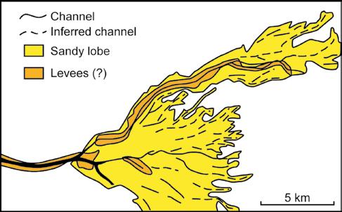
Notwithstanding these challenges, a common observation is that basin-floor lobes form a few to several kilometerwide features with an irregular outer edge (Figure 1). The finger-like margin is the result of sand deposited from turbidity currents that flowed through a superficial network of broad, shallow channels. The preservation of channel segments suggests that they form an intertwining network consisting of individual channels that became abruptly activated, acted for a time as a sediment transport conduit, and subsequently were backfilled with mostly sand-rich sediment. Details of their internal stratigraphy, however – including lithofacies and stacking patterns – are poorly known. With these questions in mind, we turn our attention to the Upper Kaza Group in the Castle Creek study area. Here, basin floor strata are continuously and almost completely exposed for several hundred metres both laterally and vertically, and as a consequence provide an outstanding opportunity to study the details of stratal geometry and architecture in basin floor deposits.
To date most of our work on the Upper Kaza Group (Arnott and Ross, 2008) has focused on the lower half of the exposed section at Castle Creek. Recently initiated work has begun higher in the stratigraphy in an attempt to link basin floor deposits of the Upper Kaza Group with slope deposits of the Isaac Formation. In the lower 120
m of the exposed section, strata have a sheet-like morphology and comprise five sandstone packages that range from 4-23 m thick (Figure 2). Packages, or what in the literature are referred to as lobes, are separated by laterally continuous, 1-3 metrethick units consisting of thin-bedded, finegrained turbidites with minor thick-bedded sandstones. Locally these units can be as (Continued on page 30..)
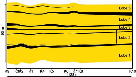
little as a few centimetres thick. Thickness of each sandstone package changes little over the 1 km width of the outcrop. Strata consist principally of thickly bedded, massive to poorly graded, coarse- to medium-grained sandstone, interpreted to be Bouma Ta or Lowe S 3 beds deposited rapidly from highconcentration turbidity currents (Figure 3). Because of basal scouring, sandstone beds can rarely be traced for more than 600 m laterally. Thick beds of sandstone are commonly capped by upper-stage plane bed (Bouma Tb division). Small-scale crossstratification (ripple; Tc) is rare. In places, beds are overlain by a thin (5 cm) layer of siltstone and mudstone (Td and Te divisions) that rarely is preserved for more than 100 meters laterally. Erosion of mud leads to bed amalgamation and creates unbroken sandstone units up to 10 m thick. Intercalated within each sandstone package are laterally discontinuous, 20-100 cm thick fine-grained beds. Observed also are thin, discontinuous debris flow deposits that generally are of the order of 5-15 cm thick and occur at the base and/or top of sandstone turbidites. This close association of sandy turbidites and debris flow deposits has been termed “linked debrites,” and has been interpreted to indicate the simultaneous occurrence of a turbidity current and genetically-related debris flow, or a turbidity current with debris-flow-like deposition (e.g., Haughton et al. 2003). Soft sediment deformation is also common in sandstone-rich lobe strata, and in addition to simple structures like load casts and flame structures, includes also small-scale injection structures like dikes and sills, although these are never more than a few decimetres long and a few centimetres wide.
Strata in the thick (100s of metres) section of Kaza stratigraphy that overlies those just described share many of the same lithological and architectural characteristics; however, a few important differences are noted, including the occurrence of a number of thick and laterally continuous debris flow deposits, and also a single, but deep (~15 m) mudfilled scour (“mud” is in fact thin-bedded turbidites) that sharply truncates a thick, sheet-like “lobe” deposit (see Meyer, 2004).
Mapping in the lower part of the exposed Upper Kaza Group section at Castle Creek illustrates how large-scale progradation (i.e., the entire depositional system) induces important changes in stratigraphic architecture. When compared to elements observed on modern fans, strata of the
Upper Kaza Group are interpreted to represent deposits of the upper to middle fan (Figure 4).
Based on our observations, sedimenttransporting currents in this part of the system are highly erosive and typically erode fine-grained sediment deposited from background suspension settling and/or the fine-grained tail region of previous flow(s). However where preserved, mudstone layers are typically laterally discontinuous and also deformed by later sand deposition and attendant sand injection. The lack of significant lateral change in the thickness
of each lobe across the ~1 km width of the outcrop suggests that successive lobes stacked vertically upward, although it could be argued that this is simply a consequence of the consistent sub-parallel trend of the outcrop surface to longitudinal axis of each lobe. Either way, the lack of lateral change in thickness might indicate that this part of the Kaza represents the narrow, more proximal (up-dip) part of the lobe system where the main sediment feeder channels tend to be more constrained laterally and therefore tend to stack vertically. Conversely, it could be argued that successive lobes stacked compensationally (i.e., successive lobes
form in the topographical lows adjacent to (positive) topography created by older lobes), but that the fan is much wider than the width of the outcrop (e.g., Meyer, 2004). Notwithstanding, one lobe does show significant lateral thinning, although only in the northwesternmost 150 meters of the section. This thinning most likely takes places near the edge of the lobe, and suggests that beyond the lobe edge sandstone thickness, and hence reservoir, decreases very rapidly.
Stratigraphically upward, the influence of slope – specifically gravitational instability – becomes increasingly more obvious, and suggests large-scale progradation of the depositional system. The presence of laterally extensive and thick debris flow deposits in the middle and upper parts of the Upper Kaza section at Castle Creek reflects the proximity of an up-dip slope. In addition, in a more proximal-to-slope setting, turbidity currents are more commonly in a state of bypass, eroding the sea floor and depositing sediment mostly from the fine-grained, tail region of the current. It is from currents like these that the 15 m-deep scour observed in the middle section, and which subsequently was filled with thin-bedded turbidites, may have originated.
PATTERNS OF SEDIMENTATION
STRATIGRAPHICALLY ABOVE AND BELOW THE STUDIED SECTION
Although work on the transition from basin floor strata of the Upper Kaza Group into slope deposits of the Isaac Formation has only just begun, preliminary observations suggest that erosion, mostly in the form of shallow scours, becomes a very common element, in addition to sandstone-rich deposits dominated by upper-stage plane bed. Also, slump/slide and especially
debris-flow deposits become significantly more common, and indicate the increasing importance of gravitational instability (i.e., slope) in the preserved stratigraphic record.
The Middle Kaza Group, which occurs stratigraphically below the Upper Kaza, and also the Old Fort Point Formation (Smith, et al., 2008a, 2008b), should, in accordance with Walther’s Law, represent deposition in a more distal setting. Although these strata are not exposed at Castle Creek they are well exposed about 20 km to the east at Mount Quanstrom. Preliminary data indicate that debris-flow deposits and major scours are absent, and both fine- and coarse-grained turbidite units are thicker. Moreover, conglomerate is more common. Collectively these observations suggest that the major depocenter occurred further basinward of the part of the system that accumulated strata of the Upper Kaza Group (upper to middle fan), and that slope (gravitational) processes had no influence in this more distal part of the fan. Furthermore, the greater lateral lithological homogeneity and continuity of the sandstone packages compared with those in the Upper Kaza Group suggests deposition from completely unconfined flow conditions on an apparently featureless basin floor.
It is somewhat appropriate to use the term “sheet sand” when describing basin-floor deposits from low-resolution seismic data. However, at the smaller scales afforded by
the ancient outcrop record, the internal architecture of these deposits is found to be significantly more complex. In large part this complexity is the result of extensive internal scouring within the sandstone packages, and as a consequence correlating sandstone and mudstone beds or bedsets based on thickness, sedimentary structures, bed sequences, etc. is highly dubious. The vertical and lateral changes in the internal architecture of basin floor deposits should have a profound effect on reservoir properties, especially sandstone connectivity (Figure 5) and net-to-gross ratio (Figure 6). In the upper to middle fan, scouring and soft sediment deformation increase vertical connectivity of sandstones. The net-to-gross ratio in that part of the fan is high, being over 90% in the axis of the lobes. Laterally, the net-to-gross ratio decreases by approximately 30% within 150 meters toward what is interpreted to be the sand-rich edge of the lobe. In the Middle Kaza Group, lateral continuity of individual lobes is likely greater than in the Upper Kaza Group. However, fine-grained intervals are thicker and more continuous and most probably completely preclude vertical connectivity between reservoir layers.
Within lobes of both the Upper and Middle Kaza, the random preservation of cmthick mudstone layers that extend for a few to several hundred meters laterally, leads to local – and only minor variation – in the net-to-gross ratio. Moreover, because of their limited length compared to the width and length of the sand-rich (Continued on page 34...)
5. Schematic view of stratal characteristics of proximal to central lobe deposits based on observations in the Upper Kaza and Middle Kaza groups. A) Longitudinal transect: fine-grained layers are thicker and more continuous basinward (Middle Kaza Group) whereas debris flow deposits are thicker and more common in the proximal lobe (Upper Kaza Group). B) Transverse transect through the proximal lobe: fine-grained intervals are commonly scoured. Note the shallow channel and debris flow deposit near the top of the section. The fine-grained intervals most probably represent a lateral facies change from an adjacent sand-rich lobe. Figure not to scale.
“With PETRA I can generate water saturation curves and update HPV maps within minutes of receiving digital logs. Now that’s staying astride of your drilling!”
Christopher J.
Collom,
Ph.D Senior Geologist enerPLUS Resources Fund
Get real-time log analysis. PETRA provides multi-discipline reservoir management teams with the analysis tools needed for today’s exploration, exploitation and acquisition challenges.
“Constructing structural or stratigraphic cross-sections in PETRA is efficient, seamless, and has virtually endless customization options. A great tool!”
Nadeem Muhammad, M.Sc. Geologist enerPLUS Resources Fund
at ihs.com/petraconnect

Figure 6. Lateral trends in the net-to-gross ratio for the five lobes identified in the lower section of the Upper Kaza Group. The marked decrease in lobes 3 and 4 most likely indicates proximity of the lobe edge. Random variations, particularly lower values, are due to local preservation of thin, discontinuous mudstone beds.
(...Continued from page 31)
lobe, these mudstone lenses represent only local permeability baffles. Nevertheless, a small number of mudstone layers, which range from a few centimetres to several meters thick, extend the full width of the outcrop, and possibly also the width of the lobe. In these cases, mudstones represent an important permeability barrier, and potentially separate the reservoir into vertically stacked flow units.
Arnott, R.W.C. and Ross, G.M., 2008. Overview of the (Neoproterozoic) Windermere Supergroup of the southern Canadian Cordillera – the world’s premier ancient deep-marine turbidite system. Canadian Society of Petroleum Geologists Reservoir v. 35, issue 2, p. 35-38.
Bouma, A.H. and Rozman, D.J., 2000. Characteristics of fine-grained outer fan fringe turbidite systems. In: Fine-grained turbidites systems. A.H. Bouma and C.G. Stone (eds.). AAPG memoir 72 / SEPM Special Publication no. 68, p. 291-298.
Haughton, P.D.W., Barker, S.P., and McCaffrey, W.D., 2003. “Linked” debrites in sand-rich turbidite systems – origin and significance. Sedimentology, v. 50, p. 459-482.
Meyer, L. 2004. Internal architecture of an ancient deep-water, passive margin, basin-floor fan system, Upper Kaza Group, Windermere Supergroup, Castle Creek, British Columbia. Unpublihsed M.Sc. thesis (University of Calgary), 175 p.
Expertise in heavy oil & deep basin reservoirs
• AVO / LMR Analysis
• Neural Network Analysis
• PP & PS Registration
• Joint PP & PS Inversion
• Fracture Detection Analysis using Azimuthal AVO
• Spectral Decomposition
Time Lapse Analysis
Carmen Dumitrescu
P.Geoph., M.Sc., Manager, Reservoir Geophysics
Direct: 403-260-6588 Main: 403-237-7711
www.sensorgeo.com
Normark, W.R., 1978. Fan valleys, channels and depositional lobes on modern submarine fans: characters for recognition of sandy turbidite environments. American Association of Petroleum Geologists, v. 62, p. 912-931.
Smith, M. D., Arnott, R.W.C., and Ross, G. M., 2008a. The Neoproterozoic Old Fort Point Formation, Southern Canadian Cordillera – Part 1: Historical background and stratigraphic formalization. Canadian Society of Petroleum Geologists Reservoir v. 35, issue 3, p. 30-34.
Smith, M. D., Arnott, R.W.C., and Ross, G. M., 2008b. The Neoproterozoic Old Fort Point Formation, Southern Canadian Cordillera – Part 2: Sedimentology and sequence stratigraphic framework Canadian Society of Petroleum Geologists Reservoir v. 35, issue 4, p. 29-33.
ACKNOWLEDGEMENTS
Our ongoing research of the WSG is funded by the industry members of the Windermere Consortium (Anadarko Petroleum, Canadian Natural Resources Ltd., Devon Petroleum Ltd., Husky Energy, Encana Corp., Nexen Inc., and Shell) and an NSERC Collaborative Research and Development Grant.


EnCana Chair in Unconventional Gas
The University of Calgary invites applications for a Chair in Unconventional Gas in the Department of Geoscience at the level of tenure-track Associate/Full Professor
We are looking for a senior scientist to build an internationally renowned geoscientific program in unconventional gas research
The successful candidate will have a PhD and an international reputation in their field of research covering major aspects of the science and engineering involved in exploring for and producing unconventional gas reservoirs Possible research areas might include one or more of tight gas, shale gas, coal bed methane or gas hydrates The candidate will work with researchers in the departments of Geoscience, Chemical and Petroleum Engineering, and Mechanical Engineering, where there are ongoing activities in unconventional gas.The successful candidate will build a vigorous, externally funded research institute or consortium that will become an internationally leading centre for developing innovative solutions to the challenges presented by the exploration for and development of unconventional gas This program will be supported by, and partnered with, both industry and government The successful candidate will have the opportunity to collaborate extensively with industry and the Institute for Sustainable Energy, Environment and Economy (www iseee ca)
The Department of Geoscience is one of the largest geoscience departments in North America with over 450 majors and approximately 170 graduate students The department brings in $5 million (CAN) per year in external research funding and is going through a period of significant expansion Additional information about the department is available at our website (www ucalgary ca/geoscience)
The University of Calgary is situated within an hour’s drive of the Canadian Rocky Mountains. It is a city of 1 million inhabitants widely recognized for its excellent quality of life and is the centre of the Canadian petroleum industry
Evaluation of applications will begin October 31, 2008 and continue until the position is filled Applicants should submit a curriculum vitae, list of publications, statements of research interests and teaching philosophy, and arrange to have three reference letters forwarded in confidence to:
Dr. D. Eaton, Head
Depar tment of Geoscience
University of Calgar y, 2500 University Drive N W , Calgar y, Alber ta, Canada T2N 1N4
Email: geojobs@ucalgar y.ca
Fax: (403) 284-0074
All qualified candidates are encouraged to apply; however, Canadians and permanent residents will be given priority
The University of Calgary respects, appreciates and encourages diversity
To see all University of Calgary academic positions, please visit: www.ucalgary.ca/hr/careers.
Samuel Aubrey Kerr pased away on February 19, 2008 at the age of 92 years.
Aubrey was born in Orillia, Ontario, on November 29, 1915. Following studies at the University of Toronto he enrolled in the graduate program at U.B.C. (Vancouver), obtaining his M.A. (Geology) in 1942.
Aubrey was Imperial’s Chief Geologist during the initial Leduc discovery in 1947 and its follow-up development. Aubrey joined Home Oil in 1949 as Chief Geologist and in 1959 Aubrey was chosen as Chief Geologist by the National Energy Board. Following success in the nation’s capital, he retired and returned to Calgary in 1975.
In retirement, Aubrey turned his attention to an intense study of the history of Alberta’s oil industry by collecting and documenting a wealth of information. He interviewed and taped many “oil patch” personalities leaving a large collection to the Glenbow Museum Archives, Calgary. All of this culminated in eight great books (including Leduc, Redwater, and Atlantic #3). In 1998 he received an honorary Doctors degree from the University of Calgary and was inducted into the Petroleum Hall of Fame in Leduc.
Aubrey Kerr was present when petroleum history was made and he left us a great legacy of knowledge and insight into the early exploration of Alberta.
We regret to announce the passing of Doris Alberta Johnston (nee Hahn) on January 28, 2008, after a courageous battle with cancer at the age of 79 years. Doris was well known by many graduates of the University of Calgary. With the support and love of her husband, Homer, and seven years of hard work and four children later Doris became the first female graduate in Geology at the University of Calgary. She worked at the University of Calgary in the Department of Geology and Geophysics where she did research and taught numerous students in her sedimentary petroleum geology lab.
Doris was born in Berwyn, AB, and grew up on a farm which her father homesteaded in the early 1900s near Paul’s Corner south of Berwyn. After marriage, Doris and Homer traveled the world. Their taste for adventure led them to the high Arctic, the wilds of Russia, the mysteries of Myanmar and the source of the Amazon.
Over forty years ago Doris purchased her beloved cabin on Windermere Lake and with her family and friends spent numerous summers and cold winter nights enjoying her retreat. She lived to see her dream of rebuilding the cabin and was fortunate enough to spend most of the summer of 2007 enjoying the fruits of her labour.
Dr. James Lee Wilson Sr., 87, internationally recognized expert on geology of carbonate sedimentary rocks, passed away on February 13, 2008 at his home in New Braunfels, Texas. He was born in Waxahachie, Texas on December 1, 1920, and was raised in San Antonio and Houston, Texas.
After graduating high school in Houston, he attended Rice University and then the University of Texas – Austin, where he earned B.A. (1942) and M.A. (1944) degrees in Geology. In 1949 he received his Ph.D. in Paleontology from yale University.
His early geologic field studies for Carter and Shell Oil Companies made him a recognized authority on limestone geology, and later academic research at University of Texas – Austin, Rice University, and University of Michigan brought him international acclaim.
Dr. Wilson was an associate professor at the University of Texas, Austin from 1949 to 1952. From 1952 to 1966 he was a research geologist for The Shell Development Company in Houston and in the Hague, Netherlands. In 1966, he accepted a Professorship of Geology at Rice University, holding the Harry Carothers Weiss Chair of Geology and serving as Chairman of the Geology Department. In 1979, Jim left Rice to join the graduate faculty in geology at the University of Michigan – Ann Arbor. He retired from there as Distinguished Professor in 1986.
His 1975 book “Carbonate Facies in Geologic History” is still the standard text on stratigraphy of carbonate rocks and has been published in several languages, including Chinese and Russian.
| by Canadian Discovery Ltd.
Operator of Note: Kereco Energy, Innova Exploration; ProEx Energy
Play:
Production of Note:
Lower Cretaceous Cadomin/Gething/Bluesky; also Triassic and Mississippian Zones
Partners Kereco Energy and Innova Exploration continue to record significant gas production from relatively shallow (<1,500m) Outpost wells completed in Basal Cretaceous sands.
This article is reprinted with permission from Canadian Discovery’s CEO map series (1stQ 2007)*. For information on products offered by CDL, please visit www.canadiandiscovery. com or call 269-3644.
R ECENT ACTIVITY
First quarter 2007 saw the release of information on three significant basal Cretaceous gas producers in the Blair
(Continued on page 38...)
Creek/Town Foothills exploration region of northeastern British Columbia. All three wells were drilled by the 50:50 partnership of Innova Exploration and Kereco Energy. These two juniors and their activities were discussed in detail in a previous CEO review (Cameron, 3Q 2005) as well as in an extensive exploration review published in the Canadian Discovery Digest, Volume 4/2006. In September 2005, the partners had spent almost $41 million to acquire two large, essentially unexplored, drilling licences at Cameron (total 15,336 ha, all P&NG) just south of a large cluster of exploratory wells licensed in 2005 at Blair Creek. At least two development (Triassic) and two Outpost (Jurassic) wells were licensed on the east side of these Cameron land holdings by Kereco in 2006. Also in 2006, still more exploration wells were licensed at Blair Creek and Town (Figure 1), in an area in full expansion for Cretaceous Cadomin (Dunlevy), Gething, and Bluesky gas. Recent extensive 3D seismic coverage, with which Innova had identified 140 drilling locations, is key to exploring and exploiting that gas resource. The company is also ready to test underbalanced horizontal drilling for exploiting the gas at Blair/Cameron (November 18, 2006 Press Release). In 2006, Innova had a CAPE x of $26.5 million earmarked for its activities at Blair/Cameron, or one quarter of its total CAPE x for that year.
Over a year after Canadian Discovery’s last CEO review, impressive results
were revealed. Deviated Outpost a-90F/94-B-16 was drilled to 1,506m TVD in the Jurassic Fernie Group by Kereco (operator) and Innova in September 2005, and was quickly put on production in November. That well recorded a very impressive initial production (IP) of 5.5 mmcf/d from the Blair Gething B Pool, and although now down to less than 500 mcf/d that shallow well flowed 750 mmcf of gas in a little over a year. The Bluesky was apparently also tested, but has not been completed at time of this report. The a90-F discovery offsets NFW c-79-F drilled less than one km southeast in late 2004 by the partnership. That vertical 1,434-m discovery well flowed 344 mmcf of gas from the Gething B Pool since February 2005, and also has apparent undeveloped Bluesky potential.
Vertical Outpost a-50-F/94-B-16 was drilled by the partnership (Kerecooperated) to 1,533m, also to the Jurassic Fernie, in August/September 2005. That well went on stream in November and recorded an IP of 3.0 mmcf/d from the Blair Gething A Pool, cumulating 370 mmcf of gas to August 2006 when the well was flowing at 290 mcf/d. Some apparent basal Cretaceous Cadomin/Nikanassin remains untapped. The a-50-B Outpost offsets Gething A production brought on December 2004 by the partners at NFW discovery well b-48-F, which has averaged 1.0 mmcf/d over the last two years and flowed 639 mmcf of gas over that period. Two other wells drilled by
the partnership in 2005 just south of the aforementioned exploratory wells are also deemed productive from the Gething A Pool (Figure 1).
Finally, Innova-operated vertical Outpost c-12-K/94-B-16 was drilled 1,375m to the Cadomin in the summer of 2005 and completed in the Town Bluesky D Pool in November. An IP rate of 2.3 mmcf/d was recorded. To date, that well has flowed 624 mmcf/d averaging 1.6 mmcf/d over its first year of production. The c-12-K completion offsets some limited production, also from the Gething B Pool. As well, the immediate area has production from the Town Bluesky D Pool.
It is clear that multi-zone productivity is the norm in the as yet undefined (officially) Blair Field and the rapidly expanding Town and Julienne Creek fields. Producing zones include not only the basal Cretaceous trio of Cadomin (Dunlevy), Gething, and Bluesky, but also Triassic Halfway, Charlie Lake, and Baldonnel sequences as well as the Mississippian Debolt. The region is also a prime candidate for shale gas potential, mainly from basal Cretaceous strata but also Triassic and Jurassic layers (a number of shale gas experimental engineering projects conducted by PetroCanada were approved in 2002, in the Beg/Jedney regions, 94-G-1/94-G-8, and some results from these are presently available).
Another successful junior operator in
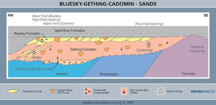
the region is ProEx Energy, which is also focussing on the Triassic to Lower Cretaceous section and has so far had much success notably with the Triassic at Gundy Creek, Town, and Beg West. The company has two significant Triassic Halfway Outpost discoveries during the quarter, both rig released during the summer of 2005, including Gundy Creek d-34-A/94-B-16 (IP 2.3 mmcf/d) and Beg West d-74-C/94-G-1 (IP 2.2 mmcf/d).
The Bluesky/Gething/Cadomin (Bullhead Group) play forms a series of thick continental to deltaic/estuarine to shoreface clastic sequences (Figure 2). The geology of that play is complicated and requires detailed geological and geophysical mapping to define prospects. The Cadomin Formation is continental in origin and was deposited on the uneven surface of the pre-Cretaceous unconformity as a series of coalescing alluvial fans and fluvial deposits sourced from the Laramide orogeny to the west. The rising level of the boreal Clearwater Sea resulted in deposition of thick continental and deltaic sequences of the Gething Formation, including stacked sands. Finally, the Bluesky Formation was deposited as a complex series of shoreface, deltaic, and estuarine valley-fill sediments overlain by a widespread blanket of thin transgressive sands. Hydrocarbons can be trapped conventionally in stratigraphic and structural closures. The latter include broad shallow Cretaceous drape anticlines over deeper Mississippian structures. Natural vertical fracturing, which can be associated with this deformation, can enhance the poorer reservoir rocks. Underbalanced horizontal drilling is most effective at maximizing recovery of the gas in this case.
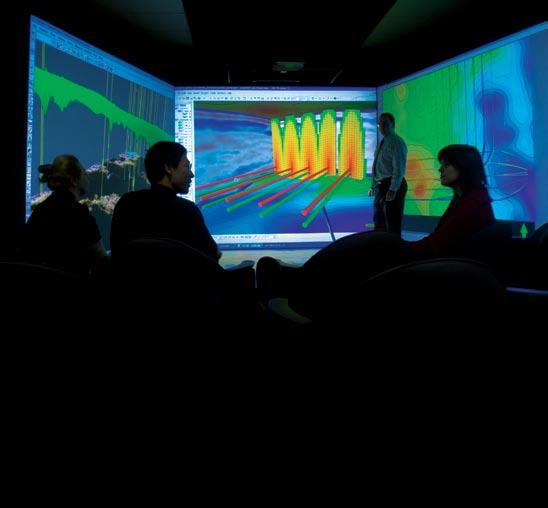
Accelerating reservoir characterization in today’s challenging environment is critical. Make smarter decisions, faster, with our powerful mix of innovative software technology and engineering expertise. Schlumberger Information Solutions (SIS) and Schlumberger Data & Consulting Services (DCS) can help you evaluate your best options for effective field planning and mature asset optimization.
Schlumberger—step-changing productivity.
www.slb.com/powerful_combination
*This article is current to data available as of 1stQ 2007.
Starting in September, the CSPG will be offering yet another service: Technical Luncheon ticket ordering and purchasing on-line. We have been planning this option for some time and the stars have now aligned with our data management system to enable this important benefit for our membership. We will be testing this new feature for the May 20 th and June 4th and 19 th luncheons at the upcoming CSPG CSEG CWLS Convention from May 12-14 in Calgary, Alberta. We invite you to drop by the CSPG Centre at the Convention and try out Luncheons On-line; we will be offering special discounts for these three luncheons to anyone ordering on-line at the Convention and an additional discount for members.
Starting in September, we will, for the first time, be offering Member pricing for luncheons, so if you are not yet a member, this might be a good time to think about joining, as there will be now be a premium for non-member tickets. As an interim measure, we will be offering on-line purchasing of our conventional colour-coded tickets, which you can either continue to pickup in the office or we will have available at a table at the Telus Convention Centre before each luncheon.
Additionally, we will, for the first time, be
offering a limited number of luncheon tickets for purchase at the door for those ‘last-minute’ folks. Given that these tickets will have to be factored into our plate ordering beforehand with the Convention Centre and we pay for whatever plates we order, this option will also come at a premium and, as mentioned, supplies will be limited.
Our ultimate goal is to integrate a bar code onto everyone’s membership card and, when you purchase your luncheon tickets on-line, your member account is credited for the luncheons you have purchased tickets for; when you arrive at the technical luncheon, a bar-code reader will simply scan your membership card for verification against your purchase credits. This will eliminate that bi-monthly scramble to ensure that you have purchased and picked up your tickets before the event.
For non-members, the same option will be available except that you will need to print off your ‘ticket,’ which will have a unique bar code on it, and you will use this at the luncheon; you will also be paying a little more for your ticket. The bar code ensures only one ‘ticket’ per customer. Our hope is to offer this more efficient method starting in January, after the membership renewals are complete and
everyone has their new membership cards, complete with bar-codes.
Again, as a benefit of membership, in this case Corporate Membership, we will be making changes to our group sales program as well for Technical Luncheon ticket sales. Starting in September, we will only be offering group sales at member pricing and with the invoicing feature to Corporate Members. In this case, Corporate Member companies will be able to group-purchase luncheon tickets at the discounted price up to the limit of the number of individual CSPG members within the company. The more members within the company, the greater the discount available to the company.
It is our expectation that this new benefit will be the leading edge of a transition to even greater purchasing flexibility for members in the future. By tracking the purchasing patterns of our individual and corporate members, we will be able to consider discounts to our consistent supporters and we will be able to assist Corporate Members in better utilizing their tickets, something we cannot do now.
Look for more details in the Reservoir and on our website in the coming months.
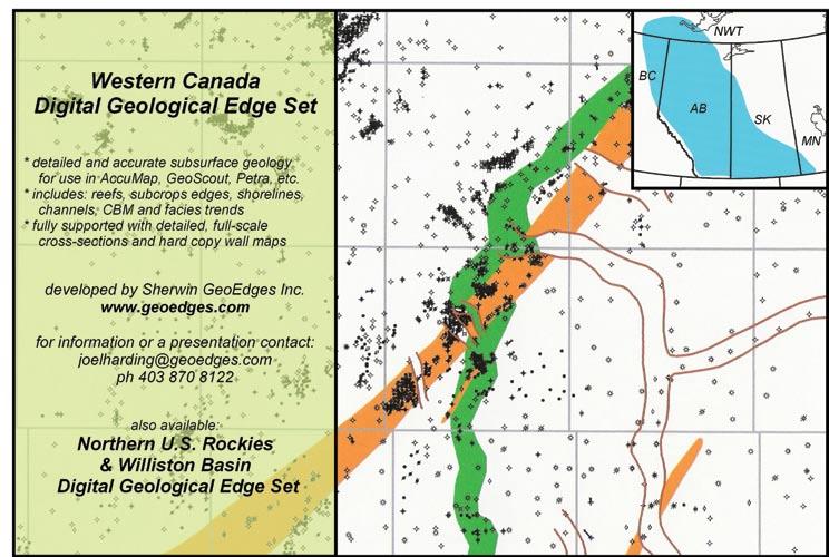

Scan, print, digitize, interpret and manage data with...
NeuraScanner
NeuraDB - NEW!
NeuraLaser
NeuraSection
NeuraLog
NeuraMap - NEW!
Visit booth 223 at the 2008 C3GEO Convention to see how Neuralog can work for you.
| by Ashton Embry
This is the first in a series of articles on one of my favorite subjects, sequence stratigraphy. I have called the series practical sequence stratigraphy because I’ll be emphasizing the application of the discipline rather than dwelling on theoretical models. Each article will cover one main topic and I hope by the end of the series anyone who has had the fortitude to read all the articles will have a good idea what sequence stratigraphy is and how it can be used to help find petroleum.
During the last 30 years, sequence stratigraphy has been discussed in dozens of books and thousands of scientific papers. It also has become the most commonly used stratigraphic discipline for developing a correlation framework within a sedimentary basin because of the low costs associated with such an analysis as well as its applicability in many cases to a well log and seismic data base in addition to cores and outcrop. Despite such popularity, considerable confusion and various misconceptions are associated with the methods and terminology (e.g., unit definition) for sequence stratigraphy. This is unfortunate because sequence stratigraphy can be an excellent foundation for facies analysis and consequent interpretations of paleogeographic evolution and depositional

history of portions of a sedimentary basin.
I became involved in developing sequence stratigraphic methodology because I found I could not apply the methods and terminology proposed by Exxon scientists almost 20 years ago. As a stratigrapher for the Geological Survey of Canada, my main focus is on the description and interpretation of the Mesozoic succession of the Canadian Arctic Archipelago. Sequence analysis is an essential part of such work and I found it frustrating that I could not apply the proposed Exxonian methods and terminology in a rigourous scientific manner. Furthermore, when I went through the literature in an attempt to see how others were applying the Exxonian methods, I found that the applications were either seriously flawed or did not really employ the Exxonian methods. This led me to develop methods and terminology which, above all, were guided by objectivity and reproducibility. I also made sure that such methods and terminology could be used in diverse geological settings, from outcrop to subsurface, and from undisturbed basin fills to tectonically disrupted areas with only fragmentary records. Finally, I also addressed the issue of data type because it is essential that any proposed methods and terms can be used equally well with
outcrop sections, mechanical well logs supported by chip samples and scattered core, seismic data, or any combination of these data types. In these efforts I was assisted by colleagues at the GSC, especially Benoit Beauchamp and Jim Dixon, who also experienced the same problems as I did when it came to the application of sequence stratigraphy to regional stratigraphic successions. I also received a great deal of help and feedback from my friend Erik Johannessen of StatoilHydro, who saw the problems stemming from Exxonian sequence stratigraphy from the perspective of a petroleum explorationist.
This series of articles will summarize the terminology and methods which I and my colleagues have found most useful in our sequence stratigraphic studies. This methodology has many features in common with the Exxon work but it also has significant differences. I hope to demonstrate that sequence stratigraphy, when properly utilized, provides a very reliable way to correlate stratigraphic cross-sections with accuracy and precision. The preparation of such cross-sections is a fundamental activity in the exploration for stratigraphically trapped oil and gas and the use of sequence stratigraphy significantly
(Continued on page 44...)
enhances the chance of success of any stratigraphic petroleum prospect. Sequence stratigraphy also allows a stratigraphic succession to be put into a time framework which in turn allows the depositional history and paleogeographic evolution to be interpreted against a background of base level changes. Such interpretations provide the predictive aspect of sequence stratigraphy.
Below, I discuss how sequence stratigraphy is best viewed as a separate stratigraphic discipline rather than some all
encompassing discipline which integrates data from all sources.
Stratigraphy is the scientific discipline that studies layered rocks (strata) that obey Steno’s Law of Superposition (younger strata overlie older strata). The Law of Superposition allows a relative temporal ordering of stratigraphic units and surfaces at any location, and correlation of such entities between different localities permits a relative ordering of strata to be assembled for the entire Earth. Stratigraphy includes
Fugro-Jason is known for World Class Results in Reservoir Characterization.
But we won’t just give you another data set to interpret.
We’ll work with you to gain a deeper understanding of your reservoir.
The results are specific drilling targets that often become the best wells in your field... Ever!
“Based on the confidence we have in the FugroJason work, we have used your products to specifically target the most prolific sand packages in the prospective area.”
recognizing and interpreting the physical, biological, and chemical properties of strata and defining a variety of stratigraphic surfaces and units on the basis of vertical changes in these properties.
Each stratigraphic discipline focuses on a specific property of strata for unit definition, description, and interpretation. Vertical changes in that specific property of the strata allow the recognition and delineation of stratigraphic surfaces within that discipline and these are used both to define the boundaries of the units and to provide stand alone correlation surfaces. The stratigraphic disciplines of lithostratigraphy (changes in lithology) and biostratigraphy (changes in fossil content) have dominated stratigraphic analysis since the time of William Smith. However, over the past 50 years, other properties of strata have been used to define new stratigraphic disciplines, each with its own specific category of stratigraphic units and surfaces. The “late comers” which have been adopted are magnetostratigraphy (changes in magnetic properties), chemostratigraphy (changes in chemical properties), and sequence stratigraphy (changes in depositional trend).
For each stratigraphic discipline, the recognized changes in the specific property which characterizes that discipline are correlated (matched on the basis of similar character and stratigraphic position) from one locality to the next and become the boundaries of a series of units. Changes in the various rock properties often can be extended over wide areas so as to allow the definition of a set of regional units. Furthermore, it is useful to determine the time relationships of a stratigraphic succession. To accomplish this, stratigraphic boundaries which are used for correlation have to be evaluated in terms of their relationship to time. Each stratigraphic surface represents an episode of change which occurred over a discrete interval of time and thus each has a degree of diachroneity over its extent. To undertake a chronostratigraphic analysis (i.e., to put the succession into a time framework), each correlated surface has to be evaluated in terms of how close it approximates a time surface.


Surfaces that have low diachroneity, that is, they developed over a short time interval, are the closest approximation to time surfaces we have and they have the most utility for the construction of stratigraphic cross sections and time frameworks. Such boundaries were classically determined by biostratigraphy with rare contributions
from lithostratigraphy (e.g., bentonites). More recently, magnetostratigraphy and chemostratigraphy have been employed to contribute to the construction of an approximate time framework. The main problems with using these stratigraphic disciplines in petroleum geology are that they are very time consuming, require highly trained specialists, and often involve large costs. Furthermore, they also require rock samples from either outcrop or core that are rarely available for most subsurface studies. All these constraints have greatly limited the application of these types of stratigraphic analysis in day-today petroleum exploration. As discussed below, sequence stratigraphy does not have the drawbacks and constraints that severely limit the use of the other stratigraphic disciplines for building an approximate time correlation framework for subsurface successions.
Sequence Stratigraphy - The recognizable property change of strata that allows sequence stratigraphic surfaces to be defined and delineated, and provides the rationale for sequence stratigraphy being a distinct stratigraphic discipline, is a change in depositional trend. Examples of changes in depositional trend include the change from sedimentation to erosion and/or starvation and vice-versa, a change from a coarsening-upward trend to a fining-upward one and vice-versa, and a change from a shallowing-upward trend to a deepening-upward one and vice-versa. Such changes are based on relatively objective observations and interpretations and they are the main ones used to define specific sequence stratigraphic surfaces. The latter two changes in trend are often used to interpret a change from a regressive trend to a transgressive trend and vice versa. Much more interpretive changes in depositional trend – the change from base level fall to base level rise and vice-versa – are also sometimes used in sequence stratigraphy but, as will be discussed, these are very difficult to apply to many datasets.
These changes in depositional trend are used to define and delineate specific types of sequence stratigraphic surfaces (e.g., subaerial unconformity for the change from sedimentation to subaerial erosion) and these surfaces in turn are used for correlation and for defining the specific units of sequence stratigraphy (e.g., a sequence). Given the above, we can say “Sequence Stratigraphy consists of:
1) the recognition and correlation of stratigraphic surfaces which represent
changes in depositional trends in the rock record and
2) the description and interpretation of resulting, genetic stratigraphic units bound by those surfaces.”
Each surface of sequence stratigraphy is characterized by a specific combination of physical characteristics, which are based on:
1) sedimentological criteria of the surface itself and the strata above and below it, and
2) geometric relationships between the surface and strata above and below it. Thus the types of data available for a sequence stratigraphic analysis must allow the facies of the succession to be reasonably interpreted and the stratal geometries to be determined. Data from other stratigraphic disciplines such as biostratigraphy and chemostratigraphy can also contribute to surface recognition (e.g., help determine stratal geometries) but cannot be used for surface characterization.
For each stratigraphic discipline, it is useful, but not essential, to have a solid

theoretical foundation which links the generation of the various surfaces in that discipline to phenomena which occur on our planet. For example, surfaces in biostratigraphy represent changes in fossil content that are due mainly to a combination of evolution and shifting environments of deposition. It must be noted that biostratigraphy flourished long before the theory of evolution was developed. Most sequence stratigraphic surfaces were recognized in the rock record and used for correlation long before a theory was developed to explain their existence. Eventually it was postulated that these sequence stratigraphic surfaces are generated by the interaction of sedimentation with relative changes in base level and this theoretical model is widely accepted today. In the next article I will describe the historical development of both the empirical observations and the theoretical underpinnings which have led to the current state of sequence stratigraphy.


| by Ben McKenzie
Occasionally, I’m asked what I do as Technical Editor for the Reservoir. Actually, it tends to be phrased more along the lines of “WHAT do you think you’re doing?” The following covers that and other odds and ends that you, gentle readers, should know.
First off, what is the Reservoir? Initially, it was an outgrowth of the Society’s informal newsletter. In the words of Wayne Shepheard, (1st Reservoir Editor, 1974-1977), “We wanted to tap into the reservoir of talent in the Society to bring new ideas and contributions to the publication, to use the pages of the Reservoir to voice concerns and make comments, both positive and negative, on the affairs of the society and on the profession in general.” (Shepheard, et al., 2004).
While the physical format of the Reservoir has changed dramatically over the years, the basic purpose, as expressed above, has stayed fairly consistent. In addition to those goals, the Reservoir is a primary vehicle for the Society to publicize its many activities and to
promote our profession (the website and enewsletter are other increasingly important methods).
Over the past few years, there have been two significant developing trends that will have an increasing impact on what the Society does and how it is perceived by the public. The first is the changing nature of our jobs. For many decades, it was assumed that people entering the petroleum industry would receive additional training and mentoring on the job. This is not so common now, hence the focus by the CSPG on increasing the Society’s role in continuing education. The Reservoir plays a part in this goal by publishing technology-related articles to inform and educate our readers.
Also, the petroleum industry has never enjoyed much general public popularity. Current attention on climate change, water use, royalties, etc., is increasingly putting the industry in the public eye – usually in a negative light. The Society recognizes that its members have varied opinions and for

that reason has an ongoing policy of avoiding political stances. For instance, we did not render an opinion on the Royalty Review Report or royalty trust taxation and we have tried to stay neutral on climate change. These are generally issues where the CSPG membership has a divided opinion and the emotion on both sides runs high. Emotional rhetoric does no good, but neither does silence. By drawing from the vast pool of members’ knowledge, the Reservoir can and should help correct misconceptions and publicize benefits the public derives from the petroleum industry.
In addition to the committee reports, luncheon abstracts, etc. that serve to report on the Society’s activities, we look for both technical and non-technical material to publish. The non-technical articles could be a report on volunteer activity by a member, a company’s support to a charitable cause, a photo-mosaic of a trip, a book review – anything that would reasonably serve to promote our members and profession.
The ability to understand deep down truths.
• Petroleum and Mining Exploration and Development Expertise
• Advanced Geophysical Interpretation
• Integrated 2D, 3D and 4D Analyses
• Seismic Acquisition and Project Management
• International Seismic Services www.boydpetro.com | 403.233.2455
Subject matter for the technical articles should stay within the broad category of petroleum geology as the vast majority of our readers are geologists. While there is obviously overlap in the various disciplines, the more narrowly focused, technical aspects of geophysics, petrophysics, mining geology, etc. are more appropriately handled by the relevant technical association. The exceptions to this are the extended technical articles that serve as an introduction to topics which are related to petroleum geology.
We are also trying to expand the Reservoir to include more information from across Canada and from the universities. These articles could deal with, for example, preview/ review articles on local conferences; status of ongoing research; condensed versions of student theses, research papers, etc.; or articles on significant events at any particular university (e.g., the start of a new department, major project, or industry funding).
As well, we welcome technical articles from commercial firms that describe how a new product does a better job, case studies, etc. – the main consideration being that it doesn’t cross the line between a technical article and overt advertising.
Because of the Reservoir’s dual nature (sciencerelated publication / Society newsletter), we have some latitude in the type of material published. While we are open to a wide variety of topics and styles of writing, we cannot, to state the obvious, use anything that is defamatory in nature or in need of extensive work in order to bring it up to commonly accepted publication standards. This is discussed further below.
The requirements for printing are fairly simple – the text should be in either plain text or MS Word document digital format and any illustrations should be as individual 300dpi TIF files. References should follow the format used in the Bulletin of Canadian Petroleum Geology. The files should be emailed to our Coordinating Editor, Heather Tyminski (heather.tyminski@cspg.org). Typically, a technical article tends to be in the two- to four-page range. A full page of text is about 1,000 words, but with illustrations (the more, the merrier) and other layout items, an article page will probably consist of about 500-750 words. Layout is handled by our printer. If any individual article runs a bit long, we can always carry it over to the next issue.
Articles should be submitted by the 23rd of the month, two months prior to publication date (e.g., articles for the June issue have to be submitted by April 23rd). Two months sounds like a long time, but in reality, the publication cycle is only about five weeks. In that time, the printer does the initial layout, three drafts and a final proof are issued for editing, and the magazine is printed and delivered. In rare instances and with some irritation, we can accept material later in the publication cycle. With lead time, we can target a particular month.
As a passing comment, printing restrictions require us to prepare the Reservoir in multiples of eight pages. Sometimes to meet the page count, material has to be bumped to a later month.
The Reservoir is not a peer-reviewed publication, but we do have a “technical” editor. Reviewing and editing are similar but are done to different degrees and for different purposes. The basic distinction is that the reviewer (who typically has the option of anonymity) is expected to have in-depth knowledge of the subject being discussed and will examine an article for such things as
(Continued on page 48...)

technical accuracy, clarity, and consistency. Any comments about those areas, as well as spelling, grammar, style, etc., are relayed to the author for consideration. It is up to the author to address those comments. If the reviewer has significant concerns that are not rectified, then the article may be turned down for publication.
The editor has several duties, first of which is determining whether an article is appropriate for the target audience. Passing that hurdle, the editor will also deal with technical accuracy, clarity, spelling, etc. However, unlike the reviewer, the editor has the right to make minor changes without further input from the author. Usually, these changes deal with mechanical aspects of publishing such as language edits, printing format, and layout.
Where there is a question about content or if a significant portion of the article has to be cut because of space restrictions, then the editor may discuss it with the author. Depending on the particular article, the editor may send it out for further review or, if the material is potentially contentious, seek a counterbalancing view for concurrent publication.
Speaking for myself, I do read everything that goes into the magazine. No, I’m not an expert on all topics, but I try to ensure that the information is readable, consistent, and has no obvious errors (differences in opinion aside). As well, Heather Tyminski (Reservoir Coordinating Editor) in the CSPG office contributes significantly to the organizational and editing process. Also, Brenda Johnston, who handles the magazine’s layout at Sundog Printing, is very good at helping us make it presentable.
Style is a wonderful thing – it can cover a wide variety of apparent inconsistencies. Because material submitted to the Reservoir comes from dozens of authors with a wide range of experience and educational backgrounds and because of our time constraints, we are not as concerned about making sure that each article matches a set style. This also helps set a somewhat informal tone to the publication that we hope will foster a sense of ownership among our members. That said, we do have a few guidelines we follow, which hopefully aid in our goals of clarity and readability.
Our technical article requirements are not as rigorous as the Bulletin (for example) since the Reservoir is not a peer-reviewed publication. This is partly because of the publishing time constraints we have, but also to allow inclusion of works that are in
progress. Hopefully, such articles will spark discussion and increase communication to the benefit of all concerned.
Although I’ve commented repeatedly about the Reservoir’s informal nature and desire to publish developing ideas for discussion purposes, the Reservoir is still a reasonably high-profile, science-oriented publication. As such, it is up to the author to ensure that his or her material is accurate, up-to-date, and properly referenced. We recognize that there are differing viewpoints on many issues and hope that the Reservoir can foster a sense of cooperative discovery. We also expect any disagreements arising over a published article to be resolved in a professional manner.
We are willing, and have on occasion, provided some assistance in getting articles ready for printing. This can take the form of extensive editing where the author’s first language is not English, converting typewritten text to digital, and drafting illustrations. This work is not part of the Reservoir’s mandate and is done by volunteers when available. Potential contributors should contact the Technical Editor if they need help along these lines. Remember, we want your article to look good too.
As stated in the Reservoir and on the website, contents in the Reservoir may not be reproduced either in part or in full without the consent of the publisher. Put simply, this is a typical blanket statement used in publishing and is not meant to impede the dissemination of an idea but rather to ensure credit is given and that the material is not used for unintended purposes. you, as an author, have the right to your original work. We, as publisher, have the right to the finished product we produce.
Occasionally, there has been some discussion as to whether memorials are better placed in the Bulletin or in the Reservoir. Our current policy is that a small notice of passing and photo is reasonable to include in the Reservoir, but that a more extensive Memorial Note would be better placed in the Bulletin.
Likewise, our profession does have a high degree of mobility associated with it and we will publish where people have gone when provided with the information.
Reality intrudes – no advertising, no magazine. We try to maintain an approximate 50/50 split between advertising and content. Kim
MacLean and Sarah Barton have done an outstanding job at finding advertisers to help us carry on.
DENY, DENY, DENY
Unless specifically identified otherwise, no official endorsement or sponsorship by the CSPG is implied for any advertisement or article that appears in the Reservoir. If you do not agree with something that has been published, we encourage you to submit your own version of reality.
Finally, I want to welcome Colin yeo aboard as co-editor. After years of volunteering in a variety of positions with the Society, Colin decided he still didn’t have enough to do and offered to help out with the Reservoir. Thanks Colin.
Along the same line, we are always looking for people to help out with the Reservoir. This could be as a correspondent for local activities or university liaison, a book reviewer, roving reporter, interviewer for the “Talking to” series, etc. Give us a call – get involved.
Communications Director
Peggy Hodgkins
CGGVeritas
Tel: (403) 266-3225
Email: peggy.hodgkins@cggveritas.com
Technical Editor
Ben McKenzie
Tarheel Exploration
Tel: (403) 277-4496
Email: bjmck@telusplanet.net
Assistant Technical Editor
Colin yeo
EnCana Corporation
Tel: (403) 645-7724
Email: colin.yeo@encana.com
Coordinating Editor
Heather Tyminski
Comunications and Public Affairs, CSPG
Tel: (403) 513-1227
Email: heather.tyminski@cspg.org
Advertising
Alyssa Middleton
Corporate Relations, CSPG
Tel: (403) 513-1229
Email: reservoir@cspg.org
Shepheard, W. W., et al., 2004. Editor(ial) Reviews in Reservoir 30th Anniversary Issue 1974-2004. Canadian Society of Petroleum Geologists, Reservoir, Vol. 31, Issue 11, p. 25.
2008 C3Geo Convention May 12 – 15,2008 Calgary,Alberta,Canada
We would like to thank all the exhibitors for participating in the 2008 Convention.
As of March 31, 2008
Company Name .............. Booth Number
AAPG 935
Acceleware Corp. ......................................... 919
Aeroquest International Limited 305
AGAT Laboratories Ltd. 802
Alberta Geological Survey 1112
ALT – Advanced Logic Technology .......... 231
ARAM Systems Ltd. ..................................... 542
Canadian Seismic Rentals, Inc.
Texas Seismic Rentals, Inc.
Association of Professional Engineers, Geologists and Geophysicists of Alberta, The 931
Baker Atlas 840
Barco ................................................................ 335
BEICIP Inc. ...................................................... 330
Boyd PetroSearch 743
British Columbia –Oil And Gas Division ............................ 1005
Calgary Rock and Materials Services Inc. 124
Canadian Discovery Ltd. 435
Canadian Society of Exploration Geophysicists ........................................... 1140
Canadian Society of Petroleum Geologists 1140
Canadian Well Logging Society 1140
Canmore Museum and Geoscience Centre 470
CGGVeritas 227
Continental Imaging Products (CIP) 921
Continental Laboratories / CL Consultants 315
Core Laboratories Canada, Ltd. 310
CREWES, University of Calgary 815
Digital Formation, Inc. ................................. 455
Divestco Inc. ................................................... 719
DMI Digital Media Inc. 932
Easycopy Company, The 320
EMGS Americas ............................................. 736
ESG (Engineering Seismology Group) .... 1003
ESRI Canada Ltd. 445
ExPRO GROUP C ANADA 804
ffA ...................................................................... 817
FUGRO (Fugro-Jason, Fugro Data Solutions, Fugro Airborne) 911
GEDCO 340
Genetek Earth Research Corporation .... 819
GeoKnowledge 929
geoLOGIC systems ltd. 505
Geo-Logic Systems, LLC 928
Geological Rentals & Services Inc. ........... 460
GeoMechanics Intl – GMI 535
Geo-Microbial Technologies (GMT) 738
Geomodeling Technology Corp. 221
GORE ............................................................... 800
Government of Nunavut .......................... 1006
Green’s Rock & Lapidary Ltd. 425
Halliburton 904
Horizontal Solutions International ........... 325
Hotwell Canada Ltd. ................................... 230
HPDI, LLC 920
Hydrocarbon Data System 405
IBM Canada Ltd. ......................................... 1002
IHS .................................................................... 731
IKON Science Ltd. 831
INDEL-DAVIS INC. 116
Industrial Vehicles International, Inc. ...... 126
Ingrain Inc. .................................................... 1001
ION 225
Isobrine Solutions 122
iSys - The Imaging Systems Group Inc. 818
JEBCO Seismic (Canada) / ARKex .......... 739
Kelman Technologies Inc. 345
KOMAREVICH ORIGINALS LTD 110
Little Rock Document Services Ltd. 100
MacKay Range Development Corporation 415
Manitoba Science, Technology, Energy and Mines – Mineral Resources Division 1106
Marc Shandro Nature Photography ......... 740
Mechdyne Corporation 915
Microseismic, Inc. 543
MJ Systems 836
Mustagh Resources Ltd. .............................. 410
Natural Resources Canada Geological Survey of Canada 1102
Nautilus 128
“Back to Exploration” - a theme well suited to today’s Oil and Gas industry in Canada. Over the past year we have seen the demise of the Royalty Trust sector of our business, continued low natural gas prices coupled with very high operating costs and a stronger Canadian dollar as well as the introduction of the new Alberta Royalty Tax structure. The Technical Program is designed to reflect the importance of all these events on our industry, and the need for integration and collaboration between all our diverse disciplines as we go forward, looking for new and riskier opportunities both here in Canada and abroad.
This year, the Technical Committee has designed a program to reflect the importance of each of these events on our local industry and the need to return to our roots and begin to “Explore” again. Geologists, Geophysicists, Petrophysicists, and Engineers will need to stretch their vision and look for opportunities in the new frontiers of Oil and Gas exploration.
To highlight our theme “Back to Exploration” we have a number of oral, core, and poster sessions that will focus on the prospects of the new frontiers of Canada – the Arctic Islands, the Beaufort Sea, the Mackenzie corridor, the Eastern Canada offshore – and even Global Exploration. Along with these new exploration prospects will come the new technologies needed to aid in our pursuits. Both oral and poster sessions will focus on Seismic
CSPG Modern Analogues Applications to the Stratigraphic Record
Keynote Lunch
CSPG Neoichnological & Palichnological Applications to Petroleum Exploration & Development
TUESDAY
2:30 2:55 3:20 2:55 - 3:10
CSPG Carbonates
Keynote Lunch
CSPG Outcrop Analogues Applications for Reservoir Characterization
CSPG Sequence Stratigraphy I
Break
CSPG New Trends in Exploration
CSPG Frontiers I Canadian Arctic Islands
Coffee Breaker and Poster Sessions On Exhibit Floor
CSPG/CSEG Frontiers II
Beaufort-Mackenzie Delta & Mackenzie Corridor
Poster Sessions – Presentation & Viewing On Exhibit Floor
CSPG Frontiers III On-shore Frontiers
Coffee Breaker and Poster Sessions On Exhibit
CSPG/CSEG Frontiers IV Global Exploration & East Coast
Poster Sessions – Presentation & Viewing On Exhibit Floor
CSEG Seismic Data Processing
CSEG Seismic Multi- Component
CSEG Seismic Migration Seismic Characterization
CSEG Seismic Migration, Inversion, Theory
Seismic Interpretation / Case Studies CSEG Seismic Interpolation I
Seismic Gravity / EM / Alternative Methods CSEG Seismic Interpolation II
The preceding schedule is provisional and therefore subject to change. Please consult the website www.GEOconvention.org for the
As in previous years, the 2008 Convention Core Conference will be held in the worldclass facilities of the EUB Core Research Center in Research Park. Core, accompanied by posters, will be on display for two days, from 10:00am – 4:00pm Wednesday, May 14, and 8:30am – 4:00pm Thursday, May 15. Check the schedule if you are interested in


Acquisition, Data Processing, Migration and Reservoir Characterization techniques, Fracture Analyses, and Neutral Network and Cluster Analyses In addition to the traditional sessions focusing on Unconventional Reservoirs, Structure, Carbonates, and Sequence Stratigraphy, there will also be sessions on Rock Properties, Interpolation, applications of Ichnology and Modern and Ancient (outcrop) Analogues to Petroleum Exploration and Development
The Technical Program will also look at the next great challenge facing the Oil and Gas industry as we pursue these new frontiers: the environment Oral and poster sessions will look at environmental issues and climate change as they relate to the Oil and Gas industry, CO2 capture and storage processes and the impacts of Heavy Oil development on the environment.
We also look forward to several Special Sessions this year 2008 is the International Year of Planet Earth and we are pleased to have several talks from the IYPE lecture series included in the program. Our Business Sessions will include topics such as Regulatory Realities of Exploration in the WCSB, and From Discovery to Maturity - The Economic Life Cycle of the Energy Business, featuring excellent talks by industry leaders.
Palomino
CWLS Rock Properties
CSEG Seismic Rock Properties
CSEG
Seismic Reservoir Characterization
CSEG Seismic AVO
CSEG
Seismic Fracture Analysis
CSEG Seismic Acquisition
CSPG Environment / Geosequestration of CO2
CSPG Structure
CSPG Geosequestration of CO2 I From Storage to Enhanced Hydrocarbon Recovery
CSPG Geosequestration of CO2 II From Storage to Enhanced Hydrocarbon Recovery
CWLS Log-Core Data Calibration
CSPG/CSEG Heavy Oil
CSPG/CSEG/CWLS Business Session From Discovery to Maturity - The Economic Life Cycle of the Energy Business Coffee
CSPG Oil Sands
CSPG/CSEG/CWLS
Unconventional I CBM and Shales
CSPG/CSEG International Year of the Planet Earth I
CSPG/CSEG International Year of the Planet Earth II Coffee Breaker and Poster Sessions On Exhibit Floor Poster Sessions – Presentation & Viewing On Exhibit Floor
CSPG/CSEG/CWLS
Unconventional II Shale Gas CWLS Logs analysis
hearing a brief formal oral presentation from the authors, or drop by to browse the core at your leisure. The displays will cover a wide variety of formations, with representation of core from across North America, from British Columbia to the Appalachia area of upstate New York. Come and enjoy discussions over real rocks, catch up with your colleagues, and partake of the refreshments, BBQ luncheons, and final Core Meltdown. The world class presenters, EUB facility, and staff all provide a great environment for interaction. It is an event not to be missed.


The 2008 Core Conference Committee is pleased to announce the list of 23 core displays, which can be characterized by their variety and scope. Reflecting the theme of this year’s convention, Back to Exploration, these displays flow from Conventional Plays, (Clastics & Carbonates) to Unconventional Exploration Heavy Oil, Tight Gas, and Shale Gas), with displays from the WCSB, Rocky Mountain Basins, Appalachia, Gulf of Mexico, and the North Sea.
Cores from the Trenton - Black River (Ordovician) HTD Play in the Quackenbush Hill Field, Chemung County, New York
Jeffrey Packard*, P. Marner, S. Coulter, R. Jacobi, and P. Agle
Jean Marie Facies, Elleh Area, N. E. British Columbia Rick Wierzbicki* and A. Hedinger
Understanding the Origin of the Sub-Unconformity Diagenetic Caprock, in the Mississippian of the Williston Basin, Southeast Saskatchewan Gemma Bates* and A. Kendall
Oil Plays Away From the Subcrop Edge in the Williston Basin of Southeast Saskatchewan John Lake* and D. Kent
Sedimentology and Stratigraphy of the Middle Jurassic Shaunavon Formation Oil Fields in Southwestern Saskatchewan Arden Marsh* and M. Yurkowski
Facies Relationships and Hydrocarbon Potential in the Souris Valley Beds (Lodgepole Fm.) in Southeast Saskatchewan
Erik Nickel and D. Kent
Characterising Fluid Flow in Bioturbated Reservoirs:
An Integrative Approach Utilising Core Analysis, Petrography, Probe Permeametry, and Percolation-Invasion Modeling
Michelle Spila*, S.G. Pemberton, B. Rostron, and M.K. Gingras
Chemostratigraphy as an Exploration Tool in Low-Accommodation Incised Valley Systems; An Example from the Lower Cretaceous Basal Quartz in Southern Alberta, Canada.
Gemma Hildred*, K. Ratcliffe, A. Wright and B. Zaitlin
Geology of the Cored Deepwater Palaeocene Forties Sandstone Member of the 22/14b Huntington Oil discovery, UK Central North Sea .
Stephen J.M.Molyneux*, J. Cater , F. Ketter, N. Holmes, G. Howarth, D. Greenwood, D. Barson , R. Tonn, K. Waters , B. Cook , K. Halward, J. McBride, and R. Christensen
Implications of an Evolving Channel/levee System on Reservoir Distribution: An Example from the Upper Miocene to Lower Pliocene Gulf of Mexico
Scott G. Comegys*, J. Wagner, D. Kucinskas, J. Nall, and J. Colliton
The Burrowed Zone of the Cadotte Member: Sedimentological and Ichnolgical Wonders from the Interface of Dramatically Different Shoreface Zones
Curtis Lettley*, T. Saunders, S.G. Pemberton, and M.K. Gingras
“Glauconitic” Oil Reservoirs in Southern Alberta - Creating the Correct Geological Model to Guide Development Drilling
Brad Hayes*, L. Griffith, and J. Carey
Gravity Flow Units in the Nikanassin Formation, Alberta: Insights into Depositional Environments in the Early Western Canada Foreland Basin
Brett Miles* and S. Hubbard
Towards Economic Production of Grosmont Formation Bitumen: Assessing the Relative Influence of Reservoir Porosity and Permeability, Versus Bitumen Quality, on Production Potential
Michèle M. Asgar-Deen*, L. S. Brown, M. C. Browning, J. E. Davison, C. Eisinger, C.B. Fefchak, G. W. Gibson, C. R. Graham, S. D. Hill, M. M. Kaspers, E. M. Kellough, and S. A. Walter
Sedimentology and Stratigraphic Framework of the Upper Clearwater Formation at Caribou Lake, Alberta
Stuart Tye*, W. Warters, S. Sayani, and M. Ranger
Reservoir Units Within a MultiLayered Dolostone Formation: Grosmont Formation, Saleski Area
John Hopkin* and K. Barrett
The Graminia-Blueridge Succession of Northeastern Alberta: A New Devonian Subcrop Bitumen Play Kent Barrett*
The Grand Rapids Formation: An Unexploited Bitumen Reservoir Douglas Cant*
The Lower Cretaceous Dina Formation Oil Sands of Northwestern Saskatchewan
Dan Kohlruss, G. Chi, and P.K. Pedersen
Sedimentology, Ichnology, and Reservoir Properties of the Low Permeability Upper Cretaceous Alderson Member - Hatton Gas Pool, SW Saskatchewan, Canada
Ryan Thomas Lemiski, M.K. Gingras, J. Hovikoski, S.G. Pemberton, J. MacEachern, and A. LaCroix
Lower Triassic Montney Sequences, Facies, and the Montney-Doig Boundary
Graham Davies* and D. Hume
Horn River Basin/Cordova Embayment, Northeastern British Columbia; Shale Units of the Horn River Formation
Warren Walsh, S. McPhail, C. Lee, K. Raines, and P. Monahan
Tight Gas Sands Uinta Basin, Mesaverde Formation: Well Case History
Randy Miller, M. Quest, and W. D. Sealey
Choose from over 50 exciting field seminars and short courses all designed with the goal of helping you explore and better understand your industry. For complete details on any of the field seminars and short courses offered by the AAPG, call +1 918 560-2650 or visit http://www.aapg.org/education/
Practical Salt Tectonics
Date: May 5-6, 2008
Location: London, England
Instructor: Mark G. Rowan, Consultant, Boulder, CO
http://www.aapg.org/education/shortcourse/details.cfm?ID=67
Basic Well Log Analysis
Date: May 13-16, 2008
Locations: Austin, TX
Instructors: George B. Asquith, Texas Tech University, Lubbock, TX; Daniel A. Krygowski, The Discovery Group, Denver, CO
http://www.aapg.org/education/shortcourse/details.cfm?ID=109
Essentials of Subsurface Mapping
Date: May 19-20, 2008
Location: Dallas, TX
Reservoir Engineering for Petroleum Geologists
Date: May 28-29, 2008
Location: Houston, TX
Instructor: Richard G. Green, Saxon Oil, Dallas, TX http://www.aapg.org/education/shortcourse/details.cfm?ID=71
Exploring for Stratigraphic Traps Using Pressure/Depth Plots & Salinities
Date: June 2-4, 2008
Location: Denver, CO
Instructor: Hugh Reid, Hugh W. Reid & Associates, Calgary, AB, Canada http://www.aapg.org/education/shortcourse/details.cfm?ID=49
Multi-Component Seismic Stratigraphy
Date: June 11-12, 2008
Location: Houston, TX
Instructor: Richard Banks, Scientific Computing Applications, Inc., Tulsa, OK http://www.aapg.org/education/shortcourse/details.cfm?ID=29
Deep-Water Sands - Integrated Stratigraphic Analysis: A Workshop Using Multiple Data Sets
Date: May 26-28, 2008
Location: London, England
Instructor: John M. Armentrout, Cascade Stratigraphics, Damascus, OR http://www.aapg.org/education/shortcourse/details.cfm?ID=52
Modern Terrigenous Clastic Depositional Systems
Dates: May 1 - 8; June 14 - 21, 2008
Location: Begins in Columbia and ends in Charleston, South Carolina
Leader: Walter J. Sexton, Athena Technologies, Inc., Columbia, SC http://www.aapg.org/education/fieldseminars/details.cfm?ID=6
Submarine Canyons, Channels, Fans and Deep-water Sequence Stratigraphy
Date: May 4-7, 2008 (beginning at noon on the 4th, ending late afternoon on the 7th)
Location: La Jolla, San Deigo County, California
Leader: John E. Warme, Colorado School of Mines, Golden, CO http://www.aapg.org/education/fieldseminars/details.cfm?ID=63
Controls On Porosity Types and Distribution in Carbonate Reservoirs
Date: May 18-23, 2008
Location: Almeria Region, SE Spain, begins and ends in Las Negras, Spain. Fly from London/ Barcelona/Madrid
Leaders: Evan K. Franseen, Kansas Geological Survey, Lawrence, KS; Robert H. Goldstein, University of Kansas, Lawrence, KS; Mateu Esteban, REPSOL-YPF, Mallorca, Spain http://www.aapg.org/education/fieldseminars/details.cfm?ID=2
Complex Carbonate Reservoirs: The Role of Fracturing, Facies and Tectonics
Date: May 24-30, 2008 (begins the afternoon of May 24 and finishes the afternoon of May 30)
Location: Begins in Naples and ends at Rome International Airport (Italy)
Leaders: Raffaele Di Cuia, G.E.Plan Consulting, Ferrara, Italy; Davide Casabianca, BP plc, Aberdeen, UK http://www.aapg.org/education/fieldseminars/details.cfm?ID=79

Instructor: Bob Hardage, Bureau of Economic Geology, Austin, TX http://www.aapg.org/education/shortcourse/details.cfm?ID=42
Seismic Interpretation in Fold- and Thrust-Belts Using Fault-Related Folding Techniques
Date: June 17-20
Location: Denver, CO
Instructor: John Shaw, Harvard University, Cambridge, MA
GEOTOUR! Geological Tour Through Alaska: A Trans-Alaskan Transect - Gulf of Alaska to Prudhoe Bay on the Arctic Ocean
Date: May 31 - June 10, 2008
Location: Trip begins in Homer and ends in Fairbanks, Alaska
Leaders: Tom Plawman, BP, Anchorage, AK, and David Hite, Consultant, Anchorage, AK, for south-central Alaskan segment; Gil Mull, Santa Fe, N.M., Tom Plawman and David Hite for Brooks Range and northern Alaska segment http://www.aapg.org/education/fieldseminars/details.cfm?ID=113
Predicting Clastic Reservoirs Using Applied Sequence Stratigraphy
Date: June 7-14, 2008
Location: Begins and ends in Salt Lake City, UT
Leaders: Lee F. Krystinik, Fossil Creek Resources, Fort Worth, TX and Beverly Blakeney DeJarnett, Bureau of Economic Geology, The University of Texas, Houston, TX http://www.aapg.org/education/fieldseminars/details.cfm?ID=11
Folding, Thrusting & Syntectonic Sedimentation: Perspectives from Classic Localities of the Central Pyrenees
Date: June 16-20, 2008
Location: Begins and ends in Barcelona, Spain
Leaders: Antonio Teixell, Universitat Autonoma de Barcelona, Spain, and Antonio Barnolas, Instituto Geologico y Minero de Espana, Madrid, Spain http://www.aapg.org/education/fieldseminars/details.cfm?ID=24
Sequence Stratigraphy and Reservoir Distribution in a Modern Carbonate Platform, Bahamas
Date: June 16-20, 2008
Location: Begins and ends in Miami, Florida. Four days are spent on a chartered boat in the Bahamas.
Leaders: Gregor P. Eberli, Comparative Sedimentology Laboratory, University of Miami, Miami, FL; G. Michael Grammer, Department of Geosciences, Western Michigan University, Kalamazoo, MI; Paul M. (Mitch) Harris, Chevron Energy Technology Company, San Ramon, CA http://www.aapg.org/education/fieldseminars/details.cfm?ID=4
For more info or to enroll call +1 918 560-2650 or visit http://www.aapg.org/aug/
| by Dave Hills, 2009 Geological Calendar Chair
Geologists are really an artistic bunch. It’s something about the career that calls to both the scientist and artist within us. For this reason, the CSPG’s calendar is always a much-anticipated publication, communicating intriguing aspects of geology with dazzling vistas of the natural world. Sure, engineers might have something like “Bridges of the year,” but I doubt if it would be quite so popular.
The number one question I and past calendar chairs get asked is “How do you select the photos that get into the calendar?” Or, to be honest, the question is sometimes phrased differently: “Why wasn’t mine chosen?”
Here’s how we pick the photos. Following the June submission deadline, the calendar judges – a hand-selected bunch of geologists /photographers – gather to review all
if the picture has relevant content and has a geological story to tell. The third and toughest of the criteria to judge is ‘artistic merit.’ This area is especially difficult due to the difference in everyone’s perception of art. Thankfully, in five years of attending the calendar selections, I have yet to witness a fight break out amongst the judges.
By Gary Johannson
By Benoit Beauchamp
the submissions. This task has grown significantly over the past few years with the 2008 calendar call reaching a record 130 submissions.
Each image is graded according to three criteria. Technical quality is the first of these, which filters out images that are blurry, dusty, or of too low a resolution to be included in the final publication. Next is the geological content. It can be fascinating to see how this is interpreted by different photographers, stretching from field images with the obligatory lens cap as scale, to decorative stone on downtown office buildings. The judges’ priority is to decide
By Mike G. Babechuk
get more shots of the Rockies than any other part of Canada), and also that the subject matter covers a wide swath of the geological sciences.
Using these three criteria, the judging panel whittles down the stack to 20 or so images, from which the chair selects the final thirteen.
The chair is responsible for ensuring the calendar is balanced with good geographical representation throughout the country (it is no surprise that we
Finally, with the thirteen submissions decided on, the judging panel regroups to make a decision on which of the images will win the competition. This year, prizes will be awarded for the ‘Best Canadian Photo,’ as well as the ‘Photo of the year.’ As these might well be one and the same, the winner stands to receive $400; just enough for that lens you’ve been eyeing up!
So, with the above in mind, it is time for us on the committee to relax until the June 30, 2008 deadline and watch the submissions come in. Until then, it’s your turn to take your camera (which needn’t be fancy, just 3 MP or greater) to wherever the springtime takes you and tell a visual geological story. Who knows – it might well be gracing your office wall this time next year.
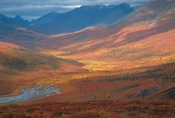
By Marc Shandro
To submit a photo, visit www.cspg.org and visit the Calendar page under the Publications section.
Wellsite Geological Supervision
�� Conventional Wellsite Geology
�� Horizontal / Directional
�� SAGD / Horizonal Heavy Oil
�� Oilsands Core Logging Programs
�� Coal Bed Methane
�� International Offshore/Onshore
�� Geological Operations Management
�� Seismic Operations Management
�� Acquisition / Processing QC
�� Site Investigation and Sur vey
�� Safety,Integrity & Risk Management
�� Petroleum Engineering Consultancy
The Medal of Merit is “awarded annually by the CSPG for the best paper published during the previous year on a subject related to the petroleum geology of Canada.” More specifically, the Medal of Merit Committee favours papers which are broad in scope and are clearly written, well presented, and illustrated with novel ideas, thorough data collection, and linkage of data to interpretations and conclusions.
The 2007 Medal of Merit is awarded to Graham R. Davies and Langhorne B. Smith Jr. for their paper: “Stucturally controlled hydrothermal dolomite reservoir facies: An overview” which was published in the November 2006 American Association of Petroleum Geologists Bulletin, v. 90, p. 1641-1690. The presentation took place
I would like to thank the CSPG and my nominator(s) for honouring me with a Tracks Award. It has been my pleasure to serve the society and its membership over the years in whatever modest way I was able.
I would like to acknowledge and thank those younger members of the society who already volunteer and strongly encourage others to step forward and lend their enthusiasm and energy to furthering the goals of the CSPG. In so doing you transform your job from “just a job,” to a stepping stone in an exciting career. You further develop skill in networking and communication, both critical to a successful career.
In working on CSPG volunteer teams you have the chance to compare both philosophical and technical perspectives on many issues with new-found colleagues. In participating in outreach, I have found numerous opportunities to sharpen one’s ability in explaining technical geological concepts to non-geologists. This is a critical skill in a successful career as a petroleum geologist whether increasing societal awareness of the contributions the profession makes to our collective quality of life, encouraging a youngster to consider a similar career, or explaining a geological concept to a non-geologist member of your multi-disciplined work team.
Once again, thank you to the society for the Tracks Award and I hope that younger members of the society will consider stepping forward and making their own “tracks” in blazing the society’s trail forward.
Jon Dudley
at the CSPG Technical Luncheon held on March 11, 2008.
The paper was chosen because it presents a comprehensive and thoroughly documented model for structurally controlled hydrothermal dolomite (HTD) using extensive mining and petroleum geology literature and data from long-term research efforts of the authors. The key tenet of the paper is that hydrothermal dolomite reservoir facies are one end member of a low temperature hydrothermal mineral association that includes sedimentaryexhalative (SEDE x ) lead-zinc ore bodies and HTD-hosted Mississippi Valley-type (MVT) sulphide deposits.
Davies and Smith argue that structurally controlled hydrothermal processes in carbonate reservoirs are much more extensive on a global scale than previously recognized and that hydrothermal dolomite has been recognized in reservoirs and outcrops globally from the Cambrian to the Cretaceous.
The paper presents definitions and characteristics of HTD reservoirs and associated facies and documents aspects of structural and other controls. The authors utilize data from seismic, fluid inclusions, oxygen isotopes, burial history, field studies, and organic petrology. Key characteristics of HTD reservoirs are:
1. HTD emplacement is early and shallow;
2. HTD is most commonly emplaced into a regional limestone;
3. Structural sags often occur above HTD;
4. Preferred localization of HTD by extensional and particularly strike-slip and wrench faults.
Understanding the characteristics, distribution, and formation mechanisms of HTD reservoirs has clear economic significance for the exploration and development of carbonates in basins globally. It has been estimated that 29% of reserves in dolomite reservoirs in western Canada are from HTD reservoirs.
Although the paper certainly does not focus exclusively on Canadian geology, the model is based on substantial data from basins in Canada and the United States. In addition, the paper is an excellent example of a broadly applicable paper that is well written and well organised.
The full Medal of Merit citation for Dr. Graham R. Davies and Dr. Langhorne B. Smith will appear in the June 2008 issue of the CSPG Bulletin of Canadian Petroleum Geology.
Industry from other sectors like education. All these proposed changes will be reflected on our website as they proceed.
An aspect of the awards that has been toyed with several times in the past is how to give them out. This process continues to be a thorn in our sides: on one hand, the technical luncheons provide us with the widest audience so fellow members can help celebrate in their friend’s accomplishment, but on the other hand, who’s listening? It is apparent that there is little to no respect for these awards, a whole problem in itself.
One facet of Awards that has clearly fit into the “ugly” category were the logistics problems to do with when and where the award was being given out, who could/would/ should be invited, and other presentation details. To correct this problem, all the logistics will be turned over to the full-time staff in the CSPG office.
letters will be sent out to all Exploration/ Geology managers, university professors, and undergraduate societies informing them of these awards, and asking them to spread the word so that those who are deserving have an opportunity to be recognized. None of this will happen overnight, of course; we want to get this right, we want to make it a transparent process, and we want to be able to role it out in a completed format.
I think (I hope!) that these are steps in the right direction to serve our membership now and into the future. your helpful suggestions, enthusiasm, and feedback are always welcome. (...Continued
Given the above changes, we will be soliciting several volunteers to chair the committees for the new awards. As well,
That brings us to the third goal: filling vacant Committee Chair positions; we are currently in need of Volunteer Management and Membership Chairs. These are key positions in the Society, ones we are looking to make some changes in to meet membership needs. Ideally, the Volunteer Management Chair will be someone with cross-country connections, an excellent mentor, and someone able to manage the volunteering careers of the members. This is another area where we hope to develop a web-based form for volunteers to fill out in order to determine the best place for their interests and experience level.
The Membership Chair position has been

vacant since Ayaz Gulamhussein agreed to step into the position of Assistant Services Director at the beginning of this year. This too is a key position within the Society, one that has had a tough job as of late. Firstly, the Enron scandal has led employers to put more emphasis on APEGGA membership for newly-hired junior geologists, and membership in the Canadian professional Society which represents and serves them seems to be coming in a distant second. Secondly, the oil industry has become more of a “whipping boy” for environmental groups than ever before, leading to a constant feeling of guilt in our profession. Whatever happened to that camaraderie and pride in being a geologist that we started out with when we graduated? How can we get that back? (Besides opening our own bar, I mean.)
It’s easy to switch to geoSCOUT. We swear. We know that almost everyone who tries geoSCOUT™ wants to use geoSCOUT. So, why hasn’t everyone already switched to geoSCOUT? Probably because, in general, people don’t like change. But, in this case, change is good – very, very good.
industry-leading customer service easy & efficient migration of existing data helping clients increase productivity

Just ask the thousands of landmen, engineers & geologists currently using geoSCOUT oil and gas mapping and analysis software to make solid decisions every day. Give us an hour for a demo – we know you’ll see the value. Call 403.262.1992 | Email info@geoscout.com | Online www.geoscout.com/demo Another powerful suite of tools from geoLOGIC
Precision. Strength. Reliability.
The XMACSM F1 high-performance acoustic logging service from Baker Atlas is not only the most accurate in the industry – but now logs even faster.
Only one logging pass is needed to acquire monopole, dipole and cross-dipole data – and depth corrections between runs are not required
And with a compressional strength of 45,000 pounds, we can log even your most complex wells pipe conveyed
You can better evaluate your reservoir, reduce your risk and maximize your hydrocarbon recovery while saving valuable rig time by choosing the best acoustic logging service in the industry – XMAC F1