Global Strike-slip Fault Systems and Giant Resource Accumulations
■ Cracks of the World: Global Strike-slip Fault Systems and Giant Resource Accumulations
■ The First Three Years of Starting-up a Geological Consulting Practice
■ The First Three Years of Starting-up a Geological Consulting Practice
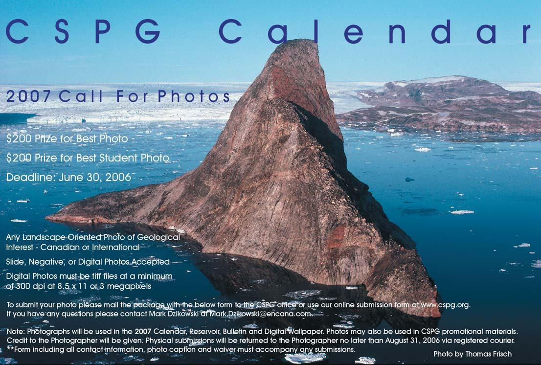
■ 2007 Call for Photos
■ 2007 Call for Photos
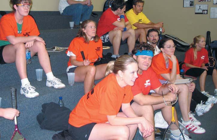
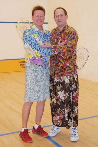
■ 2006 CSPG Squash
Tournament – Clocks for Jocks!
■ 2006 CSPG Squash Tournament – Clocks for Jocks!
CSPG OFFICE
#160,540 - 5th Avenue SW
Calgary,Alberta,Canada T2P 0M2
Tel:403-264-5610 Fax:403-264-5898
Web:www.cspg.org
Office hours:Monday to Friday,8:30am to 4:00pm
Business Manager:Tim Howard
Email:tim.howard@cspg.org
Office Manager:Deanna Watkins
Email:deanna.watkins@cspg.org
Communications Manager:Jaimè Croft Larsen
Email:jaime.croftlarsen@cspg.org
Conventions Manager:Lori Humphrey-Clements
Email:lori.humphreyclements@cspg.org
Corporate Relations Manager:Kim MacLean
Email:kim.maclean@cspg.org
EDITORS/AUTHORS
Please submit RESERVOIR articles to the CSPG office.Submission deadline is the 23rd day of the month,two months prior to issue date. (e.g.,January 23 for the March issue).
To publish an article,the CSPG requires digital copies of the document.Text should be in Microsoft Word format and illustrations should be in TIFF format at 300 dpi.For additional information on manuscript preparation,refer to the Guidelines for Authors published in the CSPG Bulletin or contact the editor.
COORDINATING EDITOR & OPERATIONS
Jaimè Croft Larsen
CSPG
Tel:403-264-5610
Fax:403-264-5898
Email:jaime.croftlarsen@cspg.org
TECHNICAL EDITOR
Ben McKenzie
Tarheel Exploration
Tel:403-277-4496
Email:bjmck@telusplanet.net
ADVERTISING
Kim MacLean
Corporate Relations,CSPG
Tel:403-264-5610,Ext 205
Email:kim.maclean@cspg.org
Advertising inquiries should be directed to Kim MacLean.The deadline to reserve advertising space is the 23rd day of the month, two months prior to issue date.All advertising artwork should be sent directly to Kim MacLean.
The RESERVOIR is published 11 times per year by the Canadian Society of Petroleum Geologists. This includes a combined issue for the months of July/August.
Advertisements,as well as inserts,mailed with the publication are paid advertisements.No endorsement or sponsorship by the Canadian Society of Petroleum Geologists is implied.
The CSPG Rock Shop is an attractive and affordable way to target the CSPG readership. Spaces are sold at business card sizes (3.5” wide by 2” high).To reserve space or for more information,please contact Kim MacLean at 403-264-5610,ext.205.
The contents of this publication may not be reproduced either in part or in full without the consent of the publisher.
DEPARTMENTS
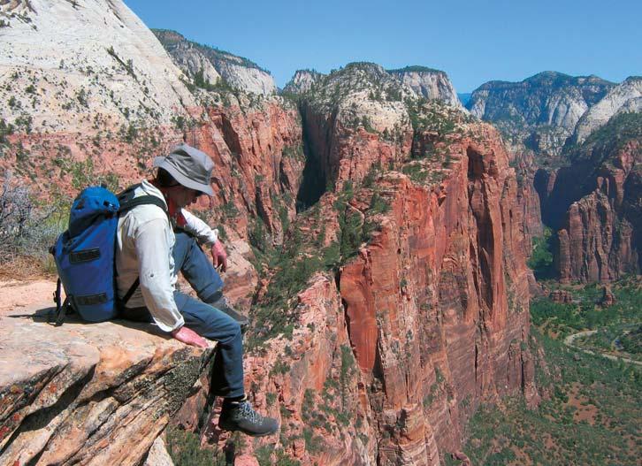
FRONT COVER
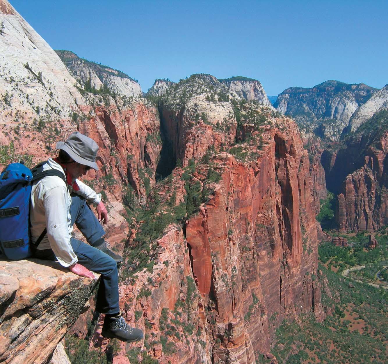
Zion National Park, Utah, USA. Magnificent fluvially carved canyons into the cream and pink Navajo Sandstone occupy the majority of Zion National Park. During the Jurassic period, giant migrating sand dunes created well preserved cross bedding on the 150,000 square-mile desert. Photo by Daniel Chavez.
As your 2006 CSPG Services Chair,I frequently get asked “What is Services?” I would have asked the same thing had I not gotten involved! So,this month,I offer you an overview of Services.Services is made up of seven committees:Membership, Awards,Volunteer Management,Social, Photographic,Archives & History,and Group Insurance.
The Membership Committee is chaired by Ayaz Gulamhussein.Ayaz has just joined us this year and is all set to get Membership off the ground with some new initiatives on attracting new members to the CSPG and retaining retirees as CSPG members.The Membership Committee has conducted surveys in the past and keeps track of the demographics of our society.It is one of the Membership Committee’s goals to work closely with the CSPG’s Strategic Plan to help our Society flourish into the future.If you have any ideas for the Membership Committee,please contact Ayaz at agulamhussein@shiningbank.com.
The Awards Committee is coordinated by Heather Hunt.The Awards that the CSPG hands out annually are the President’s Award,Medal of Merit,Stanley Slipper,RJW Douglas,Link,HM Hunter,Honorary Membership,Tracks,Service,and Volunteer awards.Each of the above Awards has its own sub-committee and is chaired by dedicated volunteers.In 2006,the Awards are currently being handed out at the Technical Luncheons.Heather is assessing this format and is seeking input from the Award Chairs and Award recipients to determine if this is the best venue for the Award presentations or if another event should be planned.Heather can be reached via email at heather.hunt@gov.ab.ca.
The Volunteer Management Committee’s (VMC) role is to match Society volunteers to committee vacancies.This committee is
chaired by Karen Webster.Karen and her VMC members identify current committee volunteer requirements,communicate committee volunteer opportunities and qualifications to the membership,and proactively recruit qualified volunteers. They also match volunteer skills and competencies to committee needs,orient potential volunteers to the Society,and recognize the volunteers for all their hard work via the Awards process.If you’d like to become a volunteer for the CSPG,please check out the CSPG website at www.cspg.org/volunteer.
The Social Committee is responsible for six social events held throughout the year:Mixed Golf Tournament,Squash Tournament,10K Road Race & Fun Run, Hockey Tournament,Long-Time Members Reception,and the Past President’s Dinner. The Mixed Golf Tournament is held annually in August at the D’Arcy Ranch.This year’s tournament will be held on August 25th and promises to be a great time.The Squash Tournament is Calgary’s longest running squash tournament! It is held every year in February and always has a huge turnout.This year was no different - I hear a good time was had by all.The 10K Road Race & Fun Run will be in its 18th year this year.It is held annually in September;the course begins and ends at Eau Claire and follows the pathways of the Bow River.The Hockey Tournament is held annually each September although,due to low attendance, was not held in 2005.Hopefully there is more interest this year and the event can be held.The Long-Time Members Reception is held each spring during the CSPG Convention.This event is by invitation only but is open to all 30+ year CSPG Members. The Honorary Membership Award is given out at the event and the reception is held as an appreciation of long-time commitment to the Society.Finally,the Past President’s Dinner is held annually in October.This
THE CSPG GRATEFULLY ACKNOWLEDGES ITS CORPORATE MEMBERS:
THE CSPG GRATEFULLY ACKNOWLEDGES ITS CORPORATE MEMBERS:
ABU DHABI OIL CO., LTD. (JAPAN)
APACHE CANADA LTD.
BAKER ATLAS
BG CANADA EXPLORATION & PRODUCTION, INC.
BP CANADA ENERGY COMPANY
BURLINGTON RESOURCES CANADA LTD.
CANADIAN FOREST OIL LTD.
CONOCOPHILLIPS CANADA
CORE LABORATORIES CANADA LTD.
DEVON CANADA CORPORATION
DOMINION EXPLORATION CANADA LTD.
DUVERNAY OIL CORP.
ECL CANADA
geoLOGICsystems ltd.
GRIZZLY RESOURCES LTD.
HUNT OIL COMPANY OF CANADA, INC.
HUSKY ENERGY INC.
IHS
IMPERIAL OIL RESOURCES LIMITED
LARIO OIL & GAS COMPANY
MJ SYSTEMS
MURPHY OIL COMPANY LTD.
NCE RESOURCES GROUP INC.
NEXEN INC.
NORTHROCK RESOURCES LTD.
PENN WEST PETROLEUM LTD.
PETRO-CANADA OIL AND GAS
PETROCRAFT PRODUCTS LTD.
PRIMEWEST ENERGY INC.
SAMSON CANADA
SHELL CANADA LIMITED
SPROULE ASSOCIATES LIMITED
STARPOINT ENERGY LTD.
SUNCOR ENERGY INC.
TALISMAN ENERGY INC.
TOTAL E&P CANADA LIMITED
WEATHERFORD CANADA PARTNERSHIP
event is hosted by the current Past President and is a venue for the current Executive and all Past Presidents to discuss events & issues of past and current nature. For more information on all the Social Events and the great people who chair them,please check out the CSPG website at www.cspg.org/events/events-social.
The Photographic Committee is chaired by our 2005 HM Hunter Award winner,Vic Panei.Vic has been the “official photographer” of the CSPG since 1974.This committee provides photographic coverage at most of the Society’s Technical Luncheons,Conventions,and Social Events. If you’d like to volunteer with Vic on this committee,or you have a CSPG function/event that you would like to have photographed,please contact Vic at paneiv@shaw.ca.
The Archives and History Committee is chaired by Clint Tippett.Clint coordinates the preparation of any significant memorials to be published by the Society in situations where this initiative has not already been taken elsewhere.If you have any ideas or suggestions for Clint,please contact him at Clinton.tippett@shell.com.
The Group Insurance Committee is chaired by Robin Mann.This is a small committee that looks after setting up group insurance discounts for CSPG members.For more information on this please check out the CSPG website at www.cspg.org/members/ members-benefits.
I’ve outlined what Services is;I’ve given you brief description of each committee. Hopefully you can glean that there is a lot of hard work,dedication,and responsibility on the part of all the volunteers.You’re probably wondering what my role is in all this! My role as your 2006 Services Chair is to attend bi-weekly CSPG Executive meetings and be a liason between the Executive and the Services Committees.I am a messenger of information between the Exec and Services and an advocate to make sure Services has a voice at the Exec table. This has been a very rewarding journey so far and I look forward to the rest of the year and what it will bring.If you have any comments or suggestions for me,please email me at shannon.nelsonevers @encana.com.
Shannon Nelson Evers Service Director
CORPORATE
Deep-Water Siliciclastic Reservoirs, California
Leaders: Stephan Graham and Donald R. Lowe, Stanford University, Stanford, California
New!!
Dates: September 17 (Sunday at 5:00pm)
– 22 (Friday – mid-afternoon)
Location: Begins and ends at the airport in San Francisco, California
Tuition: $2,675 (increases to $2,775 after 8/17/06), includes lodging, transportation during the seminar, lunches, guidebook and group dinner (1 night)
Limit: 20
Content: 5.5 CEU
Who Should Attend
Geologists, geophysicists, reservoir engineers, managers and anyone working with deep-water reservoir systems.
Be among the first!
FieldSeminars!!
Fractures, Folds, and Faults in Thrusted Terrains: Sawtooth Range, Montana
Leaders: Steven E. Boyer, Consultant, Tacoma, WA; William Hansen, Jireh
Consulting Services, Great Falls, MT; Charles F. Kluth, Kluth & Associates, Littleton, CO; James Sears, University of Montana, Missoula, MT
Date: September 11-16, 2006
Location: Begins and ends in Great Falls, Montana
Tuition: $2,600 (increases to $2700 after 8/14/06), includes lunches, transportation, guidebooks, admission to Glacier National Park, and some additional meals.
Limit: 20
Content: 4.2 CEU
Who Should Attend
Geologists, geophysicists, log analysts, engineers and exploration managers who want a thorough understanding of the geology and complexity of exploring in thrust belts.
Modern Deltas
Leaders: Harry H. Roberts, Gregory Stone and Samuel Bentley, Coastal Studies Institute, Louisiana State University, Baton Rouge, LA
Date: September 11-15, 2006
Location: Begins in Baton Rouge and ends in New Orleans, Louisiana
Tuition: $2,500 (increases to $2600 after 8/14/06), includes 5 nights lodging, bus and boat transportation, field lunches, and guidebook
Limit: 25
Content: 4.0 CEU
Who Should Attend
Geoscientists who need to understand the sedimentary architecture of deltas, internal characteristics of constituent sediment bodies, and sequence/seismic stratigraphic relationships with surrounding facies.
Sign up early—this one fills up fast!
Back to School with AAPG Education!
Sedimentology and Sequence Stratigraphic Response of Paralic Deposits to Changes in Accommodation: Predicting Reservoir Architecture, Book Cliffs, Utah
Leaders: Keith W. Shanley, Consultant, Denver, CO; J. Michael
Boyles, University of Wyoming, Laramie, WY
Date: September 21-28, 2006
Location: Begins and ends in Grand Junction, Colorado
Tuition: $2,100 (increases to $2300 after 8/10/06), includes ground transportation, lunches, and guidebook
Limit: 20
Content: 5.6 CEU
Who Should Attend Geologists, geophysicists and reservoir engineers working in exploration and production settings.
Ancient Clastics: Book Cliffs and Canyonlands, Utah
Leader: John K. Balsley, Consulting Geologist, Indian Hills, CO
Dates: September 11-19, 2006
Location: Begins and ends in Moab, Utah
Tuition: $2,100 (increases to $2,200 after 4/17/06), includes 4-wheel-drive transportation and course notes on CD Limit: 15
Content: 6.0 CEU
Who Should Attend Exploration and production geologists, geophysicists, log analysts, engineers, and exploration and development managers who want a thorough working knowledge of clastic depositional systems directly associated with energy resources.
Practical Mapping of Surfaces, Properties, and Volumes for Reservoir Characterization: Principles, Methods, Case Studies, and Workflows
Date: September 30 – October 1, 2006
Location: New Orleans, Louisiana (with SEG Annual Meeting)
Tuition: $590, AAPG members; $690, non-members (goes up to $690/$790 after 9/1/06), includes course notes and refreshments
The course is intended for geologists, geophysicists, and engineers considering or engaged in reservoir modeling projects who wish to understand more about the geostatistical methodology.
TECHNICAL LUNCHEONS
MAY LUNCHEON
Elephant hunting heating up in the Great Basin
SPEAKER
Alan K.Chamberlain,Ph.D. Cedar Strat Corp.
11:30 am
WEDNESDAY , May 10,2006
TELUS CONVENTION CENTRE CALGARY, ALBERTA
Please note:
The cut-off date for ticket sales is 1:00 pm,Friday,May 5th.
Ticket price is $28.00 + GST
The eastern Great Basin thrust belt provides an opportunity to explore for giant oil and gas fields.Thick,thermally mature,organic-rich,lacustrine oil shales deposited in the Mississippian Antler Basin floodplain in eastern Nevada are the source beds for the fifty million barrels of oil already produced in Nevada.Some of the oil migrated into the newly discovered giant oil field in central Utah.Karsted unconformities,stromatoporoid reefs, impact breccias,and sandstones make the eastern Great Basin Devonian reservoir rocks most favorable for giant accumulations.One Great Basin well in the Grant Canyon field of eastern Nevada
flowed 4,000 barrels a day for ten years from these karsted carbonates. Late Cretaceous thrusting created the compressional features of the prolific Canadian foothills,Utah/Wyoming thrust belt,the new central Utah oil field,and the eastern Great Basin thrust belt.
A deeply entrenched notion that discouraged exploration investment is that the north-south structural grain of the eastern Great Basin was caused by Tertiary extension that could have compromised seals on older,compressional structures. The newly discovered giant oil field on the eastern edge of the Great Basin provides an example of an intact compressional feature.Another example of an intact compressional feature is the Golden Gate fault fold 40 miles south southeast of the prolific Grant Canyon field and 120 miles north of Las Vegas.The Golden Gate fault fold is ten miles long and five miles wide and has more than five thousand feet of closure.It may have trapped billions of barrels of oil before it was breached by headward erosion of the Colorado River. New mapping reveals that no Tertiary extensional faults compromise the structure.Similar structures,along strike that have escaped erosion,likely contain billions of barrels of oil and trillions of cubic feet of gas such as the newly discovered giant Utah oil field.Oil seeping
from these giant fields is probably the source for the Great Basin commercial oil seep fields.However,old opinion and theories based on little or poor geologic mapping have obscured the true understanding of the eastern Great Basin geology for at least five decades.As a result,past oil exploration efforts in the eastern Great Basin based on old tectonic and depositional models have been disappointing.
BIOGRAPHY
Alan K.Chamberlain received his B.A.and M.S. from Brigham Young University and his Ph.D. from Colorado School of Mines.His dissertation,Structural Geology and Devonian Stratigraphy of the Timpahute Range,Nevada, provides a new exploration model that could lead to significant discoveries in this frontier region.After he worked for Exxon,Gulf, Marathon,and Placid,he became president of Cedar Strat Corp.(775-237-5076) in 1984. Constrained by well data,measured sections, and new gravity surveys and geologic maps, Cedar Strat has identified 36 Great Basin structural plays similar to the giant discovery in central Utah.
MAY LUNCHEON
Enhancing biogenic methane production in coal beds: processes and potential
SPEAKER
Dr.Karen Budwill
Alberta Research Council
11:30 am Tuesday,May 23,2006
TELUS CONVENTION CENTRE CALGARY, ALBERTA
Please note:
The cut-off date for ticket sales is 1:00 pm,Thursday,May 18th. Ticket price is $28.00 + GST.
Geological and hydrogeological analyses of deep coal beds in Alberta suggest that microbial activity may be responsible for a large portion of the methane held within these coals.Indeed,it is suggested that ongoing biogenic methane production,or
methanogenesis,is occurring in many deep coal beds.The Alberta Research Council is developing technology that uses methanogenic consortia to enhance and increase coalbed methane (CBM) production.Since it is well known that many methanogens reduce CO 2 to methane,we are also investigating the in situ microbial conversion of geologicalstored CO2 in coal beds to methane.
The benefits of this microbial technology to CBM companies are numerous, including re-pressurization of low pressure CBM reservoirs,boosting methane generation in low gas content coals,and enhancing seam permeability in addition to increasing production yields. Enhanced CBM (ECBM) – involving the injection and storage of CO 2 into deep coal seams – could improve both production rates and the ultimate recovery of CBM gas.The stored CO 2 can be microbially converted to methane thereby increasing the overall production
from primary CBM production and ECBM production.
This talk will review the microbial processes occurring in coal beds and the current state of the technology.Observed rates of production and methods to enhance the rates will be discussed.Expected field applications with potential biogenic methane production rates will be presented.
BIOGRAPHY
Dr.Karen Budwill is a microbiologist with the Carbon and Energy Management group within the Energy Division at the Alberta Research Council.She obtained her Ph.D.from the University of Alberta and worked as a post-doctoral fellow at the University of Idaho prior to joining ARC.Her research focus at the universities was on methanogenesis and anaerobic microbial environments.She has been at ARC for ten years and has worked on microbially enhanced CBM at the ARC for the past five years.
JUNE LUNCHEON
Bear Head LNG terminal update & fundamental changes in LNG Trade
SPEAKER
Dave Anderson Anadarko
11:30 am
Tuesday,June 6,2006
TELUS CONVENTION CENTRE CALGARY, ALBERTA
Please note:
The cut-off date for ticket sales is 1:00 pm,Thursday,June 1st. Ticket price is $28.00 + GST,
This presentation will provide background information concerning Anadarko’s Nova Scotia Bear Head LNG terminal project. The Bear Head project was purchased by Anadarko in August of 2004.Since that time,all of the major permits and approvals have been secured.Civil works began in October of 2004 and were essentially completed by December 2005.The concrete foundations for the initial two storage tanks were poured in December of 2005.Bear Head is one of only a few new LNG receiving terminals in North America currently under construction.
Long-lead items in short supply have been secured.In particular,carbon and 9% nickel
steel required for the storage tanks have been ordered and are in the process of being delivered to the site.All of the major construction contracts have been let.
The presentation will include a description of the Bear Head facility and its key attributes.The project will include two 180,000 cubic meter storage tanks with a one Bcf/d sendout capacity.The deepwater jetty will be capable of accommodating the largest LNG tankers currently under consideration – 265,000 cubic meters.
With respect to changes in global LNG fundamentals,the presentation will address delays in critical supply projects,an Atlantic Basin supply-demand balance analysis,an analysis of recent U.S.LNG terminal capacity utilization,and a reflection of the world LNG pricing dynamics experienced during this past winter.
BIOGRAPHY
Dave has over 25 years of commercial experience in the petroleum industry.Dave gradated from Penn State University in 1979 with a Bachelors of Science degree.He joined Marathon Oil Company in their Findlay,Ohio corporate headquarters upon graduation from college.
In the eight years at Marathon,Dave held various positions in the Audit and Natural Gas Divisions.Responsibilities at Marathon included spot and long-term gas sales,gas
purchases,commercial aspects of gas processing,and commercial responsibilities related to major project work.
Dave joined Anadarko Petroleum Corporation in 1987 in the Gas Marketing Department. Over the years he’s held numerous commercial positions and responsibilities.Dave has been responsible for short- and long-term sales contracts.He has also managed the commercial aspects of Anadarko’s extensive gas gathering and gas processing assets and has been responsible for numerous large project initiatives.
For the past ten years,Dave has been responsible for Anadarko’s international commercial development efforts.During this time,Dave has participated in negotiating production-sharing contracts,gas sales agreements,fiscal relief amendments,and various other commercial related activities.
Most recently,Dave’s responsibilities have included key roles in evaluating and implementing Anadarko’s initial involvement in the liquefied natural gas (LNG) business line.
C. Alex Francoeur, P.Geol. President
Tel/Fax: (403) 281-6694
Cell: (403) 861-6753
Email: afran@telusplanet.net
Wellsite Geological Supervision since 1980
ROCK SHOP
JUNE LUNCHEON
Royalty Trust’s Future in the Canadian oil and gas sector
SPEAKER
Paul Colburn CEO TriStar Oil & Gas Ltd.
11:30 am Tuesday,June 20,2006
TELUS CONVENTION CENTRE CALGARY, ALBERTA
Please note:
The cut-off date for ticket sales is 1:00 pm,Thursday,June 15th. Ticket price is $28.00 + GST
The mid 1980s and onward have seen a rapid rise in the number of oil and gas energy trusts operating in the Western Canada Sedimentary Basin.An examination of the history of petroleum exploration and development in the WCSB,in light of Canadian business economics,will provide us with insight into the future of royalty trusts in the Canadian Oil and Gas sector.
North American equity capital markets for energy companies are very efficient at adapting to investor needs in the reality of the maturing Western Canada Sedimentary Basin.This thesis will be supported,by reviewing the history of the Basin from its wildcatting days by multinational exploration companies to today’s maturing production and subsequent evolution to royalty trusts.
A review of the old paradigm where the immature Western Canada Sedimentary Basin was ruled by the multinationals for more than 60 years,ultimately giving rise to large independent oil and gas firms as the Basin continued to mature,will set the stage for the evolution into today’s current mix of large and small exploration and development companies and the rise of the royalty trusts.
We will examine this rise of the royalty trust model in the light of the new adaptation of the tax-efficient conventional oil and gas royalty trust,together with the new,high growth exploration startups.
On a macro-economic basis over the past few years investors have been experiencing the lowest interest rates in the last 50
years.In addition,after the incredible hyper-inflation of the late 1970s and early 80s,inflation has been beaten down to very low levels.Accordingly,as the baby-boomer population ages,investors are increasingly looking for better rates of return from fixed income yield products.
On this basis,as fixed income investors today look for yield product in a period of low interest rates,it is no surprise that higher yield trusts,including conventional oil and gas trusts,have evolved in Canada. Furthermore,given the particular tax legislation relating to royalty trusts in Canada,the energy trust structure is extremely tax efficient for the holders of trust units – particularly if units are held in the holders’ RRSP.
BIOGRAPHY
Paul Colburn is currently Chairman of the Board and Chief Executive Officer of TriStar Oil & Gas Limited.He also is on the board of six other oil and gas companies working the
Western Canada Sedimentary Basin.A graduate of the University of Calgary,Mr. Colburn holds a Bachelor of Laws degree and a B.A in Economics.
Paul started his business career as a corporate finance and oil and gas lawyer with Wascana Energy and Husky Oil Ltd.He later struck out on his own and founded Startech Energy Inc. where he held the position of Chief Executive Officer.Eight years later Startech was acquired by ARC Energy Trust.Paul then founded Crescent Point Energy Ltd.,which he later converted to Cresent Point Energy Trust,and subsequently spun out Starpoint Energy Ltd. Paul then converted Starpoint to a Starpoint Energy Trust and in 2005 merged with Acclaim Energy Trust to create Canetic Resources Trust. After this business transaction,Paul started Tristar Oil & Gas limited.
DIVISION TALKS INTERNATIONAL DIVISION
Angola,West Africa: Continuous exploration successes and ever increasing oil production
2nd floor, east end of the Calgary Tower Complex 1st Street and 9th Avenue S.E. Calgary, Alberta
Angola is currently producing almost 1.5 million barrels of oil per day and is the second largest oil producer after Nigeria in the sub-Sahara of Africa.The production is entirely derived from the Lower Congo Basin which covers an area of over 100,000 square kilometers.Due to the exploration successes experienced by industry in the past decade,Angola has become one of the premier countries worldwide for deepwater exploration and production.
Prior to the discovery of oil in 1996 in the deepwater area of Angola,almost all of the country’s oil production was obtained from the Albian shallow water carbonates of the Pinda formation as well as from Neocomian pre-salt lacustrine carbonates and clastics. Recoverable reserves of some three billion barrels have been discovered in the Pinda and presalt reservoirs.Salt rafting and down-to-the basin gravity-sliding of Pinda “rafts” has resulted in numerous oil fields which consist of separate blocks of carbonate,each with distinctive hydrocarbon contacts.Indeed,the global type area for salt raft tectonics is the continental margin of Angola.
Angola’s oil industry changed dramatically in 1996 when Elf (now Total) discovered the Girassol oil field in 1,400 meters of water. The reservoirs in Girassol are Oligoceneaged turbidite clastics.The field has been producing at a steady rate of 200,000 barrels of oil per day since 2001.Subsequent to Girassol’s discovery,over 60 Tertiary turbidite oil fields have been discovered
with estimated recoverable reserves of some 14 billion barrels.The reservoirs all occur in Miocene and Oligocene turbidites associated with the ancestral Congo River drainage system.
The world-class geology which has endowed Angola’s Lower Congo Basin has also resulted in world-class production facilities. This is illustrated by the following examples:
• Total’s Girassol FPSO (Floating Production & Storage Offshore) has a storage capacity of 2 million barrels oil and was the largest FPSO every built worldwide and held that world record until 2004 when Esso’s Kizomba “A” project went on production. Kizomba “A” utilizes the world’s largest FPSO with a storage capacity of 2.2 million barrels oil.
• The Chevron Block 0 Sanha Condensate Project came onto production in 2005 and is the world’s first LPG FPSO.It also
contains the world’s largest offshore gas compression facility.
• The Benguela-Belize Compliant-Piled Tower (CPT) on Chevron Block 14 was installed in 2005 in 400 meters water depth.The CPT is the fifth largest free standing structure in the world and is the tallest man-made structure in Africa.This unit will be producing 220,000 barrels oil per day at peak production.
Current investments in Angola’s oil industry are averaging about $5 billion per year and this will result in the country’s production reaching two million barrels of oil per day by 2008.Angola’s crude is light and sweet.The USA and China are the two biggest importers of Angolan oil.In addition,Angola will become an exporter of LNG to world markets in about 2010 when a $3 billion LNG plant will commence production in Zaire province,northern Angola.
(Continued on Page 54...)
SEDIMENTOLOGY DIVISION
Reservoir quality assessment: Petrography as a tool for deciphering kineticallydominated systems and the need for petrographic education
SPEAKER
Kitty L.Milliken
2005 – 2006 AAPG Distinguished Lecturer Jackson School of Geosciences
The University of Texas at Austin
12:00 Noon Monday,May 3,2006
Nexen Annex Theatre
+15 Level, North of C-Train Platform 801 - 7th Avenue SE Calgary, Alberta
As exploration efforts turn increasingly to unconventional reservoirs and,especially,to deep,hot targets,accurate prediction of reservoir quality becomes a great challenge. In rocks that have experienced a protracted history of post-depositional chemical and mechanical alteration,rock properties cannot be readily predicted from primary sediment characteristics.A dominant reason for this difficulty is that,despite temperatures that are somewhat elevated compared to the surface,reactions in sedimentary basin are relatively sluggish and
ENVIRONMENTAL
The geology of spills and leaks
SPEAKER
S.M.Mattison
Pembina Pipeline Corporation
12:00 Noon
Friday,April 28,2006
Aquitaine Building
2nd Floor Conference Room (+15 Level)
540 – 5th Ave SW Calgary, Alberta
driven largely by kinetics (rate-controls) rather than by thermodynamics.In such systems,prediction of reaction paths and mechanical behavior cannot be obtained from an understanding of bulk composition and thermal conditions alone.In sedimentary basins,rocks inevitably preserve a complex history of their modifications.Efforts to predict the progress of an individual,pore-modifying reaction (e.g.,quartz cementation) must take the proper historical context of the reaction (i.e.,its individual rate-control) into account.Predictive approaches that do utilize such a conceptual framework can meet with great success.
The broad field of sedimentary petrography involves the tools and skills required to assess kinetically-dominated processes and the complex historical records they leave behind.Although polarized light microscopy remains fundamental,the tool-kit of the modern petrographer encompasses a broad range of supporting methods. Cathodoluminescence,both SEM- and light microscope-based,fluorescence microscopy, and back-scattered electron imaging are examples of techniques that are yielding vital new insights into the post-depositional processes operative in reservoir rocks. Despite the advent of such technologies,and the great (and growing) practical utility of petrography,opportunities for university
GEOLOGY DIVISION
frequently the case,in some instances the migration of oil and other contaminants is controlled by stratigraphy.
In this talk,case studies will be presented illustrating migration of contaminants in different geologic settings.These examples demonstrate how understanding geology is critical to environmental assessment and clean-up.
BIOGRAPHY
In general,people think of oil releases in terms of topographically controlled flow along the ground surface.While that is
Ms.Mattison has 17 years of experience as an environmental geologist.She received a B.Sc. and M.Sc.in Geology from the University of Alberta in 1986 and 1988,respectively.Ms. Mattison has worked with several
students to learn petrography have been diminished as a consequence of several intersecting historical factors that have displaced petrography courses from the curriculum.A multi-media digital resource, Sandstone Petrology:A Petrographic Image Atlas,is the result of an NSF-funded project to create and assess materials that lend efficiency to the study of highly visual subject matter.It is the hope that projects such as this will serve to support the growing industry demand for expertise in the area of rock characterization and rock property prediction.
INFORMATION
Talks are free – don’t forget to bring your lunch! Coffee and donuts will be provided.
For more information on Kitty Milliken and other speakers visit the Sedimentology Division Website at www.cspgsedimentology.org.
If you are interested in joining the Sedimentology Division e-mail listing which currently provides luncheon reminders,or if you care to suggest a technical topic or present a talk to the division,please contact Scott Rose at (403) 875-7673 or scott.rose@ cspgsedimentology.org.Lunch talks are sponsored by IHS Energy (www.ihsenergy.com) and Birch Mountain Resources Ltd (www.birchmountain.com).
PROUD SPONSORS
environmental consulting firms,assessing contaminated sites and developing clean-up strategies.In 2003,Ms.Mattison joined Pembina Pipeline Corporation where she is responsible for management of contaminated sites,environmental planning associated with new construction,and reclamation of decommissioned sites.Ms.Mattison is a registered professional geologist in Alberta and British Columbia.
INFORMATION
All lunch talks are free and open to the public. Please bring your lunch.For information or to present a future talk for the Environment Division contact Andrew Fox at andrew.fox@ megenergy.com.
STRUCTURAL DIVISION
Understanding potential fields and their role in explorationBasement structure mapping in Central Alberta
SPEAKER
Jim Davies & Martin Mushayandebvu Image Interpretation Technologies Inc.
12:00 Noon
Thursday,May 11,2006
Petro-Canada
West Tower, room 17D (17th floor)
150 6th Avenue SW Calgary, Alberta
Potential fields,gravity,and magnetics,have been used in basement mapping for many years in the Western Canada Sedimentary Basin (WCSB).Their role has evolved from regional depth-to-basement estimations to mapping discrete structures that may have reactivated to control hydrocarbon occurrences in the overlying sedimentary section.Identification of structures has generally been achieved through the mapping of magnetic,and to a lesser degree gravity,anomalies.The flanks of potential field highs are often wrongly mapped as structural features.This assumption that faults and shear zones ‘create’ magnetic anomalies has lead to the misinterpretation of the basement structure in many areas. The magnetic properties of rocks are controlled by the concentration of magnetic minerals within them.Contrary to commonly stated views,the development of fault zones does not typically create significant volumes of new magnetic minerals.Therefore,the magnetic properties of rocks are generally constrained by primary petrology and/or regional metamorphic alterations.
Mapping of shear zones and ductile faults on the Canadian Shield shows that preexisting planar fabrics within rocks (bedding,cleavage,fold axial planes, magmatic fabrics) are transposed onto the plane of flattening and ultimately onto the shear plane within the shear zone.There is often measurable offset of marker horizons,either horizontal or vertical. When attempting to map structure under the WCSB the same general observations made along structures on the Canadian Shield hold true,but with the potential fields acting as a proxy for lithology. Therefore,faults and shear zones will be associated with the truncation,offset,
rotation,and transposition of potential field fabrics.
In Central Alberta this approach has lead to the identification of a major shear zone directly underlying the MeadowbrookLeduc-Rimbey Reef Trend,but oblique to the previously identified Snowbird Tectonic Zone (STZ).A northern splay of the STZ appears to exert control on the Swan Hills Reef complex.Regional studies suggest that basement fault reactivation occurred at discrete time intervals throughout the Paleozoic,and again during the development of the Deep Basin adjacent to the thrust belt.Controls on depositional facies and isopachs,as well as structural culminations are important in locating hydrocarbon deposits.
BIOGRAPHIES
Jim Davies
Jim holds a Master’s degree from McGill University in Structural Geology,and a Bachelor’s degree from Cardiff University in Exploration and Mining Geology.Since starting work with IITech in 1999,he has been
integrating geology and geophysics data to produce interpretations of geology at all scales ranging from prospects to regional mapping.His research interests include the use of magnetics for shallow mapping;characterizing basement potential field sources,and basement-cover interactions and their affect on hydrocarbon occurrences.
Martin Mushayandebvu
Dr.Mushayandebvu is IITech’s chief geophysicist with over 16 years teaching and research experience.He was the principal researcher in the development of Extended Euler Deconvolution.He is a member of CSEG, SEG,AGU.
INFORMATION
Talks are free;please bring your lunch.Goodies and drinks are provided by HEF Petrophysical Consulting,and the room is provided by PetroCanada.If you would like to be on the Structural Division e-mail list,or if you’d like to give a talk,please contact Elizabeth Atkinson at (403) 296-3694 or eatkinso@petro-canada.ca.
GEOMODELING DIVISION
Process mimicking geologic modeling:Beyond objectbased and cell-based facies modeling
SPEAKER
Clayton V.Deutsch University of Alberta
12:00 Noon
Wednesday,May 24,2006
ConocoPhillips Auditorium
3rd Floor- above Plus 15+ level
401 9th Ave SW Calgary, Alberta
The most important reservoir heterogeneity is facies;petrophysical properties such as porosity and permeability are straightforward to model once the facies are established.Historically,Geostatisticians
have used (and argued the merits of) objectbased and cell-based modeling techniques. This talk discusses advanced facies modeling techniques that create facies models with improved realism.Examples from fluvial and deepwater depositional systems are shown. The deposition in channel-form deposits are simulated with the bank retreat model and the depositional in deepwater settings are simulated with the compensational stacking of lobe structures.
The framework of stochastic reservoir modeling will also be reviewed for those not involved with geostatistical modeling.
BIOGRAPHY
Dr.Deutsch is Director and Professor in the School of Mining and Petroleum Engineering, Department of Civil & Environmental Engineering at the University of Alberta.He teaches and conducts research into better ways
to model heterogeneity and uncertainty in petroleum reservoirs and mineral deposits.
INFORMATION
There is no charge.Non-members of the CSPG are also welcome.Please bring your lunch.For details or to present a talk in the future,please contact David Garner at 403-233-3126,e-mail: David.Garner@ ConocoPhillips.com or Peter Dankers at 403-770-0350,e-mail Peter.Dankers @divestco.com
ROCK SHOP
JACK PORTERVIGNETTES OF CANADIAN PETROLEUM GEOLOGY
JOSEPH TYRRELL’S REVIVAL OF DAVID THOMPSON’S GREAT MAP
Sometime before Joseph Tyrrell’s assignment by Director Alfred R.C.Selwyn of the Geological Survey of Canada to conduct,in the field season of 1892,a reconnaissance geological survey of the region between Athabasca Lake and Churchill River,he had researched the Archives Department of the Province of Ontario.His investigation was specifically focused on the viewing of material related to David Thompson’s 28-year career in the fur trade of North West America;the first 13 years,from 1784 to 1797,associated with the Hudson’s Bay Company and his subsequent fifteen years,from 1797 to 1812, with the North West Company.Much to his amazement,he was fortunate to uncover 39 journals and 11 field notebooks;including a large map of North West America,its dimensions being 10 feet three and one half inches by six feet six inches,encompassing an area lying between 45°and 60°latitude. Joseph Tyrrell,immediately recognized this material’s authenticity as a tangible record of David Thompson’s prodigious travels as a surveyor and fur trader in North West America.Accordingly,Tyrrell prepared a paper, titled:A Brief Narrative of the Journeys of David Thompson,in North-Western America. He presented it before the members of the Canadian Institute at their annual meeting held in 1888.It was published in the Proceedings of the Institute for that year.
Some time later,it came to Tyrrell’s attention that a Charles Lindsey,who at the time was Registrar of Deeds for the city of Toronto, had come into possession of David Thompson’s original unpublished and unfinished manuscript.On contacting Lindsay, he further learned that Lindsey had purchased it from one of David Thompson’s sons (1971,Smith,James K.:David Thompson – Fur Trader – Explorer – Geographer,pub. Oxford University Press,Toronto,p.107).
Tyrrell,believing he was the vehicle that could arrange its publication,was fortunate in purchasing Thompson’s manuscript from Lindsey.David Thompson had given its narrative an unpretentious title,referring to it as Travels.However,after several unsuccessful attempts to have a reputable publisher accept the manuscript,his endeavor finally reached fruition some 25 years later when,in 1916,the Champlain Society published it under the title:David
Thompson’s Narrative of his Explorations in Western America 1784-1812.It was edited, with an accompanying introduction and notes by Joseph B.Tyrrell (Ref.:CSPG Reservoir,March,2006.p.21).
David Thompson had taken Charlotte Small as his wife on June 10th,1799 without the benefit of a clergyman while he was at Ile à la Crosse.At the time,Charlotte was a 14-yearold métis – the age when young native and métis girls were eligible,by prevailing custom,to enter into a partnership of fidelity.Charlotte was the daughter of Patrick Small,a wintering partner with the North West Company,whose wife was a native Cree.To compensate Patrick Small for the relinquishment of his daughter,it was the custom in the country – especially for those traders of European extraction – to give the bride’s father a keg of rum.David Thompson, being a Welshman of devout Christian faith, had an abhorrence to the Company’s flagrant policy of immoderate use of alcohol to debase the natives.Thus,Patrick Small was
denied a keg of rum,despite the fact that he was away from Ile à la Crosse at the time. Both Small’s native wife and David Thompson refused to offer the rum to the attending natives as a celebrity gift.
At some North West Company posts,prior to the business of trading transactions,their traders under the guise of a welcoming ritual would intentionally stupefy the natives with copious and gratis amounts of diluted rum to unduly impair their judgement in order to maximize the trader’s acquisition of pelts. The importation of alcohol into the North West had reached its zenith during the intense competition between the Hudson’s Bay Company and the North West Company, just prior to the latter’s absorption by the Hudson’s Bay Company in 1821.The consumption of alcohol by the natives for one year,during this period,had amounted to 20,000 gallons,for the most part dispensed by traders of the North West Company.
(Continued on Page 24...)
In late 1799,the same year as their marriage, David Thompson and his young bride arrived at Grand Portage where,for two weeks,he served as a clerk and accountant.Prior to their leaving for Cumberland House to join a brigade heading up the Saskatchewan River freighting winter supplies;he received a wedding gift form his fellow Nor’Westers.It consisted of a set of drafting instruments and a roll of drafting paper. David Thompson was overwhelmed with the presents,for it was a tangible acknowledgement of his future role as a surveyor and fur trader with the North West Company (1957,Campbell,Majorie Wilkins:
The North West Company,pub.,The Macmillan Company of Canada Ltd.,pp.110 & 162).
Grand Portage,located near the mouth of the Pigeon River at its inflow into the southwest side of Lake Superior,was the principal inland depot and headquarters for the North West Company’s inland posts.In 1802,it was forced to abandon Grand Portage,following the settling of the Canada – United States international boundary by Jay Treaty of 1784,when it was found to be in American territory.This important depot was relocated in 1803,some 30 miles to the northeast near the mouth of the
Kaministiquia (Kaministikwia) River.Initially, it was named Fort Kaministiquia but in 1807 was renamed Fort William after William McGillivary,who at the time was the chief director of the North West Company.Fort William was a veritable warehouse and served the same function as that of its former establishment.Like Grand Portage,it was a rendezvous for voyageurs bringing trade goods and provisions from Montreal and retracing their return home with packets of furs.Brigades of voyageurs,led by the Company’s wintering partners would deliver their packets of furs obtained through trading at their respective inland posts and return with the necessary items to restock their quarters.Fort William also served as the North West Company’s headquarters for administrative purposes and where business meetings involving the Company’s partners were held.
David Thompson had been trained in astronomy and surveying at Cumberland House during the winter of 1789-90 under the tutelage of Philip Turnor,the official surveyor of the Hudson’s Bay Company.On May 30th,1792 he had received a gift on behalf of the Committee in London:“as a reward for your assiduity,” which consisted of:one Brass Compass,one Fahrenheit Thermometer and one Case of Instruments.” To quote Thompson:“My instruments for practical astronomy,were a brass Sextant of ten inches,an achromatic Telescope of high power for observing the Satellites of Jupiter and other phenomena,one of the same constructions for common use,Parallel glasses and quicksilver horizon for double Altitudes;Compass,Thermometer,and other requisite instruments,which I was in constant practice of using in clear weather for observation on the Sun,Moon,Planets and Stars;to determine the position of the Rivers,Lakes,Mountains and other parts of the country I surveyed from Hudson Bay to the Pacific Ocean.” (1962,Glover,Richard, ed.,new edition:David Thompson’s Narrative 1784-1812,pub.,The Champlain Society,pp. XXIV & 137).
In May of 1794,when another three-year contract was up for renewal,his value to the Company was deemed indispensable.The Committee in London had further rewarded him with a new expensive watch which accompanied two of his personal watches which he had sent to London and which the Company paid for their repairs.The same year his salary increased fourfold,from £15 to £60 annually.Unfortunately,for the Hudson’s Bay Company,their generous treatment of David Thompson,in order to retain him,was to be of no avail.In the spring of 1797,his three-year employment contract
came up for renewal and his Company was anxious for Thompson to renegotiate another three-year term.
The previous spring,David Thompson in the company of two Chipewyan natives,had fulfilled his Company’s directive by discovering a shorter water route to Lake Athabasca,an objective their competitor,the North West Company,had yet to achieve. The established western route to the fur-rich region,by way of the Athabasca River was long and time-consuming.Thompson left Fairford House,a Hudson’s Bay establishment,located near the confluence of the south-flowing Reindeer River and the east-flowing Churchill River which had been built by Malcom Ross in 1795.From there he accessed the eastern extremity of Athabasca Lake by way of Canoe River,Wollaston Lake, Hatchet Lake and Fond du Lac (Black/Stone) River through Black Lake.
In the spring of 1797,David Thompson,after wintering at Bedford House,which he and Malcom Ross had built the previous fall midway on the west shore of Reindeer Lake, had decided to terminate his employment with the Hudson’s Bay Company.Leaving with his indispensable survey instruments and in the company of two Chipewyan natives,the three walked some 100 miles to the nearest post of the North West Company,which was located at the south end of Reindeer Lake.It was known as Fraser’s House,under the charge of Alexander Fraser.David Thompson,after clarifying his intentions to offer his services to his former competitor,was cordially received by Fraser.He was subsequently conveyed to Grand Portage by a North West Company fur brigade to report to his new superiors.Apparently,David Thompson had no qualms in securing his survey instruments, on leaving his former employer,since the Committee in London had,in an accompanying note included with the gift, stated:“for his sole use and benefit” (1939, Morton,Arthur S.:A History of the Canadian West to 1870-71.pub.Thomas Nelson & Sons Ltd.,Toronto).
One may question the decision made by David Thompson in leaving the Hudson’s Bay Company,in the light of the training and respect he had received from them.It appears that,although the Committee in London wanted him to continue his career as a Company surveyor,his immediate superior, Joseph Colen,Resident Master at York Fort had different plans.In his Narrative,David Thompson refers to a letter he had received from Colen in which the latter informed him: “that however extensive the countries yet unknown yet he could not sanction any
further surveys.” Notwithstanding,no trace of the said letter has been found to date in the Company’s archives to confirm Thompson’s allegation (ibid.1962,Glover, Richard - pp.130 & XXXVII).
On arriving in Montreal in mid-August,1812, following his resignation as an active partner in the North West Company,David Thompson and his family settled in Terrebonne,Lower Canada,located 10 miles north of Montreal.Here,he and Charlotte had their marriage sanctioned by being solemnized by a clergyman.
The enduring relationship of David Thompson and his wife,Charlotte lasted 58 years and 8 months.He was,at the time of his death on February 10th,1857,some three months short of his 87th birthday.Charlotte survived him for a short period,expiring three months later,have reached an age of 72 years.She is purported to have borne him a prolific family of 16 offspring,some of whom are assumed to have failed to survive childhood.At least five of their family were born during their travels in the North West. The first,a girl,saw the light of day in the year 1800 at the North West Company’s Rock Mountain House,located at the confluence of the North Saskatchewan and Clearwater Rivers.Eight additional children were born,during the family’s residency at Longeuil,Lower Canada and Williamstown, Upper Canada.
David Thompson and his family,along with his fur brigade,had arrived at the Company’s depot at Fort William on July 12th,1812. Since it was to be the last time he would be delivering furs there,it necessitated contacting his fellow Nor’Westers to wish them farewell and good health,while awaiting the final segment of their voyage to Montreal.It was during this respite that David Thompson received compliments of the contributions he made during his career with the North West Company.It was recorded in the Company’s minutes of the annual meeting of that same year:“that he is to finish his Charts,Maps etc.and deliver them to the Agents in that time,(three years) after which he is to be considered as a retired Partner and enjoy the Profits of one hundredth (i.e.,his share in the Company) for seven years – the Hundd (pounds per annum) is meant for compensation for making use of his own instruments and for furnishing him with implements for drawing, writing etc.” (ibid.1939,Morton,Arthur.–p.495).
The North West Company,in anticipation of receiving David Thompson’s map,had reserved, as early as 1807,a large blank area on one of
the walls in the banquet area of Fort Williams great hall.The displaying of his map was to be a proud testament of the geographic extent of the Company’s discoveries in the interior of North West America,confirmed by the location of its 74 trading establishments (ibid. 1957,Campbell,Majorie Wilkins – p.161).
In 1813,David Thompson completed the first draft of his great map,which,in early 1814, included revisions to his map of the previous year.It was a copy of this revised map which was delivered to the Fort William depot in the summer of 1814 to its long-awaited home,to be proudly displayed on the wall reserved for it in the banquet area.Another copy of Thompson’s revised 1814 map was purchased by the Government of Upper Canada from one of Thompson’s sons.This map now resides in the Government of Ontario archives.It could well have been the map that Joseph Tyrrell discovered in the forementioned archives that tweaked his unbridled resolve to retrace some of David Thompson’s routes.The latter had,during the years 1796,1797,1799,and 1804, circumscribed the very region assigned to Joseph Tyrrell by Director Selwyn.One may offer a conjecture that Tyrrell may have,in a subtle manner,influenced Selwyn’s decision in the choice of the area in which he was to conduct his reconnaissance geological survey for the field season of 1882.Previously this vast interior region,lying between the Churchill River and Lake Athabasca,had, following David Thompson’s departure,yet to be explored.
David Thompson’s wording of the legend he drafted on his great map reads as follows: “Map of the North-west Territory of the Province of Canada from actual Survey during the years of 1792 to 1812.”
This map made for the North West Company in 1913 and 1814 and delivered to The Honorable William McGillivray then agent embraces the region lying between 45 and 60 degrees north latitude and 84 and 124 degrees west longitude comprising the surveys and discoveries of 20 years namely the discovery and survey of the Oregon Territory to the Pacific Ocean,the survey of the Athabasca Lake Slave River and Lake from which flows Mackenzie’s River to the Arctic Sea by Mr.Philip Turner,the route of Sir Alexander Mackenzie in 1792,down part of Fraser’s River together with the survey of this River to the Pacific Ocean by the late John Stuart of the North West Company,by David Thompson,Astronomer & Surveyor.
To be continued...
RENAME THE JOINT CONVENTION CONTEST
Come up with a name for the CSPG,CSEG and CWLS Joint Conventions and win a new 30GB Apple iPod.
To find a new name for the Joint Conventions of the CSPG,CSEG and CWLS, the societies are asking that name suggestions to be e-mailed to contest@cspg.org by June 16,2006.Please include your contact information with your submission.
The top 5 names will be selected and voted on through a link on each society’s website. Voting will be tabulated by August 31,2006 and the new name will be used for all future joint conventions.
The winning submission will be awarded a new 30GB Apple iPod. (In the case of duplicate names entered in the contest, preference will be given by the order of submission)
2006 CSPG CSEG CWLS JOINT CONVENTION
REGISTRATION INFORMATION
Avoid the Monday morning onsite registration rush... REGISTER BY MAY 5TH!
On-line registration is available through www.GEO convention.org using VISA or MC.
Registrations may also be mailed,faxed or dropped off at the Convention Department c/o CSPG office.To pay by cheque or money order please make payable to 2006 CSPG CSEG CWLS Joint Convention.Registrations received after 4:00 pm Friday, May 5,2006 will be held and processed on site.On-site registration fees will be applied.
Registration fees for this year’s convention are as follows (Please note prices do not include GST.):
Delegates who register on or before May 5,2006,may pick up their registration packages during the following times: Wednesday,May 10:11:30am – 3:30pm Thursday,May 11:11:30am – 3:30pm
LOCATION:
Advance Registration Package Pick up is located at the CWLS Office.The CWLS office is located within the APEGGA Calgary Office (2200 Scotia Centre 700 2nd Street SW).
Delegate packages not claimed during the above times,can be picked up at the Registration Desk located at the Round Up Centre,Stampede Park on Monday,May 15th,2006.
ON-SITE REGISTRATION HOURS
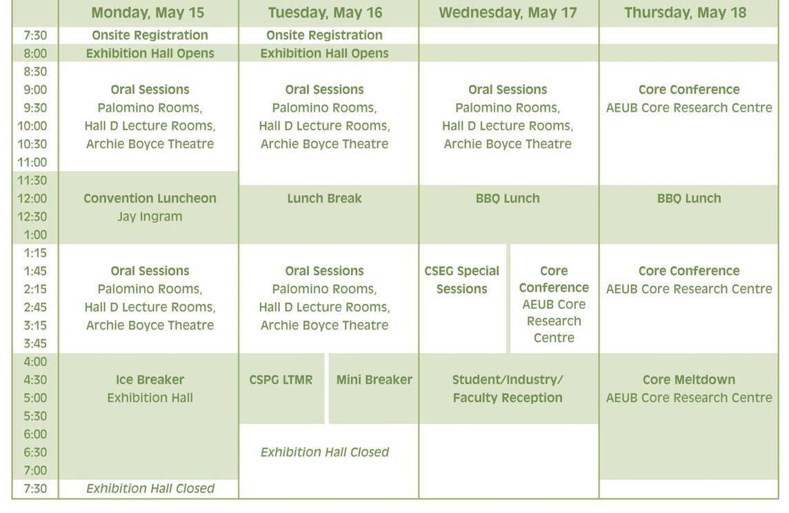
Monday,May 15:7:30am to 6:30pm
Tuesday,May 16:7:30am to 4:00pm Wednesday,May 17:7:30am to 12:00pm
On-site registration will be located at the Round Up Centre,Stampede Park.
IHS Forms Consortium with Geomatics Data Management and Veritas DGC Inc. to Deliver NAD83 Standards Migration Services
New coordinate system in compliance with Canadian Association of Petroleum Producers
IHS, a global provider of integrated oil and gas information, software and consulting services, has formed a strategic consortium with Geomatics Data Management Inc. and Veritas DGC Inc. to provide a turnkey solution for the Canadian energy sector to manage data conversion from NAD27 to NAD83, both coordinate systems used to express locations on Earth.
“The Canadian Association of Petroleum Producers (CAPP) recommends that by Q2 2008, all companies should convert to NAD83 for all data interchange between and within government and industry,” says Chris Jones, IHS senior vice president and general manager for Energy, Canada.
The CAPP report estimates that full conversion will reduce the risk of using incorrect spatial data due to datum shifts by 90 percent. The magnitude of this conversion mandate for all oil and gas companies prompted IHS to initiate a service consortium that brings together an established team of the most trusted, experienced and knowledgeable industry resources.
The oil industry primarily uses NAD27 at present in Western and Northern Canada, but all levels of government and the regulatory bodies are either converting to NAD83 or have converted, and most other industries are already using NAD83.
A location expressed in NAD27 is different than that expressed in NAD83. For example, if one were to pinpoint the location of the Dover A-43 well using NAD27 and NAD 83, the difference in
latitude is 7 m N and the difference in longitude is 61 m E.
According to Jones, “One major Canadian producer we have already assisted has referred to their complete NAD83 conversion as a competitive and operational advantage. Their data and grid is now consistent, accurate and precise.”
The current industry cost of incorrectly located operations is estimated at $25 million annually.
Dave McLintock, president of Geomatics Data Management, says, “The conversion effort has several associated critical issues, most importantly the shear magnitude of the operational and resource demands. It makes sense to form this consortium, because our combined strengths provide expertise in all aspects of industry data, and we have unequalled technical capability and knowledge, operational capacity, proven conversion experience and project management capability.”
The current industry cost of incorrectly located operations is estimated at $25 million annually.
The consortium will lead the industry by offering a complete solution for managing data referenced to NAD27 and NAD83. The solution also addresses data clean-up, which is a large part of any conversion effort and often the most unknown variable. The services offered include the upgrade and implementation of an industry-wide authoritative land grid, conversion of data references from the NAD27 datum to the NAD83 datum, gate-keeping on data transferred between organizations, and consulting on all facets of this issue.
The consortium will provide education, project scoping, definition and strategy, consulting and comprehensive data conversion, correction and quality assurance services. Companies can choose all or a subset of the full package to meet the needs of their unique conversion project.
Dan Boudreault, senior engineer of Veritas’ geomatics services says, “The consortium provides a unique combination of analysis, project management, technical expertise, conversion, quality control services and supporting software. This will be made available to all customers according to their requirements.”
For more information on NAD 83 Consulting Services, contact Earl Amankwah at IHS at 403.770.4493.
2006 CSPG CSEG CWLS JOINT CONVENTION
The CSPG 2006 Core Conference Committee is pleased to announce the list of 19 core displays received (so far...) to date! These displays were solicited and submitted in keeping with the theme of this year’s conference: “WHAT’S NEXT – where is our industry headed?” The core displays can be characterized by their variety and scope: most of the major Canadian basins and stratigraphic intervals are represented here, as well as all the major hydrocarbon-bearing resources – and we even have a jewel of a display hidden here...
NEW BRUNSWICK
(notes:only senior author affiliations shown here;some titles are preliminary)
Selected core from the Albert Formation (Mississippian),Moncton Basin,southern New Brunswick.
Dave Keighley,University of New Brunswick, Fredericton,Clint St.Peter
ARCTIC ISLANDS
A Potpourri of Reservoir Rocks from the Mesozoic Strata of the Sverdrup Basin, Canadian Arctic Islands. Ashton Embry Geological Survey of Canada,Calgary.
Bent Horn Field,Cameron Island,Arctic Islands.
Keith Dewing,Geological Survey of Canada, Calgary (title & co-authors details TBA).
SASKATCHEWAN
Star Kimberlite Complex,J.P.Zonneveld, Geological Survey of Canada,Calgary.
State A Marker Oil Production Within The Williston Basin of Southeast Saskatchewan (Mississippian,Frobisher Beds).
J.H.Lake,Swift Current.
Hydrocarbon potential in coated-grain banks of the Mississippian Frobisher Beds, southeastern Saskatchewan, Arden Marsh,Regina. Andrew Nimegeers.
A new exploration strategy for Lower Paleozoic petroleum systems in the Williston Basin.
Lateral Variability within the Cadotte Shoreline Complex (Elmworth Gas Field): breaking out depositional packages within an extensive sandstone-conglomerate body. Curtis Lettley,University of Alberta, Edmonton.George Pemberton, Murray Gingras.
Sedimentology,Ichnology,and Depositional History of the Falher D Member Presence of a Wave-dominated Delta? Trevor Hoffman, University of Alberta,Edmonton, Murray Gingras,George Pemberton.
Deeply-Rooted Bathymetric Control on the Deposition of the Falher F Conglomerate Trend,Wapiti Field,Deep Basin,Alberta. Byron Nodwell,Calgary.Bruce Hart
Reservoir and Bitumen Heterogeneity in Athabasca Oil Sands. Milovan Fustic,13 Avenue SW,Calgary. Khalis N.Ahmed,Sammi Brough,Barry Bennett,Ron Spencer,Steve Larter.
Heavy Oil Sands,Alberta. Erin Crerar,Nexen,Calgary.
Halfway Formation,Western Canada Basin. Mark Radomski, University of Calgary,Calgary.
Distribution of
“Anomalously thick sandstone bodies” in the Middle Triassic Doig Formation, Western Canada Sedimentary Basin, James Dixon, Geological Survey of Canada,Calgary.
Relationship between Reservoir Quality Sandstone & Tectonics:Carboniferous Kiskatinaw Formation, Western Canada Basin.
Abu Yousuf,University of Calgary,Calgary.
Siliciclastic Sedimentation In Paleocaves, Twining Field.
John Hopkins,University of Calgary,Calgary. Andrew Nimmo,Susan Reid.
BRITISH COLUMBIA
Reservoirs,petroleum systems and exploration challenges in the intermontane basins of British Columbia. Kirk Osadetz, Geological Survey of Canada,Calgary. Fil Ferri,Erik Thorsteinsson,Chungquing Jiang,Lavern D.Stasiuk,Carol Evenchick.
Anatomy of a Jean Marie Shoal,July Lake Area,northeastern British Columbia. Jack Wendte, Geological Survey of Canada,Calgary, David Sargent,Tim Bird,CNRL.
CSPG 2006 Convention, Core Conference Committee
Pauline Chung
Jim Barclay
Kimberly Tanasichuk
Friederike Baumeister (all from Burlington Resources)
Western Canada
Geological Edge Set 2006 Version
Now available for import into ACCUMAP, GEOSCOUT and other applications
1) Mississippian Subcrops and Devonian Reef Edges - AB, NE BC, NT and SK
Borehole Seismic Survey Design, Data Processing, and Interpretation
SPECIAL EVENTS
JAY INGRAM LUNCHEON
Monday May 15
11:30 – 1:00 pm Round Up Centre – Hall C
Jay Ingram will talk about his life as a Science Broadcaster and the show Daily Planet.
ICE BREAKER
Monday May 15
4:00 – 8:00 pm
Exhibition Area – Halls A & B
Join your colleagues for some great food and conversation while browsing the many exhibits at this year’s CSPG/CSEG/CWLS Conference
BREAKFAST WITH EXHIBITORS
Monday May 15 & Tuesday May 16
8:00 – 10:00 am
Exhibition Area
– Halls A & B
Get a chance to wander through the exhibits and enjoy a complimentary continental breakfast and coffee.
CONVENTION BBQ Lunch
Wednesday May 17
Thursday May 18
11:30 – 1:00 pm
Tents behind the AEUB Core Research Centre
Take a break from the Core Conference to enjoy the Excellent BBQ lunch provided by Hycal Energy Research Laboratories.
CORE METLDOWN
Thursday May 18
3:30 – 7:00 pm
Tents behind the AEUB Core Research Centre
MINI BREAKER
Tuesday May 16 4:00 – 6:00 pm
In the Area in front of Halls A & B
Enjoy the final hour of the Exhibition with a drink and appetizers.The exhibition floor will close at 5:00 pm where we will move into the pre-function area for a final networking opportunity with colleagues.
STUDENT/INDUSTRY/FACULTY RECEPTION
Wednesday May 17 4:00 – 6:00 pm
Location:TBA
Meet the energetic minds of tomorrow,the faculty that has nurtured these graduates and the industry representatives from companies that will employ them.We hope that this casual event can strike up new relationships.
Celebrate another successful convention at the popular Core Meltdown event. Join the CSPG/CSEG/CWLS Organizing committee and all your fellow convention delegates for some food and beverages.
For more information please contact: Andrea Reiserer Special Events chair Direct 444-1609
AReiserer@geologic.com
EXHIBITOR BOOTH LISTING
2006 CSPG CSEG CWLS
Joint Convention
Exhibitor Booth Listing by Company March 20,2006
Company NameBooth Number
A.A.P.G.1106
Advanced Geotechnology Inc.834
Aegis Group Inc.735
AGAT Laboratories831
Alberta Geological Survey1004
Alberta Research Council1003
APEGGA936
Arcis 524
Aurora Geosciences Ltd.434
Baker Atlas1130
Beicip Inc.420
Bell Geospace Inc.905
Boyd PetroSearch729
Calgary Rock and Materials Services Inc.224
Calgary Scientific Inc.922
Canadian Discovery Ltd.823
Canadian Gas Potential Committee733
CGG Canada Services Ltd.1020
Complete Land Services Ltd.339
Continental Imaging Products442
Continental Laboratories Ltd.523
Core Laboratories Canada Ltd.819
Department of Geological Services, University of Saskatchewan1116
Digital Formation,Inc.321
Divestco Inc.634
Earth Decision Sciences Canada Ltd.836
ESG-Engineering Seismology Group Inc.832
ESRI Canada1001
Fugro - Jason Canada/Pet.Com/Fugro Airborne Surveys530 to 536
GEDCO608
Genetek Earth Research Corporation1100
GeoAnalytic Inc.1011
geoLOGIC systems ltd.816
Geo-Logic Systems,LLC912
Geological Rentals and Services1007
Geological Survey of Canada (Calgary)433
Geo-Microbial Technologies/PK Services221
Geomodeling Technology Corp.628
Geophysical Service Incorporated/ Precision Seismic Processing1000
geoPLUS Corporation329
GeoTomo125
Geo-X SYSTEMS LTD.540
Global Energy Services934
Government of Nunavut341
Government of Yukon1017
GR Petrology Consultants Inc.822
Green’s Rock and Lapidary Ltd.541
HiSPEC Research Corp.622
Hydrocarbon Data Systems,Inc.435 IHS800
Indel-Davis Inc.917
Input / Output Inc.908
iSys - The Imaging System Group Inc.803
JEBCO Seismic (Canada) Company/ ARKEX Ltd.916
Justcroft International Ltd.904
Kelman Technologies Inc.616
Kodiak Nav Solutions810
LiDAR Services International817
Little Rock Document Services Ltd.320
MD TOTCO NOV828
Mitcham Canada Ltd.901
MJ Systems436
Mustagh Resources Ltd.827
Nautilus644
Neuralog,Inc217
Nikon Canada Inc.430
Norwest Labs –
A New Bodycote Company1014
NWT Geoscience Office1019
Oce-Canada Inc.811
Open Spirit Corporation1110
OYO Geo Space Canada Inc.810
PANASAS915
Paradigm Geophysical Canada Ltd.324
Pason Systems Inc.1013
Petrocraft Products Ltd.335
Petrosys Canada Inc.220
PGS Geophysical422
PhotoSat Information Ltd.327
Pinnacle Technologies624
Pro Geo Consultants316
Recall640
RECON Petrotechnologies Ltd.946
Roxar343
RPS Energy510
S.A.I.T.926
Saskatchewan Industry and Resources1016
Saudi Aramco121
Schlumberger405
Scioptic Canada428
Seismic Micro-Technology525
Sercel,Inc.927
Sherwin Geological Consulting Ltd.809
Sigma Explorations Inc.543
Society of Exploration Geophysicists1108
Sun Microsystems232
System Development,Inc.928
Technology Tax Credits1026
Terra Management317
TERRAPLUS Inc.218
TOR GEOscience Corp.924
Total Gas Detection Ltd.801
Trango Technologies Inc.431
Trivision Geosystems Ltd.318
United Oil & Gas Consulting Ltd.416
University Of Calgary230
Veritas600
VIBTECH900
W.L.Gore & Associates,Inc.426
Weatherford Canada Partnership516
WellDog,Inc.829
WellSight Systems Inc.1118
Western Diazo226
Western Explosives835
ZEH Software,Inc.319
Zokero Inc.1008
Apoterra Seismic Processing Ltd.
BP Canada Energy Company
EOG Resources Canada Inc.
GEO-X SYSTEMS LTD.
Arcis
Baker Atlas
Calgary Scientific Inc.
Compton Petroleum Corporation
Core Laboratories Canada Ltd.
Earth Signal Processing Ltd.
SHAREHOLDER
STRATEGIC ALLIANCE - $15,000 +
JOINT VENTURE - $10,000 +
PARTNERSHIP - $5,000 +
Hycal Energy Research Laboratories Ltd.
Sun Microsystems
Matrix Geoservices Ltd. Suncor Energy Inc. Total E&P Canada Ltd. Zokero Inc.
Sproule Associates Limited
ASSOCIATE - $2,000 +
GEDCO
REGENT RESOURCES LTD.
RPS Energy SENSOR GEOPHYSICAL LTD.
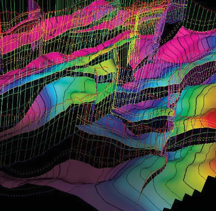
Using 3-D Earth Modeling for Reservoir Analysis
By John Boyd and Larry Herd, Boyd PetroSearch
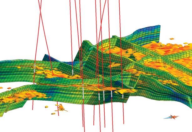
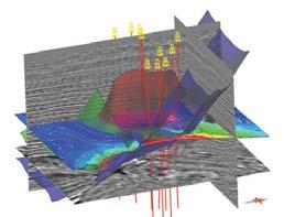
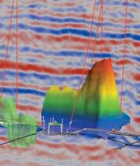
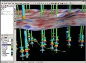
Ordinary 3-D seismic visualization systems allow you to view and interpret your data from any angle and make part of the data transparent so that you can see your reservoir more clearly. You can spin and rotate your 3-D cube but attaching, accessing and incorporating other data isn’t as easy.
The Earth Decision™ GOCAD platform, utilized by Boyd PetroSearch, has the same ability to view and interpret seismic data but it will also attach, display and use engineering and geological data to create a numerical model. A mouse click on a well track displays porosity, pay thickness or a production history graph for that level of the well bore. Relevant production data is imported and instantly displayed along with seismic and petrophysical data.
A mouse click on a well track brings up pressure data to check for communication between well bores and the proper positioning of flow boundaries.
The reservoir divided into compartments and cells
Multiple data types are combined in either time or depth. Fault planes are displayed and colour-coded. Their transparency is adjusted so that both seismic data and other fault planes can be seen behind them. The top of the reservoir is shown as a surface with both colour and contours superimposed.
The reservoir is divided into compartments and within each compartment, individual cells are colour coded for porosity. Cells could also be colour coded for water saturation, permeability or some other reservoir characteristic.
The GOCAD platform incorporates the results of other seismic analyses. Inversion, AVO, waveform classification analyses and other attribute volumes are loaded along with the conventional stacked data to provide inputs into the numerical “earth model”. A fluid flow model using industry standard simulation software completes the picture. Various drilling scenarios run against the earth model help maximize the reservoir economics.
Boyd PetroSearch offers this affordable advanced reservoir analysis to our clients. We will organize your data and help to convert the seismic data from time to depth so that it properly matches the engineering and geological data. You don’t need an expensive visualization centre. Let us show you how your development team can easily take advantage of the power of Earth Decision’s GOCAD system to maximize your reservoir’s potential.
Boyd Exploration Consultants Ltd.
Boyd PetroSearch puts the pieces in place for affordable 3-D earth modeling solutions.
Until now, only the largest players could access advanced earth modeling technology to simulate oil and gas reservoirs, leaving smaller companies scratching their heads.
As part of our consulting services, Boyd PetroSearch makes sophisticated reservoir modeling accessible to mid-tier companies, using the Earth Decision™ GOCAD platform.
Learn how we can use GOCAD to help your engineers, geologists and geophysicists put their heads together to extract more oil & gas from your reservoir.
Please call:
John Boyd 403.543.5373
Larry Herd 403.543.5362 or visit www.boydpetro.com
CSPG AWARD – H.M. HUNTER AWARD
The H.M.Hunter Award was created to recognize those individuals who have served the Society in a variety of capacities over many years.
ASHTON EMBRY
Ashton has been a member of the CSPG since 1968 and commenced his volunteerism
in the early 1970s working on conference organization.It is fitting that he is still contributing in that role,most recently as Technical Chairman of the 2005 AAPG Convention.For over 30 years,in addition to working on conferences,Ashton has served on Awards Committees,the Stratigraphic Nomenclature Committee,and the Sedimentology Division (as field trip chair, speaker chair,and general chair).He also served as Editor of the Bulletin,and is currently on the Executive as Communications Director.This award recognizes Ashton’s continued service and dedication to the Society.
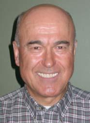
VITTORIO (VIC) PANEI
Vic Panei has made outstanding contributions to the Society since 1975.He is probably best known for his dedicated service on the Photographic Committee where he has
CSPG AWARD – MEDAL OF MERIT
The Medal of Merit is “awarded annually by the CSPG for the best paper published during the previous year on a subject related to the petroleum geology of Canada.” More specifically,the Medal of Merit Committee favours papers which are broad in scope,are clearly written,well presented,and illustrated with novel ideas.Also needed is thorough data collection and linkage of data to interpretations and conclusions.A clear relevance to Canadian petroleum geology and the practice of petroleum geology is greatly preferred if not essential.
The 2005 Medal of Merit is being awarded to Keith Shanley,Robert Cluff and John Robinson of Colorado for their paper: “Factors controlling prolific gas production from low-permeability sandstone reservoirs: Implications for resource assessment, prospect development,and risk analysis” which was published in the August 2004 AAPG Bulletin.
This paper was chosen because of its novel interpretation of major “basin-centred gas” plays in Wyoming,such as the Jonah trend. The paper maintains that these plays are conventional gas plays with downdip water and mainly stratigraphic trapping and thus it challenges much current thinking about basin-centred “Deep Basin” “continuous-
mostly served over the past 30 years.In fact for many of those years,Vic was the sole member of that committee.In his role as “CSPG Photographer,” Vic has spent countless hours helping to document the activities of the Society.This award recognizes the time and talent which Vic has contributed to the Society over the past three decaades.
type” “tight gas” accumulations.Although the paper certainly does not focus on Canadian geology,it is thought-provoking,timely,and has potential wide applicability to Canadian basins.In addition,it’s an excellent example of a regional-scale paper that is well-written, well-organised,and displays wide datagathering.
The paper has significant implications as acceptance of the authors’ points,although controversial,would require substantial downward revisions of resource estimates in a number of plays thought to be “basincentred gas”.It will also prompt questions about interpreted widespread gas regimes in the Western Canada Sedimentary Basin.
Ralph Rudser (R) accepting Medal of Merit from C.Yeo on behalf of Keith Shanley,Robert Cluff,and John Robinson.
Ashton Embry
Vittorio (Vic) Panei
Keith W.Shanley is a consulting geologist in Littleton,Colorado,with more than 24 years of experience in exploration,development, and research.He has worked in a variety of basins around the world for both major and independent oil and gas companies,including Shell Oil Research and Amoco-BP.Keith was born in The Hague,The Netherlands and moved to the United States to attend university.He received his B.A.degree in Geology from Rice University in Houston,TX in 1978 and his M.Sc.(1983) and Ph.D.(1991) degrees in Geology from the Colorado School of Mines in Golden,Colorado.He has published numerous papers,edited volumes, and organized conferences and seminars dealing with sequence stratigraphy,reservoir architecture,non-marine sedimentology and stratigraphy,and tight gas.His current research interests include sequence stratigraphy and reservoir architecture,the integration of petrophysics,and risk analysis and unconventional hydrocarbon resources. He is a member of the AAPG,SEPM,SPE, RMAG,and SPWLA and is a registered petroleum geologist in both Texas and Wyoming.Keith lives in Littleton,Colorado with his wife Paula and their children John, Stuart,James,and Kathryn.
Bob Cluff is a geologist and petrophysicist with 30 years experience in oil and gas exploration,development,and research.His principal areas of expertise are petrophysics, stratigraphy and sedimentology of carbonate and clastic reservoirs,and the integration of petrophysical data with geological data in reservoir studies.He has worked and published extensively in the fields of nonconventional gas from tight sands and shales, source rock analysis,and maturation modeling.He has conducted and supervised projects in every sedimentary basin in North America plus numerous international projects.
Bob received his degrees in geology at the University of California at Riverside and the University of Wisconsin at Madison.He has also studied geology,math,and physics at the University of Illinois at UrbanaChampaign,University of Colorado at Denver,and Metropolitan State College of Denver.Bob’s employment history includes the Illinois State Geological Survey,several years as an independent consulting geologist,and President of The Discovery Group since 1987.
John W.Robinson is the owner of North Ranch Resources LLC in Denver.He has 31 years of experience in petroleum exploration and development and previously worked for Amoco Production Company, Forest Oil Corporation,and Snyder Oil Corporation.He was most recently Senior Vice-President for McMurry Energy Company and Jonah Energy LLC.He is the past President of the Rocky Mountain Association of Geologists and the Rocky Mountain Section – SEPM.In 1999,he and co-author Peter McCabe,received the AAPG Wallace E.Pratt Award for the best paper in the 1997 AAPG Bulletin.In 2005,he and co-authors Keith Shanley and Robert Cluff received the Pratt award for the best paper in the 2004 AAPG Bulletin.
He received B.S.and M.S.degrees in Geology from San Diego State University,and a Ph.D in Geology from Colorado School of Mines. His research interests are in fluvial sedimentology and multidisciplinary reservoir studies.
Keith W.Shanley
Bob Cluff
John W.Robinson
CSPG AWARD – STANLEY SLIPPER GOLD MEDAL
The Stanley Slipper Gold Medal is named for Stanley E.Slipper (1890–1982),the first President of the Canadian Society of Petroleum Geologists.It is the Society’s most prestigious award.The award is presented annually to an individual who has made an outstanding contribution to petroleum exploration in Canada and has been personally identified as having played a crucial role in a major Canadian hydrocarbon discovery.
GERRY MACEY
Gerry Macey started his geology career with a B.Sc.in Geotechnical Science from Loyola College (now Concordia University) in Montreal and a M.Sc.in Geology from Carleton University in Ottawa.A passion for field work led to six field seasons ranging from mineral exploration in the Gaspe Peninsula,uranium exploration in the barren lands west of Hudson Bay to stratigraphic surface parties in the northern Yukon up to the arctic coastal plain.M.Sc.thesis mapping work extended across the Canadian Shield from Great Bear Lake,to Great Slave Lake, on to Uranium City and finally a ten-day solo stint on Christopher Island at the east end of Baker Lake NWT.When field work on a potential Ph.D.topic was delayed Gerry headed to Calgary for a year to try out the oil patch and 34 years later he’s still in the business.
Gerry started with Gulf Canada in 1972 working in western Canada but moved to the territories after a year to work with exploration teams in the Mackenzie delta and the team that lead to the successful delineation of the Parson’s Lake field.
In 1977 he moved to London to work the North Sea and other frontier basins west of England before returning to Canada in 1979.
After an initial stint leading a team mapping regional plays,he led the foothills exploration effort with most of the emphasis on Gulf’s central foothills agreement lands from Stolberg to Mountain Park.
In 1981 he moved to the Alberta plains. Stettler was a big area for Gulf at the time and the exploration team,looking around the edge of the big reef,identified the Rumsey pinnacle anomaly.The well was drilled in the summer of 1982 and average production over the first year was 3,800 barrels per day and with new incentives the production was royalty free with no financial cap on the
amount.It was one of Gulf’s most profitable wells ever and after that the government put a financial cap on royalty holidays.
Gerry then moved to development geology for a few years.On occasion exploration management did think he was bending the rules a bit,particularly with a 27-mile “development” step out prospect on a Glauconite channel trend but for the most part the groups got along pretty well.
After 15 years with Gulf,Gerry moved to BP Resources Canada (now Talisman) to head up Canadian exploration.These projects ranged from drilling off the East Coast to a large number of Western Canada plays,but the most exciting was in the B.C.foothills.The West Sukunka c-45-J well had been tied in and producing for almost ten years and was clearly connected to a large amount of gas but there were reservoir quality concerns. The team put together a strong prospect inventory and started a new drilling program. A string of six or seven discoveries significantly extended this play.The thrill of seeing,hearing,and feeling the ground shake as the Brazion c-59-E well tested 85 MMcf/d up two flare stacks was a highlight.
In 1992 Gerry moved to PanCanadian to take over Canadian Exploration.With direction from the top “not to sit on our assets” the well count went from 500 in 1991 to almost 1200 in 1993 and conventional oil production rose from 60,000 to break through the 100,000 bopd mark in 1994 in a heroic effort by all of the Western Canada teams.
In 1996 the Gulf of Mexico was included in Gerry’s mandate and that same year PCP’s International Group started in the U.K.In late 1998 PanCanadian started the drilling of the Deep Panuke prospect offshore Nova Scotia and this well resulted in a discovery in early 1999.
In 1999 Gerry also took over responsibility for worldwide exploration.The Gulf of Mexico team had built a strong inventory and arranged some attractive farm-ins and the U.K.team had put a strong inventory together with instructions to come up with a drilling program.In 2001 the U.K.got rolling and after a first dry hole,the second well discovered the Buzzard pool with 1.2 billion barrels in place.The Gulf of Mexico team had initial success at Llano but after a string of dry holes the big discovery was Tahiti in 2002 with more than 500 million barrels recoverable.
“The impact of a $70 million dry hole takes your breath away.The only easy part about it is pulling the bandwagon because it’s empty, carrying only the broken dreams of the exploration team.Now is the time to be with the team – the character-building time,when the tough questions need to be asked.What went wrong? What went right? What did we learn from all this? What will we do differently next time? So that there IS a next time and we DO succeed .Then on the next well,when the team looks back and sees that bandwagon full to overflowing with more “help” than you could ever want you know you’ve found the big one.”
Gerry was instrumental in the PCP AEC merger in 2002 and the foundation of EnCana.He looked after international exploration for another two years with some additional success in Chad and Brazil.He “retired” in 2004 but is still active on three boards of directors focusing on international work in Nigeria,Libya,France,and Thailand and who knows what’s next.
“I’ve had the good fortune to work with great exploration teams along the way and it’s always been a lot of fun.”
Gerry Macey
depths visions
nnovations
CONTOURING
Faulted contours Isopachs
Volumetrics
Grid operations
New flexing options
CROSS SECTIONS
New Unassigned Tops
Digital and/or Raster
Geocolumn shading
Stratigraphic/Structural
Shade between crossover Dipmeter data
MAPPING OPTIONS
Expanded GIS Functions Bubble maps Production charts
VISUALIZATION
Deviated wellbores Digital logs
Grid surfaces Tops, Shows and Perfs Land grid overlay Map images
PETRA® delivers the industry’s only easy-to-use and affordable integrated solution for today’s workflows. It provides multi-user access to large projects through geological, petrophysical and engineering analysis tools. The PetraSeis™ option extends PETRA® into 2D/3D seismic interpretation with practical tools such as RasterSeis™. Download a trial version at www.geoplus.com, or call us at 888-738-7265 (Houston: 713-862-9449 / Calgary: 403-264-9523) for more product information.
PETRA
DECLINE
etc.
PETRA
CRACKS OF THE WORLD: GLOBAL STRIKE-SLIP FAULT SYSTEMS AND GIANT RESOURCE ACCUMULATIONS
BY STANLEY B. KEITH, JAN C. RASMUSSEN, MONTE M. SWAN, AND DANIEL P. LAUX
Reprinted with permission from the Houston Geological Society Bulletin On-Line 6-April-03.
Evidence is mounting that the Earth is encircled by subtle necklaces of interconnecting,generally latitude-parallel faults.Many major mineral and energy resource accumulations are located within or near the deeply penetrating fractures of these “cracks of the world.” Future exploration for large petroleum occurrences should emphasize the definition,regional distribution, and specific characteristics of the global crack system.Specific drill targets can be predicted by understanding the local structural setting and fluid flow pathways in lateral,as well as vertical conduits,detectable through patterns in the local geochemistry and geophysics.
The faults in the cracks of the world fracture system typically move in transcurrent (strikeslip) motions that are tied to plate tectonics. One of the dynamic driving forces in plate tectonics derives from revolutions about the Earth’s rotational axis.Familiar plate tectonic driving mechanisms,such as mantle convective overturn or gravitational trenchpull,become second-order driving forces that are subordinate to the Earth’s spin axis.The scale of the kinematic reference frame thus shifts from crustal plate motions to motions between spheres (that is,lithosphere-
asthenosphere differential rotations).
At a more local scale,introduction of magma and hydrothermal fluids into the global “crack system” commonly is coincident with kinematic activity in the faults.Indeed, analysis of mineral and chemical fractionation patterns produced during sequential introductions of the hot fluids offers new tools for kinematic and dynamic analysis of the global-scale fracture system. Particularly important are lateral compositional patterns in the mineral zone artifacts of hydrothermal plumes.These lateral patterns reflect motion related to the strike-slip kinematics and inject a new laterality and conceptual opportunity into exploration for commodities deposited by the ascending hydrothermal plumes.The global scale and interconnected nature of the strike-slip fault system in both continental and oceanic crustal materials first became apparent from a regional geotectonic study of Mexico.
THE MEXICO MEGA-SHEAR SYSTEM
A recent tectonic synthesis of Mexico ore deposits and tectonics has implications for worldwide giant petroleum accumulations and resulted from the incorporation of new constraints related to the regional geographic distribution of crustal oxidation states. Oxidation state is an indicator of oxygen
fugacity – essentially the amount of oxygen available for reaction in the Earth’s crust.It is as fundamental an Earth property as magnetics or gravity and can be measured directly by the ferric:ferrous ratio in rock or inferred from the whole-rock mineralogy or commodity (element) present.Regional crustal oxidation state patterns shown on the oxidation state map of Mexico (Figure 1) were based on ferric:ferrous ratios,mineral assemblages,and geochemistry from about 2,900 plutons and mineral systems.
Petroleum accumulations of all sizes throughout the globe correlate with source and reservoir rocks of low oxidation state where ferric:ferrous ratios are equal to or less than 0.6.In the Mexico region,over 500 additional oil and gas field occurrences were used to constrain crustal oxidation state. Petroleum occurrences can regionally coexist with other commodities (such as diamond, gold,tin,antimony,mercury,lithium,and tantalum) that require low oxidation states for their stability throughout the sourcetransport-deposition process.Consequently, maps of the regional crustal oxidation state in any particular area are useful as a regional exploration tool for petroleum and many metallic commodities.
(Continued on Page 50...)
Figure 1-Mexico mega-shear system,showing Cambrian craton edge for western North America in Mexico,inferred ridge system in Gulf of Mexico based on SEASAT gravity,and crustal oxidation state contour map based on pluton ferric:ferrous ratios and associated mineral system compositions.
The Mexico oxidation state map produced a striking zig-zag pattern (Figure 1).When this is combined with an oxidation state map for the western United States,a southeastward offset of the inferred Cambrian craton edge is apparent. It extends for some 3,500 km from Cajon Pass west of Los Angeles,CA, to Guatemala City,Guatemala. The southeastward offset is accomplishedon west-northweststriking fault elements that form a giant,country-wide shear system referred to as the Mexico “megashear”.The well-known “Texas zone” forms the northernmost structural element of the shear system and the Motagua/Polochic fault system forms the southernmost element.Fault elements within the shear system are defined by sharply telescoped oxidation state gradients,where at least two levels of oxidation state are crossed in very short distances, on the order of 30-50 km.A similar pattern was found for the inferred Cambrian craton edge,which comprises offset segments of north-northeast-striking zones of telescoped oxidation states.
The overall pattern confirms the “Sonoran mega-shear” concept originally proposed by Anderson and Silver (1979).The sense of displacement of the inferred Cambrian margin is along an approximately N50W trend,sub-parallel to the trace of the proposed mega-shear.Individual offsets, however,occur along east-west- to westnorthwest-striking,apparently deep-seated fault zones that traverse the entire country of Mexico and adjacent areas.If the 3,500-km offset is restored and the Gulf of Mexico is closed,Mexico and northern Central America form a southward-pointed megapeninsula that fits neatly to the coast of northwestern South America,west of Columbia and Ecuador.This reconstruction elegantly removes the long-known “Bullardfit problem.”
West-northwest-striking fault offsets are also apparent on the gravity map of the Gulf of Mexico (Sandwell and Smith,1995) on a northeast-trending regional high that has similar characteristics to incipient mid-ocean rifts.For this reason,we believe this northnortheast-trending gravity high was a midocean ridge during the original opening of the Gulf of Mexico.Numerous west-northwest trending transform faults offset the ridge crest along trends similar to those in the present Gulf of California (Figure 1).
The mega-shear system is not confined to the country of Mexico and adjacent regions. Individual fault elements in the Mexico mega-shear extend outward into the Pacific Basin,where they link with the Pacific oceanic fracture system between 18°N and 42°N.A similar,even more dramatic connection is achieved when the Mexico mega-shear system is extended to the eastsoutheast,where it links,structural element for structural element,with the central Atlantic fracture system between the equator and a latitude of 18°N (Figure 2).In both the Pacific and Atlantic ocean basins, the oceanic ridge system displays an apparent left offset of some 3,500 km,in accord with the offset on the Mexico megashear system.
The specific offsets in the Atlantic Basin and their presumed Mexican analogs are particularly indicative of a linkage.At the southern end of the Atlantic transform shear system,large apparent left-lateral offsets of the Atlantic mid-ocean ridge along the Romanche fracture system match well with large offsets of the inferred Cambrian craton edge along the Motagua/Polochic/ Cayman trough fault system from its initial position in the Chortis block of Nicaragua-Honduras. This large offset is matched by several minor 50- to 100-km offsets in both the central Atlantic and Mexico mega-shear.About twothirds of the way northward into both systems,another large offset occurs at the Guinea fracture zones in the Atlantic and the Monterrey-Parras fracture system in north-
central Mexico.A series of smaller offsets occurs until the northernmost offset of about 150 km (Barracuda fracture in the Atlantic and the central portion of the Texas zone in southwestern Arizona and southeastern California).
The Mexico mega-shear,when correlated with its Atlantic and Pacific analogs,goes halfway around the world – extending for about 180°of longitude and ranging from 18° to 25°of latitude in width.The total accumulated offset of 3,500 km has incrementally occurred within the last 200 million years.Much of the offset occurred between 175 and 145 Ma,between 125 and 85 Ma,and between 56 to 38 Ma,based on ages of oceanic floor.These offsets in the ocean floor correlate with major tectonic events in Mexico.The offsets occurred at 1) the Oxfordian opening of the Gulf of Mexico, 2) the mid-Cretaceous formation of the Bisbee Trough in the north part of the Mexico mega-shear system,and 3) the Eocene opening of the Cayman Trough and left-slip movements on the correlative Motagua-Polochic fault system throughout Guatemala.
IMPLICATIONS FOR A NEW PLATE TECTONIC PARADIGM
If the above global-scale observations are accepted,then mobilistic,terrane-based paradigms of plate tectonics may have to be revised.The mobilistic paradigm of plate tectonics has traditionally assumed that the continental plates are rigid and “float” as
Figure 2 - Preliminary map relating transcurrent fault elements of the Mexico mega-shear to transform fracture systems in the adjoining Atlantic and Pacific ocean basins.
passive rafts on a global “conveyor belt” system linked to oceanic-spreading processes.The above mega-shear observations suggest that the continents are also active participants in the oceanicspreading process.A global network of transform faults apparently links ocean basin to ocean basin through the continents.The continents may not be tectonically inert,rigid blocks:rather,they are active,kinematic participants of the oceanic spreading process. Indeed,the “pre-breakup” fracture architecture of the continents may control the specific locations of the emergent oceanic fracture systems during incipient breakups of continental assemblies such as Pangea.Also,the motion between continental and oceanic plates is not free-faced or disconnected at the trench plate boundaries. Tears in subducting oceanic crust and fracture zones in oceanic crust are anchored to,and connected with,analog fractures in the adjacent and overriding continental plate at the subduction zone interface.They are long lived and play important roles in hydrocarbon formation.
Dynamically,the transform faults can be viewed as manifestations of large-scale motions between the lithosphere and the asthenosphere.The mega-shears largely coincide with latitude-parallel motions that define approximate great-circle planes that are perpendicular to poles of rotation approximately coincident with the Earth’s rotation axis.Northward bends in this global crack system (for example,those in the Indian Ocean basin) may reflect a long-term, tectonic wobbling effect around the spin axis. This wobbling may be a manifestation of the non-perfect,oblate-spheroid shape of the Earth and the non-perfect gravity distribution within the planet.
In this more “fixist” view of plate tectonics, the fundamental motions of the various surface plates are along east-west lines. North-south translations are subordinate, but locally important (for example,the northward translation of India in the northward “wow” segment).Also,in the segments of east-west translations,northsouth plate translations after 200 Ma between the North American and Pacific plates in this model appear to be less than the distance between two large,east-west, oceanic fracture zones (about 300 km).
The kinematic reference frame in this new, fixist paradigm changes from a relativistic continental scale to an absolute spherical scale.In the relativistic viewpoint,Africa is commonly held fixed and the other lithosphere plates are moved relative to Africa.In the fixist viewpoint,the lithosphere
and asthenosphere are moving clockwise,or eastward,relative to the spin axis as viewed from the South Pole.The clockwise,eastward motion induces contrasting mega-tectonic patterns depending on whether the subduction zones dip in the direction of spin or against the spin.Thus,subduction zones that dip east in the same direction as the flow are flatter,and subduction zones that dip west against the flow direction are steeper. Slab segmentation allows asthenosphere flow “through” subducting oceanic plates.
Dips on the subduction zones suggest a net eastward flow of the asthenosphere relative to the lithosphere.This net eastward motion
is recorded by hot spot tracks,such as the Hawaiian hot spot track.This also suggests a net eastward motion of the asthenosphere relative to the lithosphere.In the case of the Hawaiian hot spot track,the asthenosphere is moving east-southeastward relative to the lithosphere at about 8 cm/yr since 43 Ma. Similarly,the Yellowstone hot spot is moving east-northeastward at 5.7 cm/yr since 16 Ma, suggesting an east-northeast moving asthenosphere relative to the lithosphere.
At a more global scale,the ultimate reference frame becomes the orientation of the spheres around the Earth’s spin axis.In the
Our client, a senior and active participant in both the mining and in situ development and production of the Athabasca Oil Sands deposits, is currently staffing a multi-disciplinary team focused on the integration of geology, geostatistics, bitumen ore key-variables and petrophysics and requires a:
P: 403-266-8800
F: 403-266-8801
Email: rob@rjderkitt associates.com
SENIOR GEOLOGICAL MODELLING SPECIALIST
Located within the Calgary office and an integral member of the G&G project team, the successful candidate will be a senior Geologist and bring their advanced sedimentary and stratigraphic knowledge of clastics and mine extraction requirements to the reservoir characterization and geostatistical modelling processes involved with this integrated mining and upgrading project. Experienced with advanced geomodelling software such as Minesight or Surpac, the successful candidate will have an intimate working knowledge of the techniques and requirements of upscaled geocellular models prior to input into mine planning software. Flexible, adaptable and open-minded to the demands of an operational team, yet focused and selfmotivated to conduct detailed geological studies, the ideal candidate will possess the technical, business and interpersonal qualities that will allow for the successful integration of geology with the engineering and business considerations of this major mining project. Candidates possessing an advanced degree in the geological sciences, coupled with previous experience as a mine planner or modelling specialist within any of Canada’s resource extraction industries, will be given preferential consideration.
Individuals interested in exploring this ground floor opportunity with one of Canada’s premier, fully integrated Petroleum companies are invited to respond in complete confidence to Rob Derkitt by mail at the address attached, telephone at (403) 266-8800 or by email to rob@rjderkittassociates.com.
prevailing plate tectonic viewpoint,plate restorations were exercises in large-scale kinematics.In the newer,more fixist perspective,kinematics can be more easily integrated with dynamic considerations,such as core dynamics,hot spot generation,geomagnetism,etc.The above model is in accord with and expands upon a similar model of terrestrial plate dynamics developed by Doglioni,(1990,1992,and 1993).
SUMMARY AND IMPLICATIONS FOR PETROLEUM RESOURCES
Future petroleum exploration should emphasize domains of reduced crust where
deformation is associated with slab-tears and regional trans-current faulting that are related to the global crack system in both continental and oceanic regions.
The tectonic and metallogenic analysis of Mexico revealed patterns of crustal oxidation state and a country-wide, west-northwest fracture system that offsets the inferred Cambrian craton edge some 3,500 km westward from its position within the Chortis block of Central America.Furthermore,this fracture system integrates with oceanic fracture systems in both the Pacific and central Atlantic ocean basins and offsets both ridge
world Makea changethe will feel.
Deliver energy solutions with Saudi Aramco.
Make 2006 the year you change your job, your perspective, and your vision of rewards. Tap into exciting and vital opportunities with the world’s foremost energy company, Saudi Aramco. Explore your role in bringing energy to the world and rewards not found anywhere else.
We are currently seeking Geoscience Professionals. Visit us at the CSPG/CSEG/CWLS Joint Conference, May 15-18 in Calgary - Booth #121.
For more information and to apply, visit www.jobsataramco.com/RES Energy to the world.
systems in each ocean basin by similar amounts - 3,500 km.
It is now becoming apparent that the Earth is girdled by generally latitude-parallel faults. The tectonic motion of associated plates is tied to transcurrent movement on the strikeslip faults that links continental geology to ocean basin geology.Consequently,the bordering continents are also active players in the spreading history of a given ocean basin.Indeed,the continental architecture may determine the initial positions of the oceanic spreading centers and associated transform faults.These global observations suggest that the ultimate plate tectonic dynamic driving force may revolve around the Earth’s rotational axis.Familiar plate tectonic driving mechanisms,such as mantle convective overturn or gravitational trenchpull,become second-order driving forces relative to the Earth’s spin axis.
Much of the world’s major energy resource accumulations seem to be associated with the deeply penetrating fractures of the cracks of the world.These global cracks control the ascension of magmatic and hydrothermal fluids from depth.Under reduced conditions these fluids may be hydrocarbon stable and could be responsible for fractionation of extensive amounts of hydrocarbon during cooling and deposition in low-pressure sites of the cracks of the world.
Future exploration for giant petroleum fields should emphasize the definition,regional distribution,and specific characteristics of the global crack system.Because of the lateral strike-slip kinematics that accompany emplacement of given hydrothermal fluid plumes,specific drill targets at occurrence sites will be lateral as well as vertical to known resource occurrences.For example, petroleum resources in the largest hydrothermal mineral deposit in the world, the Ghawar field of Saudi Arabia (Cantrell et al.,2002),may be related to deposition of regional-scale hydrothermal dolomites in a north-northeast-trending dextral slip zone that is 175 miles long and 30 miles wide.This zone is but one element of the previously mentioned north-south segments in the global fracture system.
In conclusion,we believe that significant new energy and mineral resources remain to be discovered by integrating resource occurrences with studies of crustal oxidation state,crustal fluid generation,hydrothermal plume fractionation/zonation,deep cracks,and a globally interconnected fracture system.
BIOGRAPHICAL SKETCH
Stanley B.Keith has over 30 years of successful
exploration experience in minerals and energy.Upon earning B.S.and M.S.degrees in geology from the University of Arizona,he became a field and research geologist focused on mineralogy,geologic mapping,stratigraphy, tectonics,and isotopic age dating.At Kennecott and the Arizona Geological Survey in the mid-1970s he recognized an empirical relationship between mineral deposits and magma series.He co-founded MagmaChem Exploration in 1983 for mineral exploration, working on numerous exploration and research projects for both mineral and energy exploration companies.Currently he is a founding researcher with Sonoita Geoscience Research,an industry-supported consortium that applies hydrothermal and economic geological theory and techniques to petroleum exploration.
Jan C.Rasmussen earned her B.S.and M.S.in geology,specializing in sedimentary petrology and stratigraphy,and a Ph.D.in economic geology,from the University of Arizona.She is an expert on the geology of the southwest and has written many books,field trip guides,and articles about Arizona geology,mostly as Jan C. Wilt,during her employment at the Arizona Geological Survey.She was a member of the Arizona Oil and Gas Conservation Commission for 10 years,and its chairman for 2 years.Over 30 years as a geologist,she has worked for Woodward-Clyde,the Arizona Geological Survey,and as independent consulting geologist associated with MagmaChem since 1984.She is a founding researcher with Sonoita Geoscience Research.
Monte M.Swan received his degrees in geological engineering and geology from Michigan Technological University in 1970 and the University of Arizona in 1975.He has more
than 30 years of experience as an international exploration and research geologist in both the mineral and oil and gas industries.Swan’s early career with Kennecott Geologic Research focused on basement structure and he spent extensive time performing field mapping.While a co-founder of MagmaChem Exploration,he co-developed the MagmaChem technology that has contributed to ten major gold and copper discoveries on three continents while managing MagmaChem’s Colorado office. More recently his structural and engineering experience has led to a new fluid migration model in strike-slip settings.He is a founding researcher with Sonoita Geoscience Research.
Daniel P.Laux has over 19 years experience as an exploration and mine geologist.He received a B.S.in geology from Arizona State University in 1983.Laux worked in copper mines in Arizona and gold mines in Nevada, and has explored for mineral resources throughout western North America.His association with MagmaChem Exploration began in 1984 where he developed a passion for obtaining,manipulating,and analyzing geological data.He currently provides support for computer and GIS applications for Sonoita Geoscience Research.
ACKNOWLEDGEMENT
The authors wish to thank Kara Bennett for reviewing this paper.
REFERENCES
Anderson,T.H.,and Silver,L.T.,1979,The role of the Mojave-Sonora megashear in the tectonic evolution of northern Sonora,in Anderson,T.H., and Roldan-Quintana,J.,editors,Geology of Northern Sonora:Boulder,Colorado,Geological Society of America Cordilleran Section Meeting Guidebook,Field Trip 27,p.59-68.
Cantrell,D.L.,Swart,P.K.,and Hagerty,R.M., 2002,Genesis and characterization of dolomite,Arab-D reservoir,Ghawar field,Saudi Arabia:manuscript in review,53 p. Doglioni,C.,1990,The global tectonic pattern: Journal of Geodynamics,v.12,no.1,p.21-38. Doglioni,C.,1992,Main differences between thrust belts:Terra Nova,v.4,p.152-164. Doglioni,C.,1993,Geological evidence for a global tectonic polarity:Journal of the Geological Society,London,v.150,p.991-1002
Keith,S.B.,Laux,D.P.,Maughan,J.,Schwab,K., Ruff,S.,Swan,M.M.,Abbott,E.,and Friberg,S., 1991,Magma series and metallogeny;a case study from Nevada and environs:Nevada Geological Society Guidebook for Field Trips,v.1 (Field Trip No.8),p.404-493
Keith,S.B.,2002,Magma-metal Series: unpublished text and three appendices volumes (Magma-metal series model book), MagmaChem,L.L.C.,P.O.Box 950,Sonoita,AZ 85637.
Keith,S.B.,1991,Magma-metal series (expanded abstract):Geological Society of CIM (Saskatoon section):First annual field conference,p.33.
Keith,S.B.,and Swan,M.M.,1995,Tectonic setting,petrology,and genesis of the Laramide porphyry copper cluster of Arizona,Sonora,and New Mexico:Arizona Geological Society Digest v.20,p.339-346.
Sandwell,D.T.,and Smith,W.H.F.,1995,Marine gravity anomaly from satellite imagery:Scripps Institution of Oceanography,Geological Data Center,9500 Gilman Dr.,La Jolla,CA 92093022,(619) 534-2752.
Wilt,J.C.,1995,Correspondence of alkalinity and ferric/ferrous ratios of igneous rock associated with various types of porphyry copper deposits:Arizona Geological Society Digest,v.20,p.180-200.
Reducing Industry Risk
The Right Location…
Saskatchewan is Canada’s second largest oil producer, and the third largest natural gas producer. We are a world leader in petroleum research and new technologies, committed to the optimal development of our energy resources. Exploration and development opportunities are waiting.
The Right Tools...
Start exploring Saskatchewan’s subsurface through our technical publications, well information files, and the Subsurface Geological Laboratory, home of our core library. Examine quality geoscience data online, from the Geological Atlas of Saskatchewan to our annual Summary of Investigations, geological reports and annotated maps. We have the information you need to help you make the right decisions.
For more information, visit www.ir.gov.sk.ca or call (306) 787-2562.
SASKATCHEWAN DISCOVER US
CALENDAR OF EVENTS
DATE: May 6-7,2006
EVENT: Calgary Rock and Lapidary Club – Gem,Mineral & Fossil Show
EVENT: CSPG Course - Triassic Sedimentary Framework and Sequence Stratigraphy,
(...Continued from Page 19)
BIOGRAPHY
Tako is Holland-born but Canada-raised with a B.Sc.in Geology (1971) from the University of Alberta and a B.A.in Economics (1981) from the University of Calgary.He worked for Texaco for 29 years in various technical and management positions in Canada,Indonesia, Nigeria and Angola.He early-retired from ChevronTexaco in 2002 and continues to live and work in Angola where he is a consultant for Irish explorer,Tullow Oil.In addition,he is the incountry representative for Yme,a Norwegian aid organization involved with communitybased potable water projects in the province of Cabinda in northern Angola.Although he has spent over 20 years of his career working
overseas,he returns annually to Calgary and usually schedules his homeleaves so that he can attend the annual CSPG conventions in Calgary in order to meet up with old oil patch colleagues and friends and get caught up on the oil and gas scene in Canada.
INFORMATION
There is no charge.Please bring your lunch. Refreshments will be supplied by EnCana and Fuel X International Incorporated.For further information or if you would like to give a talk, please contact Bob Potter at (403) 863-9738 or ropotter@ telusplanet.net.
THE FIRST THREE YEARS OF STARTING-UP A GEOLOGICAL CONSULTING PRACTICE
BY GEORGE D. KLEIN, SED-STRAT GEOSCIENCE CONSULTANTS
Reprinted with permission from the Houston Geological Society Bulletin On-line 13-Apr-99.
Nearly four years ago,I worked as an Executive Director of a Marine Science Consortium in New Jersey.As the job continued,I realized that this position was a very bad match,so I met with the Board of Trustees,and asked not to have my contract renewed in exchange for certain considerations that were given.
Having consulted part-time during my earlier career as a Research Professor,I decided to become a full-time petroleum geology consultant.This article covers many of the things I learned during the first three years of operations and reviews both the excellent advice and guidance I received from many people,all listed in the acknowledgments.Some included a large network of former classroom students as well as M.S.and Ph.D.students who I supervised.
The first person I met for advice was my accountant who explained to me that if I was still in business in three years,likely I would make it (hence the title of this paper).Nearly 75 percent of businesses fail within two years. Thus the first three years are critical.When he opened his accounting firm,he did some parttime work like teaching community college accounting,while getting his practice underway.In three years he develop a core repeat client group with plenty to do.
Next,I met with the Consortium banker who had become a good friend.He provided solid advice about rearranging my finances so I could get started.I also gave him my resume because his bank financed petroleum projects and asked him to forward it to their asset branch for possible work.He did and I got work from that contact.
Perhaps the most critical step was to attend the 1996 Annual meeting of AAPG in San Diego.There,I met with many people,and started marketing my services.The advice I received there was invaluable and most turned out to be true.Since working as a Consultant, additional things were added,which I include below.That AAPG meeting was an energizer because of the support and encouragement I received,and in retrospect,I noticed many of the “new” consultants at the recent annual meeting in San Antonio were similarly energized.
CRITICAL THINGS TO GET STARTED
1).New consultants MUST buy a PC (if they don’t have one) and open a personal e-mail account IMMEDIATELY. Literally,you cannot do without it.90 percent of my correspondence is by e-mail!.Bill Gates,in a recent Time magazine interview, considered this to be the number one megatrend in business in the next century.
2).If you are going to be a consultant,you will have to undergo a CHANGE IN MINDSET REGARDING WHO YOU ARE AND WHAT YOU DO. You are now an individual entrepreneur responsible for every facet of your activities.You are in control and accountable to yourself and your clients.
3).Your CAREER OBJECTIVES will change now that you are a consultant.What is it?:To Serve the NEEDS of a client by finding them new and by-passed oil and gas reserves to ADD VALUE to their Corporate or Personal Assets.
CONSULTANTS ECONOMICS 101!!!!!
Before reading further,please be advised I am NOT a financial planner.Everything I write in this section should be checked with your accountant and your financial planner.It is for guidance only and represents what I experienced.
1).Personal reserves.A prominent hydrogeological consultant told me that it is essential that one has funds on hand totaling six months living expenses in reserve,if possible,to survive as a consultant.He explained he just finished a large two-year contract and now had to start all over marketing for new clients and did not know when the next project would start.This is part of a consultants’ life and to make it between contracts,this reserve is critical.
2).Savings rule.When I taught at the University of Illinois,I did an exit interview with graduate students I supervised.One item I reviewed was finances,knowing they were getting the largest pay checks at age 24 or 28,that they had ever seen.I advised them to set aside an emergency savings fund of 10% of their take-home pay,bank it, leave it alone and build it up to their annual salary base.Keep increasing the ceiling as salary went up.Never touch it.Keep saving. Additional savings should be used to buy a house,car or invest more assertively.Were
you so advised? If so,you have added reserves.One of these students was let go by his company after four years in 1992.He survived on his emergency funds for 18 months and had money left over when he found a new job.He is now doing very well with his new employer and rebuilt his reserves.
3).During your first year as a consultant,you can expect to finance your business operations before seeing income.Luckily it will be sooner.In most cases it will,but one needs to plan for a year of front-ending business expenses.
4).While Executive Director of the New Jersey Marine Sciences Consortium,our Chairman of the Board was the late Frank H.Wheaton,President of Wheaton Glass, the largest glass manufacturer in the world.At lunch before a board meeting one day,he was asked by a Board member who had known him a long time:“Frank, What is the Secret to your Business Success”? FRANK’S REPSONSE:“NEVER SPEND MORE THAN YOU MAKE” (and that’s all he said).
5).How to implement Frank Wheaton’s Advice? As a consultant,you will have to make a variety of decisions about expenditures to follow that advice.Do you rent an office or work from your house? Will you pay as you go to meet expenses or get corporate credit cards or charge accounts? Do you buy or lease equipment? There is no right or wrong answer that is universal.You decide with the answer to the following BOTTOM LINE Question:How Much Expense Can YOU Handle,and How Quickly Can You Pay For it?
6).Banks.As a consultant,I recommend opening business accounts with local banks rather than a supersized megabank.Local banks tend to be more accommodating and helpful and it is easier to meet key people there. Nevertheless,no matter where you bank, you must watch them like a hawk! This is particularly true with fees.It is also critical to learn to negotiate with a bank from strength (remember they really don’t want your house,car,computer,or pets).If you foresee problems,take the initiative.Don’t wait until it is too late.Propose solutions that are doable up front so it makes it easier for them to help you if problems arise,and reach a successful outcome.
(Continued on Page 59...)
When I taught in universities,I always told students up front that they were likely to see problems in handling their course work load before any faculty member does.By the time the faculty became aware of it,it is too late.If they had classroom problems,I encouraged them to take the initiative to see me so they can be addressed quickly.It works the same when dealing with banks!
One key thing I learned is NEVER to be afraid to contact the head office to get involvement if you find your banker lacks critical knowledge or skills (and this happens a lot),or seems to lack the authority level to meet your request and doesn’t want to admit it.
How to do it?: Call the Bank President’s office. Ask to speak to their Administrative Assistant.Explain your problem and ask if s/he can network you to the correct person who has authority to deal with it.Usually within two hours you get a call and go from there.The person calling back takes it very seriously because the request is viewed as “presidential” and they want to tell those folks they solved the problem,the customer is happy,and earn a gold star in their personnel record in the process.
Last,as an independent business person,it is essential that you prepare a business plan.
INCORPORATION
To make this decision,it is ABSOLUELY ESSENTIAL that you consult an attorney. S/he will explain the different styles of corporation (C,S,etc.) and corporate structures that are open to you,OR the advantages of a sole proprietorship.
Why should a consultant incorporate? Mostly for liability protection.If you are involved in brokering deals,selling prospects, advising where your name is listed on a stock offering,or are listed on a stock offering,it is essential.Take this issue very seriously.
In Houston,it will cost $750 for an attorney to handle the entire incorporation.I rarely say this,but to me this was money well-spent to do it right the first time.
MARKETING
Regrettably,university science programs do NOT teach marketing.This will be a very hard skill to learn.By chance,at a recent seminar,I came accross a simple marketing concept the USP,or Unique Selling Proposition.The essence of USP is to answer the following question: WHY SHOULD YOUR PROSPECTIVE CLIENT WANT TO DO BUSINESS WITH YOU (instead of someone else)?
Answering this question will allow you to devise a your unique marketing plan. One aspect of marketing to consider is exploring alliances with other consultants. Consultants bring different expertise and experience to the table.An alliance allows you to broaden your skill offerings,add value to your clients assets,provide broader services, greater technical flexibility,and efficient critical mass to a prospective client.
As part of marketing,it is essential that consultants prepare a one-page,fact sheet about what they offer,their track record and a brief biography.It can be double-sided.With computers,you can give them a professional appearance without a lot of expense.
Consultants also need to prepare a resume different from what they used in their previous work,and addressing their new role. It should lead off with topical expertise, geological/ geographic areas and provinces of experience,Past Clients,Accomplishments, computer skills,education and work history. Under accomplishments,be sure to include the Number of Barrels of Oil discovered (or co-discovered) and similarly the number of Bcf’s of gas discovered.
Your resume is,actually,a bidding tool.As a consultant,you will be bidding for jobs by resume.That means you do NOT limit yourself to a two-pager like the HR types have told you in out-placement service offices.However,don’t make the resume an academic CV.
Finally,as a consultant,publish papers and present talks at local,regional or National meetings.If you recently left a large oil company,try to see if you can arrange to publish the unclassified scientific part and/or present it.These papers are read and noticed and people remember them when you start discussing consulting opportunities.
NETWORKING
Regrettably,academic science programs in universities don’t teach this either.However,it is an essential skill to succeed as a consultant and as a professional and most of the readers of this article have been doing it in some form. To start,contact EVERYONE you remember from High School,College,Graduate School, Military Service (if you served),and your career.Don’t be afraid to contact people outside of your geological and oil industry contacts.For instance,the party animal back in college may now be a vice president of a brokerage firm that needs advice on asset management in the oil business.You can add value to his portfolio.The political science major down the hall from your dormitory may now be working as a Political officer or
Economic Attaché in an American Embassy overseas and can network you to key contacts to work internationally in their country of assignment.The list can go on.
To successfully network as a consultant,it is essential that you attend annual meetings of the AAPG,Annual Section meetings of AAPG like CGAGS,and your local society,the Houston Geological Society.For me,attending Houston Geological Society dinners at least twice a month has been a major benefit to broadening my network,getting appointments, and generating work assignments.Yet surprisingly,few people take advantage of it. The technical talks at these dinners are informative and useful to the work I do.
If the opportunity presents itself,serve on perhaps one or two society committees,but don’t make a career of it because they take up time.
Last,as part of networking,learn to “work a room”,circulate,meet people,talk with them, and get better acquainted with the community represented.
HEALTH
As a consultant,it is essential that one maintains a good health regimen and stay in shape.Pay attention to it,and monitor it in your own way.
International consultants face an additional health issue.During employment with large companies,if an international trip came up,one was referred to a medical department which provided shots,medicine and so forth.
As an independent consultant,that support base is gone.Here are some steps to take:
1) First check with the Harris County Health Department.They provide advisories,and can some prescriptions or shots at low cost.
2) Check the Center of Disease Control Web Page for travel advisories.
3) Also,check:http://www.tmvc.com.au/ of the Australian medical Site and service for travelers.
4) There is other information available on the following websites: http://www.sentex.net/~iamat/ http://travel.state.gov/travel_warnings.html AND http://travel.state.gov/medical.html
Take this information to your doctor if you haven’t obtained assistance from Harris County.
CURRENCY
As a consultant,read and stay up-to-date on the geologic,scientific and industry literature. It may be the best way to serve your client and add value.
(Continued on Page 62...)
2006 CSPG SQUASH TOURNAMENT – CLOCKS FOR JOCKS!
Spring forward...Fall Back.Well now you might want to add another yearly ritual to your schedule if you love to play squash or just have fun with fellow geoscientists.Before you go on holidays before Christmas,remember to send in your CSPG Squash Tourney entry.
This ever increasingly popular event managed to sell out in January,creating a waiting list of over 15 people.David Caldwell,Co-Chair of the CSPG Squash committee said the committee worked hard to get some of the people from the wait list into the tourney as some last minute cancellations opened up spots.Nonetheless,several people found themselves on the outside looking in as the 23rd Annual event took place.“We have had waiting lists before,just never had one this long.“It looks like people will have to get their entries in earlier next year,” said Caldwell.
The tourney was a huge success again as over 140 people,mostly earth scientists and sponsors,took part in the event.This year saw 14 students enter the tourney from SAIT,U of C,U of A,and Mount Royal.Colin Thiessen, Co-Chair of the CSPG Squash Committee, believes that is a record number of students for this tourney.“The students have a great time at this tourney.They get to eat and drink for next to nothing all weekend.This fits in well into the typical student budget,” says Thiessen. “Plus they get to network for future opportunities in the Oilpatch.”
These spots generously paid for by Encana Corporation,were acknowledged at the Saturday Banquet by one of the Student Representatives.
Once again Tucker Wireline led the way with its huge contribution as Tournament Sponsors. Thanks to Tucker there was two open court nights at the Bow Valley club,great tourney shirts,a fantastic wrap-up banquet plus more contributions than can be mentioned in this short article.Weatherford Wireline and Logging Services chipped in for a Premiere sponsorship.Baker Hughes followed up with its Premiere Sponsorship and the coveted “Teams Tourney”.
This year’s Teams Tourney was extended from 8 to 10 teams to fill the demand for extra competition and camaraderie as the traditional 40 person limit was met quickly.“If you are out of the competition early,you still have a chance to play and have some fun,” says Caldwell.“By extending the Teams Tourney to include 50 people,we allowed pretty much everyone a chance to get in on the action.”
The event was highlighted by a “women’s only” team that gave a few teams some serious squash lessons.When all was said and done,a few people were left standing but most headed for the showers,hot tubs or Sound Relaxation booth to relax and regroup from nearly 3 hours of the team competition.
Hats off to the 13-person Committee that worked hard for months to bring this tourney together.“I believe this is one of the most popular tournaments in Calgary,” says Caldwell.“We have an easy time getting people to help because it is such a fun tournament.”
Thanks to all of the 2006 Committee of Chris May,Kris Jewett,Jessie Gould,Travis Brookson, Ryan Barnett,Jolene Wood,Warren Dublonko,
Al Rutherford,Kim MacLean,Randy Smith,Dell Pohlman,Colin Thiessen and David Caldwell. One of the highlights of this year’s tournament was Pasta Night on Friday,it was undoubtedly a hit again this year.“We typically budget for 100 people and had almost 110 fill their bellies this year,” said Caldwell.“We also gave out a higher number of Taxi Chits on Friday night this year;quite an odd co-incidence.”
Once again,thanks to Arcis for sponsoring the Taxi Rides again this year.
Highlight of the tourney may have been the “Skirt Match” between Dell Pohlman and Bruce Schultz.In a feeble attempt to show a little leg,both of the Men’s A participants donned skirts and other feminism apparel as they fought hard to see who was the most manly...? In an effort not to mince words,Dell came out on top.No one broke a nail or had a snag in their nylons.
On behalf of the Committee...A big thanks to all of our Sponsors.Without companies like Tucker,Baker and Weatherford,this tournament would not be possible in its current format.We would also like to thank all of the other sponsors and prize donors for their contributions.Thank you to all of the participants as well.Remember to set your clocks for next year and get your entry in early.Thanks to Kim MacLean and the CSPG for all of its help.Through all of our efforts,we managed to raise almost $4,000 again for the Educational Trust Fund this year.
Recently,a client asked me to describe some core and I noticed they were recovering and testing diagenetically-altered material that would be worthless from an oil-prospective point of view.I asked why and they said they wanted more information they thought they might get.I explained the current science status of this material and recommended they stop coring it,and stop testing it.The president of the small family company said “That will save us $35,000 on every well we drill”.The work assignment was short,and my fee was less.This added value because it saved money they didn’t spend many times over in the future,and improved the economics of their future drilling.
REGISTRATION
Much to my surprise as a petroleum consultant here and abroad,it never arose. My membership in AAPG and AIPG (American Institute of Professional Geologists) seems to be satisfactory. Currently I am applying for membership in the DPA of AAPG,and SIPES should the climate change and this becomes an issue.
ETHICS
As a consultant,this is a very critical issue and demands that attention be paid to it. One’s success depends on it.It is essential that you be fair and honest with your clients,tell them what you can and cannot do,and help them network to someone who can do things for them that you KNOW you cannot do for them.Alliances will be helpful here and your clients appreciate it even if it does not generate business now.It will later.
Don’t be afraid to ask questions to get clarifications that actually may lead to an answer of “No”.You will be surprised how often the answer is “Yes”.
As a consultant,it is absolutely essential to practice the highest standards of ACCOUNTABILITY. Meet deadlines with deliverables always as promised - No exceptions of any kind.Renegotiations, particularly of dates of deliverables,leave open the possibility of termination of contracts,and leads to loss of future business.Deliver the goods when you agreed to do so without exception!.
THE WORK
As a consultant,expect a lot of variety.A lot of it may NOT be geology,sedimentology, sequence stratigraphy,structural geology, play concepts,prospect generation,or biostratigraphy.It could include recruiting for companies,brokering deals,advising on new technologies,lending credence to a
stock offering.During my first three years as a full-time consultant,I have done all them.
LOCATION
Location is extremely critical in the petroleum geology consulting field.Houston, TX,London,UK,and Singapore are the three global centers of the petroleum industry. While trying to telecommute a consultancy from New Jersey,I knew I had to move to Houston,and did.My income increased dramatically since living in Texas.
Many people I know that recently left their previous positions in large oil companies raised the possibility of moving to an idylic location,telecommute and stay in touch with their network.I strong advise against it.It likely will not work.Why? I found that living in Houston,people call,want to meet you quickly,and get a contract executed and authorize your work to start immediately. They don’t want to wait (and pay) for you to fly in.Two of my overseas client opportunities involved an e-mail or a phone call,and five days later I was on site because I was in town, could review the work plan,and do some prep work while a plane ticket was being issued.Assignments come very quickly and you must be on location to close them quickly.
If you are thinking of leaving Houston but want to stay active as a consultant, THINK TWICE.
KEYS TO SUCCESS AS A PETROLEUM CONSULTANT?
Having worked as a consultant only three years,I believe I have no right to pontificate.I am prepared to share the following.
1) There is no magic formula.Things that likely will get you there are:
• Networking
• Marketing
• Ethical and Professional Conduct
• Location
• Highest standards of Accountability with on-time quality deliverables.
• A positive,optimistic attitude and
• NEVER SPEND MORE THAN YOU MAKE.
ACKNOWLEDGMENTS
I wish to express my deepest appreciation and thanks to the following individuals for their cogent advice concerning consultancies during the past three years:Grover H.Emrich (Hydrogeology), Gerald M.Friedman,Dag Nummedal,H.Edward H.Clifton,Jory A.Pacht,Tricia Santogrossi,Brad Macurda,Walter W.Wornardt,Steve Cossey,Marc B.Edwards,Norman C.and Rashel M.Rosen, Daniel J.Tearpock,Michael Sweet,Fred L. Stricklin,Jr.,Edward McFarlan Jr.,Donna A.Davis, Dennis J.DeVito (Banker),Matthew H.Byock
(Accountant),Thomas A.Tucker,S.Qing Sun, Charles and Linda Sternbach,George E. Kronman,Jerome P.Walker,Jay E.Leonard,Walter C.Pusey III,Edward B.Picou Jr.,John L.Shepard, Milton J.Bernos Jr.,Robert H.Lander,J.Roger Palomino,Nicolas G.Munoz,Nahum Schneidermann,and Anthony J.Tankard.
In addition,I want to express my appreciate to Robert E.Pledger for referring me to some of the books listed in the annotated reading list below.
ANNOTATED SUGGESTED READING LIST:
1.Carl J.Sindermann and Thomas K.Sawyer., 1997,The Scientist as Consultant:New York, Plenum,341 p.(excellent basic primer).
2.Richard Nelson Bolles,1999,What color is my parachute,1999
3.Richard Nelson Bolles,1999,What color is my parachute workbook,1999† (Excellent book with exercises to developing your consulting mindset.And Do COMPLETEthe exercises despite the pink paper and the flower concept).
4.Fons Trompenaars and Charles HampdenTurner,1998,Riding the waves of culture: understanding diversity in global business,2nd. Ed:New York,McGraw-Hill,274p.(If you plan to do International Consulting,an outstanding guide about conducting business overseas).
5.Andrew P.Tobias,1998,The only investment guide you’ll ever need (Paperback).(Good for basic financial advice).
6.Milo O.Frank,1986,How to get your point across in 30 seconds or less:New York,Penguin Books.121 p.(Courtesy,Bob Pledger:Excellent book on communications skills.Sometimes 30 seconds is ALL you get).
7.Struan Reid,1988,Improve your memory skills:Usborne Publishing.,48 p.(Courtesy,Bob Pledger:Excellent compliment to Milo Frank’s book).
8.Lillian Brown,1989,Your Public best:New York, Newmarket Press,218 p.(Courtesy,Bob Pledger:Excellent handbook for networking, “working rooms”,and related issues).
George D.Klein taught at the Universities of Pittsburgh,Pennsylvania,and Illinois (ChampaignUrbana).In 1993,he left Illinois to become Executive Director of the NJ Marine Sciences Consortium.In 1996,he opened a consulting firm (renamed in 1998 as:SED-STRAT Geoscience Consultants,Inc.) focusing on domestic and international Petroleum Geology,advising on clastic reservoirs and facies,sequence stratigraphy,reservoir characterization and sedimentary basin evaluation.Klein relocated to Texas in 1998.
George D.Klein,SED-STRAT Geoscience Consultants Inc.,P.O.Box 42188,Houston,TX, 77242-2188.Phone:(281) 937-9483;Fax:(281) 937-9456;e-mail:gdklein@sedstrat.com