
21 Geomechanics For Everyone, Part 5: C aprock Integrity of
Injection Processes 27 GeoConvention 2014: Focus 28 Go Take a Hike 35 Geology of the Mount Stephen Trilobite Beds and Adjacent Strata near Field B.C., Yoho National Park New Perspectives on a 127 Year Old Di scovery, Part 2 $10.00
JANUARY 2014 VOLUME 41, ISSUE 01 Canadian Publication Mail Contract – 40070050
High-Pressure
IHS AccuMa p
& INTUITIVE INTERPRETATION
Developed with extensive industry feedback, a complete user interface refresh enables easy navigation with the addition of the Microsoft® Office Ribbon and mouse-driven pan and zoom functionality. Mapping and plotting are now enhanced with editable contours, flexible postings, and transparency for all layers, including Land. Expanded engineering capability increases reservoir knowledge with both the Classic Production Graph and the new Material Balance Graph.


by industry & powered by the breadth and depth of IHS IHS.com/ NewAccuMap AVAILABLE NOW IHS AccuMap®
SOLUTION NOW AVAILABLE
Shaped
A MORE POWERFUL
®
CSPG OFFICE
#110, 333 – 5th Avenue SW Calgary, Alberta, Canada T2P 3B6
Tel: 403-264-5610
Web: www.cspg.org
Office hours: Monday to Friday, 8:30am to 4:00pm
Executive Director: Lis Bjeld
Tel: 403-513-1235, Email: lis.bjeld@cspg.org
Event Coordinator: Kristy Casebeer
Tel: 403-513-1226, Email: kristy.casebeer@cspg.org
Geoscience Coordinator: Kelsey Green
Tel: 403-513-1225, Email: kelsey.green@cspg.org
Member Services:
Tel: 403-264-5610, Email: membership@cspg.org
Publications and Website: Emma MacPherson
Email: emma.macpherson@cspg.org, Tel: 403-513-1230
Co-Manager, GeoConvention 2014: Aileen Lozie
Tel: 403-513-1227, Email: aileen.lozie@cspg.org
Database Administrator and Accounting: Kasandra Amaro
Maternity leave until January 2014
Corporate Sponsorship: Lis Bjeld
Tel: 403-513-1235, Email: lis.bjeld@cspg.org
Controller: Eric Tang
Tel: 403-513-1232, Email: eric.tang@cspg.org
EDITORS/AUTHORS
Please submit RESERVOIR articles to the CSPG office. Submission deadline is the 23rd day of the month, two months prior to issue date. (e.g., January 23 for the March issue).
To publish an article, the CSPG requires digital copies of the document. Text should be in Microsoft Word format and illustrations should be in TIFF format at 300 dpi., at final size. For additional information on manuscript preparation, refer to the Guidelines for Authors published in the CSPG Bulletin or contact the editor.
Technical Editors
Hugh S. Mosher Colin Yeo (Assistant Tech. Editor) Nunaga Resources Ltd. Enc ana Corporation M.: 403-809-9997 Tel: 403-645-7724
Email: hsmosher@telus.net Email: colin.yeo@encana.com
Coordinating Editor
Emma MacPherson, Publications Coordinator, CSPG Tel: 403-513-1230, emma.macpherson@cspg.org,
ADVERTISING
Advertising inquiries should be directed to Emma MacPherson, Tel: 403-513-1230 email: emma.macpherson@cspg.org. The deadline to reserve advertising space is the 23rd day of the month, two months prior to issue date.
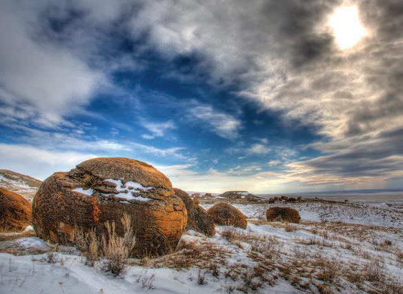
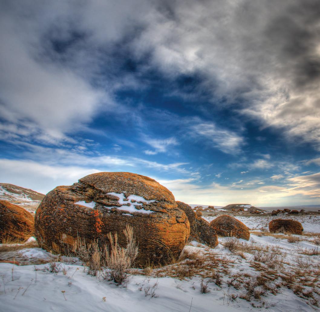
FRONT COVER
Large spherical sandstone concretions dot the badlands landscape at Red Rock Coulee, approximately 60km SW
Photo by Brett Frostad.
RESERVOIR ISSUE 01 • JANUARY 2014 3 JANUARY 2014 – VOLUME 41, ISSUE 01 ARTICLES Geomechanics For Everyone, Part 5: Caprock Integrity of High-Pressure Injection Processes 21 2013 Gussow Geoscience Conference – Importance of Rock Properties in Unconventional Reservoirs .................................................................................................... 26 GeoConvention 2014: Focus 27 Go Take a Hike 28 Photo of the Month 31 The 2014 CSPG Executive Committee 32 Geology of the Mount Stephen Trilobite Beds and Adjacent Strata near Field B.C., Yoho National Park, New Perspectives on a 127 Year Old Discovery, Part 2 ........... 35 DEPARTMENTS Executive Comment 5 Technical Luncheons 8 Division Talks 13 Rock Shop 10, 14, 15, 16, 17, 18, 20
Medicine
spheres
sand, calcite,
iron oxide
nucleus
bones.
concretions
osme
largest
their kind
world.
of
Hat. The
were formed as layers of
and
collected around a
formed by shells, leaves, or
The
are
of the
of
in the
The RESERVOIR is published 11 times per year by the Canadian Society of Petroleum Geologists. This includes a combined issue for the months of July and August. The purpose of the RESERVOIR is to publicize the Society’s many activities and to promote the geosciences. We look for both technical and non-technical material to publish. Additional information on the RESERVOIR’s submission guidelines can be found at http://www.cspg. org/publications/pubs-reservoir-submissions.cfm. The contents of this publication may not be reproduced either in part or in full without the consent of the publisher. Additional copies of the RESERVOIR are available at the CSPG office. No official endorsement or sponsorship by the CSPG is implied for any advertisement, insert, or article that appears in the Reservoir unless otherwise noted. All submitted materials are reviewed by the editor. We reserve the right to edit all submissions, including letters to the Editor. Submissions must include your name, address, and membership number (if applicable). The material contained in this publication is intended for While reasonable care has been taken, authors and the CSPG make no guarantees that any of the equations, schematics, or devices discussed will perform as expected or that they will give the desired results. Some information contained herein may be inaccurate or may vary from standard measurements. The CSPG expressly disclaims any and all liability for the acts, omissions, or conduct of any third-party user of information contained in this publication. Under no circumstances shall the CSPG and its officers, directors, employees, and agents be liable for any injury, loss, damage, or expense arising in any manner whatsoever from the acts, omissions, or conduct of any third-party user. Designed and Printed by The Data Group of Companies, Calgary, Alberta.
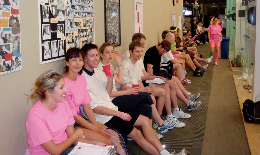

February 6-8, 2014 Early Bird Registration ends: Wednesday January 8th, 2014 For more information and to register today visit www.cspg.org 31st Annual CSPG Squash Tournament Canada’s Energy Geoscientists


CSPG EXECUTIVE
PAST PRESIDENT
Paul MacKay • Shale Petroleum Ltd. paul.mackay@shalepetroleum.com Tel: 403.457.3930
PRESIDENT
Dale Leckie • Nexen Inc. daleleckie@nexeninc.com Tel: 403.613.0458
PRESIDENT ELECT
Tony Cadrin • Journey Energy Inc. tony.cadrin@journeyenergy.ca Tel: 403.303.3493
FINANCE DIRECTOR
Gord Stabb • Durando Resources Corp. gstabb@durando.ca Tel: 403.819.8778
FINANCE DIRECTOR ELECT
Astrid Arts • Cenovus Energy aarts@barrick-energy.com Tel: 403.766.5862
DIRECTOR
Alexis Anastas • Nexen ULC alexis_anastas@nexeninc.com Tel: 403.699.4965
DIRECTOR
Andrew Fox • MEG Energy Corp. andrew.fox@megenergy.com Tel: 403.770.5345
DIRECTOR
Milovan Fustic • Statoil Canada Ltd. MFUS@statoil.com Tel: 403.724.3307
DIRECTOR
Michael Laberge • Channel Energy Inc. mlaberge@surgeenergy.ca Tel: 403.301.3739
DIRECTOR
Robert Mummery • Almandine Resources Inc. mummery1@telus.net Tel: 403.651.4917
DIRECTOR
Weishan Ren • Statoil Canada Ltd. wren@statoil.com Tel: 403.724.0325
DIRECTOR
Darren Roblin • Endurance Energy snowice@telus.net Tel: 587.233.0784
EXECUTIVE DIRECTOR
Lis Bjeld • CSPG lis.bjeld@cspg.org Tel: 403.513.1235
EXECUTIVE COMMENT
A message from 2014 Past President, Paul Mackay

Welcome Home
Twelve months ago the CSPG had a very enthusiastic incoming president who was filled with ideas about what the CSPG could become. Twelve months later the CSPG has a president who may be a bit more circumspect but has not lost any enthusiasm or desire for the Society. Often we equate enthusiasm with naiveté and know that with time the individual filled with enthusiasm may become a cynical shell whose only desire is to play out the string and hand the reins over to someone else. This is not the case this year and in reality it is rarely the case when it comes to the presidency in this Society.
As president I have had the opportunity to be involved in several events that the general membership would not be aware of and are not broadly advertised. A few had deeper meaning to me and has left a lasting impression. One of my first events was the under 35 member reception. This is a party, but it is a party where the over-whelming question is “How do I get involved”? I left (earlier than most) with a pocket full of names of future volunteers and an over-whelming feeling that our organization is one with great promise.
A bit later I was at the long-term members’ event. At that event we read out the citation for the Honorary Members. This was a task that caught me off-guard and I was surprised at my reactions as I read through the citation. I was able to see the impact of dedicated involvement. I was in a room and read out a long list of accomplishments that three of our members made to the CSPG. Everyone listened closely and there was genuine applause for the effort that these
members had made to their society. It was very simply – moving. What also hit me was there was the same enthusiasm that I had seen in the under 35 group.
I was in a room that was loud with laughter and genuine joy at the other end of the age spectrum but the similarities greatly outweighed the differences. It was these types of events that stick in my mind as I reflect on the past year.
This is not to say that there were no accomplishments. Your Board accomplished great things in the past year. The Society entered into a new relationship with our sister societies (CSEG and the CWLS) to form GeoConvention a new joint partnership that will help us advance our national convention to be the premier geotechnical convention in North America. In reality we know we are close but this partnership should help us consolidate and build more effectively on a year-to-year basis.
We began our Ambassador initiative with great success and an understanding of the issues facing geologists who work in other areas of the country. We want to foster these groups and make them more successful as they reach their maximum potential. This program should bring relevance of the CSPG to the rest of the country and help us make the ‘C’ in our name truly stand for ‘Canadian’. We have also begun a process to grow our Education Trust Fund (ETF) into a meaningful force that will advance geologic education across the country and foster
(Continued on page 7...)
RESERVOIR ISSUE 01 • JANUARY 2014 5

CORPORATE SPONSORS
SAMARIUM
geoLOGIC systems ltd.
TITANIUM
APEGA
Shell Canada Limited
PLATINUM
AGAT Laboratories
Cenovus Energy Inc.
ConocoPhilips
IHS
Imperial Oil Resources
Nexen Inc .
GOLD
Devon Energy Corp
Enerplus Corporation
MEG Energy Corp.
Tourmaline
Schlumberger Canada Limited
Statoil Canada
SILVER
Athabasca Oil Corporation
Baker Hughes
Canadian Natural Resources Ltd.
CGG Services (Canada) Inc.
Encana Corporation
Husky Energy Inc.
ION GeoPhysical
Loring Tarcore Labs Ltd.
MJ Systems
Petrosys
Suncor Energy
BRONZE
Arc Financial Corporation
Arcis Seismic Solutions
Belloy Petroleum Consulting
Earth Signal Processing Ltd.
Exova Canada Inc.
Hunt Oil
Olympic Seismic Ltd.
PGS
Pro Geo Consultants
Roke Technologies Ltd.
Saudi Aramco
Seisware
Sensor Geophysical Ltd.
Talisman Energy
Tesla
TGS
As of December 2013
A Special Thanks to Geologic Systems Ltd., CSPG ’s Top Sponsor of the Month
(...Continued from page 5)
a renewed spirit of excitement in the Geosciences. We have retooled much of our Outreach program, focusing on programs that will give maximum impact and hopefully expanding our reach across the country. We are directing more energy to our publications and courses, in this way we expand our technical relevance to the broader geologic community. These and many more initiatives were made possible by the hard dedicated work of your Board Members and the legion of volunteers supporting them and you. Their names are in this magazine and if you know any of them no matter how remotely please do me the favour of sending them a quick email of thanks or better yet buy them a cup of coffee. They are wonderful people and worth spending time with, even over coffee.
The incoming Board and president are filled with promise and enthusiasm. I expect that given the quality of these new individuals they will have the same enthusiasm this time next year. It is said that an organization is only as strong as its leaders, but in the case of the CSPG I do not believe this. This organization is strong because we have enthusiastic youth and even more enthusiasm in our long-term members group. We have volunteers who define dedication and a trained office staff that are willing to take on the almost impossible task of organizing a group of geologists. This organization is strong because we enjoy our science and we share that passion with each other to bring greater understanding. This organization is strong because we build on an amazing tradition from our past but we have even greater potential in our future. We are running to our centennial in 2027. I look forward to seeing what the CSPG will be like at that time.
Through the year I had several members ask me what they could do for the Society. The number one task that each member can engage with is to ask every geoscientist in their organization if they are a member of the CSPG and to encourage them to take the time to join. Membership is a privilege that is open to all geoscientists. With it come incredible opportunities to learn through our many public lectures. With membership comes access to our publication archives and a treasure chest of ideas; but, with membership comes something much more special and much more valuable. The CSPG is more than a technical society; it is a community of passionate individuals that find excitement and stimulation in the study of the earth and the exploration of ideas. It is community in every sense of the word and with that comes acceptance and understanding.
The greatest compliment I receive through the year was a comment made to me by a long serving member who had stepped back for a few years. We were at a CSPG event and he came up to me, shook my hand, and said that he was having a great time – he felt like the youth who had discovered the Society in his past, he said he felt like he was home. This is who we are and this is the greatest benefit of being a member. So whether you have been a member for fifty years or you have just received your first copy of the Reservoir, It is my great pleasure to say, “Welcome Home”.
RESERVOIR ISSUE 01 • JANUARY 2014 7

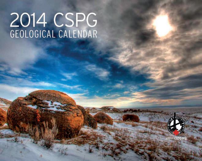
Start your year off right with the 2014 CSPG Geological Calendar Available NOW for 10 dollars! Online: www.cspg.org Office: 110-333, 5th Ave SW
TECHNICAL LUNCHEONS JANUARY LUNCHEON
Oil and Gas Exploration in the Arctic
SPEAKER
Alastair Fraser
AAPG Distinguished Lecturer
11:30 am, Tuesday, January 28, 2014 Calgary, TELUS Convention Centre Macleod Hall C/D, Calgary, Alberta
Please note: The cut-off date for ticket sales is 1:00 pm, three business days before event. [Thursday, January 23, 2013]. CSPG Member Ticket Price: $45.00 + GST. Non-Member Ticket Price: $47.50 + GST.
Each CSPG Technical Luncheon is 1 APEGA PDH credit. Tickets may be purchased online at https:// www.cspg.org/eSeries/source/Events/index.cfm.
In overcoming the technical challenges of oil production in the Arctic, are we making the most of a strategic resource or heading for an environmental and political minefield?
The vast Arctic region is probably the last remaining unexplored source of hydrocarbons on the planet.
In the past three decades of oil exploration in the Arctic, more than 200 billion barrels of oil have been discovered. Ultimate resources are estimated at 114 billion barrels of undiscovered oil and 2000 trillion cubic feet of natural gas. If these estimates are correct, these hydrocarbons would account for more than a fifth of the world’s undiscovered reserves. This great prize, in a world of diminishing resources, has stimulated both governmental and industry interest in areas such as the US and Canadian Beaufort Sea, East and West Greenland and the Kara Sea.
Balanced against this are the considerable technical challenges of exploring and producing hydrocarbons in areas where sea ice is present for more than half the year as well as the underlying threat of damage to a pristine Arctic environment.
Harnessing the considerable resources of the ‘Final Frontier’ is going to be fraught with many technical, political and environmental challenges that will engage many minds, both scientific and political over the next half century.
BIOGRAPHY
Al Fraser currently holds the post of EGI Chair in Petroleum Geoscience at Imperial College, London. He has a BSc from Edinburgh University and a PhD from Glasgow University in the UK, both in Geology. Previously, Al worked for BP as a Petroleum Geologist/ Exploration Manager for over 30 years. His career in petroleum exploration, took him to most corners of the world including N. America, Europe, Africa,
Middle East and the Far East. Following the BP Amoco merger, he led the team which made the significant Plutonio discovery in Block 18, deepwater Angola. He is the author of many papers on the Petroleum Geology of extensional basins most notably on the North Sea Jurassic and northern England Carboniferous.
He continues to pursue his interests in rifts and rifted margins and this forms his main area of research focus. Areas of interest will include the following:
• Eastern Mediterranean – the Messinian Salinity Crisis, salt-sediment interaction and its impact on hydrocarbon prospectivity of the region
Webcasts sponsored by

• Arctic Oil & Gas Exploration – the final exploration and production frontier. What is the scale and distribution of these resources and how can we develop the technologies to exploit these reserves in a socially and environmentally acceptable way?
• South Atlantic Margins – conjugate margin evolution and fill. Crustal to basin scale.
An additional and important aspect of his role is as Director of the EGI/Imperial Research Alliance. Al is currently Science Secretary of the Geological Society of London.
RESERVOIR ISSUE 01 • JANUARY 2014 9
Systematic Assessment of Water Resources to Support Unconventional Play Development, West-Central Alberta
SPEAKER
Brad J.R. Hayes Petrel Robertson Consulting Ltd.
11:30 am
Wednesday, February 5th, 2014 Calgary, TELUS Convention Centre Macleod Hall C/D Calgary, Alberta
Please note: The cut-off date for ticket sales is 1:00 pm, three business days before event. (Friday, January 31st, 2014.) CSPG Member Ticket Price: $45.00 + GST. NonMember Ticket Price: $47.50 + GST.
Each CSPG Technical Luncheon is 1 APEGA PDH credit. Tickets may be purchased online at https://www.cspg.org/eSeries/source/Events/ index.cfm.
ABSTRACT
Shale and tight sandstone and carbonate
reservoirs are now being developed in the heart of the Western Canada Sedimentary
Basin using horizontal wells and multizone frac completions. Devonian Swan Hills carbonates and Duvernay shales, Triassic Montney siltstones, and Cretaceous Wilrich and Cardium sandstones are the bestknown and most widespread plays. While drilling and completions methodologies vary by play and are still being optimized in many cases, there is a clear need for large source water volumes and secure water disposal zones to support field operations, particularly where high-volume slickwater fracs are part of the story.
A revised regulatory framework being put into place by the Alberta Energy Regulator demands that operators plan their unconventional development operations, including water sourcing and disposal on a project scale and play wide basis, and in collaboration with other operators where possible. It is important, therefore, that
10 RESERVOIR ISSUE 01 • JANUARY 2014
TECHNICAL LUNCHEONS FEBRUARY LUNCHEON Webcasts sponsored by ROCK SHOP Opus Training Group 403 720-9810 www.opustraininggroup.com Geology Training for the Petroleum Industry Wellsite 101
operators have regional knowledge of water resources, and the ability to interact readily with nearby competitors.
The West-Central Alberta Basin (WCAB) Water Project is designed to characterize surface and subsurface water resources across broad unconventional oil and gas play fairways in west-central Alberta. It provides the foundation to support more detailed characterization projects addressing specific unconventional developments. Technical work is being performed by independent consulting groups, while project governance and financial support is provided by a consortium of oil and gas producers under the umbrellas of PTAC (Petroleum Technology Alliance of Canada) and CAPP (Canadian Association of Petroleum Producers).
In order to address water issues as broadly as possible, the WCAB Project has been designed to assess water resources at surface, in surficial sediments and shallow non-saline aquifers, and in deep saline aquifers. Initial work in 2012/2013 focused on data collection and cataloguing, but by summer of 2014, more detailed modeling and analytical / predictive work will be completed. Collaboration with the Regulator ensures that Project work will be of direct value in regulatory applications. Ultimately, Project results will be made public so that all concerned stakeholders can gain a common understanding of the best technical solutions for use of both non-saline and saline water resources. At the present time, project data are being displayed in an integrated GISdriven website for client companies; more sophisticated display, query, and decisionsupport tools will be developed beginning later in 2014.
The WCAB Project is an excellent example of the collaborative work that industry needs to undertake in order to demonstrate environmental sensitivity in developing unconventional resources. Sharing this information with regulators and public stakeholders is an important step in gaining societal acceptance for the development work that needs to be done.
BIOGRAPHY
Brad Hayes is President of Petrel Robertson Consulting Ltd., a consulting firm engaged by clients including industry, government agencies, and legal and financial organizations, to address conventional and unconventional hydrocarbon exploration and development.
Much of Brad’s work on unconventionals during the past few years has focused on
characterization of subsurface aquifers as potential water source and disposal zones. He has led PRCL in regional subsurface aquifer projects in Horn River Basin, the BC Montney fairway, Central Mackenzie Valley and Deh Cho areas of NWT, and now in west-central Alberta. Ben Kerr of Foundry Spatial and Derek Brown of Strategic West are other key members of the team examining surface, shallow and deep water sources in the WCAW Project.
Brad received a PhD from the University of Alberta, and a B.Sc. from the University of Toronto, and has been with PRCL since 1996.
Brad is an active member of the CSPG, and served as its President in 2001. He is also a member of AAPG, GAC, and APEGBC, and currently sits on APEGA Council.
RESERVOIR ISSUE 01 • JANUARY 2014 11
Client: RJ DeRkitt & AssociAtes Docket: RJD-3362 File Description: RecRuitment AD Date: octobeR 21, 2013 Size: 4.8125” x 7.3125” Colour: cmYk
TECHNICAL LUNCHEONS FEBRUARY LUNCHEON
A Brief Tectonic and Depostional History of the Northern Gulf of Mexico
SPEAKER
Joseph Carl Fiduk AAPG Distinguished Lecturer
11:30 am Thursday, February 27th, 2014 Calgary, TELUS Convention Centre Macleod Hall C/D, Calgary, Alberta
Please note: The cut-off date for ticket sales is 1:00 pm, three business days before event. (Monday, February 24th, 2013.) CSPG Member Ticket Price: $45.00 + GST. Non-Member Ticket Price: $47.50 + GST.
Each CSPG Technical Luncheon is 1 APEGA PDH credit. Tickets may be purchased online at https://www.cspg.org/eSeries/source/Events/ index.cfm.
ABSTRACT
The Gulf of Mexico (GOM) is the 9th largest body of water on earth, covering an area of approximately 1.6 million km2 with water depths reaching 4,400 m (14,300’). The basin formed as a result of crustal extension during the early Mesozoic breakup of Pangaea. Rifting occurred from the Late Triassic to early Middle Jurassic. Continued extension through the Middle Jurassic combined with counter-clockwise rotation of crustal blocks away from North America produced highly extended continental crust in the subsiding basin center. Subsidence eventually allowed oceanic water to enter from the west leading to thick, widespread, evaporite deposition. Seafloor spreading initiated in the Late Jurassic eventually splitting the evaporite deposits into northern (USA) and southern (Mexican) basins. Recent work suggests that this may have been accomplished by asymmetric extension, crustal delamination, and exposure of the lower crust or upper mantle rather than true sea floor spreading (or it could be some combination of the two). By 135 Ma almost all extension had ceased and the basic configuration of the GOM basin seen today was established. The Laramide Orogeny was the last major tectonic event impacting the GOM. It caused uplift and erosion for the NW margin from the Late Cretaceous to early Eocene.
Sedimentation in the GOM can be divided into five megasequences: Rifting to Upper Jurassic, Lower Cretaceous, Upper Cretaceous, Paleogen, and Neogene. The oldest sediments are clastics in the Upper Triassic known only from peripheral rift basins onshore. In the basin center evaporites of the Middle Jurassic Louann Formation are the oldest deposits encountered. Deformation and movement of the Louann salt affects almost all the overlying strata and plays a very important role in all aspects of the basin’s petroleum systems. Above the salt, Upper Jurassic marine shales of Oxfordian and Tithonian age comprise two of the most important petroleum source beds. In the Lower Cretaceous megasequence the Aptian age Sligo and Albian age Stuart City carbonates established basin rimming reef margins that divided shelf from deep water. These reefs sit above the structural hinge between thick and thin continental crust. In the Upper Cretaceous megasequence the Cenemanian age Woodbine-Tuscaloosa system represent the first coarse clastics to advance beyond the Lower Cretaceous shelf margin. The megasequence is capped with tsunami deposits from the Chicxulub impact on the Yucatan peninsula. The Paleogene1 and Neogene 2 megasequences are dominated by major clastic inputs of the lower Wilcox1, upper Wilcox1, Vicksburg1, and Frio1, lower Miocene2, middle Miocene2, upper Miocene2, Pliocene2, and Pleistocene2. These progradational episodes not only advanced the shorelines and shelf margins significantly but also deposited thick sands (major reservoirs) in the deep GOM. The Neogene progradational episodes are strongly influenced by glacioeustatic cycles of increasing frequency and amplitude
BIOGRAPHY
Joseph has a B.S. and M.S. degree in Geology from the University of Florida, an M.B.A degree from the University of Texas of the Permian Basin and a Ph.D. in Geology and Geophysics from the University of Texas at Austin. He has worked for the USGS, Gulf Oil, Discovery Logging, the Texas Bureau of Economic Geology, British Petroleum, Texas A&M University, the University of Texas, the University of Colorado, as a private consultant, and Chief Geologist for CGG and CGGVeritas. Joseph is currently Chief Geologist for WesternGeco in Houston, TX.
Joseph’s research interests cover coastal and shelfal clastic deposition, salt structural deformation and evolution, basin analysis, shelf margin to deep marine depositional processes, marine sedimentology, petroleum systems analysis, and the use of three-dimensional seismic data in
Webcasts sponsored by
petroleum exploration. He is currently involved in salt-sediment interaction research in the Flinders Ranges, South Australia, fluvial deltaic deposition in the Cretaceous Seaway of NW Colorado, and deep marine stratigraphic analysis in the Gulf of Mexico. Joseph teaches internal training classes on seismic interpretation and salt tectonics for WesternGeco and external industry courses for Nautilus U.S.A. and local geologic societies.
He is a member of the American Association of Petroleum Geologists (AAPG) #352532 and a Certified Petroleum Geologist #5367. Joseph has served as a session chair at the 2001, 2004, 2008, 2010, and 2011 National Conventions. He was an invited speaker at the 1991, 1993, 2004, 2005, and 2010 conventions and at the 1999 and 2008 International conferences. Joesph has also been invited to speak to the Moroccan Association of Petroleum Geologists (2007) and the Mexican Association of Petroleum Geologists (2008).
Joseph is a member of the Houston Geological Society (HGS) #10461 and has been an alternate delegate for the HGS since 2004 and has sat as a voting representative four times. In addition, Joseph has served as a session chairman at the 2006 and 2012 GCAGS meetings. He co-instructed a short course in Deepwater Depositional Processes at the 2007 GCAGS meeting in Corpus Christi. Joseph has been an invited speaker to the HGS dinner meetings in 1996 and in 2005 as well as an invited speaker to the New Orleans Geological Society (1999), the Southwest Research Institute (2001), the Costal Bend Geophysical Society & Corpus Christi Geological Society (2004), the HGS-PESGB 4th International Conference on African E & P (2005), the Lafayette Geological Society (2005), the New Orleans Geological Society (2006), the Dallas Geological Society (2007), and the Offshore Technology Conference (2010).
Joseph is a member of the Society of Exploration Geophysicists (SEG) #148620 and a member of the Geophysical Society of Houston #10461 and has served as a session chair at the 2009 National Convention.
Joseph is a member of the Society for Sedimentary Geology (SEPM) #43576 and a member of the Gulf Coast Section SEPM where he is currently president-elect. He has served on the Conference program advisory committee in 2005, served as a session chair in 2005, and was an invited speaker at the 10th Annual Research Conference (1989), 24th Annual Research Conference (2004), and the 25th Annual Research Conference (2005).
In his 30+ years as a working geologist Joseph has published 70+ peer-reviewed abstracts and papers.
12 RESERVOIR ISSUE 01 • JANUARY 2014
DIVISION TALKS INTERNATIONAL DIVISION
Exploration Opportunity in the Interior Rift Basins of Southern Chad, Africa
SPEAKER
Scott Gardiner
Manager - Business Development Caracal Energy Inc.
12:00 Noon
Wednesday January 15th, 2014 Nexen Plus 15 Conference Centre Nexen Annex Building 7th Ave. & 7th Street SW Calgary, Alberta
ABSTRACT
In 2011, Caracal Energy Inc. entered into three Petroleum Sharing Contracts (PSC’s) encompassing an area of over 26,000 sq km in the Doba and Doseo interior rift basins in Southern Chad. These PSCs have initial terms of five years. Any exploration oil discoveries made are declared and, if they are deemed commercial, may be incorporated into Exclusive Exploitation Area’s (EXA’s) which allow wells to be produced for 25 years. At the completion of the initial five year term of the exploration phase of the PSC, 50% of the PSC areas, exclusive of any EXAs, must be relinquished. Caracal’s joint venture partners are Société
des Hydrocarbures du Tchad, a governmentowned entity, and Glencore Xstrata plc.
Exploration started in the Doba, Doseo and Salamat basins in the 1970s, and in the past decades has involved Conoco, a consortium containing ExxonMobil/Chevron/Petronas, and Encana amongst others. Caracal’s acreage was obtained in 2011 by the routine relinquishment of the consortium’s acreage after their drilling of 16 wells in the 1980’s, 1990’s and 2000’s.
The consortium made discoveries primarily in the Upper Cretaceous reservoirs at fields such as Kome (600 mmbbls), Miandoun, Bolobo, Nya, and Mandoulli. These fields came on production in 2003-2004 via a newly
constructed Export Transportation System (ETS) pipeline, which is 1,070 km long, 30” diameter, and has a 250,000 bopd nameplate capacity to the Cameroon coast at Kribi.
The geologic setting of Caracal’s acreage spans two Cretaceous interior rift basins, the Doba and Doseo, which contain extensional, transtensional, and contractional inversion structures, with and without basement involvement. Prospect targets are characterized by multiple, stacked, Upper and Lower Cretaceous siliciclastic reservoirs. Average porosities range from 12-25% in the Lower Cretaceous and from 20-30% in the Upper Cretaceous; permeabilities range up to several Darcies within both the Lower and Upper Cretaceous. Reservoir depths are typically 1,000 to 4,000 metres. These fluvio-deltaic reservoirs contain lacustrine-sourced, paraffinic, low GOR oil; 18-24° API in the Upper Cretaceous reservoirs and 29-47° API in the Lower Cretaceous. Tested rates, by Caracal, for Lower Cretaceous reservoirs range up to 4,000 bopd. Production planning is to optimize using electric submersible pumps (ESP’s) for artificial lift.
When Caracal acquired the acreage in Chad there were five exploration wells that had tested oil in the Lower Cretaceous, of which one well was in the Doba basin and four were in the Doseo Basin. As Badila and Mangara were declared discoveries, Caracal shot 3D seismic (467 sq km), drilled and tested appraisal wells, been granted EXA areas, and undertook field development and built production facilities. Caracal constructed a pipeline from Badila to the ETS. The Badila
Sponsored by (Continued on page 14...)
RESERVOIR ISSUE 01 • JANUARY 2014 13
field’s first oil production was on September 30, 2013; this was the first ever third party shipment of crude via access to the ETS pipeline.
The 3D seismic programs confirmed the presence of several other adjacent prospects, one of which is near Mangara called Krim. Krim, Caracal’s first exploration well, was drilled in Q3 2013 and is a significant discovery, similar to Mangara. The Badila 3D seismic also confirmed a number of separate structures including one at Bitanda; a new play type, which is due to spud in Q4 2013. Overall, Caracal has an exploration inventory of >80 prospects; 35+ of which are drill ready. These will be drilled over the next two to five years, to realize the value of the exploration opportunity present within the interior rift basins of Chad, Africa.
The content of this talk is due to the talents and dedicated hard work of the Exploration and Asset Management teams at Caracal Energy Inc. For this presentation, Scott is the messenger for their work results and would like to thank them for this opportunity to speak on their behalf.
ROCK SHOTS
Framing the Africa Playing Field for Canadian E&P Players
SPEAKER
David Bernie - President, GEOSEIS
(SAME TIME AND LOCATION AS INTERNATIONAL DIVISION TALK, JANUARY 15TH, 2014)
ROCK SHOP
BIOGRAPHY
Scott has 29 years of Industry experience which began in the Western Canada Basin at Esso (Imperial Oil) for eleven years, including an international assignment in Houston, Texas at Exxon Production Research Company. This was followed by twelve years working exclusively international opportunities at Nexen Inc. in various technical and management capacities, and eight years of both conventional and international unconventional at Talisman Energy Inc., in Global New Ventures and as Exploration Manager in Stavanger, Norway. In June 2013, Scott joined Caracal Energy Inc. in Calgary as Manager – Business Development primarily focused on Africa. His work has taken him across the globe, including major efforts in Yemen, Chad, Iraq, Colombia, Algeria, Argentina, North Sea UK & Norway, Gulf of Mexico, and Saudi Arabia, among others.
Scott graduated in 1982 from McMaster University in Hamilton, Ontario with a B.Sc. (Hons) in Geology, and in 1984 from Memorial University of Newfoundland with an M.Sc. in deepwater sedimentology. He is a member of CSPG, AAPG, APEGA, CSUR, PESGB, SPE & HGS.
INFORMATION
There is no charge. Please bring your lunch. The facilities for the talk are provided complimentary of Nexen, coffee by IHS and refreshments by Geochemtech Inc. The speakers are provided with gifts by Drilling Information and Quad Operations. For further information or if you would like to give a talk, please contact Bob Potter at (403) 863-9738 (ropotter@geochemtech. com), Kevin Morrison at (403) 536-3788 (morrison@antrimenergy.com), Jűrgen Kraus (jkraus@me.com, Jon Noad (403) 513 7541 (jon.noad@huskyenergy.com) or visit our Face Book page (“CSPG International Division”).
FARHAT HYDERI,P.Geol.

3300, 205 - 5th Ave SW Calgary, AB T2P 2V7
Tel403 726 0666
Fax403 264 1262
Cell403 819 2516 farhat@sableconsultants.com SABLECONSULTANTS.COM
14 RESERVOIR ISSUE 01 • JANUARY 2014
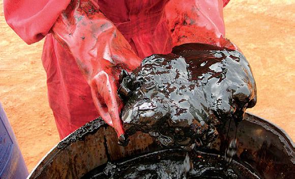
Mangara field, Chad: crude oil at 25°C.
petrographical & sedimentological descriptions for samples (thin section - fluid inclusion studies) conventional vertical/horizontal wells operations geology SPECIALIZED IN GEOLOGICAL WELLSITE SUPERVISION AND CORE ANALYSIS RockWell Consulting our best friend and most valuable partner is our client Stephan C. Dragomir president www .g e ok2. c om - phon e: 403.831.9941 - s dr a gomir @ge ok2. com SABLEPETROLEUM CONSULTANTSINC. WELLSITE GEOLOGICAL SUPERVISION
President
CEO
/
Conventional Wells Coring Programs Heavy Oil/Oil Sands Coal Bed Methane SAGD Horizontal Project Supervision (...Continued from page 13 )
DIVISION TALKS BASS DIVISION
Paleogeography, Tectonic
Evolution, and Mud Transport Processes across a Cretaceous Ramp in a RapidlySubsiding Foredeep: AlbianCenomanian of NE British Columbia
SPEAKER
Dr. Piotr Angiel
Imperial Oil
12:00 Noon
Thursday, January 16th, 2014
ConocoPhillips Auditorium, Gulf Canada Square, 401 – 9th Ave. S.W Calgary, AB
ABSTRACT
The upper Albian to lower Cenomanian succession in northeastern British Columbia was deposited in the proximal foredeep and is greatly vertically expanded relative to the
ROCK SHOP
more eastern part of the basin. The study interval has a wedge-shaped geometry, and is ~780 m thick in the west and thins dramatically to ~280 metres over a distance of ~170 km. Rapid facies changes result in lithostratigraphic units being strongly diachronous.
In order to determine depositional history, the present study subdivided the Upper Fort St. John Group into 16 genetically-related allomembers. The new allostratigraphic correlations established in this study, combined with previous studies, permit the reconstruction of lateral facies changes from the western shoreline of the Western Interior Seaway in the proximal foredeep to the forebulge in central Alberta, over a distance of about 800 km.
The Upper Viking, Westgate and Fish Scales alloformations collectively span approximately 2.7 Myr. The stratal geometry of the studied interval can be interpreted to be the result of two pulses of flexural subsidence (recorded by units VD and WA, and units WD, FA and FB) separated by a period of more subdued subsidence (units WB and FC). The stratigraphic surfaces in the studied interval are of regional extent, and can be correlated for between 300-1000 km. Almost all flooding surfaces can be traced throughout the study area (50 000 km2).
The sedimentological and stratigraphic evidence indicates that the proximal foredeep was occupied by a shallow, low-gradient, storm-dominated ramp. The abundance of wave-influenced structures (e.g. swaley and hummocky cross-stratification, wave and current ripples) suggests strong wave-
reworking of sediment on a shallow marine ramp. The deposition on the muddy portion of the shelf is interpreted to have been dependent on wave-enhanced sediment gravity/geostrophic flows. Along-shelf transport was controlled by geostrophic flows towards the southeast.
At least 16 major sequences are detectable on a regional scale; sequences have an average periodicity of 125-170 kyr. Facies successions and regional stratal geometry suggest relative sea-level fluctuations were of the order of 10-30 m which, on a timescale of the order of 100 kyr, can only be explained by a glacio-eustatic mechanism.
BIOGRAPHY
Piotr Angiel, Ph.D., is a geoscientist at Imperial Oil. He is currently working in the Cold Lake Geoscience team. He received his M.Sc. in Geography in 2003, and his M.Sc. in Geology in 2008, both from the University of Warsaw in Poland. He worked 2 years as a researcher based at the Polish Antarctic Station on King George Island (West Antarctica). In 2013 he received his Ph.D. in Geology from the University of Western Ontario.
INFORMATION
BASS Division talks are free. Please bring your lunch. For further information about the division, joining our mailing list, a list of upcoming talks, or if you wish to present a talk or lead a field trip, please contact either Steve Donaldson at 403-766-5534, email: Steve.Donaldson@ cenovus.com or Mark Caplan at 403-817-2603, email: mark.caplan@brionenergy.com or visit our web page on the CSPG website at http:// www.cspg.org.

RESERVOIR ISSUE 01 • JANUARY 2014 15
Sponsored by
210, 237 – 8th Ave. S.E. Calgary, AB T2G 5C3 Phone: 403.263.5440 Fax: 403.263.2331 m.sahota1@shaw.ca Conventional Vertical and Horizontal Wells Oil Sands - SAGD/Coring Programs Shale Gas/Oil Shales Coal Bed Methane Project Supervision Email: progeo@telus.net Tel: (403) 262-9229 Fax: (403) 265-0377 Website: www.progeoconsultants.com
DIVISION TALKS PALEONTOLOGY DIVISION
Traveling the Land of Dragons for Curiously Primitive Sauropod Dinosaurs
SPEAKER
Tetsuto Miyashita
Ph. D. Candidate, Department of Biological Sciences, University of Alberta
7:30 PM
Friday, January 17th, 2014
Mount Royal University, Room B108 Calgary, AB
ABSTRACT
China is an increasingly attractive country for doing dinosaur research, with new significant taxa added for almost every major lineage every decade. I recently had an opportunity to travel China for a month, partly for descriptive projects on sauropod dinosaurs and partly for continued work on tyrannosaur phylogeny and theropod anatomy. This travel took me from the central fossil collections in Beijing to various localities in Sichuan Basin and to outskirts of the heavily industrial city of Chongqin. I will report on this trip, as well as introduce two new sauropods I worked on while in China.
Sauropod dinosaurs were dominant megaherbivores on all continents throughout the Jurassic times. It remains an open question,
ROCK SHOP
however, as to how each continental fauna developed with different lineages of sauropods. East Asia from Middle to Late Jurassic times is particularly an interesting place and time to explore this question. Unusually rich Middle Jurassic localities from China — rare elsewhere in the world — document a diverse array of sauropods from the most basal eusauropod Shunosaurus to the potentially oldest neosauropods Abrosaurus and Bellusaurus. On the other hand, the Late Jurassic sauropod fauna from China is dominated almost entirely by a single genus Mamenchisaurus.
Recent fieldwork in China recovered two new sauropods that bear on this problem. One of the two is a recently named taxon Nebulasaurus taito from the Middle Jurassic of Yunnan Province. Although only known from a braincase, a cladistic analysis places Nebulasaurus as a sister taxon to Spinophorosaurus from the Middle Jurassic of Africa.
The second taxon is a new genus and species of a mamenchisaurid from the Late Jurassic of Qijian District, southern China. The specimen consists of an incomplete skull, partly articulated axial skeleton, and fragmentary appendicular skeleton. This new taxon is the first mamenchisaurid from the Late Jurassic of China that is definitively distinct from Mamenchisaurus, indicating a greater width to the morphological and taxonomic diversity of the Late Jurassic mamenchisaurids.
The revised faunal list identified dramatic transitions in the sauropodomorph fauna from the Jurassic to Cretaceous of Asia; the transitions are consistent with the geographic isolation of that continent through Late Jurassic times. Non-sauropod sauropodomorphs, nonmamenchisaurid eusauropods (including basal macronarians), and mamenchisaurids successively


Sponsored by
and gradually replaced one previous grade through Jurassic Period, and titanosauriforms excluded all other sauropod lineages across the Jurassic-Cretaceous boundary.
BIOGRAPHY
Tetsuto Miyashita is Ph.D. student at the University of Alberta. A book by a prominent Canadian dinosaur paleontologist Philip Currie – a Christmas gift from parents when he was ten – sparked his dream of becoming a paleontologist. He moved to Drumheller, Alberta, at age 16 to volunteer for Royal Tyrrell Museum of Palaeontology. He followed the master again to Philip’s appointment at the University of Alberta, where he has been stumbling through three degrees and one major illness, and where his academic deviations from paleontology into marine biology, embryology, and invertebrate zoology (and all other troubles he runs into) give constant headache to his two supervisors, Philip and evolutionary biologist Richard Palmer. His recent adventure was to spend two summer months at Marine Biological Laboratory at Woods Hole, MA, where he engaged in developmental research under Nobel laureates and Nobel hopefuls, and served as a class captain to lead the 120th class of Embryology to smashing victory over Physiology in a softball game after 13 years of losing streak.
INFORMATION
This event is jointly presented by the Alberta Palaeontological Society, Mount Royal University, the CSPG Palaeontology Division and Cenovus Energy. For details or to present a talk in the future please contact CSPG Paleo Division Chair Philip Benham at 403-6913343 or APS Coordinator Harold Whittaker at 403286-0349 or contact programs1@albertapaleo.org . Visit the APS website for confirmation of event times and upcoming speakers: http://www.albertapaleo.org/.


16 RESERVOIR ISSUE 01 • JANUARY 2014
• Domestic and International wellsite supervision • Conventional and Unconventional wells • Extensive Hz experience • Customized corporate solutions available (403) 250-3982 sales@clconsultants.ca www.clconsultants.ca 1602 – 5th St N.E. Calgary, AB. T2E 7W3 Phone: 403-233-7729 www.tihconsulting.com e-mail: tih@shaw.ca T.I.H. Consulting Ltd. Geologic Well-Site Supervision
DIVISION TALKS STRUCTURAL DIVISION
Using Microseismic Data to Understand Subsurface Properties Through Hydraulic Fracture Modeling
SPEAKER
Neda Boroumand
IUniversity of Calgary
12 noon Thursday, January 23, 2014 Conference Centre Room A, +30 level, Western Canadian Place (Husky Energy), 707-8th Avenue S.W. Calgary, Alberta
ABSTRACT
Since its introduction by the industry in 1947, millions of hydraulic fracture treatments have been conducted until 2013 and led to enhanced hydrocarbon recovery. This technique is most commonly used today to access oil and gas located in unconventional reservoirs such as shale and tight sand formations.
The Horn River Basin, a shale gas geologic interval of commercial interest located in northeast British Columbia, has a significant amount of natural gas in place. Therefore, it is important to understand subsurface geomechanical behaviours so that retrieval of hydrocarbons can be optimized. A way to achieve this is by fracture modeling, which requires a set of inputs from geological data such as logs, engineering data like fracture treatment design, and more recently geophysical data such as microseismic maps.
One of the goals of modeling is to obtain a match between the observed and modeled fracture geometries. An energy based hydraulic fracture model is constructed so that one, a relationship between the various physical process (e.g. energy input and output components) can be examined and two, parameter selection of the various inputs can be determined. Calibration of fracture/geomechanical models using microseismic imaging brings new capabilities to parameter selection at the hydraulic fracture scale.
Two examples are presented where parameters are adjusted in order to calibrate the fracture model based on microseismic data; observed upward growth of the fracture is fit by adjusting stress-barrier contrasts, and fracture length is fit by altering empirical parameters such as fracture toughness. The breakdown of the various energy components considered are also shown and represent the physical processes taking place during the hydraulic fracture. By calibrating fracture parameters based on microseismic observations, important geomechanical insights can be achieved and
applied to optimizing hydrocarbon recovery and improving field development.
BIOGRAPHY
Neda Boroumand is a Ph.D. Student in Geophysics at the University of Calgary. Her research is aimed at understanding the hydraulic fracture process by integrating concepts from Geophysics, Engineering and Geology.
She is the Team Lead for the microseismic processing division of Halliburton in Canada. She has gained extensive experience in the acquisition, processing and interpretation of microseismic activity related to hydraulic fracturing and reservoir monitoring. She has been involved in a number of publications and has performed and overseen hundreds of microseismic monitoring projects in unconventional oil/gas reservoirs.
Neda is the incoming 2014 Chair of the CSEG Chief Geopysicists Forum and currently serves on the CSEG/CGF Microseismic Subcommittee.
INFORMATION
Structural Division talks are monthly-ish and cover a diversity of structural themes. Our Structural Division sponsors are HEF Petrophysical and Husky Energy. All are welcome and no registration is required. For additional information, to be placed on the Division e-mail list or to present a talk, please contact Darcie Greggs, Darcie.Greggs@huskyenergy.com.

RESERVOIR ISSUE 01 • JANUARY 2014 17
www.rpsgroup.com/energy (403)263-0449 17084 Global Leaders in Wellsite Geology Serving the petroleum industry for over 25 years ■■ Conventional Vertical / Horizontal Wells ■■ Unconventional Heavy Oil / CBM Wells ■■ International WSG / Operations Geology
Sponsored by ROCK SHOP
DIVISION TALKS GEOMODELING DIVISION
Honoring
the
Depositional, Diagenetic, and Tectonic History in a 3D Computational Model of a Carbonate Reservoir: Charles Fm., S.E. Saskatchewan
SPEAKER
Garrett K. Timmerman
Geomodeler
Enerplus Corporation
12:00 Noon
Wednesday, January 29th, 2014
Husky Conference Room A +30 Level South Tower 707 8th Ave. SW Calgary, Alberta T2P 3G7
ABSTRACT
INTRODUCTION
A reservoir model has been constructed for three pools currently undergoing a development plan that includes waterflood support from existing vertical and horizontal
wells and infill drilling with multi-lateral horizontal wells. The Freda Lake, Skinner Lake, and Neptune pools produce from the lower Ratcliffe member (Oungre Beds) of the Mississippian Charles Formation in the northcentral Williston Basin. The producing interval consists of inter-fingered limestone, dolomite, and anhydrite with stratigraphic trapping due to lateral facies changes and an overlying evaporite. In order to build a representative model the depositional, diagenetic, and tectonic factors that influence the reservoir have been considered as independent elements and then combined in a sequential workflow. Results of the model have been used to improve understanding of the areal reservoir limits, enhance OOIP estimates, and optimize the development strategy.
METHOD
Incorporating the depositional, diagenetic, and tectonic factors in a reservoir model can be achieved by addressing them independently and then building them into the model following the interpreted geologic development of the reservoir. Core and wireline log data have been utilized to identify and model the depositional facies in the reservoir using multi-point facies simulation (MPFS). Optimal reservoir trends generated from mapping and seismic attributes have been applied to the petrophysical properties that have been seeded into the facies model, giving a further subdivision into reservoir units. Zones of higher fracture intensity are interpreted from seismic attributes and then input into the model as local permeability and porosity enhancements based on the attribute distribution. Since each element is handled independently, uncertainty and sensitivity workflows can be applied to each element in the sequence to determine the
relative impact each step of the interpretation has on a volumetric ranking criteria. Final calibration of the model parameters is then done using dynamic flow simulation and history match analysis.
EXAMPLE
This modeling approach has yielded a high resolution static model for the Freda Lake, Skinner Lake, and Neptune pools. It has been shown that MPFS modeling was able to honor the epeiric ramp depositional model, preserving interpreted facies distributions and relationships. Using history match analysis, porosity and permeability values have been fine-tuned using the diagentic and tectonic trends and modifiers. With a validated model a much improved understanding of the areal extent of the reservoir and associated uncertainty in reservoir properties has been reached. This has allowed for an improved assessment of OOIP across the pools and helped define the capacity for the development program. The model is actively being used to optimize development scenarios for the future.
CONCLUSIONS
By sub-dividing the elements that affect the reservoir, their relative impact and sensitivities on volumetric and simulation performance can be independently modified and analyzed. This has yielded a high-confidence reservoir model that has been used to improve the understanding of areal limits and improve OOIP calculations.
BIOGRAPHY
Garrett Timmerman is a geomodeler with Enerplus, where he has developed and maintained models for Saskatchewan and Alberta assets


18 RESERVOIR ISSUE 01 • JANUARY 2014
Sponsored by ROCK SHOP CanRock Geo Inc. Log Analyst & Wellsite Geologist www.CanRockGeo.com info@CanRockGeo.com 1.403.813.0947 Onsite & Remote Geo-Steering Conventional Vertical & Horizontal Oil Sands & Heavy Oil Specialized in Viking, Cardium, Glauconite, Ellerslie, and Bluesky Core & Cuttings Analysis Project Supervision SAGD / Horizontal Specialized in Viking, Cardium, Glauconite, Ellerslie, and Bluesky

Three key elements in reservoir parameter distribution.
for over two years. Previously he worked for Schlumberger Data and Consulting services as a reservoir characterization instructor and a borehole geologist in Midland, Texas and Calgary. He has a B.Sc. in Geology from Michigan
Technological University, and a M.Sc. in Geology from the University of Montana.
INFORMATION
There is no charge for the division talk and we
GEOEDGES INC.
Detailed and accurate geology at your fingertips in Petra, GeoGraphix, ArcGIS, AccuMap, GeoScout and other applications for
welcome non-members of the CSPG. Please bring your lunch. For details or to present a geomodeling talk in the future, please contact Weishan Ren at (403) 724-0325, e-mail: wren@statoil.com.
Northern US Rockies & Williston Basin Geological Edge Set
Western Canada Geological Edge Set
Eastern US / Appalachian Basin Geological Edge Set
Western Canada: Slave Point, Swan Hills, Leduc, Grosmont, Jean Marie, Horn River Shales, Elkton, Shunda, Pekisko, Banff, Mississippian subcrops and anhydrite barriers in SE Sask., Bakken, Three Forks, Montney, Halfway, Charlie Lake, Rock Creek, Shaunavon, BQ/Gething, Bluesky, Glauconitic, Lloyd, Sparky, Colony, Viking, Cardium, Horseshoe Canyon and Mannville CBM, Oilsands Areas, Outcrops
US Rockies & Williston: Red River, Mississippian subcrops & anhydrite barriers (Bluell, Sherwood, Rival, etc), Bakken, Three Forks, Cutbank, Sunburst, Tyler, Heath, Muddy, Dakota, Sussex, Shannon, Parkman, Almond, Lewis, Frontier, Niobrara, Mesaverde shorelines, Minnelusa, Gothic, Hovenweep, Ismay, Desert Creek, Field Outlines, Outcrops
Texas & Midcontinent: Permian Basin paleogeography (Wolfcampian, Leonardian, Guadalupian), Granite Wash, Mississippian Horizontal Play, Chat, Red Fork, Morrow, Sligo/Edwards Reefs, Salt Basins, Frio, Yegua, Wilcox, Eagleford, Tuscaloosa, Haynesville, Fayeteville-Caney, Woodford, Field Outlines, Outcrops, Structures
North American Shales: Shale plays characterized by O&G fields, formation limit, outcrop, subcrop, structure, isopach, maturity, stratigraphic cross-sections. Includes: Marcellus, Rhinestreet, Huron, New Albany, Antrim, Utica-Collingwood, Barnett, Eagleford, Niobrara, Gothic, Hovenweep, Mowry, Bakken, Three Forks, Monterey, Montney, Horn River, Colorado
Eastern US / Appalachia: PreCambrian, Trenton, Utica-Collingwood, Medina-Clinton, Tuscarora, Marcellus, Onondaga Structure, Geneseo, Huron, Antrim, New Albny, Rhinestreet, Sonyea, Cleveland, Venango, Bradford, Elk, Berea, Weir, Big Injun, Formation limits, Outcrops, Allegheny Thrust, Cincinatti Arch, Field outlines
Deliverables include:
-Shapefiles and AccuMap map features
-hard copy maps, manual, pdf cross-sections
North American Shales Geological Edge Set
Texas & Midcontinent US Geological Edge Set
-Petra Thematic Map projects, GeoGraphix projects, ArcView map and layers files
-bi-annual updates and additions to mapping
-technical support
RESERVOIR ISSUE 01 • JANUARY 2014 19
contact: Joel Harding at 403 870 8122 email joelharding@geoedges.com
information
www.geoedges.com
ROCK SHOP PRACTICAL LOG ANALYSIS COURSES

20 RESERVOIR ISSUE 01 • JANUARY 2014
For Engineers, Geologists, Geophysicists, and Technicians Practical Quantitative Log Analysis: 15 – 17 Oct 2013 Analysis of Unconventional Reservoirs: 18 Oct 2013 Details and Registration at: www.spec2000.net/00-coursedates.htm In-House and Multi-Media Narrated Self-Study Courses Also Available === Instructor: E. R. (Ross) Crain. P.Eng. 1-403-845-2527 ross@spec2000.net === – 50 Years Worldwide Experience – Analysis, Training, Mentoring, Forensic Reviews –Strip Log Strip Log Horizontal Log Horizontal Log Mud Log Mud Log Log Viewer Log Viewer Log Manager Log Manager Log Analysis Log Analysis Suite 102, 7370 Sierra Morena Blvd SW, Calgary, AB T3H 4H9 info@WellSight.com 1-800-447-1534 (403) 237-9189 *Domestic & International Supervision 906, 505 6 St. SW Calgary, AB T2P-1X5 Jocelyn Lampron, P. Geol. President & CEO Wellsite Geological Supervision *Conventional Wells-Heavy Oil/SAGD *Coal Bed Methane Wells www.hopewellpetroleum.com info@hopewellpetroleum.com ph: 403.266.3132 cell: 403.818.8549 *On & Offshore Geological Supervision 742 Memorial Drive NW Calgary, Alberta T2N 3C7 P: 403 242 1522 F: 403 242 8223 E: office@chinookconsulting.ca www.chinookconsulting.ca SERVICES • Wellsite geological supervision • Core and cuttings petrographic studies • Operations geology • Remote geo-steering and remote geological supervision • Project management Reinson Consultants Ltd. GERRY REINSON, Ph.D., P.Geol. Regional and Reservoir Mapping, Core Studies, Field and Lab Courses greinson@telus.net www.reinsonconsultants.com TEL: (403) 861-8346 (The name that says it all!!!) Bus 403.234.7625 800, 555 - 4 th Avenue SW, Calgary, AB, T2P 3E7 info@WellsiteGeologists.com www.WellsiteGeologists.com
GEOMECHANICS FOR EVERYONE
Part 5: Caprock Integrity of High-Pressure Injection Processes
| By P.M.Collins, Petroleum Geomechanics Inc.; R.Bachman, Taurus Reservoir Solutions; Q.Chou, Weatherford
INTRODUCTION TO THE ARTICLE BY AMY FOX, CANADIAN DISCOVERY
Well, we have reached the final in our series of geomechanics articles for Reservoir. I think all of the authors will agree that it was a real challenge to pack a lot of information into each piece. At our early brainstorming meetings we came up with ideas that could have resulted in many more. Part of the problem is that our field is so broad, touching on, if not overlapping with, many others such as geophysics and engineering. I hope that we’ve at least been able to highlight some of the most pressing geomechanical topics in industry today. This final article certainly does. Being from the U.S., where thermal operations are far less prominent than in Canada, particularly Alberta, I greatly appreciate the insight that the authors provide on the importance of geomechanics in processes such as Steam-assisted Gravity Drainage (SAGD).
I hope that readers have enjoyed the series and will continue to come to its authors and contributors when issues relevant to geomechanics come up in their day-to-day work. I will say adieu for now by thanking my friends and colleagues, and even complete strangers, for the positive feedback we’ve received these last few months. It’s been a fun and, I hope, relationship-building project!
INTRODUCTION
The in situ recovery of bitumen from oilsands and now carbonates has expanded in magnitude. The dominant recovery process was cyclic steam stimulation (CSS) above fracture pressure but that has now been surpassed by steam-assisted gravity drainage (SAGD). Air injection (AI), electrical methods, and solvent-assisted processes are now being used as primary, secondary, and hybridized recovery processes.
All high-pressure injection processes must contain fluids within the reservoir at all times. Reservoir fluids escaping to shallower formations will result in groundwater contamination and lost production. In the extreme, there is the potential for a surface release of fluids or in the worst case a blowout to surface. It would be difficult if not impossible to remediate any damage to the caprock. This could result in a much lower limit to subsequent steam-injection pressures and the potential sterilization of the reserves.
As such, the integrity of the caprock and associated wellbores is essential. Hydraulic containment demands a laterally continuous geological formation of sufficiently low permeability and high capillary pressure to prevent the escape of reservoir fluids. The need for mechanical containment is vital. This requires that the minimum stress in the caprock exceeds its fluid pressure at all times. Additionally the caprock must withstand the stresses and deformations imposed upon it by the recovery process (Figure 1).
RECOVERY PROCESSES
The workhorse of in situ recovery has been CSS. Due to the low injectivity of cold bituminous oilsands, CSS steam injection must exceed the reservoir’s fracture pressure. For optimal performance and safety, CSS is limited to reservoirs with no thief zones where the minimum in situ stress is or becomes vertical. This ensures the development of horizontal fractures within the reservoir that contact a large surface area. SAGD is now the dominant in situ recovery process. While SAGD operates below fracture pressure, geomechanical enhancements of porosity, permeability and relative permeability can be attained by operating at pressures that promote shear failure within the reservoir. Air injection requires high rates to ensure hightemperature oxidation; this will result in high reservoir pressures that could compromise caprock integrity. While warm solvent and solvent-assisted processes are less likely to compromise the caprock, integrity should be checked to ensure that no solvent escapes, both because of the environmental hazard and the high cost of solvent. Electrical
recovery methods operate at low pressure but the thermal effects are significant.
Most of these processes require highpressure injection. Saturated steam at higher pressures has higher temperatures, resulting in much lower bitumen viscosities, so the associated faster start-up, higher bitumen rates, and higher recovery factors are the economic incentives for operating at the highest possible MOP for the early years of a project.
SAGD projects can reap thermal and geomechanical benefits with start-up pressures close to the fracture pressure. Cenovus’ Enhanced Start-up Operations and Southern Pacific’s High-Pressure Steam Stimulation schemes promote faster start-up, better steam conformance along the wellpair, and permanently enhanced permeability and porosity around the wellpairs.
High-pressure injection demands caution to avoid caprock failure by tensile fracture, shear fracture, or thermal consolidation. Historical incidents (CSS: Texaco Athabasca Pilot Project, 1979; Imperial Oil Cold Lake, 1988; CNRL Primrose, 2009 & 2013; SAGD: TOTAL Joslyn Creek, 2006; Devon Jackfish, 2010) underline the need for containment. Ensuring caprock integrity must be a multi-disciplinary approach incorporating geophysics, geology, geomechanics, and reservoir engineering.
GEOLOGY
The typical stratigraphy of western Canadian heavy oil and bitumen reservoirs consists of
(Continued on page 22...)
RESERVOIR ISSUE 01 • JANUARY 2014 21
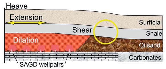
Figure 1: Schematic of SAGD Deformations.
(...Continued from page 21)
unconsolidated sandstones overlain with mudstone caprock. In deeper areas there may be more than one such sequence. These lie unconformably on carbonates, some of which are bitumen-bearing reservoirs. Over millions of years, up to 1km of overburden rock has been eroded. To varying degrees, recent glaciation has folded, faulted, thrusted, and eroded the caprock and possibly the oilsands, leaving paleochannels, surficial sands and gravels, glacial tills, and glaciolacustrine deposits.
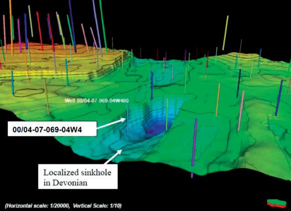
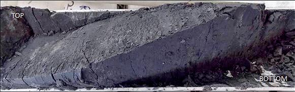
These reservoirs are comparatively shallow, resulting in lower stresses and less geological confinement. The oilsands themselves are extremely dense but uncemented; any disturbance permanently increases the porosity and permeability. The mudstone caprock, being 60% silt and 30% clay, is frictionally strong and impermeable over the engineering timeframe of these recovery processes. However, these mudstones are weakly indurated and are not true shales. The underlying Devonian carbonates, having been exposed for millions of years prior to the deposition of the Cretaceous sands and mudstones, can be extremely dense or weathered, and vary from limestone to dolostone and marl. Dissolution has resulted in breccias, vugs, and dolines (subsurface sinkholes, Figure 2, Husky Caribou Application, 2008).
Geological anomalies (e.g.: karsting, salt dissolution, faulting, erosion) alter the geomechanical characteristics of projects, particularly when these alterations occurred
after the deposition of the mudstone caprock. The displacement of oilsands into the created voidage causes the caprock to drape and extend, thereby reducing horizontal stresses. Often this will reduce the fracture pressure and can result in a change in the preferred fracture orientation from horizontal to vertical. These are controlling factors in the determination of Maximum Operating Pressure (MOP) and the choice of recovery process.
Geological characterizations of projects should identify variability. It is essential to ensure that the caprock is flat: geological marker beds in caprock must have a consistent, near-horizontal dip. Anomalies indicate post-depositional deformation.
The hydrocarbon resource is an extraheavy oil and bitumen resulting from the biodegradation of conventional oil. This has left complex reservoir fluid distributions including high transmissibility zones of top gas, bottom water, and intraformational lean zones. These “thief zones” compromise process containment within the reservoir. Regional downcutting of river valleys through the caprock and oilsands has permitted lateral drainage that has resulted in reservoirs being underpressured by as much as 1000 kPa. In some areas, exploitation of associated gas caps has further lowered the reservoir pressures such that the MOP provides insufficient temperature to mobilize the bitumen economically.
GEOPHYSICS
Seismic surveys are invaluable in providing
large-scale interpretations of the lateral continuity of caprock and may provide insight to formation depths and thicknesses. However, the resolution may be too imprecise for smaller faults. Seismic aids in interpolating between well profiles to identify larger faulting, folding and slumping. Airborne resistivity mapping is cost-effective in identifying missing or thinning caprock for shallower projects. LiDAR detects surficial features that may indicate fault lineations and dissolution trends.
Dipole sonic logs provide compressional and shear velocities for calculating geomechanical properties. Spectral GR logs provide a corrected gamma ray (CGR) that excludes radioactive sands and silts that can be mistaken for clays. Formation micro-image (FMI) logs quantify the orientation of faults and joints but must be corroborated with visual core logging to ensure that all core features have been identified. Visual core logging is essential, especially since high GR intervals may be heavily fractured or could be glacial till, not caprock.
Microseismic monitoring permits a precise determination of the locations of microseisms that occur in the reservoir and caprock in response to processes. Most seisms are small (low energy) and the oilsands and mudstones attenuate the seismic signal which limits the range of geophones to a few hundred metres.
CAPROCK CORING AND GEOMECHANICAL LABORATORY TESTS
Geomechanical laboratory tests on core specimens quantify the strength and stiffness characteristics of the caprock. Laboratory results are used as input into analytical or numerical models to calculate the geomechanical consequences of any proposed field operating scheme.
Geomechanical coring of caprock must preserve the mechanical integrity of the mudstone. Caprock core must be prevented from freezing, drying, vibration, or bending. Once in the lab, CT scans help identify specimens for testing. Core logging then identifies planes of weakness and the extent of any natural fractures (Figure 3). Their orientations are obtained from a paleomagnetic test or FMI log. Index tests such as Atterberg limits, hydrometer particle size analyses, specific gravity, unconfined compressive strength, and X-Ray Diffraction (XRD) are helpful in characterizing the rock.
Shear strength parameters are obtained with the triaxial compression and the direct shear tests. In the triaxial compression test,
22 RESERVOIR ISSUE 01 • JANUARY 2014
Figure 2: Carbonate Karst Doline underlying Oilsand Reservoir.
a confining stress is applied to a cylinder of core and the axial stress is changed until failure. This test is repeated for multiple core specimens at different confining stresses. Triaxial tests should allow fluid to drain from the core as the load is slowly applied, with the strain rate designed to minimize excess pore pressures generated during the test. Stiffness parameters of Young’s modulus and Poisson’s ratio are calculated from the triaxial stress:strain curves.
Direct shear tests measure the shear strength along pre-existing planes of weakness and through intact rock. Peak and residual strengths are obtained for different confining stresses.
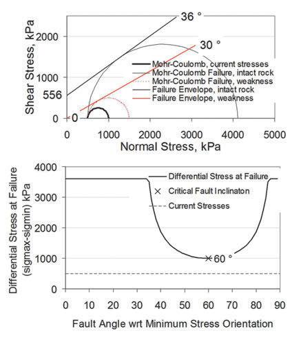
Ultimately Mohr-Coulomb plots are constructed to show the shear failure envelopes. FIgure 4 (top) shows MohrCoulomb failure envelopes for intact rock
and a plane of weakness. Figure 4 (bottom) shows the effect of the orientation of a plane of weakness within the caprock.
Testing can be done at elevated temperatures to obtain the coefficient of thermal expansion. Triaxial tests can be repeated at elevated temperatures to quantify any changes in strength or stiffness.
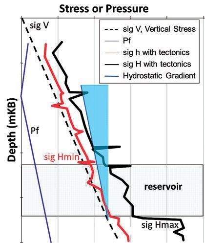
STRESSES
The Rocky Mountain Orogeny has imposed compressional strains in the rock formations in western Canada. These strains increase the stress perpendicular to the Rockies such that it becomes the major horizontal stress, and usually higher than the vertical stress for shallow projects. The other horizontal stress increases to a lesser extent so it becomes the fracture pressure unless it exceeds the vertical stress (Figure 5). The vertical (overburden) stress may be the minimum value for projects shallower than ~300m, in
which case any large induced fractures would be horizontal.
Unusually, there is little contrast in stresses between the caprock and oilsands. As such, there is no large stress increase in the caprock that would prevent the upward growth of fractures within the reservoir. If so, injection pressures must decline as the steam chamber/chest approaches the caprock to avoid any possibility of fractures breaching the caprock.
Complicating this compressive stress regime are geological features such as faults, karsting, erosion, all of which will stressrelieve the rock and lower fracture pressures. Erosion includes nearby filled paleochannels, contemporary river downcutting, open-pit mines, and CHOPS operations. Erosion also depressures reservoirs by providing a nearby outcrop at atmospheric pressure. As such, fracture gradients can fall to 11 or 12 kPa/m. This places lower limits on MOP and may require special techniques for drilling, casing, cementing, and workovers to avoid accidental fracturing.
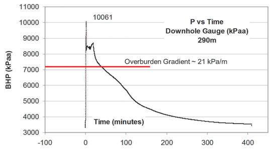
MINIFRACS
Minifrac tests are critical in determining the minimum stress (fracture pressure) in both the caprock and the oilsand formations. The caprock’s fracture pressure determines the project MOP. There are currently three major
(Continued on page 24...)
RESERVOIR ISSUE 01 • JANUARY 2014 23
Figure 3: Two natural fractures intersecting in a caprock core, Clearwater Formation.
Figure 4: Typical Peak and Residual Mudstone Strengths and the Effect of a Plane of Weakness. Figure 5: Stress Profile with Compressional Tectonics.
(...Continued from page
types of tests: (i) openhole tests over a short interval with small-volume injection with an RFT tool, (ii) injection into a 0.52m perforated interval followed by shut-in, and (iii) injection/ flowback wherein after injection the well is flowed at a constant rate. Multiple cycles ensure repeatability in all types of tests.
Typical Injection/Shut-in pressures are shown in Figure 6. There are currently three interpretation methodologies: “traditional” specialized plots first introduced by Nolte, a “holistic” approach by Barree that is the basis for most commercial software, and pressure transient analysis. There is no consensus as to how best to interpret fall-offs. This is of great concern because the difference in reported closure stresses may be dependent on the interpretation approach being used.
THERMAL CONSOLIDATION
Thermal consolidation occurs when clay minerals are heated beyond a threshold
temperature, resulting in a volume reduction that causes contractional strains and lowers stresses. This can affect the base of the caprock when in contact with high temperatures but it also affects wellbore integrity as hot fluids heat the casing and the surrounding formations. This can lead to annular leakage, particularly after shut-in, e.g.: workovers.
GEOMECHANICAL ANALYSIS
Analytical techniques for determining failure vary from the simple to the complex. As an example, the Alberta Energy Regulator (AER) has been tending towards using a ruleof-thumb of 80% of the caprock’s fracture
pressure for the SAGD MOP. This could be overly cautious during the start-up phases of SAGD if there are tens of metres of rich, bituminous oilsand between the injector well and the base of the caprock. The AER itself is aware of this conservatism and has made some exceptions for start-up procedures where conditions and monitoring allow.
Shear failure occurs at a pressure lower than the fracture pressure. In oilsands, this is more likely to occur in the reservoir itself, which is beneficial in terms of geomechanical enhancement to the injection process.
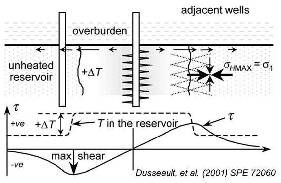
Shear failure within the caprock is inhibited by the inability of high pressures to penetrate the caprock. If steam contacts the caprock, the maximum shear stress typically occurs at the base of the caprock at the thermal shock front (Figure 7). In SAGD operations it may take years for the thermal front to rise to the base of the caprock (e.g.: Collins, et al., 2011). This rate of steam rise is dictated by the vertical permeability of the reservoir.
There is also the potential for repressuring any planes of weakness, which is one reason why lab swelling tests are done: If the caprock swells in contact with distilled water (i.e., condensed steam) then incipient leakage and pressure transmission will be stopped. Simple shear strength calculations can be done to assess the Factor of Safety (FS) against shearing, both in the intact rock and along planes of weakness.
UNCOUPLED GEOMECHANICAL/ RESERVOIR SIMULATION
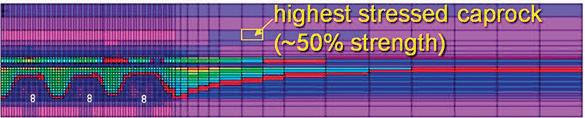
Simple analytical techniques cannot incorporate complexities in geology or geometry and it is difficult to account for the complex interaction with the recovery process over time. As such, an uncoupled geomechanical/reservoir simulation may be warranted to determine the FS for any proposed development plan; i.e. how close the caprock gets to geomechanical failure, as seen in a cross section of a SAGD reservoir, Figure 8.
MONITORING
Monitoring is necessary to ensure that project behaviour falls within an acceptable range. In observation wells, pressures are measured with vibrating-wire piezometers;
24 RESERVOIR ISSUE 01 • JANUARY 2014
Figure 6: Minifrac Pump-In Shut-in Test(muddy tidal flat)
Figure 7: Shear stress at base of caprock
23)
Figure 8: Shear Stress Level in Caprock above SAGD Wellpairs
temperatures with thermocouples or fibre optics. Continuous updating of the predictive model will be necessary to ensure that observed behaviour is history-matched, which adds confidence to predicted behaviour.
Surface deformations can be inverted to infer subsurface volumetric strains and shear displacements. Measurement techniques include precise levelling, GPS, InSAR, and tiltmeters. 4-D seismic surveys are used to monitor the progressing recovery process. Annual surveys monitor changes in seismic velocities, from which changes in fluid saturation are inferred. However, the velocity changes due to geomechanical effects are often larger.
Monitoring of the injection pressures, temperatures, rates, volumes, and mass balance are the driving forces behind the process and give early insights into irregularities. This monitoring must be integrated with the facilities design and control such that upsets in operations, particularly injecting at pressures in excess of the MOP, are prevented.
REGULATOR
The Alberta Energy Regulator (AER, formerly ERCB) manages the oil and gas industry’s environmental, health, and public safety issues while expecting the efficient extraction of resources by industry. Project approval requires quantifying risks, developing an acceptable monitoring program and contingency plans in case of failure. AER’s Draught Directive 23 (AER, 2013) for project approval/operation addresses caprock integrity aspects of in-situ projects. The AER has also been proactive in initiating the Oil Sand Cap Rock Investigation Project (OSCRIP) to study caprock issues in the Athabasca oilsands.
SUMMARY
This article has described the critical role geomechanics plays in the safe and efficient extraction of western Canada’s heavy oil and bitumen resources. Any new project should start with a comprehensive geological/ geophysical assessment followed by coring, logging and minifrac tests. Geomechanical laboratory tests on the cores quantify the strength and stiffness properties of the reservoir and caprock. Once a suitable set of reservoir and geomechanical properties are determined, models are required to confirm the safety of any proposed recovery scheme. The results of this workflow represent part of the application to the Regulator for project approval. Subsequently, any development plan would also require a comprehensive monitoring program
throughout the project life. Maintaining caprock integrity is an essential component of any recovery process, particularly those employing high-pressure injection.
REFERENCES
Alberta Energy Regulator (2013) DRAFT Directive 023: Guidelines Respecting an Application for a Commercial Crude Bitumen Recovery and Upgrading Project , 28 May 2013, 89pp.
http://www.aer.ca/rules-and-regulations/ directives/directive-023-draft
paper CSUG/SPE 149226-PP, proc. Canadian Unconventional Resources Conference, joint conf. of CSUG and SPE, Calgary, Alberta, 15–17 November 2011, 9pp
Dusseault, M.B., M.S. Bruno, and J. Barrera (2001) Casing Shear: Causes, Cases, Cures, paper SPE 72060, SPE Drilling & Completions, June, pp.98-107.
Husky (2008) Application No. 1589158: Caribou Lake Thermal Demonstration Project, Amendment Application, Husky Oil Operations Limited. Registered on October 2, 2008. Withdrawn April 8, 2009
When time is money, Wellsite Geoscience is money well spent.
Whether you’re exploring a basin, producing a well or completing a shale play, time is money. That’s why Weatherford Laboratories brings a suite of formation evaluation technologies right to the wellsite. Utilizing mud gas and cuttings, these technologies provide detailed data on gas composition, organic richness, mineralogy and chemostratigraphy in near real time. As a result, operators now have an invaluable tool to assist with sweet spot identification, wellbore positioning, completion design and hydraulic fracturing. We call it Science At the Wellsite. You’ll call it money well spent.
SCIENCE AT THE WELLSITE ™
www.weatherfordlabs.com
RESERVOIR ISSUE 01 • JANUARY 2014 25
©2013 Weatherford. All rights reserved Formation Evaluation ┃Well Construction ┃Completion ┃Production
WELLSITE GEOSCIENCE SERVICES
2013 GUSSOW GEOSCIENCE CONFERENCE Importance of Rock Properties in Unconventional Reservoirs
| By Chad Glemser and Ryan Mohr, Gussow Technical Chair’s
This year’s Gussow Geoscience Conference, Importance of Rock Properties in Unconventional Reservoirs, was held October 15th to 17th in Banff and attracted 105 participants from both Canada and the US. Presentations were given by 24 international experts from both industry and academia that aimed to highlight the key subsurface challenges while presenting new ideas and methods for exploring and developing low permeability reservoirs. In addition to the presentations, scheduled breaks and networking sessions allowed ample time for participants to network and discuss various topics relating to the conference theme.
The meeting schedule was divided into five sub-themes with each being led by a high profile international expert. To open the conference Dr. Chris Clarkson, EnCana-AITF Chair in Unconventional Gas and Light Oil Development at the University of Calgary, provided the Keynote Presentation. His talk focused on the complexities and challenges of understanding the fluid storage and transport mechanics in low porosity and permeability reservoirs. He demonstrated this through the use of novel pore measurement techniques (CO2 and N2 adsorption and SANS/USANS) that provide nano-scale information about the pore structure that can be directly combined with permeability measurements (either laboratory or well-test) to explain reservoir quality.
The first session of the conference was Mudstone Sedimentology that was led by Dr. Juergen Schieber of Indiana University. His presentation focused on experimental sedimentology and how it show the processes that deposit and eroded mudstones, and how this knowledge can lead to better interpretations of the rock record. Additional presentations within this session were given by Ken Potma, Imperial Oil Ltd., Dr. Jay Kalbas, ExxonMobil Upstream Research Company, and Dr. Per Kent Pedersen, University of Calgary, that examined formations from Canada and the US through the fundamentals of mudstone
sedimentology while integrating these data with well-logs and seismic to better sweet-spot these tight reservoirs.
The Geomechanics and Natural Fracture Characterization session was led by Dr. Jon Olson, University of Texas at Austin, and examined the role of natural fractures in reservoir processes. This was accomplished through identifying and discussing methods for characterizing the interaction of hydraulic fractures with natural fractures in shales and siltstones. Supporting talks were given by Dr. Paul MacKay, Shale Petroleum Ltd., Paul La Pointe, Golder Associates Inc., Pat McLellan, Talisman Energy and Dr. Jim Evans, Utah State University, that provided additional insight into geomechanical theory, experiments and field examples (outcrop, core, borehole imaging and DFITs) to explain the role of natural fractures on fluid flow and resource play deliverability.
Petrophysics in Unconventional Reservoirs, led by Dr. Quinn Passey of ExxonMobil Upstream Research Company, looked at the petrophysical evaluation and evolution of shale gas and shale oil reservoirs by understanding the occurrence of organic-matter pores, in both bitumen/ pyrobitumen and kerogen, and matrix porosity. Presentations by Dr. Zoyia Heidari, Texas A&M University, Matt Determan, ExxonMobil Upstream Research Company, Lyn Canter, Whiting Petroleum Corporation and Jack Breig, Whiting Petroleum Corporation, investigated the theoretical impact of pyrite and kerogen on saturation estimation from resistivity, explanation of extracting in-situ permeabilities from shale samples using a steady-state apparatus, and core-log calibration and sweetspotting studies on the Niobrara Formation, respectively.
Seismic Attributes and Microseismic Advances session was led by Dr. Mirko van der Baan of the University of Alberta. Presentations by Jim Rutledge, Schlumberger, Paige Snelling, Microseismic Inc., Barbara Cox, Shell Canada Energy, Rodney Johnston, BP Canada, and
Sean Lovric, Nexen Energy ULC explored the fundamentals and value of microseismic data through observation, new methods of data collection, and coupling data with seismic attributes (such as Young’s modulus and Poisson’s ratio) and new monitoring technologies (i.e. DAS) to explain stimulated rock volume, interaction with structural features and causation of induced seismicity relating to hydraulic fracturing and estimating permeabilities based on microseismic data.
The session on Multidisciplinary Studies, led by Dr. Roberto Aguilera, Conoco-Phillips Chair in Tight Gas Engineering at the University of Calgary, focused on the integration of multiple disciplines with a common goal of increasing production rates and ultimate recoveries from low permeability reservoirs. Presentations examined the role of organic constituents, core and log data calibration, hydraulic fracturing, resource estimates and regional mapping of production data to illustrate play trends and sweetspots. Speakers in this session were Dr. Roberto Aguilera, Robert Taylor and Eric Hards, Halliburton, Dave Quirk, Trican Well Service, Dr. Kirk Osadetz, Geological Survey of Canada, and Michael Morgan, GLJ Petroleum Consultants.
To close the conference a panel discussion was held with all of the session chairs that proved lively with abundant audience interaction. Questions focused on the evolution of knowledge in understanding shale gas/oil reservoir properties, the future of unconventional resources and important topics such as use of technical data for resource estimation and disclosure.
As a follow-up to the meeting, a call for papers was sent out to speakers for a special edition of the Bulletin of Canadian Petroleum Geology that we plan to have completed by end of summer 2014.
On behalf of the organizing committee we would like to extend a big thank you to all of the session chairs, speakers and delegates. The 2013 Gussow conference was a huge success because of your willingness to share ideas and dedicate time and effort. We would also like to acknowledge and thank the conference sponsors for their support; Nexen Energy ULC, APEGA, Schlumberger, Baker Hughes and Apache. Thank you to Kristy Casebeer, CSPG, for her time and effort organizing the venue and conference materials.
26 RESERVOIR ISSUE 01 • JANUARY 2014
FOCUS ON CORE
Do you remember the first time you looked at core? What did you think about what you were looking at? A chunk of rock, tens of millions of years old?
Were you thinking about the processes that created that rock? Of ancient rivers, beaches, submarine environments, coastal plains, caves? Or were you thinking about the potential locked in that core, of porosity and permeability, oil and gas? Or perhaps of what happened to the rock after it was deposited, of diagenesis and fractures?
The Core Conference at the 2014 GeoConvention is one of the best
opportunities for a geologist to recapture that curiosity: to look at core from around the province and around the world, and gain new ideas and new perspective to bring back to their own work area. Combined with the opportunity to meet other geoscientists and discuss new (and old) developments in their field. As well, this is the perfect opportunity for students to network with senior geoscientists, to learn from some of the best at the beginning of their long careers in the industry.
The 2014 Core Conference will have a variety of cores, from academic as well as industry presenters, which will illustrate new fields and new ideas in old fields. Even old ideas in old fields will be highlighted, with a special Turner Valley core session, in celebration of the centennial on May 14th. A lecture hall will be set up within the massive core storage warehouse for presentations on the core displays. The
presentations will also be broadcast to a secondary classroom with additional seating. Over the two days, there will be chances for open discussion with the presenters beside their chosen core and poster.
Abstract submission is now open, closing on January 10th, 2014. As in years previous, there will be lunches provided by Weatherford and the whole event will be capped off by the ever-popular AGAT Core Meltdown, a great chance to mingle with some of the best people in the world: geoscientists.
Ray Geuder, Core Conference Co-Chair Kelty Latos, Core Conference Co-Chair
CALL FOR ABSTRACTS


RESERVOIR ISSUE 01 • JANUARY 2014 27
2014: FOCUS May 12-16, 2014, www.geoconvention.com
GEOCONVENTION
Exhibit Space, Sponsorship & Advertising available Conference themes will FOCUS on adapting to change, refining workflows and sustaining the continuing evolution of technology in the oil and gas industry. Submit your abstract by January 10, 2014 www.geoconvention.com/conference May 12-16, 2014 Calgary, Alberta cspg.org
GO TAKE A HIKE
Windy Peak & Hailstone Butte, Livingstone Range, AB
| By William Jamison and Dylan Jamison
Trailhead: The access road to the trailhead is Hwy. 532, which is a gravel road that connects Hwy 22 (junction just north of Chain Lakes) to the Forestry Trunk Road (Hwy 940) at the Savanna Creek gas field. Two trails (Hailstone Butte & Windy Peak) begin near a parking lot located at the “the Hump,” which is the high spot along this gravel road (at the end of a long, steep grade from the east). Neither trail is marked or maintained. Windy Peak trail begins on the east side of small pond near the parking area, heading uphill to the south. Hailstone Butte trail begins directly across the road from the parking area, following a minor drainage for a short distance before heading up the slope to the north. Both trails are reasonably well defined by usage, but they do have confusing splits and faded definition. The trail guides of Daffern (1997) provide useful hiking directions and instructions for both trails.
Distance: The distance to the first major viewpoint on the Windy Peak trail (pt. A) is 1 km, with an elevation gain of 230 m. The distance to Windy Peak itself is 6 km, with a cumulative elevation gain of 550 m (Daffern, 1997). The distance to Hailstone Butte is 2 km, with an elevation gain of slightly over 400 m.
Please note that both grizzlies and cougars have been encountered in the Livingstone Range, so take proper defensive gear and do not travel alone!
These two trails provide views, from many different perspectives, of the intense deformation within the Livingstone Thrust complex, as well as magnificent vistas of the rolling outer Foothills and plains to the east.
The peaks and ridges of the Livingstone Range are formed by Mississippian-age carbonates that have been folded, transported and uplifted by a sequence of thrust faults that emerge on the east slope of the range as the Livingstone Thrust “complex.” Norris (1997) designates the western fault of this complex as the Sentinel Peak Thrust and the eastern fault as the Livingstone Thrust. Between these two boundaries (a distance of 4.5-5 km) an array of tight folds and thrusts are well displayed in Kootenay and Blairmore Group clastics. The Livingstone Thrust system is interpreted to have a minimum displacement here of 15 km (Norris, 1997). Paul MacKay (2001) suggests this is actually the southern extension of the McConnell Thrust, linked via a series of thrusts between this location and Mt. Head, ~25 km to the north.
Windy Peak trail contains many open views of the folds and faults that crop out on the east slope of Hailstone Butte (A & B). Hailstone Butte itself is underlain by very gently dipping Mississippian Mount Head Fm. (locally capped by Mississippian Etherington and Pennsylvanian Misty Fm.). The absence of folding in the hangingwall carbonates is a stark contrast to the footwall deformation. However, there are major folds within these carbonates along strike to the south; they have simply been eroded at this location.
Windy Peak trail continues to the south (C), providing a receding and expanding view of Hailstone Butte and the footwall structures. One of the Hailstone Butte trail options goes directly to the up-turned
beds
lower
lookout station.
clastics.
line
 MAP: Annotated excerpt from GSC map 1837A (Norris, 1993) showing geology in view from the Windy Peak and Hailstone Butte trails.
Photo A: (below) View north from pt. A along Windy Peak trail (see map) of Hailstone Butte, the Sentinel Peak Thrust and a syncline developed in lower Cretaceous beds in the footwall to this thrust. Dylan is standing next to nearvertical
in
Cretaceous
White building on Hailstone Butte is fire
Dotted yellow
is section of Hailstone Butte trail.
MAP: Annotated excerpt from GSC map 1837A (Norris, 1993) showing geology in view from the Windy Peak and Hailstone Butte trails.
Photo A: (below) View north from pt. A along Windy Peak trail (see map) of Hailstone Butte, the Sentinel Peak Thrust and a syncline developed in lower Cretaceous beds in the footwall to this thrust. Dylan is standing next to nearvertical
in
Cretaceous
White building on Hailstone Butte is fire
Dotted yellow
is section of Hailstone Butte trail.
28 RESERVOIR ISSUE 01 • JANUARY 2014
2 km
lower Cretaceous beds that are folded beneath Sentinel Peak Thrust (D). This folding is accompanied by intense fracturing of the exposed rocks and also by abundant shearing along surfaces that are parallel or sub-parallel to bedding. The trail then continues upslope through benches of the Mississippian carbonates to the forestry fire lookout (operational in summer) on the point of the butte.
REFERENCES:
Norris, D.K. 1993. Geology and structure cross sections, Langford Creek (west half), Alberta; Geological Survey of Canada, Map 1837A, scale 1:50,000. Daffern, G. 1997. Kananaskis country trail guide, vol. 2 (3rd ed.), Rocky Mountain Books, 320 pp. MacKay, P.A. 2001. Canadian Rockies Structural Geology Field Trip Guide.
The Reservoir Committee welcomes contributions from our readership to this series. If you wish to offer a submission to Go Take a Hike on your favourite hike of geological interest, email the Reservoir at Emma. MacPherson@cspg.org for more information.
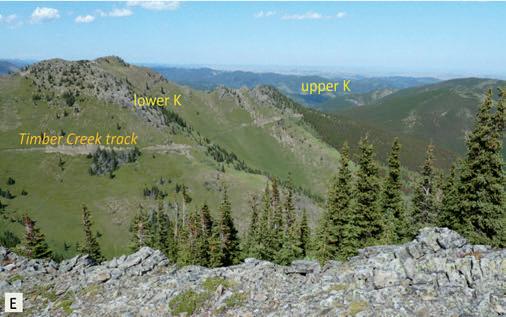 Photo C: View south of Windy Peak. Dotted yellow lines are sections of Windy Peak trail.
Photo E: View east from central part of Windy Peak trail. Steeply dipping lower Cretaceous beds in foreground. More distant tree-covered hills are underlain by upper Cretaceous rocks in outer Foothills.
Photo B: Distant view of complex folds developed in lower Cretaceous clastics within Livingstone thrust “complex.” Dark yellow line is near base Kbl.
Photo C: View south of Windy Peak. Dotted yellow lines are sections of Windy Peak trail.
Photo E: View east from central part of Windy Peak trail. Steeply dipping lower Cretaceous beds in foreground. More distant tree-covered hills are underlain by upper Cretaceous rocks in outer Foothills.
Photo B: Distant view of complex folds developed in lower Cretaceous clastics within Livingstone thrust “complex.” Dark yellow line is near base Kbl.
B D RESERVOIR ISSUE 01 • JANUARY 2014 29
Photo D: Near vertical beds of lower Kbl on west limb of syncline beneath Sentinel Peak Thrust (see “X” in photo A).
CSPG Annual General Meeting
Please join us on January 9th, 2014 for the CSPG AGM and first Technical Luncheon of 2014!
AGM - 11:30am - 12:00pm Technical Luncheon - 12:00pm - 1:00pm
For more information and to register online please visit www.cspg.org

CSPG & AAPG Canada Region Turner Valley Centennial Celebration 2014!
We are looking for historians, geologists and Alberta oil & gas industry enthusiasts to help us celebrate the 100th anniversary of Turner Valley! The CSPG and the AAPG Canada Region have teamed up to help run a field trip from Calgary to Turner Valley with other points of interest stops included along the way. The 100 year Anniversary Alberta’s first oil well; Dingman #1 is on May 14, 2014 at the Turner Valley Gas Plant.
We are looking for volunteers who have a knowledge of the oil and gas industry of Alberta as well as the geology of the Turner Valley area. If you would like to be involved in this expedition in any way please contact the CSPG office—Kelsey Green, Kelsey.green@cspg.org, 403-513-1225
30 RESERVOIR ISSUE 01 • JANUARY 2014
PHOTO OF THE MONTH
RESERVOIR ISSUE 01 • JANUARY 2014 31
The exposed geology of the Yosemite Valley is primarily granitic. The formation of the valley is complex and includes volcanism, uplift, erosion and glaciation. Yosemite Valley, California. Photo By: Michael Lam
THE 2014 CSPG EXECUTIVE COMMITTEE
PRESIDENT – DALE
LECKIE
EDUCATION : B.Sc. (Honours), University of Alberta (1977); M.Sc., McMaster University (1979); Ph.D., McMaster University (1984).
EXPERIENCE: Petro-Canada (1983-1985); Geological Survey of Canada (1985-1998); Nexen Energy ULC (1998-present).
PROFESSIONAL
MEMBERSHIPS: CSPG, AAPG, APEGA, APEGS, SEPM.
CSPG ACTIVITIES: CSPG Conference Organization; Co-Organizer of 2009 CSPG William C. Gussow Geoscience Conference “Towards Sustainable Oil Sands Development.” Oct 5-7, 2009, Banff, Canada; Co-Chaired 1988 CSPG Conference on Sequences, Stratigraphy, Sedimentology: Surface and Subsurface (1,100 delegates); CSPG Technical Luncheon Presentations – 2009, 2004, 1997, 1995, 1996a, 1996b, 1993, 1987, 1985.
PUBLICATIONS: Bulletin of Canadian Petroleum Geology – 16 papers; CSPG Memoirs and others – 6 papers; Edited CSPB Books, Co-Editor of CSPG 1988 Memoir 15, Sequences, Stratigraphy, Sedimentology: Surface and Subsurface, Leckie, D.A. and Barclay, J.E. 2011. Gas Shale of the Horn River Basin – Discovery, Potential and Future, CSPG Publication; Numerous CSPG Core Conference and Field Trip publications; CSPG Gussow Conference Committee Chair – 2011/12.
AWARDS: CSPG Medal of Merit (2005), best paper in Canadian Petroleum Geology; CSPG Service Award 1996/97; CSPG Link Award 1995; CSPG Medal of Merit (1987), best paper in Canadian Petroleum Geology; CSPG Distinguished Lecturer 1986; CSPG Honourable Mention, Best Ph.D. thesis (1985); Several AAPG and SEPM awards.
PRESIDENT ELECT – TONY CADRIN
EDUCATION : B.Sc. Geology, University of Saskatchewan, Saskatoon Saskatchewan (1985); Ph.D. Geology, University of Saskatchewan (1992).
EXPERIENCE: Geologist, PanCanadian (1991-1997); Geologist, Anderson Exploration (1997-2000); Geologist, Startech (2000- 2001); Geologist, Impact/Thunder Energy (2001-2005); Geoscience Manager, Thunder Energy Trust (2005-2006); VP Geosciences, Thunder Energy Trust/ Sword Energy/Journey Energy (2006-Present).
PROFESSIONAL
MEMBERSHIPS: CSPG, AAPG, APEGA, CSEG.
CSPG ACTIVITIES: CSPG Member since 1984. Student Industry Field Trip Committee member/Chair (1991-1996); Convention Technical Committee and session Chair (1988); CSPG Services Director (1998-1999); CSPG Program Director (2001); Tech Lunch Committee Chair/ Link Committee (2002-2005); CSPG Webcasts Program (2003-2004); CSPG Committee on Conventions/JACC (2005-2010); 2010 GeoCanada Convention (2010); CSPG East Coast Ambassador (2013).
AWARDS: CSPG Volunteer Award; CSPG Services Award; CSPG Tracks Award; CSPG Presidents Award 2009.

EDUCATION : B.Sc. (Honours, Geological Sciences), Queen’s University (1980); Ph.D. (Geology), University of Calgary (1991).
EXPERIENCE: Geologist/Geophysicist, Amoco Canada (1980-1993); Structural Geologist, Morrison Petroleum (1993-1996); Exploration Manager-Foothills, Northstar Energy (1996-1999); Principal, GeoConsultants Ltd. (1999-2010); President, Shale Exploration (2010-2011); President, Shale Petroleum (2012-Present); Adjunct Professor, University of Calgary (2005-present). Lecturer for numerous industry courses on Structural Geology and Fr actures (1995-present).
PROFESSIONAL MEMBERSHIPS: CSPG, AAPG, APEGA, CSEG.
CSPG ACTIVITIES: Speaker at several conferences and luncheons; Structural Division Chair (1993-1994); Visiting Petroleum Lecturer (1995, 2010), Editor (Bulletin), Triangle Zone Volume – Special Issue (1996); Canadian Petroleum CSPG Executive, Program Director (2000-2001); CSPG/CSEG/CWLS Annual Convention Co-Chair – Recovery (2011); GeoConvention (JAC) steering committee (present).
AWARDS: CSPG Service Award; CSPG Tracks Award; CSPG President’s Award; CSEG/CSPG/CWLS Best-Integrated Geology and Geophysics Paper for the National Convention Geotriad; GeoCanada (2010), National Convention for the CSPG, CSEG, CWLS, GAC/MAC – Best Geology Paper.
32 RESERVOIR ISSUE 01 • JANUARY 2014
PAST PRESIDENT – PAUL MACKAY
FINANCE DIRECTOR – GORD STABB
EDUCATION : B.Sc. (Geology), University of Toronto (1981).
EXPERIENCE: Exploration and Development Geologist, Unocal Canada Ltd. (1981-1992); Development and Oilsands Geologist, Gulf Canada Resources Ltd. (1993-1998); Consulting Oilsands Geologist, Durando Resources Corp. (1999-2006); V.P. Exploration Oil Sands, Southern Pacific Resource Corp. (2006-2009); Technical Director, Board, Canadian Heavy Oil Association (2008-2010); Consulting Oilsands Geologist, Durando Resources Corp. (2009-Present).
PROFESSIONAL
MEMBERSHIPS: CSPG, APEGA, CHOA.
CSPG ACTIVITIES: Basin Analysis & Sequence Stratigraphy Division (2002-2009); Publication Indexing Committee (1983-2004); Conference Presenter: Geologic Considerations in Horizontal Well Placement for McMurray Fm Thermal E xploitation: Case Example, Surmont Alberta (1999). Nisku Sedimentology, Meekwap to Sturgeon Lake (1991). Application of 3-D modeling to Leduc Exploration (CSEG 1986).
AWARDS: CSPG Service Award (2011).
FINANCE DIRECTOR ELECT – ASTRID ARTS

EDUCATION : B.Sc. (Honours), Geology, University of Alberta (1995); M.Sc., Earth and Atmospheric Sciences, University of Alberta (2000).
EXPERIENCE: ConocoPhillips Canada/Conoco/Gulf/Crestar (1998-2006), Barrick Energy (2011-2013), Cenovus Energy (2013-Present).
PROFESSIONAL
MEMBERSHIPS: CSPG, AAPG, APEGA, SPE.
CSPG ACTIVITIES: Rock the Foundation Convention - Special Events Chair (2001), Digging Deeper, Diamond Jubilee Convention - Publicity & Marketing Chair (2002), Diamond Jubilee Convention - Publicity & Marketing Chair (2002), Educational Trust Fund - Director (2003), CSPG Executive - Services director (2004-2005), Chair Electronic Communications Committee (2005-2009).
AWARDS: CSPG Tracks Award (2002, 2009), CSPG Service Award (2001, 2005, 2010).
DIRECTOR – ALEXIS ANASTAS

EDUCATION : B.Sc. (Earth Science), University of Toronto (1988); M.Sc. (Geology), University of Waterloo (1992); Ph.D. (Geological Science), Queen’s University (1997).
EXPERIENCE: Geologist, Amoco and BP Canada (1997-2003); Sedimentologist, Devon Canada (2003-2006); Staff Geologist, Nexen Energy ULC (2006-present).
PROFESSIONAL
MEMBERSHIPS: CSPG, AAPG.
CSPG ACTIVITIES: CSPG Convention Short Courses Chair (1997), Joint Annual Core Conference Chair (2012, 2013).
AWARDS: CSPG Service Award (1997).
DIRECTOR – ANDREW FOX

EDUCATION : B.Sc. (Geology), Laurentian University (1985); M.Sc. (Geology), University of Alberta (1988).
EXPERIENCE: Geologist, Dome Petroleum (1988); Geologist, Amoco Canada (1988-1998); Geologist, BP Canada (1998-2004), VP Resource Development, MEG Energy (2004-2011), Senior Advisor Subsurface, MEG Energy (Present).
PROFESSIONAL
MEMBERSHIPS: CSPG, APEGGA, CHOA.
CSPG ACTIVITIES: SIFT Committee (1992-1997); Environment Division Chair (2004-Present).
AWARDS: CSPG Volunteer Award (2007), CSPG Service Award (2010, 2011).
DIRECTOR – MILOVAN FUSTIC
EDUCATION : B.Sc. (Honours), University of Belgrade, Serbia (1993); Ph.D., University of Calgary, Canada (2010)
EXPERIENCE: Naftagas (1993-1994); Magnohrom (1994-1997); TIH Consulting Ltd. (1997-2000); Albian Sands Inc. (2000-2004); Petroleum Reservoir Group, University of Calgary (2004-2006); Nexen Energy ULC (2006-2011); Statoil Canada Ltd. (2011-present)
PROFESSIONAL
MEMBERSHIPS: CSPG, APEGA, AAPG, CHOA, IAS, SEPM.
CSPG ACTIVITIES: CSPG Technical Chair for GeoConvention 2013; CSPG GeoConvention Session Chair (2009, 2011); CSPG Technical Luncheon Presentation 2013; CSPG Short Course and Field Trip Instructor (2010-present)
AWARDS: CSPG Medal of Merit (2011), best paper in Canadian Petroleum Geology; CSPG Medal of Merit Honourable Mention (2009), Geoscience Advancements (2002)
RESERVOIR ISSUE 01 • JANUARY 2014 33 (Continued on page 30...)
DIRECTOR – MICHAEL LABERGE

EDUCATION : B.Sc. (Honours, Geology and Biology), Dalhousie University, Halifax, Nova Scotia (1977).
EXPERIENCE: Geologist, Amoco Canada Petroleum Company Limited (1977-1980); Geologist, Flame Oil & Gas Ltd. (1980-1985); Exploration Manager, Vanguard Petroleum Limited (1985-1989); VP Exploration, Tarragon Oil and Gas Limited (1990-1991); Consulting Geologist/ Co-Manager Exploration Geology/ District Manager. Crestar Energy Inc. (1991-1999); Geologist, Channel Energy Inc. (1999-2005); VP Exploration, SunOcean Energy Ltd. (2005-2007); VP Exploration, Tuscany Energy Ltd (2007), Partner, Intercept Resources Inc. (2007-2008); Geologist, Channel Energy Inc. (2008-2011); Senior Exploration Geologist, Surge Energy Inc. (2010-2013); Geologist, Channel Energy Inc. (present).
PROFESSIONAL
MEMBERSHIPS: CSPG, AAPG
CSPG ACTIVITIES: Advisory Committee for the Advantage Program (1994-1995), Classic Gold Committee (1993-2013)
AWARDS: CSPG Service Award (1994, 2009, 2010, 2011); CSPG Tracks Award (2012)
DIRECTOR – ROBERT MUMMERY
EDUCATION : McMaster University, Ph.D. Geology (1973); Univ. of Western Ontario, Hons. B.Sc. Geology (1968).
EXPERIENCE: District Geologist/Chief Staff Geologist, Home Oil; Chief Geologist/Vice President-Interpretation/Vice President, Seieslog; Executive Vice President, Teknica Resource Development Ltd.; Manager Strategic Exploration Projects/ Foothills Team Leader/Northern Team Leader, Wascana/Saskoil; Founder/Vice President – Exploration, Golden Eagle Energy; Corp. Director, Unbridled Energy Corp.; Director, Altima Resources Inc.
PROFESSIONAL MEMBERSHIPS: APEGA, AAPG, CGC, CSEG, CSPG, CNC/IUGS, MNABES, MACST, SEG.
DIRECTOR – WEISHEN REN
EDUCATION : B.Eng. (Petroleum Geological Exploration), Southwest Petroleum Institute, P. R. China (1992); M.Sc. (Petroleum Engineering), University of Alberta (2002); Ph.D. (Petroleum Engineering), University of Alberta (2007).
EXPERIENCE: SINOPEC China (1992-1997); Centre for Computational Geostatistics, University of Alberta (2003-2006); Geostatistician, Surmont geomodeling advisor, ConocoPhillips Canada (2006-2011); Principle geologist/ geomodeler, Statoil Canada (2011-present).
PROFESSIONAL
MEMBERSHIPS: CSPG.
CSPG ACTIVITIES: Chair of geomodeling committee (2007-2012); 2011 Gussow Conference organizing committee; Geomodeling session chair in GeoConvention (2008, 2009).
PUBLICATIONS: Published 20+ technical papers as principle or co-author relating to geostatistics, geomodeling, and reservoir engineering.
AWARDS: CSPG Volunteer Award (2007-2010), CSPG Service Awards (2011).
DIRECTOR – DARREN ROBLIN
EDUCATION : B.Sc. E (Honours, Geological Engineering), Queen’s University, Kingston, Ontario (1997); MBA, University of Calgary - Haskayne School of Business (2013).
EXPERIENCE: Geophysicist, Crestar Energy (1997-2000), Senior Geophysicist, BonaVista Energy (2000-2003), Geophysical Advisor, NuVista Energy (2003-2012), Exploration Manager, Shale Petroleum (2012), Geophysical Manager, Marquee Energy (2012-2013), Chief Geophysicist, Endurance Energy (2013- Present).
PROFESSIONAL MEMBERSHIPS: CSPG, AAPG, APEGA, CSEG.
34 RESERVOIR ISSUE 01 • JANUARY 2014
from page 19)
(...Continued
GEOLOGY OF THE MOUNT STEPHEN TRILOBITE BEDS AND ADJACENT STRATA NEAR FIELD B.C., YOHO NATIONAL PARK
New Perspectives on a 127 Year Old Discovery: Part 2
| By V. Allen Kimmel P. Eng., P. Geol.
This article is a summary of one technical letter and three technical papers related to ongoing research by the author in an area that includes the Mount Stephen Trilobite Beds and Burgess Shale located near Field, BC. The present research began with the recognition of, and investigation into, the Field Slide by the author, the findings of which are summarized immediately below. Analysis of the slide mass and slide failure surfaces led to other relevant findings that are contained within the pages that follow. The article is divided into three segments for publication in the Reservoir. The first segment deals with the existing surface geomorphology and Cambrian depositional environments. The second segment deals with the Mount Stephen Trilobite Beds, adjacent strata and local structural features. The final segment concludes discussing the local structural features and highlights the major conclusions of the research to date.
PART 2
SUBAREAL EXPOSURE AND THE OGYGOPSIS/BASAL CATHEDRAL UNCONFORMITY
The top of the off reef carbonate beds and the upper surfaces of the higher patch reefs on the mid and lower Trilobite Beds Slope (TBS) are part of an erosional unconformity that is visible in numerous locations on the TBS (Figures 10 through 12) and adjacent slopes. The weathered, smoothed appearance of the erosional surfaces indicates extensive subareal exposure. Future field work will focus on documenting the unconformity across the entire slope, from the more basinal westward setting into the more closely spaced and higher patch reefs to the east. The first muds of the Ogygopsis Shale section were deposited as horizontal layers, infilling erosional bedding lows between adjacent limestone layers (a) and erosional troughs (b) within the lowermost portions of the exposure surfaces (Figures 10 and 11).
The Ogygopsis bedding psuedo parallels the unconformity surface on the majority of the TBS in areas that are not
(Continued on page 36 ...)
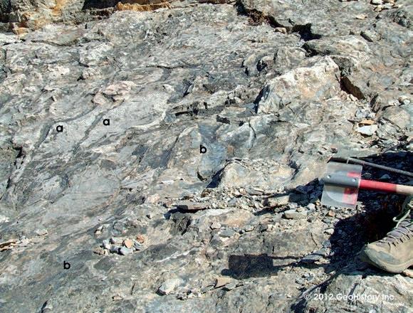
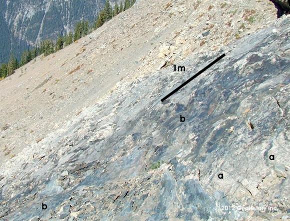
RESERVOIR ISSUE 01 • JANUARY 2014 35
Figure 10. Ogygopsis/Basal Cathedral Unconformity. Ogygopsis muds, the blue black sediments, are visible infilling erosional lows between adjacent slightly dolomitized limestone bedding layers (a) and erosional troughs (b) within the exposure surface.
Figure 11. Looking northward across the unconformity surface in Figure 10 to the edge of the TBS.
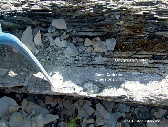
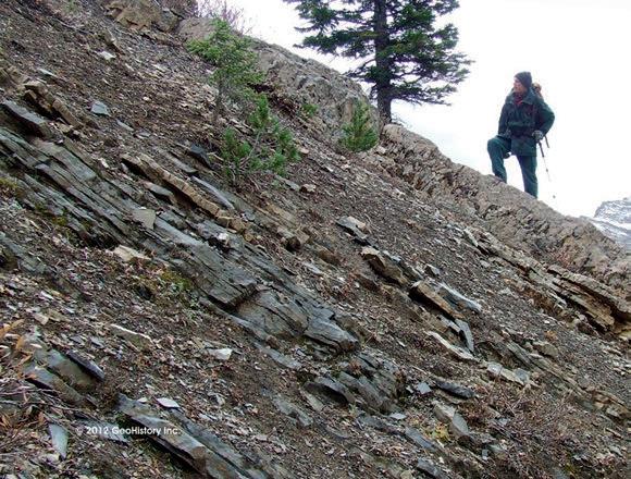
(...Continued from page 35)
adjacent to reefal/biohermal build ups, as is evident in Figure 12. The exposure surfaces may be the cause of the pervasive dolomitization of the reefs as well as the varying degree of dolomitization found in the in situ reef capping and draping limestone beds. As is evident in Figure 13, the further the horizontal and vertical distance from exposed, dolomitized reefal/
biohermal features, the less the degree of dolomitization within the limestone beds. The tan coloured bioherm under foot in the photo is slightly less than one metre in thickness and outcrops on the northern edge of the TBS. The top of the feature was at, or very near to, the unconformity surface. As one proceeds down section, the degree of dolomitization decreases rapidly. No dolomitization is
present more than two metres below the base of the bioherm – the rock is comprised of original blue black limestone. The unconformity marks the end of initial Cathedral deposition and the beginning of Ogygopsis (Stephen Burgess) deposition. Mapping of this feature is essential in understanding the geology of the area. Ney (1954 Fig. 3, p130) viewed the limestone unit below the Cathedral reefing visible in the Kicking Horse Valley to the north as the beginning of the Cathedral Formation, as did Fritz (1969, p. 1159). This paper will call the limestone unit on the TBS the Basal Cathedral Unit, the unit in which Cathedral reef growth commences.
THE UPPER AND LOWER MOUNT STEPHEN TRILOBITE BEDS
The Upper Trilobite Beds (UTBs) were deposited on top of the underlying unconformity/ Basal Cathedral Limestones in a saddle between three patch reefs (Figure 14) – one to the north (the patch reef in Figure 2, previous article segment), one to the south and, based on increasing depositional dip in the exposed carbonate layers, one to the east. The UTBs are not in situ, as is clearly evident in Figure 14. Given the displaced, jumbled nature of the UTB’s, it is impossible to get a true orientation of the bedding from any of the UTB strata – a fact which has been recognized by the majority of previous researchers. The only true dip and strike measurement that can be made is of the underlying carbonates directly to the south of the UTBs – which dip at an average of 41° west and strike at 349° – close to the average of the non reefal influenced limestone bedding elsewhere on the slope. In situ Ogygopisis across the TBS dips at an average of 43o west and strikes at approximately 345o, a comparable orientation to the underlying limestone beds in the non-patch reef/ bioherm influenced areas.
The UTBs and other adjacent remnants of the thin Ogygopsis shale beds that remained in situ post Field Slide on the upper TBS have crept to their present position in the years subsequent to the slide (Figure 15). The patch reefs, bioherms and other TBS features create bumps/inflections in the bedding plane surfaces that act as accumulation points, temporarily arresting the downhill movement of the Ogygopsis. Those portions of the creeping beds that were not halted by the bumps/inflections make up the talus slope sediments on the mid and bottom portion of the TBS. As illustrated in Figure 15, the Ogygopsis comprising the UTBs (in places over 4 meters thick) has moved an average
36 RESERVOIR ISSUE 01 • JANUARY 2014
Figure 12. Cross section of the unconformity between the underlying limestone (effervescing) and the overlying horizontal Ogygopsis Shale beds. The lowest, furthest right Ogygopsis bed visibly thins from right to left and pinches out against the erosional limestone surface, as do the beds above.
Figure 13. Half metre thick biohermal buildup underfoot of Todd Keith, Parks Canada, upslope of the patch reef in Figure 3 (previous article segment). Note the beds change vertically downward from buff colored dolostone to dark blue black limestone within 3 metres.
estimated distance of 125 metres downslope from its original depositional position amongst the patch reefs. The reef in Figure 8 (previous article segment) outcrops directly below the southern edge of the UTBs and is likely the feature responsible for the accumulation and current position of the UTBs (Figure 15).
Tracing the in situ Basal Cathedral limestone beds, the in situ Ogygopsis beds and the unconformity (where visible) and combining these observations with the measured in situ bedding orientations reveals that the Lower Trilobite Beds (LTBs) and the UTBs are the same strata. The LTBs were deposited at the same time as the UTBs, at exactly the same stratigraphic level, but approximately 400
meters to the west (basinward). This is 150 meters westward of any evident reefal or biohermal buildups in the underlying Basal Cathedral limestones. Both Trilobite Beds comprise rock from the lowermost 2 to 3 metres of the Ogygopsis. Both sit (sat) directly on top of the limestone beds (the unconformity) and, as reported by Fletcher and Collins (2003), “the Lower Trilobite Beds contain the same general faunal assemblage as the Upper Trilobite Beds, but in much fewer numbers and variety” (p.1836).
The vast majority of the lowermost one to two metres of Ogygopsis in and adjacent to the LTBs is in situ, with a strike and dip orientation (average dip of 43°west and average strike of 345°) almost
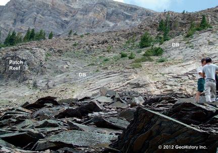
Figure 14. Looking east with the prominent patch reef in Figure 2 (previous article segment) at the left centre of the photo, less than 100 meters away. The continuous, traceable in situ beds of the Basal Cathedral limestones (DB) are visible between the patch reef (centre left), the inferred patch reef to the east (visible increase in the slope of the DBs below the trees at the right of the photo) and to patch reef to the south (just off the right centre of the photo). The jumbled, displaced Upper Trilobite Beds (UTBs) are visible in the lower third of the photo. D Teleki and M. Seo right centre of photo.
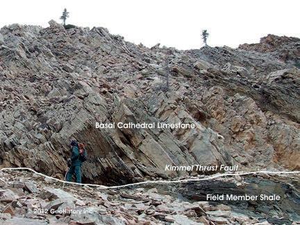
16.
identical to that of the underlying off reef/ nonbiohermal Basal Cathedral limestone beds. In contrast to this, one of the easily accessible trilobite rich surfaces found within the LTBs strikes at 355° and dips at 52° west. Not recognizing that this strata has been displaced and using the 52° dip (which is significantly steeper than the adjacent talus/mountainside at this point), one can i) easily interpret the LTBs as stratigraphically higher/younger beds than the UTBs and ii) assign a significant thickness to the in situ Ogygopsis Beds that would then have to exist under the scree between the younger downslope LTBs and the older upslope UTBs.
This may be why previous investigators
(Continued on page 38 ...)
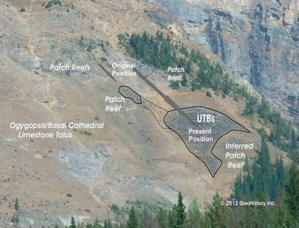
Figure 15. Looking east south east at the mid TBS from Field, B.C. showing the original depositional/in situ position of the fossiliferrous Ogygopsis strata directly upslope of the Upper Trilobite Beds (UTBs) as they sit today. The inferred patch reef at the base of the UTBs outcrops on the side of the ridge just below the right downslope tip of the outlined UTBs and is the patch reef in Figure 8 of the first article segment.
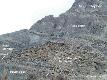
RESERVOIR ISSUE 01 • JANUARY 2014 37
Figure
Basal Cathedral strata thrust over black Field Member shale (lower right of photo) via the Kimmel Thrust Fault on the northern edge of the Upper TBS. The strata below the scree at the base of the photo comprises an interbedded Field Member shale/carbonate section that lies directly below the black shale and continues unbroken within the Eldon above Slopes 2 and 3 (Figure 17) to the north.
Figure 17. The exposed shale/carbonate sequence at the base of the Field Member above Slope 2 which continues unbroken to the cliff above Slope 3 to the north (lower centre left of photo). This strata is traceable from this location southward to below the thrust in Figure 16 on the TBS.
CORPORATE SUPPORTERS
Apache Canada Ltd.
Apoterra Seismic Processing Ltd.
BDO Canada LLP
Birchcliff Energy Ltd.
BJV Exploration Partnership
Cabra Consulting Ltd.
Cabra Enterprises Ltd.
Casey & Associates
Canada Brokerlink Inc.
CL Consultants
Compass Directional Services
Continental Laboratories (1985) Ltd.
Core Laboratories
Core Laboratories Canada
Cougar Consultants, Inc.
Datalog Technology Inc.
EDGE Technologies
Energy Navigator
EV Cam Canada Inc.
Explor
Fekete
Geotir
GLJ Petroleum Consultants Ltd.
GranTierra Energy Inc.
Little Rock Document Services
Matrix Geoservices Ltd.
Matrix Solutions Inc.
McDaniel & Associates Consultants Ltd.
Mcleay Geological Consultants Ltd.
National Oilwell Varco
Nickpoint Environmental Services
Paradigm Geophysical (Canada) Corp.
Pason Systems Corp.
Pulse Seismic Inc.
Regent Resources
RIGSAT Communications
RPS Energy Canada Ltd.
SAExploration
Shea Nerland Calnan LLP
Sigma Explorations
Statcom Ltd.
Sproule Associates Limited
Sourcex
Total Gas Detection Ltd.
Tucker Energy Services Canada
Tucker Wireline Services Canada Inc.
AS OF DECEMBER 10, 2013
CSPG welcomes our 2013 Corporate Supporters!
The benefits of being a corporate member include:
• Recognition in the monthly Reservoir and quarterly Bulletin
• One associate membership
• Reserved tables at the technical luncheons with your company logo
• One free pass to the CSPG Core Conference and more! Contact Kasandra Klein at kasandra.klein@cspg.org to be a corporate member today!
(...Continued from page 37)
(beginning with Deiss, 1940, p. 778) have interpreted the LTBs as being stratigraphically younger than the UTBs and have assumed that tens of meters of Ogygopsis section resides underneath the scree between the LTBs and the UTBs –which is not the case.
THE KIMMEL THRUST COMPLEX
Approximately ninety percent of the in situ exposed and near surface strata comprising the TBS is part of a previously unrecognized thrust complex, herein called the Kimmel Thrust Complex. The thrust strata exists on Slopes 2, 3 and 4 to the north as well as the TBS and represent the second of three major tectonic events related to mountain building in the area. Figure 16 shows the lowermost thrust sheet comprising Basal Cathedral strata sitting atop of the basal thrust fault. Upslope remnants of the thrust complex on the upper TBS as well as a possible thrust sheet outlier located southeast of the Mount Stephen peak are also visible (Figure 22 – final article segment).
North and Henderson (1954) noted that “on Mount Stephen, a beginning is made on its (the Eldon, typically all carbonate) transformation to a shalelimestone sequence, with the appearance of a prominent band of dark siliceous shale, 150 feet thick, in the lower part of the formation” – the Field Member (ASPG Guidebook p. 60). This dark marker bed is clearly visible on Mount Stephen and across the Kicking Horse Valley on Mounts Field and Wapta to the north and occurs mid Eldon. There is a shaley carbonate sequence evident at the base of the Field Member (visible in Figure 17) north of the TBS (above slopes 2, 3 and 4). A shale bed within this sequence is the strata visible below the thrust fault in Figure 16. The Field Member shaley carbonate strata is continuous from the Figure 16 location on the northern side of the TBS through to (and past) the outcrop on the Eldon ridge above Slope 3 (Figure 17). It is highly sheared with abundant slickensides from the overriding thrusting on the TBS exposure.
Recognition of the thrust strata and thrust faults changes the existing documented stratigraphic relationships, classifications and depositional models in the published literature as previous investigators did not account for the existence of any displaced strata or repeated thrust sections. Furthermore, no Cathedral Escarpment strata is found within the thrust sheets
on the west slope of Mount Stephen. Hence, the relative depositional position of the UTBs and the LTBs, located within the uppermost thrust sheet on the TBS, would have been two or more kilometres basinward of the exposed Cathedral Escarpment on the north side of Mount Stephen.
AL KIMMEL BIOGRAPHY
Al Kimmel, a Professional Engineer and Professional Geologist, has extensive knowledge of geological play types throughout the Western Canadian Basin. A graduate of the Geotechnical Option of UBC’s Geological Engineering Program, Al began his career as an Exploration Geologist with Dome Petroleum in 1985. His initial few months were spent working the Dunvegan Formation in the Whitecourt area. By the end of his first year with Dome, Al was moved into the Whitecourt Devonian group where, with 3 geophysicists, he pursued Leduc and other Devonian prospects utilizing a depositional model he had developed. After the Amoco merger, Al was transferred into the Foothills group. In 1990, Al was hired by Samson Canada – the first Canadian employee in a two man office. For the next four years, he worked throughout Western Canada, the Williston and elsewhere as an exploration and development geologist, reservoir engineer and acquisitions and divestiture specialist. In 1994, Al moved to Cimarron Petroleum and after the Newport Merger in 1998, left to consult and pursue his own oil and gas interests.
An avid history buff and jack of all trades, Al recognized the need for hands on industry training courses that would benefit junior technical and all non technical industry employees. In 1998, GeoHistory Inc. (www. geohistory.ca) was born with the creation of the Calgary to Burgess Shale Field Course. Other courses followed, including the Essentials of the Oil and Gas Industry Course, the Production and Facilities Essentials Course, and the Oil Sands and Heavy Oil Essentials Course. GeoHistory’s courses are now part of the internal training program of numerous companies and industry associations such as CAPLA.
In 2011, Al finally wrote about some of the observations he had made in the Mount Stephen area decades earlier. In 2012, he was granted a research permit from Parks Canada. Some of the initial results from his ongoing research are summarized in this article.

38 RESERVOIR ISSUE 01 • JANUARY 2014
Scope of Practice
Every member of APEGA has a self-defined Scope of Practice, as specified by Part 1, Section 5(1) of the Engineering and Geoscience Professions Act. Every member is obliged to understand and internalize those parts of the legislation, given that it defines them professionally.
The Practice of Geoscience is defined in Section 1 of the Act. A Professional Geoscientist is expected to choose an area of specialty within the broad group of tasks contained in Section 5(1) that fits that person’s academic training and professional experience. If a practitioner strays outside that competence envelope, the outcome may be dire for public health and safety.
Competence is not a static entity. As a professional grows in knowledge and experience, one’s scope of practice envelope grows with it. Professional Development (PD) is an integral part of growth in competence and re-definition of an individual’s personal scope of practice.
APEGA’s Continuing PD program underscores the essential nature of knowing how the boundaries of competence change over time. Progressive geoscientists continuously learn and adopt new ways of doing things and their confidence and competence grow.
What are the boundaries of your scope of practice, now and five years from now? Are you ready to grow?
For more information: Tom Sneddon, P.Geol., FGC Director Geoscience and Outreach
P: 403-262-7714 or 888-262-3688
E: tsneddon@apega.ca
Professionals in Geoscience www.apega.ca
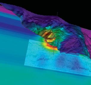
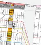
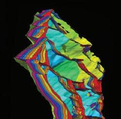
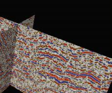
Blueback Reservoir the preferred and chosen GeoScience Solutions Partner Try something new. Find something better. Blueback Rock Physics plug-in for Petrel* Bridging the gap between geology and geophysics The complete suite of rock physics tools for quantitative interpretation across multiple domains within Petrel. Blueback Reservoir blueback-reservoir.com E sales@blueback-reservoir.com | T +1 403 538 4821 blueback-reservoir.com/rockphysics *Mark of Schlumberger 40005000 6000 8000900010000 11000 12000 7000 13000 1400015000 16000 Acoustic impedance (kP a.s/m) 17000 1.4 1.5 1.7 1.6 P/S velocity ratio 1.8 1.9 2.0 2.1 2.2 2.3 2.4 2.5 2.6 2.7 2.8 Por=0.4 Por=0.35 Por=0.3 Por=0.25 Por=0.2 Por=0.15 Por=0.1 Vol shl=0.6 Vol shl=0.4 Vol shl=0.2 Reservoir Properties
Petrel
Wells
