Practical Sequence Stratigraphy XI. Units and Sequence Stratigraphy: Part 3. 30 Climate Change IV: The Greenhouse Effect 42 2009 CSPG-CSEG-CWLS Annual Convention
Practical Sequence Stratigraphy XI. Units and Sequence Stratigraphy: Part 3. 30 Climate Change IV: The Greenhouse Effect 42 2009 CSPG-CSEG-CWLS Annual Convention
“Whether it’s cross-sections in AccuLogs, queries and search, or production show maps, AccuMap consistently delivers the quality data I need, when I need it. Its reputation as an industry leader is well deserved.”
John Wittnebel Result Energy Inc., VP Exploration

Strong words. But no newsflash. AccuMap is the premier oil and gas mapping, and data management and analysis tool on the market. Canada ’s most comprehensive dataset – nearly 50 years worth – means faster access to more accurate data. Translation? Quicker data review, enhanced workflow, better decision-making and increased profitability. And it keeps evolving.
For decades now, AccuMap’s been turning data in dollars for you. Which is why so many oil and gas pros like John have it on their desktops.
Visit www.ihs.com/accumapconnect to find out about the Well Holding and Spacing module now available in AccuMap.

#600, 640 - 8th Avenue SW
Calgary, Alberta, Canada T2P 1G7

Tel: 403-264-5610 Fax: 403-264-5898
Web: www.cspg.org
Office hours: Monday to Friday, 8:30am to 4:00pm
Executive Director: Lis Bjeld
Email: lis.bjeld@cspg.org
Communications & Public Affairs: Heather Tyminski
Email: heather.tyminski@cspg.org
Corporate Relations Coordinator: Alyssa Middleton
Email: alyssa.middleton@cspg.org
Membership Services: Dayna Rhoads
Email: dayna.rhoads@cspg.org
Reception: Kasandra Klein
Email: reception@cspg.org
Joint Annual Convention Committee
Convention Manager: Shauna Carson
Email: scarson@geoconvention.org
Convention Coordinator: Tanya Santry
Email: tsantry@geoconvention.org
EDITORS/AUTHORS
Please submit RESERVOIR articles to the CSPG office. Submission deadline is the 23rd day of the month, two months prior to issue date. (e.g., January 23 for the March issue).
To publish an article, the CSPG requires digital copies of the document. Text should be in Microsoft Word format and illustrations should be in TIFF format at 300 dpi., at final size. For additional information on manuscript preparation, refer to the Guidelines for Authors published in the CSPG Bulletin or contact the editor.
Technical Editors
Ben McKenzie Colin Yeo (Assistant Tech. Editor) Tarheel Exploration EnCana Corporation Tel: 403-277-4496 Tel: 403-645-7724 Email: bjmck@telusplanet.net Email: colin.yeo@encana.com
Coordinating Editor
Heather Tyminski
Comunications and Public Affairs, CSPG Tel: 403-513-1227, Email: heather.tyminski@cspg.org
ADVERTISING
Advertising inquiries should be directed to Alyssa Middleton, Tel: 403-513-1233, email: alyssa.middleton@cspg.org. The deadline to reserve advertising space is the 23rd day of the month, two months prior to issue date.
The RESERVOIR is published 11 times per year by the Canadian Society of Petroleum Geologists. This includes a combined issue for the months of July and August. The purpose of the RESERVOIR is to publicize the Society’s many activities and to promote the geosciences. We look for both technical and non-technical material to publish. The RESERVOIR is not intended to be a formal, peer-reviewed publication. Additional information on the RESERVOIR’s guidelines can be found in the May 2008 issue (p.46-48; available at http://www.cspg.org/publications/reservoir/reservoir-archive-2008.cfm). No official endorsement or sponsorship by the CSPG is implied for any advertisement, insert, or article that appears in the Reservoir unless otherwise noted. The contents of this publication may not be reproduced either in part or in full without the consent of the publisher.
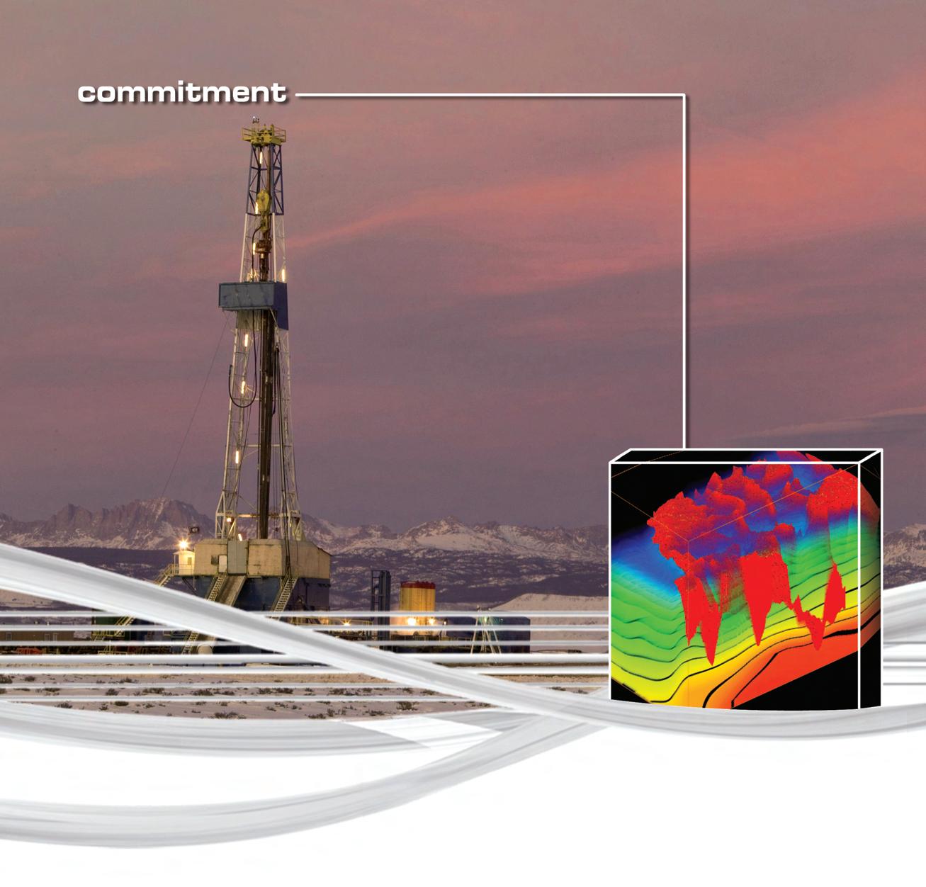
CGGVeritas is committed to targeted geophysical solutions that fit your local needs. Wherever you’re working, you have access to leading seismic imaging technologies, the highest quality 3D and 2D data library, the most advanced acquisition capabilities and a staff committed to your success.

Please join us for coffee at the CSPG CSEG CWLS Convention, booth #105.
Count on CGGVeritas to help you explore, develop and produce with confidence. Contact:
President
Graeme Bloy • Canada Capital Energy Corporation gbloy@capitalenergy.ca Tel: (403) 975-5784
Vice President
John Varsek • EnCana Corporation john.varsek@encana.com Tel: (403) 645-2000
Past President
Lisa Griffith • Griffith Geoconsulting lgriffith@griffithgeoconsulting.com Tel: (403) 669-7494
Finance director
David Garner • Chevron Canada Resources davidgarner@chevron.com Tel: (403) 234-5875
assistant Finance director
Greg Lynch • Shell Canada Ltd. greg.lynch@shell.com Tel: (403) 691-3111
Program director
Randy Rice • Suncor Energy Inc. rjrice@suncor.com Tel: (403) 205-6723
assistant Program director
Scott Leroux • EnCana Corporation scott.leroux@EnCana.com Tel: (403) 645-2000
serVices director
Ayaz Gulamhussein • NuVista Energy Ltd. ayaz.gulamhussein@nuvistaenergy.com Tel: (403) 538-8510
assistant serVice director
Penny Colton • Geophysical Service Inc. pcolton@geophysicalservice.com Tel: (403) 514-6267
outreach director
Mike DesRoches • Talisman Energy Inc. mdesroches@talisman-energy.com Tel: (403) 513-6843
communications director
Peggy Hodgkins • CGGVeritas peggy.hodgkins@cggveritas.com Tel: (403) 266-3225
A message from the Programs Director, Randy Rice
The Geology of Layoffs: Has our industry, and have we, learned from past mistakes?
So here we go again. Remember the ‘80s?
What goes up always comes down and what goes down always comes up. How quickly we forget this mantra, even those of us who have been through a previous cycle. The cyclic nature of our profession (minerals or hydrocarbons) is as assured as the sun’s daily activity. Once more it has been blatantly shown just how vulnerable resource exploration is to global factors far removed from “simply” the technical and economic grind of finding and developing them, while making a buck in the process.
As geoscientists, we are fundamentally historians. We read stories bound up in rocks and use “their experience” to help us understand how planet Earth operates going forward (the Intergovernmental Panel on Climate Change could incorporate this approach). Of all professions, ours should be the first to learn from past errors in judgment. It is early, yet, to say how serious this will get but layoffs of well qualified permanent staff are popping up on the radar now and then, to say nothing of equally well qualified contract staff. And let us not forget the recent grads who are having a hard time getting the jobs they studied years for. Is this the beginning of what happened in the ‘80s, which fundamentally caused our recent shortage of qualified geoscientists? I certainly hope not.
Only a few months ago, yes just a few months, the profession was still struggling with a lack of qualified people, or in some cases just people, to fill positions. CEOs, VPs, and other highest-placed individuals would do their companies a favor going forward to find other ways of dealing with the economic slowdown rather than knee-jerking to employee layoffs. Not all companies are reverting to this (now proven) short-sightedness and perhaps more than anything this could indicate that the ‘80s will not be back in full (looking for
some wood…). Instead, some are saying strange things such as: we value your skills and want to earn your loyalty; we put high value on the well honed skills, experience, and mentorship of our older employees particularly during difficult times (yup – I’ll swear on the highest stack of Bibles).
I very grudgingly admit that for small companies it is more difficult to apply lessons learnt but, so ironically, it is even more so that the small company lives or dies on the higher skill levels and experience of their employees. Any institution that looks past the current downturn and recognizes the crucial need to retain skills in-house will be extremely well positioned several years hence.
And let’s be clear here; it is not just companies that have lessons to learn. So too the employee that was jumping ship like there was no tomorrow for small perks and/ or minimal salary increases, naively thinking that good times will always be around and arrogantly disregarding company memory. It does, in fact, work both ways. You want to keep your job when times are thin? Let your company know that you appreciate being a working geologist and, yes, you do realize that you are being paid to do it.
I managed to ‘just’ escape from the souldestroying layoffs of the ‘80s by hiding out in grad school until ’87 (Black Monday) and then maintained my career by bouncing around the world a bit in academia and mineral exploration. I’ve always felt that it was fundamentally training that allowed me to hang on to my profession though that period. For those of you unfortunate enough to have been laid off, or if you are a recent grad unable to land a job, If your family responsibilities, and dollars, allow it, this period could be flipped into a rare window of opportunity to upgrade for an even better position coming along in a year (Continued on page 7...)
For more on short courses and field seminars, call 918-560-2650 or visit www.aapg.org/education.
Basic Well Log Analysis
July 7-10 / Denver, CO
Instructors: George B. Asquith, Texas Tech University, Lubbock, TX; Daniel A. Krygowski, The Discovery Group, Denver, CO
An Introduction to the Petroleum Geology of Deepwater Settings
July 27-29 / Houston, TX
Instructor: Paul Weimer, University of Colorado, Boulder, CO
Exploring for Stratigraphic Traps Using Pressure/Depth Plots & Salinities
July 28-30 / Houston, TX
Instructor: Hugh W. Reid, Hugh W. Reid & Associates, Calgary, AB, Canada

Folds, Faults and Hydrocarbons in the Southern Canadian Cordillera –Principles and Practices
August 3-7 / Calgary, Alberta, Canada
Instructor: Peter B. Jones, International Tectonic Consultants, Ltd., Calgary, AB, Canada
Grand Canyon Geology via the Colorado River, Arizona
June 19-26 / Begins at Marble Canyon, AZ; ends at Marble Canyon or in Las Vegas, NV
Leader: John E. Warme, Colorado School of Mines, Golden, CO
Seismic Interpretation of Compressive Structures:
Field Trip to the Southern Canadian Rocky Mountain Foreland
July 18-24 / Begins and ends in Calgary, AB, Canada
Leaders: John H. Shaw, Harvard University, Cambridge, MA, & Dr. Frank Bilotti, Chevron, Houston, TX
Fractures, Folds, and Faults in Thrusted Terrains: Sawtooth Range, Montana
August 17-21 / Begins and ends in Great Falls, MT
Leaders: William B. Hansen, Jireh Consulting Services, Great Falls, MT; Steve Boyer, Consultant, Tacoma, WA; Chuck Kluth, Kluth & Associates, Littleton, CO; Jim Sears, University of Montana, Missoula, MT


APACHE CANADA LTD.
BAKER ATLAS
CoNoCoPHiLLiPS CANADA LimiTED
DEvoN CANADA CoRPoRATioN
ENERPLuS RESouRCES TRuST
geoLogiC systems Ltd.
gEomoDELiNg TECHNoLogY CoRP.
HuNT oiL ComPANY of CANADA,
HuSKY ENERgY iNC.
iHS
imPERiAL oiL RESouRCES
LARio oiL & gAS ComPANY
LiTTLE RoCK DoCumENT SERviCES
mJ SYSTEmS
muRPHY oiL ComPANY
NExEN iNC.
PENN WEST PETRoLEum LTD.
PETRo-CANADA oiL AND gAS
PETRoCRAfT PRoDuCTS LTD.
PRoviDENT ENERgY LTD
RPS ENERgY CANADA LTD.
SHELL CANADA LimiTED
SPRouLE ASSoCiATES LimiTED
SuNCoR ENERgY iNC
TALiSmAN ENERgY iNC.
TECK ComiNCo LimiTED
ToTAL E&P CANADA LimiTED
TouRmALiNE oiL CoRP.
AS OF FEBRUARY 28, 2009
(...Continued from page 5)
or two. much easier said than done, but it could pay off down the road.
in putting together my executive comments over the last year i steadfastly avoided the business-like approach of just reporting on the ‘state of the nation’ so to speak. However, a quick summary of how things are going in Programs is probably in order. Programs is fine.
i ’m pleased to report that Scott Leroux has accepted the position of Assistant Program Director for CSP g and will be taking over from me in December 2009. over the past year the Continuing Education Committee (Con. Ed.) has continued to perform outstandingly under the direction of Travis Hobbs. Con. Ed. is a crucial part of the Programs Directorate. it looks after short courses and field trips during the annual convention as well as the courses offered during Education Week in the fall of the year. A new initiative this year is to try to bring back one- or two-day field trips so we can look at some rocks in our own neighborhood. Con. Ed. is looking for field trip leaders, so please contact Travis if you have some thesis or project (new or old) rocks that we can look at.
The other two corner pins of Programs is the Technical Luncheon Committee and individual Technical Divisions. if there is one thing that defines CSPg , it is the high caliber of the Technical Luncheons that this committee brings to us. our luncheons surely are the best attended of their type in the world. Chris Seibel and his committee are to be congratulated for a continuing exceptional job. our Technical Divisions are
variably active throughout the year usually in the form of well attended, and often noon talks. most active are the Structural Division, formerly led by Jamie Jamison and now Darcie greggs; the Core and Sample Division, led by Doug Hayden; the Basin Analysis Division, led by m ark Caplan and Steve Donaldson; the Paleontology Division, led by Phil Benham; and the Sedimentology Division, led by Steve Hubbard and Jeff Reinprecht. A new and very successful Heavy oil / oil Sands Technical Division was initiated by Randy Smith, Nicole Keilly, and fraser m acNicol of RPS Energy last year. it is standing room only at their breakfast talks.
Please remember that it is you, our membership and our volunteers, that make CSPg the unique and successful Canadian Petroleum Society that it is. Thank you very much.
Graeme Bloy is now VP of Exploration at Canada Capital Energy Corporation. Calgary: 403-984-1734.
Bob Moore from Vice President of Exploration and Development, Crown Point Ventures (Vancouver, BC and Buenos Aires, Argentina) to Consulting Geologist Force 10 Resources Co. Ltd. Calgary: 403-242-5842.
SPEAKER
Charlotte Schreiber
University of Washington
11:30 am
tuesday, a pril 14, 2009 telus convention centre calgary, alberta
Please note:
the cut-off date for ticket sales is 1:00 pm, Wednesday, april 8, 2009.
csPg member ticket Price: $38.00 + gst. non- member ticket Price: $45.00 + gst.
Due to the recent popularity of talks, we strongly suggest purchasing tickets early, as we cannot guarantee seats will be available on the cut-off date.
Did you know that you can book a table for the Technical Luncheons? To book your company’s
table, or to buy individual tickets, visit www.cspg. org or call CSPG’s office at (403) 264-5610.
Mars is an “Earth-type” planet – composed of materials of similar composition to those of Earth, having an atmosphere (mostly CO 2 ) with winds and storms and experiencing
Timothy F. Ball, Ph.D.
Environmental Consultant
Former Climatology Professor at the University of Winnipeg
Thursday May 21, 2009 at 11:30 am
Metropolitan Conference Centre 333, 4th Avenue SW, Calgary, Alberta
Sponsored by the Friends of Science
Advocates of Climate Change Debate
$65 per ticket, $585 per table www.friendsofscience.org
Ticket can be obtained by email (Visa/MC accepted): contact@friendsofscience.org
Payment can also be made by cheque to: Friends of Science
PO Box 23167 Connaught P.O., Calgary, AB T2S 3B1

marked diurnal and seasonal temperature fluctuations. Moreover, on the surface there are sands (of several different mineralogies) and evidence there is movement of these sands, forming very recognizable dunes. The presence of both calcium and magnesium sulfate deposits is widespread in many areas, as well as iron oxides, phyllosilicates, and a small amount of calcite. Thus, it is reasonable for a sedimentologist to consider Martian depositional development and possible Earth analogs. Further, it is a wonderful place to imagine resultant stratigraphy and even major structural processes, but without setting foot on the planet.
Considered in this presentation will be some sedimentary features, their earthly equivalents, and how they may fit into the morphology we see on the present Martian surface. Various sedimentary processes apparently were very important earlier in Martian geological history but are not as important in the modern environment. Although we are quite certain there is not and was not any ongoing plate tectonic activity, some of these early deposits also controlled later major structural features. Based on the degree of impact cratering, as an indicator of age, it is evident that some features developed quite early in the evolution of Mars but that in many areas there is indication of ongoing geological activity. Modern deposition is also noted, so that we can say Mars is not a geological relic but continues to evidence ongoing activity, with many processes similar to those seen on Earth.
Charlotte Schreiber is presently an Affiliate Professor of Geology at University of Washington (Seattle), teaching sedimentary petrology. First studying deep-sea sediments and their physical properties, and then working on the first cores from the Deep Sea Drilling Project (Leg 13) in the Mediterranean she became intrigued with the formation and physical characteristics of evaporites. With that in mind, her thesis was carried out on the evaporites of the late Miocene in the Mediterranean (1974).

Continuing with studies in Sicily, Spain, and Cyprus and in the late Silurian of the Michigan Basin, she has been able to create reasonable models for earth-type evaporite accumulations. At the present time, ongoing examination of additional Mediterranean evaporite deposits, plus several projects examining Martian sediments and structures, have generated an active pursuit in new fields of endeavor.
SPEAKER
Dr. Ted Daeschler Academy of Natural Sciences, Philadelphia
11:30 am monday, april 27, 2009 telus convention centre calgary, alberta
Please note:
the cut-off date for ticket sales is 1:00 pm, Wednesday, april 22, 2009. csPg member ticket Price: $38.00 + gst. non- member ticket Price: $45.00 + gst.
Due to the recent popularity of talks, we strongly suggest purchasing tickets early, as we cannot guarantee seats will be available on the cut-off date.
Did you know that you can book a table for the Technical Luncheons? To book your table, or to buy individual tickets, visit www.cspg.org or call CSPG’s office at (403) 264-5610.
Research on the origin of limbed vertebrates (tetrapods) has made great advances in
recent decades as a result of paleontological discoveries including important new material from Devonian clastic rocks of Ellesmere Island, Nunavut. The fishtetrapod transition, as it is traditionally called, is no longer an evolutionary leap between free-swimming, lobe-finned fish and lumbering early tetrapods. A series of fossil intermediates now illustrate the sequence of changes over millions of years in the transformation from finned to limbed members of the tetrapod stem lineage. The interpretation of geological data and the range of fossils associated with the transition have also refined our understanding of the environmental
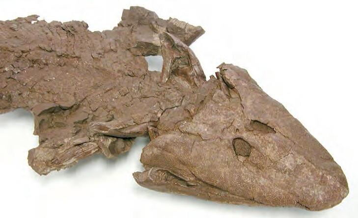
settings that were the crucible of early tetrapod evolution.
The recent discovery and description of Tiktaalik roseae from within the type section of the Fram Formation (Okse Bay Group; Frasnian) on southern Ellesmere Island provides a particularly good example of a transitional taxon that helps to resolve the sequence of morphological change between finned and limbed forms. With a phylogenetic position as the sister group of limbed forms, T. roseae retains numerous primitive features of the lower jaw, braincase, branchial skeleton, and scale cover, while also showing derived features in the skull roof, palate, and fin endoskeleton. As indicated by the depositional setting and suite of morphological features, T. roseae may have been exploiting new ecological opportunities that were developing in shallow aquatic ecosystems on Late Devonian floodplains.
BIOGRAPHY
Dr. Ted Daeschler has been at the Academy of Natural Sciences in Philadelphia since 1987. He studied geology at Franklin and Marshall College in Lancaster, Pennsylvania, and received a Master’s in paleontology at the University of California at Berkeley in 1985. He was awarded his Ph.D. at the University of Pennsylvania in 1998.
Daeschler’s research interests are centered on Late Devonian-age vertebrate fossils and the origin of limbed vertebrates. His fieldwork in Devonian-age rocks in Pennsylvania and the Canadian Arctic and has led to a series of discoveries establishing the research program as one of the most productive in the world. Daeschler’s responsibilities at the Academy of Natural Sciences focus primarily on research, collections building, and on public programs within the museum. He served as a scientific advisor for the renovation of the Academy’s Dinosaur Hall, and a variety of other paleontological exhibits. Daeschler’s work is a reflection of the rich history of vertebrate paleontology at the Academy of Natural Sciences, both in research and in public education.
NOTE
David G. Smith and Donald G. Cook will be recognized at the CSPG Technical Luncheon on Monday, April 27, 2009 as recipients of Honourary Memberships. The presentation of the Award will be at the Long-Time Members Reception on May 5, 2009, held during the CSPG, CSEG, CWLS Convention: Frontiers and Innovation.
Charles Henderson
University of Calgary
Co-AuthoR
Tyler Beatty
University of Calgary
11:30 am
Thursday, May 14, 2009
Telus Convention Centre Calgary, Alberta
Please note: The cut-off date for ticket sales is 1:00 pm, Monday, May 11, 2009.
CSPG Member Ticket Price: $38.00 + GST. Non-Member Ticket Price: $45.00 + GST.
Due to the recent popularity of talks, we strongly suggest purchasing tickets early, as we cannot guarantee seats will be available on the cut-off date.
Did you know that you can book a table for the Technical Luncheon? To book your table, or to buy individual tickets, visit www.cspg.org or call CSPG’s office at (403) 264-5610.
Earth’s greatest mass extinction 252.2 million years ago was expressed in subtle ways and the events and aftermath are both paleogeographically and paleoenvironmentally variable. Owing to this variability, a biostratigraphic framework is necessary to ensure proper global calibration of the extinction pattern. The base and top of the last stage of the Permian (Changhsingian) are defined at Meishan, South China and the intervening Changxing Limestone contains a diverse record of tropical biota until within centimetres of the top, when 90% of biodiversity is lost. On the other side of the Panthalassic Ocean, at Opal Creek in Kananaskis Country, Late Permian biodiversity was reduced over an extended period, but a sudden extinction is still recorded. These very different sites can be correlated by carbon isotopic excursions and conodonts.
Finding a discrete extinction mechanism in these very different rocks is difficult and an understanding of ancient oceanographic conditions drawn from geochemical and paleontological evidence is critical. However, the primary agent may have started on the land’s surface in Siberia with the outpouring and CO2 degassing of massive amounts of lava that also ignited older coal beds. This provided more CO2 increase, leading to a runaway greenhouse, rapid global warming, and a cascade of ecologic crises. Warmer oceans dissolve less oxygen and show reduced circulation leading to dysoxic conditions and eventually euxinic conditions that upwelled and spread across
shallow shelves as indicated by biomarker evidence of green-sulfur bacteria in shallowwater deposits.
But where on this hot, suffocating and smelly Earth did life survive this calamity? It turns out that ancient shores around Western and Arctic Canada provided one such refuge that Beatty et al. (Oct. 2008; Geology) named “the habitable zone.” In contrast to the Tethys and southwestern Panthalassic oceans, the Early Triassic trace fossil record from the northwest margin of Pangea provides numerous examples of rapid recovery, but only within a narrow set of paleoenvironmental conditions. In these locations anomalously diverse ichnofossil assemblages from shoreface environments provide evidence of oxygenated refuges for benthic marine organisms. Within these refuges, peak ichnofossil diversity and bioturbation intensity are associated with a narrow range of sedimentary environments, (lower shoreface to offshore transition, and isolated event beds in offshore settings). Within environments distal of the offshore transition, ichnofossil diversity is greatly diminished. The habitable zone hypothesis provides a model for the distribution of these refuges, in which wave aeration, enhanced by frequent storms, gave rise to an optimal zone for benthic colonization.
Subsequent biodiversity increase in the Triassic provided the shells that would be concentrated
into bioclastic hydrocarbon reservoirs in the midMontney and Halfway formations. Comparisons to biodiversity loss and greenhouse warming in today’s world cannot be ignored.
BiogRAPhy
Charles Henderson, P.Geol. is a Professor at the University of Calgary where he has been teaching stratigraphy and paleobiology for 20 years following his Ph.D. at the University of Calgary in December 1988. He worked with Esso Resources in the early 1980s after his B.Sc. and M.Sc. at University of British Columbia. His research focuses on conodont paleobiology and biostratigraphy and integrating conodonts with other stratigraphic datasets. The research of many of his former and current students has been focused on stratigraphic studies in Western and Arctic Canada that are applicable to the oil industry whose support is gratefully acknowledged. Henderson is the Chairman of the Subcommission on Permian Stratigraphy of the International Commission on Stratigraphy and his research is focused on events recorded in Permian rocks around the world.
Tyler Beatty is a geoscientist with Imperial Oil. He graduated from the University of Western Ontario in 1997 with a B.Sc. in Geology and Environmental Science and from Simon Fraser University in 2003 with a M.Sc. in Geology. He is a Ph.D. candidate in the Department of Geoscience, University of Calgary. His research interests are centred on Late Paleozoic and Triassic conodonts and trace fossils.
SPEAKER
Ben Gadd
11:30 am thursday, may 21, 2009 telus convention centre calgary, alberta
Please note:
the cut-off date for ticket sales is 1:00 pm, Friday, may 15, 2009.
csPg member ticket Price: $38.00 + gst. non- member ticket Price: $45.00 + gst.
Due to the recent popularity of talks, we strongly suggest purchasing tickets early, as we cannot guarantee seats will be available on the cut-off date.
Did you know that you can book a table for the Technical Luncheons? To book your company’s table, or to buy individual tickets, visit www.cspg.org or call CSPG’s office at (403) 264-5610.
Having written the very popular Handbook of the Canadian Rockie s, Ben Gadd wanted to follow up with a short, easy-to-read geological guide to what one sees along the TransCanada Highway between Calgary and Golden, plus a few other major routes across the Canadian Rockies. The book was planned to total about 200 pages, including a number of annotated photos.
Five hundred and seventy-six pages later, Gadd was finished, and the result has been described as “monumental.” The book includes over 500 illustrations. It details the geology of every all-weather road across the Rockies from Crowsnest Pass to the Alaska Highway. The Icefields Parkway is also covered, as is the Kananaskis Trail and its continuation through the southern foothills, plus the route southward to Waterton.
Geology Rocks is a half-hour slide talk Gadd has prepared about the origins of this book. It is also about his long, awardwinning career as a geologist, naturalist, writer, and educator. Gadd’s earth-science
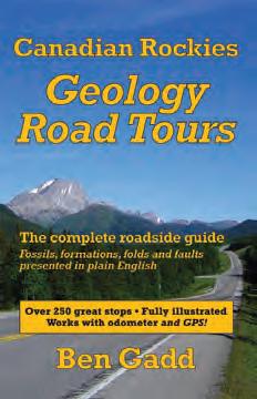
education was unique. In the talk we find out why University of Calgary professor Ed Klovan has jokingly referred to Gadd as “our most successful failure.”
Canadian Rockies Geology Road Tours was launched to great praise at the Geological Survey of Canada in Calgary on November 4, 2008. Before and after the upcoming talk, copies will be available for purchase, and Gadd will be happy to inscribe.
Ben Gadd, 62, has lived in Jasper, Alberta since 1980. The author of Handbook of the Canadian Rockies, which has sold over 50,000 copies, Gadd has written or co-authored eight other books and contributed to several more. His first novel, Raven’s End, has become an awardwinning Canadian best-seller. It has also has been translated into German, Italian, Dutch, and Danish for sale in Europe, and also into Japanese.
Gadd has received three Banff Mountain Book Festival awards.
Gadd is a recognized authority on the Rocky Mountains. Educated as a geologist, he has pursued a career in natural history, working in the summer as a freelance interpretive guide in Jasper National Park – a job he describes as “rent-a-naturalist” – and in the winter as a writer and lecturer on Rockies topics. He also teaches writing courses for Grant MacEwan College.
A member of several conservation groups, Gadd advocates for the mountain national parks, attending hearings, making representations on park-protection issues, and speaking up publicly as required. Gadd is the founder of the nonprofit Jasper Institute, which offers naturalhistory courses to park visitors. He designs nature trails, produces interpretive signage, and consults with protected-area managers. Heard frequently on CBC radio, he has also appeared in many television programs and several documentaries on the Rockies.
When not otherwise occupied, Gadd hikes, bikes, climbs, and cross-country skis in the mountains he loves best. Married over forty years, he and Cia have two adult sons.

exploring collaborating
project leading technology leading industry leading subsurface subsea subanywhere smiling geosteering globe-trekking horizontal drilling ecothinking biking team building carbon capturing pushing the envelope groundbreaking digital mapping remote sensing playing family bonding creative thinking stress reducing rock sampling rock climbing skiing hockey playing
mud logging well logging caring for our environment life balancing parenting relaxing on the weekends
initiative grabbing challenging yourself
SPEAKER
Jean-Yves D. Chatellier Talisman Energy Inc.
12:00 noon
thursday, a pril 9, 2009 room LPW-910, Livingston Place West 250 2 st sW, calgary, alberta
In western Canada, geologists commonly focus their effort on discrete wells or individual horizons in geographically restricted areas. They rarely have the chance to embark on large cross-formational studies as these require three-dimensional visualization software used by other groups (e.g. in reservoir modeling). For multidisciplinary three-dimensional statistical analysis and data mining, very powerful interactive
statistical programs have been available since the late ‘80s and have found numerous markets but these programs have failed to make in-roads in the geologist’s toolkit.
Data mining and three-dimensional visualization are ideal techniques to unravel the hidden details of mature basins. Such tools allow data from many disciplines to be used to construct an improved structural and dynamic picture of an area. Fractures, faults, and migration paths in Alberta will be examined using a series of techniques and methods involving various types of data from different disciplines. The uncertainty related to each parameter used will be addressed and will be overcome by the shear volume of data available.
The examples presented are essentially from data that are commonly neglected by the oil industry. Thus, cuttings observations that make little sense at first glance can give incredible information on type of tectonic activity, nature of fluid migrations, and their relative timing – information will include grain angularity and planes of abnormal red-colored rocks crossing formations. Three-dimensional views of large amounts of data are incredibly powerful when dealing with information from many formations. Some of the chosen examples include drilling problems, abnormal gas compositions, unusually high porosity, and netto-gross values, the latter needing normalization


per formation to be optimally utilized. Fractures, faults, and migration paths have yet to be better understood at a basin and at more local scales. The mature Western Canada Sedimentary Basin has a remaining rosy future even at a $40 oil price. Finding new resources will most likely require innovative thinking and the use of extremely large data sets in a multidisciplinary and cross-formational approach.
Jean-Yves Chatellier got his Bachelor and “Maitrise” in geology from Lille (France) and obtained a DEA and Ph.D. in tectonics from the University of Pierre et Marie Curie in Paris. He later finished a distance-learning MBA from Henley Management College (UK)
After a start with Aquitaine Company of Canada he joined Petroconsultants in Ireland before working around the world for Shell International for nine years as an exploration and production geologist and as seismic interpreter and team leader. His main areas of study include the North Sea, New Zealand, Thailand, Brunei, and West Africa. He left Brunei Shell to accept a job as senior research geology advisor for Petroleos de Venezuela. He worked on numerous projects in western and eastern Venezuela for seven years. Since 2003 he has focused on new plays in North America. He is presently employed by Talisman working on the new shale gas play of Utica and Lorraine, Quebec.


exploring collaborating
project leading technology leading industry leading subsurface subsea subanywhere smiling geosteering globe-trekking horizontal drilling ecothinking biking team building carbon capturing pushing the envelope groundbreaking digital mapping remote sensing playing creative thinking stress reducing parenting
mud logging well logging caring for our environment
life balancing family bonding skiing hockey playing initiative grabbing challenging yourself
SPEAKER
Dennis Meloche, Senior Geological Advisor (Clastics) Devon Canada Corporation
12:00 noon
Wednesday, a pril 15, 2009 encana amphitheatre, 2nd floor e ast end of the calgary tower complex 1st street and 9th avenue s.e . calgary, alberta
Geoscientists rely heavily upon depositional models to guide and constrain reservoir mapping and description. These conceptual models, for the most part, are constructed from studies of both modern depositional systems and their rock record analogs. In contrast to outcrop analogs, modern environments provide unambiguous ranges and limits for the scale and geometry of depositional elements. Other advantages of modern depositional analogs include the ability to observe reservoir and non-reservoir facies (e.g., potential seals or baffles) across the entire depositional system, accurately define the processes operating during deposition, and accurately define the long-term and short-term controls on those processes (e.g., climate, tectonics, eustacy, etc.).
The Colorado River delta (Figure 1) is located at the northern end of the Gulf of California, a Neogene-age rift basin created by strikeslip displacement of the Baja Peninsula along the San Andreas Fault. The delta is located within a complex zone of strikeslip faulting and oblique crustal extension. Five kilometres of deltaic deposits record approximately six million years of basin subsidence and sediment aggradation. The transgressive to early highstand Holocene stage of delta development is represented
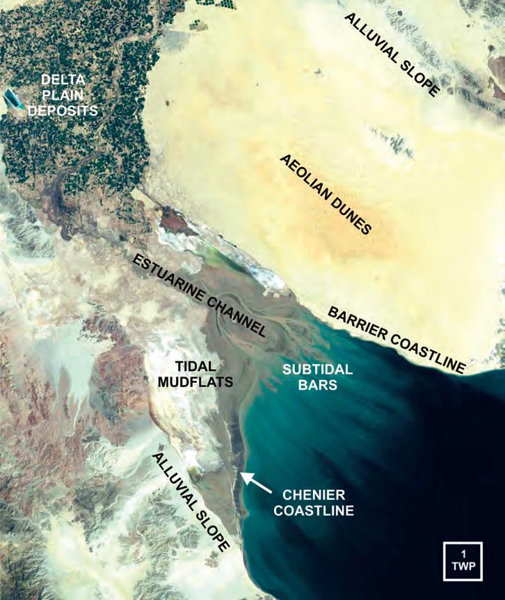
acquired through Radarsat)
by a macrotidal ‘geomorphic’ estuary (or tide-dominated delta) formed by the interglacial eustatic sea level rise and drowning of a broad lowstand delta.
The Holocene system contains several geomorphic elements that can be grouped into four broad depositional settings:
1. Shallow marine estuarine funnel that contains an estuarine channel, largescale tidal bars (including IHS point bars), actively shifting fluidized mud, and sandy subtidal bar complexes;
2. Narrow, sand-rich retrogradational barrier coastline created by combined flood tidal and longshore currents;
3. Broad progradational coastal mudflat
that contains saline playas and aerially restricted reservoir sands of several types, including a 45-kilometre-long chenier margin composed primarily of coquina sand deposits up to five metres thick; and
4. Non-marine settings that includes fluvial deltaic meander reaches; aeolian coastal dune complexes; and broad, low gradient, sand-dominated alluvial slopes that flank the western and eastern margins of the basin.
These Holocene elements, when combined with outcrops, well data, and geophysical studies, provide a more comprehensive three-dimensional view of the larger depositional system, including thick prodelta turbidites.
The Colorado River delta was selected as an analog for several reasons. The “geomorphic” estuary represents a type of depositional system commonly assigned to late transgression / early highstand deposits associated with several major unconformities in the Western Canada Sedimentary Basin. The estuary contains several coeval, sandrich geomorphic elements that contrast strongly in areal extent, geometry, spatial distribution, and preferred orientation. The Colorado delta and Gulf of California have well documented depositional, climatic, eustatic, and structural histories. Sea cliff outcrops of Pleistocene and Pliocene strata flanking the estuary provide threedimensional examination of coastal and deeper-water facies. Mesas on the delta plain and sea cliffs along the coast provide direct observation of unconformity development associated with tectonic, climatic, and eustatic changes. Lastly and most important, the Colorado River delta is easily accessed with a large group of participants.
Dennis Meloche received an Honours B.Sc. in Geology from the University of Western Ontario in 1975 and a Ph.D. in Biogeochemistry from the University of Western Ontario in 1981. He has 27 years of domestic and international experience, with more than half of it spent in the role of technical service and support.
Meloche is currently Senior Geological Advisor for Clastics within the Geotechnical Services Group of the Devon Canada Corporation. In this role, one of his functions is to promote professional development within the organization for geoscientists and engineers.
April 15, 2009
Rock Shots – TBA
UPCOMING EVENTS
May 12, 2009
Rock Shots – TBA
Main Event – TBA
June 23, 2009
Rock Shots – TBA
Main Event – TBA
INFORMATION
There is no charge for International Division Talks. Please bring your lunch. The facilities for the talk are provided complimentary of EnCana and refreshments by Geochemtech Inc. For further information or if you would like to give a talk, please contact Bob Potter at (403) 863-9738 or ropotter@telusplanet.net or Trent Rehill at (403) 615-2386 or trent.rehill@ artumas.com.

AND GAIN A COMPETITIVE EDGE
AND GAIN A COMPETITIVE EDGE Visit Alex, the Burrowing Owl, at the CSPG CSEG CWLS Convention - Booth 339
• Petroleum and Mining Exploration and Development Expertise
• Advanced Geophysical Interpretation
• Integrated 2D, 3D and 4D Analyses
• Earth Modeling
• Seismic Acquisition and Project Management
• International Seismic Services

+1.403.233.2455
www.boydpetro.com
Global Geophysical Consultants
SPEAKER
Robin Cuthbertson and Jordan Mallon University of Calgary
7:30 pm - 9:00 pm Friday, april 17, 2009 mount royal college, room B108 calgary, alberta
The jaw mechanics of extinct vertebrates, including dinosaurs, can be investigated with reference to various parameters associated with the masticatory cycle (for example, muscle insertions, kinetic limitations of cranial joints, dental microwear, etc.). While we can never
be certain of the precise motions exacted by the jaws of any extinct vertebrates during feeding, a holistic approach that combines the above parameters can shed some light on the limitations of motion. Pleurokinesis is a chewing model that has previously been proposed for all ornithopod dinosaurs. In hadrosaurids, for example, this hypothesized mechanism includes vertical adduction of the mandible, lateral displacement of the maxilla, and posterolateral movement of the quadrate. In addition, these primary actions drive a series of linked secondary motions.
In this presentation, the kinetic limitations of hadrosaurine cranial joints are identified and evaluated with respect to accommodation of the primary and secondary motions required by the pleurokinetic model. Based on these observations, pleurokinesis cannot be recreated in the hadrosaurine dinosaurs Brachylophosaurus canadensis or Edmontosaurus regalis. In contrast, a simplified model, based on a rigid maxilla and a lower jaw exhibiting limited freedom at its mandibular glenoid cannot be rejected.
A preliminary investigation of dental microwear in hadrosaurids is also presented. The microscopic pits and scratches left on teeth
as a result of food processing suggest that, in addition to vertical adduction, there was a significant retractive motion of the mandible during feeding. Together, these independent lines of evidence suggest a feeding mechanism adapted to high-fiber herbivory.
Robin Cuthbertson received his M.Sc. in 2006 from Carleton University (Ottawa) and is currently pursuing his Ph.D. at the University of Calgary. Cuthbertson has studied aspects of cranial kinesis in hadrosaurs and is currently investigating the interrelationships of basal ichthyosaurs.
Jordan Mallon is a Ph.D. student at the University of Calgary. He is studying the evolutionary palaeoecology of the herbivorous dinosaurs from Dinosaur Provincial Park in Alberta.
This event is jointly presented by the Alberta Palaeontological Society, Mount Royal College, and the CSPG Paleontology Division. For details or to present a talk in the future please contact CSPG Paleontology Division Chair Philip Benham at 403-691-3343 or programs@albertapaleo. org. Visit the APS website for confirmation of event times and upcoming speakers: http://www. albertapaleo.org/.
Elbow Springs Golf Club • June 17-19, 2009
The Golf Committee would like to thank the following sponsors:
2008 Diamond Sponsors
geoLOGIC systems ltd.
AGAT Laboratories Ltd.
GeoStrata Resources Inc.
IHS
ProGeo Consultants
Schlumberger of Canada
RECON Petrotechnologies Ltd.
Tristone Capital Inc.
Weatherford Canada Patnership
Wildcat Scouting Services (1991) Ltd.
Arcis
Baker Atlas
Belloy Petroleum Consulting
CSPG
Devon Canada Corporation
Divestco
Fugro Data Solutions Canada Inc.
GLJ Petroleum Consultants
LogTech Canada Ltd.
ATB Financial
Athabasca Oil Sands Cor[p.
Beaver Drilling Ltd.
Boland Exploration Consulting
Canadian Discovery Ltd.
Continental Laboratories Ltd.
Fekete Associates Inc.
Genesis Executive Corporation
Greystone Resources Ltd.
Hotwell Canada Ltd.
Jimel Oilfield Scouting Services Ltd.
Pajak Engineering Ltd.
AON Reed Stenhouse
Martin Quinn Esq.
Core Laboratories Canada Ltd.
Gabel Energy Inc.
Hycal Energy Research Labs
Hydro-Fax Resources Ltd.
MD Totco Nov. Wellsite Gas Watch
M J Systems
Pason Systems Corp.
Rundle Energy Partners
Ryan Energy Technologies
Tucker Wireline Services
West Canadian Vega Estate Planning Corp.
Paradigm
Paramount Resources Ltd.
Petrocraft Products Ltd.
Polaris Resources Ltd.
Regent Resources Ltd.
RGS Consultants Ltd.
Scotia Waterous
Sproule Associates Limited
Tectonic Energy Consulting Inc.
Halliburton Group of Canada
ConocoPhillips Canada
Painted Pony Petroleum Ltd.
Montane Resources Ltd.
Quality Trophies and Engraving Ltd.
Sample Pro Ltd.
Seismic Brokerage Services Ltd.
Trivision Geosystems
Wild Rose Geological Services Ltd. Ltd.
Aguila Exploration Consultants Ltd.
Candian Stratigraphic Services
Crow River Resources
Dack Resources Ltd.
IEXCO Canada Inc.
Petro Tech Printing
San Dago Resources Ltd.
NAME:
SPOUSE’S NAME:
COMPANY:
ADDRESS (Bus.):
POSTAL CODE:
TELEPHONE: CELL PHONE:
E-Mail:
SHIRT SIZE: q S q M q L q XL q XXL
All contestants are required to have a photo (any will do) in the Golfer’s Photo Roster. New applicants or former contestants who do not meet this request are considered to have submitted an incomplete entry. Former contestants who have submitted a photo in the past need not do so again.
Handicap / Golf Index __________________ or
Average of best three 18-hole scores in past 2 years:______________
Entry Fee: Includes three rounds of golf with power cart; Paid driving range; Door prize draws; Skill prizes; BBQ (at Elbow Springs) and Awards Banquet (Calgary Petroleum Club) both for you and your guest.
Cost: $395.00 Tournament Fee
To assist the Entertainment Committee with budgeting, please indicate if you plan to attend the two major social events of the tournament: Wednesday Barbecue: Self: Yes q No q Guest: Yes q No q Friday Awards Banquet: Self: Yes q No q Guest: Yes q No q
Social Events Cancellation: Contact Craig Boland with 48 hours notice.
Make Cheques Payable To: CSPG (Classic Golf)
Send Entries To: CSPG Classic Golf Tournament 600, 640-8th Avenue S.W. Calgary, AB, T2P 1G7
Attention: Craig Boland
For more information call Craig Boland: (403) 861-8686
E-mail: craig.boland@shaw.ca
Early Bird Deadline May 6, 2009. Qualify for Early Bird Draw Prize.
Entries received after May 27, 2009 will be accommodated based on availability.
* Please photocopy your entry form and cheque before mailing. No receipts issued.
** All cancellations received after May 20th subject to a administrative fee ($60) and must be submitted to Craig Boland via email craig.boland@shaw.ca or fax (403) 264-5898. No refunds after June 3, 2009.
On-Line Registration Information: Use CSPG Membership Log-In, Go to Event Registration-Social Events, CSPG Classic
Mail/Courier Registration: Print this registration Form (http://www.cspg.org/events/events-social-classicgolf.cfm) send to CSPG Office with cheque.
Get your registration in early to confirm your spot in this year’s tournament and preference in the 50th Annual Tournament. This event has eighteen flights catering to all levels of player from Beginner to the Scratch player. New Golfers are welcome, with all new entries ranked chronologically.
Your preferred E&P applications no longer need to stand alone.
Landmark’s DecisionSpace® environment, delivered through the R5000 release, has the most open architecture in the industry. It enables seamless integration of your preferred software –whether it’s ours, yours or someone else’s – into efficient, cross-disciplinary workflows. Build stronger, more collaborative business processes and more comprehensive asset understanding using the best software for your needs. Learn how at halliburton.com/landmark.
by Jason Pitcher
Today’s reservoirs are thinner, tolerances are tighter, and the need to maximize the potential return on the investment is an everpresent driver. Development geologists are key to realizing this potential and they need to be aware of the major advances in technology that can help asset teams correctly place wells – especially horizontal wells.
After discovery, the most complex phase of developing conventional and unconventional resources is positioning the development wells. The industry’s focus is moving increasingly away from conventional vertical wells and toward horizontal drilling to maximize wellbore exposure. Geosteering the horizontal wells – steering the drill bit in real time – has always been a goal, because it is the best way to ensure optimum wellbore placement. Merely placing a well along a predetermined path rarely keeps it in the best zone.
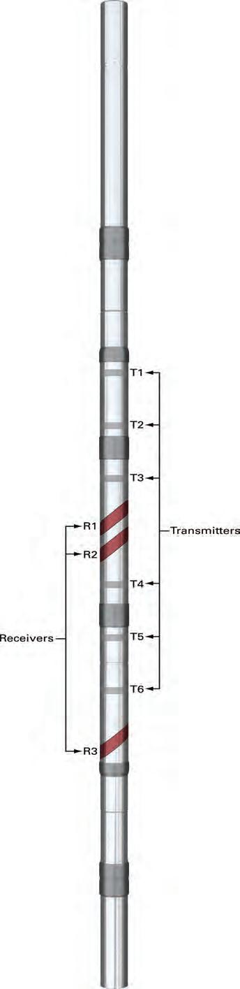
The key to successful geosteering is accurate real-time reservoir knowledge. The last decade has seen significant evolution of logging-while-drilling (LWD) tools, and their use is now widespread. In the past five years, the push has been toward azimuthal LWD capability; the azimuthal lithodensity sensor (ALD™) tool was one of the first such tools developed. Most of these LWD tools rely on the drillstring rotation to “sweep” the borehole with a sensor and then sample the tool fast enough to produce an image. Azimuthal LWD tools have especially become useful in reducing the geological uncertainties involved in drilling horizontal wells, but their sensors often suffer from a limited depth of investigation.
Recently, the next generation of deepreading resistivity tools for LWD has been developed. These tools use either a tilted antenna technology, pioneered by Halliburton, or a transverse coil system. Both types rely on the fact that, with a coil in one orientation, the tool is sensitive to changes in the resistivity of surrounding rocks, and by comparing opposite sides of the coil, it allows directional sensitivity. For the Halliburton InSite ADR™ sensor, these signals are known as geosignals.
Geosignals are not direct resistivity
measurements, but changes in the electromagnetic field around the tool caused by conductivity changes in the rocks. With these signals, it is possible to determine, in a simple three-layer system, if the bit is approaching the top or bottom boundary. Mathematical inversion is then used to estimate the distance to the boundary and the shoulder-bed resistivity. This type of system is very effective when geosteering in simple geology, but its limitations become apparent when asked to tackle more complex reservoirs. In this case, “more complex” refers to gradational boundaries, thinly bedded sequences, and multiple layers – features common to many plays in today’s reservoirs.
Most of the deep-reading resistivity tools measure resistivity changes, but not azimuthally. The InSite ADR™ sensor from Halliburton is one tool that does make azimuthal measurements. This tool is unique in its ability to actually measure the resistivity around the borehole, using two central, tilted antenna coils (Figure 1). These are compensated measurements that can be transmitted in real time to the surface to produce images of the resistivity around the borehole.
By comparing azimuthal resistivity from differently spaced transmitters, an experienced geosteering specialist can determine exactly where the tool is located in relation to the geology being drilled. By tying in the long-spaced geosignal information and inversion results, the geosteering engineer can create a comprehensive picture of the wellbore environment in real time. This allows much tighter geosteering control and accurate placement of the well.
T HE POw ER OF COMBINING REALTIME MEASUREMENTS w ITH GEOSTEERING
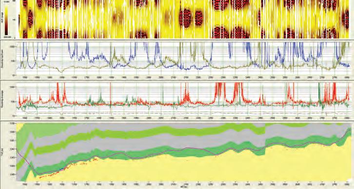
Figure 2 is an example of what can be achieved with the combination of InSite ADR™ azimuthal tool measurements and Halliburton’s StrataSteer® 3D geosteering system. This well was drilled in the Swan Hills area of Alberta, Canada, and it targeted a thin 1.8 m coal seam. This seam forms the lower member of a coal sequence, but operational requirements necessitate placing the well in this lower member.
(Continued on page 22...)
(...Continued from page 21)
This is a complex and challenging problem, with structural changes that cannot be predicted in the well-planning phase. Using the specialized LWD geosteering data, a fault was successfully negotiated and characterized – an achievement that few non-dedicated systems could manage with any degree of confidence.
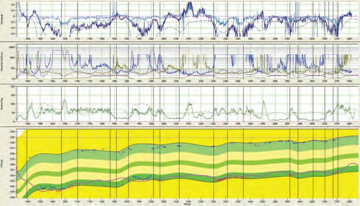
During the while-drilling or post-drilling processes, it is also possible to do more complex inversion to provide information on the thickness of a particular horizon (Figure 3). While success in this is very dependent on the reservoir’s electrical characteristics, multi-layer inversion can, if conditions are right, provide insight into bed thickness and water contact characterization.
A true geosteering system should not be limited to reliance on data from one particular tool type. While the new
azimuthal resistivity tools are an amazing leap forward in providing control over the well-placement process, other tools that provide different measurements can also enhance the picture and, in some cases, provide unique information that is essential to the geosteering process. Figure 4 shows an example where both the InSite ADR™ and gamma/at-bit inclination (GABI™) sensors from Halliburton helped the wellplacement specialists position the well.
To make geosteering effective, the ability to see changes that may affect the well position must be tied to an efficient well-planning and targeting system. Halliburton’s StrataSteer® service, based upon the StrataSteer® 3D software technology, has been used successfully since 2000. The software takes data in real time from the LWD suite and allows geosteering specialists to display it
while they are geosteering the well. The software’s capabilities include imaging and dip-picking, resistivity tool modeling, and making a flexible geological model based on customer-supplied 3D structure maps. The maps are modified in real time to refine the geological model, usually by correlation to offset well data. Where the reservoir differs in character from any offset well logs, for example in areas that were logged in vertical holes and the reservoir has been produced, the ability to modify the model to allow for a changing environment is critical.
Target generation is the most critical aspect of geosteering, and it is often overlooked. A target is a point in space that is either defined by a measured depth and a true vertical depth, or by X, Y, and Z coordinates. To be effective, targets cannot compromise the integrity of the well design. It is pointless keeping a well in the sweet spot for 1,000 m if the completion string cannot be run in the hole. The StrataSteer® 3D software has the ability to generate targets based on known dogleg limitations, so handover of targets to drillers is smooth and effective.
Because of the complexity of modern LWD tools and drilling bottomhole assembly design, Halliburton has developed in-house geosteering specialists. These people form the backbone of the StrataSteer® service. They are extensively trained and highly experienced in geosteering operations, and they provide operators with skills and new-technology experience that operators simply don’t have in-house.
In the Swan Hills well example, a 1,300 m well was placed in a 1.3-1.8 meterthick zone with challenging but predictable results. This gave the operator confidence that drilling this property was technically and commercially practical. Mapping the total package thickness also helped reduce uncertainty regarding the geological property model, thus impacting reserve categorization and helping to reduce the risk to the company and its investors.
The InSite ADR™ and StrataSteer® 3D tool technology have also had a significant impact on Canadian steam-assisted gravity drainage (SAGD) developments. Operators are using the technology for reservoir characterization by using the tools’ 3D abilities to examine large volumes of rock around both the injector and producer wells in an SAGD pair. This technology has aided operators in determining variable oil

/ water contacts and reservoir barriers to generating an efficient steam chamber. Being able to map and define calcareous events surrounding the producing pair has given operators a much clearer picture of the geological environment of these wells and helped them minimize the steam / oil ratio. The mapping ability of this system also gives a much clearer picture of the structural setting of these developments. Not only does this technology help operators refine current drilling programs, but it also influences future drilling plans.
Flexibility is key to geosteering’s value
These new geosteering technologies are enabling asset teams to place wells in zones that were inaccessible just a few short years ago. Whether the challenge is placing wells close to the roof of a reservoir to access attic oil or getting as close to the base as possible for efficient injection, there are ways to solve almost any geosteering problem. There is no single solution that is right for all situations, but with a flexible system that can access a suite of geosteering sensors, nearly all challenges can be overcome. The drilling community may not yet be aware of these new technologies, but these developments can make a significant impact in developing

new and existing assets, and they can deliver real value to your operation.
biography
Jason Pitcher is a technical advisor on geosteering for Halliburton’s Sperry Drilling Services product service line. He has spent the majority of his career with Sperry Drilling Services, in roles that included being a logging geologist and an MWD/ LWD engineer. In recent years, Pitcher has been dedicated to the geosteering business, becoming


the Geosteering Manager for Halliburton in the U.S. and in Canada. He is a 1988 graduate of the University of Derby in Derbyshire, England, and also holds a postgraduate degree from Imperial College, London.
This article was contributed by Halliburton. CSPG thanks Halliburton for the contribution.

| by Ashton Embry
The sequence is the primary unit of sequence stratigraphy and, as was discussed in the previous two articles (Embry, 2009a, b), two specific types of sequences have been defined. Both a depositional sequence and a genetic stratigraphic sequence can be subdivided into component units that are called systems tracts. Like a specific sequence type, a defined systems tract must be bound by specific, recognizable sequence stratigraphic surfaces if it is to have validity and utility.
Van Wagoner et al. (1988) and Posamentier and Vail (1988) advanced sequence stratigraphy with the innovation that a sequence can be subdivided into component units on the basis of sequence stratigraphic surfaces that occur within a sequence. This enhances mapping and communication and adds to the resolution capability of sequence stratigraphy. They referred to such component units of a sequence as systems tracts, a unit originally defined by Brown and Fisher (1977), as “a linkage of contemporaneous depositional systems”. Such a definition does not make clear what type of surfaces bound systems tracts. Furthermore, such a definition implies that systems tracts are chronostratigraphic units and have time surfaces and / or time barriers for boundaries. Van Wagoner et al. (1988, p. 39) adopted the Brown and Fisher (1977) definition and noted that systems tracts “are defined by their position within the sequence and by the stacking patterns of parasequence sets and parasequences”. This methodology also is somewhat problematic because sequence stratigraphic units are primarily defined by their bounding surfaces rather than internal properties such as “stacking patterns”.
A simpler and more straightforward definition is proposed for a systems tract. Embry et al. (2007) defined a systems tract as “a component unit of a sequence which is bound by sequence-stratigraphic surfaces”. Such a definition is generic, leaves no doubt as to a systems tract being a sequence stratigraphic unit, and
allows specific types of systems tracts to be defined. The definition also honours the Brown and Fisher (1977) original definition and makes it clear that sequence stratigraphic surfaces rather than time surfaces form the boundaries. It also is compatible with the Van Wagoner et al. (1988, 1990) usage in that various sequence stratigraphic surfaces are often delineated on the basis of a change in stacking pattern as discussed in previous articles in this series. Importantly, this definition also covers the common situation where stacking patterns are not evident. Finally, the proposed definition emphasizes the boundaries of the unit and it can be readily applied for subdividing any specific type of sequence including ones which may be proposed in the future.
Like other sequence stratigraphic units, a systems tract is defined by its bounding surfaces. A specific type of systems tract can be defined by key sequence stratigraphic surfaces and their correlative surfaces which form its lower and upper boundaries. It is emphasized that it is the bounding stratigraphic surfaces which define a given type of systems tract and not the characteristics of the strata within the systems tract. Of course, the characteristics of the strata, such as stacking patterns of smaller-scale
units and grain-size trends in the strata, substantially contribute to the delineation of the various bounding surfaces and thus indirectly contribute to the delineation of a given systems tract.
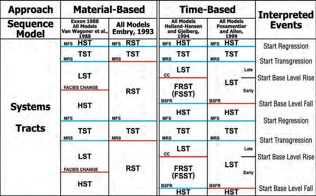
Similar to sequence boundaries, the specific bounding surfaces that have been proposed for systems tracts include both material-based surfaces and time-based surfaces. This results in the existence of both material-based systems tracts, which have only material-based surfaces for boundaries, and time-based systems tracts, which have at least one time-based surface as a part of one or both of its boundaries The two different approaches to systems tract definition are described below.
Two different, material-based systems tract classification schemes have been proposed. One defined three specific systems tracts for a depositional sequence and the other only two.
Three Systems Tracts: Van Wagoner et al. (1988) and Posamentier et al. (1988) subdivided a depositional sequence into three specific systems tracts. As described in Part 9 of this series (Embry, 2009a),
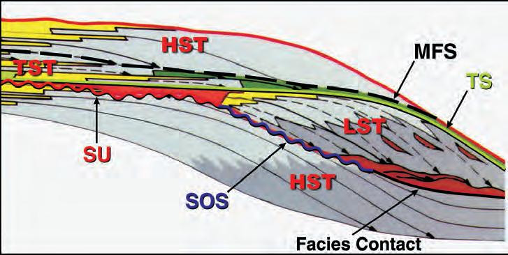
Figure 1. The Van Wagoner et al. (1988) depositional sequence boundary for a shelf / slope setting consists of a subaerial unconformity (SU) on the shelf, a slope onlap surface (SOS) on the slope, and the facies change at the base of the submarine fan deposits in the basin (modified from a portion of Figure 2 of Van Wagoner et al., 1988). Two surfaces are recognized within such a sequence – the transgressive surface (TS) and the maximum flooding surface (MFS) and allow the delineation of three systems tracts – lowstand (LST), transgressive (TST), and highstand (HST).
2. The boundaries of a material-based, depositional sequence (SU, SR-U, MRS) are shown in red on this sequence model characterized by a ramp setting with a fast initial base level rise rate. The occurrence of the low diachroneity maximum flooding surface (MFS) allows the sequence to be subdivided into two systems tracts – a transgressive systems tract (TST) and a regressive systems tract (RST). Note that all nonmarine strata between the SU and the MFS are placed in the TST.
The boundaries of a material-based, depositional sequence (SU, SR-U, SOS, MRS) are
in red on this sequence model characterized by a shelf / slope / basin setting. The internal maximum flooding surface allows such a sequence to be subdivided into a transgressive systems tract (TST) and a regressive systems tract.
the defining boundary of a depositional sequence as proposed by these authors is a combination of a subaerial unconformity and an unconformable shoreline ravinement (SU / SR-U) on the shelf, a slope onlap surface (SOS) along the slope, and a facies change at the base of the turbidites in the basin. They defined three systems tracts within such a depositional sequence (Figure 1) on the basis of two sequence stratigraphic surfaces – a transgressive surface and a maximum flooding surface – within it. In current terminology, a “transgressive surface” is equivalent to a combined maximum regressive surface (MRS) and diastemic shoreline ravinement (SR-D).
The lowermost systems tract was called the lowstand systems tract (LST) and was bound at the base by the subaerial unconformity (SU) on the shelf and basinward by the slope onlap surface (SOS) and the facies change below the turbidites (Figure 1). The LST was bound at the top by the “transgressive surface” (SR-D + MRS) and it encompassed both marine strata and nonmarine strata (Figure 1). The middle systems tract was named the transgressive systems tract (TST) and it was bound by the transgressive surface (SR-D + MRS) below and the maximum flooding surface (MFS) above. The upper systems tract was called the highstand systems tract (HST) and it was bound
by the MFS below and the sequence boundary (SU / SOS / facies change) above (Figure 1).
There are a few arguable issues associated with both the LST and the HST as defined and applied by Van Wagoner et al. (1988, 1990). The main one is that the highly diachronous facies change at the base of the turbidites is not a well defined bounding surface for either a sequence or a systems tract, as discussed in Embry (2009a). This facies change at the base of the turbidites is used as both the basal contact of the LST and the upper contact of the HST. As defined, part of the bounding surface of these systems tracts does not constitute a sequence stratigraphic surface. Furthermore, the use of a diastemic shoreline ravinement (landward portion of their “transgressive surface”) as the upper boundary of the LST on the basin flank is a problem because it is a highly diachronous surface.
Another issue involves the application of these three systems tracts to a ramp setting. The mutual boundary between the HST below and the LST above in a ramp setting equates to the sequence boundary. As discussed in Embry (2009a), Van Wagoner et al. (1988, 1990) and many others (e.g., Burchette and Wright, 1992) placed this boundary at a highly diachronous, facies change at the base of a prograding shallow-water facies. Such a boundary is not definitive enough for either a systems tract or a sequence boundary.
Two Systems Tracts: Embry (1993) and Embry and Johannessen (1993) offered a solution to the problem of employing highly diachronous facies changes or a diastemic shoreline ravinement as systems tract boundaries. In ramp and shelf / slope / basin settings, the only material-based, low diachroneity, sequence stratigraphic surface that occurs within a depositional sequence is the maximum flooding surface (MFS). On this basis, Embry (1993) proposed that a depositional sequence be subdivided into two systems tracts: a lower transgressive systems tract that follows the definition of Van Wagoner et al. (1988) and an upper, newly defined, regressive systems tract (Figures 2, 3).
These two systems tracts are best defined by the key sequence stratigraphic surfaces that form their lower and upper boundaries. Thus, a TST is defined as a sequence stratigraphic unit bound by
(Continued on page 26...)
Figure 4. The boundaries of a time-based, depositional sequence (SU, CC) based on Hunt and Tucker (1992) are shown in red on this sequence model characterized by a ramp setting with a slow initial base level rise rate. Such a sequence contains three sequence stratigraphic surfaces within it – maximum regressive surface (MRS), maximum flooding surface (MFS), and basal surface of forced regression (BSFR). This allows the time-based sequence to be subdivided into four systems tracts: three time-based ones (highstand (HST), falling stage (FSST), and lowstand (LST)) and one material-based one (transgressive (TST)).
Figure 5. The boundaries of a time-based, depositional sequence (SU, SR-U, CC) based on Hunt and Tucker (1992) are shown in red on this sequence model characterized by a shelf / slope / basin setting with a fast initial base level rise rate. The same four systems tracts with the same key, defining surfaces as shown on Figure 4 can be delineated. Note that the correlative surfaces of the key surfaces differ from those shown in Figure 4. For example the correlative surfaces of the CC in this figure are the SU and SR-U whereas in Figure 4 the only correlative surface of the CC is the SU.
(...Continued from page 25)
a maximum regressive surface and its correlative surfaces below and a maximum flooding surface and its correlative surfaces above. The RST is just the opposite being defined as a sequence stratigraphic unit bound by a maximum flooding surface and its correlative surfaces below and
by a maximum regressive surface and its correlative surfaces above.
The RST, as defined above, includes both the LST and HST of Van Wagoner et al. (1988) and this is a consequence of eliminating a facies change surface (proposed HST / LST boundary) as a
systems tract boundary (see Figure 3). Also, the nonmarine strata assigned to an LST by Van Wagoner et al. (1988) (Figure 1) are much better placed in a TST (Figures 2, 3) as discussed by Suter et al. (1987) and many others.
The genetic stratigraphic sequence has MFSs as its bounding surfaces as discussed by Embry (2009a). Like the depositional sequence, it can also be subdivided into a TST and an RST by using the internal composite boundary of an SU / SR-U / SOS / MRS as a boundary for both systems tracts (Figure 2, 3).
In summary, two material-based systems tracts – transgressive systems tract and regressive systems tract – can be recognized in both a depositional sequence and a genetic stratigraphic sequence in almost all situations. Such recognition can be accomplished in a very objective manner.
As described in Embry (2009c), two abstract, time-based surfaces are recognized in the time-based approach to sequence stratigraphy. These are the basal surface of forced regression (BSFR) which equates to the time surface at the start of base level fall and the correlative conformity (CC) which equates to the time surface at the start of base level rise. The defined, time-based systems tracts use both material-based surfaces and the two abstract, time-based surfaces (BSFR, CC) as boundaries. Two classification systems of time-based systems tracts have been proposed – one defines four systems tracts for a depositional sequence and the other three.
Systems
Hunt and Tucker (1992) proposed subdividing a depositional sequence into four systems tracts (Figure 4) which, in ascending order, were named lowstand, transgressive, highstand, and forced regressive systems tracts. The theoretical basis of this four systems tract classification scheme was elaborated upon by Helland-Hansen and Gjelberg (1994). The bounding surfaces for these units will differ slightly depending on the physiography of the setting (ramp or shelf / slope / basin) and the speed of the initial base level rise (fast, slow). Thus, these different specific systems tracts are best defined by a key sequence stratigraphic surface that is common to all models and its correlative surfaces for both the lower and upper boundary. The four key surfaces that are used are used to define
either the lower or upper boundary of the four systems tracts are two time-based surfaces – correlative conformity (CC) and basal surface of forced regression (BSFR) – and two material-based surfaces – maximum regressive surface (MRS) and maximum flooding surface (MFS). On this basis, the four systems tracts of Hunt and Tucker (1992) are defined below:
Lowstand Systems Tract (LST) – A component unit of a sequence defined by a correlative conformity (CC) and its correlative surfaces as the lower boundary and a maximum regressive surface (MRS) and its correlative surfaces as the upper boundary. This is a time-based systems tract.
Transgressive Systems Tract (TST) – A component unit of a sequence defined by a maximum regressive surface and its correlative surfaces as the lower boundary and a maximum flooding surface (MFS) and its correlative surfaces as the upper boundary. This is a material-based systems tract, which was originally defined by Van Wagoner et al. (1988).
Highstand Systems Tract (HST) – A component unit of a sequence defined by a maximum flooding surface and its correlative surfaces as the lower boundary and a basal surface of forced regression (BSFR) and its correlative surfaces as the upper boundary. This is a time-based systems tract.
Forced Regressive (Falling Stage) Systems Tract (FRST, FSST) – A component unit of a sequence defined by a basal surface of forced regression (BSFR) and its correlative surfaces as the lower boundary and a correlative conformity (CC) and its correlative surfaces as the upper boundary. This is a time-based systems tract.
In summary, the Hunt and Tucker (1992) classification scheme included three timebased systems tracts (LST, HST and FRST) of their definition and one material-based systems tract (TST), which had originally been defined by Van Wagoner et al. (1988). Figure 4 illustrates these four systems tracts for a sequence model with a ramp setting and a slow initial base level rise. Figure 5 is a model with ramp setting and a fast initial rise. Note that the key, defining surfaces for the four systems tracts remain the same in both models but in some cases the correlative surfaces are different. The same comment would apply if models with a shelf / slope / basin setting were illustrated.
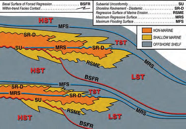
Figure 6. The boundaries of the Posamentier and Allen’s (1999) proposed time-based, depositional sequence (SU, BSFR) are shown in red on this sequence model characterized by a ramp setting with a slow initial base level rise rate. Only two internal surfaces, MRS and MFS, are recognized and accordingly Posamentier and Allen (1999) subdivided their depositional sequence into three systems tracts – lowstand (LST), transgressive (TST), and highstand (HST). The TST and HST followed the original definitions of these units but the LST was redefined by making the BSFR as the key bounding surface at its base.
In the Hunt and Tucker (1992) classification scheme, all the defined systems tracts, with the exception of the TST, utilize one or both of the two time surfaces (CC, BSFR) as part of their boundaries (Figure 4). As discussed in Embry (2009c), these time surfaces have no characteristic physical properties and thus cannot be delineated objectively in most settings. The use of such boundaries is potentially problematic. Thus, I would not recommend the LST, HST, and FRST (FSST) as defined by Hunt and Tucker (1992) for use in sequence stratigraphy.
Three Systems Tracts: The second, time-based systems tract classification scheme is that of Posamentier and Allen (1999). As described in the previous article on time-based sequences (Embry, 2009b), Posamentier and Allen (1999) placed the correlative surface for the depositional sequence boundary along the basal surface of forced regression (BSRF) which is the time surface at the start of base level fall. They divided such a depositional sequence into three systems tracts: lowstand, transgressive, and highstand (Figure 6).
The transgressive systems tract and highstand systems tract of this classification follow the definitions used by Hunt and Tucker (1992) in that they have exactly the same key surfaces defining their lower and upper boundaries. Only the lowstand systems tract has a new and different
definition and it contrasts with the two previous definitions of an LST provided by Van Wagoner et al. (1988) and Hunt and Tucker (1992).
Posamentier and Allen (1999) defined a lowstand systems tract as being bound at its base by the basal surface of forced regression and its correlative surfaces and at its top by the maximum regressive surface and its correlative surfaces (Figure 6). Note that Posamentier and Allen (1999) do not use the correlative conformity as a systems tract boundary. However, they do suggest that their lowstand systems tract might be subdivided into an “early LST” and a “late LST” by recognition of the CC within an LST.
As was discussed in the previous section, the highstand systems tract as defined by Hunt and Tucker (1992) and adopted by Posamentier and Allen (1999) has limited use in practice because it is bound in part by an abstract time surface (BSFR) with no physical characteristics. The same comment applies to Posamentier and Allen’s (1999) revised definition of a lowstand systems tract that has the abstract BSFR as the key surface for its lower boundary.
In summary, two classification schemes have been proposed in the time-based approach to sequence stratigraphy. Both
(Continued on page 28...)
(...Continued from page 27)
schemes contain one material-based systems tract, the TST, which is valid and of practical value. Two different, timebased definitions for a lowstand systems tract, which was originally defined as a material-based unit, have been proposed. Both use an abstract time surface as part of the lower boundary (BSFR for one and CC for the other), which limits their practical applications. The other specific systems tracts proposed in these schemes (HST, FRST) are also bound in part by an abstract time surface that limits their use.
A systems tract is best defined as a component unit of a sequence which is bound by sequence stratigraphic surfaces. Specific systems tracts are defined by key surfaces and their correlative surfaces for both the lower and upper boundaries of the unit. For example, a transgressive systems tract is defined as a sequence stratigraphic unit bound at its base by a maximum regressive surface and its correlative surfaces and at its top by a maximum flooding surface and its correlative surfaces.
Four different classification schemes for
subdividing a depositional sequence into systems tracts have been proposed – two material-based schemes and two timebased schemes. These four proposals are summarized and compared in Figure 7. In the material-based approach to sequence stratigraphy, the three systems tract classification scheme of Van Wagoner et al. (1988) is problematic because the LST and HST use a highly diachronous facies change as a key surface for both of these units (Figure 7). The elimination of the facies change as a bounding surface and the combination of the HST and LST into a single systems tract, which is termed a regressive systems tract (RST) (Embry, 1993), results in a more practical, two systems tract classification scheme (Figure 7).
In the time-based approach to sequence stratigraphy, both a four systems tract classification scheme and a three systems tract one have been proposed. Both classification schemes are problematic in that most of the defined systems tracts have limited practical value due to the use of an abstract time surface as one or both of bounding surfaces of the unit.
The most useful systems tracts which have been proposed so far are the transgressive
systems tract and the regressive systems tract. The most confusing and contentious unit is the lowstand systems tract in that it has been defined in three different ways.
Brown, L. and Fisher, W. 1977. Seismicstratigraphic interpretation of depositional systems: Examples from the Brazilian rift and pull-apart basins. In: Seismic stratigraphy: application to hydrocarbon exploration. C. Payton (ed.). AAPG Memoir 26, p. 213-248.
Burchette, T. and Wright, V. P. 1992. Carbonate ramp depositional deposits. Sedimentary Geology, v. 79, p. 3-57.
Embry, A. F., 1993, Transgressive-regressive (T-R) sequence analysis of the Jurassic succession of the Sverdrup Basin, Canadian Arctic Archipelago. Canadian Journal of Earth Sciences, v. 30, p. 301-320.
Embry, A. F. 2009a. Practical sequence stratigraphy IX: the units of sequence stratigraphy; part 1, material-based sequences. Canadian Society of Petroleum Geologists. The Reservoir, v. 36, issue 2, p. 23-29.
Embry, A. F. 2009b. Practical sequence
stratigraphy X: the units of sequence stratigraphy; part 2, time-based sequences. Canadian Society of Petroleum Geologists. The Reservoir, v. 36, issue 3. p. 21-24.
Embry, A. F. 2009c. Practical sequence stratigraphy VIII: the time-based surfaces of sequence stratigraphy. Canadian Society of Petroleum Geologists. The Reservoir, v. 36, issue 1, p. 27-33.
Embry, A. F. and Johannessen, E. P. 1993. T-R sequence stratigraphy, facies analysis and reservoir distribution in the uppermost Triassic-Lower Jurassic succession, western Sverdrup Basin, Arctic Canada, In: Arctic Geology and Petroleum Potential. T. Vorren, E. Bergsager, O. A. Dahl-Stamnes, E. Holter, B. Johansen, E. Lie, and T.B. Lund (eds.). NPF Special Publication 2, p. 121-146.
Embry, A., Johannessen, E. P., Owen, D., and Beauchamp, B., 2007. Recommendations for sequence stratigraphic surfaces and units (abstract). Arctic Conference Days, Abstract Book. Tromso, Norway.
Helland-Hansen, W. and Gjelberg, J. 1994. Conceptual basis and variability in sequence stratigraphy: a different perspective. Sedimentary Geology, v. 92, p. 1-52.
Hunt, D. and Tucker, M. 1992. Stranded parasequences and the forced regressive wedge systems tract: deposition during base level fall. Sedimentary Geology, v. 81, p. 1-9.
Posamentier, H. and Vail, P. 1988. Eustatic controls on clastic deposition II - sequence and systems tract models. In: Sea level changes: an integrated approach. C. Wilgus, B. S. Hastings, C. G. Kendall, H. W. Posamentier, C. A. Ross, and J. C. Van Wagoner, (eds.). Society of Economic Paleontologists and Mineralogists, Special Publication 42, p. 125154.
Posamentier, H. Jervey, M. and Vail, P., 1988. Eustatic controls on clastic deposition I-conceptual framework. In: Sea level changes: an integrated approach. C. Wilgus, B. S. Hastings, C. G. Kendall, H. W. Posamentier, C. A. Ross, and J. C. Van Wagoner, (eds.). Society of Economic Paleontologists and Mineralogists, Special Publication 42, p. 109124.
Posamentier, H. and Allen, G. 1999. Siliciclastic sequence stratigraphy – concepts and applications. Society of Economic Paleontologists and Mineralogists, Concepts in Sedimentology and Paleontology, no. 7, 210 p.
Suter, J., Berryhill, H., and Penland, S. 1987. Late Quaternary sea level fluctuations and depositional sequences, southwest Louisiana continental shelf. In: D. Nummedal, O. Pilkey, and J. Howard (eds.). Sea-level changes and coastal evolution. Society of Economic Paleontologists and Mineralogists, Special Publication 41, p. 199-122.
Van Wagoner, J. C., Posamentier, H. W., Mitchum, R. M., Vail, P. R., Sarg, J. F., Loutit, T. S., and Hardenbol, J. 1988. An overview of the fundamentals of sequence stratigraphy and key definitions. In: Sea level changes: an
integrated approach. C. Wilgus, B. S. Hastings, C. G. Kendall, H. W. Posamentier, C. A. Ross, and J. C. Van Wagoner, (eds.). Society of Economic Paleontologists and Mineralogists, Special Publication 42, p. 39-46.
Van Wagoner, J. C., Mitchum, R. M., Campion, K. M., and Rahmanian, V. D. 1990. Siliciclastic sequence stratigraphy in well logs, cores and outcrops. American Association of Petroleum Geologists, Methods in Exploration, no. 7, 55 p.

volcanic eruptions and solar variations, as well as human-induced changes in atmospheric composition. Solar radiation powers the climate system. There are three fundamental ways to change the radiation balance of the Earth: 1) by changing the incoming solar radiation (e.g., by changes in Earth’s orbit or in the Sun itself); 2) by changing the fraction of solar radiation that is reflected (called
| by Dr. A. Neil Hutton
Roughly two-thirds of this reflectivity is due to clouds and small particles in the atmosphere known as ‘aerosols’. Light-coloured areas of Earth’s surface – mainly snow, ice and deserts – reflect the remaining one-third of the sunlight. The most dramatic change in aerosol-produced reflectivity comes when major volcanic eruptions eject material very high into the atmosphere. Rain typically
(continued)


Figure 1. Estimate of the Earth’s annual and global mean energy balance. According to this model, the amount of incoming solar radiation absorbed by the Earth and atmosphere is balanced by the Earth and atmosphere releasing the same amount of outgoing long-wave radiation (new research regarding the warming of the stratosphere by cosmic rays tends to invalidate this basic concept. Osprey et al. (2009), Geophysical Research Letters). About half of the incoming solar radiation is absorbed by the Earth’s surface. This energy is transferred to the atmosphere by warming the air in contact with the surface (thermals), by evapotranspiration, and by long-wave radiation that is absorbed by clouds and greenhouse gases. It is further claimed that the atmosphere in turn radiates long-wave energy back to Earth as well as out to space. The latter concept is challenged by many scientists as discussed in the text (IPCC, Historical Overview of Climate Science, 1, p. 96, FAQ 1.1, Figure 1, after Kiehl and Trenberth, 1997).
Let us discuss the ‘greenhouse effect’, which must be the most misused term ever in scientific literature. Planetary atmospheres do not remotely resemble the warming air inside a greenhouse. The warming effect in a greenhouse results from the fact that there is no source of cooler air to circulate by convection. This, of course, can be remedied by opening doors or vents in the roof.
There is a historic misconception that the glass of a greenhouse traps infrared radiation. In 1909, R. W. Wood showed that the greenhouse effect did not result from trapped radiation. He created an enclosure with a window of rock salt (NaCl), which is transparent to visible light as well as infrared, and compared it with a second enclosure using glass as a window. The enclosure with the rock-salt window became warmer than did the enclosure with glass because it was transparent to almost the entire spectrum while the glass was not. If glass was placed
in front of the salt-faced enclosure, the temperatures equalized. Wood concluded that trapping of infrared radiation within a glass enclosure is of minimal importance in comparison to the lack of convective circulation.
The atmosphere is a veritable “mixmaster” in terms of circulation as warm tropical air is driven to the poles and, under the influence of the Coriolus force, causes the trade winds and westerlies of the northern and southern hemispheres. In addition, locally and regionally, convection drives the weather systems to draw up water vapor generated by evaporation into the atmosphere, which is then returned as precipitation. These systems act to redistribute heat in the atmosphere and maintain a degree of climatic equilibrium. Thus, it is clear that the Earth’s atmosphere is not remotely like the air in a greenhouse.
A fundamental hypothesis of the so-called
“greenhouse effect” is that if there were no atmosphere the average temperature of the Earth would be -18ºC (255ºK). This is a totally theoretical construct, or thought experiment, since it is probable that never in Earth’s history has this condition occurred. Moreover, the Earth has a radioactive core which continuously generates heat, currently at a rate of 87 milliwatts per square meter, which is neither seasonal nor diurnal. The generation of heat along ocean-spreading centres is believed to average up to 120 milliwatts per square meter. The failure to realize this resulted in Kelvin’s erroneous estimate of the age of the Earth as 100 million years. Therefore, the relevance of the theoretical temperature of the atmosphereless Earth to the greenhouse effect is questionable.
Furthermore, the Earth is 70% ocean. Is it possible to have an atmosphere-less Earth with oceans (see Gerlich and Tscheuschner,
2007)? The oceans have a fundamental influence on climate and the atmosphere. The globally averaged near-surface temperature amounts to 15ºC (288ºK). The difference in these values, 288ºK – 255ºK is 33ºK, which is attributed to the effect of the atmosphere (“greenhouse effect”). In a recent paper, Essex et al., (2006) have questioned the entire concept of an average global temperature. They argue, “while the statistic is nothing more than an average over temperatures, it is regarded as “the temperature,” as if an average over temperatures is actually a temperature in itself, and as if the out-ofequilibrium climate system has only one temperature. But an average of temperature data sampled from a non-equilibrium field is not a temperature. Moreover, it hardly needs stating that the Earth does not have just one temperature. It is not in global thermodynamic equilibrium – neither with itself nor with its surroundings.” And finally, “The temperature field of the Earth as a whole is not thermodynamically representable by a single temperature.”
Unfortunately the terms greenhouse effect and greenhouse gases have stuck in the climatological literature and in the popular press. Because infrared radiation is not trapped in a greenhouse and convection is not constrained in the atmosphere the term is an oxymoron. It is misleading since it implies some sort of boundary layer in the atmosphere and is far from descriptive of the dynamic role of the gases in the atmosphere. It has become established as climatological jargon but tends to confuse even those who should know better. Of more than 20 descriptions of the greenhouse effect that I have reviewed, many of them are simply wrong or misleading. Although it is now acknowledged that the greenhouse analogy is incorrect, nevertheless, even supposedly authoritative works, such as the Encyclopedia of Astronomy and Astrophysics (2001) has the following definition (my emphasis below):
“The greenhouse effect is the radiative influence exerted by the atmosphere of a planet which causes the temperature at the surface to rise above the value it would normally reach if it were in direct equilibrium with sunlight (taking into account the planetary albedo). This stems from the fact that certain gases have the ability to transmit most of the solar radiation and to absorb the infrared emission from the surface. The thermal (i.e., infrared) radiation intercepted by the atmosphere is then partially reemitted towards the surface, (in some texts this is referred to as back radiation) thus contributing additional heating to the
surface. Although the analogy is not entirely satisfactory in terms of physical processes involved, it is easy to see the parallels between the greenhouse effect in the atmospheresurface system of a planet and a horticultural greenhouse: the planetary atmosphere plays the role of the glass cover that lets sunshine through to heat the soil while partly retaining the heat that escapes from the ground.”
Even in the IPCC, 2007. Historical Overview of Climate Change (p. 115), “Much of this thermal radiation emitted by land and ocean is absorbed by the atmosphere including clouds, and re-radiated back to Earth. This is called the ‘the greenhouse effect.’ The glass walls in a greenhouse reduce airflow and increase the temperature of the air inside. Analogously, but through a different physical process the Earth’s greenhouse effect warms the surface of the planet .” This is not an analogue since the physical processes present a complete contrast in function.
There is obviously a serious reluctance to give up the greenhouse analogy although it is well recognized that it is incorrect. Both descriptions above introduce the concept of back radiation, suggesting that somehow long-wave infrared radiation is intercepted and radiated back to warm the Earth’s surface. This concept held by climatologists has been challenged by theoretical physicists and others (Thieme, 2003; Gerlich and Tscheuschner, 2007; Kramm, 2008). If the
outgoing thermal radiation from the Earth’s surface is absorbed then the warmed air will expand and rise convectively so that the absorbed warmth is taken away by air mass exchange as well as cooling from the adiabatic pressure drop. Most people will be familiar with the heat of gas compression when inflating a tire or the cooling effect of decompression in snow-making equipment.
As pressure drops with elevation, so does temperature – reaching -65ºC at the top of the troposphere at about 10,000 meters. The Second Law of Thermodynamics states that warmth can never spontaneously pass from a body of low temperature to a body of high temperature without the application of work. Thus according to our understanding of the ideal gas laws and thermodynamic laws, back radiation is not possible. The concept implies reflection but there is no such boundary layer. The cooler atmosphere can not warm the surface. Nevertheless, this is a basic tenet of global warming theory.
A cornerstone of the IPCC discussion of the “Greenhouse Effect” (Figure 1) is the KT97 model of the Earth’s Global Mean Energy Budget (Kiehl and Trenberth, 1997 Figure 7, p. 206). Although this study purports to have constrained measurements of the energy flux by satellite observations, in fact the instrument error range is much greater than any detectable variation at the top of the atmosphere (Spencer, 2007). With
(Continued on page 34...)

1959 - 2009
1959 - 2009
1959 - 2009
50 years of inspiration leading to 50 of innovation
50 years of inspiration leading to 50 years of innovation
50 years of inspiration leading to 50 years of innovation
Looking to maximize opportunities in today’s volatile market?
Looking to maximize opportunities in today’s volatile market?
Looking to maximize opportunities in volatile market?
Combine the power of PETRA® and IHS Critical Information including well and log data to define reservoir parameters and determine new opportunities faster and more cost effectively.
Combine the power of PETRA® and IHS Critical Information including well and log data to define reservoir parameters and determine new opportunities faster and more cost effectively.
Combine the of PETRA® and IHS Critical Information including well and log data to reservoir parameters and determine new opportunities faster and more cost effectively.
Let IHS information solutions improve your decision-making and reduce your risk.
Let IHS information solutions improve your decision-making and reduce your risk.
Let IHS solutions improve your decision-making and reduce your risk.
For more information on PETRA visit us at www.ihs.com/reservoirsolutions
For more information on PETRA visit us at www.ihs.com/reservoirsolutions
For more information on PETRA visit us at www.ihs.com/reservoirsolutions Visit us at the CSPG Convention this May to see PETRA live and help us

• Regional perspective of the entire WCSB
• Includes all the main formations which cover Western Canada
• Generate regional maps with data already combined and analyzed
• Quick way to factor the entire region into your land prospecting process

Brad Dick Director, Data Services brad.dick@divestco.com
respect to measurements of surface fluxes of long-wave radiation the study relies on model calculations based exclusively on radiative heat transfer and the spectral characteristics of the various gases.
The model study is conducted on standardized atmosphere profiles. These standard profiles are static and essentially two-dimensional. As the KT97 model indicates, the treatment of cloud is accomplished as three simple static layers of low, intermediate, and high cloud randomly overlapped to provide on average 62% cover (a simplistic and unrealistic static model). Although Kiehl and Trenberth themselves highlight a series of difficulties in developing a global energy budget, nonetheless it has become the showpiece of the IPCC assessments (Historical Overview of Climate Change Science, Figure 1, p. 96)
CO2 represents only 0.0375% by volume of the atmosphere and it demonstrates infrared absorption in three slender bands involving less than 8% of the infrared spectrum; however, the KT97 Study attributes 26% of the radiative forcing to CO2 . If such an extreme effect existed, concentrated CO2 in the laboratory should demonstrate a heat conductivity anomaly, which is not the case. Furthermore, nowhere in climatological literature have we seen any discussion of the quantum energy states of CO2 molecules in the range from -10 to -65ºC, the dominant temperature of the troposphere. The emissivity of a substance is a function of temperature.
One of the problematic issues with this model is that the energy reaching the top of the Earth’s atmosphere during daytime is about 1,370 watts per square meter (w/m2). However, because the planet is spherical, the energy averaged over the whole planet is approximately one quarter of this value, or 342 w/m2. Of this quarter of the sun’s energy, approximately 107 w/ m2 is reflected, while an additional 67 w/m2 is absorbed in the atmosphere as shown in Figure 1. Consequently, 168 w/m2 reaches and is absorbed by the surface; however, this radiated energy is not sufficient to heat the surface to +15ºC. In the KT97 model, the problem is solved by the atmosphere – by some unknown means – producing 324 w/ m2 that are “back radiated” down to the Earth’s surface. That this violates the first and second laws of thermodynamics appears to be of no consequence to climatologists. It is clear that attempting to explain the Earth’s energy solely from radiative heat transfer presents significant problems and that the
radiative-heat-transfer greenhouse theory is seriously flawed.
On the right side of Figure 1 are two fluxes – one from the surface producing 350 w/ m2 and the other ‘back radiation’ yielding 324 w/m2 to the surface. This appears to be a completely circular energy flow with no actual source. In order to back radiate this energy flux, the atmosphere would be required to have a temperature higher than the surface. The adiabatic nature of the atmosphere dictates a decrease of temperature with elevation. The drop in temperature is typically about 6.5ºC per kilometer, so that at a height of five kilometers (mid-troposphere) the temperature is -32.5ºC, which can not possibly initiate a down-going energy flux of this magnitude. Furthermore, as Thieme (2007) argues, radiant fluxes are definable as to magnitude and direction as vectors. The sum of vectors will produce a new vector modified in magnitude and direction, but with the proviso that two exactly equal vectors of opposite direction will sum to zero. The reality (Figure 1) is that, in fact, only 40 w/m2 are radiated from the surface. The outgoing 350 w/m2 and back radiation of 324 w/m2 are imaginary, again contradicting physical laws since this is in reality a perpetual motion machine of the second kind (Kramm, 2007; Gerlich and Tscheuchner, 2007; and Thieme, 2003).
Much is made of the impact of trace gases in the atmosphere, but what of the effect of the other 99% which can neither absorb nor emit infrared. Nitrogen and oxygen, the principal components of air, are heated during the day by conduction as ground temperature exceeds that of the air. The air warmed by conduction and convection can not efficiently transmit this energy because the nitrogen and oxygen of the air can neither absorb nor emit infrared radiation. The energy absorbed by the air can not be transmitted to space but will be retained to warm the ground as the temperature of the surface falls below that of the air. The thermal conductivity of oxygen and nitrogen is very low so that in the absence of convection, air is an excellent insulator. Is it possible, although never discussed in the literature, that the atmosphere in itself is actually an efficient insulator?
Gerlich and Tscheuschner (2007), two theoretical physicists, published on the internet an extensive article challenging greenhouse theory and reviewing all of the mathematical and thermodynamic principles involved. They challenged the notion of an Earth with no atmosphere, as well as the concept of global average temperature as
an indication of global emmisivity, because in reality each square meter of the Earth’s surface has a unique characteristic depending on its composition – forest, meadow, asphalt, water, snow, desert, tundra, and so on. So that as Essex et al. (2006) argue, there is no global average temperature and it has no validity within the energy balance concept, and they question the ability of the troposphere at -65ºC to warm the surface at +15ºC.
The greenhouse theorists, argue that every substance radiates if it is above absolute zero. But does this apply to gases? The fundamental argument is that oxygen and nitrogen are transparent to long-wave radiation. Gerlich and Tscheuschner argue that the Plank and Stefan-Boltzman equations used in calculations of radiative heat transfer can not be applied to gases in the atmosphere because of the highly complex multi-body nature of the problem.
The orthodoxy on the other hand argues that photons are emitted in all directions at all times within the quantum realm. Two bodies at different temperatures will continue to radiate since the colder body does not recognize the adjacent warmer body. However, in the observable realm the net transfer of energy is still from the warm object to the colder object until equilibrium is achieved, which is never in the out-ofequilibrium climate system. The argument may be valid in terms of solid objects but presents enormous difficulty in a gaseous atmosphere where molecular diffusion is intense and the atmosphere is in constant non-equilibrium motion. Therefore, although photons may be emitted towards the surface, the net energy flow will always be from the warm surface to the atmosphere. So that, unless climatology has developed some new thermodynamic principle, back radiation is denied by fundamental thermodynamic laws.
The development of greenhouse theory is exclusively developed around radiative heat transfer because the imperative of its authors was to establish CO2 as the causative mechanism in climate change to the exclusion of anything else. This perspective ignores the fact that climate is subject to other drivers, and while it continuously moves toward equilibrium it never achieves this state. Spencer (2007) argues that precipitation systems act as the Earth’s thermostat (Figure 2) and states: “I believe it can be demonstrated that precipitation systems ultimately control most of the Earth’s natural greenhouse effect. The air in our atmosphere is continuously recycled through precipitation
systems (see Figure 2), on a timescale of days to weeks. Wind picks up water vapour that has been evaporated from the surface, and then transports this vapour to precipitation systems. Those systems then remove some of that vapour in the form of rain or snow.”
This view is generally understood by climatologists, but what are not understood are the myriad microphysical processes within clouds. The orthodox view incorporated into all General Circulation Models is that the very small effect of CO2 will be amplified by an increase in cloud thereby increasing the warming – a positive feedback. Spencer (2009)
and his colleagues (Spencer and Braswell, 2008; Spencer et al., 2007), have been able to document from detailed analysis of satellite data that the climate system is much less sensitive to greenhouse gas emissions than has been claimed by the IPCC. This body of research has profound implications for the theoretical basis of Anthropogenic Global Warming since instead of relying on theoretical assumptions unconstrained by measurement and observation, Spencer and his colleagues have done exactly the opposite by examining satellite data in great detail and then determining which aspects of the climate
(Continued on page 36...)
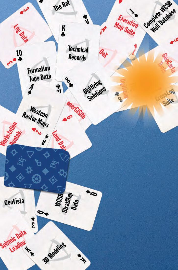
Pick a card, any card
Improve your exploration odds with Divestco. At Divestco we want the odds to be in your favor so we have given you a whole deck of geological products and services to choose from. Divestco’s integrated offering for geological professionals gives you the ability to choose from a wide range of geological products and services to suit your unique needs. Pick as many individual cards as you want or let our experts deal you a winning hand.
Call us at 403.537.9904 or email sales@divestco.com for more information.
TSX: DVT www.divestco.com
system best explain the observations. The results are salutary; the detailed observations indicate that net feedbacks in the real climate system on both short- and long-term time frames are negative. Misinterpretation of cloud behaviour has led modelers to build models in which cloud feedbacks are positive. The models, therefore, predict too much warming in response to anthropogenic greenhouse gas emissions. That this is correct is well demonstrated by the last 10 years where the IPCC projections for the thermal response of the atmosphere consistently overstate the case.
In conclusion, the greenhouse theory of anthropogenic global warming is seriously flawed and certainly provides no scientific basis to introduce policy measures. This will cause a serious misapplication of scarce capital to projects that will have no influence on climate. The amount of capital already squandered to this date on this fruitless endeavour will, without doubt, emerge as one of the greatest scientific scandals of the 20th and 21st Centuries. The almost evangelical need to save the planet has overridden any scientific objectivity.
REFERENCES:
Essex, C., McKitrick, R., and Andresen, B. 2007. Does a global temperature exist? Journal Non-Equilibrium Thermodynamics, v. 32, no. 1, p.1-27.
Gerlich, G. and Tscheuschner, R. D. 2007. Falsification of the CO2 greenhouse effects within the frame of physics. arXiv: 0707.1161 v.1 [Physics.ao-ph] 8 July 2007.
Intergovernmental Panel on Climate Change. 2007. Climate change: the physical science basis, Summary for Policymakers. Fourth Assessment Report, Geneva, Switzerland.
Intergovernmental Panel on Climate Change. 2007. Climate change: historical overview of climate change science. Fourth Assessment Report, Geneva, Switzerland.


Kiehl, J. T. and Trenberth, K. 1997. Earth’s annual mean global energy budget. Bulletin of the Meteorological Society, v.78, no. 2, p.197208.


Registertodayforthe 2009AAPGAnnual Convention&Exhibition.


TheACETechnicalProgramis unmatchedwithmorethan1,000 technicalpresentations,22field tripsand18shortcourses.
HeadtoDenverwhere you’llfindawiderangeof presentationsproviding valuableinformationforyour job,including:
•tight-gassandstones
•sedimentologyofshaleand reservoirdevelopment
•3-Dinteractionoftectonics andsedimentation
•externalcontrolsonthe shapingofdeep-water margins andsystems:influenceson reservoirdevelopment
•emergingglobaldeepwater plays
•petroleumsystemsanalysis —basinsaroundtheworld
•gasshalereservoirs

Kramm, G. 2008. Contribution to discussion of Gerlich and Tscheuschner paper. Falsification of the CO2 greenhouse effects within the frame of physics. Rabett.blogspot.com/2008/02/all-younever-wanted-to-know.html. Items 180, 457, 735, 770, and 844.
Murdin, P. (Ed.). 2001. Encyclopedia of astronomy and astrophysics. Nature Publishing Group, New York. http://eaa.crcpress.com.
Spencer, R. W. 2008. Climate Confusion: How global warming hysteria leads to bad science, pandering politicians and misguided policies that hurt the poor. Encounter Books.
Spencer, R. W. In press. Satellite and climate model evidence against substantial man-made climate change. Journal Climate.
Spencer, R. W., Braswell, W. D., Christy, J. R., and Hnilo, J. 2007. Cloud and radiation budget changes associated with tropical intra-seasonal oscillations. Geophysical Research Letters, 34, L15707, doi: 1029/2007GL029698.
Spencer, R. W. and Braswell, W. D. 2008. Potential biases in cloud feedback diagnosis: A simple model demonstration. Journal Climate, Nov 1.
Thieme, H. 2003. On the phenomenon of atmospheric backradiation. http//www.geocities. com/atmosco2/backrad.htm.
Wood, R. W. 1909. Note on the theory of the greenhouse. Philosophical Magazine v. 17, p. 319-320. www.mconolley.org.uk/sci/wood_ rw.1909.html.
The RJW Douglas Medal is awarded annually by the Canadian Society of Petroleum Geologists for outstanding scientific contributions to the understanding of sedimentary geology in Canada, commending major contributions to regional tectonics, petroleum, and structural geology.
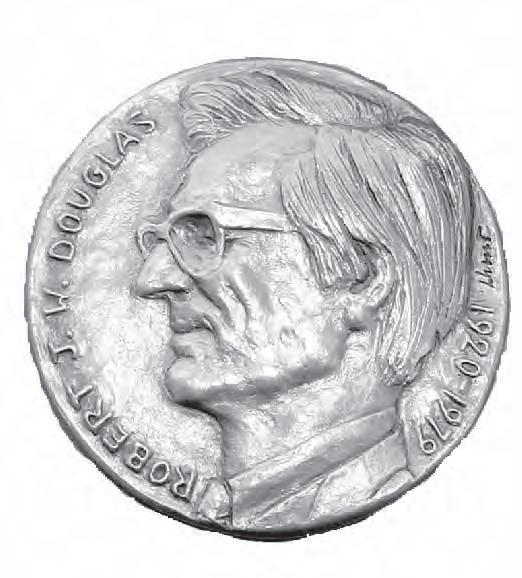

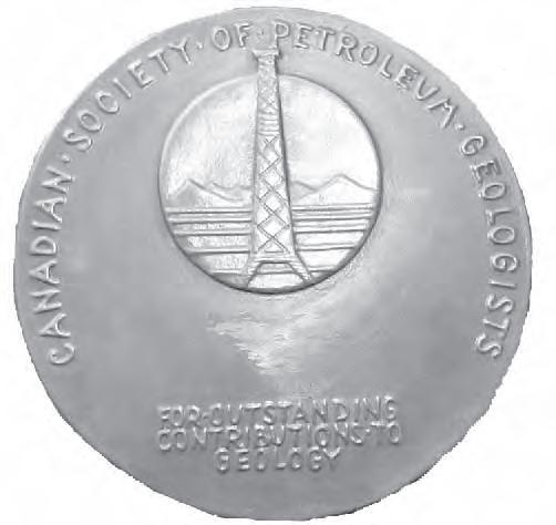

The award is open to all geologists who follow the example of Bob Douglas in contributing to the development of Canadian sedimentary, petroleum, and structural geology.
Nominations for the award of the medal must be endorsed by at least three members of the CSPG. Nominations may be proposed at any time, but to be considered for a particular year, they must be received by the Society before September 1
The sponsors of a nominee for the award should supply:
A curriculum vitae (outling the nominee’s career and previous honours or distinctions).
A list of publications by the nominee.
A summary of the nominee’s achievements in a form suitable for use as a citation for the award.
An analysis of the nominee’s achievements, highlighting the contributions for which he or she is being recognized, and relating these to the appropriate publications in the bibliography.
The last item of information is a key part of the nomination and should convey the magnitude and scope of the nominee’s scientific contributions, with comments on the influence that these contributions have had on others. An example of a submission may be provided on request.
Completed nominations should be sent to:
Margot McMechan
CSPG Douglas Medal Committee Chairman, c/o Margot McMechan
GSC – Calgary
3303, 33rd Street NW, Calgary, Alberta T2L 2A7
Telephone (403) 292-7154
Email: mmcmecha@nrcan.gc.ca
| by Regan Palsgrove
Have you been a member of CSPG for 30+ year S (SinC e at lea S t 1979)?
If so, keep an eye open for your invitation to the 9th Annual Long-Time Members Reception. This very popular event is a complimentary cocktail party organized exclusively for our more senior members, in appreciation of their long commitment to the Society. Attendance is by invitation only.
This year the reception will take place Tuesday, May 5, 2009 from 4:00 to 6:30 P.M., and will be held once again at the lovely Rotary House on the Stampede Grounds. It will be held in conjunction with the CSPG CSEG CWLS Convention, but you need not be registered for the Convention in order to attend the Long-Time Members Reception. If you are a long-time member (30+ years) in good-standing, and have not received an


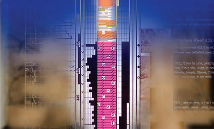


invitation by April 24th, please call Dayna Rhoads (Membership Services) at CSPG’s office ((403) 264-5610, ext. 230). She can verify your start-date, and make sure your name is included on the invitation list. Included with the invitation will be a list of all other invitees – you can look for your friends’ names and help us make sure no one is omitted. It also makes a great “cheat sheet” for the reception when you run into all those old acquaintances!
This event is highly anticipated. We have tasty hors d’oeuvres, some complimentary drink tickets, a cash bar, door prizes, and special prizes for the attendees with the earliest start-dates. Last year, about 150 people attended. We have a short, informal agenda, which includes presentation of the 2008 Honourary Membership Awards. This year the recipients will be David G. Smith and Donald G. Cook.
We hope you can make it to this year’s Long Time Members Reception! For more information regarding this event, please contact Regan Palsgrove at Talisman Energy; phone (Tues. to Thurs.) (403) 237-1423 or e-mail rpalsgrove@talismanenergy.com.
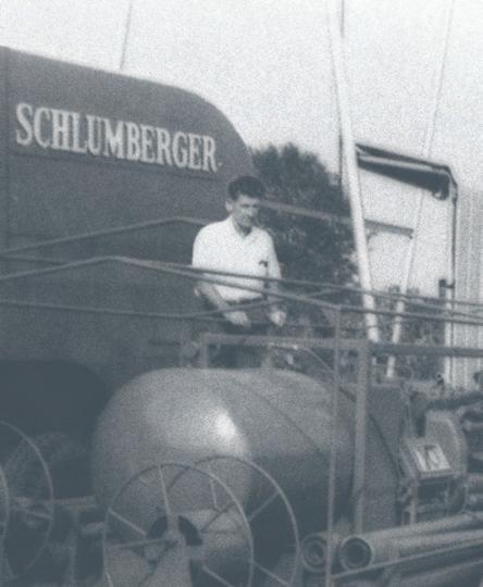
An international company with local personnel, our roots here are strong and deep. We have been a part of the Canadian landscape for 80 years—on the ground and involved, with early discoveries at Turner Valley and Leduc to opening new Arctic and East Coast frontiers.
With the opening of our Calgary office in 1949, Schlumberger put down permanent roots in Canada. Since then our Canadian operations have been key in field-testing technologies that are in use around the world.
403-509-4000
visit schlumberger booth 417 at the csPG cseG cWLs convention.
The Canadian Society of Petroleum Geologists presents the Tracks Award annually to members of CSPG who have made outstanding contributions to the Society through committee or other work. In essence, volunteers who have made “tracks” for others to follow are nominated for this award.
This year we recognized an individual who has helped the Society meet its goals of advancing the science of geology and fostering the spirit of scientific research throughout its membership. Dr. Glen Stockmal was presented with his award at the February 5, 2009 Technical Luncheon.
Dr. Stockmal has been Editor-in-Chief of the Bulletin of Canadian Petroleum Geology since 2004. During that time, Dr. Stockmal maintained a high scientific standard for the papers published in the Bulletin and introduced important innovations to how the Bulletin operates. In particular, he championed the adoption of the Editorial ManagerTM system for online submission and review of manuscripts, which required a very heavy commitment of time from Dr. Stockmal.
Because of his dedication, the Bulletin’s reviewing and publishing processes have been streamlined and future Editors-inChief will enjoy a state-of-the-art system for handling manuscript submission and peer review.
Expertise in heavy oil & deep basin reservoirs
• AVO / LMR Analysis
• Neural Network Analysis
• PP & PS Registration
• Joint PP & PS Inversion
• Fracture Detection Analysis using Azimuthal AVO
• Spectral Decomposition
Time Lapse Analysis
Carmen Dumitrescu
P.Geoph., M.Sc., Manager, Reservoir Geophysics
Direct: 403-260-6588 Main: 403-237-7711
www.sensorgeo.com
Also since 2004, Dr. Stockmal has represented the Bulletin of Canadian Petroleum Geology as a member of the GeoScienceWorld (GSW) Advisory Council. GSW is a nonprofit corporation providing online access to earth-science journals and other materials. Involvement with GSW raises the international profile of the Bulletin of Canadian Petroleum Geology and of CSPG.
In addition to serving as Editor-in-Chief, Dr. Stockmal previously served three terms as an Associate Editor of the Bulletin of Canadian Petroleum Geology (1988-1990; 1993-1995; and 2000-2003).
CSPG’s Link Award is given for the best oral presentation at one of the Society’s Technical Luncheons. Topics of the presentations must be either geological or a related technical subject, and must be presented in Calgary by a CSPG member.
The recipient of the 2008 Link Award is Dr. Benoit Beauchamp for his talk “Hydrocarbon Energy from the Arctic: Holy Grail or Pipe Dream?”, presented on March 11, 2008. Dr. Beauchamp was presented with the Link Award, a handcrafted pewter mug, at the February 17, 2009 Technical Luncheon.
Dr. Beauchamp received his Ph.D in Geology from the University of Calgary and his B.Sc and M.Sc., also in geology, from the Université de Montréal. Dr. Beauchamp joined the University of Calgary as a Full Professor in the Department of Geoscience in April 2005; upon joining this institution, he was seconded to the position of Executive Director of the Arctic Institute of North America, a position that allows him to direct a vibrant
research program. Until then, he was a Research Scientist with the Geological Survey of Canada where he conducted energy-related basin analysis in the Canadian Arctic Archipelago.
In addition to leading more than a dozen major field expeditions to one of Canada’s most remote but also most promising petroleum provinces, he established himself as a solid scientist with a rich record of government and academic publications. His curriculum vitae speak volumes about his leadership qualities, excellence as a researcher and prominence in the local, national and international scientific community.
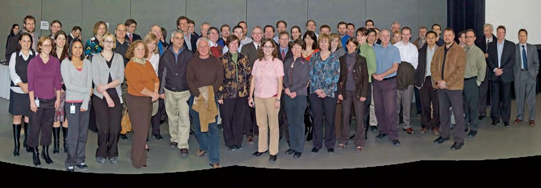
Volunteers are essential to the services and programs offered by CSPG; without volunteers our organization would not exist. CSPG recognizes our extraordinary team of volunteers through Service and Volunteer Awards. These awards were presented at the January 19, 2009 Technical Luncheon.
Service Awards are given to individuals who have contributed to the welfare of
the Society through committee or other volunteer work and are generally awarded for five to ten years of service on a committee, service on multiple committees, or service of retiring committee chairs.
Volunteer Awards are presented every year to individuals who have demonstrated significant service to the Society through volunteer work for at least two years
of service on a committee, recognizing committee members who have demonstrated commitment to the Society’s needs.
For a complete list of the 2008 Service and Volunteer Award recipients, please refer to the January 2009 Reservoir or online at www.cspg.org.


Exhibitor Listing by Company Name as of February 18, 2009
Company Name ...Booth Number
Advanced Safety Paramedics ... Corral
Aeroquest Surveys ............................ 839
AGAT Laboratories Ltd. ................. 319
AGM, Inc. ............................................ 541
Alberta Geological Survey 946
Alberta Research Council .............. 811
ALT – Advanced Logic Technology 910
American Association of Petroleum Geologists 1044
Association of Professional Engineers, Geologists and Geophysicists of Alberta 1042
Baker Hughes ................................... 1033
BEICIP Inc. 235
Boyd PetroSearch ............................. 339
Canadian Discovery Ltd. 713
CGGVeritas ........................................ 105
Continental Laboratories / CL
Consultants ......................................... 313
Core Laboratories Canada Ltd. .... 918
CREWES, University of Calgary 420
Digital Formation, Inc. ..................... 741
Divestco 721
ESG Solutions ................................... 1104
FMQ ................................................ Corral
Fugro Group of Companies (FugroJason, Fugro Gravity & Magnetic Services, Fugro Data Solutions) . 221
GEDCO ............................................... 833
Genetek 1106
GeoEdges, Inc. ................................... 510
geoLOGIC systems ltd. 304
GeoMechanics Intl - GMI ............... 433
Geomodeling Technology Corp. ... 532
Geoscience BC .................................. 940
Goldak Airborne Surveys ............... 819
Golder Associates 743
GORE ................................................... 512
Government of Nunavut 939
Halliburton .......................................... 905
Hays Specialist Recruitment ........... 915
HCL National Inc. ....................... Corral
Horizontal Solutions International 914
Hydrocarbon Data System 413
IHS ........................................................ 733
INDEL-DAVIS INC./IMATION
CANADA ....................................... 414
Ingrain Inc. 1012
ION ....................................................... 326
iSys – The Imaging Systems Group Inc. ....................................... 815
KOMAREVICH ORIGINALS LTD. 416
Little Rock Document Services Ltd. ................................... 422
Manitoba Science, Technology, Energy and Mines - Mineral Resources Division 942
Maxam Seismic Explosives, Inc. Corral
MicroSeismic, Inc. ............................. 921
MJ Systems 610
Mustagh Resources Ltd. .................. 412
Natural Resources Canada/ESS 938
Neuralog .............................................. 504
Nikon Canada Inc. 438
NORSAR Innovation ...................... 1019
Northwest Territories
Geoscience Office ........................ 945
NOV MD Totco .............................. 1014
Nov Reedhycalog Coring Services 924
OYO Geo Space Canada, Inc. ....... 640
Paradigm Geophysical Canada Ltd. 113
Pason Systems Corp. ....................... 825
Petrocraft Products/ Datacon Core Image ..................................... 137 Petroleum Geo-Services
Thank you to the following sponsors for their generous contribution and support of the CSPG, CSEG and CWLS.


Due to the current financial climate, the three societies of the 2009 CSPG CSEG CWLS Convention would like to extend their membership renewal period to Tuesday, April 21 – the last day to register for the Convention before on-site rates apply. Any membership renewals that occur after Tuesday, April 21 will
not be recognized on-site, so renew today to register for the Convention at member rates.
You can renew your CSPG membership by phone at (403) 264-5610 or by faxing your membership form to (403) 264-5898.
Visit http://www.cspg.org/ members/CSPG-MembershipApp.pdf to download your CSPG Membership Form.

| by Heather Tyminski
M IKE CECILE , GENERAL CO -CHAIR OF THE 2009 CSPG CSEG C w LS CONVENTION
Emeritus Scientist, Geological Survey of Canada
How many years have you volunteered with CSPG?
I joined the Canadian Society of Petroleum Geologists when I was a graduate student at Carleton University, around 1976. Dr. Ray Yole, one of my thesis advisors was a CSPG regional representative and suggested I join the Society. Then when I came to Calgary in 1977, I was immediately approached by Sebastian Bell to sit on CSPG’s Thesis Committee. I have been volunteering with the Society ever since. Aside from my work on the Thesis Committee, I chaired the Logan Day Committee for seven years, and I was a director on the Executive Committee in 1982-83 and in 1983-84. I was CSPG Vice President in 1986-87, President in 1987-88 and Past President 1988-1989. As Past President and for a year afterwards I represented CSPG on the Canadian Geoscience Council, and on the Alberta Geological Survey Committee.
My responsibilities as Vice President and Past President also involved liaising with the conference committees.
Why did you decide to take on the role of Convention Co-Chair?
I decided to take on the role of the 2009 CSPG General Co-Chair because of the gratifying experience I had as CSPG Executive Liaison with the 1986 and 1989 conference committees; the energy, enthusiasm and dedication of the committee volunteers impressed me. Also this is a task Ian McIlreath asked me to take on, and how can anyone refuse someone who has dedicated incredible amounts of time to volunteering for CSPG and other societies?
What are your responsibilities as Convention Co-Chair?
The role of a Convention Co-Chair is to define a theme for the conference; I proposed “Frontiers and Innovation,” a theme eventually accepted by all the CoChairs. The Co-Chair is also responsible for finding good volunteers, especially for the Technical Program Committee. I was lucky to get Kevin Root to volunteer as
CSPG Technical Program Co-Chair. Most of the other committee members are continuing volunteers from the previous year’s committee, or people who past committee chairs have recommended. All of the volunteers are outstanding and dedicated people. We also have extremely capable Convention staff who handle the logistics, sponsorship, and who make sure the committee is on track. So right now my role is to oversee the entire process, help make key decisions, and ensure that the project is on track. The position takes time but it is not an onerous job and I would encourage others to take it on.
What are some of the innovations delegates can look forward to at this convention?
The convention’s theme, Frontiers and Innovation, is a highlight of the upcoming convention. We are challenging CSPG, CSEG, and CWLS members to come up with new ideas, particularly right here in the Western Canada Sedimentary Basin, new ways to explore, innovative business concepts, and new information and ideas on geographic and international frontiers.
In addition to this, we are looking for more integration among the three societies, thus sessions will not be featured by one society but by all three. The emphasis we want is on integration. Following on that theme, we are planning a Core Conference that will offer information to geologists, geophysicists, and well loggers alike. The Technical Committee has also decided to hold plenary sessions, which we think will be exciting and popular.
Laura Brick, the Special Events Chair, who is looking to spice up the Exhibit Floor receptions and other Convention events, has two great speakers for the Convention luncheons: Sheila Watt-Cloutier, a Nobel Prize nominee and an advocate for the North and the impact of global warming on the Arctic, and Stuart McLean, CBC’s radio host of the Vinyl Café. Also, Flo Reynolds, the Exhibit Chair, will be experimenting with a “Passport” for the Exhibit Floor. Delegates will take their passport to key exhibitors for stamps, and then submit the passport for a draw prize. This is a means to get more traffic on the Exhibit Floor, and more interaction between society members and exhibitors.
(Continued on page 50...)
Why should people attend the 2009 Convention?
People should attend the Convention because it’s fun, to upgrade their technical fields and abilities, to see what’s new (there is a lot of exciting stuff on the Exhibit Floor), to network with other people, and to participate in the camaraderie of the three societies.
Who should attend the Convention?
Anyone from Canada that works in sedimentary basins or is involved in resource exploration, oil and gas or minerals, should attend this Convention. International delegates will also benefit by learning from Canadian examples and can bring us information from their unique experiences.
How do you define a successful Convention?
A successful Convention is one that is well attended and where people feel they have benefited professionally, and have had a lot of fun. Another measure is finding people talking about great talks they’ve heard, or sessions they’ve attended, and students bubbling with enthusiasm.
What have you learned, as a Convention Co-Chair?
I’ve learned that the way CSPG and the other societies are doing business has changed tremendously since I was on CSPG’s Executive. First of all, we have dedicated staff (Shauna Carson and Tanya Santry). This is a positive step; they take care of a lot of the logistics, and are carrying the experience of various convention committees from one year to the next. Also, now that all of our conventions are joint conventions, the convention management is shared between the societies. This is both a challenge and a
plus. After all, three heads are better than one, but this also means you can have three different opinions. A good manager will take advantage of the three different points of view. Another change is the overseeing committee called the Joint Annual Convention Committee (JACC), which facilitates our interactions with the three societies and is establishing general policies for future convention committees; this is intended to facilitate planning the conventions and appears to be working well.
Why volunteer for CSPG?
Volunteering in general is always rewarding because you meet excellent people, you have a feeling of camaraderie or purpose, there are networking opportunities, you develop friendships, it is fun, and it can be exciting and challenging. And if you are nice to Tanya Santry (the Conventions Coordinator) she will provide you with sandwiches from Quiznos during lunch meetings.
Why volunteer in your semi-retirement / retirement?
Retirement is a personal thing and different for everyone. As I see it, it should be more about you, your hobbies, and your family and I have a lot of that in my retirement. I have a wonderful wife, Carole, who is also retired and appears to be making a semiprofessional career as a flautist. I also have two boys: Chris, who is a geologist working in California and is married to Debbie, and Geoff, who is finishing a Forestry degree in Castlegar B.C. We share a cottage with my brother and family in Northern Ontario (Chapleau). After retiring, I’ve added in golf, singing in a choir and community poker to my long list of activities that includes hunting, fishing, camping, and hiking. And of course I now have grandchildren (Logan and Acacia) and a Chocolate Lab (Chief) to spoil.
At the same time, I’ve had a wonderful professional scientific career, and I have a strong sense of curiosity. That curiosity never goes away (thank God!). So I’m satisfying that curiosity and drive by working as a volunteer half-days at the Geological Survey and continuing to volunteer for CSPG, and I love it!
What are some memorable moments you have had as a volunteer? I have no end of great memories. I particularly enjoyed being on CSPG Executive Committees with great presidents: Fred Calverly, Ian McIlreath, Neil Hutton, and Clay Riddell. I was particularly impressed with Clay who decided that our marathon meetings, which typically went from 3:00 p.m. to 10:00 p.m., needed to be reined in and instituted a policy where all Executive meetings would end at 6:00. The interesting result was that we still completed all our business in spite of the shorter time.
I also enjoyed a great many field trips. I specifically remember one up Exshaw Creek with lots of beer, wine, and steaks at the Rafter Six Ranch; I found that I learned a lot about Devonian to Permian geology while having loads of fun. I also remember when I was CSPG Vice President in 1986 and I met Morley Brown and Art Slingsby on a fun field trip through the Williston Basin – which also involved steaks and beer! During the trip Morley and Art volunteered to take over the fund-raising effort for the CSPG Atlas. They inherited a commitment of a few tens of thousands of dollars that Grant Mossop had acquired, and from there Morley and Art collected well over a million dollars. Another case of working with great and enthusiastic volunteers – while having fun!


• Print any length raster or LAS log
• Color, B&W, full or halfscale up to 8.5” per second
• Image viewing and editing software included

• Corporate repository of your well file data
• Management of your raster and digital E&P data
• PPDM based with optional ArcMap interface See Neuralog in booth 504 at CSPG-CSEG-CWLS Convention May 4-7 or contact sales@neuralog.com
The 2009 Geoskills event took place on Wednesday, February 4th at the Metropolitan Centre in downtown Calgary. The halfday mini-courses and lectures were a great success for undergraduate and graduate students from Mount Royal College, the Universities of Alberta and Calgary, and industry professionals. This is the second year that this student-run event has taken place. Many Geoscience students found this event to be an invaluable experience.
Following a welcome address from APEGGA President Gordon Williams, P.Geol., students were able to attend technical presentations, discuss job opportunities, and learn about recent discoveries and advances in technology through corporately sponsored guest speaker presentations. The technical presentations brought a wide variety of topics ranging from East Coast petroleum exploration to diamond exploration/mining to ichnology and classification. This experience gave the students a great opportunity to explore the different aspects of both geology and geophysics.
A networking session concluded the day. Practicing Professional Geologists, Geophysicists, and a few engineers mixed with student participants to discuss science and careers in an informal atmosphere that isn’t really possible anywhere else. A wide range of door prizes were awarded during the networking session, including Power Lunches with active geophysicists. It also allowed a rare opportunity for future geoscience professionals from the different institutions to get to know one another.
The student volunteers worked very hard to make Geoskills successful. Both the University of Calgary’s Rundle and GUSS societies and the University of Alberta’s PC Warren and GUSS societies worked closely along side APEGGA for months to guarantee that the day was educational for all geology and geophysics students.
A special thank-you to APEGGA, CSPG,
CSEG, Enerplus, CNRL, Geologic Systems ltd., Oban Energy, Sigma, AAPG – Canada Region, Arcis, and Open Range for your generous sponsorship of this event. Geophysical and Geological students from the University of Calgary (37), the University of Alberta (34), Mount Royal College (4), University of Waterloo (1), and approximately 120 industry professionals and volunteers made the Geoskills event very well attended.
The organizing committee is eagerly looking forward to presenting Geoskills 2010.
SCHEDULE
Morning Session: 11:00 a.m. – 12:15 p.m. Introduction by the President of APEGGA: Dr. Gordon Williams, P.Geol., (Summus Resource Evaluations Ltd.)
Speaker: Rick Wierzbicki, P.Geol. and Dr. Rainer Tonn, P.Geoph. (Encana, Oilexco) Topic: Deep Panuke, Offshore Nova Scotia: The Integration of Geology, Geophysics, and Reservoir Engineering for Field Appraisal.
Luncheon: 12:15 p.m. – 1:20 p.m.
Afternoon Session: 1:30 p.m. – 2:30 p.m.
Speaker: Laurie Bellman, P.Geoph. (Oil Sands Imaging)
Topic: Using All the Data: An Integrated
Oil Sands Example Using the Oil Sands Imaging ‘STAC’ Process.
Speaker: Dr. Brian Zaitlin, P.Geol., (Enerplus) Topic: Incised Valley Systems in a Foreland Basin Setting: An example from the Lower Cretaceous Basal Quartz in Alberta.
2:30 p.m. – 3:30 p.m.
Speaker: Torrie Chartier, P. Geol. Topic: Diamond Exploration: Looking for the Needle in the Haystack.
Speaker: Dr. Henry Lyatsky, P.Geol., P.Geoph. (Lyatsky Geoscience Research & Consulting Ltd.)
Topic: Basement Structure in Alberta from Gravity and Magnetic Maps.
3:30 p.m. – 4:30 p.m.
Speaker: Dr. Adam Pidlisecky (University of Calgary)
Topic: Environmental Geophysics: Bringing the Near-Surface Into Focus.
Speaker: Dr. George Pemberton, P.Geol. (University of Alberta)
Topic: Assessing Permeability/Porosity Trends in Bioturbated Media.
Evening Mixer/Door prizes/Sponsor Booths: 4:30 p.m. – 8:00 p.m.
| by Debbie Legaspi
SIFT (Student/Industry Field Trip) is an annual program run by CSPG, which invites one student representative from every Canadian university offering degrees in geology, geophysics, and/or geological engineering to Calgary for a comprehensive introduction to the petroleum industry. The students are carefully selected by their university or the SIFT Committee and will be given the opportunity to take part in our job program.
About the SIFT summer employment program:
• Only students interested in obtaining summer employment in the petroleum industry apply;
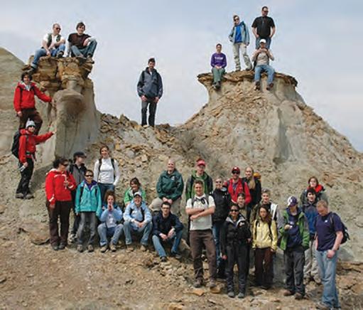
• If you do not find a student suitable for what you are looking for, you are not obligated to hire anyone;
• Interviews are usually held on the first day of the trip, Sunday May 3, and students
will be available to work starting the third week of May; and
• Approximately 8-12 students are employed each year.
Many Calgary oil and gas companies have used the SIFT job program to obtain talented summer students fresh from a two-week thorough introduction to the petroleum industry. By hiring SIFT students, companies save initial training expenses while providing the SIFT students with an opportunity to further their petroleum industry experience. To learn more about SIFT please visit CSPG’s website under ‘STUDENTS’.
If you are company interested in participating in this program please contact Debbie Legaspi at debbie. legaspi@encana.com.

| by Susan R. Eaton
During the fall of 2008, the Canadian Federation of Earth Sciences (the “CFES”) issued a report entitled Human Resources Needs in Earth Sciences in Canada. Dubbed Canada’s ‘first-ever’ multi-sector survey –spanning government agencies, academic institutions, and the petroleum, mining, environmental, and geotechnical industries – the report voiced concerns about declining student enrolments, juxtaposed against a greying population of geoscientists across the board, with the exception of the environmental industry, Canada’s fastest growing employment sector. According to the report, the impending demographic crunch and the projected shortage of highly qualified professionals (HQPs) could threaten the future viability of Canada’s earth science sectors.
With a population of about 20,000 earth scientists nationwide, Canada has a history steeped in mining and oil and gas exploration – the very health of Canada’s Gross Domestic Product (GDP) hinges upon the sustainable harvesting of the country’s natural resources.
The recent global economic turmoil, coupled with a 70% decline in world oil prices, however, has forced the oil and gas sector to slash capital expenditures and to reduce workforces.
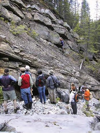
w hile there was no “one-size-fits-all” solution – each sector faces its own unique challenges –the CFES provided the following action plan:
1) General public awareness of the role of earth sciences in society;
2) Canada has abundant natural resources and needs scientifically informed extraction and environmental practices;
3) Canada’s future challenges include energy, water, material needs, and the management of short-term and long-term hazards;
4) Influence education curricula at the provincial level and increase efforts to recruit students into earth science curricula;
5) Increase Canada’s annual output of B.Sc. graduates in earth sciences;
6) Push to increase employment opportunities for immigrant professionals in the earth science sectors;
7) Provide mentors and experienced scientific leadership to younger staff; and
8) Advocate for increased research funding for all sectors of earth science disciplines.
A scant six months ago, Calgary-based oil and gas companies were aggressively competing for both entry level and experienced earth scientists – today, layoffs in the oil and gas sector have translated into an uncertain future for geoscientists. Despite being published during the euphoria of an unprecedented economic boom, the CFES survey provides an historical overview of employment trends, and lays out a road map to bridge the growing capacity gap, addressing human resource needs during the next five years.
According to Canada’s oil and gas industry leaders, the report’s findings are timely – and more relevant than ever – as the industry weathers the current economic storm, navigates uncertain waters, and shifts its business model from exploring for conventional to unconventional resources in the Western Canada Sedimentary Basin.
“No one has ever looked at purely earth sciences across the industrial sectors, at demographics and future trends,” says Ian Young, past president of the CFES and EnCana Corporation’s Vice President, Business Affairs Canadian Foothills. “To
me, the results of the survey are even more urgent because we’re experiencing a recession.”
Data collected by the CFES indicate that university enrolment, at the B.Sc. entry level, tracks the boom and bust cycles of commodity prices for metals and oil. Between 1986 and 1999 – tumultuous years for the global oil and gas industry – academic enrolment plummeted in undergraduate Earth Science programs. During this same time period, Canada’s oil and gas industry experienced waves of layoffs and dramatically reduced the recruitment of university graduates, resulting in today’s bimodal distribution of new hires and baby boomers. “When the demand side (for oil) picks up again, we’re going to have a worse human resources problem,” cautions Young. “People have described mining and oil and gas as the two solitudes,” he said, pointing to Canada’s traditional employers of Earth scientists. “Hopefully, there’s more work for geoscientists in geotechnical, environmental, and mapping applications.”
Dr. David Eaton, professor of geophysics and head of the Department of Geoscience

at the University of Calgary, echoes Young’s comments. “We need to think outside the box. Geology and geophysics students receive unique, hands-on exposure to important real-world problems, preparing them for many careers paths – from law to education – in addition to traditional professional employment in the oil industry.”
The University of Calgary’s Geoscience Department has established four main areas of technical expertise: exploration geophysics, petroleum and energy-related geoscience, environmental geoscience, and solid Earth processes.
“The current generation of students across Canada is environmentally savvy. We need to demonstrate to them the fundamental role
of environmental geoscience,” says Eaton, suggesting, at the same time, that the oil and gas sector needs to dispel some public misperceptions about its environmental track record.
According to the CFES report, the environmental sector’s need for earth scientists is expected to grow by more than 30% during the next five years alone –exhibiting a dynamic all of its own, this sector is attracting an ever-increasing percentage of Canada’s young geoscientists.
With a compliment of 480 undergraduate and 170 graduate students, the University of Calgary is, by far, Canada’s largest Earth Science degree-granting institution – in
fact, according to Eaton, his department represents approximately 15% of Canada’s entire undergraduate geoscience population. At a time when most other Canadian universities are experiencing falling Earth Science enrolments, the University of Calgary – located at the epicenter of Canada’s oil patch –is recruiting new faculty members in response to increased student numbers and generous industry funding, including EnCana’s recent endowment of a Chair in Unconventional Gas Research.
“The Canadian oil patch is unique globally, in that it prefers Bachelor graduates for entry level hires, and molds them into the corporate culture,” explains Eaton. “It reflects a tradition here.” He suggests, however, that the current economic downturn may produce a greater demand for M.Sc. graduates who possess broader levels of expertise. “Exploration and production activities are getting more challenging,” explains Eaton, citing a growing focus on unconventional resources in Western Canada, a recently announced $100-million mapping program of the Canadian Arctic by the Geological Survey of Canada, and advancements in carbon capture and geological sequestration.
“As we move forward from conventional to unconventional resources, there are different skills required,” says Young about the changing face of oil and gas exploration in Canada. “We’re moving from ‘romantic’ pioneering exploration teams working in undeveloped basins, to a new reality where earth scientists are part of multidisciplinary teams trying to extract the most from the rocks.”
According to the CFES findings, education requirements vary by sector, with the environmental and mining sectors employing a far larger percentage of M.Sc. graduates than the oil and gas sector. Not surprisingly, government and research agencies mainly hire earth scientists with M.Sc. and Ph.D. degrees.
The CFES or FCST (the “Fédération canadienne des sciences de la Terre”) is an umbrella organization comprised of 12 technical and learned societies and interest groups, including the Canadian Society of Petroleum Geologists (the “CSPG”). Striving to be the unified voice for earth sciences in Canada, the CFES engages the general public, producing outreach, education, and career materials on earth sciences for K-12 (Continued on page 56...)
school children and university students. Additionally, the organization advocates the use of sound scientific data to shape industry and government policies on resource extraction, the management of the natural environment, and the mitigation of natural disasters.
During its human resources study, the CFES polled 20% of Canada’s earth scientists, or roughly 4,000 individuals representing more than 117 organizations. Additionally, the CFES survey integrated data from 8,600 geoscientists represented by the Canadian Council of Professional Geologists (the “CCPG”). The CFES report can be viewed at: http://www.geoscience.ca/CFES_HR_ requirements_Canadian_earth_sciences.pdf.
“I like the CFES report,” says Dr. Dale Leckie, chief geologist at Nexen Inc. “It’s timely, appropriate, and it agrees with the research I’ve been doing during the past couple of months.” Adds Leckie, “The data speak in the report.” As Nexen’s chief geologist, Leckie’s job includes the recruitment of new graduates and the establishment of formalized, in-house mentoring and training programs for new hires or those individuals with zero to five years of industry experience.
Leckie, also president of the Society for Sedimentary Geology (the “SEPM”), an international technical organization, points to a shortage of young trained specialists in the oil and gas industry, a group that the CFES describes as the HQPs. “If we discourage the new graduates, we will be facing the same shortage when the industry picks up again. And, it’s not just layoffs – it’s also the lack of hiring.” At writing, Leckie indicated that Nexen was honouring job offers to this year’s crop of university graduates, while continuing to invest in the training of its new hires.
“The CSPG saw this demographic crunch coming in the mid-1980s,” says Graeme Bloy, president of the CSPG and Vice President of Exploration for Canada Capital Energy Corporation. As a technical society, he says, the CSPG has a bimodal membership distribution skewed towards the baby boomers, a group commonly referred to as the grey bulge. The health of the CSPG, he says, depends upon young geologists entering the industry. In response to membership demographics, the CSPG has allocated a “significant” budget for education and outreach, targeting both university and K-12 students. “At least 50% of earth science
graduates don’t even make it into their chosen field,” says Bloy who describes the CFES report as a good planning tool.
Bloy was surprised that the CFES report did not address gender issues, indicating that more than 50% of Canada’s earth science students are female. “In the oil and gas industry, we’ve seen such a large increase in women working in the geosciences.”
“The industry,” explains Bloy, a 30-plus-year industry veteran, “has not historically had a long-term view of manpower management. We have some challenging times ahead, in terms of keeping the younger people in the business.” In the event of layoffs, he fears that young geologists will leave the oil and gas industry, as has been evidenced during past economic downturns.
Bloy challenges the oil and gas sector – both large and small companies alike – to do a better job at hiring, mentoring, and training junior geologists. “This crash,” he adds, “will severely impact succession planning in companies.”
Dr. Grant Wach is Professor of Petroleum Geoscience and Director of Energy at Dalhousie University in Halifax, Nova Scotia. Wach entered academia, after an oil and gas career which began in Alberta’s oil sands, and which continued in the research and exploration groups of two major oil companies in Houston. “My job is to begin to train the students, and to interest them in the opportunities in the petroleum industry. It’s the responsibility of the petroleum companies to promote careers in their companies, and, for the
most part, they are failing to do so.”
“The petroleum industry needs to make work more exciting,” says Wach. “Right now, the jobs look like the civil service – here’s your workstation and in 25 years, you’re out.” Adds Wach, “Frankly, the Kingston Penitentiary looks more attractive.”
According to Wach, many young geoscience graduates are enthused about the outdoor field work component of their profession – accordingly, they’re choosing to enter the mining and environmental sectors, and are bypassing the oil and gas industry altogether.
Recent earth science graduates are seeking companies who engage them by providing mentorship, training, career development, interesting and varied projects, competitive salaries, and flexible employment options. Adding to this already expansive shopping list, some of these Generation “Y” candidates are choosing employers who mirror their personal values on issues ranging from the environment, sustainability, human rights, community giving, and volunteer involvement.
Paul Bauman, manager of the geophysics division at WorleyParsons Komex, a Calgarybased environmental consulting firm which competes against oil companies to recruit geoscientists and engineers, believes that the youth of today are distinctly different. “Today’s graduates are leisure conscious – they want the best of both worlds. It’s a whole different work ethic.” Bauman suggests, as well, that young recruits also crave value-added mentorship in the workplace: “They want to flourish and they want to be nourished.”
Kelly Murphy is a human resources business partner, specializing in exploration teams at Devon Canada Corporation. “From a demographic perspective, the CFES report rings true, for us at Devon and globally,” says Murphy. “We see that hiring gap in the Generation “X” group, the 33to 43-year-old geoscience professionals.” Adds Murphy, “The demographic challenges to Devon are not unique, but are common to the industry.” Devon describes the baby boomer generation as “the blue wedge,” a group who is slated to retire soon.
“Engagement is not a snapshot or an event – it’s not a one-time occurrence – and we need to recognize what makes employees stay or go,” explains Murphy, with respect to offering new hires training, mentoring, career rotations, and succession planning.
The current economic downturn may provide a small silver lining for the oil and gas industry: experienced oil and gas geoscientists, the baby boomer generation, are re-evaluating the financial implications of retiring within the next five to ten years, and are delaying their inevitable mass exodus –the big “crew change” – from the sector.
“This downturn will keep people working longer, and it will alleviate the corporate drainage of technical knowledge,” says Leckie. “I think the pending grey bulge will be pushed out, and we’re seeing this in all technical disciplines.”
Murphy concurs: “We haven’t lost sight of the blue wedge – it was on our radar screen a year ago. The downturn gives us a bit of breathing room; it also gives us an opportunity to use the baby boomers as mentors to the Generation “Y” group, passing on their skills.”
“Recruiters know what’s coming,” said Catherine Brownlee, president of Prominent Personnel Ltd., a Calgary-based global oil and gas search firm. “The layoffs haven’t even started.” Co-author of the best-selling book, Want to work in oil and gas? , Brownlee has been flooded by résumés and has seen a significant number of retired geoscientists returning to the industry, casualties of the global economic downturn. “They’re willing to apply for positions advertising 10 years
of experience, consult full-time or parttime, anything,” she added. “I’ve never seen anything like it: we have become a house of support for people who are desolate.”
In response to the changing economy, Brownlee’s firm has diversified its business model, gearing up for outplacement and career services. Recently, Prominent Personnel has also focused on creating training and mentoring programs for immigrant professionals, a group the CFES targeted to fill Canada’s growing capacity gap for earth scientists. “I see this downturn as a perfect time for foreign professionals to prepare for the future,” said Brownlee. “They can sharpen their skills to get ready for the turnaround.” It’s also a great time,” she added, “for new geoscience graduates who are passionate about the oil and gas industry, to offer their skills (perhaps for a reduced fee) to the industry.”
Susan R. Eaton (susaneaton@shaw.ca) is a Calgary-based geologist, geophysicist and freelance writer who manages her own environmental and energy consulting practice, SR ECO Consultants Inc. Eaton, an asset evaluator with 27 years of industry experience, consults to Canadian and American investment banks and oil and gas companies on corporate due diligence and financial, strategic, and technical evaluations.
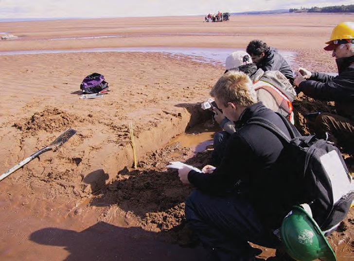


AGAT Laboratories Ltd.
BlueCastle Corp.
Canada Brokerlink
Command Equipment
Cougar Consulting
DeGolyer and McNaughton
EnCana Corporation
Enseco Energy Services
SILVER SPONSORS:
geoLOGIC systems ltd.
HOTWELL Canada Ltd.
Hycal Energy Research
Laboratories Ltd.
Matrix Solutions
NOV: MD TOTCO
Prodrill Fluid Technologies

Angle Energy Inc.
Aramark/Travers Ltd.
Black Knight
CNRL
Core Laboratories Canada Ltd.
Dack Resources Ltd.
Edge Techologies
Firecreek Resources
Genesis Executive Corporation
Matrix Geoservices Ltd.
RCS Energy Services Ltd.
Recon Petrotechnologies Ltd.
Sigma Explorations
Snub Secure
Statcom Ltd.
| by David Caldwell, CSPG Squash Tournament Chair
It was a hard event to top, following up last year’s 25th Anniversary tournament, but this year may have surpassed last year’s special event. With slow registration numbers, the committee began to worry in mid-January that the latest economic downturn in the oil patch might affect turnout at this year’s squash tournament. But a late surge by many new players filled the various divisions quickly ensuring the longest-running squash tournament in Calgary would hold up to its reputation as being one of the great sporting events in the city.
This year’s event was host to almost 25 new players out of 130 registrants. Companies like CNRL led the way with eight players and Tristar Oil & Gas chipped in sending five players to play squash. The University of Calgary also sent a strong contingent of about 12 students. The entry fees for the students are graciously funded each year by Encana.
Sponsorship was undoubtedly one of the most challenging tasks that the committee faced this year. As the economic doom and gloom began to waft across Calgary, some of the long-time sponsors trimmed budgets and opted out of our event. Nonetheless, several other companies stepped it up to a higher level while the committee did a
great job finding new sponsors. I would like to extend a big thank-you to sponsors like Tucker Wireline (Warren Dublonko and Devon Henderson) who continued their Tournament sponsorship. Kudos to Ryan Barnett and Michael Little at Geotir
who threw in extra money to ensure the Teams Tourney would continue to be part of the event. Both Doug McGlashing and Colin Thiessen of Weatherford were also instrumental in making sure this event had enough funding to ensure its success.
Event highlights included the Doubles Squash again this year. Both the Competitive and Recreational Division enjoyed great matches and showed off several great costumes along the way. The Men’s A Final had an interesting twist leaving Ian Laycock the repeat but exhausted winner after three sets. Trailing 2-0, challenger Dave Safton recruited fellow player John Cox for the third game but the pair still lost to the “one man show,” Ian Laycock.
Once again, the World Health Club in Edgemont continued to host a worldclass event. The food continued to be spectacular and the service was second to none. Highlights included a new Asian wrap night on Friday and the unbelievable brunch on Saturday morning. I would also like to thank our main sponsors such as Belloy, Pason, RPS Energy, Rigsat, Total Gas Detection, Halliburton, Lyons Oilfield (Continued on page 61...)

Men’s A
Men’s A Runner-Up
Men’s A Consolation
Men’s B
Men’s B Runner-Up
Men’s B Consolation
Men’s C
Men’s C Runner-Up
Men’s C Consolation
Men’s D
Men’s D Runner-Up
Men’s D Consolation
Men’s E
Men’s E Runner-Up
Men’s E Consolation
Women’s A
Women’s A Runner-Up
Women’s B
Women’s B Runner-Up
Women’s C
Women’s C Runner-Up
Women’s D
Women’s D Runner-up
Women’s E
Women’s E Runner-Up
Women’s E Consolation
Doubles Champion - Recreational
Ian Laycock
Dave Safton
Brian Rutherford
Ken Chong
David Cairns
Trevor Duncan
Kyle Porter
Randy Smith
Christopher Doyle
Mike Little
Dion Lobreau
Brett Sutherland
Joe Rescky
Roger Edgecomb
Terry Phillips
Ashley Ramsden-Wood
Solana Jear
Sandi Bunko
Heather Shepley
Alana Humphreys
Samantha Etherington
McKinley van Rijn
Melanie Myden
Courtney Whibbs
Brenda Pearson
Melissa Power
Solana Jear and Ann Burrage
Doubles Consolation - RecreationalJeff Barefoot and Dave Caldwell
Doubles Champion - CompetitiveJames Muraro and Gordon Copp
Doubles Consolation - CompetitiveDave Clements and Dell Pohlman
(...Continued from page 59)
Scouting, Logtech, and Earth Signal for contributing towards the costs.
Last but not least, thank you to all of the committee members who donated their time. This event would not be possible without all of these people and their tireless efforts. The committee works hard every year to make sure this tournament continues to be the best squash event in the city. Maybe that is why we already have another 5-6 new people waiting to help out next year should we need new recruits.
The Squash Committee members include the following: Megan Barefoot from Angle Energy, Ryan Barnett from Geotir, Warren Dublonko from Tucker Wireline, David Caldwell from Command Equipment, Kristy Howe from CNRL, Shawn Lafleur from Caltex Energy, Jessie Mitton from Provident Energy, Leanne Paterson from ConocoPhillips, Randy Smith from RPS Energy, Naomi Storey from Edge Technologies, and Jay Williams from Hotwell Canada. I would also like to extend a special thank you to Dayna Rhoads at CSPG’s office who helped out tremendously with the tournament registration.
| by Simon Haynes
CSPG’s University Outreach program was created in 2002 to promote the science of petroleum geology to students, particularly undergraduates, and to strengthen ties between CSPG and Canadian university earth science departments. One of the ways we maintain this relationship is through CSPG’s Student Chapter program.
Student Chapters can be formed at all Canadian university departments offering an earth science degree. All that is required is that an application form be filled out by a minimum of five students, with a representative nominated to liaison with the Outreach Committee. A faculty member is asked to act as the department liaise to help ensure a smooth transition from year to year. Once the application is received, a Chapter is eligible to receive up to $250 in funding for club activities. In the past, these funds have been used to assist in field trip expenses, provide financial assistance for

attending conferences, and to host social events. CSPG provides each Chapter with copies of the Reservoir and Bulletin to keep students informed on activities, conferences, and up to date on current research. Chapters also receive an annual gift in the form of a publication (either a book or digital CD) to use as a reference for their respective Earth Science departments.
This program is provided at no cost to students. All members of a Chapter are considered student members of CSPG and can access digital copies of the Reservoir and Bulletin on-line, as well as the secure members-only areas of CSPG’s website. These resources provide students with information on various awards and scholarships that our society offers, programs like SIFT, the latest on upcoming conferences, and other timely news.
In 2008, CSPG’s Student Chapters program had 21 chapters from coast to coast, which are divided into the following regions: Western Canada, Ontario, Quebec, and Atlantic Canada. These divisions are intended to reflect the number of universities by region, and area managed by Chapter Coordinators, who have a connection to each area. Our Student Chapter coordinators for 20082009 are:
• Denise Hodder, with ExxonMobil in St. John’s Newfoundland, represents Atlantic Canada;
• Marianne Molgat of Talisman Energy, who hails from Aylmer in Gatineau, represents Quebec;
• Simon Haynes with Shell Canada, is originally from Fonthill in the Niagara Region, and represents Ontario;
• Mark Radomski, of Talisman Energy, completed his M.Sc. at the University of Calgary, and represents Western Canada; and
• Erin Crerar of Nexen Inc, currently chairs the committee, and is the liaison with the Outreach Director.
The Coordinators are responsible for maintaining communication with the individual chapters, and try to highlight events of interest, such as upcoming CSPG University Outreach Lecture Tours in their area.
CSPG’s University Outreach Lecture Tour Program involves professional geoscientists from industry or academia visiting a particular region to give a series of talks at various university Earth Science departments. Most recently, Bill Martindale from Petro-Canada presented his talk “Is the modern Belize carbonate-siliciclastic shelf an appropriate analogue for exploration and development of Western Canada Devonian reservoirs?” at McGill, University of Ottawa, Carleton University, Queens, University of Waterloo, and the University of Western Ontario. Bill commented afterwards, “The Lecture tour program is a great idea as evidenced by the turnout at all but one of my venues and by the subsequent response from many profs and students. It fills a valuable service in providing a link between academia and industry and demonstrates that many industry geologists can and do undertake research that is both relevant and interesting.” This tour is one of the most important aspects of Outreach, and often represents the main point of contact between CSPG and the students who attend universities in provinces that do not have strong oil and gas production.
Marianne Molgat and Jean-Yves Chatellier, both geologists at Talisman, also gave very successful lecture tours in Ontario and Quebec this fall. We are excited to have four sets of lecture tours across Canada in Winter 2009 – stay tuned for announcements about tours in your area! Special thanks goes out to Chad Glemser (Shell Canada) and Tracy Allen (Nexen Inc.) for organizing these tours.
The University Outreach Program has implemented many new initiatives in the last few years thanks to such people as Aaron Grimeau (past chair) and Kris Jewett, who recently left after six years of service to accept a new position with British Gas in the U.K. The committee is composed of a strong team of volunteers with a wide range of age, education, and experience in industry. Please visit the website below for additional information on our programs, or if you are interested in volunteering.
http://www.cspg.org/students/studentsoutreach.cfm

industry-leading customer service easy & efficient migration of existing data helping clients increase productivity
We know that almost everyone who tries geoSCOUT™ wants to use geoSCOUT. So, why hasn’t everyone already switched to geoSCOUT? Probably because, in general, people don’t like change. But, in this case, change is good – very, very good.
Just ask the thousands of landmen, engineers & geologists currently using geoSCOUT oil and gas mapping and analysis software to make solid decisions every day. Give us an hour for a demo – we know you’ll see the value. Call 403.262.1992 | Email info@geoscout.com | Online www.geoscout.com/demo Another powerful suite of tools from geoLOGIC
our Booth #905 at the
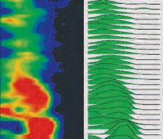
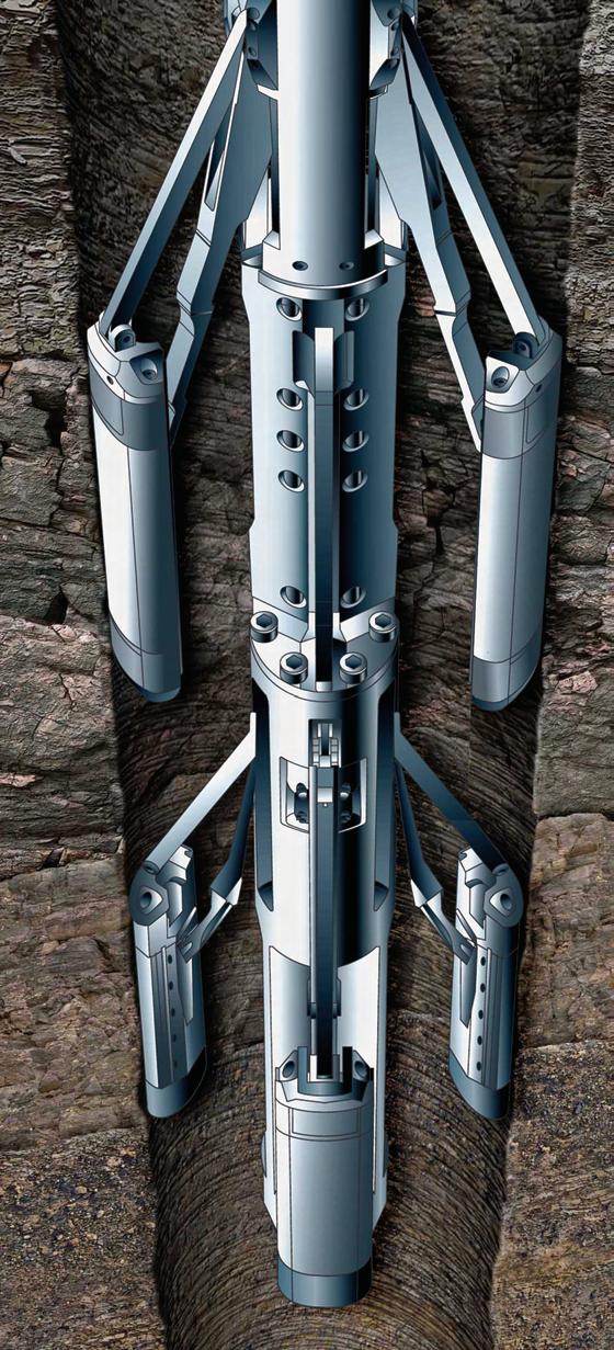
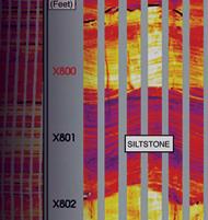
Halliburton Wireline and Perforating Services has the most reliableimaging solutions in the world—including the new Oil Mud ReservoirImager (OMRI™) tool and its X-tended Range Micro Imager (XRMI™) tool version—both of which generate crisp, digitalwellboreimages across the full range of formation resistivitiesand with excellentvertical resolution. Before you get in too deep, look into Halliburton Wireline and Perforating Services— the leader in reliability and service excellence. For more information, call 1-888-775-6447 or visit us at www.halliburton.com/wireline.