Please submit RESERVOIR articles to the CSPG office. Submission deadline is the 23rd day of the month, two months prior to issue date. (e.g., January 23 for the March issue).
To publish an article, the CSPG requires digital copies of the document. Text should be in Microsoft Word format and illustrations should be in TIFF format at 300 dpi., at final size. For additional information on manuscript preparation, refer to the Guidelines for Authors published in the CSPG Bulletin or contact the editor.
Technical Editors
Ben McKenzie Colin Yeo (Assistant Tech. Editor) Tarheel Exploration EnCana Corporation Tel: 403-277-4496 Tel: 403-645-7724 Email: bjmck@live.com Email: colin.yeo@encana.com
Advertising inquiries should be directed to Caitlin Young, Tel: 403-513-1230 email: caitlin.young@cspg.org. The deadline to reserve advertising space is the 23rd day of the month, two months prior to issue date.
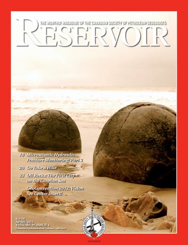
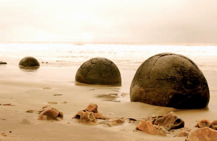
FRONT COVER Moeraki Boulders scattered along Koekohe Beach just north of Dunedin, New Zealand. The boulders are perfectly spherical concretions that have been eroded out of the coastline by the ocean and lie scattered along the beach.
Photo by Nina Prefontaine.
Miles of Shale Experience
With over 10,000 sq miles of acquisition, imaging, and analysis of shale data, CGGVeritas is the smart choice for shale. We offer integrated geophysical solutions for shale reservoirs designed to optimize well location and completion.
• Identify hazards and sweet spots, reducing development risk and costs
• Tailored solutions, from survey evaluation and design to rock property analysis, provide the most detailed reservoir models to optimize resource exploitation
• Seamless integration of best-in-class services from the leading global provider of geophysical solutions
CSPG EXECUTIVE
President
Robin Mann • AJM Deloitte rcmann@deloitte.ca Tel: (403) 648-3210
Vice President
Paul MacKay • Shale Exploration Ltd. Paul.Mackay@shalepetroleum.com Tel: (403) 457-3930
A Message from the Educational Trust Fund Interim Chair, Steve Dryer
CSPG Educational Trust Fund (ETF)
The CSPG Educational Trust Fund (ETF) exists for the purpose of supporting and funding petroleum geoscientific education. We currently have assets of $1.2 million and from that we fund approximately $40,000 of projects yearly. The details of that support will follow.
The contribution of many individuals to the ETF is greatly appreciated. The Trustees have the objective of continuing to build the fund. We would like to be working with $5-10 million which would make the funding of many more projects possible. There are two ways you can be part of this ambitious goal. The first is to communicate your ideas or vision of what can be done. For example, could it be something like a “Noble Prize” which recognizes contributions that have advanced petroleum geoscience education? The second way to be part of the ETF and create a personal legacy is to contribute financially. In this way you can give back to the profession that enabled your own success.
For fiscal year 2010-2011, the ETF funded the CSPG $40,610 in support of the following: CSPG bursaries ($2,000), Graduate Thesis Awards ($5,500), and the Honorary Address ($4,000). Additional funding went towards geoConvention: recovery 2011 ($5,000), the Andrew Baillie Award ($1,000), EdGeo ($12,500), Calgary Youth Science Fair ($610), and the Glen Ruby Scholarship ($10,000). During the year, CSPG collected donations on behalf of the ETF in the amount of $23,571.
The CSPG Educational Trust Fund as an Alberta-registered charity has restrictions, both within its Deed and as a registered charity, as to the amount it is allowed to fund yearly. Commencing in fiscal year 2011, the ETF is now able to increase its funding by reducing its capital by up to 10% per year. It also has the option to accept restricted donations that will allow
funding according to the agreement with the two parties.
During the fall of 2011, the ETF identified the need to create a Funding Proposal Guideline for funding requests and to define the selection process as a result of defining Petroleum Geoscience. These forms are available on the CSPG website.
All the ETF Trustees are here to represent you and can be contacted through the CSPG website. As Interim Chair, I would also like to thank the Trustees for continuing to serve on the ETF. Currently the ETF is comprised of myself, Interim Chair; Dan Krentz, Secretary; Peter Harrington, Treasurer; and Trustees John Cuthbertson, Simon Haynes, Dawn Hodgins, John Hogg, Brett Norris, Kirk Osadetz, Kyla Poelzer, and Clint Tippett. I would like to personally thank Claus Sitzler who chaired the ETF in 2011 followed by Dan Krentz as Interim Chair.
Long Time Members
Reception
Wednesday, May 16, 2012
5:30 – 7:30pm
TELUS Convention Centre
Macleod Hall D
(By invitation only)
They can copy us. They just can’t be us. If imitation is the sincerest form of flattery, we’re one flattered group. Drawing on a quarter century of oil and gas experience, geoLOGIC continues to be the market leader in data, software solutions and support. And while we lead the way, our competitors desperately create parity products, sometimes years after us. For details on how geoLOGIC leads the way, visit www.geoLOGIC.com/leader
Leading the way with customer-driven data, integrated software and services for your upstream decision-making needs.
geoSCOUT | gDC | petroCUBE at www.geoLOGIC.com
CORPORATE SPONSORS
Dia M o ND
IHS
GEOLOGIC SYSTEMS LTD
SCHLu MBERGER CANADA LTD.
Plati N u M
CENOvu S
CONOCOPHILLIPS
ENCANA
IMPERIAL OIL
NE xEN INC
SHELL
TALISMAN ENERGY
POGGENPOHL
GolD
APEGGA
CSPG EDuCATIONAL TRu ST Fu ND
DE vON CANADA
IMPERIAL OIL
SHELL
WEATHERFORD L ABORATORIES
Silver
ENERPLu S
JEWEL Su ITE
ROx AR
TAqA NORTH
Bro NZ e
ATHABASCA OIL SANDS
BLu EBACK RESERvOIR
PARADIGM
GEOvARIANCES
CSEG FOu NDATION
H u SKY ENERGY
LORING TARCORE LABS
ROKE TECHNOLOGIES
RPS BOYD PETROSEARCH
HALLIBuRTON ENERGY SERvICES
Su NCOR ENERGY
Su NDOG PRINTING
AS OF MARCH 10, 2012
F EATURED GEOLOGIST: David Campagna
| By Caitlin Young
CSPG is known for having the country’s leading geologists as members, and it is with great pride that we introduce to you someone who we hope you will get to know through the upcoming Gussow Geoscience Conference in November: David Campagna. David is the General Manager of u nconventional Resources at Nexen Inc. and will be the Co-Chair of the next CSPG Gussow Conference along with Christopher Clarkson of the u niversity of Calgary. The conference theme will focus on the timely, and controversial, topic of hydraulic fracture stimulation or ‘fracking’.” The title of the conference is “Hydraulic Fracture Stimulation: The Science and Perception of Fracking” and will discuss what is currently known regarding the science of the process that will hopefully provide information to address current public perceptions.
“In Alberta we are used to oil and gas activity, we know about it and acknowledge it. Other areas of the world may not have such familiarity, which is one reason for the controversy surrounding fracking,” David states. “The Gussow Conference is meant to be a rational discussion based on scientific observation from which we can formulate a reasonable assessment of the value, costs and risks associated with hydraulic fracture stimulation.
With over 25 years of experience in the oil and gas industry, and 18 years alone in u nconventional Resources, David Campagna is a strong leader for such a timely and relevant topic. “Fracking has allowed us to access vast resources, and our success has directly affected natural gas prices as well as trade.” The conference will look at the impact that fracking has on the environment, as well as water management, chemicals used, and the potential for earthquakes based on the actual rock mechanics of fracking. “I think that some of the problems fracking has come across in the past are that people are just not familiar with what we actually do know about the process as well as what we do not and that is where the misconceptions come from. With the Gussow Conference our goal is to provide information that could be the basis from which we can have a dialogue regarding the benefits of unlocking these
resources as well as the potential impacts that fracking has on the surrounding environment. “There are places that we can improve on fracking including: more precise methods to control the frac; using cleaner fluids for stimulation; establish better drilling methods; and decrease the impact that fracking has on the surface” says Campagna. The theme of this Gussow Conference is very topical and likely to be controversial and emotional. It is critical that the program strive to be multidisciplinary with a strong sciencebased approach.”
Fracking is also considered to have suffered a less-than-positive reputation because of the initial lack of communications between the industry and people living in areas where fracking is taking place. Increasing this transparency is one of the ideas that the Conference hopes to instill in each delegate that attends. Direct communication through advocate organizations such as the CSPG to environmental and local groups that oppose fracking is the most effective way to address common perceptions.
CSPG is extremely excited for David Campagna to be one of the leaders of our next Gussow Conference, and we are proud to feature him as our next Geologist of the Month.
Tuesday, May 15, 2012 5:30pm – 7:00pm
TELUS Convention Centre
Macleod Hall D
Join us in honoring our 2011 award recipients.
Everyone is welcome to attend .
technicaL Luncheons
Structural diagenesis, resource plays, the Highlands of Scotland, and curriculum development
SPEAKER
Stephen e . l aubach Bureau of Economic Geology AAPG Distinguished Lecturer 11:30 am tuesday, a pril 10, 2012 calgary, teLus convention centre calgary, alberta
Please note: the cut-off date for ticket sales is 1:00 pm, tuesday, a pril 3, 2012. csPg member ticket Price: $42.00 + gst non- member ticket Price: $45.00 + gst.
Each CSPG Technical Luncheon is 1 APEGGA PDH credit. Tickets may be purchased online at www. cspg.org.
Structural diagenesis is the study of the relationships between deformation or deformational structures and chemical changes to sediments. In shale resource plays, in tight gas sandstones, and in many other rocks the crossdisciplinary structural diagenetic approach to fracturing, fault growth, compaction, and other mechanical processes is a key to unlocking scientific knowledge about a part of the Earth’s interior that is of great intrinsic and practical interest, and a perspective that is increasingly important in the geoscience curriculum.
using examples from core-based studies of shales and tight-gas sandstones from Texas, Colorado, and Argentina, and outcrop examples from NW Scotland, this talk shows how this approach leads to new insights into fracture growth rates, how natural fractures evolve, how they may impact production, and how the surprisingly heterogeneous attributes of fractures can be better predicted and efficiently diagnosed. Some important remaining challenges are outlined that have implications for industry practice and for student training.
BIOGRAPHY
Stephen E. Laubach is a geologist at the Bureau of Economic Geology with expertise in structure, fractures, diagenesis, fluid flow, and rock mechanics. His research focuses on chemical and mechanical interactions in rock. He has worked on geological and engineering issues pertaining to tight gas, shale gas, and coalbed methane since 1986. He supervises graduate students in the Geosciences Department of Geological Sciences and was first chair of the Jackson School Energy Geoscience Education and Research Group in 2008-2009.
Dr. Laubach served as a member of the Committee on Advanced Drilling Technologies, National Research Council from 1992–1994 and is a member of the National Research Council Committee to Assess the Deep Underground Science and Engineering Laboratory. He cochaired the first North American Rock Mechanics Symposium in 1994. He was a Distinguished Lecturer for the Society of Petroleum Engineers in 2004 and was a Member of the Geological Society of America Panel on energy and mineral resources policy in 2007–2008. He is Elected Editor of the American Association of Petroleum Geologists (2010-present) and is a member of the AAPG Executive Committee.
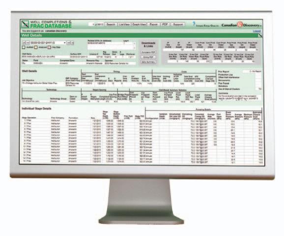
OPTIMIZE YOUR COMPLETION SUCCESS
» Identify completion trends/most common practices
Benchmark drilling and completion costs
Analyze competitor performance
The Well Completions & Frac Database is a searchable, web-based application offering digital completions and fracturing data. Currently covering all Resource Plays in Western Canada, the database focuses on horizontal multi-stage fracs, vertical multi-event fracs and client requests.
technicaL Luncheons APRIL LUNCHEON
Feathers and protofeathers in Canadian Cretaceous amber
SPEAKER
r yan C. McKellar Department of Earth and Atmospheric Sciences, u niversity of Alberta
11:30 am
tuesday, a pril 24, 2012 c algary, te L us convention centre c algary, a lberta
Please note: the cut-off date for ticket sales is 1:00 pm, tuesday, a pril 17, 2012 csPg member ticket Price: $42.00 + gst. non- member ticket Price: $45.00 + gst
Each CSPG Technical Luncheon is 1 APEGGA PDH credit. Tickets may be purchased at www.cspg.org.
The main deposit of Canadian amber occurs within the Taber Coal Zone in the uppermost part of the Foremost Formation (Campanian in age). These coal seams have been mined in the vicinity of Grassy Lake, southern Alberta, leaving behind tailings piles where amber accumulates at the surface as a result of erosion. Grassy Lake amber and a secondary deposit of the same material along the shores of Cedar Lake in western Manitoba are collectively referred to as ‘Canadian amber’, and have been known for more than a century. Despite the length of time that this material has been studied, work upon the amber inclusions has been sporadic, and has typically focused on single groups of insects found as inclusions. Taphonomic studies have indicated that inclusions are present in one out of every 50 to 100 amber pieces collected, so large collecting efforts have been key to our understanding of the deposit’s assemblage. As a result, many of the largest advances in our knowledge of the assemblage have taken place within the last two decades.
In a recent survey of Grassy Lake amber within the Royal Tyrrell Museum of Palaeontology collections, the Leuck
family collection (Medicine Hat), and u niversity of Alberta specimens, feather fragments were observed as a very rare component in the assemblage. Within the more than 4,000 inclusion-bearing amber pieces observed, 11 feather specimens were discovered. Surprisingly, this find constitutes the most abundant and diverse suite of feather fossils yet documented from a Mesozoic amber deposit. The suite of feathers is exceptional in that alongside feather fragments structurally indistinguishable from those of modern birds, the amber also contains simple (unbranched) feather types. These ‘protofeathers’ had previously been discovered as compression fossils surrounding dinosaur skeletons in the Lower Cretaceous of Liaoning, China, but are unknown from modern bird plumage, suggesting a dinosaurian source.
In addition to preserving both ends of the evolutionary-developmental spectrum for feather morphologies, Canadian amber preserves plumage with a high degree of fidelity. The amber displays good clarity, and bears little in the way of a suspended particulate load. This, coupled with the practice of embedding and slide-mounting specimens for long-term preservation, has provided the opportunity to observe pigmentation and micrometer-scale structures within the plumage. Pigment distribution and intensity indicate plumage colours ranging from white to nearly black within the sample set, with some specimens displaying visible reddishbrown colouration. Among the feather fragments comparable to modern bird plumage, fine structural details of the barbules also indicate specific functions. Much of the plumage is plumulaceous (downy) in structure, but some specimens possess barbules specialized for forming vaned flight feathers. One specimen in particular possesses distinctive, coiled barbules that are only found in modern bird feathers adapted for water uptake (to facilitate transport to the nest or diving behavior).
Canadian amber provides a snapshot of feather morphologies, appearances, and functions within a Late Cretaceous palaeo-forest. Although the plumage is not found in direct association with skeletal material, the amber record provides unmatched preservation and is a valuable addition to the vertebrate fossil record of Alberta.
Webcasts sponsored by
BIOGRAPHY
Ryan McKellar is currently a Postdoctoral Fellow at the University of Alberta. He was educated at that institution, with degrees spanning a range of palaeontological topics including: vertebrate palaeontology, particularly theropod dinosaurs (B.Sc., Honours); invertebrate palaeontology, specifically the Devonian phacopid trilobites of Morocco (M.Sc.); and palaeoentomology (Ph.D.). His doctoral dissertation dealt with inclusions in Canadian amber. The main focus of this work was parasitic Hymenoptera (microscopic wasps) in amber, but work on the deposit permitted the study of a number of other insect groups, along with unique inclusions, such as feather fragments. In addition to studying amber inclusions, he has been involved in the use of Fouriertransform infrared spectroscopy, and stable isotopic analyses of amber, in an effort to characterize various amber deposits. Combined with amber inclusions, this line of research has provided a more comprehensive picture of source trees in amber-producing forests, as well as some of the ecological conditions at the time of amber production.
Dr. McKellar is currently involved in an effort to expand the number of inclusion-bearing amber deposits being studied within western Canada, and has also resumed trilobite research. The ongoing amber research will provide a more comprehensive record of insect evolution, paleo-forests, and terrestrial conditions throughout the Late Cretaceous and into the Paleocene. Alberta offers one of the most complete records throughout this time interval, as well as the opportunity to study amber in direct association with dinosaur remains.
technicaL Luncheons MAY LUNCHEON
An integrated approach to assessing natural fracture initiation, spatial arrangement, aperture preservation and flow properties in sandstones versus shales
SPEAKER
Dr. Jon e . o lson
The university of Texas at Austin 11:30 am tuesday, m ay 22, 2012 c algary, te L us c onvention c entre c algary, a lberta
Please note: the cut-off date for ticket sales is 1:00 pm, tuesday, may 15, 2012 csPg member ticket Price: $42.00 + gst. non-member ticket Price: $45.00 + gst.
Each CSPG Technical Luncheon is 1 APEGGA PDH credit.
ROCK SHOP
Natural fracture characterization is an important component of reservoir flow capacity assessment as well as hydraulic fracture propagation analysis. This talk will describe some new developments in understanding natural fracture pattern development and allude to how the difference in natural fracture attributes in sandstones and shales might impact hydraulic fracture operations.
Accurate predictions of natural fracture flow attributes in sandstones and shales require an understanding of the underlying mechanisms responsible for fracture growth and aperture preservation. Geomechanical calculations show that opening-mode crack growth (tensile failure) can precede shear failure in the subsurface under a wide range of pore pressure and stress conditions. Crack-seal textures and fracture aperture to length ratios suggest that fractures typically propagate and fill with cement simultaneously. The degree of openness of a fracture to flow depends on the competing rates of mechanical aperture growth and precipitated cement crystal growth. Fractured reservoir permeability is also strongly dependent on fracture pattern geometries. Modeling shows that effective permeabilities calculated for tight gas sandstones depend more strongly on fracture pattern connectivity than on the magnitude of open fracture aperture, in apparent contradiction to the widely applied cubic law for fracture permeability estimation.
Natural fractures in shales seem to have some fundamental differences with
RockWell Consulting
Webcasts sponsored by
sandstones. One aspect commonly observed in shales is a very small fracture spacing to mechanical thickness ratio, often much less than one. To address this problem, we have developed a coupled poroelastic fracture growth model to investigate the influence of host rock permeability during natural fracture growth. The hypothesis is that for a fracture to develop a substantial stress shadow around it, which would promote wider fracture spacing, it needs to grow faster than its neighbors in order to suppress their growth. Fast fracture growth, however, can be retarded by the lack of fluid replenishment to the fracture in extremely low permeability mudrocks. This allows slower fractures to catch up, and the result should be very close spacing. Preliminary modeling confirms the growth retardation for low permeability rocks, which can change fracture growth time from thousands of years to millions of years.
BIOGRAPHY
Dr. Olson has been an Associate Professor in Petroleum and Geosystems Engineering at The University of Texas at Austin since 1995, before which he spent six years working for Mobil Research and Development Corporation. He specializes in geomechanics applications to fractured reservoir characterization and hydraulic fracturing. Having degrees in both engineering and geology (B.S. from the University of Notre Dame and Ph.D. from Stanford University) gives him a unique perspective on problems that lie within the intersection of structural geology and reservoir geomechanics.
diVision taLKs BASS DIVISION
Joslyn Creek SAGD: Geologic considerations related to a surface steam release incident, Athabasca Oil
On May 18, 2006, a surface steam release incident occurred at the Joslyn Creek insitu steam-assisted gravity-drainage (SAGD) operation in the Athabasca oil sands of northeastern Alberta. The surface steam release lasted several minutes and caused significant surficial disturbance on the ground (which has since been remediated), with the volume of displaced material ejected on surface estimated to be between 1,400 and 1,700 cubic meters.
A comprehensive multidisciplinary investigation into the event identified the following geologic factors that may have contributed to the release:
• Thin overburden (29-47 m), which is sandy and silty, and locally fractured. In cases of excessive down-hole pressures, this overburden above the confining steam-chamber seal cannot be relied upon to act as a caprock if the confining steam-chamber seal is breached.
• Occurrence of upper thief zones above the Athabasca oil sands deposit substantiated by the presence of gas and bitumen within the overlying quaternary (glacial) succession.
• Presence of glacial channel fills that had locally removed any or all overburden including any potential caprock seal.
• Structural influences related to karsting and/or regional tectonics which may reduce the confining ability of the seal above the exploited interval.
The experience of the Joslyn Creek SAGD surface steam release incident shows that all engineering and geologic factors have to be integrated when assessing sites for potential in-situ thermal recovery of bitumen. Results of the present investigation point to the need to have detailed site-specific characterization and modeling of both the overlying and underlying formations to properly understand the present stress regime of the area being steamed, so appropriate operating pressures can be determined prior to steaming. Given ongoing caprock integrity concerns associated with
the hydro-fracing in the subsurface to initiate production, these findings may have relevance to other shallow in-situ thermal and non-thermal operations, including insitu bitumen/extra-heavy oil deposits and unconventional commodities such as oil shale, shale gas, and tight oil development.
BIOGRAPHY
Fran Hein got her B.Sc. in Geology, University of Illinois at Chicago and her M.Sc. and Ph.D. at McMaster University. Prior to joining the Alberta Geological Survey in 1997, she taught geology and geography courses at University of Alberta, Dalhousie University, and University of Calgary, where she supervised over 35 grad students. While at the Alberta Geological Survey, Fran was in charge of the Oil Sands section and was involved in the G/B Hearings. In 2005 she moved to the Geology and Resources Branch of the ERCB, and in 2010 was appointed Chief Geologist of the ERCB. At present she is advising and working on all unconventional energy resources of the province and is largely involved with the new unconventional regulatory framework, being developed by the ERCB.
INFORMATION
BASS Division talks are free and open to anyone to attend (CSPG members and nonmembers alike). Please bring your lunch. For further information about the division, joining our mailing list, a list of upcoming talks, or if you wish to present a talk or lead a field trip, please contact either Steve Donaldson at 403766-5534, email: Steve.Donaldson@cenovus. com or Mark Caplan at 403-817-2603, email: mcaplan@aosc.com or visit our web page at www.cspg.org.
29th Annual Squash Tournament
Thank you to our generous sponsors!
Tournament Sponsor
Registration Night Sponsor
Gold Sponsors
29th Annual Squash Tournament
Thank you to our generous sponsors! Silver Sponsors Bronze
diVision taLKs CORE AND SAMPLE DIVISION
ERCB
guidelines and regulations for sampling core and drill cuttings for destructive and non-destructive analysis
12:00 noon -1:30 PM. Wednesday, a pril 4, 2012 erCB Core research Centre 3545 research Way NW, Calgary, a B
CSPG members are invited to participate in the ERCB Core Research Centre (CRC) Stakeholder Group, which is an open forum for discussion between ERCB management (and staff) and users of the Core Research Centre, concerning the storage and use of material, and raw data provided from the analysis of material, stored at the CRC as well as other associated data.
Our next meeting will discuss the current
diVision taLKs STRUCTURAL DIVISION
The
effects of lateral lithology changes on the development of fold geometry and fracture patterns for an area near Grande
ROCK SHOP
Cache in westcentral Alberta
SPEAKER
Melissa Newton Conoco-Phillips
12 noon to 1pm thursday, a pril 5, 2012 Conference Centre room a , +30 level Western Canadian Place (Husky energy), 707 – 8th avenue SW Calgary, a lberta
Sponsored by
procedures and guidelines of the ERCB for sampling of core and drill cuttings, current and future demands for information obtained through destructive and nondestructive testing (thin sections, xRD, SEM, etc.), and ERCB policies on retention, loan, and return of materials and data.
Lunch will be provided. If you wish to attend please contact Doug Hayden, Chair, CSPG Core and Sample Division via haydengeo@ telus.net. If you are unable to attend but would like to be informed of future meetings and receive minutes from them, please contact Doug at the same email address.
Sponsored by
DIVISION I
NFORMATION:
Structural Division talks are monthly and cover a diversity of structural themes. Our Structural Division sponsors are Hef Petrophysical and Husky Energy. All are welcome and no registration is required. For additional information, to be placed on the Division e-mail list or to present a talk, please contact Darcie Greggs, Darcie. Greggs@huskyenergy.com.
Please visit www.cspg.org for the talk abstract
205
Tel403 726 0666
Fax403 264 1262 Cell403 819 2516
farhat@sableconsultants.com SABLECONSULTANTS.COM
diVision taLKs INTERNATIONAL DIVISION
Albania –A Complex Mediterranean Opportunity?
SPEAKER
Peter J. Meehan, M.Sc., P. Geo. Geoscience Advisor, Stauralite Consulting Inc.
12:00 Noon
Wednesday, a pril 11, 2012 Nexen Plus 15 Conference Centre Nexen a nnex Building 7th ave. & 7th Street SW Calgary, a lberta
The recent production revival of Albania’s giant Patos Marinza field, chiefly as a result of Banker’s Petroleum application of modern technology to a languishing asset, has focused several other Canadian companies on unlocking southeast Europe’s poorest country’s additional potential. This talk will review the general geology of the country, its strategic location, recent and ongoing operations, examples of available data, and quickly look at the potential that may have been overlooked in one area.
Albania is part of the Alpine-Mediterranean orogenic belt and its Mesozoic and Tertiary evolution was controlled by relative movements of the Adriatic sub-plate, culminating in major Miocene-Pliocene tectonics. This resulted in a series of structural zones striking northwestsoutheast, primarily thrusted to the southwest. These zones are characterized by a thick series of passive margin Mesozoic to Tertiary carbonates, unconformably overlain by post-Eocene clastic sediments.
There are two prospective sub-basins in Albania, the Periadriatic Depression of northwestern Albania and the more structurally complex Ionian overthrust belt of southern Albania. There is more extensive structural shortening in the Ionian sub-basin, with large-scale NW-SEstriking ramp anticlines. This complexly overthrusted area gives rise to the dramatic carbonate mountains and flysch valleys that characterize southern Albania, allowing the country to remain relatively isolated and difficult to control, as successive invaders have found.
Sponsored by
Exploration has recently focused on carbonate sub-thrusts, particularly as the Italian success in the Apennines mirrors an analogous structural/petroleum system with many similar features. Although data acquisition within the Eastern European countries was often not up to western standards, the current Albanian biostratigraphic, well, seismic, and surface data is reliable, with some caveats, and needs integration into the regional structural/stratigraphic framework to build concepts and leads into drillable prospects.
Similar data types to the examples illustrated are also present in other former Eastern Block countries, all of which were influenced by Russian methods and technologies. The author’s overall conclusion is that the data is generally useful, despite some reporting and quality issues.
BIOGRAPHY
Peter Meehan has ~30 years oil industry experience: as a technical G&G specialist in International (Indonesia, Libya, N.Sea) and Canadian Frontier (Jeanne d’Arc, Beaufort Sea, notably White Rose and Amauligak Fields); he worked in Albania as OMV’s Exploration Manager and in Romania as E&R Manager for OMV/Petrom from 2001-2007, before returning to Canada as a geoscience consultant. He graduated from Carleton with a 1st Class Honours B.Sc. a short lifetime ago, after which he worked as a field mapper for several years before moving to Calgary. He also has an M.Sc. with Distinction from Imperial College.
There is no charge. Please bring your lunch.
The facilities for the talk are provided complimentary of Nexen, coffee by IHS and refreshments by Geochemtech Inc. The speakers are provided with gifts by Drilling Information and Quad Operations. For further information or if you would like to give a talk, please contact Bob Potter at (403) 863-9738 or ropotter@geochemtech.com or Trent Rehill at (403) 606-6717 or trehill@ kulczykoil.ca. Or visit our new Face Book page (“CSPG International Divisio n”).
Would you like to network with fellow co-workers?
Do you want to hear leading edge technical know-how?
Will you help CSPG activate the Oil Sands Technical Division?
Call CSPG at 403-513-1227 or email Aileen.Lozie@cspg.org
Drilling with a view; looking towards Italy on the Adriatic coast near Vlora, Albania
diVision taLKs PALEONTOLOGY DIVISION
Adrift at sea in the Early Cretaceous – the Fort McMurray armoured dinosaur
SPEAKER
Dr. Don Henderson
The Royal Tyrrell Museum of Palaeontology
7:30 PM
Friday, a pril 20, 2012 Mount royal u niversity, room B108 Calgary, a lberta
In March of 2011 a giant excavating machine in the Athabasca oil sands of northern Alberta exposed the rear half of what turned out to be a nearly complete ankylosaur with only the tail missing. The specimen is hosted in the Wabiskaw member of the Clearwater
Formation and is dated as late Aptian (113Ma). The specimen was excavated over a threeweek period in April with the assistance of heavy equipment and staff from the Suncor Millenium Mine. The find is significant for many reasons. It is the oldest known, complete dinosaur from Alberta. It is the first ankylosaur from the Early Cretaceous of Alberta in contrast to the more typical latest Cretaceous forms from the province. It is the first dinosaur from the marine Clearwater Formation (better known for its ichthyosaurs and plesiosaurs), and represents a terrestrial animal that became entombed in a seafloor approximately 200km from the nearest known palaeo-shoreline. It experienced no post-mortem disruption, with all the bones, including phalanges, in three-dimensional articulation. All the dermal armour appears to be undisturbed and present. There are large areas with impressions of scales of alternating diamond and hexagon shapes in close association with the osteoderms on the dorsal surface. There is a large cluster of unusual, pisolith-like bodies (up to 2cm in diameter) in the gut region, and these may represent stomach contents. unfortunately, the bone is much softer than the concretion containing
Sponsored by
the specimen, and careful and responsible preparation will take several years.
BIOGRAPHY
Donald Henderson is the Curator of Dinosaurs at the Royal Tyrrell Museum of Palaeontology in Drumheller, AB. He dabbles in a range of fossil organisms including dinosaurs, marine reptiles, and pterosaurs, as well as studies of living forms such as crocodilians, elephants, and giraffes. His main research interests are biomechanics and palaeoecology, but has recently begun to do descriptive palaeontology as well. He has a B.Sc. in Geology and Physics from the University of Toronto, and a Ph.D. in Vertebrate Palaeontology and Biomechanics from the University of Bristol in England.
INFORMATION
This event is jointly presented by the Alberta Palaeontological Society, Mount Royal University, and the CSPG Palaeontology Division. For details or to present a talk in the future please contact CSPG Paleo Division Chair, Philip Benham at 403691-3343 or APS Coordinator Harold Whittaker at 403-286-0349 or contact programs@ albertapaleo.org. Visit the APS website for confirmation of event times and upcoming speakers: http://www.albertapaleo.org/.
UPCOMING EDUCATION SCHEDULE
Last Chance
Shale Gas Reservoir Assessment short course
April 21-22, 2012 Long Beach, CA (with AAPG Annual Convention)
Deep-water Siliciclastic Reservoirs field seminar April 27-May 2, 2012 California
Field Seminars
Folding, Thrusting and Syntectonic Sedimentation
September 10-14, 2012 Spain
Modern Terrigenous Clastic Depositional Systems
South Carolina
Sedimentology and Sequence Stratigraphic Response of Paralic Deposits to Changes in Accommodation
September 10-17, 2012
September 20-27, 2012 Colorado
Fundamentals of Wrench Tectonics Applied to the Anatolian Plate
September 21-27, 2012 Turkey
Short Courses
Application of Structural Geology in Prospecting in Thrusted and Extensional Terrain, course plus field trip August 27-31, 2012 Perugia, Italy
Fractured Reservoirs: From Geologic Concepts to Reservoir Models, course plus field trip
October 1-5, 2012 Casper, WY
Online Courses
Introduction to Geologic Reservoir Characterization
September 10-December 13, 2012 www.aapg.org/education/online/
Download a
M ICROSEISMIC H YDRAULIC F RACTURE IMAGING
Part 3: Height Growth
| By Shawn C. Maxwell, Schlumberger
This article is the third in a series on microseismic monitoring of hydraulic fractures and focuses on height growth. Hydraulic fracture stimulations or ‘fracs’ are vital for economic production in low-permeability tight-gas and shale-gas reservoirs, and the frac height is a key factor for engineers to optimize in the hydraulic fracture treatment. As unconventional reservoir development has spread through North America and specifically to regions unaccustomed to petroleum production, public awareness of hydraulic fracturing has increased. Environmental concerns have also grown, e.g., protection of shallow freshwater aquifers. Fortunately within the engineering and geophysical literature there are a number of published microseismic results in numerous settings and various depths. These examples shed light on the factors that control height growth, and show the actual hydraulic fracture heights that are created in a variety of reservoirs.
Hydraulic fracturing involves fluid injection at sufficient pressure to create a tensile fracture in the formation, which will tend to grow perpendicular to the minimum
stress direction. At the depths of most petroleum reservoirs, the minimum stress is approximately horizontal, which results in the creation of a vertical fracture. The vertical fracture height growth is of interest for various engineering reasons, particularly related to coverage of the reservoir depth range and out-of-zone fracture growth. Hydraulic fracture engineers have developed modeling tools to enable prediction and simulation of frac geometry, including the fracture height. The creation of these engineering tools has also spawned a need for fracture imaging technologies to monitor and validate fracture growth. Several techniques exist, including tracers and distributed temperature and vibration sensors that monitor near-wellbore fracture geometry. However, in order to monitor the hydraulic fracture growth away from the wellbore, microseismic monitoring has proven to be the most valuable technology.
In the early days of hydraulic fracture simulation, the fractures were modeled as simplistic penny-shaped cracks in infinite elastic media. These models tend to estimate approximately circular fractures,
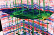
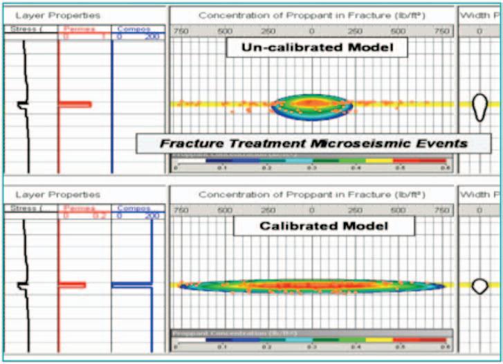
as tall as they are long. More advanced approximations were able to account for depth-varying material properties and, ultimately, the associated variable stresses. As monitoring technologies began to provide insight into the actual growth, evidence quickly mounted that the fractures were not as simple as initially thought. 2D hydraulic fracture models have been available for quite some time, and have evolved in order to better match observed fracture geometries. As an example, consider the application to a project that included microseismic data (Figure 1). Typically these fracture models match injected pressures and net volumes (including fluid leakoff from the fracture) to hydraulically model the resulting fracture profile. The mechanical material properties and stresses are also used to geomechanically constrain the hydraulic fracture mechanics. In this example, the initial modeling (top panel of Figure 1) incorporated stress and material property variations around a thin reservoir, and predicted some fracture containment within the reservoir. This ‘uncalibrated’ model predicted both upward and downward growth that limited the length of the fracture. However, the microseismic monitoring results (overlain on both models) showed that the fractures were contained entirely in the reservoir and that the actual fracture length was much longer than originally anticipated. The microseismic data was used to ‘calibrate’ the model (bottom panel of Figure 1) by adjusting the input parameters such that the predicted and observed geometries match. The fracture model also predicts the proppant concentration in the fracture (contours) that will define the relative permeability enhancement associated with the fracture. In this example, the calibrated model predicts a geometry that is more favorable from a reservoir contact point of view, since the depth containment results in a longer fracture mostly in the reservoir with little out-of-zone fracturing. In order to match the microseismic geometry an additional material property of composite layering was included, as shown by the blue track on the left side of Figure 1. This composite layering (or its equivalent) has found its way into many fracture simulation workflows and has proven to be an important factor to match the fracture
Figure 1. Cross-sectional view of a frac model and microseismic events. Yellow is the reservoir depth interval. The top panel shows the original model and the model after calibration to the microseismic results is shown in the bottom panel. On the left are the input model parameters and on the right is the relative fracture-width profile (after SPE96080).
containment that is typically observed.
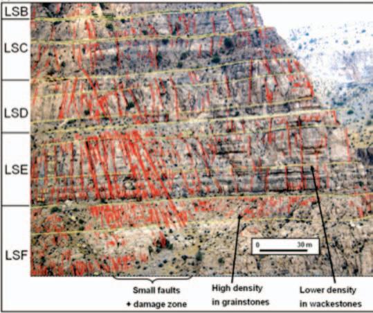
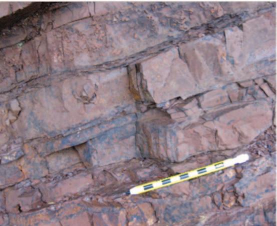
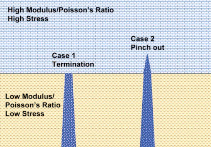
In order to understand this composite layering effect, it is informative to examine geologic examples of fracture growth. Figure 2 is a downloaded geologic section with annotated fractures. Notice that all of the fractures eventually stop at a bed boundary. Some fractures persist longer than others and cross some bedding planes but all eventually terminate. Figure 3 highlights one potential cause of the bed termination. This example illustrates that the containment is related to changes in the fabric of the rock and can be caused by thin laminations between thicker layers. Consider possible causes as shown in Figure 4 depicting two alternate views or end members of the possible effect of fractures growing between layers with different properties. The layering could correspond to fractures growing from a soft shale unit into more brittle layers (a common lithologic sequence in many shale gas reservoirs surrounded by limestone layers). Horizontal stresses will tend to be amplified in the stiffer layers associated with the increased load-bearing capabilities. Increased stress will tend to limit fracture growth for similar fracture pressures, due to a lower net pressure acting on the fracture face. In addition, fractures in the stiffer rocks will open less for a given pressure increase, limiting their ability to accommodate fluid. Together, the stress and compressibility define geomechanical conditions that tend to restrict hydraulic fracture height growth. The alternate scenario depicted in Figure 4 involves the fracture completely terminating at the interface. Note that variations between these two scenarios are also possible, including fracture ‘offsets’ or
deflection where the frac partially grows along the interface layer. If the bedding plane is mechanically weak and allows the two layers to move independently, the fracture opening in one layer may not translate to fracture opening in the second layer. If the bedding plane is either not welded or contains thin laminations (such as Figure 3) the associated v TI strength anisotropy may hinder the fracture crossing the interface. Instead, the fracture may either terminate or grow along the interface depending on the geomechanical and hydrodynamic conditions. Bedding laminations are analogous to automobile safety glass structure, where laminated layers of glass
are used to limit fracturing entirely through windshields (as known by many of us Alberta drivers watching fractures grow from stone chips!). Composite layering in rocks tends to limit the overall hydraulic fracture height growth, and fracture simulations have found these to be an equally important factor together with geomechanical variations. The combined impact of these factors limits fracture height growth, both for natural and hydraulically created fractures.
Limited fracture-height growth can impact the ability of a single horizontal well to contact a thick reservoir section, resulting in (Continued on page 20...)
Figure 2. Interpreted fractures within an outcrop. Notice that many fractures terminate at bed boundaries and that none persist all the way from top to bottom of the section (from lyellcollection.org).
Figure 3. Natural fractures within an outcrop. Note the fracture termination from the thick to thinly laminated layers (from agu.org).
Figure 4. Schematic diagram of end-member scenarios when fractures grow between layers of different properties.
(...Continued from page 19 )
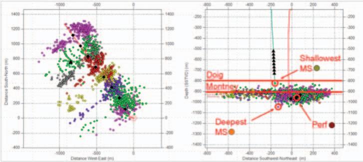
engineering challenges to drain the reservoir with few horizontal wells. Consider an example from the Montney. Depending on the location, there could be a thick potential target zone spanning from the Lower to upper Montney and in places up into the overlying Doig. Figure 5 shows microseismic data recorded while fracing a horizontal well targeting the upper Montney. In this case, the microseismicity shows that the frac was successfully contained within the u pper Montney (a few events locate in the Doig but are attributed to location resolution) and that relatively long horizontal fracture wings were created providing good reservoir contact area. In this case the upper Montney is the target and so the fracture containment is favourable, but for discussion purposes consider a hypothetical example where the intention is to create a hydraulic fracture that grows upwards and downwards. In these conditions, it would be an engineering challenge to contact a large depth interval that could be overcome by modifying the fracture injection parameters (often injection rate is the control) or changing the horizontal well landing point and drilling the well at a different depth. In the Horn River for example, microseismic monitoring is being used by various operators to look at containment in the Muskwa and Evie shales in order to understand the depth containment and interactions between wells drilled into the different layers.
How can geophysics help? Clearly the engineers want to be able to characterize the geology sufficiently to robustly predict containment. There is a lot of effort being made to extract stresses and rock properties from seismic reservoir characterization to help quantify hydraulic fracture response and define sweet spots. While sweet-spot identification is an
important aspect for well placement, in terms of height containment thinly laminated
beds such as shown in Figure 3 may occur below seismic resolution. u ltimately, robust geomechanical characterization will likely require an integrated approach of geology and geophysics, including highresolution wireline measurements of sonic and formation imaging. We face technical challenges as we travel this path: such as up-scaling between log and seismic and extrapolating from high-resolution wellbased imaging. To help bridge this gap, microseismic is the key technology to validate and confirm the geomechanical earth model. Imaging height growth and validating the fracture containment characteristics is an important engineering application of microseismic and one of the reasons that microseismic is an important component in both the appraisal and development phases of unconventional resources. Microseismic
Figure 5. Map (left) and cross section (right) of a multistage hydraulic fracture stimulation in the Montney shale. Cross-section shows average perforation depth with shallowest and deepest microseismic events, along with associated symbols used in figures 6 and 7. (Courtesy Mark Norton, Progress Energy).
Figure 6. Depth to shallowest microseismic (green circle), deepest microseismic (orange circle), and perforation depth (red circle) for published examples in various reservoirs. (Various sources).
Table 1. Statistics of the data depicted in Figures 6 and 7.
provides insight into a number of aspects of the hydraulic fractures, but in particular has opened the engineer’s eyes to issues of height containment as discussed earlier. Extensive industry knowledge has been built from tens of thousands of fracs that have been imaged using microseismicity. While the results of all this monitoring are obviously proprietary to the individual operators, it has provided insight into fracture growth as well as competitive advantages around the best fracing practices for a given reservoir.
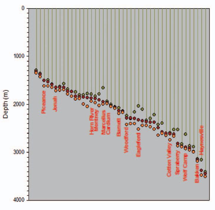
As the search continues to predict fracture containment, a large number of papers have been written showing the microseismically imaged hydraulic fracture growth in many unconventional reservoirs. These publications provide released examples of the microseismic hydraulic fracture height (the number of publications is too large to provide a complete listing of the papers here). For each published example the depth of the upper- and lowermost microseismic event and associated average perforation depth was determined as illustrated in Figure 5. In some cases, multiple stages of a given project were included in the publication but here only a representative example is included, intentionally using the example with the largest height growth. Figure 6 shows a plot of the depth to the shallowest microseism, perforation (frac initiation depth), and deepest microseism. Several well known reservoirs have been highlighted: including examples from the Montney, Horn River, and Cardium. Perforation depths vary between about 1,200 to 3,500 m, although for each of the reservoirs there will be a variety of perforation depths beyond that flagged in this plot. Note that while there is a large
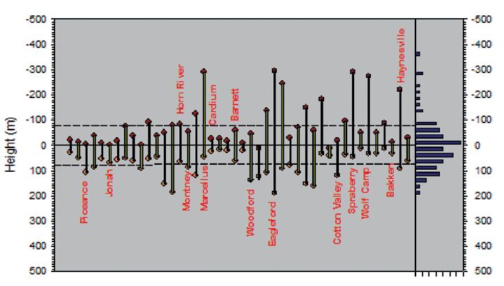
variation in the height growth from project to project the top of the hydraulic fracture tends to get deeper as the well or frac initiation gets deeper. Figure 7 shows the relative upward and downward growth to better illustrate the variation. Notice that there tends to be more upward growth than downward growth, which does not appear to be a detection bias. The most probable explanation is that stress tends to decrease upward, favouring upward growth into lower-stress rocks, which is accentuated by frac fluid buoyancy effects. Also note that significant upward growth is limited to a few cases and most examples tend to be less than about 100 m. Figure 7 also shows the average upward and downward height along with a histogram, which is summarized in Table 1.
The variation in height growth between locations is expected with the variation in injection rates, geomechanical variations, and reservoir settings depicted in this broad sampling. Within a given setting, the overall height growth tends to be fairly consistent with the examples included here. For example, in the Haynesville and Wolfcamp/Spraberry formations upward fracture growth tends to be commonplace, while in formations such as the Cardium sands hydraulic fractures are often vertically contained. The height growth summarized here also provides context regarding concerns around the possibility of fracing into aquifers. While the depth to the bottom of an aquifer depends on the geographical location, most tend to be relatively shallow. The average top of the fracs shown here is more than 2 km below the surface – much deeper than freshwater aquifers. The data shows a significant thick buffer of rock above the top of the hydraulic fracture. Obviously
in particular cases where there may be a shallow frac or regions with particularly deep aquifers, targeted monitoring may be advisable to ensure aquifer integrity.
In conclusion, examples of hydraulic fractures in many different reservoirs demonstrate contained height growth that is directly analogous with natural fractures. As fractures grow vertically and pass through different lithologies, the geomechanical conditions change and limit height growth. Composite horizontal layering also imposes additional height containment. From an engineering perspective, contained hydraulic fracture height growth can be either good or bad news. In thin reservoir targets, containment favours longer fractures and increased reservoir contact area, whereas in thick or layered reservoir targets, containment can introduce challenges associated with contacting the entire reservoir depth interval. ultimately this may lead to having to use multiple horizontal wells at different depths to drain the entire target interval. However, containment is good news from an environmental perspective, because it results in limited hydraulic fracture height growth and an associated buffer between deep fractures and shallow aquifers.
ABOUT THE AUTHOR
Shawn Maxwell (SMaxwell@slb.com) is Chief Geophysicist and Advisor for Schlumberger’s microseismic services, and is based in Calgary. Prior employment included leading microseismic services with Pinnacle Technologies (Halliburton) and ESG, and he was also a Lecturer at Keele University in England. Shawn was awarded a Ph.D. in earthquake seismology from Queen’s University, and is currently passive seismic associate editor for Geophysics. He regularly teaches microseismic courses through the CSEG, including the fall Doodletrain and a Microseismic Bootcamp during the spring GeoConvention. The CSEG plans to launch a Microseismic User’s Group in early 2012; details will be available at www.cseg.ca.
Figure 7. Hydraulic fracture-height growth depicted in Figure 6. Average upward and downward growth are included (dashed lines) along with a histogram of the overall height.
2011 L INK AwARD
| By Lloyd Freeman, Chairman, Link Award committee
The CSPG Link Award committee has been evaluating papers/talks presented at the Technical Luncheons of the Society since 1958. The mandate of the committee is to select the best oral presentation to the membership. The emphasis has always been on the quality of the presentation as it relates to speaking excellence and judicious use of visual aids/graphics. Scientific interest is an important but secondary consideration as this is more the domain of scientific journals and peer reviews. The list of winners and their subjects serves as a history of Canadian petroleum geology since the days of Leduc, including many famous names, both of people and discoveries. Additionally, the speaking tour of Canadian universities made by the winner is an important element of the Outreach Program.
In the program year from September 2010 to June 2011, six of the seventeen talks were eligible for the Link Award. Eligible speakers must be members of the Society and must not be a previous recipient of the Link Award.
The Link Award committee has selected Dr. Stephen Grasby as the winner of the 2011 Link Award for his September 23, 2010 presentation, A Late Permian Hot Anoxic Acid Bath.
Dr. Steve Grasby is a Research Scientist at the Geological Survey of Canada/ Natural
Resources Canada. He has been at the Geological Survey of Canada since receiving a Ph.D. in Aqueous Geochemistry from the University of Calgary in 1997 and is an Adjunct Professor at the university of Calgary, Department of Geoscience. He has worked on regional groundwater studies in the Canadian Prairies and in British Columbia, including climate change impacts of regional water supply. He has also conducted extensive study on thermal and mineral springs in western and northern Canada. Additionally, Dr. Grasby has worked for over 10 years in Canada’s High Arctic on chemostratigraphy, regional correlations, and petroleum potential within the Sverdrup Basin. He is co-author of the recently released report by the Geological Survey of Canada on “Canada’s Geothermal Energy Resource Potential”.
Awards will be officially presented at the CSPG Awards Ceremony on Tuesday May 15th starting at 5:30 pm at the Telus Convention Centre (Macleod Hall D). Everyone is welcome to attend.
| By Ian Kirkland, Chairman, Medal of Merit Award committee
The Canadian Society of Petroleum Geologists Medal of Merit is awarded annually for the “best paper related to Canadian petroleum geology” (as specified in CSPG bylaws) published during the previous publication year, in this case for peer-reviewed papers published in 2010. The paper chosen this year was written by t im McCullagh and Bruce Hart and is entitled “Stratigraphic controls on production from a basin-centered gas system: Lower Cretaceous Cadotte Member, Deep Basin, Alberta, Canada.” The paper was published in the March 2010 AAPG Bulletin, v. 94, p. 293-315.
This paper describes the reservoir characteristics of the Lower Cretaceous Cadotte Member in the Wapiti area of the Alberta deep basin. The authors utilized core description, well log interpretation, petrophysics, 3D seismic, thin sections, production, and pressure data to determine the differences between productive and non-productive areas in the Cadotte. They determined that economic production is only obtained from wells that penetrate chert-rich shoreface and beachface deposits and that these deposits can be identified using sonic porosity/density porosity log crossplots and can be visualized on 3D seismic amplitude maps. The chert-rich deposits preserved porosity in contrast to the quartzose sandstones that experienced significant porosity destruction through precipitation of quartz overgrowths. A linear east-west-striking fabric within the seismic amplitude data was interpreted to be beach ridges in a strand plain prograding to the north-northwest, similar to the modern analogue of the Nayarit coast of Mexico.
The authors also updated the existing gas/updip water contact map and showed how the updip water is separated from the downdip gas by shale-filled erosional channels and by areas of quartz-rich nonreservoir-quality sand.
This work is an important contribution as it will be valuable in ongoing gas development in the Cadotte and other reservoirs within the Deep Basin in Alberta and British Columbia and in other Deep Basin settings. It also has important implications for understanding and assessing basin centred gas models. In addition, the paper is very well written and illustrated, and effectively
integrates data from multiple sources.
Tim McCullagh received a B.Sc. in Geology and Mathematics from Brandon university and his M.Sc. in Geology (Seismic Interpretation) from McGill. His winning paper for the Medal of Merit award was from the work that he did on his M.Sc. thesis, sponsored by Talisman Energy Inc. and presented at the 2004 geoConvention. Tim has been a volunteer on the CSPG Geomodeling committee and received a volunteer award in 2010. He is currently living and working in Jakarta, Indonesia as part of the team at Niko Resources that will be drilling approximately 20 exploration wells over the next four years. His prospect is the second well in the drilling campaign in a basin (in eastern Indonesia) that has never been drilled (quite an amazing switch from working in the WCSB, he says)!
Bruce Hart finished his Ph.D. on the Cardium Formation in 1990 at the university of Western Ontario. He then held research and teaching positions with the Geological Survey of Canada, Penn State, the New Mexico Bureau of Mines, and McGill university. During that time, his research focus broadened from a focus on clastic sedimentology to include 3-D seismic analyses. He joined ConocoPhillips in Houston in 2008, and is currently working shale plays in the Global New ventures unconventional group. He was a Guest Lecturer for CSPG in 2006, the 2009-2010 AAPG/SEG Distinguished Lecturer and a previous co-recipient of the CSPG Medal of Merit in 2008 for a paper on the Second White Specks. His CD-format textbook on seismic interpretation was released by
AAPG in 2011. Bruce plans to return to his Home and Native Land at some point.
Awards will be officially presented at the CSPG Awards Ceremony on Tuesday May 15th starting at 5:30 pm at the Telus Convention Centre (Macleod Hall D). All are welcome to attend.
HUGH
REID’S 2012 SPRING COURSES
NEW SHORTER DST COURSE (3 1/2 days) April 10-13, 2012
16 WAyS tO IDENtIfy ByPASSED PAy fROm DSt DAtA (more advanced, for those “comfortable” with DST charts) April 19-20, 2012
HyDRODyNAmICS (Oil and Gas Finding Aspects) April 30- m ay 3, 2012
In-house courses available For course outline visit: www.hughwreid.com 262-1261
Tim McCullagh
Bruce Hart
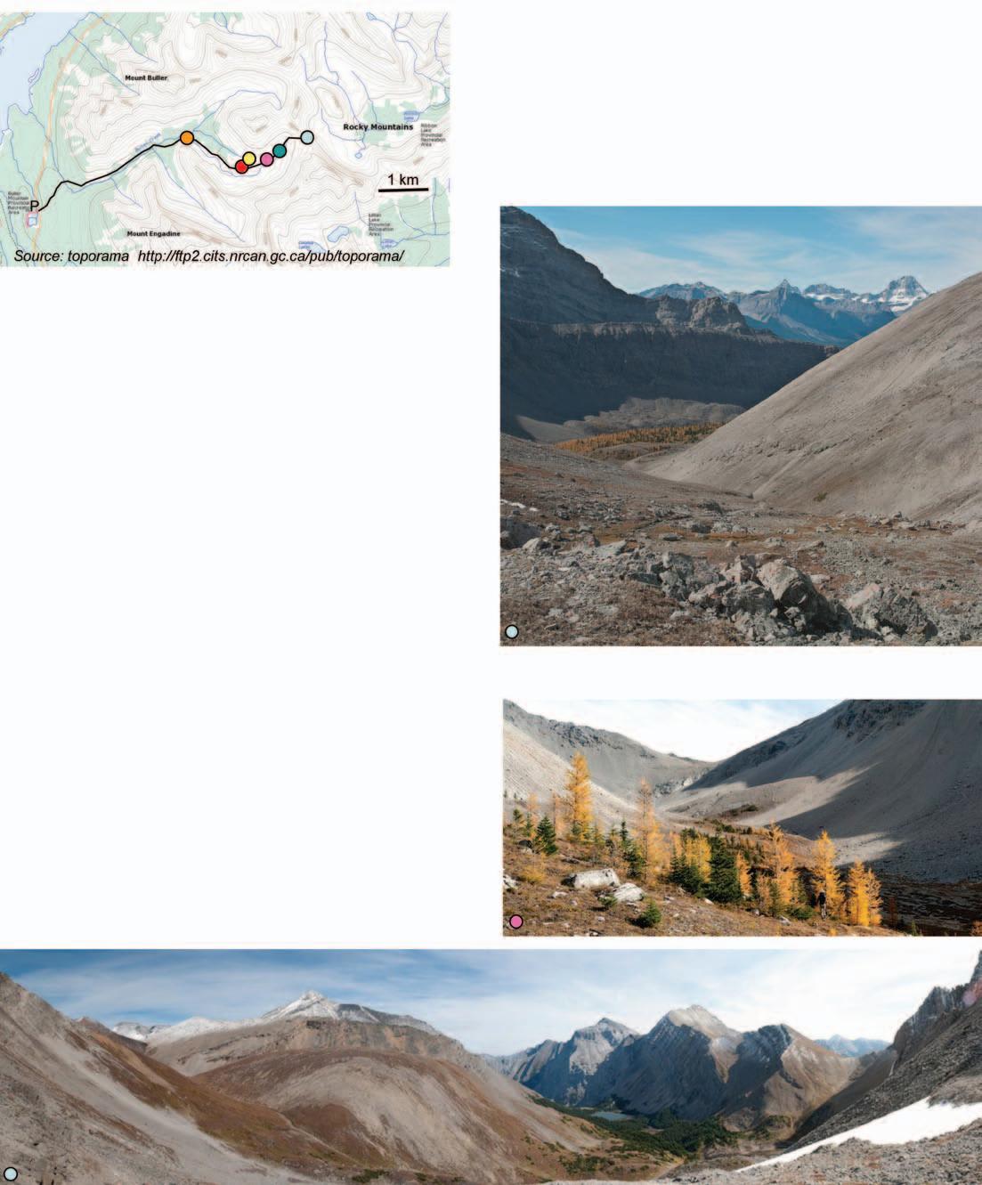
GO TAKE A HIKE
Buller Pass, Kananaskis Country, Alberta
| By Margot McMechan and Christine Nygren
The Buller Pass trail provides access to mountain vistas, a fall show of colour and the crest of the Kananaskis Range. The route crosses mainly west-dipping Upper Devonian through Triassic strata brought to surface by the Sulphur Mountain thrust fault. The Sulphur Mountain Thrust is one of a series of larger displacement thrust faults in the southern Canadian Rocky Mountains that have each carried resistant Paleozoic and softer Mesozoic strata to surface. In Kananaskis Country this has produced mountain ranges held up by resistant Paleozoic carbonate and quartzite separated by valleys cut into Mesozoic sandstone and shale. The Kananaskis Range, Smith-Dorrien valley, and Spray Mountains are excellent examples of this.
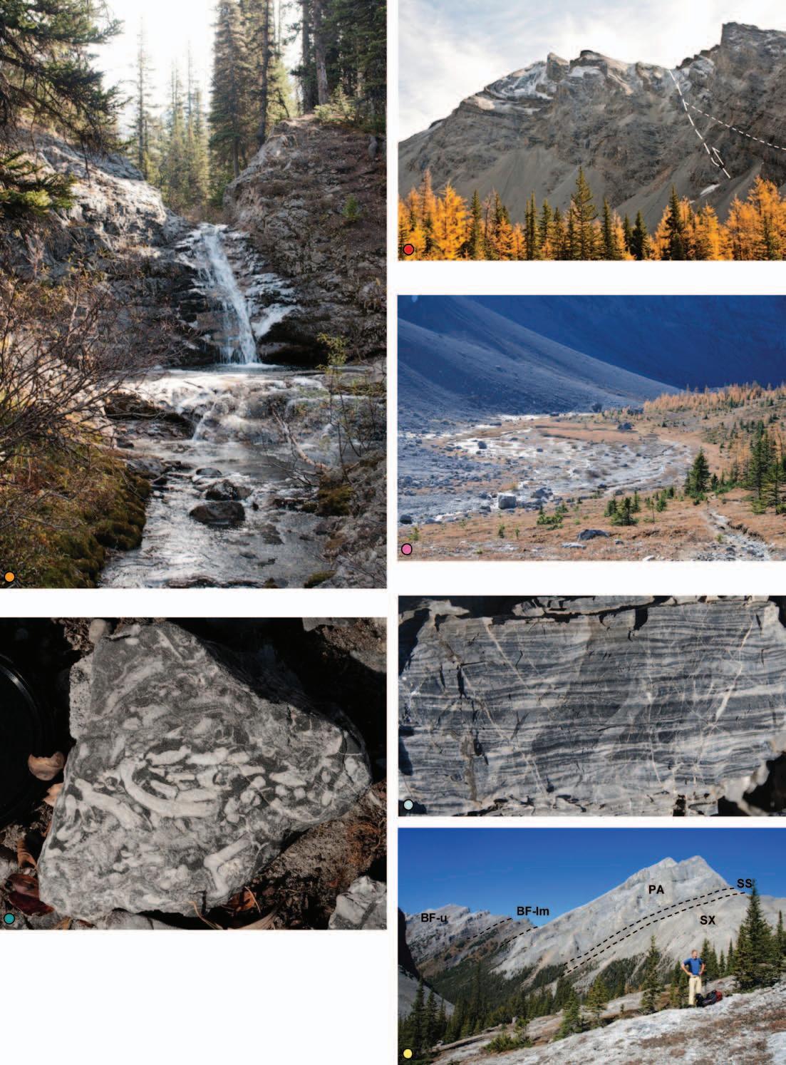
The first part of the hike crosses forest or a recent (Fall 2011) controlled burn. Near the junction of the north and south forks of Buller Creek a waterfall occurs beside the trail. The trail follows the south fork and after one last burn patch enters a more open forest with abundant larch trees that turn golden yellow in the Fall. From this point on the trail becomes a true pleasure for the eyes. To the northwest, resistant limestones (Palliser Formation) form Mount Buller. A prominent dip slope on the west side marks the change into overlying dark recessive strata. On the shaded cliff to the southwest a small thrust fault is readily recognized by the truncation of dark dolostones along it.
As the talus slope climb to Buller Pass is approached a second small waterfall occurs along the trail. Abundant fossils occur in the dark dolostone (Cairn Formation) exposed below the waterfall. The trail to the pass is shorter than it looks and provides abundant opportunity to admire talus of Palliser limestone. The sudden change in talus into dark-weathering cherty strata (upper Banff Formation) near the pass marks another small thrust fault. The Sulphur Mountain Thrust fault runs immediately east of the pass and is well exposed at the base of the cliff to the southeast. From the pass great views to the east are of Ribbon Lake, Mount Kidd, and mountainous ridges held up by Paleozoic carbonate and quartzite; great views to the west are of Mount Engadine, Buller Creek valley, and Mount Assiniboine.
references: McMechan, M.E. 1995. GSC Map 1865A.
trailhead: Proceed 50 km south of Trans-Canada Highway on Highway 40, turn right on Kananaskis Lakes Trail, then right on Smith Dorrien-Spray Trail. Drive 30 km to Buller Mountain day use area. Park in lot to west of road (P) and hike east across road to trailhead.
distance: Approximately 14.6 km return with 670 m of elevation gain. Strong hikers can continue another 2.6 km from top of pass down to Ribbon Lake.
by
Photo
above: View to Buller Creek and Mount Assiniboine. Below: Subalpine meadows along upper Buller Creek. Buller Pass is at notch on skyline.
Panorama looking from northwest to southeast from Buller Pass. The Rundle Thrust runs at base of grey-weathering rock near both sides of photo.
above left: Abundant branching stromatoporiod fossils in dark Upper Devonian dolostone of Cairn Formation.
above right: Irregularly laminated chert from the upper Banff Formation.
Below right: View to Mount Buller. Resistant limestone of Palliser Formation (PA) forms mountain peak. Overlies sandstone and limestone of Sassenach Formation (SS), dolostone of Southesk Formation (SX) and overlain by dark- and ribbed-weathering shale and chert of lower and middle Banff (BF-lm) and ribbed-weathering limestone and chert of upper Banff (BF-u).
Thrust fault on ridge south of Buller Pass. Note truncation of dark dolostone in hanging wall of the fault as the ridge crest is approached.
Floodplain adjacent to talus fans with a few large blocks that have fallen from the cliffs above.
Waterfall in Southesk Formation dolostone.
52nd ANNUAL CSPG CLASSIC Elbow Springs Golf Club • June 21-22, 2012
52ndCLASSIC2012
The Tour nament would like to thank the following 2011 sponsors:
Diamond Sponsor s
g eoLOGIC Systems
Schlumberg er of Canada
Emerald Sponsor s
Baker Atlas Wireline
Energy Navigator Inc.
Fugro Data Solutions Canada Inc.
GeoStrata Resources Inc.
Halliburton
IHS
Platinum Sponsor s
AGAT Laboratories
ATB Corporate Financial Services
Athabasca Oil Sands Corp.
Belloy Petroleum Consulting
CB Securities
Demchuk & Day
Gold Sponsor s
Arcis Corporation
Canadian Discovery Ltd.
Canadian Society of Petroleum Geologists
ConocoPhillips Canada
Continental Laboratories Ltd.
Geo-Steering Solutions Inc.
Greystone Resources Ltd.
Knowledge Energy Inc.
MD Totco Nov. Wellsite Gas Watch
Silver Sponsor s
Fekete Associates
Gabel Energy Inc.
Bronze Sponsor s
Candian Stratigraphic Services
Global Energy Services
NAME:
Little Rock Document Ser vices
Macquarie Capital Markets Canada Ltd.
M J Systems
ProGeo Consultants
RBC Dominion Securities
RECON Petrotechnologies Ltd.
Weatherford Canada Partnership
Divestco Inc.
GLJ Petroleum Consultants
LXL Consulting Ltd.
Painted Pony Petroleum Corp.
Ryan Energy Technologies
West Canadian
Pajak Engineering Ltd.
Pason Systems Corp.
Petrocraft Products Ltd.
Rigsat Communications
RPS Energy
Sample Pro Ltd.
Sproule Associates Ltd.
Total Gas Dectection Ltd.
Typhoon Energy Ltd.
Martin Quinn
Seismic Brokerage Services Ltd.
Hydro-Fax Resources Ltd.
San Dago Resources Ltd.
Sponsorship Contact: Richard Chisholm 403-538-8290 Visit us on Facebook or Linkedin: CSPG Classic Golf
The CSPG Classic Golf Tournament has incorporated fundraising for charity as part of the event. In 2012 the charities selected are the Salvation Army Agape Hospice and CSPG Educational Trust Fund
Re gistration For m
SIGNIFICANT OTHER:
COMPANY:
ADDRESS (Bus.):
POSTAL CODE:
TELEPHONE: CELL PHONE*:
E-Mail*: SHIRT SIZE:
*The CSPG Classic respects FOIP. (Privacy Act of Alberta) No contact information is given to third parties.
All contestants are required to have a photo in the Golfer’s Photo Roster For mer contestants who have submitted a photo in the past need not do so again. Handicap: __________ Golf Index: __________ or Averag e of best three 18-hole scores in past 2 years:______________
Registration Fee: Includes two rounds of g olf with power car t; Paid driving rang e; Door prize draws; Skill prizes; BBQ (at Elbow Springs) and Awards Banquet (Calg ar y Petroleum Club) for you and your guest.
Cost:
To assist the Enter tainment Committee with budg eting, please indicate if you plan to attend the two major social events of the tour nament:
Thursday Barbecue: Yes No Friday Awards Banquet: Self: Yes No Guest: Yes
Social Events Cancellation or Additions require
notice before the event. Please contact Bob Ear le by phone: (403) 803-3744 or email: cspgclassicgolf@gmail.com
Make Cheques Payable To: CSPG (Classic Golf)
Send Entries To: CSPG Classic Golf Tour nament 110, 333 5th Avenue S.W Calg ar y, AB, T2P 3B6
* Please photocopy your entr y for m and cheque befor e mailing Last day for refund requests: June 5,
Mail/Courier Registration: Print this registration For m (http://www.cspg.org/events/events-social-classicgolf.cfm)
THE CSPG ANNUAL CLASSIC Golf Tournament is evolving!
on June 21 & 22, 2012, the elbow Springs Golf Club in Calgary will be hosting the 52nd annual CSPG Classic Golf tournament.
The format of the tournament will remain the same with one important change. To reflect the time commitments and changing demographics of our participants the tournament will be held over two days rather than the traditional three days. The result is that only two half-days are required to play. The food, on-course refreshments, fun, prizes, and the networking all remain the same.
WHat Will tHe ClaSSiC 2- Day MatCH Play tourNaM e Nt looK liKe?
Players will be organized into flights based on their similar ability and past performance. Each Flight is comprised of two foursomes; each foursome has two matched pairs of golfers.
On day 1, the matched pairs within each foursome play the first 9 holes. The winners play the second 9 holes while the losers play a consolation round. By day’s end, there are two match winners remaining within the Flight.
On Day 2, the winners from the previous day playoff over 18 holes to claim the coveted Flight trophy, prize money, and bragging rights for a year! The remaining golfers are grouped into Chuck Wagon teams playing in a Texas Scramble over an 18-hole championship where every player contributes to the team.
The 52nd CSPG Annual Classic Golf Tournament includes two rounds of golf with power carts, and on-course sponsor tents with refreshments and food, Thursday dinner at the club, Friday breakfast, and capped off with the semi-formal awards banquet
and entertainment on Friday evening at the Calgary Petroleum Club, which has become one of the premier social events of the year for those who participate.
The tournament features $10,000 in prizes including two vacation trips, a BBq, daily hole, and skill prizes. A charity raffle offers many more opportunities to win prizes. The 52nd CSPG Classic welcomes “Agapé Hospice” as our charity partner who will benefit from your support with the raffle ticket sales held during the tournament.
We expect to sell out so please register early at http://www.cspg.org/events/events-socialclassicgolf.cfm.
Join us on Linkedin http://www.linkedin. com/groups/CSPG-Classic-Golf3792589?trk=myg_ugrp_ovr and on Facebook http://www.facebook.com/#!/ groups/80161073364/.
Congratulations to the 2011 CSPG Classic Golf Tournament champion Darrel Joy with runner-up Daniel Gee of the Paskapoo Flight. Winners of the remaining 14 Flights were Brian Halberstadt, Mirek Zaoral, John Williams, Mike Swain, Deno Adams, Jeff Boissonneault, Tom Phillips, Colin McNeil, Carl Glaser, Devon Henderson, Terry Dey, Richard Klippenstein, Richard Nash, and Rachel Phillips of the Pre cambrian flight.
On behalf of all its participants, the CSPG 2011 Classic Tournament committee wishes to thank the 54 sponsors who contributed to a successful event last year, particularly our Diamond sponsors: geoLOGIC Systems Ltd, Little Rock Document Services, Macquarie Capital Markets Canada Limited, and Schlumberger of Canada.
Mike LaBerge, Chairman CSPG Classic Golf Committee
The winning Chuck Wagon team consisted of Rob Langill, Brad Torry, Colby Ruff, and Max Howard.
CAN ADIAN FEDERATION OF EARTH SCIENCES
The Canadian Federation of Earth Sciences invites you to a seminar about its recently launched Canadian geoscience reference database CanGeoRef (www.cangeoref.org).
The seminar will take place Tuesday April 17, 1-2 pm in the ConocoPhillips Auditorium on Gulf Canada square (3rd floor). The seminar is free of charge and will give participants the opportunity to explore the power of this reference database interactively.
CanGeoRef was launched in September 2011. It is a joint venture of the American Geosciences Institute and the Canadian Federation of Earth Sciences. CanGeoRef is a subset of GeoRef, currently containing more than 200,000 references to (chapters) in books, maps, Federal and provincial geological survey literature, peer-reviewed literature, and theses pertaining to Canadian geoscience, dating back to the early 1800s. It is available at a very competitive price,
especially targeted at smaller companies and individual consultants focused on Canadian geoscience.
For further information, contact Elisabeth Kosters, executive manager, Canadian Federation of Earth Sciences: ekosters_ cfes@magma.ca
Wednesday, May 16, 2012 5:30 pm – 7:30 pm
New location!
teluS Convention Centre Macleod Hall D
Have you been a member of the CSPG for 30+ consecutive years (since at least 1982)?
If so, keep an eye open for your invitation for the 12th Annual Long-Time Members Reception. The popular event is a cocktail party organized exclusively for our more
senior members, in appreciation of their long commitment to the Society. Attendance is by invitation only.
New this year we are sending invitations by e-mail and for those that do not have an e-mail address we will be sending out paper copies in the mail.
This year’s reception will be held in conjunction with geoConvention: vision 2012, but you need not be registered for the convention in order to attend. Tickets are $20 and are
available for purchase online at www.cspg.org.
As is tradition, we will be presenting the Honorary Membership Awards at the LongTime Members Reception. Please join CSPG in recognizing this year’s recipients: Gerry Reinson and Roger G. Walker.
If you are a consecutive long-time member and have not received an invitation by April 20, please contact Bea McDowell, Member Liaison at 403-513-1226 or bea.mcdowell@ cspg.org.
OIL ROCKS: The First City on the Caspian Sea
| By Mir-Yusif Mir-Babayev
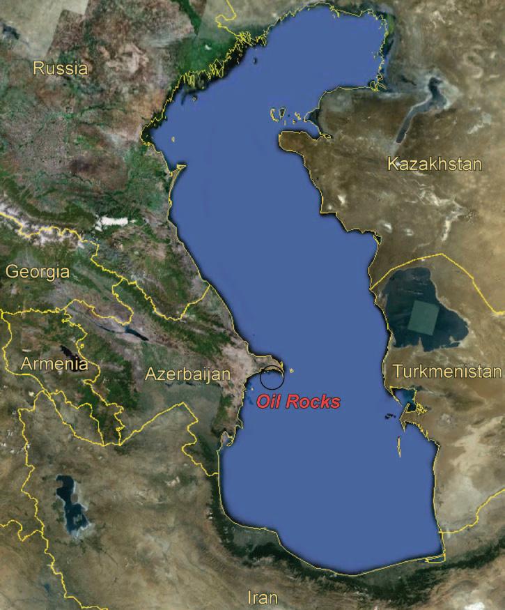
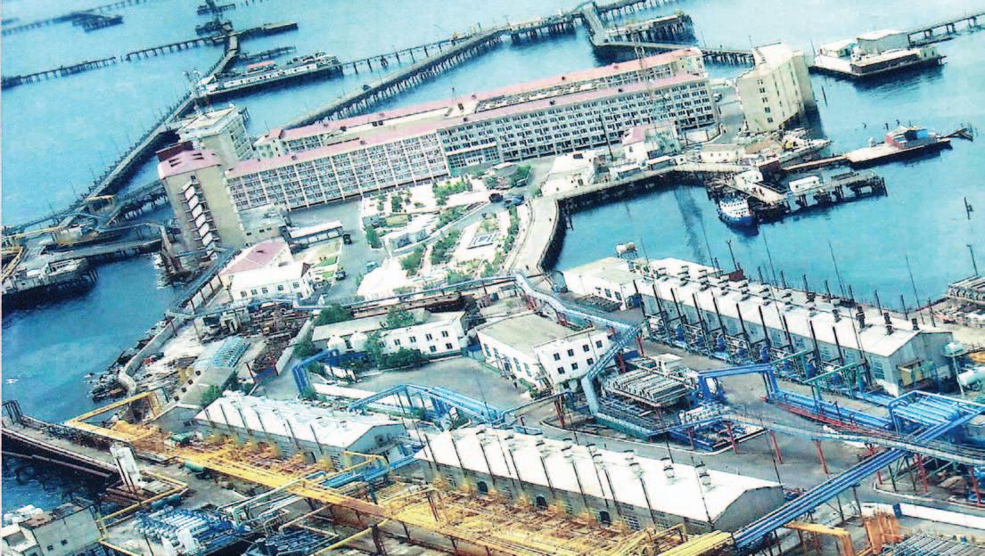
The discovery in 1949 of a unique sea deposit – Oil Rocks (Neft Dashlari in Azeri) – was an outstanding event in the development of the Azerbaijan oil industry. For a short time on the open sea, at a distance up to 100km from the coast, large platforms equipped with first-class (for that time) living and production facilities were created. During this period, Oil Rocks was the largest offshore oil field in the world, both in reserves and in produced oil.
It is significant that today, with many thousands of oil and gas wells drilled offshore and countries worldwide slaking their thirst for energy by oil and gas extracted in the North Sea, in the Gulf of Mexico, etc., foreign experts are coming to Azerbaijan interested in Oil Rocks – a unique city on piles constructed in the Caspian Sea about 60 years ago (Figure 1).
There is increasing interest in this first-inthe-world city constructed on the sea. For all countries engaged in development of oil and gas on a continental shelf, Oil Rocks was something akin to an outer space station, leading to development beyond traditional boundaries.
The name Oil Rocks has a historical meaning – even long before the discovery of this deposit scientists noticed black rocks covered by an oil film in the Caspian Sea. This area was named Oil Rocks and study of it began in 1859. One of the first to study the area was the outstanding Caucasus researcher G.W. Abikh, and after him came work by renown scientists, geologists, and oilmen such as S.A. Kovalevsky, F.A. Rustambekov, E.N. Alikhanov, B.K. Babazadeh, A.G. Aliyev, F.I. Samedov, S.A. Orujov, Yu.A. Safarov, A.A. Yakubov, A.B. Suleymanov, Kh.B. Yusifzadeh, and many others.
German Wilhelm Abikh (1806-1886) was an outstanding geologist and traveler. Abikh devoted himself to extensive and continuous research on the Caucasus and Transcaucasia. During 1859-1861, he twice visited the Caspian Sea in the areas of the Baku and Absheron archipelagoes. He described the Oil Rocks and made the first map of underwater rocks in this region; he identified their connection to an underwater range, connecting the Absheron peninsula to the island Cheleken, where he noted the escape of hydrocarbons. In 1863, Abikh made the first geological map of Absheron
peninsula, which for a long time was the basis for geologic work on oil and gas on the peninsula. In 1877, Abikh moved to vienna to work on a major report – Geologische Forschungen in den Kaukasischen Landern –and published four volumes before his death. His widow later published Abikh’s letters and notes, which contained a colorful description of Caucasus (Aus Kaukasischen Landern Reisebriefe, v. I-II, Vienna, 1895).
The articles of mining engineer Fatullabey Rustambekov are also of note. Published in 1934 in the magazine, Azerbaijan Oil Industry, these articles described the development of the offshore oilfields and listed six prospective sites on the Caspian Sea shelf. His ideas were confirmed in 1949
by the discovery of the major offshore oilfield, Oil Rocks.
One of the first initiators of offshore oil production was mining engineer v.K. Zglenitsky, who in 1896 made a formal request to the Baku Mining Department to drill wells on an artificial island in Bibi-Heybat bay. This request included a proposal to build the installation with a special waterproof rostrum 12 feet above sea level and with plans to drain produced oil into barges. In case of a gusher, it was stipulated for a barge with a carrying capacity up to 200 thousand tons (a ton is approximately equal to seven barrels) of oil to be on standby. The Caspian Mining Management turned down
(Continued on page 34...)
Figure 1. Location of Oil Rocks in the Caspian Sea (image from Google Earth).
his proposal, but agreed that the Caspian Sea close to Absheron was oil-bearing and it should check into the oil-bearing potential of the shelf, as well as the technical feasibility of oil production and the economic conditions necessary for such an operation. The first practical study of geological structures in the Oil Rocks area was carried out in 1946 by an Azerbaijan Academy of Sciences expedition. This study resulted in the discovery of huge reserves of oil.
Located 42 km from the Absheron peninsula, this area of the Caspian Sea had long been considered unlucky by sailors, similar to the reputation of the Bermuda Triangle on the other side of the world. On old pilot charts, this zone of the Caspian Sea with its characteristically treacherous banks and reefs – as if a signal of danger – was designated by an inscription “Black Rocks.” The most experienced captains avoided this place in bad weather, having named it a “cemetery of the ships.”
One of the tragic events at Black Rocks became the beginning of this unique sea deposit’s modern story. In 1946, geologist Aga Gurban Aliyev, was looking through the ship’s log of an old Caspian schooner that had sunk many years before during a storm at Black Rocks. Aliyev noted a reference made by the captain: “…If the wind blows from the north, the seamen, even at a great distance, can smell an odor that defines the dangerous ridge of underwater and surface stones.” Reports similar to this were also recorded in logs from a 1913 naval hydrographic expedition on the Caspian Sea. However, with the beginning of the First World War in 1914, these expeditions were stopped.
Talking with many captains and navigators with knowledge of the Caspian Sea, Aliyev learned that they always encountered a smell of oil around the Black Rocks during a storm. From his investigations, Aliyev believed an oilprospecting expedition to the Black Rocks was needed. However, to begin industrial development of a new oilfield in the sea was not that simple. Opponents to the idea argued that to create an oilfield facility would require thousands of tons of many materials, and to build the underwater platforms for drilling wells and connect them with pilings without a harbor nearby to facilitate the task would be impossible. The proponents, however, had the experience of developing Ilyich Bay to build on.
Successful production of oil from Ilyich Bay (now known as Bail Limani) from oil well #71, constructed in 1924 on timber piles, was a powerful spur to exploring for oil and gas
fields in the Caspian Sea. Later, in 1932-1933, another two platforms were constructed. The first platform was constructed 270 meters from the bay in a water depth up to 6 meters with a platform area of 948 m² and length of 55 meters. For comparison, the first American timber-pile platforms constructed in the Gulf of Mexico in 1937 were in a water depth up to 4 meters.
On November 14th, 1948 the sea towboat “Pobeda” (Russian for “ victory”) moored in the rocky group of islets. In addition to the towboat’s captain, Azhdar Sadikhov, there were geologist-scientist Aga Gurban Aliyev, the expert on drilling works Yusif Safarov, and Chief of the Association “Aznefterazvedka”, which was set up in 1947, Sabit Orujov. This team successfully landed on an islet and managed to construct the first drilling installation and small house for a drilling crew (with an area of 14 square meters!).
Yusif Safarov (1907-1963) was a talented oil scientist and major founder of the Soviet oil industry, winning the Stalin Prize twice. In 1949, he (jointly with L. Mezhlumov and S. Orujov) designed the new construction of the MOS large block foundation and its modifications MOS-1, MOS-2, and MOS-3, which were used at sea depths of up to 25 meters. Later constructions of this type were
built in the Gyurgani-more, Darwin’s Bank, Zhiloy (Chilov) Island, and especially at Oil Rocks. The settlement of Oil Rocks on the Caspian Sea belonged to Artyom’s district council and had 1,600 residents by 1956. In Houston, in 2004 Safarov was posthumously awarded the American Ocean Star Order for prospecting and developing offshore oilfields on the Caspian Sea in 1945-1952.
Sabit Orujov (1912-1981) also was a major founder of the Soviet oil and gas industry. He was appointed as a minister of the Soviet gas industry in 1972; he was a winner of the Lenin and State Prizes of the uSSR, Doctor of technical sciences, and associate member of the Azerbaijan Academy of Sciences. Orujov was actively involved in developing a number of major oil and gas fields in Azerbaijan, Western Siberia, Russia’s Orenburg region, Turkmenistan, and Uzbekistan. In 1978, Orujov through the Mingazprom (Ministry of Gas Industry – the Central administrative board for exploring and exploitation of sea oil and gas fields), developed oil production from water areas of the Caspian, Barents, Black, and other seas. On July 18th of 1979 he signed the order creating Arcticmorneftgasrazvedka, which established records of deep-water production and opened major fields on the northern shelf of Russia. As a legacy, the
Figure 2. Offshore developments of islands and causeways at Oil Rocks (image from Google Earth).
best students of the Russian Gubkin State university of Oil and Gas receive Orujov scholarships. As well, the uSSR’s largest gasproducing association “ urengoygasdobicha” was named after Orujov.
Work on drilling the first exploratory well at Oil Rocks began in June of 1949; for this purpose, the ship Chvanov was scuttled to create a drilling base. On August 24th, 1949 the team of the future Hero of Socialist Labor - Michael Kaverochkin (with his first assistant, driller Ali Jabarov) began drilling the first well. Completed successfully on November 7th, the well reached a depth of about 1,000 meters and had a daily production rate of 100 tons of flowing oil. This event was the beginning of the town on piles, and was depicted in a documentary about Caspian oilmen made by the Soviet film director Roman Carmen: a black fountain rocketing into the sky, cheerful oilmen, and the master himself who was shown washing his face with the first offshore oil. This was how Azerbaijani oilmen remembered the legendary M.P. Kaverochkin.
In the book, My motherland is Azerbaijan, the renown statesman (Stalin’s people’s commissar), legendary oil industry worker, and economic planner Nikolay Baybakov remarked: “With pride I will tell that I supervise over the first landing on Oil Rocks. In November 1948, academician A.A. Yakubov; geologist A.K. Aliyev; engineers, builders, and rig fixers v.M. Roschin, Ivan
Bugalayev, Fyodor Blokhin, Peter Zemskov, Shamil Jabarov, Anna Meleshina, Fyodor Kulikov, Peter Knutov, M.Yu. Salamov, H.A. Hadikov and the author of these lines landed on the mossy, oily stones, which were sticking out of water in the open sea. And in less than a year, thanks to the dedicated work of many, the first exploratory oil well produced a powerful fountain of oil. Development of the new sea oilfield, Oil Rocks, was entrusted to the team of skilled master Michael Kaverochkin, to whom the high rank of the Hero of Socialist Work (posthumously) has been awarded.”
To construct the drilling base for the second well, another seven old ships (Chvanov, Zoroaster, Tsesarevich Nicolai, etc.) were scuttled. So was born the artificial “Island of seven ships”, where after a half-year, was producing oil. The second well, drilled by a team led by another Hero of Socialist Labor, Kurban Abasov, came in with approximately the same daily flow as the first well and was handed over in the first six months of 1950.
Kurban Abasov (1926-1994) provided considerable contribution to the development of an oil industry in Azerbaijan. Starting as a driller, he worked his way up to the General Director of the Association Kaspmorneftegazprom. He was a Hero of Socialist Labor (1959) and an Honored engineer of the Azerbaijan republic. Kurban Abasov was the best student and closest associate of the drilling master Mikhail
Kaverochkin. After the tragic death of Kaverochkin (on November 21st, 1957; a dreadful storm broke on the Caspian Sea, destroying the drilling platform and drowning the crew), the 25-year-old Kurban Abasov took over for him on the drilling platform. The prestigious Soviet State Prize was awarded to him for developing the first offshore oilfields on the Caspian Sea – Gyurgani-more and Oil Rocks (Neft Dashlari).
In February 1951, the first tanker with oil from Oil Rocks unloaded at the Dubendi terminal. The underwater oil pipeline from Oil Rocks, through which oil is now delivered to onshore, was constructed only in 1981.
Today, Oil Rocks has more than 200 platforms, and up to 350 km of streets and lanes in this city on the sea (Figures 2, 3). This deposit has extracted more than 160 millions tons of oil and 13 million cubic meters of associated petroleum gas. More than 380 production wells are active here, each of which gives on the average up to 5 tons of oil per day. Certainly, in comparison with wells from a modern, permanent offshore platform such as Chirag, each of which initially gives up to 2,000 tons of oil per day, it is a small amount. But we always should remember that Oil Rocks for more than half a century was a pioneer in the development of oil production from the sea.
At Oil Rocks, the complete cycle of offshore
(Continued on page 36 ...)
Figure 3. Oil Rocks today.
oil field production for the first time was put into practice: from exploration of oil and gas to delivery of production, from experiments in the field of sea engineering to mass production. It is possible to claim that Oil Rocks has played the role of an academy for oil industry workers of Azerbaijan and the former Soviet union, since during the prospecting and operational works the whole program of training for the scientific staff was formed. In practice the newest ideas and development of the scientists were carried out, and oil industry workers got professional experience and skills in more complicated sea conditions. The petroleum
experts working at Oil Rocks later were sent to work on the oilfields of Kazakhneft, Turkmenneft, Dagneft, Tatneft, Bashneft, and many others. Soviet (Azerbaijani) specialists from Oil Rocks also worked in the vietsovpetro joint venture, which was set up in vung Tau (Petroleum Center of vietnam) in 1981, to develop the first oilfield, White Tiger, on its continental shelf.
Another first for the uSSR that occurred at Oil Rocks was the drilling of several deviated wells from one drilling pad. This method of cluster drilling was then widely used in other oilfields of the uSSR. As well, a new method of development using
trestle platforms was started there. The experience gained at Oil Rocks accelerated exploration and exploitation work in other parts of the Caspian Sea and within a short period of time new oil and gas deposits were put into operation. The Soviet government recognized the tremendous effort put forth by the workers at Oil Rocks by awarding the State premium of the uSSR of the first degree to the Azerbaijan oil industry workers in 1951.
FOCUSON DECISIONS DATANOT
In 1960, the First Secretary of the Central Committee of the Communist Party of the Soviet union, Nikita Khrushchev, visited the site. Thanks to Khrushchev, two changes were made that significantly improved operations in the oil field. First, he ordered that helicopters be used to transfer personnel and material to and from shore, where before it had only been done by sea. Secondly, he instructed that multi-story apartments on artificial islands be built to replace the one- or two-story houses on pilings in which the workers had been living.
The State Oil Company of Azerbaijan estimates the geological resources of Oil Rocks field to be 365 million tons, 182 million tons of which can be produced. By the beginning of November 2009, 167 million tons of oil had been produced. It should be pointed out that the reserves of oil that can be extracted may be considerably increased in the future. Programs to enhance the field’s recovery are being developed, with more wells being drilled and existing infrastructure being repaired and expanded. Also in this process, older piers and platforms are being decommissioned as they come to the end of their productive life.
In November 2007, a new platform (#2387) was put into operation. Intended for drilling 12 wells to a mean depth of 1,800m, the platform is 45 meters high, weighs 542 tons, and is in a water depth of 24.5 meters. The operational life of the platform is expected to be 50 years. As well, in December 2007, a 67km, 20-inch pipeline was commissioned. With a carrying capacity of 5.5 million cubic meters per day, this gas pipeline is intended to transport natural gas extracted from the oilfield Guneshli to onshore.
In conclusion, let us stress that it was not so long ago that humanity started to replenish oil reserves from the rich fields in the world’s oceans. This process will only increase in importance as more and more offshore drilling units, platforms, and infrastructure are developed and put into
2012 – 23RD ANNUAL CSPG Mixed Golf Tournament
Mark your calendars, and get ready for the 2012 CSPG Mixed Golf tournament on 24th August at Lynx Ridge Golf course. The four-golfer best-ball tourney includes a round of golf, meals, plenty of hospitality and good times, and a chance to network with your colleagues and industry sponsors. The tournament has always benefited from the pleasant August weather, and typically the golf course is at its finest, with the inviting fairways, smooth greens, spectacular mountains, and the ever-beckoning water hazards and sand traps to capture errant golf shots.
This is a fun tournament, with balanced teams that allow all golfers to contribute to the team score, while having a great time enjoying the day and the fellowship of the team.
Please watch for further announcements, registration forms, and information in the CSPG Reservoir, or on-line at the CSPG website www.cspg.org, and make sure to register early, to avoid disappointment.
We thank our previous sponsors from 2011 and look forward to the return of members, guests, and sponsors to enjoy the event. A big thank-you to our continuing committee members: Darin Brazel, Penny Christensen, Norm Hopkins, and the cochair Brenda Pearson. David Caldwell has decided to step down from the organizing committee after many years, and we thank him for his leadership and dedication to the tournament.
You can address registration inquiries to David Middleton at 403-296-8844 (dmiddleton@suncor.com), or to Bea McDowell, CSPG Member Liaison at 403513-1226 (bea.mcdowell@cspg.org)
If you are interested in sponsoring the tournament this year, please contact me or Darin Brazel at darin.brazel@ihs.com
information contact: Joel Harding at 403 870 8122 email joelharding@geoedges.com www.geoedges.com
Western Canada: Slave Point, Swan Hills, Leduc, Grosmont, Jean Marie, Horn River Shales, Elkton, Shunda, Pekisko, Banff, Mississippian subcrops and anhydrite barriers in SE Sask., Bakken, Three Forks, Montney, Halfway, Charlie Lake, Rock Creek, Shaunavon, BQ/Gething, Bluesky, Glauconitic, Lloyd, Sparky, Colony, Viking, Cardium, Horseshoe Canyon and Mannville CBM, Oilsands Areas, Outcrops
US Rockies & Williston: Red River, Mississippian subcrops & anhydrite barriers (Bluell, Sherwood, Rival, etc), Bakken, Three Forks, Cutbank, Sunburst, Tyler, Heath, Muddy, Dakota, Sussex, Shannon, Parkman, Almond, Lewis, Frontier, Niobrara, Mesaverde shorelines, Minnelusa, Gothic, Hovenweep, Ismay, Desert Creek, Field Outlines, Outcrops
North American Shales: Shale plays characterized by O&G fields, formation limit, outcrop, subcrop, structure, isopach, maturity, stratigraphic cross-sections. Includes: Marcellus, Rhinestreet, Huron, New Albany, Antrim, Utica-Collingwood, Barnett, Eagleford, Niobrara, Gothic, Hovenweep, Mowry, Bakken, Three Forks, Monterey, Montney, Horn River, Colorado
Application of Neural Network for Advanced Reservoir Characterization
Instructors: Azer Mustaqeem, Valentina Baranova
Date: May 8th, 2012
Price: $625.00 CDN
Surface Geochemical Exploration for Oil
Case Histories and Gas: Theory, Methods, and Exploration
Instructor: Dietmar Schumacher
Dates: May 8th - 9th, 2012
Price: $620.00 CDN
Directional Drilling and Geological Placement
Instructor: Glen Eckert
Date: May 9th, 2012
Price: $885.00 CDN
Subsurface Methods in Clastic Sediments
Instructor: Doug Cant
Dates: May 9th - 10th, 2012
Price: $930.00 CDN
Reservoir Geomechanics in Heavy Oil Recovery Operations
Instructor: Safdar Khan
Dates: May 9th - 10th, 2012
Price: $1,400.00 CDN
Clastic Facies and Depositional Environments in Core
Instructor: Bill Arnott
Dates: May 9th - 11th, 2012
Price: $1,400.00 CDN
Practical Sequence Stratigraphy: Concepts and Applications
Instructor: Ashton Embry
Dates: May 10th - 11th, 2012
Price: $700.00 CDN
Fluvial Stratigraphy
Instructor: John Holbrook
Dates: May 10th - 11th, 2012
Price: $860.00 CDN
Geostatistics for Modeling Geological Heterogeneity and Uncertainty
Instructor: Clayton Deutsch
Dates: May 10th - 11th, 2012
Price: $1,020.00 CDN
Deepwater Petroleum Systems - Reservoir Characterization and Linked Depositional Systems
Instructor: Grant Wach
Dates: May 10th - 11th, 2012
Price: $1,085.00 CDN
Rock Mechanics Essentials for Drilling
Instructor: Safdar Khan
Date: May 11th, 2012
Price: $700.00 CDN
Methodology for Logging Clastic and Carbonate Cores
Instructors: Eva Drivet, Lisa Griffith
Date: May 11th, 2012
Price: $775.00 CDN
Analyzing Unconventional Reservoirs
Instructor: Ross Crain
Date: May 22nd, 2012
Price: $695.00 CDN
Conflict Resolution within the Realm of Oil and Gas Negotiations
Instructor: David Hill
Dates: May 22nd - 23rd, 2012
Price: $850.00 CDN
Sequence Stratigraphy: Principles and Applications
Instructor: Octavian Catuneanu
Dates: May 22nd - 24th, 2012
Price: $1,150.00 CDN
SHORT COURSES & FIELD SEMINARS
Mannville Stratigraphy, Sedimentology, and Petroleum Geology
Instructor: Doug Cant
Dates: May 22nd - 24th, 2012
Price: $1,680.00 CDN
Seismic Exploration for Non-Geophysicists
Instructor: Bill Nickerson
Dates: May 22nd - 24th, 2012
Price: $1,625.00 CDN
Log Analysis for Stimulation Design
Instructor: Ross Crain
Date: May 23rd, 2012
Price: $695.00 CDN
Petroleum Geomechanics for Developing Unconventional Resources
Instructors: Pat McLellan, Chris Hawkes
Dates: May 23rd - 24th, 2012
Price: $1,440.00 CDN
Drilling and Production Fundamentals
Instructor: David Hill
Dates: May 24th - 25th, 2012
Price: $850.00 CDN
FIELD SEMINARS
Anastomosing Channel Belt Architecture and Reservoir Considerations of the Modern Columbia River, BC as it applies to the Mannville in West -Central Alberta
Instructors: Peter Putnam, Derald Smith
Dates: May 9th - 10th, 2012
September 5th - 6th, 2012
Price: $1,300.00 CDN
SAGD Fundamentals - Application of Outcrop Analogues, Geology, Geophysics and Geochemistry to Oil Sands Recovery
Anastomosing Fluvial Architecture of the Lower Tertiary Porcupine Hills Formation (Paskapoo Equivalent), Southwest Alberta
Instructors: Peter Putnam, Derald Smith
Dates: May 11th, 2012
September 7th, 2012
Price: $800.00 CDN
Meander Belt Fluvial Architecture and Reservoir Considerations (Upper Cretaceous Dinosaur Park Formation), Southern Alberta
Instructors: Peter Putnam, Derald Smith
Dates: May 18th - 19th, 2012
September 10th - 11th, 2012
Price: $985.00 CDN
Geological Walking Tour
Instructor: Bill Aryton
Date: June 1st, 2012
Price: $200.00 CDN
Tide-Dominated Depositional Environments in the Bay of Fundy, Canada
Instructors: Murray Gingras, Shahin Dashtgard
Dates: June 9th - 12th, 2012
Price: $2,750.00 CDN
Contrasting the Reservoirs of Braided vs. Meandering Depositional Systems
Instructor: Jon Noad
Dates: June 14th - 15th, 2012
Price: $580.00 CDN
Petroleum Geology for Non-Geologists
Instructor: Jon Noad
Date: June 25th, 2012
Price: $325.00 CDN
Stratigraphy and Hydrocarbon Systems of the Sappington (Bakken/Exshaw) and Three Forks Formations in Western Montana
Instructors: Ted Doughty, George Grader
Dates: July 19th - 21st, 2012
Price: $1,375.00 CDN
Structure and Hydrocarbons: A Field Trip from Calgary through Kananaskis Country and Crowsnest Pass to the Rocky Mountain Trench
Instructors: Peter Jones, Peter Hews
Dates: September 6th - 7th, 2012
Price: $1,225.00 CDN
Geology of the Athabasca Oil Sands
Instructors: Murray Gingras, Mike Ranger
Dates: September 6th - 8th, 2012
Price: $3,900.00 CDN
Geology of Horizontal Wells in Liquid-Rich Reservoirs
Instructors: Deborah Sanderson, Andrew Newson
Date: September 7th, 2012
Price: $675.00 CDN
Wabamum, Bakken-Equivalent Exshaw, and Banff Formations in Core, Cuttings, and Outcrop from Southern Alberta
Instructors: Tim Hartel, Willem Langenberg, Barry Richards
Dates: September 14th - 15th, 2012
Price: $750.00 CDN
ROCK SHOP
GeoSkills Training Day Enters its Fifth Year
| By Colleen Flynn, Kyle Plante, and Victoria Walker
What were you up to February 1st 2012? If you were one of the geoscientists at the 5th annual GeoSkills you would have been in for a treat. GeoSkills is a one-day student-industry training day held in Calgary, facilitated by volunteers and students, and hosted by APEGGA. The event took place Wednesday February 1st at the Metropolitan Centre in Downtown Calgary. Students from the university of Calgary, The university of Alberta, and Mount Royal university were in attendance. The event provides students in geoscience with exposure to different disciplines within the industry through technical lectures, an opportunity to connect with other students throughout the day, and experience with networking with industry professionals at the evening mixer.
This year’s GeoSkills incorporated subtle changes that have evolved the event to appeal to the student audience. One change made was to the length of lectures – by shortening the length of the lectures the organizers were able to add more talks to the schedule than in previous years. Some of the topics featured were: Making Rocks talk – Integrating Core Data for better Geological understanding, Geoscience Data Management from a Mapping Perspective, and Oil Sands Development Strategies and the utilization of Geostastics in SAGD Well Planning. The lectures were also changed to be delivered to an audience of 1st and 2nd year students. The effects of these changes were that students could attend more talks throughout the day and retain more knowledge on a wider variety of topics.
Another change to the event this year was the addition of the panel discussion. The panel this year was created with the theme of “ university Graduate to New Hire.” The panel gave students the opportunity to ask geoscientists with a variety of experience questions in a formal setting. A larger audience of students benefited from the discussion and sparked further questions for the evening mixer. From the conversations it is evident students are most interested in getting advice on obtaining that first job, advice on how to maximize your summer job experience, how to identify which area within geology to focus on, and asking advice on what to do to make the most of your undergraduate degree.
Current student organizers share that attending GeoSkills is an excellent way to become exposed to the science in a meaningful way. The one-day event is not too disruptive to the typical busy semester. Students from Edmonton commit to a full day, but students from Calgary can pick and choose which lectures to attend and work the day around their class schedule, or even just attend the evening mixer. For some students, GeoSkills is the first conference they attend, as well as the first opportunity to network with industry professionals.
Students and organizers have commented that industry attendance at the evening mixer was up this year, students were especially excited that there were more professionals to speak to one on one. The mixer is formatted as a cross between a career fair and cocktail hour. Industry professionals that were in attendance spread the message to students to network at every opportunity – both to increase your contacts within the industry, and to increase knowledge in the science.
MUNDIREGINA RESOURCES CANADA INC.
CORPORATE MEMBERS
ALLEN GEOPHYSICAL CONSu LTING LTD
APACHE CANADA LTD
APEGGA
BAKER ATLAS
BDO CANADA LLP
BLACK SWAN ENERGY
BLu EBACK RESERvOIR
CANADIAN NATu RAL RESOu RCES LTD
CASEY & ASSOCIATES
CENOvu S
CSEG FOu NDATION
CONOCOPHILLIPS CANADA LIMITED
DE vON CANADA CORPORATION
ENCANA
ENERPLu S CORPORATION
E xxON MOBIL u PSTREAM RESEARCH COMPANY
GEOLOGIC SYSTEMS LTD
GEOSTRATA RESOuRCES INC.
GEOvARIANCES
HALLIBu RTON
Hu NT OIL COMPANY OF CANADA
H u SKY ENERGY INC.
IHS
IMPERIAL OIL RESOuRCES
JEWELSu ITE
LITTLE ROCK DOCu MENT SYSTEMS
LORING TARCORE LABS
MJ SYSTEMS
M u RPHY OIL COMPANY
NE xEN INC
PARADIGM
PENN WEST PETROLEu M LTD
PETROCRAFT PRODuCTS LTD
PLu SPETROL S.A.
ROKE TECHNOLOGIES
ROx AR
RPS ENERGY CANADA LTD
SCHLu MBERGER
SHELL CANADA LIMITED
S PROu LE ASSOCIATES LIMITED
Su NCOR ENERGY INC .
TALISMAN ENERGY INC
TOTAL E&P CANADA LTD.
TOu RMALINE OIL CORP
u NITED OIL AND GAS CONSu LTING
WEATHERFORD LABORATORIES
AS OF MARCH 10, 2012
CSPG welcomes our 2012 Corporate Members! The benefits of being a corporate member include:
• Recognition in the monthly Reservoir and quarterly Bulletin
• One associate membership
• Reserved tables at the technical luncheons with your company logo
• One free pass to the CSPG Core Conference
…and more! Contact Kasandra Klein at kasandra.klein @ cspg.org to be a corporate member today!
EARTH SCIENCE FOR SOCIETY: Planting the seeds of future geoscientists
| By Kyla Poelzer
I have volunteered on the Earth Science for Society (ESfS) organizing committee since its formation three years ago. Every year I am exhausted yet encouraged by the enormous volunteer effort that goes into planning and executing such a successful event. I volunteer because I love being a geoscientist and I want everyone to have the opportunity to be inspired and engaged by the Earth Sciences.
Working downtown in Calgary, and being surrounded by oil and gas companies, we often forget that many people have no idea what it means to be a geoscientist. There are no other geoscientists in my family, and while growing up the only opportunity I had to meet a geologist was in grade eight science class. ESfS goes beyond just meeting a geoscientist; it provides the opportunity for thousands of students, teachers, and the general public to be involved through hands-on activities and dynamic demonstrations.
Last year, a parent told me that her teenaged child did not want to attend ESfS as it was supposed to be ‘lame’, but he ended up having a great time and is now considering the geosciences as a career path. ESfS is planting the seeds of future geoscientists.
ESfS is held during the annual GeoConvention at the Calgary TELu S Convention Centre. Don’t miss the family event on May 13th, 2012! We will be giving away prizes to the first 100 mothers and we have many other giveaways and draws for the whole family. Admission is FREE! Hours are as follows:
Sunday, May 13: 12noon – 5:00PM Monday, May 14: 9:00a M – 4:00PM tuesday, May 15: 9:00a M – 4:00PM
For more information visit our website www.geoconvention.com/esfs. If you have a few hours to spare on May 13th, 14th, or 15th why not volunteer to guide a school group or help Yukon Dan? Email us at esfsvolunteer@geoconvention.com.
Want to bring geology back into geophysical interpretation?
All Aboard
Landmark’s new DecisionSpace® Desktop software accelerates seismic interpretation with geomodel-enabled workflows.
The geophysics and geology modules in Landmark’s new unified DecisionSpace® Desktop software share the same topology engine. This gives geophysicists easy access to framework construction tools that combine well picks and horizons to produce a high resolution, accurate geomodel. The geomodel uses conformance technology to produce well-based surfaces at the same resolution as seismic data, enabling a model that truly represents your reservoir. Get better answers faster. Visit halliburton.com/decisionspacedesktop