


16 Geomechanics For Everyone, Part 4: Geomechanics of Hydraulic Fracturing 21 GeoConvention 2014: Focus 22 Geology of the Mount Stephen Trilobite Beds and Adjacent Strata near Field B.C., Yoho National Park New Perspectives on a 127 Year Old Discovery 26 Go Take a Hike $10.00 DECEMBER 2013 VOLUME 40, ISSUE 11 Canadian Publication Mail Contract – 40070050


IHS AccuMap®
A MORE POWERFUL & INTUITIVE INTERPRETATION
Developed with extensive industry feedback, a complete user interface refresh enables easy navigation with the addition of the Microsoft® Office Ribbon and mouse-driven pan and zoom functionality. Mapping and plotting are now enhanced with editable contours, flexible postings, and transparency for all layers, including Land. Expanded engineering capability increases reservoir knowledge with both the Classic Production Graph and the new Material Balance Graph.
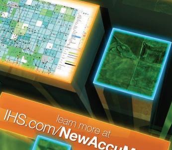


by industry & powered by the breadth and depth of IHS IHS.com/ NewAccuMap AVAILABLE NOW IHS AccuMap®
Shaped
SOLUTION NOW AVAILABLE
CSPG OFFICE
#110, 333 – 5th Avenue SW
Calgary, Alberta, Canada T2P 3B6
Tel: 403-264-5610
Web: www.cspg.org
Office hours: Monday to Friday, 8:30am to 4:00pm
Executive Director: Lis Bjeld
Tel: 403-513-1235, Email: lis.bjeld@cspg.org
Event Coordinator: Kristy Casebeer
Tel: 403-513-1226, Email: kristy.casebeer@cspg.org
Geoscience Coordinator: Kelsey Green
Tel: 403-513-1225, Email: kelsey.green@cspg.org
Member Services:
Tel: 403-264-5610, Email: membership@cspg.org
Publications and Website: Emma MacPherson
Email: emma.macpherson@cspg.org, Tel: 403-513-1230
Co-Manager, GeoConvention 2014: Aileen Lozie
Tel: 403-513-1227, Email: aileen.lozie@cspg.org
Database Administrator and Accounting: Kasandra Amaro
Maternity leave until January 2014
Corporate Sponsorship: Lis Bjeld
Tel: 403-513-1235, Email: lis.bjeld@cspg.org
Controller: Eric Tang
Tel: 403-513-1232, Email: eric.tang@cspg.org
EDITORS/AUTHORS
Please submit RESERVOIR articles to the CSPG office. Submission deadline is the 23rd day of the month, two months prior to issue date. (e.g., January 23 for the March issue).
To publish an article, the CSPG requires digital copies of the document. Text should be in Microsoft Word format and illustrations should be in TIFF format at 300 dpi., at final size. For additional information on manuscript preparation, refer to the Guidelines for Authors published in the CSPG Bulletin or contact the editor.
Technical Editors
Hugh S. Mosher Colin Yeo (Assistant Tech. Editor) Nunaga Resources Ltd. Encana Corporation
M.: 403-809-9997 Tel: 403-645-7724
Email: hsmosher@telus.net Email: colin.yeo@encana.com
Coordinating Editor
Emma MacPherson, Publications Coordinator, CSPG Tel: 403-513-1230, emma.macpherson@cspg.org,
ADVERTISING
Advertising inquiries should be directed to Emma MacPherson, Tel: 403-513-1230 email: emma.macpherson@cspg.org. The deadline to reserve advertising space is the 23rd day of the month, two months prior to issue date.
RESERVOIR ISSUE 11 • DECEMBER 2013 3 DECEMBER 2013 – VOLUME 40, ISSUE 11 ARTICLES 25th Annual CSPG/CSEG/CAPL 10K and 5K Road Race and Fun Run ......................... 14 Geomechanics For Everyone, Part 4: Geomechanics of Hydraulic Fracturing ........... 16 GeoConvention 2014: Focus ...................................................................................................... 21 Geology of the Mount Stephen Trilobite Beds and Adjacent Strata near Field B.C., Yoho National Park, New Perspectives on a 127 Year Old Discovery ......................... 22 Go Take a Hike 26 50th Annual Western Inter-University Geosciences Conference (WIUGC) 30 DEPARTMENTS Executive Comment 5 Technical Luncheons ................................................................................................................. 8 Division Talks ........................................................................................................................... 13 Rock Shop ..................................................................................................................... 7, 12, 29
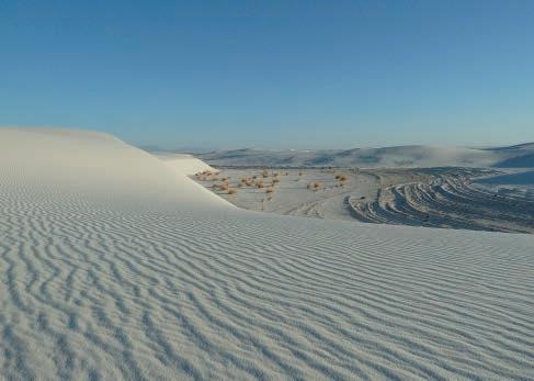
FRONT COVER
eroded
White Sands National Monument, New Mexico, Largest gypsum dune field in the world has formed from lake deposits, note the
interdune
foresets.
Photo by Rhea Karvonen.
The RESERVOIR is published 11 times per year by the Canadian Society of Petroleum Geologists. This includes a combined issue for the months of July and August. The purpose of the RESERVOIR is to publicize the Society’s many activities and to promote the geosciences. We look for both technical and non-technical material to publish. Additional information on the RESERVOIR’s submission guidelines can be found at http://www.cspg. org/publications/pubs-reservoir-submissions.cfm. The contents of this publication may not be reproduced either in part or in full without the consent of the publisher. Additional copies of the RESERVOIR are available at the CSPG office. No official endorsement or sponsorship by the CSPG is implied for any advertisement, insert, or article that appears in the Reservoir unless otherwise noted. All submitted materials are reviewed by the editor. We reserve the right to edit all submissions, including letters to the Editor. Submissions must include your name, address, and membership number (if applicable). The material contained in this publication is intended for informational use only. While reasonable care has been taken, authors and the CSPG make no guarantees that any of the equations, schematics, or devices discussed will perform as expected or that they will give the desired results. Some information contained herein may be inaccurate or may vary from standard measurements. The CSPG expressly disclaims any and all liability for the acts, omissions, or conduct of any third-party user of information contained in this publication. Under no circumstances shall the CSPG and its officers, directors, employees, and agents be liable for any injury, loss, damage, or expense arising in any manner whatsoever from the acts, omissions, or conduct of any third-party user. Designed and Printed by The Data Group of Companies, Calgary, Alberta.


February 6-8, 2014 Visit cspg.org for more information 31st Annual CSPG Squash Tournament Canada’s Energy Geoscientists


CSPG EXECUTIVE
PRESIDENT
Paul MacKay • Shale Petroleum Ltd. paul.mackay@shalepetroleum.com Tel: 403.457.3930
PRESIDENT ELECT
Dale Leckie • Nexen Inc. daleleckie@nexeninc.com Tel: 403.613.0458
PAST PRESIDENT
Robin Mann • AJM Deloitte rcmann@deloitte.ca Tel: 403.648.3210
FINANCE DIRECTOR
Samantha Etherington • Barrick Energy SEtherington@barrick-energy.com Tel: 403.386.6459
FINANCE DIRECTOR ELECT
Gord Stabb • Durando Resources Corp. gstabb@durando.ca Tel: 403.819.8778
DIRECTOR
Alexis Anastas • Nexen Inc. alexis_anastas@nexeninc.com Tel: 403.699.4965
DIRECTOR
Curtis Evans • ERCB curtis.evans@ercb.ca Tel: 403.297.8386
DIRECTOR
Andrew Fox • MEG Energy Corp. andrew.fox@megenergy.com Tel: 403.770.5345
DIRECTOR
Dawn Hodgins • Imperial Oil Resources dawn.hodgins@exxonmobil.com Tel: 403.232.5931
DIRECTOR
Weishan Ren • Statoil Canada Ltd. wren@statoil.com Tel: 403.724.0325
DIRECTOR
Dave Russum • AJM Deloitte drussum@deloitte.ca Tel: 403.648.3228
DIRECTOR
Mike Seifert • Canadian Discovery mseifert@canadiandiscovery.com Tel: 403.269.3644
EXECUTIVE DIRECTOR
Lis Bjeld • CSPG lis.bjeld@cspg.org Tel: 403.513.1235
EXECUTIVE COMMENT
A message from 2013 Finance Director, Samantha Etherington

Finance Overview for 2013
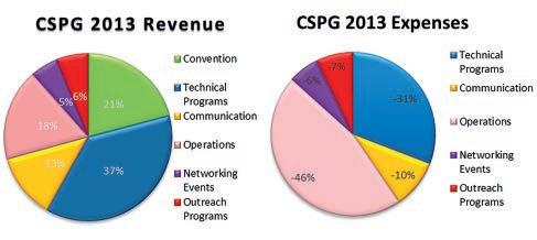
CSPG’s 2012/2013 fiscal year ended on Aug 31st, 2013. At $125,000 net income was higher than the $31,000 budgeted. This was a function of the strong 2013 GeoConvention, increased Technical lunch advertising and Bulletin royalties, less spending and more sponsorship on Outreach programs, office expense offset by GeoConvention use, and higher interest than expected on investments. Over budget expenses were relatively minor and included audit and legal costs associated with complying with the new Non-profit Organization act, higher executive costs, and write downs on old book inventory.
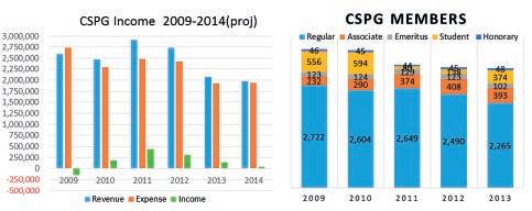
Overall net profits have fallen for the CSPG over the last several years. This is mainly due to lower GeoConvention and Technical program revenues, falling membership numbers and increased expenses due to higher profile office space, increased staffing, and general cost increases. 2013 Operation expenses were also impacted by a onetime gift of 100,000 to ETF. Industry advertising and sponsorship is a large part of revenue for all programs and costs are kept down by hardworking volunteers. The CSPG is a not for profit who’s revenue streams are meant to support the society’s mission to advance the professions of the Energy Geosciences. Net income for 2014 is projected to be $36,000, but is off to a strong start following t he success of the 2013 Gussow Geoscience Conference:
Importance of Rock Properties in Unconventional Reservoirs.
GeoConvention continues to be the largest source of income for the CSPG. The 2013 Geoconvention: Integration was successfully operated for the second year by the CSEG on behalf of the CSPG and CWLS. Net profit of $435,126 was better than budgeted with an increase in delegate registration. Overall metrics were very similar to last year, although fewer exhibitors meant that profits were down from $457,488 in 2012. Traditionally the CSPG and CSEG have had the option of running the GeoConvention for 2 years before switching operatorship. A Limited Partnership (45% CSPG, 45% CSEG, 10%CWLS) was formed this year that will operate GeoConvention commencing in 2015. The CSPG will run GeoConvention in 2014. This stability should allow for better resource continuity and a maximized GeoConvention.
Declining CSPG membership numbers are a concern. Most recent survey results show 2/3 of the membership to be over 45 and almost 80% male. 2013 has seen initiatives to focus on the Bulletin and its circulation, reorganize Continuing Education, and improve on the success of the Gussow Geoscience Conference and the annual GeoConvention.
(Continued on page 7...)
RESERVOIR ISSUE 11 • DECEMBER 2013 5

CORPORATE SPONSORS
SAMARIUM
geoLOGIC systems ltd.
TITANIUM
APEGA
Shell Canada Limited
PLATINUM
AGAT Laboratories
Cenovus Energy Inc.
ConocoPhilips
IHS
Imperial Oil Resources
Nexen Inc.
GOLD
Devon Energy Corp
Enerplus Corporation
MEG Energy Corp.
Tourmaline
Schlumberger Canada Limited
Statoil Canada
SILVER
Athabasca Oil Corporation
Baker Hughes
Canadian Natural Resources Ltd.
CGG Services (Canada) Inc.
Encana Corporation
Husky Energy Inc.
ION GeoPhysical
Loring Tarcore Labs Ltd.
MJ Systems
Petrosys
Suncor Energy
BRONZE
Arc Financial Corporation
Arcis Seismic Solutions
Belloy Petroleum Consulting
Earth Signal Processing Ltd.
Exova Canada Inc.
Hunt Oil
Olympic Seismic Ltd.
PGS
Pro Geo Consultants
Roke Technologies Ltd.
Saudi Aramco
Seisware Sensor Geophysical Ltd.
Talisman Energy
Tesla
TGS
As of November 2013
A Special Thanks to Geologic Systems Ltd.,
CSPG’s Top Sponsor of the Month
(...Continued from page 5)
Overall the CSPG is in good financial shape. Operating budget for 2013 was just over $2,000,000 and 2014 should be similar. Total assets have risen to over $3,000,000. Previous budget surpluses have provided the organization with a ‘rainy day’ fund of ~$1,000,000. On a cautionary note the CSPG fortunes are tied tightly to a successful GeoConvention and strong technical program (including Gussow) and three consecutive bad years would quickly erode this money.
ROCK SHOP
The CSPG relies heavily on industry sponsors and advertising and is grateful for their support. This funding underlies all CSPG activities including paid floor space at GeoConvention, venues for technical programs, advertising in the Communication portfolio, and direct funding for Outreach and Networking Events. As a final plug for CSPG membership this means that not only are networking events a great way to socialize with your fellow geoscientists, but are a great deal too (prizes!)


RESERVOIR ISSUE 11 • DECEMBER 2013 7
TECHNICAL LUNCHEONS DECEMBER LUNCHEON
A geoscientist in Antarctica: Following
in Shackleton’s footsteps one hundred years later
SPEAKER
Susan R. Eaton, P. Geol., P. Geoph., M.Sc., B.J. (Journalism) Hon. President, SR ECO Consultants Inc.
11:30 am Tuesday, December 10, 2013 Telus Convention Centre, Macleod Hall A/B/C Calgary, Alberta
Please note: The cut-off date for ticket sales is 1:00 pm, three business days before event. (Thursday, December 5th, 2013). CSPG Member Ticket Price: $45.00 + GST. Non-Member Ticket Price: $47.50 + GST.
Each CSPG Technical Luncheon is 1 APEGA PDH credit. Tickets may be purchased online at https:// www.cspg.org/eSeries/source/Events/index.cfm.
ABSTRACT
Geology field schools can be tough – and sometimes they can be hazardous. During a recent geology field school in Antarctica, I became adept at running the gauntlet of lunging fur seals and lumbering elephant seals, their oversized proboscises flared outwards, exposing shiny pink gums and sizeable teeth...
The old adage, “their bark is worse than their bite,” doesn’t ring true in Antarctica. Our seasoned guides cautioned us that a bite from a fur seal or an elephant seal would require the immediate administration of intravenous antibiotics...
Bitten by the polar bug, I returned to the Bottom of the World, participating in my third science-based expedition in three years. From December 29, 2012, to January 19, 2013, I joined an expedition sponsored by the Geological Society of America (“GSA”) and entitled “Antarctica, South Georgia and the Falkland Islands: Scotia Arc Tectonics, Climate and Life.” Led by earth scientists from Pennsylvania State,
Webcasts sponsored by

the Jackson School of Geosciences (University of Texas at Austin), Stanford University and the Federal University of Rio de Janeiro, the expedition investigated the interplay of solid earth systems, plate tectonics, glaciology, oceanography, climate and life.
I traveled to the Southern Ocean with an intrepid group of 100 explorers from 15 nations – fifty percent of the group was female – aboard the MV Akademik Ioffee, a 117-meterlong, Russian ice-strengthened vessel. The GSA-sponsored group of explorers included 70 earth scientists (ranging in age from early twenties to late seventies) representing more than twenty specializations. In fact, there were enough Ph.D. geologists on the expedition to staff four or five university earth science departments!
A century ago, Sir Ernest Shackleton’s scientific teams were comprised of geologists and geophysicists who explored Antarctica because it was there, and because it was unclaimed by any nation.
During the heroic age of Antarctic exploration, geoscientists discovered volcanoes, mountain ranges, fossils, coal and minerals in this
8 RESERVOIR ISSUE 11 • DECEMBER 2013
uncharted continent. And, in 1909, geoscientists in Shackleton’s Nimrod Expedition planted the British flag at the Magnetic South Pole.
Today, earth scientists travel to Antarctica – the world’s last remaining wilderness –to research planetary processes, including the impacts of climate change and ocean change. During the past fifty years, the Western Antarctic Peninsula has warmed 3 degrees Celsius, triggering a cascading series of geological and biological changes in this fragile ecosystem which have global implications.
Blogging from the Bottom of the World, I’ve conveyed the excitement of these extraordinary voyages of exploration and discovery.
During the past three years, I’ve experienced numerous Serengeti moments, witnessing some of the largest concentrations of wildlife on the planet. Snorkeling in brash ice, I’ve come face-to-mask with 1,400-pound leopard seals, jaws agape – so close, that I could count the freckles on their upper palates and inspect their tri-serrated teeth which can dispatch 40-pound penguins in mere seconds. And, I’ve completed the “Leadership on the Edge Program,” an Antarctic Outward Bound-like school led by British polar explorer Robert Swan, OBE.
Translating lessons from Antarctica, I’ve reached out to thousands of K-12 students, university students and the general public, empowering them to formulate scientificallydriven global solutions for today’s social, economic, energy and global sustainability challenges.
BIOGRAPHY
Susan a geologist, geophysicist, journalist and ‘extreme’ snorkeler. She has a B.Sc. Honours in Geology and Biology from Dalhousie University, a B.J. (Journalism) Honours from Carleton University, and a M.Sc. in Petroleum Geology (Geophysics Specialization) from Imperial College, University of London.
She is the Antarctic-Explorer-in-Residence for the American Association of Petroleum Geologists (“AAPG”) and the Houston Geological Society (“HGS”). Susan was the keynote speaker for the HGS Guest Night 2012, and one of two co-presenters at the 2010 Canadian Society of Petroleum Geologists’ Honorary Address, entitled “The Next Generation of Cool Science.”
Susan has developed a successful career in the Canadian energy sector, attaining the position of vice president of exploration in several junior oil and gas companies. Through her wholly owned consultancy, SR ECO Consultants Inc., Susan consults to the Canadian, American and
GEOEDGES INC.
Detailed and accurate geology at your fingertips in Petra, GeoGraphix, ArcGIS, AccuMap, GeoScout and other applications
Basin Geological Edge Set
Eastern US / Appalachian Basin Geological Edge Set
North American Shales Geological Edge Set
Texas & Midcontinent US Geological Edge Set
international petroleum and financial sectors, on oil and gas exploration and production, acquisitions and divestitures, environmental risk assessments and media relations.
Susan began her journalism career as a television news reporter with CBC-TV. Today, she reports on science and technology, business, oil and gas, renewable energy, the environment, ecotourism and extreme snorkeling. Her articles and photographs have been published in Alberta Oil Magazine, New Technology Magazine, Popular Mechanics, the Calgary Herald, the Edmonton Journal, the Vancouver Sun, the Financial Post, ALERT Diver, DIVER Magazine, Business Edge News Magazine, Water Canada, AAPG’s EXPLORER Magazine and APEGA’s The PEG.
Active in several Canadian and American oil and gas industry associations, Susan is a recipient of the Geological Society of America’s Distinguished Mentor Certificate of Appreciation and the AAPG’s Public Outreach Award. She is a speaker with the Association for Women Geoscientists’ Distinguished Lecturer Program.
For additional information, including Susan’s dispatches from the Bottom of the World, videos and related magazine articles please go to: http://susanreaton.com/, https://twitter.com/ SusanREaton_Geo, http://www.youtube.com/ user/srecoconsultants.
for information contact: Joel Harding at 403 870 8122 email
www.geoedges.com
Western Canada: Slave Point, Swan Hills, Leduc, Grosmont, Jean Marie, Horn River Shales, Elkton, Shunda, Pekisko, Banff, Mississippian subcrops and anhydrite barriers in SE Sask., Bakken, Three Forks, Montney, Halfway, Charlie Lake, Rock Creek, Shaunavon, BQ/Gething, Bluesky, Glauconitic, Lloyd, Sparky, Colony, Viking, Cardium, Horseshoe Canyon and Mannville CBM, Oilsands Areas, Outcrops
US Rockies & Williston: Red River, Mississippian subcrops & anhydrite barriers (Bluell, Sherwood, Rival, etc), Bakken, Three Forks, Cutbank, Sunburst, Tyler, Heath, Muddy, Dakota, Sussex, Shannon, Parkman, Almond, Lewis, Frontier, Niobrara, Mesaverde shorelines, Minnelusa, Gothic, Hovenweep, Ismay, Desert Creek, Field Outlines, Outcrops
Texas & Midcontinent: Permian Basin paleogeography (Wolfcampian, Leonardian, Guadalupian), Granite Wash, Mississippian Horizontal Play, Chat, Red Fork, Morrow, Sligo/Edwards Reefs, Salt Basins, Frio, Yegua, Wilcox, Eagleford, Tuscaloosa, Haynesville, Fayeteville-Caney, Woodford, Field Outlines, Outcrops, Structures
North American Shales: Shale plays characterized by O&G fields, formation limit, outcrop, subcrop, structure, isopach, maturity, stratigraphic cross-sections. Includes: Marcellus, Rhinestreet, Huron, New Albany, Antrim, Utica-Collingwood, Barnett, Eagleford, Niobrara, Gothic, Hovenweep, Mowry, Bakken, Three Forks, Monterey, Montney, Horn River, Colorado
Eastern US / Appalachia: PreCambrian, Trenton, Utica-Collingwood, Medina-Clinton, Tuscarora, Marcellus, Onondaga Structure, Geneseo, Huron, Antrim, New Albny, Rhinestreet, Sonyea, Cleveland, Venango, Bradford, Elk, Berea, Weir, Big Injun, Formation limits, Outcrops, Allegheny Thrust, Cincinatti Arch, Field outlines
Deliverables include:
-Shapefiles and AccuMap map features
-hard copy maps, manual, pdf cross-sections
-Petra Thematic Map projects, GeoGraphix projects, ArcView map and layers files
-bi-annual updates and additions to mapping
-technical support
RESERVOIR ISSUE 11 • DECEMBER 2013 9
Western Canada Geological Edge Set Northern US Rockies & Williston
joelharding@geoedges.com
TECHNICAL LUNCHEONS
Sedimentology, Ichnology and Sequence Stratigraphy of the Lower Cambrian Gog Group, Southern Rocky Mountains, Canada
SPEAKER
Dr. Patricio Desjardins Shell Exploration
11:30 am Thursday, January 9th, 2013 Calgary, TELUS Convention Centre, Macleod Hall C/D Calgary, Alberta
Please note: The cut-off date for ticket sales is 1:00 pm, three business days before event. [Monday, January 6, 2013]. CSPG Member Ticket Price: $45.00 + GST. Non-Member Ticket Price: $47.50 + GST.
Each CSPG Technical Luncheon is 1 APEGA PDH credit. Tickets may be purchased online at https:// www.cspg.org/eSeries/source/Events/index.cfm.
Shallow-marine sandstone of the Gog Group in the southern Rocky Mountains comprise part of the vast terrace of siliciclastic deposits that rimmed the continental margin of western Canada, indeed almost contiguously around Early Cambrian Laurentia. It lies at the base of one of the thickest Cambrian sections in the world and records the initial phases of the early Paleozoic transgression onto the craton. Seemingly monotonous, and perhaps for this reason it has escaped detailed study, the Gog Group is revealed to consist of a more varied lithology than hitherto appreciated. Continuous sedimentary successions without major interruptions provide an instructive opportunity to trace depositional evolution of the broad shelf setting in this region. Lithologic variations, sedimentary structures and trace fossils in
Expertise in Integrated Subsurface Solutions
DATA ROOM SERVICES


the Gog Group have only been previously documented at reconnaissance level.
This presentation will laid out the revised lithostratigraphy of the Gog Group in the Bow Valley region. Sequence stratigraphy aspects of the Gog Group will be discussed, focusing on the forced-regressive tidal flats. Finally a new integrated sedimentologic–ichnologic model for tide-dominated sandbodies will be discussed with the proposal of a new classification of subtidal sandbodies.
The detail study of the Gog Group have “awakened a giant” as it were, and its most likely that these rock will play in the near future a major role in our understanding of tide-dominated shallow-marine systems.
BIOGRAPHY
Dr. Patricio Desjardins is the 2011 recipient of the CSPG Best Ph.D. thesis award for his thesis entitled “Sedimentology, Ichnology and Sequence Stratigraphy of the Lower Cambrian Gog Group, Southern Rocky Mountains, Canada”, supervised by Drs. Luis A. Buatois, Brian R. Pratt and M. Gabriela Mángano at the University of Saskatchewan in Saskatoon. Patricio graduated in 2005 as a Geologist from the Universidad Nacional de Tucumán in Argentina and continued his graduate studies as a PhD student at the University of Saskatchewan. While in Argentina he conducted research in the Upper Palozoic Tupe Formation of the Paganzo Basin analyzing the sedimentology, ichnology and sequence stratigraphy of postglacial transgressions in Gondwana. As a student Patricio has received several awards including Best Geology Graduate Award from Universidad Nacional de Tucumán, the University of Saskatchewan’s Appel Global Citizenship Awards and the named Saskatchewan S cience Ne twork (SSN) Scientist of the Month, both in from in recognition for outstanding volunteer contributions to science education in Argentina and Canada. Today, Patricio works as a Specialist Geologist for Shell Exploration and Production Company in Houston, Texas focusing on the description and interpretation of cores from mainly unconventional reservoirs from several basins around the globe. Before his current assignment in Shell, he worked in Deep Water Gulf of Mexico, and Onshore US New Ventures and Business Development.
10 RESERVOIR ISSUE 11 • DECEMBER 2013
JANUARY
sponsored by GEO-RESERVOIRSOLUTIONS.COM A division of Geo-Reservoir Solutions Ltd. Your data will be carefully managed on secure workstation and made available to reviewers in one of our spacious, private and comfortably appointed data rooms. If you desire to establish a data room on your own site, we can supply a dedicated workstation with working software license to you on a rental basis, which we will manage and maintain. Contact us for further information and pricing.
LUNCHEON Webcasts
We offer seismic project preparation, data presentation on Seisware, Kingdom or WinPics seismic workstation. storage support convenience comfort
403.777.0008 info@geo-reservoirsolutions.com Featuring one of our many technical services offering world class geophysical data support ... RESERVOIR_GEORes_third_Dataroom_08_2013.indd 1 2013-08-22 1:25 PM
TECHNICAL LUNCHEONS JANUARY LUNCHEON
Oil and Gas Exploration in the Arctic
SPEAKER
Alastair Fraser AAPG
Distinguished Lecturer
11:30 am, Tuesday, January 28, 2014 Calgary, TELUS Convention Centre Macleod Hall C/D, Calgary, Alberta
Please note: The cut-off date for ticket sales is 1:00 pm, three business days before event. [Thursday, January 23, 2013]. CSPG Member Ticket Price: $45.00 + GST. Non-Member Ticket Price: $47.50 + GST.
Each CSPG Technical Luncheon is 1 APEGA PDH credit. Tickets may be purchased online at https:// www.cspg.org/eSeries/source/Events/index.cfm.
In overcoming the technical challenges of oil production in the Arctic, are we making the most of a strategic resource or heading for an environmental and political minefield?
The vast Arctic region is probably the last remaining unexplored source of hydrocarbons on the planet.
In the past three decades of oil exploration in the Arctic, more than 200 billion barrels of oil have been discovered. Ultimate resources are estimated at 114 billion barrels of undiscovered oil and 2000 trillion cubic feet of natural gas. If these estimates are correct, these hydrocarbons would account for more than a fifth of the world’s undiscovered reserves. This great prize, in a world of diminishing resources, has stimulated both governmental and industry interest in areas such as the US and Canadian Beaufort Sea, East and West Greenland and the Kara Sea.
Balanced against this are the considerable technical challenges of exploring and producing hydrocarbons in areas where sea ice is present for more than half the year as well as the underlying threat of damage to a pristine Arctic environment.
Harnessing the considerable resources of the ‘Final Frontier’ is going to be fraught with many technical, political and environmental challenges that will engage many minds, both scientific and political over the next half century.
BIOGRAPHY
Al Fraser currently holds the post of EGI Chair in Petroleum Geoscience at Imperial College, London. He has a BSc from Edinburgh University and a PhD from Glasgow University in the UK, both in Geology.


Previously, Al worked for BP as a Petroleum Geologist/Exploration Manager for over 30 years. His career in petroleum exploration, took him to most corners of the world including N. America, Europe, Africa, Middle East and the Far East. Following the BP Amoco merger, he led the team which made the significant Plutonio discovery in Block 18, deepwater Angola. He is the author of many papers on the Petroleum Geology of extensional basins most notably on the North Sea Jurassic and northern England Carboniferous.
He continues to pursue his interests in rifts and rifted margins and this forms his main area of research focus. Areas of interest will include the following:
• Eastern Mediterranean – the Messinian Salinity Crisis, salt-sediment interaction and its impact on hydrocarbon prospectivity of the region
• Arctic Oil & Gas Exploration – the final exploration and production frontier. What is the scale and distribution of these resources and how can we develop the technologies to exploit these reserves in a socially and environmentally acceptable way?
• South Atlantic Margins – conjugate margin evolution and fill. Crustal to basin scale.
An additional and important aspect of his role is as Director of the EGI/Imperial Research Alliance. Al is currently Science Secretary of the Geological Society of London.


RESERVOIR ISSUE 11 • DECEMBER 2013 11
Webcasts sponsored by 2014 CSEG Symposium: value oriented geophysical case studies Thursday March 6th, 2014 8:00AM to 4:30PM Telus Convention Centre 2014 CSEG Symposium: value oriented geophysical case studies For more information, go to: www.cseg.ca/symposium To register, go to: www.cseg.ca/symposium/register.php The 2014 CSEG Symposium is the third annual event which will showcase the CSEG's best speakers, with talks highlighting our mission to estimate the truth about the earth in a case study format.
ROCK SHOP

3300, 205 - 5th Ave SW Calgary, AB T2P 2V7
Tel 403 726 0666 Fax403 264 1262 Cell403 819 2516
farhat@sableconsultants.com SABLECONSULTANTS.COM
Conventional Wells Coring Programs


12 RESERVOIR ISSUE 11 • DECEMBER 2013
Strip Log Strip Log Horizontal Log Horizontal Log Mud Log Mud Log Log Viewer Log Viewer Log Manager Log Manager Log Analysis Log Analysis Suite 102, 7370 Sierra Morena Blvd SW, Calgary, AB T3H 4H9 info@WellSight.com 1-800-447-1534 (403) 237-9189 petrographical & sedimentological descriptions for samples (thin section - fluid inclusion studies) conventional vertical/horizontal wells operations geology SPECIALIZED IN GEOLOGICAL WELLSITE SUPERVISION AND CORE ANALYSIS RockWell
our best friend and most valuable partner is our client Stephan C. Dragomir president www.geok2.com - phone: 403.831.9941 - sdragomir@geok2.com 210, 237 – 8th Ave. S.E. Calgary, AB T2G 5C3 Phone: 403.263.5440 Fax: 403.263.2331 m.sahota1@shaw.ca 742 Memorial Drive NW Calgary, Alberta T2N 3C7 P: 403 242 1522 F: 403 242 8223 E: office@chinookconsulting.ca www.chinookconsulting.ca SERVICES • Wellsite geological supervision • Core and cuttings petrographic studies • Operations geology • Remote geo-steering and remote geological supervision • Project management
LOG
For Engineers, Geologists, Geophysicists, and Technicians Practical Quantitative Log Analysis: 15 – 17 Oct 2013 Analysis of Unconventional Reservoirs: 18 Oct 2013 Details and Registration at: www.spec2000.net/00-coursedates.htm In-House
Multi-Media Narrated Self-Study Courses Also Available === Instructor:
R.
1-403-845-2527
=== – 50 Years Worldwide Experience – Analysis, Training, Mentoring, Forensic Reviews –=== Conventional Vertical and Horizontal Wells Oil Sands - SAGD/Coring Programs Shale Gas/Oil Shales Coal Bed Methane Project Supervision Email:
Tel: (403) 262-9229
(403) 265-0377 Website: www.progeoconsultants.com SABLEPETROLEUM CONSULTANTSINC. WELLSITE GEOLOGICAL SUPERVISION
CEO
Consulting
PRACTICAL
ANALYSIS COURSES
and
E.
(Ross) Crain. P.Eng.
ross@spec2000.net
progeo@telus.net
Fax:
FARHAT HYDERI,P.Geol. President /
Heavy
SAGD Horizontal
Oil/Oil Sands Coal Bed Methane
Project Supervision
DIVISION TALKS STRUCTURAL DIVISION
The development of thrust belts and the influence of fluid pressure
SPEAKER
Paul MacKay
Shale Petroleum paul.mackay@shalepetroleum.com
12 noon to 1pm Thursday, December 5, 2013 Conference Centre Room A, +30 level, Western Canadian Place (Husky Energy), 707-8th Avenue S.W. Calgary, Alberta
ABSTRACT
Fold and Thrust belts are contractional systems created by plate collisions. These collisions create stress conditions where the maximum and intermediate principal stresses are horizontal and the minimum principal stress is vertical. The stress orientation favours the development of low angle reverse faults consistent with Anderson’s rules. Though the stress orientation is important in the determination of the fault orientation, the shape of the thrust system is also dependent on a wide variety of semi-related rates. Rates of uplift, erosion, deposition all play a role in the shape of the thrust belt. Spatial variations in sedimentary thickness, rock properties, and the relief on crystalline basement also have a profound effect on the development of the thrust belt.
Another fundamental influence on thrust belts is the presence of fluids within the geologic section and the role these fluids play as a trigger mechanism for seismic failure of faults. Failure occurs in the crust when the differential stress conditions within the crust (the difference between the maximum and minimum principal stresses) exceeds the strength of the crustal material. The effect of increased fluid pressure is to reduce the effective stresses within the system but maintain a consistent differential stress. Thus increasing fluid pressure is an effective trigger mechanism to create failure conditions in the section and allow faults to slip. As faults slip the fluids have an escape route and leave the system thus reducing the fluid pressure and re-establishing stability conditions effectively arresting the slip on the fault. Motion on the fault ceases until the fluid pressure elevates and recreates the failure condition thus repeating the process.
Within the sedimentary section the principal fluids available are water and hydrocarbons. Water is an effective mechanism to increase fluid pressure in relatively young unconsolidated sediments as those sediments compact; but in older more consolidated strata there is little water available to sustain prolonged deformation periods. The generation of hydrocarbons appears to be a more effective mechanism to create sustained elevated fluid pressure and to maintain that fluid pressure within a leaky system. Organic material goes through a volume increase when heated and converted to hydrocarbons. This volume increase creates substantial overpressure fluid conditions within the rock as a greater volume must be confined within a restricted pore volume. The generation of hydrocarbons are a sustained source of fluids that is used to create episodic elevated fluid pressures and failure within a thrust belt.
The flush of hydrocarbons during deformation results in abundant petroleum traps where the structural development and hydrocarbon charge are simultaneous. There are several nuances which add to the complexity of the system. Erosion has a greater effect where it both lightens the weight of the
Sponsored by
overburden on the active thrust belt but in some cases also compromises the top seal no longer allowing fluid pressures to build up and likely retarding the continuity of deformation. Another implication to this system is that the migration pathways become predominantly horizontal rather than vertical. The flush of hydrocarbons will migrate beyond the thrust belt into the adjoining foreland basin forming massive hydrocarbon resource deposits within the undeformed strata. In the case of the Canadian Rockies the lateral migration of hydrocarbons is hundreds of kilometres in distance to the point where the flush of hydrocarbons coming from the thrust belt has migrated to the other side of the foreland basin to form the massive oilsands bitumen deposits at the Alberta/ Saskatchewan border.
INFORMATION
Structural Division talks are monthly-ish and cover a diversity of structural themes. Our Structural Division sponsors are HEF Petrophysical and Husky Energy. All are welcome and no registration is required. For additional information, to be placed on the Division e-mail list or to present a talk, please contact Darcie Greggs, Darcie. Greggs@huskyenergy.com.
RESERVOIR ISSUE 11 • DECEMBER 2013 13
10K and 5K Roadrace and Fun Run
| By Armin Schafer, Race Director
On a hot fall afternoon Sept 11th, 2013 the 25th annual CSPG/CSEG/CAPL road race and fun run took place along the Bow River Pathway. With the temperature in the 28 degrees range, it felt more like summer than fall. An enthusiastic group of 111 runners bolted from the start line. This year the 5K had 51 runners, getting every closer to the 71 runners in the 10K.
Due to the floods, the route had to cross the river at the Crowchild Bridge underpass and continue west on the North side of the river. Our race volunteers, decked out in bright orange safety vests, aided the runners in negotiating the route. Once again distances were marked uniquely in geologic time to assist, or perhaps confuse, the participants. Like every year it’s great to see a mix of competitive and first time runners. Winning Time once again provided timing with the race chip mounted conveniently on the runners’ race bib.
We returned to The Calgary Curling Club for the post race awards party, where the mix of racers and volunteers enjoyed plenty of cold beverages and a pasta dinner. Being the 25th Annual race, everyone was encouraged to wear a prior race shirt. We even had someone with the inaugural year 1 Tshirt on. It still fit, although it now had a few holes. Prizes were drawn for anyone wearing a prior year race shirt. Special thanks goes to Target Data (Vic Urban) for sponsoring the 25th Annual celebrations. The evening was topped off with door prizes, awards and of course our now infamous sock- toss. Through great sponsorship and strong participation, we are once again able to contribute to our designated charity the YMCA strong kids foundation!
I would like to thank all the volunteers and sponsors who helped make this event a success! We have acknowledged our sponsors on a separate page. Thank you also to all the runners. It was a pleasure cheering you in at the finish line.
Finally a huge thank-you to our group on the committee that made this all work: Kathy Waters, Greg Hayden, Jocelyn Frankow, Tina Donkers, Shirley Fleming, Dan Cicero, Vic Urban, Chris Savels, Tim
Fatima
and Kristy Casebeer at the CSPG office. As well, thanks to Nick Wiggins and the staff at the Eau Claire YMCA for their hospitality.
For more information on category winners, run times and placement, please see http:// www.startlinetiming.com/races/2013/cspg/
Armin Schafer, Race Director (aschafer@
14 RESERVOIR ISSUE 11 • DECEMBER 2013
Burk,
Halari
look forward
seeing you next year
the 26th annual; race date will be September 10, 2014.
We
to
for
Thank you.
25TH ANNUAL CSPG/CSEG/CAPL
canadiandiscovery.com).
Here’s a summary of the CSPG, CSEG, and CAPL winners from 2013: OVERALL TOP MALE 10 K RESULTS PlaceTime Race # Div Name Member 1 35:59.871262M3039 John RUSSEL CSEG 2 38:41.381232M3039 John LAUGHTON CSPG 3 40:13.131214M-U30 Alex DUHAULT None 4 40:54.371280M4049 Dale HAESSEL None 5 41:08.121204M3039 Dan CICERO CAPL OVERALL TOP FEMALE 10 K RESULTS PlaceTimeRace#Div Name Member 1 42:15.891211F3039 Kellie D’HONDT CAPL 2 43:27.131226F-U30 Megan HEISE None 3 43:31.141218F3039 Jessie FLETCHER CAPL 4 44:15.381246F-U30 Jane MARZETTI CSPG 5 44:19.141273F4049 Shirley FLEMING CSEG OVERALL MALE 5K RESULTS PlaceTime Race # Div Name Member 1 19:54.12 541M3039 Franck DELBEG CSEG 2 20:32.38 540M4049 Bob DAWSON CSPG 3 21:28.13 580M3039 Nathan BAKER CSPG 4 23:06.37 566M4049 Stephen ROBINSON CSPG 5 23:25.62 582M-U30 Brett HUITIKKA None OVERALL FEMALE 5K RESULTS PlaceTime Race # Div Name Member 1 21:56.38 534F-U30 Courtney BOGSTIE CSPG 2 22:02.14 536F5059 Jodi COHEN CSPG 3 22:04.62 554F-U30 Rachel LEA CSPG 4 25:39.63 569F3039 Susan WILLIAMS CSPG 5 26:12.12 543F5059 Tina DONKERS CSPG

September 11th, 2013


RESERVOIR ISSUE 11 • DECEMBER 2013 15 25th Annual CSPG/CSEG/CAPL 10K & 5K Road Race
GEOMECHANICS FOR EVERYONE
Part 4: Geomechanics of Hydraulic Fracturing
| By Keri Yule, CalFrac Well Services
INTRODUCTION TO THE ARTICLE BY
AMY FOX, CANADIAN DISCOVERY
This month’s article in our geomechanics series is sort of a follow-up to the previous article. While in the last piece we addressed ideas about what makes a rock “fracable,” in this article we look at how the rock actually fractures during hydraulic stimulation and the geomechanical and operational parameters important in that process. It drives home the point that while we are making great strides in understanding what factors influence completions, quantifying and predicting those factors in a practical way remains a major challenge in our industry.
Completions are just one aspect of many when it comes to success in unconventional plays, and it is becoming increasingly apparent that these aspects can’t be considered in isolation. I recently attended the Denver Well Logging Society’s annual convention in Golden, CO, and this year’s topic was “Geomechanics in Unconventional Reservoirs.” As the speakers were questioned about what they think is most important in these plays, the same two words were repeated time and time again –“it depends.” What does it depend on? The number of answers to that question, at least right now, is downright overwhelming, but progress will come from understanding what “it depends” means from someone else’s point of view. Hopefully with this article we take our readers a step in that direction.
INTRODUCTION
When geomechanics was first introduced to the petroleum industry, few could have predicted how significant a role it would play. Hydraulic fracturing and horizontal drilling are two key technologies that have made the development of unconventional resources commercially economical. However, the mechanisms to produce from such unconventional sources are very difficult and challenging. Today, the subject of geomechanics is now recognized as an integral component not only of the relevant phases of field development such as well planning and drilling, but perhaps more importantly, of well completions.
In the preceding article in this series, a brief description of fracability and the most well-known brittleness indices was presented. The article mentioned that the terms fracability and brittleness have been
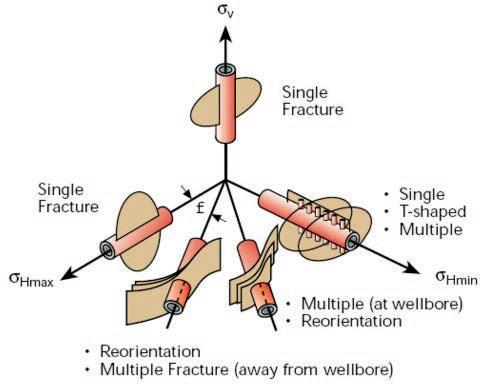
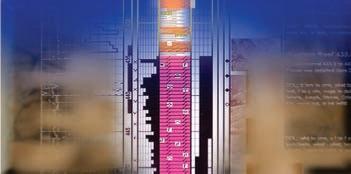
Illustration of the diverse types of hydraulic fractures that can result from the interaction between the well orientation, the near wellbore stress concentration, and the far-field in situ stress state. (Abass, H.H. et al. SPE 24823)
used interchangeably in the literature as a means of describing the likelihood in creating complex fracture networks or stimulated reservoir volume (SRV’s). Even though these indices have been mainly used to evaluate and compare various shale plays, formations and layers, the creation of complex fracture networks during hydraulic fracture stimulation requires more than brittle rocks. Simply, the presence of planes of weakness and brittle rock does not mean that a complex fracture network will be created. Stimulation design parameters play a key role. This article will introduce the function of geomechanics specifically as it pertains to hydraulic fracture stimulation.
APPLYING GEOMECHANICS TO HYDRAULIC FRACTURING
One of the most significant parts in the development of any unconventional resource is the successful implementation and design of the well stimulation. However, the essentials for an optimum fracture treatment include a wide range of factors— proper selection of well location, drilling azimuth, lateral placement, reservoir contact and completion strategy, to name a few. On the other hand critical fracturing
design parameters such as the specific type of fluid and proppant(s), fracture staging and spacing, perforation strategy, pumping schedule, fluid volumes and treatment rate also contribute to effectively stimulating and producing these challenging reservoirs. Applying geomechanics provides a significant opportunity to optimize these completion design parameters, enhance stimulated reservoir volume and maximize well performance.
Hydraulic Fracture Growth
Hydraulic fracturing is the process of transmitting pressure by means of a fluid or a gas to create or open existing cracks in the rock. The purpose is to create a contact between the well and the formation corresponding to a permeable pathway for fluids to flow into the well. Knowledge of in-situ stresses is critical to understanding hydraulic fracture growth, geometry and treatment pressures. The insitu stress distribution controls factors such as fracture orientation, height containment, treating pressure magnitude, and change in pumping pressure during the treatment. The orientation of induced fractures in the earth is controlled primarily by the
16 RESERVOIR ISSUE 11 • DECEMBER 2013
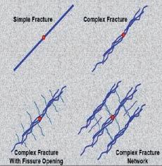
The above illustrates the various fracture growth types, which can occur during hydraulic stimulation, ranging from simple to complex fracture networks. (SPE 114173).
differences in magnitude between the three principal stresses. As with most things in nature, the fracture will take the path of least resistance. This means that the major displacement (opening of the fracture width) will occur in the direction of the minimum principal stress. Therefore, the plane of the propagated fracture will always be normal to the minimum stress direction, and fractures will always propagate in the direction of the maximum and intermediate principal stresses. Close to the well, however, the fracture is controlled by the near-wellbore stress concentration. This can lead to fracture tortuosity as seen in the first figure.
The magnitude of the various stresses, especially the minimum stress, determines the fluid pressure required to open a fracture. The stress variation owing to bedding interfaces can control both the alternating path of least resistance as well as the vertical connectivity, hence controlling created fracture height growth. Another aspect that needs to be examined is the effects in pore pressure variations. Pore pressure directly affects the minimum horizontal in-situ stress (closure stress), therefore fracture propagation and final geometry. As well, a comprehensive assessment of fracture geometry and proppant placement has indicated that spatial variations in fracture fluid leakoff caused by permeability and porosity distributions can have a huge impact on where the hydraulic fracture moves and, more importantly, where the proppant goes. Similarly, natural fractures and their impact on leakoff and transport are one of the single most dominant impacts on stimulation treatment success or failure. Together these factors determine the completion design schedule that can be pumped.
Hydraulic Fracture Complexity
Early in hydraulic fracturing it was believed that all fractures created through pumping were vertically oriented, bi-wing, and planar, extending in the direction of maximum horizontal stress. However, with the use of hydraulic fracture diagnostics, observations have shown that hydraulic fractures are generally not single and planar, aligned with the wellbore or contained in the desired target interval. More importantly, the creation of farfield complex fracture networks during fracture extension is evident. But not all rocks possess the properties required for successful induction of far field complexity.
Compliant, homogeneous rocks have the capacity to yield to induced stress and are more likely to create a single tensile failure plane. By contrast, brittle, heterogeneous rocks have the additional mechanism of creating indirect shear failure, with fracture extension deeper into the rock matrix. If significant heterogeneity exists in the matrix, such as unconformities caused by laminations or microfractures, there is a significant opportunity to enhance SRV with fracturing designs aimed at creating connected fracture networks.
In order to achieve far field complexity, (Continued on page 18 ...)


RESERVOIR ISSUE 11 • DECEMBER 2013 17
it is important to address the issue of near wellbore complexity. The concept of near wellbore complexity is usually defined as concurrent extension of multiple competing fractures or fracture tortuosity. As fluid exits the perforation(s),fracture creation and propagation are initially controlled by the near wellbore stress concentration. The fracture then follows a tortuous pathway to reorient itself to the direction of maximum horizontal stress (SHmax). In association with near wellbore complexity this so called tortuosity is not only problematic but could be attributing to

the abnormally high treating pressures seen in today’s horizontal completions during the early phases of fracture extension. Transitioning from the near wellbore complexity effects to the far field stress state can have a direct function on fracture dimensions and the net pressure created. Fracture net pressure or fluid pressure within the fracture, in turn, is a function of the treatment fluid properties, designed pump rate and reservoir mechanical elastic properties. Based on the completion design, induced far-field complexity or enhanced fracture networks are achievable while also improving the network connectivity to the


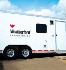
Whether you’re exploring a basin, producing a well or completing a shale play, time is money. That’s why Weatherford Laboratories brings a suite of formation evaluation technologies right to the wellsite. Utilizing mud gas and cuttings, these technologies provide detailed data on gas composition, organic richness, mineralogy and chemostratigraphy in near real time. As a result, operators now have an invaluable tool to assist with sweet spot identification, wellbore positioning, completion design and hydraulic fracturing. We call it Science At the Wellsite. You’ll call it money well spent.
SCIENCE AT THE WELLSITE ™
main fracture. This improved connectivity to the fracture networks should result in a greater stimulated reservoir volume and improved economic recovery.
Hydraulic Fracture Simulation
Although many models have moved beyond Linear Elastic Fracture Mechanics, a majority of the imperfections associated with today’s hydraulic fracturing models reflect both an inability to predict the enhanced fracture containment effects that may be provided by layer/lamination interfaces and/or stress and mechanical property contrasts, and the failure to arrest the exaggerated influence on fracture growth that may result from large scale reservoir heterogeneities such as natural fractures, small faults, bedding planes, etc. These shortfalls may be due more to a lack of characterization in the reservoir heterogeneities than to fundamental model limitations.
To approach an optimum design it is imperative to utilize an iterative process. It is not reasonable to expect a model to capture all aspects of a complex reservoir system initially. On the other hand, if any model is not challenged, questioned, and/ or calibrated it can never achieve the goal of becoming a predictive and useful design tool. Through analysis of fracture performance, post-fracture production and application of treatment diagnostics we must question whether the treatment performed according to expectations. If the hydraulic fracture objectives were not accomplished then the reasons for these deficiencies must be identified and changes may need to be made to the treatment design.
Through detailed numerical modeling, pre-fracture testing, analysis of treatment response, and use of more complete fracture diagnostics, we can learn much more about the fracturing process. A complete understanding must be based on sound observations and a fundamental understanding of process physics. We are now beginning to understand how to better predict in-situ stress. There is strong evidence for fracture height containment mechanisms other than stress contrast. With these factors integrated into our model we can better approach the fracture treatment design problem.
The hydraulic fracture optimization impasse is that models can often be incorrect, and diagnostic tools are an “after the fact” measurement of what went on during the fracturing process and thus of little value by themselves in optimizing the next completion. The combination of modeling
18 RESERVOIR ISSUE 11 • DECEMBER 2013
(...Continued from page 17)
When
is money,
www.weatherfordlabs.com ©2013 Weatherford. All rights reserved Formation Evaluation ┃Well Construction ┃Completion ┃Production
GEOSCIENCE SERVICES
time
Wellsite Geoscience is money well spent.
WELLSITE
and diagnostics allows fracture simulation models to be developed and more accurate, permitting a better prediction and continuous refinement of the fracturing process on subsequent treatments in the same area.
INTEGRATION OF MICROSEISMICITY
One approach which has the potential to address the hydraulic fracture dimensions and validation issues is the monitoring of microseismicity. Microseismic mapping can provide the necessary hydraulic fracture feedback for the design and fracture placement. The design parameters that can be altered as a result of fracture mapping are fluid chemistry, pad volumes, treatment rates, sand stages, sweeps, treatment sizes, wellbore and stage spacing as well as wellbore azimuth. Not only would this diagnostic approach aide in our abilities to better understand surface treating pressures but it could assist in further distinguishing the variability in rock fabric in contrast to job execution.
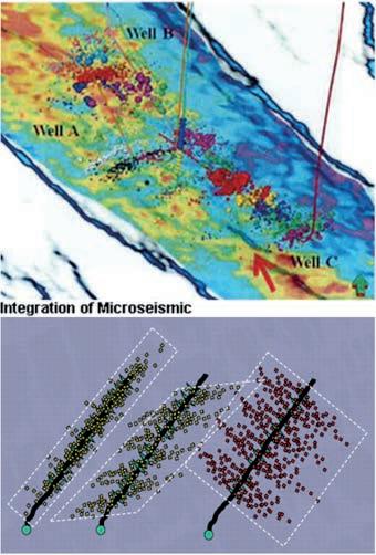
Microseismic data can be acquired in a number of ways but can generally be grouped into two categories: downhole and surface/near-surface. Well-constrained seismic event locations can be used to tell us about the reservoir as well as to evaluate the effectiveness of a hydraulic fracturing program. Where the events occur in depth tell us about height growth and fractures that extend out-of-zone and can aide in well placement. The lateral extent of event locations (hypocentres) can tell us how far apart to place wells and stages along wells to avoid over- or under-stimulation. Trends in the event locations can often indicate the orientation of SHmax, or in structured areas, events may effectively highlight preexisting faults or natural fracture systems. The hypocentres can also indicate when mechanical failures occur during a completions program – such as failure to isolate a zone or tool malfunctions that may prevent fluid from accessing the designated entry point. Events can also be used to determine the volume of rock accessed (SRV) through hydraulic stimulation.
Additional insight from focal mechanism analysis can also help to better understand hydraulic fractures and the stress environment. Focal mechanisms tell us how
the rock failed (dip-slip, strike-slip, etc.) and allow us to infer the orientation of the planes along which the rock failed. Often changes in focal mechanism can indicate a change in rock properties, such as a fault, or fractures breaking out of zone. Changes in focal mechanism solutions can also reflect stress changes that may occur in different portions of the reservoir or due to the hydraulic fracturing program itself, depending on the stress state. By combining microseismic data with pumping information, the effectiveness of fluid and proppant volumes used or the fluids themselves (if varied) can be evaluated.
SUMMARY
Unlike conventional reservoirs, unconventional reservoirs have large areal extents, are not easily accessible, have significantly high development cost and are characterized by extremely low flow capacity with high in-situ stress conditions. The concept of achieving the desired maximum SRV becomes increasingly complicated as we continue to drill increasingly complex wellbores. While addressing reservoir challenges, optimizing economics, and increasing production the need to further understand geomechanics as it pertains
to hydraulic fracture stimulation is obvious. Different approaches to optimizing reservoir contact such as extended reach wells, multi-laterals and multi-stage stimulation have enabled significant improvements in hydrocarbon recovery, but the evolving completion designs need to be addressed over the entire life of the well. The industry is taking a more integrated approach, where wells are drilled and completed to enable stimulation with an overall reservoir centric focus. In general, maximum reservoir contact and complex wells bring new challenges and additional risks that need to be balanced with completion and stimulation designs that can overcome reservoir or regional challenges.
ACKNOWLEDGEMENTS
The author wishes to thank Paige Snelling of MicroSeismic Inc., as well as colleagues and peers for all comments and suggestions provided.
REFERENCES
Abass, H.H., Soliman, M.Y., Tahini, A.M., Surjaatmadja, J., Meadows, D.L., Sierra, L. 2009. Oriented Fracturing: A New Technique to Hydraulically Fracture Openhole horizontal Well. Paper SPE 124483 presented at the 2009 SPE Annual Technical Conference and Exhibition, New Orleans, Louisiana, USA, 4-7 October 2009.
Barree, R.D., et al. 2003. Closing the Gap : Fracture Half-length from Design, Buildup, and Production Analysis. Paper SPE 84491 presented at the SPE Annual Technical Conference and Exhibition, Denver, Colorado, USA, 5-8 October.
Castillo, D.A. and Moos, D. 2000. Reservoir Geomechanics Applied to Drilling and Completion Programs in Challenging Formations: Northwest Shelf, Timor Sea, North Sea and Columbia. APPEGA Journal. p. 509-521.
Cipolla, C.L., Warpinski, N.R., Mayerhofer, M.J., Lolon, E.P., Vincent, M.C. 2008. The Relationship Between Fracture Complexity, Reservoir Properties, and Fracture Treatment Design. Paper SPE 115769 presented at the 2008 SPE Annual Technical Conference and Exhibition held in Denver, Colorado, USA, 2124 September 2008.
Cramer, D.D., 2008. Stimulating Unconventional Reservoirs: Lessons Learned, Successful Practices, (Continued on page 20...)
RESERVOIR ISSUE 11 • DECEMBER 2013 19
Areas for Improvement. Paper SPE 114172 presented at the 2008 SPE Unconventional Reservoirs Conference held in Keystone, Colorado, USA, 10-12 February 2008.
East, L., Soliman, M.Y., Augustine, J. Methods for Enhancing Far-Field Complexity in Fracturing Operations. Paper SPE 133380 presented at the SPE Annual Technical Conference and Exhibition, Florence, Italy. 19-22 September 2010.
Fisher, M.K., Davidson, B.M., Goodwin, A.K., Fielder, E.O., Buckler, W.S., Steinberger, N.P. 2002. Integrating Fracture Mapping Technologies to Optimize Stimulations in the Barnett Shale. Paper SPE 77411 presented at the SPE Annual Technical Conference and Exhibition, San Antonio, Texas, 29 September – 2 October.
Kettler, AA. Et al. 2006. A Field Study
Optimizing Completion Strategies for Fracture Initiation in Barnett Shale horizontal Wells. Paper SPE 103232 presented at the 2006 SPE Annual Technical Conference and Exhibition, San Antonio, 24-27 September 2006.
Mayerhofer, M.J., Lolon, E.P., Warpinski, N.R., Cipolla, C.L., Walser, D., Rightmire, F.A., 2008. What is Stimulated Reservoir Volume (SRV)? Paper SPE 119890.
Maxwell, S., Cho, D., Norton, M. 2011. Integration of Surface Seismic and Microseismic Part 2: Understanding Hydraulic Fracture Variability through Geomechanical Integration. CSEG Recorder. February.
Maxwell, S.C., Waltman, C.K., Warpinski, N.R., Mayerhofer, M.J., Boroumand, N. 2006. Imaging Seismic Deformation Induced by Hydraulic Fracture Complexity. Paper SPE 102801 presented at the SPE Annual Technical Conference and Exhibition held in San Antonio, Texas, USA, 24-27 September 2006.
Urbancic, T.I., Shumila, V., Rutledge, J.T., Zinno, R.J., 1999. Determining Hydraulic Fracture Behavior using Microseismicity, Rock Mechanics for Industry. Balkema, Rotterdam. ISBN 90 5809 052 3.
Wright, C.A., Weijers, Davis, E.J., Mayerhofer, M., 1999. Understanding Hydraulic Fracture Growth: Tricky but not Hopeless. Paper SPE 56724 presented at the 1999 Annual Technical Conference and Exhibition in Houston, Texas, USA. October 3-6, 1999
BIOGRAPHY
Keri Yule is Manager, Geosciences currently at Calfrac Well Services. Keri holds a Diploma (Honours) in Petroleum (Reservoir Engineering) Technology; SAIT Polytechnic and a B.Sc. in

Over the past 13 years, Keri has advanced her role as a Fracture Design Specialist to a MultiDisciplinary and Integrated approach. Within her profession Keri recognized the necessity for well stimulation to be specifically tailored to the needs of the individual reservoir.
Keri’s overall responsibility is for the integration between Reservoir characterization and Completion design. This enables her to build a strong relationship between the two disciplines for the successful exploitation of both conventional and unconventional reservoirs.
Keri is an active member of the CWLS, SPWLA, SPE, and CSUR.
20 RESERVOIR ISSUE 11 • DECEMBER 2013
Geology from the Brandon University.
(...Continued from page 19) CSPG and geoLogic Systems Ltd. Present our Annual Holiday Social & Technical Luncheon Tuesday December 10th, 2013 Wine & Appetizers
Technical Luncheon
This is a sellout social event that you don’t want to miss Tickets are available at www.cspg.org
Energy
10:30-11:30 am
11:30-1:00 pm
Canada’s
Geoscientists
GEOCONVENTION 2014: FOCUS
FOCUS ON SPONSORSHIP
When I became involved in the Sponsorship / Exhibit portfolio some years ago, two of the very first questions (and they are still relevant today) that I dealt with were “Why should I bother to be a sponsor /exhibitor of the GeoConvention?” and, “What’s in it for me or my company?” The best responses that I can give are paraphrased below from the opening remarks of our GeoConvention Sponsorship / Exhibitor brochure published each year.
“Sponsorship and exhibiting provide much of the funding to bring over 4,000 earth science professionals from North America and around the world to attend the GeoConvention with three full days of technical talks, an exhibit floor displaying the latest industry developments, a core conference at the world-class AER facility, and special social events to allow the delegates and exhibitors to mingle, network, and learn from industry and scientific leaders in the geosciences. This convention is the ultimate opportunity to reinforce and increase your company’s brand and visibility with conference delegates and exhibit attendees.”
Companies can sponsor technical sessions, poster sessions, and social events such as the
icebreaker, daily luncheons, evening functions, and the Core Meltdown which closes out the conference on Friday afternoon. It’s your opportunity to highlight your technical expertise in specific play trends or technology, to advertise your products, and to showcase your corporate brand to potential clients, customers, and future employees (students) to the geosciences community in one location.
Finally, as a delegate myself, I have attended almost all of the GeoConventions (or its predecessors) in Calgary since I started in the oil & gas business over 35 years ago. It’s a great way to find out what the geoscience community in Canada is doing, and, a great way to maintain the personal and professional relationships so unique to this industry and its success. Take a few moments to review possible sponsorship opportunities at this year’s GeoConvention by visiting www.geoconvention. com/sponsors
Douglas J. Colvin, P.Geoph. Sponsorship Chair, GeoConvention 2014
FOCUS ON EXHIBITING
After many years of partaking, participating and attending GeoConvention, we often wondered,
“why would you exhibit?” So when potential exhibitors ask “why?” we can now say with confidence, that it affords you visibility and focus.
This year’s convention is called “FOCUS”.
Four advantages to exhibiting at GeoConvention:
• High visibility
• Networking
• Show of commitment to our respected societies
• Education
Every exhibitor is provided a booth for breaking the cycle of social media and meeting people face to face.
Real handshakes, real smiles and real focus.
This opportunity is only once a year; take advantage of meeting over 4,000 delegates.
Be encouraged, be visible and be focused. Be there.
Judi Macdonald, Exhibit Chair
Craig Van Dongen, Judi’s Wing Man GeoConvention 2014
RESERVOIR ISSUE 11 • DECEMBER 2013 21
May 12 – 16, 2014, www.geoconvention.com
Open www.geoconvention.com Be a part of the convention: Submit your abstract by January 10 www.geoconvention.com/conference Sponsorship & Advertising Opportunities Available visit the webiste or call 403-264-5610 GeoConvention 2014: Focus will be held May 12-16 at the Calgary TELUS Convention Centre in Calgary, Alberta. Conference themes will focus attention on the most significant facets of an operation, refining evolving workflows, and sustaining effective practices. CSPG CSEG CWLS
Abstract Submission
GEOLOGY OF THE MOUNT STEPHEN TRILOBITE BEDS AND ADJACENT STRATA NEAR FIELD B.C., YOHO NATIONAL PARK
New Perspectives on a 127 Year Old Discovery
|
By V. Allen Kimmel P. Eng., P. Geol.
This article is a summary of one technical letter and three technical papers related to ongoing research by the author in an area that includes the Mount Stephen Trilobite Beds and Burgess Shale located near Field, BC. The present research began with the recognition of, and investigation into, the Field Slide by the author, the findings of which are summarized immediately below. Analysis of the slide mass and slide failure surfaces led to other relevant findings that are contained within the pages that follow. The article is divided into three segments for publication in the Reservoir. The first segment deals with the existing surface geomorphology and Cambrian depositional environments. The second segment deals with the Mount Stephen Trilobite Beds, adjacent strata and local structural features. The final segment concludes discussing the local structural features and highlights the major conclusions of the research to date.
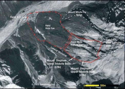
PART 1 BACKGROUND - THE FIELD LANDSLIDE
The exposed southern slopes of the lower west side of Mount Stephen represent the failure surface(s) of a major post glacial landslide (Figure 1), herein named the Field Slide. The town of Field, BC. is built on the distal toe of that slide. The slide mass, predominantly comprising strata of the Ogygopsis Shale (lower Burgess) section, now resides as soil, rocks, boulders and large, relatively intact bedded strata 10’s of meters in height and length in the landslide toe. On the southernmost slope (the Trilobite Beds Slope (TBS)), all but the lower 2 to 3 meters of the Ogygopsis Shale were removed from the mountainside during the slide. Roughly 40% of the post slide Ogygopsis beds still remain intact and are in situ on the TBS. The remainder of the beds have either slid or are actively creeping down the mountainside.
The famous Upper Mount Stephen Trilobite Beds (UTBs) and Lower Mount Stephen Trilobite Beds (LTBs) are both part of and representative of the Ogygopsis, what may prove to be the oldest Burgess Shale (Stephen Formation). Pre movement, they
rested/rest on top of what has previously been interpreted as the Boundary Limestone Beds (found adjacent to the Cathedral Escarpment on the north face of Mount Stephen) and later interpreted and named the Kicking Horse Formation (Collins and Fletcher, 1998 p. 422). The present day, slightly modified slide failure surface on the TBS psuedo parallels the dip slope of the original Cambrian bedding. This allows a unique look at the topography that existed at the beginning of Ogygopsis (Burgess Shale) deposition and at the facies and lateral facies changes in the Ogygopsis and adjacent Cambrian strata from west (downslope) to east (upslope) over a one kilometre distance and from south to north over a comparable distance. It also explains why so many fossils are exposed on the TBS.
Cambrian Patch Reefs and Adjacent Strata
The carbonate strata found on the TBS is predominantly comprised of limestone layers and makes up a large portion of the exposed and scree covered in situ dip slope surface of the mid TBS. Analysis of the in situ strata on the TBS and adjacent slopes
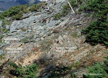
reveals that the previously interpreted carbonate mud mounds (Collom, 2000), one of which is shown in Figure 2, and previously interpreted mega clasts (Figure 3) found on the TBS (Fletcher and Collins, 2003, p.1835) and adjacent slide slopes, are relatively symmetrical small patch reefs that increase in areal extent and vertical height to the east.
Individual limestone beds can be traced for tens, and in some cases, hundreds of feet along the mountainside (Figure 4). The flat to gently curving rocks of this strata also make up the majority of the talus on the TBS directly above the UTBs. The in situ limestone layers, dolomitized adjacent to and in proximity of the reefs, drape in all directions around the sides of the larger patch reefs and cap the smaller patch reefs (Figure 3). The layers have been eroded off of the tops of the larger reefs (Figure 2).
Depositional slopes of these draping beds reach a maximum of 15 to 20 degrees on the reef sides (Figures 2 and 3).
Similar reef draping/capping carbonate
22 RESERVOIR ISSUE 11 • DECEMBER 2013
Figure 1 - The Field Landslide
beds occur in other formations elsewhere in the Rockies. In the Front Ranges of the Canadian Rockies (Figure 5), they are evident above the interpreted Devonian patch reef (Hunter, Bloy and Leggett,1989, Fig.5 p. 401) at Grassi Lakes near Canmore, Alberta.
Initial observations in the study area lend to the premise that the exposed upper most draping/patch reef capping limestone beds adjacent to the UTBs (and elsewhere) are very likely the off reef, syndepositional stratigraphic equivalents of larger, closer spaced patch reefs or massive reef complexes to the east.
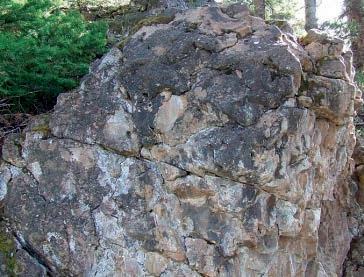
The central reef cores of the one dozen reefs/bioherms examined on the TBS to date are completely dolomitized and can be massive/blocky in nature (Figure 6) or riddled with vertical fractures (Figure 7) oriented perpendicular to the underlying conformable limestone beds. These fractures can be confused with bedding. Open fractures are commonly lined with white dolomite crystals and crystal lined vugs are occasionally present. For the purposes of this paper, bioherms are defined as buildups less than one meter in vertical height/thickness.
The degree of dolomitization and surface weathering of the analyzed TBS reefs makes the identification of reefal fauna impossible, though many scientists, starting with Rasetti in 1951, recognized “the massive carbonates represent reefs of algal origin (note the abundance of Girvanella in the undolomitized portions of the Cathedral Formation...)” when discussing the Cathedral carbonates adjacent to the Monarch Mine on the north face of Mount Stephen (Rasetti, 1951, p.45). Aitken and McIlreath (GEOS 1984/1, p.17) also noted the existence of Epiphyton and Renalcis in off reef limestone blocks originating from the Cathedral Escarpment and, as with the TBS patch reefs, the Cathedral Escarpment reefs have had “all fine primary detail destroyed” during the dolomitization process. Future work on undolomitized features should confirm the internal faunal makeup of the patch reefs and bioherms.
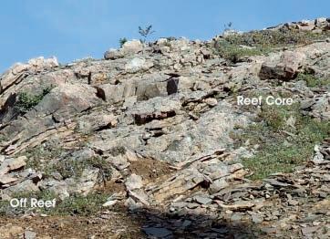
Several preliminary conclusions can be drawn from the initial examination of the patch reefs (and bioherms). First, the more massive dolomitic (originally limestone) rock comprising the reef core passes laterally into time equivalent, depositionally equivalent limestone beds off reef (Figures 7 and 8). From the opposite perspective,
(Continued on page 24...)
RESERVOIR ISSUE 11 • DECEMBER 2013 23
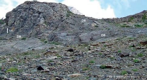
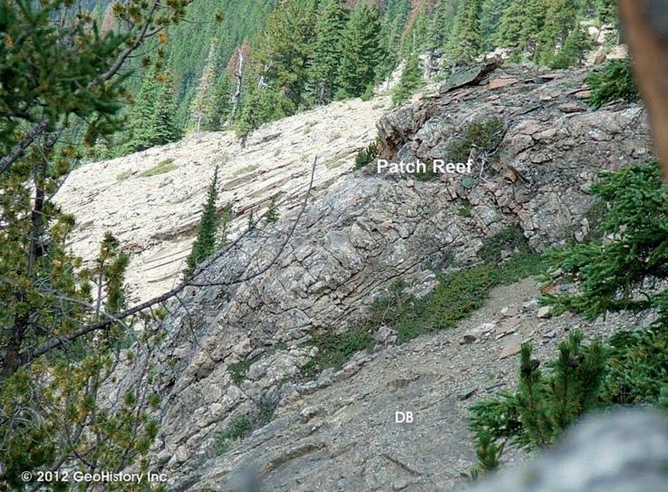
Figure 2 - 3D view of the “draping” limestone beds (DB) at the front and to the right of the Cambrian patch reef located 100 metres upslope of the main UTBs. This reef is approximately 7 metres high from base at the far left to top.
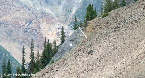
Figure 3 - Looking from the UTBs to the NNE approximately 200 metres away. This 3.5 meter high patch reef (2 metres exposed above the scree) shows the symmetrical reef structure and capping limestone beds drapping equally in all directions. The 38 to 42 degree angle of the talus in the foreground (unaffected by the patch reef) pseudo parallels the dip slope of the underlying off reef limestone bedding.
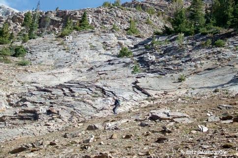
Figure 4 - Looking east, directly upslope of the UTBs at the curved centimeter thick individual beds of (at times dolomitized) limestone, positioned stratigraphically below the Ogygopsis Shale beds. The individual layers can be traced for tens to hundreds of feet across the slope. The patch reef in Figure 2 is located approximately 40 metres to the left of the photo. Note the person (M. Quinn) in the lower centre of the photo.
beds below the reef (angled due to thrusting) and curved draping beds above the reef are the lagoonal syndepositional equivalents of the main (eroded) reef complex deposited basinwards of this lagoonal patch reef.
7 - Originally vertical post depositional fractures in a dolomitized
in the lower centre of the photo. Note the capping/draping beds over the top of the massive portion of the reef at the left centre of the photo. Note also the thinning of the beds off the top right side of the massive part of the reef and the thickening (biohermal developments) of the beds near the top of the outcrop. The capping/draping beds and biohermal developments at the top of the outcrop are likely the off reef/reef edge facies of a higher part of the visible reef that has either been eroded away or develops more fully within the mountainside beyond the outcrop.
(...Continued from page 23 )
each basinal limestone bed changes into a thicker biohermal/reefal interior (core) facies as it enters the side of the reef.
Second, the reef core is made up of stacked sequences of biohermal lenses. As Figure 8 illustrates, the reef core to off reef transition can be migratory over several metres. The reef shows no distinctive reef/ off reef edge, though clearly the reef core exists to the right and the off reef facies to the left in the photo.
Third, as evident in Figure 9, all of the larger reefs show remnant internal bedding structures (biohermal lenses) that change
laterally into their off reef equivalents, reemphasizing the syndepostional nature of the reefs with the offsetting and adjoining off reef limestone beds. This relationship is evident in the smaller biohermal lenses as well. Further, the internal bedding structures within the reef core parallel/ pseudo parallel the depositional surfaces of the underlying limestones.
Fourth, preliminary work lends to the hypothesis that the patch reefs found on the TBS eventually coalesce into a more massive reef complex to the east - the initial stage of Cathedral reefing evident at the base of the Cathedral exposed on Mount Field and Mount Stephen. This
complex has been previously interpreted as part of the lower Cathedral Escarpment (Aitken and McIlreath GEOS 1984/1, Fig. 3, p19 ) and related Takawkaw Tongue facies (Fletcher and Collins, 1998, Fig. 1, p. 414).
Fifth, the patch reefs initiate in and are part of the uppermost 10 to 20 metres of the bedded carbonate sequence on the lower and mid TBS. Buff in color on several exposed surfaces and when dolomitized, the rock adjacent to and below the reefal/biohermal developments typically comprises dark blue/black thin bedded limestone (Figure 13) that is in excess of 15 metres thick directly underlying the LTBs. This strata appears to be the same
24 RESERVOIR ISSUE 11 • DECEMBER 2013
Figure 5 - 2D cross sectional view of the Devonian patch reef at Grassi Lakes, Canmore, Alberta. Note the remnant bedding still visible in the lower one metre of the reef (outlined in red). The laminar carbonate
Figure
patch reef
Figure 6 - Blocky, massive nature of the dolomitized reefs. The exposed portion of this reef is approximately 1.5 metres high - note the Brunton at the lower left of the photo.
Figure 8 - Note the thinning of the biohermal reef core beds as they pass laterally off reef and the corresponding thickening and character change of the individual off reef carbonate beds as they pass into the reef core. Note also the migratory positioning of the reef core/off reef edge.
strata described by Ney (1954) as the almost 100m thick zone of “thin bedded dark limestone” found directly below the dolomitized Catherdral containing the East Monarch and West Monarch Mine ore bodies (p.123, Figure 3 p. 130). The strata appears correlative to the top portion of what is referred to as the Mount Whyte limestones visible in Figure 18 (final article segment) on the SW corner of Mount Field (Fritz, 1969 Fig 2. p.1158).
AL KIMMEL BIOGRAPHY
Al Kimmel, a Professional Engineer and Professional Geologist, has extensive knowledge of geological play types throughout the Western Canadian Basin. A graduate of the Geotechnical Option of UBC’s Geological Engineering Program, Al began his career as an Exploration Geologist with Dome Petroleum in 1985. His initial few months were spent working the Dunvegan Formation in the Whitecourt area. By the end of his first year with Dome, Al was moved into the Whitecourt Devonian group where, with 3

geophysicists, he pursued Leduc and other Devonian prospects utilizing a depositional model he had developed. After the Amoco merger, Al was transferred into the Foothills group. In 1990, Al was hired by Samson Canada - the first Canadian employee in a two man office. For the next four years, he worked throughout Western Canada, the Williston and elsewhere as an exploration and development geologist, reservoir engineer and acquisitions and divestiture specialist. In 1994, Al moved to Cimarron Petroleum and after the Newport Merger in 1998, left to consult and pursue his own oil and gas interests.
An avid history buff and jack of all trades, Al recognized the need for hands on industry training courses that would benefit junior technical and all non technical industry employees. In 1998, GeoHistory Inc. (www. geohistory.ca) was born with the creation of the Calgary to Burgess Shale Field Course. Other courses followed, including the Essentials of the Oil and Gas Industry Course, the Production and Facilities Essentials Course, and the Oil Sands and Heavy Oil Essentials Course. GeoHistory’s courses are now part of the internal training program of numerous companies and industry associations such as CAPLA.
In 2011, Al finally wrote about some of the observations he had made in the Mount Stephen area decades earlier. In 2012, he was granted a research permit from Parks Canada. Some of the initial results from his ongoing research are summarized in this article.
RESERVOIR ISSUE 11 • DECEMBER 2013 25
Figure 9 - Remnants of depositional bedding (stacked biohermal lenses) within the patch reef shown in Figure 2 oriented psuedo parallel to the slope, steepening near the reef edge to the left. This photo looks NW and shows the upper most two meters of the southern side of the patch reef. The limestone beds in front of the reef (lower centre of photo in front of vegetation) are the draping beds (DB) to the right of the reef in Figure 2 and are the off reef equivalent beds of the upper patch reef lenses.
GO TAKE A HIKE Edworthy Park, Calgary, Alberta
| By John Varsek and Philip Benham
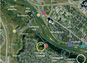
Trailhead: Location P1 is the Edworthy Park parking lot, adjacent to intersection of Bowness Road and Shaganappi Trail, NW Calgary. The park is a popular walking, biking and picnic area. The Wildwood Slide is best viewed across the Bow River from location P2 on Parkdale Boulevard between 34 St and 37 St adjacent to the Bow River pathway.
Distance: The trail to Douglas Fir Lookout, from P1, is 2.8 km return with about 70m elevation gain. It crosses the Boothman bridge to the south side of the Bow river then continues downstream, east, to the to the Douglas Fire lookout – watch for signage.
Bedrock of the Upper Scollard formation is located about 100 m downstream of the Boothman Bridge and comprises fluvial channels and mudstones deposited about 1.5 Ma after the K-T extinction event (ca. 64 Ma, magnetochron 28 r). This exposure is correlative to the Lower Porcupine Hills Fm of southern Alberta. It is stratigraphically above the Willow Creek Fm and below the Paskapoo Formation which is exposed at Canada Olympic Park. The strata consist of cross-bedded channel sandstones and interchannel siltstones and mudstones. The channels contain clay rip-up clasts and numerous well preserved fresh water bivalves.
The Bow River occupies a larger valley than contemporary flow rates would indicate. Glacial melting cycles during the Pleistocene (spanning the Ice Age of the last 2.5 million years), created much larger rivers that incised deep into the bedrock. At the bottom of the Bow Valley are gravelly deposits that date back to about 1 – 2.5 Ma. This ancestral valley was subsequently partly filled with glacial till, most likely from the last
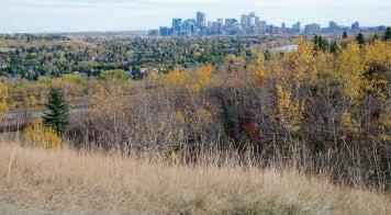
glacial episode between 25,000 and 13,000 years ago. The till is overlain by fine silts deposited in Glacial Lake Calgary which formed when melt waters from the Cordilleran Ice Sheet were blocked by the Laurentide Ice Sheet. The Laurentide Ice Sheet was centered on Hudson’s Bay. It is believed that the abrupt southward turn of the Bow River east of city centre is due to deflection of the Ice Age Bow River by a wall of ice marking the western limit of the Laurentide Ice Sheet. The boundary between the continental scale Cordilleran and Laurentide ice sheets is approximately marked by the Foothills Erratics Train. Meter-scale blocks of quartzite, sourced from the Cambrian Gog Group in the Jasper area, are found on Nose Hill and elsewhere in Calgary.
The modern day Bow River has cut through the till and glacial lake sediments leaving behind the terraces which can be seen from Douglas Fir Lookout. In the valley bottom are gravels dated at about 11,000 bp (Big Hill Formation), and are thought to be sourced from fluvial reworking of collapsed valley walls as the perma-frost thawed. Incision by the Bow River has left the steep slopes stretching from the Wildwood Cliffs to Canada Olympic Park. These cliffs served as Buffalo jumps with documented camps – hearth and butchered bison bones, dating as far back as 4600 years bp in Point MacKay. A spear point, discovered in point bar deposits at Point MacKay, dates to 8000 – 9000 bp, and is the oldest found in the Edworthy Park area to date.
The Wildwood slide (blue circle) is a slope instability caused by the presence of springs issuing from permeable sandstone lenses. First records of movement date to the 1920s and in 1956 twenty eight railway cars were derailed there due to slope debris caused by a cloudburst. Springs activity and slope movement accelerated with development of the Spruce Cliff and Wildwood communities in the 1950s and are attributed to watermain leakage and excessive lawn irrigation. Slope failure mechanisms vary from slope creep involving up to 12 m of unconsolidated cover, to surface sloughing, debris flows and occasionally rock falls when mudstones below sandstone layers are washed away. Immediately downstream, to the east and across from P2 (white circle) is a newly formed land slip and marked by a “drunken forest “with trees, some now dead, pointing it every direction except straight up. In winter numerous springs ice up across the pathway, in thicknesses that can exceed 1 m, and these often don’t thaw until early June.
The Edworthy area hosted quarries to provide building stone after the Great Fire of 1886, earning Calgary the moniker ‘Sandstone City.’ The quality of the sandstone left something to be desired: seasonal freeze thaw cycles and impurities (such as shale clasts) cause spalling and limited durability. Brick replaced sandstone early in the 20th century as the favoured building material due to lower cost and ease of construction.
Between 1905 and 1931 Brickburn, now within Edworthy Park, was the site of a terracotta brick factory. Quarries targeted the ‘shales’, actually lacustrine or abandoned channel fill clays, to manufacture brick (one is within the yellow circle on the map). The factory was fired with coal from the Bankhead mine in Banff. Some of the older brick buildings in the downtown core, and the first author’s house in Parkdale were sourced from Brickburn. Little is left of the small community and factory but you will see a railway station sign denoting Brickburn and a few hundred meters up the railway to the west you may find brick refuse piles in aspenshrub thickets with bricks stamped EHC, for Edward Henry Crandell, owner of the brickworks.
26 RESERVOIR ISSUE 11 • DECEMBER 2013 (Continued on page 28...)
At your option you may obtain a view of the city from atop the plateau west of the Edworthy coulee. Tipi rings found here are likely associated with the Buffalo Jump. The main walking paths are along the tree covered slope to the right of the image.
Upper fine-grained, cross-bedded unit
Middle medium-grained, channelized unit
Lower fine-grained, cross-bedded unit
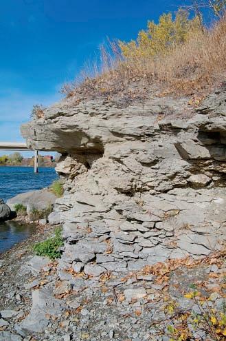
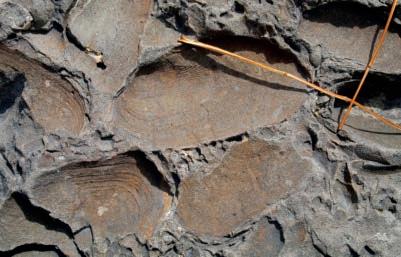
Light grey and tan to light orange shale rip up clasts. These form through cutbank collapse or as fragments of flood plain muds that are swept into the river.
Top Left: fine to medium grained lithic sandstone with cross-beds, rip up clasts and isolated log casts.
Top Right: close-up of the freshwater bivalve Unio. Notice the fine detail of preservation, growth lines are readily visible. Pine needles provide scale.

Below Left: View from P2 to ‘drunken forest’ located downstream of Wildwood slide. Since this photograph was taken in Sep 2010, this slide has advanced and exposes bedrock.
Bottom Left: Wildwood Slide with mediation in the form of slope coverings, stabilization structures and drainage pipes. Both can be best viewed from along the north side of the river between 37 and 34 St NW.
Geology of Bow
Below: View from Douglas Fir Lookout of post-glacial topography. Note the post-glacial alluvial fan that deflects the Bow River’s path.
 Above:
Valley in vicinity of Edworthy Park (image Courtesy of Terry Poulton).
Above:
Valley in vicinity of Edworthy Park (image Courtesy of Terry Poulton).
RESERVOIR ISSUE 11 • DECEMBER 2013 27
Foothills
Parkdale
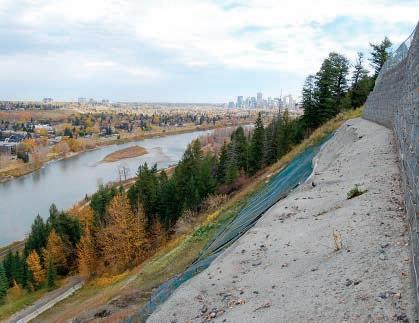
Top of Wildwood Slide: View from base of retaining wall along shotcrete cap.
Shotcrete is wet concrete applied at a high velocity through a hose onto a surface. The emplaced drainage pipes are designed to lower water pressure and reduce surface sloughing. The inset figure shows hydraulic excavation, slope failure and top of debris flow originating at detached pipes. The pictured erosion incident occurred months after this remediation work was completed. Photographed October 2010. This feature can be observed from across the river (purple dot) or from the walking trail. It’s location on the map is identified from the blue circle.
The Reservoir Committee welcomes contributions from our readership to this series. If you wish to offer a submission to Go Take a Hike on your favourite hike of geological interest, email the Reservoir at Emma.MacPherson@cspg.org for more information.
REFERENCES:
Ayrton, W.G. (Bill), 2003. The Building Rocks of Calgary Geological Walking Tour. Field Trip Guidebook from 2003 CSPG/CSEG Convention.
Lerbekmo, J.F. and Sweet, A.R., 2000. Magnetostratigraphy and biostratigraphy of the continental Paleocene in the Calgary area, southwestern Alberta. Bulletin of Canadian Petroleum Geology, v. 48, p. 285-306.
Edworthy Park Heritage Society, 1994. Early Days in Edworthy Park (http:// www.ourroots.ca/page.aspx?id=862174&&qryID0=cebf98f5-d8cc4053-be7d-a3c70860bbea).
Moran, S., 1986. Surficial Geology of the Calgary Urban Area. Alberta Research Council, Bulletin No. 83. http://www.ags.gov.ab.ca/publications/ abstracts/BUL_053.html.
Osborn, G., 2003. Urban Geology of Calgary. Field Trip Guidebook from 2003 CSPG/CSEG Convention.
Osborn, G. and Scott, C., 2002. Geology and Paleontology. In Treasures of the Trail: A Nature Guide to Edworthy Park, Lawrey Gardens and Douglas Fir Trail, p. 5-11. Editor G. Osborn. Published by Edworthy Park Heritage Society. Osborn, G., 1987. Geologic and Hydrologic Hazards in Calgary. In Geology of the Calgary area, Ed. L.E. Jackson and M.C. Wilson. Canadian Society of Petroleum Geologists, Chapter 11, p. 121-127.
Osborn, G. and Rajewicz, R., 1998. Urban Geology of Calgary. In Urban Geology of Canadian Cities, Editors P.F. Karrow and O.L. White. Geological Association of Canada Sp. Pap. 42, p. 93-115.
Poulton, T., Neumans, T, Osborn G., Edwards, D., Wozniak, P., 2002. Geoscape Calgary. GSC Misc Rpt #72. http://www.nrcan.gc.ca/sites/www.nrcan.gc.ca. earthsciences/files/pdf/calgary/pdf/geoscape_calgary_print_e.pdf.
Poulton, T., 2002. Geoscape Calgary Poster. Geological Survey of Canada Miscellaneous Report 72. Produced by Terry Poulton, Tracey Neumar, Gerald Osborn, Dixon Edwards, Paul Wozniak. http://www.nrcan.gc.ca/earth-sciences/ products-services/mapping-product/geoscape/calgary/6115.
Wilson, M.C., 1987. Geological history of the Bow River valley in the Calgary region, In Geology of the Calgary area, Ed. L.E. Jackson and M.C. Wilson. Canadian Society of Petroleum Geologists, Chapter 10, p. 109-120.
Wilson, M.C. and Hardy, K.J, 1987. The archeology of the Calgary area, Alberta. In Geology of the Calgary area, Ed. L.E. Jackson and M.C. Wilson. Canadian Society of Petroleum Geologists, Chapter 12, p. 129-142.
28 RESERVOIR ISSUE 11 • DECEMBER 2013 (...Continued
page 26) Canada’s Energy Geoscientists CALL FOR INSTRUCTORS The CSPG Continuing Education committee is looking for instructors interested in teaching a course or field trip in conjunction with the 2014 GeoConvention: Focus If you are interested please contact Kelsey Green at the CSPG office, 403-513-1225, kelsey.green@cspg.org
Hospital Crescent Heights Downtown
from
ROCK SHOP


RESERVOIR ISSUE 11 • DECEMBER 2013 29
*Domestic & International Supervision 906, 505 6 St. SW Calgary, AB T2P-1X5 Jocelyn Lampron, P. Geol. President & CEO Wellsite Geological Supervision *Conventional Wells-Heavy Oil/SAGD *Coal Bed Methane Wells www.hopewellpetroleum.com info@hopewellpetroleum.com section ph: 403.266.3132 cell: 403.818.8549 *On & Offshore Geological Supervision (The name that says it all!!!) Bus 403.234.7625 800, 555 - 4 th Avenue SW, Calgary, AB, T2P 3E7 info@WellsiteGeologists.com www.WellsiteGeologists.com • Domestic and International wellsite supervision • Conventional and Unconventional wells • Extensive Hz experience • Customized corporate solutions available (403) 250-3982 sales@clconsultants.ca www.clconsultants.ca 1602 – 5th St N.E. Calgary, AB. T2E 7W3 Phone: 403-233-7729 www.tihconsulting.com e-mail: tih@shaw.ca T.I.H. Consulting Ltd. Geologic Well-Site Supervision Opus Training Group 403 720-9810 www.opustraininggroup.com Geology Training for the Petroleum Industry Wellsite 101 Reach more than 3000 petroleum professionals who are empowered to purchase your product or service. ADVERTISE IN THE RESERVOIR Please call: Emma MacPherson Tel:403.513.1230 Email:emma.macpherson@cspg.org www.rpsgroup.com/energy (403)263-0449 17084 Global Leaders in Wellsite Geology Serving the petroleum industry for over 25 years ■■ Conventional Vertical / Horizontal Wells ■■ Unconventional Heavy Oil / CBM Wells ■■ International WSG / Operations Geology
CORPORATE SUPPORTERS
Apache Canada Ltd.
Apoterra Seismic Processing Ltd.
BDO Canada LLP
Birchcliff Energy Ltd.
BJV Exploration Partnership
Cabra Consulting Ltd.
Cabra Enterprises Ltd.
Casey & Associates
Canada Brokerlink Inc.
CL Consultants
Compass Directional Services
Continental Laboratories (1985) Ltd.
Core Laboratories
Core Laboratories Canada
Cougar Consultants, Inc.
Datalog Technology Inc.
EDGE Technologies
Energy Navigator
EV Cam Canada Inc.
Explor
Fekete
Geotir
GLJ Petroleum Consultants Ltd.
GranTierra Energy Inc.
Little Rock Document Services
Matrix Geoservices Ltd.
Matrix Solutions Inc.
McDaniel & Associates Consultants Ltd.
Mcleay Geological Consultants Ltd.
National Oilwell Varco
Nickpoint Environmental Services
Paradigm Geophysical (Canada) Corp.
Pason Systems Corp.
Pulse Seismic Inc.
Regent Resources
RIGSAT Communications
RPS Energy Canada Ltd.
SAExploration
Shea Nerland Calnan LLP
Sigma Explorations
Statcom Ltd.
Sproule Associates Limited
Sourcex
Total Gas Detection Ltd.
Tucker Energy Services Canada
Tucker Wireline Services Canada Inc.
AS OF NOVEMBER 10, 2013
CSPG
•
•
•
• One free pass to the CSPG Core Conference
…and more! Contact Kasandra Klein at kasandra.klein@cspg.org
to be a corporate member today!
50TH ANNUAL
Western Inter-University Geosciences Conference (WIUGC)
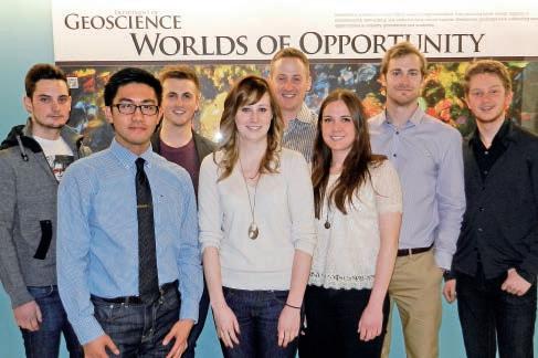
The University of Calgary’s Rundle Group and GUSS Club, along with Mount Royal University’s Joli Fou Club, are pleased to host the 50th Annual Western Inter-University Geosciences Conference (WIUGC). WIUGC is an annual student-run event that allows undergraduate and graduate students from across western Canada to present research, meet industry professionals, gain industry insights and explore future career opportunities. The conference will be held at the Hyatt Regency Hotel in downtown Calgary from January 2nd-4th, 2014.
WIUGC 2014 will include the opening night Rockbreaker event, an industry fair with our sponsoring companies and organizations as well as field trips to the Canmore Geoscience Museum, Tyrrell Museum and the AER Core Research Centre. Our Technical Talk Series will take place on Saturday, January 4th along with a poster session as well as the first ever WIUGC Challenge
Bowl regional qualifier. We will close the conference with a wrap-up Banquet and awards ceremony, where the best research presentations of the conference will be awarded with scholarships from the CSPG (Best Petroleum Geology Talk), CSEG (Best Geophysical Talk) and Imperial Oil (Best Overall Talk).
To commemorate this special anniversary, we would like to extend an invitation to the Rockbreaker event to industry members and geoscience graduates who have attended the WIUGC conference over the last 50 years. The Rockbreaker will take place at the Palomino Smokehouse on 7th Ave, across from the Hyatt Regency Hotel, on Thursday, January 2nd at 7:00pm.
To learn more about the WIUGC 2014 conference or for sponsorship and registration information, please visit our website at www.wiugc2014.com.
our 2013
benefits
being a corporate member
welcomes
Corporate Supporters! The
of
include:
Recognition in the monthly Reservoir and quarterly Bulletin
One associate membership
Reserved tables at the technical luncheons
your company logo
with
30 RESERVOIR ISSUE 11 • DECEMBER 2013
Back Row (L-R): Matt Torriero, Jordan Domin, Dennis Ellison, Zac Colbran, Matt Lennon. Front Row (L-R): Maverick Rae Cue, Micaela MacDonald, Adrienne McDougall. Not Pictured: Victor Hoang, Hussein Hassanali, Mike Ostrzenski.
Using the Old to Create the New Geoscience uncovers and
innovates
Nowhere in the APEGA Code of Ethics do the words “innovation” or “innovate” appear. Yet, Professional Geoscientists are deeply involved with the process of acquiring and applying new data and information about places and materials that no one else has discovered. Often, new data are a reinterpretation of old data that were collected for different purposes during different times.
Learning leads to innovation by developing new and improved methods of doing old things. Reinterpreting data is key to innovation, which serves the public interest, a concept at the heart of the fifth Rule of Conduct under APEGA’s Code of Ethics. When combined with old data, information derived from new methods may detect previously overlooked resources. These resources create new wealth for Albertans.
Geoscience professionals must perpetually improve and expand their knowledge and skills within their chosen scopes of practice. Courses offered by APEGA and geoscience technical societies can be useful tools in improving how we do things. All it takes is a thoughtfully developed professional development plan. Have you evaluated yours recently?
For more information: Tom Sneddon, P.Geol.
Director of Geoscience and Outreach
P: 403-262-7714 or 888-262-3688
E: tsneddon@apega.ca


in Geoscience
Professionals
www.apega.ca


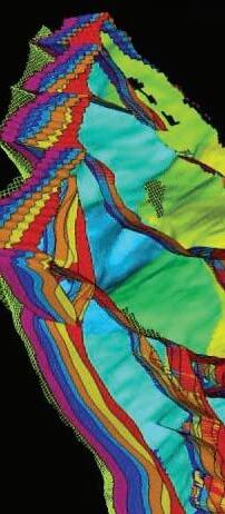


Blueback Reservoir the preferred and chosen GeoScience Solutions Partner Try something new. Find something better. Blueback Rock Physics plug-in for Petrel* Bridging the gap between geology and geophysics The complete suite of rock physics tools for quantitative interpretation across multiple domains within Petrel. Blueback Reservoir blueback-reservoir.com E sales@blueback-reservoir.com | T +1 403 538 4821 blueback-reservoir.com/rockphysics *Mark of Schlumberger 13000 Vol shl=0.2 Reservoir Properties Seismic
Wells Petrel
