There’s a Reason Why “Everyone Is Using AccuMap®.”
“Whether it’s cross-sections in AccuLogs, queries and search, or production show maps, AccuMap consistently delivers the quality data I need, when I need it. Its reputation as an industry leader is well deserved.”
John Wittnebel Result Energy Inc., VP Exploration

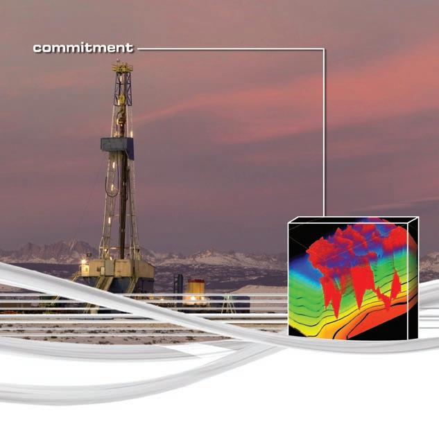
Strong words. But no newsflash. AccuMap is the premier oil and gas mapping, and data management and analysis tool on the market. Canada ’s most comprehensive dataset – nearly 50 years worth – means faster access to more accurate data. Translation? Quicker data review, enhanced workflow, better decision-making and increased profitability. And it keeps evolving.
For decades now, AccuMap’s been turning data in dollars for you. Which is why so many oil and gas pros like John have it on their desktops.
Visit www.ihs.com/accumapconnect to find out about the Well Holding and Spacing module now available in AccuMap.


CSPG OFFICE
#600, 640 - 8th Avenue SW
Calgary, Alberta, Canada T2P 1G7
Tel: 403-264-5610 Fax: 403-264-5898
Web: www.cspg.org
Office hours: Monday to Friday, 8:30am to 4:00pm
Interim Executive Director: Lis Bjeld
Email: lis.bjeld@cspg.org
Communications & Public Affairs: Heather Tyminski
Email: heather.tyminski@cspg.org
Corporate Relations Coordinator: Alyssa Middleton
Email: alyssa.middleton@cspg.org
Membership Services: Dayna Rhoads
Email: dayna.rhoads@cspg.org
Reception: Kasandra Klein
Email: reception@cspg.org
Joint Annual Convention Committee
Convention Manager: Shauna Carson
Email: scarson@geoconvention.org
Convention Coordinator: Tanya Santry
Email: tsantry@geoconvention.org
EDITORS/AUTHORS
Please submit RESERVOIR articles to the CSPG office. Submission deadline is the 23rd day of the month, two months prior to issue date. (e.g., January 23 for the March issue).
To publish an article, the CSPG requires digital copies of the document. Text should be in Microsoft Word format and illustrations should be in TIFF format at 300 dpi., at final size. For additional information on manuscript preparation, refer to the Guidelines for Authors published in the CSPG Bulletin or contact the editor.
Technical Editors
Ben McKenzie Colin Yeo (Assistant Tech. Editor) Tarheel Exploration EnCana Corporation Tel: 403-277-4496 Tel: 403-645-7724
Email: bjmck@telusplanet.net Email: colin.yeo@encana.com
Coordinating Editor
Heather Tyminski
Comunications and Public Affairs, CSPG Tel: 403-513-1227, Email: heather.tyminski@cspg.org
ADVERTISING
Advertising inquiries should be directed to Alyssa Middleton, Tel: 403-513-1233, email: alyssa.middleton@cspg.org. The deadline to reserve advertising space is the 23rd day of the month, two months prior to issue date.
The RESERVOIR is published 11 times per year by the Canadian Society of Petroleum Geologists. This includes a combined issue for the months of July and August. The purpose of the RESERVOIR is to publicize the Society’s many activities and to promote the geosciences. We look for both technical and non-technical material to publish. The RESERVOIR is not intended to be a formal, peer-reviewed publication. Additional information on the RESERVOIR’s guidelines can be found in the May 2008 issue (p.46-48; available at http://www.cspg.org/publications/reservoir/reservoir-archive-2008.cfm).
No official endorsement or sponsorship by the CSPG is implied for any advertisement, insert, or article that appears in the Reservoir unless otherwise noted. The contents of this publication may not be reproduced either in part or in full without the consent of the publisher.
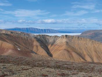
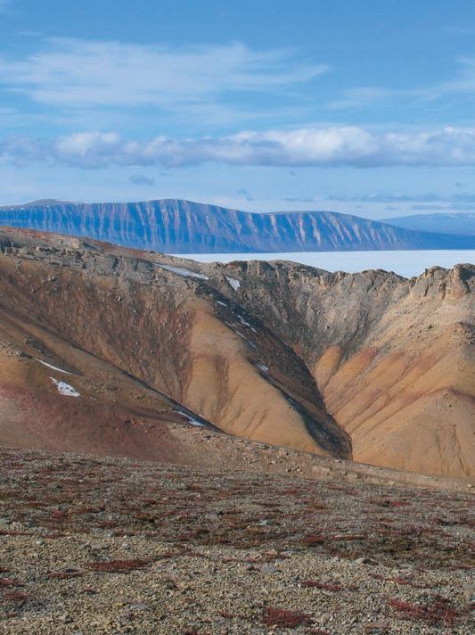
FRONT COVER Canyon Fiord, Ellesmere Island, Nunavut. Permian-Triassic boundary in the Sverdrup Basin, Canadian High Arctic. Photo by Stephen Grasby.
Targeted Solutions
CGGVeritas is committed to targeted geophysical solutions that fit your local needs. Wherever you’re working, you have access to leading seismic imaging technologies, the highest quality 3D and 2D data library, the most advanced acquisition capabilities and a staff committed to your success.
Count on CGGVeritas to help you explore, develop and produce with confidence.
Contact:
CSPG EXECUTIVE

President Graeme Bloy bloy@telus.net
Vice President
John Varsek • EnCana Corporation john.varsek@encana.com Tel: (403) 645-2000
Past President
Lisa Griffith • Griffith Geoconsulting lgriffith@griffithgeoconsulting.com Tel: (403) 669-7494
Finance director
David Garner • Chevron Canada Resources davidgarner@chevron.com Tel: (403) 234-5875
assistant Finance director
Greg Lynch • Shell Canada Ltd. greg.lynch@shell.com Tel: (403) 691-3111
Program director
Randy Rice • Suncor Energy Inc. rjrice@suncor.com Tel: (403) 205-6723
assistant Program director
Scott Leroux • EnCana Corporation scott.leroux@EnCana.com Tel: (403) 645-2000
serVices director
Ayaz Gulamhussein • NuVista Energy Ltd. ayaz.gulamhussein@nuvistaenergy.com Tel: (403) 538-8510
assistant serVice director
Penny Colton • Geophysical Service Inc. pcolton@geophysicalservice.com Tel: (403) 514-6267
outreach director
Mike DesRoches • DesRoches Consulting Inc. mdesroch@shaw.ca Tel: (403) 828-0210
communications director
Peggy Hodgkins • CGGVeritas peggy.hodgkins@cggveritas.com Tel: (403) 266-3225
EXECUTIVE COMMENT
A message from the Communications Director, Peggy Hodgkins

How do you receive information about CSPG’s luncheons, division talks, membership, special events, or technical papers:
...the Bulletin of Canadian Petroleum Geology, the Reservoir, the eNewsletter, or the website? CSPG’s Communications Committee aims to disseminate important geoscience news, both technical and social, to our members and today we have a variety of tools to make it more effective and efficient.

March 1972 September 2008
Communication within CSPG has greatly evolved since the inaugural issue of the Bulletin appeared in 1927 as the first official publication of the Society. The Bulletin is, and always has been, a place where great thoughts reside. Its format and mandate as a peer-reviewed journal has not changed in the last 80 years or so. A second vehicle for disseminating geoscience information within CSPG began in 1974 with the advent of the Reservoir. At that time, this six-to eight-page magazine provided editorials, executive reports, informed members of technical talks and upcoming events, and introduced new members to the Society.
The Reservoir you are looking at today bears little resemblance to that of the 1980s and 90s. In addition to the change in the physical layout of the publication, the Reservoir has evolved into a magazine which serves to inform, educate, and entertain our members. Much of this expansion (it is now over 40 pages) is due to the inclusion of technical articles. The Reservoir does not aim to supplant from the Bulletin, but since it is a more concise and frequent publication, it is possible for researchers and companies to share their knowledge more easily and quickly.
A very popular addition to the Reservoir is the technical article series, which spans many issues and covers a wide range of topics from geophysics to completions engineering. While these series are a broad-brush approach to

January 1974 January 2009
the various subjects, they serve as a reference to members, especially junior members, by simplifying common technical issues in the workplace. We hope to increase our diversity of topics so that our readers are made aware of all the different technologies and processes that are involved in today’s petroleum industry. Despite the electronic environment we live in today, the Reservoir will continue to be printed in hard copy. Members have told us that they really like the concise technical articles and enjoy picking up the Reservoir, reading an article, and putting it down with the intention of picking it up again when they have a few minutes. If the Reservoir were in an electronic form only, this convenience would be lost.
The Geological Calendar first began in 1978. This calendar includes 12 full-page geologic photographs, reminders of CSPG events, and listings of various geosciences community events in Canada and the United States. Members receive a copy of this publication at no additional cost to their membership and are able to download the images from the website as desktop wallpaper. The Calendar Committee accepts geologic photos from all over the world, but encourages the submission of Canadian photos, especially non-Rockies photos, to ensure geographical representation from across Canada.
Communications today has been greatly enhanced by the internet. Both CSPG’s website and the eNewsletter enable fast and efficient communication between CSPG and its members. The eNewsletter began in February, 2005 and serves a purpose somewhat like the original Reservoir of 1974 did: It is a reminder of upcoming events, deadlines, and happenings in the Society.
(Continued on page 7...)

Proudly
brought to you by Professionals in Geoscience
and Engineering
Alberta’s Professional Geoscientists and Engineers provide Albertans with many of the essentials of daily living. The work that they do allows all of us to enjoy warmth, light, power, water and the ability to travel and communicate over distance.
Since 1920, Members of APEGGA, The Association of Professional Engineers, Geologists and Geophysicists of Alberta, have made a difference in the daily lives of millions of Albertans by bringing science and innovation to life.
The P.Geol., P.Geoph., P.Eng., and R.P.T. professional designations represent the highest standards of quality, professionalism and ethics in geoscience and engineering. APEGGA Members can take pride in the role they play and the contribution they make to Alberta.
APEGGA and its more than 53,000 Members are committed to public safety and well-being through the self-regulation of the geoscience and engineering professions in Alberta.
Visit www.apegga.org for more information.
Geologists Geophysicists Engineers
CORPORATE MEMBERS
APACHE CANADA LTD.
BAKER ATLAS
CoNoCoPHILLIPS CANADA LIMITED
DEvoN CANADA CoRPoRATIoN
ENERPLUS RESoURCES TRUST
geoLoGIC systems Ltd.
HUNT oIL CoMPANy oF CANADA,
HUSKy ENERGy INC.
IHS
IMPERIAL oIL RESoURCES
LARIo oIL & GAS CoMPANy
LITTLE RoCK DoCUMENT SERvICES
MJ SySTEMS
MURPHy oIL CoMPANy
NEXEN INC.
PETRo-CANADA oIL AND GAS
PETRoCRAFT PRoDUCTS LTD.
PRovIDENT ENERGy LTD
RPS ENERGy CANADA LTD.
SHELL CANADA LIMITED
SPRoULE ASSoCIATES LIMITED
SUNCoR ENERGy INC
TALISMAN ENERGy INC
TECK CoMINCo LIMITED
ToTAL E&P CANADA LIMITED
ToURMALINE oIL CoRP.
AS OF JANUARY 29, 2009
(...Continued from page 5)
The current CSPG website, launched in January, 2006, is a tool to access all facets of the Society, including:
• Archives of the Bulletin and Reservoir,
• Technical Luncheon Webcasts,
• Membership renewals,
• Luncheon ticket purchases,
• CSPG Publications Index,
• Publications and Bookstore inventory, and
• Convention registration.
Among the top sites visited on the website are the Publications Index page, the Geological Calendar wallpaper page, and member
directory lookup. As of September 2008, Technical Luncheon tickets can be purchased online, which is a fast and easy way to get them. We are looking at adding webcasts of division lunch talks and an interactive online version of the WCSB Geological Atlas. The website will continue to expand and improve to become a central “portal” through which all areas of CSPG can be accessed.
As always, we welcome members’ comments about how the Communications area of CSPG is working. What would you like to see in the Reservoir or on the Website? How do you see the communications of tomorrow? Let us know.


Register today for the 2009 AAPG Annual Convention & Exhibition.

The ACE Technical Program is unmatched with more than 1,000 technical presentations, 22 field trips and 18 short courses.
Head to Denver where you’ll find a wide range of presentations providing valuable information for your job, including:
• tight-gas sandstones
• sedimentology of shale and reservoir development
• 3-D interaction of tectonics and sedimentation
• external controls on the shaping of deep-water margins and systems: influences on reservoir development
• emerging global deep-water plays
• petroleum systems analysis basins around the world
• gas shale reservoirs

A passion for the West lives on. Ar e you in?
technicaL Luncheons MARCH LuNCHEON
New petroleum reservoir modeling techniques improve
field management and optimize recovery
SPEAKER
Marjorie Levy
Chevron Energy Technology Company
AAPG Distinguished Lecturer
11:30 am tuesday, m arch 10, 2009 telus convention centre c algary, a lberta

Please note:
the cut-off date for ticket sales is 1:00 pm, thursday, march 5, 2009. csPg member ticket Price: $38.00 + gst. non- member ticket Price: $45.00 + gst
Due to the recent popularity of talks, we strongly suggest purchasing tickets early, as we cannot guarantee seats will be available on the cut-off date.
Did you know that you can book a table for the Technical Luncheons? To book your table, or to buy individual tickets, visit www.cspg.org or call CSPG’s office at (403) 264-5610.
Because of the extremely high cost of developing a subsurface reservoir, commonly a billion dollars or more, it is critical to understand the volumes of hydrocarbon that are present within the reservoir and the amount that can be recovered. Each well is expensive, so we must make the most of the information collected from each well to constrain the uncertainty surrounding the architecture of the reservoir, its extent, and its internal heterogeneities, as well as the impact on recoverability. We approach this by constructing a geocellular model of the hydrocarbon accumulation that incorporates a reasonable range of possible reservoir characteristics, and then simulate the flow of fluids – hydrocarbons and water – throughout the life of the field. The results from any reservoir simulation are strongly dependent on the accuracy of the underlying geologic models. Until recently, it has not always been possible to build geocellular models that accurately portray the subsurface geology.
over the past several years, Chevron has developed a new geolog-based modeling workflow, which combines Multiple Point Statistics (MPS) and Facies Distribution Modeling (FDM) to generate a 3D geologically robust geocellular reservoir model. MPS is an innovative depositional facies modeling technique, developed by Chevron in collaboration with Stanford University, which incorporates 3D geological concepts in training images that more accurately integrate geological information into reservoir models. Training images allow MPS to retain complex spatial relationships among multiple facies and to model non-linear shapes such as sinuous channels or irregular bar forms that conventional variogrambased modeling techniques typically fail to reproduce. In addition, because MPS is pixelbased, not object-based, MPS models can be constrained by very large numbers of wells. FDM is a novel technique that is used to

generate a facies probability cube to better constrain the facies spatial distribution in geostatistical models.
The MPS/FDM workflow described above is preferred to variogram-based and objectbased techniques to model important Chevron assets in both shallow-water and deep-water clastic reservoirs, and more recently, in carbonate reservoirs. Additionally, this workflow has been used in synthetic studies to explore the potential impact of architectural and textural parameters on flow behavior. Using experimental design methods, it is possible to determine the relative impact on production of a variety of field parameters. With this information, one can focus on better understanding the key subsurface parameters and gather new data to reduce their uncertainty. This work flow enables field management by lowering risk and optimizing production.
BIOGRAPHY
In 1999, Marjorie Levy joined Chevron Energy Technology Company, where she is now a Senior Staff Research Geologist with Chevron Energy Technology Company. She received her M.A. in 1986 and in 1991 her Ph.D., both from LamontDoherty Geological Observatory of Columbia University. From 1984 to 1991 she was a Faculty Fellow at Lamont-Doherty Geological Observatory of Columbia University, and from 1991 to 1999 she was a Research Geologist with Chevron Petroleum Technology Company. Levy has been a Senior Staff Research Geologist with Chevron Energy Technology Company since 1999.
Levy has authored and co-authored papers and presentations on geocellular modeling, reservoir characterization, and subsurface flow. Professional memberships include American Association of Petroleum Geologists and European Association of Geoscientists and Engineers. Professional interests include stratigraphic architecture with particular interest in using it to constrain geocellular reservoir models and evaluate its impact on fluid flow response.
technicaL Luncheons MARCH LuNCHEON
Controls on sedimentology and geomorphology of Holocene isolated, shallow, tropical carbonate platforms: Bahamas and beyond
SPEAKER
Gene Rankey
University of Kansas
AAPG Distinguished Lecturer
11:30 am tuesday, m arch 24, 2009 telus convention centre c algary, a lberta
Please note: the cut-off date for ticket sales is 1:00 pm, thursday, march 19, 2009. csPg member ticket Price: $38.00 + gst. non- member ticket Price: $45.00 + gst.
Due to the recent popularity of talks, we strongly suggest purchasing tickets early, as we cannot guarantee seats will be available on the cut-off date.
Did you know that you can book a table for the Technical Luncheons? To book your table, or to buy individual tickets, visit www.cspg.org or call CSPG’s office at (403) 264-5610.
Isolated carbonate platforms are the archive of much of geologic history. Similarly, in many cases, they host large hydrocarbon reservoirs (e.g., Miocene of southeast Asia, Devonian-Carboniferous of Caspian Basin). Although we understand the general factors influencing the stratigraphic evolution of isolated platforms, factors controlling platform-scale geomorphic and sedimentologic details within individual timeslices are less well constrained. The purpose of this talk is to systematically explore controls on facies patterns of Holocene platforms from a ‘process-response’ spectrum, based on field, remote sensing,
and lab observations of several Holocene isolated platforms in the Caribbean and Pacific oceans. The results provide testable conceptual models that might be used to predict stratal architecture and potential reservoir quality in subsurface analogs.
To begin to develop these predictive models, this study compares geomorphic and sedimentologic patterns on platforms across a ‘process-response’ spectrum. Sedimentologic and geomorphic comparison of Caribbean (Great Bahama, Crooked-Acklins, Caicos) and Pacific (Aitutaki, Maupiti, Nonouti) shallow-water (<25 m) platforms from settings with a range of island and reef-rim configuration, tidal amplitude, and significant wave height reveals several themes:
1) Neither an open windward margin nor currents driven by strong winds are fundamental controls on the occurrence of grainy platform interiors;
2) Tide-dominated platforms commonly have broader, more gradational lateral facies changes normal to platform margins; wavedominated platforms have more abrupt facies boundaries related to dissipation of wave energy at the margins;
3) Well developed reefs and reef aprons are likely on margins facing open-ocean swell, which may or may not be coincident with windward margins;
4) on individual platforms, and between platforms, grain size, sorting, and type are not strongly correlated with water depth, but are related instead to hydrodynamics (wave and tide energy) and setting (e.g., proximity to shelf margin); and
5) Although an open windward margin or currents driven by strong winds may indeed facilitate removal of muds, their absence does not dictate that a muddy platform interior is present.
These results from Holocene analogs illustrate and quantify the importance of waves, tides, and currents on platformscale facies patterns. As such, they provide conceptual facies models for understanding field and inter-well facies variability, and can aid in developing more robust geologic models of reservoirs in isolated carbonate platforms.
BIOGRAPHY
Gene Rankey is an Assistant Professor of Geology at the University of Kansas. He

received his B.Sc. in 1991 from Augustana College, Illinois, M.Sc. in 1993 from the University of Tennessee, and Ph.D. in 1996 from the University of Kansas. From 1996 to 2000 he was with ExxonMobil Upstream Research. From 2000 to 2002 he was at Iowa State University and from 2002 to 2008 at the University of Miami.
Rankey has authored and co-authored numerous papers on ooid shoals, shallow shelf carbonate facies, and geomorphic changes on carbonate tidal flats. Gene Rankey was awarded with the Outstanding Paper Award from the Journal of Sedimentary Research in 2002.

technicaL Luncheons APRIL
A Sedimentologist’s view of Mars
SPEAKER
Charlotte Schreiber
University of Washington
11:30 am
tuesday, a pril 14, 2009 telus convention centre calgary, alberta
Please note: the cut-off date for ticket sales is 1:00 pm, Wednesday, april 8, 2009. csPg member ticket Price: $38.00 + gst. non- member ticket Price: $45.00 + gst.
Due to the recent popularity of talks, we strongly suggest purchasing tickets early, as we cannot guarantee seats will be available on the cut-off date.
Did you know that you can book a table for the Technical Luncheons? To book your table, or to

buy individual tickets, visit www.cspg.org or call CSPG’s office at (403) 264-5610.
Mars is an “Earth-type” planet – composed of materials of similar composition to those of Earth, having an atmosphere (mostly Co 2 ) with winds and storms and experiencing
marked diurnal and seasonal temperature fluctuations. Moreover, on the surface there are sands (of several different mineralogies) and evidence there is movement of these sands, forming very recognizable dunes. The presence of both calcium and magnesium sulfate deposits is widespread in many areas, as well as iron oxides, phyllosilicates, and a small amount of calcite. Thus, it is reasonable for a sedimentologist to consider Martian depositional development and possible Earth analogs. Further, it is a wonderful place to imagine resultant stratigraphy and even major structural processes, but without setting foot on the planet.
Considered in this presentation will be some sedimentary features, their earthly equivalents, and how they may fit into the morphology we see on the present Martian surface. various sedimentary processes apparently were very important earlier in Martian geological history but are not as important in the modern environment. Although we are quite certain there is not and was not any ongoing plate tectonic activity, some of these early deposits also controlled later major structural features. Based on the degree of impact cratering, as an indicator of age, it is evident that some features developed quite early in the evolution of Mars but that in many areas there is indication of ongoing geological activity. Modern deposition is also noted, so that we can say Mars is not a geological relic but continues to evidence ongoing activity, with many processes similar to those seen on Earth.
BIOGRAPHY
Charlotte Schreiber is presently an Affiliate Professor of Geology at University of Washington (Seattle), teaching sedimentary petrology. First studying deep-sea sediments and their physical properties, and then working on the first cores from the Deep Sea Drilling Project (Leg 13) in the Mediterranean she became intrigued with the formation and physical characteristics of evaporites. With that in mind, her thesis was carried out on the evaporites of the late Miocene in the Mediterranean (1974).
Continuing with studies in Sicily, Spain, and Cyprus and in the late Silurian of the Michigan Basin, she has been able to create reasonable models for earth-type evaporite accumulations. At the present time, ongoing examination of additional Mediterranean evaporite deposits, plus several projects examining Martian sediments and structures, have generated an active pursuit in new fields of endeavor.
Do more


exploring collaborating


project leading technology leading industry leading subsurface subsea subanywhere smiling geosteering globe-trekking horizontal drilling ecothinking biking groundbreaking digital mapping remote sensing carbon capturing challenging yourself discovering rock sampling rock climbing relaxing on the weekends playing creative thinking stress reducing parenting mud logging well logging caring for our environment life balancing family bonding skiing hockey playing initiative grabbing pushing the envelope


technicaL Luncheons APRIL LuNCHEON
Great steps in the history of life: the origin of limbed vertebrates
SPEAKER
Dr. Ted Daeschler Academy of Natural Sciences, Philadelphia
11:30 am monday, april 27, 2009 telus convention centre calgary, alberta
Please note: the cut-off date for ticket sales is 1:00 pm, Wednesday, april 22, 2009. csPg member ticket Price: $38.00 + gst. non- member ticket Price: $45.00 + gst.
Due to the recent popularity of talks, we strongly suggest purchasing tickets early, as we cannot guarantee seats will be available on the cut-off date.
Did you know that you can book a table for the Technical Luncheons? To book your table, or to buy individual tickets, visit www.cspg.org or call CSPG’s office at (403) 264-5610.
Research on the origin of limbed vertebrates
(tetrapods) has made great advances in recent decades as a result of paleontological discoveries including important new material from Devonian clastic rocks of Ellesmere Island, Nunavut. The fishtetrapod transition, as it is traditionally called, is no longer an evolutionary leap between free-swimming, lobe-finned fish and lumbering early tetrapods. A series of fossil intermediates now illustrate the sequence of changes over million of years in the transformation from finned to limbed members of the tetrapod stem lineage. The interpretation of geological data and the range of fossils associated
with the transition have also refined our understanding of the environmental settings that were the crucible of early tetrapod evolution.
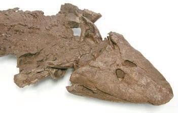
The recent discovery and description of Tiktaalik roseae from within the type section of the Fram Formation ( o kse Bay Group; Frasnian) on southern Ellesmere Island provides a particularly good example of a transitional taxon that helps to resolve the sequence of morphological change between finned and limbed forms. With a phylogenetic position as the sister group of limbed forms, T. roseae retains numerous primitive features of the lower jaw, braincase, branchial skeleton, and scale cover, while also showing derived features in the skull roof, palate, and fin endoskeleton. As indicated by the depositional setting and suite of morphological features, T. roseae may have been exploiting new ecological opportunities that were developing in shallow aquatic ecosystems on Late Devonian floodplains.
BIOGRAPHY
Dr. Ted Daeschler has been at the Academy of Natural Sciences in Philadelphia since 1987. He studied geology at Franklin and Marshall College in Lancaster, Pennsylvania, and received a Master’s in paleontology at the University of California at Berkeley in 1985. He was awarded his Ph.D. at the University of Pennsylvania in 1998.
Daeschler’s research interests are centered on Late Devonian-age vertebrate fossils and the origin of limbed vertebrates. His fieldwork in Devonian-age rocks in Pennsylvania and the Canadian Arctic and has led to a series of discoveries establishing the research program as one of the most productive in the world. Daeschler’s responsibilities at the Academy of Natural Sciences focus primarily on research, collections building, and on public programs within the museum. He served as a scientific advisor for the renovation of the Academy’s Dinosaur Hall, and a variety of other paleontological exhibits. Daeschler’s work is a reflection of the rich history of vertebrate paleontology at the Academy of Natural Sciences, both in research and in public education.
Tiktaalik roseae from the Fram Formation (Okse Bay Group; Middle to Upper Devonian) of Ellesmere Island, Nunavut. This species is an excellent intermediate form in the transition from lobe-finned fish to the earliest limbed animals.
Do more


exploring collaborating
project leading technology leading industry leading subsurface subsea subanywhere smiling geosteering globe-trekking horizontal drilling ecothinking biking team building carbon capturing pushing the envelope groundbreaking digital mapping remote sensing playing creative thinking stress reducing parenting

rock sampling rock climbing relaxing on the weekends mud logging well logging caring for our environment life balancing family bonding skiing hockey playing initiative grabbing challenging yourself


Geometry and kinematics of a triangle zone in the Central Alberta Foothills
SPEAKER
Josgre Salazar
Geoscience Department
University of Calgary
12:00 noon
thursday, march 5, 2009 room LPW-910, Livingston Place West 250 2 st sW, calgary, alberta
A triangle zone consists of a blind tectonic wedge composed of a series of forelandverging duplexes underthrusting a hinterlandverging upper block, which has been passively uplifted at the front of a thrust belt. Typically this zone is the boundary between the Foothills and the Plains of a foreland thrust and fold belt. Gordy in 1977 introduced the
term triangle zone to describe a structure characteristic of the foothills area of the Canadian Cordillera. Since that time, several models have been proposed to explain the geometry and kinematics of the Alberta triangle zone. The internal geometry of the Alberta triangle zone varies along the strike direction resulting in the formation of complex structures. Previous work has shown that changes in structural geometry comprise both pop-up structures found in Grande Cache and Sundre duplex structures dipping to the hinterland in Grease Creek and Pincher Creek and antiformal stack structures in the Stoney and Turner valley areas.
In this presentation, preliminary results of an integrated structural interpretation of a triangle zone in the central Alberta Foothills will be shown. A data set comprising threedimensional seismic data, well logs, and surface geology has been interpreted and integrated.
We have interpreted a triangle zone composed of three tectonic blocks: upper, middle, and lower. The middle and lower blocks consist of northeast-verging duplexes and an antiformal stack, part of which crops out at the surface. The southwest-verging upper


block has been passively uplifted and folded as the underlying blocks advanced toward the foreland. Bedding-parallel detachment faults separate the blocks such that the middle block consists of Cretaceous strata and the lower block consists primarily of TriassicJurassic strata. A piggyback sequence of deformation appears to have occurred in the area, with the middle block of Cretaceous strata deforming first and then deforming further in conjunction with the underlying block. Both blocks contain blind duplexes and pop-up structures. Some of the pop-ups in the lower block of Triassic-Jurassic strata may have initiated as detachment folds that were later breached by thrusts.
Three widespread bedding-parallel detachment surfaces in the Wapiabi, Blackstone, and Fernie shales have been interpreted to be the boundaries between the tectonic blocks. They acted as glide horizons allowing slip transfer to the foreland; ramps branching from them transferred displacement to higher stratigraphic and structural levels. The upper detachment is a continuous southwest-verging backthrust (the Pedley Fault) that is a major structural element at the surface. Several other backthrusts have been interpreted; they die out laterally into only a few backthrusts, indicating a transfer zone.
FORMATION INTERPRETATION
our interpretation indicates changes in the geometries of folds, pop-ups, and thrust faults along strike, suggesting the presence of oblique or lateral ramps thrusts appear in an en échelon fashion, dying out laterally and gradually transmitting slip to the adjacent thrust. Partial restorations by line length balance have been carried out over diporiented seismic lines, resulting in shortening of 11-14% for the middle block and 8 -11% for the lower block.
BIOGRAPHY
Josgre Salazar is currently a Ph.D. student at the University of Calgary, studying under Drs. Spratt and Lawton. He has over ten years of experience as a geophysicist in Venezuela and Mexico and completed his Master’s in Geology at the University of South Carolina.
INFORMATION
Talks are free; please bring your lunch. Goodies and drinks are provided by HEF Petrophysical Consulting. If you would like to be on the Structural Division e-mail list, or if you’d like to give a talk, please contact either William (Jamie) Jamison, The Upper Crust Inc., (403) 816-1818, wjamison@shaw.ca or Darcie Greggs, Shell Canada Limited, (403) 691-3111, darcie. greggs@shell.com.

diVision taLKs GEOFLuIDS DIVISION
Dating
petroleum charge and reservoir residence times: the final frontier in petroleum geochemistry?
SPEAKER
Steve Larter
Petroleum Reservoir Group University of Calgary
4:00 pm thursday, march 12, 2009
mulligan room
James Joyce irish Pub and restaurant 114 – 8 avenue sW, calgary, alberta
The dating of earth processes has been a central and pivotal achievement of the geosciences without which our understanding of the earth would have been a shadow of our current level of knowledge. While timing of petroleum generation can be reasonably well estimated using basin models we do have not practical tools for assessing when petroleum first arrived at a trap or how long a given petroleum mass has resided in a given trap. This is surprising given the long time we have been studying petroleum systems and this crucial information is probably the most important single parameter in assessing petroleum systems in both an exploration and production context.
Steve Larter will briefly review possible options for dating petroleum residence and charge times and an open discussion will ensue where attendees are encouraged to bring and present their own ideas in a pub-like atmosphere of open discourse and alkanolic relaxation.
BIOGRAPHY
Steve Larter is the Canada Research Chair in Petroleum Geology at the Department of Geosciences at the University of Calgary in Canada, the J.B. Simpson Chair of Geology at the University of Newcastle upon Tyne (UK), and a PI of the Alberta Ingenuity Centre for In-situ Energy. He is interested in the origin and clean production of heavy oils and oil sand bitumen and in technologies for reduced- or zero-carbon emission recovery of fossil fuel energy. His current research interests include the nature of the deep biospheres of Earth and Mars and dating of petroleum reservoir charge.
I NFORMATION
The division talks are free and everyone is welcome to attend. If you would like to suggest a technical topic or present a talk to the division, please contact the Division Chair, Jennifer Adams, University of Calgary, at (403) 220-3258 or via e-mail at adamsjj@ ucalgary.ca.
May
4-8,
2009 CSPG CSEG CWLS CONVENTION
Roundup Centre & ERCB Core Research Centre, Calgary, Alberta
The 2009 CSPG CSEG CWLS Convention Committee needs VOLUNTEERS to assist with the many exciting functions, events, and operations prior to and during the main event
STUDENTS who volunteer a minimum of eight hours will have their registration fee refunded.
SIGN-UP as a volunteer by April 17, 2009.
For more information on the Convention and to sign up on-line visit: www.GEOconvention.org
See you at the Convention!
Lyndsey Nicholas, Absolute Imaging Volunteer Chair

diVision taLKs PALAEONTOLOGY DIVISION
PALEO 2009: Annual Palaeontology Symposium
Presented in conjunction with CSPG’s Paleontology Division, Alberta Palaeontological Society (APS), and Mount Royal College Earth Sciences Department
L ECTURES AND POSTER DISPLAYS
Saturday, March 14, 2009
9:00 am – 5:00 pm
WORKSHOPS
Sunday, March 15, 2009
9:00 am – 4:00 pm
Mount Royal College 4825 Richard Road S.W. Calgary, Alberta
Saturday lecture events and poster viewings are free and require no registration. on that day there will be fossil displays and experts on hand to identify any fossils you might have. Families and general public are welcome. Sunday activities restricted to workshops, which will require registration and a minor fee.
M ARCH 14 L ECTURES
Held in the Jenkins Theatre
9:00 am – Introduction APS President Dan Quinsey.
9:15 am – Donald Prothero, Occidental College
Stasis in late Pleistocene birds and mammals from Rancho La Brea during the last glacialinterglacial cycle.
10:00 am – Don Brinkman, Royal Tyrrell Museum
The non-marine fish of the Late Cretaceous and early Paleocene of western North America – evidence from microvertebrate sites.
10:30 am – Coffee Break
10:45 am – Danielle Fraser University of Calgary
Studying latitudinal variation in the response of ungulates to late Miocene climate change.
11:15 am – Keiichi Aotsuka
Canadian Fossil Discovery Centre
The first occurrence of the Baptornithidae in the Pierre Shale Formation (Pembina Member) of Manitoba.
11:45 am – 1:45 pm
Lunch Break and Poster Displays
1:45 pm – Darren Tanke
Royal Tyrrell Museum
The use of helicopters in paleontological fieldwork in Alberta, Canada .
2:15 pm – Murray Gingras University of Alberta
Pleistocene walrus predation; trace fossil evidence in Willapa Bay, Washington.
2:45 pm – Jason Anderson University of Calgary
The impact of the ‘frogamander’ on ideas of modern amphibian evolution.
3:45 pm – Coffee Break
4:00 pm – Joseph Hatcher
Canadian Fossil Discovery Centre
Paleotaxa of the Pierre Shale Formation, Southern Manitoba.
5:00 pm – Finish
M ARCH 15 WORKSHOPS
Room B108, Mount Royal College
9:00 am – 12:00 pm
Comparative Osteology of the Fossil Marine Taxa of Southern Manitoba.
Presented by Joseph Hatcher, Canadian Fossil Discovery Centre.
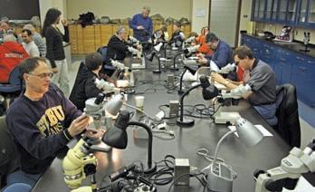
This workshop will provide a hands-on approach to understanding the functional osteology of the various marine vertebrates that once swam in the Western Interior Seaway that covered southern Manitoba during the Late Cretaceous (Campanian). Participants will enjoy examining fossil specimens from Manitoba using a variety of techniques from hand-held analysis to digital microscopy. Comparative vertebrate models will be used to simulate body design and movement as we re-create the marine paleoecology of southern Manitoba 80 million years ago.
1:00 pm – 4:00 pm
Classification and Identification of Bryozoa
Presented by Wayne Haglund, Mount Royal College
INFORMATION
To register for workshops contact Mona Marsovsky (403) 547-0182 or monahome@ telus.net. Workshop fee is $15 per person, per workshop. Please make cheques payable to the Alberta Palaeontological Society, P.O. Box 35111, Sarcee Postal Outlet, Calgary Alberta, Canada T3E 7C7. Deadline for workshop registration is March 1, 2009.
For information on the lecture program or other events please contact Philip Benham (Philip. Benham@shell.com) or phone (403)-691-3343.
Studying coprolites at the workshop. No scratch and sniff.
diVision taLKs INTERNATIONAL DIVISION
The recognition and exploitation of fracture systems in a carbonate reservoir –Gulf of Suez
SPEAKER
Dr. Paul MacKay
Department of Geology and Geophysics University of Calgary.
12:00 n oon
Wednesday, m arch 18, 2009 e ncana a mphitheatre, 2nd floor e ast end of the c algary tower complex 1st street and 9th avenue s. e . c algary, a lberta
HUGH REID’S SPRING COURSES
PRACTICAL DST CHART INTERPRETATION
(Thorough Basic Course) Mar. 30-Apr. 3, 2009
16 WAYS TO IDENTIFY BYPASSED PAY FROM DST DATA
(More advanced, for those “comfortable” with DST charts) Apr. 15-16, 2009
HYDRODYNAMICS SEMINAR
(Oil & Gas Finding Aspects) Apr. 20-24, 2009
In-house courses available. For course outline visit: www.hughwreid.com 262-1261
The Issaran oil Field is located in Egypt on the west coast of the Gulf of Suez along the western flank of the Suez extensional system. The field is a heavy oil deposit (8-12° API) within a thick succession of Miocene-aged carbonate rocks. The field is trapped by a series of down-to-thewest normal faults that formed as part of a large antithetic system associated with the down-to-the-east basin bounding fault, which forms the western edge of the Suez extensional system.
The fault history of the area is complex and formed as a series of extensional releases throughout the Eocene and Miocene epochs. Growth structures and fault linkage episodes are common in the area. The oldest Miocene strata are displaced by different fault patterns than the younger Miocene strata.
Faults form the lateral seals for the entrapment of hydrocarbons. The sealing properties of the faults are created by the juxtaposition of tight impermeable strata next to the reservoir rock and also by fault gouge or smear along the fault plane. Smallscale faults (tens of meters of displacement), which do not place tight rock against reservoir strata, behave as permeability inhibitors within the reservoir.
Despite the sealing characteristics of the faults, the most prolific wells within the field are in close proximity to the faults. Fractures associated with the faulting enhance the permeability of the reservoir and greatly increase the productive capacity of the wells. Early development of the field did not recognize the influence that the fracture systems have on the petroleum production from specific wells.
With the identification that the reservoir contains important natural fracture systems, the drilling and completion techniques have been modified to enhance the productive capability of the wells. As a result of these changes the production from individual wells has increased by a factor of several times and the total field production has increased from 1,500 B o PD to in excess of 6,000 Bo PD.
The fracture systems also control the production of water from the field and the oil / water ratio from specific wells. The most likely fluid migration into the
reservoir appears to be vertical along fracture systems that plumb into the deeper Eocene and Cretaceous section. This vertical migration improves the exploration potential for hydrocarbons in deeper zones and has widespread connotations to the fluid migration along the western flank of the Suez Basin. Detailed fracture patterns derived from image logs have been modeled and correlated with seismic data to give a means of predicting other fracture fairways within the reservoir.
BIOGRAPHY
Paul MacKay received a B.Sc. Honours (Geological Sciences) from Queen’s University in 1980 and a Ph.D. from the University of Calgary in 1991. He initially worked for Amoco Canada, then moved to Morrison Petroleums, Northstar Energy, and Devon Canada before beginning a successful consulting practice. His expertise is in petroleum exploration and development in structurally complex reservoirs.
He currently teaches field courses in Structural Geology/Geophysics in the Canadian Rockies and Fractured Reservoirs in Wyoming. Dr. MacKay has extensive experience in many international basins as well as in the interior basins of North America. He is an Adjunct Professor in the Department of Geology and Geophysics at the University of Calgary.
March 18, 2009
Rock Shots – Sig Joiner
UPCOMING EVENTS
April 15th, 2009
Rock Shots – TBA
Main Event – Dennis Meloche Modern Depositional Analogs in Mexico/Baja California.
INFORMATION
There is no charge to attend International Division talks. Please bring your lunch. The facilities for the talk are provided complimentary of EnCana and refreshments by Geochemtech Inc. For further information or if you would like to give a talk, please contact Bob Potter at (403) 863-9738 or ropotter@telusplanet. net or Trent Rehill at (403) 615-2386 or trent. rehill@artumas.com.
diVision taLKs SEDIMENTOLOGY DIVISION
Jurassic and lower Cretaceous deposits of northeastern British Columbia: surface and subsurface
SPEAKER
Godfried Wasser Eucalyptus Consulting Inc.
12:00 noon
Wednesday, march 18, 2009
BP tower
240-4 ave sW, room 201 calgary, alberta
Until the Geological Survey of Canada’s geologist D.F. Stott summarized his surface studies in the Pine River-Williston Lake area in 1998, Jurassic and lower Cretaceous stratigraphic nomenclature in northeastern British Columbia was in a state of confusion. In this presentation, Stott’s nomenclature is linked to the subsurface hydrocarbonbearing reservoirs of the Buick-Beg area. The latter includes fields such as Blueberry, Peejay, Bernadette, Siphon, Silver, Cutbank, and Grizzly.
Cuttings and core from over 1,200 wells were examined over the Wilrich to Nordegg interval, which ranges in thickness from zero to over two kilometres. Applying Stott’s stratigraphic nomenclature to this data, combined with wireline logging data, the Wilrich Member shale, Bluesky Formation, Gething Formation, Cadomin Formation, Minnes Group, Fernie Formation, and Nordegg Formation were mapped. The Minnes Group, according to Stott, is partially equivalent to the Nikanassin Formation. The latter occurs in the Foothills of Alberta and northeastern British Columbia south of Township 68, while the Minnes Group occurs north thereof. The Minnes Group has been subdivided in ascending order into the Monteith Formation, Beattie Peaks Formation, Monach Formation, and Bickford Formation.
The base of the lower Minnes Group is demarcated by the Monteith-Fernie contact. This contact can be either unconformable or conformable; in the latter case, the transition is sometimes informally referred to as ‘Passage Beds.’ The upper contact of the
Minnes is an angular unconformity overlain by the Cadomin Formation. The top of the Minnes Group is characterized by the Bickford Formation in the south near the Grizzly Field. However the Minnes Group is increasingly truncated towards the north and in the Buick area, only the Monteith Formation is present. The Monteith Formation is also sometimes referred to as the Buick Sandstone or in an inconsistent manner as Dunlevy. The latter was initially defined as comprising the entire Fernie-Bluesky interval; however the inconsistent use of this term has rendered it impractical. The Monteith Formation represents a series of west-southwestward draining deltaic deposits.
The overlying Cadomin Formation comprises medium- to coarse-grained pebbly chert sandstones or pebbly sandstones. In places, it also occurs as chert conglomerate with sand or shaly sand matrix. The Cadomin Formation grades laterally and upwards into the Gething Formation. The Cadomin Formation also pinches out towards the north and east and is no longer present north of the Blueberry Field and in the Buick area. Even at Williston Lake the Cadomin Formation comprises thick fluvial sandstone
or pebbly sandstone deposits; only near Quintette Mountain (Tumbler Ridge) does it comprises mostly conglomerate.
The Bluesky Formation occurs in patches of sandstone, pebbly sandstone, and conglomerate deposits. These likely represent erosional remnants of multiple generations of shoreline and related deposits.
Regional isopach maps and current directions measured in the Monteith, Cadomin, and Gething formations around Williston Lake suggest that the Spirit River Channel changes orientation and disappears below the Foothills around Williston Lake.
BIOGRAPHY
Godfried Wasser has an M.Sc. in sedimentology from the University of Utrecht, Holland. His work motto is, “From Rock to Log.” He has worked in the Canadian and international oil industry for nearly 30 years both on staff and as a consultant. Wasser currently offers industry courses, fieldtrips, and consulting services focusing on sandstone reservoirs through Eucalyptus Consulting Inc. He is leading fieldtrips to study Jurassic – Lower Cretaceous deposits in NEBC this summer.
Reservoir Characterization
Expertise in heavy oil & deep basin reservoirs
• AVO / LMR Analysis
• Neural Network Analysis
• PP & PS Registration
• Joint PP & PS Inversion
• Fracture Detection Analysis using Azimuthal AVO
• Spectral Decomposition
Time Lapse Analysis
Carmen Dumitrescu
P.Geoph., M.Sc., Manager, Reservoir Geophysics
Direct: 403-260-6588 Main: 403-237-7711
www.sensorgeo.com
For more on field seminars and short courses, call 918-560-2650 or visit www.aapg.org/education.
FIELD SEMINARS
Predicting Clastic Reservoirs Using Applied Sequence Stratigraphy: Understanding the Fundamental Drivers of Basin Fill Architecture
May 31-June 6, in conjunction with the AAPG Annual Meeting / Begins and ends in Salt Lake City, UT. Leaders: Lee F. Krystinik, Fossil Creek Resources, Fort Worth, TX and Beverly Blakeney DeJarnett, Bureau of Economic Geology, The University of Texas, Houston, TX
Characterization of Conventional and Unconventional Fractured Reservoirs: Modeling Rock and Fluid Dynamics for Optimizing Reservoir Management
May 31-June 7, in conjunction with the AAPG Annual Meeting / Begins in Salt Lake City, UT, and ends in Denver, CO. Leaders: Laird Thompson, Utah Faults, Fractures and Fluids (UF3), Auburn, CA; James Evans, Utah State University, Logan, UT; Tom Doe, Golder Associates, Redmond, WA
Folding, Thrusting and Syntectonic Sedimentation: Perspectives from Classic Localities of the Central Pyrenees
June 15-19 / Begins and ends in Barcelona, Spain. Leaders: Antonio Teixell, Universitat Autònoma de Barcelona, Spain, and Antonio Barnolas, Instituto Geológico y Minero de España, Madrid, Spain
Sequence Stratigraphy and Reservoir Distribution in a Modern Carbonate Platform, Bahamas
June 15-20 / Begins and ends in Miami, FL. Leaders: Gregor P. Eberli, University of Miami, Miami, FL; G. Michael Grammer, Western Michigan University, Kalamazoo, MI; Paul M. (Mitch) Harris, Chevron Energy Technology Company, San Ramon, CA
SHORT COURSES
Interpretation of Old DST’s for Bypassed Pay Potential
June 5-7 / Denver, CO, with AAPG Annual Meeting
Instructor: Hugh W. Reid, Hugh W. Reid & Associates, Calgary, AB, Canada
Pore Pressure Prediction in Practice
June 6-7 / Denver, CO, with AAPG Annual Meeting
Instructor: Martin Traugott, Consultant, New Orleans, LA
Quantification of Geologic Risk in the Conventional and Unconventional Realm
June 6-7 / Denver, CO, with AAPG Annual Meeting
Instructors: Gary Citron, Rose & Associates, LLP, Houston, TX, and Mark McLane, Rose & Associates, LLP, Midland, TX
Regional Stress and Reservoir Geomechanics
June 11-12 / Denver, CO, with AAPG Annual Meeting
Instructor: Mark Zoback, Stanford University, Stanford, CA


PRACTICAL SE qUENCE STRATIGRAPHY X.
The Units of Sequence Stratigraphy: Part 2 Time-Based Depositional Sequences
| by Ashton Embry
I NTRODUCTION
As described in the last article on materialbased sequences (Embry, 2009b), a sequence is best defined generically as “a stratigraphic unit bound by a specific type of unconformity and its correlative surfaces.” Two specific types of sequences have been defined in the literature – the genetic stratigraphic sequence of Galloway (1989) (part of a maximum flooding surface for defining unconformity) and the depositional sequence of Mitchum et al. (1977) and van Wagoner et al. (1988) (subaerial unconformity for defining unconformity).
The boundaries of a genetic stratigraphic sequence are always material-based for all sequence models and consist of maximum flooding surfaces. However, proposed boundaries for a depositional sequence are much more diverse. The proposed, material-based boundaries were described and evaluated in the last article (Embry, 2009b). The proposed boundaries for a depositional sequence which include timebased surfaces as correlative surfaces are described and evaluated herein. These time-based, depositional sequences are somewhat controversial as to their validity and utility.
T IME -BASED, DEPOSITIONAL SEqUENCE BOUNDARIES
In the time-based approach to sequence stratigraphy, two time-based surfaces are recognized as valid surfaces of sequence
stratigraphy. These surfaces were introduced by Hunt and Tucker (1992) and are: 1) the basal surface of forced regression (BSFR) which equates to the time surface (depositional surface) at the start of base level fall and 2) the correlative conformity (CC) which equates to the time surface (depositional surface) at the start of base level rise. These time-based surfaces were discussed in detail in a previous article in this series (Embry, 2009a).
E MPLOYING THE CORRELATIVE CONFORMITY
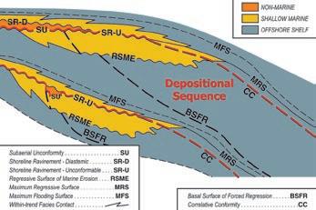
o ne proposed, time-based, depositional sequence boundary uses the correlative conformity (CC) as a key correlative surface of a subaerial unconformity so as to extend the sequence boundary well into the basin (e.g., Hunt and Tucker, 1992; Helland-Hansen and Gjelberg, 1994). In a sequence model with a ramp physiography and a fast, initial rise, the correlative conformity joins the basinward end of the shoreline ravinement (SR-U) which in turn truncates the subaerial unconformity (SU) as previously discussed (Figure 1, see also Figure 2 in HellandHansen and Gjelberg, 1994). Thus, the CC is an acceptable correlative surface of an SU in
(Continued on page 22...)
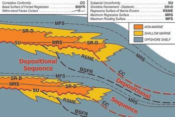
2. The boundaries of one proposed, time-based, depositional sequence are shown in red on this sequence model characterized by a ramp setting with a slow initial base level rise rate. The correlative conformity (CC) is the only theoretically possible correlative surface of the subaerial unconformity for such a model. Unfortunately a CC has no physical characteristics which allow its delineation.
Figure 1. The boundaries of a time-based, depositional sequence are shown in red on this sequence model characterized by a ramp setting with a fast initial base level rise rate. The correlative surfaces of the SU are the shoreline ravinement (SR-U) and the correlative conformity (time surface at start base level rise).
Figure
(...Continued from page 21) this model and such a depositional sequence boundary (SU/SR-U/CC) is theoretically valid.
Figure 2 illustrates a time-based, depositional sequence boundary using a CC as a correlative surface for a sequence model with ramp physiography and a slow initial rise (see also Figure 1 in Helland-Hansen and Gjelberg, 1994). As was previously discussed in Embry (2009b), there are no materialbased, correlative surfaces for the SU in such a model. However, in the time-based approach, the CC provides such a correlative surface because it adjoins the basinward termination of the SU as shown in Figure 2. once again, such a depositional sequence boundary (SU/CC) is theoretically valid.
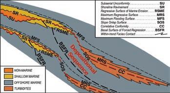
In a shelf/slope basin model, the CC closely coincides with the MRS as was discussed in Embry (2009a). As illustrated in Figure 3, a continuous boundary consisting of an SU, an SR-U, an SoS, and a CC can be delineated on such a sequence model. Thus, such a time-based, depositional sequence boundary would also be theoretically valid.
Although depositional sequence boundaries which employ a CC as a correlative surface are theoretically valid, the practical utility of such boundaries is debatable. The reason for this is that no published studies have demonstrated how a CC can be delineated and correlated in well exposed strata or on closely spaced well logs with abundant core (see Embry, 2009a for a detailed discussion). Unconstrained interpretations of a CC on seismic data have been offered (e.g., Catuneanu et al., in press) but these have not been corroborated by rock-based
data and remain questionable. As discussed by Embry (2009a), such seismic reflectors, which are interpreted to encompass timebased CCs, may actually be harbouring material-based MRSs. overall, much more research is necessary before a depositional sequence boundary which employs a CC can be accepted as having practical utility.
E MPLOYING THE BASAL SURFACE OF FORCED REGRESSION
Another time-based depositional sequence boundary which has been proposed involves the use of the basal surface of forced regression as a correlative surface of an SU (Posamentier and Allen, 1999; Coe, 2003).
This sequence boundary comprises the same combination of surfaces (SU/BSFR) for all sequence models. Such a depositional sequence boundary is shown for a ramp setting with a slow initial base level rise (Figure 4).
Because the BSFR is developed long before the start of base level rise, it intersects the SU landward of the basinward termination of the SU (Figure 4). It is also slightly offset by the regressive surface of marine erosion (RSME) if such a surface is developed. As was discussed by Embry (2009a), the BSFR has no physical characteristics making it of dubious value for comprising part of a sequence boundary. However, more importantly, the BSFR cannot be considered to be a valid correlative surface of an SU because it does not join with the end of the SU as shown in Figure 4. The use of such a sequence boundary results in much of the subaerial unconformity being inside the proposed sequence rather than on its boundaries (Figure 4), an inappropriate relationship for a depositional sequence. This would suggest that such a proposed depositional sequence boundary (SU/BSFR) be rejected as a possible option.
SUMMARY
By defining a sequence as a generic unit which is bound by a specific type of unconformity and its correlative surfaces, two specific types of sequences are recognized – a depositional sequence (SU, defining unconformity) and genetic stratigraphic sequence (part MFS, defining unconformity). Numerous
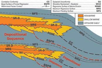
Figure 3. The boundaries of a time-based, depositional sequence are shown in red on this sequence model characterized by a shelf/slope/basin setting with a fast initial base level rise rate. The correlative surfaces of the SU are the shoreline ravinement (SR-U), most of the slope onlap surface (SOS) and the correlative conformity (CC) (time surface at start base level rise).
Figure 4. The boundaries of another proposal for a time-based, depositional sequence are shown in red on this sequence model characterized by a ramp setting with a slow initial base level rise rate. In this case, the basal surface of forced regression (BSFR) (time surface at start base level fall) is used as the primary correlative surface. Such a proposal is not reasonable because, as illustrated, the BSFR does not join the end of the subaerial unconformity.

combinations of material-based and timebased surfaces have been proposed for a depositional sequence boundary.
In a time-based approach, a correlative conformity (CC) which represents a time surface (depositional surface) at the start of base level rise is advocated for use as a correlative surface for extending the boundary well into the basin. Although the CC is a theoretically valid correlative surface, its use as part of a sequence boundary is compromised by a lack of physical characteristics which would allow a CC to be delineated and correlated with reasonable objectivity.
Another proposed, time-based, depositional sequence uses a basal surface of forced regression (time surface at start base level
fall) as a major part of the sequence boundary. The largest objection to such a proposal is that the BSFR is not a correlative surface of an SU because it is truncated by the SU far landward of the basinward termination of the SU. Such a proposed boundary is not compatible with the established definition of a depositional sequence.
The main proposed material-based and time-based sequence boundaries are summarized in Figure 5 and most are for a depositional sequence boundary. The only boundaries which have widespread utility are material-based ones and include the MFS of the genetic stratigraphic sequence and the combined SU/SR-U/MRS, with or without an SoS, for the depositional sequence. All other proposed boundaries use an inappropriate correlative surface (e.g.,
BSFR, facies change) or include a correlative surface that cannot be recognized in most situations (e.g., CC).
The next article will examine systems tracts which are component stratigraphic units of a sequence. once again, both materialbased and time-based systems tracts have been defined. The main ones in each approach will be discussed and appraised as to their validity and utility for mapping and communication.
R EFERENCES
Catuneanu, O., et al., in press. Towards the Standardization of Sequence Stratigraphy. Earth Science Reviews.
Coe, A. (ed.). 2003. The sedimentary record of (Continued on page 24...)
Figure 5. A summary of the various combinations of surfaces for the different types of sequence boundaries which have been proposed.

(...Continued from page 23)
sea-level change. Cambridge University Press, New York, 287 p.
Embry, A.F. 1993. Transgressive-regressive (T-R) sequence analysis of the Jurassic succession of the Sverdrup Basin, Canadian Arctic Archipelago. Canadian Journal of Earth Sciences, v. 30, p. 301-320.
Embry, A.F. 2009a. Practical Sequence Stratigraphy VIII: The Time-based Surfaces of Sequence Stratigraphy. Canadian Society of Petroleum Geologists, The Reservoir, v. 36, issue 1, p. 27-33.
Embry, A.F. 2009b. Practical Sequence Stratigraphy IX: Part 1 Material-based Sequences. Canadian Society of Petroleum Geologists, The Reservoir, v. 36, issue 2, p. 23-29.
A BRILLIANT MOVE
A BRILLIANT MOVE
IN INTERNATIONAL SEISMIC ACQUISITION
IN INTERNATIONAL SEISMIC ACQUISITION
Playing a game that is foreign to you can be tough at first. There are many different rules and tactics involved.
Thirty years and some 38 countries later, Boyd PetroSearch has developed extensive seismic acquisition experience around the world.

Trust us to manage your international seismic operation, and ensure the highest degree of professionalism and quality. The next move is up to you…
• Program Design
• Logistics
• Risk Analysis & Mitigation
• Contract Negotiation
Please call:
Malcolm McDonald +1.403.233.2455
• Project Management & Hiring
• Quality and Cost Control
• International Safety Compliance
Boyd PetroSearch
Larry Herd +1.403.543.5362 or visit www.boydpetro.com Global Geophysical Consultants
Galloway, W. 1989. Genetic stratigraphic sequences in basin analysis I: architecture and genesis of flooding surface bounded depositional units. American Association of Petroleum Geologists Bulletin, v. 73, p. 125-142.
Helland-Hansen, W. and Gjelberg, J., 1994, Conceptual basis and variability in sequence stratigraphy: a different perspective. Sedimentary Geology, v. 92, p. 1-52.
Hunt, D. and Tucker, M. 1992. Stranded parasequences and the forced regressive wedge systems tract: deposition during base level fall. Sedimentary Geology, v. 81, p. 1-9.
Mitchum, R, Vail, P., and Thompson, S. 1977. Seismic stratigraphy and global changes in sea level, part 2: the depositional sequence as the basic unit for stratigraphic analysis, In: Seismic stratigraphy: application to hydrocarbon exploration. C. Payton, (ed.). American Association of Petroleum Geologists Memoir 26, p. 53-62.
Posamentier, H. and Allen, G. 1999. Siliciclastic sequence stratigraphy – concepts and applications. Society of Economic Paleontologists and Mineralogists, Concepts in Sedimentology and Paleontology, no. 7, 210 p.
Van Wagoner, J.C., Posamentier, H.W., Mitchum, R.M., Vail, P.R., Sarg, J.F., Loutit, T.S., and Hardenbol, J. 1988. An overview of the fundamentals of sequence stratigraphy and key definitions, In: Sea level changes: an integrated approach. C. Wilgus, B.S. Hastings, C.G. Kendall, H.W. Posamentier, C.A. Ross, and J.C. Van Wagoner, (eds.). Society of Economic Paleontologists and Mineralogists, Special Publication 42, p. 39-46.
BOOK REVIEW
Canadian Rockies Geology Road Tours by Ben Gadd
| by Gerry Reinson

Ben Gadd has done it again! From the author of the critically acclaimed and bestselling Handbook of the Canadian Rockies, published in 1986 and again in 1995, comes a comprehensive 576-page guide to the roadside geology of the Canadian Rockies. This renowned naturalist and award-winning writer above all is a geologist in the classical sense, practicing his profession only as we, his peers, wish we could do. A true field geologist; James Hutton and William Smith would be proud.
As the title implies, the main part of the book deals with geology you can observe from beside the road. All the major Canadian Rockies roadways are discussed in a series of tours, including the Trans-Canada Highway, yellowhead Route, Icefields Parkway, Alaska Highway, Crowsnest Pass route, David Thompson Highway, Kananaskis Trail, Pine Pass, the Pincher Creek to Waterton route, and vermilion Pass (Highway 93).
ROCK SHOP
Along these tour routes, the author has documented 268 roadside stops where one can examine outcrops and road-cuts up close, or lookout upon geologically spectacular panoramic vistas. The roadside stops are richly illustrated with over 500 diagrams and photographs. The locations of all stops along each tour route are given not only by odometer-based readings, but also by GPS waypoints, which you may download from the author’s website. Perhaps what makes this book most appealing is the strength of the geological descriptions of individual waypoints, and of the overviews that preface each major tour route and internal segment (i.e., Calgary to Canmore, Canmore to Lake Louise, etc.).
This brings me to the first 95 pages of the book. The introductory section contains in Mr. Gadd’s own words, “a quick-start on the essential geological concepts required to understand the main part of the book.” The primer itself is an excellent entry to geology for the layperson. In fact, many of us socalled experienced geologists may find this a very useful refresher course in the basics of observational field geology. Also included in the introductory section are:
1) a physiographic summary of the Canadian Rockies region,
2) a discussion of the four great rock layers that make up the 30-kilometer-thick sedimentary succession, and
3) a succinct summary on how the Rockies came to be through geological time.
The appendix contains a geological timeline chart, regional cross-sections, geological
maps of the Canadian Rockies, a formation correlation chart, illustrations of common fossils to be found in the rocks of the Canadian Rockies, and a list of references for further reading. To top it off, the inside front cover features an up-to-date Geological Time Scale, and the inside back cover contains metric/imperial conversion tables.
In summary, Ben Gadd has out-done himself in this book. This book is a must for those non-geologists who want to understand more about our wonderful Canadian Rockies region. Even those with only a passing interest in natural science will benefit from obtaining a copy to refer to as they travel along any of the routes described therein. In fact, this book should be recommended as a standard reference for students (high school and university) who aspire to be earth scientists, and even for those teachers/ professors to aid the planning of field trips/and related classroom activities. Finally, seasoned professional geologists will benefit immensely by obtaining a copy of this book, primarily because it contains basic and pure geology, the foundation upon which our formative training was based. Truly, in its genre, this book is an invaluable piece of work.
Ben Gadd’s Canadian Rockies Geology Road Tours may be purchased at CSPG’s Bookstore. The price for non-members is $28.50. CSPG Members receive a 25% discount off the list price. If you wish to purchase a copy of the book, visit us at 600, 640 – 8th Ave SW, Calgary, Alberta, or email us at htyminsk@cspg.org.
CUSTOMI z ING DRILLING F LUIDS to Minimize Formation Damage
| by Brad Ross
Production techniques of yesteryear have broadened significantly to extend the life of individual wells and to increase the overall quality of hydrocarbon production. The key to minimizing formation damage is maintaining an unobstructed flow path from the reservoir to the wellbore. The maintenance of such a path is a challenge facing operators throughout the world, but nowhere more so than in the horizontal wells of many Canadian reservoirs, such as the Montney, Rock Creek, Jean Marie, Crossfield, Cardium, and Nahanni. Through repeatable processes and sound science, Baroid is able to customize drilling fluid solutions to help minimize formation damage in these reservoirs, as well as any others.
The customization of a fluid solution is the fulfillment of an interdependent technical planning process that calls for both extensive data analysis and lab work. The data analysis portion of the referenced process includes the use of predictive engineering tools and the analysis of local offset data. In the case of experienced service providers, like Baroid, the wealth of information gained through years of wellsite execution in an area, or those geologically similar to it, can be combined with local offset data and evaluated with probabilistic engineering tools to scenario-test possible solutions. This will serve to help establish causal relationships between formulation chemistry, fluid behaviour, and the likelihood of success for proposed solutions.
Requisite laboratory testing on reservoir rocks and their fluid characteristics enables the customization of the most suitable fluid formulations. The laboratory tests include the examination of the effective pore size distribution and morphology of each reservoir rock. Ideally, flow tests should also be run on core samples from each reservoir to determine the residual damage caused by candidate fluids.
FORMATION DAMAGE M ECHANISMS
Some common causes of formation damage that reduce conductivity include 1) fine particles invading and plugging the pay zone, 2) formation clay swelling, 3) commingling of incompatible fluids, and 4) movement of dislodged formation pore-filling particles. Engineering drilling fluids that minimize the effects of these damage mechanisms is of vital importance to a well’s lifetime
production. o nce reservoir permeability has been reduced, it can seldom be restored.
Under normal drilling conditions, wellbore hydrostatic pressure is greater than reservoir pressure. While cutting into the permeable pay zone, the bit forces drilling fluid into nearby rock pores; carrying with it fine drilled solids, suspended weighting materials, clays, polymers, lost circulation materials, cement particles, rust, pipe dope, and even precipitates, any of which can reduce conductivity and cause significant production problems.
Nearly all sandstone reservoir rocks contain some type of clay. Disturbed by conventional fluid or filtrates, clay granules can swell or migrate into the pay zone, occasionally causing serious losses of permeability.
Chemical incompatibility between drilling or completion fluids and reservoir fluids can cause severe plugging when they interact in a pay zone. Drilling fluids are typically alkaline, while most reservoir fluids are slightly acidic, especially in the presence of carbon dioxide or hydrogen sulphide. When the two fluid types mix, insoluble salts may form and precipitate into the rock pores, reducing conductivity.
Particle movements vary according to particle size and formation pore size. When suspended particles are larger than formation pore size, they are generally carried up and out of the wellbore with the drilling fluid. Smaller particles, on the other hand, tend to become trapped on the face of the wellbore, forming a permeable filter cake. As long as a differential pressure is applied toward the formation, the filter cake allows fluids to continuously filter into the formation. Filter cake in a non-producing part of the wellbore is not a significant problem, but in a permeable producing zone, filter cake will reduce production.
TOOLS OF T ECHNICAL PLANNING
PROCESS A ID F LUID SELECTION
Selecting the most suitable nondamaging fluid
system for drilling into the pay zone requires a thorough understanding of the reservoir. By minimizing the impact of the various formation damage mechanisms, impairment to reservoir productivity will be limited.
While many reservoir characterization tools and methods help identify the geologic parameters that could affect produceability, special consideration should be given to conducting a detailed reservoir fluid sensitivity study.
A fluid sensitivity study will detail the morphological and mineralogical composition of the reservoir rock, based upon core plugs from carefully selected pay zones. It will also analyze natural reservoir fluids to establish their chemical makeup. This data can help determine the potential for the occurrence and degree of damage from typical mechanisms for formation damage, and the effectiveness of possible solutions.
Additionally, the modern analytical methods of scanning electron microscopy and X-ray diffraction will determine the crystalline bulk component of the reservoir rock and the clay size fractions. Such findings will help provide an understanding of the rock-fluid and fluid-fluid relationships and interactions. Data from these advanced instruments can remove guesswork from defining potential damage mechanisms. The data is also foundational to the development of reliable bases for designing solutions that can optimize well productivity.
The investment in research and resources
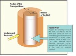
Figure 1. Radial Flow Diagram
to technically plan a well can ultimately lead to the delivery of a customized, less damaging fluid, which will result in greater
preservation of the reservoir’s natural permeability and greater well production over its life.
DESIGN CRITERIA FOR EFFECTIVE F ILTER C AKE FORMATION WITH NON-DAMAGING F
LUIDS
Fundamentally, a non-damaging fluid is one with low solids that causes little or no loss of a pay zone’s natural permeability. The fluid should establish an external filter cake on the face of the formation, without penetrating too far into the formation pore pattern. The filter cake will reduce the flow of solids into the reservoir, preventing the impairment of productivity. This can be accomplished by adding high-quality, sized particles of a durable bridging solid into the fluid system. In general, the bridging solid should have a broad distribution in particle size, with a median particle size equal to at least one-third of the diameter of the mean pore-throat diameter. optimal particle size distribution and tight filtration control will also significantly reduce differential sticking forces and thus help prevent stuck pipe while drilling.
Under dynamic conditions, circulation velocity, rate of penetration, formation permeability and degree of overbalance also affect filter cake formation. Therefore, each must be understood and planned for. In the high-energy conditions near the bit, where flow is more likely to be turbulent, filter cake will not readily set up on a newly exposed formation. These unfavourable conditions can be partially offset by formulating the fluid to promote rapid cake formation in the presence of overbalanced pressure through careful management of fluid particle size. Effective formulation of a fluid to address this issue will lead to minimization of initial spurt losses.
(Continued on page 36...)
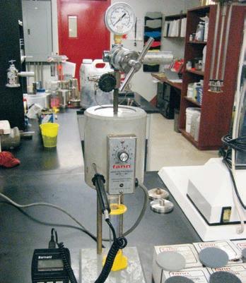
Figure 2. Particle-Plugging Test Apparatus.
Figure 3. Filter Cake Example.


May 4-8, 2009 CSPG CSEG CWLS CONVENTION ROUNDUP CENTRE,
STAMPEDE PARK CALGARY, ALBERTA, CANADA


FTPRE01
Siliciclastic Depositional Systems
in the Cretaceous Book Cliffs Utah - Colorado: Applications to the Subsurface
Leaders: Simon Pattison and Huw Williams Date: April 28 – May 1, 2009
Maximum Attendance: 25 participants
Trip Fee: $2,500 (Trip begins and ends in Grand Junction, CO – Airfare not Included)
With over 300 kilometres of outcrop, the Book Cliffs are a world-class field laboratory for studying clastic sedimentology, sedimen tary architecture, and sequence stratigraphy, and are an outcrop analog for fluvio-deltaic and shoreface-to-shelf hydrocarbon reser voirs worldwide, at both an exploration and a development scale. These rocks have been used to develop, test, and refine sedimen tological and stratigraphic ideas and models over the years. on this trip, we will integrate classic sedimentological and stratigraphic research with the latest breaking research on fluvial-shoreline-shelf depositional systems.
OR PROPSECTUS

Maximum Attendance: 25 participants Trip Fee: $375
To the world, the Turner valley oilfield is a structural model, but it is more than just that. From Millarville to the Highwood River Canyon, you can observe different styles of deformation in different periods, and possible connections between them. Features such as the Fluvio-Glacial Longview Hill, a region characterized by the interaction of the Laurentide and Cordilleran ice sheets, the Red Deer Lake/Twin Dome structure, and the modern Calgary landslide. The interactions between these structures make for an
Upper Cretaceous (Eagle Formation – Milk River equivalent) wave-impacted sandstones form important (historical and current) petroleum reservoirs in western Canada and Montana. Although sheet-like in gross geometry, sufficient heterogeneity exists in these deposits to influence exploration strategy, well operations, completions, and production practices. Excellent exposures of these units in north-central Montana provide useful analogues for those geoscientists exploring or exploiting these types of reservoirs anywhere in western Canada.
FTPST02


FTPRE02


Jurassic and Lower Cretaceous Deposits of Northeast British Columbia: Exploring the Surface and Subsurface Leader: Godfried Wasser


Geological Walking Tour -
Leader: Bill Ayrton Date: April 30, 2009


The Building Rocks of Calgary

FTPRE03


Maximum Attendance: 30 participants Trip Fee: $150


This interesting half-day tour examines the rocks, sedimentary features, and fossils beautifully displayed on the buildings of Calgary, Alberta. We will also see the building rocks used by our landscapers and sculptors. The rocks range in age from Precambrian to Tertiary, and come from as far away as Scandinavia and India; some were even quarried locally.
From Turner Valley to the Calgary Landslide: Three ages of deformation Laramide, Pleistocene, and Present


Date: May 11 – 14, 2009


A one-day field trip to examine outcrop lithofacies and contacts of several different depositional elements of an ancient (74 ma) meandering river system in the ldman Formation of Dinosaur Provincial Park. Depositional elements and complexities are common in ancient meandering river deposits in the Belly River and Mannville, but not normally discussed in textbook lithofacies models. An understanding of the nature and relationship of these various lithofacies is important in hydrocarbon exploration and developments in meandering river sequences such as the McMurray and other formations.


CONVENTION
FTPST01


Maximum Attendance: 11 participants
Trip Fee: $2,975
(Trip begins and ends in Fort St. John – Airfare not included)
This is a four-day course, comprising a fieldtrip at Williston Lake, a core workshop, and lectures on the northeast British Columbia gas reservoirs covering the Bluesky to Nordegg interval. Areas discussed include Buick, Beg, Blueberry, Peejay, Bernadette, Siphon, Silver, Cutbank, and Grizzly. The course addresses petrography, log analysis, core, and cuttings examinations as well as production and pressure history.

Upper Cretaceous Shelf and Shoreface Sandstones: Montana Outcrops and Alberta Basin Cores Leaders: Peter Putnam and Derald Smith Date: May 11 – 13, 2009


Form Inside on Page 8

Triassic Sedimentary Framework and Sequence Stratigraphy, Williston Lake, British Columbia Leader: John-Paul Zonneveld Date: May 12 – 15, 2009
Maximum Attendance: 14 participants
Trip Fee: $2,975
(Trip begins and ends in Fort St. John – Airfare not included)
Maximum Attendance: 15 participants Trip Fee: $1,499
This course centres around the sedimentologic and stratigraphic development of the Triassic (Continued on page 30...)
Optimize lifetime production
Cased Hole Wireline
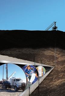

Engineered perforating enabled a North Sea operator to increase oil production by 94%.
Productivity and longevity depend on more than the completion. A lifelong well service program is the best way to maximize well performance and safeguard long-term value. From engineered perforating to ABC* analysis behind casing, the comprehensive Schlumberger range of cased hole services helps your wells reach full productive potential, year in, year out.
Minimize risk by identifying and resolving more cased hole production issues—proactively.
403-509-4000
www.slb.com/casedhole
(...Continued from page 29)
succession in western Canada. outcrop equivalents of major producing subsurface units (Montney, Doig, Halfway, Charlie Lake, Baldonnel, and Pardonet) are observed and discussed. The first day is spent at the core storage facility to discuss basic controls on subsurface hydrocarbon reservoir nature and distribution, as well as similarities and differences between the outcrop and subsurface sections. The following three days are spent visiting Lower, Middle, and Upper Triassic outcrop localities along the shores of Williston Lake.
FTPST04
Student Field Trip: Marginal Marine Depositional Environments of the Bearpaw-Horseshoe Canyon Transition, Drumheller, Alberta Leader: Jason Lavigne Date: May 12, 2009
Maximum Attendance: 40 participants Trip Fee: $25
This one-day field trip will examine outcrops of the Upper Cretaceous Bearpaw and Horseshoe Canyon formations east of Drumheller. The goals of the trip are to look at the sedimentology and trace fossil assemblages of marine, shoreline, and fluvial deposits, as well as the lateral and vertical succession of facies to better understand how to evaluate the significance of several stratigraphic surfaces. We will examine these aspects of the deposits in the context of the historical work that has been done in the area.
FTPST05
Geology of the Athabasca Oil Sands Leaders: Murray Gingras and Mike Ranger Dates: May 18 – 20, 2009
Maximum Attendance: 20 participants Trip Fee: TBD
(Trip begins and ends in Ft. McMurray - Airfare not included)
This three-day field excursion to the Fort McMurray area provides an excellent opportunity to observe the geology of the Athabasca oil Sands, as well as the engineering and mining technology related to recovery of the bitumen. Numerous outcrops along the Athabasca, Christina, and Steepbank Rivers will be visited by high-speed jet boat and helicopter.
2009 CSPG-CSEG-CWLS
Annual Convention Short Courses
NEW THIS YEAR!
Certain Short Courses have early bird rates for delegates who register before April 3, 2009.
PRE - CONVENTION COURSES
SCPRE01
Shale Gas Critical Fundamentals, Techniques and Tools for Exploration Analysis
Instructor: Basim Faraj
Date: April 27, 2009
Maximum Attendance: 25 participants Fee: $650
This one-day course will introduce the fundamental differences between conventional, hybrid, and shale gas plays. Source and reservoir rock attributes of shale gas plays will be discussed as well as GIP calculations; water, oil, and gas saturations; essential laboratory analysis; and optimum geochemical and mineralogical parameters. Slickwater completion (vertical and horizontal) lessons learned from the United States will be detailed. Canadian plays will be highlighted and discussed.
SCPRE02
Practical Sequence Stratigraphy: Concepts and Applications
Instructor: Ashton Embry
Date: April 27 – 28, 2009
Maximum Attendance: 25 participants Fee: $700
This two-day course presents the concepts and practical applications of sequence stratigraphy for petroleum exploration. Workshop exercises will emphasize the recognition and correlation of sequence stratigraphic surfaces on well log crosssections. Following the course, participants will have a clear understanding of the use of sequence stratigraphy for predicting facies types and geometries away from control points.
SCPRE03
An Introduction to Petroleum Geostatistics
Instructor: Clayton Deutsch
Date: April 30 – May 1, 2009
Maximum Attendance: 25 participants Fee: $750
The fundamentals of geostatistical tools for constructing models of geological heterogeneity and quantifying uncertainty are presented. The place of old and new techniques are reviewed. Examples and practical aspects of modern geostatistics will be emphasized.
SCPRE04
Basic Petroleum Economics
Instructor: Dave Volek
Date: April 28, 2009
Maximum Attendance 12 participants Fee: $475
Discount rates! Net present values! Risk analysis! Decision trees! Monte Carlo! Learn the basic tools of petroleum economics. Gain basic skills for higher level training. Facilitator is Dave volek, inventor of the oilFinancier simulation (www.oilfinancier. com). This is a hands-on seminar. Bring your laptop with EXCEL spreadsheet to do all sorts of financial analysis based on various oilFinancier scenarios. you learn by doing in Basic Petroleum Economics.
SCPRE05
The Stratigraphic Setting of Lower and Middle Triassic Strata, Western Canada Sedimentary Basin
Instructor: Jim Dixon
Date: May 1, 2009
Maximum Attendance: 20 participants Fee: $375
The objective of this course is to help explorationists understand the regional stratigraphic setting of Triassic rocks and how this can be used in a more local exploration program. The course is four hours long and consists of two lectures, some correlation exercises, and an examination of several cores that illustrate various facies types and/or significant stratigraphic surfaces.
SCPRE06
Clastic Facies and Depositional Environments in Core
Instructor: Bill Arnott
Date: April 29 – May 1, 2009
Maximum Attendance: 20 participants Fee: $1,250
This is a hands-on core workshop that emphasizes the understanding of physical
and biogenic structures in the interpretation of sedimentary depositional environments. Environments are then related in both time and space using sequence stratigraphic principles.
SCPRE07
Wave Equation Imaging: Theory and Practice
Instructor: Robert J. Ferguson
Date: April 30 – May 1, 2009
Maximum Attendance: 20 participants Fee: $700 early bird, $800 regular
This is an intensive two-day course designed for those interested in the theory and numerical implementation of the common algorithms in seismic depth migration. In particular, this course will interest software developers, seismic data processors, students, and interpreters working in complex geology, and those with a general interest in reflection seismology.
SCPRE08
Formation Damage
Instructor: Brant Bennion
Date: April 28 – 29, 2009
Maximum Attendance: 40 Participants Fee: $750
This short course will cover the following topics:
• Definitions of formation damage,
• Why prevent damage,
• Major mechanisms of formation damage,
• Mechanical damage mechanism,
• Chemical damage mechanisms,
• Fluid – fluid issues,
• Wettability alterations and their impact on reservoir performance,
• Biological formation damage issues,
• Thermally induced formation damage,
• Formation damage and horizontal wells,
• Why is damage more a concern in horizontal wells, and
• Underbalanced drillling and completions.
SCPRE09
Clay Minerals and Their Effect on the Electrical Behavior of Shaly Sands
Instructor: E.C. Thomas
Date: April 29, 2009
Maximum Attendance: 40 Participants Fee: $750
This short course will cover the following topics:
• The structure of clay minerals,
• The origin of cation exchange capacity in clay minerals,
• Understanding how the cation exchange properties of clay minerals alters the conductivity of brine-saturated shaly sands,
• Development of the Waxman-Smits equation as a model to compute water saturation when cores and their analyses are not available,
• Bound water – how it is measured and compared to NMR,
• Handling laminated shaly sands using the Thomas-Stieber approach to derive porosity and water saturation of the sand laminae, and
• Advantages of having horizontal and vertical resistivity measurements for the analysis of shaly sands.
SCPRE10
SAGD 101 in the McMurray…
Cartooned for the Layman!
Instructor: Doug Walsh
Date: April 30, 2009 Tentative Maximum Attendance: 40 Participants Fee: $500
This one-day workshop will attempt to reduce the complex geology of the McMurray Formation and the complexities of the Steam Assisted Gravity Drainage (SAGD) process to an understandable form, using colored sketches and animations in PowerPoint. The highly visual form of the presentation should give participants in the workshop a library of mental pictures that will be useful for understanding and applying the fundamentals of SAGD.
This presentation should allow newcomers to SAGD to easily gain a good grasp of the fundamental principles of the process, while those more experienced in this segment of the industry should also be able to glean insights into a wide array of SAGDrelated subjects including: an overview of the paleogeography of the McMurray Formation, basic sedimentology of the McMurray, the geological model for selected SAGD projects near Bonnyville, a review of the history of SAGD, an analysis and an update of Butler’s equation, how to drill SAGD well pairs, how to complete SAGD well pairs, how to start up SAGD well pairs, and how to operate SAGD well pairs.
A supplemental study of three selected cores from Foster Creek will be used to support
the classroom description of the McMurray Formation and also to demonstrate how variations in the reservoir impact the way SAGD works in the real world. This will be discussed in light of the concepts that will have been outlined in the lecture portion of the workshop.
SCPRE11
Acoustic Logging
Instructors: Denis Schmitt, Doug Patterson, and John Walsh
Date: April 30, 2009
Maximum Attendance: 40 Participants Fee: $500
The objective of this short course is to provide both an overview and understanding of the theory, physics, and measurements of borehole acoustic devices. The course will discuss the basic system configurations of the older generation monopole devices, still being utilized, as well as the new generation multipole and cross-dipole systems, which are more commonly used. The critical issues of log quality control and the borehole environmental effects will also be covered.
The course focus will be the application and limitations of the measurements from these
2009 Gussow Geoscience Conference
Towards Sustainable Oil Sands Development
October 4 - 7, 2009
Banff, Alberta, Canada
The 2009 CSPG Gussow Geoscience Conference will bring together geoscientists, engineers, environmental scientists, regulators and policy makers worldwide who are working in the complex technical and environmental issues related to energy recovery from heavy oil and bitumen deposits in Canada. The Conference focuses at the energy environment interface and seeks to better understand the complex impact of geological heterogeneity in bitumen reservoirs on feasible routes to sustainable energy recovery from heavy oil and bitumen reservoirs.
www.cspg.org
in petrophysical, geophysical, and reservoir engineering disciplines using realworld examples. Geophysical applications will be particularly emphasized including how these measurements are used for synthetic seismograms, Avo, multi-component seismic, and velocity model calibration.
SCPRE12
Borehole Imaging
Instructors: Paul Elliott and Carlos Silva
Date: May 1, 2009
Maximum Attendance: 40 Participants Fee: $500
This one-day short course will introduce attendees to the following aspects of Borehole Imaging:
• Tool theory and data acquisition,
• Data processing workflows,
• Identifying bed boundaries,
• Fractures,
• Faults,
• Micro-faults,
• Rose diagrams,
• Schmidt plots,
• Azimuth frequency plots,
• Dip domain analysis,
• In situ stress,
• Identifying sedimentary features, and
• Artifacts.
SCPRE13
Microseismic Mapping
Instructor: Kenneth D. Mahrer
Date: May 1, 2009
Maximum Attendance: 30 Participants Fee: $500
This short course will cover the following topics:
• Brief history of hydraulic fracturing and related studies,
• Background – related, basic, yeoman science you need to appreciate before you can make sense of this technology,
• Hydraulic fracturing 101,
• Studies related to hydraulic fracturing,
• Basic earthquake seismology – again, yeoman science,
• Microseismic Mapping – tools,
• Microseismic Mapping – field operations, and
• Microseismic Mapping – data, data analysis, and data processing.
POST- CONVENTION COURSES
SCPST01
Sequence Stratigraphy: Principles and Applications
Instructor: Octavian Catuneanu
Date: May 11 – 14, 2009
Maximum Attendance: 25 participants Fee: $950
This course presents the concepts and practical applications of sequence stratigraphy for petroleum exploration and production. All concepts are illustrated with field examples of seismic, well-log, core, and outcrop data. In-class exercises emphasize the recognition of sequence stratigraphic surfaces and systems tracts on well-log cross-sections, seismic lines, and outcrop profiles.
SCPST02
Structural Styles and Interpretation Techniques in Fold-Thrust Belts
Instructor: Shankar Mitra
Date: May 11 – 13, 2009
Maximum Attendance: 25 participants Fee: $1,050
(Continued on page 34...)

(...Continued from page 33)
Fold-thrust belts contain complex trapforming structures, which are not well imaged on seismic data. The objective of the course is to discuss the use of two-dimensional and three-dimensional structural models and techniques for constructing maps, balanced cross-sections, and three-dimensional interpretations. Models of trap-forming structures for foldthrust belts will be presented. Problem sets will provide hands-on experience in interpreting subsurface structures using seismic and well data.
SCPST03
Concepts, Models, and Case Studies of Dolomitization – with Applications to Hydrocarbon Exploration and Development
Instructors: Hans Machel and Jay Gregg
Date: May 11 – 12, 2009
Maximum Attendance: 20 participants Fee: $950
This course summarizes the major advances and current controversies in dolomite research. A major part of this course deals with the various dolomitization models, from early to late and from shallow to deep, from hypersaline reflux to hydrothermal dolomitization and M v T mineralization. These concepts will be applied to hydrocarbon exploration and development, with specific reference to the Devonian of western Canada.
SCPST04
How to Get Control of Your Day, Life, and Career
Instructor: Bruce Lee
Date: May 14, 2009
Maximum Attendance: 25 participants Fee: $175

This combines the best of time management with the most critical templates along with the best attributes of leadership that focus on creating results. The bottom line is moving careers ahead by doing the right things at the right time.
SCPST05
Memory Techniques
Instructor: Bruce Lee
Date: May 14, 2009
Maximum Attendance: 25 participants Fee: $175
How to remember everything, anytime, anywhere, forever! This includes the all important areas of names of people and activities.
SCPST06
Evaporites: Settings, Formation, Diagenesis, and Implications for Petroleum Reservoirs
Instructors: Charlotte Schreiber and Hans Machel
Date: May 13 – 14, 2009
Maximum Attendance: 20 participants Fee: $1,075
Evaporites commonly function as top seals or as pore-plugging cements, thus they can be a boon or a bane for reservoir geologists. The course will discuss, in detail, how to determine the difference between desirable and detrimental evaporites. The course will build a fundamental understanding of evaporite facies development, conditions and rates of deposition, basinal constraints, and rock textures. Then it will examine diagenesis and the alterations that take place from the moment of deposition, such as simple compaction and dehydration, until deep burial, including sulfate-hydrocarbon redox-reactions that lead to sour gas formation. Finally, the course will show how to determine the effects of tectonism
on regional deformation, deformational textures, and associated fluid expulsion.
SCPST07
The Architecture of Fluvial Reservoirs
Instructor: Andrew Miall
Date: May 11-12, 2009
Maximum Attendance: 25 participants Fee: $800
Fluvial reservoirs are typically of the “jigsaw puzzle” or “labyrinthine” type. Development and management require a detailed knowledge of facies architecture and sequence stratigraphy. The course commences with a description of variations in fluvial style and channel and bar architecture, and provides a broad understanding of fluvial depositional processes, plus descriptions of fundamental basinal controls on fluvial systems, including the effects of tectonism and climate change on fluvial stratal patterns and sequences. The strengths and limitations of various subsurface mapping techniques are discussed. Numerous case studies are described. Key concepts are illustrated with practical exercises, including subsurface analyses and an outcrop photomosaic analysis.
SCPST08
Core Analysis for Geophysicists
Instructor: Yongyi Li Date: May 11, 2009
Maximum Attendance: 20 participants Fee: $350 early bird, $400 regular
Rock properties are of fundamental importance in reservoir identification, description, and characterization. This course covers measurements of reservoir rock properties in laboratory, ranging from basic theories, laboratory techniques, computer techniques, and quantitative parameter determination to practical applications. We will present geological concepts with physics principals accompanied with in-class exercises. We will emphasize the integration of laboratory measurements and in-situ petrophysical, petroleum, and geophysical measurements. The primary objective of this course is to expand the knowledge basis of geophysicists who are involved in geophysical reservoir characterization.
2009 CSPG-CSEG-CWLS
Convention Special Events
MONDAY, M AY 4th
BREAKFAST WITH EXHIBITORS
8:00 am – 10:00 am
Exhibit Floor – Halls B & C
Spend some quality time with the Exhibitors while enjoying a complimentary continental breakfast and coffee.
LUNCH WITH THE EXHIBITORS
11:30 am – 1:00 pm
Exhibit Floor – Halls B & C
Indulge in a complimentary gourmet bagged lunch on the Exhibit Floor. No need to venture off the grounds for a bite to eat.
GEOCONVENTION GALA
4:00 pm – 6:00 pm
Exhibit Floor – Halls B & C
Join your colleagues for some food, drinks, and conversation while mingling on the Exhibit Floor. The first social event of the Convention, the Gala is a great opportunity to visit with old friends and make new contacts.
TUESDAY, MAY 5th
BREAKFAST WITH EXHIBITORS
8:00 am – 10:00 am
Exhibit Floor – Halls B & C
Spend some quality time with the Exhibitors while enjoying a complimentary continental breakfast and coffee.
LUNCH WITH THE EXHIBITORS
11:30 am – 1:00 pm
Exhibit Floor – Halls B & C
Indulge in a complimentary gourmet bagged lunch on the Exhibit Floor. No need to venture off the grounds for a bite to eat.
BEER & BULL
4:00 pm – 6:00 pm
Exhibit Floor – Halls B & C
Enjoy the final hours of the Exhibition with drinks, appetizers, and entertainment.
9TH ANNUAL LONG-TIME MEMBERS RECEPTION
4:00 pm – 6:00 pm
Rotary House
Have you been a member of the CSPG for 30+ years? If so, keep an eye open for your invitation to the 9th Annual Long-Time Member’s Reception. The very popular event is a complimentary cocktail party organized exclusively for our more senior members, in appreciation of their long commitment to the Society.
STUDENT/INDUSTRY SOCIAL
4:00 pm – 6:00 pm
Boyce Theatre – Stampede Park
Meet the energetic minds of tomorrow, as graduates have the opportunity to meet industry representatives from the companies that will employ them. Strike up new relationships and wander into the theatre to take in the always entertaining Challenge Bowl competition.
Geophysics and Geoscience Studentswin an expenses-paid trip to Houston in october 2009! Teams of two will compete to answer a range of geophysical and geological questions, the winning team will be sent to the SEG Annual Meeting to participate in the 4th Annual SEG Challenge Bowl! For more information please contact Brian Russell: brian.russell@cggveritas.com.
WEDNESDAY, M AY 6th
TECHNICAL SESSION LUNCH 11:30am – 1:00pm Palomino Room Foyer
Enjoy a complimentary gourmet bagged lunch in the Palomino Rooms as you attend the last day of Technical Sessions at the Roundup Centre.
THURSDAY, M AY 7th
CONVENTION BBQ LUNCH
11:30am – 1:00pm
Tents behind the ERCB Core Research Centre
Take a break from the Core Conference to enjoy a fun and delicious BBQ lunch provided by Hycal Energy Research Laboratories.
FRIDAY, M AY 8th
CORE MELTDOWN 12:00pm – 4:30pm
Tents behind the ERCB Core Research Centre
Celebrate the close of another successful Convention at the popular Core Meltdown event. Join the CSPG-CSEG-CWLS organizing Committee, fellow Delegates, and Exhibitors for some food, drinks, and fun.
Convention Guest Speakers
MEET SHEILA WATT-CLOUTIER, A 2009 CONVENTION GUEST SPEAKER
In 2007, Sheila Watt-Cloutier was nominated for the Nobel Peace Prize for using her advocacy work to show the impact of global climate change on human rights, especially in the Arctic, where it is felt more immediately and dramatically than anywhere else. WattCloutier is in the business of changing public opinion into public policy. In her stirring keynotes, she takes us to the Arctic, where Inuit today face profound challenges to their environment, their wildlife, and their culture. The environmental changes, she shows us, are connected to the cars we drive, the industries we support, the green-house gases we emit, the disposable world we have become, and the policies we create. “We have a right to life, health, security, land use, subsistence, and culture,” she says of the Inuit, “These issues are the real politics of climate change.”
Based out of Nunavut, Sheila Watt-Cloutier is an officer of the order of Canada. She is also a recipient of a UN Lifetime Achievement Award for Human Development, the Rachel Carson Prize, a Global Green USA Award, and an Aboriginal Achievement Award. As the Canadian Chair of the Inuit Circumpolar Council (a position she held from 1995 to 2002), she helped negotiate the Stockholm Convention, the landmark global treaty banning PoPs. She was later elected the International Chair of the ICC, a post she held until 2006. She was also part of the group that launched the world’s first international legal action on climate change.

MEET STUART MCL EAN, A 2009 CONVENTION GUEST SPEAKER
Stuart McLean is without doubt one of Canada’s most popular storytellers. As the
host of The vinyl Cafe on CBC Radio, he has created a national institution that is somehow folksy and familiar, but also utterly contemporary. Every week, over 700,000 listeners tune in to McLean, a man possessed with the gift of narrative, a knack for writing relatable characters, and a voice recognized from victoria to Newfoundland.
Since 1998, Stuart McLean has performed The vinyl Cafe in cities and small towns across Canada, allowing him not only to do what he loves most (tell his stories to live audiences), but also to experience the unique culture and people of this country, from which he draws endless inspiration. In its traveling incarnation, The vinyl Cafe’s roots as a variety show come into focus: McLean’s venerable program is also an important showcase for some of this country’s most talented local musicians, comedians, and storytellers. If it weren’t so entertaining, you might view his show as a sort of public service.
McLean has also authored a series of bestselling books, including Home from the vinyl Cafe, and vinyl Cafe Unplugged, both winners of the Stephen Leacock Award for Humour. He is also the author of The Morningside World of Stuart McLean and Welcome Home: Travels in Small Town Canada. Born in Montreal, McLean has made documentaries for CBC Radio’s Sunday Morning, and was a columnist and guest host on Morningside. A tenured professor at Ryerson University, he is also the school’s former director of the broadcast division of the School of Journalism.
(...Continued from page 27)
The filter cake should also be designed with low lift-off pressure so it can be easily removed when the reservoir fluids are flowing into the wellbore. Two fluid properties are critical for achieving a suitable filter cake in this regard, dynamic filtration behaviour and high-pressure, hightemperature (HPHT) fluid loss. Dynamic filtration behaviour is measured during lab testing under down-hole pressure and temperature conditions and produces a cake filtration index. HPHT fluid loss is checked during the operation phase of drilling at the wellsite and run at very low values in the test cell, that is < 2 mls at 3,000F° and 500 psi. In recent Canadian experience, these
properties have been successfully engineered using low concentrations of polymeric additives in Baroid’s INNovERT® oil-based fluid system.
By increasing the understanding of the reservoir in the planning process, utilizing the many tools available to test and evaluate potential solutions, an effective drilling fluid can be customized and employed to minimize formation damage, regardless of location.
BIOGRAPHY
Brad Ross is a chemical engineering graduate of the Technical University of Nova Scotia (now part of Dalhousie University) in Halifax. He has spent his entire career in the intensive
drilling fluids industry of Canada’s hydrocarbon reservoirs. Mr. Ross joined Halliburton in 1999 as a fluids engineer, and has subsequently held positions as an in-house technical representative for ExxonMobil Canada West and Canadian technical manager for Baroid Fluid Services. Since May 2008 he has served as the country manager for Baroid Fluid Services in Canada.
This article was contributed by Halliburton. CSPG thanks Halliburton for the contribution.
W ESTERN I NTER-U NIVERSITY Geological Conference
| by Simon Haynes
If you attended a geology program at a university in western Canada over the last four decades, then you are probably familiar with the Western Inter-University Geological Conference (WIUGC). This year was the 45th anniversary of the WIUGC, and it was held January 8 – 11th 2009 in vancouver, British Columbia, and was attended by 120 student delegates from all universities west of ontario, and even included some American students from the Universities of Alaska (Fairbanks) and oregon. The students at the University of British Columbia who were on the WIUGC organizing committee are to be commended on a well organized and efficiently run conference.
A joint CSPG-CSEG University outreach contingent consisting of Sandra Rosenthal, Simon Haynes, Stephen Kotkas, and Lori Barth attended to raise the profile of our respective societies, and to encourage students to consider a career in petroleum geoscience. The CSPG/ CSEG booths were a big draw for students who were curious about careers in petroleum exploration and development, opportunities for research, and simply about living and working in Calgary. Between our outreach Programs, a total of $2,600 in prizes and sponsorship monies was donated to this year’s WIUGC.
Thursday night started off with the conference registration, a welcome address from the organizing committee, and was followed by a social event, “The Rockbreaker.” Friday morning dawned with representatives from industry, government, and academia setting up booths in the Crystal Ballroom, with consecutive talks being held in an adjacent hall. Student talks by both undergraduate and
graduate students allowed an opportunity for the presenters to share their current scientific research. It also benefited the junior students who had an opportunity to see what the standards of research are, and get some ideas on presentations. Between talks, students also had an opportunity to peruse their colleague’s posters in the hallway outside the ballroom.
Two keynote addresses were held between student talks on the Friday. Dr. Ben Stephenson from Shell Canada gave a talk on the geology of Iran, and discussed the components of the petroleum system that explain why the country contains almost 50% of the world’s oil deposits that are contained in thrust-belts. Dr. Greg Dipple of UBC presented results from his recent and novel work using stable and radiogenic isotope fingerprinting to document “Carbon Sequestration in Mine Tailings.”
Saturday night was the Conference banquet, which was attended by all the conference delegates, and a large number of sponsors. Simon Haynes gave an address entitled “Careers in Petroleum Geology (And Why you Should Join the CSPG).” The first part of the talk was aimed at giving some advice for undergraduate students looking to get their first job at an E & P company in Calgary. The second portion went on to describe the benefits of signing up as a CSPG student member, and how our Society can be of enormous value in terms of expanding their professional network, and staying updated on what is going on in petroleum geosciences.
At the conclusion of the banquet, the industry representatives announced the award winners.
The CSPG award for the best undergraduate student poster went to Melissa Freeman,
currently completing her B.Sc. Honours at the University of Calgary for her poster entitled “The Heterogeneity of Intrusive Dykes in South Eastern BC, and Corresponding Tectonic Implications.”
The CSPG award for the best graduate student poster went to Shane Hood, an M.Sc. candidate at the University of British Columbia for his poster entitled “The Relationship of Mineral Chemistry, Mineral Paragenesis and Foliation Development to Fluid Flow and Metal Precipitation in the Minto Cu-Au Deposit, yukon.”
Each of the CSPG award winners received an ammonite trophy and a $300 prize.
The big winner of the night turned out to be Dave Toni from the University of Manitoba, who was awarded both the Best Geophysical Presentation by the CSEG, and the Imperial Barrel Award for Best overall Student Presentation at the conference. His presentation was entitled “Investigating anisotropy in the upper mantle using shear wave splitting from the Manitoba teleseismic array.”
Congratulations to our winners, and to all the delegates who presented their research.
In closing, next year’s WIUGC is going to be hosted by the University in Saskatchewan in Saskatoon. The CSPG will once again provide financial support for our future geoscientists, and we would encourage all CSPG/CSEG affiliated companies who plan on employing students and new hires, or who simply want to raise their profile, to attend. For further information on the 2010 WIUGC, please contact Tyler Tolton-Ropchan, ore Gangue vice President, at tat881@mail.usask.ca.
Shawn Hood, recipient of the 2009 CSPG Best Graduate Poster Award at the 2009 WIUGC, receiving his ammonite from Sandra Rosenthal and Simon Haynes CSPG University Outreach Committee.
Melissa Freeman, recipient of the 2009 CSPG Best Undergraduate Poster Award at the 2009 WIUGC, in front of her winning poster.
CLIMATE CHANGE III: Carbon Dioxide
| by Dr. A. Neil Hutton
It is curious that this gas, which is the fundamental building block of life, has become vilified as the culprit of an impending Climate Catastrophe. With visual media, at this point, on screen would appear a nest of stacks belching forth great plumes of “pollution.” The fact that this is mainly water vapour, the Earth’s primary “greenhouse gas” responsible for somewhere between 85-95% of atmospheric warming is never acknowledged.
What do we really know about Co 2 ?
From my experience, the general public is poorly informed. When asked to specify the content of Co 2 in the atmosphere, and given a choice of 37.9%, 3.79%, or 0.0379% the great majority opts for one of the first two values. However carbon dioxide is a trace gas representing less than 1% of the atmosphere, currently 379 parts per million by volume (ppmv). To put this in perspective, only 38 out of every 100,000 molecules of air are carbon dioxide. Then consider that it takes up to five years of emissions created by humans to add 1 molecule to every 100,000 molecules. Moreover, in the media and other reports, it is commonplace to read that humans emit 14.5 gigatons (GT) of Co 2 annually. This sounds enormous, but it is never stated that this represents only 1.25 parts per million by volume annually of the total atmosphere.
To provide some perspective on the numbers, it is useful to compare the relative amounts of carbon contained globally in the atmosphere, the surface, and the oceans. The atmosphere contains 750 GT C, vegetation soils and detritus contain 2,200 GT C, the surface ocean contains 1,000 GT C, and the intermediate and deep ocean contain 38,000 GT C. (Schimmel, 1995) These amounts, of course, are not fixed and static as there is a continuous exchange between these global carbon reservoirs. Thus it is estimated that each year the atmosphere and the surface ocean exchange 90 GT C; vegetation and the atmosphere, 60 GT C; marine biota and the surface ocean, 50 GT C; and the surface ocean and the intermediate and deep oceans, 100 GT C. (Schimel, 1995). Therefore the human contribution of 5.5 GT C represents only a very small amount within the totality of the carbon cycle. However, it is the annual
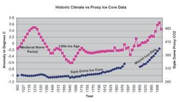
Figure 1. This figure is a plot of Historic Climate after Lamb included in the report of the IPCC, 1990 showing the well defined Medieval Warm Period and Little Ice Age. This chart of temperature variation is compared with Proxy CO2 data from the Siple Dome in Antartica. What is noteworthy is the complete disconnection between the proxy CO2 data and climate. Although the ice core proxies are claimed to be a direct measure of atmospheric CO2 , they do not reflect well established climate trends. The decline of CO2 proxies is coincident with burial depth and unrelated to climate. This should be compared with the data from Siple Dome Ice Core in IPCC, 2007 Synthesis Report, p. 38, Figure 2.3., in which the horizontal scale has been unduly compressed and the data gap between Siple Dome Proxies and the real CO2 values from Mauna Loa eliminated.
increase of 3 GT of carbon annually which drives the hypothesis of anthropogenic global warming (AGW).
Carbon dioxide is significantly denser than the other elements of air. It is almost 60% denser than nitrogen and 40% denser than oxygen. Happily, gases do not segregate gravitationally, otherwise we would all suffocate in a layer of Co 2 some 400 to 500 meters thick. Molecular activity in gases known as Brownian Motion causes rapid diffusion and mixing of the different molecular components. This is also aided by convection as well as global atmospheric circulation such that the components of the air are relatively constant globally. There are variations regionally and –especially in the southern hemisphere –where some fluctuations are attributed in part to La Nina and El Nino events, but the variation amounts to only a few parts per million by volume. In general, the southern hemisphere stations have values about 5 ppmv lower than in the northern hemisphere.
As a medium to warm the atmosphere, Co 2 seems like a very poor candidate. First, because it is a trace gas forming less than .0379 % by volume of the atmosphere and,
second, because it’s thermal conductivity is extremely low. Thermal conductivity is a property which measures how much heat per time unit and temperature difference flows in a medium. Most gases have such low conductivity values that they are excellent insulators in the absence of convection. The conductivity of Co 2 (0.009) is less than half that of air (0.024), and it is only 15% of the conductivity of water (0.058). Comparatively then, the capacity of Co 2 to warm the atmosphere conductively is negligible. Furthermore, examining the isochoric thermal diffusivity (a measure of how rapidly a temperature change will spread) demonstrates that doubling of Co 2 has a negligible effect. Based on these fundamental physical attributes, Co 2 can not be the vehicle of atmospheric warming. (Gerlich and Tscheuschner, 2007.)
This, then, leaves only radiation heat transfer as the principal vehicle for atmospheric warming by Co 2 . Radiation heat transfer occurs as a result of the exchange of thermal radiation energy between two or more bodies that arises as a result of a temperature difference. No medium need exist between the two bodies for heat transfer to take place, since Photons traveling at the speed of light are
the intermediaries of the electromagnetic radiation with a wavelength range of 0.1 to 100 microns, encompassing the visible light spectrum. Atmospheric warming is believed to occur as a result of the fact that the atmosphere is essentially transparent to short wave radiation in the visible light spectrum – 0.38 to 0.75 microns. However, global warming theory suggests that long-wave infrared radiation is preferentially absorbed by certain gases in the atmosphere, which causes it to warm. The principal atmospheric gas causing warming is water vapour and cloud with 85-95% of the warming attributed to it. The other gases in order of relative importance are carbon dioxide, methane, nitrous oxide, and ozone.
However, carbon dioxide has been identified in the global warming hypothesis as having the fundamental characteristics of absorption and emission of infrared radiation (IR) and, as a result, it is claimed that it is a potential driver of global climate. The carbon dioxide molecules do not have a simple single response to IR radiation. Four modes of molecular vibration, or spin occur in response to photon stimulation. Carbon dioxide is a linear molecule with the carbon atom situated in line between two oxygen atoms. The linear molecular structure allows a vibrational response in which the carbon atom oscillates between the oxygen atoms. This particular response has the ability not only to absorb infrared radiation but also to emit radiation; however, only some 5% of molecules actually radiate at room temperatures. The ability of Co 2 to radiate has been utilized in the development of lasers and in the thermodynamics of combustion chambers but this quantum state depends on elevated temperatures and electromagnetic stimulation. Alfred Schack, a pioneer in industrial thermodynamics, as early as 1972 indicated that the radiative heat transfer capabilities of Co 2 at atmospheric temperatures were negligible. The other quantum states of Co 2 are capable of absorbing infrared but do not radiate. Carbon dioxide absorption of IR radiation occurs in four narrow bands at 2, 3, 5, and 13-17 microns. Co 2 occupies only about 8% of the infrared band and, given its levels as a trace gas, does not in itself have the capacity to change the climate. This point is, in fact, conceded by climatologists but they rely on the concept of feedbacks to amplify the effect. Feedbacks are unproven assumptions that the warming by Co 2 will cause changes in clouds, water vapour, and precipitation
systems amplifying the warming. The positive feedback assumptions have been incorporated into climate models which are typically the major basis for global warming predictions. All leading climate models forecast that warming by increasing Co 2 would cause an increase in cloud, especially high altitude cirrus clouds, which would then amplify the warming. A recent publication by Spencer et al. (2007) has shown these assumptions to be incorrect. In fact the feedback is negative so that as the tropical atmosphere (of the study area) warms, cirrus clouds decrease. That allows more infrared heat to escape from the atmosphere to outer space.
Because Co 2 absorption occurs over a limited range of the IR spectrum it is generally accepted that 99% of the radiation in the Co 2 absorption bands is absorbed within only a few tens to hundreds of meters of the source. In other words the absorption capacity of Co 2 is saturated within a few hundred meters above the Earth’s surface. Thus doubling of atmospheric Co 2 will reduce the saturation distance, causing only a minor change in temperature. Climatologists accept that the temperature will change by less than 1°C. Nevertheless, as was discussed above, they claim that doubling of Co 2 will trigger
positive feedbacks, although – to this date – there is no measurable evidence that this occurs. Currently we are 40% of the way to doubling pre-industrial levels of Co 2 ; nevertheless, there has been no warming this century.
If Co 2 is saturated, that is to say incapable of getting any warmer by any further absorption of IR radiation, then how does the warmed gas behave? At this point convective heat transfer will take over and the gas will rise to be replaced by cooler air molecules. Since carbon dioxide, is to a large extent, a product of combustion its vertical ascent along with water vapour is a common feature of our winter landscape. As the warmed air ascends the pressure drops and the molecules expand, which causes a drop in temperature. When gas is compressed it generates heat, as in the inflation of a tire, and when decompressed it loses heat, the property utilized in snow-making equipment. If the volume remains the same and pressure is decreased, then the temperature will drop, which is the case in the global atmosphere. The determining factor in atmospheric pressure is the mass and weight of the gas in that part of the atmosphere above the point of measurement. Air pressure
(Continued on page 40...)
Figure 2. The “Hockey Stick Curve for CO2 from the IPCC, 2007 Synthesis Report p. 38, Figure 2.3 also from Siple Dome in Antarctica. Note the monotonous almost flat CO2 proxy curve for the last 10,000 years, a period, during which, there was significant climatic variation. This suggests that, either the proxy data are wrong, or CO2 has no effect on climate. Also compare to Figure 1 the same data without the manipulation to exaggerate the post industrial increase of CO2
increases continuously from the top of the atmosphere to the Earth’s surface and so does temperature. This behaviour of the atmosphere is described as adiabatic because there is no actual change in heat, but only pressure and temperature. The rate at which temperature changes in the atmosphere is called the lapse rate. The theoretical lapse rate for a dry atmosphere is 9.8°C per kilometer but this is only for extremely dry atmosphere such as in desert and arctic climates. The effect of high humidity and cloud is to reduce the lapse rate to an average of about 6.5°C per kilometer. As a result it is normal to find aircraft cruising at 10,000 meters (32,000 feet) experience air temperatures of -65°C. Given an average sea level temperature of 15°C the temperature at 2,500 meters altitude is -1.25°C, which is why mountains maintain snow cover and glaciers. This means that some 80% of the lower 20 kilometers of the atmosphere (the troposphere) is between 0 and -65°C. Therefore, in the predominantly subzero temperatures of the troposphere with the atmospheric pressure progressively diminished by adiabatic expansion, the kinetic energy of the gases is greatly reduced. As a result, quantum molecular activity causing IR emission is reduced substantially.
Irrespective of the discussion above, the IPCC 2007: Historical o verview of Climate Change (p. 115, Figure 1) suggests that some infrared radiation passes through
the atmosphere but most is absorbed and re-emitted in all directions by greenhouse gas molecules and clouds. The effect of this is to warm the Earth’s surface and the lower atmosphere. This statement conflicts with the Second Law of Thermodynamics which indicates that energy will always flow from a higher to a lower energy state. Heat can not flow from a colder body (the atmosphere) to a warmer body (the Earth’s surface) without work being applied. This is a fundamental problem with the Global Warming Hypothesis which unaccountably never seems to be challenged. Clouds have the capacity to absorb infrared radiation but their capacity to emit is poor. Even if this were not the case, the cooler cloud can not warm the Earth’s surface. Clouds generally, and low clouds in particular, cool the surface. A point that is clearly made in the weather records of the Little Ice Age (Lamb, 1965) and more specifically by Svensmark and Friis-Christensen (1997).
IPCC in the May, 2007. “Summary for Policymakers” stated that Co 2 was the most important anthropogenic greenhouse gas, that it had increased markedly as a result of human activities, and that its atmospheric concentration of 379 ppmv in 2005 far exceeded the natural range of 180 to 300 ppmv over the last 650,000 years.
This statement is based on proxy Co 2 concentration data derived from ice cores and is based on the assumption that air inclusions in ice are closed systems permanently preserving the
Figure 3. This is a plot of proxy CO2 values versus depth from the Taylor Dome Ice Core. This data together with data from Siple Dome is used to establish a pre-industrial level for CO2 of 280 ppmv in the IPCC 2007 report. This core covers an age range from the 17th Century into the Holocene, 8,992BP covering four well documented warm periods, and yet, shows no variability in concert with the climatic cycles. The most striking feature of the proxy CO2 values is the progressive decrease with depth suggesting depletion by diffusion from decompression and mechanical fracturing of the core during drilling.
chemical and isotopic composition of the gas. This is one of the cornerstones of the AGW hypothesis. Why should we doubt this particular proposition? First, when examined in detail the Co 2 proxy values are remarkably invariant within a narrow range for a period of 10,000 years, during which the climate oscillated through several well defined warm and cold periods. Unlike most substances, the solubility of C o 2 decreases as temperature increases, thus warm periods will have elevated atmospheric Co 2 values because of degassing of the oceans. In cold periods, like the Little Ice Age, the values should be lower because of increased solubility of Co 2 . As displayed in Figure 1, there is no correspondence between the plot of proxy Co 2 values from Siple Dome and the corresponding plot of Historic Temperature published by IPCC (1990) following Lamb (1965) Reproduced in Figure 2 (page 39) is the IPPC (2007) version of the Siple Dome data (IPCC, Summary for Policymakers, p. 3 Figure SPM1). The pronounced hockey stick shape of the curve is due primarily to the intense compression of the horizontal scale which causes the sharp bend and near vertical trajectory where the ice core proxy curve intersects with the actual measurements from Mauna Loa. It also neglects the 83-year gap between the ice cores and modern data.(Figure 1, lower curve).
The most significant trend in the proxy data at Siple and Taylor Domes in Antarctica is a drop in Co 2 values with depth as shown in Figure 1 and Figure 3. In both instances there is a nearly linear decline in proxy Co 2 values with depth, which bears no relationship to historic climate. The depth corresponds to burial pressure in the ice where each 100 meters is equivalent to roughly one atmosphere of pressure. The burial depth at Taylor Dome is some 350 meters so that the pressure at the base of the core is 3 bars, or about 50 psi. When the core is recovered, decompression and drilling stress causes a network of fine cracks which attract and absorb bipolar molecules such as Co 2 and H 2 o. The cracks become diffusion paths for trapped gases to leave the ice, or for some atmospheric gas to enter, thus causing a depletion of the original Co 2 content of the core. (Jaworowski, 2007; Hurd, 2006). There is also strong evidence indicating that the Co 2 values in ice cores are depleted. Stomatal frequency analysis in fossil birch leaves (Wagner, 1998; Wagner et al., 2002) show a much greater variation in Co 2 values from 270 ppmv up to 323 ppmv
Figure 4. The number of stomatal pores in plant leaves respond to atmospheric CO2 . The greater the CO2 the fewer pores develop. The upper curve then is a proxy CO2 curve based on stomatal indices in Birch leaves after Wagner et al. 2002. Note the consistently higher proxy values based on stomatal indices and the clear response to the well known Holocene cooling event. In contrast, the ice core data is invariant with a steady decline in proxy values with depth and shows no response to the Holocene cold period. Data from noaa.gov/pub/paleo/ice core/ antartica/taylordome.
(Figure 4, top curve). Furthermore, there is a significant response to the Holocene cooling event from 8400-8100 BP. The atmospheric C o 2 content decreases concurrent with increased solubility in the cooling ocean. In comparison the ice cores at Taylor Dome demonstrate nearly flat values. (Figure 4, lower curve).
Further evidence of the variability of Co 2 values has been provided in a review by Beck (2007) of some 90,000 analytical measurements conducted before 1958 and dating back to the nineteenth century. The Co 2 show rather large variations, in contrast to the ice core data’s flat and invariant Co 2 proxy data. Beck’s summary of the analytical data documents a large increase in Co 2 values co-incident with the warming observed from 1920 to 1940 (Figure 5). In general, this data is rejected by IPCC but not on grounds of analytical accuracy, which is excellent, but because the values did not fit their preconceived concepts. Beck’s review is thorough and comprehensive, and convincingly demonstrates significant variability in atmospheric Co 2 in contrast to ice core data.
Although a great deal has been made of the dangers of Co 2 emissions, much of it is nothing more than fear mongering. The truth is that Co 2 is highly beneficial to the planet. The measurements at the Mauna Loa recording station are demonstrating an increase in amplitude of the seasonal Co 2 cycle (high in winter, low in summer), which indicates that Co 2 fertilization is expanding
the biosphere and, in fact, creating a negative feedback. Plants use Co 2 to produce the organic molecules which forms their tissues. Higher levels of Co 2 in the air allows plants to grow bigger, produce more branches and leaves, expand their root systems, and produce more flowers and fruit (Idso, 1989). There is an extensive amount of published data indicating the growth enhancement provided by a 300 ppmv increase in atmospheric C o 2 . (Poorter, 1993; Ceulmans and Mousseau,
1994; Wullschleger et al., 1995 and 1997). Fertilization by Co 2 causes plants to produce fewer stomatal pores per unit area of leaf and the pores are narrower. This change reduces most plants’ rate of water loss by transpiration allowing them to withstand drought conditions more effectively (Tuba et al., 1998; Idso and Quinn, 1983).
Similarly in the oceans, Co 2 fertilizes the organisms at the base of the food chain. The high solubility of Co 2 in cold water explains the rich organic life of the cold Arctic and Antarctic waters. Alarms have been raised concerning acidification of ocean waters. However, much of this is unfounded as sea water is not inorganic brine but is dominated by organic life which interacts with the oceans chemistry. Surface waters in particular are teeming with microorganisms. Cyanobacteria at the base of the oceanic food chain photosynthesis Co 2 to provide sugars and give up oxygen. These very ancient organisms are believed to have provided the oxygen in the ancient atmosphere, which originally was dominated by nitrogen and carbon dioxide, which has had concentrations ranging up to 5,000 ppmv in the Palaeozoic. These values are up to 13 times higher than present day numbers. During the early part of the Palaeogene Period, from 65 to 34 million years ago, global climates were much warmer than today with very little ice at the poles, and Co 2 levels up to 5 times
(Continued on page 42...)
Figure 5. A comparison of Proxy CO2 ice core data with CO2 derived by analytical chemical methods from 18501958. The results are displayed against the average temperature in the northern hemisphere from GISS. The chemical analyses are displayed as five-year averages and show significant variation associated with cooling and warming of the climate, while the proxy ice core data is flat and invariant. The atmospheric CO2 content after 1958 is from Mauna Loa observatory. Figure modified after Beck 2007.
greater than today at 1,889 ppmv. (Pagani, 2005). The richness and diversity of life at this time does not indicate any injurious effects to the biosphere of significantly higher Co 2
Finally, the IPCC claim that the reported warming since 1979 is very likely caused by the human emission of greenhouse gases (mainly Co 2 ) can not be supported because it places an undue reliance on proxy Co 2 values from ice cores. The ice core data, because of the low and invariant values would indicate a prolonged cold period. This is not supported by well documented cycles of warming and cooling since the Holocene. Therefore, one has to conclude that the ice core data is wrong or Co 2 has no obvious connection with climate change. The only coincidental correlation of Co 2 with warming climate has occurred in the decades from the 1980s to 1990s. This correlation no longer appears relevant since there has been no warming since 1998 and the climate has cooled significantly since 2007. The failure to demonstrate a link between Co 2 and climate change indicates that the policies being called for to fight climate change can not be justified and are unnecessary. To
follow this path will result in an enormous misuse of capital that diverts from developing more effective and efficient methods of energy use.
The public debate over climate change has strayed far from objective science and has been extremely distorted by the errors and exaggerations in the reports of the IPCC. It is a profound embarrassment to science that hype and spin have replaced reason in such an important issue.
REFERENCES:
Beck, E. G. 2007. 180 years of CO2 gas analysis by chemical methods. Energy and Environment, v. 18, no. 2, p. 258-282.
Ceulmans, R. and Mousseau. M. 1994. Effects of elevated CO2 on woody plants. New Physiologist v. 127, p. 425-446.
Friedli, H. et al. 1986. Ice core record of the 13C/12C ratio of atmospheric CO2 in the past two centuries. Nature, v. 324, p. 237-238.
Gerlich, G. and Tscheuschner, R. D. 2007. Falsification of the atmospheric CO 2 greenhouse effects within the frame of physics. arXiv:0707.1161v1[Physics.ao-ph] 8 July 2007.
Hurd, B. 2006. Analyses of CO2 and other atmospheric gases. AIG News, no. 86, p. 1011.
Idso, S. B. and Quinn, J. A. 1983. Vegetational redistribution in Arizona and New Mexico in response to doubling of the atmospheric CO2 concentration. Laboratory of Climatology, Arizona State University, Tempe, Arizona. Climatological Publications Scientific Paper no. 17.
Indermuhle et al. 1999. Holocene carboncycle dynamics based on CO2 trapped in ice at Taylor Dome, Antarctica. Nature, v. 398, p. 121-126.
Intergovernmental Panel on Climatic Change. 1990. Climate Change – The IPCC Scientific Assessment. Cambridge University Press, Cambridge.
Intergovernmental Panel on Climatic Change. 2001. Climate change 2001: The scientific basis. Cambridge University Press, Cambridge.
Intergovernmental Panel on Climatic Change. 2007. Climate change: The physical science basis. IPCC Summary for Policymakers. Fourth Assessment Report. Geneva, Switzerland.
Jaworowski, Z. 1994. Ancient atmosphere - validity of ice core records. Environmental Science and Pollution Research v. 1, pt. 3, p. 161-171.
Jaworowski, Z. 2007. The greatest scientific scandal of our time. EIR, Science. March 16.
Lamb, H. H. 1965. The Early Medieval Warm Epoch and its sequel. Palaeogeography, Palaeoclimatology, Palaeoecology. v. 1, p. 13-37.
Neftel, A. et al. 1985. Evidence from polar ice cores for the increase in atmospheric CO2 in the past two centuries. Nature, v. 315, p. 45-47.
Pagani, M. 2005. Deep sea algae connect ancient climate, carbon dioxide and vegetation. Yale University, June 27 2005.
Poorter, H. 1993. Interspecific variation in the growth response of plants to an elevated ambient CO 2 concentration. Vegetation 104/105: p. 77-97.
Schack, A. 1929. Industrial Heat Transfer. (in German) Stahleissen m.b.H., Dusseldorf, First Published 1929, 8th Edition 1983.
Schack, A. 1972. The influence of the carbon dioxide content of the air on the climate of the world. (in German) Physikalische Blatter v. 28, p. 26-28.
Schimel, D. S. 1995. Global Change Biology. v. 1, p. 77-91.
Spencer, R. 2008. Climate confusion: How global warming hysteria leads to bad science, pandering politicians, and misguided policies that hurt the poor. Encounter Books, New York.
Spencer, R. W., Braswell, W. D., Christy, J. R., and Hnilo, J. 2007. Cloud and radiation budget changes associated with tropical intraseasonal oscillations. Geophysical Research Letters, v.34 L15707, doi: 10.1029/2007 GL 029628.
Svensmark, H., and Friis-Christensen, E. 1997. Variation of cosmoc ray flux and global cloud coverage – A missing link in solar climate relationship. Journal of Atmospheric and SolarTerrestrial Physics, v. 59, no. 11, p. 12251232.
Tuba et al. 1998. Carbon gains by desiccationtolerant plants at elevated CO2 . Functional Ecology. v. 12, p. 39-44.
ROCK SHOP

Wagner, F. et al. 1999. Century-scale shifts in Early Holocene atmospheric CO2 concentrations. Science, v. 284, p. 1971-1973.
Wagner,T., Aaby, B., and Visscher, H. 2002. Rapid atmospheric CO2 changes associated with the 8200-years-BP cooling event. Proceedings of the National Academy of Sciences, v. 99, no. 19, p. 12011-12014.
Wullschleger, et al. 1997. Forest trees and their response to atmospheric CO2 enrichment: A compilation of results. In: Advances in Carbon Dioxide Effects Research. L.H. Allen et al (eds.). American Society of Agronomy, Madison, WI. p. 79-100.
Wullschleger et al. 1995. On the potential for a CO2 fertilization effect in forests: Estimates of biotic growth factor based on 58 controlled exposure Studies. In: Biotic Feedbacks in the Global Climatic System. G.M. Woodwell and F.T. MacKenzie (eds.). Oxford University Press, New York. p. 85-107.

COMMENTS ON THE NATIONAL ENERGY BOARD MISCELLANEOUS REPORT 2008-8: Saskatchewan’s Ultimate Potential for Conventional Natural Gas
| by Robert A. Meneley
This review focuses on two aspects of the recently released National Energy Board (NEB) Report 2008-8, which was prepared jointly with staff from the Saskatchewan Ministry of Energy Resources: First, the discrimination between conventional and unconventional gas resources in Saskatchewan and, second, the treatment of conceptual gas plays in Saskatchewan compared with the NEB’s treatment of conceptual exploration plays in Canadian frontier basins.
C ONVENTIONAL AND U NCONVENTIONAL G AS R ESOURCES
In Saskatchewan the segregation of natural gas resources between conventional and unconventional gas plays is highly problematic. It can be argued that all of the gas resources in Saskatchewan are unconventional. In that case, the estimates of Ultimate Undiscovered Potential of
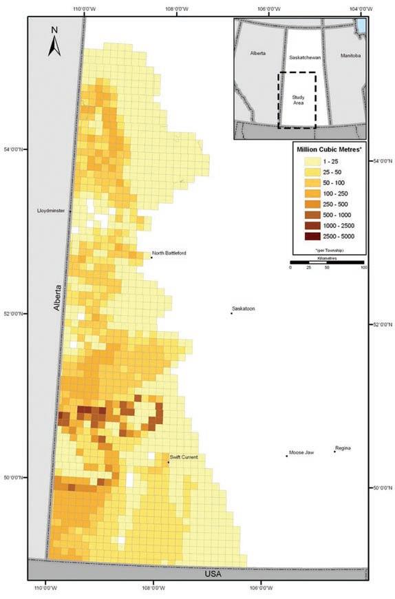
2.7 trillion cubic feet for conventional gas presented in NEB Report 20088 represent a reasonable estimate of the total undiscovered gas resources in Saskatchewan to be anticipated from all sources. The shale gas plays in eastern Saskatchewan described by yurkowski (2008), while interesting, cannot hold large volumes of marketable gas because of limited reservoir volume and shallow depth. There probably is not a significant additional tranche of gas called “Unconventional Gas” that would supplement long-term supply of conventional gas in Saskatchewan, as suggested in the joint report.
From a data-use standpoint, it would have been useful to show the distribution of undiscovered resource potential by gas density per township (Figure 1) in a table or graph. For example, this would
answer the question as to what portion of the undiscovered resource is contained in townships holding less than 25 million cubic metres of marketable gas. Using the average for this gas density class, only 12.3 million cubic feet of gas per section would be expected in this the areally largest undiscovered area. It may also show that a disproportionate volume of the cumulative undiscovered gas is contained in the large number of low-gas-density townships that will be the least likely to be developed commercially. The maximum undiscovered potential is expected in a relatively few townships (approximately 16) in the vicinity of the larger discovered gas fields. Stacked plays probably contribute to this upper limit of gas density.
C ONCEPTUAL PLAYS
The treatment of gas resources in “Conceptual Plays” in Saskatchewan described in this report is highly commended. No marketable gas resources are counted for gas in Conceptual Plays. This treatment, applied to plays in Western Canada, stands in marked contrast to that applied by the NEB to the conceptual plays identified in Canadian Frontier Basins.
In the Canadian Gas Potential Committee (CGPC) Report “Natural Gas in Canada – 2005” assessments of marketable natural gas resources in all Established Exploration Plays were made for all of the Frontier Basins in Canada. However the assignment of no marketable gas volumes to conceptual plays in frontier basins by the CGPC is very different from the approach used by the NEB and the Geological Survey of Canada (GSC). The following quote from CGPC 2005 (p. 1-21) explains the rationale for this important difference.
“The fundamental difference between established and conceptual plays is the presence or absence of significant discoveries. This has profound impact on the risk that must be applied to any estimate of undiscovered potential. The average probability of geological success (defined as having a sustained, stabilized
Figure 1. A portion of Figure A3.2 from the NEB-SMER Miscellaneous Report 2008-8 illustrating undiscovered conventional natural gas resources potential per township.
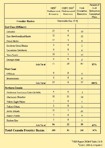
flow of hydrocarbons on test – o tis and Schneidermann, 1997) in a new play in a new basin is 5%. Assessment of large potential resources in such a setting can be very misleading unless proper risk levels are assigned in the assessment process.”
Undiscovered resource estimates for conceptual plays used by the NEB for the Frontier Basins are primarily derived from the work of the GSC. In their studies, the GSC consider that the presence of even minute quantities of hydrocarbons is sufficient to eliminate “play risk” in their assessments. This assumption, plus the propensity for subdividing geological areas and stratigraphic columns into many individual exploration plays gives rise to
their presumption that every exploration play will contain hydrocarbons. When all of the GSC estimates for individual conceptual plays are summed it gives rise to an unrealistic expectation of undiscovered resources.
Table 1 in this review illustrates the separation of Established and Conceptual Play volumes based on the CGPC 2005 report. Conceptual Plays hold 143 trillion cubic feet of gas, which is over 75% of the volume of undiscovered marketable gas estimated by the NEB in Canadian Frontier Basins. These are plays which have been identified and assessed, but where no Significant Discoveries have been made. Such plays are subject to a
very high risk that is hard to evaluate. Even in Established Plays in Frontier Basins only a portion of the estimated marketable gas will ever actually be marketed.
o verestimation of Frontier Gas resource potential through inclusion of estimated marketable volumes contributed by Conceptual Plays, as presented in NEB 2008-8 and in most recent NEB reports, leads to the false premise that Canada has a large future resource of undiscovered natural gas in Frontier Basins. This is not the case. In reality almost none of the Conceptual Plays will ultimately prove to be productive. This bias results in a relative downgrading of the future potential from Western Canada gas plays and overemphasis of Frontier potential. It would be more consistent and factually correct for the NEB to show their estimates of marketable gas from Conceptual Frontier plays as a separate category in tables such as Tables 2.6 A and 2.6 B (Current NEB estimates of ultimate potential for conventional marketable natural gas in Canada) in NEB 2008-8. Such estimates of conceptual marketable gas have such a low probability of ever being achieved they should not be included in the same tables as the much more assured undiscovered volumes in western Canada.
Assessment of undiscovered hydrocarbon resources is always difficult. There are no correct answers. Consistency in methodology and presentation are important to avoid skewing the results, particularly when people who do not understand how resource estimates were made use those results.
REFERENCES
Canadian Gas Potential Committee, 2005. Natural Gas Potential in Canada 2005. Summary and Conclusions. v. 1, 109 p.
National Energy Board and Saskatchewan Ministry of Energy and Resources. 2008. Saskatchewan’s Ultimate Potential for Conventional Natural Gas. Miscellaneous Report 2008-8. 42 p.
Otis and Schneidermann. 1997. A process for evaluating exploration prospect. American Association of Petroleum Geologists Bulletin. v. 81, no. 7, p. 1087-1109.
Yurkowski, M. 2008. Unconventional Gas in Saskatchewan: The Good, the Bad, and the Ugly. Canadian Society for Unconventional Gas. 10th Annual Unconventional Gas Conference November 19-21, 2008. Calgary, Alberta.
Table 1. NEB conceptual resources in frontier basins.
NORTH A MERICAN COMMISSION on Stratigraphic Nomenclature
| by Brian R. Pratt and Octavian Catuneanu
The North American Commission on Stratigraphic Nomenclature (NACSN) reviews and updates the North American Stratigraphic Code as required, and its commissioners represent various geological societies and federal, provincial, and state geological surveys. CSPG maintains a presence on NACSN through two representatives, and for the past few years this task has fallen to o ctavian Catuneanu (University of Alberta) and Brian Pratt (University of Saskatchewan).
The 2008 gathering was convened in early o ctober 2008 during the Geological Society of America annual meeting in Houston. NACSN has endeavoured to enhance participation by Mexican bodies,
and this year was able to welcome new representatives. o ne item that is being considered for possible inclusion in the Code is whether or not formal hydrostratigraphic units should be recognized. CSPG members who have thoughts on this idea should send them to either Brian or o ctavian.
NACSN is closely linked to the International Subcommisson on Stratigraphic Classification, which is in turn part of the International Commission on Stratigraphy and the International Union of Geological Sciences. Both Brian and o ctavian are active in ISSC, with Brian having been elected chair for 2008–2012. NACSN and other national bodies are
awaiting recommendations from ISSC about the nomenclature of sequence stratigraphy and at present an international consensus is being marshalled.
Eventually an updated International Stratigraphic Guide will be published, and it is hoped national codes will be harmonized with it. In the meantime, the North American Stratigraphic Code was published in its most recent iteration in 2005 (AAPG Bulletin, v. 89, p. 1547–1591), and is available for free downloading (http:// ngmdb.usgs.gov/Info/NACSN/05_1547. pdf). The NACSN website is hosted by the American Geological Institute: http:// www.agiweb.org/nacsn/.


industry-leading customer service
easy & efficient migration of existing data helping clients increase productivity
We know that almost everyone who tries geoSCOUT™ wants to use geoSCOUT. So, why hasn’t everyone already switched to geoSCOUT? Probably because, in general, people don’t like change. But, in this case we’ve got you covered, so change is good – very, very good.
Just ask the thousands of landmen, engineers & geologists currently using geoSCOUT oil and gas mapping and analysis software to make solid decisions every day.
Give us an hour for a demo – we know you’ll see the value. Call 403.262.1992 | Email info@geoscout.com | Online www.geoscout.com/demo
Another powerful suite of tools from


Right When You Need
Open for business 24/7, Halliburton has the right open-hole technology—backed by our legendary reliability and service excellence—right now
Whether you need formation evaluation, imaging, testing, fluid sampling, acoustics/rock mechanics, NMR, hostile/slim hole, sidewall coring or any other open-hole service—Halliburton has exactly what you need, when you need it. For more information, call 1-888-775-6447. Or visit us at www.halliburton.com/wireline.