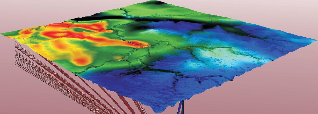
IHS AccuMap ®
“AccuMap encompasses speed, stability, efficiency and accuracy. As an intuitive and easy-to-use product, AccuMap serves a broad audience, from field users to the CEO.”
Darrel Saik Senior Geological Technologist Paramount Energy Trust
AccuMap is the most widely used and highly trusted oil and gas mapping software touching every segment of E&P, for every professional.

www.ihs.com/energy
Call toll free 1 877 495 4473


CSPG OFFICE
#600, 640 - 8th Avenue SW
Calgary, Alberta, Canada T2P 1G7
Tel: 403-264-5610 Fax: 403-264-5898
Web: www.cspg.org
Office hours: Monday to Friday, 8:30am to 4:00pm
Business Manager: Tim Howard
Email: tim.howard@cspg.org
Membership Services: Kristina Keith
Email: kristina.keith@cspg.org
Communications & Public Affairs: Heather Tyminski
Email: heather.tyminski@cspg.org
Conventions & Conferences: Shauna Carson
Email: shauna.carson@cspg.org
Conventions & Conferences Assistant: Tanya Santry
Email: tanya.santry@cspg.org
Corporate Relations Manager: Sarah Barton
Email: sarah.barton@cspg.org
Programs and Services Manager: Lori Humphrey Clements
Email: lori.humphreyclements@cspg.org
Reception: Dayna Rhoads
Email: reception@cspg.org
EDITORS/AUTHORS
Please submit RESERVOIR articles to the CSPG office. Submission deadline is the 23rd day of the month, two months prior to issue date. (e.g., January 23 for the March issue).
To publish an article, the CSPG requires digital copies of the document. Text should be in Microsoft Word format and illustrations should be in TIFF format at 300 dpi., at final size. For additional information on manuscript preparation, refer to the Guidelines for Authors published in the CSPG Bulletin or contact the editor.
Technical Editor
Ben McKenzie
Tarheel Exploration
Tel: 403-277-4496, Email: bjmck@telusplanet.net
Coordinating Editor
Heather Tyminski
Comunications and Public Affairs, CSPG
Tel: 403-513-1227, Email: heather.tyminski@cspg.org
ADVERTISING
Advertising inquiries should be directed to Sarah Barton, Tel: 513-1229, Email: sarah.barton@cspg.org. The deadline to reserve advertising space is the 23rd day of the month, two months prior to issue date.
The RESERVOIR is published 11 times per year by the Canadian Society of Petroleum Geologists. This includes a combined issue for the months of July/August.
Advertisements, as well as inserts, mailed with the publication are paid advertisements. No endorsement or sponsorship by the Canadian Society of Petroleum Geologists is implied. The contents of this publication may not be reproduced either in part or in full without the consent of the publisher.
Design & Layout by Sundog Printing. Printed in Canada by Sundog Printing.
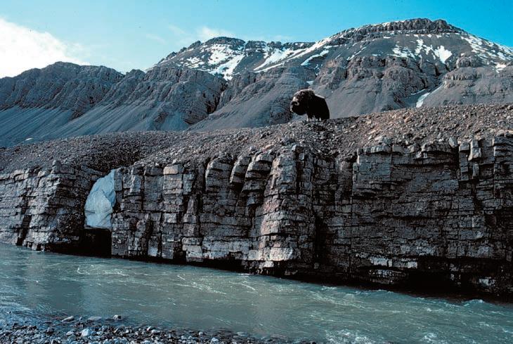
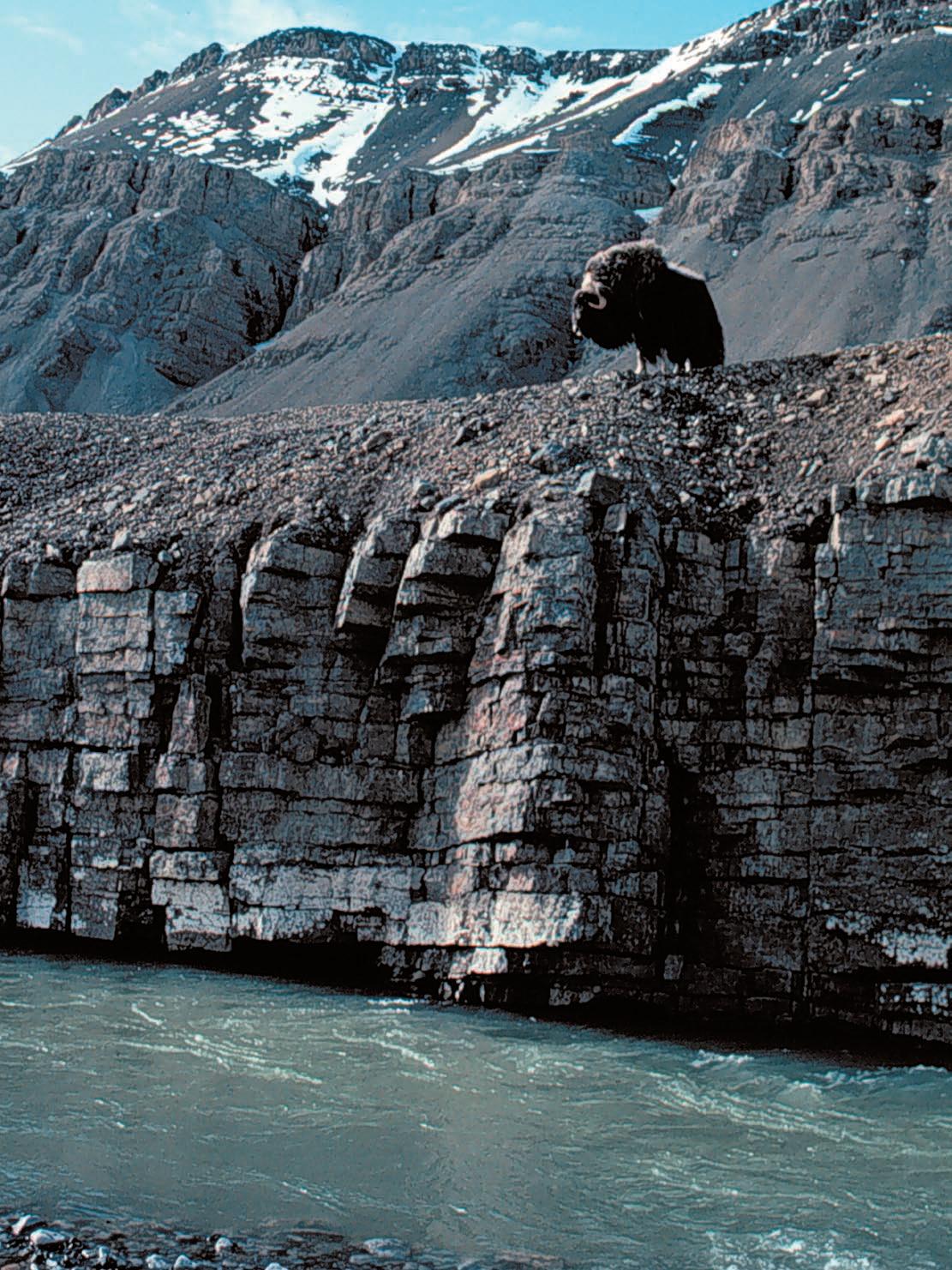
FRONT COVER
Blind Fiord, Ellesmere Island, Nunavut. Muskox bull standing on Lower Permian Great Bear Cape Formation with same succession overthrusted in the background. Photo by Benoit Beauchamp.
Spend more time making decisions and less time managing data.
PETRA provides geoscientists and engineers the analysis tools needed for today’s exploration and exploitation challenges
IHS Enerdeq Desktop and IHS AccuMap directly export well and production data into PETRA projects
For the first time raster logs from IHS AccuLogs are available in PETRA for use with digital log data
Download a trial version at ihs.com/energy/petra


For more information visit: energy.ihs.com/petra


CSPG EXECUTIVE
President
Lisa Griffith • Griffith Geoconsulting Inc. lgriffith@griffithgeoconsulting.com Tel: (403) 669-7494
Vice President
Graeme Bloy • West Energy Ltd. gbloy@westenergy.ca Tel: (403) 716-3468
Past President
Colin Yeo • EnCana Corporation colin.yeo@encana.com Tel: (403) 645-7724
Finance director
James Donnelly • ConocoPhillips Canada james.donnelly@conocophillips.com Tel: (403) 260-8000
assistant Finance director
David Garner • Chevron Canada Resources davidgarner@chevron.com Tel: (403) 234-5875
Program director
Randy Rice • Suncor Energy Inc. rjrice@suncor.com Tel: (403) 205-6723
serVice director
Jen Vezina • Devon Canada Corporation jen.vezina@devoncanada.com Tel: (403) 232-5079
assistant serVice director
Ayaz Gulamhussein • NuVista Energy Ltd. Ayaz.gulamhussein@nuvistaenergy.com Tel: (403) 538-8510
outreach director
Greg Lynch • Shell Canada Limited greg.lynch@shell.com Tel: (403) 691-2052
assistant outreach director
Mike DesRoches • DesRoches Consulting Inc. mdesroch@shaw.ca Tel: (403) 828-0210
communications director
Peggy Hodgkins • CGGVeritas peggy.hodgkins@cggveritas.com Tel: (403) 266-3225
corPorate relations director
Monty Ravlich • Sanjel Corporation mravlich@sanjel.com
EXECUTIVE COMMENT
A message from the Communications Director, Peggy Hodgkins
In the fall of 2007, I was asked to join the CSPG Executive as Communications Director.
Ashton Embry, who had been in this position for seven years, was stepping down and I saw an opportunity to help the Society achieve one of its important goals. A key underpinning of the Society is the dissemination of high quality, relevant, useful, and important information to its members. As the new Communications Director, it is my mandate to make sure that members have quick access to any and all information they need to do their jobs.
Communications within the CSPG can be broken down into three core areas of focus: the Bulletin, the Reservoir, and the CSPG website. It is the goal of the CSPG executive committee, and namely me, your Communications Director, to continually evaluate and improve these services to make them vital to you, our members. We want to know how we can improve the Reservoir so that you will want to hang on to copies rather than tossing them in the recycle bin. We want to know how you like your publications delivered to you. We want to know how the website can better work for you and to know what should be included in it. I need to make sure that you have an efficient way to access the information you need to work productively in your interdisciplinary team.
Last year, a key communications strategy was to use the Reservoir as a vehicle for making our members aware of new technologies and techniques that enable them to participate more fully in integrated work team processes. As more emphasis is placed on exploitation activities, necessary skill sets are changing dramatically. It is now reservoir characterization rather than exploration plays that dominate company activities. Subtle bypassed pay, type well production profiles, and geomechanics are only a few areas of expertise that geologists now must address as part of their team. This year, two technology series were run in the Reservoir, covering GIS and reservoir engineering, and we hope to launch additional
series that cover many of the other subjects that our members will be exposed to in their work environments.
With this in mind, let me describe the Communications objectives for 2008.
The Reservoir is the CSPG’s primary vehicle to inform, entertain, and educate our members. We would like to expand its scope so that it helps prepare members for the reality of prospecting in a mature basin. This will be accomplished through a series of articles that span the range of disciplines necessary to be a successful petroleum geologist. Economics, joint interest and land negotiating, drilling and completions, production and facility engineering, and reserve assessments are all part of the world we work in.
As a geologist, it is not necessary to be an expert in any of these fields, but the more we know about each, the better we are at our jobs as we interact with other experts. My plan is to lay out a three-year storyboard of topics and recruit expert individuals or organizations that will contribute material for each topic. The idea is to have a series of articles on each topic that will span several issues of the Reservoir. Look back at the series Simplifying Seismic , written by Dr. Easton Wren during 2005, as an example of what we are trying to achieve. Ben McKenzie (the Reservoir ’s technical editor) recently completed a seven-part series on GIS. Lisa Dean with Fekete is currently publishing a series on reservoir engineering. These informative articles exemplify our goal of expanding our members’ awareness in earth science advances.
For the Bulletin , we plan to develop a proactive recruiting drive for new papers. Of course, I will be working closely with new co-editors Denis Lavoie of the GSC-Quebec (eastern co-editor) and Rob MacNaughton of the GSC-Calgary (western co-editor) to (Continued on page 7...)
Proudly brought to you by Professionals in Geoscience and Engineering
Alberta’s Professional Geoscientists and Engineers provide Albertans with many of the essentials of daily living. The work that they do allows all of us to enjoy warmth, light, power, water and the ability to travel and communicate over distance.
Since 1920, Members of APEGGA, The Association of Professional Engineers, Geologists and Geophysicists of Alberta, have made a difference in the daily lives of millions of Albertans by bringing science and innovation to life.
The P.Geol., P.Geoph., P.Eng., and R.P.T. professional designations represent the highest standards of quality, professionalism and ethics in geoscience and engineering. APEGGA Members can take pride in the role they play and the contribution they make to Alberta. APEGGA and its over 47,000 Members are committed to public safety and wellbeing through the self-regulation of the geoscience and engineering professions in Alberta.
Visit www.apegga.org for more information.
Geologists Geophysicists Engineers

CORPORATE MEMBERS
ABu DhABI OIL CO., LTD. (JAPAN)
APAChE CANADA LTD.
BAKER ATLAS
BG CANADA ExPLORATION & PRODuCTION, INC
BP CANADA ENERGy COMPANy
CANADIAN FOREST OIL LTD.
CANETIC RESOuRCES TRuST
CONOCOPhILLIPS CANADA
CORE LABORATORIES CANADA LTD
DEvON CANADA CORPORATION
DOMINION ExPLORATION CANADA LTD
DuvERNAy OIL CORP
ENERPLuS RESOuRCES FuND
FuGRO AIRBORNE SuRvEyS
geoLOGIC systems ltd.
GRIZZLy RESOuRCES LTD
huNT OIL COMPANy OF CANADA, INC
huSKy ENERGy INC.
IhS
IMPERIAL OIL RESOuRCES LIMITED
LARIO OIL & GAS COMPANy
MJ SySTEMS
MuRPhy OIL COMPANy LTD.
NExEN INC
PENN WEST PETROLEuM LTD
PETRO-CANADA OIL AND GAS
PETROCRAFT PRODuCTS LTD.
PROvIDENT ENERGy LTD
RPS ENERGy CANADA LTD.
ShELL CANADA LIMITED
SPROuLE
SuNCOR ENERGy INC
TAQA NORTh LTD
TALISMAN ENERGy INC
TOTAL E&P CANADA LIMITED
WEAThERFORD CANADA PARTNERShIP
AS OF JANUARY 31, 2008
(...Continued from page 5)
help increase the current inventory of papers. More contributions are needed, especially in the areas of case studies and practical technology and techniques. how can we get more papers into the Bulletin ? Should we consider using technical ghostwriters; should we consider a format similar to AAPG’s E&P Notes?
A big concern is that many significant papers on Canadian petroleum geology are being published in the AAPG Bulletin rather than the CSPG Bulletin. I understand authors want maximum exposure (the AAPG Bulletin has a circulation ten times that of the CSPG Bulletin ), so we will have to think long and hard as to what we can offer CSPG authors. We also need to consider an e-Bulletin format. In this digital age, there is less need for space-consuming, paper-wasting publications, but we are committed to serve those members who wish to receive the traditional hard-copy format.
I would like to thank long-serving editor Glen Stockmal for his excellent stewardship of the Bulletin these last years. During that time, he reduced the cycle time for publication that is very important to contributors and ensured a steady stream of high-quality material for our members.
We are moving ahead to convert the Atlas of the Western Canada Sedimentary Basin to GIS format. A committee has been organized and is ready to begin the conversion process. They will be determining what additional features can be linked to these digital maps, such as type wells, cross-sections, and key papers. This has the potential to be a very powerful tool for our members to access large volumes of high-quality data quickly. I find this to be a very exciting opportunity for our members.
Finally, I see our website as a vehicle to bring everything together. Our members can log in and access all sorts of Society news, publications, presentations, and tools. With advanced search engines and links to other data and applications, we will strive to provide our members with the kind of information, technology, and know-how to increase their efficiency and effectiveness in their relentless search for oil and gas in Canada and around the world.
It is all about service to our members.
Special thanks to Ashton Embry for getting me up to speed on the activities of the past few years and to Colin Yeo, who was instrumental in helping me write this article.

Annual Luncheon Event
“Global Warming: Some Inconvenient Facts”
Patrick J. Michaels, PhD
Senior Fellow in Environmental Studies, CATO Institute Research Professor of Environmental Science, University of Virginia
Friday, May 2, 2008 at 11:30 Metropolitan Conference Centre 333, 4th Avenue SW, Calgary, Alberta
Sponsored by the Friends of Science Advocates of Climate Change Debate
$ 60 per ticket, $540 per table www.friendsofscience.org
Ticket can be obtained by email (Visa/MC accepted): friendsofscience.admin@gmail.com Payment can also be made by cheque to: Friends of Science

technical luncheons MARCH LuNCHEON
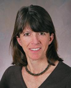
Hydrocarbon energy from the Arctic: Holy Grail or pipe dream?
SPEAKER
Benoit Beauchamp
Arctic Institute of North America, university of Calgary
11:30 am tuesday, march 11, 2008 telus convention centre calgary, alberta
Please note:
the cut-off date for ticket sales is 1:00 pm, thursday, march 6, 2008. ticket Price: $34.00 + gst
Due to the recent popularity of talks, we strongly suggest purchasing tickets early, as we cannot guarantee seats will be available on the cut-off date.
It is only a matter of time before Industry embarks seriously on exploration and development of Canada’s Arctic energy resources. With conventional natural gas production already in decline in the mature Western Canada Sedimentary Basin, the stubbornly low price of gas will recover before long. Oil currently hovers near $100 a barrel and could well pass that benchmark within the year, getting ever closer, in absolute dollars, to levels not reached since the oil shocks of the 1970s.
At a time when the world’s largest fields are in decline, only remote frontier areas like Canada’s Arctic offer any hope for large discoveries. And while China and India are rising, our u.S. neighbour shows no sign of losing its thirst for energy any time soon. Supply, demand, and the price of commodities will be high on the mind of Industry decision-makers the day they decide to go north, but a flurry of other factors will also weigh heavily on industry’s decision-makers before they commit billions of dollars in capital investment to go after Arctic resources.
One of the least worrisome aspects of Arctic energy development is probably the resource itself. Large gas discoveries were made during the first round of exploration three decades ago. There is enough gas in the large three fields of the Mackenzie Delta – Taglu, Ninglintgak, and Parsons Lake – to feed the yet-elusive Mackenzie valley pipeline for the next 20 years. h uge quantities of gas were also found in the Arctic islands, and shipping this gas to market is within the realm of possibilities if one is to believe a recent study by the Calgary-based Canadian Energy Research Institute (CERI).
While oil was the prime reason for the early round of exploration, the paucity of sizeable oil discoveries was a disappointment for early explorers. h owever, the recent discovery of 250 million barrels beneath the Beaufort Sea by Devon Canada in 2006 and the massive $585 million bid for a huge offshore block by Imperial Oil and Exxon Mobil Canada this past summer may have rekindled the oil flame. Beyond the known discoveries, the vast area that extends from the Delta and the Arctic islands, including both continental shelves to the north and east, holds much promise for many large and medium-size discoveries.
A handful of companies did not wait for the starting gun before taking a leadership position. One of them is MGM Energy, an offspring of Paramount Energy, which sees the recent pullback from the North as an opportunity to get in early. The same probably can be said of ConocoPhillips Canada and Chevron Canada, which also acquired some offshore land dispositions in the summer of 2007.
But beyond finding the resources in the ground, above or below the sea, these gutsy companies all face a seemingly endless list of challenges: a regulatory process that is seen as overly complicated and in the throes of too many interests, an environment that is harsh and unforgiving, a warming climate that is playing havoc with infrastructures, and political ramifications that seem far more complicated than they used to be.
Still, the conditions may not be insurmountable when compared with the earth’s other last remaining areas with substantial potential. These are often
war-torn countries, forsaken by democracy, and where corruption and terrorism rule the day. In the end, the loathed regulatory problems in the North may pale relative to dealing with war lords or with governments with a propensity to renege on sealed deals. No matter what and where, going after the big ones in the 21st century will be costly and risky.
BIOGRAPH y
Dr. Benoit Beauchamp is an established scientist who joined the University of Calgary as a Full Professor in the Department of Geoscience in April 2005. Until then, he was a Research Scientist with the Geological Survey of Canada (GSC), where he conducted energyrelated basin analysis in the Canadian Arctic Archipelago.
In addition to leading more than a dozen major field expeditions to one of Canada’s most remote, but also most promising petroleum provinces, he established himself as a solid scientist with a rich track record of government and academic publications. His curriculum vitae speaks volumes of his leadership quality, excellence as a researcher, and stature in the local, national, and international scientific community.
Upon joining the University of Calgary, he was seconded to the position of Executive Director of the Arctic Institute of North America, a position that allows him to direct a vibrant research program.
He is currently on the Scientific Board of the French Petroleum Institute (IFP). He was coChair of the 2007 Gussow Conference on Arctic Energy Exploration and gave the 2007 CSPG Honorary Address at the Jubilee Auditorium in November 2007 to commemorate the International Polar Year.
technical luncheons MARCH LuNCHEON
AcadianAlleghanian orogenesis as revealed by fracturing within the Appalachian Foreland
SPEAKER
Terry Engelder
Pennsylvania State university
11:30 am tuesday, march 25, 2008 telus convention centre calgary, alberta
Please note: the cut-off date for ticket sales is 1:00 pm, Wednesday, march 19, 2008. ticket Price: $34.00 + gst.
Due to the recent popularity of talks, we strongly suggest purchasing tickets early, as we cannot guarantee seats will be available on the cut-off date.
Assets within the Appalachian Basin range from conventional clastic and carbonate reservoirs to source rocks of Devonian black shale and Pennsylvanian coal, all of which are fractured. These fractures range from coal cleats and cracks around kerogen flakes to natural hydraulic fractures, tensile joints in stiff beds, and late-stage cross joints.
With some exceptions this broad range of fracture types propagated with the help of pressure generation accompanying the positive v reaction during maturation of hydrocarbons.
Before and during maturation, fracture orientation in the Appalachian foreland was controlled by an evolving tectonic stress that reflects three important details of AcadianAlleghanian orogenesis in the Appalachian hinterland.
First, pre-maturation, forebulge-related tensile joints in distal portions of the Acadian Catskill Delta complex reflect initial
loading of Laurentia (i.e., North America) by Gondwana (i.e., Africa) at the New york promontory. The earliest syn-maturation fractures are microcracks around kerogen flakes in black shale. Maturation-related pressure was enhanced by compaction disequilibrium.
Maturation continued to elevate pressure within Devonian black shales to the point that macroscopic natural hydraulic fractures (NhF) developed within the source rocks. The orientation of NhF in black shale and early coal cleats in the foreland reflects a basin-wide stress field arising from the oblique convergence of Gondwana and Laurentia, the second detail of AcadianAlleghanian orogenesis.
This basin-wide joint system supports the emerging view that dextral transpression controlled the kinematics in the mountain belt to a greater extent than previously recognized. Further burial led to the development of a complete fracture network in siltstones and gray shale of the basin. This later system of fracturing evolved in Alleghanian stress fields arising when

transpressional tectonics within crystalline basement, the third detail, drove the classic detachment sheets of the valley and Ridge and Appalachian Plateau.
BIOGRAPH y
Terry Engelder completed his Bachelor’s Degree in Geology at the Pennsylvania State University, his Master’s in Geology at Yale University, and his Ph.D. in Geology at Texas A&M University. He is currently a professor of geosciences at Pennsylvania State University.
He has written over 130 research papers, including “Stress Regimes in the Lithosphere.” He has also received numerous awards, such as the Fulbright Senior Fellowship and the FrenchAmerican Foundation Fellowship.
His professional interests include frictional properties of fault gouge, strain relaxation and hydraulic fracture in situ stress measurements, fracture analysis with focus on development of natural hydraulic fractures, strain analysis in foreland fold and thrust belts, and analysis of coupling between pore pressure and stress in basins.


technical luncheons APRIL
4D Seismic in the deepwater –challenges and rewards
SPEAKER
David Johnston
Exxonmobil Exploration Company
AAPG Distinguished Lecture
11:30 am
t hursday, a pril 10, 2008 telus c onvention c entre c algary, a lberta
Please note: the cut-off date for ticket sales is 1:00 pm, monday, april 7, 2008. t icket Price: $34.00 + gst.
Due to the recent popularity of talks, we strongly suggest purchasing tickets early, as we cannot guarantee seats will be available on the cut-off date.
Time-lapse or 4D seismic data has proven value in reservoir management, increasing reserves and recovery by locating bypassed and undrained hydrocarbons, and optimizing infill well locations and flood patterns. 4D seismic can also decrease operating costs by reducing uncertainty in the reservoir geologic model and flow simulation, optimizing completions, and minimizing the number of dry holes. 4D is simply the use of multiple seismic surveys shot over a producing field. Changes in the seismic response typically occur because of production-induced changes in saturation and pressure. Successful 4D projects have been carried out in a wide range of geographical areas, geological settings, and depletion scenarios.
To maximize the value of a 4D seismic project, planning for 4D is a critical part of an overall field lifecycle strategy. In exploration, assets can be screened for potential 4D application. Early in development planning, 4D seismic models based on reservoir flow simulations and geologic models are used to estimate the magnitude and interpretability
of the 4D response, evaluate optimal survey repeat times, and assess potential business impact. Once the field is under production, effective 4D project execution requires collaboration among asset team geoscientists, engineers, and field operations with geophysical acquisition and processing specialists.
Fields in West Africa and the Gulf of Mexico demonstrate that the deepwater production environment presents unique opportunities and challenges for 4D projects. Issues range from the impact of surface facilities on data quality to contending with ongoing field operations. In addition, aggressive drilling schedules dictate a rapid turnaround of 4D data. But these fields have high drilling and well intervention costs and 4D seismic may be the only available field-wide reservoir surveillance tool. This presentation shows how 4D seismic technology can be used in deepwater reservoir management and discusses some of the challenges faced in its application.
B IOGRAPH y
Reservoir Imaging
Expertise in heavy oil & deep basin reservoirs
• Time Lapse (4D) Processing
• 4D Cross Equalization
• Multicomponent (3C, 4C) Processing
• 3D Merging
• PSTM with Common Offset Vector Binning
Hart Janssen
B.Sc., Manager, Seismic Processing
Direct: 403-260-3372 Main: 403-237-7711
www.sensorgeo.com
David Johnston graduated in 1973 with his B.Sc. in Earth Science from Massachusetts Institute of Technology. He then went on to receive his Ph.D. in Earth Sciences from Massachusetts Institute of Technology in 1978. Between 1978 and 1979 Johnston did doctorial research at the Massachusetts Institute of Technology. From 1979-2000 Johnston worked as a Research Geophysicist for Exxon Production Research Company. From 2000 to 2002 he worked as a Research Geophysicist for ExxonMobil Upstream Production Research Company.
Presently Johnston is a Senior Geophysical Advisor for ExxonMobil Exploration Company. Johnston has authored and co-authored over 25 external publications, numerous publications internal to ExxonMobil, and presented over 50 technical papers at conferences including AAPG, SEG, SPE, and OTC. Johnston is involved with AAPG, Society of Exploration Geophysicists, Society of Petroleum Engineers, and American Geophysical Union.
Depth Imaging
Before drilling your next well, work with CGGVeritas to obtain a superior structural image and experience the advantages of effective collaboration between interpreter and imager.
Expertise
> largest team of depth imaging specialists in Canada
> extensive experience processing foothills, deep basin, permafrost, and marine data
> largest in-house geophysical R&D team in Canada
ENVISION SUCCESS
Service
> dedicated imagers, supported by industryrecognized processing experts
> visualization facilities for effective QC and interactive analysis
> leverage communication and teamwork to achieve your goals
Technology
> advanced 2D and 3D model building tools
> anisotropic Kirchhoff and other leading technologies designed for land and marine data
> thousands of CPU nodes enable large throughput capacity
Rely on CGGVeritas to maximize your exploration accuracy. You’ll have access to leading seismic imaging technologies, highly sought 3D and 2D data, the most advanced acquisition capabilities and a staff dedicated to helping you succeed.
Focus on Performance. Passion for Innovation. Powered by People. Delivered with Integrity.
Time in time
Depth in depth
technical luncheons APRIL LuNCHEON
Reservoir-Scale Seismic Stratigraphy
SPEAKER
Bruce Hart McGill u niversity
11:30 am
tuesday, a pril 29, 2008 telus c onvention c entre c algary, a lberta
Please note: the cut-off date for ticket sales is 1:00 pm, thursday, april 24, 2008. ticket Price: $34.00 + gst.
Due to the recent popularity of talks, we strongly suggest purchasing tickets early, as we cannot guarantee seats will be available on the cut-off date.
The introduction of seismic stratigraphic techniques in the 1970s gave sedimentary geologists in the petroleum industry and Academia new tools for predicting lithology and analyzing the depositional history of sedimentary basins. Seismic stratigraphy originally focused on largescale exploration problems and was based on analyses of 2D seismic data in areas that were relatively “data poor” (i.e., few logs, core, or production data). Reflection terminations, seismic facies, and other readily observable characteristics of seismic data were revealed to contain information that could be used, at least qualitatively, to
predict the distribution of lithologies and reconstruct depositional histories.
Although these conventional seismic stratigraphic analyses are still used fruitfully, new challenges and opportunities confront the Petroleum Industry as it faces the need to improve recovery from mature fields. These areas are commonly data-rich (lots of log, core, and production data), and covered by relatively small three-dimensional seismic surveys that do not image all of the sequences or systems tracts that the reservoir rocks are part of. As such, a new mindset is needed, here termed reservoir-scale seismic stratigraphy, to help geoscientists maximize the stratigraphic information they can extract from seismic data. Integration of geologic and geophysical concepts and data is critical.
A case study from the Deep Basin (McCullagh, M.Sc., 2007, McGill u niversity) illustrates concepts and methods used in a reservoir-scale seismic stratigraphy. Every piece of available data, core, logs, seismic, and engineering data, was integrated to define stratigraphic controls on production from the Cadotte Member in the Wapiti Field area. Core and logs were integrated to establish a stratigraphic framework. Not all of the units defined this way were resolvable seismically, and the three-dimensional seismic volume imaged only a relatively small portion of the depositional sequence represented by the Member. h owever, the seismic data volume provided key information about inter-well variability in reservoir
properties that could not be defined or mapped using the well data alone.
Techniques employed by geophysicists for at least the past decade (inversion, seismic attribute studies, automated seismic facies analysis, seismic visualization, etc.) need to become routine parts of the sedimentary geologist’s toolkit, whereas seismic interpreters (traditionally geophysicists in most companies) need to study outcrops, core, and modern analogs in order to anticipate the presence of depositional features that cannot be resolved seismically. This crossdisciplinary interaction will undoubtedly spawn new breakthroughs in sedimentary geology, reflection seismology, petroleum geology, and related fields.
B IOGRAPH y
Bruce Hart has a Bachelor’s Degree from McMaster University, a Master’s Degree from the Université du Québec à Rimouski, and a Ph.D. from the University of Western Ontario. He worked for the Geological Survey of Canada, Penn State, and The New Mexico Bureau of Mines and Mineral Resources prior to joining McGill University in the summer of 2000. From August 2006 – May 2007 (sabbatical leave) he was a seismic stratigrapher with ConocoPhillips’ Subsurface Technology Group in Houston.
His research focuses on the integration of 3D seismic and other data types in reservoir characterization programs. His 3D seismic work has addressed structural and stratigraphic problems from Paleozoic, Mesozoic, and Cenozoic clastic and carbonate reservoirs from the Alberta Basin, San Juan Basin, Williston Basin, Onshore and Offshore Gulf of Mexico, Permian Basin, Appalachian Basin, Scotian Shelf, West Africa, and Western Desert of Egypt. Reservoir characterization efforts have included evaluating fractured tight-gas reservoirs, porosity prediction in carbonate build-ups, sequence stratigraphy of lowstand deposits, extensional and strike-slip tectonics, and other topics.
He has over 50 technical publications (not including abstracts) and has taught courses and workshops for industry professionals on 3D seismic interpretation in Cairo, Copenhagen, The Hague, Kuala Lumpur, Houston, Denver, New Orleans, San Antonio, Calgary, Halifax, and elsewhere, with participants working for companies such as Anadarko, ConocoPhillips, Nexen, Chevron, Apache, Shell, PetroCanada, Talisman, and others.
To us, it’s all about making your career a big success.
Choose from over 50 exciting field seminars and short courses all designed with the goal of helping you explore and better understand your industry. For complete details on any of the field seminars and short courses offered by the AAPG, call +1 918 560-2650 or visit http://www.aapg.org/education/
SHORT COURSES
Practical Salt Tectonics
Date: May 5-6, 2008
Location: London, England
Instructor: Mark G. Rowan, Consultant, Boulder, CO
http://www.aapg.org/education/shortcourse/details.cfm?ID=67
Basic Well Log Analysis
Date: May 13-16, 2008
Locations: Austin, TX
Instructors: George B. Asquith, Texas Tech University, Lubbock, TX; Daniel A. Krygowski, The Discovery Group, Denver, CO http://www.aapg.org/education/shortcourse/details.cfm?ID=109
Essentials of Subsurface Mapping
Date: May 19-20, 2008
Location: Dallas, TX
Reservoir Engineering for Petroleum Geologists
Date: May 28-29, 2008
Location: Houston, TX
Instructor: Richard G. Green, Saxon Oil, Dallas, TX http://www.aapg.org/education/shortcourse/details.cfm?ID=71
Exploring for Stratigraphic Traps Using Pressure/Depth Plots & Salinities
Date: June 2-4, 2008
Location: Denver, CO
Exploration in Stratigraphic Traps
Instructor: Hugh Reid, Hugh W. Reid & Associates, Calgary, AB, Canada http://www.aapg.org/education/shortcourse/details.cfm?ID=49
Multi-Component Seismic Stratigraphy
Date: June 11-12, 2008
Location: Houston, TX
Instructor: Richard Banks, Scientific Computing Applications, Inc., Tulsa, OK http://www.aapg.org/education/shortcourse/details.cfm?ID=29
Deep-Water Sands - Integrated Stratigraphic Analysis: A Workshop Using Multiple Data Sets
Date: May 26-28, 2008
Location: London, England
Instructor: John M. Armentrout, Cascade Stratigraphics, Damascus, OR http://www.aapg.org/education/shortcourse/details.cfm?ID=52
FIELD SEMINARS
Modern Terrigenous Clastic Depositional Systems
Dates: May 1 - 8; June 14 - 21, 2008
Location: Begins in Columbia and ends in Charleston, South Carolina
Leader: Walter J. Sexton, Athena Technologies, Inc., Columbia, SC http://www.aapg.org/education/fieldseminars/details.cfm?ID=6
Submarine Canyons, Channels, Fans and Deep-water Sequence Stratigraphy
Date: May 4-7, 2008 (beginning at noon on the 4th, ending late afternoon on the 7th)
Location: La Jolla, San Deigo County, California
Leader: John E. Warme, Colorado School of Mines, Golden, CO http://www.aapg.org/education/fieldseminars/details.cfm?ID=63
Controls On Porosity Types and Distribution in Carbonate Reservoirs
Date: May 18-23, 2008
Location: Almeria Region, SE Spain, begins and ends in Las Negras, Spain. Fly from London/ Barcelona/Madrid
Leaders: Evan K. Franseen, Kansas Geological Survey, Lawrence, KS; Robert H. Goldstein, University of Kansas, Lawrence, KS; Mateu Esteban, REPSOL-YPF, Mallorca, Spain http://www.aapg.org/education/fieldseminars/details.cfm?ID=2
Complex Carbonate Reservoirs: The Role of Fracturing, Facies and Tectonics
Date: May 24-30, 2008 (begins the afternoon of May 24 and finishes the afternoon of May 30)
Location: Begins in Naples and ends at Rome International Airport (Italy)
Leaders: Raffaele Di Cuia, G.E.Plan Consulting, Ferrara, Italy; Davide Casabianca, BP plc, Aberdeen, UK http://www.aapg.org/education/fieldseminars/details.cfm?ID=79
Instructor: Bob Hardage, Bureau of Economic Geology, Austin, TX http://www.aapg.org/education/shortcourse/details.cfm?ID=42
Seismic Interpretation in Fold- and Thrust-Belts Using Fault-Related Folding Techniques
Date: June 17-20
Location: Denver, CO
Instructor: John Shaw, Harvard University, Cambridge, MA
GEOTOUR! Geological Tour Through Alaska: A Trans-Alaskan Transect - Gulf of Alaska to Prudhoe Bay on the Arctic Ocean
Date: May 31 - June 10, 2008
Location: Trip begins in Homer and ends in Fairbanks, Alaska
Leaders: Tom Plawman, BP, Anchorage, AK, and David Hite, Consultant, Anchorage, AK, for south-central Alaskan segment; Gil Mull, Santa Fe, N.M., Tom Plawman and David Hite for Brooks Range and northern Alaska segment http://www.aapg.org/education/fieldseminars/details.cfm?ID=113
Predicting Clastic Reservoirs Using Applied Sequence Stratigraphy
Date: June 7-14, 2008
Location: Begins and ends in Salt Lake City, UT
Leaders: Lee F. Krystinik, Fossil Creek Resources, Fort Worth, TX and Beverly Blakeney DeJarnett, Bureau of Economic Geology, The University of Texas, Houston, TX http://www.aapg.org/education/fieldseminars/details.cfm?ID=11
Folding, Thrusting & Syntectonic Sedimentation: Perspectives from Classic Localities of the Central Pyrenees
Date: June 16-20, 2008
Location: Begins and ends in Barcelona, Spain
Leaders: Antonio Teixell, Universitat Autonoma de Barcelona, Spain, and Antonio Barnolas, Instituto Geologico y Minero de Espana, Madrid, Spain http://www.aapg.org/education/fieldseminars/details.cfm?ID=24
Sequence Stratigraphy and Reservoir Distribution in a Modern Carbonate Platform, Bahamas
Date: June 16-20, 2008
Location: Begins and ends in Miami, Florida. Four days are spent on a chartered boat in the Bahamas.
Leaders: Gregor P. Eberli, Comparative Sedimentology Laboratory, University of Miami, Miami, FL; G. Michael Grammer, Department of Geosciences, Western Michigan University, Kalamazoo, MI; Paul M. (Mitch) Harris, Chevron Energy Technology Company, San Ramon, CA http://www.aapg.org/education/fieldseminars/details.cfm?ID=4
For more info or to enroll call +1 918 560-2650 or visit http://www.aapg.org/aug/
pick at.
diVision talKs EMERGING PETROLEuM R ESOuRCES AND
Random blowout, potential fuel source or driver of climate change?
SPEAKER
John Bothwell Consultant, Calgary
12:00 noon
Friday march 14, 2008
aquitaine Building
2nd Floor conference room (+15 l evel) 540 – 5th ave sW calgary, alberta
Ten years ago a surprising natural gas blowout occurred in a well being drilled northwest of Wabasca, Alberta. The blowout occurred at a depth of 124 metres while drilling the surface hole through Quaternary glacial till. various estimates of maximum gas flow were between 2 and 4 MMCF per day. Eventually the blowout was
controlled and the well was successfully drilled and cased for a deeper target in the Paleozoic. The well however, never delivered gas at the rate and volume that was anticipated.
What caused this sudden release of gas from the Quaternary? Field data and observations suggest that the gas was released or dissociated from a clathrate or gas hydrate that was trapped in the Quaternary tills. Clathrates are composed of a solid water lattice with trapped natural gas such as methane. Clathrates, which are found trapped in permafrost and below the sea floor, are formed in response to specific temperature and pressure conditions. When subjected to an increase in temperature or a drop pressure outside their stability field, the gas hydrates dissociate, releasing methane. These clathrates could become potential sources of natural gas as conventional pools experience declining productivity.
The dissociation of gases from clathrates might also impact climate change, adding additional greenhouse gases to the atmosphere. Is it possible that as the Earth

is emerging out of the last Ice Age, that the observed warming is being driven by methane being released from clathrates?
BIOGRAPH y
John Bothwell has a B.Sc. in Mining Engineering from Queen’s University in Kingston. Starting in the iron ore mines of Labrador he has worked in mining and related projects across Canada eventually ending up in Alberta, where he has consulted on rigs and in the oil sands mines for over 30 years. Bothwell is currently consulting for a company on a porphyry copper deposit in British Columbia. He is a member of APEGGA.
I NFORMATION
All lunch talks are free and open to the public and do not require registration. Please bring your lunch. For information or to present a talk for the Environment Division please contact Andrew Fox at andrew.fox@megenergy.com. For information or to present a talk for the Emerging Petroleum Resources Division please contact Michelle Hawke at Michelle.Hawke@ bp.com.
Technical Division Events are sponsored by IHS (http://www.ihs.com)
“Sharing Ideas –
Embracing
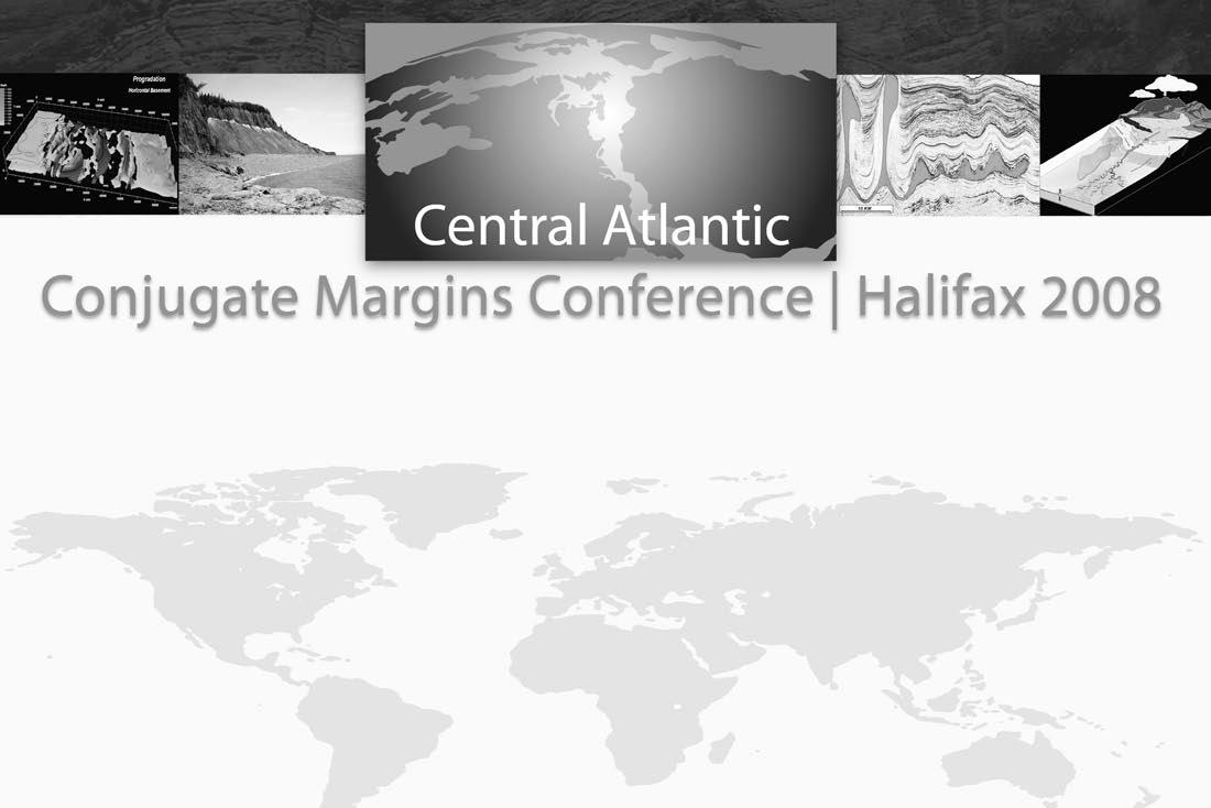
Opportunities” August 13 — 15 | 2008 Dalhousie University | Halifax | Nova Scotia | Canada
Thematic Sessions
(Oral & Poster Presentations)
Margin Evolution & Development | Basin Petroleum Systems | Productive Fields & Analogues
OTHER PROGRAM FEATURES Field Trips: Short Courses: Nova Scotia,Morocco,PortugalPractical Salt Tectonics | Petroleum Systems Modelling
Core Workshop: Seismic Data Room: Offshore N.S.Reservoirs & Facies Latest Central Atlantic Programs & Profiles
ABSTRACT SUBMISSION DEADLINE March 1,2008
All abstracts must by submitted through the conference website WEBSITE www.conjugatemargins.com
PROGRAM INFORMATION
David E.Brown dbrown@cnsopb.ns.ca
Grant D.Wach grant.wach@dal.ca
LOGISTICAL INFORMATION
Trudy D.Lewis trudy.lewis@ns.sympatico.ca


diVision talKs PALAEONTOLOGY DIVISION
PALEO 2008: Annual Paleontology Symposium
Presented in conjunction with the CSPG’s Palaeontology Division, Alberta Palaeontological Society, and Mount Royal College Earth Sciences Department
Lectures and Poster displays Sat., March 15, 2008, 9:30 am – 5:00 pm
Workshops Sun., March 16, 2008, 9:00 am – 4:00 pm
Saturday lecture events and poster viewings are free and no registration is required. Workshops, however, require registration and a minor fee. All are welcome.
m ount r oyal c ollege
4825 r ichard r oad s .W. c algary, a lberta
HuGH rEID’s sPrING cOursEs
PRACTICAL DST CHART INTERPRETATION
(Thorough Basic Course) a pr. 14-18, 2008
16 WAYS TO IDENTIFY BYPASSED PAY FROM DST DATA
(More advanced, for those “comfortable” with DST charts) a pr. 23-24, 2008
HYDRODYNAMICS SEMINAR
(Oil & Gas Finding Aspects) a pr. 28 - May 2, 2008
In-house courses available. For course outline visit: www.hughwreid.com 262-1261
Marc H 15: L E c T ur E s held in Jenkins theatre
9:30 a M – Introduction APS president Dan Quinsey
9:45 a M – a lwynne Beaudoin
Royal Alberta Museum – Seeds and shells from soft sediment: macrofossil analysis at some late Quaternary sites in Alberta
10:15 a M – Kevin a ulenback h eterospory and you, the heterosporous ferns of the h orseshoe Canyon Formation
11:00 a M – c offee Break
11:15 a M – Lisa Buckley
PRPRC – Determining ontogenetic and individual variation in Coelophysis bauri teeth
11:45 a M – Eric s nively
u niversity of Alberta – Raptors x 10,000: Continuities of carnivorous dinosaur feeding across their size range
12:15 – 2:00 PM Lunch Break and Poster Displays
2:00 PM – r ichard Mc c rea PRPRC – Fossil vertebrate tracks from the Gorman Creek Formation, northeastern BC
2:30 PM – Darla Zelenitsky u niversity of Calgary – Reproductive traits in non-avian dinosaurs: a comparison with birds and crocodiles
3:00 PM – Darren Tanke, Don Henderson Royal Tyrrell Museum – Erosion Rates and loss of fossils in Dinosaur Provincial Park
3:30 PM – c offee Break
3:45 PM – Keynote s peaker: Karen c hin u niversity of Colorado – Coprolites and Dinosaur Biology
5:00 PM – Finish
Marc H 16: WO r K s HOP s Room B108, Mount Royal College
9:00 – 12:00 a M
Sleuthing Ancient “Menu Mysteries”. Presented by Dr. Karen Chin, Assistant Professor and Curator of Paleontology at the u niversity of Colorado at Boulder. Participants will learn about how coprolites can be used to decipher diet.
1:00 – 4:00 PM
Introduction to fossil vertebrate track identification and field techniques. Presented by Rich McCrea, Lisa Buckley, and Tammy Pigeon, P.R.P.R.C. Participants will learn the basics of recognizing fossil tracks and the kinds of data and records that are useful when reporting discoveries to a museum or palaeontologist. They will be given a short lesson on the different types of footprints and what animals potentially made them. Participants will make their own replica cast of a dinosaur footprint to take home.
To register for workshops contact Mona Marsovsky (403) 547-0182 or monahome@ telus.net. Workshop fee is $15 per person, per workshop. Make cheque payable to the Alberta Palaeontological Society, P.O. Box 35111, Sarcee Postal Outlet, Calgary Alberta, Canada T3E 7C7. Deadline for registration is February 29, 2008.
For information on the lecture program please contact Philip Benham (Philip.Benham@shell. com) or phone (403) 691-3343.
I NFORMATION
This event is jointly presented by the Alberta Palaeontological Society, Mount Royal College, and the CSPG Palaeontology Division. For information or to present a talk in the future please contact CSPG Palaeontology Division Chair Philip Benham at 403-691-3343 or programs@albertapaleo. org. Visit the APS website for confirmation of event times and upcoming speakers: http:// www.albertapaleo.org/.
Depositional history of the McMurray Formation: a model driven by outcrop observation
SPEAKERS
Mike r anger
Independent Consultant, and Murray Gingras university of Alberta
12:00 noon
Wednesday, march 26, 2008 encana amphitheatre 2nd Floor, east end of the calgary tower complex 1st street and 9th avenue se calgary, alberta
We present here a model for the deposition of the McMurray Formation built on the study and observation of the outcrops along the Athabasca River and its tributaries over many seasons. These observations can be carried into the subsurface, but not without difficulty due to restraints of scale and differences in the nature of core versus outcrop.
The prevailing thought regarding the McMurray Formation is that it represents overall transgression wherein the lower McMurray is mostly fluvial, the middle McMurray is mostly estuarine, and the upper McMurray is mostly marine in nature. We do not agree with this interpretation. Abundant evidence from outcrop and core suggests that each of the lower, middle, and upper members have experienced independent complex histories not necessarily restricted to, or defined by, marine, brackish, or fresh water conditions.
There are a number of stratigraphic relationships that are observed to recur in outcrop. Each of the lower, middle, and upper members contains boundaries and internal stratigraphic surfaces that can be correlated over a wide area, and which we interpret to have sequence stratigraphic significance.
One of the units that is easily correlated within the McMurray Formation is a coal-
bearing pedogenic/alluvial interval that caps and demarcates the lower McMurray. This “alluvial unit” is restricted to the deeper parts of the Athabasca basin, but can be persistent over an extensive area. It contains the only terrestrial trace fossil assemblage (insect burrows) recognized to date from the McMurray Fm. The alluvial unit also includes abundant coarse-grained, apparently freshwater, fluvial channels. At outcrops around Daphne Island in the Athabasca River, the alluvial unit lies directly and unequivocally on brackish-water, epsilon, point-bar deposits (the so-called IhS or Inclined heterolithic Stratification).
Therefore, although the lower member is commonly described as being dominantly fluvial, we frequently observe brackish-water characteristics in outcrop. Fluvial channels are indeed a common element, but they appear to be constrained to the extensive alluvial unit that caps the lower member.
The middle McMurray member lies on an erosional, apparently transgressive, contact with the lower McMurray alluvial unit. Two facies associations dominate the middle McMurray member: thick, cross-bedded, megarippled sands, and thick sand- to muddominated IhS beds with a brackish trace fossil signature. The mega-rippled sands (the main reservoir) always underlie the IhS beds, a package ranging up to 40 metres in thickness. The prevailing interpretation has been that this succession represents a continuous genetic unit of thick estuarine channel fills, where the lower mega-rippled sands comprise the traction load in the thalweg, merging upwards into point-bar (IhS) deposits. This is commonly referred to as the Flach and Mossop model. More recently, some researchers have suggested that the estuarine channels comprise an incised valley fill complex.
Although we agree with some elements of the Flach and Mossop model, observations from outcrop suggest that the model should be modified and restricted in scope. We observe a regional, erosional discontinuity between the mega-rippled reservoir sands and the overlying IhS point bars, which at least locally, precludes their interpretation as a continuous channel fill. Furthermore, we find no strong evidence that the middle McMurray represents an amalgamation of incised valley fills. Rather, the IhS beds at all of the outcrops can be explained as intensely crosscut channel and distributary channel deposits. We also observe an overwhelming marine-tidal signature in the mega-rippled reservoir sands and suggest that
they represent a transgressive systems tract in a meso- to macro-tidal environment.
The upper member of the McMurray Formation abruptly overlies the middle member. The contact is typically dramatic in outcrop, but can be somewhat enigmatic and elusive in core. In subsurface studies several coarsening-upwards parasequences have been identified in the upper McMurray. These are typically widespread and bounded by flooding surfaces exhibiting transgressive erosion. Where the coarsening-upwards gamma ray signature of the parasequences is missing, some researchers prescribe an incised valley fill.
Overall, the McMurray Formation appears to reflect a stacked set of parasequences punctuated by episodes of sea level rise. These parasequences are predominantly regressive/ progradational in nature, and therefore deltaic by definition. We interpret the middle McMurray succession (the main reservoir unit) to represent a trans-regressive couplet. The lower megarippled sands constitute transgressive tidal sand deposits whereas the
(Continued on page 18...)
CORRECTION
In the January issue of the Reservoir the 2006 Thesis award Winners were listed instead of the 2007 Thesis award Winners. The recipients of the 2007 Thesis awards are the following: the M. s c. Thesis Winner is Jessica r . rylaarsdam, the Ph.D. Thesis Winner is a lexander J. MacNeil, and the M. s c. Thesis Honourable Mention is Patrick D. Johnstone.
We would also like to announce that Mike Finn is the 2007 Link award recipient.
erosionally overlying IhS constitute brackishwater (deltaic), distributary channel deposits. The sharp discontinuity between the units is a regressive surface of erosion suffered during the deltaic phase.
The system appears to have been dominantly controlled by tidal forces in its initial and middle stages (lower and middle McMurray), evolving to a wave- and fluvial-dominated system later in its history (upper McMurray) due to the physiography of the basin.
BIOGRAPHIES
Mike r anger
Ranger attended Concordia University in Montreal and Memorial University in St. John’s Newfoundland before starting his career in Calgary. Following eight years as a geologist for Gulf Canada Resources, he resumed his academic
studies to pursue a Ph.D. in petroleum geology at the University of Alberta. His dissertation was a basin study of subsurface south Athabasca. Since 1993 he has been an independent consultant and researcher, and has worked on many of the major projects of the Athabasca and Peace River oil sands. Ranger is also an adjunct professor at the University of Alberta.
Murray Gingras
Murray Gingras received his diploma in mechanical engineering technology from the Northern Alberta Institute of Technology in 1987, his B.Sc. degree from the University of Alberta in 1995, and his Ph.D. from the University of Alberta in 1999. Gingras has worked professionally in the hydrocarbon industry at the Northern Alberta Institute of Technology and as an assistant professor at the University of New Brunswick. He is presently tenured at the University of Alberta. Gingras’
research focuses on applying sedimentology and ichnology to sedimentary rock successions, as a paleoecological tool, a reservoir-development tool, and in process sedimentology.
The authors have offered to host an extended, informal discussion of the models and ideas presented here. An additional 30 minutes have been allocated, and we welcome your input.
INFORMATION
BASS Division talks are free. Please bring your lunch. For further information about the division, joining our mailing list, a list of upcoming talks, or if you wish to present a talk or lead a field trip, please contact either Steve Donaldson at 403-645-5534, email: Steve.Donaldson@ encana.com or Mark Caplan at 403-532-7701, email: mcaplan@aosc.com or visit our web page at www.cspg.org/events/divisions/basinanalysis-sequence-strat.cfm.

diVision talKs SEDIMENTOLOGY DIVISION
Using the sedimentary record to reconstruct the rise of the Tibetan Plateau
SPEAKER
a ndrew L. Leier, Department of Geoscience, university of Calgary aleier@ucalgary.ca
12:00 noon
thursday, march 27, 2008 BP tower, 240 – 4 ave sW, room 201
The Tibetan plateau is the largest region of elevated topography on earth, encompassing an area approximately half the size of Canada and at an average elevation of five kilometres above sea-level. Plateau construction is typically associated with the collision between India and Asia at ~55 Ma; however, several collisions between northward-migrating terranes and southern Asia are thought to have preceded the IndoAsian collision, leading to speculation that plateau formation may have commenced as early as the Mesozoic Era.
Mesozoic strata in southern Tibet record a dynamic tectonic history. u pper Jurassic strata in central and southern Tibet consist of deepwater clastic sediments that coarsen- and shallow-upward into lower Cretaceous marginal marine sandstone and fluvial conglomerate. These strata were deposited in a peripheral foreland basin that formed as the southernmost terrane of Tibet was sutured onto southern Asia. Middle Cretaceous strata consist of a widespread orbitolinid-bearing limestone that was deposited in a shallow marine seaway. u pper Cretaceous strata consist of arkosic fluvial sandstone and mudstone, including numerous paleosols. These strata were deposited in a foreland basin that formed as a volcanic arc and northverging fold-thrust belt developed along the southern margin of the plateau.
Whereas the sedimentary record contains clear evidence of crustal deformation and rock uplift during the Cretaceous, the
broader question of when the Tibetan plateau actually became a large topographic feature is more difficult to resolve. Oxygen isotope values of nonmarine carbonate provide a means of investigating paleoelevation histories. The oxygen isotopes of carbonate nodules in paleosols and lacustrine limestone are a function of the oxygen isotope values of local water and precipitation, which in turn, are strongly influenced by elevation. Thus, oxygen isotope values of nonmarine carbonate can be used to infer paleoelevation. A necessary precondition of this technique, but one that is difficult to assess, is that the sampled carbonates have not been altered during diagenesis.
The oxygen isotopic component of this investigation yielded both positive and negative results. Samples were collected from paleosol carbonate nodules and marine limestone from Cretaceous strata throughout southern Tibet. Implausibly low oxygen isotope values measured in the marine limestone indicate extensive diagenetic alteration of the original isotopic values. The oxygen isotope values of paleosol carbonate nodules are identical to those of the altered marine limestone, and
are therefore interpreted as having been reset during burial. Thus, paleoelevation reconstructions derived from the oxygen isotope values of these paleosol carbonate nodules are completely erroneous.
however, slightly younger strata (Eocene) in southern and central Tibet have paleosol carbonate nodules that retained their original oxygen isotope values and indicate southerncentral Tibet was at an elevation of ~five kilometres above sea level by 40 Ma. These paleoelevation data are inconsistent with several tectonic models that propose only recent (<10 Ma) surface uplift in the region.
BIOGRAPH y
Andrew Leier received a B.S. in Geology from Bucknell University (Pennsylvania), an M.S. in Sedimentary Geology from the University of Wyoming, and a Ph.D. from the University of Arizona in 2005. From 2005 to 2007 Leier was a post-doc at Princeton University. Leier recently joined the University of Calgary as an Assistant Professor in the Department of Geosciences. Leier’s interests are in basin-scale sedimentary studies and investigating tectonic and climatic controls on the sedimentary record.
diVision talKs G EOFL uIDS DIVISION
Geothermal resource potential in Canada
SPEAKER
Dr. s tephen Grasby, Geological Survey of Canada
12:00 n oon, Friday, m arch 28, 2008 a quitaine tower a uditorium (on +15 l evel), r oom 1400, 540 – 5th avenue s W, c algary, a lberta
As of 2005, the global generation of electricity from geothermal power reached 8,900 MW. Direct use of geothermal energy (space heating, heat pumps, etc.) accounted for 28,000 MW. Despite high potential, geothermal energy has been a largely undeveloped resource in Canada. In
response to the energy crises of the 1970s, the federal government ran a Geothermal Energy Program (from 1976 to 1986). Resultant work provided a first-order assessment of national geothermal energy potential which spurred a number of test sites that have shown both economic savings as well as significant reduction in greenhouse gas emissions.
Still some areas of high geothermal potential have never been developed to full realization. More recent increases in energy prices, declining conventional oil reserves, and increased concern over greenhouse gas emission has combined to renew interest in alternative renewable energy supply.
Geothermal energy can be subdivided into high and low temperature. h igh temperature resources, restricted to western Canada, allow direct generation of electricity, whereas low temperature resources available across the country allows for use of direct heating and heat pump technology. Potential sites for power

generation have been examined in British Columbia (total estimated 1,500 MW capacity) but have not been developed to date. Sedimentary basins of western Canada have also been shown to host localized areas of high temperature waters that could be used to generate electricity.
While historically discovering hot water has been a bad thing, there exists potential to make ‘dry wells’ a profitable geothermal energy resource. Estimates of total inplace geothermal energy resources of the Western Canada Sedimentary Basin (~13x10 21 J) exceed that of oil and gas energy reserves.
Benchmark ACTUAL
Finding & Development Costs
• compare to 12 conventional strategies (7 gas, 5 oil) plus Tight Gas & CBM
• ‘drill vs. buy’ (M&A data from Sayer Energy Advisors)
• full cycle economics (with Sproule) for 38 plays, including 10 unconventional
• extensive Trust analysis
• Early Bonus: 2 complimentary 8-page Natural Gas Topic reports
Canada has recently seen a rapid expansion of low temperature developments, over 40,000 private installations representing 2,546 TJ/year of direct use. Many new developments and private home owners are now considering geothermal energy as a viable heating option. Spurred by the success of using warm waters in the abandoned and flooded mine at Springhill Nova Scotia, several towns are examining flooded mines for similar potential. In general, Canada has a well defined and extensive renewable geothermal energy resource, a resource that has only barely been realized.
BIOGRAPH y
Stephen Grasby obtained his Ph.D. in aqueous geochemistry from the University of Calgary in 1997. Since then he has worked at the Geological Survey of Canada – Calgary, as well as holding Adjunct Professor positions in the Department of Geology, University of Calgary and in the Department of Microbiology, University of Manitoba. He has been active in the Groundwater Program and currently leads the project on assessment of regional aquifers. He is recognized for his expertise on the biogeochemistry of thermal and mineral springs in Canada. In addition he has worked for several years in Canada’s High Arctic on chemostratigraphy and regional correlations within the Sverdrup Basin, in addition to work on petroleum potential in the basin.


Canada Rocks – The Geological Journey
| by Ashton Embry
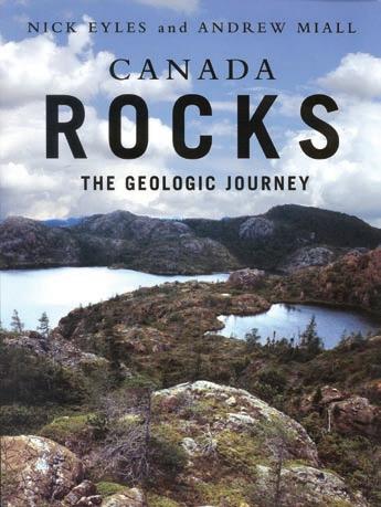
This is the first time I have ever written an unsolicited book review. h owever, after having gone through this book by geologists from the u niversity of Toronto, Nick Eyles and Andrew Miall, I felt compelled to let our members know that, at last, we have a wonderful, user-friendly account of the geological evolution of Canada. The authors rightly note in the preface that geological text books used in Canada most often employ examples from areas outside of Canada, a strange occurrence given that Canada has the most diverse and well exposed geology in the world. The authors leave no doubt about Canada’s geological bounty and they unabashedly show it off with countless exquisite pictures of geological phenomenon from all of our diverse geological provinces.
Besides the many outstanding photographs, the book also contains many, well conceived, colourful diagrams which go a long way to help explain how the geology of Canada came to be. The authors emphasize the long plate tectonic history of Canada from the Archean to the present and clearly demonstrate how Canada is an amalgamation of continental fragments which have been brought together over billions of years. In the first three chapters, the authors discuss some key geological principles and methods such as dating rocks with zircons and how plate tectonics works. Their explanations are very clear, well illustrated, and easy to
understand. One of the most impressive features of the book is that everyone from seasoned geologists to non-scientists with a vague curiosity about rocks will find the book highly informative and entertaining.
The next five chapters are the heart of the book and describe the five main geological regions of Canada – Precambrian Shield, Interior Platform, Atlantic Canada, Arctic, and Cordillera. I found it most useful to learn about the latest thinking about the areas which I am less familiar with, such as the Precambrian Shield where I spent a very long field season some 42 years ago. The story of the growing Precambrian continental masses from “Arctica” to “Nena” and culminating in “Rodinia” opened up a new way of looking at our fly-infested Shield. I read the Arctic chapter with both interest and a critical eye, wondering if the authors would do my favorite bit of Canada justice. I am pleased to report they have indeed captured the latest concepts of the geological history of the Arctic basins and I could only smile when I came across a picture which used a much earlier version of me as a scale. If anyone wants a concise and accurate summary of the development of Arctic Canada, this account fits the bill.
I am sure our members will be most interested in the treatment of Western Canada geology and the authors have done an admirable job of describing and illustrating the rocks and history of the Western Canada Sedimentary Basin and the adjacent mountain belt. The Paleozoic history is reviewed in the Platform chapter and the authors nicely adopt the Sloss sequences to form the framework for their descriptions. The Mesozoic and Tertiary sedimentary packages are well integrated into the Cordillera chapter and the linkage between the basin development and the mountain belt is emphasized.
Given that Nick Eyles’s main research area is glacial geology, it is not surprising that the book contains an excellent chapter on the Pleistocene geology of our country. I learned a lot from this account and, again, it is the outstanding pictures and illustrations that allow one to readily grasp the big picture of how and why glaciers have waxed and waned
and shaped our landscape over the past 2½ million years.
The chapter on resources emphasizes mining and again there is a wealth of information compacted into the breezy text and great diagrams. This chapter provides a good way to get an update on the latest hypotheses and theories on mineral formation. For example, I had not realized that all the kimberlite occurrences in Canada can be related to hot spot tracks which developed as North America drifted westward in Mesozoic and Tertiary.
I was surprised at the very short section on oil and gas. Although the authors cover some of the basics, they could have greatly fleshed out this section, especially given the great contribution of the petroleum industry to Canada and to geoscience.
The chapter on environmental geology is comprehensive and covers topics such as water resources, pollution, earthquakes, rock falls, and medical geology. Global warming is also addressed in a well balanced account and it was good to see that the authors assessed a two minute penalty to the erroneous and misleading hockey stick curve. The book ends with a short chapter on how geology has been a big contributor to the shaping of a Canadian identity. Fittingly, the authors point out that “Canada is a nation whose rocks and peoples are all from some place else.”
In summary, this is a book that should be in every Canadian household. It presents the science of geology and the geology of Canada in a very colourful and easy to understand fashion, a feat never before accomplished. I have no doubt that any geologist who flips through the book will not be able to resist the urge to purchase it. It is the ideal source book for a basic understanding of the geology of every region of Canada and it may well inspire young people to pursue a career of studying Canadian rocks. We owe Eyles and Miall a debt of thanks for portraying our science and our rocks in such a fine fashion.
“We need a world-class team to manage one of Western Australia’s greatest assets.”
Professor
Alan Robson – Vice-Chancellor
A teaching and research centre for petroleum geoscience is being established within the School of Earth and Geographical Sciences at The University of Western Australia (UWA). Funding related to this initiative is being provided by Woodside Energy Ltd, Chevron Pty Ltd, the Western Australia Energy Research Alliance (WA:ERA) and UWA. The Centre is expected to begin operation early in 2008. The School of Earth and Geographical Sciences at UWA is one of the leading geoscience groups in the world with established strengths in resource industry teaching and research. The successful applicants will be joining a group with extensive experience in teaching and research designed for the needs of the local and international resource industry.
WOODSIDE-CHEVRON CHAIR IN PETROLEUM GEOSCIENCE (REF: 2107)
This position is funded by Woodside Energy, Chevron and UWA. The Chair’s role calls for an outstanding geoscientist with a demonstrated record of achievement in petroleum geoscience. Applications are also encouraged from individuals early in their career who can demonstrate outstanding potential. The appointee will have primary responsibility for building and leading a unique and sustainable research and education enterprise and will also provide technical advice to the sponsoring companies. Experience of working in, or closely with, the petroleum industry is essential.
The appointment is initially for 5 years with extension of this term and the opportunity of a permanent appointment dependent on the success of the Centre and satisfactory performance reviews.
RESEARCH FELLOW/SENIOR RESEARCH FELLOW (REF: 2108)
This three year appointment is funded by the Western Australian Energy Research Alliance (WA:ERA). The appointee will play an active role within the petroleum geoscience discipline in the University and industry and will work closely with WA:ERA partners in particular the Commonwealth Scientific and Industrial Research Organisation (CSIRO). Applications are sought from candidates with expertise in any field of petroleum geoscience but with preference given to geologically oriented interpretation of seismic reflection data. The successful applicant’s expertise will complement the geophysical, petrophysical and reservoir-scale expertise available in UWA, CSIRO and Curtin University. Experience of working in, or closely with, the petroleum industry is highly desirable.
Closing date: Friday, 28 March 2008.
The University of Western Australia offers an attractive remuneration package including generous superannuation and leave provisions, fares to Perth (if applicable) for appointee and dependants along with a removals allowance.
For further information regarding the positions please contact Professor Mike Dentith, on 61 8 6488 2676 or email mdentith@cyllene.uwa.edu.au, School of Earth and Geographical Sciences
The Information for Candidates brochure which includes details to assist with your application may be found at https://www.his.admin.uwa.edu.au/Advertising/2107-2108CandidateInformation.pdf or via a link at http://jobs.uwa.edu.au/ or contact Ms Toni Pilgrim, Human Resources on +61 8 6488 3533, email toni.pilgrim@uwa.edu.au. Written applications should be sent to Ms Toni Pilgrim, Human Resources, M350, The University of Western Australia, 35 Stirling Highway, Crawley, WA 6009 or to lodge an application electronically please refer to the Information for Candidates brochure for details.
Committed to International Excellence
CSPG 2007 Finance Report
| By Peter Harrington, 2007 Finance Director
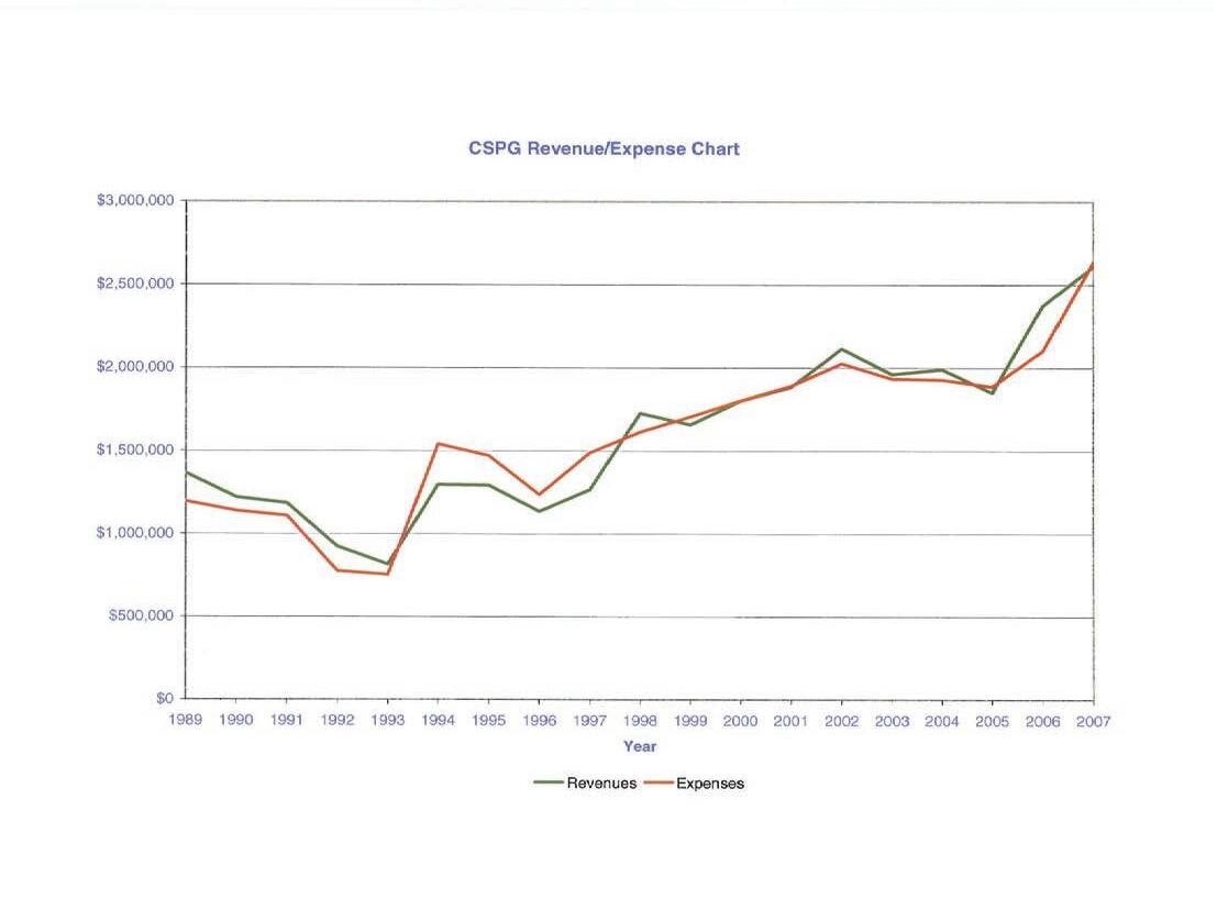
CSPG again had a strong financial year while organizing and delivering on a wide variety of technical and social events. The ongoing success of the Society is due in no small part to our energetic volunteers with the help and support of our skilled and dedicated office staff.
For fiscal 2007 the audited financial statements show a deficit of $27,043 on revenues of $2,609,196 less expenses of $2,636,239. During the audit process last year a total of $27,358 in net accruals were mistakenly left in fiscal 2006. If those accruals had been properly accounted for, the CSPG would have ended fiscal 2007 with a small ($315) surplus. We do a conservative annual budget which typically projects a small surplus.
This year there were a number of unforeseen and unpredictable circumstances which resulted in some negative impacts on our final numbers. Also, some delays in invoicing will result in some revenues associated with fiscal 2007 events (like the Student Industry Field Trip) being included in next year’s financials. As in past years, one of the main drivers of our
financial perspective. The annual convention realized a net profit of $387,271 to the CSPG, not including profits the society made on field trips and short courses run during the convention (this year those amounts are included under Education).
It’s abundantly clear that without a successful and robust annual convention, the CSPG finances would be significantly impacted. Fiscal 2008 should provide another strong convention year for the CSPG with the planned joint annual convention along with the recently completed Gussow conference.
Continuing Education continues its resurgence and posted a profit during fiscal 2007 of $79,877, up from last year’s profit of $65,146 and from the fiscal 2005 profit of only $1,051. Continuing Education is now coordinating the field trips and short courses during the annual convention as well as at other times throughout the year. 2008 should be another successful year for our education efforts as we’ve now added an annual CSPG Education Week beginning in late October.
Technical Luncheons showed a strong increase in attendance during fiscal 2007. Profits from technical luncheons remain relative low however ($4,871 in net income during fiscal 2007 from revenues of $462,774) as the technical luncheons are budgeted with a fairly low profit margin. The loading of webcast versions of our luncheons on our website costs $45,000 – $50,000 per year but is an important part of the CSPG’s efforts to market it to our members who reside outside of southern Alberta and thus represents a good investment for the CSPG.
CSPG membership increased during fiscal 2007 thanks to the efforts of the Membership Committee supported by our office staff. We ended the year with membership income of $323,680, up 1.4% from last year’s total. The CSPG has not raised its annual dues since 2002 thanks to the monies provided by such efforts as the annual convention, continuing education, and the Reservoir along with the conservative financial planning strategy carried out by the Society.
The CSPG Reservoir showed a profit of $82,584 during fiscal 2007, down from $95,182 in 2006 and $103,707 in 2005. The Society is planning for a larger Reservoir in the
future with additional technical content (we’ve already seen some of the enhancements in recent editions of the Reservoir) which should also result in additional profits.
The CSPG’s various social events are budgeted to run at a small profit in order to help cover the overhead costs carried by the Society to run these events (office costs, staff costs related to sponsorships and ticket sales, etc). We are able to run a broad range of social events at a reasonable price to our members and these events are a key part of our Society’s contribution to the industry and our profession.
Outreach has been a growing part of our society’s efforts and expenditures over the last number of years. As we raise more money through sponsorships as well as through the efforts of the annual convention, continuing education and the like, much of the excess resources have been channeled into outreach efforts. Outreach expenditures totaled $154,078 in fiscal 2007, up from $143,602 last year. Our efforts in this area will continue to grow in the future with the addition of new programs including the 100 Student Jobs and K-12 Education initiatives.
The CSPG’s largest single expense category is office overhead or “Operations,” which in
fiscal 2007 totaled $803,435. The oil industry has changed and what could be done by volunteers in the past now has to be handled through the office. Also, we could not have realized our significant increases in the technical and financial results of our annual convention (to give just one example) without the work of our office staff. Our increased office presence has allowed us to grow many areas of our Society, including sponsorship and advertising, which has allowed us to keep membership dues constant while increasing various activities including outreach.
Additionally during fiscal 2007 a number of maternity leaves, staff changes, and other staffing issues created a challenging environment for the CSPG office, especially considering Calgary’s overheated job market last year. All in all considering the challenges and resources available to the CSPG, our investment in our office staff has been money well spent.
In order to protect our Society from unexpected events, we maintain a surplus fund (not to be confused with the CSPG Trust which is used to fund both CSPG outreach activities along with other general philanthropic efforts). The CSPG surplus fund had an estimated market value of $1,017,057 on August 31, 2007, an increase of 2.43%
over last year’s total. While that sounds like a lot of money, it represents less than 40% of our expenses for fiscal 2007. We completed a review of our surplus fund during 2007 and did not recommend any changes to our investment portfolio or to the size or rationale behind the fund itself.
My job as your Finance Director would not have been possible without the help of many individuals. The entire CSPG office staff is to be commended for their support of all the CSPG’s efforts, and I’d like to personally thank both the Business Manager, Tim howard as well as Kim MacLean (Corporate Relations) for their help and assistance to me throughout the year. I’d also like to thank the entire CSPG Executive for their support of my work.
Any individual builds on the work of his/ her predecessors and hands off to their successors. I’d like to thank Marty hewitt, the previous Finance Director as well as James Donnelly who will be succeeding me, for their help over the past two years. I know the Society’s finances will be in good hands under James’ stewardship over the next year.
Peter harrington 2007 Finance Director
Part 5B – Material Balance for Oil Reservoirs
| by Ray Mireault P. Eng., Chris Kupchenko E.I.T, and Lisa Dean P. Geol., Fekete Associates Inc..
Material balance calculations for oil reservoirs are more complex than for gas reservoirs. They must account for the reservoir volumes of the produced fluids and the effect of pressure depletion on the oil volume remaining in the reservoir. They must account for the formation, expansion, and production of solution gas. The calculations must also account for the expansion of the reservoir rock and formation water, since they have similar compressibility as oil. As noted in last month’s article, typical compressibility ranges are:
• Rock: 0.2 to 1.5x10 -6 kPa-1
• Gas: 10 -3 to 10 -5 kPa-1 ( varies significantly with reservoir pressure.)
• Water: 0.2 to 0.6x10 -6 kPa-1
• Oil: 0.4 to 3x10 -6 kPa-1
Nonetheless, in theory, material balance calculations can provide an independent estimate for the original oil-in-place for a solution gas drive reservoir with sufficient production history.
h avlena and Odeh (1963) developed a useful graphical procedure for estimating the oil-in-place volume for a solution gas drive reservoir (see Figure 1). By rearranging the material balance equation so that the total withdrawals from the reservoir are grouped onto the y axis while all the expansion terms are grouped on the x axis, the correct oil-in-place value will generate a straight line trend on the graph. Thus the oil volume for a solution gas drive reservoir can be determined by successively iterating until a straight line is achieved. u pward curvature indicates that the value selected as the OOIP is too small. Downward curvature indicates that the selected value is larger than the true size of the oil deposit. various formulations of the material balance equation can be sourced in any of the references cited.
Figure 2 presents a h avlena-Odeh plot for a solution gas drive reservoir with an OOIP of 49 MMSTB. The four points calculated from reservoir pressure measurements are in good agreement with the predicted trend based on the OOIP value. Inadequate pressure buildup time may be the reason that the third pressure measurement comes in slightly below the predicted trend line.
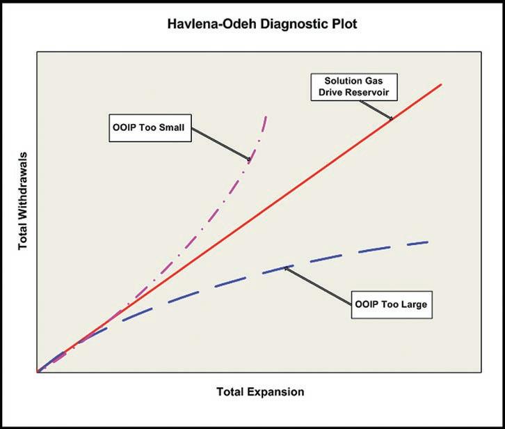
When an oil deposit has a gas cap, the material balance calculations must also account for gas cap expansion and production. however, there are now too many unknowns to develop a unique solution by material balance alone. Estimating the oil-in-place in the presence of a gas cap first requires a volumetric estimate for the size of the gas cap. Then the size of the oil deposit can be estimated via material balance calculations.
Though it cannot independently determine the oil-in-place volume when a gas cap is present, the h avlena-Odeh plot can assist in confirming the consistency of the proposed solution. For every gas cap volume, there will be a corresponding oilin-place volume that together result in a straight line pressure trend on the h avlenaOdeh plot. As before, upward curvature on the plot indicates that the OOIP value is too small; downward curvature that it is too large (Figure 3).
In practice, a table of values for OOIP is often set up and iteration performed on the ratio of the reservoir volume of the gas cap relative to the oil-in-
place (referred to as “m”). Now upward curvature on the h avelena-Odeh plot indicates that the “m” value (size of the gas cap) is too small relative to the selected oil volume. Downward curvature indicates that “m” (size of the gas cap) is too large (Figure 3).
Due to the fact the solution is non-unique many combinations of OOIP and “m” can be found that will mathematically match the reservoir production and pressure history. Mathematically successful solutions can range from:
• A large oil volume with a relatively small gas cap.
• A small oil volume with a relatively large gas cap.
• Multiple intermediate oil and gas cap volume combinations.
The dilemma can usually be resolved by using geological knowledge to identify the material balance solution(s) consistent with the reservoir’s physical geometry. This consistency check provides the best chance of determining the correct magnitude of OOIP and OGIP.
Figure 1. Gas Reservoir P/Z Material Balance Diagnostics.
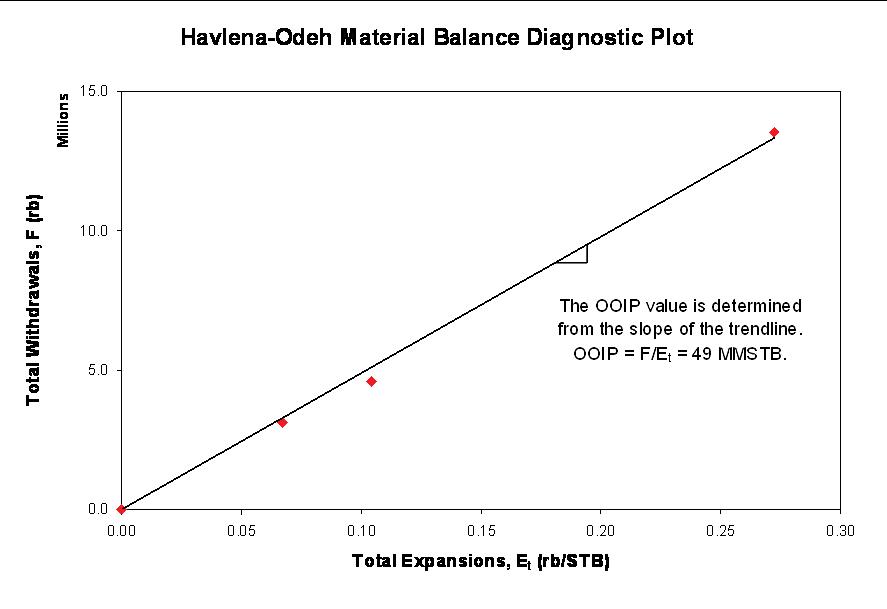
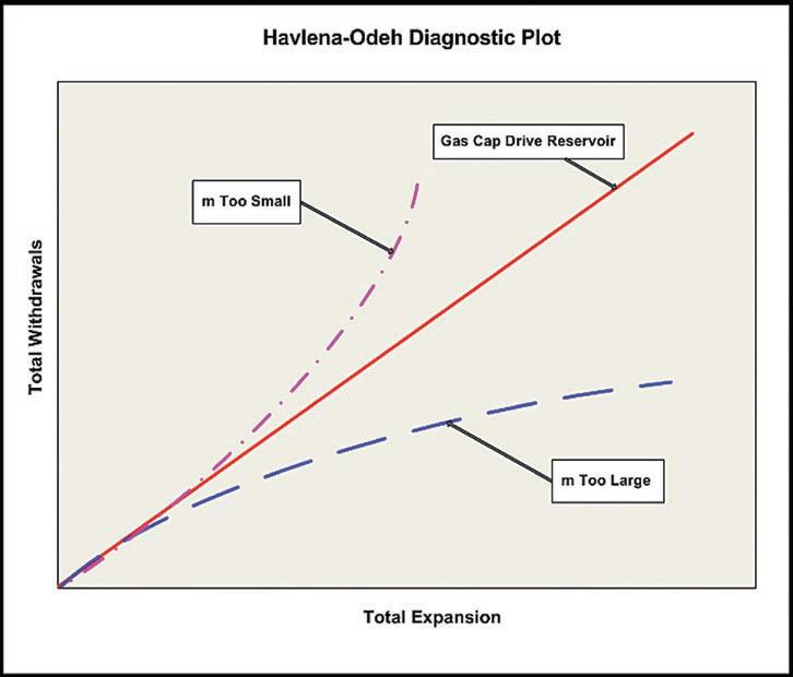
Geologic knowledge of the reservoir geometry is also essential when attempting to assess fluid influx into a reservoir. For example, water influx into a D-3 reef with an underlying aquifer could be assessed by periodically logging selected wellbores to determine and relate a rising oil-water interface to a water influx volume. Once the influx volume is estimated, in theory a material balance estimate for the original oil-in-place volume can be calculated. however, internal compartmentalization of the reef into multiple reservoirs may make the
task significantly more challenging than might be concluded from this article.
The h avlena-Odeh plot is also useful when fluid influx is suspected, as in possible inflow across a fault. In theory, measured reservoir pressures on a h avlena-Odeh plot will exhibit (Figure 4):
• A straight line for a volumetric (solution gas or gas cap) expansion reservoir provided the OOIP and OGIP values are correct.
• An upward curvature when there is pressure support due to fluid influx.
• A downward curvature when there is a pressure deficit.
The h avlena-Odeh plot cannot however, identify the reason for pressure support or the pressure deficit. Potential reasons for pressure support include:
• An unaccounted-for water injection/ disposal scheme.
• Flow from a deeper interval via a fault or across a fault from an adjacent reservoir compartment. Note that the fluid can be any combination of oil, gas, and water.
• “ u tube” displacement of the producing reservoir’s water leg by a connected reservoir. The connected reservoir is usually gas-bearing and may be undiscovered.
• Expansion of water. Due to the limited compressibility of water (0.2 to 0.6x10 -6 kPa-1) the water volume must be at least 10 times the reservoir oil volume for water expansion to provide pressure support. Thus the Cooking Lake aquifer underlying Alberta D-3 oil pools has the potential but water legs in clastic reservoirs are too small.
Potential reasons for a pressure deficit or downward curvature include:
• Later time interference from unaccountedfor producing wells.
• Rock compressibility in an overpressured reservoir.
• An inflow that gradually decreases over time, perhaps because of depletion or because flow across the fault decreases/ ceases below a certain pressure threshold.
In cases where fluid inflow is suspected, knowledge of the reservoir geometry is an absolute requirement to limit the possible reasons for either an upward or downward curving trend.
Thus far, the discussion has been on the theoretical challenges to material balance analysis. In addition, a real world challenge is the scatter that is present in the pressure data. As with gas systems, oil well pressure data must first be correctly grouped into common reservoirs to generate reliable trends. But oil pressure data generally exhibits greater scatter because:
• Longer build-up times are required to extrapolate the pressure data to a reliable estimate of reservoir pressure, due to the increased viscosity of oil.
Figure 2. Multi-Well Gas Reservoir P/Z Plot.
Figure 3. Multi-Well Gas Reservoir Pressure vs. Time Plot.
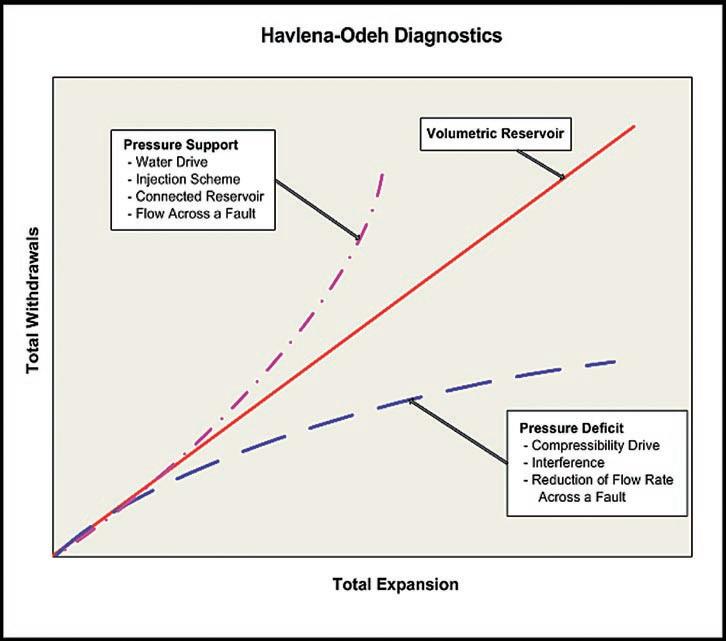

(...Continued from page 27)
• Pressure gradients across the reservoir are more pronounced, due to the oil viscosity.
• Pressure differences in an oil column, due to the density of the oil, are sufficient to require careful correction to a common datum.
• Multiple perforation intervals and inadvertent commingling of intervals that were isolated by nature creates the potential for crossflow and further confuses the pressure data interpretation.
Other potential sources of error include:
• Thermodynamic equilibrium is not attained.
• Pv T data that does not represent reservoir conditions.
• uncertainty in the “m” ratio.
• Inaccurate production allocation.
yet despite the foregoing theoretical and practical challenges, material balance analysis has proven its worth, with the accuracy of the analysis generally increasing as the reservoir is produced. In Fekete’s experience, the most reliable analyses are obtained by integrating the reservoir geology; fluid properties; and the well production, pressure, and completion histories into a consistent explanation.
R EFERENCES
Canadian Institute of Mining, Metallurgy and Petroleum, 2004. Determination of Oil and Gas Reserves. Petroleum Society Monograph Number 1, Chapter 7.
Havlenah, D., and Odeh, A.S. 1963. The Material Balance as an Equation of a Straight Line. Trans., AIME, Vol. 228, p. 896.
Canadian Oil and Gas Evaluation Handbook, 2005. Procedures for Estimation and Classification of Reserves, Vol 2, Section 6.
Craft, B.C., and Hawkins, M.F., 1964. Applied Petroleum Reservoir Engineering. Prentice Hall Inc., Englewood Cliffs, NJ.
Look for our next article on “Well Test Interpretation/Pressure Transient Analysis” in the April issue of the Reservoir.
This article was contributed by Fekete Associates, Inc. For more information, contact Lisa Dean at Fekete Associates, Inc.
Figure 4. Single Well Gas Reservoir P/Z Plot.


THE NEOPROTEROZOIC OLD FORT POINT FORMATION, Southern Canadian Cordillera
| by Mark D. Smith, R.W.C. (Bill) Arnott, and G.M. Ross
PART 1: H ISTORICAL
B ACKGROUND AND STRATIGRAPHIC FORMALIZATION
INTRODUCTION
Regional stratigraphic markers are essential for reconstructing large, poorly fossiliferous sedimentary systems. In the same way that the Exshaw Formation forms part of a panNorth American series of nearly isochronous black shales, the Old Fort Point Formation (OFP) of the Neoproterozoic Windermere Supergroup (WSG) is a unique stratigraphic marker that provides a key element in reconstructing the WSG sedimentary basin and linking it with coeval global events. The OFP is a predominantly fine-grained mixed siliciclastic / carbonate marker unit, locally exposed over an impressive area of 35,000 km2 in the southern Canadian Cordillera (Figure 1), and key for regional stratigraphic correlations. The WSG has long been plagued by complex stratigraphic nomenclature due largely to its indistinct (some would say monotonous) lithologic character, immense size of the depositional system, structural complexity, and small study areas (Figure 1). These uncertainties have resulted in a complex and commonly confusing stratigraphic nomenclature for not only strata of the OFP, but the entire WSG (Figure 2).
The distinctive nature and widespread occurrence of the OFP led to its recognition by several authors as a significant and correlatable horizon throughout the southern Canadian Cordillera. Stratigraphically upward, the OFP comprises three lithological units:
1) fine-grained siltstone-mudstone that grades upward to a rhythmic limestone / siltstone;
2) organic-rich mudstone/pelite that locally is sulfidic; and
3) heterogeneous lithofacies including diamictite, breccia-conglomerate, sandstone, quartz arenite, calcareous arenite, arenaceous limestone, limestone, and mudstonesiltstone. These units and their stratigraphic relationship are unique when compared to strata in other parts of the WSG in the southern Canadian Cordillera.
Although the OFP has been described from many locations in the southern Canadian
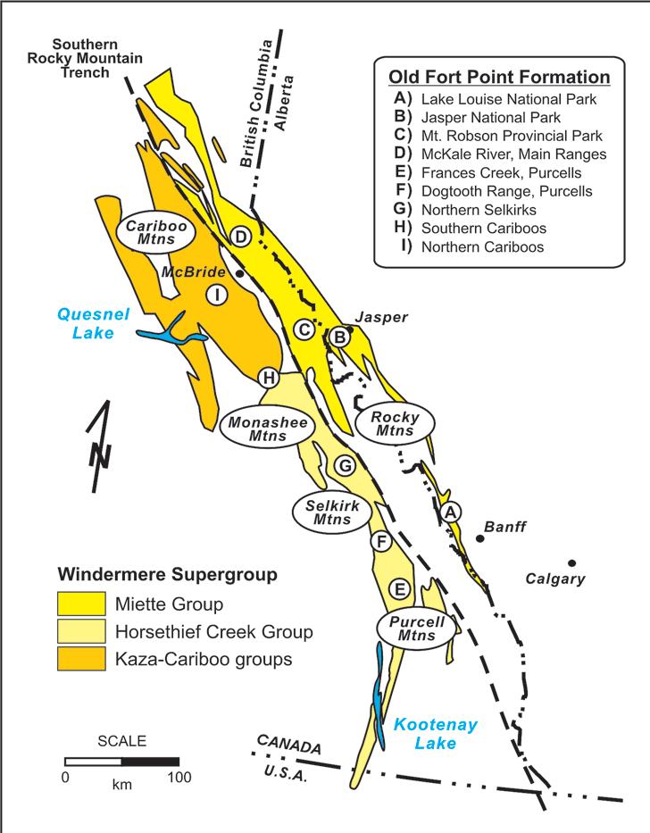
Cordillera, and its importance as a stratigraphic marker recognized, there is no single study that has specifically focused on the detailed sedimentology and stratigraphy of the OFP on a regional scale. This and the next paper on the OFP stem from the current Ph.D. research conducted by the first author. The purpose of this paper is to provide the historical background of work conducted over the last ~100 years, and the current effort toward a formal stratigraphic definition of the OFP and its three constituent members. The second paper presents details of the
sedimentology and sequence stratigraphic framework of the deep-marine OFP.
H ISTORy OF PREVIOUS WORK
The first report of lithologies consistent with the OFP was by Charles Doolittle Walcott in 1910, from his work in the Lake Louise area (Figure 1, Location A). he identified two Precambrian units, the Corral Creek (lower conglomerate-sandstone) and hector (upper slate) formations that were unlike the cliff-forming quartz arenites in the overlying Cambrian. The division of
Figure 1. Simplified geological map of the WSG, southern Canadian Cordillera showing prominent outcrop localities of the OFP and correlatives (modified from Ross and Murphy, 1988).
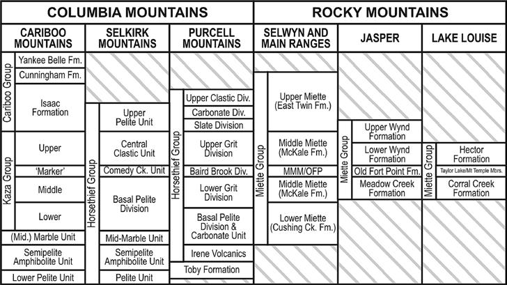
these two formations over the study area was feasible using the distinctive lithologies consisting of purple/green slate, limestone, and limestone-bearing conglomerate to mark the base of the hector Formation. he also identified the Precambrian-Cambrian contact as an angular unconformity but incorrectly placed it at the base of immature conglomerates, shown later to be Neoproterozoic in age. William Carruthers Gussow was the next to conduct work on Precambrian rocks in the Lake Louise area during the 1950s. he revised the stratigraphy to comprise a single stratal unit, the hector Formation, but then subdivided it into four informal members:
1) basal Corral Creek member (coarsegrained, immature);
2) Taylor Lake member (purple argillite or shale);
3) Mount Temple member (rhythmic bedded limestone); and
4) an unnamed upper member (coarsegrained, immature). he was also the first to recognize (or at least document) the
significance of the Mount Temple member as a marker horizon in the Lake Louise area and assign names to OFP lithologies (Taylor Lake and Mount Temple members), but these were not properly defined, being published in the 1957 conference fieldtrip guidebook of the Alberta Society of Petroleum Geologists.
During the first half of the 20th century, additional reconnaissance mapping was carried out in a number of other regions in the southern Canadian Cordillera of Alberta and British Columbia. These workers included: Walcott (1913) in the Mount Robson area; J. A. Allan, P. S. Warren, and R. L. Rutherford (1932) in the Jasper area; and J. F. Walker (1926), C. S. Evans (1933), and J. E. Reesor (1957) in the Purcell Mountains. These authors described lithologies consistent with the OFP, but no specific subdivisions or implications of a regional marker horizon were noted.
henry A. K. Charlesworth and his graduate students from the university of Alberta were
the first group to conduct detailed structural and stratigraphic mapping of the Precambrian Miette Group within Jasper National Park in the 1960s (Figure 1, Location B). The Old Fort Point Formation was first informally named in the 1950 Edmonton Geological Society Fieldtrip Guidebook to describe a unit consisting of phyllite, limestone, limestone breccia, and conglomerate that were easily differentiated from other Miette Group stratigraphy. The name “Old Fort Point” comes from a prominent local landmark south of the Jasper townsite where accessible exposures of the unit are located (Figure 3A). C. R. Evans completed a M.Sc. thesis (1961) mapping and describing the OFP at the landmark, followed by the Ph.D. work of J. L. Weiner (1966) who correlated the OFP on a more regional scale within Jasper National Park. Compilation of these works and formal definition of the OFP and proposed regional correlations were first published in Charlesworth et al. (1967). Subsequently, J. D. Aitken of the Geological Survey of Canada was the first in 1969 to unequivocally correlate the OFP of the Jasper area with the distinctive basal unit of the hector Formation in the Lake Louise area. he also corrected Walcott’s placement of the PrecambrianCambrian recognizing that its “angular” nature was in fact a prominent Precambrian erosion surface (submarine canyon studied by R.W.C. Arnott for his M.Sc. in 1984) and documented the magnitude of erosion along the regional unconformity (Aitken, 1969).
The recognition of a consistent, probably correlative, fine-grained triad (siltstone, limestone-siltstone, organic-rich mudstone) throughout the southern Cordillera resulted from detailed mapping beginning in the early 1980s by a number of workers at Canadian institutions:
(Continued on page 33..)
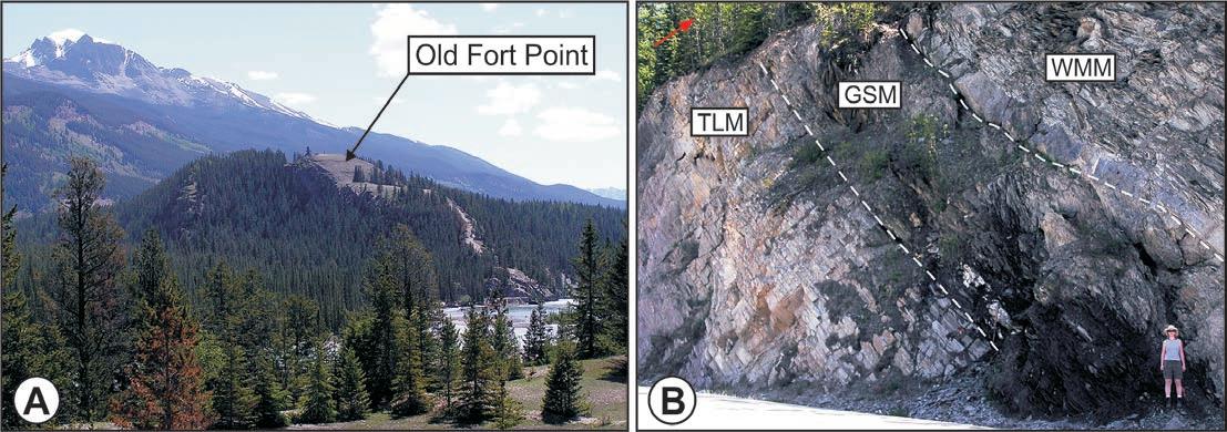
Figure 3. OFP localities in the Jasper National Park. A) Old Fort Point Landmark. B) Geikie Siding along Highway 16.
Figure 2. Stratigraphic nomenclature of the WSG, southern Canadian Cordillera.
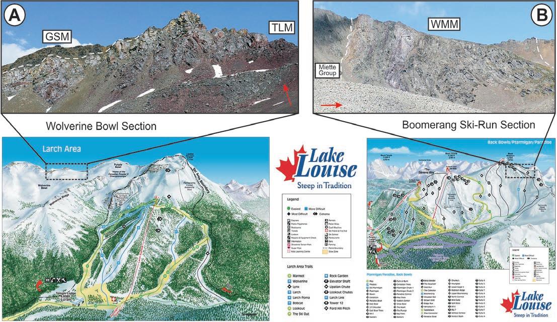


Figure 4. OFP localities on the Lake Louise Ski Hill. A) Temple Lake and Geikie Siding members, Wolverine Bowl. B) Whitehorn Mountain Member, Boomerang Ski-Run. Ski hill (images used courtesy of the Resorts of the Canadian Rockies Inc.).
1) Phillip S. Simony and graduate students from the university of Calgary including: J. Pell in the Monashee and Cariboo Mountains (Figure 1, Location h ); J. A. Carey in the Cushing Creek and McKale River areas, Rocky Mountains (Figure 1, Location D); M. R. McDonough in Mount Robson Provincial Park area and Selwyn Range, Rocky Mountains (Figure 1, Location C); and T. E. Kubli in the Dogtooth Range, Purcell Mountains (Figure 1, Location F).
2) Eric W. Mountjoy and graduate students from McGill university: R. Forest, G. A. Klein, R. G. Deschesne and S. E. Grasby in the Park and Selwyn Ranges, Rocky Mountains (Figure 1, Location C); and R. G. Deschesne in Jasper National Park, Rocky Mountains (Figure 1, Location B)
3) Other projects included: D.C. Murphy and R. L. Brown from Carleton university in the Cariboo Mountains (Figure 1, Location h ); S. E. Grasby and R. L. Brown in the Selkirk Mountains (Figure 1, Location G); and M. J. Warren and Ray Price from Queen’s university in the Purcell Mountains (Figure 1, Location E).
These projects focused primarily on unraveling the structural complexity in their respective areas and resulted in a number of location-specific, informal names for the OFP including: Old Fort Point Formation, Kaza Group “marker,” Baird Brook Division, Comedy Creek unit, and upper and lower markers (Figure 2). During this time, mapping by Gerry M. Ross from the Geological Survey of Canada examined the Windermere succession from a sedimentological perspective and recognized the stratigraphic significance of this distinctive marker horizon in the Cariboo Mountains and correlated it with other regions in the southern Canadian Cordillera (Ross and Murphy, 1988).
T OWARDS STRATIGRAPHIC FORMALIZATION
Given the significance of the unit, it is important to properly formalize the stratigraphic nomenclature of OFP across the southern Canadian Cordillera. We will also introduce three new members, the Temple Lake, Geikie Siding, and Whitehorn Mountain members according to the North American Stratigraphic Code (NASCN, 2005). The following summary is a brief description of the forthcoming work that outlines the proper stratigraphic formalization.
The name “Old Fort Point Formation” is to be retained and simply undergo a revision in definition to receive proper designation as outlined by the recently amended stratigraphic
code (NACSN, 2005). The type locality for the OFP comes from the prominent landmark located <1 km southeast of Jasper where strata of the OFP crop out (Figure 3A). unfortunately, the locality is a poor type section because it is unrepresentative of the full OFP succession with only strata of the upper member exposed, and lacks the more regionally extensive and recognizable lower two members that enabled basin-wide correlation (e.g., Ross and Murphy, 1988).
The new principal reference section of the OFP is proposed to be the Geikie Siding roadcut outcrop located along highway 16,
approximately 15 km west of Jasper, Alberta (Figure 3B). The selection of this site as the principal reference section is based on a number of factors: it is well exposed, easily accessible, close to the previously defined type locality, the recent Re-Os isochron age (607.8 ± 4.7 Ma) is from this locality (Kendall et al., 2004), and representative strata of all three members crop out. Despite its suitability in many stratigraphic aspects, neither the basal nor upper contact with the WSG are exposed and thus, a number of supplementary reference sections for the OFP have been designated (Figure 1).
(Continued on page 34..)

Based on previous studies and more recent detailed work, we also propose three new lithostratigraphic subdivisions for the OFP: Temple Lake Member (lower), Geikie Siding Member (middle), and Whitehorn Mountain Member (upper). These names are based on geographic features where well exposed representative sections can be easily observed, and for the most part, do not duplicate names already in the literature.
Temple Lake Member: the Temple Lake Member (TLM) is introduced to describe the variably coloured (purple, green, red-brown, grey) fine-grained, siltstone-
mudstone, rare sandstone, and rhythmic limestone-siltstone packages of the lower OFP. The name of the member comes from an exceptional exposure near Temple Lake on the northeastern slope of Mount Temple, Lake Louise area. A similar, well exposed section is located in Wolverine Bowl, at the Lake Louise Ski Resort (Figure 4A, page 32).
Geikie Siding Member: the Geikie Siding Member (GSM) is introduced to describe the light grey to dark grey, fine-grained mudstone (shale and pelite) unit with rare beds of darkgrey limestone and fine-grained sandstones of the middle OFP. The name of the member
comes from the railway marker Geikie Siding, located along highway 16, approximately 15 km west Jasper (Figure 3B).
Whitehorn Mountain Member: the Whitehorn Mountain Member (WMM) is introduced to describe lithologically diverse strata in the upper part of the OFP. It is composed of diamictite, brecciaconglomerate, sandstone, quartz arenite, calcareous arenite, arenaceous limestone, limestone, and mudstone-siltstone. The name of the member comes from Whitehorn Mountain where, <0.5 km downslope from the peak, is a representative section located on the “ upper Boomerang” Ski Run (#64) of the Lake Louise Ski Resort (Fig. 4B).
SUMMARy
customsolution

The Old Fort Point Formation is a lithologically unique unit that forms an important stratigraphic marker horizon in the WSG, and is mappable and correlatable on a regional scale in the southern Canadian Cordillera. The purpose of formalizing the stratigraphic nomenclature of the OFP in accordance with the North American Stratigraphic Code (NASCN, 2005) is an attempt to provide a simple and consistent stratigraphic framework for this important marker horizon in the WSG of the southern Canadian Cordillera. The next paper will summarize the main stratigraphic and sedimentologic elements of the OFP and describe its depositional environment in a sequence stratigraphic framework.
R EFERENCES
Aitken, J. D., 1969. Documentation of the subCambrian unconformity, Rocky Mountains Main Ranges, Alberta. Canadian Journal of Earth Sciences, Vol. 6, p. 193-200.


There is no wrong answer.
At Divestco, we understand what it means to be a customer. You like to be able to depend on a service provider to act in your best interests, give you exactly what you need, and only what you want. Divestco’s integrated offering for geological professionals gives you the ability to choose from a wide range of geological products and services to suit your unique needs. Pick anything you want, choose a bundled offer or let our experts create a custom solution for you.
Call Jennifer Davies at 403.537.9904 or email jennifer.davies@divestco.com for more information. Take your pick


Charlesworth, H. A. K., Weiner, J. L., Akehurst, A. J., Bielenstein, H. U., Evans, C. R., Griffiths, R. E., Remington, D. B., Stauffer, M. R., and Steiner, J., 1967. Precambrian Geology of the Jasper Region, Alberta. Alberta Research Council Bulletin, 74 p.


Kendall, B. S., Creaser, R. A., Ross, G. M., and Selby, D., 2004. Constraints on the timing of Marinoan “Snowball Earth” glaciation by 187 Re-187Os dating of a Neoproterozoic, postglacial black shale in Western Canada. Earth and Planetary Science Letters, Vol. 222, p. 729-740.
NACSN, 2005. North American Stratigraphic Code; North American Commission on Stratigraphic Nomenclature. AAPG Bulletin, Vol. 89, p. 1547-1591.
Ross, G. M., and Murphy, D. C., 1988. Transgressive stratigraphy, anoxia, and regional correlations within the late Precambrian Windermere grit of the southern Canadian Cordillera. Geology, Vol. 16, p. 139-143.
C ADOMIN T IGHT G AS R ESERVOIRS along the updip edge of the WCSB Deep Basin
| by Brad Hayes, President, Petrel Robertson Consulting Ltd.
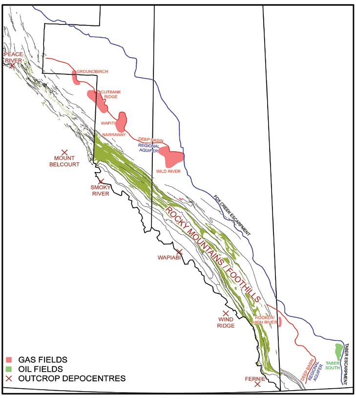
(This article is an expansion of a presentation made at “Let it Flow” – the 2007 CSPG / CSEG Convention Core Conference, in May, 2007)
STRATIGRAPH y AND DISTRIBUTION
The Cadomin is a widespread sandstone and conglomerate ranging from five to more than 25 metres thick. It lies sharply on the preMannville unconformity, and is abruptly or gradationally overlain by Gething and Lower Mannville non-marine rocks.
Cadomin strata represent an initial pulse of pediment, alluvial fan, and fluvial sedimentation in Early Cretaceous time, following uplift of the Columbian orogenic highlands to the west. Pronounced subsurface and outcrop thicks, particularly evident at Mount Belcourt and Peace River, mark major depocentres.
Cadomin sediments are the initial fill of the northward-draining Spirit River valley system, which is bounded sharply to the east by the Fox Creek Escarpment in the north, and the Taber Escarpment in the south (Figure 1) (Gies, 1984; Smith et al., 1984; hayes, 1986; Smith, 1994; hayes, 2005).
R ESERVOIR DESCRIPTION
Poorly sorted fine- to coarse-grained sandstones and chert pebble conglomerates characterize the Cadomin (Figures 2, 3). Alluvial fan to fluvial environments of deposition are indicated by large-scale, highenergy cross-bedding, poor sorting, lack of marine features, and position atop the pre-Mannville unconformity. There are no characteristic internal stratigraphic markers, and specific reservoir trends have not been
mapped. very poorly sorted conglomerates are typical of proximal alluvial fan settings; sorting generally increases eastward such that moderately sorted medium- to coarsegrained sandstones with minor pebbles are common in fluvial strata of the Spirit River valley (Figure 4).
Conglomerates are typically chert litharenites, with well rounded chert pebbles ranging from granules up to several centimetres in diameter. Sorting is poor, with finer sands filling interpebble pore spaces; only rarely is pebble-supported porosity observed. Finer sandstones feature more quartz and better sorting overall. Sedimentary rock fragments are locally common, as are coal and mud clasts. Less common accessories include detrital carbonates, feldspars, and igneous/ metamorphic rock fragments.
(Continued on page 36..)
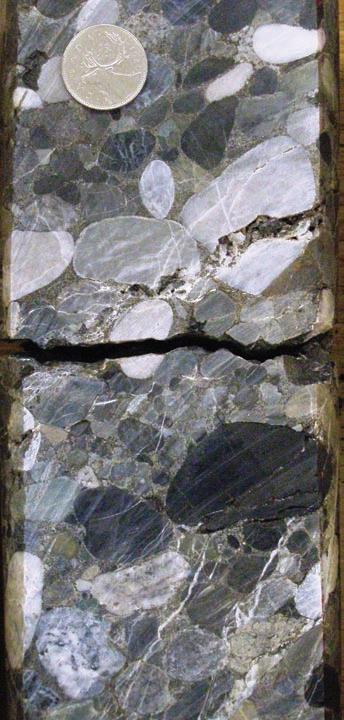
Figure 1. Cadomin situation map, Western Canada. Fox Creek Escarpment is updip depositional edge of Cadomin. West of the Deep Basin edge, Cadomin strata are gas saturated, and gas can be produced wherever there is sufficient permeability. To the east, gas and oil are produced from conventional stratigraphic and structural traps.
Figure 2. Poorly sorted Cadomin conglomerate with sandy matrix. Extensive silicification has almost completely destroyed primary matrix porosity. Brittle fractures (some filled) provide some overall permeability to the Cadomin reservoir.
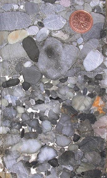
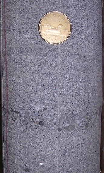
(...Continued from page 35)
Cadomin reservoir quality is generally poor. Pervasive silica cement occludes most quartz sand-supported porosity, while pressure solution has produced sutured/stylolitic contacts, and has reduced porosity in more chert-rich sands and conglomerates. White (kaolinitic) clays fill much of the rare pebblesupported porosity (Figure 3). Cadomin rocks are characteristically glassy and brittle, but have locally developed considerable permeability as the result of small- to moderate-scale fracturing (Figures 2, 4). In places, core is rubbled or has not been recovered.
Core analyses show very low porosities (commonly <5%) and permeabilities (<0.5 mD, with many values <0.1 mD) in deep Cadomin sections in the western parts of the basin. Where fractures occur, porosity values remain low, but permeabilities are in the 0.5-10 mD range, with spikes to 100 mD+ corresponding to larger fractures. updip toward the Deep Basin edge, reservoir quality improves to 5-10% porosity and 1-10+ mD, reflecting less extensive diagenetic degradation. Pressure transient analyses indicate in situ permeabilities of 0.01 to 0.5 mD.
Conventional well log suites are reliable in assessing Cadomin lithologies and porosity. Permeabilities are more difficult to assess, however, because of variations arising from grain size, sorting, and fracturing. Locally, bitumen or pyrobitumen may appear as porosity on porosity tools.
Hy DROCARBON OCCURRENCES AND PRODUCTION
The Deep Basin was first defined in Canada within the Cadomin Formation, and is well documented at Elmworth and adjacent areas (Gies, 1984; varley, 1984) (Figure 1). The Cadomin produces gas from the updip edge of the Deep Basin in northeastern B.C. and adjacent Alberta, at Wild River in west-central Alberta, and at hooker/ high River in southwestern Alberta. There
is isolated production from Foothills fractured reservoirs at Ojay / hiding Creek (northeastern B.C.), and at Chinook Ridge / Narraway (west-central Alberta), but some of this is commingled with the Nikanassin, so that the Cadomin contribution is difficult to differentiate.
Reliable resource estimates are not available for the Cadomin. Both GSC and Canadian Gas Potential Committee assessments combine the Cadomin within several play types. More importantly, existing resource assessments do not address significant strides made within the last few years in producing gas from lowpermeability Cadomin reservoirs.
CUT BANK R IDGE – GROUNDBIRCH PRODUCTIVE T REND
Deep Basin Cadomin prospectivity was established with the initial development of the Elmworth Field in the early 1980s, and was extended into B.C. with Canadian hunter’s exploration drilling in the late 1980s. however, economic production rates could not be systematically achieved with the technology and gas prices of the day.
In 2003, EnCana completed acquisition of a large acreage position at Cutbank Ridge, capping 18 months of purchasing land and drilling delineation wells. Based upon their “resource play” concept first employed at Greater Sierra in the Jean Marie, EnCana determined that the Cadomin could be exploited economically using current drilling and completion practices, and economies of scale associated with drilling and tying in many wells in a contiguous area. Burlington Canada (now ConocoPhillips) and other
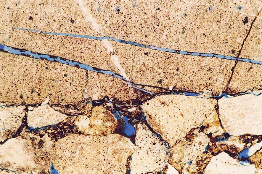
Figure 3. Cadomin conglomerate – some interpebble porosity occurs where sandy matrix is absent, but it has been largely filled by white authigenic clay.
Figure 4. Cadomin sandstone from a well near the eastern margin of the Spirit River Valley in westcentral Alberta. Note better sorting in sands and isolated pebbly lens.
Figure 5. Thin section showing relatively poor intergranular porosity and cross-cutting fractures within chert pebbles. Partially filled fractures impart limited permeability fairways within Cadomin strata.
operators have also aggressively pursued the Cadomin at Cutbank Ridge since 2003. To the northwest at Groundbirch, intensive drilling since 2005 for deeper Triassic targets has extended the Cadomin Deep Basin edge play fairway.
The updip edge of the Cadomin Deep Basin is well defined by gas production downdip, and formation water tests updip. Isolated water recoveries in the Deep Basin may be attributed to locally trapped “perched” water accumulations, or to mud filtrate recoveries. Almost every well completed in the Cadomin Deep Basin has flowed some gas, but economic rates and reserves (at reasonably projected gas prices) are limited to better reservoir rock found in a narrow band along the Deep Basin updip edge.
Cutbank Ridge is a good example of modern engineering technology and elevated long-term gas prices making a previously uneconomic “tight” gas play economic. The Cutbank Ridge area itself does not appear to be unique in terms of Cadomin reservoir characteristics, and current drilling is expanding the play northwestward toward Groundbirch and southeastward toward Wapiti.
HOOKER / HIGH R IVER FIELD
Cadomin strata (locally termed the Basal Quartz) lie within a north-south trending valley system in the hooker / high River area, part of a more regional valley mappable over 150 km. Drilling depths range from about 2,300 metres in the north to more than 3,200 metres in the southern part of the valley trend (Figure 6).
Gas was discovered in conventional traps in the Basal Quartz valley fill to the north at Crossfield in the 1960s. Spence (1997) mapped the Basal Quartz valley system southward, into an area with little well control. Reservoir quality deteriorated downdip, and conventional traps were difficult to define. Following Spence’s work, Compton Petroleum identified an extensive Cadomin / Basal Quartz fairway in the hooker / high River area, and assembled an extensive land position. In 1999, they participated in the high River discovery well, which demonstrated that gas was present and producible. Today, the hooker / high River development covers about three townships, and is controlled almost completely by Compton.
The Cadomin / Basal Quartz valley-fill section at hooker / high River ranges in excess of 25 metres thick, but exhibits considerable variability, with net/gross ratios below 50% in some wells. Sandstones are finer grained and less pebbly than the Cadomin to the north, and have experienced significant degradation
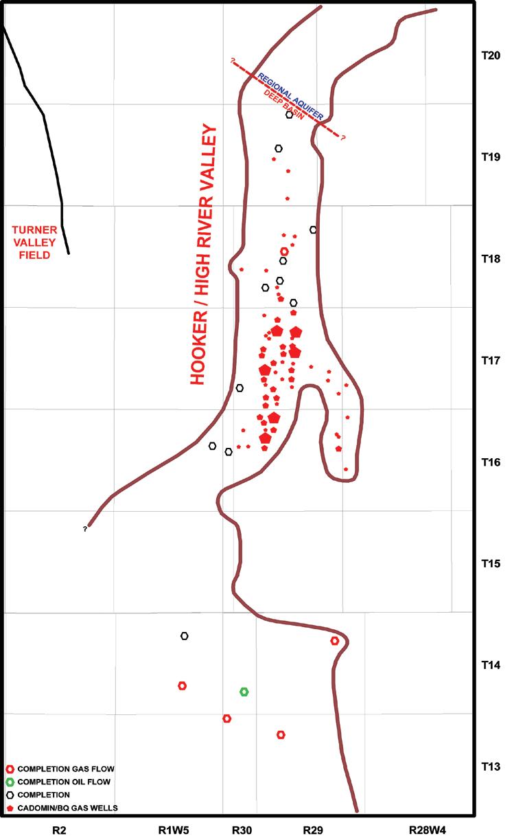
through compaction and silica cementation. Reservoir quality is highly variable – core analysis porosities generally range from 5-14%, with permeabilities of 0.1-5mD, but isolated sweet spots with better sorting and/or coarser grain size exhibit 20-80 mD permeability. Downdip, reservoir quality
is significantly poorer at 4-35-14-1W5, where a Cadomin core exhibited average porosity and permeability of 6.0% and 0.4 mD, respectively. In situ values are probably considerably lower, as the reservoir is buried to almost 3,500 metres at this location.
Figure 6. Situation map, Cadomin / Basal Quartz at Hooker / High River. Intensive development has taken place downdip of the Deep Basin edge, at depths where economic porosity and permeability are preserved. The valley trend can be traced southwestward, but production tests in Twp. 13 and 14 show lower permeabilities. (Continued
however, considerable secondary solution porosity has been observed in a number of cores, and the potential for porosity enhancement in coarser reservoirs at depth must be considered.
A core production area in Twp. 16-18, Rge. 29W4 has been developed with well densities of up to 4 wells/section (Figure 6). Compton reportedly uses 3D seismic attribute mapping to highgrade infill locations. h ayes et al. (2003) reported average initial deliverabilities of 1.2 MMCF/D, with associated liquids of 20 Bbl/MMCF, and reserve potential of 6 BCF/section through the main pool area. Cumulative production values vary substantially, reflecting reservoir quality variations and staged development of the pool. The best wells have produced 50-100 e6m3 over about 4.5 years.
Formation water has not been encountered within hooker / high River, and a Deep Basin regime appears to exist where impermeable Rierdon shales separate the reservoir from the underlying Mississippian regional aquifer. The Deep Basin updip limit has been interpreted to occur in Twp. 19-20, near the Rierdon subcrop edge.
C ADOMIN T IGHT G AS SUMMARy AND F UTURE ACTIVIT y
The Cadomin is the best defined and most widespread tight gas play in western Canada. Deep Basin sandstones and conglomerates blanket the western margin of the WCSB, and large gas fields are being developed in several distinct areas – Groundbirch / Cutbank Ridge / Wapiti, Wild River, and hooker / high River. These developments are based upon occurrence of the best reservoir quality along the updip margin of the Deep
ROCK SHOP
Basin. Considerable exploration potential remains in southwestern Alberta, where the updip margin is poorly defined, and further north, between Townships 20 and 50, where the Fox Creek Escarpment veers westward toward the mountain front, and regional fluid relationships are poorly known.
Regionally, Cadomin reservoirs thicken westward, but suffer degradation of reservoir quality through compaction and cementation. Gas resource potential in these areas is huge, but is only now being realized as production on a large scale. Specific structural trends at Ojay, hiding Creek, Chinook Ridge, and Copton / Narraway in the central Foothills are under active development.
More generally, an important strategy for accessing tighter Cadomin gas resources in the future is through drilling for multizone potential, so that other zones share the economic burden. Successful development at Elmworth, Wapiti, and Wild River all depend upon accessing gas in uphole zones, and in many cases, commingling it with the Cadomin.
R EFERENCES
Gies, R.M., 1984. Case history for a major Alberta Deep Basin gas trap: the Cadomin Formation. In: Elmworth – Case Study of a Deep Basin Gas Field, AAPG Memoir 38, p. 115-140.
Gordon, A.A., and M.E. Reichenbach, 2004. Cadomin Formation mechanisms that control reservoir quality and fluid sensitivity. Proceedings ICE 2004 Conference, CSPG.
Hayes, B.J., 1986. Stratigraphy of the basal Cretaceous Lower Mannville Formation, southern Alberta and north-central Montana. Bulletin of Canadian Petroleum Geology, Vol. 34, #1, p. 30-48.
Hayes, B.J., 2005. Revisiting the Early Cretaceous paleogeography of N.E. British Columbia –important stratigraphic controls on large gas fields. CSPG Reservoir, Vol. 32, #1.
Hayes, B.J.R., M. Junghans, K. Davies, and M. Stodalka, 2003. New Deep Basin gas plays at Hooker Alberta: extending Deep Basin prospectivity southward . Proceedings, AAPG 2003 Conference, Salt Lake City (extended abstract).
Petrel Robertson Consulting Ltd., 1998. Mannville and Jurassic petroleum geology of the Chin Coulee Area, South-Central Alberta. Non-exclusive report.
Schultheis, N.H., and E.W. Mountjoy, 1978. Cadomin conglomerate of western Alberta – a result of Early Cretaceous uplift of the Main Ranges. Bulletin of Canadian Petroleum Geology, Vol. 26, #3, p. 297-342.
Smith, D.G., 1994. Foreland Basin. In Geological Atlas of the Western Canada Sedimentary Basin. G.D. Mossop and I.Shetsen (compilers). Calgary, Canadian Society of Petroleum Geologists and Alberta Research Council, p. 277-296.
Smith, D.G., C.E. Zorn, and R.M. Sneider, 1984. The paleogeography of the Lower Cretaceous of western Alberta and northeastern British Columbia in and adjacent to the Deep Basin of the Elmworth area. In: Elmworth – Case Study of a Deep Basin Gas Field, AAPG Memoir 38, p. 79-114.
Spence, B.R., 1997. Sedimentology of the Lower Cretaceous Basal Quartz formation, southwestern Alberta. University of Calgary, M.Sc. thesis, 220 p.
Varley, C.J., 1984. The Cadomin Formation: a model for the Deep Basin type gas trapping mechanism. In: The Mesozoic of Middle North America, CSPG Memoir 9, p. 471-484.


2008 CSPG CSEG CWLS CONVENTION SHORT COURSES
PRE- CONVENTION COURSES
SCPRE01
s equence stratigraphy: a Practical u nderstanding of Basinal controls for Mapping and Exploration
Instructor: Andrew Miall
Date: May 5 – 6, 2008
A practical course designed to assist the petroleum geologist in the identification of different types of sequence, based on the generating mechanisms. The sequence architecture in a given basin (thickness, extent, isopach pattern, composition) may reflect the action of several simultaneous processes interacting locally to globally over a wide range of time scales.
SCPRE02
s hale Gas c ritical Fundamentals, Techniques and Tools for Exploration a nalysis
Instructor: Basim Faraj
Date: May 5, 2008
This one-day course will introduce the fundamental differences between conventional, hybrid, and shale gas plays. Source and reservoir rock attributes of shale gas plays will be discussed as well as GIP calculations, water, oil and gas saturations, essential laboratory, and optimum geochemical and mineralogical parameters. Slickwater completion (vertical and horizontal) lessons learned from the uS will be detailed. Canadian plays will be highlighted and discussed.
SCPRE03
Basic Petroleum Economics
Instructor: Dave Volek
Date: May 6, 2008
Learn the principles of cash flow discounting and present value – and how these principles apply in making capital investment decisions in a world of risk. Bring your laptop with a spreadsheet program for lots of “learn-by-doing.” visit the Finance section of www.oilfinancier.com to inspect this seminar’s topics.
SCPRE04 canada rocks: The Geological History of canada’s sedimentary Basin
Instructors: Nick Eyles and Andrew Miall
Date: May 7 – 8, 2008
“Canada Rocks: The Geologic Journey”
is a new book, illustrated with a wealth of new photographs, maps and diagrams, that describes the four-billion-year geologic history of Canada for a nontechnical audience. This course describes and explains the Phanerozoic history of Canada’s sedimentary basins by situating the development of the North American continent within the context of global platetectonic evolution.
SCPRE05
s equence stratigraphy: Principles and a pplications
Instructor: Octavian Catuneanu
Date: May 7 – 9, 2008
This course presents the concepts and practical applications of sequence stratigraphy for petroleum exploration and production. All concepts are illustrated with field examples of seismic, well-log, core, and outcrop data. In-class exercises emphasize the recognition of sequence stratigraphic surfaces and systems tracts on well-log cross-sections, seismic lines, and outcrop profiles.
SCPRE06
Practical s equence stratigraphy: concepts and a pplications
Instructor: Ashton Embry
Date: May 5 – 6, 2008
This two-day course presents the concepts and practical applications of sequence stratigraphy for petroleum exploration. Workshop exercises will emphasize the recognition and correlation of sequence stratigraphic surfaces on well log cross-sections.
Following the course, participants will have a clear understanding of the use of sequence stratigraphy for predicting facies types and geometries away from control points.
SCPRE07
3-D s eismic Interpretation
Instructor: Bruce Hart
Date: May 7 – 8, 2008
An introduction to 3D seismic technology, emphasizing fundamental principles of the interpretation process. Course touches on physical basis of seismic method, acquisition and processing effects on data interpretability, 3D survey design, 3D visualization, and 3D interpretation workflow. Short exercises, case studies
and live demonstrations emphasize course material.
SCPRE08
concepts, Models, and c ase studies of Dolomitization – with a pplications to Hydrocarbon Exploration and Development
Instructors: Hans Machel and Jay Gregg Date: May 8 – 9, 2008
This course summarizes the major advances and current controversies in dolomite research. A major part of this course deals with the various dolomitization models, from early to late and from shallow to deep, from hypersaline reflux to hydrothermal dolomitization and M v T mineralization. These concepts will be applied to hydrocarbon exploration and development, with specific reference to the Devonian of Western Canada.
SCPRE09 a n Introduction to Petroleum Geostatistics
Instructor: Clayton Deutsch Date: May 8 – 9, 2008
The fundamentals of geostatistical tools for constructing models of geological heterogeneity and quantifying uncertainty are presented. The practical application of tools and procedures for constructing high resolution models of surfaces, facies and petrophysical properties will be covered with examples. Emphasis will be placed on reproducing all available data and quantifying uncertainty for improved decision making.
SCPRE10
Exploration 101: Basic Geological and s eismic Principles in the u pstream
Petroleum Industry
Instructor: Easton Wren
Date: May 9, 2008 (Half-day)
This is a brief, yet illuminating, introduction to exploration and will take the participant through the normal progression from the origins of oil and gas to geological concept to prospect definition to drilling the exploratory well using a combination of geological and seismic tools. This course is open to all interested parties, but preference will be given to exhibitors and students.
SCPRE11
r isk and a nalysis of Exploration Plays
Instructor: Gary Citron
Date: May 9, 2008
This course serves as a companion with R&A’s successful course “Exploration Economics, Risk Analysis and Prospect Evaluation.” While The Prospect is the economic unit of exploration, The Play is the operational unit. Accordingly, this course addresses what many authorities believe to be the most difficult and critical task in Petroleum Exploration: the selection of plays and concessions in which to explore.
SCPRE12
The stratigraphic s etting of Lower and Middle Triassic strata, Western c anada s edimentary Basin
Instructor: Jim Dixon
Date: May 9, 2008
The objective of this course is to help explorationists understand the regional stratigraphic setting of Triassic rocks and how this can be used in a more local exploration program. The course is four hours long and consists of two lectures, some correlation exercises and an
examination of several cores that illustrate various facies types and/or significant stratigraphic surfaces.
SCPRE13
Exploration: From Geology to the s eismic s ection
Instructor: Bob Parker
Date: May 7 – 9, 200 8
This 3-day course takes the participants through the complete cycle of exploration geophysics. It starts with a review of geological principles – the target of the seismic tool. It then looks at seismic acquisition and processing – how the subsurface is imaged. A section on the seismic response to geology examines how these images appear on the seismic section, and looks at pattern recognition as a tool in interpreting both structural and stratigraphic features. The course ends with hands-on interpretation exercises (including some interpretation pitfalls).
SCPRE14
Production Logging
Instructor: Munir Sharar
Date: May 5, 2008
Learn about Logging -
in Three Days
Your company expects you to interpret and understand open-hole logs in the eld. Incorrect and inaccurate data may lead to decisions that will cost your company tens of thousands of dollars.
If you’re a geologist or technologist and want to learn more about logging, this three-day course is for you. Logging – Finding the Oil and Gas is a hands-on course that will improve your understanding of the various open-hole logging methods, as well as wellbore parameters and logging theory. Learn from Baker Atlas – the leaders in open-hole logging.
This course will be held in Calgary, April 22-24, 2008
Wireline Production Logging is an invaluable means in assisting Reservoir and Completion Engineers in understanding the effects of completions and stimulations on a well. Production logging can also be used as a diagnostic tool in checking cross flow between zones, packers or sliding sleeves integrity and channels behind casing. This one day course will cover all PL tools available in the industry and specific applications of each tool. More information on this course may be found in the Final Circular or online at www. GEOconvention.org.
SCPRE15
Formation Damage Evaluation, reduction and removal
Instructor: Brant Bennion
Date: May 6, 2008
Course will consist of a combination of interactive lectures and question-answer sessions. Course Content includes:
• Definitions of formation damage
• Major mechanisms of formation damage
• Mechanical damage mechanism
• Chemical damage mechanisms
• Fluid –fluid issues
• Wettability alterations and their impact on reservoir performance
• Biological formation damage issues
• Thermally induced formation damage
• Formation damage and horizontal wells
• Why is damage more a concern in horizontal wells
SCPRE16
acoustic Logging
Instructors: Denis Schmitt, Doug Patterson, John Walsh
Date: May 7, 2008
The objective of this course is to provide both an overview and understanding of the theory, physics, and measurements of borehole acoustic devices. The course will discuss the basic system configurations of the older generation monopole devices, still being utilized, as well as the new generation mulitpole and cross-dipole systems more commonly used. The critical issues of log quality control and the borehole environmental effects will also be covered. The course focus will be the application and limitations of the measurements from these devices in petrophysical, geophysical, and reservoir engineering disciplines using real-world examples.
SCPRE17
Log- core Integration
Instructors: John Nieto, Ross McLean, David Kelly
Date: May 8, 2008
This course provides an in-depth look at the integration of wireline log response and rock lithofacies as seen in core. The course instructors will take several carbonate and clastic formations at the Core Research Centre and demonstrate that these can be subdivided based upon log response. This classification leads to a reservoir ‘facies’ curve which can be used directly in shared Earth Modeling, petrophysical evaluation, and reservoir engineering. Course attendees may be geoscientists, petrophysicists, or reservoir engineers. A basic knowledge of core lithofacies description and wireline log response would be an advantage, but is not essential. By the end of the day, attendees will have a better appreciation of techniques of integrating core description and wireline logs in to their daily workflow.
SCPRE18
Borehole Imaging
Instructors: Paul Elliott, Tahereh Mirzadeh
Date: May 9, 2008
The one-day course will introduce attendees to the following aspects of Borehole Imaging:
• Tool theory and data acquisition
• Data processing workflows
• Identifying bed boundaries
• Fractures
• Faults
• Micro-faults
• Rose diagrams
• Schmidt plots
• Azimuth Frequency plots
• Dip Domain analysis
• In situ stress
• Identifying sedimentary features
• Artifacts
POST- CONVENTION COURSES
SCPST01
structural styles and Interpretation
Techniques in Fold-Thrust Belts
Instructor: Shankar Mitra
Date: May 20 – 23, 2008
Fold-thrust belts contain complex trapforming structures, which are not well imaged on seismic data. The objective of the course is to discuss the use of 2D and 3D structural models and techniques for constructing maps, balanced cross sections and 3D interpretations. Models of trap-
Reservoir Characterization
Expertise in heavy oil & deep basin reservoirs
• AVO / LMR Analysis
• Neural Network Analysis
• PP & PS Registration
• Joint PP & PS Inversion
• Fracture Detection Analysis using Azimuthal AVO
• Spectral Decomposition
Time Lapse Analysis
Carmen Dumitrescu P.Geoph., M.Sc., Manager, Reservoir Geophysics
Direct: 403-260-6588 Main: 403-237-7711
www.sensorgeo.com
forming structures for fold-thrust belts will be presented. Problem sets will provide hands on experience in interpreting subsurface structures using seismic and well data.
SCPST02 a pplied structural Geology
Instructors: Mark Cooper & Marian Warren Date: May 20 – 22, 2008
how can an understanding of the way in which rocks deform impact exploration, development, drilling, and production of hydrocarbons?
• See how the basic rules of fault geometry can be applied to compressional, extensional, inverted, and strike-slip tectonic regimes
• Learn how to apply simple but rigorous geometric techniques to construct structural cross-sections in a variety of tectonic regimes
• Learn how structural models can aid in planning directional drilling
• Common pitfalls in correlating faults
• Why does a fault seal or not; Is there an answer
• Impact of deformation in reservoirs on fluid flow, including fractured reservoirs
The aim of the course is to provide a basic overview of how structural geology techniques can improve the finding and production of hydrocarbons. The course will involve both lectures and practical exercises.
SCPST03
c lay Minerals and Their Effect on the Electrical Behavior of s haly s ands Instructor: E.C. Thomas Date: June 17, 2008
This one-day course will cover the fundamentals of the following topics:
• The structure of clay minerals
• The origin of cation exchange capacity in clay minerals
• understanding how the cation exchange properties of clay minerals alters the conductivity of brine-saturated shaly sands
• Development of the Waxman-Smits equation as a model to compute water saturation when cores and their analyses are not available
• Bound water and how it is measured, including comparison to NMR
• h andling laminated shaly sands using the Thomas-Stieber approach to derive porosity and water saturation of the sand laminae
• Advantages of having horizontal and vertical resistivity measurements for the analysis of shaly sands
2008 CSPG CSEG CWLS CONVENTION FIELD TRIPS
PRE- CONVENTION
FTPRE01
Virgelle Member at Writing-on stone Provincial Park, southern alberta: analogue for a subsurface Exploration Target
Leader: Rudi Meyer
Date: May 7 – 8, 2008
Maximum Attendance: 14 participants
The primary aim of this field trip is to provide an overview of high-resolution stratigraphic relationships and depositional facies within virgelle Member sandstones of the upper Cretaceous Milk River Formation, southern Alberta. Continuous outcrops offer threedimensional exposures to illustrate relevant sedimentologic and stratigraphic linkages across a range of scales, from metre-scale bedforms to successions 5-30 km apart.
FTPRE02
Geological Walking TourThe Building rocks of calgary
Leader: Bill Ayrton
Date: May 7, 2008
Maximum Attendance: 30 participants
This interesting half-day tour examines the rocks, sedimentary features, and fossils beautifully displayed on the buildings of Calgary. We will also see the building rocks used by our landscapers and sculptors. The rocks range in age from PreCambrian to Tertiary, and come from as far away as Scandinavia and India; some were even quarried locally.
FTPRE03
Triassic sedimentary Framework and sequence stratigraphy, Williston Lake, British columbia
Leader: John-Paul Zonneveld
Date: May 6 – 9, 2008
Maximum Attendance: 14 participants (Trip begins and ends in Fort St. John)
The Williston Lake, British Columbia, field course centres around the sedimentologic and stratigraphic development of the Triassic rocks in Western Canada. Excellent outcrop equivalents of all major producing subsurface units (Montney, Doig, halfway, Charlie Lake, Baldonnel, and Pardonet) are observed and discussed. The first day of the field course is spent at the provincial core storage facility in Charlie Lake, British
Columbia, to discuss basic controls on subsurface hydrocarbon reservoir nature and distribution, as well as similarities and differences between the outcrop and subsurface sections. The following three days are spent visiting Lower, Middle, and upper Triassic outcrop localities along the shores of Williston Lake.
POST- CONVENTION
FTPST01
Fluvial architecture of the Lower Tertiary Porcupine Hills Fm, southwest alberta
Leaders: Derald Smith, Peter Putnam
Date: May 16, 2008
Maximum Attendance: 15 participants
Fluvial architecture in the Porcupine hills Fm. (Paskapoo equivalent) of southwestern Alberta is best exposed where Willow Creek cuts through the north end of the Porcupine hills. These early Tertiary rocks consist of channel-fill and crevasse-splay sandstones and overbankshallow lacustrine, poorly cemented siltstones. The largest channel-fills average 12 m thick, but are limited in width from 100 to 200 m, while
(Continued on page 44...)
* Bakken! Bakken! Bakken! * Crude Oil Bottleneck
* Technical Talks
* Prospect Expo
* Dr. Michael Economides
* Updates on “Hot plays”
* State Land Sale
Have questions? Call 701-223-6380, or email ndpc@ndoil.org or write to WBPC , PO Box 1395, Bismark, ND 58502

adjacent crevasse-splay sheet sandstone beds are greater than 1,000 m in lateral extent, but are only 0.50 to 2.0 m thick. Outcrops consist of 30% sandstone and 70% siltstone. On the basis of stratigraphy, architecture, and lithologies, we interpret these fluvial facies as being most analogous to modern anastomosing fluvial deposits. hydrocarbon-bearing upper Cretaceous Willow Creek, St. Mary, and Belly River Formations have similar fluvial architecture to that of the Porcupine hills.
FTPST02
upper cretaceous shelf and shoreface sandstones: Montana
Outcrops and alberta Basin cores
Leaders: Peter Putnam, Derald Smith Date: May 20 – 22, 2008
Maximum Attendance: 15 participants
upper Cretaceous wave-impacted sandstones form important (historical and current) petroleum reservoirs in western Canada and Montana. Although sheet-like in gross geometry, sufficient heterogeneity exists in these deposits to influence exploration strategy, well operations, completions, and production practices. Excellent exposures of these units in north-central Montana provide useful analogues for those
geoscientists exploring or exploiting these types of reservoirs anywhere in western Canada.
FTPST03
Jurassic and Lower cretaceous Deposits of Northeast British columbia: Exploring the surface and subsurface Leaders: Godfried Wasser Date: May 20 – 23, 2008
Maximum Attendance: 11 participants (Trip begins and ends in Fort St. John)
This is a 4-day course, comprising a fieldtrip at Williston Lake, a core workshop and lectures on the N.E. British Columbia gas reservoirs covering the Bluesky to Nordegg interval. Areas discussed include Buick, Beg, Blueberry, Peejay, Bernadette, Siphon, Silver, Cutbank, and Grizzly. The course addresses petrography, log analysis, and core and cuttings examinations as well as production and pressure history.
FTPST04
Major Dolostone reservoir Types, Outcrops and subsurface analogues Western canada: Distinct Types or continuum ?
Leaders: Graham Davies, Jack Wendte Date: May 21 – 22, 2008
Maximum Attendance: 20 participants
This field seminar will compare the origin of dolomite and evolution of pore systems of two lithologically distinct types of dolostones in the Canadian Rocky Mountains. The first day of the seminar is in Calgary and consists of a half-day of lectures on these dolostones and their subsurface analogues, and a half-day core seminar focused on Devonian ‘Cairn’style dolostones and origin of porosity in dolostones. The second day will be a field trip to view hydrothermal dolostones hosted in Cambrian exposures in southwestern Alberta and southeastern British Columbia.
FTPST05
Geology of the athabasca Oil sands
Leaders: Mike Ranger, Murray Gingras Date: May 26 - 29, 2008
Maximum Attendance: 20 participants (Trip begins and ends in Ft. McMurray)
This three-day field excursion to the Fort McMurray area provides an excellent opportunity to observe the geology of the Athabasca Oil Sands, as well as the engineering and mining technology related to recovery of the bitumen. Numerous outcrops along the Athabasca, Christina, and Steepbank Rivers will be visited by high-speed jet boat and helicopter.


“Seismic
for Un Conventional Plays”

Rocky Mountain Association of Geologists

Denver Geophysical Society

14THANNUAL


Kickoff Speaker: Peggy Williams
Senior Exploration Editor, Oil & Gas Investor Magazine
Exploration Trends Across the Globe, the Continent and the Rockies
Downtown Marriott Hotel
Denver
Monday, March 17, 2008
Keynote Speaker: Larry Lunardi
Vice-President-Geophysics, Chesapeake Energy Corp. 3-D Seismic for Unconventional Plays

2008 CSPG CSEG CWLS CONVENTION GUEST SPEAKERS

M EET PETER T ERTZAKIAN, A 2008 CONVENTION GUEST SPEAKER
Best-selling author of A Thousand Barrels a Second, published by McGraw- hill, Peter Tertzakian is the Chief Energy Economist of ARC Financial Corporation, one of the world’s leading energy investment firms.
Tertzakian’s background in geophysics, economics, and finance, combined with his entrepreneurial spirit, helped him rise from the trenches of hands-on oil exploration fieldwork to become an internationally recognized, top-ranked expert in energy matters.
Often seen and heard through media outlets around the world, Tertzakian has been a featured guest on many high-profile radio and television shows including The Daily Show with Jon Stewart. In print, Tertzakian has been featured in uS News and World Report and has contributed editorials to widely read publications like The Globe and Mail and Forbes.com. he also writes a weekly column, ARC Energy Charts, and is a sought-after public speaker.
Tertzakian has an undergraduate degree in Geophysics from the university of Alberta, and a graduate degree in Econometrics from the university of Southampton, u.K. he also holds a Master of Science in Management of Technology from the Sloan School of Management at MIT.
he lives in Calgary, Alberta, one of the world’s leading oil and gas centers, with his wife and two children.
M EET R ICK M ERCER , A 2008 CONVENTION GUEST SPEAKER
Think This hour has 22 Minutes... Think Made In Canada... Think Talking To Americans... Think The Rick Mercer Report. Now you understand why Rick Mercer has become “Canada’s unofficial Opposition.” he understands what amuses, delights, and occasionally enrages Canadians about our politicians, our media elite, and our great neighbour to the south, and has the comedic skills and satirical sensibility to translate that into some of the funniest television on the planet.
Rick Mercer is without a doubt one of this country’s most highly respected writer/ actors, having garnered many awards and accolades since he burst on to the stage at the National Arts Centre in 1990. he has

won numerous Gemini awards for his writing and performances, the Sir Peter ustinov Award at the prestigious Banff Television Festival, and was the 2004 recipient of The National Arts Centre Award at the Governor General’s Awards for the Performing Arts. he is also the only civilian to be awarded the Canadian Arms Forces Commander Land Force, Command Commendation—this in recognition of his ongoing support of Canada’s armed forces, which has included several visits to Canadian troops in Afghanistan.
But the awards only tell a small part of the story. Mercer has become Canada’s most celebrated entertainer because of his ability to connect with ordinary Canadians. Nowhere is
that better illustrated than in his historic onehour CBC special, Rick Mercer’s Talking to Americans, which attracted 2.7 million viewers across Canada, making it the highest-rated comedy special in the history of Canadian television. The special drew rave reviews and media attention across North America and the world.
hailing from St. John’s Newfoundland, Mercer premiered his one-man show at Ottawa’s National Arts Centre (NAC) in 1990. Show Me the Button, I’ll Push It became a national hit and was performed from St. John’s to vancouver. his second one-man show, the critically acclaimed I’ve Killed Before; I’ll Kill Again opened at the NAC in 1992. It played to sold-out houses across Canada. A third one-man show, A Good Place to hide, premiered at the NAC in May 1995, and was met with critical praise and full houses.
he has hosted the East Coast Music Awards, The Gemini Awards, The Juno Awards, the history series It Seems like yesterday, the annual Canada Day show from Parliament hill, and the CBC Television special The Next Great Prime Minister. Time and Maclean’s have published his work, and in June 1998, his first book, Streeters, was published by Doubleday and quickly rose to #1 on the Globe and Mail’s National Best Seller List. Mercer currently hosts The Rick Mercer Report, one of the CBC’s most popular and acclaimed shows. A book based on the show will be released in September 2007.


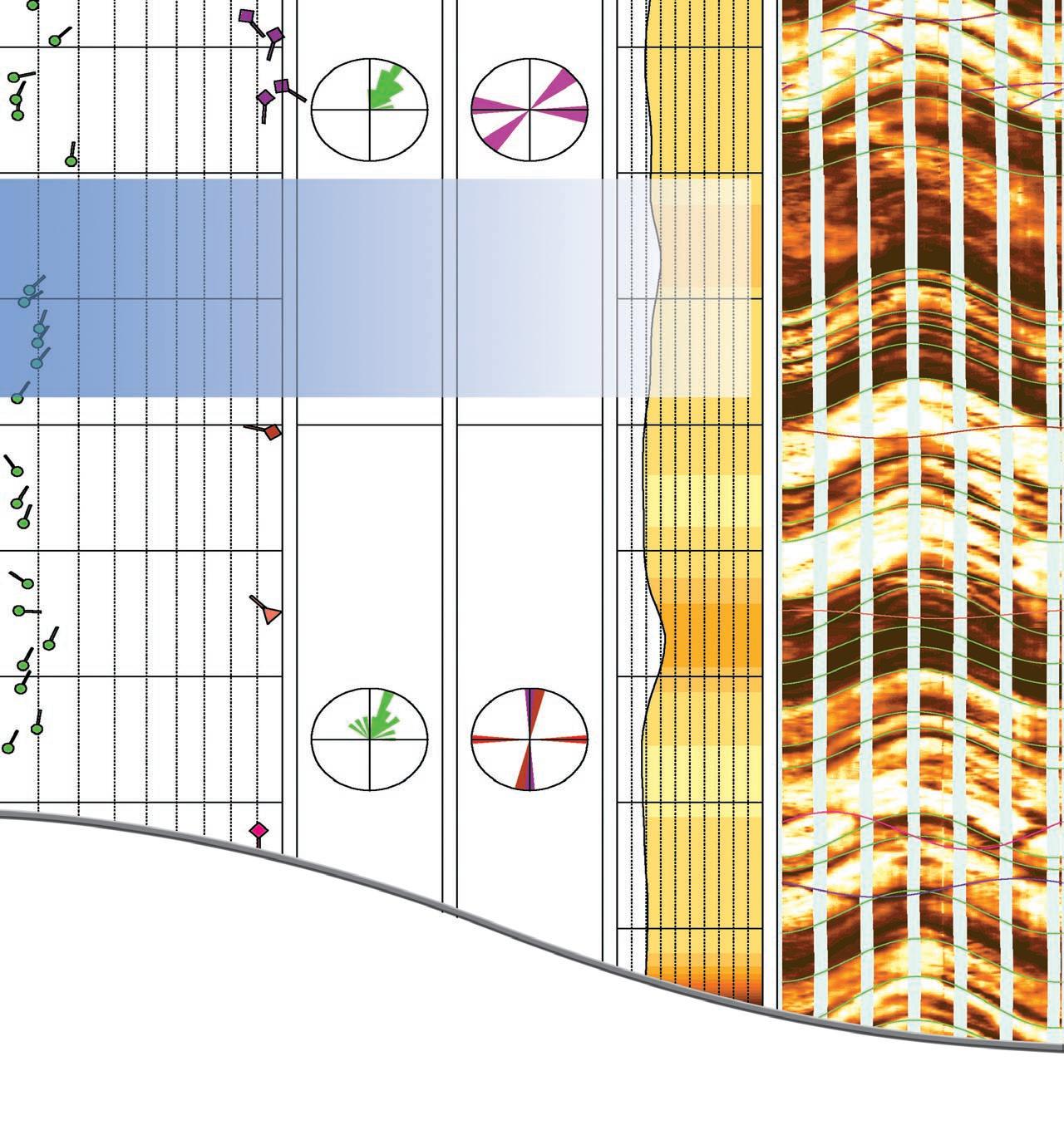
The EARTH ImagerSM service delivers high-resolution micro-resistivity images in oil-based mud with great hole coverage.
This proven micro-resistivity imager from Baker Atlas offers a vertical resolution of less than 7.5mm at a standard logging speed of 275 m/hr giving you details never seen before in oil-based mud images.
The EARTH Imager service operates in 152 to 533mm diameter boreholes. With its 6 pads mounted on individually articulated arms, it provides you with 63% borehole coverage in 200mm diameter holes while maintaining pad contact at all hole deviations.
Call us today to find out how you can use the EARTH Imager service in your next oil-based well to accurately identify structural and sedimentary features, rock texture, fracture orientation and estimate net-to-gross.