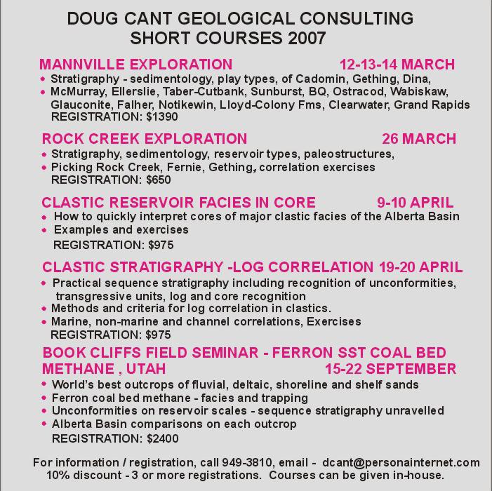
28 Resource Assessment and GIS
31 Ryerson, Saskatchewan T8-9, R30-31W1
34 2007 CSPG CSEG Convention: Registration opens March 19th!
36 2007 CSPG CSEG Convention: Short Courses and Fieldtrips
28 Resource Assessment and GIS
31 Ryerson, Saskatchewan T8-9, R30-31W1
34 2007 CSPG CSEG Convention: Registration opens March 19th!
36 2007 CSPG CSEG Convention: Short Courses and Fieldtrips
“AccuMap encompasses speed, stability, efficiency and accuracy. As an intuitive and easy-to-use product, AccuMap serves a broad audience, from field users to the CEO.”
Darrel Saik Senior Geological Technologist Paramount Energy Trust
AccuMap is the most widely used and highly trusted oil and gas mapping software touching every segment of E&P, for every professional.


CSPG OFFICE
#600, 640 - 8th Avenue SW
Calgary, Alberta, Canada T2P 1G7
Tel: 403-264-5610 Fax: 403-264-5898
Web: www.cspg.org
Office hours: Monday to Friday, 8:30am to 4:00pm
Business Manager: Tim Howard
Email: tim.howard@cspg.org
Membership Services: Sarah Barton
Email: sarah.barton@cspg.org
Communications & Public Affairs: Jaimè Croft Larsen
Email: jaime.croftlarsen@cspg.org
Corporate Relations: Kim MacLean
Email: kim.maclean@cspg.org
Corporate Relations Assistant: Heather Tyminski
Email: heather.tyminski@cspg.org
Conventions & Conferences: Shauna Carson
Email: shauna.carson@cspg.org
Conventions & Conferences Assistant: Tanya Santry
Email: tanya.santry@cspg.org
Reception: Dayna Rhoads
Email: reception@cspg.org
EDITORS/AUTHORS
Please submit RESERVOIR articles to the CSPG office. Submission deadline is the 23rd day of the month, two months prior to issue date. (e.g., January 23 for the March issue).
To publish an article, the CSPG requires digital copies of the document. Text should be in Microsoft Word format and illustrations should be in TIFF format at 300 dpi., at final size For additional information on manuscript preparation, refer to the Guidelines for Authors published in the CSPG Bulletin or contact the editor.
Coordinating Editor & Operations
Jaimè Croft Larsen, CSPG
Tel: 403-513-1227 Fax: 403-264-5898
Email: jaime.croftlarsen@cspg.org
Technical Editor
Ben McKenzie
Tarheel Exploration
Tel: 403-277-4496, Email: bjmck@telusplanet.net
ADVERTISING
Kim MacLean
Corporate Relations, CSPG
Tel: 403-513-1229, Email: kim.maclean@cspg.org
Advertising inquiries should be directed to Kim MacLean. The deadline to reserve advertising space is the 23rd day of the month, two months prior to issue date. All advertising artwork should be sent directly to Kim MacLean.
The RESERVOIR is published 11 times per year by the Canadian Society of Petroleum Geologists. This includes a combined issue for the months of July/August.
Advertisements, as well as inserts, mailed with the publication are paid advertisements. No endorsement or sponsorship by the Canadian Society of Petroleum Geologists is implied.
The contents of this publication may not be reproduced either in part or in full without the consent of the publisher.
& Layout by Sundog
Additional copies of the RESERVOIR are available at the CSPG office for $3.00
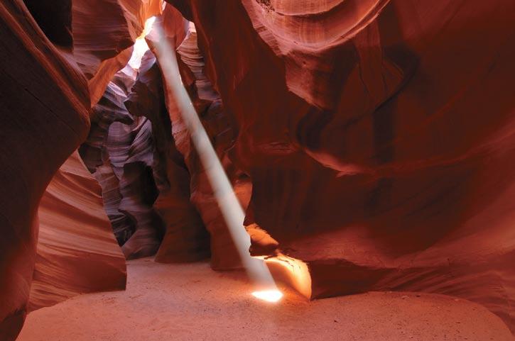
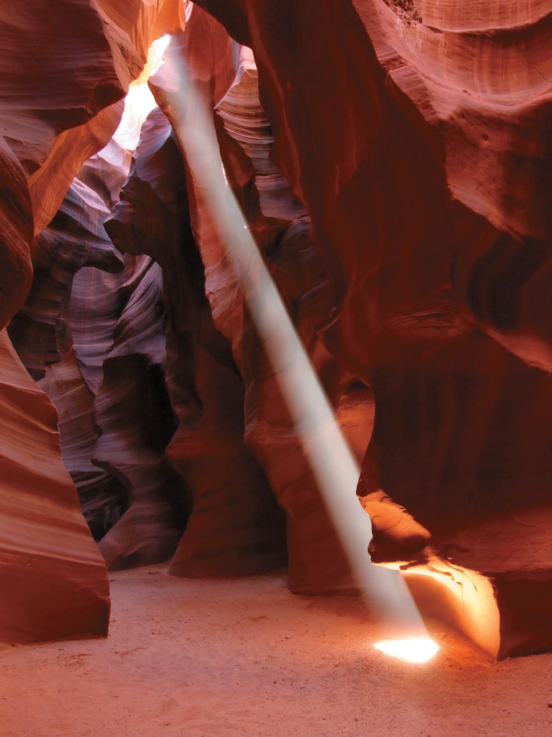
Antelope Canyon, Northern Arizona. Flash flooding and wind erosion have combined to sculpt spectacular slot canyons in the sandstones of the Late Triassic/ Jurassic Navajo Formation. Metre-scale cross-bedding in the canyon walls betray the Navajo Sandstone’s origin as an eolian-deposited dune field, the extent of which possibly rivaled that of the Sahara Desert. Photo by Marc Shandro.

CSPG EXECUTIVE
President Colin Yeo • EnCana Corporation colin.yeo@encana.com Tel: (403) 645-7724
Vice President
Lisa Griffith • Griffith Consulting lgriffith@griffithgeoconsulting.com Tel: (403) 669-7494
Past President
Jim Reimer • Result Energy Inc. jim@resultenergy.com Tel: (403) 539-5207
Finance director
Peter Harrington • Northrock Resources Ltd. harrington@northrock.ab.ca Tel: (403) 213-7665
assistant Finance director
James Donnelly • ConocoPhillips Canada james.donelly@conocophillips.com Tel: (403) 260-8000
Program director
Nadya Sandy • Esso Imperial Oil Resources Limited nadya.sandy@esso.ca Tel: (403) 237-3925
assistant Program director
Randy Rice • Suncor Energy Inc. RJRice@suncor.com Tel: (403) 205-6723
serVice director
Dave Newman • McDaniel & Associates Consultants Ltd. dnewman@mcdan.com Tel: (403) 218-1392
assistant serVice director
Jen Vezina • Devon Canada Corporation jen.vezina@devoncanada.com Tel: (403) 232-5079
outreach director
David Middleton • Petro-Canada Oil & Gas middletn@petro-canada.ca Tel: (403) 296-4604
assistant outreach director
Greg Lynch • Shell Canada Limited greg.lynch@shell.com Tel: (403) 691-2052
communications director
Ashton Embry • GSC - Calgary aembry@nrcan.gc.ca Tel: (403) 292-7125
corPorate relations director
Monty Ravlich • GRGO Holdings Ltd. ravlich@telus.net Tel: (403) 560-1701
A message from the Communications Director, Ashton Embry

One of the reasons I like the Long Time Members reception at the Annual Convention is that I get the chance to talk with people who have been CSPG members for more than 50 years. I enjoy hearing about what our Society was like back in the 1950s and 60s. As a 39-year member myself, I have seen my share of change and this, plus the tales passed down from my elders, have given me a reasonable perspective for what has been accomplished and the paths we have gone down over the past 50 years. When I joined the CSPG in 1968, our staff was a secretary we shared with APEGGA on the 6th floor of the Lougheed Building. We now have seven full-time staff and some people, especially those who remember the 1950s and 60s, ask why we need so many people. The main reasons for the increased staff are the increased complexity of Society activities and the reduced amount of time members have for volunteer effort.
The larger staff complement make it possible to accomplish things formerly not possible such as publishing a 40-to-48 page Reservoir every month and keeping accurate and up-to-date financial records for all CSPG activities. Most importantly, the staff has taken on many tasks for which it is no longer possible to find volunteers, especially over the long term. Our Reservoir would not arrive on time every month if not for the hard work of Jaimè Croft Larsen, the staff member who looks after our Communication and Public Affairs portfolio. A three-week-late Reservoir would not be of much value. There is no doubt that CSPG members get many more services than they did 50 years ago and that is mainly because of the growth of our staff component.
I look after the Communications portfolio which centres on the publication of the Bulletin, the Reservoir, and our Calendar; the maintenance and expansion of our website; and the Public Affairs activities of the Society. For most of my tenure
as Communications Director the main preoccupations of the Communications Committee have been going digital with the Bulletin, expanding the Reservoir and making it profitable, and building a member-friendly and comprehensive website. These goals have been realized although the committee chairs that look after each of these activities are still making notable improvements to their bailiwicks.
For example, Ben McKenzie has recently put a new face on the Reservoir and he continues to look at ways to increase the technical content. This is not an easy task but, knowing Ben, I expect we will be seeing an even bigger and better Reservoir within a year. Glen Stockmal, who edits the Bulletin, is investigating systems that will allow complete digital submission, critical reading, and tracking of all manuscripts. This will make everyone’s life a little easier when it comes to publishing the Bulletin. And the ever-energetic Astrid Arts is always coming up with ways to improve the interactive functionality of our great website and make it even more user-friendly. There is no doubt that our website and other electronic communication vehicles, such as our recently instituted E-Newsletter (produced by Jaimè), will continue to play more important roles when it comes to providing our members with new and improved services.
I am also responsible for New Publications and that is one area in my portfolio that I have let slide as we strived to bring our established publications into the 21st century. I am sure all those who care about such things have noticed that very few new publications have appeared over the last decade or so. This stands in contrast to our record from the late 60s to the mid90s when we regularly cranked out major publications including 18 memoirs and the magnificent Western Canada Sedimentary Basin Atlas. So what happened? Why did the
(Continued on page 7...)

CONTOURING
Faulted contours
Isopachs
Volumetrics
Grid operations
New flexing options
CROSS SECTIONS
New Unassigned Tops
Digital and/or Raster
Geocolumn shading
Stratigraphic/Structural
Shade between crossover
Dipmeter data
MAPPING OPTIONS
Expanded GIS Functions
Bubble maps
Production charts
Log curves
Posted data
Highlighted Symbols
3D VISUALIZATION
Deviated wellbores
Digital logs
Grid surfaces
Tops, Shows and Perfs
Land grid overlay
Map images
DECLINE CURVES
Compute EUR, RR, etc.
Hyperbolic or exp.
Rate/Time or Cum P/Z
User defined Econ. Limit
User defined Extrap. Time
How our vision supports yours
PETRA: Pioneer of easy, affordable PC solutions for today’s workflows.
IHS: The industry’s leading choice of E&P data and delivery systems to populate PETRA projects. The combination: Fast, confident prospect analysis for you.
Download a trial version at www.ihs.com/energy/petra, or call us at 888-738-7265 for more information. And stay tuned for more on our vision of streamlined data flows for prospect studies.


(...Continued from page 5)
well go dry? Every time my fellow Executive members chide me over the lack of new publications, I ask myself these questions.
Deadline: Jan 26, 2007
ABu DHABI OIL CO., LTD. (JAPAN)
APACHE CANADA LTD.
BAKER ATLAS
BG CANADA ExPLORATION & PRODuCTION, INC
BP CANADA ENERGy COMPANy
CANADIAN FOREST OIL LTD.
CANETIC RESOuRCES TRuST
CONOCOPHILLIPS CANADA
CORE LABORATORIES CANADA LTD
DEvON CANADA CORPORATION
DOMINION ExPLORATION CANADA LTD
DuvERNAy OIL CORP
ENERPLuS RESOuRCES FuND
geoLOGIC systems ltd.
GRIZZLy RESOuRCES LTD.
HuNT OIL COMPANy OF CANADA, INC
HuSKy ENERGy INC.
IHS
IMPERIAL OIL RESOuRCES LIMITED
LARIO OIL & GAS COMPANy
MJ SySTEMS
MuRPHy OIL COMPANy LTD
NExEN INC.
NORTHROCK RESOuRCES LTD.
PENN WEST PETROLEuM LTD
PETRO-CANADA OIL AND GAS
PETROCRAFT PRODuCTS LTD.
PRIMEWEST ENERGy TRuST
PROvIDENT ENERGy LTD
RPS ENERGy
SHELL CANADA LIMITED
SPROuLE ASSOCIATES LIMITED
SuNCOR ENERGy INC
TALISMAN ENERGy INC
TOTAL E&P CANADA LIMITED
WEATHERFORD CANADA
AS OF JANUARY 24, 2007
Probably the main reason why major new publications stopped appearing is that our members became too busy to spend long volunteer hours on such major endeavours. In the past, each publication was a grass roots effort. One of our members would approach the Executive with a plan to put together a publication on a given subject. As long as the subject matter was appropriate and the person had a reasonable financial plan for the book, the Executive would bless its creation and not think anymore about it until boxes of books started appearing in the office. Having been a co-editor of three memoirs, I know how much time it takes to produce such volumes and, given the major shifts in work expectations, it does not surprise me that people are not coming to the Executive with plans for major, new publications.
In recognition of this, we made the decision to include more symposium volumes as regular issues of the Bulletin. This has the advantage of providing all of our members with these more-specialized publications
and it also makes them readily available to geologists throughout the world through DataPages and GeoScienceWorld. We may still publish larger, hard-copy books if excellent opportunities present themselves. Another option is to publish a volume electronically as a CD. This saves on costs and allows the product to be priced much more reasonably. I have come to the point where I would far rather have a digital publication than a hard-copy one simply because of a space crunch in my office. We will be debating the various options for new publications over the next year.
One new “old” publication we have recently revived is the creation of a digital “Geological Atlas of the WCSB.” Dawn Hodgins of Exxon/Mobil has volunteered to chair this project which was put on hold when Grant Mossop passed away over a year ago. I expect it will take awhile to get all the issues connected with creating a Digital Atlas resolved but we are committed to seeing such a product available to our members. If you would like to get involved in this major project, please give Dawn a call at Exxon/ Mobil. Of course if you have an idea for a new publication I would love to hear it. We will always be a grassroots organization.
Your company expects you to interpret and understand open-hole logs in the field. Incorrect and inaccurate data may lead to decisions that will cost your company tens of thousands of dollars.
If you’re a geologist or technologist and want to learn more about logging, this three-day course is for you. Logging – Finding the Oil and Gas is a hands-on course that will improve your understanding of the various open-hole logging methods, as well as wellbore parameters and logging theory. Learn from Baker Atlas – the leaders in open-hole logging.
This course will be held in Calgary, April 25-27, 2007
SPEAKER
Steven L. Bachtel
ConocoPhillips Co., Houston, Texas 2006-07 AAPG Distinguished Lecture
11:30 am tuesday, march 6, 2007 telus convention centre calgary, alberta
Please note: the cut-off date for ticket sales is 1:00 pm, thursday, march 1st.* t icket price is $31.00 plus gst.
*Please note: Due to the recent popularity of talks, we strongly suggest purchasing tickets early, as we cannot guarantee seats will be available on the cut-off date.
Seismic stratigraphy and seismic facies analysis provide a useful methodology for the genetic understanding of carbonate platform systems during exploration, initial assessment, and early field development (e.g., sparse well data). A highresolution 2D seismic survey covering 7,500 square kilometers allows documentation of the evolution of a Miocene-Pliocene carbonate platform in the East Natuna Sea, Indonesia. The Segitiga Platform (1,400 km2) contains Terumbu Formation carbonates up to 1,800 meters thick that were deposited in platform interior, reef and shoal margin, and slope to basin environments of an isolated carbonate platform.
The Segitiga Platform was subdivided into twelve seismic sequences that demonstrate a history of: 1) initial isolation, 2) progradation and coalescence, 3) backstepping and shrinkage, and 4) terminal drowning.
Seismic facies maps indicate that the Segitiga Platform originated as three smaller
sponsored by
platforms on extensional fault-block highs. Deep intraplatform seaways separated these platforms. Progradation of shallow-water carbonates filled the seaways during a phase of coalescence and the three platforms were amalgamated to form a composite platform during the middle-upper Miocene. A rapid relative rise in sea level at the end of Miocene time caused a major backstepping of the carbonate margins (and a concomitant drowning of the adjacent Natuna Field carbonates to the east) resulting in a platform of reduced size (600 km2) during the lower Pliocene. Rapid subsidence, combined with a eustatic rise at the end of the early Pliocene caused terminal drowning of the Segitiga Platform. The platform was buried by younger siliciclastics of the Muda Formation.
Eustatic sea-level change controlled the timing of sequence boundary formation, but structural movements modified internal sequence character and facies distribution. Faulting created topography that acted as templates for the initiation of carbonate platform deposition, as well as providing pedestals for the localization of backstepped platforms. Cessation of faulting may have allowed progradation to occur due to a reduction in the rate of increasing accommodation. Regional subsidence may have
controlled the location and extent of platform backstepping. Geographic variability in sequence stacking of coeval platform margins is observed over relatively short distances. Progradation is most strongly developed on the leeward side of the platform, but increased accommodation due to rapid local subsidence or changing oceanographic currents also influenced the direction and magnitude of progradation.
BIOGRAPH y
Education:
1995: Ph.D., Texas A&M University, College Station, TX
1984: M.Sc., University of Idaho, Moscow, ID
1982: B.Sc., University of Idaho, Moscow, ID
Experience:
2005-Present: ConocoPhillips Company, Houston, TX, Carbonate Reservoir Specialist
1995-2005: ExxonMobil Exploration Company, Houston, TX, Upstream Research, Carbonate Research Specialist
1986-91: Phillips Petroleum Company, Denver, CO, Oklahoma City, OK, Houston, TX. Development and Exploration Geologist
1984-85: AGAT-Geochem Consultants, Denver, Colorado, Petrography, SEM/XRD interpretation, core description, and regional studies in carbonate and siliciclastic settings
Publications and Awards:
• Authored and Co-authored numerous publications internal to ExxonMobil and ConocoPhillips and external in AAPG, SEPM, and JSR
• Excellence in Instruction Award, ExxonMobil Upstream Research Co. (2001, 2002, 2003)
Professional Memberships:
• American Association Petroleum Geologists
• Society Economic Paleontologists & Mineralogists
• Houston Flying Disc Society
PROFESSIONAL INTERESTS
Involved in all aspects of carbonate reservoir prediction and characterization, from globalscale exploration to inter-well-scale production issues. Interests include integration of seismic interpretation, seismic and image attributes, well logs, petrography, and core in order to establish more disciplined stratigraphic frameworks and a better spatial understanding of reservoir properties that fill these frameworks. Outcrop analogs also allow direct observation of seismic-scale geometries and the reservoir properties that fill these larger scale frameworks. Remote sensing data (e.g., LANDSAT) allow a better understanding of lateral facies distributions between wells (developmentscale) and the creation of potential multiple scenarios in sparse data regions (explorationscale). Recent projects have included stratigraphic investigations in Russia, Turkey, West Africa, Abu Dhabi, Indonesia, and the North Caspian (Tengiz). I teach carbonate schools and lead field trips to modern CO3 environments (Florida/Turks & Caicos) and to ancient outcrops (West Texas/ New Mexico).
PETREL* SEISMIC-TO-SIMULATION SOLUTION unites the subsurface domains of geophysics, geology, and reservoir engineering.
With Petrel software, asset team members can easily integrate their work— throughout the life of the field. No more over-the-wall data transfers, with the associated inaccuracies and errors. Traditional workflow and software barriers between technical disciplines are eliminated, opening the way for optimal reservoir understanding.
“In new assets and in older fields, leveraging technology is a key element of profitability and adding value for our shareholders. New insights and efficiencies from technologies within the Petrel suite of workflow tools provide significant potential benefits to companies like ours.”—
SteveFarris,CEO,ApacheCorporation
With Petrel software, all work processes lead to one shared earth model, resulting in faster, better decisions.
www.slb.com/petrel
SPEAKER
Jacob B. Lowenstern u SGS
2006-07 AAPG Distinguished Lecture
11:30 am
tuesday, march 20, 2007 telus convention centre calgary, alberta
Please note: the cut-off date for ticket sales is 1:00 pm, thursday, march 15th.* t icket price is $31.00 plus gst.
*Please note: Due to the recent popularity of talks, we strongly suggest purchasing tickets
early, as we cannot guarantee seats will be available on the cut-off date.
The yellowstone caldera is well known for its cycles of uplift and subsidence over both historic and geologic timescales. Most models for deformation assume sources due to transport of magma or hydrothermal brine streaming through ruptured permeability barriers. Recent investigations of chemical mass balance at yellowstone provide critical insights into potential sources of both deformation and heat. volatile fluxes from the yellowstone caldera have been calculated by summing the flux of Cl – , F, SO2– , and HCO3 – through the major rivers leaving the yellowstone Plateau. Long-term studies show that Cl – , the primary nonH2O component of geothermal brines has not changed appreciably in output during recent periods of subsidence and uplift. Instead, Cl – flux is dominated by recharge constraints, increasing during periods of greater precipitation. Carbon is much more abundant than sulfur in yellowstone’s waters, but is even more dominant when combined with data on gas flux from

fumaroles and diffuse degassing. In fact, CO2 is about 300 times more abundant than Cl – on a molar basis as an effluent from the yellowstone hydrothermal system. Similarly sulfur flux exceeds Cl – by about 25 times what one would expect from the concentrations in degassed volcanic rocks that could be leached. Phase equilibrium constraints imply that the shallow subsurface at yellowstone (the upper two km) should be saturated with a CO2-rich vapor phase under most conceivable P-T conditions. This volumetrically significant (even dominant) phase should have an important role in pressurization of the hydrothermal system and may contribute to ongoing cycles of deformation within the caldera. The volatile “signature” from yellowstone strongly suggests that gas discharge is controlled not by the crustal granitic magma chamber but by subjacent basaltic intrusions that provide both heat and mass to the overlying system.
BIOGRAPH y
Education:
1992: Ph.D., Stanford University, Stanford, California USA
1990: M.S., Stanford University, Stanford, California USA
“The Sun as the Primary Driver of Climate Change?”
R. Tim Patterson, PhD
Professor and Director, Ottawa-Carleton Geoscience Centre
Carleton University, Ottawa, Ontario
Wednesday, May 16, 2007 at 11:30 Metropolitan Conference Centre 333, 4th Avenue SW, Calgary, Alberta
Sponsored by the Friends of Science
Advocates of Climate Change Debate
$50 per ticket www.friendsofscience.org
Ticket can be obtained by phone or email (Visa/MC accepted): (403) 236-4203 fos@telus.net
Payment can also be made by cheque to: Friends of Science PO Box 23167 Connaught P.O., Calgary, AB T2S 3B1

1985: B.A., Dartmouth College, Hanover, New Hampshire, USA
Experience:
2002-present: Scientist-in-Charge, Yellowstone Volcano Observatory
1994: Research Geologist, U.S. Geological Survey
1993-94: Postdoctoral Fellow, U.S. Geological Survey
1992-93: Research Associate, Geological Survey of Japan
Publications and Awards:
Authored or co-authored over 50 scientific papers and over 50 abstracts
2000: Lindgren Award (Young Scientist) Society of Economic Geologists
1986-87: Fulbright Fellowship, Catania, Italy
Research Interests:
Interaction between magmas and their overlying hydrothermal systems. Behavior of magmatic volatiles during magmagenesis, ascent, and eruption. Geothermal systems and their role in redistribution of heat and mass in the upper crust. Gas geochemistry of magmahydrothermal systems – geochemical signals of volcanic unrest.


You can’t always get what you want
Matt Dymond
Alberta Department of Energy
11:30 am
tuesday, a pril 10, 2007 telus c onvention c entre c algary, a lberta
Please note:
t he cut-off date for ticket sales is 1:00 pm, t hursday, a pril 5th.* t icket price is $31.00 plus gst.
*Please note: Due to the recent popularity of talks, we strongly suggest purchasing tickets early, as we cannot guarantee seats will be available on the cut-off date.
The continuation of Crown P&NG rights following a successful exploration play is one of the necessary steps that have to be done when doing business within Alberta. When a geoscientist might rather be dealing with the upcoming drilling plan, the near-term budget, or a variety of other tasks, he or she is often required to prove what he or she already believes to be true to the Crown. Transferring that knowledge, information, and confidence to the Department of Energy is, however, crucial to protecting your company’s investment in your play.
The Technical Guideline provided by the Department of Energy (as distinct from the AE u B) provides the framework for the technical requirements that accompany an application to continue leased rights beyond their primary term. The Guideline facilitates the understanding and clarity between geoscientists supplying data for an application and the geoscientists reviewing the file for the Department.
Some elements of the Guideline hopefully are common sense to experienced geoscientists; however crucial gaps in information occur frequently in the technical submissions. This may result in unsatisfactory responses from the Crown for technical applications that otherwise appear to have technical merit. For industry, eliminating these gaps in
advance may reduce time and effort for geoscientists and companies seeking timely continuation of their P&NG rights. Some elements of the Guideline are subtle in their application; although their consequences can be considerable to the oil and gas industry. This subtlety and the ‘conventionality’ of the Guideline in using concepts, such as ‘pools’, presents potential difficulties when dealing with unconventional resources. Economic plays such as shallow dry coals and deep wet coals (CBM), ‘tight’ gas, ‘basin-centred’ gas, extensive commingling of multiple zones, and the creation of Development Entities by the AE u B complicate the application of the Guideline.
How the Guideline is used by the Department in these unconventional plays will be illustrated. Hopefully this presentation will provide some sense of reasonable expectation at the points of application to – and response from – the Department concerning continuation of P&NG rights.
BIOGRAPH y
Matt Dymond graduated from the University of Windsor with an Honours B.Sc. (Geology) in 1980. His professional career began with Shell Canada Resources in Calgary and continued through a succession of exploration and development companies through 1998. His experience ranged widely from southeast Saskatchewan through northeast British Columbia, but primarily in central and northern Alberta. In 1999 Matt joined the Alberta Department of Energy in Edmonton where he is currently employed. His current duties include the geotechnical review of applications for Tenure (Continuations, Land Sales), Crown Equity (Offsets, Units, Trespass), and Oil Sands (Minimum Level of Evaluation).
SPEAKER
Stephen M. Hubbard
Consortia for Applied Basin Studies, university of Calgary
CO-AUTHORS
Menno J. de Ruig
Shell International E & P, The Netherlands
Ralph Hinsch
Rohölaufsuchungs A.G., Austria
11:30 am tuesday, a pril 24, 2007 telus c onvention c entre c algary, a lberta
Please note: the cut-off date for ticket sales is 1:00 pm, thursday, april 19th.* ticket price is $31.00 + gst.
*Please note: Due to the recent popularity of talks, we strongly suggest purchasing tickets early, as we cannot guarantee seats will be available on the cut-off date.
Deep-water gravity-flow deposits dominate the stratigraphic successions of numerous foreland basins around the world. In the eastern Molasse foreland basin of southwestern Germany and u pper Austria, natural gas has been produced from Oligocene-Miocene turbidites for over half a century. An extensive collection of core, wireline log, reservoir, and seismic (2D and 3D) data represents the foundation of the work presented. An immense basin axial channel belt (> 100 km long) was largely responsible for the distribution of coarse-grained gravityflow deposits in the productive units of interest. Elements of this depositional system, recognized in regional 3D seismic attribute maps calibrated by nearly 350
wells, include channel-belt thalweg, mass-transport complexes, overbank wedge, overbank lobe, and tributary channel. As the Molasse Basin is mature, this newly developed depositional model has provided a fresh outlook for explorationists looking for more subtle traps.
Sedimentation in the 3-6 km-wide channel belt was commonly focused within smaller channel elements, 1-2 km in width. These elements consist of upward fining and thinning gravityflow deposit successions, which record the waning of flows in the channel setting. Chaotically bedded fine-grained units, including debris flow deposits, slumped material, and rafted sediment blocks are common in the channel belt locally. Overbank sedimentation, from flows that spilled over the margin of the smaller channel elements, was common within the confines of the axial channel belt. A significant amount of fine-grained material overtopped the margin of the axial channel belt, lapping onto the (Continued on page 38...)

SPEAKER
Jean-Yves Chatellier
Tecto Sedi Integrated Inc.
12:00 noon
monday march 5, 2007
nexen annex theatre
+15 l evel, north of c-train Platform 801-7th avenue se calgary, alberta
u nderstanding that the sedimentation has been structurally controlled can be vital in establishing a reliable geological model, estimating the reserves properly or choosing the best drilling locations. This presentation will detail a series of methods to outline sedimentary patterns linked to tectonic control of sedimentation in clastic sequences. A series of tools and rules will be described that deal with differentiating syn-sedimentary control of sedimentation from post-sedimentation tectonic overprint.
Field examples from Europe, South America, and Asia will show that unconformities and other structural elements can be overlooked if a reference well is used to establish the stratigraphy, an otherwise excellent and recommended practice.
The faults controlling sedimentation may not be the same through time; that makes recognition and understanding difficult. The best modeled sequence of successive control is in strike-slip settings when
sedimentation is successively controlled by riedel shears and then by the main strikeslip fault; the Seria field in Brunei will be used as a real case example.
Alternate fault activity is an often misrecognized but very common process that can be vital in understanding fault geometries, timing of activity, and the relative importance of the faults controlling the sedimentation. Evidence of such alternate fault activity will be shown at field and basin scale; analogy and mechanism will be evidenced from outcrop exposures and from seismicity pattern through time.
Additionally, the use of detailed biostratigraphy can be invaluable to establish the proper correlations, to identify a structural control of sedimentation, and sometimes to discover the next hydrocarbon pool (e.g., turbidites of the Gannet F field u K). Recognizing structural activity can also come from core observations; examples from the Nelson field ( u K) outline the timing of these events and pinpoint

areas where compartmentalization can pose problems in accessing the known reserves.
BIOGRAPH y
Jean-Yves Chatellier received his B.Sc. from Lille University (France) in 1977, M.Sc. from Lille, Paris and Calgary and his Ph.D. from University of Pierre et Marie Curie in Paris in 1984. Throughout his academic and professional career he has been interested in combining sedimentology and structural geology. He has worked on basins and oil fields from every continent, most of it while working for Elf, Petroconsultants, Shell International, and Petroleos de Venezuela. In the last fifteen years he has focused on multidisciplinary integration, combining sedimentology, structural geology, geochemistry, reservoir engineering, and 4D visualization.
Quantification of Risk - Petroleum Exploration and Production
Date: May 7-10, 2007
Location: Dallas, Texas
Tuition: $1095, AAPG members; $1,195, nonmembers (increases to $1195/1295 after 4/9/07), includes course notes and refreshments
Limit: 40 persons
Content: 3.0 CEU
Instructors: Gary Citron, Mark McLane, Rose and Associates, Houston and Midland, TX, respectively
Who Should Attend
Course is designed for geologists, geophysicists, engineers, and their managers. The course is also helpful for financial advisors, corporate planners, accountants, and state and federal government individuals.
Seismic Interpretation in Fold- and Thrust- Belts Using Fault-Related Folding Techniques
Date: May 21-24, 2007
Location: Houston, Texas
Tuition: $995, AAPG members; $1,095, non-members (increases to $1095/1195 after 4/23/07), includes course notes and refreshments
Content: 2.8 CEU
Instructor: Professor John H. Shaw, Harvard University, Cambridge, MA
Who Should Attend
This course is intended to assist E&P professionals involved in the interpretation of seismic reflection data for trap delineation and reservoir characterization in both orogenic and passive margin fold-and-thrust belts. The course should also be a useful for supervisors who evaluate structural interpretations to assign and reduce drilling risks.
Complex Carbonates Reservoirs: The Role of Fracturing, Facies and Tectonics
Leaders: Raffaele Di Cuia, G.E.Plan Consulting (Italy); Claudio Turrini, Total S.A. (France), Davide Casabianca BP plc (UK)
Dates: May 19 -25, 2007
Location: Begins in Naples and ends in Rome (Italy)
Tuition: $2,800.00 (increases to $2900.00 after 4/06/07); includes guidebooks, transportation expenses during the field seminar, all meals during the course.
Limit: 15
Content: 4.2 CEU
Who should attend
Petroleum/exploration geologists and geophysicists who are involved in the interpretation of carbonate sequences/ reservoirs in sub-thrust and thrust belts; reservoir geologists and engineers that deal with the 3D characterization and distribution, at reservoir scale, of carbonate facies and fracture/faults.
Controls On Porosity Types and Distribution in Carbonate Reservoirs
Leaders: Evan K. Franseen, Kansas Geological Survey, Lawrence, KS; Robert H. Goldstein, University of Kansas, Lawrence, KS; Mateu Esteban, REPSOL-YPF, Mallorca, Spain
Dates: May 20-25, 2007
Location: Almeria Region, SE Spain, begins and ends in Las Negras, Spain. Fly from London/Barcelona/Madrid
Tuition: $2,500 USD, dependent on exchange rate (increases to $2,600 after 4/06/07), includes field transportation, all meals and lodging during trip, guidebook
Limit: 15
Content: 4.8 CEU
Who Should Attend
Petroleum geologists, engineers, and geophysicists who are involved in interpreting carbonate sequences.
Leader: Walter J. Sexton, Athena Technologies, Inc., Columbia, South Carolina
Dates: April 13-20; May 12-19; September 22-29, 2007
Location: Begins in Columbia and ends in Charleston, South Carolina
Tuition: $2,500 (increases to $2600 one month prior to each start date), includes ground transportation to Charleston, water transportation, guidebook, beach cookout, modern core workshop, lunch on the fluvial day, and CD-ROM Limit: 27
Content: 5.6 CEU
Who Should Attend
Geoscientists and engineers who need to understand the sedimentology, facies architecture, and sequence stratigraphy of modern terrigenous clastic depositional systems in tidal estuarine, incised valley, shelf, shoreface barrier island, fluvial and alluvial environments.
SPEAKER
Cindy Riediger university of Calgary, Calgary
12:00 noon thursday, march 15, 2007 encana amphitheatre, 2nd Floor east end of the calgary tower complex 1st street and 9th avenue se calgary, alberta
Lower Cretaceous sandstones in the Western Canada Sedimentary Basin (WCSB) contain enormous reserves of conventional crude oil, heavy oil, and bitumen, with estimates as high as 1.3 trillion barrels of oil in place, much of this being contained in the Athabasca and Wabasca oil sands deposits. Numerous geochemical studies have characterized these oils and bitumens, and the view here is that these oils were generated from a single source rock interval, the DevonianMississippian Exshaw Formation. Previous 1D modelling studies, geological evidence, and Re-Os dating of the oil sands bitumens, support the suggestion that oil arrived in the traps in eastern Alberta during and/ or shortly after deposition of the host sandstones, about 115 to 110 Ma.
This presentation will examine these previous studies in light of new results from measurements of the age of illitization in K-bentonites from the Devonian-Mississippian Exshaw Formation and the Jurassic Fernie Group, from several outcrop localities in the Rocky Mountain Fold and Thrust Belt in southern Alberta. Our results suggest that Exshaw source beds currently exposed at the surface in the Fold and Thrust Belt were unfaulted and laterally continuous within an undeformed portion of the WCSB at the time of hydrocarbon generation, and could thus have contributed to the giant
accumulations of hydrocarbons along the eastern edge of the WCSB. This new work suggests a much larger extent of the presumed Exshaw Formation “oil kitchen” at the time of oil generation and migration than has previously been considered. The new data, therefore, have important implications for basin analysis studies, which must consider the geological evolution of sedimentary accumulations and their controls on petroleum systems.
Cindy Riediger received her B.Sc. from the University of Waterloo (1981), M.Sc. from the University of British Columbia (1985) and Ph.D. from the University of Waterloo (1991). Following post-doctoral fellowships at the University of Calgary and the Geological Survey of Canada, she joined the University of Calgary in 1994, where she was most recently appointed as Professor in the Department of Geology and Geophysics. In 2005, she took a leave of absence to join the Frontier Exploration team at Shell Canada, where she is currently working. Her interest in the origin of the Alberta oil sands deposits stems
from her many years of research on source rock and oil geochemistry and petroleum systems of the Western Canada Sedimentary Basin during her tenure at the University of Calgary. She is grateful for many years of fruitful collaboration with researchers from the Geological Survey of Canada, and more recently, just prior to joining Shell Canada, with collaborators from Statoil, Dartmouth College, and the Macaulay Institute.
BASS Division talks are free. Please bring your lunch. For further information about the division, joining our mailing list, a list of upcoming talks, or if you wish to present a talk or lead a field trip, please contact either Steve Donaldson at 403-645-5534, email: Steve. Donaldson@encana.com or Mark Caplan at 403-691-3843, email: Mark.Caplan@ shell.com or visit our web page at www.cspg. org/events/divisions/basin-analysis-sequencestrat.cfm.


SPEAKER
Eugene A. Dembicki Suncor Energy Inc.
12:00 noon thursday, april 5, 2007 encana amphitheatre, 2nd Floor east end of the calgary tower complex 1st street and 9th avenue se calgary, alberta
Suncor has produced bitumen from the Lower Cretaceous McMurray Formation since 1967 by mining the shallow oil sands deposit adjacent to the Athabasca River and upgrading the bitumen into refinery feedstock and diesel fuel in northeastern Alberta, Canada. In January 2006, Suncor produced 1 billion barrels of oil sands crude and Suncor’s reserve base consists of 5 billion barrels of mineable synthetic crude oil and 9 billion barrels of in-situ synthetic crude oil. Today, Suncor’s production capacity stands at 260,000 barrels per day, with plans in place to expand to 500,000 barrels per day by 2012.
In 2003, Suncor began to exploit its in-situ reserves at a lease called Firebag using the Steam Assisted Gravity Drainage (SAGD) process. SAGD utilizes a pair of stacked horizontal wells that are positioned near the base of the reservoir. Steam is injected into the upper horizontal well and hot bitumen and water flow into the lower horizontal well. A typical well pair is spaced vertically 5-6 m apart with a horizontal length of 1000 m. The true vertical depth (T v D) is 320 m.
At Firebag, the McMurray Formation is subdivided into four informal units: continental, estuarine channel complex (which is the bitumen reservoir unit), estuarine tidal flat, and shoreface. The continental unit occurs at the base
of the McMurray Formation and it is usually present in paleotopographic lows on the eroded Devonian surface. It is a heterogeneous unit and consists of narrow sandy fluvial channels, shaly overbank deposits, and thin argillaceous coal seams. Above the continental unit is the estuarine channel complex and in places it can be up to 70 m thick. This is the primary reservoir target and it is comprised of bitumen-saturated, stacked channel bar sands, abandoned channel-fill shales, and interbedded sand and shale sequences. Capping the estuarine channel complex is the shale-dominated estuarine tidal flat complex and it is expected to form an internal seal within the McMurray Formation for the recovery of bitumen from the underlying estuarine channel complex. The uppermost unit within the McMurray Formation is the shoreface and it consists of lower to upper shoreface sands.
Steam was first injected in October 2003 and the first barrel of bitumen was processed in January 2004. Production is continuing to ramp-up and some wells have
produced more than 2,500 barrels/day. Cumulative bitumen production to the end of 2006 is 23,000,000 barrels.
Eugene Dembicki is the Manager of Firebag Geology and Geophysics for Suncor Energy Inc. and he is responsible for the discovery and delineation of Suncor’s in-situ heavy oil properties. Prior to joining Suncor in 1998, he worked as a consultant, well site geologist, and mining exploration geologist. He obtained his B.Sc. (1988) and M.Sc. (1994) degrees in Geology from the University of Alberta.
BASS Division talks are free. Please bring your lunch. For further information about the division, joining our mailing list, a list of upcoming talks, or if you wish to present a talk or lead a field trip, please contact either Steve Donaldson at 403-645-5534, email: Steve. Donaldson@encana.com or Mark Caplan at 403-691-3843, email: Mark.Caplan@shell. com or visit our web page at www.cspg.org/ events/divisions/basin-analysis-sequence-strat. cfm.
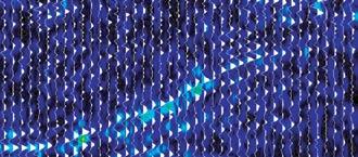
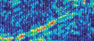
Using SpecMAN TM for detection/location of reservoirs; thicker portions of reservoirs tune in at lower frequencies and thinner portions at higher frequencies
AAPG
Abu Dhabi Oil Co., Ltd. (Japan)
Advanced Geotechnology Inc.
Aegis Group Inc.
AEUB
AGAT Laboratories
Air North
AJM Petroleum Consultants
Alberta Energy and Utilities Board
Alberta Geological Survey
Alberta Research Council
Anadarko Canada Corporation
Antrim Energy Inc.
Apache Canada Ltd.
APEGGA
Apoterra Seismic Processing Ltd.
Aramco Services Company
ARC Financial Corporation
Archean Energy Ltd.
Arcis
Atwell International Consultants
Aurora Geosciences Ltd.
Avenida Art Gallery
Ayrton Exploration Consulting Ltd.
Baker Atlas
Baker Hughes Canada Company
Beicip Inc.
Belfield Resources Inc.
Bell Geospace Inc.
Belloy Petroleum Consulting Ltd.
Birch Mountain Resources Ltd.
Black Knight
Blue Castle Corporation
Bodycote Norwest
Bootleg Gap Golf
Boyd PetroSearch
BP Canada Energy Company
Burgess Shale Geoscience Foundation
Calgary Marriott Hotel
Calgary Rock and Materials Services Inc.
Calgary Science Centre
Calgary Scientific Inc.
Canada Fossils
Canadian Centre for Energy Information
Canadian Discovery Ltd.
Canadian Forest Oil Ltd.
Canadian Hydrodynamics Ltd.
Canadian Natural Resources Limited
Canadian Stratigraphic Services (2000) Ltd.
CAPL
Carbon Copy
CBM Solutions
CGG Canada Services Ltd.
Chinook Consulting Services
CHOA
Cire Resources Ltd.
Complete Land Services Ltd.
Compton Petroleum Corporation
Conference Board of Canada
ConocoPhillips Canada Resources Limited
Conroy Ross Partners Limited
Continental Imaging Products
Continental Laboratories (1985) Ltd.
Continental Rocktell Services
Cora Lynn Drilling
Core Laboratories Canada Ltd.
Corion Diamond Products Ltd.
CPGO
Crackers Promotional Products
Crescent Spur Heli-Skiing
CSEG
CSUG
CWLS
Dalhousie University
Datalog Technology Inc.
Datamaxx Oilfield Corporation
Deadeye Engineering Inc.
DeGolyer and MacNaughton Canada Limited
Devon Canada Corporation
Digital Formation, Inc.
Divestco Inc.
Dominion Exploration Canada Ltd.
Doug Cant Geological Consulting
Dravis Geological Services
Duvernay Oil Corporation
Dynamic Oil & Gas
Geo-Logic Systems, LLC
Geological Survey of Canada
Geology Ring
Geo-Microbial Technologies/PK Services
Geomodeling Technology Corp.
Geophysical Service Incorporated
geoPLUS Corporation
GeoStrata Resources Inc.
GeoTomo
GeoVision Consulting Ltd.
Geo-X System Ltd.
Gibson Energy Ltd.
GLJ Petroleum Consultants Ltd.
Global Energy Services
Glyde Resources Ltd.
Gord’s Running Store
Government of Nunavut
GR Petrology Consultants Inc.
Graham Davies Geological Consultants Ltd.
Green’s Rock and Lapidary Ltd.
Greystone Resources Ltd.
ThankThe
Canadian Society of Petroleum Geologists with the CSPG in recognizing and thanking support of advancing the science of petroleum
Earth Decision Sciences Canada Ltd.
Earth Signal Processing Ltd.
Edge Technologies Inc.
EnCana Corporation
Engineering Seismology Group Inc.
EOG Resources Canada Inc.
Esprit Exploration Ltd.
Fekete Associates Inc.
Fernie Golf & Country Club
FirstEnergy Capital Corp.
Flagship Energy Inc.
fma insurance
Fugro Airborne Surveys
Galleon Energy Inc.
GEDCO
Genesis Corporate Search Ltd.
Genetek Earth Research Corporation
GeoAnalytic Inc.
GeoGraphix
Geo-Help Inc.
Geologic Rentals and Services
geoLOGIC systems ltd.
Halliburton
Hayden Geological Consultants
Hayden Resources Ltd.
Hef Petrophysical Consulting
Highwire Press & GeoScienceWorld.org
HiSPEC Research Corp.
Hugh W. Reid & Associates Ltd.
Hunt Oil Company of Canada Inc.
Husky Energy Inc.
Hycal Energy Research Laboratories Ltd.
Hydrocarbon Data Systems, Inc.
Hydro-Fax Resources Ltd.
IHS
Image Interpretation Technologies Inc.
Impact Energy Inc.
Imperial Oil Resources Limited
Indel-Davis Inc.
Input/Output Inc.
Intercontinental Seismic
International Techtonics Consultants
Ireland’s Field Scouting Services (1981) Ltd.
JEBCO Seismic (Canada) Company
Jennifer Wells & Associates Ltd.
Justcroft International Ltd.
Keitech Seismic Processing
Kelman Seismic Processing
Kelman Technologies Inc.
Kenn Borek Air Ltd.
Kestrel Data Ltd.
Key Safety Services Inc.
Key Seismic Solutions Ltd.
Kiva Promotions
Kodiak Nav Solutions
Komarevich Originals Ltd.
Lane’s Studio
Lario Oil & Gas Company
LiDAR Services International Inc.
Little Rock Document Services Ltd.
macdonaldcole inc.
Mancal Energy Inc.
Matrix Geoservices Ltd.
McLeay Geological Consultants
MD TOTCO NOV
Open Spirit Corporation
Opus Petroleum Engineering Ltd.
OYO Geo Space Canada, Inc.
Pajak Engineering Ltd.
PANASAS
Paradigm Geophysical Canada Ltd.
Paramount Resources Ltd.
Park Place Lodge, Fernie, BC
Pason Energy Systems
Penn West Energy Trust
Petrel Robertson Consulting Ltd.
Petro Logic Services
Petro-Canada Oil & Gas
Petrocraft Products Ltd.
Petrosys Canada Inc.
PGS Geophysical
PhotoSat Information Ltd.
Polaris Explorer Ltd.
PrimeWest Energy Inc.
Pro Geo Consultants
Pulse Data Inc.
Geologists highly values their corporate partners. Please join thanking the following corporations and organizations for their petroleum geology through CSPG programs and services.
Mitcham Canada Ltd.
MJ Systems
Mount Royal College
Murphy Oil Company Ltd.
Mustagh Resources Ltd.
MYSTIQUE ENERGY, INC.
Natural Rocknobs
Nautilus Limited
Neo Exploration Ltd.
Neuralog, Inc.
Nexen Inc.
Nikon Canada Inc.
North Dakota Geological Survey
North Rim Exploration Ltd.
Northrock Resources Ltd.
Northstar Drillstem Testers Inc.
NWT Geoscience Office
Oce Canada Inc.
Ogilvie Printing Ltd.
Oh Canada Restaurant & Bar
Olympic Exploration & Production Co.
Olympic Seismic Ltd.
Q’max Solutions Inc.
Quality Microscopes
R.J. Derkitt & Associates Inc.
Rakhit Petroleum Consulting Ltd.
RECON Petrotechnologies Ltd.
Red Brick Consulting Ltd.
Regent Resources Ltd.
Reinson Consultants Ltd.
Response Seismic Surveys Ltd.
RGS Consultants Ltd.
RigSkills Canada
Rimrock Resort Hotel
River Spirit Golf Club
Roxar
RPS Energy
Running Horse Resources Inc.
S.A.I.T.
Samson Canada Ltd.
Saskatchewan Industry and Resources
Schlumberger
Scioptic Canada
Scope Wellsite Security Ltd.
Scott Land & Lease Ltd.
Seismic Micro-Technology
Seismic Processing Ltd.
Sensor Geophysical Ltd.
Sercel, Inc.
Serpa Petroleum Consulting Ltd.
Shell Canada Ltd.
Sherwin Geological Consulting Ltd.
SIGMA Explorations Inc.
Signal Geophysical Consulting
Simmon Exploration Consultants
Sound Relaxation
Spirit Energy Inc.
Spitfire Energy
Sproule Associates Limited
Stoakes Consulting Group Ltd.
Straterra Inc.
Subsurface Consulting Canada
Sun Microsystems, Inc.
Suncor Energy Inc.
Sundog Printing
Sunterra Market
System Development, Inc.
Talisman Energy Inc.
Technology Tax Credits
TELUS Convention Centre
Terra Management
TERRAPLUS Inc.
The Phoenix Group
Tigh-Na-Mara Seaside Spa Resort & Conference Centre
TOR GEOscience Corp
Total E&P Canada Limited
TOTAL Gas Detection Ltd.
Trango Technologies Inc.
Trident Exploration Corp.
TRIVISION Geosystems Ltd.
Tucker Wireline Services
United Oil & Gas Consulting Ltd.
University of Calgary
University of Tulsa
Varco Canada
Varidata Surveys Ltd.
Vault Energy Trust
Veritas
VIBTECH
W.L. Gore & Associates Inc.
Weatherford Canada
WellDog, Inc.
WellSight Systems Inc.
Wellsite Gas Detection Inc.
Western Diazo
Western Explosives
Westmark Whitehorse Hotel & Conference Centre
Wild Horse Entertainment Inc.
Wildcat Scouting Services
Xperience Media
YMCA
Yukon Tourism
ZEH Software, Inc.
Zokero Inc.
The origin, prediction, and impact of oil viscosity heterogeneity on the production characteristics of tar sand and heavy oil reservoirs
SPEAKER
Dr. Haiping Huang, Jennifer Adams, Barry Bennett, Steve Larter
Petroleum Reservoir Group, Alberta Ingenuity Center for In-Situ Energy, university of Calgary.
12:00 noon
thursday, march 15, 2007
conocoPhillips auditorium
3rd Floor (above +15 l evel)
401 – 9th avenue sW calgary, alberta
The defining characteristic of heavy and super heavy oilfields is the large spatial variation in fluid properties, such as oil viscosity, commonly seen within the reservoirs. Traditional heavy oil and tar sand exploration and production strategies rely significantly on characterization of key reservoir heterogeneities and assessments of fluid saturations. While it is important to understand these reservoir variations,

variations in fluid properties can often dominate production behavior but are usually ignored.
Heavy oil and tar sands are formed by microbial degradation of conventional crude oils over geological timescales. Constraints such as charge mixing, biodegradation rate and water and nutrient supply to the organisms ultimately dictate the final distribution of API gravity and viscosity found in heavy oil fields. Large-scale lateral and smallscale vertical variations in fluid properties due to interaction of biodegradation and charge mixing are common, with up to orders of magnitude variation in viscosity over the thickness of a reservoir. These variations are often predictable and can be input into reservoir simulation models in a manner similar to specifying geological heterogeneity. In this work, we describe and illustrate quantitative geological controls on fluid property variations in heavy oil reservoirs.

“I trust GEDCO’s work because its consultants are geophysically honest.”
-
Devon Geologist
HRAM DATA & BROKERAGE
» High Resolution AeroMagnetic (HRAM) data over much of the WCSB
» Customized data areas
» Merged and re -leveled surveys to minimize seams
INTERPRETATION SERVICES
» Customized interpretations adding scope and depth to assessments
» Arsenal of cutting- edge tools such as GEDCO’s unique MaFIC Cube technology
» Comprehensive project management from concept through design and to interpretation

Jenkins theatre
mount royal college 4825 mount royal g ate sW calgary, alberta
The event includes lectures and poster displays (Saturday, March 17th, 9:15 am to 5:00 pm only ) and both children’s (Saturday) and adult’s Workshops (Sunday). All lectures will be held in Jenkins Theatre (Mount Royal College). Posters will be on the lower level, in the Main Hall outside of Jenkins Theatre. A fossil identification booth, video and fossil displays will also be present on Saturday. Attendance to this portion of the symposium is free, open to the general public and does not require registration. Workshops, however are limited space and do require registration, see below.
Alberta Palaeontological Society, Canadian Society of Petroleum Geologists (Paleontology Division), and Mount Royal College Department of Earth Sciences jointly sponsor the symposium.
L ECTURE SCHEDULE FOR
S ATURDAy M ARCH 17, 2007
9:15 am
Introduction – APS president Dan Quinsey
9:30 am
Pectinates: Multibranched Rangeomorphs from the Ediacaran of Newfoundland
Emily Bamforth and Guy Narbonne, Queen’s university
10:00 am
Burgess bugs, brines, and mines a new paradigm for some old rocks
Dr. Paul Johnson and Kimberley Johnson (MRC)
11:00 am Coffee Break
11:15 am
Scow Expedition Re-enactment , Darren Tanke, Royal Tyrrell Museum
11:45 am
Spiny Trilobites Through Time
Dr. Brian Chatterton, u. of Alberta
12:15 pm
Lunch Break and Poster Displays
2:00 pm
Subfossil Wolves of Little Fish Lake, AB Patty Ralrick, u. of Calgary
2:30 pm
Life at a 4 Million-Year-Old Beaver Pond in High Arctic Canada , C.R. Harington, Canadian Museum of Man and Nature
3:30 pm Coffee Break
3:45 pm
Canada’s Fossil Heritage Godfrey Nowlan, Geological Survey of Canada
5 pm Finish
S ATURDAy, M ARCH 17 TH, 2007
All four workshops will be held in room B108 at Mount Royal College.
Children’s Workshop #1 10:00 a.m. – 11:00 a.m.
How to be a Fossil Detective: Presented by: Dan Quinsey, President, Alberta Palaeontological Society Cost $10
Children’s Workshop #2 12:00 noon – 4:00 p.m.
Make-a-saurus Modelling Workshop, Build your own dinosaur sculpture: Instructor: Brian Cooley Cost $20
SUNDAy, M ARCH 18 TH, 2007
Workshop #3
9:00 a.m. – 12:00 p.m.
Trilobites:
Instructor Dr. Brian Chatteron, u of A, Cost $15
Workshop #4 1:00 p.m. – 4:00 p.m.
Brachiopods:
Instructor: Wayne Haglund Mount Royal College Cost $15
The Sunday workshops will exhibit specimens and presenters will discuss how to identify various species and skeletal parts. Attendees are welcome to bring in specimens for identification. No previous experience required. There are limited seats for each workshop. The registration deadline is March 7, 2007. To sign up contact Vaclav Marsovsky at (403) 547-0182 or vaclav@telusplanet.net. A nominal fee will be charged for each workshop to cover materials and preparation costs. Cheques should be made payable to Alberta Palaeontological Society. Payment may be handed to Vaclav or mailed to the APS mailing address, PO Box 35111, Sarcee Postal Outlet, Calgary, AB, Canada T3E 7C7
For information or to present a talk in the future please contact CSPG Paleo Divison Head Philip Benham at 403-691-3343 or programs@albertapaleo. org. visit the APS website for confirmation of event times and upcoming speakers: http://www.albertapaleo.org/
Now available for import into ACCUMAP, GEOSCOUT and other applications:
1) Mississippian Subcrops and Devonian Reef Edges - AB, NE BC, NT and SK
2) Triassic Halfway, Doig, Charlie Lake - Peace River Arch, Alberta, NE BC
3) Rock Creek Subcrop Edge - Alberta
4) Glauconitic Channel Trends - AB and SK
5) Colony/Sparky/Lloydminster Reservoir Trends - East-central AB
6) Bluesky-Dunlevy Reservoir Trends - NE BC
7) Viking Fm. - Alberta
8) CBM - Horseshoe Canyon, Mannville
All edges are formatted as map features for use in Accumap and ESRI Shape files for other programs.
For more information contact: Mike Sherwin 403-263-0594
email: mike@sherwingeological.com www.sherwingeological.com
SPEAKER
Weishan Ren
ConocoPhillips Canada
12:00 noon
Wednesday, march 21, 2007 conocoPhillips auditorium
3rd Floor- above Plus 15+ level 401 9th avenue sW calgary, alberta
The McMurray Formation consists of heterogeneous Cretaceous bitumensaturated sands. The reservoirs are thick and laterally extensive in the main fairways. Many commercial projects are in the early stages of development. Resources too deep to mine are considering Steam Assisted Gravity Drainage (SAGD). Detailed high resolution 3D geostatistical modeling is useful for individual well pair or pad flow simulation, but is neither practical nor necessary for resource assessment over large areas.
This talk presents a practical and tested methodology and case history for resource assessment of the Surmont Lease. The uncertainty in over 30 correlated variables is calculated on a dense 2D grid using all available information including wells, seismic and geologic trends. Seismic-derived structural surfaces are used as secondary information. Many different maps were created to reveal different aspects of the reservoir properties and their uncertainty. Trend maps and prior maps can be used to understand the variability of the reservoir parameter independent of any secondary information. The likelihood maps can be used to show the information from the secondary data. The updated maps contain the information from the well data as well as from the secondary data. The local uncertainty is accessed by the 2D models, and the P10, P50, and P90 maps provide heterogeneity and uncertainty information
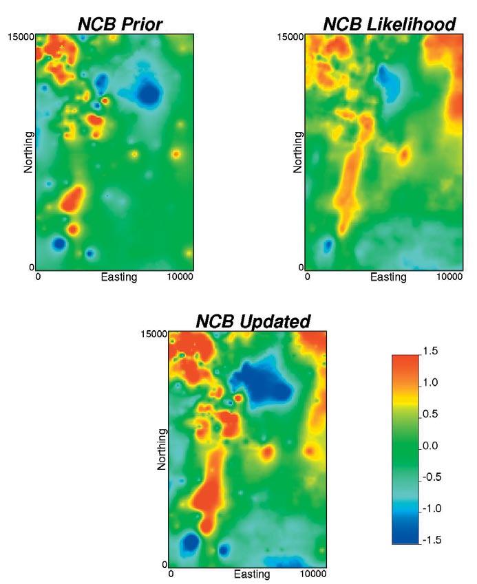
on the bitumen reservoir properties. The local distributions of uncertainty have been checked with cross validation and with more than 100 new wells drilled during the last two drilling seasons.
Resource uncertainty over the entire lease area and a number of arbitrary development areas is derived from the 2D maps of uncertainty. A combined P-field / Lu simulation approach is used to account for both multivariate and spatial correlations; different net continuous bitumen cutoffs and thief zone are also taking into account. The global uncertainty is consistent with the local uncertainty. This is a presentation of SPE paper #102094 from the SPE ATCE in September, 2006.
BIOGRAPH y
Weishan Ren is a geostatistician who currently works on Surmont Oil Sands for ConocoPhillips
Canada. Previously, he worked on several Surmont projects as a researcher in the Centre for Computational Geostatistics (CCG) of University of Alberta for three years, and worked as a reservoir engineer for Shengli Oilfield Inc. of SINOPEC, China for five years. He holds a B.Sc. degree in petroleum geological exploration from Southwest Petroleum Institute of China, a M.Sc. degree in petroleum engineering from University of Alberta, and expects to complete a Ph.D. degree in petroleum engineering concentrating on geostatistical reservoir modeling this year.
There is no charge. Non-members of the CSPG are also welcome. Please bring your lunch. For details or to present a talk in the future, please contact David Garner at 403-234-5875, e-mail: DavidGarner@Chevron. com or Rob Chelak at 403-290-0551, email: Robert.Chelak@Roxar.com.


You are invited to submit an abstract for Poster Presentations at the 2007 CSPG Gussow Geoscience Conference on Arctic Energy Exploration, to be held October 15-17, 2007 at The Banff Centre.
Poster presentations will be an important part of the two-day Technical Program. Posters will be the medium of choice to present new geological models, play concepts, specific case histories or regional correlations and will complement a limited number of invited lectures. These lectures will cover a wide spectrum of topics, including the vast hydrocarbon resources of the Mackenzie Delta an d the Sverdrup Basin as well as promising prospects such as those of the Arctic continental shelves or Hudson Bay and Foxe basins. Methane hydrates and other unconventional resources will also be examined, as well as the wealth of possibilities in Alaska and Greenland.
In addition, a number of presentations about some of the rapidly evolving issues that will affect Northern oil and gas development will complement the geoscientific part of the program. Attendees will hear the latest views regarding Canadian and Alaskan pipeline development, the current regulator y maze, Aboriginal issues, environmental/climatic change and ramifications with respect to Arctic sovereignty.
To submit an abstract by the deadline of June 30, 2007 please visit the Conference website at www.cspg.org
Benoit Beauchamp & Gerr y Reinson, Chairs
A message from the Membership Chair, Ayaz Gulamhussein

All too often, we forget to look back at the visions and goals we originally set out to achieve. In an effort to gauge the progress of the Membership Committee – I dug through the stack of ‘Reservoirs’ on my coffee table, and revisited the original blueprint.
In my July 2006 article, “Strategies for Increasing CSPG Membership,” I outlined a membership development plan focusing on the “4 R’s.” The 4 R’s which were defined as retention, renewal, recovery, and recruitment. The Membership Committee has worked on each of these “R’s,” and the results have been very encouraging.
Excerpts from the original article are in italics.
“…renewal refers to keeping members after their subscription has expired. Continually adding new programs and new member advantages will allow us to encourage renewal since the last time the individual subscribed.”
Renewal reminders for 2007 were sent out on October 20th, 2006. As of submission date for this article (January 23rd, 2007), 90% of 2006 members had renewed their memberships. This renewal rate outpaces previous renewal rates (at this time) by approximately 20%. Renewal forms are still coming in every week, and the Membership Committee expects a spike in renewals prior to Convention registration.
CSPG membership already offers a wide array of advantages, and we are working towards adding even more.
Membership benefits are frequently updated online, so we encourage you to check back often! http://www.cspg.org/members/ members-benefits.cfm
“There are numerous issues that may cause a person to give up their societal membership. Rather than speculate on what these issues might be, it is important that we contact past members and ask them directly. After understanding the issues that have contributed to their displeasure, it is up to the Society to address their concerns in hopes of attracting them back.”
With the assistance of Sarah Barton and Leah Barnett, the Membership Committee has been contacting lapsed members by email and telephone. Many of the previously expired members have decided to rejoin the Society. Those who have decided against rejoining have provided us with invaluable feedback, with which we intend to improve the Society.
“…the CSPG will have no problems retaining members if it remains well organized, financially stable, and most importantly, displays a sense of direction and purpose. It is also critical that the CSPG membership consider the input of members in Society decisions and provide recognition for members’ efforts.”
The traits that are characteristic of a strong organization are all displayed by the CSPG Leadership. Current membership has shown great support for the vision we are trying to achieve. The Membership team is hoping to actively facilitate communication between the general Membership and various other committees. New efforts such as online surveys and table drops at luncheons, will give us the feedback required to achieve societal needs.
“If there is a secret to membership recruitment, it is to be methodical. Clearly defining what membership means, and what the community represents are critical to attracting new members. A potential member is not just ‘anyone,’ but rather a person that fits into a set of clearly defined interests.”
Of the 4 R’s, this is the one that has received the least attention. In an effort to keep our membership base strong, we have not been able to dedicate our full efforts to recruitment. With the renewal period coming to a close, we will be spending more time actively implementing our plan to attract new individuals.
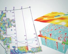
| by Ben McKenzie
This is the first of a series of articles discussing oil and gas resource assessment and the use of GIS.
All modern economies are dependent on oil and gas to varying degrees. Alternative energy sources – such as wind, solar, geothermal, nuclear, tidal, etc. – are available and used in numerous places for a variety of applications. However, they all have limitations that restrict their use in some way, e.g., toxic wastes from nuclear plants, corrosive waters from geothermal wells, or dependence on weather for wind and solar power. Additionally, the main use of these alternative sources is in the generation of electricity, which requires a massive infrastructure to be in place for the energy to be of use (Seel 2004). Major industries such as transportation, agriculture, forestry, construction, etc. are unable to take full advantage of this energy source because they typically are not
connected to that infrastructure. In addition, the cost of implementing alternative energy sources is typically more expensive than that of conventional, non-renewable (i.e., oil and gas) sources. This is of particular concern in developing countries that lack conventional energy resources but whose economies are not robust enough to take advantage of higher-priced, alternative energy technologies.
There is no doubt that the technical limitations restricting use of alternative energy sources will be overcome. However, even if there was a major technological revolution and cheap, clean, renewable energy became available tomorrow, it would be decades before the majority of the world could take advantage of it. This is a reflection not only of the massive task of implementing a new technology, but also of the immense cost associated with switching over existing systems (e.g., consider the number and variety of internal combustion engines in use). At this time,
there is no alternative energy source that can provide the overall reliability, portability, or efficiency of that provided by oil and gas.
In addition to these obvious technological and economic problems, there are more subtle issues to consider. Oil and gas exploration and production companies are frequently depicted as being the main force behind restricted supply and high energy prices. This is inaccurate for a number of reasons. First of all, over 70% (Caffentzis 2004) of the world’s oil and gas is controlled by government-run organizations. This means that supply and price issues are being affected by national policies. As well, both the government and private oil and gas companies are affected by energy supply and price in their daily activities. They have to buy fuel to run their equipment and pay for electricity just like the general public. Then there is the limiting economic point at which alternative energy sources can substitute for oil and gas. This prevents the petroleum-

producing companies from having an energy monopoly. For example, if the price of natural gas goes too high, utility companies (which are a major consumer) will switch to coal or low-quality (i.e., cheaper) oil to power their generators. Likewise, high prices encourage use of alternative energy sources such as hydroelectric and wind turbines.
Also, the petroleum producers are only the first link in the energy supply chain; after them come the transporters, the refiners, the distributors, and the retailers – each with a reasonable expectation of earning a profit for their work, which cumulatively sets the end price. But most importantly, the oil and gas companies constitute only a small portion of the people that have a vested interest in a healthy petroleum industry. According to Export Development Canada spokesman, Stephen Poloz, “…a lot of the increased revenues being garnered by oil companies are being ploughed back into investment programs to boost capacity. This is creating employment booms in energy-rich provinces, especially Alberta, and these income streams inevitably flow into most other sectors of the economy, too.” (Beauchesne 2006)
To find and produce hydrocarbons requires the efforts of literally hundreds of thousands of people. These include such diverse groups as seismic companies, surveyors, and drilling companies, as well as the less obvious contributions from steel manufacturers, chemical producers, caterers that supply food to remote drill sites, etc. Even less obvious, but just as important, are the pension funds and members of the public that provide the capital through their stock investments in these companies, with the expectation of earning a positive return on their investments. And, at each step of the way, there are the various levels of government that also benefit from the demand for oil and gas. Taxes and royalties derived from these commodities further expand the petroleum industry’s sphere of influence as the money is used to pay for improved infrastructure and social programs to the benefit of the general public. Consider the (currently) robust economy of Alberta and the transfer payments from it to the rest of Canada, all due largely to the petroleum industry.
It is important to remember that energy resources are, at the base level, a commodity. As such, they are heavily influenced by supply and demand cycles – when an economy is expanding, the demand grows, resulting in tight supply and increasing prices. This situation gives rise to ‘boom and bust’ cycles where prices will increase as long as
the demand increases. Once the demand slackens, the prices will fall, reflecting the increased supply capacity. These ‘boom and bust’ cycles in the oil and gas industry also affect other sectors. Kevin Seel discussed similar effects of tight supply conditions and high energy prices on the Alberta electrical industry in his 2004 Ph.D. thesis (Seel 2004). In it, he describes how electricity supply may be limited by infrastructure (i.e., power plants), which would lead to rising energy prices. The resulting ‘boom’ in the construction of power plants would lead to a subsequent ‘bust’ in energy prices once the new capacity came online. The cost associated with building the new plants influences not only where and when they are built but also what type is built (e.g., coalfired, hydro, gas). Seel projected that gasfired generation in Alberta would increase from 23% of total capacity in 1997 to over 42% by 2006. Likewise, it was projected that Canadian natural gas consumption for electrical generation would increase from 200 trillion Btu in year 2000 to 1,300 trillion Btu by 2020. Natural gas availability and the electricity markets will thus become increasingly interdependent upon one another. Exactly the same situation occurs in petroleum exploration – increasing prices
lead to increased exploration efforts, which result in new discoveries of oil and gas. Once these new discoveries are developed, prices decline due to the increased supply availability. Decreased prices make it uneconomical to explore for new reserves and the petroleum industry contracts until such time that demand once again outpaces supply.
Accurately determining where these natural resources exist and in what quantities is a major concern to the industrialized countries of the world as well as the developing nations that seek to improve their standard of living. Governments use this information in strategic planning and formulating domestic land use, energy, and economic policies. Financial institutions and large corporations use it for long-term planning and in making decisions concerning investment options (Lore, Marin et al. 2001). This information impacts the day-to-day operation of businesses in such ways as cost of materials (e.g., plastics), cost of production (e.g., electricity generation from natural gas), and cost of delivery of services (e.g., fuel cost). Regional development depends on whether there will be sufficient energy resources to fuel growth. (Continued on page 30...)

(...Continued from page 29)
On a national scale, the quest for energy (i.e., oil and gas) supply security drives many international alliances and events.
In countries such as Canada, policy-makers look to the technical sector of the petroleum industry for answers to the questions of: “What is the size of our potential resource base?”, “Where will it most likely occur?”, and “What obstacles stand in the way of its development?”. In the early days of the industry, these questions were answered by laboriously mapping the geology on handdrawn maps and by tracking production data with simple spreadsheets. The accuracy of such methods was good enough when hydrocarbon demand was far outweighed by the known supply. With continual growth in demand and with the easily obtained supplies having been used up, more accurate methods of resource assessment must be developed.
In the latter half of the twentieth century, statistical analysis used in resource assessment received a major boost with the growth of computer technology. While the numerical data could be manipulated much more easily than before, spatial (geographical) analysis still lagged behind. To further increase the accuracy of resource assessments, it will be necessary to expand the use of spatial data analysis in the process.
To be continued...
R EFERENCES:
Beauchesne, E. (2006). Oil Benefits all of Canada: study. Calgary Herald, August 4, 2006. Calgary, Alberta: p. E5.
Caffentzis, G. (2004). Who Owns the World’s Oil, http://www.energybulletin.net.3756.html. accessed August 27, 2006.
Lore, G. L., D. A. Marin, et al. (2001). 2000 Assessment of Conventionally Recoverable Hydrocarbon Resources of the Gulf of Mexico and Atlantic Outer Continental Shelf as of January 1, 1999. New Orleans, Minerals Management Service: p.15-25.
McKenzie, B. J. (2006). Enhancing Oil and Gas Resource Assessment Through the Use of Geographic Information Systems. Department of Geography. Calgary, University of Calgary: 208 p.
Seel, K. C. (2004). “Boom and bust” cycles in power plant construction: a simulation study of the temporal and geographical aspects of the Alberta competitive electrical industry. Department of Geography. Calgary, University of Calgary: 345 p.

|
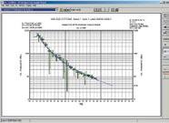
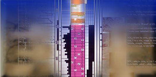
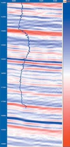
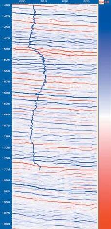
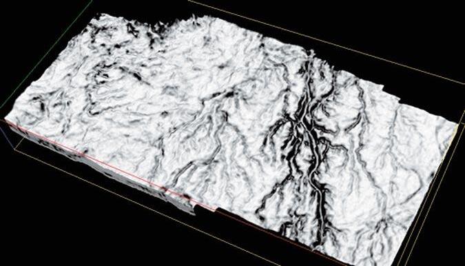
by Canadian Discovery Ltd.
Operator of
Note: Magnus Energy
Play: upper Devonian Light Oil
This article is reprinted with permission from Canadian Discovery’s current exploration overview (CEO) map series (Q3 2006).
C URRENT ACTIVIT y
Brokers purchased four parcels of land in the Ryerson area of southeastern Saskatchewan at the April 11, 2006 land sale (Figure 1). Prices ranged from $1,299 to $3,223 per hectare. Additional parcels fetched prices of $935 and $2,517 at the August 15 landsale. These parcels surround
a cluster of seven wells drilled at 50% working interest by Magnus Energy in a joint venture with WaveForm Energy. Magnus is the operator on the project and announced the wells as a discovery on April 19, 2006. The wells produce 38.4°API oil from the u pper Devonian Torquay Formation. This dolomite reservoir lies between 1,050 and 1,150m in depth with pay ranging from two to five metres in thickness. Magnus interprets this discovery as extending the large regional stratigraphic trap from the nearby Sinclair Field in Manitoba. Magnus has acquired over 18,600 ha in the area, possibly including land from this most recent land sale. As of June 27, 2006, Magnus had drilled 17 wells in the
Ryerson/Antler area, all of which were successfully completed in the Torquay. The two best wells were producing at 43 bopd and 20 bopd according to the most recent information. Magnus estimates that production from this area will be at 900 boe/d gross (450 boe/d net) by the end of 2006. The company states that it has an inventory of over 300 drilling locations in the Torquay play.
There are a number of other companies pursuing Torquay or Mississippian Bakken plays in southeastern Saskatchewan/ southwestern Manitoba including Tundra Oil and Gas, Mission Oil & Gas, and Rideau
(Continued on page 33...)
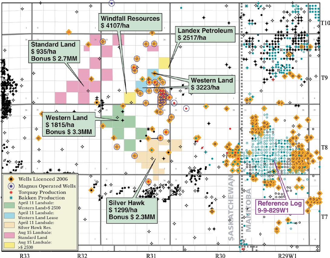
PRACTICAL DST CHART INTERPRETATION (Thorough Basic Course) Apr. 16-20, 2007
16 WAYS TO IDENTIFY BYPASSED PAY FROM DST DATA
(More advanced, for those “comfortable” with DST charts) Apr. 26-27, 2007
HYDRODYNAMICS SEMINAR (Oil & Gas Finding Aspects) May 7-11, 2007
In-house courses available. For course outline visit: www.hughwreid.com 262-1261
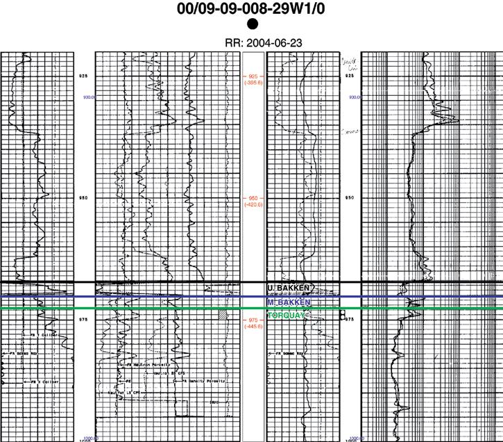


Petroleums. The closest Torquay production (Figure 2, opposite) is from the Sinclair Field just over the border in Manitoba (T8, R29W1). Tundra is the primary operator in the field, with the discovery well drilled in 2003. Cumulative production to date is over 1,000,000 barrels, mostly from the Torquay commingled with some Bakken production. The South Ebor area of the Daly Field (T9, R29W1), also in Manitoba, has some Torquay production as well. Although Tundra is the dominant player, Rideau Petroleums, Kiwi Resources, and Grand Banks Energy are also working in the area.
The Torquay Formation of the u pper Devonian Three Forks group is a shallow water dolostone that has been brecciated. Throughout most of southeastern Saskatchewan and southwestern Manitoba it is conformably overlain by the Bakken Formation. The Bakken has three members; the u pper and Lower Bakken are shales, while the middle member is sandstone. However, where the Torquay is productive, the Lower Bakken shale has been eroded and there is an unconformity between the Torquay dolostone and the Middle Bakken sandstone, which can also be dolomitic. There is an onlapping relationship between the Bakken and the Torquay that is interpreted to indicate uplift of the Torquay prior to deposition of the Bakken. The resulting erosional thinning appears to have enhanced the reservoir characteristics of the Torquay. u p to nine metres of pay, extending from the unconformity down to an oxidized siltsone-mudstone, can be present in Torquay wells.
The u pper Devonian to Lower Mississippian Bakken Formation is speculated to have generated up to 400-500 billion barrels of light (40° API), sweet oil in the Williston Basin. The u pper and Lower Bakken shales are the organic-rich source rocks responsible for the oil and the Middle Bakken sandstone is the host rock for much of the production in the area. Tight formations above and below the Bakken make it likely that most of the oil generated remains in a system extending from the top of the Three Forks to the base of the Lodgepole. The Middle Member Bakken sandstone is also relatively tight. Recently, operators working in Richland County, Montana have had great success using horizontal drilling and fracing to access oil reserves in the Middle Bakken. Companies in Saskatchewan and Manitoba are starting to use the same technology to increase production and access previously bypassed
pay. High resistivity anomalies in some Bakken shales could indicate oil saturation, opening up the possibility of an oil shale resource play in the future.
It is significant to note that Torquay production occurs when the Lower Bakken shale is absent, the Middle Member is thinner due to onlap and the brecciated Torquay is in direct communication with the oil-saturated sandstones of the Middle Bakken. Although horizontal drilling is common when targeting the Bakken, so far all wells drilled into the Torquay are vertical wells.
**For a more detailed review of Bakken exploration activity, see “Rising Activity by Juniors in Southern Saskatchewan and Manitoba” (Canadian Discovery Digest, Volume 3 2005) and “The Bakken at Antler and Sinclair” (Canadian Discovery Digest, Volume 5 2006). Visit www.canadiandiscovery. com or call 269-3644 for more information.

COMPLETED 1994 - 2004
COLD LAKE OIL SANDS
BALDONNEL - CHARLIE LAKE
MONTNEY (6 PHASES)
TURNER VALLEY
BANFF-PEKISKO
ALSO
WORSLEY COMPILATION
MONTNEY SPECIAL CORE ANALYSIS
MONTNEY CORE WORKSHOP
HTD SEMINAR, CORE WORKSHOP
DOLOMITE FIELD TRIPS
HTD MAP WCSB
NOTE: DEBOLT, BALDONNEL-PARDONET
PROJECTS IN NE BC DELETED
May 14 – 17, 2007
The 2007 Annual CSPG CSEG Convention is truly underway, with exciting new developments in Special Events and the Technical Sessions joining old favourites such
as the Core Meltdown. Watch out for the Final Circular being mailed to you shortly – this will contain everything you need to know about our first-class offering of
oral presentations, poster sessions, core presentations, field trips, and short courses, as well as the Convention schedule and information on registration!
Registration fees for this year’s Convention are as follows (Please note prices do not include GST):
Early Bird Registration Deadline: April 13, 2007 (cutoff time is 6:00pm MST)
Regular Registration Deadline: April 27, 2007 (cutoff time is 6:00pm MST)
Reception Tickets (additional tickets may be purchased for guests of convention delegates)
Avoid the Monday morning on-site registration rush….REGISTER EARLY!
On-line registration will be available through www.GEOconvention.org using vISA or Mastercard.
Please make cheques or money orders payable to 2007 CSPG CSEG Convention. Registrations forms with payments may be mailed or dropped off to:
Let it Flow: The Flow of Ideas, Hydrocarbons and Business c/o CSPG office #600, 640 8th Avenue SW Calgary, Alberta T2P 1G7
Fax: (403)264-5898
Registrations received after 6:00pm (MST) Friday April 27, 2007 will be held and processed on-site. On-site registration fees will be applied.
LUNCHEON SPEAKER
BIOGRAPH y
Sponsored by:
Rex Murphy was born and raised in St. John’s, Newfoundland, where he graduated from Memorial university. A Rhodes Scholar, he attended Oxford university (along with u.S. President Bill Clinton). When he returned to Newfoundland he was soon established as a quick-witted and accomplished writer, broadcaster, and teacher.
Murphy contributes extensively to CBC on many current affairs issues. For The National Magazine he created a number of documentaries from Newfoundland, including the highly acclaimed “ unpeopled Shores,” about the tragedy of the disappearing cod, and human interest pieces on writer Annie Proulx, World War II, and scientist Hubert Reeves.
He contributes a regular essay to The National Magazine, dealing with topics as diverse as the Royal Family, smoking, and Quebec politics and writes a weekly column for the Globe and Mail. Murphy is also the author of the book, Points of view, a collection of his best writing spanning 30 years. The selection includes an assortment of topics, from his hard-hitting political commentaries, book reviews, and hilarious satires, to warm memories of Newfoundland.

An award-winning broadcaster, Murphy is the regular host of CBC Radio’s Cross Country Checkup and commentator on the CBC Radio show Definitely Not the Opera. He has also contributed to Morningside, Land and Sea, The Journal, Midday, and Sunday Report.
His endearing style showcases a sarcastic intellect and deep insight into issues affecting all Canadian individuals and businesses. Graced with his own brand of persuasion, no one walks away not knowing exactly what Rex Murphy thinks.

Registration for the following Short Courses and Field Trips opens March 19, 2007 and is on a first come, first served basis – register early to ensure you don’t miss out! Further information on dates and fees may be found in the Final Circular and online at www.GEOconvention.org.
FTPRE01
Upper Cretaceous Shelf and Shoreface Sandstones: Montana
Outcrops and Alberta Basin Cores Leaders: Peter Putnam & Derald Smith
Maximum Attendance: 17 participant s
upper Cretaceous wave-impacted sandstones form important (historical and current) petroleum reservoirs in western Canada and Montana. Although sheet-like in gross geometry, sufficient heterogeneity exists in these deposits to influence exploration strategy, well operations, completions, and production practices. Excellent exposures of these units in north-central Montana provide useful analogues for those geoscientists exploring or exploiting these types of reservoirs anywhere in western Canada.
FTPRE02
Triassic Sedimentary Framework and Sequence Stratigraphy
Williston Lake, British Columbia Leader: John-Paul Zonneveld
Maximum Attendance: 14 participants
*Note: this course is also offered Post Convention*
The Williston Lake, British Columbia, field course centers around the sedimentologic and stratigraphic development of the Triassic succession in Western Canada. Excellent outcrop equivalents of all major producing subsurface units (Montney, Doig, Halfway, Charlie Lake, Baldonnel, and Pardonet) are observed and discussed. The first day of the field course is spent at the provincial core storage facility in Charlie Lake, British Columbia, to discuss basic controls on subsurface hydrocarbon reservoir nature and distribution, as well as similarities and differences between the outcrop and subsurface sections. The following three days are spent visiting Lower, Middle, and upper Triassic outcrop localities along the shores of Williston Lake.
FTPRE03
Geological Walking Tour
The Building Rocks of Calgary Leader: Bill Ayrton
Maximum Attendance: 30 participants
This interesting half-day tour examines the rocks, sedimentary features, and fossils beautifully displayed on the buildings of Calgary. We will also see the building rocks used by our landscapers and sculptors. The rocks range in age from PreCambrian to Tertiary, and come from as far away as Scandinavia and India; some were even quarried locally.
FTPST01
Triassic Sedimentary Framework and Sequence Stratigraphy
Williston Lake, British Columbia Leader: John-Paul Zonneveld
Maximum Attendance: 14 participants
*Note: this course is also offered Pre Convention*
The Williston Lake, British Columbia, field course centers around the sedimentologic and stratigraphic development of the Triassic succession in Western Canada. Excellent outcrop equivalents of all major producing subsurface units (Montney, Doig, Halfway, Charlie Lake, Baldonnel, and Pardonet) are observed and discussed. The first day of the field course is spent at the provincial core storage facility in Charlie Lake, British Columbia, to discuss basic controls on subsurface hydrocarbon reservoir nature and distribution, as well as similarities and differences between the outcrop and subsurface sections. The following three days are spent visiting Lower, Middle, and upper Triassic outcrop localities along the shores of Williston Lake.
FTPST02
Marginal Marine Depositional Environments of the BearpawHorseshoe Canyon Transition, Drumheller, Alberta
A Field Trip for Students Sponsored by Talisman Energy Leader: Jason Lavigne
Maximum Attendance: 40 participants
This one-day field trip will examine outcrops of the upper Cretaceous Bearpaw and Horseshoe Canyon formations east of Drumheller. The goals of the trip are to look at the sedimentology and trace fossil assemblages of marine, shoreline, and fluvial deposits, as well as the lateral and vertical succession of facies to better understand how to evaluate the significance of several stratigraphic surfaces. We will examine these aspects of the deposits in the context of the historical work that has been done in the area.
Savanna Creek, Alberta – A Fractured Carbonate Reservoir in a Complex Structural Setting Leader: Thomas Kubli
Maximum Attendance: 20 participants
This one-day field trip will take us to the Plateau Mountain area in the southern Alberta Foothills to give the participants an overview of the structure of the Savanna Creek gas field as well as the stratigraphy and sedimentology of the Mississippian reservoir rocks, and place them in a regional context. We will also have the opportunity to examine in detail the nature and distribution of fractures exposed at the surface, relate them to their position within the structure and compare with fracture distributions obtained from FMI data in both vertical and horizontal wells within the structure.
Major Dolostone Reservoir Types, Outcrops and Subsurface Analogues
Western Canada: Distinct Types or Continuum?
Leaders: Graham Davies & Jack Wendte
Maximum Attendance: 20 participants
This field seminar will compare the origin of dolomite and evolution of pore systems of two lithologically distinct types of dolostones in the Canadian Rocky Mountains. The first day of the seminar is in Calgary and consists of a half-day of lectures on these dolostones and their subsurface analogues, and a half-day core seminar focused on Devonian ‘Cairn’-style dolostones and origin of porosity in dolostones. The second day will be a field trip to view hydrothermal dolostones hosted in Cambrian exposures in southwestern Alberta and southeastern British Columbia.
Geology of the Athabasca Oil Sands
Leaders: Mike Ranger & Murray Gingras
Maximum Attendance: 20 participants
This three-day field excursion to the Fort McMurray area provides an excellent opportunity to observe the geology of the Athabasca Oil Sands, as well as the engineering and mining technology related to recovery of the bitumen. Numerous outcrops along the Athabasca, Christina, and Steepbank Rivers will be visited by high-speed jet boat and helicopter.
SCPRE01
Mathematical Approaches to Structural Analysis
Instructor: William Jamison
Maximum Attendance: 20 participants
This two-day lecture course will provide an introduction to the use of geometric, kinematic and mechanical analyses in structural geology interpretations. Topics included are dip-domain fold-and-fault interpretations from dip data, cross section balance evaluations, fault-displacement balancing, kinematic models of fold-thrust structures and listric normal faults, and the application of mechanical principals to the investigation of structures in strike-slip and transpressional systems and to fracture prediction.
Clastic Facies and Depositional Environments
Instructor: Bill Arnott
Maximum Attendance: 20 participants
This three-day core workshop discusses the most important variables that control the make-up of the sedimentary record – the primary depositional mechanisms that deposit sediment, the sedimentary structures formed by those mechanisms (and the ability to recognize and interpret them in core), and then integrate
all those observations and interpretations into meaningful stratigraphic models.
Emphasis is on the understanding of physical and biogenic structures in the interpretation of sedimentary depositional environments. Environments are then related in both time and space using sequence stratigraphic principles. Specific environments to be discussed include fluvial, shallow, and marginal marine.
SCPRE03
Stratigraphic Setting of Lower and Middle Triassic Strata, Western Canada Sedimentary Basin
Instructor: James Dixon
Maximum Attendance: 20 participants
*Note: this course is also offered Post Convention*
The intent of this half-day core course is to show that an understanding of the regional and local stratigraphy of the Lower to Middle Triassic Montney, Doig, and Halfway formations has considerable influence on exploration and production models.
Lithostratigraphic and sequence stratigraphic analysis of the Lower to Middle Triassic Montney, Doig and Halfway formations will be presented and discussed. Detailed correlations and their usefulness in understanding the stratigraphic and sedimentological setting of the various potential reservoirs are emphasized. Also, an appreciation of the stratigraphy helps to understand the relative timing of various tectonic movements that affected Triassic strata.
SCPRE04
Practical Sequence Stratigraphy: Concepts and Applications
Instructor: Ashton Embry
Maximum Attendance: 22 participants
This two-day lecture course presents the concepts and practical applications of sequence stratigraphy for petroleum exploration. The course will involve both lecture and workshop formats.
Following the course, participants will have a clear understanding of the principles of sequence stratigraphy. They will readily be able to recognize and use sequence stratigraphic surfaces as the main correlation lines on their cross sections and to use sequence stratigraphy for predicting facies types and geometries away from control points.
SCPRE05
Understanding Basinal Controls of Sequence Generation
Instructor: Andrew D. Miall
Maximum Attendance: 30 participants
Sequence-generating mechanisms range from local to global in scope, and operate over time spans of thousands of years to hundreds of millions of years. The sequence architecture in a given basin may reflect the action of several simultaneous processes interacting locally to globally over a wide range of time scales.
This two-day lecture course provides background knowledge of sequence-generating mechanisms and examines the range of processes that control vertical movement of the crust and eustatic changes in sea level. With examples from around the world, this course broadens the range of interpretive skills that can be brought to bear on practical mapping problems anywhere in the world.
SCPRE06
The Nature of Coal: Application and Interpretation of Coal Quality Parameters in CBM Prospecting
Instructors: David Marchioni and Judith Potter
Maximum Attendance: 20 participants
The goal of this one-day core course is to illustrate what can be inferred about CBM prospectivity/producibility from the visual analysis of core. This course is intended to provide geologists working in the field of CBM exploration with an appreciation of the heterogeneous nature of coals and basin wide variations in source/reservoir potential displayed by high and low rank coals. Emphasis will be on the interpretation of these macroscopic characteristics and on geological controls on coal quality relating to the peat-forming depositional environment, geologic setting and history, and the interpretation of analytical parameters in the context of prospecting for coal gas using examples from Canadian, u.S. and Australian basins.
SCPRE07
Exploration 101: Basic Geological and Seismic Principles in the Upstream Petroleum Industry
Instructor: A. Easton Wren Maximum Attendance: 50 participants
*Note: This course will be free of charge, with preference given to exhibitors and student volunteers*
This half-day course is designed for those persons in the service industry, as well as government, legal, and accounting professions, who interact with the oil industry but who do not have a technical background in geology or geophysics.
This is a brief, yet illuminating, introduction to exploration and will take the participant through the normal progression from the origins of oil and gas to geological concept to prospect definition to drilling the exploratory well using a combination of geological and seismic tools.
The course is non-mathematical in its treatment of the subject material and will explain much of the jargon that permeates the upstream business. The presentation format will include PowerPoint images and a handout reference booklet .
SCPST01
Shales: Seals, Leaks, and Reservoirs in Petroleum Systems
Instructors: Andrew Aplin and Steven Larter
Maximum Attendance: 30 participants
Shales and mudstones act as source rocks, seals, migration pathways, and - with increased interest in shale gasreservoirs. This two-day lecture course explores the world of shale, emphasizing those petrophysical and mechanical properties that control fluid trapping and fluid flow. We see how lithological and petrophysical properties of shales might be assessed through wireline analysis. We consider strategies to quantify overpressure, seal capacity and seal failure, and show how geochemical data can be used to indicate leakage. Finally, we examine how shale heterogeneity controls fluid flow on both geological and production timescales.
The Architecture of Fluvial Reservoirs
Instructor: Andrew D. Miall
Maximum Attendance: 30 participants
Significant volumes of oil and gas are stored in fluvial reservoirs and exploitation of many of these fields has provided a wide array of data and techniques for use in exploration and development. Considerable potential remains for additional discoveries in such areas as Andean South America, Australia (onshore and offshore), and Southeast Asia.
The focus of this two-day lecture course will be on the reservoir architecture and sequence stratigraphy of fluvial systems and will contain descriptions of fundamental basinal controls on fluvial systems. Information and ideas presented in the course will contribute to the development of fluvial sandstone production and exploration models. Participants are presented with numerous case studies and key concepts are illustrated with practical exercises.
Stratigraphic Setting of Lower and Middle Triassic Strata, Western Canada Sedimentary Basin
Instructor: James Dixon
Maximum Attendance: 20 participants
*Note: this course is also offered Pre Convention*
The intent of this half-day core course is to show that an understanding of the regional and local stratigraphy of the Lower to Middle Triassic Montney, Doig, and Halfway formations has considerable influence on exploration and production models.
Lithostratigraphic and sequence stratigraphic analysis of the Lower to Middle Triassic Montney, Doig, and Halfway formations will be presented and discussed. Detailed correlations and their usefulness in understanding the stratigraphic and sedimentologal setting of the various potential reservoirs are emphasized. Also, an appreciation of the stratigraphy helps to understand the relative timing of various tectonic movements that affected Triassic strata.
A variety of CSEG short courses will also be offered, please check www.geoconvention.org , www.cspg.org, or www.cseg.ca for more information
confining foredeep slopes and ultimately accumulating in sediment wedges up to 200-300 m thick. These overbank wedges are commonly incised by tributary channels oriented perpendicular to the axial channel belt. Local breaching of channel levees resulted in the deposition of sandy material in an overbank setting (akin to crevasse splay deposits).

Confinement of the depositional system within the narrow Molasse Basin foredeep had a profound effect on the distribution of sediment in the deep-water setting. Lateral migration of the axial channel belt was limited, and as a result, coarsegrained channel-belt material aggraded nearly vertically for approximately 8 m.y. (deposition of up to 1500 m of sediment). Widespread mudstone beds are often not preserved in the sequence as a result of erosion processes in the channel belt.
Consequently, stratigraphically trapped gas accumulations are difficult to predict due to amalgamation of reservoir bodies and variably eroded seal facies.
Most producing reservoirs in the basin are associated with a combination of both stratigraphic and structural trapping; historically, exploration success had been closely linked to the recognition of subtle structural highs in 2-D seismic data. With most of the structural highs already drilled, future discoveries are likely to be associated with stratigraphic traps. Depositional elements characterized by significant reservoirs include massive sandstone and conglomerate of channel thalweg affinity, with more modest reservoirs present in thin–bedded turbiditic overbank units dominated by Bouma sequences (crevasse splay lobes and tributary channels). Channel abandonment and migration are two processes known to result in a stratigraphic architecture conducive to reservoir development in the basin.
BIOGRAPH y
Stephen Hubbard received his B.Sc. and M.Sc. degrees in geology from the University of Alberta. His M.Sc. thesis focused on the sedimentology, ichnology, and petroleum geology of the Peace River Oil Sands deposit, and following completion of his thesis he joined Shell Canada where he worked as a development geologist on the deposit for two additional years. He completed his Ph.D. at Stanford University on the stratigraphic architecture of deep-water depositional systems in the subsurface (Austrian Molasse Basin) and in outcrop (Chilean Magallanes Basin). He recently joined the faculty in the Department of Geology and Geophysics at the University of Calgary in an assistant professor role. He teaches classes to undergraduate students enrolled in the new petroleum concentration program, and is working on research projects in the Western Canada Sedimentary Basin and abroad. He is a co-director of the Consortia for Applied Basin Studies (CABS), a new research group at the University of Calgary designed to work on international and national (WCSB and Arctic Canada) project-based studies in close collaboration with sponsoring oil and gas companies.
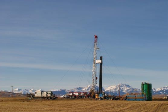

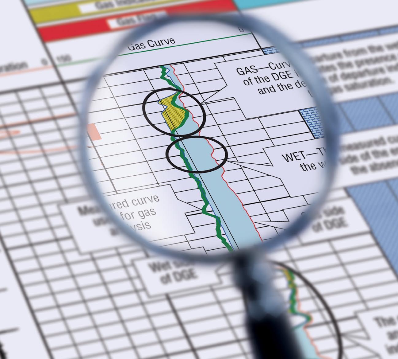
Now there is a better method for identifying gas and measuring gas saturation in cased holes. Baker Atlas is proud to introduce the GasViewSM service, a high-resolution measurementand analysis service that produces an exceptionally clear picture of reservoir gas.
Using Baker Atlas’ RPMSM pulsed neutron system, the GasView service can be used to measure reservoir gas in virtually any well. Applications range from identifying by-passed pay in wells nearing abandonment to openhole log replacement for new wells.
Contact your Baker Atlas representative today to learn how the GasView service can help you produce more gas with greater efficiency.