
18 2015 CSPG Geological Calendar Wrap-up 20 Go Take a Hike 24 Get More Data from Cuttings – Tools to Aid East Coast Exploration $10.00 NOVEMBER 2014 VOLUME 41, ISSUE 10 Canadian Publication Mail Contract – 40070050
CSPG OFFICE
#110, 333 – 5th Avenue SW Calgary, Alberta, Canada T2P 3B6
Tel: 403-264-5610
Web: www.cspg.org
Please visit our website for all tickets sales and event/course registrations Office hours: Monday to Friday, 8:00am to 4:30pm
The CSPG Office is Closed the 1st and 3rd Friday of every month.
OFFICE CONTACTS
Membership Inquiries
Tel: 403-264-5610 Email: membership@cspg.org
Technical/Educational Events: Biljana Popovic
Tel: 403-513-1225 Email: biljana.popovic@cspg.org
Advertising Inquiries: Emma MacPherson
Tel: 403-513-1230 Email: emma.macpherson@cspg.org
Sponsorship Opportunities: Candace Seepersad
Tel: 403-513-1227 Email: candace.seepersad@cspg.org
Conference Inquiries: Kelsey Thompson
Tel: 403-513-1233 Email: kelsey.thompson@cspg.org
CSPG Educational Trust Fund: Kasandra Amaro
Tel: 403-513-1234 Email: kasandra.amaro@cspg.org
Accounting Inquiries: Eric Tang
Tel: 403-513-1232 Email: eric.tang@cspg.org
Executive Director: Lis Bjeld
Tel: 403-513-1235, Email: lis.bjeld@cspg.org
EDITORS/AUTHORS
Please submit RESERVOIR articles to the CSPG office. Submission deadline is the 23rd day of the month, two months prior to issue date. (e.g., January 23 for the March issue).
To publish an article, the CSPG requires digital copies of the document. Text should be in Microsoft Word format and illustrations should be in TIFF format at 300 dpi., at final size.
Technical Editor
Hugh S. Mosher
Nunaga Resources Ltd.
M.: 403-809-9997
Email: hsmosher@telus.net
CSPG Coordinating Editor
Emma MacPherson, Communications Coordinator, CSPG Tel: 403-513-1230, emma.macpherson@cspg.org
The RESERVOIR is published 11 times per year by the Canadian Society of Petroleum Geologists. This includes a combined issue for the months of July and August. The purpose of the RESERVOIR is to publicize the Society’s many activities and to promote the geosciences. We look for both technical and non-technical material to publish. The contents of this publication may not be reproduced either in part or in full without the consent of the publisher. Additional copies of the RESERVOIR are available at the CSPG office. No official endorsement or sponsorship by the CSPG is implied for any advertisement, insert, or article that appears in the Reservoir unless otherwise noted. All submitted materials are reviewed by the editor. We reserve the right to edit all submissions, including letters to the Editor. Submissions must include your name, address, and membership number (if applicable). The material contained in this publication is intended for informational use only. While reasonable care has been taken, authors and the CSPG make no guarantees that any of the equations, schematics, or devices discussed will perform as expected or that they will give the desired results. Some information contained herein may be inaccurate or may vary from standard measurements. The CSPG expressly disclaims any and all liability for the acts, omissions, or conduct of any third-party user of information contained in this publication. Under no circumstances shall the CSPG and its officers, directors, employees, and agents be liable for any injury, loss, damage, or expense arising in any manner whatsoever from the acts, omissions, or conduct of any third-party user. Designed and Printed by The Data Group of Companies, Calgary, Alberta.
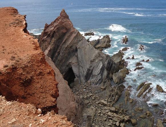
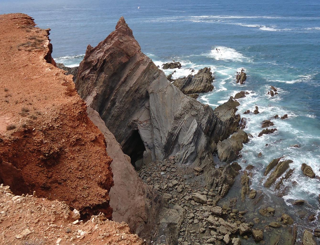
Triassic-Carboniferous unconformity, Telheiro, Portugal. Upper Triassic redbeds in the foreground overlie Carboniferous basement turbidites, deformed into chevron folds during the Variscan orogency. Photo by Peter Meehan.
RESERVOIR ISSUE 10 • NOVEMBER 2014 3 NOVEMBER 2014 – VOLUME 41, ISSUE 10 ARTICLES 2015 CSPG Geological Calendar Wrap-up 18 Go Take a Hike 20 Get More Data from Cuttings – Tools to Aid East Coast Exploration ........................ 24 Photo of the Month ...................................................................................................................... 27 26th Annual CSPG/CSEG/CAPL: 10K & 5K Road Race and Fun Run ........................... 29 Honorary Member – John Hogg 30 DEPARTMENTS Message from the Board 5 Technical Luncheons 9 Division Talks ........................................................................................................................... 13 Rock Shop ............................................................................................................................ 7, 23
FRONT COVER
(You may never return to the office)

Now, get geoLOGIC’s value-added data almost any place, any time, any way you want it. Available through gDCweb on your tablet, smartphone or computer.
With 30 years of data experience behind it, gDC is the source for high quality, value-added well and land data from across Western Canada and the Northern United States. Another plus – our data is accessible through an expanding range of industry software utilizing our own easy-to-use gDC GIS and our geoSCOUT software.
View, search, import and export well, land and production data, documents, logs and more from almost anywhere. For more information visit our website at www.geoLOGIC.com
Leading the way with customer-driven data, integrated software and services for your upstream decision-making needs.
geoSCOUT | gDC | petroCUBE at www.geoLOGIC.com
Our data has gone mobile
Warning:


CSPG BOARD
PAST PRESIDENT
Paul MacKay • Shale Petroleum Ltd. pastpresident@cspg.org Tel: 403.457.3930
PRESIDENT Dale Leckie president@cspg.org
PRESIDENT ELECT
Tony Cadrin • Journey Energy Inc. presidentelect@cspg.org Tel: 403.303.3493
FINANCE DIRECTOR
Gord Stabb • Durando Resources Corp. directorfinance@cspg.org Tel: 403.819.8778
FINANCE DIRECTOR ELECT
Astrid Arts • Cenovus Energy directorfinanceelect@cspg.org Tel: 403.766.5862
DIRECTOR
Alexis Anastas • Nexen Energy ULC education@cspg.org Tel: 403.699.4965
DIRECTOR
Andrew Fox • MEG Energy Corp. outreach@cspg.org Tel: 403.770.5345
DIRECTOR
Milovan Fustic • Statoil Canada Ltd. publications@cspg.org Tel: 403.724.3307
DIRECTOR
Michael LaBerge • Channel Energy Inc. memberservices@cspg.org Tel: 403.301.3739
DIRECTOR
Robert Mummery • Almandine Resources Inc. affiliates@cspg.org Tel: 403.651.4917
DIRECTOR
Weishan Ren • Statoil Canada Ltd. conferences@cspg.org Tel: 403.724.0325
DIRECTOR
Darren Roblin • Kelt Exploration corprelations@cspg.org Tel: 587.233.0784
DIRECTOR
Ryan Lemiski • Nexen ULC youngprofessionals@cspg.org
EXECUTIVE DIRECTOR
Lis Bjeld • CSPG lis.bjeld@cspg.org Tel: 403.513.1235
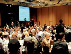
Message from the Board
A message from Brett Norris, the chairman of the CSPG Educational Trust Fund (CSPG ETF)
CSPG Educational Trust Fund (CSPG ETF)
The Canadian Society of Petroleum Geologists (CSPG) is an active geological society with more than 3000 members. Many of you, as members, have benefited from the CSPG in the past, whether it was attending technical luncheons, presenting a paper at the annual convention, reading or contributing to the Bulletin of Canadian Petroleum Geology, attending one of the many divisional talks, volunteering with the CSPG, or simply staying in touch with friends and colleagues. The CSPG is 87 years old and many of the privileges and benefits we enjoy today came about as the result of deliberate initiatives from previous generations who understood the importance of supporting their geological society and thereby fostering future generations of geologists. The CSPG is without doubt a great and enduring organization that is defined by its particular membership and volunteer base.
The CSPG, in addition to providing valuable and relevant services to its members, also has a mandate for outreach and education. These outreach activities cover a broad scope, from grade school student and teacher awareness and education right through to university
undergraduate and graduate student and thesis awards.
The CSPG ETF is charged with developing and stewarding donations to “fund programs that inspire and advance education, foster technical excellence, and encourage awareness of petroleum geoscience” (CSPG ETF Mission Statement). Despite the CSPG appointing Trustees, the CSPG ETF is a separate entity, complete with its own Board of Trustees and Trust Deed, and operates independently of the CSPG. This arrangement is necessary to maintain the charitable designation of the CSPG ETF as a trust.
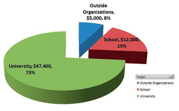
During the previous fiscal year (ending August 31), the CSPG ETF awarded roughly $64,000 to various educational requests. Universityaffiliated recipients received 73% of the total, with grade school and high school audiences accounting for the next most significant sector at 19%. The programs that receive funding include bursaries, scholarships, field study grants, donations to Canadian universities, and grants to outside organizations. Not all
(Continued on page 7...)
CSPG ETF Recipient Groups
RESERVOIR ISSUE 10 • NOVEMBER 2014 5

CONTINUING EDUCATION
Upcoming Fall CSPG Short Courses
Mannville Stratigraphy, Sedimentology and Petroleum Geology
17 -Nov- 14
Topic(s): Overview of Mannville basin, structure and sedimentation; Review of individual units/plays
Type of Play(s): This clastic unit is a reservoir for unconventional oil (heavy oil, bitumen), unconventional gas (tight, sands, coals), liqui dsrich gas, as well as conventional hydrocarbons.
Who Should Attend: Geologists and geophysicists who work local areas in the Mannville.
Why Should You Attend: Previous attendees have cited the regional perspective of their areas, gaining knowledge of other related plays, and frequent unpredictable shifts of exploration areas in the Mannville.
Objectives:
1. To familiarize attendees with the vast amount of Mannville research already published.
2. To put small exploration areas in regional and stratigraphy context.
3. To review details of presently active and inactive plays.
Characterization and Management of SAGD Reservoirs with Geostatistical and Optimization Techniques
The tools and techniques presented are not restricted to heavy oil reservoirs to be developed with variants of Steam Assisted Gravity Drainage (SAGD), but the emphasis and examples are all drawn from this area of application. This is appropriate for geoscientists at an introductory level that want an overview of specialized techniques or for geomodelers at an intermediate or advanced level who want details of the latest techniques applied to this important class of resource projects. Each participant will gain an appreciation for the application of modern geostatistical tools and techniques to characterize and manage SAGD reservoirs.
Course Content:
1. Introduction - Mannville, Stratigraphic and Basin Setting
2. Basal Cretaceous Unconformity
3. Lower Mannville Units and Plays - Cadomin, Gething, Bluesky, Ostracode, McMurray, Dina, Wabiskaw, Cummings -Sunburst, Cutbank, Basal Quartz - Ellerslie, Ostracode.
4. Upper Mannville Units and Plays - Glauconite, Wilrich, Falher, Notikewin - Colongy to Lloydminster Fms - Clearwater, Grand Rapids, non-marine Upper Mannville, Pense Fm
Current best practice geomodeling and geostatistics will be reviewed. SAGD -specific topics that will be covered include: (1) 1 -D processing of well data for autopicking of surfaces and calculation of effective resource/reserve summaries, (2) resource mapping with realistic uncertainty, (3) geomodeling of facies and petrophysical properties, (4) regridding of models for flow simulation and proxy modeling, (5) optimization (preplanning) of drainage areas and (6) proxy modeling for fast approximate prediction of dynamic flow response.
Detailed documentation and all software will be provided with the class notes.
START
LENGTH 3 days INSTRUCTOR Doug Cant PDH Credits 24
DATE
Hours
START DATE 17 -Nov- 14 LENGTH 4 days INSTRUCTORS Clayton Deutsch John Manchuk PDH Credits 32 Hours Register online today at www.cspg.org
CORPORATE
SPONSORS
SAMARIUM geoLOGIC systems ltd.
DIAMOND
The CSPG Educational Trust Fund
TITANIUM
ConocoPhillips Canada Limited
Energy Corp. Devon Canada Corporation
Canadian Natural Resources Ltd
Loring Tarcore MJ Systems Chinook Consulting
Cabra Consulting Inc.
Arcis Seismic Solutions
CSEG Foundation
Bellatrix Exploration Ltd. Emerson Process Management
Enerplus
EOG Resources Canada Inc. Husky
Pro Geo Consultants ION Geophysical Roke Technologies Ltd.
Ikon Science Ltd.
Energy Services Canada
Belloy Petroleum Consulting Canadian Discovery Ltd. Talisman Energy
Pason System
Painted Pony Petroleum Ltd.
AAPG
Earth Signal Processing Ltd
RPS Energy Canada Ltd.
Total Gas Detection Ltd.
Encana Corporation
GLJ Petroleum Consultants Ltd
PLS Inc
RIGSAT Communicationse
requests are funded. The criteria for funding requests have changed through time. If the requests do not meet our mandate, or if available funding is limited for the fiscal year, some requests may not be granted.
There continues to be great demand for additional funding. The CSPG and CSPG ETF invest roughly $175,000 annually in outreach activities. To fund these programs completely would require roughly three times the capital than what is currently invested. It is the intent of the current CSPG ETF Trustees to accomplish the following:
• Increase the proportion of the CSPG outreach activities funded by the CSPG ETF
• Increase donor participation and contribution to the CSPG ETF
To achieve these goals, the CSPG ETF has embarked on a strategic review. The most immediate issue for us to address is raising donor participation. Clearly, the CSPG ETF provides valuable funding to raise awareness of and education in petroleum geoscience in Canada. However, it cannot continue to do so without ongoing support through donations from its members and outside parties. In a city renowned for donating significantly to many great causes, we recognize that this is a competitive environment. With over 3000 members, we would be able to maintain the current award levels and grow the fund capital modestly if each CSPG member considered donating $30 per year. The CSPG and the CSPG ETF have some excellent ideas for growth of the outreach activities, but this requires more donor participation. A great step forward would be to have a majority of CSPG members donate this modest annual sum.
ROCK SHOP
We heard that many CSPG members wished to donate to the CSPG, but were unclear how to do this. There was a consistent misunderstanding that the ETF was somehow not really part of the CSPG. To be clear, the CSPG ETF is the charitable trust arm of the CSPG. As a member of the CSPG, this is your Trust, and it exists to ensure that your donated funds are managed effectively and distributed according to the needs and wishes of you, the donors and CSPG members.
Our board currently consists of eight trustees. Typically, many of the trustees are former Directors or Executive of the CSPG. The current board includes Stan Lavender, Kirk Osadetz, Simon Haynes, Dawn Hodgins, Andrew Fox, Paul MacKay, Kyla Poelzer (Vice Chair), and myself, Brett Norris (Chairman). The heavy presence of ex-CSPG Directors and Executive provides a coherency that best serves the CSPG members. More information about the CSPG ETF, the Trustees, the programs that are funded, and information of how to apply for grants, or how to make donations, can be found on the CSPG website.
Thanks to the CSPG members for their past donations. We, the Trustees of the CSPG ETF, look forward to continuing to build our ability to achieve our goals, and by extension, the goals of the CSPG organization and its members. I would also like to take opportunity to thank the current and recently retired Trustees for their dedication and energy. It is a privilege to serve as the Chairman of such a great group. Lastly, should any member wish to become more involved with the CSPG ETF your volunteer effort would be greatly appreciated and the trustees are convinced that you would find this to be both engaging and personally rewarding. Please contact the CSPG office should this be of interest to you.


RESERVOIR ISSUE 10 • NOVEMBER 2014 7
APEGA Nexen
ULC Cenovus Energy PLATINUM Baker Hughes Schlumberger Canada Limited IHS Global Canada Limited Imperial Oil Resources
GOLD MEG
Tourmaline Suncor
SILVER CGG
AGAT Laboratories Shell Canada Limiteds
Energy Seitel Canada Ltd.
Petrosys
SeisWare Halliburton
BRONZE Crescent Point Energy
Tucker
Divestco
Paradigm
Geovariances
Geomodeling Technology Corp PGS Telsa CL Consultants
As of October 3, 2014 A Special Thanks to Geologic Systems Ltd., CSPG ’s Top Sponsor of the Month. (...Continued
page 5)
Sproule Associates Limited Streamsim Technologies, Inc.
from
1602 – 5th St N.E. Calgary, AB T2E 7W3 Phone: 403-233-7729 www.tihconsulting.com e-mail: tih@shaw.ca T.I.H. Consulting Ltd. Geologic Well-Site Supervision


NOVEMBERy17y2014
appetizersy4:30pmy:yEventy6:00pm th hostedybyyCBCyRadiowsyDougyDirks
Scott W. Tinker
Director$ Bureau of Economic Geology
University of Texas
EPCOR CENTRE5s
Jack Singer Concert Hall F15 8 Ave SE$ Calgary$ AB
François Therrien
Curator of Dinosaur Palaeoecology
Royal Tyrrell Museum
Adults: HF5 8H31 at DoorA
Students: Hh5 8HF1 at DoorA
Children 8hF and underA: FREE


understanding OUR PAST 1 producing OUR FUTURE www.cspg.org theycspgywouldylikeytoythankyalbinymerleyforytheirycontribution
TECHNICAL LUNCHEONS NOVEMBER LUNCHEON
Large,
Heterolithic
Channel Fills
of the Upper Permian Rangal Coal Measures, Queensland, Australia: Well-exposed Analogues for the McMurray Formation
SPEAKER
Dr. Christopher R. Fielding University of Nebraska
11:30 am
Wednesday, November 12th, 2014 Calgary, TELUS Convention, Exhibition Hall D, North Building Calgary, Alberta
Please note: The cut-off date for ticket sales is 1:00 pm, three business days before event (Thursday, Nov 6, 2014). CSPG Member Ticket Price: $45.00 + GST. Non-Member Ticket Price: $47.50 + GST.
Each CSPG Technical Luncheon is 1 APEGA PDH credit. Tickets may be purchased online at https://www.cspg.org/eSeries/source/Events/ index.cfm.
Webcasts sponsored by

Queensland, Australia. The unit, around 100 m thick in total, comprises sandstone bodies, thick heterolithic sandstonesiltstone intervals with Inclined Heterolithic Stratification (IHS), mudrocks with thinbedded sandstones, and coal bodies up to 8 m thick. A number of large, opencut mines have provided extensive though temporary exposures of the Rangal Coal Measures, allowing an evaluation of their sedimentology and stratigraphy.
In an earlier study, Fielding (1993, Sedimentary Geology, 85, 475-497) carried out a facies analysis and concluded that the depositional environment was an extensive, low-lying alluvial plain crossed by rivers that alternated between two distinct fluvial styles:


1. heterolithic channel fills of moderately sinuous planform (<1.5), and sheet-like sandstone channel bodies that were the product of more mobile, perhaps braiding rivers. In this talk,


RESERVOIR ISSUE 10 • NOVEMBER 2014 9
(((( (((((( (((((( (((( 10 10 10 10 20 20 30 10 10 10 40 10 30 10 40 10 10 10 10 40 40 10 10 40 20 10 10 50 30 20 40 10 20 10 10 30 20 10 10 Alberta British Columbia Saskatchewan Manitoba Projection:UTM;CentralMeridian-115.5;NorthAmericanDatum1983 1:500,000 Duvernay C Isopach (m) C.I. = 5m 53.3 2.0 Structural and Geological Edges (((( Paleozoic Deformation Front Leduc Reefs (WCSBAtlas, 1994) Duvernay C Isopach Copyright © 2014 Canadian Discovery Ltd.All Rights Reserved. Author: Hume Cartographer: Keeler E.8 Enclosure Reviewer: Fockler Filename: DVRN_C_ISOPACH_MAP.mxd Project:DVRN Created:2-January-2014 Edited: 10-March-2014 Duvernay Gas Liquids and Geomechanics Project T45 T60 T65 T70 T75 T80 R10 R20 R15 R10 R5 R1W5 T50 T40 T35 R5 R1W6 R25 T80 T75 T70 T65 T60 T55 T45 R25 R1W5 R5 R10 R15 T50 T55 T40 R20 T35 R25 Understand the drivers behind Canada’s hottest plays, operators and technology with industry-leading E&P research, technical analysis and reporting from Canadian Discovery Ltd. Canadian Discovery Lt d. Subscribe Today! 403-269-3644 | info@canadiandiscovery.com New platform. Better content. Same focus on excellence. PERFORM to your Potential canadiandiscovery.com (Continued on page 10...)
the outcomes of a re-evaluation of this dataset are discussed, and the conclusion is drawn that significant portions of the Rangal Coal Measures were likely formed in tidally-influenced rivers (estuaries) that drained the north-south Bowen Basin axially during the latest Permian.
The principal lines of evidence in support of this reinterpretation are:
1. abundance and diversity of IHSfilled channel forms, and abrupt lateral facies variations that indicate significant areal partitioning of sand in the formative rivers,
2. presence of abundant small-scale sedimentary structures commonly associated with tidal activity (flaser bedding, mud drapes, etc.),
3. presence of a low-diversity, sporadically distributed trace fossil suite,
4. presence of fish fossils of types that
have been previously regarded as marine, and
5. bimodal to bipolar palaeocurrent distributions. Given this reinterpretation, the Rangal Coal Measures can serve as a wellexposed analogue for the internal stratal architecture and reservoir heterogeneity that is known to characterize the Cretaceous McMurray formation in the Athabasca oil sands province
BIOGRAPHY
Chris Fielding grew up in Scotland, was awarded a BSc Honours degree in Geology from Edinburgh University (1979) and a PhD in Geology from Durham University (1982) on the sedimentology and stratigraphy of Pennsylvanian coal-bearing rocks in NE England. He then joined BP Exploration Co. as a petroleum sedimentologist, working out of London, Guangzhou (China) and Aberdeen until 1986 when he commenced an academic position at the University of Queensland in Australia. He remained at UQ for 16 years, rising to the rank of Associate Professor and was Director (Academic) of the
Department of Earth Sciences from 2001 until his departure in mid-2002. Chris is now the inaugural Mr & Mrs JB Coffman Chair in Sedimentary Geology at the University of Nebraska-Lincoln, in the USA. He was Editor of the journal “Sedimentology” from 1998 to 2002, has been on the Editorial Board of “Sedimentary Geology” since 1995, and was Editor-in-Chief from 2005-2008. He was elected President of SEPM (the Society for Sedimentary Geology) for 2011/12, and a Fellow of the Geological Society of America in 2011. His research interests span the sedimentology and stratigraphy of continental, coastal and shallow marine depositional systems, their paleoclimatological archives, and applications to resource exploration and production. He maintains active field-based research programs in eastern Australia, Antarctica, Atlantic Canada, Midwestern and Western USA. He will watch any kind of football.


Maximize your reservoir understanding through seamless interpretation of seismic and geological data
Quick & easy high-resolution 3D seismic attribute generation*
Optimize reservoir characterization away from your wells through highresolution seismic multi-attribute rock property prediction
Combine seismic interpretation with multi-attributes results and visualize in one scene * Requires LMKR Volume Attributes


10 RESERVOIR ISSUE 10 • NOVEMBER 2014
Advanced Geophysics Capabilities Maximize Your Potential With LMKR Holdings is the exclusive world-wide licensor and distributor of GeoGraphix® software. GeoGraphix® is a registered trademark of Landmark Graphics Corporation. The LMKR Logo is a trademark of LMKR Holdings. www.lmkr.com/geographix Discover Your Potential (...Continued from page 9 )
TECHNICAL LUNCHEONS NOVEMBER LUNCHEON
Episodic Tectonics in the Phanerozoic Succession of the North American Arctic and the “10 Million Year Flood”
SPEAKER
Ashton Embry Geological Survey of Canada
11:30 am
Wednesday, November 19th, 2014 Calgary, TELUS Convention, Exhibition Hall D, North Building Calgary, Alberta
Please note: The cut-off date for ticket sales is 1:00 pm, three business days before event. (Friday, Nov 14th, 2014). CSPG Member Ticket Price: $45.00 + GST. Non-Member Ticket Price: $47.50 + GST.
Each CSPG Technical Luncheon is 1 APEGA PDH credit. Tickets may be purchased online at https://www.cspg.org/eSeries/source/Events/ index.cfm.
Abstract
We have catalogued all the large scale, tectonically-generated sequence boundaries which punctuate the Phanerozoic stratigraphy of the North American (NA) Arctic so as to determine the frequency and possible origin of the interpreted tectonic episodes which gave rise to the boundaries. Notably, the entire Phanerozoic succession is present in the NA Arctic and the data come mainly from Franklinian Basin, Sverdrup Basin and Beaufort-Mackenzie Basin. Data from other basins such as the North Slope Basin of Alaska have been used to complement and refine the results obtained from the three main basins.
Detailed stratigraphic studies in the basins have revealed the presence of 57, large magnitude, sequence boundaries within the Phanerozoic succession of Arctic North America. The sequence boundary characteristics indicate that the boundaries were generated primarily by tectonics.
Each sequence boundary is interpreted to have been produced by a tectonic episode which affected the entire region and which resulted in tectonic uplift and erosion on the margins of the basins. The sequence boundaries have been assigned a numerical age and the time intervals between the boundaries were no less than 5 and no more than 15 million years in almost all cases. It is clear that the tectonicallygenerated boundaries were not strictly periodic but were chaotic and had a relatively high chance of reoccurring within 10 million years. The major transgression which follows each boundary could perhaps be referred to as a “10 million year flood.”
The tectonic episodes which generated the sequence boundaries lasted for a few million years and were separated by longer intervals of relative tectonic quiescence. The tectonic episodes are interpreted as an expression of relatively rapid and substantial changes in the stress fields of the NA Arctic. Such stress changes would be possibly due to somewhat abrupt changes in the speed and/or direction of plate movements which affected the NA Arctic. Given there is a complex feedback between plate distribution and dynamics with mantle convection and heat release, the recognized tectonic episodes may reflect a gradual buildup of, and a consequent episodic release of, stress and heat occurring every 5-15 million years.
There are indications that the recognized tectonic episodes affected basins throughout the world. A literature survey has indicated most of the tectonic sequence boundaries
Webcasts sponsored by
we have recognized are present in basins on different continents. Furthermore, many of the tectonic episodes correlate with significant carbon isotope excursions and with mass extinctions. Given that all the tectonic plates are linked and a major adjustment in the speed or direction of one plate would require compensatory movement changes in all the other plates, a phenomenon of episodic global tectonics occurring with a frequency of 5-15 million years is a theoretical possibility.
These results have implications for petroleum exploration in that petroleum traps would have been formed, altered and sometimes breeched during the tectonic episodes. Also, the movement of subsurface fluids would have been greatly influenced by such intermittent convulsions of the sedimentary column. Finally, the recognition and dating of these tectonically-generated sequence boundaries, in combination with their potential global distribution, allows their occurrence to be predicted in unexplored sedimentary basins.
BIOGRAPHY
Ashton Embry is an emeritus scientist with the Geological Survey of Canada in Calgary and has worked in the Canadian Arctic Islands since 1969. His main focus has been on the stratigraphy, depositional history, and petroleum potential of the Devonian and Mesozoic strata of the region. He has also developed methodologies for sequence stratigraphic analysis and this work has been compiled into a Handbook on Practical Sequence Stratigraphy which can be downloaded from the CSPG website.
RESERVOIR ISSUE 10 • NOVEMBER 2014 11
PETROLEUM INDUSTRY COURSES
OVERVIEW OF THE OIL & GAS INDUSTRY IN WESTERN CANADA
Date: November 6th and 7th, 2014
Cost: $1050 (includes GST)
Instructor: Bill Ayrton
Effective for personnel just joining the oil patch, or for financial, accounting, and information systems personnel.
• Learn about the many facets of the industry.
• Oil finding, land acquisition, drilling, seismic, well completion, jargon and terminology
GEOLOGY FOR NON-GEOLOGISTS
Date: November 12th and 13th, 2014
Cost: $1050 (includes GST)
Instructor: Bill Ayrton
Effective for geological technicians or administrative staff, or for those who just want a better understanding of geology to appreciate the world around us.
WHO SHOULD ATTEND
New geologists, engineers, geophysicists and landmen, as well as summer students entering the industr y for the first time will find the courses a very beneficial introduction to the petroleu m industry These courses will be extremely useful to nonprofessional and support staff in the oi l and gas industry, as w ell as accountants, lawyers, brokerage and financial personnel working primarily alongside the oil and gas industry.
TO REGISTER
To register or to obtain additional information regarding in-house and upcoming courses, please contact:
Ayrton Exploration Consulting Ltd.
Tel: (403) 262-5440
Email: ayrtonex@shaw.c a
Or visit our website: www.ayrtonexploration.com
• Learn about earth structure, geologic time-scale and processes, Western Canada geology, and interesting nearby locations.
• Participate in a r ock identification exercise , cross-section project and a mini-field trip in downtown Calgary.
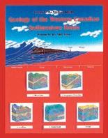
GEOLOGY OF THE WESTERN CANADIAN SEDIMENTARY BASIN
Date: December 3rd, 4th and 5th, 2014
Cost: $1575 (includes GST)
Instructor: Bill Ayrton
Ideal for those who wish to improve their geological understanding of where and how we look for oil and gas fields in Western Canada.
• To visualize what Western Canada looked like throughout the stages of history, for example, the position of the sea versus land, what sediments were deposited, and what type of life that existed and evolved.
• To review the importance of each major stratigraphic unit, i.e. Devonian, Mississippian, Cretaceous, etc.
• Discuss the geological and seismic expression of typical oil and gas fields in each unit.
• To review the variety of “unconventional” oil and gas plays currently being pursued.
12 RESERVOIR ISSUE 10 • NOVEMBER 2014
technology • seismic • rocks • maps • formations • land • sediments • history • sea • fossils • environment
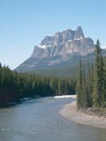
The ”Guardwall” at the new Trilobite “Burgess Shale” discovery at Stanley Glacier Valley, Kootenay National Park. Photo: Bill Ayrton
GE OL OG Y FO R NO N- GE OL OG ISTS Pr esen ted by W.G. Bi ll) A yr ton
Sponsored
The Effects of the Laramide Orogeny, (Early Tertiary) on the Oil Migration and Entrapment in the
Plains area of Southern Canada and Northern Montana
SPEAKER
Michael Griffin
12:00 Noon
Friday, November 21st, 2014
Schlumberger
Second Floor Lecture Theatre
Palliser One Building 200, 125 – 9 Avenue S.E. Calgary, Alberta
ABSTRACT
The topic covers the area from 113deg W and East to 107degW and South from 51degN in Canada to 47degN in Montana.
Most of Montana was not subject to the Pleistocene Glaciation and the surface geology map gives a good picture of the Early Tertiary Faulting and intrusive activity of the Laramide Orogeny.
In Canada glacial sediments tend to mask the surface effects of the Laramide Orogeny in the plains. Magnetic and gravity surveys can define the major transform fault pathways and intrusive events in the sedimentary section which can later be vetted by seismic and drilling.
Specifically in Northern Montana and Southern Canada the Laramide Orogeny of the Rocky Mountains is responsible for Tertiary aged major structural effects. Thrusting from the West causes major consequent transform faulting in the Alberta Praires, such as the Vulcan Graben, and the Great Falls Transform Fault Zone. Between the faults, the westerly compression causes doming, displayed as the Sweet Grass Arch and the Kevin Sunburst Dome. The doming results in erosion of up to 2000 m in the Tertiary and Upper Cretaceous sediments during the uplift.
At the same time, the huge intrusions of the Sweet Grass Hills, Bears Paw Mountains, Little Rocky Mountains and Bowdoin Dome occurred in Northern Montana. These Tertiary intrusive events caused uplift, faulting and fluid movement over a wide area of Montana and Southern Canada.
These structural events resulted in very complex fluid and oil migration pathways and secondary diagenesis of many sedimentary formations in the plains.
BIOGRAPHY
Michael Griffin started in the Petroleum Industry in 1971 and has 14 years international experience in South America, Europe, and the Middle East, and 25 years working in Canada and the U.S.A. He has an Honors Geology, and Honors Biology degrees from Acadia University, N.S. He presently runs Ancient Solutions Inc. which concentrates on renewable energies, especially geothermal.
RESERVOIR ISSUE 10 • NOVEMBER 2014 13
TALKS STRUCTURAL DIVISION
DIVISION
BYPASSED HYDROCARBONS IN CONVENTIONAL AND UNCONVENTIONAL RESERVOIRS Taras Dziuba Integrated Petrophysics Instruction in Log Analysis Combined with Rock Typing 36 years’ experience in finding and evaluating hydrocarbons Course Date: Jan. 14-15, 2015 Course Info: www.tdintegratedpetrophysics.com Phone: 587-581-0126 e-mail: tdziuba@telus.net
by
DIVISION TALKS PALAEONTOLOGY DIVISION
Ice Age Yukon: Mammoths, Migrations and Extinction in the Northern Refugium
SPEAKER
Dr. Duane Froese
Department of Earth and Atmospheric Sciences, University of Alberta
7:30 PM
Friday, November 21st, 2014
Mount Royal University, Room B108 Calgary, Alberta
ABSTRACT
During the height of the last glaciation, more than 95% of Canada was covered by glaciers, with the largest ice-free area in Yukon. This area was part of a non-glaciated sub-continental region that extended from northwestern Canada, across Alaska and the Bering Land Bridge, into Asia. This region was home to a diverse population of grazing megafauna including mammoths, horses, camels, lions and bison. Permafrost in this region preserves the fossils from these animals along with plants and even ancient DNA, and tells us about migrations and population changes. But these changes also raise important questions about what ultimately drove extinction of these megafauna across this region. In this talk, I present recent research that outlines how these populations responded to climate over the last several hundred thousand years, and the events of the Late Pleistocene that ultimately led to extinction.
BIOGRAPHY
Duane Froese finished his PhD at the University of Calgary in 2001 and following post-doctoral work at Simon Fraser University, joined the Department of Earth and Atmospheric Sciences at the University of Alberta in 2003. He was appointed to the Canada Research Chair in Northern Environmental Change in 2009. For more than 20 years he has been leading interdisciplinary research focused on understanding the evolution and impacts of
Arctic and subarctic climate on northern ecosystems using diverse approaches ranging from the dynamics of ice age mammals, ancient biomolecules to geophysical techniques, all focused on the exceptional archives of past environments preserved in Arctic permafrost. He is a recipient of the J. Ross Mackay award and Hutchison medal from the Geological Association of Canada for his contributions to understanding northern environmental change.
Sponsored by
Department of Mount Royal University, and the Palaeontology Division of the Canadian Society of Petroleum Geologists. For details or to present a talk in the future, please contact CSPG Palaeontology Division Chair Jon Noad at jonnoad@hotmail.com or APS Coordinator Harold Whittaker at 403-2860349 or contact programs1@albertapaleo.org. Visit the APS website for confirmation of event times and upcoming speakers: http://www. albertapaleo.org/.
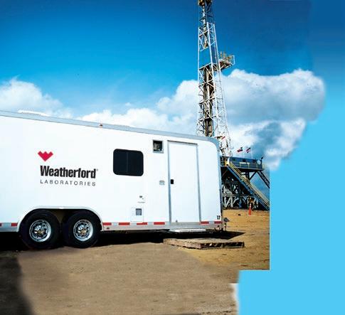

When time is money, Wellsite Geoscience is money well spent.
Whether you’re exploring a basin, producing a well or completing a shale play, time is money. That’s why Weatherford Laboratories brings a suite of formation evaluation technologies right to the wellsite. Utilizing mud gas and cuttings, these technologies provide detailed data on gas composition, organic richness, mineralogy and chemostratigraphy in near real time. As a result, operators now have an invaluable tool to assist with sweet spot identification, wellbore positioning, completion design and hydraulic fracturing. We call it Science At the Wellsite. You’ll call it money well spent.
SCIENCE AT THE WELLSITE ™
14 RESERVOIR ISSUE 10 • NOVEMBER 2014
©2013 Weatherford. All rights reserved Formation Evaluation ┃Well Construction ┃Completion ┃Production
www.weatherfordlabs.com
WELLSITE GEOSCIENCE SERVICES
DIVISION TALKS BASS DIVISION
Stratigraphic Insight into Formative DeepSea Channel Processes with Emphasis on Sand Distribution
SPEAKER
Stephen M. Hubbard
Department of Geoscience, University of Calgary
12:00 Noon
Wednesday, December 3rd, 2014
ConocoPhillips Auditorium Gulf Canada Square 401 – 9th Ave. S.W. Calgary, Alberta
The stratigraphic record of sinuous rivers and submarine channels contains a wealth of information about formative sedimentary processes. For decades fluvial deposits have been considered in the context of processes observed in rivers – the point bar facies model represents a well-established linkage between process and product, for example. This type of direct link has yet to be achieved in the deep-sea as coarse-grained sediment transport cannot be readily monitored due to the challenging physical environment (e.g., water depth, destructive currents). The difficulty in monitoring and measuring sediment transport events in submarine channels, such as turbidity currents, is exacerbated by their sporadic and infrequent nature. Until such time that regular direct observation of turbidity currents is achievable, the stratigraphic record of sediment transfer in the deepsea provides critical and unique insight into processes that shape not only ancient basin margin slopes, but also the present day seascape. Furthermore, the stratigraphic record of individual slope channel systems contain the fingerprint of protracted processes of sediment transfer, on the scale of centuries to millennia, providing insight beyond what can be expected from modern systems.
The similarity in sinuous planforms of open, single thread fluvial and deep-sea channels is widely appreciated, however, outcrop characteristics indicate different formative processes. Meandering fluvial systems are most commonly represented by deposits that reflect point bar migration, whereby processes of bank erosion and bar growth are genetically linked. At the bed scale, crossstratification reflects bedload sediment transport and deposition by traction sedimentation. At the reservoir scale, the stratigraphic record is dominated by widespread sandstone-prone sedimentary packages that reflect sustained channel migration and punctuated avulsion across a meanderbelt (Fig. 1). In contrast, the deposits of single thread deep-sea channels are commonly characterized by sandstonefilled channelform bodies, which are characterized by evidence for both traction and suspension sedimentation. Heterolithic thin beds and cross-stratification can be locally preserved above channel bases and against channel margins, but the majority of channel fill comprises tabular sandstone turbidites that bi-directionally lap onto channel edges (Fig. 1). Thick and stratified flows result in elevated aggradation in submarine systems, and a result is vertically stacked channelform bodies that are commonly amalgamated (Fig. 1). The stratal record of submarine channels indicates a distinction between phases of channel maintenance (i.e., erosion, sediment bypass) and phases of substantial infilling with coarse-grained sediment – they are not contemporaneous.
ACKNOWLEDGEMENTS
Funding for this research is provided by sponsoring companies of the Chile Slope Systems industrial consortium (www.chileslopesystems. com), including Anadarko, BG Group, BHP Billiton, BP, Chevron, ConocoPhillips, Hess, Marathon, Maersk, Nexen, Shell, and Statoil.
BIOGRAPHY
Steve Hubbard is an Associate Professor in the Department of Geoscience at the University of Calgary. He is a clastic sedimentologist with recent research emphasizing sediment transfer through channels in both deep-marine and fluvial settings.
INFORMATION
BASS Division talks are free. Please bring your lunch. For further information about the division, joining our mailing list, a list of upcoming talks, or if you wish to present a talk or lead a field trip, please contact either Steve Donaldson at 403-766-5534, email: Steve.Donaldson@ cenovus.com or Mark Caplan at 403-9757701, email: mcaplan@atha.com or visit our web page on the CSPG website at http://www. cspg.org
RESERVOIR ISSUE 10 • NOVEMBER 2014 15
Sponsored by
Figure 1. Deep-sea channel deposits from the Magallanes Basin of Chile (Campanian, Tres Pasos Formation) and tidal-fluvial channel deposits from the Alberta Basin (Campanian, Horseshoe Canyon Formation).
DIVISION TALKS INTERNATIONAL DIVISION
Downslope Variations in Slope Channel Body Stacking Patterns in Outcrop, Magallanes Foreland
Basin, Chile
SPEAKER
Benjamin Daniels
12:00 Noon
November 12th, 2014
Nexen Plus 15 Conference Centre, Nexen Annex Building 7th Ave. & 7th St. SE, Calgary, AB
ABSTRACT
Deep-water channels, which transport large volumes of detritus to the deep ocean, are highly variable along their length as they transect the continental slope. Slope channel systems have been imaged extensively using modern 3-D seismic reflection surveys and bathymetric methods in an attempt to understand their variability along continental slope profiles. While 3-D seismic surveys provide incredible insight into these systems, there is a paucity
Sponsored by
Figure 1. Illustration of the downslope variations in slope channel architecture. (A) Planform expression of the twenty-four channel elements. The width of the composite channel succession narrows considerably from north to south. (B) Depositional-dip-oriented cross-section A-A’. Many of the channels in this crosssection are considerably offset from one another. (C) Depositional-dip-oriented cross-section B-B’. Compared to A-A’, channels at this location show stacking that is far more aggradational and apparently confined.
of detailed sedimentological data available with which to consider variation in formative processes over long distances. The study addresses this lack of fine-scale data through the examination of slope channel deposits along a 10 km-long depositional-dip-oriented slope profile in the Tres Pasos Formation of southern Chile. The Tres Pasos Formation was deposited on the prograding margin of a foreland basin that was characterized by >1000 m of water depth (Hubbard et al., 2010). The foreland basin was developed in response to Andean uplift during the Cretaceous.
Channel strata were documented with 18 measured sections (total of 550 m), as well
as channelform surfaces (i.e., tops, bases) that were surveyed using high-resolution differential GPS (dGPS) methods. These data provide the basis for the stratigraphic architectural characterization of the outcrop belt, from which calculations of channel width, thickness and offsets were derived. Intra-channel deposits are divided up into six lithofacies associations, consisting primarily of turbiditic sandstone and siltstone.
Along the 10 km-long downslope transect, several key sedimentological and architectural observations are made. Individual channels are characterized by intra-channel fill showing significant changes downslope, from areas
16 RESERVOIR ISSUE 10 • NOVEMBER 2014
dominated by substantial bypass of sand (i.e., recorded by lags and bypass drapes) to channel segments filled with heterolithic material, including thick units of amalgamated sandstone. Twenty-four individual channels have been identified, and these channels possess widths, thicknesses, and sinuosities which are comparable to other modern and ancient examples (Fig. 1A; cf., McHargue et al., 2011). While the majority of these channels stack systematically eastward, pronounced changes in vertical and lateral offsets between channels occur at numerous stratigraphic levels (Fig. 1B, 1C). These changes contribute to the variations in overall width and stratigraphic thickness observed for the entire succession. In a basinward direction, the width of the composite channel succession decreases from 1696 m to 707 m, and the overall stratigraphic thickness increasesfrom 133 m to 87 m. These associations suggest an increased confinement of the channel system, along with increased aggradation downslope (Fig. 1A-C). Ongoing work is focused on GeoConvention 2014: FOCUS 2 documentation of systematic changes within the channel strata along the depositionaldiporiented outcrop exposure, which will aid in the understanding of downslope variation in processes of sediment transfer
GEOEDGES
(i.e., erosion, bypass and deposition), and provide an opportunity to consider variation in large-scale channel stacking patterns that is commonly observed in slope channel systems on the continental margin of Atlantic Canada (cf., Piper et al., 2005).
BIOGRAPHY
Benjamin Daniels is presently pursuing a Master’s degree in Geology at the University of Calgary under the supervision of Dr. Stephen Hubbard. Prior to Calgary, Ben obtained a Bachelor’s degree in Geology from the University of Waterloo. Ben was enrolled in the co-op program during his time at Waterloo, and several influential internships and work terms that he undertook over the duration of the program convinced him to study sedimentology in graduate school. Ben currently investigates the ancient submarine slope channel deposits that constitute part of the Tres Pasos Formation in southern Chile, and is particularly interested in the downslope changes in channel fill, morphology, and architecture that persist in both ancient and modern continental slope settings worldwide.
ACKNOWLEDGEMENTS
Funding for this research was generously provided by the sponsoring corporations of the Chile Slope Systems Joint Industry Project (Chevron
Corporation, ConocoPhillips Company, Statoil ASA, Royal Dutch Shell, Nexen Inc., Marathon Petroleum Corporation, Talisman Energy,
Anadarko Petroleum Corporation, BG Group, BP, and BHP Billiton), as well as the Natural Sciences and Engineering Research Council of Canada (NSERC). Schlumberger is also thanked for providing access to the software Petrel.
REFERENCES
Hubbard, S.M., Fildani, A., Romans B.W., Covault, J.A., and McHargue, T.R., 2010. High-relief slope clinoform development: Insights from outcrop, Magallanes Basin, Chile. Journal of Sedimentary Research, v. 80, p. 357-375.
McHargue, T.R., Pyrcz, M.J., Sullivan, M.D., Clark, J.D., Fildani, A., Romans, B.W., Covault, J.A., Levy, M., Posamentier, H.W., and Drinkwater, N.J., 2011. Architecture of turbidite channel systems on the continental slope: patterns and predictions. Marine and Petroleum Geology, v. 28, p. 728-743.
Piper, D.J.W., Macdonald, A.W.A., Ingram, S., Williams, G.L., and McCall, C., 2005. Late Cenozoic architecture of the St. Pierre Slope. Canadian Journal of Earth Sciences, v. 42, p. 1987-2000.
Detailed and accurate geology at your fingertips in Petra, GeoGraphix, ArcGIS, AccuMap, GeoScout and other applications for information contact: Joel Harding at 403 870 8122 email joelharding@geoedges.com www.geoedges.com
Western Canada: Slave Point, Swan Hills, Leduc, Grosmont, Jean Marie, Horn River Shales, Elkton, Shunda, Pekisko, Banff, Mississippian subcrops and anhydrite barriers in SE Sask., Bakken, Three Forks, Montney, Halfway, Charlie Lake, Rock Creek, Shaunavon, BQ/Gething, Bluesky, Glauconitic, Lloyd, Sparky, Colony, Viking, Cardium, CBM, Oilsands Areas, Outcrops
Northern US Rockies & Williston Basin Geological Edge Set
Western Canada Geological Edge Set
Eastern US / Appalachian Basin Geological Edge Set
US Rockies & Williston: Red River, Mississippian subcrops & anhydrite barriers (Bluell, Sherwood, Rival, etc), Bakken, Three Forks, Cutbank, Sunburst, Tyler, Heath, Muddy, Dakota, Sussex, Shannon, Parkman, Almond, Lewis, Frontier, Niobrara, Mesaverde shorelines, Minnelusa, Gothic, Hovenweep, Ismay, Desert Creek, Field Outlines, Outcrops
Texas & Midcontinent: Granite Wash, Permian Basin paleogeography (Wolfcampian, Leonardian, Guadalupian), Mississippian Horizontal Play, Red Fork, Morrow, Cleveland, Sligo/Edwards Reefs, Salt Basins, Frio, Wilcox, Eagleford, Tuscaloosa, Haynesville, Fayeteville-Caney, Woodford, Field Outlines, Outcrops, Structures
North American Shales: Shale plays characterized by O&G fields, formation limit, outcrop, subcrop, structure, isopach, maturity, stratigraphic crosssections. Includes: Marcellus, Rhinestreet, Huron, New Albany, Antrim, UticaCollingwood, Barnett, Eagleford, Niobrara, Gothic, Hovenweep, Mowry, Bakken, Three Forks, Monterey, Montney, Horn River, Colorado
Eastern US / Appalachia: PreCambrian, Trenton, Utica-Collingwood, MedinaClinton, Tuscarora, Marcellus, Onondaga Structure, Geneseo, Huron, Antrim, New Albny, Rhinestreet, Sonyea, Cleveland, Venango, Bradford, Elk, Berea, Weir, Big Injun, Formation limits, Outcrops, Allegheny Thrust, Cincinatti Arch, Field outlines
North American Shales Geological Edge Set (all colors)
Texas & Midcontinent US Geological Edge Set
Mexico: Eagle Ford-Agua Nueva, Pimienta, Oil-Gas-Condensate Windows, Cupido-Sligo and Edwards Reefs, Tuxpan Platform, El Abra-Tamabra facies, Salt structures, Basins, Uplifts, Structural features, Sierra Madre Front, Outcrops, Field Outlines
Deliverables include:
-Shapefiles and AccuMap map features
-hard copy maps, manual, pdf cross-sections
-Petra Thematic Map projects, GeoGraphix projects, ArcView map and layers files
-bi-annual updates and additions to mapping
-technical support
RESERVOIR ISSUE 10 • NOVEMBER 2014 17
INC. Mexico Geological Edge Set
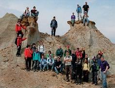
2015 CSPG Geological Calendar Wrap-up
| By Markus Ebner
It is that time again – the annual changing of the guard of the CSPG calendar, and this year is sure to please. Included in this month’s issue of the Reservoir, you will find the 2015 CSPG Geological Calendar.
The 2015 collection of 12 amazing geological images from around the globe have been contributed by our society’s members. This year we had a total of 91 (down from last year) photographs submitted. The quality of photographs year by year has definitely been on the rise, so even though we had a decrease in submission volume, voting the 12 winners was no easy task.
Some highlights from next year’s calendar include:
• to home, a new twist on the Badlands that we have never really seen submitted before, a long exposure shot over the Hoodoos, submitted by John P. Andersen.
• Continuing on the ‘night train’ John was voted into the calendar with a second photo of the Big Rock Glacial erratic.
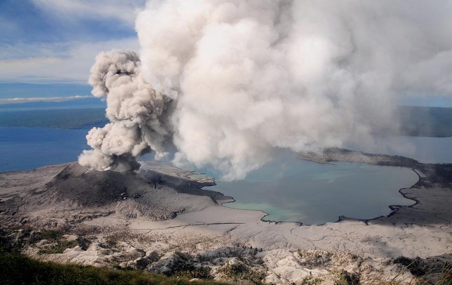
• Best Photo was taken by Paul G. Nicholson’s shot of Tavurvur on New Britain Island, Papau New Guinea.
• Wayne Laturnas submitted a spectacular aerial shot above Doris Lake, within the Carcajou Range, NWT.
The 2015 calendar really showcases some amazing and varying global geology. I think what makes the 2015 calendar extraordinary this year is the large amount of Canadian content (a total of 6) that has been voted in. Increasingly in years past, Canadian content has not made the cut, but with the new and differing locations, as well as photographic techniques, the Canadian photos really took the forefront.
I would like to thank my partners in this project, Emma MacPherson, our Publications Coordinator and Donna Elkow-Nash, our calendar graphic designer. Additionally, I would like to thank the volunteer lunch time judges that assembled and helped to rank all of the submitted photographs, including: Darin McBeath, Reid Kennedy, Erik Parker and Emily Duncan (Token Geophysicist…).
We would like to thank the support of our society’s members, continuously submitting such great photos for the competition – even if they did not make it into the calendar, you will be seeing some of these photos as “Photos of the Month” in upcoming Reservoir issues. We could not assemble such a great calendar and monthly publication without the support of our members. Please enjoy your 2015 CSPG Geological Calendar as the months roll by.
18 RESERVOIR ISSUE 10 • NOVEMBER 2014
2015 Best Photograph Winner: Paul G. Nicholson – Tavurvur is a stratovolcano within the Rabaul caldera, located at the eastern tip of New Britain Island, Papua New Guinea. Explosive eruptions have occurred persistently since 1994, repeatedly covering the town of Rabaul and surrounding area in fine, powdery ash.

Go where the passionate geoscientists are
Discuss the science
Socialize within a like -minded community
Grow your specialty by attending our conferences
Engage in qualified professional development (PDH accredited)
Meet industry
Volunteer and be on a team
Develop leadership skills
Get introduced to geoscience software tools
Access to technical journals on AAPGDatapages and GeoScienceWorld
Leave your legacy where you are most passionate
Join us and be part of the team that advances the professions of the energy geosciences – as it applies to geology


Distinguished Lecturer Series Go Take a Hike Mixed Golf Tournament Student Industry Field Trip
Advantages!
Membership has its
Welcome to your
“Reaching New Depths” - Check out CSPG Executive Director - Lis Bjeld’s Interview in the Oct/Nov/Dec issue of Advantage Magazine Available online at www.advantagemagazine.ca JOIN TODAY VISIT WWW.CSPG.ORG TO BECOME A MEMBER TODAY
Professional Career Home

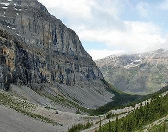
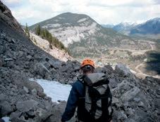
GO TAKE A HIKE
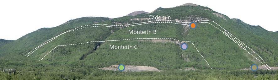
Late Jurassic Monteith Formation, Mt. Hamel, Grande Cache, Alberta
| By Ross Kukulski, Steve Hubbard, Brett Miles and Keegan Raines
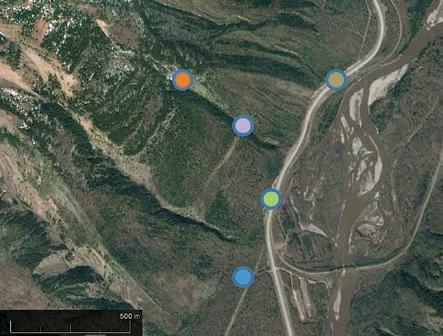
Trailhead: From Grande Cache, AB drive north approximately 5 km along Highway 40 to a small turnoff on the left side of the road adjacent to the rail bridge. A small parking area and a Mt. Hamel trail sign is present amongst the trees.
Distance: Approximately 1.5 km with roughly 400 m of elevation gain.
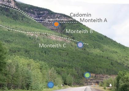
This hike starts a few minutes north of Grande Cache and includes valley, road cut and waterfall exposures of the Late Jurassic – Early Cretaceous Monteith and Cadomin formations. Much of the hike is not on well-defined trails, so be ready to navigate slopes in wooded terrain. The outcrop is part of a box-fold anticline with exposures ranging from near horizontal to almost vertical.
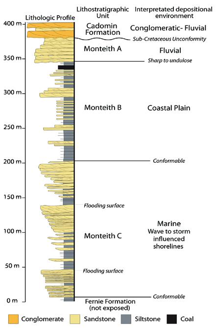
During the Early Jurassic, mountain building began to the west of the area, which created a foreland basin and interior seaway that persisted until the Late Cretaceous. The nearly continuous exposure of the Monteith Formation represents the first coarse clastic deposit in the foreland basin and provides an excellent outcrop analogue for equivalent deposits in the subsurface. The section is informally subdivided, from bottom up into the Monteith C, B and A, which are interpreted to record marine, costal plain, and fluvial deposition, respectively (Miles et al. 2012).
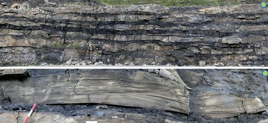
The first outcrop (Monteith C) is a short walk along Highway 40 which includes 0.5-2 m thick hummocky cross stratified sandstone beds interbedded with shale. These are marginal marine units that were deposited above storm weather wave base.
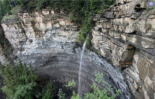
The second outcrop is spectacularly exposed beneath a waterfall and is accessed by following the northern ridge of a small creek near the northern extent of the first outcrop (be wary of steep slopes and cliffs!). The stratigraphic section is ~35 m thick and characterized by an upwards increase in bed thickness and grain size. This interval is interpreted to record the transition from offshore to shoreface deposits of a marine succession; it caps the Monteith C interval.
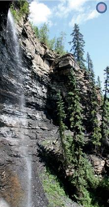
The third outcrop is a thin (5-10 m) exposure of the Monteith A that is unconformably truncated by the Cadomin Formation. The Monteith A is a medium grained chert rich sandstone (salt and pepper) with common trough cross bedding, interpreted as a fluvial deposit (Kukulski et al., 2013). The Cadomin Formation is a chert rich conglomerate with interbedded sandstone, and is interpreted as coarser grained fluvial deposit. This outcrop is located high on the mountain and should be visited with care.
The final outcrop to visit is a road-cut exposure of the interbedded sandstone, siltstone, and coal of the Monteith B interval. This interval is interpreted to have been deposited in a coastal plain environment.
20 RESERVOIR ISSUE 10 • NOVEMBER 2014
Idealized measured section from Mt. Hamel.
Overview of Mt. Hamel with parking highlighted in blue.
RESERVOIR ISSUE 10 • NOVEMBER 2014 21
Westerly overview of Mt. Hamel from the east bank of the Smokey River. The Monteith and Cadomin formations are exposed in various outcrops from within the box fold anticline. Note the train bridge in the lower left for scale.
Top image – Interbedded offshore transition deposits of a Monteith C shoreline deposit. Bottom - Hummocky cross stratified bed of the Monteith C.
Waterfall exposure of the Monteith C. The overall coarsening upwards succession is interpreted to be a shoreline deposit. The sediment is dominantly quartzose and was likely sourced from the fold and thrust belt to the south and west, it was transported northward via a river system that occupied the axis of the foreland basin (Raines et al., 2013).
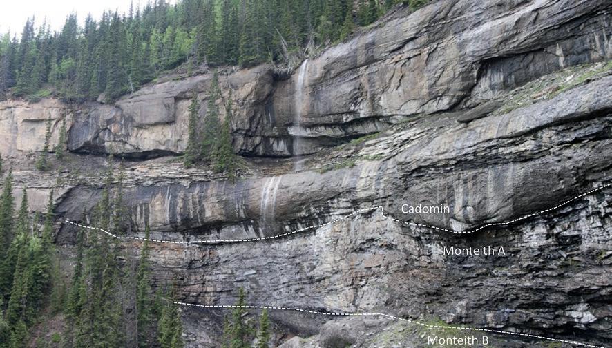
Monteith B, A intervals, and the Cadomin Formation (view from outcrop 3). The Monteith A is comprised of trough cross bedded chert rich sediment derived from a fluvial system that sourced the uplifting Cordillera. The Cadomin unconformably overlies the succession and is composed of chert rich conglomerate, representing a time in which pebble to boulder size sediment was being deposited in the basin from mountains to the west.
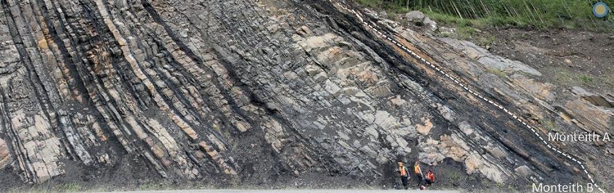
Monteith B exposure consists of thinly bedded sandstone, siltstone and coal deposits. This
near
attributed to
Paleogeographic interpretation of the Monteith Formation. Left figure – Monteith C and B, with presumed outcrop localities indicated. Right figure – Monteith A (Raines et al. 2013).
REFERENCES
Kukulski, R.B., Hubbard, S.M., Moslow, T.F., and Raines, M.K., 2013, Basin scale stratigraphic architecture of upstream fluvial deposits: Jurassic-Cretaceous foredeep, Alberta Basin, Canada. Journal of Sedimentary Research, v. 83, p. 704-722.
Miles, B.D., Kukulski, R.K., Raines, M.K., Zonneveld, J.P., Leier, A.L., and Hubbard, S.M. 2012. A stratigraphic framework for Late Jurassic–Early Cretaceous gas-bearing strata (Monteith Formation) in the subsurface of northwest Alberta. Bulletin of Canadian Petroleum Geology, v. 60, p. 3-36.
Raines, M.K., Hubbard, S.M., Kukulski, R.B., Leier, A.L., and Gehrels, G.E. 2013. Sediment dispersal in an evolving foreland: Detrital zircon geochronology from Upper Jurassic and lowermost Cretaceous strata, Alberta Basin, Canada. Geological Society of America Bulletin, v. 125, p. 741-755.
22 RESERVOIR ISSUE 10 • NOVEMBER 2014
The
succession is
coastal plain deposition with small sandstone filled channels and finer grained overbank deposits. The Monteith A contact is present
the right hand side of this photo. The Cadomin is not exposed along the road cut, but is present in the forest on the top of the road cut.


RockWell Consulting


Data Magnetic & Gravity data for the Western Canadian Basin John W. Peirce, P. Geo. Chief Geophysicist www.chad-data.com 250.616.6914 Wellsite Geologists Inc. the Rock Solid Choice
Project
Graphic
Profiles Verticals
Sample
Core Studies
ROCK SHOP CHAD
Wellsite Supervision
Management
Well
/ Horizontals EUB
/
Conventional / Un-conventional 1350, 734 - 7th Ave SW Calgary, AB T2P 3P8
petrographical
sedimentological descriptions for samples
section
conventional vertical/horizontal wells
IN GEOLOGICAL WELLSITE SUPERVISION
ANALYSIS
B 403.234.7625, www.WellsiteGeologists.com C 403.660.9883, info@WellsiteGeologists.com
&
(thin
- fluid inclusion studies)
operations geology SPECIALIZED
AND CORE
our best friend and most valuable partner is our client Stephan C. Dragomir president www .g e ok2. c om - phon e : 403.831.9941 - s dr a gomir @ g e ok2. c o m
Domestic and International wellsite supervision • Conventional and Unconventional wells
Extensive Hz experience
Customized corporate solutions available (403) 250-3982 sales@clconsultants.ca www.clconsultants.ca
•
•
•
GET MORE DATA FROM CUTTINGS – Tools to Aid East Coast Exploration
| By Ceri Roach, Dr. David Riley, Dr. Tim Pearce, Chemostrat Ltd.
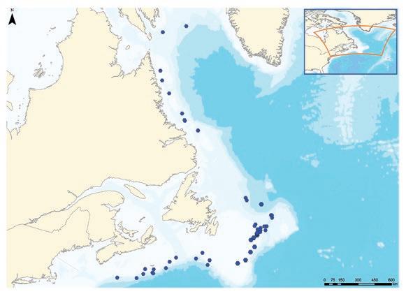
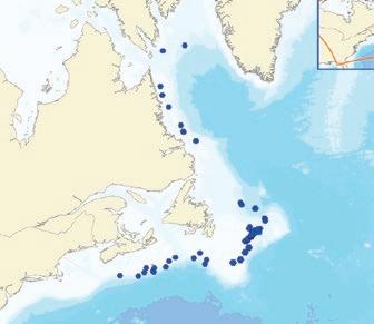
The Canadian Atlantic has undergone various stages of exploration activity especially on the Grand Banks and along the Nova Scotian margin. However, due to advancements in seismic data acquisition and deepwater drilling technology, along with recent discoveries, exploration interests have extended along the entire margin and into deepwater blocks offshore Nova Scotia, Newfoundland and Labrador.
Chemostrat Ltd has produced a report detailing a chemostratigraphic study undertaken on the Jurassic, Cretaceous and Lower Paleogene successions encountered by thirteen wells located in the Grand Banks area, offshore Newfoundland (Figure 1). The study represents the first phase of a larger chemostratigraphic investigation being undertaken on a series of basins along Canadian Atlantic margin. This includes the wells from offshore Nova Scotia and Laurentian Basins (total of 14 wells), with an additional twelve wells from the Grand Banks / Carson Basin. Furthermore, analysis is underway in the Hopedale and Saglek Basins (10 wells). Chemostrat also published data on the stratigraphy and volcanic geochemistry of wells from the Saglek Basin (Roach et al. 2010) while, Chemostrat and PetroStrat Ltd are completing a major stratigraphic re-evaluation (biostratigraphy and chemostratigraphy) of a series of wells in the Porcupine Basin that will eventually be integrated with Canadian margin data.
Overall, reliable biostratigraphic and lithostratigraphic schemes have been established for the Mesozoic and Cenozoic successions occurring in the Grand Banks area and along the Scotian margins, but nevertheless disagreements still arise concerning the resolution of the stratigraphy, especially in the Lower Cretaceous / Jurassic of certain well sections. Moreover, the challenging environmental factors associated with drilling in the Canadian Atlantic margin add to the overall cost of exploration, thus the regional geology of the area needs to be clearly understood in order to maximise drilling operations. With these points in mind, Chemostrat has undertaken a study to erect a chemostratigraphic correlation framework for the aforementioned successions, which would also generate useful information about their provenance and depositional environments. The results
of these studies will also provide a refined stratigraphic framework to constrain existing published and new provenance datasets to ground truth sediment dispersal mapping.
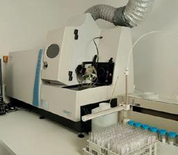
The strategy behind studies has been to geochemically characterise the sand successions, then erect chemostratigraphic zonations for each of the study intervals based on up-sequence variations in the geochemistry of the laterally extensive siltstones and silty claystones. In addition, closely spaced samples are analysed through potential reservoir sections. In the case of the Phase 1 Grand Banks study, two thousand and thirty-four cuttings samples have been collected from the thirteen study wells (average spacing of ten metres). All samples have been analysed by inductively-coupled plasma - optical emission spectrometry (ICP-OES) and inductively-coupled plasma - mass spectrometry (ICP-MS) techniques, resulting in inorganic geochemical data being acquired for fifty elements.
To give an indication of the results obtained by these studies, the findings of the Phase 1 Grand Banks study are: Establishment of a hierarchical chemostratigraphic zonation, with Mega-sequence MS1, MS2 and MS3 being the equivalent of the
Jurassic, Cretaceous and Palaeogene strata respectively. Furthermore, Mega-sequences MS1 and MS2 have each been divided into five chemostratigraphic sequences termed Sequences S1 to S10. Sequences S1 to S4 and S7 to S9 have been further divided into third order chemostratigraphic divisions called packages, with twenty packages in total being identified, most of which can be correlated across the study area, though some remain locally constrained. Chemostrat suggests the geochemical characteristics on which the chemostratigraphic zonations and correlations are founded reflect variations in the abundance of heavy, clay and carbonate minerals and organic matter, which themselves are linked principally to changes in provenance and depositional environment. Based on lateral variations in the geochemical data related to the heavy mineral assemblages, Chemostrat are able to make some conclusions on possible provenance changes and sediment input paths active during the deposition of the Jurassic and Cretaceous strata. Furthermore, the reports demonstrates how U associated with organics can be partitioned from detrital sources and used to predict TOC distributions throughout entire wells sections, highlighting that TOC abundance is generally low throughout the
(Continued on
24 RESERVOIR ISSUE 10 • NOVEMBER 2014
page 27...)
Figure 1.
East coast Canada non-exclusive reports
Reports are completed on the North Grand Banks and in the Saglek Basin and studies are underway in the Scotian, Laurentian, South Grand Banks, Carson and Hopedale Basins.
The studies are based on high resolution ICP based chemostratigraphic data that are used to construct an independent stratigraphic correlation framework (tied to biostratigraphic data where avaliable) that can be used to support/enhance seismic correlations.
In addition, to correlation, the high resolution elemental data can be used to provide an assessment of cuttings quality, to construct mineralogical and TOC logs for wells sections for petrophysical log calibration and provenance data to ground truth palaeoenvironmental maps.
For further details on any of these studies please call: Gemma Hildred 403-463-8188 email: gemmahildred@chemostrat.com or Ceri Roach +44 1938 555 330 email: ceriroach@chemostrat.com
CHE MOSTR AT
Chemostrat Canada Ltd. 144-4 Avenue SW, Suite 1600, Sun Life Plaza, West Tower, Calgary,
403-463-8188 e CAoffice@chemostrat.com www.chemostrat.com A library of more than 30 non-exclusive Regional Studies
Alberta, T2P 3N4 t

CSPG & geoLogic Systems Ltd.
Present the
Annual Holiday Social & Technical Luncheon
Tuesday December 9th, 2014
Wine & Appetizers: 10:30 - 11:30 am
Technical Luncheon: 11:30 - 1:00 pm

Technical Luncheon :
Title: The Marble Canyon fossil deposit, a new “Burgess Shale” treasure-trove from Kootenay National Park
Speaker: Jean-Bernard Caron, Department of Natural History, Royal Ontario Museum
Tickets are available at www.cspg.org
(...Continued from
Cretaceous successions, but high in a series of horizons in the Jurassic and also in the Paleogene in some wells.
It is important to note that chemostratigraphic data can be acquired from Hand-Held XRF, bench top XRF and highly accurate ICPs but the resolution of the data and the quality of any correlations will be influenced significantly by the analytical protocol employed. Chemostrat can provide all of these analytical options, but recommends the use of ICP to provide clients with the highest data quality. This ensures that data initially collected for chemostratigraphic correlation can be used as a resource for data modelling initiatives. For example, Chemostrat can
use this data to assess cuttings quality, to construct mineralogy logs (avoiding the need for expensive and time consuming XRD analysis – following initial calibration mineral modelling method using a training set of elemental and XRD data), TOC proxies from elemental data and assessment of changes in sediment provenance which can be targeted for further forensic analysis. Furthermore, Chemostrat’s ICP lab has the capability to analyse >3000 samples per month, which ensures that chemostratigraphic correlations based on the highest quality of elemental data can be generated for a large number of wells. The speed of this workflow contrasts with the throughput for detailed biostratigraphic analysis which is a much more protracted process. However, Chemostrat propose
PHOTO OF THE MONTH
an integrated approach and the results from the Irish study and the Phase 1 Grand Banks and Scotian wells have employed biostratigraphic data to ground truth chronostratigraphic significance of the chemostratigraphic correlations. As a result, once validated, chemostratigraphy can be applied to a large number wells far more quickly than biostratigraphy providing a basin wide correlation within a few months providing operators the means to test and validate seismic correlations with well bore data. In addition, the ability to use the elemental data for mineralogy and TOC prediction and test provenance models means that large seismic service companies and operators alike can ground their paleoenvironmental models.
RESERVOIR ISSUE 10 • NOVEMBER 2014 27
The Sulphur Gates – Grande Cache Alberta. The Cadomin Formation thrust almost vertical at the Sulphur gates. The Smokey River has eroded through the near vertical conglomerate sheet as it flows in from the Wilmore Wilderness to the West. Photo by: Chris Steudler.
page
25)
10K & 5K Road Race and Fun Run, Sept. 17, 2014
| By Armin Schafer, Race Director
This race was originally scheduled for Sept. 10th, but a massive dump of wet snow broke branches all over the pathway and left the Calgary Curling Club without power. I had no choice but to cancel and try again next week. The 26th annual CSPG/CSEG/CAPL road race and fun run took place along the Bow River Pathway one week later on Sept. 17th with perfect sunny 20deg C weather. An enthusiastic group of 101 runners finished the race. We lost a few runners due to the move back a week (158 were actually registered to run). This year the 5K had 44 runners, while the 10K had 57 runners.
The route was the same as last year, where we had runners cross over the river to the north pathway at the Crowchild Bridge underpass and continue west on the North side of the river, as clean up after the floods last year was still not completed. Our race volunteers, decked out in bright orange safety vests, aided the runners in negotiating the route. Once again distances were marked uniquely in geologic time to assist, or perhaps confuse, the participants. Like every year it’s great to see a mix of competitive and first time runners. Start Line Timing once again provided timing with the race chip mounted conveniently on the runners’ race bib. To see individual times, please go to http://www.startlinetiming. com/races/2014/cspg/index.php.
We returned to The Calgary Curling Club for the post race awards party, where the mix of racers and volunteers enjoyed plenty of cold beverages and a pasta dinner. The evening was topped off with door prizes, awards and of course our now infamous sock- toss. Through great sponsorship and strong participation, we are once again able to contribute to our designated charity the YMCA strong kids foundation!
I would like to thank all the volunteers and sponsors who helped make this event a success! We have acknowledged our sponsors on a separate page. Thank you also to all the runners. It was a pleasure cheering you in at the finish line.
Finally a huge thank-you to our group on the committee that made this all work: Jocelyn Frankow, Tina Donkers, Shirley Fleming, Dan Cicero, Chris Savels, Tim
Burk, Baltej Sidhu, Tammy Willmer, Shawna Christensen and Kelsey Thompson at the CSPG office. As well, thanks to Nick Wiggins and the staff at the Eau Claire YMCA for their continued hospitality.
For more information on category winners, run times and placement, please see http:// www.startlinetiming.com/races/2014/cspg/ index.php
We look forward to seeing you next year for the 27th annual; race date will be Wednesday, September 23, 2015.
Thank you. Armin Schafer, Race Director (aschafer@ikonscience.com)
RESERVOIR ISSUE 10 • NOVEMBER 2014 29
ANNUAL CSPG/CSEG/CAPL
26TH
HERE’S A SUMMARY OF THE CSPG, CSEG AND CAPL WINNERS: OVERALL TOP MALE 10K RESULTS Place Gun Time Race # Div Name Member 1 38:20 74 M-U30 Dylan CHILDS CSPG 2 38:40 110 M-U30 Justin KANGARLOO CAPL 3 39:53 113 M30-39 John LAUGHTON CSPG 4 40:21 62 M-U30 Gabriel ALTEBAEUMER CSPG 5 41:10 76 M3039 Dan CICERO CAPL OVERALL TOP FEMALE 10K RESULTS Place Gun Time Race# Div Name Member 1 43:48 109 F3039 Rhonda JEWETT CSEG 2 45:59 133 F-U30 Holly RATZLAFF CSPG 3 47:26 149 F3039 Erin LINLEY CSPG 4 47:35 77 F3039 Stephanie CICERO CAPL 5 49:21 90 F3039 Sara DOBEK CSEG OVERALL MALE 5K RESULTS Place Gun Time Race # Div Name Member 1 19:08 435 M3039 Franck DELBECQ CSEG 2 20:59 433 M3039 Troy DASHKEWYTCH CAPL 3 21:44 486 M4049 Allan CARSWELL CSPG 4 21:47 450 M-U30 Davin HERTZ CSEG 5 23:35 439 M4049 Curtis EVANS CSPG OVERALL FEMALE 5K RESULTS Place Gun Time Race # Div Name Member 1 21:52 119 F-U30 Maryse L’HEUREUX CSPG 2 22:22 441 F4049 Shirley FLEMING CSEG 3 25:46 478 F-U30 Nicole BALERUDE CAPL 4 25:55 466 F-U30 Julianne FIC CSPG 5 28:07 443 F5059 Jocelyn FRANKOW CSEG
CORPORATE SUPPORTERS
Cougar Consultants, Inc.
Sensor Geophysical Ltd.
Exova Canada Inc
Advanced Flow Technologies
Enviro-Tech Surveys Ltd
EV Cam Canada Inc.
McDaniel & Associates Consultants Ltd.
Serpa Petroleum Consulting Ltd.
Pulse Seismic Inc
Canada Brokerlink Inc.
Energy Navigator
Golder Associates
Sigma Explorations
Apache Carbon Management Canada
Saudi Aramco
EDGE Technologies
Target Data Ltd.
GeoSpace Technologies
Compass Directional Services
Canacol Energy Ltd.
Explor
Japan Canada Oil Sands Ltd.
Sproule International Limited
Petrocraft Products Ltd.
Spectrum
Datalog Technology Inc.
Birchcliff Energy Ltd.
Cabra Enterprises Ltd.
SAExploration
Glacier Exploration Surveys
Matrix Solutions Inc.
National Oilwell Varco
Cossack Land Services Ltd.
Deloitte Petroleum Services Group
EPI Group
FMQ Southern Exploration
GeoChemTech Inc.
Geotir
Hurry Hydrocarbons
Matrix Geoservices Ltd.
Maxam Seismic Explosives
Osum Oil Sands Corp.
Petrel Robertson Consulting Ltd.
Statcom Ltd.
Trident Exploration
HEF Petrophysical Consulting Inc.
Sourcex
Caracal Energy Inc.
Regent Resources
Bankers Petroleum Ltd.
BJV Exploration Partnership
SOCO International
Roxar Little Rock Document Services
3e Royalties
Bengal Energy
Bounty Developments Ltd.
Brasoil Corp.
Bukit Energy
Central European Petroleum Ltd
DualEx Energy International
Franconia Geoscience
Gran Tierra Energy Inc.
International Petroleum Consulting
Jenner Geoconsulting Inc.
Korean National Oil Company
Long Reach Resources Ltd.
Lorne LeClerc & Associates
Madison Petrogas Ltd.
Petroamerica
Serinus Energy
Sherritt International Corporation
Skyhawk Exploration
Tretio Exploration Ltd.
Valeura Energy AS
HONORARY MEMBER –JOHN HOGG
John Hogg earned his B.Sc. in geology from McMaster University in 1981 and joined CSPG the next year, where he has been an active volunteer ever since. He started working with the Publications Marketing Committee in 1982 and was Chair from 1986 through 1989 and also worked on the 1985 Mesozoic of North America Conference for the Society. From 1993 to 1995, he was on the Bulletin Committee as a member and Associate Editor. Mr. Hogg earned his first President’s Award in 1995. Next, he was the General Chair for Convention Pools ’96, and from 1997 through 2001 he was Co-Chair of the Luncheon Committee. In 2001, he was given an Award for Best Paper at Convention. 2002 saw Mr. Hogg acting as both Executive Vice President and Educational Trust Fund Vice President. He was President in 2003, and Convention Chairman of AAPG ICE in 2005. John won 4 Awards in 5 years: a Volunteer Award and President’s Award in 2005, a Volunteer Award in 2007 and a Service Award in 2010. During this time, he was a Member and Chair of the Stanley Slipper Gold Medal Committee, Educational Trust Fund Director and the General Chair of the AAPG International Convention which was in Calgary in 2010. In 2012, he earned another Service Award for these additional achievements.
Mr. Hogg worked just as hard at non-CSPG work. He has been an active member of AAPG since 1982 and during that time, earned a Leverson Award for Best Paper (2000), Distinguished Service Award (2002), an Honorary Membership (2010), and was General Chairman of the AAPG International Conference Committee from
2006 through 2009. As well, he is has been active with APEGA, serving on their Council from 2007 through 2012, and with Geoscientists Canada as a Director from Alberta from 2011-2013 and has served on CAPP’s Atlantic Canada and Northern Canada Executive Policy Groups. His work has won him President’s awards from PanCanadian and Encana and a Distinguished Alumni Award from McMaster’s University.
John’s career is just as illustrious. He started with Gulf Canada in 1981 as an Exploration Geologist focusing on the Arctic Island. In 1984, he moved to Husky as a Senior Exploration Geologist, responsible for monitoring and drilling offshore wells. As a Team Lead/Specialist at Petro-Canada from 1988 to 1997, he was charged with charged with rejuvenating the company’s exploration position on the Grand Banks of Newfoundland. In 1997, he joined PanCanadian/Encana as the Vice President of Atlantic Canada Exploration, where he was accountable for all Atlantic Canada exploration and the supervision of a staff of 40. He and his team were responsible for the Deep Panuke gas discovery in 1998, and the redevelopment of the Cohasset and Panuke oilfields. John moved to a similar role new venture role at Burlington Resources in 2005, and stayed with the company after it became ConocoPhillips Canada, managing a large multidisciplinary staff and building a portfolio of new plays in the Arctic, Atlantic and Western Canada. John now works for MGM Energy as a Vice President of Explorations and Operations, where he manages a multidisciplinary staff, regularly presents on Investor Relations road shows and is a company spokesman, particularly with government officials.
John has more than thirty years of experience in exploration, operations, development geology, leadership, and business management. He is a strong geoscientist, always optimistic, a broad thinker, a natural leader and above all passionate about his science and profession. His lifelong commitment to volunteering has bettered both CSPG and the industry at large, and we are pleased to award John Hogg Honorary Membership status.
OF OCTOBER 3, 2014 30 RESERVOIR ISSUE 10 • NOVEMBER 2014


SPONSORED BY: Hyatt Regency Calgary Hyatt Regency Calgary March 31, 2015 March 2015 Produced by Geoscientists for Geoscientist's, the Playmaker Forum brings wellknown, successful and distinguished Canadian speakers together for a day of unparalleled discussion. Register now at www.cspg.org or by calling 403-513-1233 Speakers include: David Gardner Michael McDonough Lee Krystinik (AAPG Past-President) Dale Leckie (CSPG President) Your ticket includes:
Complimentary networking lunch at the Hyatt Regency with a Q&A forum with Dr.
Paramount Resources)
Up
appetizers and refreshments will be served Join AAPG President-Elect John Hogg as the Playmaker Forum makes its Canadian debut!
Clay Riddell (OC, CEO
White Hat Round-
Reception;
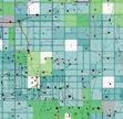
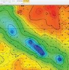

IHS Energy
IHS ENERGY
From reservoir characterization to production optimization, IHS continues to be your trusted partner in making the right decision for your investments.
Geoscience
Surface to subsurface, IHS is the world’s leading provider of information, insight and analytics supporting technical and strategic decisions throughout the energy asset value chain.
From big picture to critical detail, proven capabilities to superior results, IHS geoscience software does it all—backed by the world’s most respected forecasting, analysis and play-specific geological and geophysical data.
IHS is the only company that effectively combines high quality critical information with powerful analytical tools to enable you to make accurate technical and business decisions throughout the energy value asset chain. Whether you are investing in conventional or unconventional sources, leverage your partnership with IHS to maximize your investment, accelerate your time to market, and reduce risks. Get to the right decision faster with IHS.
TO LEARN MORE, PLEASE VISIT WWW.IHS.COM/GEOSCIENCE
To learn more, please visit IHS.com/energy
6154-0614TS
