

“AccuMap encompasses speed, stability, efficiency and accuracy. As an intuitive and easy-to-use product, AccuMap serves a broad audience, from field users to the CEO.”
Darrel Saik Senior Geological Technologist Paramount Energy Trust
AccuMap is the most widely used and highly trusted oil and gas mapping software touching every segment of E&P, for every professional.


www.ihs.com/energy
Call toll free 1 877 495 4473


CSPG OFFICE
#600, 640 - 8th Avenue SW
Calgary, Alberta, Canada T2P 1G7
Tel: 403-264-5610 Fax: 403-264-5898
Web: www.cspg.org
Office hours: Monday to Friday, 8:30am to 4:00pm
Business Manager: Tim Howard
Email: tim.howard@cspg.org
Membership Services: Kristina Keith
Email: kristina.keith@cspg.org
Communications & Public Affairs: Heather Tyminski
Email: heather.tyminski@cspg.org
Corporate Relations: Kim MacLean
Email: kim.maclean@cspg.org
Conventions & Conferences: Shauna Carson
Email: shauna.carson@cspg.org
Conventions & Conferences Assistant: Tanya Santry
Email: tanya.santry@cspg.org
Reception: Dayna Rhoads
Email: reception@cspg.org
EDITORS/AUTHORS
Please submit RESERVOIR articles to the CSPG office. Submission deadline is the 23rd day of the month, two months prior to issue date. (e.g., January 23 for the March issue).
To publish an article, the CSPG requires digital copies of the document. Text should be in Microsoft Word format and illustrations should be in TIFF format at 300 dpi., at final size. For additional information on manuscript preparation, refer to the Guidelines for Authors published in the CSPG Bulletin or contact the editor.
Technical Editor
Ben McKenzie
Tarheel Exploration
Tel: 403-277-4496, Email: bjmck@telusplanet.net
Coordinating Editor
Heather Tyminski
Comunications and Public Affairs, CSPG
Tel: 403-513-1227, Email: heather.tyminski@cspg.org
ADVERTISING
Kim MacLean
Corporate Relations, CSPG
Tel: 403-513-1229, Email: kim.maclean@cspg.org
Advertising inquiries should be directed to Kim MacLean. The deadline to reserve advertising space is the 23rd day of the month, two months prior to issue date. All advertising artwork should be sent directly to Kim MacLean.
The RESERVOIR is published 11 times per year by the Canadian Society of Petroleum Geologists. This includes a combined issue for the months of July/August.
Advertisements, as well as inserts, mailed with the publication are paid advertisements. No endorsement or sponsorship by the Canadian Society of Petroleum Geologists is implied. The contents of this publication may not be reproduced either in part or in full without the consent of the publisher.
Design & Layout by Sundog Printing. Printed in Canada by Sundog Printing.
Spend more time making decisions and less time managing data.
PETRA provides geoscientists and engineers the analysis tools needed for today’s exploration and exploitation challenges
IHS Enerdeq Desktop and IHS AccuMap directly export well and production data into PETRA projects
For the first time raster logs from IHS AccuLogs are available in PETRA for use with digital log data
Download a trial version at ihs.com/energy/petra


For more information visit: energy.ihs.com/petra


CSPG EXECUTIVE
PRESIDENT
Lisa Griffith • Griffith Geoconsulting Inc. lgriffith@griffithgeoconsulting.com Tel: (403) 669-7494
VICE PRESIDENT
Graeme Bloy • West Energy Ltd. gbloy@westenergy.ca Tel: (403) 716-3468
PAST PRESIDENT
Colin Yeo • EnCana Corporation colin.yeo@encana.com Tel: (403) 645-7724
FINANCE DIRECTOR
James Donnelly • ConocoPhillips Canada james.donnelly@conocophillips.com Tel: (403) 260-8000
ASSISTANT FINANCE DIRECTOR
David Garner • Chevron Canada Resources davidgarner@chevron.com Tel: (403) 234-5875
PROGRAM DIRECTOR
Randy Rice • Suncor Energy Inc. rjrice@suncor.com Tel: (403) 205-6723
SERVICE DIRECTOR
Jen Vezina • Devon Canada Corporation jen.vezina@devoncanada.com Tel: (403) 232-5079
ASSISTANT SERVICE DIRECTOR
Ayaz Gulamhussein • NuVista Energy Ltd. Ayaz.gulamhussein@nuvistaenergy.com Tel: (403) 538-8510
OUTREACH DIRECTOR
Greg Lynch • Shell Canada Limited greg.lynch@shell.com Tel: (403) 691-2052
ASSISTANT OUTREACH DIRECTOR
Mike DesRoches • DesRoches Consulting Inc. mdesroch@shaw.ca Tel: (403) 828-0210
COMMUNICATIONS DIRECTOR
Peggy Hodgkins • CGGVeritas peggy.hodgkins@cggveritas.com Tel: (403) 266-3225
CORPORATE RELATIONS DIRECTOR
Monty Ravlich • Sanjel Corporation mravlich@sanjel.com
A message from the President, Lisa Griffith
This
A year to celebrate the earth sciences and reach out with our profession. This is also a great year for the CSPG to focus on how we can effectively reach out across Canada. There are ramifications for the prioritization, organization, and financing of our programs, volunteers, and support staff.
Over the last year, as your vice-president, I have had the privilege of attending several collaborative national meetings that have made me aware of opportunities to share, refocus, and renew our role within the broader Canadian geological community. Now, as your President, I’m looking forward to taking steps to steering the society toward fulfillment of the “Canadian” part of our name.
This is completely in line with the Society goals published in 2005, which include: “advocate a positive national image of our profession emphasizing the role and contributions of petroleum geoscientist to society; nurture a sense of pride and community for all Canadian petroleum geoscientists; and become indispensable to petroleum geoscientists and employers in Canada.” Together with an enthusiastic and energetic board, Colin Yeo, our experienced and supportive past president, and advice from the past president community, I’d like to take steps to consolidate our national presence.
Before this board can focus on strategic goals, however, we have work to do to get our financial and operational house in order. For the first time in many years, the CSPG is running very close to the profit/loss margin as reported to you at our AGM in January. Our Finance Director will address this situation in detail in his column in the March Reservoir
In addition, the office staff is dealing with unforeseen challenges: first Tim Howard (our Business Manager for the last 12 years), then Kim MacLean (our Corporate Relations
Manager for the last five years), have been out of the office on overlapping extended medical leaves. Fortunately, they are both on their way to recovery. During their absence, the remaining office staff has been doing the best it can, and is to be commended for its exceptional efforts. Meanwhile, we have some operational catching up to do.
Moving from the day-to-day to the long term: Why target the national issue? Because if we can build bridges (or is that build a national railroad?) to our professional brethren across the country, we will benefit from a much broader range of knowledge, opportunities, and talent. We can lobby for strategic issues important to the earth science community with a Canada-wide viewpoint and support. We can more effectively reach out to the general public to share the importance of the earth sciences in general and the petroleum industry in particular.
There is another side to this initiative: use it or lose it. At a recent Canadian Federation of Earth Sciences meeting in Toronto (CFES is the umbrella organization for Canadian earth sciences), I was surprised to find common concern regarding the successful competition from American geotechnical societies for Canadian members from at least two nonpetroleum societies. If we don’t take active steps to make our societies vibrant and important representatives of the earth sciences in Canada, we may wake up one day to find our members have trickled away as a result of our apathy and lack of vision.
Where do we start? First, we need to decide what we want to accomplish with input from the petroleum geologists we intend to reach. Shared knowledge? Recruitment and mobility of geoscientists and students? Greater awareness of petroleum geology and its role and impact across Canada? More Canadian-built field trips and courses? Currently, the CSPG creates webcasts of (Continued on page 7...)
Choose from over 50 exciting field seminars and short courses all designed with the goal of helping you explore and better understand your industry. For complete details on any of the field seminars and short courses offered by the AAPG, call +1 918 560-2650 or visit http://www.aapg.org/education/
Decision Methods And LNG Value Chain Management
March 1 – 2, 2008
Manama, Bahrain, in conjunction with GEO-2008 Meeting
William Haskett & Deborah Resley, Decision Strategies Inc., Houston, TX
(Note: Registration handled thru GEO-Bahrain website, NOT AAPG. Go to http://www.geobahrain.org/ for complete meeting and registration information)
Basic Petroleum Geology for the Non-Geologist
A joint course with AAPG and The University of Tulsa Continuing Engineering and Science Education Department
March 25-27; April 15-17, 2008
Oklahoma City, OK (March); Houston, TX (April)
Norman Hyne, The University of Tulsa, Tulsa, OK http://www.aapg.org/education/shortcourse/details.cfm?ID=26
Principles of Reservoir Characterization
April 7-8, 2008
Houston, TX
Jeffrey Yarus, Landmark Graphics Corp., Houston, TX http://www.aapg.org/education/shortcourse/details.cfm?ID=105
Risk Analysis and Decision-Making in E & P:
From Evaluating Plays and Prospects To Efficient Appraisal and Development
April 19-20, 2008
San Antonio, TX, with AAPG Annual Meeting
P. Jeffrey Brown, Decision Strategies, Inc., Oak Ridge, TN; Patrick Leach, Decision Strategies Inc., Missouri City, TX http://www.aapg.org/education/shortcourse/details.cfm?ID=68
Deepwater Clastic Deposits
March 17-21, 2008
Begins and ends in Little Rock, AR
Roger M. Slatt, Director, Institute of Reservoir Characterization, University of Oklahoma, Norman, OK; Charles G. Stone, Arkansas Geological Commission (ret.), Little Rock AR; Robert Davis, Schlumberger Oilfield Services, Oklahoma City, OK http://www.aapg.org/education/fieldseminars/details.cfm?ID=10
Deep-Water Siliciclastic Reservoirs, California
April 13-18, 2008
Begins in Palo Alto and ends at the airport in San Francisco, California
Stephan Graham and Donald R. Lowe, Stanford University, Stanford, CA http://www.aapg.org/education/fieldseminars/details.cfm?ID=17
Clastic Reservoir Facies and Sequence Stratigraphic Analysis of Alluvial Plain, Shoreface, Deltaic, and Shelf Depositional Systems
April 2008. Check website for latest scheduling details.
Begins and ends in Salt Lake City, Utah
Thomas A. Ryer, The ARIES Group, LLC, Katy, TX
http://www.aapg.org/education/fieldseminars/details.cfm?ID=9
For more info or to enroll call +1 918 560-2650 or visit http://www.aapg.org/education/
More science than you can shake a pick at.


ABU DHABI OIL CO., LTD. (JAPAN)
APACHE CANADA LTD.
BAKER ATLAS
BG CANADA EXPLORATION & PRODUCTION, INC.
BP CANADA ENERGY COMPANY
CANADIAN FOREST OIL LTD.
CANETIC RESOURCES TRUST
CONOCOPHILLIPS CANADA
CORE LABORATORIES CANADA LTD.
DEVON CANADA CORPORATION
DOMINION EXPLORATION CANADA LTD.
DUVERNAY OIL CORP.
ENERPLUS RESOURCES FUND
FUGRO AIRBORNE SURVEYS
geoLOGIC systems ltd.
GRIZZLY RESOURCES LTD.
HUNT OIL COMPANY OF CANADA, INC.
HUSKY ENERGY INC.
IHS
IMPERIAL OIL RESOURCES LIMITED
LARIO OIL & GAS COMPANY
MJ SYSTEMS
MURPHY OIL COMPANY LTD.
NEXEN INC.
PENN WEST PETROLEUM LTD.
PETRO-CANADA OIL AND GAS
PETROCRAFT PRODUCTS LTD.
PRIMEWEST ENERGY TRUST
PROVIDENT ENERGY LTD.
RPS ENERGY CANADA LTD.
SHELL CANADA LIMITED
SPROULE
SUNCOR ENERGY INC.
TAQA NORTH LTD.
TALISMAN ENERGY INC.
TOTAL E&P CANADA LIMITED
WEATHERFORD CANADA PARTNERSHIP
AS OF DECEMBER 24, 2007
(...Continued from page 5)
technical luncheon talks, and our Outreach does a good job at the student level. How can we add to these programs?
Secondly, we need to consider which initiatives to tackle alone, and on which ones we collaborate. Potential partners could include other local geoscience societies rooted in the petroleum business, nationally based societies in other sectors, and internationally positioned societies such as the AAPG.
Locally, the CSPG already shares many of our local triumphs and trials – as well as employers – with our sister societies here in Calgary, such as the CSEG and CWLS. We share office space with the CSEG, and the CSPG is in the midst of signing agreements to hold ongoing joint annual conventions with them. Additionally, we are adapting the CSEG “Doodletrain” education week to offer geologists a concentrated week of courses. Are there common national goals we can pursue?
Nationally, CFES is bringing together earth science societies from the resource, academic, government, and environmental sectors. Possible alliances to share Student Chapters with other technical societies like the Prospectors and Developers Association of Canada (PDAC), and the Geological Association of Canada (GAC), for example, are being discussed. Similar cooperative efforts may include cross-Canada visiting lecturers, a national lobbyist in Ottawa, and shared efforts to put earth sciences into a more prominent place in the public school curriculum.
On the regulatory side, the Canadian Council of Professional Geoscientists (CCPG) is working with the provincial registrars to ensure that a geoscience professional admitted to practice in Newfoundland can move to British Columbia and start work without having to re-qualify. The CSPG was invited to provide input as a stakeholder. As you can see, the CSPG has a voice in national forums which have the potential to make a difference to earth sciences. Ideally, there can be economies of scale and shared expenses. Duplication of effort can be reduced by sharing expertise and experience. The CSPG can and should bring ideas to these tables. Internationally, we are both fortunate and challenged to have easy access to many excellent American geoscience societies. We share similar geology and a similar industry with our American neighbours. Last year, the AAPG approached the CSPG with a proposal to share office space in Calgary (it is still
being discussed). Many geologists in Calgary hold memberships in both organizations and attend AAPG-sponsored courses. We have hosted many AAPG conventions in Calgary. The truth is the AAPG does a superb job of marketing courses and field trips, attracting publications, maintaining an international presence, and raising money. For both political and strategic reasons, we need to remain independent. Can we learn from them and potentially partner with them without becoming just a ‘Canadian Region’ of the AAPG?
Finally, let me acknowledge that reaching across Canada will inevitably impact our budget, volunteers, and staff. Yes, I need buy-in from my board. For that matter, I’d welcome feedback from the members, too. The CSPG has an operating budget of around $2.5M, financed primarily with money from the annual conference, memberships, courses and field trips, and the Reservoir. We have many vibrant local programs to support. Let’s deploy our society’s resources wisely and efficiently, with a vision for the future. This year, let’s celebrate the planet earth and broaden the role of petroleum geology across Canada.
PRACTICAL DST CHART INTERPRETATION
(Thorough Basic Course) Apr. 14-18, 2008
16 WAYS TO IDENTIFY BYPASSED PAY FROM DST DATA
(More advanced, for those “comfortable” with DST charts) Apr. 22-23, 2008
(Oil & Gas Finding Aspects) Apr. 28 - May 2, 2008
In-house courses available. For course outline visit: www.hughwreid.com
262-1261
Is the modern Belize carbonatesiliciclastic shelf an appropriate analog for exploration and development of Western Canada Devonian reservoirs?
SPEAKERS
Burr Silver
Olympic Exploration and Production
Nigel Watts, EnCana
CO-AUTHOR
Bill Martindale
W. Martindale Consulting
11:30 am
Tuesday, February 12, 2008
Telus Convention Centre Calgary, Alberta
Please note: The cut-off date for ticket sales is 1:00 pm, Thursday, February 7, 2008. Ticket Price: $34.00 + GST.
Due to the recent popularity of talks, we strongly suggest purchasing tickets early, as we cannot guarantee seats will be available on the cut-off date.
Modern clastic and carbonate settings of Belize are often used as analogs for Devonian sequences in the Western Canada Sedimentary Basin (WCSB) but are these analogs valid? Despite differences in age, components, and regional setting, we believe they are but as with any modern analog, should be used with caution.
The Belize shelf consists of coastal clastics and a lagoon/barrier-reef/atoll complex. Coastal clastics are derived from late Silurian granites and Pennsylvanian-Permian meta-sediments of the Maya Mountains. East-flowing rivers transport coarse-grained feldspathic sands from the Mayas to the coast where they are moved south by longshore currents. Middle Devonian analogs include terrigenous delta plain complexes that are closely associated with carbonates that fringe the Peace River Arch.
sponsored by
Between the Belizean coast and the barrier reef are hundreds of individual reefs. These range from a few metres thick near the coast to nearly 30 m thick near the barrier and are constructed primarily of bulbous and branching corals. Analogous shelf reefs, constructed almost entirely by stromatoporoids, occur in the Beaverhill Lake, Leduc, and Nisku of western Canada.
The Belize barrier reef forms the eastern margin of the Belize shelf and is dominated by a variety of coral species distributed across deep to shallow water facies. The barrier is 250 km long, ranges from 0.7 to 1.2 km wide and is over 300 m thick. Similar high-relief fore-reef to back-reef facies, consisting of stromatoporoids and corals occur in Keg River, Slave Point, Swan Hills, and Leduc formations in western Canada.
Three large atolls occur basinward of the Belize barrier in waters over 400 m deep. Each is rimmed by reefs that enclose a central lagoon. Rim reefs are populated by all of the major reef builders whereas lagoonal patch reefs are dominated by finger and a few species of bulbous corals. Examples of detached Devonian basinal atolls, constructed by stromatoporoids and


corals, include Fenn/Big Valley, Judy Creek, Redwater, Golden Spike, and Wizard Lake.
Despite the similarities mentioned above, there are also significant differences between Belize reefs and their Devonian counterparts. These include: role of antecedent structure on reef location, types of reef builders, scale, magnitude of sea level change, and time. Antecedent Pleistocene topography dictated Holocene depositional patterns in Belize. In contrast, an underlying (basement?) structural control on Devonian reef development is still debated. Whereas corals are the dominant reef builders in Belize, western Canada Devonian reefs were dominated by stromatoporoids. Stromatoporoids and corals exhibit similar growth forms (bulbous, branching, and sheet) and probably occupied similar ecological niches, determined by water depth, light, and sediment load.
The growth form of Belizean and Devonian reefs is related to accommodation space, determined by relative sea level change. Aggradational growth forms dominate in Belize, where over 120 m of post-glacial sea level. rise has occurred over the last 18,000 years. In contrast, aggradational and progradational styles occur in the WCSB Devonian, reflecting significant fluctuations in relative sea level.
Although depositional dip and relief across the Belize shelf margin exceeds that of most WCSB Devonian margins, scale of the Devonian complexes dwarf the Belize complex. The Belize shelf covers approximately 36 x 103 km2 . In contrast, the Devonian carbonate factory covered an area of 1,400 x 103 km2 . This vast difference is related to the relative absence of tectonic features on the pre-Devonian surface and the effects of relative sea level change over time.
Perhaps the most important difference between Belizean carbonates and those of the WCSB Devonian is time. The Holocene (about 10,000 years) is a snap shot in time when compared to the more than 45 million years represented by Devonian strata. It is possible that time will “flatten out” all of the Holocene observations with the result that the differences discussed above would become less signifi cant. The appreciation of geologic time and its influence on the evolution of carbonate reservoirs is perhaps the greatest obstacle in paleoenvironmental interpretations. Rather than attempting to force-fit modern analogs into our reconstruction efforts, perhaps it is the processes that influence carbonate reservoirs that should be our focus. This, we would argue, is where the greatest impact of the modern analog lies.
Burr A. Silver has experience with a major oil company research lab as well as its exploration, development, and corporate planning groups that included research and exploration in Alberta and several U.S. basins. Silver served on the faculties of two universities where he and his M.Sc. and Ph.D. candidates conducted research in modern carbonates located in the South Pacific, Jamaica, Puerto Rico, Bahamas, and Belize. Silver organized an independent exploration company but he has maintained his enthusiasm in our science by instructing seminars in exploration stratigraphy, seismic stratigraphy, and a field workshop and seminar in Belize.


Nigel Watts has worked in the exploration, production, and reservoir engineering groups of a major multi-national oil company as well as three large Canadian Independents. His area of expertise is the exploration for and the development of carbonate reservoirs in the WCSB. His experience also includes studies of ancient carbonate sequences in the US, Indonesia, Australia, Angola, Great Britain, and Europe as well as modern carbonates in Jamaica, Shark Bay – Western Australia, and Belize. He has taught in-house short courses on carbonate sedimentology as well as field seminars on the Devonian reefs in the Canadian Rockies.
Subsidence and sea-level change along the northern Gulf of Mexico, response of the Mississippi River to the last glacial cycle, and the flexural ups and downs of the Mississippi Delta
SPEAKER
Mike Blum
Louisiana State University
Talk Funded by the AAPG Foundation
11:30 am Tuesday, February 26, 2008
Telus Convention Centre, Calgary, Alberta
Please note: The cut-off date for ticket s ales is 1:00 pm, Thursday, February 21, 2008. Ticket Price: $34.00 + GST.
Due to the recent popularity of talks, we strongly suggest purchasing tickets early, as we cannot guarantee seats will be available on the cut-off date.
Subsidence and sea-level change in the Mississippi delta region have seen renewed interest after Hurricanes Katrina and Rita. Subsidence and sea-level change include contributions from a number of interrelated processes, which operate over a variety of spatial and temporal scales. This presentation discusses a new component to land-surface dynamics in the delta region, and along the adjacent Gulf of Mexico shoreline, a cyclical flexural response to excavation of lower Mississippi valley sediments by meltwaters during the last deglaciation, when sea level was relatively low, and valley filling during Holocene sea-level rise.
Recent studies of the lower Mississippi
Expertise in heavy oil & deep basin reservoirs
• AVO / LMR Analysis
• Neural Network Analysis
• PP & PS Registration
• Joint PP & PS Inversion
• Fracture Detection Analysis using Azimuthal AVO
• Spectral Decomposition
Time Lapse Analysis
Carmen Dumitrescu
P.Geoph., M.Sc., Manager, Reservoir Geophysics
Direct: 403-260-6588 Main: 403-237-7711
www.sensorgeo.com
valley provide a new and more detailed view on valley evolution in response to glaciation, deglaciation and meltwater routing, and global sea-level change. These studies contribute to our understanding of the subsidence and sea-level change because they constrain the thickness and lateral extent of sediments that were removed during the last glacial period and subsequently replaced during the Holocene, as well as provide a chronology for excavation and filling.
Results of 1D steady-state and 3D viscoelastic models show the volume of sediments removed and replaced was sufficient to induce large-scale flexural uplift of the delta region, followed by flexural subsidence. Amplitudes of uplift and subsidence range from 12 metres in the valley center to 9 metres at the valley margins, and dissipate to negligible values over distances of >100 kilometres along the adjacent Gulf of Mexico shoreline.
This high-frequency, cyclical flexural signal has a number of implications for the analysis of subsidence patterns, as well as spatially varying views on sea-level change along the Gulf of Mexico shoreline. Moreover, incision and aggradation is a common response of large rivers to cyclical climate and sealevel change: cyclical, high-amplitude flexural uplift and subsidence should therefore be an important component in large fluvialdeltaic systems elsewhere, today and in the stratigraphic record.
Mike Blum completed his Bachelor’s Degree in 1983 at the University of Texas at Austin, his Masters’ Degree in 1987 at the University of Texas, and his Ph.D. in 1992 at the University of Texas. He is currently a Professor in the Department of Geology and Geophysics at Louisiana State University.
Some of his publications include “Climate change, sea-level change, and fluvial sediment supply to deepwater sysems” (co-written with J.H. Womack), “Fluvial evolution of the lower Mississippi River Valley during the last 100-kyr glavial cycle: Response to glaciation and sea-level change” (co-written with T.M. Rittenour), and “Signatures of climate versus sea-level change within incised valley successions: Quaternary examples form the Texas Coastal Plain and Shelf” (co-written with S.B. Marriott).
His professional interests include fluvial and coastal sedimentology, sequence stratigraphy of continental successions, and geologic responses to global climate and sea-level change.
Rely on CGGVeritas Data Library to maximize your Foothills exploration success. You’ll have access to the leading seismic imaging technologies, depth imaging, highly sought 2D and 3D data, themost advanced acquisition capabilities and a staff dedicated to helping you succeed.
Focus on Performance. Passion for Innovation. Powered by People. Delivered with Integrity.
SPEAKER
Benoit Beauchamp
Arctic Institute of North America, University of Calgary
11:30 am
Tuesday, March 11, 2008
Telus Convention Centre Calgary, Alberta
Please note:
The cut-off date for ticket sales is 1:00 pm, Thursday, March 6, 2008. Ticket Price: $34.00 + GST.
Due to the recent popularity of talks, we strongly suggest purchasing tickets early, as we cannot guarantee seats will be available on the cut-off date.
It is only a matter of time before industry embarks seriously on exploration and development of Canada’s Arctic energy resources. With conventional natural gas production already in decline in the mature Western Canada Sedimentary Basin, the stubbornly low price of gas will recover before long. Oil currently hovers near $100 a barrel and could well pass that benchmark within the year, getting ever closer, in absolute dollars, to levels not reached since the oil shocks of the 1970s.
At a time when the world’s largest fi elds are in decline, only remote frontier areas like Canada’s Arctic offer any hope for large discoveries. And while China and India are rising, our U.S. neighbour shows no sign of losing its thirst for energy any time soon. Supply, demand, and the price of commodities will be high on the mind of industry decision-makers the day they decide to go north, but a flurry of other factors will also weigh heavily on industry’s decision-makers before they commit billions of dollars in capital investment to go after Arctic resources.
One of the least worrisome aspects of Arctic energy development is probably the resource itself. Large gas discoveries were made during the first round of exploration three decades ago. There is enough gas in the large three fields of the Mackenzie Delta – Taglu, Ninglintgak, and Parsons Lake – to feed the yet elusive Mackenzie Valley pipeline for the next 20 years. Huge quantities of gas were also found in the Arctic islands, and shipping this gas to market is within the realm of possibilities if one is to believe a recent study by the Calgary-based Canadian Energy Research Institute (CERI).
While oil was the prime reason for the early round of exploration, the paucity of sizeable oil discoveries was a disappointment for early explorers. However, the recent discovery of 250 million barrels beneath the Beaufort Sea by Devon Canada in 2006 and the massive $585 million bid for a huge offshore block by Imperial Oil and Exxon Mobil Canada this past summer may have rekindled the oil fl ame. Beyond the known discoveries, the vast area that extends from the Delta and the Arctic islands, including both continental shelves to the north and east, holds much promises for many large and medium-size discoveries.
A handful of companies did not wait for the starting gun before taking a leadership position. One of them is MGM Energy, an offspring of Paramount Energy, which sees the recent pullback from the North as an opportunity to get in early. The same probably can be said of ConocoPhillips Canada and Chevron Canada, which also acquired some offshore land dispositions in the summer of 2007.
But beyond fi nding the resources in the ground, above or below the sea, these gutsy companies all face a seemingly endless list of challenges: a regulatory process that is seen as overly complicated and in the throes of too many interests, an environment that is harsh and unforgiving, a warming climate that is playing havoc with infrastructures, and political ramifications that seem far more complicated that they used to be.
Still, the conditions may not be insurmountable when compared with the earth’s other last remaining areas with substantial potential. These are often
war-torn countries, forsaken by democracy, and where corruption and terrorism rule the day. In the end, the loathed regulatory problems in the North may pale relative to dealing with war lords or with governments with a propensity to renege on sealed deals. No matter what and where, going after the big ones in the 21st century will be costly and risky.
Dr. Benoit Beauchamp is an established scientist who joined the University of Calgary as a Full Professor in the Department of Geoscience in April 2005. Until then, he was a Research Scientist with the Geological Survey of Canada (GSC), where he conducted energyrelated basin analysis in the Canadian Arctic Archipelago.
In addition to leading more than a dozen major field expeditions to one of Canada’s most remote, but also most promising petroleum provinces, he established himself as a solid scientist with a rich track record of government and academic publications. His curriculum vitae speaks volume of his leadership quality, excellence as a researcher, and stature in the local, national and international scientific community.
Upon joining the University of Calgary, he was seconded to the position of Executive Director of the Arctic Institute of North America, a position that allows him to direct a vibrant research program.
He is currently on the Scientific Board of the French Petroleum Institute (IFP). He was coChair of the 2007 Gussow Conference on Arctic Energy Exploration and gave the 2007 CSPG Honorary Address at the Jubilee Auditorium in November 2007 to commemorate the International Polar Year.
SPEAKER
Terry Engelder
Pennsylvania State University
11:30 am
Tuesday, March 25, 2008
Telus Convention Centre Calgary, Alberta
Please note:
The cut-off date for ticket sales is 1:00 pm, Wednesday, March 19, 2008. Ticket Price: $34.00 + GST.
Due to the recent popularity of talks, we strongly suggest purchasing tickets early, as we cannot guarantee seats will be available on the cut-off date.
Assets within the Appalachian Basin range from conventional clastic and carbonate reservoirs to source rocks of Devonian black shale and Pennsylvanian coal, all of which are fractured. These fractures range from coal cleat and cracks around kerogen flakes to natural hydraulic fractures, tensile joints in stiff beds, and late-stage cross joints.
With some exceptions this broad range of fracture types propagated with the help of pressure generation accompanying the positive V reaction during maturation of hydrocarbons.
Before and during maturation fracture orientation in the Appalachian foreland was controlled by an evolving tectonic stress that reflects three important details of AcadianAlleghanian orogenesis in the Appalachian hinterland.
First, pre-maturation, forebulge-related tensile joints in distal portions of the Acadian Catskill Delta complex reflect initial
loading of Laurentia (i.e., North America) by Gondwana (i.e., Africa) at the New York promontory. The earliest syn-maturation fractures are microcracks around kerogen fl akes in black shale. Maturation-related pressure was enhanced by compaction disequilibrium.
Maturation continued to elevate pressure within Devonian black shales to the point that macroscopic natural hydraulic fractures (NHF) developed within the source rocks. The orientation of NHF in black shale and early coal cleat in the foreland reflects a basin-wide stress field arising from the oblique convergence of Gondwana and Laurentia, the second detail of AcadianAlleghanian orogenesis.
This basin-wide joint system supports the emerging view that dextral transpression controlled the kinematics in the mountain belt to a greater extent than previously recognized. Further burial led to the development of a complete fracture network in siltstones and gray shale of the basin. This later system of fracturing evolved in Alleghanian stress fields arising when
transpressional tectonics within crystalline basement, the third detail, drove the classic detachment sheets of the Valley and Ridge and Appalachian Plateau.
BIOGRAPHY
Terry Engelder completed his Bachelor’s Degree in Geology at the Pennsylvania State University, his Master’s in Geology at Yale University, and his Ph.D. in Geology at Texas A&M University. He currently a professor of geosciences at Pennsylvania State University.
He has written over 130 research papers, including “Stress Regimes in the Lithosphere.” He has also received numerous awards, such as the Fulbright Senior Fellowship and the FrenchAmerican Foundation Fellowship.
His professional interests include frictional properties of fault gouge, strain relaxation and hydraulic fracture in situ stress measurements, fracture analysis with focus on development of natural hydraulic fractures, strain analysis in foreland fold and thrust belts, and analysis of coupling between pore pressure and stress in basins.

“We need a world-class team to manage one of Western Australia’s greatest assets.”
Professor
Alan Robson – Vice-Chancellor
A teaching and research centre for petroleum geoscience is being established within the School of Earth and Geographical Sciences at The University of Western Australia (UWA). Funding related to this initiative is being provided by Woodside Energy Ltd, Chevron Pty Ltd, the Western Australia Energy Research Alliance (WA:ERA) and UWA. The Centre is expected to begin operation early in 2008. The School of Earth and Geographical Sciences at UWA is one of the leading geoscience groups in the world with established strengths in resource industry teaching and research. The successful applicants will be joining a group with extensive experience in teaching and research designed for the needs of the local and international resource industry.
This position is funded by Woodside Energy, Chevron and UWA. The Chair’s role calls for an outstanding geoscientist with a demonstrated record of achievement in petroleum geoscience. Applications are also encouraged from individuals early in their career who can demonstrate outstanding potential. The appointee will have primary responsibility for building and leading a unique and sustainable research and education enterprise and will also provide technical advice to the sponsoring companies. Experience of working in, or closely with, the petroleum industry is essential.
The appointment is initially for 5 years with extension of this term and the opportunity of a permanent appointment dependent on the success of the Centre and satisfactory performance reviews.
RESEARCH FELLOW/SENIOR RESEARCH FELLOW (REF: 2108)
This three year appointment is funded by the Western Australian Energy Research Alliance (WA:ERA). The appointee will play an active role within the petroleum geoscience discipline in the University and industry and will work closely with WA:ERA partners in particular the Commonwealth Scientific and Industrial Research Organisation (CSIRO). Applications are sought from candidates with expertise in any field of petroleum geoscience but with preference given to geologically oriented interpretation of seismic reflection data. The successful applicant’s expertise will complement the geophysical, petrophysical and reservoir-scale expertise available in UWA, CSIRO and Curtin University. Experience of working in, or closely with, the petroleum industry is highly desirable.
Closing date: Friday, 28 March 2008.
The University of Western Australia offers an attractive remuneration package including generous superannuation and leave provisions, fares to Perth (if applicable) for appointee and dependants along with a removals allowance.
For further information regarding the positions please contact Professor Mike Dentith, on 61 8 6488 2676 or email mdentith@cyllene.uwa.edu.au, School of Earth and Geographical Sciences
The Information for Candidates brochure which includes details to assist with your application may be found at https://www.his.admin.uwa.edu.au/Advertising/2107-2108CandidateInformation.pdf or via a link at http://jobs.uwa.edu.au/ or contact Ms Toni Pilgrim, Human Resources on +61 8 6488 3533, email toni.pilgrim@uwa.edu.au. Written applications should be sent to Ms Toni Pilgrim, Human Resources, M350, The University of Western Australia, 35 Stirling Highway, Crawley, WA 6009 or to lodge an application electronically please refer to the Information for Candidates brochure for details.
SPEAKERS
Ben Stephenson
Shell Canada Energy
12:00 Noon
Thur sday, February 7, 2008
Petro-Canada
West Tower, Room 17B/C (17th floor) 150 6 Ave SW Calgary, Alberta
Iran is estimated to hold up to 10% of t he world’s remaining oil reserves and the majority of that is within fractured carbonates in the Zagros Mountains. The geology of the Zagros is unique and this has created a stunning landscape. Mechanical stratigraphy and detachments occur on many scales, but on a crustal scale, a thick competent unit of carbonates and shales
is surrounded by a salt layer below, and an evaporite layer above.
The structural expression of these layers upon compression is a series of mega-scale box folds in the carbonate rocks, several kilometers tall, in some places hundreds of kilometers long, cored by salt, with very few thrusts evident at surface. Furthermore, the overlying evaporite provides a ductile top seal for one of the most prolific petroleum provinces in the world. In 2002, a team from Shell International carried out some fieldwork on two of these giant folds to further understand the relationship between the folds, the fractures, and the stratigraphy. An abstract for this work follows.
New observations of fracture corridors >150 metres tall and planes of bedding-parallel slip are integrated with sedimentological descriptions of the Asmari Formation to understand the main controls on the development of fractures in the Zagros Mountains of Iran. In the Kuh-e Pahn, foldrelated fracture corridors are axis-parallel (NW–SE) and occur in the crest of the anticline. They form by neutral surface folding, but at a critical dip of the beds (c.15°), bedding-parallel slip by flexural slip folding is the predominant mechanism. This relationship is substantiated by curvature calculations. Crestal fractures have a large vertical extent in mechanical unit B (>150 m), primarily due to the lithological homogeneity of massive packstones within the Asmari Formation. Northerly and easterly trending fracture corridors, interpreted from satellite imagery, are spatially unrelated to the detachment folding of the cover series, but represent the distributed effect of deep-

seated basement reactivation related to fault movement. These trends define high production zones in the nearby Gachsaran super giant oilfield. Observations from an adjacent eroded box fold, the Kuh-e Mish, with steeper dipping limbs (60°), revealed a contrast in the style of deformation, and we interpret these folds to represent different stages in box fold evolution.
Ben Stephenson is a Senior Geologist with Shell Canada Energy. He is a geology graduate from Cambridge University (1991) and holds a Ph.D. from Oxford University (1997) in the tectonics and metamorphism of the Indian Himalaya and the evolution of the Main Central Thrust. Stephenson began his geological career as a field geologist for the Cambridge Arctic Shelf Programme and carried out fieldwork in Greenland and Spitsbergen. He joined Shell International in 1998 and spent six years in Holland studying fractured carbonates in Shell’s portfolio around the world and was involved in research projects in Iran and Syria. In 2004 he transferred to Shell Canada, and is presently involved in the exploration and development of natural gas in the Rocky Mountains as part of the Foothills group. Stephenson is first or coauthor of 13 publications in refereed journals.
Structural Division Talks are free and do not require pre-registration. Please bring your lunch. Refreshments are provided by HEF Petrophysical Consulting, and the room is provided by PetroCanada. If you would like to be on the Structural Division e-mail list, or if you’d like to give a talk, please contact Jamie Jamison at (403) 2693158 or jamie@hef.com.
SPEAKER
Peter J. Meehan
12:00 Noon
Wednesday, February 13, 2008
Encana Amphitheatre
2nd fl oor, East end of the Calgary Tower Complex 1st Street and 9th Avenue S.E. Calgary, Alberta
The fall of the Berlin Wall in 1989 marked t he first step in the opening of previously unavailable areas to international oil companies.
Although interest was slow to develop, legislation changes and the expansion of the European Union has seen several
companies take acreage positions in the formerly state-run exploration and development sector.
Data acquisition within the Eastern European countries was often not up to western standards, the amount of biostratigraphic, well, seismic, and surface data is tremendous, and requires at least some study to integrate this data into the regional structural/stratigraphic framework to determine whether opportunities exist. This talk will review commonly available data in Eastern Europe to demonstrate data quality, and some general ideas on reliability and usage throughout the sector. Albania is a good example from which to start, as it has had a functioning petroleum industry since the first half of the twentieth century, and is small enough not to be overwhelming.
Albania is part of the Alpine-Mediterranean orogenic belt and its Mesozoic and Tertiary evolution was controlled by relative movements of the Adriatic subplate. The result is a series of structural zones striking primarily northwest-southeast, generally

showing thrusting to the southwest. These zones are characterized by a thick series of passive margin Mesozoic to Tertiary carbonates, unconformably overlain by Tertiary clastic sediments.
Although there are two prospective sub-basins in Albania, the Periadriatic Depression of northwestern Albania and the Ionian Overthrust belt of southern Albania, data examples illustrated are from the more structurally complex Ionian Overthrust. Here, there is extensive structural shortening, with large scale NW-SE striking ramp anticlines. This complexly overthrusted area gives rise to the numerous carbonate mountains and flysch valleys which characterize southern Albania, and continue into northern Greece.
Exploration has recently focused on carbonate sub-thrusts, using the Italian success in the Apennines, a short distance away across the Adriatic Sea, as an analogous structural/petroleum system containing many similar features.
Similar data types to the examples illustrated are also present in Romania, and other former Eastern Block countries, all of which were influenced by Russian methods and technologies. The overall conclusion is that when available, in most aspects the data is reliable, despite some reporting/quality issues.
Following a B.Sc. from Carleton in Geology and an M.Sc. in Petroleum Geology from Imperial College in 1982, the author worked for various Calgary companies, most recently for Husky up to 2000. He has just returned from a seven-year exploration and reservoir management position in Albania and Romania with OMV of Austria.
The International Division talks are free and open to anyone. Donuts and muffins are provided by Gore Surveys but feel free to bring your lunch. The facilities for the talks are provided complements of EnCana Corporation. For further information, to volunteer to give a talk or to list your name on the contact list, please contact Bob Potter at (403) 863-9738 or ropotter@telusplanet. net.
SPEAKER
Dr. Jennifer Mather, De partment of Psychology, University of Lethbridge
7:30-9:00 PM
Friday, February 15, 2008 Room B108
Mount Royal College Calgary, Alberta
While the Cephalopod mollusks were domin ant in the seas during the late Paleozoic and Mesozoic eras, the line almost died out in subsequent times. However, the Coleoids appeared, probably in the Jurassic, and flourished with quite a different body form likely due to the competition with bony fishes. They have lost the external shell in most cases and have evolved an active predatory lifestyle. Octopuses, squid, and cuttlefish have a closed circulatory system, a flexible mantle, excellent sensory systems and an unmatched skin colour/texture system. The combination of good sensory acuity, muscular manipulative arms, and a large central brain has set the stage for complex behavior and intelligence in this group. For octopuses in particular, this has meant acute memory and problem solving, play, and perhaps even consciousness. This talk will discuss how far the coleoids have taken the basic molluscan design to produce an advanced intelligence unique in the invertebrates.
Dr. Mather was born and raised in Victoria, B .C., which partly fueled her interest in sea animals. She received a B.A. in Biology from University of British Columbia in 1964, a M.Sc. in Biology from Florida State University in 1972 and a Ph.D. in Psychology from Brandeis University in Boston in 1978. She is now a Professor in the Department of Psychology at the University of Lethbridge. She strongly believes in mentoring and community services

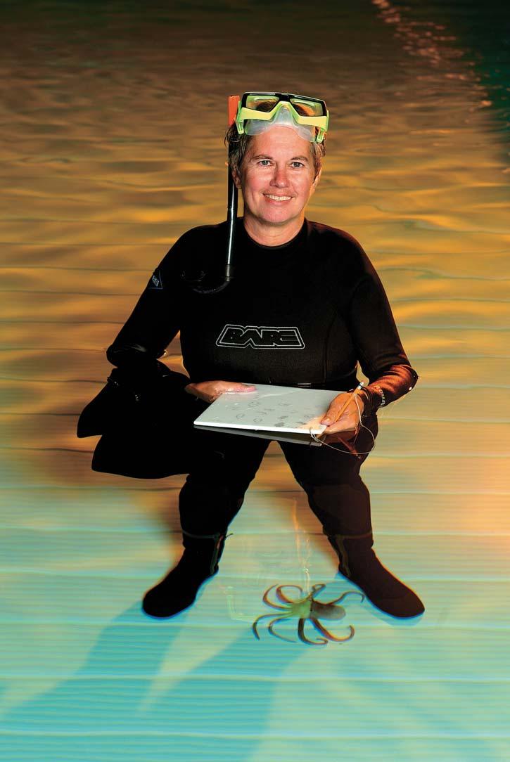
and has been very active in both those areas. Working with cephalopods over the years, she has studied the ways they communicate and play, which are important areas studied by psychologists who are trying to understand human communication and language.
INFORMATION
This event is jointly presented by the Alberta Palaeontological Society, Mount Royal College and the CSPG Palaeontology Division. For information or to present a talk in the future,
please contact CSPG Palaeontology Division Chair Philip Benham at (403)691-3343 or programs@albertapaleo.org. Visit the APS website for confirmation of event times and upcoming speakers: http://www.albertapaleo. org/.
SPEAKER
Oy Leuangthong
University of Alberta
12:00 Noon
Wednesday, February 20, 2008
ConocoPhillips Auditorium, 3rd Floor, above Plus 15+ level, 401 – 9 Ave SW, Calgary, Alberta
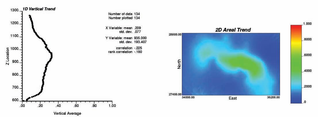
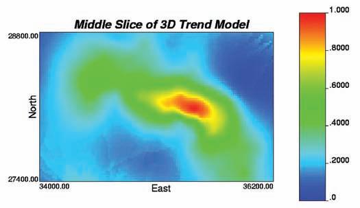
Geostatistics is increasingly popular for n atural resource characterization. The tools provide the ability to construct geologically realistic numerical models; however, they rely on some basic assumptions that permit inference of spatial statistics to unsampled locations. Geostatistical models depend on a decision of stationarity that assumes invariance of the multivariate cumulative distribution
function (cdf) over the domain of interest. For most practical problems, spatial trends violates this fundamental decision and the application of geostatistical methods is no longer straightforward. Real data often exhibit spatial trends in the mean and/or variance. In these cases, common geostatistical tools may inappropriately spread (or smear) these spatial features across different areas; trend modeling becomes an integral component to the numerical modeling workflow.
This talk will focus on the detection and modeling of trends for geostatistical characterization. Specifically, trend integration methods including trend scaling and probabilistic combination approaches will be discussed. The additive approach to geostatistical modeling in presence of trends will be presented along with a transformation approach to handle complex relationships. Throughout the talk, different examples will be presented to illustrate the concepts including an example of trend model construction for an oil sands setting.
BIOGRAPHY
Oy Leuangthong, Ph.D. and P.Eng., is an A ssistant Professor with the School of Mining and Petroleum Engineering in the Department of Civil and Environmental Engineering at the University of Alberta. She teaches and conducts research in improved characterization of mineral resources and petroleum reservoirs using geostatistics. Leuangthong holds a Ph.D. in Mining Engineering (Geostatistics) from the University of Alberta (2003) and a B.Sc. in Civil Engineering (Honours) from the University of Toronto (1998). She is a member of APEGGA, SME, SPE, CIM, and IAMG.
INFORMATION
There is no charge for the division talk and we we lcome non-members of the CSPG. Please bring your lunch. For details or to present a talk in the future, please contact Weishan Ren at (403) 233-3428, e-mail: weishan. ren@conocophillips.com.
Understanding groundwater recharge in a sandy landscape: observing the effects of disturbance is a step towards reclamation in northern Alberta
SPEAKERS
Dr. Brian D. Smerdon, Wo rleyParsons Komex
Carl A. Mendoza, Department of Earth and Atmospheric Sciences, University of Alberta Clara Qualizza, Syncrude Canada Ltd.
12:00 Noon, T hursday, February 21, 2008
ConocoPhillips Auditorium, 3rd Floor (above +15 Level), 401 – 9th Avenue SW, Calgary, Alberta
The influence of landscape disturbance, s uch as forest clearing, road building, well pad construction, and open pit mining, to water cycling in a shallow outwash aquifer is discussed in the context of the Boreal plains of northern Alberta. Elucidating change in groundwater recharge caused by such activities has added to a growing understanding of reclamation for boreal forest ecosystems. The hummocky, glacial outwash landform supports aquatic ecosystems (e.g., lakes, wetlands, and ponds) in a fine balance between a subhumid climate and subsurface. In the summer months, open water bodies were found to function as evaporation windows, capturing local groundwater and releasing it to the atmosphere. Water budget analyses clearly identify that these aquatic systems are maintained by groundwater. However, the relationship between a relatively dry climate and replenishment of groundwater (recharge) was less clear.
Herein, we present an investigation
of groundwater recharge in a sandy landscape, and provide an example of how recharge was altered due to forest clearing and excavation of a small gravel pit. Hypothetical one-dimensional models of unsaturated flow illustrate the sensitivity of groundwater recharge to climate history and water table depth. Simulation results indicate that in summer months, when transpiration and canopy interception were considered explicitly, groundwater recharge was negligible.
For water table depths of two to four metres below ground surface, the occurrence of recharge depends on climatic conditions (water deficit or surplus) of the current and previous year. For water table depths greater than six metres, recharge was approximately 75 to 80 mm/year, and depends on climate conditions from the most recent decade. These time-lagged results were summarized as probability distributions for a range of water table depths, and tested (verified) in a transient analysis of an isotopic tracer that was observed in the groundwater flow system following disturbance.
Agreement between the simulations and field observations suggest that probabilistic recharge functions, based on water table depth, provide a suitable method for use in larger-scale models to assess impact of disturbance and forecast performance of reclamation.
Brian Smerdon is a hydrogeologist and water resources scientist with WorleyParsons Komex, and has an enthusiasm for conceptualizing hydrologic processes and interest in applying numerical models to watershed-scale problems.
Carl Mendoza is an associate professor at the University of Alberta, whose research focuses on ground-water/surface-water interactions at both natural and oil-sands impacted sites, and flow and transport in heterogeneous porous media.
Clara Qualizza is a senior environmental scientist with Syncrude Canada Ltd., and works toward having ecosystem fundamentals incorporated in land reclamation.
Time Lapse (4D) Processing
Hart Janssen
B.Sc., Manager, Seismic Processing
Direct: 403-260-3372 Main: 403-237-7711
www.sensorgeo.com
SPEAKER
Gerry Belyk
RP S Energy
8:00-9:00 am
T hursday, February 28, 2008
RPS Energy Canada Ltd., Training Room in 1400, 800 5 Ave SW Calgary, Alberta
Western Canada has a range of heavy a nd extra heavy oil which can exceed 6,000,000 centipoise in viscosity. It can be problematic to develop a process to extract heavy oil which in some situations
can be stiff enough to be driven on by transport trucks. This bitumen, when combined with sand and gravel, is called asphalt. We developed a number of unique extraction techniques to meet these challenges.
We will briefly discuss these innovative production techniques including; mining, Cold Heavy Oil Production (CHOP), Cold Heavy Oil Production with Sand (CHOPS), Cyclic Steam Stimulation (CSS), Steam Assisted Gravity Drainage (SAGD), and in-situ combustion. It is unlikely that any two reservoirs are identical and therefore each one needs to be uniquely developed. The applied production technique is determined by the geology of that reservoir. For a number of reservoirs, there may only be one technology that can be applied to produce the heavy oil. Geology is a key player in the effectiveness of any technique.
BIOGRAPHY
Gerry Belyk, B.A.Sc., P.Eng., graduated as a Geo technical Engineer and began working with Shell Canada as a Reservoir Engineer.
He is currently with RPS Energy where he supports local and international business development for the Canadian Consulting Team with a special focus on his expertise in conventional and thermal heavy oil. Belyk is the 2006-2007 President of the Canadian Heavy Oil Association (CHOA) and is regularly called upon to make presentations around the world on Heavy Oil and Bitumen Developments in Alberta. In addition, he leads RPS efforts in technology transfer for heavy oil, Canadian field operations, and well servicing capabilities for International clients.
Belyk is a registered professional engineer in Alberta. He is a member of the Canadian Heavy Oil Association (CHOA), Petroleum Society of CIM (Canadian Institute of Mining, Metallurgy & Petroleum), Society of Petroleum Engineers (SPE), and Canadian Association of Drilling Engineers (CADE).


PRINCIPLES and PRAKTYCIZ
Presented by Peter Jones, D. Sc., P. Geol.
Geoscience Professional Development Centre, ES 254
University of Calgary
February 19-21, 2008
For more information, call: (403) 233-0494, 264-0173 or e-mail peter.jones@thementors.com


| by Ray Mireault P. Eng. and Lisa Dean P. Geol., Fekete Associates Inc.
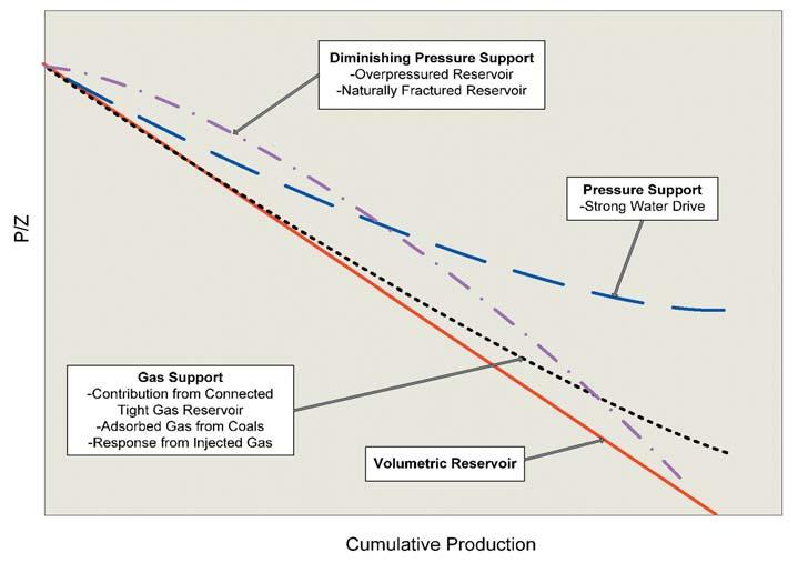
With sufficient production, material balance techniques offer an alternative, largely independent, method of estimating the original hydrocarbons in-place (OOIP and OGIP) to supplement the direct volumetric calculation. A material balance of a pool’s history can also help to identify the drive mechanism and the expected recovery factor range, since different drive mechanisms display different pressure behaviours for the same cumulative production. Figure 1 presents the different P/Z curve trends that result from different drive mechanisms.
Material balance calculations are commonly used to answer reservoir development questions but the technique can also help with the interpretation of reservoir geometry. Geological and geophysical mapping will give an indication of a pool’s shape and orientation but typically the confidence in the in-place volume is not high unless the well and/ or seismic control is abundant. Conversely, material balance can reveal a great deal about the volume of a reservoir but nothing about its shape or orientation. The combination of the two often greatly improves the understanding and interpretation of the pool parameters.
Material balance uses actual reservoir performance data and therefore is generally accepted as the most accurate procedure for estimating original gas in place. In general, a minimum of 10 to 20% of the in-place volume must be produced before there is sufficient data to identify a trend and reliably extrapolate to the original in-place volume through material balance. Thus material balance is of direct use to the development geologist who is attempting to identify infill and step-out drilling locations to optimize the depletion of a pool. To the explorationist, material balance is probably most often used to describe the production behaviour of analogous producing pools.
The material balance procedure describes the expansion of oil, gas, water, and rock over time as a pool is produced. When fluid is removed from a reservoir, reservoir pressure tends to decrease and the remaining fluids expand to fill the original space. Injection situations, such as waterflooding or gas storage, are handled by treating the injection volumes as negative production.
The material balance equation is simply an inventory of the mass of all materials entering,
exiting, and accumulating in the reservoir. For the sake of convenience, this mass balance is usually expressed in terms of reservoir voidage (see CIM Monograph 1, page 143 for the general material balance equation). In theory, the original in-place volume can be determined knowing only:
• Oil, gas, water, and rock compressibility.
• Oil formation volume factor (Bo) and solution gas ratio (Rs) at the pressures considered.
• The amount of free gas in the reservoir at initial reservoir pressure.
• Connate water saturation.
• Production/injection volumes and the associated reservoir pressures.
In practice, the material balance calculation is quite complex and its application requires several simplifying assumptions, including:
• A constant reservoir temperature is assumed despite changes in reservoir pressure and volume. For most cases the approximation is acceptable, as the relatively large mass and heat conduction capability of reservoir rock plus the relatively slow changes in pressure create only small variations in reservoir temperature over the reservoir area.
• A constant reservoir volume assumes that changes in the pore space of the rock with pressure depletion are so small that they
can be ignored. The assumption is valid only when there is a very large contrast between reservoir rock compressibility and the compressibility of the contained fluids. Typical compressibility ranges are:
• Rock: 0.2 to 1.5x10 -6 kPa-1
• Gas: 10 -3 to 10 -5 kPa-1 (Varies significantly with reservoir pressure.)
• Water: 0.2 to 0.6x10 -6 kPa-1
• Oil: 0.4 to 3x10 -6 kPa-1
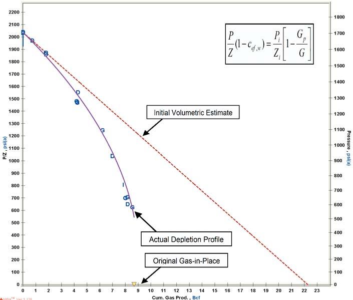
Thus rock compressibility can be ignored in normally pressured or volumetric gas reservoirs (see Figure 1) and oil reservoirs with free gas saturation. Ignoring rock compressibility in over-pressured reservoirs and in fluid systems that do not have a gas phase will overestimate the original in-place hydrocarbons (see Figure 2).
• Representative pressure/volume/temperature (PVT) data for the oil, gas and water in the reservoir. Usually, the challenge is to obtain a representative oil sample for laboratory analysis. Bottomhole sampling can inadvertently lower the sampling pressure and cause gas to come out of solution. Surface sampling requires accurate measurements of oil and gas production during the test to correctly recombine the produced streams. Gas reservoir sampling requires accurate measurement of the gas and condensate production
and compositional analysis to determine the composition and properties of the reservoir effluent.
• Accurate and reliable production data directly impacts the accuracy of the in-place estimate. Produced volumes of oil (and gas if it’s being sold) are generally accurate because product sales meters at the oil battery and gas plant are kept in good repair. Prorationing of the monthly sales volumes back through the gathering system(s) to the individual wells is standard industry practice. It introduces a level of uncertainty in the reported production values for the wells that can generally be tolerated, provided the prorationing is performed in accordance with industry standards.
• A uniform pressure across the pool is assumed because the properties of the reservoir fluids are all related to pressure. In practice, average reservoir pressures at discrete points in time are estimated from analyses of well pressure build-up tests (we’ll talk about well tests in another article). Although local pressure variations near wellbores can be ignored, pressure trends across a pool must be accounted for. The additional uncertainty in the pressure estimate introduces another challenge to the hydrocarbon in-place calculations but is generally tolerable.
A material balance can be performed for a single well reservoir (or flux unit) or a
group of wells that are all producing from a common reservoir / flux unit. However, well production and pressure information is commonly organized into “pools” or subsurface accumulations of oil or gas by regulatory agencies, on the basis of the initially available geological information. The “pool” classification does not account for internal compartmentalization so a single pool can contain multiple compartments/ reservoirs/flux units that are not in pressure communication with each other. To further confuse the issue, the word “reservoir” is often used interchangeably with the word
“pool” and is also used to refer to the “reservoir” rock regardless of fluid content. For clarification, in this series of articles “reservoir” means an individual, hydraulically isolated compartment within a pool.
Thus the first real world challenge to a reliable material balance is identifying which portions of the off-trend data scatter are due to measurement uncertainty, pressure gradients across the reservoir, and different pressure trends over time due to reservoir compartmentalization. For gas reservoirs (oil reservoirs will be discussed in next month’s Reservoir), a pressure vs. time plot (see Figure 3) greatly assists in the diagnosis as follows:
• The accuracy of electronic pressure gauges has dramatically reduced the uncertainty in the interpreted reservoir pressure due to gauge error. It can cause small random variations in the interpreted pressures but the magnitude is so small that it is seldom a factor when a pressure deviates from the trend line on a P/Z plot.
• Inadequate build-up times during pressure tests lead to interpreted reservoir pressures at the well that are always less than true reservoir pressure.
• Pressure gradients across a reservoir are always oriented from the wells with the greatest production to wells with little or no production.
• The failure to separate and correctly group wells into common reservoirs is the most common reason for excessive data scatter. Wells producing from different reservoir compartments within a common pool (Continued on page 26...)
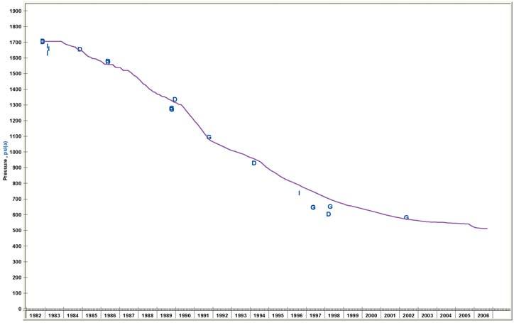
will each have their own pressure/time trend that can be identified with adequate production history and used to properly group the wells.
For confidence in the original-gasin-place estimate of Figure 2, Figure 3 compares a computer-predicted “average” reservoir pressure, based on the combined production history of the grouped wells and the interpreted gas-in-place volume of Figure 2, with the interpreted reservoir pressures from well pressure build-up tests. All pressure measurements follow the predicted trend, which indicates that the wells have been correctly grouped into a common reservoir.
Well pressures that fall below the trend line of Figure 3 are consistent with a productioninduced pressure gradient across the reservoir (well G and I) and/or an inadequate build-up time during pressure testing (wells D and G). For the occasional anomalous reservoir pressure in a series that otherwise follows the trend, other circumstances may justify a detailed review of selected well build-up tests and their interpretation. The horizon(s) tested, the reservoir geometry, formation permeability and depth variations across the reservoir, the type of test (static gradient, wellhead, flow, and buildup), the length of the test (shut-in time for buildups), the temperature gradient in the reservoir, and the accuracy of the fluid composition all contribute to the accuracy of the reservoir pressure interpretation.
The classical P/Z plot for normally pressured gas reservoirs is perhaps the simplest form of the material balance equation and so it is introduced first. Rock and water expansion can be ignored because of the high gas compressibility. Assuming an isothermal or constant temperature reservoir and rearranging terms yields the equation in the form of a straight line y = b - mx as follows:
Where:
P = the current reservoir pressure
Z = the gas deviation from an ideal gas at current reservoir pressure
Pi = the initial reservoir pressure
Zi = the gas deviation from an ideal gas at initial reservoir pressure
Q = cumulative production from the reservoir
Gi = the original gas-in-place
As the equation and Figures 1 and 2 indicate, when there is no production, current reservoir pressure is the initial reservoir pressure. When all the gas has been produced, reservoir pressure is zero and cumulative production equals the initial gas-in-place volume.
A straight line on the P/Z plot is common in medium and high (10 to 1000 mD) permeability reservoirs. A strong upward curvature that develops into a horizontal line, as presented in Figure 1, demonstrates pressure support in the reservoir and is usually associated with a strong water drive. Formation compaction can cause a non-linear, downward trend, as in the example of Figure
2. However, a downward trend may also be caused by unaccounted-for well production from the reservoir.
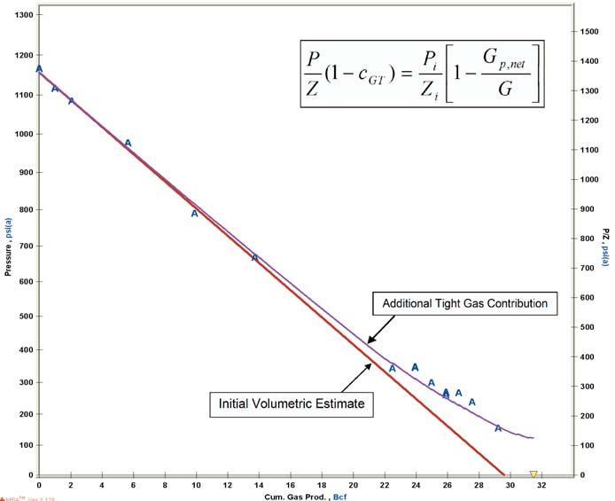
A slight upward curvature in the P/ Z plot indicates some gas influx into the main reservoir from adjacent tight rock as illustrated by Figure 1 and the single well reservoir of Figure 4. The upward curvature illustrates that there is a significant permeability difference between the main reservoir and the adjacent rock. A limited upward curvature on P/Z plots is being observed with increasing frequency in Alberta as medium and high permeability reservoirs are produced to depletion and the industry develops lower and lower permeability plays.
Canadian Institute of Mining, Metallurgy and Petroleum, 2004. Determination of Oil and Gas Reserves. Petroleum Society Monograph Number 1, Chapter 7.
Canadian Institute of Mining, Metallurgy and Petroleum, 2005. Canadian Oil and Gas Evaluation Handbook, Volume 2, Detailed Guidelines for Estimation and Classification of Oil and Gas Resources and Reserves. Section 6: Procedures for Estimation and Classification of Reserves.
Cosentino, Luca, 2001. Integrated Reservoir Studies. Gulf Publishing Company. Chapters 5-6.
Mattar, L. and Anderson, D, 2005. Dynamic Material Balance (Oil or Gas-in-place without Shut-ins). SPE paper # 2005-113, presented at the 2005 Canadian International Petroleum Conference, Calgary, AB, Canada, 7-9 June 2005.
Mattar, L. and McNeil, R, 1998. The “Flowing” Gas Material Balance. Journal of Canadian Petroleum Technology, Volume 37, No. 2, Pages 52-55.
Rahman, Anisur N.M., Anderson, D., and Matter, L., 2006. New, Rigorous Material Balance Equation for Gas Flow in a Compressible Formation with Residual Fluid Saturation. SPE Paper #100563, presented at the 2006 SPE Gas Technology Symposium, Calgary, AB., 15-17 May 2006.
Our next article, in the March issue of the Reservoir, will continue the Material Balance (Part 5B) discussion for Oil Reservoirs.
This article was contributed by Fekete Associates, Inc. For more information, contact Lisa Dean at Fekete Associates, Inc.


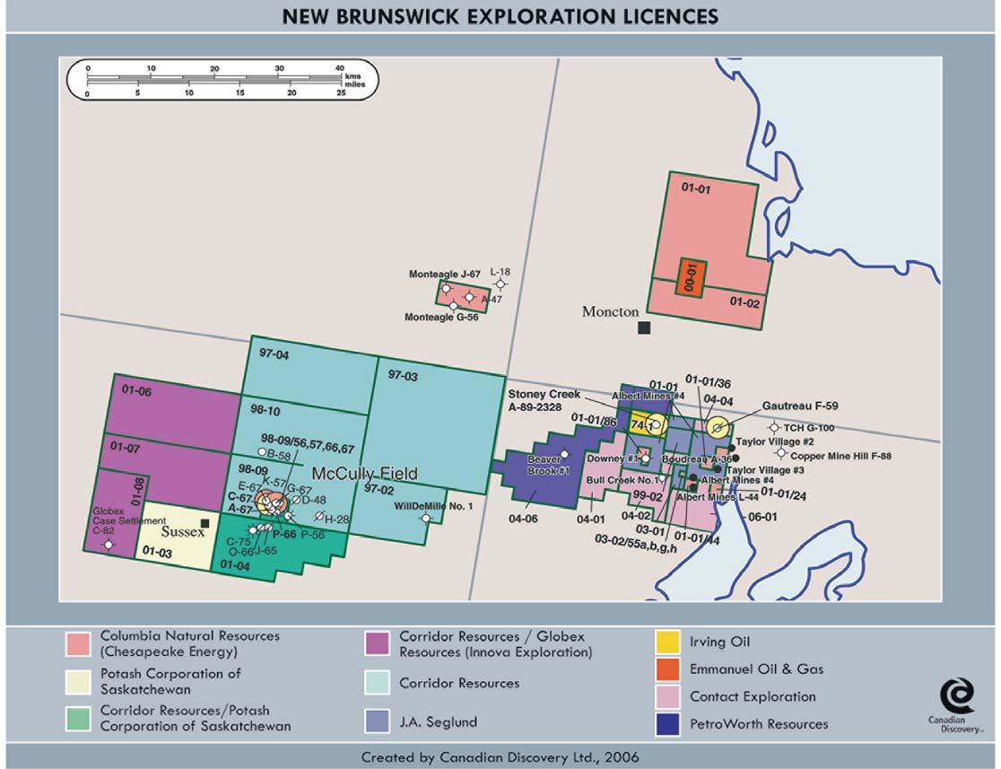
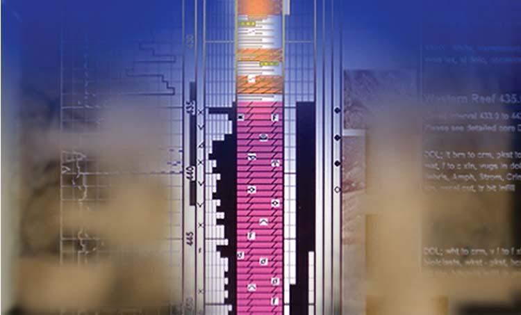
This article is reprinted with permission from Canadian Discovery’s CEO map series (Spring/ Summer 2007 Eastern Canada Onshore & Offshore Regions). For information on products offered by CDL, please visit www. canadiandiscovery.com or call 269-3644.
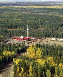
The news coming out of New Brunswick just keeps getting better. At the McCully natural gas field near Sussex in the southern part of the province, twenty wells, all gas-bearing, have been drilled at McCully since the field was discovered in 2000 by Potash Corporation of Saskatchewan (PCS) and its 50% partner Halifax-based Corridor Resources. Since 2003, production from the initial two wells has fueled the nearby PCS potash mill at approximately 2 mmcf/d. Up until now, the remainder has been stranded, but in mid
to late May, following the completion of the $50 million gas gathering system, gas conditioning plant and the 54-km lateral pipeline, first gas should be flowing into the Maritimes and Northeast Pipeline (M&NP). It will be primarily destined for New England markets. Initial gross production of about 35 mmcf/d from 15 wells is planned. Those rates should increase to 40 to 45 mmcf/d following a planned frac program later in 2007. The gas plant capacity is 50 mmcf/d at current pipeline operating pressures, but with additional compression, the line could carry up to 90 mmcf/d.
The August 2006 reserves report by APA E ngineering assigned gross proved plus probable reserves of 124 bcf of gas based on 15 wells, however the study covered
only 20% of the field due to limited seismic coverage. New 3D seismic has since been acquired over the entire structure. Corridor says it has identified more than 80 potential step-out drilling locations.
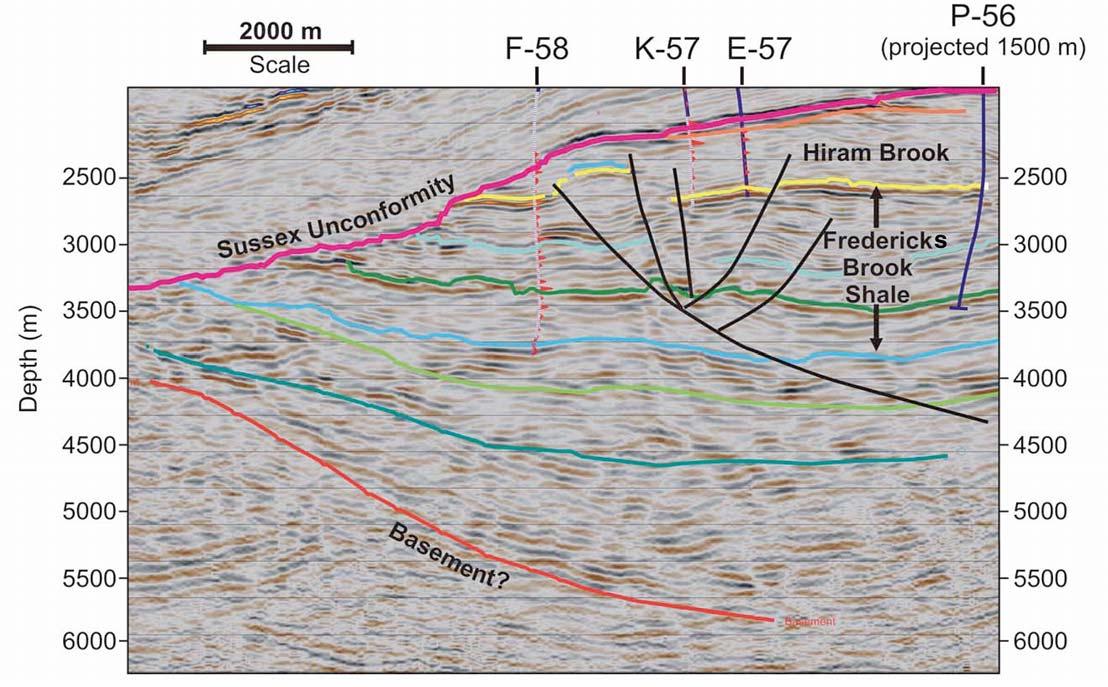
The McCully Field is a large northeasterlytrending anticlinal structure with four-way closure. The structure measures about 15 km long by about 5 km wide, and is estimated to contain 1 tcf of gas in place. The reservoir is in a combined structural/ stratigraphic trap. It currently produces sweet gas from two overpressured tight sandstone packages in the Hiram Brook Member of the Carboniferous (Tournaisian) Albert Formation at a depth of about 2,100 m. The sands are interpreted as lacustrine (Continued on page 30...)


(403)263-0449


www.rpsgroup.com/energy


| by Godfrey Nowlan, Program Chair, IYPE
The idea of an International Year of Planet E arth (IYPE) was launched in 2000 at an IUGS Council meeting. Proclamation of an International Year was seen as a potentially powerful means of demonstrating how society could benefit from the accumulated knowledge of the solid Earth as part of System Earth. Following a feasibility study, immediate support was provided by UNESCO’s Earth Science Division, making it a joint initiative by IUGS and UNESCO (Initiators). After broad consultation, it was decided in 2002 to seek proclamation of the International Year of Planet Earth by the General Assembly of the UN, with a view to providing the best possible exposure to national governments.
On August 26, 2004, the joint Council of IUGS and the International Geological Congress, together representing Earth science communities in 140 countries and regions, adopted a Declaration on the International Year. This invited UNESCO’s Executive Board to adopt an International Year of Planet Earth, considering that:
• the geosciences can contribute significantly to a safer, healthier, and wealthier world;
• this potential contribution is seriously under-used by society and should be substantially increased;
• Proclamation of an international year under the aegis of UN member states would help the Earth sciences to make their full contribution to the sustainable stewardship of the planet.
Proclamation of 2008 as the International Year of Planet Earth was effected at the UN General Assembly in New York on 22 December 2005. At least three years will be needed to realize most of the ambitious science and outreach plans, and the Year’s triennium will thus run from 2007 to 2009.
IYPE is an ambitious program of outreach and research activities designed to raise global awareness of the vast (but often under-used) potential of Earth Sciences to improve quality of life on the planet. The
program envisages a significantly expanded role for the Earth Sciences in building a healthier, safer, and wealthier society. The aim is encapsulated in the Year’s tag line: “Earth Science for Society.” The program is based around ten scientific themes: Groundwater, Hazards, Earth and Health, Climate, Resources, Megacities, Ocean, Deep Earth, Soil – Earth’s Living Skin, and Earth and Life, with a strong emphasis on outreach to ordinary citizens of the planet. More information can be obtained at www.yearofplanetearth.org.
National committees have been e stablished in more than sixty countries. The Canadian National Committee (CNC) was established in late 2006 under the Chairmanship of John Boyd (see www. iypecanada.org for a full listing). It released its first brochure in time for the May 2007 meetings of Canadian earth science societies and has recently released a new one aimed at fund raising (this latter version is available as a download under “Media Kit” at the national web site – see above).
The CNC has adopted a theme entitled: “WHERE on Earth, WHERE in Canada” – in which WHERE stands for Water, Hazards, Energy, Resources, and Environment. It will focus its effort on increasing public awareness of Earth Sciences in Canada. To that end, projects have been solicited from across the country and fundraising is currently in progress to support the projects. About twenty proposals have been made including a new popular book on the Geology of Canada called Four Billion Years and Counting: Canada’s Geological Heritage (for more information please visit http://cfes-fcst.ca/fby/). The book will be a joint product of the Canadian Federation of Earth Sciences and a private publisher, yet to be identified. It will be published in late 2008. Other proposals include a web site to give details to students on Earth Science careers, Earth Science through music in the schools, a national lecture tour, a national contest on awareness of the importance of resources in our lives, workshops for teachers of Earth Sciences, facts sheets on Earth Sciences as well as
several regional projects in different parts of the country.
Former Canadian astronaut, Dr. Roberta Bondar is the Honorary Patron of IYPE in Canada.
A number of projects have already been c ompleted. Canadian IYPE was a cosponsor of a new Canadian Broadcasting Corporation five-part television series called A Geologic Journey (www.cbc. ca/geologic). The series was shown in September and October 2007 and an advertisement for IYPE was shown twice during each airing of the shows.
A series of thirty-two fact sheets on Mineral and Energy resources has already been released on the Geological Association of Canada web site at: www.gac.ca/ populargeoscience. These are available for free download and are a valuable source of simple information on many resources topics including such things as gas hydrates, uranium, oil sands, gemstones, mineral deposits, and industrial minerals. The fact sheets were put together by a team of authors based at the Geological Survey of Canada in Calgary, with contributions from specialists in many institutions.
One of the principal proposals for IYPE is the concept of a GeoTime Trail. The prototype has been partially completed in the Waterloo region. The Geotime Trail is designed to be a 4,567 metrelong trail that will eventually make its way from a common start and end point as a loop trail. The distance of the Trail corresponds to the current estimates of the age of the Earth at 4.567 billion years. Every metre along the trail represents one million years of geological time, and each single millimetre represents 1,000 years. The first part of this trail was opened on 21 October 2007. If you are interested in more information on this trail, please contact Alan Morgan at the University of Waterloo.
A small poster on the mineral and energy resources required to build and run a snowmobile has been released by Mining Matters of the Prospectors and
Developers Association of Canada in association with staff from the Geological Survey of Canada. This handy poster provides information on the minerals required to build a snowmobile and where in Canada and elsewhere in the world they can be found. If you are interested in obtaining this product, please contact Mining Matters at MiningMatters@ pdac.ca.
Another recent release is the Northern British Columbia Geological Landscapes Highway Map a joint project of the B.C. Geological Survey and the Geological Survey of Canada (B.C. Geological Survey, Geofile 2007-1; see also www.geoscape. nrcan.gc.ca.) This is a basic geological map with descriptions of all the key geological regions and a compendium of sixty-eight photographs of a variety of geological localities along the highways of northern British Columbia. The map covers the area from Kitimat and Quesnel north to the border with the Territories and includes the Queen Charlotte Islands.
A poster has been prepared for display at the many scientific meetings that take place in the last quarter of the year.
The success of the year will depend o n both the success of the fund-raising campaign and the degree to which Canadian earth scientists support the various IYPE ventures. If all goes well, it could be a banner year for earth science that results in many products that will serve to enlighten Canadians for many years to come.


PETREL* SEISMIC-TO-SIMULATION SOLUTION unites the subsurface domains of geophysics, geology, and reservoir engineering.
With Petrel software, asset team members can easily integrate their work —throughout the life of the field. No more over-the-wall data transfers, with the associated inaccuracies and errors. Traditional workflow and software barriers between technical disciplines are eliminated, opening the way for optimal reservoir understanding.
“In new assets and in older fields, leveraging technology is a key element of profitability and adding value for our shareholders. New insights and efficiencies from technologies within the Petrel suite of workflow tools provide significant potential benefits to companies like ours.”— Steve
Farris, CEO, Apache Corporation
With Petrel software, all work processes lead to one shared earth model, resulting in faster, better decisions.
www.slb.com/petrel

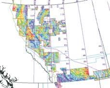

| by R.W.C. (Bill) Arnott and G.M. Ross
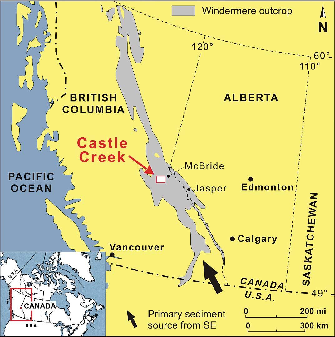
During the past decade, deep-water clastic depositional systems formed on and at the base of passive continental margins have become one of the most promising global exploration plays. Currently areas like west coast Africa, offshore Brazil, Gulf of Mexico, and the North Sea contribute about 20-30% of global petroleum production, and all from reservoirs hosted in deep-water turbidite systems (e.g., Dromgoole et al., 2000). Although these targets hold tremendous potential, they also pose significant risk because of the high cost of drilling and complexity of reservoir geometries. In order to reduce risk, petroleum geologists
have long emphasized the need for analogue studies to help constrain geologic attributes at both the seismic and reservoir scale. In the case of turbidite systems, the disparity in scale between outcrop studies and the scale of architectural elements observed on modern fan systems has made it a challenge to relate outcrop examples to stratigraphic units based on seismic attributes and widely spaced well control. In addition, most outcrop analogues of turbidite systems are preserved in sedimentary basins that formed in convergent plate settings such as foreland basins or flysch troughs (Ebro and Hecho groups, Spain; Cerro Toro, Chile), forearc basins (Great Valley
Group, California), or small extensional basins (coastal California). The concern in these kinds of basins is their comparative small spatial scale and the unknown control that tectonically related seafloor irregularities may have had on the spatial and temporal evolution of channel systems and the resultant stratigraphic architecture. Therefore, how representative are models of reservoir sandstone stratigraphy and geometry based on ancient analogues formed in tectonically confined, sand-rich convergent margin turbidite basins when applied to modern day exploration taking place mostly in passive margin, mixed sandmud and mud-rich systems? Of significance, therefore, is the Windermere Supergroup turbidite system in the southern Canadian Cordillera, an areally expansive, mixed sand-mud deep-water system deposited on a passive continental margin.
The Neoproterozoic Windermere Su pergroup (WSG) of western North America extends from northwestern Mexico northward through the western United States, along the length of the Canadian Cordillera, and into the YukonAlaska border region – a distance of over 4,000 km. The deep-water part of the basin crops out most extensively in the southern Canadian Cordillera where it covers an area of approximately 35,000 km2 (palinspastically unrestored; Figure 1). Here the WSG, which overlies the Mesoproterozoic Belt-Purcell Supergroup, is up to about 9 km thick and comprises two main stratigraphic units (Ross, 1991, 2000; Figure 2). However in spite of its great thickness and areal extent, geochronological control in these strata is poor. Dates obtained from rocks occurring below and above the WSG bracket deposition between 736 Ma and 569 Ma, although recently a date of 608 Ma was measured from strata within the WSG, specifically the Old Fort Point Formation (Smith et al., in press). The basal part of the WSG consists
(Continued on page
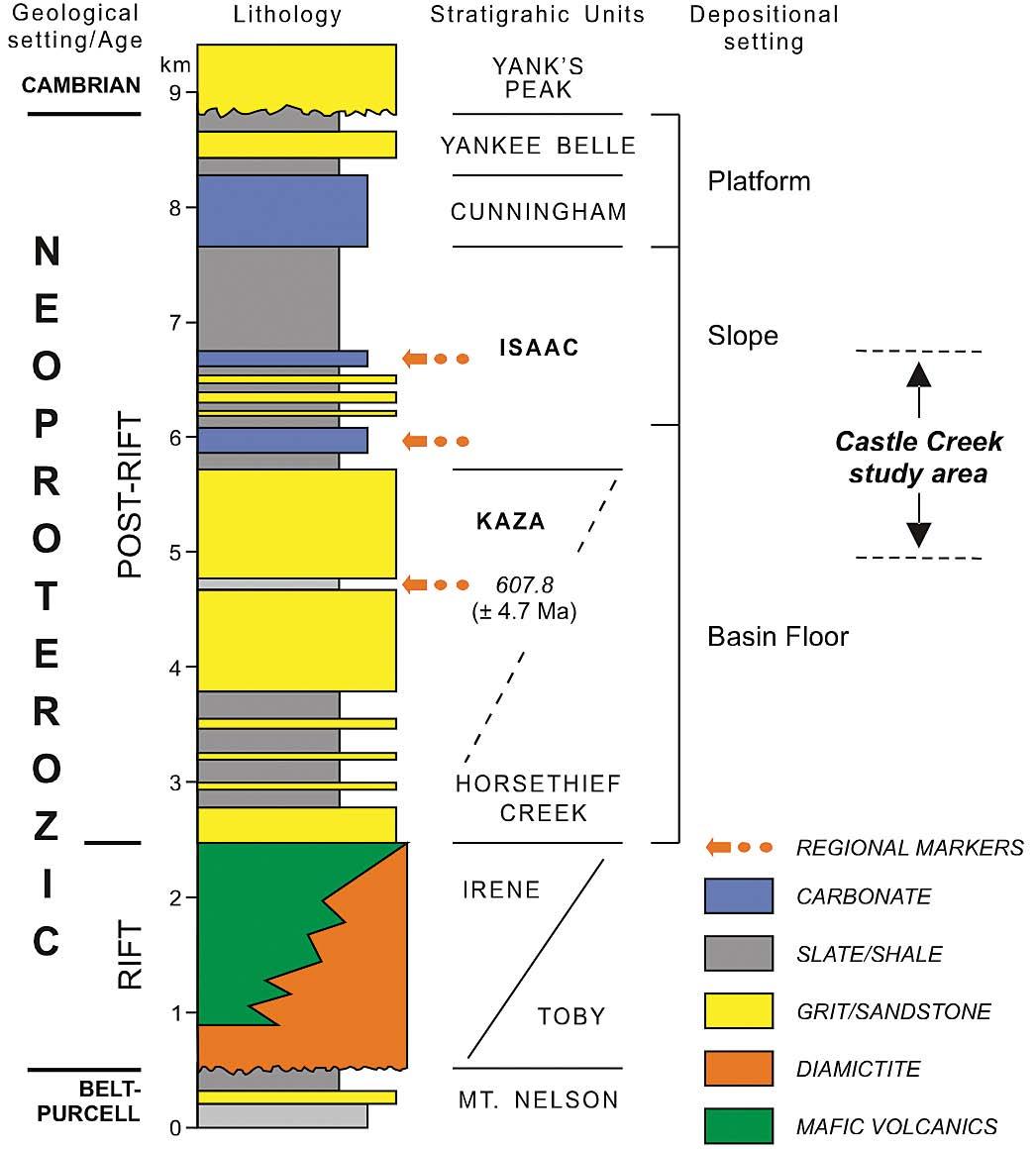
(...Continued from
of siliciclastic and subordinate carbonate and mafic volcanic rocks deposited during continental rifting (break-up of Rodinia) and the formation of Laurentia (a landmass consisting in large part of North America). The conformably overlying upper unit makes up a single deep-water turbidite system emplaced during the subsequent (postrift) passive-margin phase. More recently, however, it has been suggested that the Windermere in the southern Canadian Cordillera might represent deep-water deposits that accumulated in a major northto northwest-opening aulacogen trough formed during continental (Rodinia) breakup (Colpron et al., 2002). Notwithstanding differences in tectonic model, based on its exposed areal dimensions, this turbidite system appears comparable in size to the modern Amazon and Mississippi fans, and as a consequence is at least an order of magnitude larger than most other ancient (outcrop) fan systems. Moreover, in spite of its enormous size and age (uncertain due to lack of biostratigraphic control), the
construction of regional correlations and paleogeographic reconstruction is not an intractable exercise. The occurrence of three distinctive marker horizons, each several tens to over 100 m thick, permits confident regional correlation. The lowermost is the lithologically and geochemically distinctive Old Fort Point Formation (see Smith et al., in press), followed upward by two deep-water carbonate horizons, informally termed the first and second Isaac carbonates. Deposition of these carbonate markers represents a major change in sediment flux into the WSG basin, and by necessity, important changes in shallow-water carbonate production – a factory that only rarely became activated, or more likely sufficiently activated that it overwhelmed the flux of siliciclastic sediment into the deep parts of the basin.
The most completely preserved sequence of WSG deep-marine rocks crops out in the Cariboo Mountains of British Columbia and consists of a more-than-five-kilometerthick succession of basin-floor-through-slope
turbidites to upper-slope mudrocks and shelf carbonates (Figure 2). This km-scale, shoaling-upward succession is interpreted to reflect westward (basinward) progradation of the continental margin of western North America (Laurentia) into the Pacific Ocean miogeocline in response to decreased rates of thermally driven subsidence (Ross, 1991). Of particular note are rocks exposed in the headwaters region of Castle Creek, a glacially fed tributary of the Fraser River. Here a km-scale, upward-shoaling, deepwater succession is superbly exposed on the overturned limb of a major southwestverging fold, and forms an outcrop belt up to 2.3 km thick (perpendicular to bedding) and up to 7 km wide (parallel to bedding). Although strata have been metamorphosed to greenschist facies (abundant chlorite and muscovite), primary sedimentary structures and textures are well preserved, even at millimeter scale. Important also is that the area lies adjacent to a rapidly retreating glacier that in many places has exposed glacially polished, lichen-free strata. Owing to the excellence of the exposure and the nearly vertical dip of the strata, beds and bedsets can be commonly traced for hundreds of meters parallel to depositional strike.
At Castle Creek, exposed strata are subdivided into two stratal units: upper Kaza Group, which is about 800 m thick, overlain by the Isaac Formation (about 1,500 m thick; Figure 3). As defined, the upper Kaza Group is sandstone rich, and at Castle Creek is generally of the order of 75:25 sandstone: mudstone (mudstone consisting mostly of thin-bedded turbidites). Sandstone is organized into laterally extensive sandstone “sheets” that are several meters to about 25 m thick (Figure 4). Generally, strata consist of stacked decimeter- to meterthick, graded sandstone beds that commonly become progressively more interstratified with mudstone over several hundreds of meters laterally (Longuepee et al., in press). These strata are interpreted to represent major loci of basin-floor deposition and are analogous to seismically resolved features termed depositional lobes, suprafan lobes, and terminal splays (cf. Posamentier and Kolla 2003). Deposition is the result of strong temporal and spatial gradients in sediment transport caused by the lateral spreading of the flow on the rather featureless, lowslope basin floor.
In contrast to the Kaza, the Isaac Formation is dominated by mudstone – sandstone: mudstone approximately 25:75. In addition, coarser strata, consisting of sandstone and less common conglomerate, form decameterto 100 m thick, laterally discontinuous units
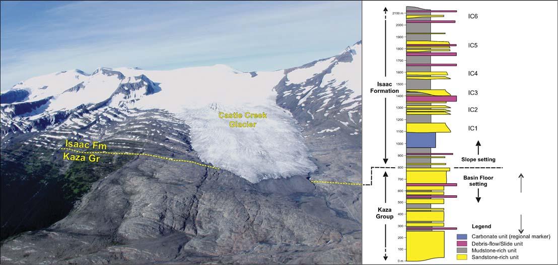
encased in mudstone (Figure 5). These coarse- and fine-grained deposits represent, respectively, channel and levee/interchannel deposits of stacked channel-levee complexes and complex sets that formed in a slope to base-of-slope setting (see upcoming articles by Navarro and Khan). Six such successions have been identified at Castle Creek and are informally termed Isaac channels 1-6 (IC1IC6). Moreover, the occurrence of deposits interpreted to be related to lateral accretion and channel avulsion processes suggest that
sinuous channels form common elements in Isaac channel complexes (Arnott, in press). Thick slide, slump, and debris flow deposits, which in one case forms a unit about 130 m thick, in addition to slope creep deformation, are common in the Isaac Formation (Wallace et al., in press). These features indicate that slope (i.e., gravitational) instability is an important process affecting strata of the Isaac Formation, but by comparison is all but absent in the more distal, basin-floor deposits of the Kaza Group.
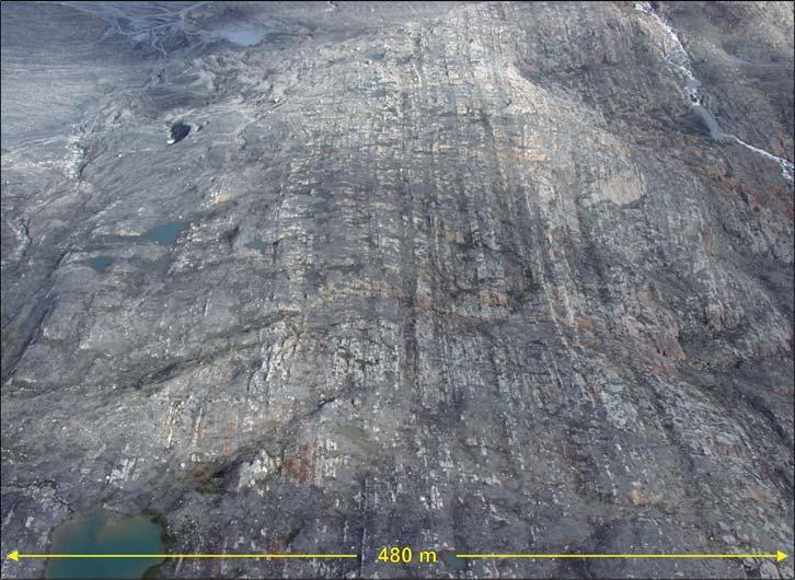
In summary, the Windermere Supergroup of the southern Canadian Cordillera represents the remnants of a large, regionally integrated turbidite depositional system that potentially was similar in scale to modern systems like the Mississippi and Amazon fans. The impressive dimensions of the WSG makes stratigraphic mapping arduous and painstaking; however, our developing recognition of a consistent regional stratigraphic and paleogeographic framework now makes such studies a tractable undertaking. Studies at Castle Creek, and currently in other areas of the southern Canadian Cordillera, provide important insight at not only the reservoir scale (cm to a few dm resolution), but also the seismic scale (100s to 1000s m), and accordingly are helping to merge together these vastly different in scale, but equally important datasets. Beginning with this brief introduction of the Windermere Supergroup, the next nine articles of this series will present details of the many elements that make up the deep-marine record of the WSG in the southern Canadian Cordillera – the world’s truly premier example of ancient deep-marine sedimentation.
Our ongoing research of the WSG is funded by the industry members of the Windermere Consortium (Anadarko Petroleum, Canadian Natural Resources Ltd., Devon Petroleum Ltd., Husky Energy, Encana Corp., Nexen Inc., and Shell) and an NSERC Collaborative Research and Development Grant.
(Continued on page 38...)
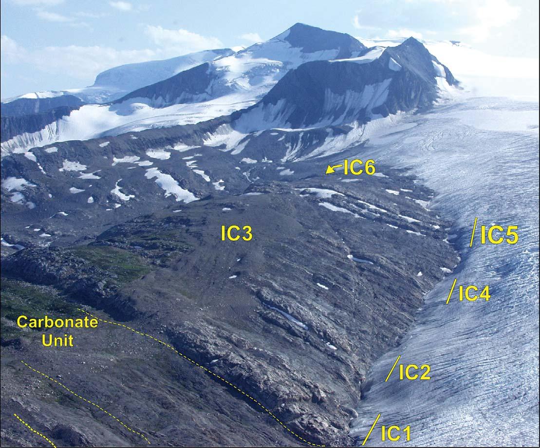
(...Continued from page 37)
Arnott, R.W.C., in press. Depositional patterns and mechanisms on the inner-bend margin (point bar) of a sinous deep-marine channel. Canadian Society of Petroleum Geologists, Reservoir, Vol. 35.
Colpron, M., Logan, J.M., and Mortensen, J.K, 2002, U-Pb zircon age constraint for late Neoproterozoic rifting and initiation of the lower Paleozoic passive margin of western Laurentia, Can. Jour. Earth Sci. v. 39 p. 133-143.
Dromgoole, P., Bowman, M., Leonard A., Weimer P., and Slatt, R.M., 2000. Developing and managing turbidite reservoirs - case histories and experiences: results of the 1998 EAGE/AAPG research conference. Petroleum Geoscience, Vol. 6, #2, May 2000, pp. 97-105.
Longuépée, H., Meyer,L., Terlaky, V., Privett, K., van Hees, G., and Arnott, R.W.C., in press. Lateral and vertical variations in deepmarine basin floor deposits as illustrated in the upper Kaza group, Neoproterozoic Windermere Supergroup. Canadian Society of Petroleum Geologists, Reservoir, Vol. 35.
Posamentier, H.W., and Kolla, 2003, Seismic geomorphology and stratigraphy of depositional deep-water elements. Journal of Sedimentary Research, v. 73, p. 367-388.
Ross, G.M., 1991. Tectonic setting of the Windermere Supergroup revisited. Geology, 19, 1125-1128.
Ross, G.M., 2000. The Neoproterozoic Windermere Supergroup: An on-land continental margin turbidite system. Geological Survey of Canada, Open File 3932, 2 sheets.
Ross, G.M., Bloch, J.D, and Krouse, H.R., 1995. Neoproterozoic strata of the southern Canadian Cordillera and the evolution of seawater sulfate. Precambrian Research, v. 73, p. 71-99.
Smith, M.D., Arnott, R.W.C., and Ross, G.M., in press. The Neoproterozoic Old Fort Point Formation, Southern Canadian Cordillera. Canadian Society of Petroleum Geologists, Reservoir, Vol. 35.
Wallace, K., Laurin, J., and Arnott, R.W.C., in press. Architecture and evolution of a mass transport deposit, Neoproterozoic Isaac Formation. Canadian Society of Petroleum Geologists, Reservoir, Vol. 35.


The EARTH ImagerSM service delivers high-resolution micro-resistivity images in oil-based mud with great hole coverage.
This proven micro-resistivity imager from Baker Atlas offers a vertical resolution of less than 7.5mm at a standard logging speed of 275m/hr giving you details never seen before in oil-based mud images.
The EARTH Imager service operates in 152 to 533mm diameter boreholes. With its 6 pads mounted on individually articulated arms, it provides you with 63% borehole coverage in 200mm diameter holes while maintaining pad contact at all hole deviations.
Call us today to find out how you can use the EARTH Imager service in your next oil-based well to accurately identify structural and sedimentary features, rock texture, fracture orientation and estimate net-to-gross.