21 Celebrate National Engineering and Geoscience Week
25 International Commission on Stratigraphy: ICS Stratigraphy Prizes
27 Prospect Saskatchewan: The Mississippian Looking beyond the subcrop plays
33 Puskwaskau –Beaverhill Lake Sand Oil
21 Celebrate National Engineering and Geoscience Week
25 International Commission on Stratigraphy: ICS Stratigraphy Prizes
27 Prospect Saskatchewan: The Mississippian Looking beyond the subcrop plays
33 Puskwaskau –Beaverhill Lake Sand Oil
“AccuMap encompasses speed, stability, efficiency and accuracy. As an intuitive and easy-to-use product, AccuMap serves a broad audience, from field users to the CEO.”
Darrel Saik Senior Geological Technologist Paramount Energy Trust
AccuMap is the most widely used and highly trusted oil and gas mapping software touching every segment of E&P, for every professional.


CSPG OFFICE
#600, 640 - 8th Avenue SW Calgary, Alberta, Canada T2P 1G7
Tel: 403-264-5610 Fax: 403-264-5898
Web: www.cspg.org
Office hours: Monday to Friday, 8:30am to 4:00pm
Business Manager: Tim Howard
Email: tim.howard@cspg.org
Membership Services: Sarah Barton
Email: sarah.barton@cspg.org
Communications & Public Affairs: Jaimè Croft Larsen
Email: jaime.croftlarsen@cspg.org
Corporate Relations: Kim MacLean
Email: kim.maclean@cspg.org
Corporate Relations Assistant: Heather Tyminski
Email: heather.tyminski@cspg.org
Conventions & Conferences: Shauna Carson
Email: shauna.carson@cspg.org
Conventions & Conferences Assistant: Tanya Santry
Email: tanya.santry@cspg.org
EDITORS/AUTHORS
Please submit RESERVOIR articles to the CSPG office. Submission deadline is the 23rd day of the month, two months prior to issue date. (e.g., January 23 for the March issue).
To publish an article, the CSPG requires digital copies of the document. Text should be in Microsoft Word format and illustrations should be in TIFF format at 300 dpi., at final size For additional information on manuscript preparation, refer to the Guidelines for Authors published in the CSPG Bulletin or contact the editor.
Coordinating Editor & Operations
Jaimè Croft Larsen, CSPG
Tel: 403-513-1227 Fax: 403-264-5898
Email: jaime.croftlarsen@cspg.org
Technical Editor
Ben McKenzie
Tarheel Exploration
Tel: 403-277-4496, Email: bjmck@telusplanet.net
ADVERTISING
Kim MacLean
Corporate Relations, CSPG
Tel: 403-513-1229, Email: kim.maclean@cspg.org
Advertising inquiries should be directed to Kim MacLean. The deadline to reserve advertising space is the 23rd day of the month, two months prior to issue date. All advertising artwork should be sent directly to Kim MacLean.
The RESERVOIR is published 11 times per year by the Canadian Society of Petroleum Geologists. This includes a combined issue for the months of July/August.
Advertisements, as well as inserts, mailed with the publication are paid advertisements. No endorsement or sponsorship by the Canadian Society of Petroleum Geologists is implied. The contents of this publication may not be reproduced either in part or in full without the consent of the publisher.
Design & Layout by Sundog Printing. Printed in Canada by Sundog Printing.
Additional copies of the RESERVOIR are available at the CSPG office for $3.00.


President
Colin Yeo • EnCana Corporation colin.yeo@encana.com Tel: (403) 645-7724
Vice President
Lisa Griffith • Griffith Consulting lgriffith@griffithgeoconsulting.com Tel: (403) 669-7494
Past President
Jim Reimer • Result Energy Inc. jim@resultenergy.com Tel: (403) 539-5207
Finance director
Peter Harrington • Northrock Resources Ltd. harrington@northrock.ab.ca Tel: (403) 213-7665
assistant Finance director
James Donnelly • ConocoPhillips Canada james.donelly@conocophillips.com Tel: (403) 260-8000
Program director
Nadya Sandy • Esso Imperial Oil Resources Limited nadya.sandy@esso.ca Tel: (403) 237-3925
assistant Program director
Randy Rice • Suncor Energy Inc. RJRice@suncor.com Tel: (403) 205-6723
serVice director
Dave Newman • McDaniel & Associates Consultants Ltd. dnewman@mcdan.com Tel: (403) 218-1392
assistant serVice director
Jen Vezina • Devon Canada Corporation jen.vezina@devoncanada.com Tel: (403) 232-5079
outreach director
David Middleton • Petro-Canada Oil & Gas middletn@petro-canada.ca Tel: (403) 296-4604
assistant outreach director
Greg Lynch • Shell Canada Limited greg.lynch@shell.com Tel: (403) 691-2052
communications director
Ashton Embry • GSC - Calgary aembry@nrcan.gc.ca Tel: (403) 292-7125
corPorate relations director
Monty Ravlich • GRGO Holdings Ltd. ravlich@telus.net Tel: (403) 560-1701
A message from the President, Colin Yeo
In this our Society’s 80th year, I am honored to serve as your president. The Society’s mission is to advance the science of petroleum geology and the vision is to be the premier source of continuing professional development for our members. Our Society is the repository of 80 years of scientific, observational, and experiential literature, allowing petroleum geologists to benefit from the collective wisdom of their peers, past and present. An impressive array of technical luncheons, division presentations, conventions, conferences, field trips, and short courses makes us arguably the most active and dominant technical society in the country.
During my term, my goals are to:
• Create a future direction for the Society, building on our Strategic Plan;
• Drive for effectiveness and efficiency in the Society’s governance and operations;
• Look after our volunteers;
• Participate fully with the Canadian Federation of Earth Scientists.
With a tight and expensive energy supply forecast and a shrinking labour pool, our younger members are becoming increasingly busy finding and developing new hydrocarbon supplies. However, classical exploration through new field wildcat drilling is a diminishing opportunity as depletion of existing pools in the WCSB becomes a corporate strategy. Today a geologist’s success may be measured, not so much by successful wildcat wells, but by increased production volumes through the meter station. High-grading new opportunities in a developed oilfield or extending a productive trend through outpost drilling require an entirely different knowledge base and skill set. While “looking at the rocks” is still an essential skill, an in-depth understanding of well logs, seismic data, drilling and completion technology, decline analysis, pressure
information, and material balance calculations is now critical. In addition, the petroleum geologist must now have a strong grasp of economics and business. Multi-stakeholder issues are becoming increasing important as companies send their technical teams to meet members of the public and present their plans to those most impacted by these developments. Today’s geologists must have a good understanding of the importance and contribution of other petroleum sciences if they strive to be project leaders, team leaders, or executives of companies.
The CSPG must respond to these changes. Our revitalized Continuing Education Committee needs to assess which new courses should be developed so that our members are able to utilize new analytical tools, providing guidance to their teams in gathering, analyzing, and integrating critical information in the quest to understand controls on oil and gas occurrence and production. Our Technical Luncheon Committee is doing a great job bringing us new and innovative presentations. The annual convention has set aside sessions focusing on new technological breakthroughs and case studies. Our Technical Divisions continue to present a wide variety and range of concepts on a regular basis.
The Society must continue to encourage and enable its members to take a central role in leading exploration, exploitation, and development teams. We cannot sit back and let ourselves become limited, pigeon-holed, technical people with little to offer, other than sticking red dots on maps and speaking jargon that means little to other team members, and is dismissed as quaint ramblings. We are earth scientists and must be able to simply and accurately communicate with our teams and senior management as we quantify those rocks that provide energy to people and profit to the enterprises for which we work.
(Continued on page 7...)
Leader: Walter J. Sexton, Athena Technologies, Inc., Columbia, South Carolina
Dates: April 13-20; May 12-19; September 22-29, 2007
Location: Begins in Columbia and ends in Charleston, South Carolina
Tuition: $2,500 (increases to $2600 one month prior to each start date), includes ground transportation to Charleston, water transportation, guidebook, beach cookout, modern core workshop, lunch on the fluvial day, and CD-ROM
Limit: 27
Content: 5.6 CEU
Who Should Attend
Geoscientists and engineers who need to understand the sedimentology, facies architecture, and sequence stratigraphy of modern terrigenous clastic depositional systems in tidal estuarine, incised valley, shelf, shoreface barrier island, fluvial and alluvial environments.
Clastic Reservoir Facies and Sequence Stratigraphic Analysis of Alluvial Plain, Shoreface, Deltaic, and Shelf Depositional Systems
Leader: Thomas A. Ryer, The ARIES Group, LLC, Katy, TX
Date: April 22-28, 2007
Location: Begins and ends in Salt Lake City, Utah
Tuition: $1,800 (increases to $1,900 after 3/23/07), includes field transportation, lunches in the field, guidebook
Limit: 15
Content: 5.0 CEU
Who Should Attend
Exploration and development geologists, geophysicists, reservoir engineers, log analysts, and managers of exploration and development programs who want a better understanding of the facies variations that control the distribution of clastic reservoirs.
Basic Petroleum Geology for the Non-Geologist
Basic Well Log Analysis
Dates: April 23-26; July 24-27, 2007
Locations: Denver, CO (April); Austin, TX (July)
Tuition: $1095, AAPG members; $1,195, non-members (increases to $1195/1295 after 3/26/07, for April course, and after 6/26/07, for July course); includes course notes, refreshments, and a copy of Basic Well Log Analysis by George Asquith and Daniel Krygowski, with Neil Hurley and Steve Henderson
Content: 2.8 CEU
Instructors: George B. Asquith, Texas Tech University, Lubbock, TX; Daniel A. Krygowski, Chevron, Houston, TX
Who Should Attend
Geologists, engineers, geophysicists, and other professionals with a need to understand the responses of common logging measurements to subsurface conditions, and become familiar with basic openhole well log interpretation techniques.
Dates: April 24-26; August 28-30; September 18-20; December 4-6, 2007
Locations: Houston, TX (April, August and December), Denver, CO (September)
Tuition: $1195 (increases to $1295 one month prior to each course date), includes the textbook “Nontechnical Guide to Petroleum Geology, Exploration, Drilling and Production”, course notes, various maps and glossaries, and daily morning and afternoon refreshments.
Content: 2.1 CEU
Instructor: Norman Hyne, The University of Tulsa, Tulsa, OK
Who Should Attend
Train your staff! This course is for anyone who could benefit by an overall perspective of petroleum geology, exploration, drilling and production to be more productive in their job. It is a non-technical course, so anyone can take this course.
This is a joint course with AAPG and The University of Tulsa Continuing Engineering and Science Education Department
Please note – if paying with a check, please make check payable to The University of Tulsa, CESE (applies to this course only)

ABu DHABI OIL CO., LTD. (JAPAN)
APACHE CANADA LTD.
BAKER ATLAS
BG CANADA ExPLORATION & PRODuCTION, INC
BP CANADA ENERGy COMPANy
BuRLINGTON RESOuRCES CANADA LTD.
CANADIAN FOREST OIL LTD
CANETIC RESOuRCES TRuST
CONOCOPHILLIPS CANADA
CORE LABORATORIES CANADA LTD.
DEVON CANADA CORPORATION
DOMINION ExPLORATION CANADA LTD
DuVERNAy OIL CORP
ENERPLuS RESOuRCES FuND
geoLOGIC systems ltd.
GRIZZLy RESOuRCES LTD
HuNT OIL COMPANy OF CANADA, INC
HuSKy ENERGy INC.
IHS
IMPERIAL OIL RESOuRCES LIMITED
LARIO OIL & GAS COMPANy
MJ SySTEMS
MuRPHy OIL COMPANy LTD.
NCE RESOuRCES GROuP INC
NExEN INC
NORTHROCK RESOuRCES LTD.
PENN WEST PETROLEuM LTD.
PETRO-CANADA OIL AND GAS
PETROCRAFT PRODuCTS LTD.
PRIMEWEST ENERGy TRuST
PROVIDENT ENERGy LTD.
RPS ENERGy
SHELL CANADA LIMITED
SPROuLE ASSOCIATES LIMITED
SuNCOR ENERGy INC.
TALISMAN ENERGy INC
TOTAL E&P CANADA LIMITED
WEATHERFORD CANADA
AS OF DECEMBER 24, 2006
(...Continued from page 5)
With my Executive team, my goal is to deliver a plan to prepare the Society to develop its members for a bright future and enable them to lead and direct programs that will benefit themselves and their companies.
Go back and read Past President (then President) Jim Reimer’s column in January’s Reservoir. He identified a problem that has plagued many previous executives – the need to meddle in day-to-day office issues. We, the Executive, need to admit the obvious – the Society is too large and too complex to be run by a handful of members who do not have the time or the expertise to be effective. Jim Reimer goes on to say that recent executives have used this meddling to distract themselves from the real job that they have been appointed to do – plan for the future of the Society and deliver quality programs to the membership.
During my year as President, I intend to move to a governance model that allows the President, Vice President, Past President, Finance Director, Trust Chairman, and Business Manager to focus solely on the internal and external strategic direction of the Society – where it should head to best serve its members while advancing the science of petroleum geology. An Operating Committee comprised of the Vice President, Finance Director and Assistant, Program Director and Assistant, Services Director and Assistant, Outreach Director, Communications Director, Corporate Relations Director, and the Committee on Conventions Chairman will provide internal operational oversight. Their job will be to ensure committees are executing their plans and delivering results to the membership, to report on activities under their jurisdiction, and to secure the necessary resources to enable them to execute their plans. In many cases, small subcommittees will be formed to focus on a specific issue or problem. These subcommittees will report back to the operating committee and decisions will be made. I intend to stop Executive Meetings from becoming problem solving sessions and, instead, focus on discussing the recommendations of the subcommittees assigned tasks from previous meetings. These changes will require major organizational adjustments, but we must move with a sense of urgency in order to effect these changes in the Society’s governance structure so that we can do the right things well.
During the last few years, our office has substantially increased in numbers and has
been reorganized into functional areas. Over the next year, they will be focused on increasing revenue, reducing cost or providing more service for the Society. I have asked our Business Manager, Tim Howard, to work with the office staff to set targets and goals aligned with our Strategic and Business Plans. I have every confidence that the office team will meet their objectives. I know I speak for all members when I say thank you to all of our office staff for their dedication and hard work in keeping the Society running so well.
Volunteers, some 400 of them, are the bedrock of the Society’s committees. They do a superior job of providing the programs and services that we have all come to expect. Their efforts involve a significant amount of personal time. In the past, when upstream exploration moved at a more leisurely pace and exploration vice presidents understood the tremendous value of the Society’s activities, volunteers essentially managed all aspects of the CSPG. That work environment has now changed. Geologists are under continuous pressure to deliver ever more drilling locations with less preparation time, but the expectation that work quality remain high. With these demands placed on them, our members are simply running out of time to volunteer. Additionally, our members do not have the expertise to carry out some of the more complex or sophisticated activities that are now part of our annual operations. When I chaired the 1995 core conference, the Core Meltdown was little more than a few cases of beer and picnic tables out behind the Core Research Centre. Now, the Core Meltdown is fenced in, catered, sound enhanced, police protected, and EMS supported. Our members do not have the time or knowledge of all the contacts, rules, and regulations required to execute such an elaborate function. And remember, this is just one small piece of the much larger annual convention. This one example demonstrates that execution excellence and cost reduction, through continuous learning and economies of scale, can only be achieved if we provide specialized support to our volunteer base.
The Volunteer Management Committee will continue to find the right volunteers for committee vacancies. However, the Society now relies heavily on its excellent office staff to help guide and support its committees. The office staff will be taking a proactive role in helping our Society’s committees, so that programs and services are delivered on time, within budget and are of high quality.
(Continued on page 14...)

SPEAKER
Philip J. Currie
Professor and Canada Research Chair in Dinosaur Paleobiology, Department of Biological Sciences, u niversity of Alberta 11:30 am thursday, February 8, 2007 telus convention centre calgary, a lberta
Please note: the cut-off date for ticket sales is 1:00 pm, monday, February 5th. ticket price is $31.00 + gst.
In 1922, the first good dinosaur skeletons from Mongolia were discovered by an expedition from the American Museum of Natural History. The area soon became famous for its nests of dinosaur eggs, and the quality of preservation of its dinosaur skeletons. RussianMongolian, Polish-Mongolian, and numerous other expeditions have shown the upper Cretaceous beds of Mongolia to be one of the richest sources of dinosaur remains. The palaeoenvironments represented are diverse, and each has its own characteristic fauna. The
Djadokhta Formation and its equivalents, for example, represent arid regions that produce many skeletons, but of relatively low diversity. Nevertheless, the conditions were favourable for the preservation of eggs, birds, mammals, lizards, and small dinosaurs. The somewhat younger Nemegt Formation was laid down under more favourable conditions, and has yielded more than 35 species of dinosaurs. Although it has been heavily prospected, new discoveries are constantly being made. Over the past ten years, our program has been responsible for making many exciting new discoveries in Mongolia. These include several new species of dinosaurs, one of the richest dinosaur footprint sites in Asia, and numerous fine skeletons of rare and poorly known dinosaurs. More importantly, however, the data collected is shedding new light on the unusual taphonomic imprint that produces more carnivorous dinosaurs than herbivores. In 2006, we merged into a larger multinational, multidisciplinary field party known as the Korean International Dinosaur Project.
Philip J. Currie is currently Professor, Canada Research Chair at The University of Alberta in The Department of Biological Sciences, former Curator of Dinosaurs at the Royal Tyrrell Museum
of Palaeontology and Adjunct Professor University of Calgary. He got his B.Sc. in Toronto, 1972 and his M.Sc. and Ph.D. at McGill in 1975 and 1981. He is a Fellow of the Royal Society of Canada (1999) and a member of the Explorers Club (2001). As a researcher at the Royal Tyrrell Museum of Palaeontology (Drumheller), he published more than 100 scientific articles, 85 popular articles, and twelve books, focussing on the growth and variation of extinct reptiles, the anatomy and relationships of carnivorous dinosaurs, and the origin of birds. Fieldwork connected with his research has been concentrated in Alberta, Argentina, British Columbia, China, Mongolia, the Arctic, and Antarctica.
Dr. Currie is the recipient of the Sir Frederick Haultain Award for significant contributions to science in Alberta (1988), the American Association of Petroleum Geologists Michel T. Halbouty Human Needs Award (1999), the Michael Smith Award (2004), and the ASTech Award for outstanding leadership in Alberta Science (2006).
Since 1986, he has supervised or co-supervised 31 M.Sc. and Ph.D. students at the Universities of Alberta, Calgary, Copenhagen, and Saskatchewan. He has given hundreds of popular and scientific lectures on dinosaurs all over the world, and is often interviewed by the press.


SPEAKER
Timothy Dixon
university of Miami AAPG Distinguished Lecture
11:30 am
tuesday, February 20, 2007
telus convention centre calgary, a lberta
sponsored by
Please note: the cut-off date for ticket sales is 1:00 pm, thursday, February 15th. ticket price is $31.00 + gst.
It has long been recognized that New Orleans is subsiding, potentially leading to catastrophic flooding. A new subsidence map for New Orleans derived from space-based Synthetic Aperture Radar (SAR) shows high subsidence rates in parts of New Orleans, including levees adjacent to the MRGO canal that failed during Hurricane Katrina. This gives clues to the failure process: these levees may have been overtopped during peak storm surge due to subsidence of ~ 1 meter or more since levee construction, or high subsidence rates may indicate a weak substrate beneath the levees
BIOGRAPHY
Education:
1979, Ph.D. – Scripps Institution of Oceanography, University of California, San Diego
1974, B.Sc. – University of Western Ontario, London, Canada
Experience:
1992 – Present
Professor, University of Miami, Rosenstiel School of Marine and Atmospheric Sciences.
Director of Geodesy Laboratory
Co-Director of Center for Southeastern Tropical Advanced Remote Sensing (CSTARS)
1979–92
NASA, Jet Propulsion Laboratory, Pasadena, California
Publications and Awards:
2001 – Fellow of the American Geophysical Union
Professional Interests:
Research focuses on the application of space geodetic and remote sensing data for the study of the Earth’s surface and sub-surface processes, including earthquakes and volcanic deformation, crustal deformation and mountain building, and coastal subsidence.
Dr. Timothy Dixon has been selected by the AAPG to perform a series of lectures throughout North America as a part of their distinguished lecturer program. The AAPG Distinguished Lecture Series was developed to offer outstanding speakers on current research and applicable geology.
SPEAKER
Steven L. Bachtel
ConocoPhillips Co., Houston, Texas 2006-07 AAPG Distinguished Lecture
11:30 am tuesday, march 6, 2007 telus convention centre calgary, alberta
Please note: the cut-off date for ticket sales is 1:00 pm, thursday, February 1st. ticket price is $31.00 + gst.
Seismic stratigraphy and seismic facies analysis provide a useful methodology for the genetic understanding of carbonate platform systems during exploration, initial assessment, and early field development (e.g., sparse well data). A high-resolution 2D seismic survey covering 7,500 square kilometers allows documentation of the evolution of a Miocene-Pliocene carbonate platform in the East Natuna Sea, Indonesia. The Segitiga Platform (1,400 km2 ) contains Terumbu Formation carbonates up to 1,800 meters thick that were deposited in platform interior, reef and shoal margin, and slope to basin environments of an isolated carbonate platform.
The Segitiga Platform was subdivided into twelve seismic sequences that demonstrate a history of:
1) initial isolation, 2) progradation and coalescence, 3) backstepping and shrinkage, and 4) terminal drowning.
Seismic facies maps indicate that the Segitiga Platform originated as three smaller platforms on extensional fault block highs. Deep intraplatform seaways separated these platforms. Progradation of shallowwater carbonates filled the seaways during a phase of coalescence and the three platforms were amalgamated to form a composite platform (1,400 km2 ; middleupper Miocene). A rapid relative rise in sea level at the end of Miocene time caused a major backstepping of the carbonate margins (and a concomitant drowning of the adjacent Natuna Field carbonates to the east) resulting in a platform of reduced size (600 km2 ) during the lower Pliocene. Rapid subsidence, combined with a eustatic rise at the end of the early Pliocene caused terminal drowning of the Segitiga Platform. The platform was buried by younger siliciclastics of the Muda Formation.
Eustatic sea-level change controlled the timing of sequence boundary formation, but structural movements modified internal sequence character and facies distribution. Faulting created topography that acted as templates for the initiation of carbonate platform deposition, as well as providing pedestals for the localization of backstepped platforms. Cessation of faulting may have allowed progradation to occur due to a reduction in the rate of increasing accommodation. Regional subsidence may have controlled the location and extent of platform backstepping. Geographic variability in sequence stacking of coeval platform margins is observed over relatively short distances. Progradation is most strongly developed on the leeward side of the platform, but increased accommodation due to rapid local subsidence or changing oceanographic currents also influenced the direction and magnitude of progradation.
BIOGRAPHY
Education:
1995: Ph.D., Texas A&M University, College Station, TX
1984: M.Sc., University of Idaho, Moscow, ID
1982: B.Sc., University of Idaho, Moscow, ID
Experience:
2005-Present: ConocoPhillips Company, Houston, TX, Carbonate Reservoir Specialist 1995-2005: ExxonMobil Exploration Company, Houston, TX, Upstream Research, Carbonate Research Specialist
1986-91: Phillips Petroleum Company, Denver, CO, Oklahoma City, OK, Houston, T x . Development and Exploration Geologist
1984-85: AGAT-Geochem Consultants, Denver, Colorado, Petrography, SEM/XRD interpretation, core description, and regional studies in carbonate and siliciclastic settings
Publications and Awards:
• Authored and Co-authored numerous publications internal to ExxonMobil and ConocoPhillips and external in AAPG, SEPM, and JSR
• Excellence in Instruction Award, ExxonMobil Upstream Research Co. (2001, 2002, 2003)
Professional Memberships:
• American Association Petroleum Geologists
• Society Economic Paleontologists & Mineralogists
• Houston Flying Disc Society
PROFESSIONAL INTERESTS
Involved in all aspects of carbonate reservoir prediction and characterization, from globalscale exploration to inter-well-scale production issues. Interests include integration of seismic interpretation, seismic and image attributes, well logs, petrography, and core in order to establish more disciplined stratigraphic frameworks and a better spatial understanding of reservoir properties that fill these frameworks. Outcrop analogs also allow direct observation of seismicscale geometries and the reservoir properties that fill these larger scale frameworks. Remote sensing data (e.g., LANDSAT) allow a better understanding of lateral facies distributions between wells (development-scale) and the creation of potential multiple scenarios in sparse data regions (exploration-scale). Recent projects have included stratigraphic investigations in Russia, Turkey, West Africa, Abu Dhabi, Indonesia, and the North Caspian (Tengiz). I teach carbonate schools and lead field trips to modern CO3 environments (Florida/Turks & Caicos) and to ancient outcrops (West Texas/ New Mexico).
SPEAKER
Jacob B. Lowenstern u SGS
2006-07 AAPG Distinguished Lecture
11:30 am tuesday, march 20, 2007 telus convention centre calgary, a lberta
Please note: the cut-off date for ticket sales is 1:00 pm, thursday, march 15th. ticket price is $31.00 + gst.
The yellowstone caldera is well known for its cycles of uplift and subsidence over both historic and geologic timescales. Most models for deformation assume sources due to transport of magma or hydrothermal brine streaming through ruptured permeability barriers. Recent investigations of chemical mass balance at yellowstone provide critical insights into potential sources of both deformation and heat. Volatile fluxes from the yellowstone caldera have been calculated by summing the flux of Cl –, F, SO2–, and HCO3 – through the major rivers leaving the yellowstone Plateau. Long-term studies show that Cl –, the primary nonH2O component of geothermal brines has not changed appreciably in output during recent periods of subsidence and uplift. Instead, Cl – flux is dominated by recharge constraints, increasing during periods of greater precipitation. Carbon is much more abundant than sulfur in yellowstone’s waters, but is even more dominant when combined with data on gas flux from fumaroles and diffuse degassing. In fact, CO2 is about 300 times more abundant than Cl – on a molar basis as an effluent from the yellowstone hydrothermal system. Similarly sulfur flux exceeds Cl – by about 25 times what one would expect from the concentrations in degassed volcanic rocks that could be leached. Phase equilibrium constraints imply that the shallow subsurface at yellowstone (the upper two km) should be saturated with a CO2-rich vapor phase under most conceivable P-T conditions. This
volumetrically significant (even dominant) phase should have an important role in pressurization of the hydrothermal system and may contribute to ongoing cycles of deformation within the caldera. The volatile “signature” from yellowstone strongly suggests that gas discharge is controlled not by the crustal granitic magma chamber but by subjacent basaltic intrusions that provide both heat and mass to the overlying system.
Education:
1992: Ph.D., Stanford University, Stanford, California USA
1990: M.S., Stanford University, Stanford, California USA
1985: B.A., Dartmouth College, Hanover, New Hampshire, USA
Experience:
2002-present: Scientist-in-Charge, Yellowstone Volcano Observatory
1994: Research Geologist, U.S. Geological Survey
1993-94: Postdoctoral Fellow, U.S. Geological


Survey
1992-93: Research Associate, Geological Survey of Japan
Publications and Awards:
Authored or co-authored over 50 scientific papers and over 50 abstracts.
2000: Lindgren Award (Young Scientist) Society of Economic Geologists
1986-87: Fulbright Fellowship, Catania, Italy
Research Interests:
Interaction between magmas and their overlying hydrothermal systems. Behavior of magmatic volatiles during magmagenesis, ascent, and eruption. Geothermal systems and their role in redistribution of heat and mass in the upper crust. Gas geochemistry of magmahydrothermal systems – geochemical signals of volcanic unrest.


Playing a game that is foreign to you can be tough at first. There are many different rules and tactics involved.
Twenty-seven years and some 38 countries later, Boyd PetroSearch has developed extensive seismic acquisition experience around the world.
Trust us to manage your international seismic operation, and ensure the highest degree of professionalism and quality. The next move is up to you…
• Program Design
• Logistics
• Risk Analysis & Mitigation
• Contract Negotiation
Please call:
Kevin Bowman 403.543.5357
Larry Herd 403.543.5362 or visit www.boydpetro.com
• Project Management & Hiring
• Quality and Cost Control
• International Safety Compliance
(...Continued from page 7)
The Canadian Federation of Earth Scientists has now been established as the collective national presence of geoscience in Canada and the CSPG is strongly committed to ensuring its success. One of our members, Ian young, is the new president of the Federation. Six initiatives have been identified as high priority and present opportunities for the Federation to gain critical traction. The Society has appointed a past president to be its representative on the Federation. We all look forward to being part of the larger Earth Science community and working collaboratively with our sister societies across Canada.
I know I have set lofty goals for this year’s Executive, but the environment in which geologists work is rapidly changing, and we must move forward in a new and decisive direction, focused on tackling the most important issues with the support of an effective and efficient office committed to helping the Society achieve its mission of advancing the science of petroleum geology. The future requires changes in our Society’s governance and work structure, but our future is bright!
Let’s go!
AAPG Annual Convention and Exhibition
April 1-4, 2007
Long Beach, California www.aapg.org
15th Williston Basin Petroleum Conference and Prospect Expo
April 29-May 1, 2007
Delta Regina Hotel – Saskatchewan Trade & Convention Centre www.wbpc.ca
Geological Association of Canada / Mineralogical Association of Canada Annual Meeting
May 23-27, 2007 yellowknife, NWT http://www.nwtgeoscience.ca/ yellowknife2007/index.html
Boyd Exploration Consultants Ltd.
2007 CSPG CSEG Annual Convention May 14-17, 2007 Calgary, AB www.GEOconvention.org
SPEAKER
Christopher Harrison Geological Survey of Canada – Calgary
Martin Jackson (co-author) university of Texas at Austin
12:00 noon thursday, February 1, 2007 Petro- canada West tower, room 17B/ c (17th floor) 150 6th avenue sW calgary, a lberta
Axel Heiberg Island (Nunavut Territory) contains the thickest Mesozoic section in the Sverdrup Basin, and the ~370-km-long island is second only to Iran in the number and concentration of exposed evaporite diapirs. However, local geology and tectonic history have hardly been studied. The polar desert provides excellent exposure of 46 diapirs of Carboniferous evaporites and associated minibasins. Paleogene (Eurekan) sinusoidal and box-fold anticlines trend roughly north on a regular ~20km wavelength, and probably detach on autochthonous Carboniferous Otto Fiord evaporites. In contrast, a 60-km-wide area, known as the wall-and-basin-structure (WABS) province, has a characteristic wavelength of <10 km, irregular fold spacing, and bimodal fold trends. Crooked walls of diapiric anhydrite crop out in the cores of tight anticlines. Wider, open synclinal minibasins separate the diapir walls. We interpret the WABS province to detach on a shallow evaporite canopy. The only other known exposed evaporite canopy is in the Great Kavir of Iran.
The WABS evaporite canopy comprises an allochthonous coalescence of evaporite diapirs that spread during the Hauterivian (mid-Cretaceous, ~130 Ma), close to the onset of sea floor spreading in Canada Basin and plume-related flood basalt volcanism associated with Alpha Ridge. Since then,
the canopy has yielded second-generation diapirs, now exhumed and exposed by modest late Paleocene-Eocene shortening (Eurekan Orogeny). Local strata record minibasin evolution and diapirism since at least the Late Triassic. Diapir-flanking angular unconformities, involving proven reservoir sandstones, are present at four stratigraphic levels between the Jurassic and Paleocene. Most significant and widespread is the mid-Cretaceous event marking the time of canopy emplacement and spreading. Outcrops record the later fate of the canopy, including its subaerial exposure, onlap of diapiric evaporite, and off-diapir debris flows. Extensional tectonics evidently had a significant influence in the region from the mid-Early Cretaceous (~125 Ma) to the mid-Late Cretaceous (~90 Ma) as indicated by diabase dyke swarms emplaced in several directions, extrusive basalt, and sills in most Mesozoic strata but especially common in the vicinity of some diapirs. A record of hyperactive fluid circulation includes fossil tufa deposits, migrated hydrocarbons, and metal sulphide deposits in diapir aureoles. Saline springs, recently formed subaerial debris flows and geomorphically unstable diapir relief indicate that the evaporite

canopy on western Axel Heiberg Island remains a geologically dynamic feature of the central Sverdrup Basin.
BIOGRAPHY
Dr. Christopher Harrison has participated in Arctic geological mapping and seismic interpretation projects with the Geological Survey of Canada since the early 1980s. His work is aimed at regional tectonics and resource potential of the Innuitian Orogen. Dr. Martin Jackson is the director of the Applied Geodynamics Laboratory at the University of Texas at Austin and well known for his work on salt tectonics in the Gulf of Mexico and around the world. The present study is cooperative research that began with targeted field work on western Axel Heiberg Island in 2004. The intention was to examine the area as a possible onshore analog for Gulf of Mexico-type salt tectonics. The present talk is an expanded version of a co-authored paper first presented at an International Lithosphere Program (ILP) workshop held in Quebec City in September 2006. Preliminary results are published in the December 2006 issue of GEOLOGY.
SPEAKER
Stephen Grasby* and Benoit Beauchamp Geological Survey of Canada
12:00 noon
monday February 5, 2007
nexen a nnex theatre
+15 l evel, north of c -train Platform 801-7th avenue se calgary, a lberta
A major late Paleozoic depocentre, the Sverdrup Basin, Canadian High Arctic, has been excluded from the end-Permian extinction debate as early workers presumed Middle to Late Permian strata were absent. Basin-scale sequence-stratigraphic and chemostratigraphic correlations indicate Late Permian strata are only missing on the basin margins, associated with sub-Triassic erosion, whereas continuous deposition is recorded in the basin centre. The varying degree of sub-Triassic erosion has significant impact of the carbon isotope record across the End-Permian extinction event, where both the apparent rate and magnitude of carbon isotope shift vary as a function of basin position. The intra-basin variability in apparent d13C org shift across the event is equivalent to that observed globally. In contrast to the abrupt and rapid isotope
SPEAKER
Gavin Jensen and Ben Rostron Earth and Atmospheric Sciences university of Alberta
12:00 noon
thursday, February 15, 2007
conocoPhillips auditorium
3rd Floor (above +15 l evel)
401 – 9th avenue sW calgary, a lberta
Mississippian-aged strata (in particular the Madison Group) in the Williston Basin (Canada- u SA) contain abundant
hydrocarbon deposits that have produced over 1,500 MMBO during the last fifty years. The Williston Basin contains an active groundwater flow system and previous research has shown that geochemistry (e.g., O & D isotopes, Br) of formation waters is useful for tracing fluid flow across the basin. To date, there has not been a systematic study of the geochemistry of formation waters in the main oil-producing zone (Mississippian) in the basin. Problems with aquifer correlation across an international boundary combined with a vast number of producing wells have restricted a regionalscale analysis of this zone.
Water and oil samples were collected from more than 150 producing wells from the Midale Beds (Charles Formation) across the Williston Basin. Mapped results reveal large variations in geochemical and isotopic compositions across the basin. These results show:
i) formation waters have distinct chemical fingerprints which can be applied in various petroleum exploration and production activities; ii) large variations in isotopic compositions
shifts recorded on the basin margin, similar to many records reported globally, the basin centre section shows a gradual change associated with the End-Permian Extinction. The Earth likely underwent a prolonged period of increasing environmental stress leading up to the event.
Dr. Grasby completed a B.Sc. at the University of Calgary in 1989. He continued with a M.Sc. in structural geology at McGill University, finishing in 1991. He then switched to a career in aqueous geochemistry, completing his Ph.D. at the University of Calgary in 1997. Since that time he has been working with the Geological Survey of Canada. He currently leads a project on groundwater related to energy development. He has also been working in the High Arctic for over six years on chemostratigraphic records of the Permian/Triassic extinction event.

indicate variable flow pathways within the aquifer;
iii) some parts of the aquifer host formation waters with a composition very similar to original Mississippian seawater. We interpret the variations in geochemistry to reflect a history of widely variable flow rates in the aquifer, over time. These new geochemical data indicate the Mississippian flow system is not a simple regional groundwater flow system. Rather, a highly-variable flow system across the basin, thus impacting petroleum migration and emplacement in this important hydrocarbon-producing zone.
Due to technical issues, a number of the days of the week were incorrect for Technical Luncheons and Division Talks in the January issue. Our apologies to the committess involved and for any inconvenience this may have caused.
SPEAKER
Dr. Jon Noad
Shell Canada Limited
7:30 Pm
Friday, February 16, 2007
mount royal college room B108
4825 mount royal g ate sW calgary, a lberta
Despite the abundance of mangroves in tropical regions of the globe today, relatively little research has been undertaken on their fossil counterparts. In this presentation I plan to take you wading knee deep into the muddy Miocene mangroves of eastern Borneo, before sunning ourselves on Bahamas-like beaches in the Pliocene of Mallorca. We will be looking at ancient mangrove systems and their inhabitants from around the world, using data from recent mangroves as analogues.
Often the fossils provide key information in helping to identify ancient mangrove deposits. They include footprints, a wide variety of invertebrates including mangrove lobsters and gastropods, and fossil trees and other plants. Sand-dominated (clastic) and lime mud-dominated (carbonate) mangroves feature very different (and sometimes spectacular) faunas, both in ancient and modern settings.
The morphology of the mangroves depends to a large extent on the dominant sediment type, which itself relates to the climate. Channel sizes and abundance are controlled by root density, and therefore are far more common in clastic mangrove systems. Evidence will be presented showing the similarities between the morphology of mangroves in modern Florida and Miocene Borneo. Finally you will get to witness what
The
happens when a mangrove is savaged by a hurricane, and what this can teach us about mangrove preservation.
Jon Noad as a child was a mad keen palaeontologist, and has retained this interest while working as a mine geologist (five years in South Africa), and a marine geologist assessing undersea cable routes. He has spent the last eight years with Shell in the Netherlands, working as a production and latterly an exploration geologist. In between times he completed an M.Sc. in Sedimentology, and a Ph.D. investigating the Tertiary evolution of eastern Borneo. He has also taught half-time at Delft University for the last two years, before moving to Shell Canada in June 2006.
This event is jointly presented by the Alberta Palaeontological Society, Mount Royal College and the CSPG Palaeontology Division. For information or to present a talk in the future please contact CSPG Paleo Division Chair Philip Benham at 403-691-3343 or programs@ albertapaleo.org. Visit the APS website for confirmation of event times and upcoming speakers: http://www.albertapaleo.org/
of Geology and Geophysics.
Program Highlights
The program integrates reservoir engineering, geology and geophysics. Students will have the opportunity to take courses outside their main discipline, study geostatistics and reservoir simulation together and undertake a field development planning exercise in multidisciplinary teams. A team-building course is also offered as part of the program.
Program Benefits
Graduates will have the expertise to work effectively on multidisciplinary teams to address the diverse challenges involved in the exploration, development and production of petroleum resources.
APPLY BY April 1, 2007 for September 2007 Admission
SPEAKER
David Garner
Chevron Canada Resources
12:00 noon
Wednesday, February 21, 2007
conocoPhillips auditorium
3rd Floor- above Plus 15+ level 401 9th avenue sW calgary, alberta
Geomodeling technology is readily available to G&G teams. The workflows to build geological models are largely dictated by the software capabilities and by industry experiences from large conventional reservoirs. Thermal recovery, using SAGD and associated development issues, requires attention to specific details which can make a difference to the results we want from our models. Let us emphasize that the practitioner’s objective is to build geological models as is fit for understanding the physical process. In this presentation, techniques and steps from enhanced modeling workflows will be presented with some concepts identifying why this matters for horizontal well placement strategy, thermal simulation, and performance prediction. The target audience is the integrated subsurface team. Most of this talk was presented to the CHOA in October.
SPEAKER
Fran Hein
Alberta Energy and utilities Board
12:00 n oon
Wednesday, February 28, 2007
e n c ana a mphitheatre 2nd Floor, e ast end of the c algary tower complex
1st street and 9th avenue se c algary, a lberta
Canadian oil sands cover an area >140,000 km2 in northeastern Alberta. The Cretaceous Lower Mannville Group host sediments include: the Wabiskaw-McMurray for Athabasca; the Bluesky-Gething for Peace River; and the younger, Grand Rapids-Clearwater for Cold Lake. Structure associated with the
regional salt-dissolution front mainly affected Athabasca and Cold Lake, whereas controls at Peace River relate to the sub-Cretaceous unconformity. Influences of the salt-dissolution front included creation of extensive N-NW valley systems for the main Athabasca; E-W for eastern and southern Athabasca; and two superimposed N-S and NW-SE incised valley systems for Cold Lake. Other saltdissolution effects in Athabasca and Cold Lake relate to the development of more regional bay-fill deposits outside of the main incised valleys; local karstification and development of thick organic and deltaic successions. At Peace River, controls on the NE-SW incised valleys relate to paleotopographic effects, largely due to erosion on the sub-Cretaceous unconformity. Other post-depositional effects for oil sands include: development of salt ‘roll-over’ and anticlinal structures, younger paleokarst, and local faulting, all of which resulted in combined stratigraphicstructural traps for much of the bitumen and associated water and gas reservoirs. Enhanced accommodation at Peace River allowed for the vertical and lateral separation of reservoirs, whereas more reduced accommodation at Athabasca and Cold Lake resulted in superimposed, inherently complex reservoir interconnections. Integration of regional geologic frameworks with local depositional features of the different oil sands deposits allows for efficient development of these vast resources.
sponsored by
David Garner is a Professional Geophysicist who received his B.Sc. from Washington and Lee University in 1980 and M.Sc. from Cornell University in 1983. He is currently working on Chevron’s Ells River oilsands development project. David started his industry career with Chevron and left there in 1995. Through Terramod Consulting Inc. he provided service in geostatistics and modeling mainly for international field studies until 2002. He has worked on four oilsands projects including a span of six years on Surmont for ConocoPhillips.
There is no charge. Non-members of the CSPG are also welcome. Please bring your lunch. For details or to present a talk in the future, please contact David Garner at 403-234-5875, e-mail: DavidGarner@ Chevron.com or Rob Chelak at 403-290-0551, email: Robert.Chelak@Roxar.com.
sponsored by
Fran Hein received her B.Sc. from the University of Illinois at Chicago (1972), her M.Sc. from McMaster University (1974), and her Ph.D. also from McMaster (1979). She taught for 20 years (1980-2000) (full and part-time) at various universities, including the University of Southern California in Los Angeles, the University of Alberta, Dalhousie University in Halifax, and the University of Calgary. She also did contract work during that time, mainly for the Geological Survey of Canada (Ottawa, Dartmouth, Calgary, and St.-Foy offices). Fran has authored over 100 publications. In 1997 she joined the Alberta Energy and Utilities Board/Alberta Geological Survey in Edmonton; in 2006 she transferred full time to the Alberta Energy and Utilities Board Calgary Office. Fran has served as Senior Geologist in Oil Sands for the Survey and the Board, and has participated in Gas over Bitumen Hearings at the Board.
BASS Division talks are free. Please bring your lunch. For further information about the division, joining our mailing list, a list of upcoming talks, or if you wish to present a talk or lead a field trip, please contact either Steve Donaldson at 403-645-5534, email: Steve.Donaldson@ encana.com or Mark Caplan at 403-691-3843, email: Mark.Caplan@shell.com or visit our web page at www.cspg.org/events/divisions/basinanalysis-sequence-strat.cfm.
SPEAKER
Cindy Riediger university of Calgary, Calgary
12:00 noon
thursday, march 15, 2007
encana a mphitheatre, 2nd Floor east end of the calgary tower complex 1st street and 9th avenue se calgary, a lberta
Lower Cretaceous sandstones in the Western Canada Sedimentary Basin (WCSB) contain enormous reserves of conventional crude oil, heavy oil and bitumen, with estimates as high as 1.3 trillion barrels of oil in place, much of this being contained in the Athabasca and Wabasca oil sands deposits. Numerous geochemical studies have characterized these oils and bitumens, and the view here is that these oils were generated from a single source rock interval, the DevonianMississippian Exshaw Formation. Previous 1D modelling studies, geological evidence as well as Re-Os dating of the oil sands bitumens, support the suggestion that oil arrived in the traps in eastern Alberta during and/or shortly after deposition of the host sandstones, about 115 to 110 Ma.
This presentation will examine these previous studies in light of new results from measurements of the age of illitization in Kbentonites from the Devonian-Mississippian Exshaw Formation and the Jurassic Fernie Group, from several outcrop localities in the Rocky Mountain Fold and Thrust Belt in southern Alberta. Our results suggest that Exshaw source beds currently exposed at the surface in the Fold and Thrust Belt were unfaulted and laterally continuous within an undeformed portion of the WCSB at the time of hydrocarbon generation, and could thus have contributed to the giant accumulations of hydrocarbons
along the eastern edge of the WCSB. This new work suggests a much larger extent of the presumed Exshaw Formation “oil kitchen” at the time of oil generation and migration than has previously been considered. The new data, therefore, have important implications for basin analysis studies, which must consider the geological evolution of sedimentary accumulations and their controls on petroleum systems.
Cindy Riediger received her B.Sc. from the University of Waterloo (1981), M.Sc. from the University of British Columbia (1985) and Ph.D. from the University of Waterloo (1991). Following post-doctoral fellowships at the University of Calgary and the Geological Survey of Canada, she joined the University of Calgary in 1994, where she was most recently appointed as Professor in the Department of Geology and Geophysics. In 2005, she took a leave of absence to join the Frontier Exploration team at Shell Canada, where she is currently working. Her interest in the origin of the Alberta oil sands deposits stems from her many years of research on source rock and oil geochemistry and petroleum
Now available for import into ACCUMAP, GEOSCOUT, and other applications
1) Mississippian Subcrops and Devonian Reef Edges - AB, NE BC , NT and SK
2) Triassic Halfway, Doig, Charlie Lake - Peace River Arch, Alber ta, NE BC
3) Rock Creek Subcrop Edge - Alber ta
4) Glauconitic Channel Trends - AB & SK
5) Colony/Sparky/Lloydminster Reser voir Trends - East-central Alber ta
6) Bluesky-Dunlevy Reser voir Trends - NE BC
7) Viking Fm. - Alber ta
8) CBM - Horseshoe Canyon, Mannville
All edges are formatted as map features for use in Accumap and ESRI Shape files for other programs. For more information contact: Mike Sherwin 403-263-0594
systems of the Western Canada Sedimentary Basin during her tenure at the University of Calgary. She is grateful for many years of fruitful collaboration with researchers from the Geological Survey of Canada, and more recently, just prior to joining Shell Canada, with collaborators from Statoil, Dartmouth College, and the Macaulay Institute.
BASS Division talks are free. Please bring your lunch. For further information about the division, joining our mailing list, a list of upcoming talks, or if you wish to present a talk or lead a field trip, please contact either Steve Donaldson at 403-645-5534, email: Steve. Donaldson@encana.com or Mark Caplan at 403-691-3843, email: Mark.Caplan@ shell.com or visit our web page at www.cspg. org/events/divisions/basin-analysis-sequencestrat.cfm.
email: mike@sherwingeological.com www.sherwingeological.com HUGH
PRACTICAL
16 WAYS TO IDENTIFY BYPASSED PAY FROM DST DATA
(More advanced, for those “comfortable” with DST charts) Apr. 26-27, 2007
Now there is a better method for identifying gas and measuring gas saturation in cased holes. Baker Atlas is proud to introduce the GasViewSM service, a high-resolution measurementand analysis service that produces an exceptionally clear picture of reservoir gas.
Using Baker Atlas’ RPMSM pulsed neutron system, the GasView service can be used to measure reservoir gas in virtually any well. Applications range from identifying by-passed pay in wells nearing abandonment to openhole log replacement for new wells.
Contact your Baker Atlas representative today to learn how the GasView service can help you produce more gas with greater efficiency.
| by Althea Adams, Apegga
Professionals across Alberta are “Building the Future” as part of The Association of Professional Engineers, Geologists and Geophysicists of Alberta (APEGGA) celebration of the fifteenth annual National Engineering & Geoscience Week (NEGW), February 22 - March 3, 2007.
NEGW is an annual opportunity to increase public awareness about the important role that geologists, geophysicists, and engineers play in the everyday lives of Canadians. “The celebration of National Engineering & Geoscience Week continues to grow throughout Alberta,” says David Chalcroft, P.Eng., APEGGA President. “It is a great way to celebrate the professions.” This year’s theme, Building the Future, will highlight the significant contributions geologists, geophysicists, and engineers have made to building Alberta’s future through industry and innovations.
As part of the celebrations, APEGGA has several activities planned for NEGW 2007. To launch the week, APEGGA will be organizing kickoff events on February 22 in Calgary, hosted by Bantrel, and in Edmonton at ATCO Electric. The kickoff event is a great opportunity for organizations to submit a team to compete in a mystery challenge to show-off their amazing science skills.
APEGGA will continue the tradition of science olympics for 2007. This year the science olympics will take place in Calgary on February 24 at the Stampede Grounds and March 3 in Edmonton at the Shaw Conference Centre. APEGGA will also sponsor science olympics in Grande Prairie, Medicine Hat, Lethbridge, Lloydminster, and Red Deer. APEGGA members also volunteer for the Fort McMurray science olympics. Students in each city will be competing in a variety of team challenges that tests their knowledge of science and math in a fun and entertaining way.
Elementary science nights have become an integral part of APEGGA’s celebrations in Calgary and Edmonton. APEGGA organizes evenings at elementary schools throughout the week for a fun night of hands-on science and science demonstrations. APEGGA is expanding this program beyond NEGW specifically for schools with large Aboriginal populations.
For the twelfth year in a row, an NEGW special supplement will be published in both the Calgary Herald and Edmonton Journal on February 22. This insert features geoscientists and engineers
from across the province and highlights their contribution to building the future in Alberta.
Other organizations are also planning activities in celebration of NEGW. Fluor Canada in Calgary, for example, will be hosting its second annual Canstruction® Calgary. This event brings together geoscientists, engineers, architects, designers, and others from the geoscience, engineering, and construction communities. They will work as teams to build structures using canned food. The
sculptures will be judged, put on public display and then “de-canstructed.” All of the food will be given to the Calgary Interfaith Food Bank. This event requires creative designs with structural integrity, and an eye for picking the right cans to match the design. “It’s like a little project that requires team work, project management, and creativity, and it’s all for a great cause,” says Dan Burns, P.Eng., Canstruction® Calgary co-chair.
If your organization plans to host an event during (Continued on page 22...)
(...Continued from page 21...)
NEGW, please feel free to contact APEGGA and have it added to the events list on the APEGGA website.
There are many ways to celebrate NEGW. you can:
• plan a challenge between departments within your organization, or with other companies or technical societies,
• host a coffee session for other employees and tell them about NEGW,
• visit a school in your area to talk with students about your profession.
For more information on what’s happening throughout Alberta during NEGW and to get involved, visit the APEGGA website at www. apegga.org/NEGW. For more information about NEGW, please contact APEGGA Calgary Public Relations Coordinator Althea Adams at (403) 262-7714, aadams@apegga.org or APEGGA Outreach Supervisor Jeanne Keaschuk in Edmonton at (780) 426-3990, 1-800-661-7020, jkeaschuk@apegga.org.
At the end of the January article “The Devil is in the details,” the Canadian Gas Potential Committee’s email address was given instead of its website address.
The CGPC’s website is www.canadiangaspotential.com
ConocoPhillips is pleased to announce the recipients of the ConocoPhillips Glen Ruby Memorial Scholarships in Geoscience for 2006.
Trevor Faunt
Tara Muth
Ryan Noftall
ConocoPhillips would like to wish all applicants the best of luck in their studies and future endeavors.
Rocky Mountain Association of Geologists & Denver Geophysical Society
Oil & Gas Trends in the Rockies
* 3-D seismic Case Histories
* Rockies Basin Plays
* Reservoirs Defined
* Shale Gas
Keynote: Colin Bruce, BP North American Gas and Jim Hollis, I/O, Inc.
“BP’s World-Record Seismic Program near Wamsutter, Wyoming”

Kickoff: Bob A. Hardage – Texas BEG
“Seismic for Independents Exploring Unconventional Resources”
* Plan your next Giant Field! * Network with the Best in the Rockies
The International Commission on Stratigraphy (ICS) is a leading entity of the International u nion of Geological Sciences (I u GS) with responsibility for establishing international standards in stratigraphy, such as the Geological Time Scale and the International Chronostratigraphical Scale, defined by boundary stratotypes (GSSPs).
Stratigraphy is the core discipline of the geological sciences, concerned with the relationships in time and space of rocks (not just sedimentary, but also igneous and metamorphic rocks) and the varied processes that have formed and affected them. Results and interpretations deriving from other disciplines can only be integrated into a coherent all-embracing geological history if they are based on sound stratigraphy.
To emphasise this key role of stratigraphy, the International Commission on Stratigraphy awards two ICS Prizes to outstanding geoscientists every four years during an International Geological Congress. The first awards were made at the 32nd IGC in Florence, 2004; the second will be made at the 33rd IGC in Oslo, 2008.
The awards are made at two levels:
1. The Digby McLaren Medal is awarded to honour a significant body of internationally important contributions to stratigraphy sustained over a number of years. The contributions can be in research (through publication of papers, monographs or books) or in education (through development of influential
educational material or resources). It is expected that a major proportion of this work will have been published in an international language. The medal is named in honour of the Canadian geologist Digby McLaren who was so influential in developing the key “golden spike” concept of a Global Stratotype Section and Point (GSSP) with reference to the Silurian - Devonian boundary, and a major force behind the International Geological Correlation Programme (IGCP) of u NESCO.
2. The ICS Medal is awarded to honour high-quality research in stratigraphy by recognizing a single major achievement in advancing stratigraphical knowledge. The research can be either in the development of new methods of analysis or in the presentation of new data and/or interpretation of the geological history of a particular area or time interval. There are no limitations to the size or scale of the subject matter. The geographical scope of the work need not be international, but the work should be of an international scientific caliber. The language of publication of the work is not a criterion, and it may comprise a single paper of distinction or a series of papers over a short period of time that have similar impact.
Nominations for either of the Awards are solicited from any source, not just members of the Commission or other entities within I u GS. Nominations should include a brief biographical background of the Nominee, a reasoned case based on the Nominee’s contributions, and, if necessary, translation
into English of at least abstracts of this material so that independent judgement can be made.
The ICS has established a committee to elicit and evaluate nominations for the two Prizes, and afterwards to make recommendations to all members of ICS, who must then approve the nominations by a clear majority vote. The committee includes Stan Finney (Vice-Chair of ICS, California State u niversity at Long Beach), Brian Pratt ( u niversity of Saskatchewan, Canada), André Strasser ( u niversity of Fribourg, Switzerland) and Finn Surlyk ( u niversity of Copenhagen, Denmark), any of whom can be contacted for further information.
Nomination documents should be submitted by October 1, 2007 to:
Prof. Stan Finney Chair of ICS Stratigraphy Prizes Committee
Dept. of Geological Sciences
California State u niversity at Long Beach Long Beach, CA 90840 u SA
Tel.: 562 985 8637
email: scfinney@csulb.edu
2007 CSPG CSEG Convention May 14 – 17, 2007 Calgary, Alberta, Canada
The concept of ‘flow’ is fundamental to our industry. In the search for, and development of, hydrocarbon reservoirs we need to respond flexibly to evolving markets, changing corporate strategies and innovations in geoscience and technology. The knowledge and capabilities to do so reside in the communities of survey and research geoscientists, data and technology providers, and of course, the exploration and production geologists, geophysicists and business analysts.
These communities will be brought together this May at the Roundup Centre, Stampede Park as the 2007 CSPG CSEG Convention delivers a four day experience featuring innovations such as a revamped Technical Programme that will include morning and afternoon Poster Showcases and an enlarged Core Conference that now encompasses two full days at the EUB Core Research Centre. In addition to all this, Special Events such as the Flowdown Reception on Monday evening and a new Beer & Bull on Tuesday evening will maximize your networking possibilities and allow for more time to explore the Exhibit Floor.
We are looking forward to a successful 2007 Convention, and beginning the flow!
Registration fees for this year’s convention are as follows: (Please note prices do not include GST)
Early Bird Registration Regular RegistrationOn-Site Registration Deadline: April 13, 2007 Deadline: April 27, 2007May 14 – 17, 2007 (cutoff time is midnight MST)(cutoff time is midnight MST)
Avoid the Monday morning on-site registration rush….REGISTER EARLY!
On-line registration will be available through www.GEOconvention.org using VISA or MC.
Please make cheques or money orders payable to 2007 CSPG CSEG Convention. Registration forms with payments may be mailed or dropped off to:
Let it Flow: The Flow of Ideas, Hydrocarbons and Business c/o CSPG Office #600, 640 8th Avenue SW Calgary, Alberta T2P 1G7 Fax: (403) 264-5898
| by Staff Geologists, Petroleum Branch, Saskatchewan Industry and Resources
This article is reprinted with permission from the Prospect Saskatchewan Informational Brochure series. The series is intended to highlight prospective areas in order to further develop the oil and natural gas resources of Saskatchewan. Further information may be obtained by emailing: prospectsask@ir.gov.sk.ca.
Throughout the history of Mississippian exploration in Saskatchewan, plays have been focused on exploiting oil stratigraphically trapped against the regional Sub-Mesozoic u nconformity (Kent, 1987). This strategy has been effective for many
years, and has yielded abundant reserves in southeastern Saskatchewan. Although this proven concept may result in further incremental production in some fields, new Mississippian targets are more subtle, and require detailed knowledge of the interplay between facies and structure.
This issue of Prospect Saskatchewan familiarizes the reader with facies, structures, and trapping mechanisms that should be considered when embarking upon Mississippian exploration in Saskatchewan.
STUDY AREA AND INTERVAL
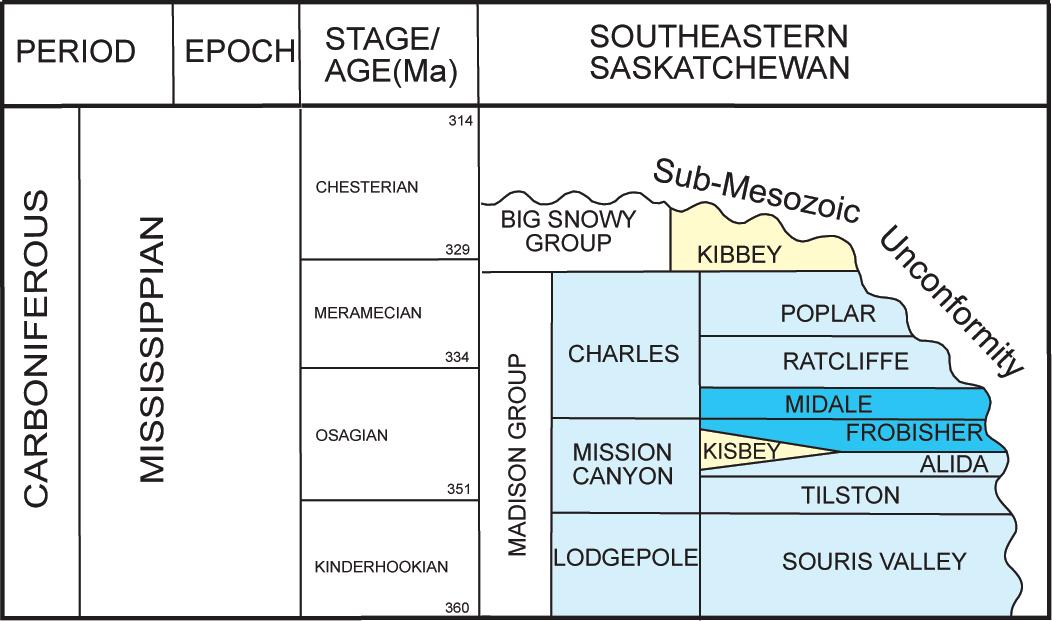
The sequences studied here are the Frobisher Beds, (uppermost Mission Canyon Formation), and the Midale Beds at the base of the Charles Formation (Figure 1).
One useful area in which to examine trapping mechanisms in Mississippian strata down-dip from the subcrop lies within Townships 3 to 5, Ranges 7 to 13 W2M and encompasses the West Kingsford,
(Continued on page 28...)
(...Continued from page 27)
Macoun, Elswick, and Bromhead oilfields (Figure 2). Here, the effect of underlying structure influencing facies distribution and ultimately hydrocarbon accumulation in the Frobisher and Midale Beds can be demonstrated.
An isopach map of the Frobisher Beds (Figure 3) shows the unit thickness to be highly variable; this is due largely to the presence of shoals commonly developed in this package. The isopach map of the lower Midale or “Vuggy” Beds in the same area also shows anomalous “thicks” that reflect oolitic shoals. Oolitic shoals in the younger Midale strata tend to be found farther south than the shoals in the Frobisher Beds, suggesting the distribution of this facies migrated progressively basinward with continued basin-filling. To illustrate the relationship of structure on sedimentation patterns, regional basement faults identified by high-resolution aeromagnetic data are displayed on the structure map of the Frobisher Beds in Figure 3. A close spatial correspondence of the east-west fault trend and shoal development is evident.
The multi-layer shoal pattern developed in the Frobisher-Midale sequence (Figure 4, page 30), has led to a configuration wherein specific facies serve as reservoirs, whereas others act as cap rocks. Potential reservoirs can, for example, occur in the ‘washover facies’ consisting of reworked crinoidal and oolitic grainstones (Figure 5A, page 31) deposited in a high-energy environment proximal to shoal developments. Shoals also may have well-developed vuggy and interparticle porosity (Figure 5B, page 31).
Cap rocks are generally formed by lower energy, landward, lagoonal or intershoal facies mudstones with little porosity or permeability. The seaward edges of evaporites may also act as sealing units.
Traps resulting from favourable spatial distribution of appropriate facies likely developed associated with underlying paleotopography. Paleotopography in southern Saskatchewan is usually controlled by either (a) dissolution along the edge and within the underlying Prairie Evaporite and other Devonian salts, or (b) movement along regional linear fault zones in underlying strata. Two such fault zones are shown on the Frobisher structure map of Figure 3. Many other regional fault zones (Figure 2) may have impacted depositional history,
resulting in the development of potential Mississippian traps.
Inverse thickness relationships of overlying beds may be a predictor of the location of Mississippian shoal developments. For example, the overlying Poplar and Ratcliffe Beds ‘thin’ above Frobisher shoals as shown in well 13-09-04-08W2 and 1121-4-8W2 of Figure 4. This correlation occurs in many areas, and can be used as a predictive tool for Mississippian exploration.
- Mississippian exploration in Saskatchewan should no longer focus solely on structure and unconformity trapping. Integrated structure and facies analysis will be useful toward finding new Mississippian pools.
- Predictive facies analysis is possible considering that deposition of facies having reservoir potential in Mississippian strata is often controlled by underlying structure, and is reflected in overlying strata.
- The example provided here can be used to assist in exploring similarly faulted areas, but with less well control.
Analogs: West Kingsford, View Hill, and Macoun Pools.
Trap:
Stratigraphic with facies distribution partially influenced by underlying structure
Reservoir:
Skeletal/oolitic/crinoidal grainstones and vuggy oolitic wacke/packstones
Seal:
Lagoonal mudstones and sabkha/salina evaporites
Oil Source: Lodgepole Formation
R EFERENCES :
Kent, D.M., 1987, Mississippian facies, depositional history, and oil occurrences in Williston Basin, Manitoba and Saskatchewan: Rocky Mountain Association of Geologists Symposium, p., 157-170.
(Continued on page 31...)
Petrel* workflow tools provide a complete seismic-to-simulation toolkit— one solution uniting the subsurface domains of geophysics, geology, and reservoir engineering.
Geologists can use new modeling capabilities to better predict facies distributions, work with geophysicists to analyze structural uncertainties, and work with reservoir engineers to define a well placement strategy.
“It is like having an extra geologist sitting there, it’s telling you things that you didn’t know, it’s testing your theories like you never saw before and helping you come up with new ideas.” DavidHamilton,CEO,SubsurfaceComputerModeling
With Petrel software, all work processes lead to one shared earth model, resulting in faster, better decisions.
sisinfo@slb.com www.slb.com/petrel
Nimegeers, A.R. and Nickel, E. (2005): Hydrocarbon trapping in the Mississippian Midale and Frobisher Beds, southeastern Saskatchewan: Looking away from the subcrop edge; in Summary of Investigations 2005, Volume 1, Saskatchewan Geological Survey, Sask. Industry Resources, Misc. Rep. 2005-4.1, CD-ROM, Paper A-13, 16p.
Although the Department of Industry and Resources has exercised all reasonable care in the compilation, interpretation, and production of this article, it is not possible to ensure total accuracy, and all persons who rely on the information contained herein do so at their own risk. The Department of Industry and Resources and the Government of Saskatchewan do not accept liability for any errors, omissions or inaccuracies that may be included in, or derived from, this article.
This is the fourth in a series of informational brochures released by the Petroleum Geology Branch of Saskatchewan Industry and Resources. These brochures are intended to highlight prospective areas in the province as identified by staff geologists. It is hoped these will be useful introductions to regions and concepts for explorationists to further develop the oil and natural gas resources of Saskatchewan.
To download these and other documents related to hydrocarbon resources of Saskatchewan, visit: http://www.ir.gov.sk.ca/ prospectsask or email: prospectsask@ir.gov. sk.ca
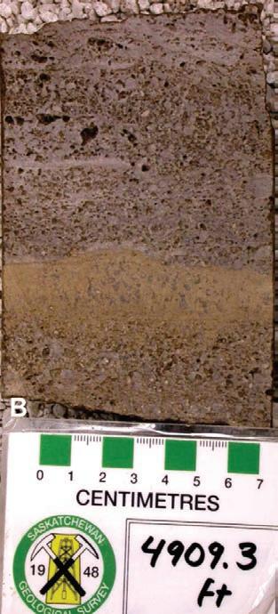
5. A) Coated-grain intraclastic packstone reservoir in the Frobisher
interpreted to be a “washover” facies. 5-6-5-12W2 (1540.8m), B) Lower
reservoir in 15-20-4-7W2 (1496.3m) in the West Kingsford area.
of
2007 Convention • May 14 - 17, 2007 • Calgary, Alberta, Canada


| by Canadian Discovery Ltd.
Operator of Note: Galleon Energy
Play: Devonian Beaverhill Lake Sand Oil
Test of Note: Galleon announced in March an important Middle Devonian Beaverhill Lake sand discovery at Kleskun 16-32-71-36W5, where the 3,000m+ reservoir tested 2,559 boe/d, mostly sweet 38°API oil.
This article is reprinted with permission from Canadian Discovery’s CEO map series (2ndQ 2006). For information on products offered by CDL, please visit www.canadiandiscovery.com or call 269-3644.
On March 9, 2006, Galleon Energy, a Calgary-based, technically-oriented junior oil and gas company, announced a significant light sweet oil discovery at wholly-owned NPW Kleskun 16-32-71-26W5. That well, which was drilled to 3,220m in the Precambrian in February, encountered 10m of Middle Devonian Beaverhill Lake (BHL) sand oil pay with an average porosity of 14%, based on well logs. Flow testing yielded a rate of 2,559 boe/d of 38°API oil with gas (90% oil/10% gas) on a 10.32 mm choke. Reservoir drawdown was 10%. These test results represent some of the best initial rates of any Western Canadian oil well in the last decade. Three additional zones including the Lower Devonian Granite Wash Formation were not tested but appear to be gas-bearing.
Galleon started up in October 2003 and today has a dominant land position (recently boosted to 342,000 gross hectares) and control of infrastructure in its sole core area at present, the Peace River Arch. Based on a CAPE x of $150 million, the company plans on drilling 120 to 130 wells. In the six-by-four-township area of the significant oil discovery alone, Galleon has identified 28 drill locations through 3D seismic and geological mapping. At least 10 to 12 wells will be drilled in 2006 to delineate the newly discovered BHL pool. The company expects the 16-32 discovery to be on stream by the end of June 2006,
at restricted rates of 500 to 1,000 boe/d until a planned crude oil battery is fully operational at the end of 2006 (as of January 2007, the 16-32 had reported production from March to October 2006 of 65mmcf gas and 79,000 bbls oil – ed.). Natural gas and NGL production, such as that anticipated from Granite Wash, will have to wait until a gas plant is built in mid-2006.
In the latter half of 2005, Galleon drilled another successful 100% well, about five kilometers northeast of the BHL discovery,
at NPW 13-11-72-26W5. That well is listed as an oil discovery and was drilled to 3,150m in the Precambrian, and flow tested 2.7 mmcf/d of sweet gas and 75 bopd of NGLs from the Granite Wash. The BHL in 13-11 has not been tested but an offset at 12-11 was licensed by Galleon in 2Q 2006 (Figure 1).
The significant BHL discovery likely keyed off another recent well located less than a section away. NPW Kleskun 6-32-71-26W5 was drilled to 3,171m in the Precambrian
(Continued on page 34...)
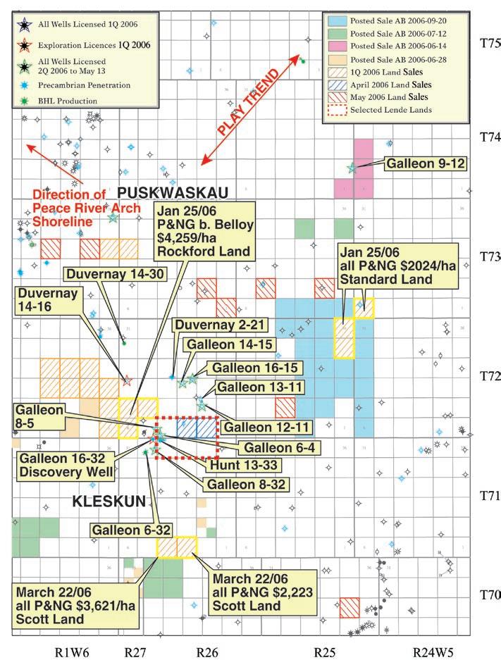
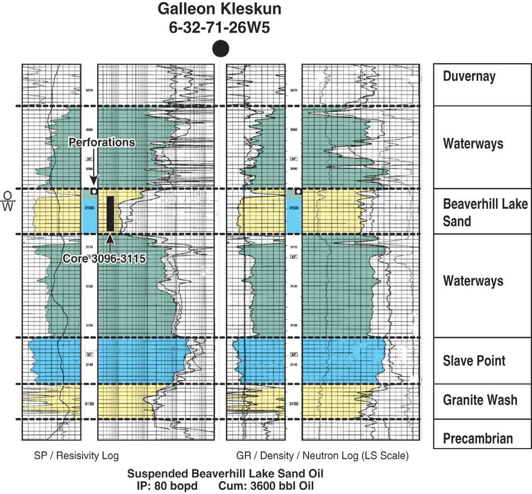
(...Continued from page 33) by Devon Canada during the later half of 2002 and is now operated by Galleon. That well flowed 3,609 barrels of oil and 2.5 mmcf of gas from a BHL A pool at sporadic rates as high as 79 bopd for the first threequarters of 2003 before being abandoned. It is apparent that water influx killed the oil flow. This is a consequence of the reservoir configuration, where about 2.5m of oil sand pay sits on top of 9.0m of water-filled sand (Figure 2). It is very likely that the 16-32 discovery (10m according to Galleon information, listed above) intersected the same thick sand as in 6-32, only structurally higher. Also perforation-tested in 6-32 was the basal Devonian Granite Wash; that interval was abandoned.
To date in 2006 (mid-May) Galleon has licensed three Outposts and three NPWs in the vicinity of the 16-32 discovery. All are planned to drill to the Precambrian, at depth averaging 3,250m (Figure 1).
Other operators are apparently pursuing similar targets in the same area. Hunt Oil drilled NFW Kleskun 13-33-71-26W5 to 3,216m in the Precambrian in July/August 2005. That suspended well is flowing oil from an unspecified zone, but produced 2,676 bbls of oil, in November 2005. Hunt also drilled NPW Puskwaskau 11-3-72-26W5 in February/March 2006, to 3,173m in the Precambrian. That potential oil well was
drilled on a 1,536 ha (six sections) licence purchased through Lende Investments, a land agent, for $28/ha in October 2001, which includes deep P&NG rights below the Jurassic Nordegg. In contrast, an adjacent undrilled three-section (744 ha) licence (sections 6, 7, and 8-72-26W5) was purchased by Rockford Land on January 25 for a top price of $4,259/ha. That land flanks the 16-32 discovery and Hunt’s 1333 oil well. Duvernay Oil, a Calgary-based company focused on northwestern Alberta/ northeastern British Columbia, drilled two deep wells in the area and licensed another during 1Q 2006. NFW Smoky 14-30-72-26W5 was drilled to 3,122m in the Precambrian, and completed in the
(Continued on page 36...)

CONTOURING
Faulted contours
Isopachs
Volumetrics
Grid operations
New flexing options
CROSS SECTIONS
New Unassigned Tops
Digital and/or Raster
Geocolumn shading
Stratigraphic/Structural
Shade between crossover
Dipmeter data
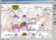
MAPPING OPTIONS
Expanded GIS Functions
Bubble maps
Production charts
Log curves
Posted data
Highlighted Symbols
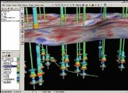
3D VISUALIZATION
Deviated wellbores
Digital logs
Grid surfaces
Tops, Shows and Perfs
Land grid overlay
Map images
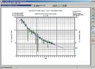
DECLINE CURVES
Compute EUR, RR, etc.
Hyperbolic or exp.
Rate/Time or Cum P/Z
User defined Econ. Limit
User defined Extrap. Time
How our vision supports yours
PETRA: Pioneer of easy, affordable PC solutions for today’s workflows.
IHS: The industry’s leading choice of E&P data and delivery systems to populate PETRA projects. The combination: Fast, confident prospect analysis for you.
Download a trial version at www.ihs.com/energy/petra, or call us at 888-738-7265 for more information. And stay tuned for more on our vision of streamlined data flows for prospect studies.

Slave Point and BHL sand during 1Q 2003. Two Slave Point/BHL production events are listed for that well, which together have flowed 9,438 barrels of oil and 10.7 mmcf of gas between March 2003 and November 2005. More recently, in October 2005, Duvernay drilled and completed NPW 221-72-26W5 to 3,165m in the Precambrian. That well has flowed 3,610 barrels of oil from an undisclosed interval to March 2006. Finally, Duvernay licensed NPW 14-18-7226W5 3,228m in the Precambrian in January 2006, offsetting undrilled deep rights land purchased on January 26, for $678/ha by an agent.
A little further afield and more on the rank exploration side, Galleon licensed and drilled NPW 9-12-74-25W5 to 3,007m in the Precambrian in February/March 2006, in a very sparsely drilled area. That well, currently standing, offsets four, all P&NG, one-section licenses offered for the June 14, 2006 sale.
The BHL sand play is not new, having been
punctuated with reports of discoveries over the last half-century in a wide swath along the southeastern flank of the Peace River Arch that constitutes the play fairway. In all, about 23 pools have so far been discovered. Most prominent among these are the very significant late ‘90s/early ‘00s oil discoveries at Girouxville East and Normandville, located ~50 km northeast of Puskwaskau/Kleskun. Since discovery of the Girouxville East BHL B pool in 1998 (1.3 million barrels oil produced to date, commingled with Gilwood D), the Girouxville East/Normandville BHL pools have produced over 5.6 mmbbls of oil from about 65 wells, with approximately 2.5 bcf of solution gas. The often thin BHL sands are encased in the open-marine transgressive shales and argillaceous carbonates of the Waterways Formation. During the Devonian Period, coarse siliciclastics were shed off the Peace River Arch of western Alberta and northeastern British Columbia, some extending far into the basin, indicating prolonged periods of lowstand. The BHL is only one of these sand bodies (Figure 3), the others being the Granite Wash Formation, the Keg
River sands, and the Gilwood Member of the Watt Mountain Formation. The BHL sand play is slowly extending on strike with the Waterways shoreline along the southeastern flank of the Peace River Arch and has important remaining potential (see www.canadiandiscovery.com for information on Canadian Discovery’s latest report which examines in detail the Beaverhill Lake Sand Oil Play).
Although the highlight in this region during this quarter is the significant BHL sand discovery, much potential remains for other deep, stacked reservoirs in this underexplored region of the Peace River Arch, including Granite Wash, Keg River, and Gilwood sands of the Elk Point Group, Slave Point carbonate banks in the BHL Group, and numerous other Paleozoic reservoirs.

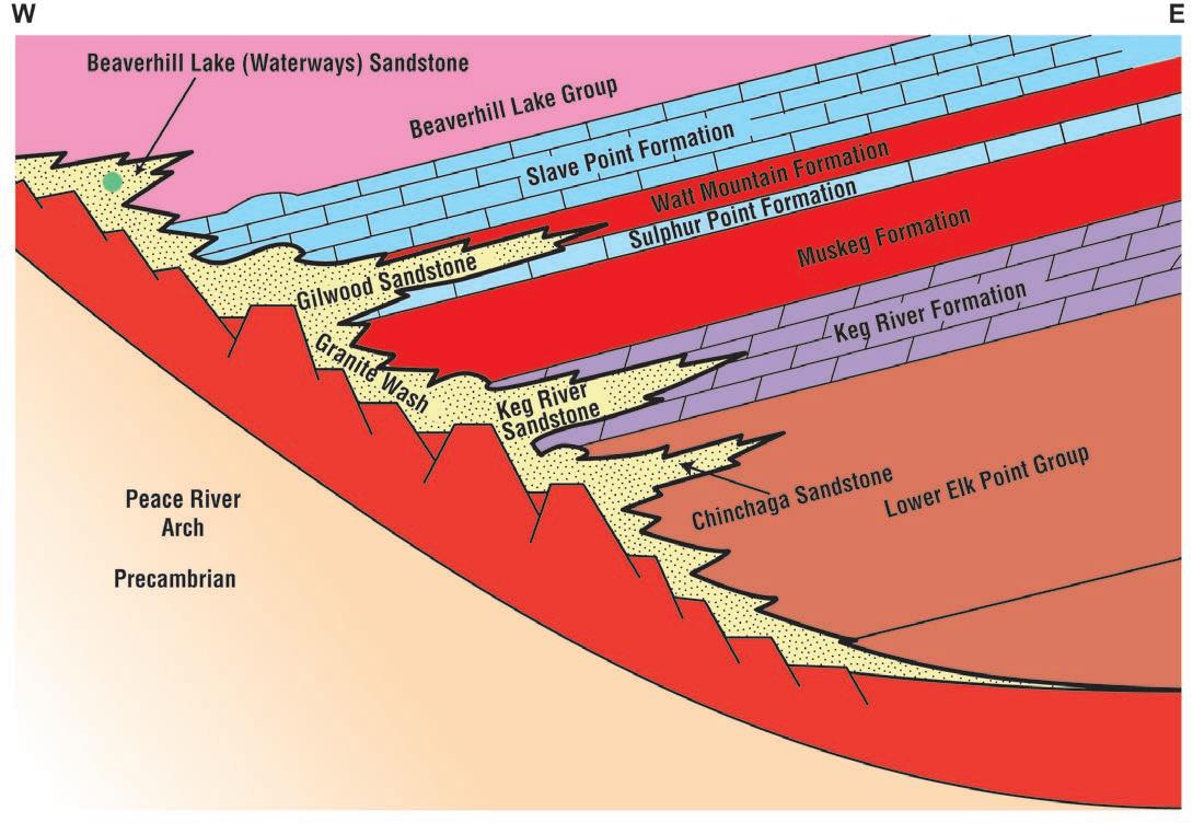
April 29 - May 1, 2007
Delta Regina, Regina, SK Canada
15th Williston Basin Petroleum Conference & Prospect Expo
Registration information will be available after February 1, 2007 at www.wbpc.ca
Have questions? Call 306-787-0169, email info@wbpc.ca, or write to WBPC, 201 Dewdney Ave. East, Regina, SK S4N 4G3
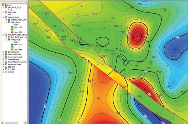
� Prospect Expo Registration begins February 1, 2007!
� Workshops
� Technical Talks
� Activity Updates “Hot Plays”

Name
William T. Birch
Douglas S. Gowland
Bruce J. Keen
Ms. Andrea Reiserer
Corinne Riley
Name
Jawwad Ahmad
Eva M. Armeneau
Megan D. Barefoot
Michael Benrud
Sean M. Brady
Raegan K. Brown
Zhihong Cao
Ramona D. Ciobanu
John R. Cockrill
Lona-Kate Dekeyser
Natalie Dobie
Laura Faulkenberry
Michael E. Freeman
Robert M. Gerhardt
Deborah Glover
Anthony L. Graup
Neil J. Guenter
Memet Metin Hagi
Susan L. Harbidge
Benjamin Hollands
Michael R. Lazorek
Shaohua Li
Tim R. Mack
Terry L. Mah
Jessica M. McPherson
Andrew J. Mumpy
Brian Parsons
Michelle F. Prochotsky
Bernard G. Scheck
Nichole L. Scott
Galal G.B. Soliman
Jeff L. Taylor
Birch Oilfield Consulting Ltd. Grand Prairie, AB
Acumen Capital Partners Calgary, AB
Recon Petrotechnologies Calgary, AB
geoLOGIC systems ltd. Calgary, AB
Simpson & Associates Calgary, AB
Vigilant Exploration Inc. Calgary, AB
Alberta Energy And utilities Board Calgary, AB
Angle Energy Calgary, AB
South Bay Resources LLC Houston, T x
Encana Corporation Calgary, AB
uTS Energy Corporation Calgary, AB
Imperial Oil Resources Calgary, AB
RPS Energy Canada Ltd.
Calgary, AB
Trident Exploration Corp. Calgary, AB
Husky Energy Inc. Calgary, AB
Bonavista Energy Trust Calgary, AB
ConocoPhillips Canada Limited Calgary, AB
Belloy Petroleum Consulting Calgary, AB
Canetic Resources Inc. Calgary, AB
Petro-Canada Oil And Gas Calgary, AB
Angle Energy Inc.
Calgary, AB
Birchcliff Energy Ltd. Calgary, AB
Encana Corporation Calgary, AB
Alberta Energy And utilities Board Calgary, AB
Canadian Natural Resources Ltd. Calgary, AB
Ministry of Natural Resources, Petroleum Resources Centre London, ON
Petrobank Energy and Resources Ltd. Calgary, AB
Alberta Energy And utilities Board Calgary, AB
Norse Horse Enterprises Ltd. Calgary, AB
Encana Corporation Calgary, AB
university Of Alberta Edmonton, AB
Vision 2000 Exploration Ltd. Calgary, AB
Husky Energy Inc. Calgary, AB
Telluric Consulting Ltd. Provost, AB
Total E&P Canada Ltd. Calgary, AB
Zaki Geological Consulting Calgary, AB
ConocoPhillips Canada Ltd.
Calgary, AB
yangfa (Thomas) Tu Baker Atlas Calgary, AB
Alexandru Vant
Aaron D. Vaughan
Enervant Consulting Ltd. Calgary, AB
Aaron Vaughan Consulting Inc.
Calgary, AB
Tom Wang Edmonton, AB
Angie K. Webster
GR Petrology Consultants Inc. Calgary, AB

Whether it is fluid contact depths, permeability, faults and fractures or numerical inputs for flow simulation, there is always an element of uncertainty in one’s reservoir operations.
And yet, unlike playing roulette on the casino floor, uncertainty and luck doesn’t have to be inevitable. Roxar is seeing to that.
Through generating multiple scenarios, systematic analysis of the results and incorporating them into a dynamic, simulation environment, Roxar is helping oil and gas operators to better manage and quantify uncertainty within the reservoir.
And, unlike roulette, the end result will be that operators won’t have to rely on chance and luck to succeed but will be able to quantify uncertainty in their reservoir operations and more accurately determine the level of risk – often financial – in their decisions.
For more information on how Roxar is adding uncertainty capabilities to its industry-leading IRAP RMS™ modeling solution, contact us today.