Please submit RESERVOIR articles to the CSPG office.Submission deadline is the 23rd day of the month,two months prior to issue date. (e.g.,January 23 for the March issue).
To publish an article,the CSPG requires digital copies of the document.Text should be in Microsoft Word format and illustrations should be in TIFF format at 300 dpi.For additional information on manuscript preparation,refer to the Guidelines for Authors published in the CSPG Bulletin or contact the editor.
COORDINATING EDITOR & OPERATIONS
Jaimè Croft Larsen
CSPG
Tel:403-264-5610 Fax:403-264-5898
Email:jaime.croftlarsen@cspg.org
TECHNICAL EDITOR
Ben McKenzie
Tarheel Exploration
Tel:403-277-4496
Email:bjmck@telusplanet.net
ADVERTISING
Kim MacLean
Corporate Relations,CSPG
Tel:403-264-5610,Ext 205
Email:kim.maclean@cspg.org
Advertising inquiries should be directed to Kim MacLean.The deadline to reserve advertising space is the 23rd day of the month, two months prior to issue date.All advertising artwork should be sent directly to Kim MacLean.
The RESERVOIR is published 11 times per year by the Canadian Society of Petroleum Geologists. This includes a combined issue for the months of July/August.
Advertisements,as well as inserts,mailed with the publication are paid advertisements.No endorsement or sponsorship by the Canadian Society of Petroleum Geologists is implied.
The CSPG Rock Shop is an attractive and affordable way to target the CSPG readership. Spaces are sold at business card sizes (3.5” wide by 2” high).To reserve space or for more information,please contact Kim MacLean at 403-264-5610,ext.205.
The contents of this publication may not be reproduced either in part or in full without the consent of the publisher.
EXPANDING THE VITALITY AND INFLUENCE OF OUR SOCIETY
Over the past year,I have had the pleasure of volunteering as vice-president of our Society alongside an excellent executive team.Now, it is time for me to assume the leadership role for 2006.Therefore,it seems appropriate to take a moment to reflect on recent progress,look ahead to current challenges and opportunities,and consider potential new initiatives.
The CSPG has always been a vibrant Society, highly responsive to its members.We currently have more than 50 active subcommittees and divisions,delivering a wide range of technical,social,and outreach services.We are financially healthy,our office is reasonably well organized and staffed with excellent personnel.By all accounts,we are very successful and the envy of many other not-for-profit organizations.
As reported in the December issue of the RESERVOIR,your executive spent considerable effort in 2005 developing a new strategic plan for the Society.The purpose of this exercise was to identify key factors affecting our collective future,then respond to these via a set of strategic goals and objectives.In 2006,we will begin implementing specific action plans by selecting one topic for discussion at the first executive meeting of each month.
Our six strategic goals may be grouped into two broad areas of influence:
(i) addressing the needs of our membership and
(ii) encouraging young people to consider (and pursue) a career as a petroleum geoscientist.
The six goals are worth repeating here:
ADDRESSING THE NEEDS OF OUR MEMBERSHIP
1) advance the professional development of our members,
2) nurture a sense of pride and community for our members,
3) become indispensable to Canadian petroleum geoscientists and employers,and
4) foster the spirit of scientific inquiry and debate.
ENCOURAGING YOUNG PEOPLE TO PURSUE A CAREER IN PETROLEUM GEOSCIENCE
5) advocate a positive national image of our profession and
6) inspire the petroleum geoscientists of the future.
As you can imagine,there is plenty of work to do and lots of room for additional volunteers to help out.You may wish to consider participating in one the following ‘topics’:
GREATER ADVOCACY
Under goal 5,we plan to work on our national presence,with the dual objective of recruiting new members and articulating an exciting,challenging,technically progressive, and,environmentally responsible image for the upstream petroleum industry.I believe that we can achieve significant levels of influence by partnering with other E&P technical societies such as CSEG,SEPAC, CAPP,APEGGA,etc.,and by revamping our public relations material and building media relationships.
ARTICULATING OUR CLIMATE CHANGE PERSPECTIVE
In recent months,Canadians have been subjected to continual media bombardment on the (questionable) global warming issue, coupled with a direct,unfavorable (and definitely unwarranted) linkage to petroleum exploration and extraction.As a learned technical Society,well acquainted with dramatic climate change throughout geologic time,we have remained remarkably silent on this issue.Before you inundate me with emails,I realize that we must not become engaged in a political debate,however if we wish to build a positive image of our profession and attract youth to the petroleum geosciences (goal 6),we have a responsibility to draw attention to the climate change facts, by promoting scientific debate on the issue and possible solutions.Look for more on this topic in a future issue of the RESERVOIR.
A NEW NATIONAL UMBRELLA ORGANIZATION
During the past year,our 2005 President,Jeff Packard,spearheaded a new initiative to rebuild a national geoscience umbrella
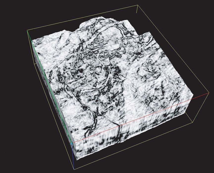
The EARTH ImagerSM service delivers high-resolution micro-resistivity images in oil-based mud with great hole coverage.
This proven micro-resistivity imager from Baker Atlas offers a vertical resolution of less than 8mm at a standard logging speed of 274m/hr giving you details never seen before in oil-based mud images.
The EARTH Imager service operates in 149mm to 533mm diameter boreholes. With its 6 pads mounted on individually articulated arms, it provides you with 64.9% borehole coverage in 200mm diameter holes while maintaining pad contact at all hole deviations.
Call us today to find out how you can use the EARTH Imager service in your next oil-based well to accurately identify structural and sedimentary features, rock texture, fracture orientation and estimate net-to-gross.
THE CSPG GRATEFULLY ACKNOWLEDGES ITS CORPORATE MEMBERS:
THE CSPG GRATEFULLY ACKNOWLEDGES ITS CORPORATE MEMBERS:
ABU DHABI OIL CO., LTD. (JAPAN)
BAKER ATLAS
BG CANADA EXPLORATION & PRODUCTION, INC.
BP CANADA ENERGY COMPANY
BURLINGTON RESOURCES CANADA LTD.
CALPINE CANADA
CANADIAN FOREST OIL LTD.
CONOCOPHILLIPS CANADA
CORE LABORATORIES CANADA LTD.
DEVON CANADA CORPORATION
DOMINION EXPLORATION CANADA LTD.
DUVERNAY OIL CORP.
ECL CANADA
geoLOGICsystems ltd.
GRIZZLY RESOURCES LTD.
HUNT OIL COMPANY OF CANADA, INC.
HUSKY ENERGY INC.
IHS ENERGY
IMPERIAL OIL RESOURCES LIMITED
LARIO OIL & GAS COMPANY
MJ SYSTEMS
MURPHY OIL COMPANY LTD.
NCE RESOURCES GROUP INC.
NEXEN INC.
NORTHROCK RESOURCES LTD.
PENN WEST PETROLEUM LTD.
PETRO-CANADA OIL AND GAS
PETROCRAFT PRODUCTS LTD.
PRECISION ENERGYSERVICES
PRIMEWEST ENERGY INC.
SAMSON CANADA
SHELL CANADA LIMITED
SPROULE ASSOCIATES LIMITED
STARPOINT ENERGY LTD.
SUNCOR ENERGY INC.
TALISMAN ENERGY INC.
TOTAL E&P CANADA LIMITED
organization.Excellent progress was made on attracting the major participants to the design table and your executive is now pleased to report that we have a ‘straw-man’ built for a new organization.It has also been agreed that the first president of this organization will be drawn from the energy sector.We are confident that this organization will provide important strength to a national earth science voice and lobby (goals 2 and 5).
RECRUITING AND RETAINING MEMBERS (CORPORATE & INDIVIDUAL)
The Society requires a membership chairperson and is actively looking for a volunteer to take on this important role.The membership committee provides support for recruiting new members across Canada (goal 6),as well as initiatives aimed at retaining existing members as many of us approach our ‘retirement’ stage (goal 3).We have several excellent (recent) membership surveys and some innovative concepts to begin dealing with these challenges.Please contact Shannon Nelson Evers if you would like to help.
BUILDING AND GUIDING OUR TRUST FUND
The CSPG Educational Trust Fund (Trust) exists to fund our various public outreach programs (goals 5 and 6).Such programs include the annual Student-Industry Field Trip (SIFT),visiting lecturer tours,student chapters,
scholarships,and the Honorary Address,to name a few.The Trust provides a tax-efficient mechanism for raising the necessary cash, while allowing the executive and the outreach committees to influence and mange the initiatives.As such it is an important tool of the CSPG.The Trust chairman,Bruce McIntyre,and his team are about to embark on an ambitious fundraising initiative in 2006. Stay tuned for more details.I will be contributing to their goal and I hope that you will too.
CONVENTIONS, PROGRAMS, AND NEW OFFICE SPACE
In 2006,we plan to work all of this and more, while continuing to deliver top quality technical conventions,short courses,field trips,Bulletins,and publications.We have an agreement in place to hold joint annual conventions with the CSEG for the next five years,and more recently we have signed a lease for new office space,part of which will also be shared with the CSEG.We are considering another joint technical convention with the AAPG for 2012.We are also working on a comprehensive safety and risk management policy for the Society.All of this should keep us busy for a while.Best wishes for a healthy and prosperous 2006.
Jim Reimer,President
CORPORATE MEMBERS AS OF DECEMBER 24, 2005
TECHNICAL LUNCHEONS
FEBRUARY LUNCHEON
Modern and ancient methane clathrate hydrate accumulations:comparative sedimentology of Mesozoic deposits from the Western Interior Seaway of North America
SPEAKER
Federico Krause
University of Calgary
11:30 am Tuesday,February 7,2006
TELUS CONVENTION CENTRE CALGARY, ALBERTA
Please note:
The cut-off date for ticket sales is 1:00 pm,Thursday,February 2nd. Ticket price is $28.00 + GST.
Below modern seafloors,at water depths exceeding both storm wave-base and photic basement,methane clathrate hydrates are widespread.However,because methane clathrate hydrates are inherently unstable, the prevailing historical consensus maintains that these materials lack a stratigraphic record.This presentation will illustrate that a variety of biological,chemical,and physical features have indeed been preserved.
Geophysical studies along modern continental margins and interior basins have identified vast tracts of sediments that contain clathrated hydrate gases,and columnar zones where gas evolution is active and ongoing.In some cases,the sediment interval containing clathrated gas hydrates can exceed 400 meters in thickness,and can extend laterally for many kilometers,well beyond zones of focused cold seepage.The volume of sediment below the seafloor that is saturated with variable quantities of gas and gas clathrate hydrates is therefore immense.
At the sites of active methane gas evolution and clathration,conditions near and below the seafloor typically are anaerobic and/or hypoxic,and nearby fluids are sulfidic and methanic.Significantly,underwater investigations conducted with human and remotely operated submersibles have confirmed that numerous benthic, chemosynthetic,and chemosymbiotic organisms live at these locations.
Furthermore,the clathration of methane hydrates also results in the precipitation of a variety carbonate minerals that often are strongly depleted in 13C.This signal arises from the diagenesis of carbon in methane and is based on the fractionation between 12C and 13C isotopes.
In the Mesozoic Western Interior Seaway, calcite that is strongly depleted in 13C has been identified in limestone nodules of the Teepee Butte Member of the Pierre Shale Formation of South Central Colorado.This formation is marine in origin and accumulated during the Campanian Stage (approximately 70 to 80 Ma ago).The limestone nodules are encased in shale and consist of an immense number of coquinoid, infaunal,nymphalucinid bivalves;pellet grainstones,packstones,wackestones and mudstones;and centimeter-sized,irregularly nodular spar-filled vugs.
The coquinoid nymphalucinid bivalves found in the Teepee Butte Member belong to a wellknown group of chemosymbiotic,infaunal pelecypods,the Lucinidae.In modern oceans this bivalve group is very successful,occupying almost every possible marine seafloor environment known,as they are capable of living under anaerobic conditions.In contrast to other chemosymbiotic organisms,lucinids are mixotrophic opportunists.Modern lucinids combine siphonate filter feeding and chemosymbiosis with sulfate-oxidizing bacteria,a behaviour that allows them to exploit sediment zones of anaerobic methane oxidation and sulfate reduction.
The sparry nodular vugs consist of three primary calcite cement phases that in paragenetic order are high-magnesium,
botryoidal fibrous;ferroan “dendrolublinite;” and ferroan blocky.The botryoidal fibrous cements have 13CPDB ratios that range from -41.5‰ to -46.3‰,a signal that is strongly indicative of a methanogenic carbon source for these cements. 13CPDB ratios of dendrolublinite and blocky calcites have greater separation,ranging from -12.6‰ to -40.8‰ and -15.1‰ to -44.5‰,respectively. These cements also originate from the diagenesis of methane,but followed a geochemical path that incorporated the reduction of iron.All three sparry cements grew from “free surfaces” into open space. The petrographic pattern observed points to the presence of a precursor material that displaced the encasing shales and pelletal and nymphalucinid carbonates,and which subsequently “disappeared” in stages.In modern marine shales the clathration of methane gas is often nodular and displacive, and is also accompanied by carbonate mineral precipitation.
In conclusion,Teepee Butte Member limestone nodules preserve biological, chemical,and physical evidence indicative of active methane gas diagenesis and clathrate hydrate consolidation and dissociation during sedimentation in the late Mesozoic foreland basin of North America.
BIOGRAPHY
Federico (Fed) Krause is a professor in the Department of Geology and Geophysics at the University of Calgary who worked in the petroleum industry and government prior to joining the university.He is working with a great group of students on a number of projects, including carbonate mud-mounds and petrifactions from gas clathrate hydrates.
FEBRUARY LUNCHEON
Collisional fold-and-thrust belts detached on salt
SPEAKER
Mark G.Rowan
Rowan Consulting Inc.
11:30 am
Tuesday,February 21,2006
TELUS CONVENTION CENTRE CALGARY, ALBERTA
Please note:
The cut-off date for ticket sales is 1:00 pm,Thursday,February 16th. Ticket price is $28.00 + GST.
Collisional fold-and-thrust belts detached on salt can be divided into two subsets: those where the pre-kinematic section is undeformed,and those where diapirs and minibasins were established prior to the onset of shortening.Examples from the Sierra Madre Oriental of Mexico,the Flinders Ranges of South Australia,and the
Zagros Mountains of Iran are used to illustrate the very different geometries that result.
In cases where pre-shortening deformation is absent,structural styles are relatively simple,characterized by regular wavetrains of parallel,elongate detachment folds that are broadly symmetrical.Individual folds are typically cylindrical over much of their lengths and then conical and more open where they plunge gently toward their terminations. Thrust development,variations in fold orientation,and anomalously steep plunges on some folds are attributed to the spatial and thickness distribution of the décollement layer.
In fold-and-thrust belts where salt withdrawal and diapirism predated the shortening,the pre-existing structural architecture and the consequent variable strength of the overburden control the deformation and yield much more complex geometries.Modelling by B.
Vendeville of circular minibasins separated by a polygonal pattern of salt ridges,with diapirs at the ridge intersections,shows that the weak diapirs are squeezed,the intermediate-strength ridges form a complex pattern of contractional structures,and the strong minibasins simply translate and may rotate.The result is a polygonal array of folds,thrusted folds,strike-slip faults,and even extensional structures that typically intersect at,and plunge away from,the diapirs.
If early salt withdrawal and diapirism lead instead to linear salt walls and elongate withdrawal basins,later shortening structures have the same preferred orientation.Moreover,strong strata around the tips of salt walls result in a strike-parallel strain gradient in which the centers of the walls shorten more than the ends.With enough shortening,steep salt welds form that link two remnant diapirs at the tips of the walls.Further shortening leads to folding above the welds,producing geometries where diapirs are located at fold terminations rather than culminations.
BIOGRAPHY
Mark received his B.S.Biology from the California Institute of Technology in 1976,his M.Sc.in Geology from the University of California at Berkeley in 1982,and his Ph.D. in Geology from the University of Colorado at Boulder in 1991.While persuing his academic career Mark gained industry-related experience with Sohio Petroleum Co.(198285),Geo-Logic Systems (1985-89),and Alastair Beach Associates,Glasgow Scotland (1989-92).After successfully defending his Ph.D.,Mark joined the University of Colorado as a research associate and professor from 1992-1998.He is presently President of his own company,Rowan Consulting Inc.,in Boulder Colorado.
Mark’s professional interests include styles and processes of salt tectonics,salt-sediment interaction,geometry and kinematics of fold-and-thrust belts,and applications to petroleum exploration.He is currently a member of the American Association of Petroleum Geologists,Geological Society of America,and International Association of Structural / Tectonic Geologists.
The Veritas Experience
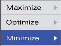
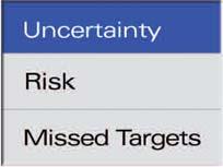
Veritas is a leading provider of integrated geophysical information and services worldwide. In Canada, our comprehensive suite of technologies and unmatched experience maximize your drilling success,optimize image quality, and minimize your exploration risk
When you need results, call Veritas.
Seismic Attributes
Work with Veritas and experience the advantages of reliable, petrophysicallymeaningful solutions, from seismic all the way through reservoir characterization.
Meaningful Solutions
>fit-to-purpose approaches to meet specific challenges
>AVO, LMR, Fracture Analysis, Spectral Decomposition, Converted- and Shear-wave analysis and registration, and much more
>physically meaningful attributes
>analysis to derive multi-attribute relationships
>calibration with well logs and geologic data
Real World Experience
>unconventional gas plays
>heavy oil
>tight gas
>shale gas
>coal bed methane
>pore pressure prediction
>lithology, fluid and porosity models
Relevant Expertise
>dedicated research teams focused on solving clients’ exploration and development problems
MARCH LUNCHEON
A simplified approach to the climate change controversy
SPEAKER
James M.White
NRCan,Geological Survey of Canada
11:30 am
Thursday,March 9,2006
TELUS CONVENTION CENTRE CALGARY, ALBERTA
Please note:
The cut-off date for ticket sales is 1:00 pm,Monday,March 6th. Ticket price is $28.00 + GST
This talk considers several lines of evidence that persuade me that the issue of anthropogenic climate change is significant,and that the science is substantial.Enquiry into trace gases and climate began over a century ago,in part spurred by geological evidence of dramatically different past climates.The significance to Earth’s climate of trace
gases,such as carbon dioxide,is well established,and our activities influence its atmospheric concentration.Geology shows that climate has changed on many time scales and from many causes,ranging from tectonics to solar variability,but carbon dioxide is one important factor. Even if a warming cycle such as the Mediaeval Warm Period was not caused by man,it does not mean that our activities are not influencing the modern climate. The Urban Heat Island effect has been used to dismiss evidence of surface warming,but there are corroborating lines of evidence,independent of urban temperature records.Moreover,satellite evidence does not reliably contradict evidence of surface warming.It is often said,correctly,that “climate has always changed,and people adapted,” but the geological view of adaptation is too remote.The process of adaptation at a time scale relevant to people bears a closer look.The inability of a complex society to adapt to climate change is illustrated by the collapse of classic Mayan civilization.
BIOGRAPHY
James White began his palynological career in 1976 with doctoral research on the Late Quaternary of the Peace River district.Since joining the Geological Survey of Canada in 1986 he has studied the Cenozoic biostratigraphy of western and northern Canada, resulting in a synthesis of palynostratigraphy and paleoclimatology spanning the last 18 million years.Work in the Jurassic and Cretaceous has resulted in publications on the age of the Cadomin Formation and on modeling biostratigraphy from a literature database.The palynostratigraphy of the Mallik gas hydrate research borehole,Mackenzie Delta is his recent focus.Climate is a major determinant of plant assemblages,so paleoclimatology is an inherent aspect of his research.He has presented talks on paleoclimates and climatic change to the CSPG Environment Committee,the University of Calgary,the University of Northern British Columbia,Australia National University,the Geological Association of Canada,and other professional societies.He is senior author of 16 publications concerning paleoclimatology and its relation to biostratigraphy.
MARCH LUNCHEON
Hydrocarbons in the Paleozoic basins of eastern Canada: new perspectives and promising targets
SPEAKER
Dennis Lavoie Geological Survey of Canada
11:30 am Tuesday,March 21,2006
TELUS CONVENTION CENTRE CALGARY, ALBERTA
Please note:
The cut-off date for ticket sales is 1:00 pm,Thursday,March 16th. Ticket price is $28.00 + GST.
The Cambrian to Middle Devonian successions at the continental margin of Laurentia consist of marine to continental sediments deposited during alternating passive margin and foreland basin episodes. Two significant orogenic pulses,the Ordovician Taconian Orogeny and the Late Silurian-Middle Devonian Salinian-Acadian event,controlled tectono-sedimentary patterns.
Good hydrocarbon source rocks are found in the Upper Ordovician foreland basin shales (TOC up to 14%,Type I/II),in the Middle Ordovician oceanic shales (TOC up to 10.7%,Type I) and in the Lower Ordovician passive margin shales (TOC up to 10.4%,Type I/II).Fair hydrocarbon source rocks are found in Lower – Middle Devonian foreland basin limestones and coals (TOC from 2% to 50%,Type II/III respectively).Maturation suggests that the Cambrian-Ordovician St.Lawrence Platform has a gas (southern Quebec) to oil (western Newfoundland) potential;the coeval Humber Zone has a gas (Quebec) to gas and oil (western Newfoundland) potential.The Late Ordovician to Middle Devonian Gaspé Belt has both gas and oil potential.
Clastic reservoirs are found in CambrianOrdovician passive margin and foreland basin coarse sandstone and conglomerate slope facies and in Silurian-Devonian nearshore sandstones.The potential for secondary carbonate reservoirs is recognized in the recent documentation of hydrothermally-altered carbonates (Lower to Upper Ordovician passive margin and foreland basin;Lower and Upper Silurian
and Lower Devonian foreland basin).The recognition of hydrothermal dolomites is based on the burial scenario,tectonic framework,and detailed petrography and geochemistry.Production of natural gas and sub-economic accumulation of oil have been recently documented in these dolomites.GC-MS and GC-IRMS fingerprinting of hydrocarbons,bitumen, and potential source rocks indicate a most likely dominant Ordovician source.Based on crosscutting relationships and basin modeling,multiple events of hydrocarbon migration are recognized with a significant Late Silurian (syn-Salinian orogeny) and a late Early Devonian migration.
Traps and seals are multiple and include various stratigraphic (pinch-out, impermeable layers,and unconformities), tectonic (fault closures,anticlines, duplexes,and triangle zones) and diagenetic (HTD) types.
Exploration is picking up rapidly in these Lower Paleozoic basins in eastern Canada
with large areas under exploration permits and promising recent drilling results.
BIOGRAPHY
Denis Lavoie received a B.Sc.A.in geological engineering from Laval University in 1982 and a M.Sc.(1985) and Ph.D.(1988) in sedimentology and carbonate geochemistry.The Geological Survey of Canada hired him in 1989 as research scientist for its Quebec division. Since then,he has carried out research projects on Cambrian to Carboniferous sedimentary basins in eastern Canada and published over 50 research papers on various aspects of these basins.North American and International oil and gas exploration companies interested in the hydrocarbon potential of these basins have requested his expertise.He currently leads a multi-organization and multi-discipline project on the evaluation of the hydrocarbon resource of these basins.In 2001,he edited the first appraisal of the hydrocarbon potential of the Gaspé peninsula (Bulletin of Canadian Petroleum Geology) and is currently associate editor for the Canadian Journal of Earth Sciences and Geoscience Canada.
ROCK SHOP
DIVISION TALKS STRUCTURAL DIVISION
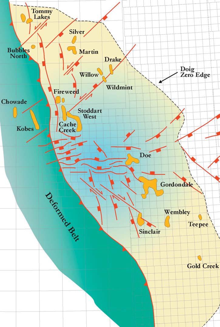
Detection and analysis of basement structures and their influence on hydrocarbon plays in Northeast British Columbia
SPEAKER
Zeev Berger
Image Interpretation Technologies Inc.
12:00 Noon
Thursday,February 9,2006
Petro-Canada
West Tower, room 17D (17th floor) 150 6th Ave SW
Calgary, Alberta
Recent quality improvements in the free GSC magnetic data and new developments in magnetic filtering techniques allowed us to generate a cost-effective tectonic map over NE BC.We demonstrate the control of basement structures on hydrocarbon plays as well as identify new concepts for exploration in this region.The most important contribution of this study is to the emerging play of the Doig Formation. This study illustrates how Doig “incised valleys” appear to develop along the downthrown side of reactivated basement faults and uplifted basement horst blocks. The relationship between basement faults and Doig reservoir fairways can be demonstrated in:
(1) the Buick-Cache Creek Complex, (2) the Doe-Gordondale complex,and (3) the Wembley field.
In addition,the relationship between basement structures and other reservoirs can be illustrated with examples from:
(1) the Parkland-Doe complex for the Wabamun Formation, (2) the Blueberry-Kobes complex for the Debolt Formation,and (3) the Deep Boundary Lake Complex for the Kiskatinaw Formation.
BIOGRAPHY
Dr.Zeev Berger is the president of Image Interpretation Technologies Inc.,a company from Calgary that specializes in conducting tectonic/exploration studies based primarily on the analysis of high-resolution magnetic and gravity surveys as well as remote-sensing data. Prior to forming IITech,Zeev was involved in
research and exploration with Exxon Production Research Company in Houston and Imperial Oil in Calgary.Dr.Berger published extensively on the subject of integrated tectonic studies,the applications of remote-sensing to exploration, and the control of basement structures on hydrocarbon plays.For more information on his publications,visit IITech’s website at www.iitech.ca.
INFORMATION
Talks are free;please bring your lunch.Goodies and drinks are provided by HEF Petrophysical Consulting,and the room is provided by PetroCanada.If you would like to be on the Structural Division e-mail list,or if you’d like to give a talk, please contact Elizabeth Atkinson at (403) 296-3694 or eatkinso@petro-canada.ca.
PALAEONTOLOGY DIVISION
Lost world:the past,present, and future of biodiversity in Madagascar
SPEAKERS
Philip Benham
Shell Canada Limited
Dr.Jonah Ratsimbazafy
Durrell Wildlife Conservation Trust (co-author)
7:30 pm Friday,February 17,2006
Mount Royal College Room B108
4825 Richard Road SW Calgary, Alberta
Madagascar is essentially a “Lost World” where evolution has proceeded,largely in isolation for about 135 million years.The 300-kilometer-wide Mozambique Channel, separating the country from continental Africa provides a fairly effective barrier to colonization.As a result,Madagascar has one the highest rates of endemism of any region in the world.About 90% of Madagascar’s plants and over 95% of its many bizarre mammals,reptiles,and amphibians are unique to the island.Due to the vagaries of fossil preservation and historical documentation,much of the ancient and more recent past is lost to us.Much of the Tertiary rock record is absent,thus information on a critical period in the development of the country’s mammalian fauna is missing.Little work has been done to understand the intriguing geological history of Madagascar but it is geology that is the tie to Madagascar’s heritage.
One source of Alfred Wegener’s theories of plate tectonics was the restricted distribution of fossils of primitive seed plant Glossoptera in landmasses (including Madagascar) that could be reassembled in what would be called Gondwanaland.Later Malagasy continental connections with Pangaea and a last separation with India perhaps about 80 Ma complicate the picture and even now Madagascar retains strong floral and faunal ties with India.These connections can be unraveled by examining the fossil record (ancestral lemurs and the lineage of giant birds known as ratites),the modern distributions of plants and animals (such as freshwater crayfish,earthworms, and leeches),and genetics.While Madagascar’s relative isolation bears a strong overprint of its earlier tectonic
configurations,the formidable stretch of water in the Mozambique Channel did not completely prevent occasional colonization. For example,the molecular clock,defined by changes in DNA extracted from subfossil and 50 species extant lemurs points to a single colonization event by this primate in the early Tertiary (approximately 60 Ma). Similar origins are postulated for rodents, spiny tenrecs,plated lizards,and the more recent carnivorans (including the mongoose,cat-like fossa,and the fox-like Malagasy civet) who arrived perhaps 20-30 Ma.On the other hand,the chameleon,of
which over 50 species thrive on the island, seems to demonstrate multiple oceanic dispersals from Madagascar to various destinations bordering the Indian Ocean. Presumably its slow metabolism allowed it to survive ocean crossings.While the oldest chameleon fossils date to Miocene (18 Ma) in Kenya,the genetic evidence points to a Malagasy source.
Madagascar,in perhaps the 3rd Century BC, was one of the last colonized major landmasses (only Hawaii and New Zealand were later).As a result,Madagascar provides
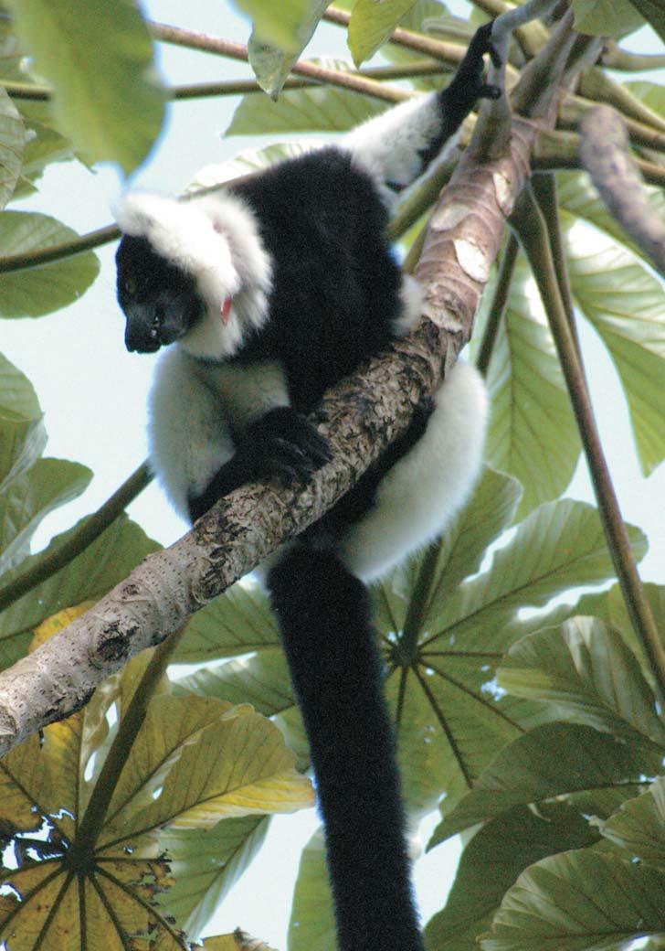
Black and white ruffed lemur (Varecia variegata variegata) perched in a Cecropia tree in Manombo Special Reserve,southern Madagscar.
a good laboratory for observing the impact of man on surrounding wildlife.The results are sobering.Since the island’s colonization, the Aepyornis (one of the largest birds ever to have lived),17 species of giant lemurs, three species of pygmy hippopotami,giant tortoises,and many other fauna went extinct by about 400 AD.Growth of the human population has led to conversion of 90% of the original forest to farmland through a slash and burn process known locally as tavy.Much of this farmland is lost to erosion as the soils of Madagascar bleed red into the ocean. Today the pressures are greater than ever on the remaining natural areas.Even reserves and parks are not immune to local populations hunting,gathering plants for food,weaving materials,firewood,and construction.It is not as simple as banning and enforcing the protection of the reserve areas.Most people on this tenth-poorest nation in the world are at bare subsistence level,seasonally starve,and may have minimal access to alternate fuels with which to cook their food.
The authors’ talk will outline the current situation at Manombo Special Reserve where a small parcel of forested land supports a population of black and white ruffed lemurs (Varecia variegata variegata).
GEOFLUIDS DIVISION
CSPG Geofluids Division student travel bursary to attend Geofluids V conference.
A $300 bursary is available for a graduate student for travel to the Geofluids V conference in Windsor,Ontario in May 2006.
Please submit your accepted Geofluids conference abstract or a one-page description of your thesis research related to studies of groundwater,and basin terrestrial or submarine fluids,such as basinal brines, petroleum,and non-hydrocarbon gases, in terms of (bio)geochemistry and physical fluid flow.
Abstracts must be submitted to adamsjj@ ucalgary.ca by March 15,2006.Funded by our corporate sponsor IHS Energy.
Periodically,local villagers have required the resources the forest offers.In the past the lemurs and other mammals were hunted. Earthwatch expeditions,led by the second author,have provided an opportunity for the local community to see the value that the international community places on their particular reserve,but more importantly they serve as a form of employment where subsistence was the only previous option. Further activities by other charitable organizations will lead to construction of a new school,medical and dental assistance, more productive farming practices,and opportunities to produce crafts to be sold in local markets or further afield.Manombo is Madagascar in microcosm,the unique ecosystem cannot be protected without also doing something to help local communities and,more importantly, providing them the means to help themselves without destroying their natural heritage.While prospects for Madagascar’s flora and fauna are challenging,Manombo and several other small communities around the country demonstrate there is still hope.
In 2003,new President Marc Ravalomanana announced his intention to triple the protected areas of Madagascar.Additional announced global financial support in the
form of a $50 million trust fund will go a long way in a country where the average daily wage is $1.
BIOGRAPHY
Philip Benham is an exploration geologist for Shell Canada Limited’s Newfoundland Offshore Team.The inspiration for this talk is an Earthwatch Expedition to Madagascar funded by Shell to allow their employees to be more aware of issues pertaining to biodiversity and sustainable development.Co-author Dr.Jonah Ratsimbazafy is Scientific Coordinator for the Durrell Wildlife Conservation Trust.His first love is paleontology but he now focuses on the more urgent task of protecting natural regions within his Malagasy homeland and providing means for local communities to help themselves without negatively impacting the remaining islands of diversity.
INFORMATION
This event is jointly presented by the Alberta Palaeontological Society,Mount Royal College and the CSPG Palaeontology Division.For information or to present a talk in the future please contact CSPG Paleo Division Chair Philip Benham at 403-691-3343 or programs@ albertapaleo.org.Visit the APS website for confirmation of event times and upcoming speakers:http://www.albertapaleo.org/
PROUD SPONSORS
EMERGING PETROLEUM RESOURCES DIVISION
Diagenesis of the Mallik 5L-38 gas hydrate research well,NWT
SPEAKER
Nick Wilson Talisman Energy
12:00 Noon
Wednesday,February 14,2006
ConocoPhillips Auditorium
(3rd Floor – west side of building) 401-9th Ave SW (Gulf Canada Square) Calgary, Alberta
Localized calcite- and dolomite-cemented sandstones occur within poorly cemented sandy and silty packages of both the Mackenzie Bay and Kugmallit sequences from the Mallik 5L-38 gas hydrate production well,NE Mackenzie Delta. Previous work by Jenner et al.(1999) on samples from the Mallik 2L-38 well concluded that dolomite formation was genetically linked to the presence of coals, pyrite formation,and the formation of gas hydrates in the overlying sequence by the mixing of saline Mg-rich fluids expelled from gas hydrate zones and reduced SO 4 fluids responsible for authigenic pyrite formation.
Petrographic study using transmitted, reflected,UV,and cathodoluminescence (CL) imaging identified that the cements had very variable habits and mineralogy (calcite,dolomite,or minor pyrite cements),document simple to complex growth histories,and lack correlatable paragenetic events between adjacent samples.All samples are matrixsupported,preserve floating and point-topoint grain contacts,and indicate very early cement formation.The proportions of cement in most cemented samples is significantly higher than the porosity of adjacent unconsolidated sands and indicates that the cements formed before burial,probably within a few meters to tens of meters of the sediment-water interface.In-situ carbon and oxygen isotope data highlights the broad range in both 13 C (~45‰) and 18 OVPDB (~27‰) values and suggests that individual cemented zones formed by different processes and preserved primary isotopic signatures.Data indicates an interplay of bacterial mixing of different
C sources (~-10 to -25‰),and evaporation were responsible for the resulting isotopic data.Pyrite within the sands was previously interpreted to be authigenic but petrographic and isotopic studies indicated that the majority of pyrite was detrital ( 34S of 0 ±10‰) and is consistent with magnetic studies (see Wilson et al,2005).Minor authigenic cements (heavy S,34 - 70‰) are intergrown with carbonate cements and formed by bacterial processes in a closed system.
Therefore cement formation is not related to gas hydrate formation and instead represents near surface cements (e.g.,duricrust or dolocretes;probably forming via evaporation) that formed prior to burial and are now surrounded by unconsolidated sands cemented by gas hydrates.
BIOGRAPHY
Nick Wilson is an Exploration Geologist for Talisman Energy in the North American
Frontiers group.A geologist by training,he received his Ph.D.from Dalhousie University in Economic Geology,completed postdoctoral research at the University of Nevada Las Vegas working on the Yucca Mountain nuclear waste repository,and worked as a Research Scientist for the Geological Survey of Canada Calgary undertaking integrated mineral deposit and basinal-thermal history studies.
INFORMATION
EPRD noon-hour talks are free and do not require registration.Non-CSPG members are also welcome to attend.Please bring your lunch.If you would liketo join our email distribution list,suggest a topic,or volunteer to present a talk,pleasesend a message to Michelle.Hawke@bp.com
CALENDAR OF EVENTS
DATE: April 25-28,2006
EVENT: 15th Calgary Mining Forum
LOCATION: Ramada Inn,Calgary,Alberta
INFORMATION: Call for Papers
The Calgary Mining Forum,to be held at the Ramada Inn,Calgary,Alberta on April 2528th,2006,has two essential objectives:
(1) to highlight mineral exploration in Alberta and (2) to provide western Canadian mineral exploration companies an opportunity to put their projects before an interested public.
The Calgary Mining Forum Organizing Committee seeks submission of oral or poster presentations for the 2006 Forum and welcome talks on a variety of exploration activities.The abstracts must be no longer than one page.Tables and figures may be included if they are black and white and are embedded in the text.The abstracts should be in a common format,preferably Microsoft,and a 10-12 point font size. Additional information on the conference and registration may be found at the Calgary Mineral Exploraton Group (MEG) website: www.meg.calgary.ab.ca
If you are interested in presenting an oral paper or poster,please submit a title to Ted Glenn at wglen@telusplanet.net as soon as possible to allow the Organizing Committee some lead time in developing the program. Abstract deadline is February 15,2006.See the website for instructions on submission of the abstracts.
JACK PORTERVIGNETTES OF CANADIAN PETROLEUM GEOLOGY
(Continued from the January Reservoir)
A BACKDROP TO JOSEPH TYRRELL’S 1892 RECONNAISSANCE GEOLOGICAL SURVEY OF NORTHERN SASKATCHEWAN AND NORTHEASTERN ALBERTA
After reaching a depth of 292 feet,which stratigraphically was within the Vermilion River Formation,the drilling machinery broke down.This would appear to be the approximate time of Tyrrell’s and Dowling’s arrival.Operations were halted that year,and, presumably on the advice of the two geologists,plans were made for deeper drilling the following year.
In the late spring of 1888,the rig was skidded to a new location,a short distance down the valley of the river,and drilling was resumed. This second attempt attained a depth of 743 feet before it was abandoned.Selwyn (1889) further commented on the information obtained from the section encountered in his summary report by stating that:“During the past summer the bore was sunk to a depth of 743 feet,the Devonian limestone having been struck at a depth of 422 feet,two feet below the depth stated by Mr.Tyrrell.Flows of salt water are reported from the well,but no petroleum or gas.”
Tyrrell (1891) concluded that the “palaeozoic beds passed through in the Vermilion River boring (420 to 743 feet) represent an upward continuation of the Point Wilkins limestone,and therefore in the main overlie the highest Devonian beds seen on the shore of Swan Lake or Lake Winnipegosis.” However,on the basis of the drillers’ log and cutting specimens described by Tyrrell,the well appears to have encountered at least 160 feet of Middle Jurassic arenaceous limestone,white (anhydrite) gypsum,and red shale,with only 163 feet of Devonian limestone penetrated. In all fairness,Tyrrell had no cause to suspect the presence of rocks of Jurassic age encountered in the well,because no exposures of beds of this age appear to be present between the Cretaceous of the Manitoba escarpment and the lower Paleozoics exposed in the Interlake area.
The Vermilion River boring appears to represent the first privately financed exploratory venture drilled solely for the
discovery of oil or gas in the Western Canada sedimentary basin.Its location,like that of the Geological Survey of Canada’s Fort Pelly borehole,is located on Tyrrell’s and Dowling’s geological map of northwestern Manitoba dated 1891 (1992,Porter,J.W.,Early Surface and Subsurface Investigations of the the Western Canada Sedimentary Basin;AAPG Memoir 55,Foreland Basins and Fold Belts, editors:Roger W.Macqueen and Dale A. Leckie,pub.AAPG,pp.136,137).
Joseph Tyrrell’s first nine years of his field career with the Geological Survey of Canada involving,geographically,the southwest and southern portion of the Western Canada Sedimentary Basin,had afforded him the opportunity to map exposed strata ranging in age from middle Ordovician to Tertiary. For eight of these seasons,Donaldson Dowling had been his outstanding field assistant,commencing with Tyrrell’s appointment as party chief in 1884.During each of these seasons,his party had moved progressively eastward,maintaining
stratigraphic inter-relationship with the field studies they had performed in the map area of the previous year.The terrains covered, during this protracted period,were for the most part confined to the badland,prairie, and aspen parkland regions of Western Canada.Later investigations were conducted by Tyrrell in the transitional belt of mixed deciduous and northern conifers found in parts of the Interlake area of southern Manitoba;these lowlands being a vestige of the former Lake Agassiz.
Agricultural-based settlements had been established in southern Manitoba in the early 1880s with the advent of the Canadian Pacific transcontinental railway and its connecting branch lines.Towns had emerged along the right-of-way of the rail lines as settlers arrived seeking farmland.This development and its attendant commerce afforded Tyrrell and Dowling a degree of convenience in regard to transportation,provisions,and equipment.The accessibility to telegraph
(Continued on Page 22...)
stations enabled Tyrrell to expedite matters relating to his field operations with his headquarters in Ottawa.However,such amenities would not be forthcoming in the remote territory where their 1892 field operations would be conducted.Whereas, they had previously been involved in mapping the stratigraphic sequences of the Phanerozoic in the Western Canada Sedimentary Basin,this new region would transfer them in geologic time and geographic distance to the Precambrian Shield.There,they would be faced with its complexities of rock types ranging from metamorphosed ancient sediments,plutonic rocks,and lava flows – as well as the metalliferous deposits associated with these rocks.Tyrrell and Dowling’s venture into this ancient arena was not without its physical challenges,primarily from the unanticipated rapids and laborious portages with constant torment from myriads of black flies and mosquitoes,as well as having to intermittently “live off the land.” To Tyrrell, this challenge was irresistible and it was later to characterize him,not only as one of Canada’s esteemed geologists but also as an explorer and discoverer.The key to his success in the 1892 venture and subsequent
Western Canada
Geological Edge Set
2006 Version
Now available for import into ACCUMAP, GEOSCOUT and other applications
1) Mississippian Subcrops and Devonian Reef Edges - AB, NE BC, NT and SK
surveys conducted across the Barren Lands was the quality of his team members, especially his canoe men,carriers,and guides, most of whom he scrupulously selected from the ranks of experienced natives and Metis. Succinctly,Joseph Tyrrell could be considered the latter-day ilk of those intrepid late eighteenth and early nineteenth century fur traders,explorers,and mapmakers, exemplified by the accomplishments of David Thompson and Alexander Mackenzie.
The Athabasca district was part of the widespread ancestral home of the Algonkianspeaking Woodland Cree,as well as the Chipewyan (Northern) Indians whose tongue was Athapascan.The latter’s habitat of the Barren Lands extended southward into the boreal forest belt,incorporating the Athabasca,Wollaston,and Reindeer Lakes. The migration of caribou herds for winter protection from the Barren Lands into the southern forest region drew the transient Chipewyan families as far south as the Churchill (English) River.
The area comprising the former district of Athabasca was confined by latitude 55°to 60°and longitude 100°to 120°WGM.When Alberta and Saskatchewan were created
HUGH REID’S 2006 COURSES HUGH REID’S 2006 COURSES
provinces in 1905,the district of Athabasca was apportioned to the two new provinces. Joseph Tyrrell’s 1892 field assignment was undertaken in what is now northern Saskatchewan and northeastern Alberta.
From a physiographical aspect,central Alberta and northern Saskatchewan are divisible into two watersheds separated by a continuous highland,which trends from the southwest to the northeast.It lies midway between Edmonton and Athabasca Landing and continues from the upper reaches of the Beaver River to the Methy Portage, immediately south of the Clearwater River. Its expression is maintained immediately south of Cree Lake and north of the headwaters of the Yudjatik (Caribou) River. From there,it continues to the northeast between the northwest side of Wollaston Lake and the flanking southeast shore of Hatchet Lake.The drainage on the northwest side of the divide flows ultimately into the Arctic Ocean while Hudson Bay collects the drainage on its east and southwest side,the latter defining the geographic extent of the Hudson’s Bay Company’s Rupert’s Land, which was granted to the Company by Charles II of England in May,1670.
Tyrrell’s assigned area for his 1892 reconnaissance geological survey of the former district of Athabasca had been little explored,apart from some of the major river routes,which traversed the region. Historically,these had served as expressways for the freighting of trade goods and beaver pelts as well as the transport of personnel and equipment.The Hudson’s Bay Company’s Governor and Committee in London,as early as 1794,had requested that a practical, shorter water-route be found from the Churchill River to the Athabasca Lake country.David Thompson,who in 1796 while with the Hudson’s Bay Company and who had been trained as a surveyor under the Company’s Philip Turnor,had been instructed to undertake the task.The existing route,by way of the North Saskatchewan River, involved a 108-mile overland journey by cart, originally known as the Sturgeon FortGreen Lake trail.It began at Sturgeon (Pond’s) Fort,located four miles west of the present city of Prince Albert,at the confluence of the south-flowing Sturgeon River with the North Saskatchewan River. The trail terminated at the south end of Green Lake.Peter Pond,the New England “Pedlar” had established the river post,which later became known as Sturgeon Fort,and spent the ensuing winter there.
The majority of independent fur traders, who competed at the time with the Hudson’s Bay Company,were mainly
Highland Scots,along with some French Canadians.Collectively,they were identified as “Canadians” by the indentured English “Bay men” comprising the Hudson’s Bay Company,but prided themselves as being referred to as “Nor‘Westers.” Initially, a few independent traders formed partnerships in order to reduce competition and gain economic advantage.These small partnerships amalgamated to form co-partnerships which evolved by 1779 to form the initial North West Company. Unlike the Hudson’s Bay Company,it never possessed a charter (1957,Campbell, Majorie Wilkins:The North West Company; pub.,Douglas & McIntyre,Vancouver and Toronto,p.(l) - prologue).
In 1778,Peter Pond,having received trading goods and provisions,including pemmican from his partners at Sturgeon post,journeyed overland by trail to Green Lake.Here,Pond and his 16 French Canadian voyageurs commenced their canoe trip by traveling along the short Green Lake River to its confluence with the Beaver River.Descending the Beaver River to Ile-a-la-Crosse Lake,they continued up its Aubichon (Deep River) Arm with waterway connections to Buffalo (Peter Pond) Lake,La Loche River,and La Loche Lake.At the north end of the latter lake,the voyageurs unloaded their canoes and, carrying their trade goods,provisions,and empty canoes,crossed the 13-mile Methy (La Loche) Portage.Their northward descent brought Pond and his party to the westflowing Clearwater River.Reloading their canoes they proceeded down this river to its junction with the north-flowing Athabasca River.Descending the Athabasca,Peter Pond and his voyageurs traveled to a location within a few miles of its inflow into Lake Athabasca.Here he built a trading post and remained over the winter,trading with the Chipewyan natives.To quote AlexanderMackenzie:“Mr.Pond’s reception and success was beyond his expectation:and he procured twice as many furs as his canoes could carry. They also supplied him with as much provision as he required during his residence among them,and sufficient for his homeward voyage.Such of them as he could not embark, he secured in one of his winter huts,and they were found the following season,in the same state in which he left them.” (1939,Morton, Arthur S.:A History of the Canadian West to 1870-71,pub.Thomas Nelson & Sons Ltd., Toronto and New York,pp.318,328,and 335).The Chipewyan natives of the Athabasca area would no longer have to travel a 700mile tortuous overland route to trade their beaver pelts at Fort Churchill on Hudson Bay. Thomas Frobisher,an independent trader had
(Continued
Advanced Unconventional Gas Solutions
arrived,with trading goods,at Ile-a-la-Crosse in 1776,some two years earlier than Peter Pond.He had accessed this lake,not by the North Saskatchewan – Green Lake overland route,but rather by ascending the Churchill River to Ile-a-la-Crosse.Here he erected a trading post,which was located at the tip of a lengthy,narrow peninsula extending from the lake’s west shore.It had been occupied by Peter Pond in 1777,following Frobisher’s departure and a year prior to Pond’s crossing of the Methy Portage.This site has been occupied as a culturally mixed settlement ever since.Thomas Frobisher was the first fur trader to have sent a fur packet overland from Green Lake to the North Saskatchewan River,to be received by his brother,Joseph (Ibid.;- 7.1939,Morton, Arthur S.--- p.318).
Cumberland House,located on the southeast corner of Cumberland Lake and two miles north of the Saskatchewan River, was built by Samuel Hearne of the Hudson’s Bay Company in 1774,it being their first inland trading post.Its establishment was in response to the incursion into the interior of Western Canada by independent fur traders intercepting the flow of beaver pelts destined to be traded by natives arriving at Hudson Bay – either at Fort Prince of Wales, located at the mouth of the Churchill River or York Factory,located at the mouth of the Hayes River.The situation worsened following the formation of the North West Company in 1779,creating a fierce rivalry,at times resulting in bloodshed,which persisted for 42 years.It culminated in a union in 1821 of the North West Company with the Hudson’s Bay Company,with the latter retaining its tenure.
Cumberland House was strategically located near the shore of Cumberland Lake such that it involved a two-mile trail (Pemmican Portage) to access the Saskatchewan River. It also afforded a direct waterway link to the Churchill River from Cumberland Lake to Cross and Namew Lakes,then ascending the Sturgeon – Weir River to Amisk (Beaver) Lake,the river reappearing to express itself as far as Cornielle Lake.It continues as a waterway through a series of interconnecting lakes,namely:Mirond, Pelican,Wood,and Linstrom,where at the latter’s north end,following a two-mile crossing of the Portage du Traite (Frog Portage),the Churchill River is reached.This site is at a point 20 miles to the south and upstream from the confluence of the southflowing Reindeer River with the east-flowing Churchill River.
To be continued...
ConocoPhillips Glen Ruby Memorial Scholarships in Geoscience
ConocoPhillips is pleased to announce the recipients of the ConocoPhillips Glen Ruby Memorial Scholarships in Geoscience for 2005.
ConocoPhillips would like to wish all applicants the best of luck in their studies and future endeavors.
Alexander Haluszka
Blaine Stewart
Andrea Wolter
NEWShortCourse!!
Geochemical Exploration for Oil and Gas: Strategies for Doubling Exploration Success while Halving Its Cost
Date: May 11-12, 2006
Location: Houston, Texas
Tuition: $700, AAPG members; $800, non-members (increases to $800/900 after 4/13/06), includes course notes and refreshments
Content: 1.5 CEU
Instructors: Dietmar Schumacher, Geo-Microbial Technologies, Inc., Mora, NM, and Leonard LeSchack, Topaz Energy Exploration Ltd., Calgary, AB, Canada
Who Should Attend
CEOs, VPs of exploration, exploration managers, investors and drilling fund managers and, of course, exploration and developmen t geoscientists. This course is essential for anyone who needs to cost-effectively develop, evaluate, or fund prospects, or high-grade otherwise unexplored acreage. It will also be of interest to senior government officers concerned with enhancing domestic energy production and related environmental issues.
MAYbe you need a MAY course with AAPG!!
FieldSeminars
Equatorial Carbonate Systems - Modern and Miocene Analogs for Carbonate Plays in SE Asia
Leaders: Paul Crevello, Petrex Asia Reservoir & Stratigraphy Group, Kuala Lumpur, Malaysia; Robert K. Park, Kodeco Energy Co. Ltd., Jakarta, Indonesia
Dates: May 14-20, 2006
Location: The trip will begin and end in Jakarta, Indonesia. Participants should plan to arrive for an evening welcoming reception at 16.00 on May 13 and plan their departure for the evening of May 20.
Tuition: $2,850 USD (increases to $2,950 after 4/02/06), includes travel to/from the island resort of Pulau Putri, all meals on Pulau Putri, field refreshments, ground transportation to/from Bandung and night of May 13 hotel in Jakarta and 3 nights hotels in Bandung
Limit: 20
Content: 4.2 CEU
Who Should Attend
Exploration and Development geologists, geophysicists, reservoir and production engineers, log analysts and exploration and development managers who want a thorough working knowledge of productive carbonate reservoir systems.
Ancient
Clastics: Book Cliffs and Canyonlands, Utah
(formerly Foreland Basin Clastic Reservoirs, Book Cliffs, Utah)
Leader: John K. Balsley, Consulting Geologist, Indian Hills, CO
Dates: May 15-23, 2006
Location: Begins and ends in Moab, Utah
Tuition: $2,100 (increases to $2,200 after 4/17/06), includes 4wheel-drive transportation and course notes on CD Limit: 15
Content: 6.0 CEU
Who Should Attend
Complex Carbonates Reservoirs: The Relationship between Facies and Fracturing
Leaders: Raffaele Di Cuia, G.E. Plan Consulting, Ferrara, Italy
Dates: May 20-26, 2006
Location: begins in Naples and ends in Pescara, Italy
Tuition: $2,650 USD (increases to $2750 after 4/07/06), includes guidebooks, transportation expenses during the field seminar and all meals during the course.
Exploration and production geologists, geophysicists, log analysts, engineers, and exploration and development managers who want a thorough working knowledge of clastic depositional systems directly associated with energy resources.
Limit: 15
Content: 4.2 CEU
Who Should Attend
Petroleum/exploration geologists and geophysicists who are involved in the interpretation of carbonate sequences/reservoirs in sub-thrust and thrust belts settings; reservoir geologists and engineers that deal with the 3D characterization and distribution, at reservoir scale, of carbonate facies and fracture/faults.
Controls
On Porosity Types and Distribution in Carbonate Reservoirs
Leaders: Evan K. Franseen, Kansas Geological Survey, Lawrence, KS; Robert H. Goldstein, University of Kansas, Lawrence, KS; Mateu Esteban, Carbonates International, Mallorca, Spain
Dates: May 28-June 2, 2006
Location: Almeria Region, SE Spain, begins and ends in Las Negras, Spain. Fly from London/Barcelona/Madrid
Tuition: $2,500 USD, dependent on exchange rate (increases to $2600 after 4/14/06), includes field transportation, all meals and lodging during trip, guidebook
Limit: 15
Content: 4.8 CEU
Who Should Attend Petroleum geologists, engineers, and geophysicists who are involved in interpreting carbonate sequences.
CELEBRATE NATIONAL ENGINEERING & GEOSCIENCE WEEK
February 24 – March 5,2006
Join your colleagues in The Association of Professional Engineers,Geologists and Geophysicists of Alberta and celebrate the 14th annual National Engineering and Geoscience Week (NEGW),February 24March 5,2006.
NEGW is an annual opportunity to highlight geoscience and engineering in the community.This year’s theme,Celebrating Innovation,recognizes the significant role geologists,geophysicists,and engineers play in every segment of the economy,and how your technical and management expertise ensures Alberta remains at the forefront of technological innovation.
You can help make NEGW 2006 even bigger and better.There are a number of ways to get involved:
• plan a challenge between departments within your organization,or with other companies or technical societies
• host a coffee session for other employees and tell them about NEGW
• visit a school in your area to talk with students about your profession
APEGGA HAS SEVERAL ACTIVITIES
PLANNED FOR NEGW 2006
• an NEGW special supplement will be published in both the Calgary Herald and Edmonton Journal on February 23
• NEGW kick-off events will take place on February 24 in Calgary at Fluor Canada and in Edmonton at Stantec Inc.The public is invited to watch the fun as professional geoscientists and engineers put their expertise to the test in a corporate challenge
• the APEGGA-sponsored Science Olympics will take place February 25th in both Calgary and Peace Country,and March 4th in Edmonton,Lloydminster,Medicine Hat, and Red Deer.Students in each city will compete in a variety of team challenges. Take family or friends to watch the team challenges and to participate in hands-on science activities
• science nights at select elementary schools
Other organizations are also planning activities in celebration of NEGW.Fluor Canada in Calgary,for example,will host a brand new event.Canstruction® Calgary will bring together geoscientists,engineers, architects,designers,and others from the geoscience,engineering,and construction communities.They will work as teams to
build structures using canned food.The sculptures will be judged,put on public display and then “de-canstructed.” All of the food will be given to the Calgary Interfaith Food Bank.
If your organization plans to host an event during NEGW,please feel free to contact APEGGA and have it added to the events list on the APEGGA website.
BY ALTHEA ADAMS, APEGGA
For more information on what’s happening throughout Alberta during NEGW and to get involved,visit APEGGA’s website at www.apegga.org/NEGW.You can also contact APEGGA Calgary Public Relations Coordinator Althea Adams at (403) 262-7714,aadams@apegga.org or APEGGA Senior Outreach Coordinator Jeanne Keaschuk in Edmonton at (780) 426-3990,1-800-661-7020,jkeaschuk@ apegga.org.
HORIZONTAL WELL GEO-NAVIGATION WHILE DRILLING
Planning,monitoring,and successful well placement
ABSTRACT
Directional/horizontal drilling has become the preferred method of accessing oil,gas, and unconventional resources.Horizontal drilling is mainly driven by the economics of improved rates and recovery,although it is also driven by land and environmental forces.
Precise placement of a horizontal well is comprised of many inter-related issues.It is an accurate trajectory placement through space geometry that needs to consider the structural and stratigraphic settings.Other related issues include collision avoidance, mitigation of water or gas,and time and costs related to potential placement mistakes.
The correct well placement can be verified and optimized while drilling.Being able to incorporate actual observations through drilling and changing the geo-model on the fly allows us to make meaningful changes that will influence the well and project economics to its successful end.
INTRODUCTION
As many operational and well site geologists agree,the chores of incorporating MWD, LWD,and plotting of the position of a well with respect to the geology,is a timeconsuming and labour-intensive process.This is particularly true considering the process has to be repeated numerous times while drilling and communicated to various stakeholders,namely,the project geologists,
BY ROCKY MOTTAHEDEH, P.ENG. P.GEOL., UNITED OIL & GAS CONSULTING LTD.
managers,drillers,engineers,and partners.
The new approach presented here recognizes the value of the well site geologist in verifying the contacts (structural tops),gathering cuttings information,and assisting in the well placement.It goes further by providing a common understanding of the geological information in real time as well as the well data through a technology that seals the gap between the field activity and the office.
Until recently this geo-navigational approach and services were only provided for expensive offshore wells,through service companies with proprietary data links. Through technological advances in geomodelling as well as new standards of data transfer protocols and communication,lower cost solutions are available for on-shore drilling by small and large Exploration and Production (E&P) companies.
The new process provides this technology for 80% of the marketplace that could not previously afford or access it for its’ horizontal well placements.
Ensuring up-to-date mappings are always available to the driller is a very time-consuming process for the operational/project geologists.This problem is particularly magnified for resource plays. Several rigs drilling at the same time in a resource play can particularly exhaust the geological teams to stay with the changes.In times of very high activity levels,this may
cause mistakes somewhere in the drilling program.The challenge is to keep the geological team ahead of the game.
The solution provided here addresses most if not all of the above issues and concerns.This type of process will become very prevalent in the next few years in North America as the economics of resource plays become more important and as expert resource personnel will be in short supply to keep up with the drilling programs of E&P’s.
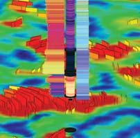
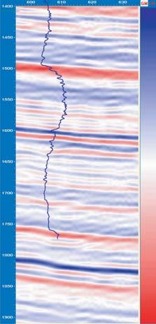
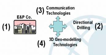
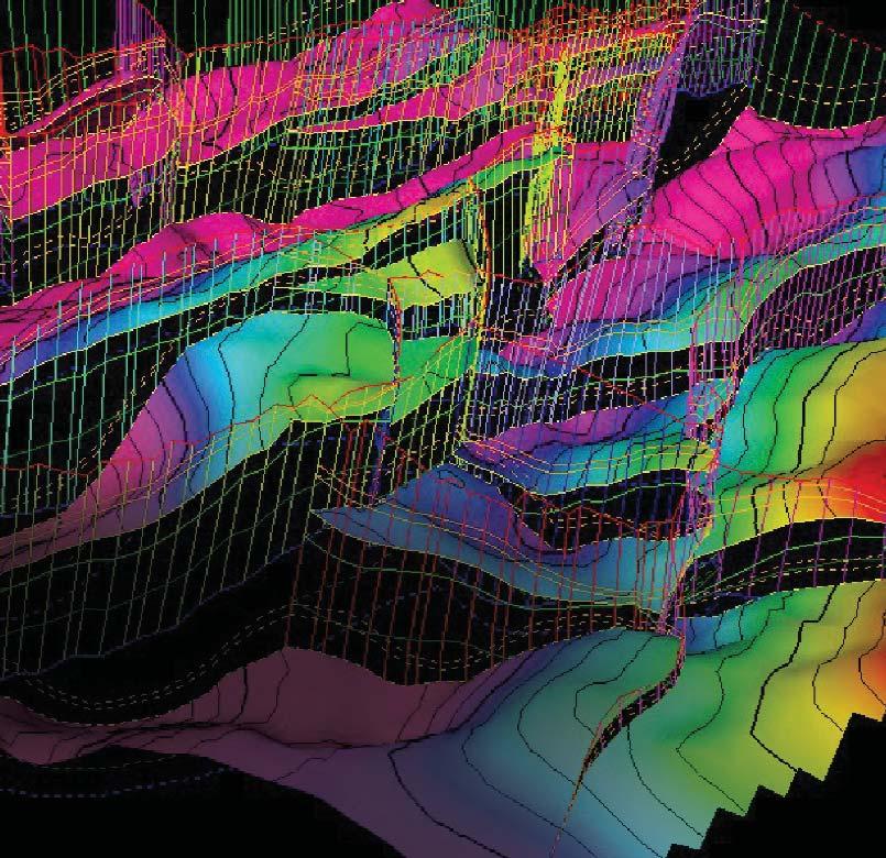
E&P’s are continuously being driven to reduce their costs per BOE.Convergence of E&P needs,technologies related to advanced and accurate directional drilling, communication of vital data in real-time through the internet,as well as reduced cycle time associated with advanced forwardlooking 3D geo-modelling and visualization technologies (Figure 1) has occurred.
Last but not least,it is important to note that the process described here is essentially collaborative.Experience shows that in the first place,high-level management
Figure 1.Convergence of technologies for geo-navigation. (Continued on page 30...)
of E&P companies need to be onboard with the concept and its derived benefits.The vision has to be driven from the top, because it is not a business-as-usual process. It demands the collaboration between the E&P operational staff,the well site geologist, directional driller,and geo-modeling staff,as well as any consultants involved in the project to ensure this optimization takes place.The process essentially closes the loopholes for making costly mistakes and holds the promise to improve the bottom line for every well.
GEO-NAVIGATION PROCESS
The geo-navigation process integrates 3D geology as well as Measurement While Drilling (MWD) and Logging While Drilling (LWD) data into mainstream drilling practices.It also incorporates real-time data retrieval and visualization of drilling path through the zone of interest,via the internet.
An important benefit of this process is improving the odds of success by staying in the productive zone for the longest length of the well.The name of the game is to optimize the positioning of a horizontal well bore in the stratigraphic and structural sweet spots within the reservoir while drilling,which ultimately improves rates and recoveries.
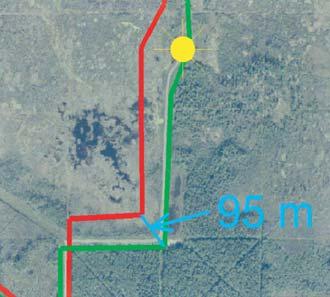
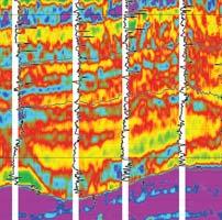
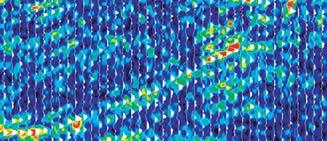
The process is used as a planning,monitoring, and geo-navigation tool,irrespective of the depth,rock type,or the speed of drilling which can range from very fast (300 m/hr in shallow heavy oil horizontals) to very slow (2-10 m/hr in tight formations).This reduces guesswork in the drilling which can translate into less drilling time for a given well and ultimately decreases the total cost and increases profitability.The web-based reports are updated every few minutes for structural changes and periodically for characterization of the gamma ray (GR),resistivity,porosity, and other reservoir attributes.
The process is not confined to development drilling cases;it is also very useful in exploratory settings.Although large data sets may not be available for exploration wells, geo-navigation process can enhance the well placement by staying in the productive strata for longer periods of time.Examination of the true stratigraphic position of the well as well as adjustment of the structure due to faulting and unforeseen changes are definite benefits for exploratory wells.
Universal economic benefits gained from the geo-navigation process can be found in all play types (conventional oil and gas,heavy oil,
tight gas,CBM,and shale gas).
E&P or consulting companies produce the integrated 3D geo-models using geological and geophysical data.This ‘pre-drill’ model brings together all available data from the rig and provides the starting point for the geonavigation process.This mapped out characterization is used to plan the path of the heavy oil or tight gas horizontal wells.
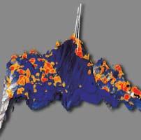
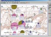
These geo-models can contain as few as a couple of wells to over 1,000 wells.Figure 2 illustrates a horizontal injector in a small oil reservoir.The pre-drill model had eight wells
and a 3D seismic-generated surface.This model also integrated strip log porosity data for enhancing the geo-model.
Through an automation process,re-mapping of structures or characterizations and posting of results into a secured website,the cycle time is reduced to minutes.
OPTIMAL WELL REQUIREMENTS
Whether drilling a long-reach horizontal in heavy oil,in a tight gas play,or for CBM horizontals,the basic requirements for a successful well are:
Figure 2.While drilling visualization and characterization.
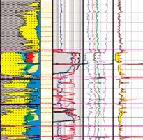
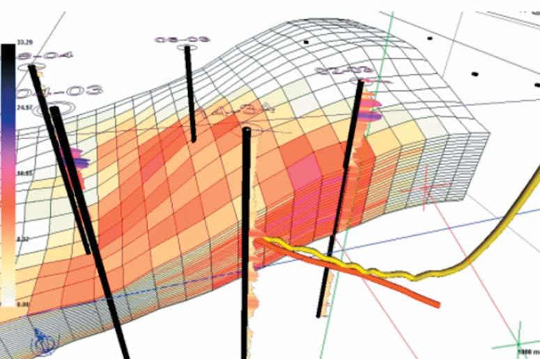
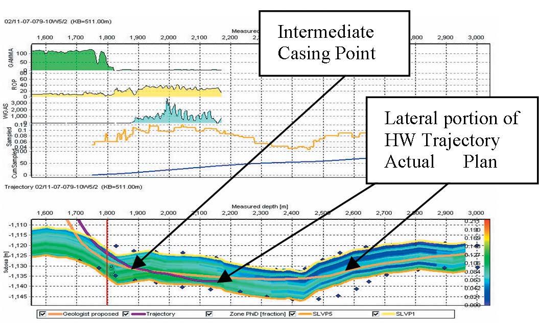
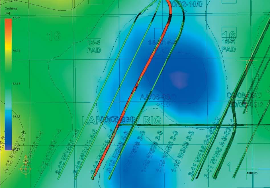
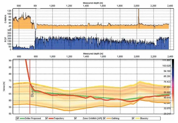
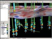
Figure 3.Horizontal well trajectory with porosity zone profile for a gas reservoir in south central Alberta.
1) Planning the optimal path based on the current knowledge of integrated geological/geophysical models.
2) Monitoring the progress of the well through real-time updates.
3) Continuously remapping to identify the true stratigraphic position (TSP) of the bit relative to the reservoir.This information is used to provide advice to the drilling team for staying in the zone of interest while drilling.
4) Continuous and timely reporting on the updated drilling road map to provide the information necessary for drilling ahead of the bit.
The Geo-navigation process is instrumental in assisting the placement of two critical segments for a horizontal well.These are:
1) the landing of a well to the Intermediate Casing Point (ICP) and
2) the drilling of the horizontal leg.
Figure 3 shows a proposed and actual well through a porosity model.The geological profile also integrates MWD,and LWD data, as well as the drilling plan.
BENEFITS OF GEO-NAVIGATION
1) For operators working in reservoirs with multiple drilling rigs,the information gathered and processed will influence and change the 3D mapping window (drilling plan) for the current or subsequent wells. Visualizing this change will influence decision-making in upcoming planned trajectories.This ‘Just in time’ modelling reduces re-drill costs associated with sidetracks.
2) The automation of the integrated MWD,
LWD (a machine to machine process),and 3D geology frees the operational and well site geologists to concentrate on higherlevel aspects of well placement.
3) A large percentage of the rigs today are equipped with satellite communication and access to the Internet.Geo-navigation is driven from the office and uses a secured website access in delivering all essential information back and forth.This speeds up decision time to real time.The frequency of reporting can be adjusted depending on the speed of drilling,since machines don’t mind doing repetitive processes.
4) Another important benefit in controlling placement of wells is mitigation of water or gas in oil reservoirs.Optimization opportunities exist for many mature waterfloods in heavy oil.After identification of the drilling locations,
accurate well placement is essential.Often times plans and actual paths vary.Timely visualization of well placement WD for example,can be an effective tool in avoiding contact with water or gas or collision issues.
5) Faster and more productive drilling through the sweet spots in a reservoir can mean:operational time saving.This is particularly true in tight gas wells and in hard formations.Longer productive reservoir intervals are exposed in well bores resulting in higher productivities.
6) Collision avoidance in tightly spaced and extended horizontal wells is also an issue. Its importance extends to any reservoir, whether oil,gas,or CBM.
Safety and operational cost considerations are major concerns to operators and field personnel.The risk of losing an existing oil producer or getting ‘stuck in the hole’ leads to costly down-time as well as lost revenue from poor well placement on the new drill. The real-time monitoring process provides the driller and the geologist with accurate information to avoid well-bore collisions.
Other concerns with collision include the additional cost of sidetracks,drill bit damage, and equipment loss.While drilling,the geomodel visualization provides the visual check for errors associated with the surveys of horizontal wells.
CASE STUDIES
The Geo-navigation process has been implemented on development and
(Continued on Page 32...)
Figure 4.Top view visualization of horizontal well trajectories in a heavy oil reservoir.
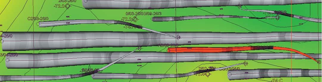
Figure 5.Top view visualization of cones of survey uncertainty.
Figure 6.Visualization of cones of survey errors for mitigating wellbore collisions.
exploration drilling in heavy oil,conventional gas,and tight gas with great results.
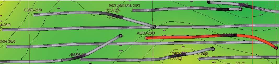
The first example is from the heavy oil in Dina sands reservoir in the Hayter Field, southeast Alberta.Development in the field has progressed to the point that there are over 130 horizontal wells within a Section (one square mile).
A typical-long reach horizontal well (~1500m) with an average survey error uncertainty of one degree from the kick off point can have up to 25 m of potential drift (Figures 4,5).This producer has successfully planned and drilled over 30 oil wells in this mature waterflood without any collision issues,using geo-navigation.
Figure 6 shows a perspective view of porosity distribution and trajectories with the survey error cones shown in this reservoir.
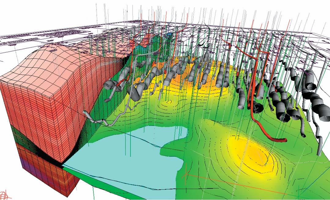
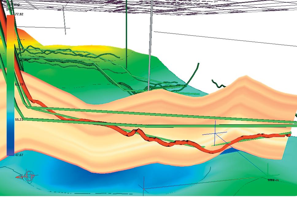
Another example is from the geo-navigation of over three dozen horizontal wells in a heavy oil development-drilling program in Northern Alberta.
The well planning and monitoring capabilities of the geo-navigation process proved beneficial for guiding the remaining well lengths for the horizontals,optimizing the path when it was most advantageous to do so.The well placement was monitored continuously through top views (Figure 7), side views along the length (Figure 8),and within a 3D perspective view (Figure 9).
CONCLUSIONS
Technologies and services have converged to provide real-time mapping and reporting of MWD,LWD,and geology for more productive horizontal and directional wells. E&P companies can take advantage of the geo-navigation process to improve the bottom line on drilling results and have their operational and well site geologists work at a higher level through access to this process.
Real-time planning,monitoring,and geonavigation capabilities are applicable for all reservoir types.These have advanced to the point that they can be incorporated into the workflow process of any horizontal or directional drilling program in order to increase operational efficiencies and profitability.
Mitigation of gas and water in oil reservoirs and collision avoidance issues are common reasons for incorporating geo-navigation into the drilling process.
Figure 7:Time-based model of proposed vs actual trajectories.The red well is the well being placed.
Figure 9.Time-based geo-model of structure and gamma.The red trajectory is the “while drilling”well.Additional planned trajectories are in view in green.The profile is through gamma ray.
Figure 8.Time-based model of structure and gamma along the horizontal.The LWD profile shows gamma and ROP.
The buy-in to the concept of geonavigation has to be at high levels of E&P’s. Further to this buy-in,the collaborative process between E&P operational staff, consultant services,directional drillers,and real-time data providers is required at every stage of the drilling operation for a successful geo-navigation.
Similar to other new technologies,there are barriers to early adoption of the geonavigation process.Although operators tend to focus on added cost,the overall value added for the life of a well needs to be evaluated.The early return on investment and resources that may be left untapped,as a result of missed pay zone, also need consideration.
The cost-savings,improved wells,and communication advantages that this new process brings together,are key benefits to E&P teams in the field and in the office.
ACKNOWLEDGEMENT
All images reported are from various United Oil & Gas Consulting projects using SMART 4D Modelling,integrated geo-modelling,and geonavigation process from United.
ABOUT THE AUTHOR
Rocky Mottahedeh is a P.Eng.and P.Geol.He is currently the President of United Oil & Gas Consulting Ltd.He has 25 years of oil and gas experience with emphasis on new technology and integrated reservoir studies in oil,gas, unconventional (CBM and tight gas),and heavy oil at E&P companies in Canada and internationally.In the past nine years Rocky has been involved in technology development focused on geo-modelling and geo-navigation through his company,United Oil and Gas Consulting Ltd.Rocky graduated from the University of Toronto in 1981 with a B.Sc., Geological Engineering.
Geology Petrel
Petrel* workflow tools provide a complete seismic-to-simulation toolkit— one solution uniting the subsurface domains of geophysics, geology, and reservoir engineering.
Geologists can use new modeling capabilities to better predict facies distributions, work with geophysicists to analyze structural uncertainties, and work with reservoir engineers to define a well placement strategy.
“It is like having an extra geologist sitting there, it’s telling you things that youdidn’t know, it’s testing your theories like you never saw before and helping you come up with new ideas.” David Hamilton, CEO, Subsurface Computer Modeling
With Petrel software, all work processes lead to one shared earth model, resulting in faster, better decisions.
sisinfo@slb.com
CONTOURING
Faulted contours
Isopachs
Volumetrics
Grid operations
New flexing options
CROSS SECTIONS
New Unassigned Tops
Digital and/or Raster
Geocolumn shading
Stratigraphic/Structural
Shade between crossover
Dipmeter data
MAPPING OPTIONS
Expanded GIS Functions
Bubble maps
Production charts
Log curves
Posted data
Highlighted Symbols
3D VISUALIZATION
Deviated wellbores
Digital logs
Grid surfaces
Tops, Shows and Perfs
Land grid overlay
Map images
PETRA® delivers the industry’s only easy-to-use and affordable integrated solution for today’s workflows. It provides multi-user access to large projects through geological, petrophysical and engineering analysis tools. The PetraSeis™ option extends PETRA® into 2D/3D seismic interpretation with practical tools such as RasterSeis™ Download a trial version at www.geoplus.com, or call us at 888-738-7265 (Houston: 713-862-9449 / Calgary: 403-264-9523) for more product information.
Director - CSPGDavid MiddletonPetro-Canada296-4604middletn@petro-canada.ca
AAPG Canada Region VOLUNTEERS WANTED!
The Canada Region of the American Association of Petroleum Geologists (AAPG) needs you. If you are a member of the AAPG and interested in volunteering, please consider how you can assist.
Members of the Canada Region are wanted to serve on various committees, and if you are an Active, Honorary, or Emeritus Member of the AAPG you are also eligible to take advantage of one or both of the opportunities below.
1) Call for Nominations for Delegates, 2) AAPG House of Delegates
The Canada Region is currently represented in the AAPG House of Delegates by thirteen Delegates from the Region, and there will be five vacancies in these 3-year positions for the coming term of office (2006-2009). There are also additional opportunities to serve as Alternate Delegates.
The House of Delegates of the AAPG is responsible for all legislative functions of the Association, within the scope of the AAPG’s Constitution and Bylaws. As a group, the HOD is an influential body and serving as a Delegate is a great way to get involved in the workings of the AAPG. Canadian Region Delegates also participate in the Executive Committee of the Region.
Interested? Want more information? Want to submit your name – or that of another candidate?
Then for any of these opportunities please contact the following (as soon as possible before April 30, 2006): Bob Phelps, Secretary/Foreman bphelps@valiantenergy.ca 403-237-5163 or by mail: AAPG Canada Region c/o CSPG, 160 540 – 5th Avenue SW, Calgary, AB T2P0M2
We are excited to have Jay Ingram from the Discovery Channel’s award-winning Daily Planet as our Keynote Luncheon speaker on Monday.
As in past years,the Ice Breaker will be on Monday evening.It will be held on the Exhibition Floor and we are looking forward to a great networking opportunity between Delegates and Exhibitors.
On Tuesday there will be a Mini Ice Breaker on the exhibition floor which will conclude the exhibition part of the 2006 Convention.
The always anticipated Core Meltdown party will wrap up the convention on Thursday afternoon at the AUEB Core Research Centre – we hope to see you all there to enjoy some food and beverages with your colleagues.
We are looking forward to a successful 2006 Joint convention to find out What’s next? Where is our industry heading?
LUNCHEON SPEAKER - BIOGRAPHY
Broadcaster and writer Jay Ingram is co-host of Discovery Channel’s science show,Daily Planet. Jay joined Discovery in 1994 and was instrumental in helping shape the program format.From 1979 to 1992,Ingram hosted CBC Radio’s Quirks and Quarks and earned two ACTRA Awards,including one for Best Host.In 1992 and 1993,Ingram hosted two CBC Radio series:‘Cranial Pursuits,’ a series “by,for,and about the brain,” and ‘The Talk Show,’ a language series that won a Science in Society Journalism Award.
Jay also contributed to the CBC television show The Health Show and CBC Newsworld’s Canada Live.For ten years,Jay wrote articles for the popular children’s publication Owl Magazine.He has been writing a weekly science column for the Toronto Star since 1993.In 1984,Jay was awarded the Sandford Fleming Medal from the Royal Canadian Institute for his efforts to popularize science,and he also earned the Royal Society of Canada’s McNeil Medal for the Public Awareness of Science in 1997.In 2000,Jay was awarded a Michael Smith Award for Science Promotion by the Natural Science and Engineering Research Council of Canada.He is a Distinguished Alumnus of the University of Alberta,and has received four honorary doctorates.Jay has written nine books,three of which have won Canadian Science Writers’ Awards.
REGISTRATION OPENS MONDAY MARCH 27,2006
Registration fees for this year’s convention are as follows: (Please note prices do not includes GST)
Maximum reservoir performance
Want to make the most of your valuable oil and gas reserves?
Roxar’s integrated technology solutions and services help companies of all sizes realize the full economic potential of their oil and gas resources.
• Innovative modeling and simulation software
• Downhole monitoring and control systems
• Reservoir production multiphase metering
• Reservoir and production consultancy
Roxar’s leading-edge technology solutions from reservoir interpretation through to production & process meet the changing needs of users in managing the entire reservoir lifecycle.