
Follow the Leader.
The global industry leader in critical information and insight, IHS continues to invest in the progress of the Canadian energy market so you can get from discovery to drilling in record time. By updating, improving and streamlining our Canadian products and services, we have delivered workflow integration between IHS PETRA® and IHS AccuMap®; created solutions for better access to global resources, from well log databases to subject matter experts; and continued to provide transparency and insight to Canadian energy businesses that need actionable information.
See how IHS is investing in Canada at www.followihs.com.

CSPG OFFICE
#110, 333 – 5th Avenue SW Calgary, Alberta, Canada T2P 3B6
Tel: 403-264-5610
Web: www.cspg.org
Office hours: Monday to Friday, 8:30am to 4:00pm
Executive Director: Lis Bjeld
Tel: 403-513-1235, Email: lis.bjeld@cspg.org
Member Liaison: Bea McDowell
Tel: 403-513-1226, Email: bea.mcdowell@cspg.org
Communications and Publications: Caitlin Young
Email: caitlin.young@cspg.org, Tel: 403-513-1230
Programs Development: Aileen Lozie
Tel: 403-513-1227, Email: aileen.lozie@cspg.org
Accounting and Office Administration: Kasandra Klein
Tel: 403-513-1233, Email: kasandra.klein@cspg.org
Corporate Sponsorship: Lis Bjeld
Tel: 403-513-1235, Email: lis.bjeld@cspg.org
EDITORS/AUTHORS
Please submit RESERVOIR articles to the CSPG office. Submission deadline is the 23rd day of the month, two months prior to issue date. (e.g., January 23 for the March issue).
To publish an article, the CSPG requires digital copies of the document. Text should be in Microsoft Word format and illustrations should be in TIFF format at 300 dpi., at final size. For additional information on manuscript preparation, refer to the Guidelines for Authors published in the CSPG Bulletin or contact the editor.
Technical Editors
Ben McKenzie Colin Yeo (Assistant Tech. Editor) Tarheel Exploration EnCana Corporation Tel: 403-277-4496 Tel: 403-645-7724 Email: bjmck@live.com Email: colin.yeo@encana.com
Coordinating Editor
Caitlin Young, Publications Coordinator, CSPG Tel: 403-513-1230, Email: caitlin.young@cspg.org,
ADVERTISING
Advertising inquiries should be directed to Caitlin Young, Tel: 403-513-1230 email: caitlin.young@cspg.org. The deadline to reserve advertising space is the 23rd day of the month, two months prior to issue date.
The RESERVOIR is published 11 times per year by the Canadian Society of Petroleum Geologists. This includes a combined issue for the months of July and August. The purpose of the RESERVOIR is to publicize the Society’s many activities and to promote the geosciences. We look for both technical and non-technical material to publish. Additional information on the RESERVOIR’s submission guidelines can be found at http://www.cspg. org/publications/pubs-reservoir-submissions.cfm.
The contents of this publication may not be reproduced either in part or in full without the consent of the publisher. Additional copies of the RESERVOIR are available at the CSPG office. No official endorsement or sponsorship by the CSPG is implied for any advertisement, insert, or article that appears in the Reservoir unless otherwise noted. All submitted materials are reviewed by the editor. We reserve the right to edit all submissions, including letters to the Editor. Submissions must include your name, address, and membership number (if applicable). The material contained in this publication is intended for informational use only.
While reasonable care has been taken, authors and the CSPG make no guarantees that any of the equations, schematics, or devices discussed will perform as expected or that they will give the desired results. Some information contained herein may be inaccurate or may vary from standard measurements. The CSPG expressly disclaims any and all liability for the acts, omissions, or conduct of any third-party user of information contained in this
and its
or
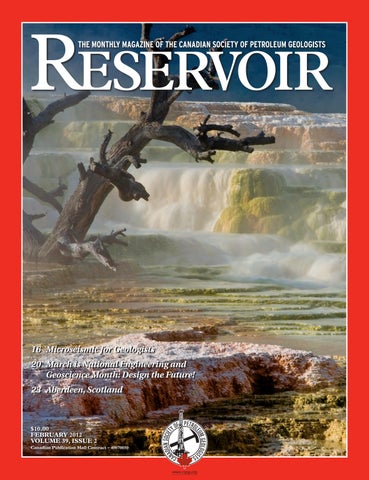
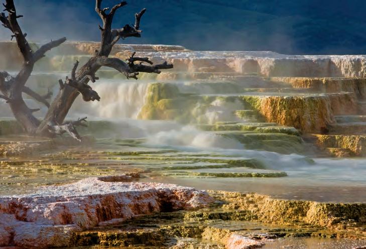
FRONT COVER Mammoth Hot Springs, Yellowstone National Park, Wyoming. Heated water moves along the
Photo by Michael
UPCOMING EDUCATION SCHEDULE
Last Chance Short Courses
The DW Geopressure Tolerance Window: Case Histories - An AAPG E-Symposium
Selim S. Shaker, Geopressure Analysis Services, Houston, TX
Basic Well Log Analysis
March 15, 2012
March 26-30, 2012 Austin, Texas
Practical Salt Tectonics
March 28-30, 2012 Austin, Texas
Basic Petroleum Geology for the Non-Geologist
A joint course with AAPG and University of Tulsa Continuing Engineering and Science Education Department Houston, TX
Shale Gas Reservoir Assessment
April 17-19, 2012
April 21-22, 2012 Long Beach, CA (with AAPG Annual Convention)
Field Seminars
Field Safety Course for Field Trip Leaders
March 28-29, 2012 Houston, Texas
Deep-Water Siliciclastic Reservoirs, California
Begins in Palo Alto and ends at the airport in San Francisco, California
Clastic Reservoir Facies and Sequence Stratigraphic Analysis of Alluvial-Plain, Shoreface,
Deltaic, and Shelf Depositional Systems
Begins and ends in Salt Lake City, Utah
Complex Carbonates Reservoirs: Sedimentation and Tectonic Processes.
April 27-May 2, 2012
April 28-May 2, 2012
May 12-18, 2012 Begins in Naples and ends at Rome International Airport (Italy)
Play Concepts and Controls on Porosity in Carbonate Reservoir Analogs
Almeria Region, SE Spain, begins and ends in Las Negras, Spain. Fly from London/Barcelona/Madrid
Modern Terrigenous Clastic Depositional Systems
Begins in Columbia and ends in Charleston, South Carolina
May 13-18, 2012
May 15-22, 2012
Download
Since 1927...


CSPG EXECUTIVE
President Robin Mann • AJM Deloitte rcmann@deloitte.ca Tel: (403) 648-3210
Vice President
Paul MacKay • Shale Exploration Ltd. Paul.Mackay@shalepetroleum.com Tel: (403) 457-3930
Past President
Kirk Osadetz • Geological Survey of Canada, Calgary kosadetz@nrcan.gc.ca Tel: (403) 292-7022
Finance director
Andrea Hood • geoLOGIC systems ltd. ahood@geologic.com Tel: (403) 262-1992
assistant Finance director
Samantha Etherington • CNRL samantha.etherington@cnrl.com Tel: (403) 386-6459
Program director
Jon Noad • Murphy Oil Corporation jon_noad@murphyoilcorp.com Tel: (403) 294-8829
assistant Program director
Dave Russum • AJM Deloitte drussum@deloitte.ca Tel: (403) 648-3228
serVices director
Michelle Hawke • Apache Canada Ltd. Michelle.Hawke@apachecorp.com Tel: (403) 261-1200
assistant serVices director
Mike Seifert • Canadian Discovery mseifert@canadiandiscovery.com Tel: (403) 269-3644
communications director
Jim Barclay • ConocoPhillips Canada Jim.E.Barclay@conocophillips.com Tel: (403) 532-3889
assistant communications director
Curtis Evans • ERCB curtis.evans@ercb.ca Tel: (403) 297-8386
outreach director
Simon Haynes • Statoil Canada Ltd. sihay@statoil.com Tel: (403) 724-0364
assistant outreach director
Dawn Hodgins • Imperial Oil Resources dawn.hodgins@exxonmobil.com Tel: (403) 232-5931
executiVe director
Lis Bjeld • CSPG lis.bjeld@cspg.org Tel: (403) 513-1235
EXECUTIVE COMMENT
A message from 2012 President, Robin Mann
Steady stewardship and a vibrant membership keep the CSPG on course as a world-class organization!
Moving into 2012, the CSPG is well situated in its position as a world-class petroleum geology organization. This is due to three major factors: the involvement and enthusiasm of the members; the leadership we have had over the past few years who have positioned the CSPG to succeed into the future; and, the dedicated staff who work to bring everything together. On behalf of all the members and staff, I would like to sincerely thank Kirk Osadetz and John Varsek for their years of dedication and leadership to the CSPG. I would also like to thank their respective Executives for insightful direction and guidance. I would also like to take this opportunity to acknowledge and thank Darren Aldridge (Finance Director), Brett Norris (Program Director), Chris Seibel (Services Director), Stephen Hubbard (Assistant Communications Director) and Steve Dryer (Outreach Director) who have been members on the Executive for the past two or more years. These people have grown the CSPG into what it is today. To all of you a tremendous “thank you” for your service and dedication to the Society; we look forward to building on your foundation as we move forward. In addition, we as members need to thank our Executive Director, Lis Bjeld and our committed staff for another year of administrative stability and financial growth through trying economic times. 2011 was a year that saw our staff changing work spaces twice before arriving at our new offices. These moves, which are never simple, were accomplished by September with little fuss to us as members, and the CSPG now has a great location at #110, 333 - 5th Avenue SW, with very bright, welcoming, and functional offices.
As we start a new year, in addition to those who are continuing on our Executive
Committee, I would like to welcome the following incoming volunteers: Paul Mackay (Vice President/President Elect), Samatha Etherington (Assistant Finance Director), Dave Russum (Assistant Program Director), Mike Seifert (Assistant Services Director), Curtis Evans (Assistant Communications Director), and Dawn Hodgins (Assistant Outreach Director). We would also like to thank Bruce Schultz for allowing his name to stand for election as Vice President and to Dave Clyde for allowing his name to stand for Assistant Finance Director. The reoccurrence of elections over the past two years within the CSPG demonstrates that we do have an involved and committed membership who are willing to put their names forward to help complete the goals of our Society.
Moving into 2012, the Society is well positioned for growth and continued eminence in the geologic community. Most of us, as members of the CSPG, are well aware of certain things the Society has to offer and the programs that are run, but I would say even we as members are not aware of everything the CSPG actually is. In addition, the corporate community has not seen the CSPG as a resource for scientific knowledge, innovation, and mentorship that can help business advance their geologic capabilities in this new age of technology-driven prospects and projects. We see this year as a year where the CSPG can begin the journey of communicating (in the modern sense) everything the CSPG is, not only to our membership, but also to the corporate community, establishing ourselves as a truly world class organization.
The target of our communication strategy in the coming years is to raise a positive (Continued on page 7...)
MARK YOUR CALENDARS...
And join thousands of industry professionals at GeoConvention 2012: Vision in Calgary May 14 - 18, 2012 at the Calgary TELUS Convention Centre.
n Online registration opens March 1 – register early to take advantage of early bird pricing and secure your tickets for the many special events scheduled for 2012!
n Increase your company’s brand visibility among thousands of industry professionals – sponsor or advertise in our official publications.
n Earn up to 6 PDH credits each day you attend.
n Re-connect with friends, meet new contacts and take advantage of the opportunity to network with industry professionals at various social events including Luncheons and the Core Meltdown.
n Earth Science for Society – our family-oriented Outreach Program – will be returning for another year. Many highlight exhibits from last year will be here again – including Gold Panning with Yukon Dan and Fossil Hunting with the Burgess Shale Geoscience Foundation. Plan to bring your family on Mother’s Day, May 13, for a fun-filled geoscience adventure.


Since 1927...

CORPORATE SPONSORS
Dia M o ND
IHS
GEOLOGIC SySTEMS LTD
SCHLUMBERGER CANADA LTD
Plati N u M
AGAT L ABORATORIES
CENOVUS
CONOCOPHILLIPS
NE xEN INC . TALISMAN ENERGy
POGGENPOHL
GolD
APEGGA
CSPG EDUCATIONAL TRUST FUND
DEVON CANADA
ENCANA
IMPERIAL OIL
SHELL
WEATHERFORD L ABORATORIES
Silver
ARC FINANCIAL CORPORATION
ENERPLUS
JEWEL SUITE
ROx AR
Bro N ze
ATHABASCA OIL SANDS
BLUEBACK RESERVOIR
PARADIGM
GEOVARIANCES
CSEG FOUNDATION
RPS BOyD PETROSEARCH
HALLIBURTON ENERGy SERVICES
SUNCOR ENERGy
SUNDOG PRINTING
TUCKER WIRELINE SERVICES
AS OF JANUARY 10, 2012
profile on all aspects of the organization and demonstrate what we have to offer to all of our members, both across Canada and globally, and to the petroleum industry as a whole. It is not that we are unknown; it is that as geologists we tend to put our collective heads down and work hard but under-communicate what we actually do and how responsible we are when we do it. Over the next few years it will be extremely important to our community, and Canada as a nation, that geology has a voice in the development of various aspects of the petroleum business. This does not mean that the CSPG should become an advocate group, but it does mean that the CSPG should communicate its prowess as a scientific leader in the field of petroleum geology for the responsible development of all types of hydrocarbon projects. In the modern world of oil sands, coal bed methane, shale gas, tight oil, and the possible exploitation of gas hydrates, the global community will need good factual information and proper scientific reason to make sensible and rational decisions. In addition, the geologists of today and tomorrow will also need an easily
accessible resource where they can get trusted, unbiased information and exchange a wide range of ideas. The CSPG needs to be part of how geologic information is accurately communicated in the petroleum industry, and we need to push the limits of our science in this new age of continual technology advancements. But, like all good ideas, planning is required to make this a reality. A proper communications strategy must be developed to advance the positive aspects of petroleum geology.
If we can spend the next year better engaging the geologic leadership of the petroleum business, communicating, and demonstrating how the CSPG can be a scientific resource for everyone (including our membership), we will be doing ourselves – but more importantly, all of Canada – a very valuable service. Putting ourselves on this path will continue to demonstrate what you as members already know: that the CSPG is truly a world-class organization.
technicaL Luncheons FEBRUARY
Are shales really that dull? Shining light into dark places and the effects of opening
Pandora’s Box
SPEAKER
Joe H.S. Macquaker Department of Earth Sciences Memorial University of Newfoundland
11:30 am
m o nday, February 6, 2012
c a lgary, te L u s convention cen tre c algary, a l berta
Please note: the cut-off date for ticket sales is 1:00 pm, tuesday, January 31, 2012. csPg member ticket Price: $42.00 + gst non- member ticket Price: $45.00 + gst
Each CSPG Technical Luncheon is 1 APEGGA PDH credit. Tickets may be purchased online at www.cspg.org.
Fine-grained sedimentary rocks are currently the subject of a great deal of research. In spite being very common, they are poorly known, relative to other sedimentary rock types. Most geologists consider them to be the product of deposition in low-energy environments, and if they are source rocks, below anoxic bottom waters. Recent petrographic studies of marine mudstones have shown that they are typically organized into very thin, sharp-based beds and commonly contain a wide variety of microsedimentary structures including: gutter casts, compacted ripples, triplet fabrics, organo-minerallic aggregates, aggregate grains, and diminutive burrows. The presence of these fabrics forces a radical reappraisal of the conditions under which they were deposited and the processes responsible for organic carbon enrichment of the sediment.
Using micro-textural data derived from classic fine-grained successions (e.g., Kimmeridge Clay, Mancos Shale, Whitby Mudstone, and Marcellus Shale), the sedimentological processes responsible for mudstone deposition in these units
will be reviewed. The presence of a wide diversity of microfabrics suggest that prior to being deposited the components of the mudstones were:
a) delivered to the sea floor as organominerallic aggregates and
b) t hen dispersed both in bedload and as fluid mud by processes such as wave-enhanced sediment gravity flows and geostrophic flows, prior to
c) b eing burrowed by diminutive organisms that were living close to the sediment-water interface.
These data suggest that mudstones, and source rocks in particular, were deposited in much more dynamic conditions than most researchers have assumed, and that the deep water, predominantly low energy, anoxic model that is typically the default setting for interpreting their origin needs to be revisited. They also demonstrate that these rocks contain a great deal of useful, but largely unrecognized stratigraphic information, and that they reward careful study.
BIOGRAPHY
Joe H.S. Macquaker is presently an Associate Professor in Petroleum Geology at the Department of Earth Sciences, Memorial University of Newfoundland (St. John’s, Canada). Previous to that, he was a Faculty Member at the University of Manchester. Prior to becoming an academic he was a Post-Doctoral Researcher at the Universities of Manchester and Sheffield. He received both a Ph.D. and Honours degrees from the University of Bristol.
His main research interest has been focused on investigating the fundamental causes of the variability preserved within fine-grained sedimentary rocks. He has more than 45 papers published in international peer-reviewed journals in this research area. Joe is currently a member of the SEPM Research Council. He has been an Associate Editor for the Journal of Sedimentary Research since 1989 and was an Editor for the Journal of the Geological Society of London from 2000 to 2004.
technicaL Luncheons FEBRUARY LUNCHEON
Is it the rock or the frac? Shale reservoir quality and production performance
SPEAKER
r a ndall
S. Miller
Integrated Reservoir Solutions
11:30 am
tu esday, February 21, 2012
c a lgary, te L u s convention cen tre c algary, a l berta
Please note: the cut-off date for ticket sales is 1:00 pm, tuesday, February 14 2012
csPg member ticket Price: $42.00 + gst. non- member ticket Price: $45.00 + gst.
Each CSPG Technical Luncheon is 1 APEGGA PDH credit. Tickets may be purchased online at www.cspg.org.
Post-frac production performance from source rock reservoirs varies significantly between various formations, regionally within a shale formation, and even within a field area. Are these variances caused by differences in reservoir quality, stimulation efficiencies, or both? In order to understand this problem and manage well performance expectations, it is essential to determine the key reservoir-quality parameters that correlate with production performance, and be able to evaluate the stimulation efficiency. By benchmarking reservoir quality to production performance, underperforming wells can be identified and the stimulation can then be optimized. This is best accomplished by evaluating a number of cored, vertical pilot wells and their corresponding laterals.
Source-rock reservoir quality is influenced by a number of parameters. These have been reported in the literature to include TOC, geochemical maturity, porosity, matrix and system permeability, fractures, mineralogy, brittleness, thickness, reservoir pressure, vertical and lateral heterogeneity, and closure stress. All of these parameters may have an impact on reservoir quality; however, in each shale play a few of the parameters dominate significantly over the others as drivers of production. The
goal is to then determine which ones are the drivers in the play.
The goal of the completion engineer is to optimize the fracture stimulation in terms of production rate and ultimate recovery at an economic cost. The challenge for the completion engineer is that there many parameters to optimize. These include lateral direction, lateral length, lateral landing point, toe up or toe down, number of stages, stage spacing, cluster spacing, perforation orientation, fluid systems, proppant type, fluid volumes, proppant volumes, pump rates, and more. In order to properly evaluate the stimulation, the engineer has a number of post-frac tools that are available. These include proppant tracers, chemical flow-back tracers, production logging, micro-seismic monitoring, and production analysis. The use of these technologies allows the engineer to determine if proppant went into all the perforation clusters, flow-back efficiency of the various stages, which stages are contributing to production and which may not be, fracture-height growth, effective frac length, drainage area, and the producing permeability.
A case history demonstrates that reservoir quality is the primary driver to production performance and that optimizing the fracture stimulation treatment has a secondary impact. The concept of the Shale Reservoir Quality Index (SRQI) is introduced and it is shown to correlate well with cumulative production. The resulting model also allows the identification of poorly stimulated wells.
Webcasts sponsored by
BIOGRAPHY
Randall S. “Randy” Miller is President of Integrated Reservoir Solutions, a division of Core Laboratories located in Houston, Texas. Randall Miller received his B.A. in Chemistry and Geology from the University of California at San Diego and pursued graduate studies at Scripps Institute of Oceanography and the University of Houston. He has 29 years of experience in the analysis and evaluation of reservoirs both domestically and internationally. He has conducted and directed over 50 joint industry projects including a Tight Gas Sands of North America – Reservoir Characterization and Fracture Stimulation Optimization; Gas Shales – Reservoir Characterization and Production Properties; and Regional Evaluations of the Haynesville, Bossier, Marcellus, Eagle Ford, Montney, and now the Duvernay Shale. His special interests are integrating geology, petrophysics, stimulation, and production analysis for optimizing the exploitation of unconventional reservoirs. He is a member of the American Association of Petroleum Geologists, Houston Geological Society, Society of Professional Well Log Analysts, and Society of Petroleum Engineers.
HUGH REID’S 2012 SPRING COURSES
(3 1/2 days) April 10-13, 2012
16 WAyS tO IDENtIfy ByPASSED PAy fROm DSt DAtA (more advanced, for those “comfortable” with DST charts) April 19-20, 2012
3, 2012

Market
Stable
Please note: the cut-off date for ticket sales is 1:00 pm, tuesday, February 28, 2012 csPg member ticket Price: $42.00 + gst. non-member ticket Price: $45.00 + gst
Each CSPG Technical Luncheon is 1 APEGGA PDH credit. Tickets may be purchased online at www.cspg.org
A B STRACT
The history of life is punctuated by five “major” mass extinctions. In recent years it has seemed that at least three, and perhaps all five were caused by extraterrestrial causes – from asteroid impacts to gamma ray bursts. New research, however, suggests that the Earth may have been a far worse enemy to its life than outer space has been. While the temporal coincidence of large body igneous provinces and mass extinction or mass depletion of life has long been noted, only recently have actual “kill” mechanisms become believable. In this talk the new understanding of mass extinctions will be presented – as will the question of whether or not the most probable cause – lowered oceanic oxygen levels as a consequence of reduced pole to equator temperature differentials – is of relevance to our own world.
“Rare Earth: Why Complex Life Is Uncommon in the Universe” (co-author Donald Brownlee, 2000), “Under a Green Sky: Global Warming, the Mass Extinctions of the Past, and What They Can Tell Us About Our Future” (2007), and “The Medea Hypothesis: Is Life on Earth Ultimately Self-Destructive?” (2009).
Dr Ward has held the position of Senior Council within the Paleontological Society and has edited numerous publications including the GSA Special Paper 247, Global Catastrophes in Earth History, as well as with the Paleonotological Society, and the journals Paleobiology and Geology. He served as principal investigator and Lead at the NASA Astrobiology Institute at the University of Washington from 2001-2006.
In 1984 he was elected Fellow to the California Academy of Sciences. He also was the 1996 Gallagher Lecturer at the University of Calgary. He has been the Keynote Speaker at many conferences and meetings and recently won the Annual Faculty Lecturer award from the University of Washington. He is a prolific writer and has published in scientific journals for both biology and geology.
technicaL Luncheons
The French Alps – classic geology re-interpreted in the light of passive margin geology and allocthonous salt tectonics
SPEAKER
r o d Graham
Research Associate, University of Cambridge AAPG Distinguished Lecturer
11:30 am
tu esday, m a rch 20, 2012 c a lgary, te L u s c onvention c en tre c al gary, a l berta
Please note: the cut-off date for ticket sales is 1:00 pm, Wednesday, march 14, 2012 csPg member ticket Price: $42.00 + gst. non-member ticket Price: $45.00 + gst.
Each CSPG Technical Luncheon is 1 APEGGA PDH credit. Tickets may be purchased online at www.cspg.org
Just as an understanding of structural geometry in the field is essential in the interpretation of seismic data, so sometimes seismic data and the new ideas that stem from it enable us to see classic field geology in a completely new light, even though the data may come from a completely different geological setting or a totally different part of the world. This lecture describes how, a few years ago, our understanding of the geological evolution of one of the worlds classic mountain belts was transformed by reference to data obtained from the Atlantic passive margin, and how at the present time, our increased understanding of salt tectonics might be bringing about a similar shift in thinking.
The understanding of salt tectonics has been transformed in recent years by the seismic imagery in places like Brazil and the Gulf of Mexico, augmented by inspirational physical modelling. I will try to apply this new knowledge to geology ‘on the ground’ in the sub-Alpine chains of Haut Provence in the southwestern Alps. In this part of the world, a very well exposed Mesozoic sequence showing rapid thickness and facies changes associated with Jurassic and Cretaceous extension on the margin of the Ligurian Tethys, has been deformed by a series of ‘Alpine’ compressional events that occurred from the Late Cretaceous to the Pliocene. Although the geology has been very well known for decades, aspects of the structure remained enigmatic and could not be explained by either Mesozoic extension or Alpine shortening alone. This talk will make the case that they resulted from salt tectonics that occurred not in the developing Alpine mountain chain, but on the seabed of a Late Jurassic continental slope, analogous, perhaps, to the Gulf of Mexico today.
A completely overturned , highly condensed Jurassic section is interpreted as the elevated roof of a salt body in a deep marine setting, which overturned as a ‘flap’ in the Middle Jurassic as allochthonous salt broke out at the sea floor Later, Alpine compression exploited the weakness of the salt sheet as a major thrust zone. Although the ‘flap’ is in the footwall of the thrust, evidence of softsediment deformation and other anomalous structures within the flap suggest that it cannot have originated as an overturned footwall syncline.
Webcasts sponsored by
The ideas are prompted by seismic, the conclusions rely heavily on conventional field evidence. We geologists should never lose sight of our field-based roots.
BIOGRAPHY
Like many other geologists, Rod Graham was attracted to geology by a love of mountain walking, and an inspirational school teacher. He studied Geology in the University of Wales at Aberystwyth, graduated with first-class honours and went on to do a Ph.D. at Imperial College, London on the Precambrian basement rocks of the Western Isles of Scotland. After two years of postdoctoral work on geological strain in crystalline rocks he took up a lectureship in structural geology at the University of Wales at Swansea and his research interest shifted first to the Precambrian rocks of Africa, then to the structure and evolution of the French Alps.
During this time the geometrical ideas of ‘thin-skin tectonics’ were taking hold of the structural geology community. They were highly relevant (and new) in Alpine geology, but, more significantly, were proving important in hydrocarbon exploration, and so, after thirteen years at Swansea, Rod left academia and joined BP in a structural consulting role that enabled him to see the geology of a very great deal of the world. The last couple of years at BP were spent in Colombia at the time of the discovery and early development of the giant fields of the Llanos foothills. Rod developed a fascination with Colombia and its geology, which eventually took him from BP to consultant, business development, and exploration manager roles in Monument, Lasmo, and Emerald, all small companies with major interests in Colombia.
After Emerald, Rod took up a new global consulting role within the Hess corporation, which included substantial regional work in salt provinces, particularly the Gulf of Mexico.
Rod has published on a variety of topics in structural geology and tectonics. He will have retired from Hess by the time this talk is given, will have taken up a research associate role at the University of Cambridge, and will be doing as much geology as his wife will allow.
diVision taLKs STRUCTURAL DIVISION
Fractures, elastic moduli and stress: geological controls on hydraulic fracture geometry in the Horn River Basin
SPEAKER
r ory Dunphy Nexen Inc.
12 noon to 1pm, t h ursday, February 2, 2012 Conference Centre r oom a , +30 level, Western Canadian Place (Husky e n ergy), 707-8th avenue
S.W., Calgary, a l berta
Production from the shale gas reservoirs is dependent upon successfully stimulating these formations by creating hydraulic fractures. In the Horn River Basin the hydraulic fracture geometry resulting from stimulation depends not only on operational controls (rate, fluid volume, sand volume, etc.) but on fundamental geological properties of the formations being completed.
Changes in geomechanical rock properties such as yo ung’s Modulus and Poisson’s Ratio that influence the borehole insitu stress profile, and therefore the achievable frac geometry, are driven by changes in the depositional and diagenetic history of the Horn River shales. What can be seen is that, similar to other shale plays, the mineralogy, (particularly the volume of clay) has a strong impact on the moduli. yo ung’s Modulus decreases and Poisson’s Ratio increases in the clayrich units of the Fort Simpson and lower Otter Park formations. These zones have higher uranium/thorium ratios than the rest of the Horn River section indicating more terrigenous influence on deposition. Strong transverse anisotropy also
Sponsored by
appears to be confined to these horizons demonstrating the link between geological facies and geomechanical properties.
A variety of in-situ stress models are in existence and their effectiveness at predicting height growth was assessed using microseismic data as a validation tool. This showed that consideration of anisotropic properties is an important part of understanding the in-situ stress profile. Once the link between facies and geomechanical properties is established and validated it can be exploited during drilling to enhance the utilization of MWD gamma-ray-informed geosteering to insure that the lateral and vertical heterogeneity of the shale is used as a guide for proper well and frac stage placement.
Early microseismic work in the Barnett Shale revealed a variety of hydraulic fracture geometries in gas shales that led to the emergence of the concept of hydraulic fracture complexity. Many studies since make a case that stress anisotropy and the nature of a natural fracture system are the key geological drivers to this complexity. In assessing the applicability of this work from the Barnett to the Horn River it became
apparent that an isotropic or weakly anisotropic stress regime was viewed as a prerequisite for achieving complexity. Microseismic monitoring of multiple hydraulic fracture stimulations, performed with the same design parameters, has identified a spectrum of length/width geometries in Horn River from highly complex to long and linear. In order to be able to understand and try predict the mechanisms behind the varying geometry (both design and geological) it was necessary then to characterize the natural fracture system and define the insitu stress tensor.
Density, sonic, and image logs and DFIT’s were utilized to estimate the orientation and relative magnitudes of the three principle stresses in the Horn River. A normal stress regime was originally identified but the pattern of drillinginduced fractures in horizontal image logs indicate parts of the reservoir were on the cusp of a strike-slip regime. Therefore, relative to plays like the Barnett, the stress regime in the Horn River Basin is potentially more anisotropic (maximum horizontal stress significantly greater than minimum horizontal stress). The common occurrence of highly complex hydraulic
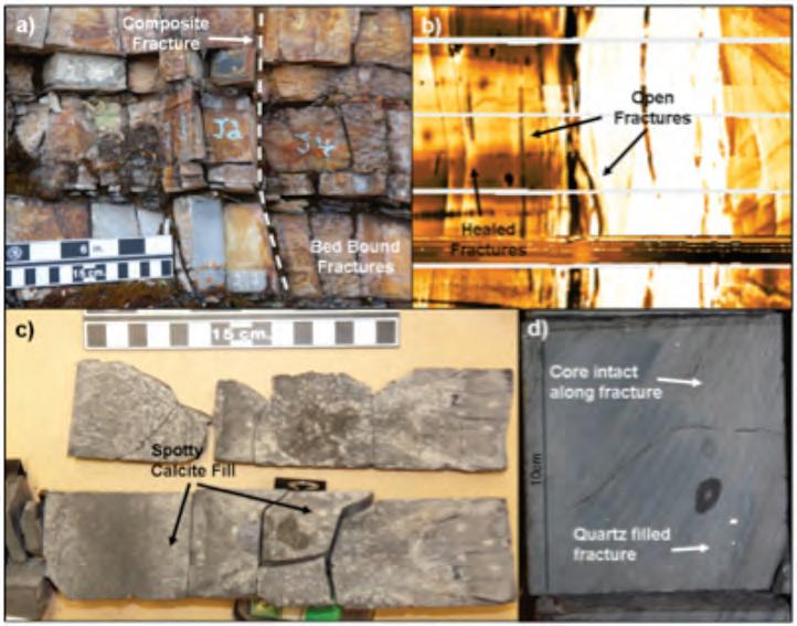
Figure 1. Small-scale examples of fracture information. a) Northeast BC Devonian shale outcrop showing multiple fracture sets. b) Image log data in a horizontal well through the Muskwa/Otter Park formations. Core data showing c) partially open and d) healed fractures in the Muskwa/Otter Park formations.
fractures as evidenced in microseismic therefore did not appear to fit the Barnett model. This led to focusing on the impact of natural fractures to try to explain the observations.
Natural fractures are readily identifiable in the Horn River in core, image log, and outcrop (Figure 1) and some observations on the nature of the fracture systems present suggest they are multi-faceted, with multiple histories of generation and with diverse fills or open-porosity. Given this complexity, we performed a parametric study investigating the impact of fracture network properties on stimulated geometry in the Horn River. The results indicated that hydraulic fracture complexity patterns typically associated in the literature with “isotropic” or “weakly anisotropic” stress regimes can be created in an anisotropic stress regime as a result only of changes in the fracture network. This suggests that understanding lateral and vertical variations in fractures and fracture network properties within the Horn River is a necessary step in understanding hydraulic fracture geometry
and ultimately the productive surface area that is created during stimulations.
BIOGRAPHY
Rory Dunphy received a B.A. (mod) in Geology (2001) and M.Sc. (2003) from Trinity College Dublin. His M.Sc. research was focused on utilizing GIS tools and structural mapping to understand the impact of natural fractures on groundwater production from Devonian and Carboniferous strata in Ireland. Rory is currently a Senior Geologist with the NEBC Shale Group in Nexen Inc. where he has spent the last three years as part of a multidisciplinary team and in that group focused on optimizing development design within the Horn River Basin. Prior to that he worked as an operations and regional geologist on Nexen’s Fort Assiniboine Mannville CBM play where successfully utilizing geomechanics to map permeability variations in the coal developed his interest in that field. He began his career in Canada in 2004 as a geologist with CBM Solutions Ltd. Rory is a member of APEGGA, CSPG. and AAPG.
DI VISION I N FORMATION :
S tructural Division talks are monthly and
cover a diversity of structural themes. Our Structural Division sponsors are Hef Petrophysical and Husky Energy. All are welcome and no registration is required. For additional information, to be placed on the Division e-mail list or to present a talk, please contact Darcie Greggs, Darcie. Greggs@huskyenergy.com.
diVision taLKs PALEONTOLOGY DIVISION
Earthquakes –macro to micro: characteristics, recent advances
SPEAKER
Dr. Kris va sudevan
7:30 PM
Friday, February 17, 2012 Mount r oy al u n iversity, r oom B108 Calgary, a lb erta
Earthquakes occur at different depths in regular intervals according to geologic principles. They cause extensive damage to life and property, depending upon their magnitude and intensity. In this presentation, we will take a journey of human perception of earthquakes since the beginning of the documenting and
ROCK SHOP
recording of them. We will review a sequence of major devastating earthquakes that changed human history. The characteristics of these historical earthquakes can be scientifically evaluated based on empirical data.
Earthquakes take place at both macro- and micro-scales. Here, I would like to bring to your attention the documented history of earthquakes (historical seismicity) in Canada. Closer to home, I would like to look at what might be at stake in Alberta. This will take us into the science of microseismicity.
Finally, this presentation will conclude with some recent advances that are being made in the field of earthquake seismology as well as a discussion on the status of seismic hazard analysis.
BIOGRAPHY
Kris Vasudevan has his Ph.D. in geophysics and is retiring at the end of 2011 from the University of Calgary. He will be working as a geophysical consultant in Calgary starting January 2012. His current interests


are shallow and deep crustal reflection seismology, earthquake seismology, seismic hazard analysis and geophysical methods as applied to exploration of minerals. He is a great admirer of the Alberta Palaeontological Society and its outreach activities in the community.
INFORMATION
This event is jointly presented by the Alberta Palaeontological Society, Mount Royal University, and the CSPG Palaeontology Division. For details or to present a talk in the future please contact APS Program Coordinator Harold Whittaker at 403-2860349 or CSPG Palaeontology Division Chair Philip Benham at 403-691-3343 or contact programs@albertapaleo.org. Visit the APS website for confirmation of event times and upcoming speakers: http://www.albertapaleo. org/.

diVision taLKs BASS DIVISION
The Grosmont Formation: from potential to production
SPEAKER
Kent Barrett
Senior Staff Carbonate Geologist, Laricina Energy Limited
12:00 Noon
Wednesday, February 22, 2012 ConocoPhillips auditorium, Gulf Canada Square, 401 - 9th ave. S.W. Calgary, aB
The ERCB recently estimated that the Grosmont Formation in northeastern Alberta contains 400 Billion barrels of bitumen. But capturing this resource has not been easy. In the late 1970s Unocal embarked upon a pilot project at Buffalo Creek (T87-88, R19W4) aimed at identifying a method of extracting the sticky crude. Cyclic Steam (CSS) and even fireflood techniques were tested without success
before the project ended with the plunging oil prices of 1986.
Fast forward twenty years and two developments had changed the outlook on the Grosmont bitumen resource: horizontal drilling and SAGD technology. Horizontal drilling was in its infancy in the 1980s and SAGD operations had not been tested at this time.
In 2006 Laricina identified good Grosmont potential in lands at Saleski (T84-85, R1920W4). These lands were subsequently acquired. After encouraging results from the strat well program, Laricina applied for regulatory approval to conduct a SAGD Pilot on section 26 (T85 R19W4). Laricina commenced steaming of the first Grosmont well pair on December 23, 2010 and has established in situ bitumen production.
This presentation will provide an overview of the regional and reservoir geology of the Grosmont Formation in the Saleski area and how this has influenced the initial design and execution of the Pilot.
BIOGRAPHY
Kent Barrett is a carbonate geology specialist
It’s Membership Renewal Time…….
2012 membership fees are now due - renew your membership online today!
Here’s how:
1. Go to www.cspg.org
2. Click Log On at the top of the webpage
with 30 years of industry experience in Western Canada, having worked for various large, midsized, and small E&P companies. Most of his experience has been devoted to developing exploration models and exploring for oil and gas in the Devonian of the Western Canada Sedimentary Basin. During the last five years Kent has devoted his time to mapping and evaluating Laricina’s Devonian bitumen resources. Kent has authored or co-authored numerous papers and conference proceedings on the geology of the bitumen deposits of the Grosmont Formation and Winterburn Group of northeast Alberta.
Kent has a M.Sc. in Geology from U. Manitoba and is a member of APEGGA, the Canadian Society of Petroleum Geologists, and the American Association of Petroleum Geologists.
INFORMATION
BASS Division talks are free. Please bring your lunch. For further information about the division, joining our mailing list, a list of upcoming talks, or if you wish to present a talk or lead a field trip, please contact either Steve Donaldson at 403766-5534, email: Steve.Donaldson@cenovus. com or Mark Caplan at 403-817-2603, email: mcaplan@aosc.com or visit our web page at www.cspg.org/events/divisions/basin-analysissequence-strat.cfm.

3. Logon is your membership number; password is the first four letters of your last name plus your membership number (no spaces, all lowercase)
4. Go to “Members” on the black menu bar across the top of the page then “My Account” and then click on “Billing”
Go to “My Account” in the top right-hand corner of the page and then click on “Billing” on the right-hand menu
5. Follow the prompts to pay your dues with VISA or MasterCard
6. You will receive confirmation by ema il of your payment
Please consider making a donation to the CSPG Educational Trust Fund which funds educational programs to inspire individuals to pursue a career in petroleum geoscience. You can make a donation at the same time as your membership renewal.
If you are having trouble logging in please send an email to CSPG Member Liaison, Bea McDowell, bea.mcdowell@cspg.org
Has your contact information changed? Please make the necessary updates in your online profile.
Membership is on an anniversary basis
MICROSEISMIC FOR GEOLOGISTS
Microseismic Hydraulic Fracture Imaging: Part 1 Introduction to Processing and Acquisition
| By Shawn C. Maxwell, Schlumberger
With the rapid expansion of unconventional shale and tight reservoirs, effective hydraulic fracture stimulation (fracing) is becoming increasingly important and a critical factor for economic success. The inherent permeability of these reservoirs requires fracing to create a conductive fracture network to drain the reservoir. Horizontal wells, which typically require multiple, transverse fracs placed along its length, are the favored completions. Compared to conventional reservoirs, frac effectiveness and associated reservoir contact are critical for a productive well where the reservoir quality is being created. Clearly the local geology including lithologies, pre-existing fractures and state-of-stress will ultimately control how the fractures grow. Therefore, to properly design the wells and associated fracs, engineers require an imaging method to track the created fracture network. Microseismic monitoring is the only proven method to track hydraulic fracture as it grows from the well into the reservoir, and has grown rapidly alongside the interest in unconventional reservoirs.
Hydraulic fracturing involves the injection of large volumes of fluid at sufficient pressures to create a tensile fracture. A propping agent is typically included to hold the created fracture open once the injection pressure has stopped. During the frac, microseismic activity associated with either the creation new fractures or interaction with pre-existing fractures is generated with characteristics that can be used to image the frac. Each microseismic event is analogous to the popping heard when dropping an ice cube into a glass of water (in which case cracking results from the thermal expansion of heating the cold ice cube). The microseismicity is monitored by deploying sensitive seismometers to listen to the frac and detect the microseisms. The resulting seismic signals are processed to determine the source position along with other attributes. Interpretation of the microseismic data can be used to determine fundamental characteristics of the fracture geometry (Figure 1) including direction, length, height, and width or degree of complexity (variation from a single planar fracture, multiple parallel fractures or a complex fracture network consisting of fractures in various directions). Temporal variation in these geometric aspects through the injection history
provides insight into how the fractures grow and enables engineering evaluation of the factors controlling the geometry. Ultimately this validated engineering approach can lead to improved fracs and improved production or well performance.
The first two articles in the series introduce various aspects of microseismic frac imaging. This first part details microseismic acquisition and processing and the second part addresses basic interpretation. Subsequent articles will describe geological controls on frac growth and engineering applications of integrating microseismic imaging into workflows to improve the well, completion and frac design.
MICROSEISMIC ACqUISITION
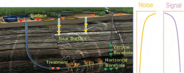
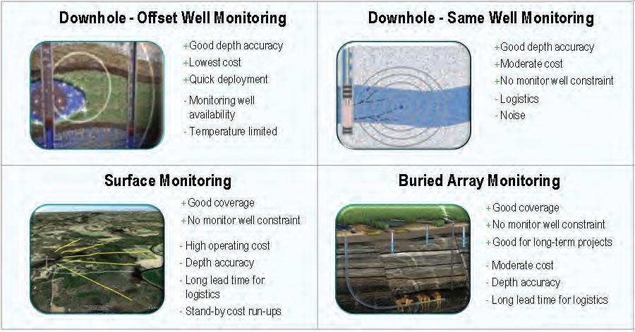
There are four primary ways to deploy sensors to acquire microseismic data based on the geometry of the recording systems (Figure 2). Sensors are normally geophones or accelerometers, similar to those used for conventional borehole VSP or surface seismic reflection acquisition. The majority of microseismic projects use an offset well for deployment of wireline-based borehole
sensors: usually temporarily clamped in place using either mechanical or magnetic means. These monitoring wells can either be new or existing wells, and either vertical or horizontal. Deploying sensors in the treatment well is also possible, although it poses significant challenges associated with deployment logistics and increased background noise with the frac fluid flow. Alternatively, sensors can be deployed on the surface, in a manner analogous to the geometry used to acquire reflection surveys. The final configuration involves “near surface” sensors cemented or temporarily deployed in shallow wells. Each configuration has various pros and cons, as summarized in Figure 3. Fundamental to each of these is the inherent sensitivity and location accuracy associated with data recorded with particular configurations.
The sensitivity of particular acquisition geometries is determined by the ability to record weak microseismic events. The goal of microseismic monitoring is to detect discrete microseismic signals associated with the fracturing, through continuous
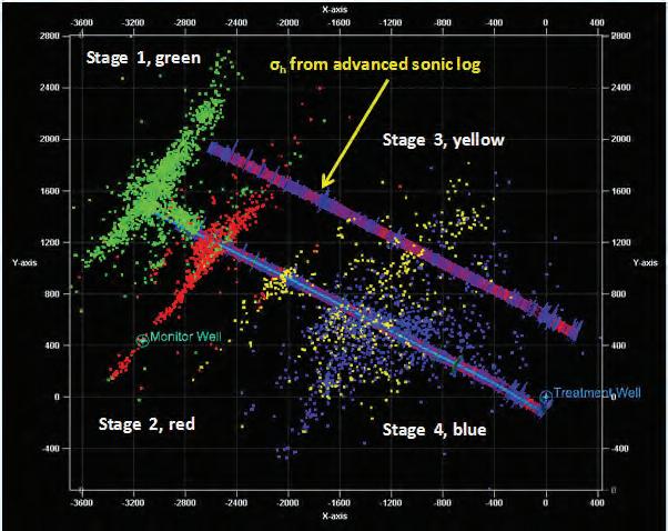
Figure 1. Map view of a four-stage frac in a horizontal well. For each stage the azimuth, length, height, and complexity can be inferred. In this example stage 1 (green) and 2 (red) are relatively planar, while 3 (yellow) and 4 (blue) are wider, suggesting more complexity through interaction with pre-existing fractures (see SPE131779).
of P- and/or S-wave signals (hodogram analysis). The depth of each event is constrained by analyzing the arrival times on multiple seismic sensors (move out).
passive seismic recording. The nature of the microseismic signal is that the amplitude or strength is variable between events, similar to natural tectonic earthquakes. In fact, magnitude scales developed for earthquakes are also applied to measure the microseismic source strength. Conceptually similar to the Richter magnitude scale, moment magnitudes are the preferred scale and are directly related to the area and displacement of the fracture slip generating the microseismicity. Generally the largest events recorded during the frac are below zero magnitude and often in the range -1 to -2 (the magnitude scale is logarithmic such that each magnitude unit corresponds to a factor of 30 times in signal amplitude). Microseismic data statistics follow similar relationships between frequency and magnitude as found for tectonic earthquakes, in that for a decrease in one magnitude unit 10 to 100 times more events are observed. Therein is a prime factor distinguishing the different acquisition geometries: in order to record a large number of microseismic events, we must detect as small of a magnitude event as possible. Quiet background noise levels are important, as well as recording as close as possible to the fracture source since the observed amplitude decreases with distance. Downhole is generally the most sensitive recording as long as a monitoring well close to the treatment well is available, typically several hundred meters away. Many fracs are relatively deep, so surface and nearsurface are relatively far from the target and hence only record relatively large magnitude microseismic events.
Another aspect is the location accuracy associated with each configuration. Location uncertainty varies between microseismic events, depending on the signal quality, earth model and geometry relative to the monitoring array. Accuracy also tends to decrease with increasing distance from the monitoring array, due to decreased data quality (lower signal relative to noise) and geometrically increased uncertainty with distance. The location uncertainty is also generally different in different directions. All these factors make it difficult to generalize, although for a properly designed survey with robust processing the depth accuracy is normally better with downhole data.
MICROSEISMIC LOCATIONS
One of the key differences between passive microseismic and active reflection surveys is that both the source position and origin time of the microseismicity are unknown. The first step in processing is to detect the presence of a microseismic signal, using techniques similar to earthquake detection. Typically impulsive, transient
(Continued on page 18...)
Figure 2. Schematic of the various monitoring scenarios, along with associated signal-to-noise ratios flagged from green (good) to red (poor).
Figure 3. Pros and cons of various monitoring geometries.
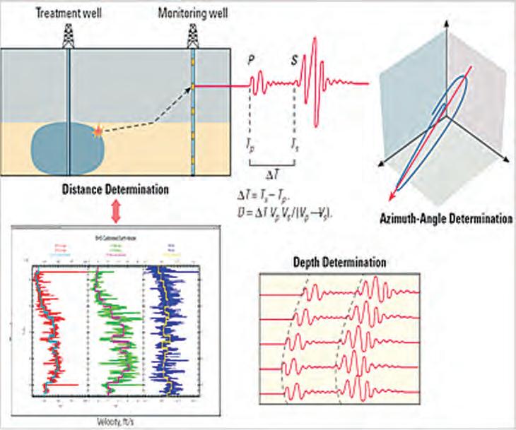
Figure 4. Basic downhole processing workflow. The P- and S-wave sonic velocity model, combined with a downhole array of seismic sensors in a nearby offset well that record microseismic events, allows the location of the event to be determined. The distance to a given event is constrained by the time separation of the arrival of the P- and S-waves, while the direction or azimuth-angle is determined using the polarization
(...Continued from page 17)
seismic signals are triggered by a detection method, which are then categorized as noise or microseismic events. The goal of basic microseismic processing is then to determine the hypocenter location of the event (x, y, and z coordinates and origin time) along with the source magnitude and quality control attributes of the signal-tonoise ratio and error ellipsoids. Figure 4 shows the general workflow. There are two primary methods used to determine the source location for both downhole and surface data: arrival time determination or migration/beam-steering methods. In the first method, arrival times of p- and s-waves are manually or automatically determined for signals visible on each sensor. For most applications, particularly single-well recording, signal polarization measurements are also used to constrain the source location. A velocity model of the zone of interest is constructed and the hypocentral location is determined, giving the best match between forward modeled and observed arrival times and polarizations. Location uncertainties can be estimated based on statistical uncertainties in arrival times and polarizations. In contrast, the migration methods involve a combination of event detection and location determination. From multiple possible source positions, the forward modeled arrival times are compared with observed signals to determine the most probable time and space coordinates that corresponds to the onset of seismic signals. Often, potential source positions are tested throughout the continuous recordings, such that the method acts as both signal detection and location estimation. Signal processing methods, including noise reduction and signal stacking,
are used to detect small signals relative to the background noise levels, but introduce challenges to differentiate potential noise signals contaminating the results and falsely indentifying noise as a microseismic signal. Associated robust location error estimates are more of a challenge, but can be estimated from the location probability for positions around the most probable position.
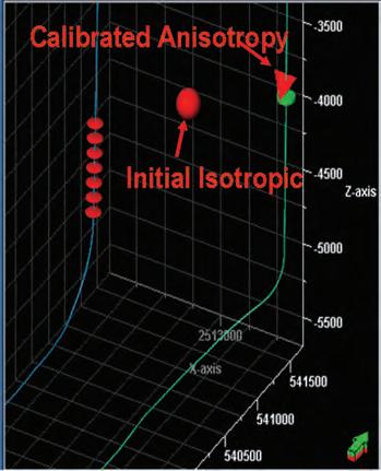
An earth model of the speed that seismic waves travel, the velocity model, is generally constructed from dipole sonic logs and geological models (Figure 4). Often a laterally homogenous, layered velocity model is constructed with layer thickness comparable to the wavelength or characteristic lengths of seismic waves. Sonic logs are normally vertical measurements and since many microseismic monitoring are performed with horizontally propagating waves in anisotropic shale formations, a calibration for the effective anisotropy is performed. Typically perforation shots or other controlled seismic sources are used to calibrate the anisotropy, either explicitly or effectively through adjusting the sonicbased isotropic velocities in various layers. Additional information such as core log measurements, advanced sonic imaging logs or expected anisotropy values for different lithologies can also be used in
the calibration. The controlled sources are also used to determine the direction of the various components of the three orthogonal components of each sensor. Finally the controlled sources can be used to validate the source location accuracy by comparing the computed location with the known location (Figure 5). Perforation shots are ideal calibration sources, located within the fracture network and relatively strong signals.
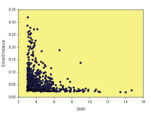
In addition to the location and associated uncertainty estimates, magnitude and signalto-noise ratio (SNR) attributes are generally available. SNR is somewhat related to magnitude but decreases with distance from the source. SNR and location uncertainty are also related, in that low SNR events tend to be relatively uncertain as shown in Figure 6. The impact of the location uncertainty is to geometrically spread out the true microseismically active region proportional to the location uncertainty. The more uncertain the data is, the larger the apparent microseismic volume (Figure 7). In order to get more accurate microseismic results, the interpretation should utilize the higher SNR events and lower location uncertainty microseisms. Interpretation of the fracture geometry needs to account for the location uncertainty as shown in Figure 8. Also of importance is the impact of uncertainties in the velocity model, which can result in incorrect event locations. Pre-survey design studies can estimate the expected accuracy and sensitivity of specific array geometries. The sensitivity to the velocity model uncertainty can also be examined, to compare various array options and potentially deploy the array to provide the best possible results.
SENSITIVITY
The magnitude of the events is also an important quality control (QC) factor. In
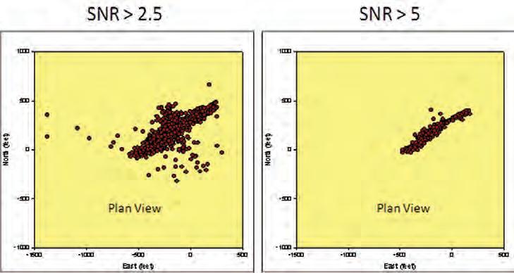
Figure 5. View of a monitoring well with geophones (red disks) and known shot location (green). Red sphere is initial velocity model and triangle is after calibration for anisotropy.
Figure 6. Relationship between relative location error and signal-to-noise ratio (SNR).
Figure 7. Impact of signal-to-noise ratio on microseismic event patterns.
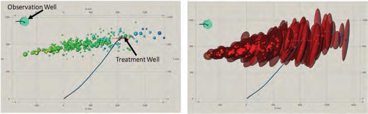
8. Illustration of observation well orientation bias (plan view). Event patterns are more dispersed further from the observation well due to azimuth uncertainty. The left graph shows event locations, with the size of the sphere proportional to the event magnitude. The right graph shows the event error ellipsoids, illustrating the impact of azimuth uncertainty on event patterns.
downhole recording, there is a recording bias associated with increased sensitivity close to the monitoring well (Figure 9). For the same reason, surface monitoring suffers from overall reduced sensitivity using arrays far from the reservoir while downhole is able to detect more events especially close to the array. The recording bias results in two QC aspects that can be assessed through plotting the magnitude versus distance between source and array: whether the entire fracture geometry been detected and how to remove the detection bias.
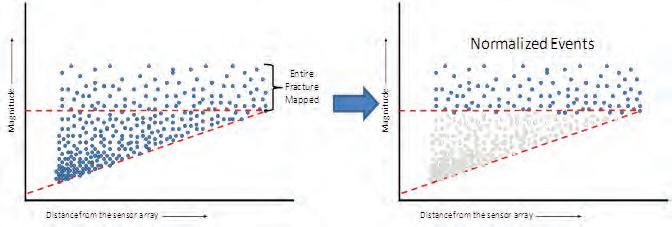
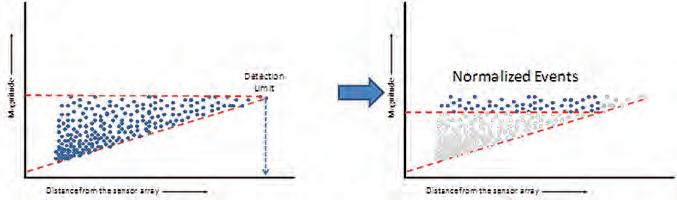
Figure 9 shows an example magnitude versus distance plot for a single- downhole monitoring array configuration. Notice that the smallest magnitude event that is detected at various distances increases as the source gets further from the sensor array (sloping red dashed line). The increased sensitivity at close distances results in an exponential increase in the number of events. To determine if the entire fracture has been detected, the maximum magnitude is compared with the minimum
magnitude which can be detected for the furthest events. The example in Figure 9 illustrates a scenario where there is a range of magnitudes recorded at the greatest distance, which can be used to infer that if the fracture had grown further away, the sensitivity was adequate to still detect the activity. Therefore, in this example, the conclusion can be drawn that the entire fracture was recorded. By contrast, Figure 10 depicts the opposite case where the extent of the microseismic activity is limited by the recording. At the maximum offset, the minimum detected event is equivalent to the largest events that occurred and so it is not possible to conclude if the fracture grew further since even the biggest events would not be detected. In both examples, the recording bias can be removed by just considering the larger magnitude events. In Figure 9 the horizontal red dashed line represents a magnitude that can be detected regardless of distance and this subset of events represents an unbiased data set. In Figure 10, since the recording is distance limited, only the part of the fracture closest
to the monitoring can be filtered to remove the distance bias. The unbiased data set can be used for better comparison of the relative number of microseismic events in various positions.
CONCLUSIONS
In conclusion, microseismic monitoring is a quickly growing technology that is proving that geological variations in unconventional reservoirs result in complex, unexpected fracture patterns. Microseismic can be performed either with an existing offset well for the deployment of a wireline array, or with a surface spread of geophones or sensors in shallow wells. Understanding the microseismic accuracy and sensitivity is critical for proper interpretation of the hydraulic fractures. Some of the challenges with the use of this relatively new and still maturing geophysical technology include educating engineers and the geology and geophysics communities about the benefits and potential pitfalls associated with interpretation of microseismic data. Inaccuracies in the processing must be estimated and communicated to the interpreters (whether engineers, geologists, or geophysicists). As with many areas of assessment and development of unconventional reservoirs, effective communication between geoscientists and engineers is paramount.
ABOUT THE AUTHOR
Shawn Maxwell (SMaxwell@slb.com) is Chief Geophysicist and Advisor for Schlumberger’s microseismic services, and is based in Calgary. Prior employment included leading microseismic services with Pinnacle Technologies (Halliburton) and ESG, and he was also a Lecturer at Keele University in England. Shawn was awarded a Ph.D. in earthquake seismology from Queen’s University, and is currently passive seismic associate editor for Geophysics. He regularly teaches microseismic courses through the CSEG, including the fall Doodletrain and a Microseismic Bootcamp during the spring GeoConvention. The CSEG plans to launch a Microseismic User’s Group in early 2012; details will be available at www.cseg.ca.
Figure
Figure 9. Illustration of magnitude versus distance graph showing that the entire fracture was mapped (left) and the normalized events (right).
Figure 10. Illustration of magnitude versus distance graph showing that the entire fracture was NOT mapped (left) and the normalized events (right).
MARCH IS NATIONAL ENGINEERING AND GEOSCIENCE MONTH: Design the Future!
Across Alberta, Professional Engineers and Geoscientists are turning their ideas into innovations. In every industry and every community, they are transforming the world we live in.
During National Engineering & Geoscience Month (NEGM) March 1 to 31, it’s time to celebrate the contributions these professionals make in our province and around the globe.
“There are more than 62,000 Professional Engineers and Geoscientists in Alberta. The work they do benefits everyone, improving our quality of life, keeping us safe, and growing our economy,” says Jim Smith, P.Eng., President of The Association of Professional Engineers, Geologists and Geophysicists of Alberta (APEGGA). “We’re proud to showcase the excellent work being done by Professional Engineers and Geoscientists, not only during NEGM but all year long.”
Various events will be held throughout the month to raise awareness about the professions and highlight careers in science, math, and technology. “There are many exciting and diverse career paths
in engineering and geoscience. We want to encourage young people, in particular female and Aboriginal students, to explore the possibilities,” says Smith.
Celebrating NEGM is also an important part of APEGGA’s commitment to building strong relationships within the engineering and geoscience communities.
C ALENDAR OF EVENTS
Celebrations start with NEGM kickoff events. Engineers and geoscientists will compete in a fun science challenge that will test their skills. The public and other engineering and geoscience professionals are invited to attend and cheer them on.
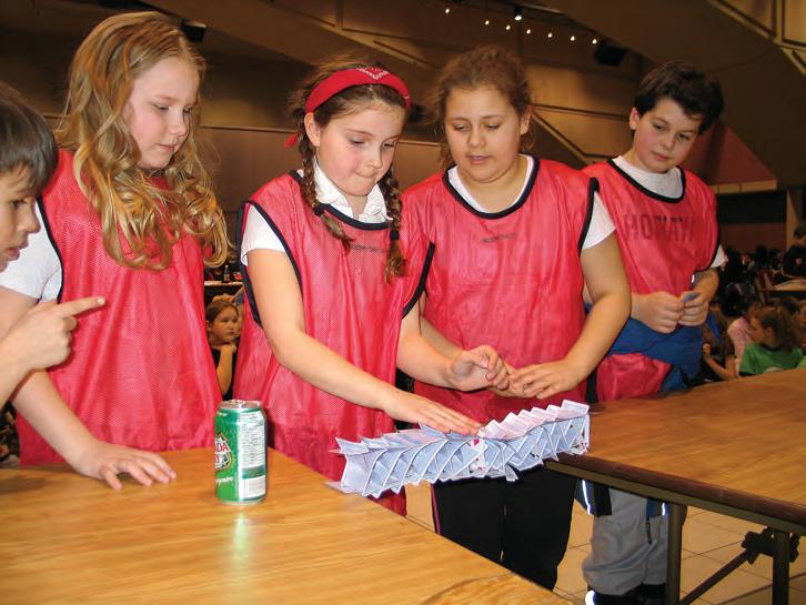
Throughout the month, APEGGA will host Science Olympics and elementary school science nights around the province. In 2011, more than 5,000 students, teachers, and volunteers took part in these events. “The focus is on fun,” says Edmonton Science Olympics Chairman Jeff Goldie. “The kids like the hands-on nature of the activities. It gives them an outlet for their creativity.”
Trish Hunter, a science teacher at Balmoral School in Calgary, encourages parents and
schools to take part in NEGM activities. She’s been bringing her Grade 5 and 6 students to the APEGGA Calgary Science Olympics since 2003. “Science is a lot more than a subject in school. I think the Science Olympics creates a desire in students to learn more, and to possibly consider a career in science,” says Hunter.
For a complete calendar of events taking place during the month, look for the annual NEGM newspaper supplement in the March 1 editions of the Calgary Herald, Edmonton Journal, and Fort McMurray Today, and on March 2 in the Grande Prairie Herald Tribune. Articles in the supplement will profile engineers and geoscientists whose innovations and volunteer work are helping Design the Future, both in Alberta and beyond our borders.
GET INVOLVED
For more information on what’s happening across Alberta during NEGM, and to get involved, visit APEGGA’s calendar of events at www.apegga.org and click on National Engineering & Geoscience Month under the K-12 & Teachers section.
If your organization is holding an event to celebrate NEGM, let APEGGA know. Contact Corinne Lutter at 780-426-3990, or by email at clutter@apegga.org, to have your event added to the calendar. For information about other NEGM events, please contact Jeanne Keaschuk at 780426-3990, or by email at jkeaschuk@ apegga.org.
Hundreds of students will take part in Science Olympics events during National Engineering and Geoscience Month in March.
ROCK SHOP


FALL EDUCATION WEEK
| By Tina Donkers, Committee Chair
During the fall the CSPG scheduled 12 courses, of which five met the minimum registration requirements. Courses that did successfully run were 60-100% filled. I’m sure it is disappointing to the members who have registered and are looking forward to attending a course, to have it cancelled two weeks before the course starts. The CSPG chooses not to run courses at a negative balance and be a drain on their finances. Unfortunately, this leads to the false perception that the CSPG is not running a successful Education program.
The most popular registration period for education continues to be associated with the May conference, where 90% of the courses offered have enough registration to run. In general, numbers are much lower for the fall Education Program, but the CSPG feels that it is a worthy program to continue. It is interesting how the numbers
vary from year to year or from spring to fall in registration for particular courses. Some courses are over-subscribed at the spring conference, but when offered again in the fall, the course fails to run.
Advertising continues to be through the Reservoir and via member e-mails. This is an area that has been identified as needing improvement. Notices in the Daily Oil Bulletin as well as advertising at division talks have been recommended. Researchers claim that people need to see an ad 5-6 times before they take action. A sobering thought, that the same basic information has to be placed in front of a person five times before there is a response. Thus if only a portion of the membership reads the CSPG Reservoir or the e-newsletter, then we haven’t really advertised to our membership successfully. Taking over the helm for the Fall Education Program in 2012 is Andrew Riben. Andrew
GeoEdges Inc.
Petra, GeoGraphix, ArcGIS, AccuMap, GeoScout and other applications
has been on the committee for several years now and has been immersed in other duties. He is fully cognizant of the duties and responsibilities he is taking on. On behalf of the membership, I’d like to thank Andrew for continuing to volunteer for the CSPG.
Also thanks to Carrie Jeanes, (now Carrie Kukko) for her continuing support as Chair for the Education Committee, this past year. Carrie took on this role at a very busy time in her life, knowing that she had a wedding to prepare for in August. She also had a very proactive role in setting up a new instructor payment system, which led to several new courses for the convention as well as for the fall program.
I appreciated the opportunity to work on the committee for the last four years and thank the committee volunteers for their ongoing support and friendship.
Western Canada: Slave Point, Swan Hills, Leduc, Grosmont, Jean Marie, Horn River Shales, Elkton, Shunda, Pekisko, Banff, Mississippian subcrops and anhydrite barriers in SE Sask., Bakken, Three Forks, Montney, Halfway, Charlie Lake, Rock Creek, Shaunavon, BQ/Gething, Bluesky, Glauconitic, Lloyd, Sparky, Colony, Viking, Cardium, Horseshoe Canyon and Mannville CBM, Oilsands Areas, Outcrops
US Rockies & Williston: Red River, Mississippian subcrops & anhydrite barriers (Bluell, Sherwood, Rival, etc), Bakken, Three Forks, Cutbank, Sunburst, Tyler, Heath, Muddy, Dakota, Sussex, Shannon, Parkman, Almond, Lewis, Frontier, Niobrara, Mesaverde shorelines, Minnelusa, Gothic, Hovenweep, Ismay, Desert Creek, Field Outlines, Outcrops
North American Shales: Shale plays characterized by O&G fields, formation limit, outcrop, subcrop, structure, isopach, maturity, stratigraphic cross-sections. Includes: Marcellus, Rhinestreet, Huron, New Albany, Antrim, Utica-Collingwood, Barnett, Eagleford, Niobrara, Gothic, Hovenweep, Mowry, Bakken, Three Forks, Monterey, Montney, Horn River, Colorado
Appalachian Basin: PreCambrian, Trenton, Utica-Collingwood, Medina-Clinton, Tuscarora, Marcellus, Onondaga Structure, Geneseo, Huron, Antrim, New Albny, Rhinestreet, Sonyea, Cleveland, Venango, Bradford, Elk, Berea, Weir, Big Injun, Formation limits, Outcrops, Allegheny Thrust, Cincinatti Arch, Field outlines
Deliverables include:
-Shapefiles and AccuMap map features
-hard copy maps, manual, pdf cross-sections
-Petra Thematic Map projects, GeoGraphix projects, ArcView map and layers files
-bi-annual updates and additions to mapping
-technical support
ABERDEEN, SCOTLAND
| By Anne Hargreaves
www.scottishgeology.com/findoutmore.
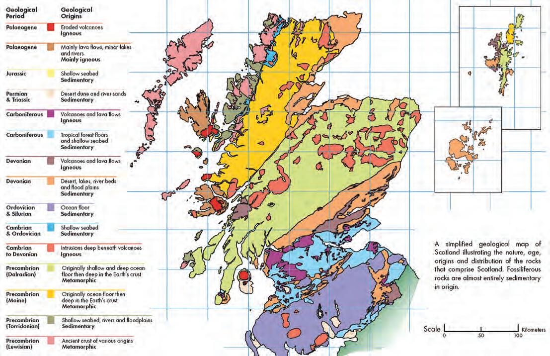
Scotland has long figured in the history of geology. One early geologist was James Hutton. Hutton was a Scottish gentleman farmer, philosopher, and scientist who published a book in 1795 called Theory of the Earth. By studying the geological features in and around Edinburgh (Figure 1) he came up with ideas regarding the formation of igneous and sedimentary rocks in the area. His most famous finding was an ‘unconformity’ where by observing a structural difference between two sedimentary rock sequences, he determined that one sequence was deposited, uplifted, eroded, before being overlain by another sequence.
Another early Scottish geologist of note is Hugh Miller. Self taught, he described sedimentary rocks and their associated fossils, discovering many new species. His most famous book was titled The Old Red Sandstone. His birthplace home is available to tour in Cromarty north of Inverness.
Today, an important center of Scottish geology
(Continued on page 24...)

Figure 1. The geology of Scotland. © The Trustees of the National Museums of Scotland, used with permission for educational purposes from the Scottish geology website,
i NBurG H
MartY
Figure 2. Aberdeen’s buildings are all made of granite from the local Rubislaw Quarry. Begonias are still blooming in November despite being at 57 degrees N latitude.
(...Continued
is Aberdeen. Aberdeen is known as the ‘Granite City’ as the majority of its buildings are built with the local grey granite (Figure 2, page 23). This stone, hewn from the Rubislaw Quarry located right in the city of Aberdeen, is an igneous diorite with flakes of mica that, on sunny days, sparkle brilliantly. The quarry opened in 1741 and after producing six million tons of granite for buildings in Aberdeen, as well as the Houses of Parliament in London, finally closed in 1971 and is now filled with water. The quarry is believed to be the largest man-made hole in Europe and measures 120 m wide by 142 m deep.
The city, which has a population of around 225,000 people, is also known as the oil capital of Europe due to its proximity to the North Sea, where it acts as the main staging area for people and equipment operating there on the many drilling platforms (Figure 3). Presently there are 156 of 169 rigs operating in the North Sea – an enviable 91% utilization rate, even though it is believed that more than 50% of the reserves in the North Sea have already been produced since offshore drilling commenced in 1964.
The University of Aberdeen was founded in 1495, and one of its buildings, Marischal College (Figure 4), is the second biggest granite building in the world after El Escorial in Spain. This college is leased by the city of Aberdeen from the University, and has recently undergone extensive restoration to the tune of 65 million pounds. It currently houses the Aberdeen civic offices.
When in Aberdeen, it is well worth a visit to the Maritime Museum (Figure 5), which is situated near the harbour in a building dating back to 1593. The refurbished museum opened in 1997 and the centerpiece is the nine-meter high model of the Murchison Oil Platform (Figure 6). This model was made to plan the construction of the platform before the era of high-quality computer modeling. The museum itself houses an excellent multi-media exhibit that brings to life the drama of the offshore oil and gas industry in the North Sea, as well as Aberdeen’s fishing and shipping industry.
There is a unique area called the Sands of Forvie, which stretch from the city for 24 km north along the coast. Here, the sands form a beach dune complex that developed during the past 4,000 years. At the end of the last ice age approximately 10,000 years ago, sediment was transported by rivers to the coast and deposited off-shore. As sea levels rose due to the melting of the Scandinavian and North American ice sheets, with peak water levels approximately 4,000 years ago, the sediments were reworked and deposited back onshore.

Figure 3. Aberdeen harbour packed with drilling and service ships.
Figure 4. Aberdeen’s Marischal College today, after a 65 million pound refurbishment.
Researchers study the sand dunes and the processes that formed them as winds, waves, and tides work to move the sediment steadily northwards. In the past few years Donald Trump and his contentious plans for a massive golf course, in the dunes near Balmedie, have met with much local opposition. The word ‘links’ is the original Scottish term for the dune area which is not suitable for cultivation but not in the ocean either, but links the land to the sea. Links courses usually have a lot of rough and uneven fairways, as well as a lot of wind, not surprisingly!
A three-hour train ride south of Aberdeen brings you to Edinburgh, which is a beautiful and historically fascinating city, not only culturally, but also most definitely geologically!
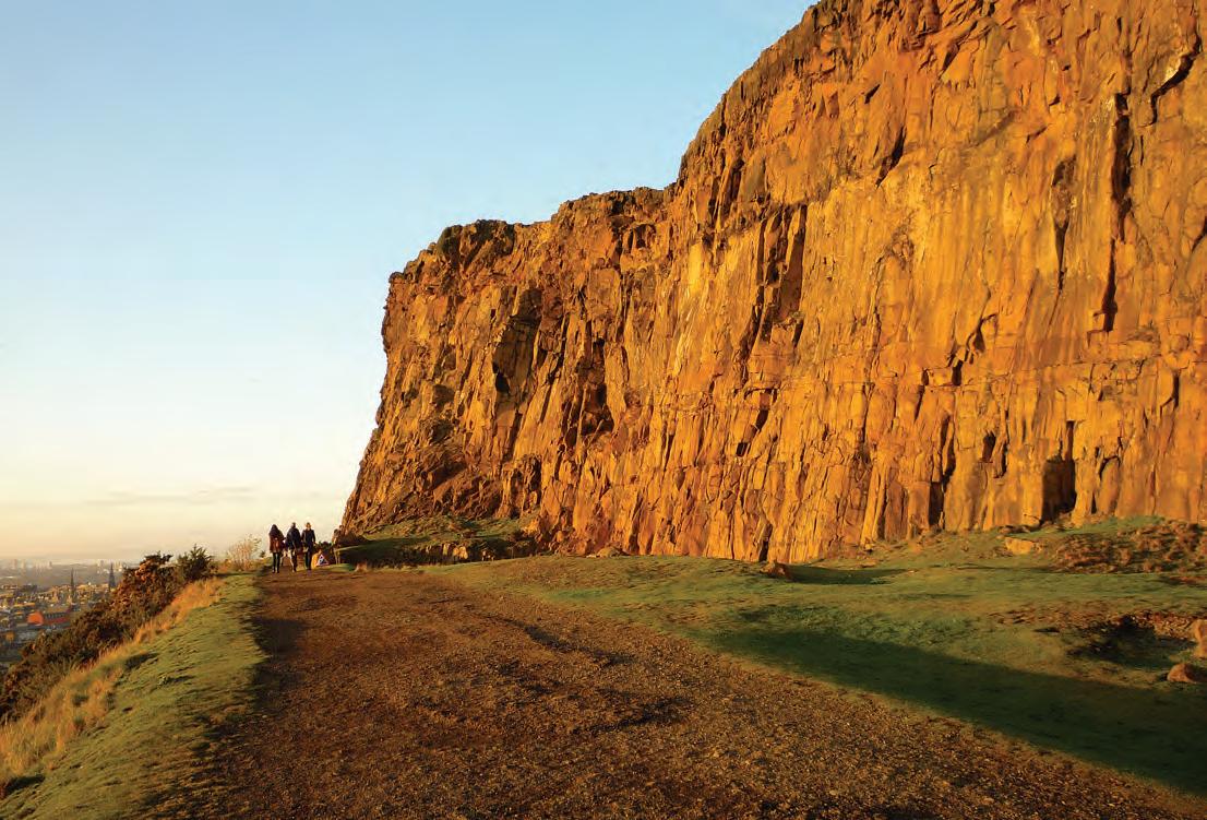
It was here at Arthur’s seat (Figure 7) that James Hutton demonstrated that igneous rocks were intruded into sedimentary rock layers resulting in what is called a sill. The surrounding sedimentary rocks have been eroded away, leaving a sill exposed that is now known as the Salisbury Crags (Figure 8, page 26). Often sills are created with very fluid magma that can force its way between sedimentary rock layers for great distances.
Arthur’s seat itself is an extinct Carboniferous volcano, which was plugged with volcanic ash and hardened lava when it became extinct. The plug or neck of a volcano often survives when surrounding rock is eroded away. There are a number of volcano plugs in the area, one of which is the rock that Edinburgh Castle is built on (Figure 9, page 26).
BIBLIOGRAPHY
http://www.rigzone.com/ http://scottishgeology.com/ Toghill, Peter. 2007. The Geology of Britain. Airlife Publishing, Marlborough,
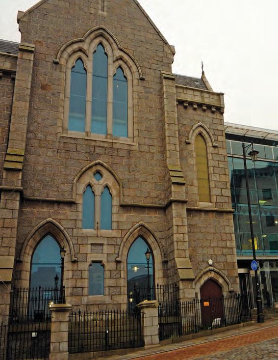
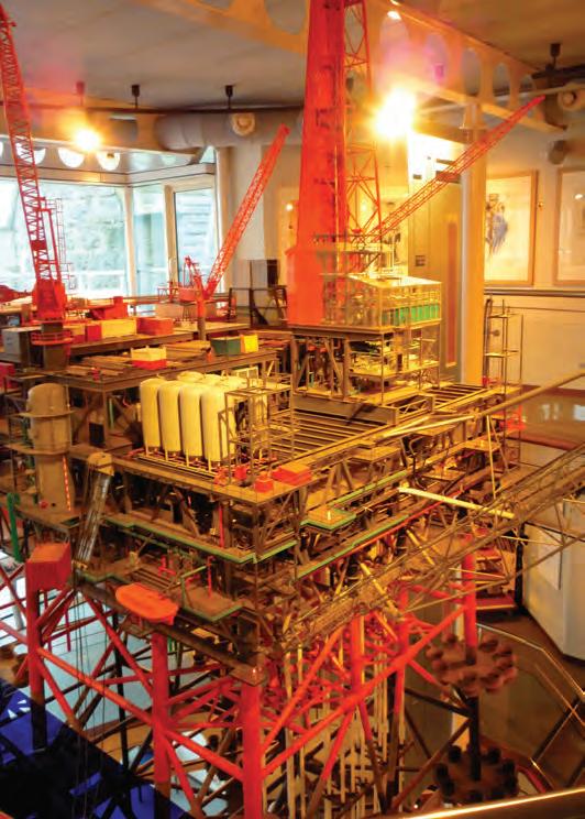

Figure 6. The Aberdeen Maritime Museum houses the model of the Murchison Oil Platform, which is 9 m high. This model was used during construction in 1980 as computer modeling was not yet perfected.
Figure 5. Maritime Museum, Shiprow, Aberdeen. The museum was refurbished in 1997 with the portion on the right, a house that was built in 1593 (www.aagm.co.uk).
Figure 7. Arthur’s seat, which is an extinct Carboniferous volcano, with the Salisbury Crags in the foreground as viewed from Edinburgh Castle.
remnants of a sill that was intruded parallel to bedding planes in sedimentary rocks surrounding the volcano. Early November light casts long shadows even at 3 p.m. as in this photo. Aberdeen lies fairly far north, at 57 degrees N, so daylight is limited in winter with under 7 hours between sunrise and sunset at winter solstice.

Figure 8. Salisbury Crags,
Figure 9. View of Edinburgh Castle from Arthurs Seat. The Castle is built on an old Carboniferous volcanic plug.
2011 CSPG AWARDS
T E CHNICAL AWARDS
St anley Slipper Gold
Medal for Outstanding Career Contributions to Oil and Gas Exploration in Canada
Edward (Ned) Gilbert
r . J.W. Douglas Medal for Outstanding Contributions to the Understanding of Sedimentary Geology in Canada
Darrel Long
Honorary Membership for Distinguished Service to the Society
Gerry Reinson
Roger Walker
l ink aw ard for Best Presentation – Technical Luncheon Series
Stephen Grasby for his September 23, 2010 presentation “A Late Permian Hot Anoxic Acid Bath”.
Medal of Merit for Best Paper Related to Canadian Petroleum Geology
Tim McCullagh and Bruce Hart for their paper “Stratigraphic controls on production from a basin-centered gas system:
Lower Cretaceous Cadotte Member, Deep Basin, Alberta, Canada.”
VOLUNTEER AWARDS
President’s aw ard for Outstanding Service by a CSPG Member
Paul MacKay
H.M. Hunter aw ard for Distinguished Service to the Society
Timothy Bird
Graeme Bloy
tr acks aw ards for Members Who Have Set New Standards of Excellence
David Garner
Greg Lynch
Dennis Meloche
Trent Rehill
Bob Potter
Partnership aw ard for NonCSPG members or Non-Geologists who Have Made Outstanding Contributions to CSPG
Rob McGrory
Service aw ards for Members who have Served the Society for over Five Years
Linden Achen
Norbert Alwast
George Ardies
Peter Aukes
Andreas Bayer
Philip Benham
George Bowley
Peter Boyle
Chuck Buckley
David Caldwell
Mark Caplan
Richard Chisholm
Nancy Chow
Andre Chow
Penny Christensen
Penny Colton
Debbie Cook
Andrew Cook
Barrie Dargie
Tim de Freitas
Foon Der
Ian DeWolfe
Steve Donaldson
Tina Donkers
Dave Drover
Bob Earle
Markus Ebner
Ashton Embry
Samantha Etherington
Ned Etris
Richard Evoy
Lloyd Freeman
Riona Freeman
Jean-Francois Gagnon
Stephen Grasby
Darcie Greggs
Aaron Grimeau
Ayaz Gulamhussein
Tony Hamblin
Peter Harrington
Peter Hay
Doug Hayden
Greg Hayden
Adam Hedinger
Dave Hills
Denise Hodder
Dawn Hodgins
John Hogg
Norm Hopkins
Kristy Howe
Michele Innes
Dale Issler
Wim Jalink
Glenn Karlen
Don Keith
Ian Kirkland
Peter Kouremenos
Dan Krentz
Carrie Kukko
Mike LaBerge
Shaun Lafleur
Larry Lane
Denis Lavoie
Sid Leggett
Robert MacNaughton
Bruce McIntyre
Ben McKenzie
Margot McMechan
David Middleton
Steve Minions
Jessie Mitton
Regan Palsgrove
Alice Payne
Brenda Pearson
John Peirce
Guy Plint
Frank Pogubila
Brian Pratt
Mark Radomski
Indy Raychaudhuri
Weishan Ren
Claude Ribordy
Justine Sagan
Terry Sami
Claus Sitzler
Heather Slavinski
Randy Smith
Tom Sneddon
Gordon Stabb
Lavern Stasiuk
Glen Stockmal
Mike Swain
Martin Teitz
Clint Tippett
Tony Wain
John Waldron
Michael Webb
Jay Williams
Dick Willot
Hugh Wishart
Tammy Wolcott
Keith yaxley
Colin yeo
vol unteer awa rds for Members who have Served the Society for up to Five Years
James Ablett
Heather Archibald
Olena Babak
Jeff Barefoot
Kelly Batten Hender
Ali Beken
Laurie Bellman
Berry Bennett
Khaled Benzaoui
Tim Bergen
Kyla Bishop
Edlyn Bruni
Gary Bugden
Matt Burns
Jean-yves Chatellier
Guoxiang Chi
Christopher Collom
Ryan Cook
Jonathan Cribb
Leena Davis
Clayton Deutsch
Noel Devere-Bennett
Keith Dewing
Eva Drivet
Kyle Durocher
Colleen Flynn
Patrick Fothergill
Jocelyn Frankow
Ranald Gault
Sasan Ghanbari
Chad Glemser
Tony Habib
Anne Hargreaves
Tim Hartel
Tracy Hay
Fran Hein
Dan Hermary
Amir Hosseini
Paula Jennings
Tracey Jungwirth
Kevin Keogh
Nate Kreiger
Adam Leather
Alex MacNeil
Ryan Martin
Jane Marzetti
Darin McBeath
Tannis McCartney
Rick McCulloch
Amanda Mitander
Aliyyah Mohamed
Ryan Mohr
Rob North
Jeff Packard
Per Kent Pedersen
Amanda Perrot
Kyla Poelzer
Mark Rabin
Melanie Regehr
Andrew Riben
Cindy Robinson
Mike Rogers
Kristin Rohr
Sandra Rosenthal
Jen Russel-Houston
Armin Schafer
Jacey Seebach
Angie Simpson
Meghan Speers
Stan Stancliffe
Scott Thain
Damien Thenin
Elizabeth Turner
Cole Webster
Renjun Wen
Gerald Wendland
Marissa Whittaker
Andrew Willis
Nick Wilson
Stefan Zanon
| By Tom Sneddon, P.Geol., Manager of Geoscience Affairs, APEGGA Calgary
Geologists are, by and large, a congenial lot who are more inclined to collaborate than compete (much to the dismay of many corporate executives!) Teamwork comes easily and is the competitive edge in 21st Century corporate Canada.
Kyosei is a Japanese word that explicitly means “living and working together to achieve the common good.” It is the core value for Canon Inc. and that company’s
manifesto is explained in some detail in “The Path of Kyosei” by Ryuzaburo Kabu, Canon’s Honourary Chairman in the July 1997 edition of the Harvard Business Review (http://hbr.org/1997/07/the-path-of-kyosei/ ar/1). The concept of kyosei is an expression of teamwork and thus comes easily to geoscientists.
Canon has extended the idea somewhat in its corporate philosophy: “All people, regardless
of race, religion or culture, harmoniously living and working together into the future” (http:// www.canon.com/about/philosophy/index. html). The extended concept also comes naturally to geologists, who have always worked in a global economy world.
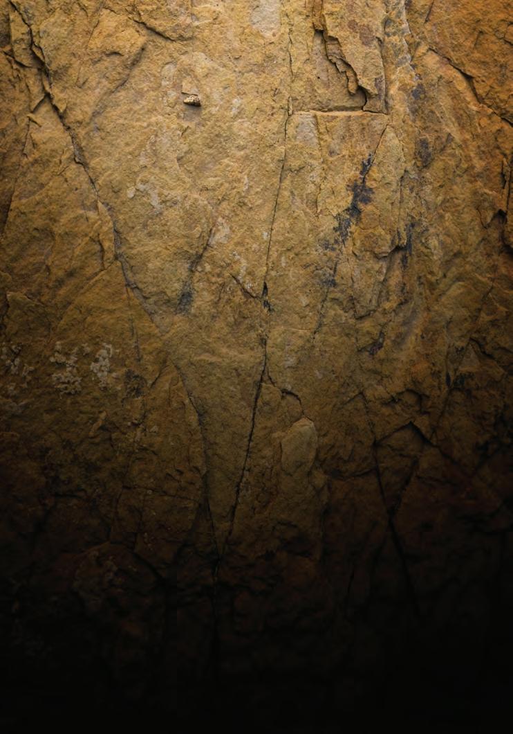
FOCUSON DECISIONS DATANOT
Kyosei isn’t a bad analogy for how Canada has developed over the past 150 years and will likely continue to do for the next century. It certainly beats constant inter-cultural enmity, constant warfare, and political intrigue. We tend to take out our aggressive tendencies via the sports field, hockey rink, and House of Commons where hopefully they do no real harm. In places of commerce, social interaction, and in the street we tend toward kyosei more than any other way and if our leaders get too carried away with their rhetoric, we remind them that we are basically a peaceful and cooperative lot who come from a wonderfully diverse cultural background.


Professional geoscience has a history of kyosei. We socialize a lot; discuss technical and scientific matters objectively, fairly, truthfully, and honestly and try (sometimes vainly) to avoid getting our egos wound into geological debate. This is clearly the way to tentatively adopting a difficult to disprove orthodoxy or discarding a current orthodoxy until it has been shown to be fallacious.
Professional Geologists are also committed to placing the health and welfare of the public ahead of personal and private gain and have an equal concern for the health of the natural environment. By our Rules of Conduct, this is our obligation as well. We must serve the public interest.
Others in the world have adopted kyosei and further extended it to include the rather vague concept of sustainability and much of the blogosphere has embraced that definition. By searching the internet using “kyosei”, you will have no difficulty in exploring those interpretations of the word.
As we approach the GeoConvention 2012: Vision, there is a great need for members to assist the organizing committee structure in delivering one of the world’s great gatherings of geoscientists. Volunteering for CSPG and APEGGA committees is an expression of kyosei, working together for the common good.
you know, that isn’t a bad vision for our profession.


Since 1927...
CORPORATE MEMBERS
ALLEN GEOPHySICAL CONSULTING LTD
APACHE CANADA LTD
APEGGA
BAKER ATLAS
BDO CANADA LLP
CANADIAN NATURAL RESOURCES LTD.
CASE y & ASSOCIATES
CONOCOPHILLIPS CANADA LIMITED
DEVON CANADA CORPORATION
ENERPLUS CORPORATION
E xxON MOBIL UPSTREAM RESEARCH COMPANy
GEOLOGIC SySTEMS LTD
GEOSTRATA RESOURCES INC.
H UNT OIL COMPANy OF CANADA
HUSKy ENERGy INC.
IHS
IMPERIAL OIL RESOURCES
JEWELSUITE
LITTLE ROCK DOCUMENT SySTEMS
MJ SySTEMS
MURPHy OIL COMPANy
NE xEN INC
PENN WEST PETROLEUM LTD.
PETROCRAFT PRODUCTS LTD.
PLUSPETROL S.A
ROx AR
RPS ENERGy CANADA LTD
SCHLUMBERGER
SHELL CANADA LIMITED
S PROULE ASSOCIATES LIMITED
SUNCOR ENERGy INC
TALISMAN ENERGy INC
TOTAL E&P CANADA LTD.
TOURMALINE OIL CORP
AS OF JANUARY 10, 2012
CSPG welcomes our 2011 Corporate Members!
The benefits of being a corporate member include:
• Recognition in the monthly Reservoir and quarterly Bulletin
• One associate membership
• Reserved tables at the technical luncheons with your company logo
• One free pass to the CSPG Core Conference
…and more! Contact Kasandra Klein at kasandra.klein
@cspg.org to be a corporate member today!
FALL LECTURE TOUR Wrap-up
| By Garrett Quinn and Chad Glemser
One of the most significant ways the CSPG University Outreach Committee connects with students is through the lecture tour series. Over the years this program has proven to be very effective as it puts industry professionals in direct contact with students where they can share their work and give students a sense of what the Canadian oil and gas industry has to offer. For students in some regions of Canada this may be their first exposure to the petroleum industry and the lectures are a chance to broaden their knowledge to new geological ideas and techniques. Above all, the lecture tours provide an opportunity for students and faculty to see the technical challenges we face as geoscientists in the petroleum industry and to network with an industry professional. This spring we are planning another round of lecture tours, so students and faculty should regularly check their department announcement boards and watch the CSPG Student Newsletter for a lecture tour near you.
This fall Brad Hayes, President of Petrel Robertson Consulting Ltd., travelled to Eastern Canada visiting McGill, Memorial, Dalhousie, Acadia, and St. Mary’s Universities. His lecture entitled “Unconventional” gas and oil development – how is it changing careers in geology?” was oriented towards students and faculty who likely have heard much about unconventional oil and gas development and are curious to hear about the issues from an industry professional while learning about the role of a geologist in these new frontiers. Brad’s lecture focused on the nature of unconventional resources and how they differ from conventional plays while addressing the many different roles geologists are now experiencing outside of traditional hydrocarbon exploration. For example, geologists specializing in hydrogeology, stratigraphy, Quaternary geology, and environmental geology are becoming increasingly important within the industry as the need grows for high-quality sand used for proppant in hydraulic fracturing, new water sources, and improved understanding of how to manage all of these resources responsibly in a more environmentally conscious society. In many new areas of North America traditionally not well known for
hydrocarbon production, it is essential that industry professionals network with students and faculty to spread the knowledge of these new and enormous resource plays, the challenges we face, and the many different geological careers one can take within this blossoming industry.
The lecture tours are also a forum for students to learn about what the CSPG has to offer with its free student membership: the Student Industry Field Trip, cash awards, iPad draws, field trips, networking events, and conferences, to list a few. The CSPG University Outreach committee is always looking for enthusiastic individuals with new and creative lecture ideas to bring to aspiring undergraduate and graduate students across Canada. If you or someone you know has an idea for a talk you would like to give on any aspect of petroleum geology, or if your university is interested hosting a lecturer, please feel free to contact either Chad Glemser (C.Glemser@shell.com) or Garrett Quinn (gquinn@osumcorp.com). The CSPG University Outreach Committee expresses their sincere appreciation and thank you to all universities involved with hosting a lecturer on tour this year and, of course, the lecturers for contributing their time and effort toward making this program a success.
4th - 19th
www.apegga.org
Investing in the Future
At APEGGA we like to make science fun! We also hope to attract the best and brightest students to careers in geoscience. And we remain committed to building strong relationships with the geoscience community. Put that all together and you get an active geoscience outreach and sponsorship program.
In fact, every year APEGGA provides in-kind donations and thousands of dollars to multiple groups as a sponsor of organizations and events including: Alberta Science Literacy Society, Alberta Women’s Science Network, Burgess Shale Foundation, Canmore Museum and Geoscience Centre, Doodle Train, Earth Sciences for Society, Geophysics Undergraduate Student Society, Geoscience Day, Honorary Address, P.S. Warren Undergraduate Geological Society, PTAC Spring Water Forum, Rock ‘N’ Fossil Clinics, Rundle Group of Geology, Science Alberta Foundation, Seismic in Motion, Stones and Bones Summer Camp, TELUS World of Science Calgary and Edmonton and W.C. Gussow Geoscience Conference as well as multiple science olympics and science fairs.
That’s because, like you, we see sponsoring geoscience outreach organizations and events as an investment in future human capital and an important opportunity to raise awareness of the wealth generation and quality of life made possible by geoscientists right here in Alberta.

By working with Alberta’s geoscience community, we help to ensure that today’s students become tomorrow’s geoscience leaders.
For more information:
Tom Sneddon, P.Geol. Geoscience Affairs Manager P: 403-262-7714 or 800-661-7020
E: tsneddon@apegga.org
DecisionSpace® Desktop software automatically generates accurate sealed frameworks in about a minute.
As geoscientists interpret data, Landmark’s new unified DecisionSpace® Desktop software automatically constructs fault networks, seals horizons against the fault network and generates a sealed framework. When geologists make picks or geophysicists interpret sections, watch live updates ripple through the framework and then create accurate, report-quality maps instantly. What once took hours, or even days, now takes just a minute. So speed up your cycle time. Get better answers faster. Visit halliburton.com/decisionspacedesktop.
High Science Simplified®