
17 Wildcatters, Wellsiters and the Immortality of Data 24 Go Take a Hike 28 Understanding Oil Source Systems –A Multifaceted and Novel Approach 31 Dr. Scott Tinker: CSPG University Outreach – Intervew a Geologist $10.00 OCTOBER 2014 VOLUME 41, ISSUE 09 Canadian Publication Mail Contract – 40070050
CSPG OFFICE
#110, 333 – 5th Avenue SW
Calgary, Alberta, Canada T2P 3B6
Tel: 403-264-5610
Web: www.cspg.org
Please visit our website for all tickets sales and event/course registrations Office hours: Monday to Friday, 8:00am to 4:30pm
The CSPG Office is Closed the 1st and 3rd Friday of every month.
OFFICE CONTACTS
Membership Inquiries
Tel: 403-264-5610
Email: membership@cspg.org
Technical/Educational Events: Biljana Popovic
Tel: 403-513-1225 Email: biljana.popovic@cspg.org
Advertising Inquiries: Emma MacPherson
Tel: 403-513-1230 Email: emma.macpherson@cspg.org
Sponsorship Opportunities: Candace Seepersad
Tel: 403-513-1227 Email: candace.seepersad@cspg.org
Conference Inquiries: Kelsey Thompson
Tel: 403-513-1233 Email: kelsey.thompson@cspg.org
CSPG Educational Trust Fund: Kasandra Amaro
Tel: 403-513-1234 Email: kasandra.amaro@cspg.org
Accounting Inquiries: Eric Tang
Tel: 403-513-1232 Email: eric.tang@cspg.org
Executive Director: Lis Bjeld
Tel: 403-513-1235, Email: lis.bjeld@cspg.org
EDITORS/AUTHORS
Please submit RESERVOIR articles to the CSPG office. Submission deadline is the 23rd day of the month, two months prior to issue date. (e.g., January 23 for the March issue).
To publish an article, the CSPG requires digital copies of the document. Text should be in Microsoft Word format and illustrations should be in TIFF format at 300 dpi., at final size.
Technical Editor
Hugh S. Mosher
Nunaga Resources Ltd.
M.: 403-809-9997
Email: hsmosher@telus.net
CSPG Coordinating Editor
Emma MacPherson, Communications Coordinator, CSPG Tel: 403-513-1230, emma.macpherson@cspg.org
The RESERVOIR is published 11 times per year by the Canadian Society of Petroleum Geologists. This includes a combined issue for the months of July and August. The purpose of the RESERVOIR is to publicize the Society’s many activities and to promote the geosciences. We look for both technical and non-technical material to publish. The contents of this publication may not be reproduced either in part or in full without the consent of the publisher. Additional copies of the RESERVOIR are available at the CSPG office. No official endorsement or sponsorship by the CSPG is implied for any advertisement, insert, or article that appears in the Reservoir unless otherwise noted. All submitted materials are reviewed by the editor. We reserve the right to edit all submissions, including letters to the Editor. Submissions must include your name, address, and membership number (if applicable). The material contained in this publication is intended for informational use only. While reasonable care has been taken, authors and the CSPG make no guarantees that any of the equations, schematics, or devices discussed will perform as expected or that they will give the desired results. Some information contained herein may be inaccurate or may vary from standard measurements. The CSPG expressly disclaims any and all liability for the acts, omissions, or conduct of any third-party user of information contained in this publication. Under no circumstances shall the CSPG and its officers, directors, employees, and agents be liable for any injury, loss, damage, or expense arising in any manner whatsoever from the acts, omissions, or conduct of any third-party user.
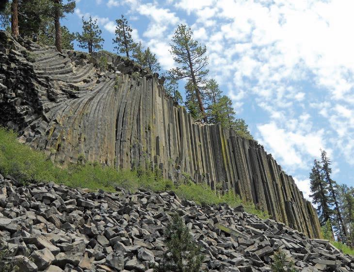
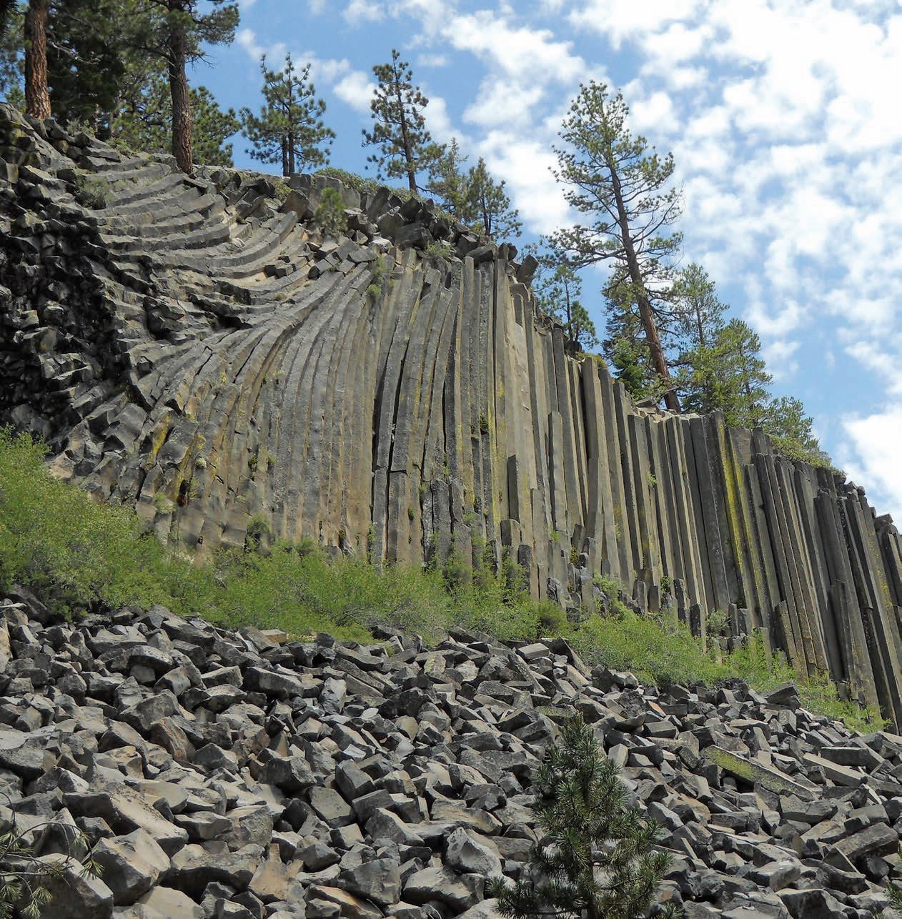
Devil’s Postpile, California. Dated at approximately 100,000 years old, basaltic lava cooled slowly to form the columnar basalt of this National Monument established in 1911. Approximately 82 percent of the columns have five or six sides. Photo by Dianne
RESERVOIR ISSUE 09 • OCTOBER 2014 3 OCTOBER 2014 – VOLUME 41, ISSUE 09 ARTICLES 2014 Andrew D. Baillie Awards ................................................................................................. 14 Wildcatters, Wellsiters and the Immortality of Data 17 Go Take a Hike .............................................................................................................................. 24 Understanding Oil Source Systems – A Multifaceted and Novel Approach ............... 28 Dr. Scott Tinker: CSPG University Outreach – Intervew a Geologist 31 Photo of the Month ...................................................................................................................... 33 Honorary Member Citation for James Terrance McCoy 34 DEPARTMENTS Message From the Board 5 Technical Luncheons 8 Division Talks ........................................................................................................................... 12 Rock Shop 12, 18
Designed
Printed by The Data Group of Companies, Calgary, Alberta.
and
FRONT COVER
Leonhardt.
(You may never return to the office)

Now, get geoLOGIC’s value-added data almost any place, any time, any way you want it. Available through gDCweb on your tablet, smartphone or computer.
With 30 years of data experience behind it, gDC is the source for high quality, value-added well and land data from across Western Canada and the Northern United States. Another plus – our data is accessible through an expanding range of industry software utilizing our own easy-to-use gDC GIS and our geoSCOUT software.
View, search, import and export well, land and production data, documents, logs and more from almost anywhere. For more information visit our website at www.geoLOGIC.com
Leading the way with customer-driven data, integrated software and services for your upstream decision-making needs.
geoSCOUT | gDC | petroCUBE at www.geoLOGIC.com
Warning:
data has gone mobile
Our


CSPG BOARD
PAST PRESIDENT
Paul MacKay • Shale Petroleum Ltd. pastpresident@cspg.org Tel: 403.457.3930
PRESIDENT Dale Leckie president@cspg.org
PRESIDENT ELECT
Tony Cadrin • Journey Energy Inc. presidentelect@cspg.org Tel: 403.303.3493
FINANCE DIRECTOR
Gord Stabb • Durando Resources Corp. directorfinance@cspg.org Tel: 403.819.8778
FINANCE DIRECTOR ELECT
Astrid Arts • Cenovus Energy directorfinanceelect@cspg.org Tel: 403.766.5862
DIRECTOR
Alexis Anastas • Nexen Energy ULC education@cspg.org Tel: 403.699.4965
DIRECTOR
Andrew Fox • MEG Energy Corp. outreach@cspg.org Tel: 403.770.5345
DIRECTOR
Milovan Fustic • Statoil Canada Ltd. publications@cspg.org Tel: 403.724.3307
DIRECTOR
Michael LaBerge • Channel Energy Inc. memberservices@cspg.org Tel: 403.301.3739
DIRECTOR
Robert Mummery • Almandine Resources Inc. affiliates@cspg.org Tel: 403.651.4917
DIRECTOR
Weishan Ren • Statoil Canada Ltd. conferences@cspg.org Tel: 403.724.0325
DIRECTOR
Darren Roblin • Kelt Exploration corprelations@cspg.org Tel: 587.233.0784
DIRECTOR
Ryan Lemiski • Nexen ULC youngprofessionals@cspg.org
EXECUTIVE DIRECTOR
Lis Bjeld • CSPG lis.bjeld@cspg.org Tel: 403.513.1235
Message from the Board
A
message from Bob Mummery, Director Affiliate Societies
Outreach to Affiliate Societies
The CSPG is one of several technical societies for earth scientists. Over the years I have been a member of and served on the executive of several technical societies, umbrella organizations and government committees representing Earth Science in Canada. Participation in these activities has broadened my understanding of the relationships between industry, governments and academia. It is a complex relationship and industry groups (CSPG and PDAC) have occasionally withdrawn participation in umbrella organizations (CGC, CFES) because of perceived lack of relevance and competing interests.
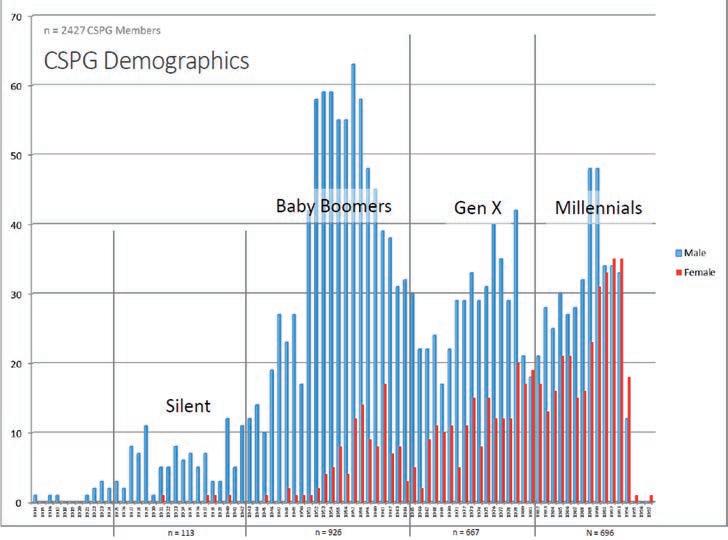
The above mentioned groups, including technical societies, are facing challenges related to changing membership demographics. For example, an evaluation of current CSPG membership shows that “Boomers” and older members represent 44% of active members (see Graph 1) and are predominantly male. The younger groups,
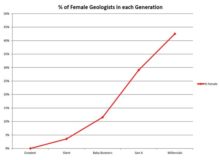
Gen Xers and Millennials make up 27% and 29% respectively and show increasing participation by women in our profession (up to 43% in Millennials, see Graph 2). Increasing workplace demands compete with the search by professionals for a more balanced lifestyle (work and family). The net result is that volunteerism has waned and it has become increasingly difficult to engage young professionals with the Society in order to develop a strong pool of volunteers willing to run for office or chair committees. This volunteer vacuum is not unique to CSPG. The net result is that many society executive committees no longer accurately reflective the membership demographics from either age or gender perspectives. In addition most technical societies are experiencing a decline in active membership. The trend of reduced volunteerism leads to the need for more office staff which in turn increases office overhead. Some organizations have even resorted to paying a salary to their president.
(Continued on page 7...) Graph 1.
RESERVOIR ISSUE 09 • OCTOBER 2014 5
CORPORATE
SPONSORS
SAMARIUM
geoLOGIC systems ltd.
DIAMOND
APEGA
Nexen ULC
CSPG Educational Trust Fund
TITANIUM
ConocoPhillips
Cenovus Energy
IHS
PLATINUM
Schlumberger Canada Limited
Shell Canada Limited
Imperial Oil Resources
Baker Hughes Inteq
AGAT Laboratories
GOLD
MEG Energy Corporation
Devon Canada Corporation
Tourmaline
Suncor Energy
SILVER
CGG.
Olympic Seismic
Canadian Natural Resources Ltd.
Loring Tarcore
Statoil
MJ Systems
Chinook Consulting
Cabra Consulting Inc.
Arcis Seismic Solutions
CSEG
Bellatrix Exploration Ltd.
Emerson Process Management
Enerplus
EOG Resources Canada Inc.
Husky Petrosys
BRONZE
SeisWare
Pro Geo Consultants
ION Geophysical
Roke Technologies Ltd.
Paradigm
Tucker Energy Services Canada
Canadian Discovery Ltd.
Belloy Petroleum Consulting
Seitel Canada Ltd.
Talisman Energy
Divestco
Geovariances
PGS
Telsa
Pason System
Serpa Petroleum Consulting Ltd.
Painted Pony Petroleum Ltd.
Continental Laboratories/CL Consultants
Total Gas Detection Ltd.
AAPG - Canada Region
Earth Signal Processing Ltd.
RPS Energy Canada Ltd.
Encana Corporation
GLJ Petroleum Consultants Ltd.
PLS Inc.
Sproule Associates Ltd.
Streamsim Technologies, Inc.
(...Continued from page 5)
Increased expenses during membership decline leads to anxiety with the Executive.
What can be done? The current executive and staff have been compiling lists of CSPG membership advantages for both individuals and corporations. Networking and education opportunities are the most obvious benefits of membership. Partnership with other societies is important to deliver educational and technical content for meetings outside Calgary. CSPG is in the process of establishing “chapters” and “ambassadors” across Canada. We are helping to sponsor and offering to supply technical input to meetings outside Calgary and across Canada. In addition I have met with a number of provincial licensing authorities including APEGA. These groups look to CSPG to provide many of the opportunities required to maintain professional status as a geoscientist in the petroleum industry including luncheon talks, courses, field trips and conventions. Our biggest challenge is to offer these opportunities outside Southern Alberta. We are currently responding to requests from Ontario and Newfoundland for courses normally only offered in Calgary.
What can you do as a CSPG member? First, consider volunteering in one of the many technical Divisions within CSPG. Second, talk to your supervisors about company support for CSPG membership. Third, consider letting your name be nominated for a CSPG Executive/Director position. I have been a volunteer to CSPG and other technical societies for over 40 years. The connections made through volunteering and the resultant networking have opened several doors for both career and business opportunities. It has also greatly enhanced my understanding of our industry and its complex relationship with government and academia. We, the CSPG, need to be at the table with other Earth Scientists when government are seeking advice/ expertize. We need to cooperate with other societies in our industry both domestic and international to pool expertize and better use limited resources. The current executive is in the process of addressing opportunities to cooperate with affiliated societies and will continue to seek ways to better serve our membership.
RESERVOIR ISSUE 09 • OCTOBER 2014 7
As of August 2014 A Special Thanks to Geologic Systems Ltd., CSPG ’s Top Sponsor of the Month.
Graph 2.
TECHNICAL LUNCHEONS OCTOBER LUNCHEON
Reservoir
Characterization in Carbonate Mudrocks – The Unconventional Conventional –The Next Generation Carbonate Reservoirs
SPEAKER
Rick Sarg Colorado School of Mines
11:30 am Tuesday, October 7th, 2014 Calgary, TELUS Convention Centre Exhibition Hall D, North Building Calgary, Alberta
Please note: The cut-off date for ticket sales is 1:00 pm, three business days before event. [Thursday, Oct 2, 2014]. CSPG Member Ticket Price: $45.00 + GST. Non-Member Ticket Price: $47.50 + GST.
Each CSPG Technical Luncheon is 1 APEGA PDH credit. Tickets may be purchased online at https://www.cspg.org/eSeries/source/Events/ index.cfm.
ABSTRACT
The majority of carbonate reservoir rocks have been developed using conventional development schemes, due to the presence of macro-pores that are the product of skeletal and non-skeletal depositional textures modified by diagenesis. Carbonate reservoir heterogeneity is complex, due to ternary porosity distributions composed of matrix, vugs, and fractures. Recently, matrix related micro-porosity has been recognized
Webcasts sponsored by

as an important control on transmissivity and storage capacity of hydrocarbons. With the advancement of completion technologies for low-permeability reservoirs, quantifying the matrix-related micro-porosity, understanding pore size and pore throat distributions as well as tortuosity has become increasingly important. Traditional methodologies for porosity characterization developed for conventional reservoirs are often inadequate for low permeability, micro-porous reservoirs. Within carbonate reservoirs, the matrix porosity contribution is often overshadowed by the relative contribution from vugs and fractures, yet it is the matrix pore network that effectively “feeds” the vugs and fractures through diffusive transport.
The main focus of this research has been on carbonate reservoir mud-rocks that lack macro-pores, but contain pores that are less than a micrometer in size. These rocks have high hydrocarbon saturation within the matrix micro-porosity. Examples come from both conventional carbonate wackestone and mudstone from the Gulf States region of the Arabian Peninsula, and
INTRODUCTION TO GEOMECHANICS THEORY AND PRACTICE
A Two-day Workshop - November 24-25, 2014, Calgary, AB
» Learn about geomechanical applications that are vital to today’s oil and gas industry
» Understand sources of geomechanical data and how to exploit them

» Practice analyzing data through hands-on examples from western Canada plays
» Apply geomechanical insight into drilling and completions planning
» Receive a free, 30-day trial license for the Vinland Software Suite® by Eriksfiord
Appropriate for individuals from multiple disciplines including geologists, geophysicists, petrophysicists, petroleum engineers, drilling and completions engineers and asset managers.
Pricing
Registration before October 15, 2014: $1800
Registration after October 15, 2014: $2000 (Space is limited)
For more information and/or to register contact: Sandi Bredy - Client Liaison P. 403.269.3644 E. sbredy@canadiandiscovery.com
Instructor Amy Fox earned her PhD in Geomechanics from Stanford University and has 16 years of experience in the oil and gas industry. She is currently the Geomechanics Director at Canadian Discovery.

8 RESERVOIR ISSUE 09 • OCTOBER 2014
Canadian Discovery Ltd.
unconventional carbonate mud-rocks from the Bakken and Three Forks reservoirs of the Williston basin. These mud-rocks have porosities that range from less than 5% to more than 20%, and permeabilities that are in general less than 3mD, and most commonly much less than 1mD.
Porosity is estimated for these reservoirs by petrographic image analysis as well from QEMSCAN ® (quantitative evaluation of minerals and porosity by scanning electron microscopy) analysis. Estimated porosities are compared to measured porosity from a CMS-300 ® (core measurement system) automated permeameter. Porosity and pore throat distributions are determined by mercury porosimetry and gas adsorption experiments in order to capture both micro- and nanopore distributions. Results show distinct differences in porosity, permeability, surface area and tortuosity among different facies, despite their seemingly similar mudstone to wackestone textures. Pore size distributions indicate bimodal pore distributions that are in the micro to nanoporosity range. Pore size distributions as well as tortuosity vary across the different lithofacies, which can be related to subtle differences in physical rock properties. These subtle differences in
lithofacies and in pore architecture appear to control fluid flow in these rocks. These fine-grained rocks are thus postulated to be facies determinate flow units.
BIOGRAPHY
J. Frederick ‘Rick’ Sarg received his Ph.D. (1976) in Carbonate Sedimentology and Stratigraphy from the University of WisconsinMadison. Rick also holds an M.S. (1971) and a B.S. (1969) in Geology from the University of Pittsburgh. He has extensive petroleum exploration and production experience in research, supervisory, and operational assignments with Mobil (1976), Exxon (197690), as an Independent Consultant (1990-92), with Mobil Technology Company (1992-99) where he attained the position of Research Scientist, and with ExxonMobil Exploration (2000-05).
Rick was a member of the exploration research group at Exxon that developed sequence stratigraphy, where his emphasis was on carbonate sequence concepts. He has worldwide exploration and production experience in integrated seismic-well-outcrop interpretation carbonate and mixed system stratigraphic sequences, and has authored or co-authored 34 papers on carbonate sedimentology and stratigraphy. Rick achieved
the position of Stratigraphy Coordinator at ExxonMobil Exploration Company.
In August of 2006, Rick joined the Colorado School of Mines as a Research Professor in the Department of Geology and Geological Engineering. Rick’s current projects at CSM include the Bakken Resource Play in the Williston basin; fractured carbonates in Abu Dhabi; and the lacustrine carbonates and stratigraphy of the Green River Formation in Colorado. Rick served as President of the Society for Sedimentary Geology (SEPM) (2004-05), and is currently the President of the SEPM Foundation. Rick has been awarded the 2013 Robert R. Berg Outstanding Research Award by the AAPG.
LMKR GeoGraphix Pro is a new upgrade option to GeoGraphix 2014 that provides geoscientists with advanced technologies to enhance productivity and maximize their existing GeoGraphix investment Powerful new capabilities include:

Advanced 3D Visualization
Visualize your interpretation with a single button click.
Field Planning

Quick and easy to use field planning capabilities that result in tangible reductions in time and cost
Fence Diagrams

Use your cross sections to create fence diagrams in advanced 3D views


RESERVOIR ISSUE 09 • OCTOBER 2014 9
Discover Your Potential www.lmkr.com/geographix Accelerate Your Potential with LMKR GeoGraphix Pro
GeoGraphix Pro is a licensed upgrade to the GeoGraphix® software and requires the purchase of a separate license. GeoGraphix® is a registered trademark of Landmark Graphics Corporation. The LMKR Logo is a trademark of LMKR Holdings. LMKR Holdings is the exclusive world-wide licensor and distributor of GeoGraphix® software. Visit us at: SEG 2014 Denver Booth 2280
TECHNICAL LUNCHEONS OCTOBER LUNCHEON
The Great Flood: Alberta’s “Biblical” Deluge of 2013
SPEAKER
Jon Noad Husky Energy
11:30 am
Wednesday, October 22, 2014 Calgary, TELUS Convention Centre Exhibition Hall D, North Building Calgary, Alberta
Please note: The cut-off date for ticket sales is 1:00 pm, three business days before event. [Thursday, October 16, 2014]. CSPG Member Ticket Price: $45.00 + GST. Non-Member Ticket Price: $47.50 + GST.
Each CSPG Technical Luncheon is 1 APEGA PDH credit. Tickets may be purchased online at https://www.cspg.org/eSeries/source/Events/ index.cfm.
The Flood
On June 21st 2013 more than 100,000 people were evacuated from their homes in Alberta. Over the following week significant portions of Calgary (and other southern Albertan communities) were inundated by what was variously described as a “biblical” or 100 year flood. The result was Canada’s costliest ever disaster, estimated at $1.7 Billion in insurable damage alone. In other southern Albertan localities, such as High River, where all 13,000 residents were evacuated, hundreds of people remain in temporary accommodation.
One of the main causes of the flooding was traced back to a weather system trapped over a small catchment basin some 80 km to the west of Calgary. Four days of torrential rain poured more than 250 mm of water, in addition to snow melt, into Cougar Creek. The mass of water flowed towards Calgary, bolstered by heavy rains along its length. It burst its banks in many areas, flooding much of downtown Calgary. The Bow River demonstrated to the city planners that rivers will be rivers, depositing tons of sediment and eroding up to 60 m into its banks. The flooding had a large impact on the city infrastructure which is gradually being repaired. Crevasse splay deposits (including manmade debris and sediment)
were deposited, and studied in detail both in Calgary and downstream.
GEOLOGICAL IMPLICATIONS
Canmore, in particular the area around Cougar Creek to the North of the highway, suffered disastrous flooding. Cougar Creek is in reality an alluvial fan, and reverted to type under the impact of million of litres of rainfall. Huge boulders and trees were mobilized across a vast gravel plain. The resulting flows destroyed all access to Canmore and Banff, washing away both the Trans Canada Highway and Highway 1A.
In Calgary, both the Elbow and the Bow were strongly affected by the flooding. The rivers saw bank erosion, with the most significant occurring close to the Bird Sanctuary in Inglewood. Over 30 km of paths were washed away in the Calgary region, as well as several bridges. Repair work is ongoing, but by no means complete. The Bow is something of a hybrid river, classified as a braided river yet with a series of point bars. Many of the braid bars were built up by more than a metre, and also increased in size, particularly close to the confluence of the Bow and Elbow. Many of the point bars, including Bowness and Inglewood Golf Course, were flooded to a depth of metres.
Examination of the associated crevasse splays showed a variety of behaviours. In some localised areas the splays were more than 50 cm in thickness, but over most of the
region they were less than 5 cm thick. The grain size was a (almost silt free) mudstone, strongly suggesting that no coarse material was being transported by the Bow except as bedload. The preservation potential of these deposits will be discussed. Rippled surfaces left after the flood provided useful current data. Scouring associated with the high river levels could have led to serious contamination close to the rail yards, where a concrete bridge stanchion was undermined.
OTHER IMPACTS
From hippos making their way into the Bow River to tigers being incarcerated in the downtown holding cells at the new court house, there were many stories that showed the lighter side of the flooding. But it should be remembered that some people have still not returned to their homes, and that many thousands were evacuated, sometimes with almost no warning. Many treasured possessions were lost to the flood waters, and several homes were completely washed away. At one time Canmore was cut off from the world with both the Highway 1 and 1A washed out. Many events were cancelled including Sled Island and the inaugural Banff Marathon. However what will be remembered is the wonderful spirit of the Albertan volunteers, giving up their time to help those less fortunate. Indeed the Calgarians received a special Commendation for Outstanding Service from the Governor General of Canada.
10 RESERVOIR ISSUE 09 • OCTOBER 2014
Webcasts sponsored by
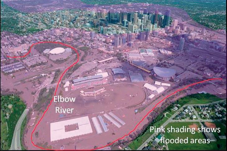
Figure 1. View of Calgary from Scotsman’s Hill showing the downtown flooding highlighted in pink.
WHY IT HAPPENED AND CAN IT HAPPEN AGAIN?
The weather was clearly a major factor in creating the flood. A giant low pressure system came over the Rocky Mountains and became mired, bringing in water from as far away as the Gulf of Mexico. In less than two days the Bow River Basin saw more than half the yearly average rainfall. However this was not a unique scenario, with a very similar weather pattern experienced in the Milk River Basin this year. Historical data will be presented to show the likelihood of nature repeating itself over time, and what the possible magnitude of a flood in the Bow River Basin could reach, based on past floods, particularly those of 1879 and 1897, the two largest in Calgary’s recorded history. Finally the latest flood mitigation plans will be evaluated and conclusions drawn as to whether the Flood of 2013 was a one off.
BIOGRAPHY
After graduating from Imperial College, London in 1985, Jon spent five years working as a mining geologist in South Africa, followed by four years as British Telecom’s marine geologist. He took a Masters in Sedimentology at evening classes with London University, with his thesis looking at ancient fluvial channels in Dinosaur Provincial Park in Alberta, then went on to complete a PhD on the sedimentary evolution of eastern Borneo. He joined Shell as an exploration geologist in 1998, concentrating on the Middle East before moving to Calgary in 2006 to explore for tight gas and in the Orphan Basin. He spent two years as Murphy Oil’s exploration manager before joining Husky in 2012, where he manages the new grad program, reviews projects and runs the odd field trip. He is also an Adjunct Prof at the University of Alberta. Outside work he loves running, travel and wildlife photography, and trying to keep up with his three year old daughter.
RESERVOIR ISSUE 09 • OCTOBER 2014 11
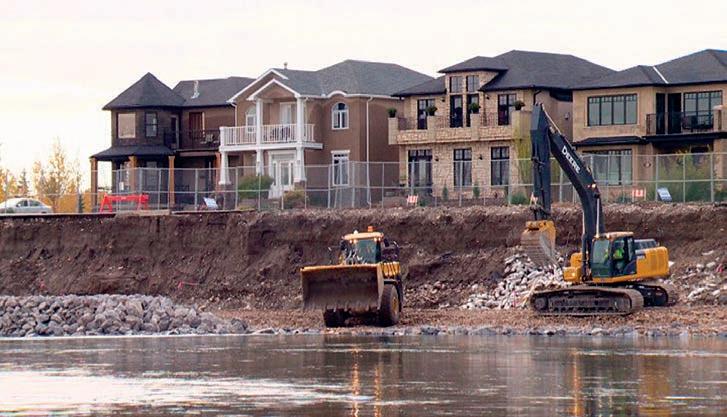
Figure 2. Heavy equipment rebuilding the river bank in Inglewood.
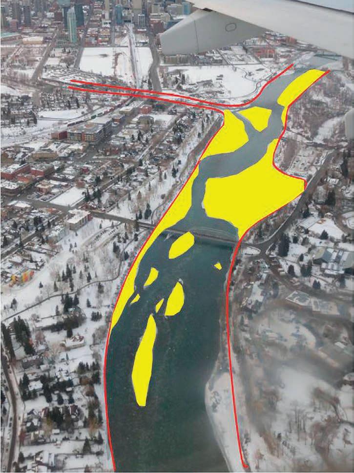
Figure 3. View of the braid bars (highlighted in yellow) built up by the flooding.
DIVISION TALKS PALAEONTOLOGY DIVISION
The Relationships and Biology of the Caengnathidae, a Family of
North American Oviraptorosaurs
SPEAKER
Gregory F. Funston, M. Sc. Candidate University of Alberta
7:30 pm
Friday, October 17, 2014
Mount Royal University, Room B108 Calgary, Alberta
ABSTRACT
The Caenagnathidae (Dinosauria: Oviraptorosauria) is a family of North American theropods that was poorly known until recently. Although the first specimens were described in 1924, only now have we begun to understand their anatomy and biology. Although complete specimens are now known from Asia and the United States, Albertan caenagnathids remain a mystery. Isolated fossils representing nearly every element are known, but understanding how they relate to each other taxonomically is difficult. Only two partial skeletons from Alberta have been described and their diagnostic elements do not overlap, making relationships unclear. Many mandibles,
are isolated or fragmentary. This problem is being tackled from three angles. First, a new specimen, TMP 1993.051.0001, is being described. Uncovered in 1993 and initially mistaken for an ornithomimid, the specimen sat unprepared for 15 years, until it was finally prepared in 2008. Besides being articulated, the specimen is well preserved and nearly complete, allowing us to unite isolated material. Another dinosaur, Elmisaurus, has long been an enigma. Originally found in Mongolia, specimens from Alberta now appear to be close relatives of the Mongolian form. A slew of new material lets us reevaluate the position of Elmisaurus relative to the caenagnathids, and understand relationships within the group. Finally, by understanding how the cranial skeleton changes throughout development, we can evaluate whether specimens of different sizes and shapes are separate species, or if they are the result of growth and development (ontogeny). Although known from a nearly complete growth series from embryos to babies to adults, oviraptorosaur ontogeny remains poorly studied. In particular, developmental changes of the face and mandible are not fully understood, nor is the effect that ontogeny has on phylogenetic hypotheses. Histological analysis of new caenagnathid material lets us age these dinosaurs, to see if problematic fossils are juveniles. The combination of these three studies is beginning to provide a clearer picture of the relationships of this mysterious group of toothless dinosaurs, and the way they interacted with the environment around them.
BIOGRAPHY

Greg Funston is a Master’s student studying the relationships and biology of the Caenagnathidae,
Sponsored by
a family of North American oviraptorosaurs. The oviraptorosaurs are an odd group of dinosaurs. Although they have evolved from carnivorous ancestors, they have lost their teeth, and developed beaks instead. His undergrad work showed, through osteology, comparative anatomy, and functional morphology, that caenagnathids are omnivorous. The group shows remarkable convergence with modern birds, and he believes studying them can help us understand why birds became so successful. His current research aims to reconstruct the relationships of the group using new, more complete specimens. In the future, he’d like to refocus on the origin of birds, and see what oviraptorosaurs can reveal about the ecological role of early birds.
Originally from Yellowknife, NWT, Greg completed his BSc in Honours in Palaeontology at the University of Alberta in 2013. His undergraduate thesis focused on determining the diet of a toothless caenagnathid dinosaur. He has been involved in a number of other projects, including work on Brachiopods, troodontid tooth morphology, sexual dimorphism in dinosaurs, and growth and development of caenagnathids
INFORMATION
This event is presented jointly by the Alberta Palaeontological Society, the Earth Science Department of Mount Royal University, and the Palaeontology Division of the Canadian Society of Petroleum Geologists. For details or to present a talk in the future, please contact CSPG Palaeontology Division Chair Jon Noad at jonnoad@hotmail.com or APS Coordinator Harold Whittaker at 403-286-0349 or contact programs1@albertapaleo.org. Visit the APS website for confirmation of event times and upcoming speakers: http://www.albertapaleo.org/
ACTICAL LOG ANALYSIS COURSES For Engineers, Geologists, Geophysicists, and Technicians
Practical Quantitative Log Analysis: 14 – 16 Oct 2014 Analysis of Unconventional Reservoirs: 17 Oct 2014
etails and Registration at: www.spec2000.net/00-coursedates.htm

House and Multi-Media Narrated Self-Study Courses Also Available
=== Instructor: E. R. (Ross) Crain. P.Eng. 1-403-845-2527 ross@spec2000.net
=== Years Worldwide Experience – Analysis, Training, Mentoring, Forensic Reviews –
• Domestic and International wellsite supervision • Conventional and Unconventional wells • Extensive Hz experience
Customized corporate solutions available (403) 250-3982 sales@clconsultants.ca www.clconsultants.ca
===
•
DIVISION TALKS BASS DIVISION
Thermal Recovery of Bitumen from the Grosmont Carbonate
SPEAKER
Daniel Yang Laricina Energy Ltd.
12:00 Noon
Monday, November 24th, 2014
ConocoPhillips Auditorium
Gulf Canada Square 401 – 9th Ave. S.W.
Calgary, Alberta
At the Saleski pilot, bitumen has been recovered from the Grosmont carbonate reservoir by steam injection since December 2010. The initial application of conventional SAGD with horizontal well pairs developed into a single-well cyclic injection and production scheme with now 5 horizontal wells. The Grosmont carbonate has three porosity systems: matrix, fractures and vugs. The distribution of each individual porosity system varies between the sub-units, and thereby impacts the recovery mechanism.
The presentation will provide an overview of reservoir properties and the pilot history, followed by a discussion of relevant recovery mechanisms. Pilot data examples are used to demonstrate the impact of drilling (over/under balanced mud), well completion (slotted liner/open hole), artificial lift (pump tripping or failure), facility (limitation of steam rates) and operational constrains (heat integration) on the observed production, to enable the evaluation of the actual reservoir performance. A new recovery strategy for future exploitation is presented.
BIOGRAPHY
Daniel Yang is Chief of Reservoir Engineering at Laricina. He dedicated 15 years of his oil industry career to reservoir physics, focussing on thermal recovery, and originating from 10 years of research in geothermal energy. Previously, Yang worked for Shell International, Shell Canada and Canadian Natural Recourses. He graduated in Geophysics and has a PhD in Natural Sciences from the Technical University Berlin, Germany
Sponsored by
INFORMATION
BASS Division talks are free. Please bring your lunch. For further information about the division, joining our mailing list, a list of upcoming talks, or if you wish to present a talk or lead a field trip, please contact either Steve Donaldson at 403-766-5534, email: Steve. Donaldson@cenovus.com or Mark Caplan at 403-975-7701, email: mcaplan@atha.com or visit our web page on the CSPG website at http://www.cspg.org.

AVO COMPLIANT STRUCTURE AND STRATIGRAPHIC 5D INTERPOLATION 4D TIME LAPSE 3D PRESTACK TIME MIGRATION 3D MERGE 2D PRESTACK DEPTH 2D MARINE MULTICOMPONENT WORKSTATION RENTALS
RESERVOIR ISSUE 09 • OCTOBER 2014 13
The On-Shore Seismic Specialists EDGE TECHNOLOGIES INC. Direct: +1.403.770.0440 • edge-tech.ca
2014 ANDREW D. BAILLIE AWARDS
The CSPG Educational Trust Fund is pleased to announce the recipients of the 2014 Andrew D. Baillie Award. The award is given for the best student poster presentation and the best student oral presentation and at the annual GeoConvention.
The Baillie award commemorates Dr. Andrew Dollar “Andy” Baillie (19122001) whose geological career spanned
five decades. His petroleum career began with the British American Oil Company (the precursor to Gulf Canada) in 1953. After retiring from Gulf, Andy spent more than 20 years pursuing his passion for teaching geology in a variety of ways. His technical skills and desire to share his knowledge made him an invaluable asset to the geological community.
In 1997, to celebrate his lifetime of geological achievements, the CSPG awarded Andrew Baillie the Stanley Slipper Gold Medal for “life-long accomplishments and outstanding contributions to petroleum geology in Canada and abroad.” He was an inspiration to literally hundreds of geologists, who came under his influence, however fleetingly, during his life. Andy was an active member of the CSPG and had a particular interest in the CSPG Educational Trust Fund. The award in his name was established in 1992 by the CSPG Executive as a technical recognition award. The idea of accompanying cash prize was instituted by a donation from Andy himself. His family ensured this tradition will continue with a commemorative gift to the

CSPG Educational Trust Fund following his passing. The award recognizes excellence in technical presentations by students and encourages a level of technical prowess worthy of Dr. Andrew D. Baillie.
The award recipient of this year’s best student poster presentation was Raymond Van from the University of Calgary. The GeoConvention 2014 award committee selected his presentation entitled “Reservoir Characterization Of The Cardium Formation, Garrington, Alberta”, to be the best of an excellent group of student posters at the 2014 convention.
Cheryl Hodgson from the University of Alberta was granted the award for the best student oral presentation for her presentation entitled, “Significance of Sedimentological and Ichnological Relationships between Various Substrate Types in an Intertidal Marine Environment”.
The 2014 Baillie awards were presented at the September 9th CSPG Technical Luncheon by Kirk Osadetz, one of the Trustees of the CSPG Educational Trust Fund.
14 RESERVOIR ISSUE 09 • OCTOBER 2014
Kirk Osadetz (CSPG President – 2011) presenting Cheryl Hodgson with Andrew D. Baillie Award for Best Student Oral Presentation.
Raymond Van, recipient of Andrew D. Baillie Award for Best Student Poster Presentation.
Andrew D. Baillie


NOVEMBERy17y2014
appetizersy4:30pmy:yEventy6:00pm th hostedybyyCBCyRadiowsyDougyDirks
Scott W. Tinker
Director$ Bureau of Economic Geology
University of Texas
EPCOR CENTRE5s
Jack Singer Concert Hall F15 8 Ave SE$ Calgary$ AB
François Therrien
Curator of Dinosaur Palaeoecology
Royal Tyrrell Museum
Adults: HF5 8H31 at DoorA
Students: Hh5 8HF1 at DoorA
Children 8hF and underA: FREE


understanding OUR PAST 1 producing OUR FUTURE www.cspg.org theycspgywouldylikeytoythankyalbinymerleyforytheirycontribution

“This pioneer and explorer in geology, engineering and natural gas technology bequeathed a fundamental knowledge, years ahead of his time and was considered by many a virtual Leonardo da Vinci of the Petroleum Industry. Slipper, our First President, deserved the honour (unbeknownst to him) of our highest award in the Canadian Society of Petroleum Geologists” (Aubrey Kerr).
The Stanley Slipper Medal is the CSPG’s highest honour.
The gold medal is presented annually for outstanding contributions to oil and gas exploration in Canada. The contributions of the winner of this award should encompass a number of activities related to aspects of petroleum exploration. Such activities include: initiating and/or leading exploration programs, significant discoveries on new or existing exploration trends, teaching and/or training of explorationists, and involvement in and leadership within geological societies and professional organizations.
The committee is currently calling on the CSPG membership to provide additional nominations for this prestigious award. The award winner must be a CSPG member and should be able to attend the awards presentation to be held in the spring of 2015.
Please include an updated bibliography and letters in support of your nominee.
Nominations should be mailed, faxed or emailed before October 15 to:
CSPG Stanley Slipper Committee – Clint Tippett
110, 333 – 5 Ave SW Calgary, AB T2P 3B6
Email: kasandra.amaro@cspg.org
Phone: 403-264-5610 Fax: 403-264-5898

 2013 Stanley Slipper Recipient Marc Bustin
Stanley Slipper Medal
2013 Stanley Slipper Recipient Marc Bustin
Stanley Slipper Medal
WILDCATTERS, WELLSITERS and the Immortality of Data
| By Tom Sneddon
“If some countries have too much history, Canada has too much geography.”
– William Lyon Mackenzie-King; -18 June 1936.
Most of us would argue that the Right Honourable Gentleman just about had it right – except we would say “…Canada has too much Geography and too little Geology.” The human geography of the country has us 36th (UN 2005 figures, if we trust Wikipedia) in population amongst the world’s countries; 2nd in area and 230th by population density (same less than reliable source).
Alberta is Canada’s 6th largest territory (lumping provinces and Territories together) and unquestionably possesses the best known subsurface in Canada. The country as a whole has surficial geological maps covering about 30% of the land area. Alberta is somewhat better off and recently all existing maps and data sets accessible by the Alberta Geological Survey were incorporated into Fenton, M.M.; Waters, E.J.; Pawley, S.M.; Atkinson, N.; Utting, D.J.; Mckay, K. (2013) Map 601 Surficial Geology of Alberta, Queen’s Printer for Alberta, Edmonton. Works in progress that will further elaborate on the geology of Alberta include the Digital Atlas project being conducted by the Canadian Society of Petroleum Geologists.
The first wave of mapping that began with Dr. Hector and his observations during the Palliser Expedition published in 1863, continued with the Geological Survey of Canada reconnaissance surveys conducted by G.M. Dawson in the 1880’s, continued with D.B. Dowling between 1904 and 1924; and included other officers of the GSC that have become the foundation for modern exploration geoscience. That same period is marked by names like McConnell, Tyrrell, Lord and others. This could be called the heroic period of exploration, given the difficult travel conditions and long periods of exposure to the elements these people endured. Coal and mineral deposits were the drivers for mapping and
rock unit definition during this period of history. Drilling information was all but non-existent.
The second wave began around World War I with the arrival of the early petroleum geologists who were usually mining and petroleum engineers. Dr. John Allen following the formation of the Department of Mining Engineering at the University of
from the oilfields of the United States. Their exploits are described in David Finch’s 2002 CSPG Diamond Anniversary volume called “Field Notes, The story of the Canadian Society of Petroleum Geologists” in detail and the reader is directed there for a good read.
The second wave is marked by the explosion in knowledge derived from detailed petrographic study of the rock
(Continued on page 19...)

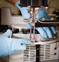
When time is money, Wellsite Geoscience is money well spent.
Whether you’re exploring a basin, producing a well or completing a shale play, time is money. That’s why Weatherford Laboratories brings a suite of formation evaluation technologies right to the wellsite. Utilizing mud gas and cuttings, these technologies provide detailed data on gas composition, organic richness, mineralogy and chemostratigraphy in near real time. As a result, operators now have an invaluable tool to assist with sweet spot identification, wellbore positioning, completion design and hydraulic fracturing. We call it Science At the Wellsite. You’ll call it money well spent.
SCIENCE AT THE WELLSITE ™
RESERVOIR ISSUE 09 • OCTOBER 2014 17
©2013 Weatherford. All rights reserved Formation Evaluation ┃Well Construction ┃Completion ┃Production WELLSITE GEOSCIENCE SERVICES
www.weatherfordlabs.com


Data Magnetic & Gravity data for the Western Canadian Basin John W. Peirce, P. Geo. Chief Geophysicist www.chad-data.com 250.616.6914 Wellsite Geologists Inc. the Rock
Choice
Graphic
Sample
petrographical
descriptions for samples
our best friend and most valuable partner is our client Stephan C. Dragomir president www .g e ok2. c om - phon e : 403.831.9941 - s dr a gomir @ g e ok2. c o m
ROCK SHOP CHAD
Solid
Wellsite Supervision Project Management
Well Profiles Verticals / Horizontals EUB
/ Core Studies Conventional / Un-conventional 1350, 734 - 7th Ave SW Calgary, AB T2P 3P8 B 403.234.7625, www.WellsiteGeologists.com C 403.660.9883, info@WellsiteGeologists.com
& sedimentological
(thin section - fluid inclusion studies) conventional vertical/horizontal wells operations geology SPECIALIZED IN GEOLOGICAL WELLSITE SUPERVISION AND CORE ANALYSIS RockWell Consulting
cores and cuttings recovered during coal mining and early exploratory petroleum drilling operations. Efforts to relate those data with surface mapping from the earlier wave of exploration with more detailed analysis of outcrops continued. The outcrop and sparse drill derived data available to geologists were enhanced by using aerial photography that became more generally available after World War II. The second wave can also be characterized as the age of the wildcatters – those adventurous souls who often had little or no knowledge of geology kept drilling holes until they hit marketable petroleum, often with disastrous results for themselves and for the countryside. Seismic data acquisition appeared in the mid-1930’s, contributing much new knowledge of subsurface geology.
Following the Leduc discovery, the wildcatters morphed into the sophisticated industry we know today that is dominated by Professional Geoscientists and Engineers who are driven by economics, science and technology. Make no mistake – the spirit of the wildcatters survives both in the
field and through the streets of downtown Calgary and truck jams that characterize the streets and fabrication shops of Nisku, Grande Prairie, Fort McMurray and all the other resource towns in Alberta. The same can be said for the British Columbia and Saskatchewan resource towns of Fort Nelson, Fort Saint John, Dawson Creek, Kerrobert, Estevan and Kindersley. The modern industry differs in its attitudes to social responsibility and care for its environmental impact. After all, we all live in the areas where we work and therefore we care for them as well.
The third wave we live in today is the age of data: acquisition, processing, storage, interpretation and multidimensional modelling. The drivers haven’t changed –demand for product and its delivery; cost controls; the need for investment and the physical environment within which we operate. The economic and physical drivers demand detailed information on remaining reserves/resources, available resource supply and availability of transportation. Intrinsic to a timely response to the demand for better information continues to be an ever more refined knowledge of
geology and the geophysical behaviour of rocks in the subsurface. The key player in this milieu is the wellsite geologist.
Acquisition of petrographic data is the most important facet of the wellsite geologist’s scope of practice insofar as the client is concerned. Other facets include establishing casing points; supervision of cuttings sampling and core cutting; wireline logging (whenever possible) and monitoring the stability of the borehole. The last two involve close interaction with drilling and logging engineers and technologists to ensure the safety of the rig and the downhole data to be derived from the hole the team is making. The main reason for the geologist being there is to ensure the integrity of the petrographic data and metadata and that means ensuring the well is drilled according to plan. Without that, none of the secondary data sets will have much value: they are all calibrated against what is known about the formation being bored through.
The most fundamental element of data for the petroleum industry is petrography.
(Continued on page 20...)

Young Geoscientists Networking Reception
WHEN: Thursday, October 30 4:30 pm - 7:30 pm
WHERE: Garage Sports Bar
Eau Claire Market
195 –200 Barclay Parade SW Calgary, Alberta
WHO: University students, young professionals, and industry mentors


RESERVOIR ISSUE 09 • OCTOBER 2014 19
A networking event for young geoscientists and experienced industry mentors FREE Event! | Drink tickets and appetizers provided | Register now at www.cspg.org Sponsored by Sponsorship opportunities available.
(...Continued from page 17)
It defines the physical and chemical characterization of the rock, the fluids it contains and its location in three dimensional space. It is the validation for an operating company that a deposit exists and that its characteristics as a reservoir are known from the volume of rock sampled from the wellbore. Without bomb-proof petrography, the mechanical/electrical logs and seismic data it is calibrated against become unreliable and of little utility.
The data reported by the wellsite geologist is contained in the usual spreadsheet format. It is displayed through the medium of a graphical strip log that records the interpretation of the data as it is derived for documentation of samples and cores that may be subject to further analyses by others in laboratories remote from the rig site, if geochemistry or mechanical properties are required. The strip log contains nonnumeric observations like clues to the presence of faulting and fracturing; thief zones; mega- and microfossils; presence of gas and other features the observer believes might be useful to other geologists
both in the operator’s company and parties unknown in the far future. Most strip logs also contain photographs of important observations, such as macro and microfossils. Data truly is immortal.
Why must a wellsite geologist be a Professional Geoscientist? There are two important principles involved:
• The physical safety of the public and the workers on the rig are at risk and the wellsite geologist continuously tracks for the stability of the wellbore, for the presence of gas and its pressure in the formation being penetrated to ensure the safety of the operation in cooperation with the drilling engineer and tool-push
• The data will be used to classify the discovery reservoir as a resource or a reserve by other Professional Geoscientists and Engineers for reporting its economic potential to the public and thus must be stamped and thus authenticated by the author. This guarantee of quality is essential
given that the person who does the resource assessment may be separated in time and space from the wellsite geologist
Wellsite geologists need a high level of competence to keep up with rapidly developing drilling technologies. They also must be current with the needs of the equally rapidly developing reservoir modelling technologies. Fewer, longer and deeper holes sited on multiple well pads steered horizontally through petrologically challenging formations demand both long experience and current knowledge.
The days of the three day gig on vertical gopher holes in east-central Alberta aren’t quite over, however the future is pretty clear. Much longer assignments in the same location and geological supervision over seeing virtually every hole drilled. Professionalism will continue to be paramount in this geological specialty.


20 RESERVOIR ISSUE 09 • OCTOBER 2014
A dedicated single track technical conference, taking a more holistic approach to the various multifaceted aspects of the oil sands: geology, geophysics, engineering, environment, regulation, and sustainable development. Register Today! www.cspg.org OIL SANDS AND HEAVY OIL SYMPOSIUM: A LOCAL TO GLOBAL MULTIDISCIPLINARY COLLABORATION October 14-16, 2014 Calgary, Alberta Member Registration Rate CSPG & AAPG Members $ 800.00+ gst Non Member Registration Rate $ 950.00+ gst (...Continued from page 19 )

CONTINUING EDUCATION
Upcoming Fall CSPG Short Courses
Reservoir Geomechanics in Thermal Operations
Geomechanics plays a critical role in successfully optimizing heavy oil/oil sands exploitation. This course can help understa nd the essential aspects of geomechanics in thermal operations for heavy oil production enabling an engineer or geoscientist to make better field development and operational decisions.
This course introduces the necessary fundamentals of geomechanics as applied to oil sands, effect of increased pressure and temperature on reservoir stresses and rock properties, critical elements of caprock integrity analysis, understanding expecta tions of regulatory boards, ground uplift, reservoir compaction and subsidence, reservoir geomechanics thermal coupled simulation, monitoring techniques for reservoir compaction/subsidence, caprock integrity, casing integrity.
Who should attend?
This introductory training course is intended for engineers, geoscientists, and technologists involved in exploration, drilling, completions and production in Heavy oil recovery operations. No background of geomechanics is required from participants.
Course Outline:
Day 1: Understanding Fundamentals of Geomechanics
1. Basic Mechanics
• concept of stress/strain
• definition and physical meaning of mechanical properties and rock strength
• Estimating mechanical properties from logs,
• dynamic to static conversion of mechanical properties
2. Understanding Earth Stresses
• in-situ stresses and estimating from logs
• pore pressure and principle of effective stress
• stress measurement and calibration - mini-frac/LOT/MDT tests
• basic definitions of fracture gradient and closure pressure and other terminologies used in LOT/XLOT
• how fractures are created, preferential direction, fracture growth –frac height and width
3. Understanding Rock Failure
• rock failure types and causes - tensile vs shear, failure theories
• description of common rock mechanical core tests
• mechanical properties from core testing
• rock strength parameters from core testing
• Mohr-Coulomb failure envelope and its use in geomechanical analysis
4. Mechanical Earth Modeling (MEM)
• data requirements for a typical geomechanical analysis
• process of building mechanical earth model
• integrating log data, core data and field stress measurements in MEM
• calibration of geomechanical model
Day 2: Geomechanics Applications in Thermal Operations
5. Geomechanical effects in SAGD
• geomechanical risk scenarios
• effect of temperature on rock properties, rock strength, porosity and permeability
• thermal stresses/strains, shear dilation
• effect of injection pressure – alteration in in-situ stresses
• effect of cyclic injection/production on rock properties
• reservoir compaction, subsidence, and ground uplift
6. Caprock Integrity Analysis
• Caprock integrity– definitions and expectations of regulatory boards
• assessing hydraulic integrity and mechanical integrity
• effect of dilation on reservoir and caprock
• effect of increased reservoir temperature and pressure on caprock
• caprock failure mechanism - tensile and shear
• fault reactivation
• geomechanics workflow for caprock integrity analysis
7. Reservoir Geomechanics Coupled Modeling
• what is coupled modeling and what parameters are coupled
• common techniques - one-way and two-way coupling
• advantages and disadvantages of coupled modeling
• overview of software tools available for coupled modeling
• case study examples of caprock integrity analysis using coupled modeling
8. Reservoir Monitoring
• overview of common monitoring techniques
• surface and down hole tools to monitor reservoir and caprock deformation
• how monitoring data are used in geomechanical caprock integrity modeling and prediction of subsidence/compaction in the reservoir
APEGA PDH credits applicable
START DATE 06
LENGTH 2 days INSTRUCTOR Safdar Khan PDH Credits 16 Hours
-Oct- 14
Register online today at www.cspg.org
CONTINUING EDUCATION
Upcoming Fall CSPG Short Courses
An Unconventional Petroleum & Reservoir System - A Workshop
DATE 09 -Oct- 14
The Bakken -Three Forks tight oil petroleum and reservoir system is an excellent example of an unconventional resource play in a continental interior basin that possesses aspects of typical shale oil plays as well as some additional characteristics (e.g. tight carbonate mud -rock reservoirs) all of which have applications in other basins. Over the past six years, the Colorado School of Mines has undertaken an integrated geologic and geophysical study of the Bakken Petroleum System, in the Williston basin of North Dakota and Montana. The results of this work indicates, in part, that: (1) dolomite is needed for good reservoir performance in the Middle Bakken and Three Forks reservoirs; (2) regional and local fractures play a significant role in enhancing permeability and well production, and it is important to recognize both because local fractures will dominate in on -structure locations; (3) the organic-rich siliceous Bakken shale serves as both a source and reservoir rock; and (4) although the Bakken is a basinwide resource play, large accumulations such as at Elm Coulee, Sanish, and Parshall fields do appear to have significant trap and seal components. Traps include:
(1) hydrodynamic at the mature to immature source rock boundary, (2) stratigraphic pinch out of the Middle Bakken, (3) porosity pinch out of Middle Bakken dolomitic facies, and (4) lateral facies changes in Middle Bakken.
SAGD - Reservoir Engineering for Geoscientists & Non Reservoir Engineers
This course is designed to provide basic understanding of thermal recovery of bitumen. It covers the practical aspects of commercial development of SAGD pads, pads layout, drilling, completion, and production. All phases of SAGD production like start up and winddown are included in this course. Special attention is paid to SAGD enhancement processes, new technologies, steam properties, steam trap, reservoir surveillance and management, reservoir simulation modeling, and surface components of pads and central process facility. Sand control, SAGD side-track, and geo-mechanical aspects of SAGD are also covered in this course. The success and challenges of SAGD will be demonstrated by SAGD field cases.
This one-day workshop is aimed at both exploration and production geoscientists involved in unconventional plays and will cover the following topics:
• Introduction to the Williston basin and surrounding areas and the Bakken/Three Forks petroleum system
• Stratigraphy, biostratigraphy, and the lithofacies of the Bakken/Three Forks and their role in the reservoir and trap distribution
• Mineralogy and reservoir quality and producibility in the Bakken/Three Forks
• Integrated imaging and engineering analysis of pore architecture
• Rock physics, anisotropy, and organic maturity
• Regional structural and fracture analysis and seismic attributes
• Integrated geo -model at Elm Coulee field, eastern Montana
• Bakken/Three Forks Exploration model
Who Should Attend the Course:
This course is designed to provide basic understanding of subsurface bitumen recovery methods and also the fundamental concepts of thermal recovery. This course is intended for professionals with no formal petroleum training. This course is ideal for G&G personnel, Engineers in Training, Facility Engineers, co-op students, non -reservoir engineering disciplines, non-technical personnel and those who are new to the oil and gas industry, or business units who may want a basic understanding of the SAGD process.
APEGA PDH credits applicable
LENGTH 1 day INSTRUCTOR Rick Sarg PDH Credits 8 Hours
START DATE
LENGTH 2 days INSTRUCTOR Hussain Sheikha PDH Credits 16 Hours
05 -Nov- 14
Register online today at www.cspg.org
CONTINUING EDUCATION
Upcoming Fall CSPG Short Courses
Mannville Stratigraphy, Sedimentology and Petroleum Geology
DATE 17 -Nov- 14
Topic(s): Overview of Mannville basin, structure and sedimentation; Review of individual units/plays
Type of Play(s): This clastic unit is a reservoir for unconventional oil (heavy oil, bitumen), unconventional gas (tight, sands, coals), liqui dsrich gas, as well as conventional hydrocarbons.
Who Should Attend: Geologists and geophysicists who work local areas in the Mannville.
Why Should You Attend: Previous attendees have cited the regional perspective of their areas, gaining knowledge of other related plays, and frequent unpredictable shifts of exploration areas in the Mannville.
Objectives:
1. To familiarize attendees with the vast amount of Mannville research already published.
2. To put small exploration areas in regional and stratigraphy context.
3. To review details of presently active and inactive plays. Characterization and Management
Course Content:
1. Introduction - Mannville, Stratigraphic and Basin Setting
2. Basal Cretaceous Unconformity
3. Lower Mannville Units and Plays - Cadomin, Gething, Bluesky, Ostracode, McMurray, Dina, Wabiskaw, Cummings -Sunburst, Cutbank, Basal Quartz - Ellerslie, Ostracode.
4. Upper Mannville Units and Plays - Glauconite, Wilrich, Falher, Notikewin - Colongy to Lloydminster Fms - Clearwater, Grand Rapids, non-marine Upper Mannville, Pense Fm
The tools and techniques presented are not restricted to heavy oil reservoirs to be developed with variants of Steam Assisted Gravity Drainage (SAGD), but the emphasis and examples are all drawn from this area of application. This is appropriate for geoscientists at an introductory level that want an overview of specialized techniques or for geomodelers at an intermediate or advanced level who want details of the latest techniques applied to this important class of resource projects. Each participant will gain an appreciation for the application of modern geostatistical tools and techniques to characterize and manage SAGD reservoirs.
Current best practice geomodeling and geostatistics will be reviewed. SAGD -specific topics that will be covered include: (1) 1 -D processing of well data for autopicking of surfaces and calculation of effective resource/reserve summaries, (2) resource mapping with realistic uncertainty, (3) geomodeling of facies and petrophysical properties, (4) regridding of models for flow simulation and proxy modeling, (5) optimization (preplanning) of drainage areas and (6) proxy modeling for fast approximate prediction of dynamic flow response.
Detailed documentation and all software will be provided with the class notes.
APEGA PDH credits applicable
LENGTH
INSTRUCTOR
PDH Credits 24 Hours
START
3 days
Doug Cant
SAGD
START DATE 17 -Nov- 14 LENGTH 4 days INSTRUCTORS Clayton Deutsch John Manchuk PDH Credits 32 Hours Register online today at www.cspg.org
of
Reservoirs with Geostatistical and Optimization Techniques

GO TAKE A HIKE
Devonian outcrop near the Water Treatment Plant, Fort McMurray: Moberly Member, Waterways Formation
| By Chris L. Schneider and Matthias Grobe
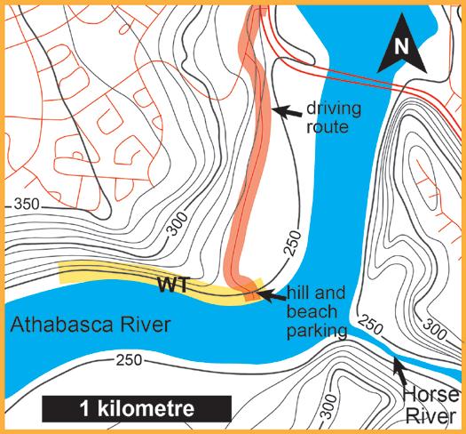
Trailhead: Drive south along Silin Forest Road, past the Water Treatment Plant, to its end. There is a short, steep, dirt drive off of Silin Road to the Athabasca River “beach.” (Note: before making the drive down this slope, make sure the river level is low enough to maneuver and park along the shore, otherwise you will be driving directly into the river!). Park along the shoreline on the limestone gravel. Walk upstream a short distance – up to a few hundred metres, depending on where you park. In-situ outcrop will start appearing beneath your feet. A limestone barrier must be scrambled or the river around the barrier (ankle to knee deep) must be forded in order to reach the main outcrop.
Distance: The outcrop is just under 1000 m in length from the beds near the parking area to the west end of the outcrop; total distance depends on where the vehicle is parked.
Elevation Gain: Except for a short, optional scramble over the limestone barrier and over some boulders along the shore, the traverse is nearly flat-lying.
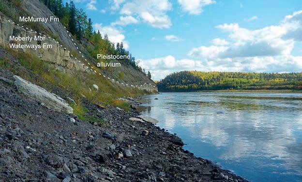
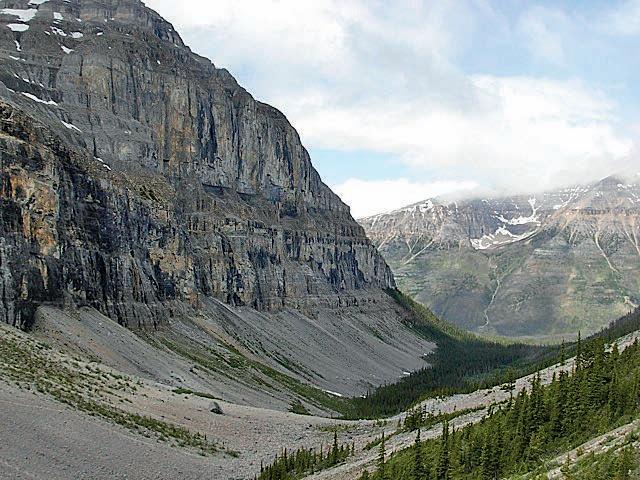
If you’ve ever observed the McMurray Formation in outcrop along the Athabasca River – and some people reading this have done so repeatedly – you likely have noticed the white to beige Devonian limestone beneath the oil sand. Most of these limestone beds are accessible only by boat or helicopter, but a precious few outcrops are easily observed by a short drive and a short hike.
The Waterways Formation outcrop near the Water Treatment Plant in Fort McMurray is an excellent spot to become acquainted with the limestone beds of the Moberly Member (Waterways Formation). Of the five members of the Waterways Formation (from oldest to youngest: Firebag, Calumet or Calmut, Christina, Moberly, and Mildred), this member outcrops the most extensively, in part because the Athabasca River has carved a valley nearly along the subsurface strike of the lower Moberly Member.

24 RESERVOIR ISSUE 09 • OCTOBER 2014
Alluvium McMurray Formation Waterways Formation
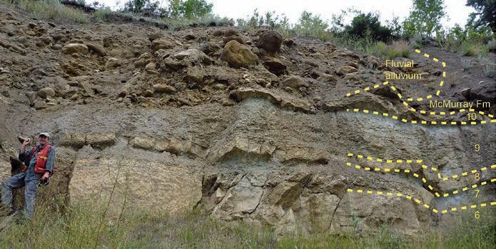
Figure 4. Pleistocene, Cretaceous, and Devonian rocks at the Water Treatment Plant.
Figure 3. Map and driving directions: Cross the Athabasca River, going north on highway 63. Very soon after the river crossing, turn west on Silin Forest Road. Take the first left and continue to follow Silin Forest Road; you will drive downhill and along the Water Treatment Plant facility. Silin Forest Road will become a dirt road near the river. The short slope to the river is near the end of the unpaved portion of Silin River Road. The yellow highlight along the river outlines the lateral extent of the outcrop.
Figure 1. View downstream toward the parking area along the Athabasca River bank. The limestone beds in the foreground are part of the upper portion of the outcrop.
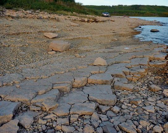
Figure 2. View from the limestone beds near the parking area towards the limestone barrier that separates the main outcrop from the parking area. The red arrow points to the limestone barrier that must be scrambled over or forded around. The yellow arrow points to the location of slickensides and a fracture with a small offset (see below, and figure 10). The resistant beds of unit 9 in the area of this photo are very fossiliferous.

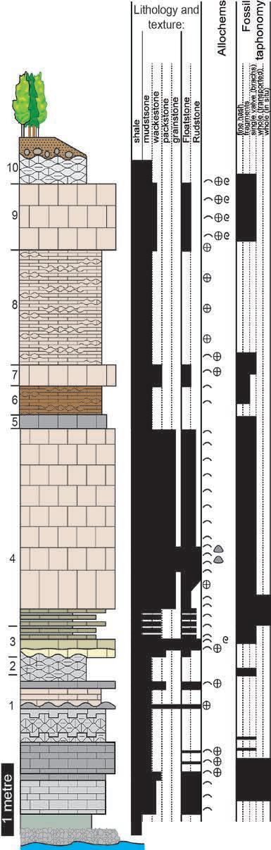
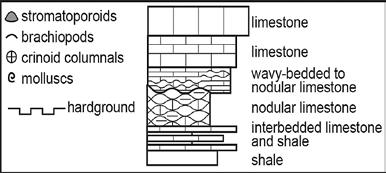
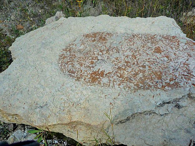
The stratigraphic section, from base to top, includes:
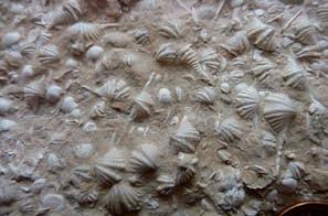
1. Approximately 250 cm exposed of a variably thinly-bedded to nodular, argillaceous lime mudstone and shale with rudstone beds. The mudstone and shale is largely unremarkable, but the rudstone beds range from encrinites to coquinas and can contain symmetrical ripple forms in cross-section. Among these rudstones are the “Eleutherokomma beds” which contain abundant specimens of the spirifer brachiopod Eleutherokomma.
2. A resistant, up to 40 cm thick brachiopod, crinoid, and gastropod floatstone to rudstone in a packstone matrix.
3. Approximately 45 cm of a return to the thinly-bedded to nodular, interbedded lime mudstone and shale with a few, thinner rudstone beds than in unit 1.
4. A “brachiopod bank,” which is approximately 250 cm comprised almost entirely of specimens of Radiatrypa brachiopods with occasional stromatoporoids that are not in life position. Other brachiopod taxa and gastropods have also been encountered in this unit, but are rare. Stromatoporoids are massive, and on close inspection, often have small borings in their surfaces – the remnant of domicile-constructing borers from the Devonian. As a note of interest, across the river and downstream at the Horse River mouth, this unit outcrops on the river bank and contains in-situ stromatoporoids. Downstream, the brachiopods decrease in abundance near Fort McKay and the fauna is mainly branching and tabular stromatoporoids and the coral Thamnopora. Upstream, west of the outcrop, this unit becomes a highly fossiliferous floatstone to rudstone of diverse brachiopods and molluscs and was heavily bioturbated with Thalassinoides-like burrows.
5. Up to 20 cm thick, slightly recessive, lime mudstone with rare crinoid fragments.
6. A 40 cm thick, recessive, nodular-weathering, lime mudstone with occasional brachiopod fragments.
7. A 30 cm thick resistant, bioturbated, brachiopod and crinoid floastone in a wackestone matrix.
8. 165 cm of a recessive, nodular weathering, lime mudstone. Nodules are separated by mm-scale shale partings.
9. A resistant, 95 cm thick, Thalassinoides bioturbated, brachiopod, crinoid, and mollusc floatstone in a wackestone matrix. Several species of bivalves and gastropods are common in this unit, which is best observed shortly upstream of the parking area and just downstream of the limestone barrier between the beach and the main outcrop.
10. Approximately 40 cm of a recessive, nodular-weathering, lime mudstone.
The base of the outcrop is covered in talus. The lowermost beds of unit 1 are often covered in a mixture of limestone slabs, nodules and chunks from the McMurray Formation, and occasional cobbles of Precambrian Athabasca Group quartzite, presumably transported by glacial and river processes.
The upper units 5 through 10 are variably eroded
RESERVOIR ISSUE 09 • OCTOBER 2014 25
Figure 5. Cartoon of the complete stratigraphic section of the Moberly Member outcrop at the Water Treatment Plant locality in Fort McMurray. The outcrop was measured at several spots and the data compiled to construct the stratigraphic section. Modified from Schneider et al., 2013.
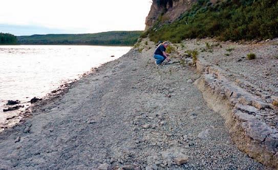
Figure 6. M. Grobe at the outcrop, with units 6 through 10 labeled.
Figure 7. Close-up of unit 4 with a toppled stromatoporoid (white dashed outline; arrow points in the original “up” orientation of the fossil).
Figure 8 (above): Close-up of a sample of the Eleutherokomma beds from unit 1. In this specimen, the long spine-like alae are unusually well-preserved on the Eleutherokomma brachiopods.
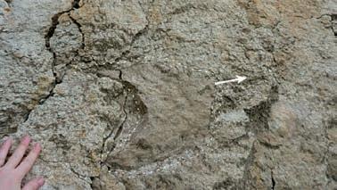
Structure: Because of salt dissolution in the subsurface from the Prairie Evaporite Formation, the Waterways Formation in this region was folded into a series of lowtopography domes and saddles, and in places was faulted. Karst features, such as paleosinkholes, caves, and enlarged joints, are present at other outcrops, but do not occur at the Water Treatment Plant outcrop. From the parked car to the end of the outcrop, the Water Treatment Plant outcrop gently undulates through five syncline-anticline pairs.
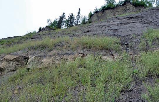
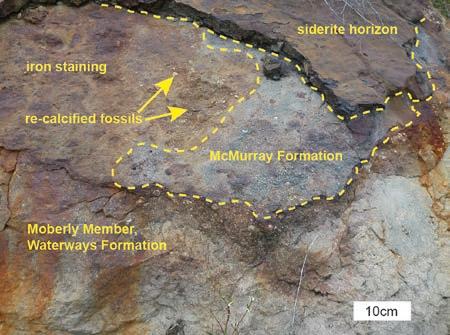
Devonian surface: The Moberly Member is overlain by the McMurray Formation oil sand or, where eroded, by fluvial sediments deposited from a Pleistocene fluvial channel. At some spots, the limestone appears unaltered beneath the oil sand or sediment; at others, the limestone has been iron-stained and decalcified in the top several centimetres. Some fractures are also iron-stained.
While you are observing these features of the outcrop and walking the shoreline, examine the talus at your feet, particularly if you are a fossil or rock collector. Many of the fossiliferous beds erode into small enough chunks to adorn your desk or rock garden. Pieces of the Eleutherokomma beds and other thin rudstones are fairly common, and even mollusc-bearing chunks of McMurray Formation are readily found to the discerning eye.
The take-away: Once your eye is trained to the Eleutherokomma beds and to the resistant-recessive patterns of units 2 through 4 at this locality, you should be able to orient yourself at most outcrops along the Athabasca River. Of course, lithology and fossil content will vary, but those two features are helpful in determining stratigraphic position at most outcrops. The folds and fracture patterns of this outcrop are also shared with most other Devonian outcrops on the Athabasca River, so this outcrop is a sufficient example for the structural features of joints and of folds less than 100 m in length.
ACKNOWLEDGEMENTS
We thank Lindsey Leighton (University of Alberta) and Tyler Hauck (Alberta Geological Survey) for field assistance and Steve Russell for jet boat transportation.
REFERENCE
Schneider, C.L., Grobe, M., and Hein, F., 2013. Geology of the Upper Devonian Moberly Member (Waterways Formation, Beaverhill Lake Group) Outcrops in Fort McMurray, Alberta (NTS 74D/11).
AGS/ERCB Open File Report 2012-19, 30p.
26 RESERVOIR ISSUE 09 • OCTOBER 2014
Figure 13: Composite photograph of the Moberly Member outcrop at the Water Treatment Plant in Fort McMurray. Montage (A) shows one anticline-syncline pair at the western (upstream) end of the outcrop. Montage (B) shows the east (downstream) end of the outcrop up to the limestone barrier between the main outcrop (shown) and the parking area (not shown). The arrows mark the same spots in both photomontages.
Figure 9. Alteration and iron staining at the Devonian-Cretaceous contact.
Figure 11. View of the Moberly Member outcrop at the Water Treatment Plant in Fort McMurray, from the west (upstream) end of the outcrop. Fluvial alluvium is deposited in a Pleistocene channel incised into both the McMurray Formation and the topmost limestone beds of the Waterways Formation
Figure 12. Bioturbated slab of the Moberly Member, showing fresh surface (beige) and exposed, weathered surface (orange-brown).
A B (...Continued from page 25)
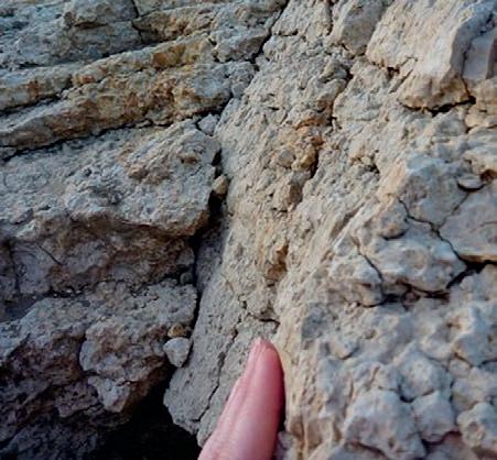
Figure 10. Surface with slickensides, side view, from unit 9 near the parking area. The yellow arrow in Figure 2 corresponds to the location of this feature.
PETROLEUM INDUSTRY COURSES
OVERVIEW OF THE OIL & GAS INDUSTRY IN WESTERN CANADA
Date: November 6th and 7th, 2014
Cost: $1050 (includes GST)
Instructor: Bill Ayrton
Effective for personnel just joining the oil patch, or for financial, accounting, and information systems personnel.
• Learn about the many facets of the industry.
• Oil finding, land acquisition, drilling, seismic, well completion, jargon and terminology
GEOLOGY FOR NON-GEOLOGISTS
Date: November 12th and 13th, 2014
Cost: $1050 (includes GST)
Instructor: Bill Ayrton
Effective for geological technicians or administrative staff, or for those who just want a better understanding of geology to appreciate the world around us.
WHO SHOULD ATTEND
New geologists, engineers, geophysicists and landmen, as well as summer students entering the industr y for the first time will find the courses a very beneficial introduction to the petroleu m industry . These courses will be extremely useful to nonprofessional and support staff in the oi l and gas industry, as w ell as accountants, lawyers, brokerage and financial personnel working primarily alongside the oil and gas industry.
TO REGISTER
To register or to obtain additional information regarding in-house and upcoming courses, please contact:
Ayrton Exploration Consulting Ltd.
Tel: (403) 262-5440
Email: ayrtonex@shaw.c a
Or visit our website: www.ayrtonexploration.com
• Learn about earth structure, geologic time-scale and processes, Western Canada geology, and interesting nearby locations.
• Participate in a r ock identification exercise , cross-section project and a mini-field trip in downtown Calgary.
GEOLOGY OF THE WESTERN CANADIAN SEDIMENTARY BASIN
Date: December 3rd, 4th and 5th, 2014
Cost: $1575 (includes GST)
Instructor: Bill Ayrton
Ideal for those who wish to improve their geological understanding of where and how we look for oil and gas fields in Western Canada.
• To visualize what Western Canada looked like throughout the stages of history, for example, the position of the sea versus land, what sediments were deposited, and what type of life that existed and evolved.
• To review the importance of each major stratigraphic unit, i.e. Devonian, Mississippian, Cretaceous, etc.
• Discuss the geological and seismic expression of typical oil and gas fields in each unit.
technology • seismic • rocks • maps • formations • land • sediments • history • sea • fossils • environment
The ”Guardwall” at the new Trilobite “Burgess Shale” discovery at Stanley Glacier Valley, Kootenay National Park. Photo: Bill Ayrton
GE OL OG Y FO R NO N- GE OL OG ISTS Pr esen ted by W.G. Bi ll) A yr to n
UNDERSTANDING OIL-SOURCE SYSTEMS A Multifaceted and Novel Approach
| By Dr. Sarah J. Porter, Dr. Ken Ratcliffe, Dr. Tim Pearce, Chemostrat Ltd.
The Canadian oil sands are the third largest reserves of hydrocarbons in the world. Comprising three major deposits, Athabasca, Cold Lake and Peace River, the oil sands represent > 95 % of Canada’s oil reserves. However, despite being at the forefront of frontier exploration, this complex petroleum system still maintains a large degree of uncertainty as oil-source and oil-oil relationships have yet to be fully defined.
The ability to recognise families of oils in a petroleum system and to relate those families to each other and to their parent basinal source rocks is essential in understanding any petroleum system. Often this apparently basic understanding is lacking, and has so far mostly been restricted to using standard organic geochemical methods. Oil-source correlation can not only yield significant insight into oil migration pathways, but can also provide an understanding of basin, reservoir and trap structure. Evaluation of these parameters in turn may also allow the identification of additional oil plays and accumulations.
Combing isotopic geochemistry, trace elemental geochemistry and the rheniumosmium (Re-Os) geochronometer on both oils and source rocks provides a novel approach to unravelling the often complex relationships between these key petroleum system components.
RHENIUM-OSMIUM
GEOCHRONOLOGY
Rhenium-osmium geochronology exploits the decay of 187Re to 187Os. This isotopic decay system provides a very useful and widely used chronometer for the absolute dating of organic rich sediments (Selby and Creaser, 2005a; Kendall et al., 2006). Both Re and Os are highly enriched in organic-rich sedimentary units (due to their organophilic nature), relative to upper continental crust, reflecting the sequestration of Re and Os from the water column during sedimentation and under oxygen-limited conditions. Furthermore, the transferral of Re and Os from the source rock to the generated oil when it enters the oil window allows the Re-Os geochronometer to be used to generate an absolute date for oil generation (Selby and Creaser, 2005b; Selby et al., 2007; Finlay et al., 2011).
OIL GEOCHRONOLOGY
Uncertainty regarding the timing of oil generation is a common exploration problem.
Constraining the timing of hydrocarbon generation through direct radiometric dating of hydrocarbons provides a robust temporal constraint on the timing of oil formation and migration within the petroleum system. The key advantage of utilising Re-Os over other traditional techniques is that this proven approach provides a quantitative determination of when the oil was generated. Further, through use of hydrocarbon geochronology it is possible to assess and quantify charge events within a basin.
OIL-SOURCE CORRELATION
Oil to source rock correlation relies on utilising and identifying genetic parameters that are internally consistent between an oil and its source rock. If the Re-Os geochronometer described briefly above is being used, the data acquired can also be used for oil-source correlation (Finlay et al., 2011; Finlay et al., 2012).
For a correlation parameter to be successfully applied, it is imperative that it remains insensitive to the effects of biodegradation, migration and changes in thermal maturity; factors that can cause difficulties with some of the more traditional approaches to oil-source correlation. However, Re-Os systematics in hydrocarbons are not disturbed by thermal maturity or biodegradation, making this isotope system an ideal oil-source correlation tool. Further, the robust nature of this technique makes it ideally suited for application to highly degraded oil systems such as those of the Canadian oil sands.
OIL CHARACTERISATION
Oil characterisation has traditionally been focused around organic geochemical techniques, such as biomarker analysis (Peters et al., 2007). However, here we describe the use of inorganic elemental geochemistry to compositionally categorise oils with a view to identifying oil populations. This technique also enables us to conduct oil-oil correlation, which in turn provides valuable insight into the assessment of reservoir connectivity. The elemental analysis has the advantage of being an inexpensive technique that yields significant compositional information in a short timeframe. This compositional data, in conjunction with the geochronological dataset, also allows conclusions to be drawn regarding charge events and the likelihood of expulsion from a single or multiple source rock units. Inorganic analysis of oils can be conducted on fluids as
well as bitumen staining within a reservoir rock (following extraction), making its application ideal to Canada’s oil sands.
Chemostrat can also conduct stratigraphic oil characterisation using chemostratigraphy (elemental characterisation) through sections of oil sands and heavy oils. This technique is particularly valuable in plays where tar mats pose a significant production problem. Tar mats are notoriously difficult to identify in the sub-surface as traditional petrophysical methods are unable to determine the transition from heavy oils to the tar mat phase. Chemostratigraphic analysis of oils in this setting enables the use of oil compositional data to identify this transition and highlight the presence of tar mats within the well. As with conventional chemostratigraphy, correlations on a multi-well scale can also be conducted if required.
REFERENCES
Finlay, A. J., Selby, D., and Osborne, M. J. (2011) ReOs geochronology and fingerprinting of United Kingdom Atlantic margin oil: Temporal implications for regional petroleum systems. Geology, v. 39, no. 5, p. 475-478.
Finlay, A. J., Selby, D., and Osborne, M. J. (2012) Petroleum source rock identification of United Kingdom Atlantic Margin oil field and the Western Canadian Oil Sands using Platinum, Palladium, Osmium and Rhenium: Implication for global petroleum systems. Earth and Planetary Science Letters, v. 313-314, p. 95-104.
Kendall, B., Creaser, R. A., and Selby, D. (2006) Re-Os geochronology of postglacial black shales in Australia: Constraints on the timing of “Sturtian” glaciation. Geology, v. 34, no, 9, p. 729-732.
Peters, K. E., Walters, C. C., and Moldowan, J. M. (2005) The Biomarker Guide: Volume 2, Biomarkers and Isotopes in Petroleum Systems and Earth History. Cambridge University Press, 704 pp.
Selby, D., and Creaser, R. A. (2005a) Direct radiometric dating of the Devonian-Mississippian time-scale boundary using the Re-Os black shale geochronometer. Geology, v. 33, no. 7, p. 545-548.
Selby, D., and Creaser, R. A. (2005b) Direct Radiometric Dating of Hydrocarbon Deposits Using Rhenium-Osmium Isotopes. Science, v. 308, p. 1293-1295.
Selby, D., and Creaser, R. A. (2007) Re-Os elemental and isotopic systematics in crude oils. Geochimica et Cosmochimica Acta, v.71, p. 378-386.
28 RESERVOIR ISSUE 09 • OCTOBER 2014
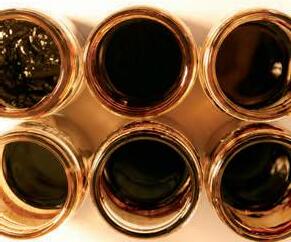
Understanding Oil-Source systems -
a novel multifaceted approach
Understanding the spatial and temporal relationships of the hydrocarbon-generating source rocks and the associated hydrocarbons within a petroleum system, is key for maximising production.
Chemostrat combines rhenium-osmium (Re-Os) geochronology and inorganic compositional data to optimise basin modelling through providing:
Absolute temporal constraints on the depositional age of the source rock and timing of oil generation.
Oil-source fingerprinting.
Oil-oil correlation and identification of oil populations.
An assessment of charge events from single or multiple source units.
An evaluation of reservoir connectivity.

RESERVOIR ISSUE 09 • OCTOBER 2014 29 CHEMOSTRAT
Chemostrat Canada Ltd. 144-4 Avenue SW, Suite 1600, Sun Life Plaza, West Tower, Calgary, Alberta, T2P 3N4 t 403-463-8188 e CAoffice@chemostrat.com www.chemostrat.com OIL SOURCE MIGRATION RESERVOIR OIL SOURCE MIGRATION RESERVOIR


SPONSORED BY: Hyatt Regency Calgary Hyatt Regency Calgary Calgary March 31, 2015 March 31, 2015 March 2015 Produced by Geoscientists for Geoscientist's, the Playmaker Forum brings wellknown, successful and distinguished Canadian speakers together for a day of unparalleled discussion. Register now at www.cspg.org or by calling 403-513-1233 Speakers include: David Gardner Michael McDonough Lee Krystinik (AAPG Past-President) Dale Leckie
President) Your ticket includes:
Complimentary networking lunch at the Hyatt Regency with a Q&A forum with Dr. Clay
Paramount Resources) White Hat Round-Up Reception; appetizers and refreshments will be served Join AAPG President-Elect John Hogg as the Playmaker Forum makes its Canadian debut!
(CSPG
Riddell (OC, CEO
DR. SCOTT TINKER CSPG University Outreach – Interview a Geologist
| By Melanie Klucker
For this month’s “Interview a Geologist” we spoke with one of this fall’s Honorary Address speakers, Dr. Scott Tinker, about his career path, mentorship, and outreach. Scott is the director of the Bureau of Economic Geology (BEG), the Director of the Advanced Energy Consortium, and the State Geologist of Texas. He is also a professor and acting Associate Dean for Research at the University of Texas at Austin’s Jackson School of Geosciences.
Scott completed a Bachelor of Science degree in Geology and Business Administration in his home state of Texas at Trinity University, later completing a Master of Science degree in Geosciences at the University of Michigan, and a Ph.D. in Geosciences at the University of Colorado. After having worked in the petroleum industry for 17 years, Scott became Director of the BEG in 2000. This change from the oil and gas industry to an executive role in research meant that his professional focus shifted somewhat from the technical to executive administration, research, education, and outreach. Despite his busy schedule in his multiple roles with the University of Texas and the State, Scott makes time to get involved with professional associations and engage the public through education and outreach initiatives. He has been the President of the American Association of Petroleum Geologists (AAPG), the Association of American State Geologists (AASG), the Gulf Coast Association of Geological Societies (GCAGS) and is the incoming president of the American Geosciences Institute (AGI). He has also delivered over 500 keynote and invited lectures in 50 countries and has received major public service and education awards from the AAPG, the American Institute of Professional Geologists (AIPG), the AGI, and the Texas Independent Producers and Royalty Organization (TIPRO). Scott is a Geological Society of America (GSA) Fellow and member of several private, public and university boards.
Q&A

geosciences. What first motivated you to pursue geology and when did you decide that a career in the energy industry was a good fit for you?
My Dad is a geologist and was with Shell for 39 years. I went off to Trinity University to be anything except a geologist! But life sometimes has different plans and I met Dr. Ed Roy my first few days of orientation. His enthusiasm was infectious and before I knew it I was sitting in his intro geology class. One or two field trips later and I was hooked.
What was your first job in industry and what were your first impressions? How are things different now?
My first job was with Bob Sneider in 1982 following graduation from Trinity. I did basic well log correlation and mapping; and shadowed Bob, who would later be honored with the AAPG Sidney Powers medal. When Bob hired me he told me he would fire me a year later so that I could get a master’s degree. He was true to his word! It was a terrific first job.
Thinking back to your early days in the energy industry, what relationships and / or decisions had the greatest impact on your career?
were all in New Orleans or Houston, except for one offer from a small company called Champlin located in Denver. I had lived in Denver as a kid, and my wife Allyson and I had hiked through the Rockies for six weeks on our honeymoon, so... we followed our hearts and moved to Denver to start our careers. It was a major life decision, and one we never regretted.
What role have experts in the field engaged in outreach and / or mentors played in your career? How were you able to gain the most that you could from mentors and peers throughout your career?
I have been blessed with terrific mentors. In addition to Ed Roy at Trinity, Professor James Lee Wilson at the University of Michigan taught me about carbonates. Colleagues, advisors and friends Steve Balsley, Jay Kipper, Eric Potter, Charlie Kerans, David Budd, Paul Weimer, Bill Fisher, Peter Flawn, Sharon Mosher, Nick Tew, Jon Price, Bud Brigham, Bud Scherr, Tim Brittan and many others have influenced my career and my life.
What do you wish you would have known before starting your career and what advice do you have for aspiring petroleum geologists?
Every chance you get, look at and learn from the rocks; from cores to outcrops. Even though technology has evolved remarkably, from 3-D modeling to geosteering; from lidar to SEM-FID; it all starts with a solid understanding of the rocks.
What was the turning point in your career that led you to your current directorial role in research and education at the University of Texas at Austin’s Jackson School of Geosciences?
Many of us have taken somewhat of a winding path to a career in
I got my MS from the University of Michigan in 1985 and had job offers from most of the major oil companies. They
In 1999, I had been in the oil and gas industry for 17 years, 12 of it in research at Marathon’s Technology lab in Littleton. But the price of oil was falling
(Continued on page 32...)
RESERVOIR ISSUE 09 • OCTOBER 2014 31
in 1999 and labs across the country were closing. Coincidently, at the same time, the Bureau of Economic Geology was advertising for a new Director. My good friend Charlie Kerans suggested that I interview, and with a bit of luck and support from friends, I got the nod.
What do you find compelling or engaging about your current role? What do you enjoy most about your job?
First, the people at the Bureau and in the School are remarkable. Second, every day is different. The challenges and opportunities span from administrative, to technical, to political, to industrial. Finally, because the Bureau is over 90% soft money, my job takes me on the road...and in the air. I have visited over 50 countries, spoken to over 500 different audiences, and flown over 3 million miles. It has been a remarkable ride. Being in a directorial or executive role, do you find you miss certain aspects of your previous roles? If so, what and why?
I miss the technical work. On the other hand, it is remarkably rewarding to be involved in conceiving of new science and technology programs, finding and attracting financial support, and setting strategic directions with all of the talented folks at the Bureau. In addition, I have been able to raise support for and stay engaged in several areas of research such as subsurface nanosensors (the Advanced Energy Consortium), shale gas reserves and production forecasting (Sloan Foundation supported integrated Bureau
team), and global energy resources and trends ( Switch Energy Project).
Despite the demands of your roles at the University of Texas and extensive involvement with a number of academic, government, and industry boards you have been very active in public education and outreach activities. What inspires you to invest so much of yourself in these initiatives? Why is it important for geosciences professionals and leaders to make time for public education and outreach?
Geosciences play a major role in global energy resources, and energy underpins everything in modern society. It is very important to me that people of all ages have an objective and balanced understanding of energy. That is why I speak all over the world, and also why I teamed with Director Harry Lynch to co-produce the Switch Energy Project. Harry and the team at Arcos have done an amazing job, and the film Switch has now reached over 4 million people, and the Switch website has had over 1 million page loads. We have just completed filming the Switch Energy Lab, targeted at 6th-12th grade science students, and hope to see it make a difference.
Thinking about what has helped you to achieve success in your career, what characteristics are necessary to make it to this level? What does it take to become a leader in industry and academia?
Luck, tenacity, adaptability, and great support. I could not do what I do without
the partnership of my wife of 31 years, Allyson and the understanding and support of our four kids. In my 15 years at the Bureau, I have had three remarkable Executive Assistants: Wanda LaPlante, Emily Hooks and Theresa Caillouet, and worked with several terrific associate directors: Doug Ratcliff, Jay Raney, Eric Potter, Jay Kipper, Ian Duncan and Michael Young None of this happens without them.
The energy industry brings many benefits to society, both economic and social. Yet, despite the everincreasing global demand for energy, it seems that the industry has gotten a bit of a bad rap. What, in your view, can we as geoscientists and energy professionals do to dispel public misconceptions and improve the situation?
Energy has and continues to lift the world out of poverty. Be proud of what you do. Always strive to do it better. And tell the world. Communicate with everyone you can, every chance you get.
The CSPG University Outreach Committee would like to thank Scott for sharing his experiences and insights with us for this installment of Interview a Geologist. If you would like an opportunity to hear Scott`s perspective first-hand, you can catch his talk at the CSPG’s 2014 Honorary Address on Monday, November 17. For more information or to register for the Honorary Address, please see “Events” on the CSPG site, www.cspg.org.
32 RESERVOIR ISSUE 09 • OCTOBER 2014
Great Team Building experience for your group! Team Building Package Includes: Reserved Seating Private Meeting Area Free Appetizers Bulk Ticket Sales Now Available Visit www.cspg.org to order your tickets today! (...Continued from page 25)
PHOTO OF THE MONTH
RESERVOIR ISSUE 09 • OCTOBER 2014 33
Striking spires Cuerno Principal and Cuerno Este, as part of the Cuernos del Paine, in Torres del Paine National Park, Magallanes, Patagonia, Chile. Dark Cretaceous sedimentary rocks of the Cerro Toro Formation contrast sharply against the white Miocene granitic intrusives of the massive Torres del Paine laccolith. This unique landscape led to the creation of the park in 1959 and a designation as a UNESCO Biosphere Reserve in 1978. Photo by Chris Steudler.
CORPORATE
SUPPORTERS
RIGSAT Communications
Cougar Consultants, Inc.
Ltd.
Sensor Geophysical Ltd.
Exova Canada Inc.
Advanced Flow Technologies Crescent Point Energy
Enviro-Tech Surveys Ltd.
EV Cam Canada Inc.
McDaniel & Associates Consultants Ltd.
Pulse Seismic Inc.
Canada Brokerlink Inc.
Energy Navigator
Sigma Explorations
Carbon Management Canada
Saudi Aramco
EDGE Technologies
Compass Directional Services
Canacol Energy Ltd.
Explor
Japan Canada Oil Sands Ltd.
Sproule International Limited
Target Data Ltd.
Datalog Technology Inc.
Birchcliff Energy Ltd.
Cabra Enterprises Ltd.
GeoSpace Technologies
Petrocraft Products Ltd.
SAExploration
Glacier Exploration Surveys
Matrix Solutions Inc.
National Oilwell Varco
Cossack Land Services Ltd.
Deloitte Petroleum Services Group
EPI Group
FMQ Southern Exploration
GeoChemTech Inc.
Geotir
Hurry Hydrocarbons
Matrix Geoservices Ltd.
Maxam Seismic Explosives
Osum Oil Sands Corp.
Petrel Robertson Consulting Ltd.
Spectrum
Ltd.
Trident Exploration
HEF Petrophysical Consulting Inc.
Sourcex
Energy Inc.
Regent Resources
Bankers Petroleum Ltd.
BJV Exploration Partnership
Nickpoint Environmental Services
SOCO International
3e Royalties Bengal Energy Bounty Developments Ltd.
Brasoil Corp.
Bukit Energy
Central European Petroleum Ltd.
DualEx Energy International
Franconia Geoscience
Gran Tierra Energy Inc.
International Petroleum Consulting
Jenner Geoconsulting Inc.
Korean National Oil Company
Long Reach Resources Ltd.
Lorne LeClerc & Associates
Madison Petrogas Ltd.
Petroamerica
Serinus Energy
Sherritt International Corporation
Skyhawk Exploration
Tretio Exploration Ltd.
Valeura Energy
AS OF AUGUST, 2014
HONORARY MEMBER CITATION for James Terrance McCoy
James Terrance McCoy was born and raised in Calgary and graduated from the University of Calgary with a B.Sc. in geology in 1970, joining the CSPG shortly after. Terry’s first major volunteer role in the CSPG was from 1992 through 1995 as the Coordinator of the Regional Geology and Hydrocarbon Potential of Western Canada course. He served on various committees from 1997 through 2003, included serving as Educational Trust Fund Trustee. In 2008 Terry earned a Service Award for work as Convention Sponsorship Chair, and from 2007 to 2009 he was the Convention Co-Chairman of Sponsorship and Exhibits. His three year term on the Executive started in 1997 and during his 1998 Presidential year, he steered the CSPG using skills gained from his professional experience. He was instrumental in maintaining a corporate governance model, and helped the CSPG maintain a balance between business culture and its geoscience mandate.
Terry started his career with Amoco Canada Petroleum in 1970 and worked as a prospect generator in Alberta. He transferred to Amoco’s Research Centre in Tulsa Oklahoma in 1973 and their office in Chicago, Illinois in 1977. In 1979 he moved to Union Oil as the Chief Geologist, where he managed all technical and training aspects for the geological team and later became Exploration Manager for Southern Alberta. He then spent two years with Conwest Exploration as the Vice President of Exploration before he moved to Columbia Gas Development of Canada in 1982 as Chief Geologist and then as Vice President Exploration, establishing an exploration program focusing on western Canada, as well as managing the company’s frontier lands. In 1989 he moved to Poco Petroleum as the Vice President of Exploration and Land, a role he held for a decade as he directed and managed Poco’s oil and gas exploration and development program. Burlington Resources
purchased Poco in 1999 and Terry became the President of Burlington’s Canadian division. In 2001 Terry moved to Murphy Oil as Vice President of Exploration and Land, where he was responsible for the company’s exploration and development program in Western Canada and the East Coast. His next move in 2004 was as President of Trafina Energy, a junior producer. In 2007 Terry joined Calvalley Petroleum as Vice President of Exploration, working on exploration and development in Yemen. In 2009 he started Koa Resources, which is a private geological and management consulting company working in Western Canada and internationally. Terry left consulting in 2012 to become CEO of Arcan Resources, an oil exploration and development company working in the Swan Hills area of Alberta.
Terry is also active in the community. He has been active on the boards of several oil and gas companies and is currently on the Board of Directors for Arcan Resources and PRD Energy. He served with the Canadian Oilmen’s Executive Association from 1999 through 2004, being Chairman of the 53rd Oilmens in 2003. He is currently a Board Member of CAWST, The Centre for Affordable Water and Sanitation Technology. Mr. McCoy has been on the Board of Governors of St. Mary’s University College since 2003, and is currently Chair of the Board of Governors. Terry is a former President of the Fort Calgary Historical Preservation Society where he served on the Board from 2001 to 2006. He and his wife Gayle have four children and when they were young, he was an active volunteer in various community activities, including baseball, hockey and scouting. At present Terry enjoys following the activities of his six grandchildren.
Mr. McCoy is senior oil and gas executive with forty-four years of industry experience. He possesses strong project management leadership, technical analysis, exploration, organizational and communication skills. He has been a technical geologist, exploration leader, senior executive, company founder and board member. He has been an active and prolific volunteer throughout his life, within CSPG and beyond. Terry is well known for his sense of humour, which when coupled with excellent listening skills, makes him a valued supervisor, coworker, and friend. He has had a memorable business career and the CSPG is proud to welcome Terry McCoy into the ranks of Honorary Members.
Halliburton Apache Canada
Golder Associates
Statcom
Caracal
Roxar Little Rock Document Services
34 RESERVOIR ISSUE 09 • OCTOBER 2014

Go where the passionate geoscientists are
Discuss the science
Socialize within a like -minded community
Grow your specialty by attending our conferences
Engage in qualified professional development (PDH accredited)
Meet industry
Volunteer and be on a team
Develop leadership skills
Get introduced to geoscience software tools
Access to technical journals on AAPGDatapages and GeoScienceWorld
Leave your legacy where you are most passionate
Join us and be part of the team that advances the professions of the energy geosciences – as it applies to geology


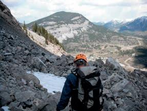


Distinguished Lecturer Series Go Take a Hike Mixed Golf Tournament Student Industry Field Trip Membership has its Advantages!
Welcome to your Professional
Home “Reaching New Depths” - Check out CSPG Executive Director - Lis Bjeld’s Interview in the Oct/Nov/Dec issue of Advantage Magazine Available online at www.advantagemagazine.ca JOIN TODAY VISIT WWW.CSPG.ORG TO BECOME A MEMBER TODAY
Career
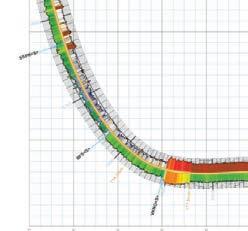


IHS Energy
IHS ENERGY
From reservoir characterization to production optimization, IHS continues to be your trusted partner in making the right decision for your investments.
Geoscience
Surface to subsurface, IHS is the world’s leading provider of information, insight and analytics supporting technical and strategic decisions throughout the energy asset value chain.
From big picture to critical detail, proven capabilities to superior results, IHS geoscience software does it all—backed by the world’s most respected forecasting, analysis and play-specific geological and geophysical data.
IHS is the only company that effectively combines high quality critical information with powerful analytical tools to enable you to make accurate technical and business decisions throughout the energy value asset chain. Whether you are investing in conventional or unconventional sources, leverage your partnership with IHS to maximize your investment, accelerate your time to market, and reduce risks. Get to the right decision faster with IHS.
TO LEARN MORE, PLEASE VISIT WWW.IHS.COM/GEOSCIENCE
To learn more, please visit
IHS.com/energy 6154-0614TS
