RETURN UNDELIVERABLE CANADIAN ADDRESSES TO: CSPG – 150, 540 – 5th Ave SW Calgary, AB, T2P 0M2 $7.00 NOVEMBER/DECEMBER 2017 VOLUME 44, ISSUE 6 Canadian Publication Mail Contract – 40070050 Academic Issue In This Issue... Stonehammer UNESCO Global Geopark Water Escape versus Gas Escape Structures: Examples from Ancient and Modern Records and Laboratory Experiments 2017 Classic Golf Wrap-up

THANK-YOU TO ALL OF OUR SPONSORS

SAMARIUM SPONSORS


TITANIUM SPONSORS


DIAMOND SPONSOR


PLATINUM SPONSOR

SILVER SPONSORS

BRONZE SPONSORS


GOLD SPONSORS


CORPORATE SUPPORTERS
MJ Systems
Geovariances
XRF Solutions Ltd
I H S Markitt
Encana
Foothills Resource Services
LXL Consulting Ltd.
RS Energy Group
Secure Energy Services
Trican Laboratories
Birchcliff Energy Ltd.
Canadian Natural Resources Ltd.


*As of October 1st
Sproule Associates Limited
Pulse Seismic Inc
Cabra Consulting Ltd.
CAPL
Crescent Point Energy
Earth Signal Processing Ltd.
Ember Resources
McDaniel & Associates Consultants Ltd.
MEG Energy Corp.
Saguaro Resources
Seitel Canada Ltd.
Velvet Energy Ltd.
PERM Inc.
Sensor Geophysical Ltd.
Siftgrid
CoreSearch
NAL REsources
TAQA North Ltd.
Baker Hughes Calgary
Enlighten Geoscience Ltd.
Midwest Surveys
RPS Energy Canada Ltd.
Tectonic Energy Consulting Inc.
Shale Petroleum
BOARD OF DIRECTORS 2017
CSPG OFFICE
#150, 540 - 5th Ave SW
Calgary, Alberta, Canada T2P 0M2
Tel: 403-264-5610
Web: www.cspg.org
Please visit our website for all tickets sales and event/course registrations
Office hours: Monday to Friday, 8:30am to 4:00pm
The CSPG Office is Closed the 1st and 3rd Friday of every month.
OFFICE CONTACTS
Membership Inquiries
Tel: 403-264-5610
Email: membership@cspg.org
Advertising Inquiries: Emma MacPherson
Tel: 403-513-1230
Email: emma.macpherson@cspg.org
Sponsorship Opportunities: Lis Bjeld
Tel: 403-513-1235
Email: lis.bjeld@cspg.org
Conference Inquiries: Candace Jones
Tel: 403-513-1238
Email: , candace.jones@cspg.org
Accounting Inquiries: Nancy Mosher
Tel: 403-513-1232
Email: nancy.mosher@cspg.org
Education Inquiries: Kristy Casebeer
Tel: 403-513-1233
Email: kristy.casebeer@cspg.org
Executive Director: Lis Bjeld
Tel: 403-513-1235, Email: lis.bjeld@cspg.org
EDITORS/AUTHORS
Please submit RESERVOIR articles to the CSPG office.
Submission deadline is the 23rd day of the month, two months prior to issue date. (e.g. January 23 for the March/April issue)
To publish an article, the CSPG requires digital copies of the document. Text should be in Microsoft Word format and illustrations should be in TIFF format at 300 dpi., at final size.
CSPG COORDINATING EDITOR
Emma MacPherson, Programs Coordinator, Canadian Society of Petroleum Geologists Tel: 403-513-1230, emma.macpherson@cspg.org
The RESERVOIR is published 6 times per year by the Canadian Society of Petroleum Geologists. The purpose of the RESERVOIR is to publicize the Society’s many activities and to promote the geosciences. We look for both technical and non-technical material to publish.
The contents of this publication may not be reproduced either in part or in full without the consent of the publisher. Additional copies of the RESERVOIR are available at the CSPG office.
No official endorsement or sponsorship by the CSPG is implied for any advertisement, insert, or article that appears in the Reservoir unless otherwise noted. All submitted materials are reviewed by the editor. We reserve the right to edit all submissions, including letters to the Editor. Submissions must include your name, address, and membership number (if applicable).The material contained in this publication is intended for informational use only.
While reasonable care has been taken, authors and the CSPG make no guarantees that any of the equations, schematics, or devices discussed will perform as expected or that they will give the desired results. Some information contained herein may be inaccurate or may vary from standard measurements. The CSPG expressly disclaims any and all liability for the acts, omissions, or conduct of any third-party user of information contained in this publication. Under no circumstances shall the CSPG and its officers, directors, employees, and agents be liable for any injury, loss, damage, or expense arising in any manner whatsoever from the acts, omissions, or conduct of any third-party user.
Printed by CBN Commercial Services, Calgary, Alberta.


PRESIDENT
Mark Cooper
Sherwood Geoconsulting Inc. president@cspg.org
PAST PRESIDENT
Greg Lynch
Shell Canada Ltd. pastpresident@cspg.org
FINANCE DIRECTOR ELECT
Jim Barclay
directorfinanceelect@cspg.org
DIRECTOR
Mark Caplan conferences@cspg.org

DIRECTOR
Alex MacNeil
Osum Oil Sands Corp. AMacNeil@osumcorp.com
DIRECTOR
Michael Webb
Suncor Energy mwebb@suncor.com
PRESIDENT ELECT
Clint Tippett presidentelect@cspg.org
FINANCE DIRECTOR
Shelley Leggitt
NAL Resources Ltd. directorfinance@cspg.org
DIRECTOR
Laurie Brazzoni membershipdirector@cspg.org
DIRECTOR
John Cody
Statoil Canada Ltd. industryrelations@cspg.org
DIRECTOR
Kevin Parks
Alberta Energy Regulator kevin.parks@aer.ca
EXECUTIVE DIRECTOR
Lis Bjeld
CSPG lis.bjeld@cspg.org
RESERVOIR ISSUE 6 • NOV/DEC 2017 3
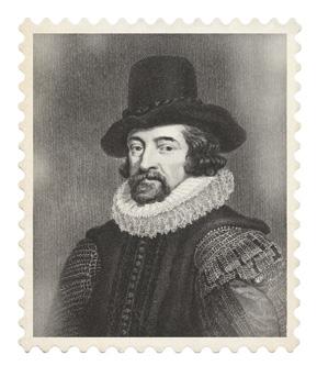
knowledge IS POWER.
Francis Bacon

Power your upstream decision-making with customer-driven data, integrated software and services from geoLOGIC.
At geoLOGIC, we help turn raw data into actionable knowledge. That’s a powerful tool to leverage all your decision making, whether it’s at head office or out in the field. From comprehensive oil and gas data to mapping and analysis, we’ve got you covered. Get all the knowledge you need, all in one place with geoLOGIC.
For more on our full suite of decision support tools, visit geoLOGIC.com
geoSCOUT | gDC Upstream knowledge solutions
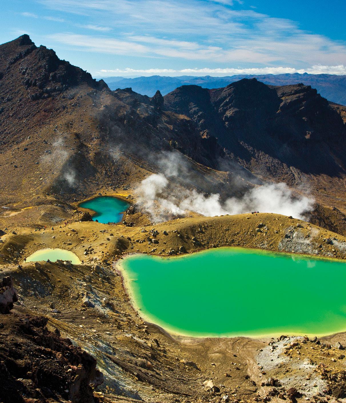
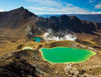
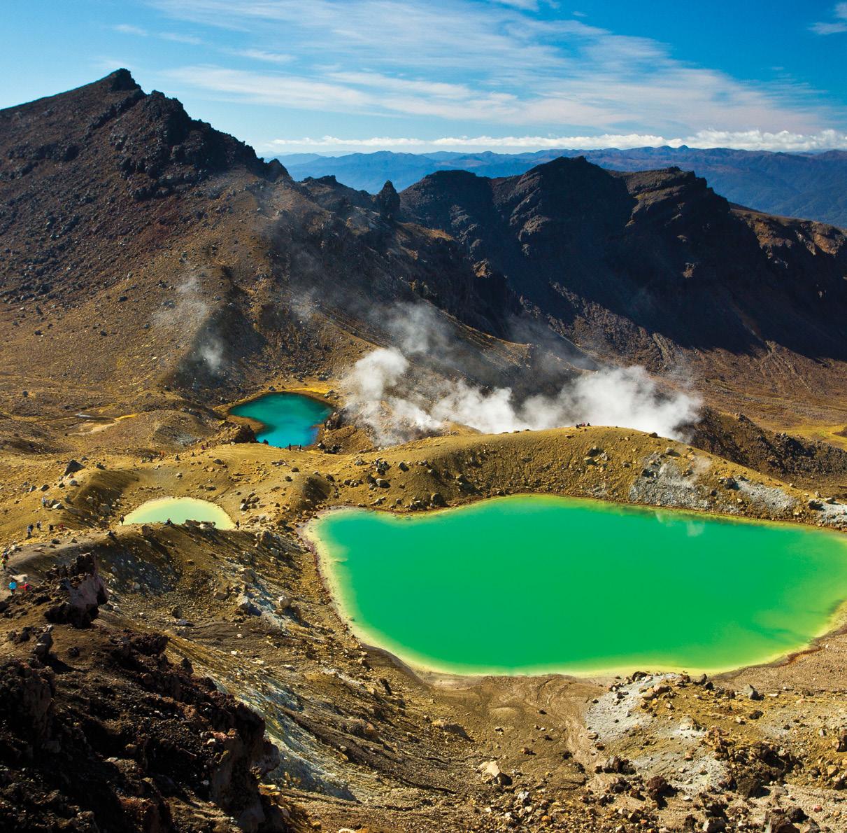
RESERVOIR ISSUE 6 • NOVEMBER/DECEMBER 2017 5 TABLE OF CONTENTS FRONT COVER Emerald Lakes, New Zealand. Emerald Lakes, Tongariro National Park, North Island, New Zealand. This park encompasses the active volcanoes of Tongariro, Ngauruhoe and Ruapehu. The Emerald Lakes are hosted in explosion craters resulting from this volcanic activity. Their distinctive green colour is due to the dissolution of volcanic minerals in the water. Mike Lam NOVEMBER/DECEMBER 2017 – VOLUME 44, ISSUE 6 MONTHLY SPONSORS 4 MESSAGE FROM THE THE CSPG FOUNDATION ........................................7 MESSAGE FROM THE EDITORS ........................................................................8 ACADEMIC ARTICLES Stonehammer Unesco Global Geopark ..................................................................9 Water Escape Versus Gas Escape Structures: Examples From Ancient And Modern Records And Laboratory Experiments ...................................................14 NEW IN CALGARY When Life Gives You Lemons… The Bowfort Towers...........................................22 UPCOMING EVENTS Technical Luncheons..............................................................................................23 Honorary Address Luncheon .................................................................................24 Division Talks ..........................................................................................................28 SOCIETY NEWS 2017 – Frosty Sunshine Arrives For The CSPG Mixed Golf Tournament 36 Bulletin Of Canadian Petroleum Geology – Editorial Transitions 38 2017 Core Conference Wrap Up 39

NEW ISSUE OF THE BULLETIN

Issue Contents:
The Upper Devonian-Lower Mississippian Bakken Formation of west-central Saskatchewan: stratigraphic architecture and sequence stratigraphy of a conventional heavy oil reservoir
L.E. Chabanole and L.A. Buatois
Foraminiferal biostratigraphy of the middle Turonian -late Santonian interval in southern Saskatchewan, Canada
J.F. Diaz and M.I. Velez
An allostratigraphic and paleogeographic framework for the Joli Fou and Pelican formations and contiguous strata (Late Albian, Early Cretaceous) in central Alberta
K.M. Vannelli, A.G. Plint, R.A. Buckley, J.R. Krawetz and C.M. Cunningham
Check out the newest issue of the CSPG Bulletin of Canadian Petroleum Geology online today at www.cspg.org
TGREETINGS FROM YOUR CSPG FOUNDATION BOARD OF TRUSTEES
By Tony Cadrin Chair
he CSPG Foundation Board of Trustees is comprised of David Clyde, Kirk Osadetz, Samantha Etherington, Tom Sneddon, Keith Yaxley, Michael Webb and myself, Tony Cadrin. Jassie Kang and Kathleen Shannon are Board Trustees who provide invaluable expertise in Accounting and Legal Affairs respectively. Katie Romansky is volunteering for the Foundation and is a Board Trustee in training until her appointment in March 2018. Please show your appreciation to these volunteers at your next opportunity for all their efforts on behalf of the CSPG Foundation.
The CSPG Foundation is a Registered Charity with the Canada Revenue Agency that funds and supports petroleum geoscience education. It was founded in 1978 by the Canadian Society of Petroleum Geologists to ensure sustainable funding for its’ outreach activities. Canadian Registered Charity No. 890218043RR0001
CSPG Foundation is committed to supporting all our current programs that further the understanding of Canadian Petroleum Geoscience in Alberta and across Canada from now to well into the future. A combination of CSPG committees and independent organizations are receiving funding for their activities that support petroleum geoscience education.
The 50th Anniversary Trust Fund was established in 1978, during the 50th Anniversary of the CSPG. Funds were raised from corporations and individuals to endow an income fund that was used to ¬finance the CSPG Student Industry Field Trip. Until 1991 the disbursements from the 50th Anniversary Trust Fund were used speci¬fically to support SIFT. Although initially funded by an appeal to individual and corporate members and stakeholders the primary source of
funding soon became the CSPG itself, with the Board of Directors routinely transferring society surpluses into the Endowment fund.
Beginning in 1990 the Society began to broaden the scope of funding beyond SIFT, beginning with support of the EdGeo program and support of youth science fairs. The expanded scope of the 50th Anniversary Trust Fund was recognized and on June 1st, 1992, the 50th Anniversary Trust Fund was collapsed and its assets were transferred into a new charitable organization that established the CSPG Educational Trust Fund. The CSPG Educational Trust Fund provided funding for the advancement of geoscience education, with a special focus on petroleum geology. Subsequently the CSPG Educational Trust Fund was instructed to act as the primary source of Educational Outreach Funding for the CSPG, which still includes the CSPG Student Industry Field Trip.
Funding was provided primarily by the Society through the 90’s. The Board of Directors and the Executive recognized that the planned goal of having the Educational Trust Fund provide the funding for all the CSPG’s outreach activities could not be achieved without contributions directly from Society revenues to Outreach activities.
In 2001 public and university outreach programs expanded. In 2004, 2005, and 2007 the Trustees and the Society made signifi¬cant efforts to increase the endowment fund through corporate and individual donors.
In 2011 the focus of the fund was narrowed to be for, “the purpose of supporting and funding petroleum geoscientifi¬c education in Canada.”
In March 2015, the CSPG Educational Trust Fund changed its name to the CSPG Foundation. The CSPG Foundation aims to fully fund current and future
CSPG outreach programs along with independent programs that also fulfill the mandate of the Foundation.
The CSPG Foundation allocates funding through the following means:
• providing bursaries, scholarships, field study grants
• donations to Canadian universities
• grants to organizations that meet the requirements as a “qualified donee” under the Income Tax Act (Canada) and undertake to fulfill the Foundation’s purpose through its programs and activities
Together we are building our geoscience future by supporting educational outreach that inspires and advances education, fosters technical excellence, and encourages awareness of petroleum geoscience. Our programs include the Student Industry Field Trip, University Outreach which includes (University Lecture Tours, Undergraduate Awards, Student Field Trips and Student Event grants), Graduate Student Scholarships, Distinguished Lecturer Tour (Link Award Winner), Honorary Address, CSPG Ambassador Program, GeoConvention Student Travel Assistance Program and Andrew D. Baillie Award, Earth Science for Society and Canadian museums. We also support CSPG Awards such as the Medal of Merit, R.J.W Douglas Medal, Link award, Stanley Slipper Award. The Foundation is also looking to establish two new awards to coincide with the CSPG 100th Anniversary in 2027, the John Allen Award and the Dr Helen Belyea Award. We consistently evaluating our funded programs, to ensure they continue to deliver a quality program for the purposes of Energy Geoscience Education, and looking to partner with new funding opportunities to ensure we meet the expectations of our donors.
The Board of Trustees encourages each (Continued on page 8...)
RESERVOIR ISSUE 6 • NOVEMBER/DECEMBER 2017 7 MESSAGE FROM THE CSPG FOUNDATION
Jason Frank
Technical Editor for the CSPG Reservoir Sr. Geologist at Athabasca Oil Corporation
Jason Frank is a Professional Geologist who holds a B.Sc. and M.Sc. from the University of Alberta. He has over 16 years of experience in oil and gas including technical and leadership positions in exploration and development both on and offshore. Past experience includes Shell Canada Ltd., Burlington Resources Ltd., ConocoPhillips Canada Ltd., and Talisman Energy Inc. Jason has volunteered for the Society in the past, most recently chairing the Duvernay session at the Society’s annual convention (2014) and the Honourary Address Committee.
Travis Hobbs
Technical Editor for the Reservoir Professional Geologist at Encana
Travis Hobbs is an undergraduate from University of Calgary with a graduates degree from Simon Fraser University in Geology. Professionally has worked both domestically and internationally for 19 years in the Oil & Gas industry, and is currently celebrating 15 years with Encana. Industry roles have included development, exploration, management and business development. Prior to the Reservoir, Travis has held previous roles on convention committees and six years as the Chair of Continuing Education. As free time permits Travis enjoys cycling, cross-country skiing and teaching his two daughters violin.
WINTER ACADEMIC ISSUE
Where did those last couple of months go? It’s been an incredibly busy couple of months for the editors at the Reservoir, with budget cycles underway, rigs returning to the fields, and busy personal schedules. The last two months have flown by! As always, thank-you for taking some time and sit down with a copy of the Reservoir and welcome to the November/December edition of the Reservoir – the ‘winter academic edition.’
We had such an amazing response from academia that we decided to run another edition dedicated to this theme. David Wheatley (University of Utah) submitted a paper highlighting the diagnostic criteria to discern water from gas fluid escape structures. In addition, his outcrop photographs from southern Utah are quite remarkable.
Randall Miller has provided the Reservoir with an outstanding overview of the first North American Geopark, “Stonehammer,” in New Brunswick. Admittedly we had no idea what a Geopark was, let alone that Canada was home to the first one in North America. Simply put a Geopark uses its geological heritage, in connection with all other aspects of the area’s natural and cultural heritage, to enhance awareness
and understanding of key issues facing society, such as using our earth’s resources sustainably, mitigating the effects of climate change and reducing natural disasters-related risks. As of 2016, there were 119 Geoparks recognized by UNESCO around the globe, with many more in ‘aspiring’ Geopark status (10 in Canada). Please see http://www.globalgeopark.org/ aboutGGN/list/index.htm for the complete list of parks. This list is definitely a great place to start planning a geologically based holiday whether it be here in Canada, or abroad.
As we approach the onset of the holiday season and the end of another exciting year, please remember to contact us with comments, ideas for future papers or general feedback. This has been our first year of ‘themed’ editions, and we’d love to hear what you think - what’s working, what isn’t, and content that you’d like to see us focus on in future editions.
As with every edition, we thank-you for your time and continued support for the Reservoir and the CSPG.
Your editors,
Jason and Travis
(Continued from page 7...)
member to consider supporting the CSPG Foundations’ Goals through: Donating along with your CSPG membership renewal, purposed donations if there is a specific Foundation program you would like to support, general donations if you support all the Foundations outreach programs and estate planning allocations to the CSPG Foundation (includes equities).
We thank all our donors for their past support and look forward to continuing
serving our past and new donors by supporting quality educational outreach that inspire and advance education, fosters technical excellence, and encourages awareness of petroleum geoscience.
Sincerely,
Tony Cadrin, Chair on behalf of the CSPG Board of Trustees
8 RESERVOIR ISSUE 6 • NOVEMBER/DECEMBER 2017
FROM
MESSAGE
THE EDITORS
STONEHAMMER UNESCO GLOBAL GEOPARK
By Randall F. Miller Ph.D., P.Geo., FGC, Geoscientist, Stonehammer UNESCO Global Geopark, and, Curator Emeritus, New Brunswick Museum , Saint John, New Brunswick E2K 1E5, Canada
In North America we may have an idea of what a geopark is. Surely it is a place that has some sort of geological heritage or significance that geologists would find fascinating. If we pitch it right perhaps non-geologists would discover something about geology as well. Beginning in the late 1990s geoparks in Europe and Asia were developing into something much more. By 2004 the Global Geoparks Network (GGN), with the support of UNESCO was holding its first meeting in Beijing. Large-scale geoparks were being created across a European Geopark Network and a growing Asian Geopark Network. They developed as much more than places for geologists, and about more than rocks. Geoparks are economic development projects that use a region’s geology for public education, geoscience, preservation of geological heritage and geotourism. In many countries significant government and private sector support recognize the opportunities geoparks offer.
In 2004 the New Brunswick Museum
started a project to develop a geoheritagegeotourism product based on a long history of geological exploration and a tradition of public education in the geosciences in southern New Brunswick. The remarkable geological complexity around the city of Saint John had nurtured a homegrown group of professional and amateur geologists in the early 1800s. Many became internationally known for their work, and the institutions they created were at the forefront of research and public education from the middle 19th to early 20th century. By the 1920s it had mostly disappeared from the community, and at the end of the 20th century that geoscience heritage was largely a forgotten part of the community’s understanding of its past. That history included Abraham Gesner, the inventor of kerosene and a founder of the modern petroleum industry. In the late 1830s to early 1840s Dr. Gesner lived in Saint John. ‘Gesner’s Museum’, an historic collection, now forms the basis for the New Brunswick Museum, Canada’s oldest continuing museum. In 1857 a group of young men in
Saint John started the Steinhammer Club. They conducted pioneering geological work used by Sir William Dawson in the 2nd edition of his classic book Acadian Geology.
With tremendous community engagement the museum’s project turned into an application to become North America’s first Global Geopark, a goal achieved in 2010.
Originally called Stonehammer Global Geopark (to recognize the Steinhammer Club), it brought stories of the region’s geology back to public attention by providing geological interpretation of existing parks and trails originally developed (in part) because of the scenic geology. Following the Beijing conference the GGN held conferences in Northern Ireland, Germany, Malaysia, and Japan. In 2014 the conference came to Saint John, hosted by Stonehammer Global Geopark. In 2015 UNESCO formally adopted global geoparks as a program, alongside World Heritage sites and Biosphere Reserves. In 2016
(Continued on page 10...)
TECHNICAL ARTICLE RESERVOIR ISSUE 6 • NOVEMBER/DECEMBER 2017 9
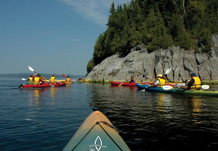
Experience Provider kayak tour to see Precambrian stromatolites, Saint John
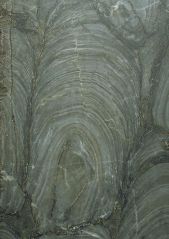
Precambrian stromatolite, Archaeozoon acadiense, courtesy New Brunswick Museum, NBMG 3200
(Continued from page 9...)
Stonehammer UNESCO Global Geopark (stonehammergeopark.com) joined more than 120 geoparks as members of UNESCO (http://www.unesco.org/new/en/naturalsciences/environment/earth-sciences/ unesco-global-geoparks/).
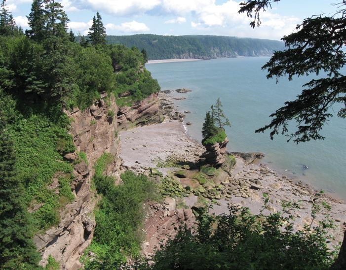
Stonehammer UNESCO Global Geopark is a big place. It covers 2,500 km2 centered on Saint John, from Lepreau Falls Provincial Park in the west, along the Bay of Fundy coast to the Fundy Trail Parkway. Inland the geopark includes the lower river valleys of the Saint John and Kennebecasis rivers extending north to Hampstead, the site of an historic building stone quarry. Geotourism
and public education is built upon familiar landscapes and stories, existing sites and infrastructure, recognizing that many places of interest to geologists have attracted people for their natural and cultural appeal. Landscapes at the Reversing Falls, Rockwood Park, and Irving Nature Park in Saint John; the Bay of Fundy coast at St. Martins and the Fundy Trail Parkway; and cultural sites at covered bridges and historic Uptown Saint John all have rich geological stories. Stonehammer’s strategy has been to link significant geological places, many in existing parks and trails, under a common geological theme. The scenic landscape has resulted in a rich mosaic of parks
depending on geology for their beauty, but with little prior interpretation of the rocks. About fifteen of the key geosites are publicly accessible. The use of existing infrastructure was a deliberate attempt to add geological interpretation to places familiar to the community. Geotourism activities are offered by independent businesses, ‘experience providers’ who incorporate geological themes into their offerings, or develop new products showcasing Stonehammer. Sir Charles Lyell might be considered among Stonehammer’s first and most famous geotourists. He visited the Reversing Falls in September 1852. In a letter to his father-in-law, Lyell described
TECHNICAL ARTICLE 10 RESERVOIR ISSUE 6 • NOVEMBER/DECEMBER 2017
Precambrian (left) and Cambrian (right) rocks at the Reversing Falls, Saint John
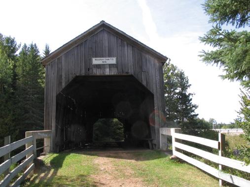
Moosehorn Creek covered bridge and Mississippian, Albert Formation site near Norton
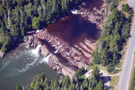
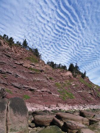
Mississippian Mabou Group at Lepreau Falls Provincial Park
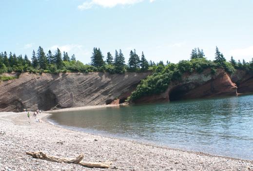
Permian-Triassic sea caves at St. Martins
the rush of the tidal current in and out of the narrow gorge. A prominent tourist attraction since the early 1800s, the Reversing Falls was named for the phenomenon that causes the Saint John River to flow backwards as the rising tides of Bay of Fundy flood the estuary. Lyell also saw the graphite mines at the falls. Graphite and lime quarries were two of the early mining activities that attracted people to the Saint John area in the 1700s. Today, among its geological assets, Stonehammer has the industrial energy infrastructure based around Saint John. The energy industry dates back almost 400 years when coal mined north of the geopark was first shipped from the Saint John harbour in 1639. Although New Brunswick has only small petroleum resources found in the Carboniferous Albert Formation (found in the eastern end of the geopark), Saint John on Canada’s east coast has one of Canada’s largest oil refineries. It is home to the first deep-water crude oil terminal in the western hemisphere able to receive supertankers, and the first liquefied natural gas terminal in Canada. Just west of Saint John at Point Lepreau the geopark has one of Canada’s only nuclear power generating stations.
(Continued on page 12...)
TECHNICAL ARTICLE RESERVOIR ISSUE 6 • NOVEMBER/DECEMBER 2017 11
Flowerpot in Triassic rock along the Fundy Trail Parkway
Pennsylvanian outcrops at Giffin Pond
Public tour of Pennsylvanian outcrops led by the New Brunswick Museum, Gardner Creek
(Continued from page 11...)
The geopark records a billion years of geological history; ‘a billion years of stories’ is the geopark’s tagline. Stonehammer UNESCO Global Geopark is located on the margin of the North American continent, built from terrane slices that originated on the late Precambrian supercontinent Rodinia and the Precambrian-Early Paleozoic continent Gondwana. As the older terranes of Ganderia and Avalonia collided with Laurentia they created a complex geological history, culminating in the creation of the supercontinent Pangea and the Appalachian Mountains to the west of the geopark. Devonian to Upper Carboniferous cover rocks lie on top of the older Precambrian and Early Paleozoic terranes. The breakup of Pangea beginning in the Mesozoic and the creation of Atlantic Ocean, left behind pieces
of those early Paleozoic terranes, but also produced Permian to Cretaceous geology recording the creation of a rift valley and the subsequent erosion of the landscape. During the Quaternary glaciers covered all of eastern Canada, and everywhere in the geopark the influence of glaciation is evident.
The story is complex and the geopark has chosen the ‘big idea’ of plate tectonics as the story Stonehammer can tell. It is a story about the closing of the ancient Iapetus Ocean and the opening of the modern Atlantic Ocean (know to geologists as a ‘Wilson Cycle’), a story that started in late Precambrian about a billion years ago and continues today. The geopark includes rocks from most geological periods, representing about one-fifth of the
age of the Earth. More than 100 formations and igneous suites are found in the geopark. Outcrops and interpretive opportunities are found in rocks from the Precambrian, Cambrian, Ordovician, Silurian, Devonian, Early Carboniferous, Late Carboniferous, Permian, Triassic, Cretaceous, and Quaternary time periods.
Stonehammer is rich in ‘classic localities’, significant sites in Canadian geology known for their stories of early exploration, geologic interpretation and palaeontology. The oldest rocks in the geopark belong to the Green Head Group where, in 1890, George Matthew was the first in the world to describe Precambrian stromatolite fossils. In the late 1800s Matthew was among the first in the world to recognize small shelly
TECHNICAL ARTICLE 12 RESERVOIR ISSUE 6 • NOVEMBER/DECEMBER 2017
Late-glacial moraine and marine deposits, Irving Nature Park, Saint John
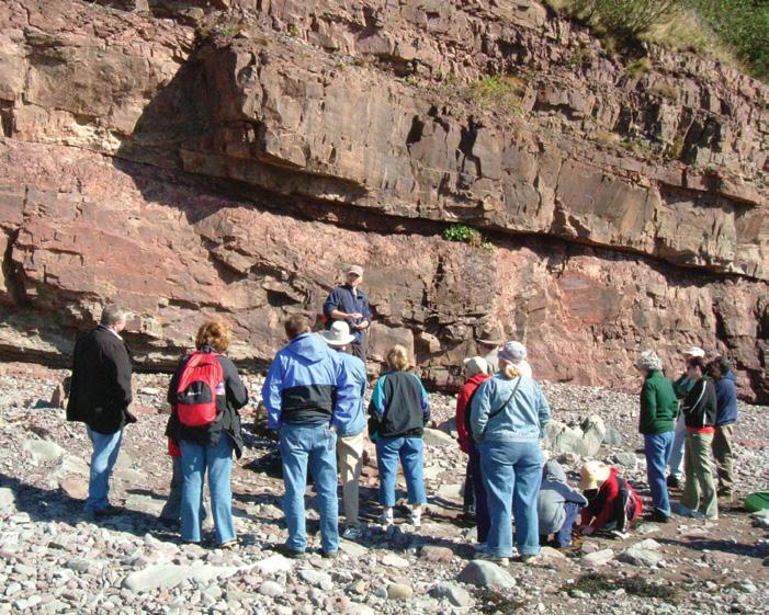
Building Stone tour, Uptown Saint John
Teachers rock climbing during an EdGEO workshop
fossils in the lowest Cambrian rocks. The first Cambrian trilobites in Canada were discovered here in 1863, and in 1914 Marie Stopes wrote her classic Geological Survey of Canada palaeobotany monograph on the Upper Carboniferous ‘Fern Ledges’ in Saint John.
As geoscientists we often think how wonderful it might be if more people had an appreciation for geology. Geoparks provide a perfect venue for introducing people of all ages to earth sciences. In addition to ‘experience providers’ leading tourism walking tours or kayak excursions, Stonehammer has an active education program in schools. While focused mostly on elementary classes, we have also supported high schools and university students. Stonehammer staff and volunteers have delivered programs to thousands of students. One of our most recent projects has been ‘Chip & Crystal Experience Energy’, a book about energy resources in New Brunswick that was distributed to every grade 4 student in the province (stonehammergeopark. com/learn/experience-energy/). The book was funded by the Canadian Geological Foundation, the New Brunswick Energy Institute, the Province of New Brunswick, and the New Brunswick Museum. Chip and Crystal, our geopark ambassadors, travel through time to learn where energy resources come from.


2017 Membership Renewal Make sure your membership is paid and up to date to ensure discounts at upcoming CSPG events and Conferences! TECHNICAL ARTICLE RESERVOIR ISSUE 6 • NOVEMBER/DECEMBER 2017 13
Chip & Crystal Experience Energy
WATER ESCAPE VERSUS GAS ESCAPE STRUCTURES: EXAMPLES FROM ANCIENT AND MODERN RECORDS AND LABORATORY EXPERIMENTS
By Wheatley, D. F.a*, Chan, M. A.a
aDepartment of Geology and Geophysics, University of Utah, 115 S 1460 E, Room 383, Salt Lake City, Utah, 84112, USA, *Corresponding author., Email address: davidfwheatley@gmail.com
Abstract
Liquefaction and fluidization features such as clastic pipes (columnar injectites that vertically crosscut bedding) are common within the stratigraphic record. However, little study has focused on the differences between water escape structures and gas escape structures. Water escape and gas escape structures have distinct morphologies as observed in ancient deposits, modern deposits, and laboratory experiments. Water escape structures form columns of sediment that vertically crosscut bedding with sharp contacts. These pipes can brecciate the host rock and have flared bases. As pipes reach the surface, the sides of the pipe flare outwards and upwards producing a coneshaped extrusion structure. This entire system feeds a positive-relief sand volcano characterized by a low-angle mound or in some cases a sand sheet. Water escape structures commonly have associated soft-sediment deformation such as synsedimentary faults and folds, and ring faults that surround the pipes. Stratigraphic layers commonly bend downward against the pipe edges. Gas escape structures lack a feeder pipe but instead form coneshaped extrusion structures that taper to a point at depth. These gas extrusion structures also feed positive-relief sand volcanoes. The gas escape structures form at or near the surface, and thus have a lower preservation potential than water escape structures. Both water and gas escape structures are important indicators of fluidization and the remobilization of reservoir facies. Documentation of the size, extent, and geometries of these features is important to understanding reservoir size and connectivity. Water escape structures likely make better postdepositional fluid flow conduits because of the vertical feeder pipe that crosscuts
The bleaching (white color) of the pipes indicates that these pipes were conduits for chemically reducing fluids, likely hydrocarbons or CO2.
layered stratigraphy (i.e., bypasses potential barriers and baffles to flow).
Introduction
Liquefaction and fluidization induced
soft-sediment deformation (SSD) structures occur throughout the geologic record (eg. Duranti and Hurst, 2004; FreyMartınez et al., 2007; Hubbard et al., 2007; Moss and Cartwright, 2010; Hurst et al.,
TECHNICAL ARTICLE 14 RESERVOIR ISSUE 6 • NOVEMBER/DECEMBER 2017
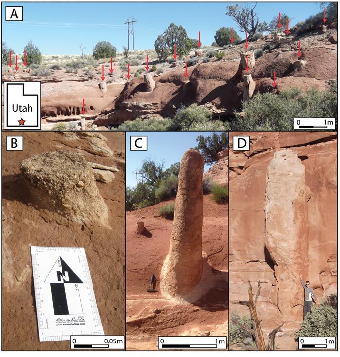
Fig. 1. Clastic pipes within the Jurassic Carmel Formation within the Colorado Plateau (red star located in southern Utah). Pipe diameters span several orders of magnitude across the Plateau (~10 cm to ~100 m) (Netoff, 2002) and are commonly exposed/weathered as 1) free standing columns, 2) crosscutting stratigraphy in cross section, or 3) circles in map/plan view.
2011; Sherry et al., 2012; Wheatley et al., 2016). Clastic pipes (columnar injectites composed of clastic material that vertically crosscut bedding with sharp contacts) (Fig. 1), have sparked extensive debate in regards to their formation processes (Owen and Moretti, 2011). This debate has largely centered on the formation mechanism (i.e., liquefaction/fluidization vs. dissolution collapse) (Hunter et al., 1992; Chan et al., 2007) and the potential trigger (e.g., earthquakes, springs, depositional loading, etc.) (Hannum, 1980; Alvarez et al., 1998; Baer and Steed, 2010; Loope et al., 2013; Dubiel et al., 2014; Wheatley et al., 2016). However, very little discussion has centered on the distinction between water escape and gas escape features. Many studies have sufficient documentation to support a liquefaction/ fluidization formation hypothesis, yet do not present any evidence to distinguish the potential deformational fluid (i.e., water or gas). These formation processes have good modern analogs, and physical laboratory models allow for controlled testing of specific variables such as fluid type (i.e., water escape vs gas escape). The subtle distinction of these processes and the preservation potential of these features in the rock record warrants the discussion presented here.
Within petroleum systems, large-scale pipes and other injectites act as fluid conduits connecting reservoir bodies and bypassing barriers and baffles to flow (Duranti and Hurst, 2004). Pipes and other injectites remobilize reservoir facies and redistribute them throughout the system (Hurst et al., 2011). Understanding the geometries, extent, and internal facies of these features is important in predicting reservoir size and connectivity. The purpose of this study is to gather published literature to examine the difference between water escape and gas escape structures using laboratory, modern, and ancient examples in order to assess the geometries, vertical extent, and internal facies of these features. For the ancient examples, this study focuses on Colorado Plateau examples of clastic pipes because of their high concentration and excellent exposure (Fig. 1) (Wheatley et al., 2016).
Previous Work
Studies of clastic pipes on the Colorado
Plateau began in earnest in the 1950s as part of a greater effort to map and mine uranium ore along with other metallic metals such as copper (Hilpert and Moench, 1960; Wenrich, 1985; Wenrich and Huntoon, 1989). Pipes, which acted as preferential flow conduits for mineralizing fluids, hosted these ore deposits. As economic interest in these deposits waned, academic interest in these features increased. Recent studies examine examples within southern Utah specifically within the Navajo, Carmel, and Entrada formations (Chan et al., 2007; Wheatley et al., 2016).
In response to an increasing number of outcrop-based SSD studies, researchers began running physical modeling experiments in the laboratory in an attempt to replicate the features documented in the outcrop-based studies (Nichols et al., 1994; Frey et al., 2009; Rodrigues et al., 2009; Ross et al., 2011). The experimental setups allowed researchers to simulate gas escape or water escape while constraining physical properties such as grain size, roundedness, layer thicknesses, etc.
Modern analogs provided important reference data for both the physical models and the outcrop-based studies. Obermeier’s (1996) work on sites across the United States as well as work by others centered on the New Madrid Fault zone (Saucier, 1989) are popular analogs for seismically induced liquefaction. The boiling sand springs in Nebraska (Guhman and Pederson, 1992) provide excellent analogs for studies that interpret pipes as spring structures. Mud volcanoes occur worldwide and together with deep sea pock mocks constitute the most popular gas escape modern analogs (Dimitrov and Woodside, 2003; Mazzini and Etiope, 2017).
Physical Modeling of Fluid Escape Structures
Physical modeling of fluidization structures has helped increase our understanding of the sequential process of the formation of fluidization features. These experiments encompass both water and gas escape (Nichols et al., 1994; Pralle et al., 2003; Frey et al., 2009; Rodrigues et al., 2009; Ross et al., 2011). They typically are performed in either a cylinder or a
thin rectangle (made with transparent materials) with a mix of fine- and coarsegrained material. The experiments used a porous, coarse-grained fluidizable source layer overlain by a fine-grained cohesive sealing layer. Some experiments added additional sediment on top of the seal, which simulates the “host rock” (Frey et al., 2009; Rodrigues et al., 2009; Ross et al., 2011). This geometry of water-saturated, coarse-grained sediment overlain by a fine-grained, confining seal comes from Obermeier’s work on modern injectites (Obermeier, 1996a) and is widely believed to be the optimal geometry for creating fluidization features. Physical models of gas escape and water escape structures demonstrate a difference in formation mechanism that yields a difference in preserved morphology.
Water Escape Experiments
Water escape experiments reproduced small-scale pipe geometries similar to the Jurassic outcrop examples. Upon initiation of water escape experiments, several studies observed a decoupling of the cohesive and fluidizable layer producing a water filled cavity between them (Nichols et al., 1994; Ross et al., 2011). Once the seal could no longer hold back the pressure it failed by producing pipe-like structures. Once formed the pipes had internal convection cells with water moving upwards in the center and downwards on the sides of the pipes (Frey et al., 2009). The sides of the pipe were vertical, straight, and had sharp contacts with the surrounding sediments. Laminations within the host rock lipped or tilted downwards as they met the pipes. The fill within the pipes was massive similar to outcrop examples (Frey et al., 2009). Where the fluidized sediment breached the surface, pipes formed sand volcanoes that were fed by cone-shaped vents (i.e., extrusion structures). These vents were connected to a feeder pipe that continued at depth (Ross et al., 2011).
Gas Escape Experiments
In contrast, modeling of gas escape structures produced different, distinguishable features compared to water escape structures (Frey et al., 2009; Rodrigues et al., 2009). Frey (2009) ran an experiment comparing both gas and water escape structures. Gas escape structures created only subtle deformation
TECHNICAL ARTICLE RESERVOIR ISSUE 6 • NOVEMBER/DECEMBER 2017 15
(Continued on page 16...)
(Continued from page 15...)
throughout his experiments. During the initial gas experiment Frey used a low effusion rate. Gas moved upwards through the sediment via the path of least resistance and was then extruded at the surface. This process produced little or no preserved sediment deformation. In subsequent runs, Frey (2009) increased the gas effusion rate. This produced some observable structures, however the deformation was still subtle relative to the water escape structures. The gas escape structures produced upward lipping/tilted laminations (contrasted to the downward lipping/tilted laminations of the associated water escape experiment). The majority of sediment deformation occurred at or near the surface and the boundary with the host sediment was gradational compared to the sharp contacts of the water escape structures. When deformation did occur, gas escape formed sand volcanoes at the surface. Just below the surface these volcanoes were fed by cone-shaped vents that tapered to a point. Rodrigues (2009) used finer-grained test sediment in his experiments and therefore achieved a higher degree of deformation, however the structures remained largely similar to those in Frey’s experiment (2009). Within the experiment, gas escape formed coneshaped extrusion structures just below the surface connected to sand volcanoes. These cone-shaped structures tapered downwards to a point near the surface. In addition to the cone-shaped extrusion structures, Rodrigues (2009) also observed laccolith-like features. Pralle (2003) used only mud-sized sediment and cyclic injection of gas in his experiment, and was able to create pipe structures. This is likely due to the smaller grain size of the mud-sized sediment, which requires less upwards forces to fluidize the sediment, compared to the sand-sized source layer experiments.
Comparison
Overall, modeling of water escape features produced vertical pipe-like structures with sharp contacts with the host sediment. These features created extrusion structures with sand volcanoes at the surface fed by cone-shaped vents just below the surface. These vents connected to pipes at depth, which penetrated the entire stratigraphic column. The pipes formed internal convection cells with upwards flow in the
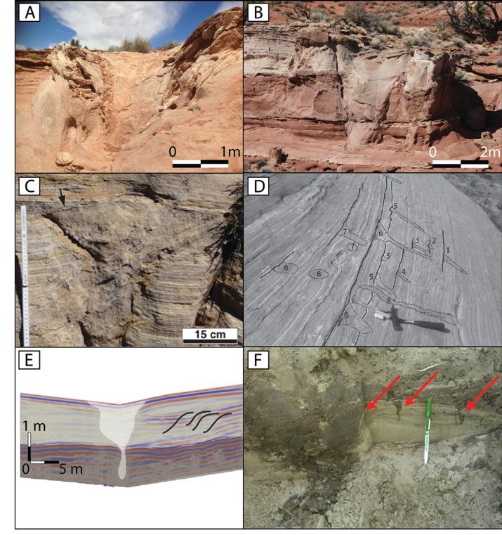
Fig. 2. Although extrusion structures are rarely preserved in ancient deposits, several Jurassic examples allow for comparison with modern analogs. Figures 2A-D show centimeter-scale to meter-scale pipes with upward flaring geometries. These flaring geometries are interpreted as extrusion structures (i.e., the subsurface bases of sand volcanoes) and paleoeruption horizons. Figures 2E and 2F are ground penetrating radar (GPR) and trenched views of modern gas escape structures from the Hite delta, southeastern Utah.The modern gas escape structures taper to a point just below the surface. (Figures 2C and 2D are from Loope et al., 2013 and images 2E and 2F are from Sherrod et al., 2016).
center and downwards flow on the edges. In contrast, gas escape structures had more diffuse or gradational boundaries, and significantly less deformation. This deformation concentrated at or near the surface and did not continue at depth. The cone-shape vents, which connected to the sand volcanoes on the surface, tapered to a point. These tapered vents may be difficult to detect in outcrop exposure if there was any erosion across the eruptive surface.
Modern Examples of Fluid Escape Structures
Water Escape Analogs
Modern analogs for water escape structures occur throughout the United States. Sand volcanoes, also termed “sand blows” or “sand boils”, occur within the New Madrid Fault Zone (Braile et al., 1986; Saucier, 1989; Obermeier, 1996), the Central Virginia Seismic Zone (Tuttle et al., 2015), the East Tennessee Seismic Zone (Powell et al., 1994), central Kentucky (Ettensohn, 2015), coastal South Carolina (Obermeier, 1996a), the Wabash Valley Seismic Zone (Obermeier, 1996a), and coastal Washington state (Obermeier, 1996a). These seismically
TECHNICAL ARTICLE 16 RESERVOIR ISSUE 6 • NOVEMBER/DECEMBER 2017
induced examples exhibit both pipe and dike geometries, and many of these localities overlie buried fault systems often related to deep basement structures. These faults and their associated historical records provide a direct linkage between paleoseismicity and the formation of water escape features (Saucier, 1989; Obermeier, 1996).
Modern trenches of these structures reveal a consistent morphology across multiple sites. The water escape structures form positive relief, low-angle, conical mounds on the surface composed of extruded sediment (Saucier, 1989; Obermeier, 1996). In areas with a high density of water escape structures, the mounds merge together to form a sand sheet (Saucier, 1989). Directly below the surface, the features have a cone-shaped vent connected to a feeder pipe or dike that continues at depth and crosscuts layered stratigraphy (Saucier, 1989; Obermeier, 1996). The pipe or dike sometimes contains broken pieces of the “host rock” or sidewall material (Obermeier, 1996a). Stratigraphic layers lip/tilt downwards towards the pipes and there is downwards movement of coarsegrained material on the outer edges of the pipe (Obermeier, 1996a). Pipes have a flared base when traced back to their original source bed (Obermeier, 1996a). Saucier (1989) notes that pipes can have multiple episodes of sand extrusion through the same pipe. Historical accounts of the New Madrid sand volcanoes record pipes erupting 3-4 m into the air indicating a violent formation process (Saucier, 1989).
The Dismal River and its surrounding flood plain host interesting artesian springs termed boiling springs (Guhman and Pederson, 1992). Dissimilar from the discrete, rapid, violent injection of the features studied by Obermeier and others (Saucier, 1989; Obermeier, 1996a), these boiling springs form continuously and over time. They do not actively expel sediment but do form vertical conduits of upwelling water. Similar to the physical models, modern water escape structures form vertical conduits with sharp contacts that crosscut layered stratigraphy.
Gas Escape Analogs
Modern analog studies of gas escape
modern deposits, ancient deposits, and laboratory experiments. Water escape structures vertically crosscut bedding and can brecciate the host sediment and sealing layer. The feeder pipe connects to a coneshaped extrusion structure at the surface. The surrounding host sediment commonly lips/tilts downward towards the pipe and the host rock commonly has associated SSD. Gas escape structures have coneshaped extrusion geometries that taper to a point below the surface.
structures have focused on mud volcanoes and subsea pock marks (Dimitrov, 2002; Dimitrov and Woodside, 2003; Loncke et al., 2004; Mazzini and Etiope, 2017). Mud volcanoes are usually depicted in schematic figures with piping systems that connect to a vent at the surface. The effect of water and/or gas escape in mud volcanoes can be difficult because mud volcanoes involve a mix of gas and water escape (Mazzini and Etiope, 2017). Pockmarks, which commonly occur on the sea floor, are depicted as creating only near-surface disruption without a connecting feeder pipe (Dimitrov and Woodside, 2003). The Hite Delta, formed at the northern end of Lake Powell due to the damming of the Colorado River provides an excellent subaerial example of gas escape structures (Sherrod et al., 2016). The modern structures emit methane gas and form volcanoes or calderas at the surface. Subsurface imaging along with trenching reveal the geometry of these features at depth. The gas escape structures taper to a point within several meters of the surface (Fig. 2E and 2F). Similar to the physical modeling results, the gas escape structures have well-developed extrusion structures but only deform the sediments at or near the sediment surface; tapering to a point at within only a few meters of the
surface (Sherrod et al., 2016).
Ancient Examples of Fluid Escape Structures
Ancient Water Escape Structures
Increased understanding of modeled and modern systems can help researchers interpret ancient outcrop examples. The Colorado Plateau provides a great variety of SSD features and many examples of water escape structures. Morphologically, these features resemble water escape structures from physical models and modern analog studies. These outcrop examples of pipes have vertical, sharp contacts with the surrounding host rock, occasionally have entrained pieces of sidewall material, and can cut across tens of meters of stratigraphy (Fig. 1) (Wheatley et al., 2016). Several examples have well-preserved, cone-shaped extrusion structures at the paleosurface that connect to pipes at depth (Fig. 2) (Netoff, 2002; Loope et al., 2013; Wheatley et al., 2016). In examples where pipes have an exposed base, they have a flaring geometry (Hunter et al., 1992; Chidsey et al., 2012). One outcrop example has numerous crosscutting pipes (Wheatley et al., 2014, 2017), which indicates reactivation and multiple episodes of sand extrusion
TECHNICAL ARTICLE RESERVOIR ISSUE 6 • NOVEMBER/DECEMBER 2017 17 (Continued on page 18...)
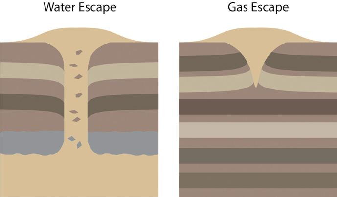
Fig. 3. Water escape and gas escape structures have distinct morphologies that occur across
(Continued from page 17...)
FLUID TYPE
WATER ESCAPE
GAS ESCAPE
Geometry Cylinder + Funnel Funnel
Feeder pipe Yes No
Extrusion structure Yes Yes
Crosscuts stratigraphy Yes No
Brecciates host sediment Yes No
Extent of deformation High Low
Post-depositional fluid conduits Good, vertically extensive Poor, vertically limited/local
through the same pipe, similar to Saucier’s (1989) observations of modern water escape structures.
Ancient Gas Escape Structures
Ancient gas escape structures are rare relative to their water escape counterparts. This is in part due to the fact that gas escape structures deform sediment at or near the surface, and thus are easily eroded or reworked over time. One of the best examples of gas escape structures occurs in the Rift Valley of Africa. Hilbert-Wolf (2016) describes “inflation structures” and surface fractures with sandstone splays. Inflation structures match many of the morphologic characteristics of gas escape structures. They taper at depth and expand in diameter at the paleosurface. Surface fractures, as the name implies, break the sediment surface and form upward lipping/tilting laminations. Dendritic sandstone splays form in association with these surface ruptures and likely represent extruded material. All of these features form at or near the sediment paleosurface (i.e., they do not have significant vertical, stratigraphic penetrations), which is consistent with physical modeling and modern analogs.
Summary and Conclusions
Physical modeling and studies of both modern and ancient deposits all demonstrate a distinct morphologic difference between gas escape and water escape structures (Table 1, Fig. 3). This is important for future outcrop studies, where proxy evidence must be collected to interpret past formation conditions. Both
gas escape structures and water escape structures can form extrusion features. At the surface they form positive-relief, conical mounds with a central pit (Saucier, 1989; Obermeier, 1996). Just below the surface these features are funnel or cone shaped. The funnel-shaped morphology is observed in physical models (Ross et al., 2011), modern studies (Obermeier, 1996a), and outcrop studies (Loope et al., 2013). However, the positive relief, aboveground, eruptive part of these features are not long-lasting.
Observations of the modern gas escapes structures at Hite, southern Utah indicate that these features easily collapse into a funnel shaped “caldera” (Livingston et al., 2014). Additionally, Pralle (2003) observed that when continuing to run the gas escape experiment after the formation of sand volcanoes that the positive-relief cones eventually disappeared. In addition to natural collapse, the positive relief sand volcanoes have a low preservation potential and are likely reworked into other deposits. It should be noted that the modern artesian spring analogs did not produce sand volcanoes (Guhman and Pederson, 1992), contrasted with the more violent seismically induced modern water escape structures which did form extrusion structures (Saucier, 1989; Obermeier, 1996b). The presence of extrusion structures therefore likely corresponds to SSD formed via overpressure (i.e., fluidization) compared to more subdued/less violent processes such as springs.
Both water and gas escape structures can have funnel shaped extrusion structures just below the surface, therefore the presence of these extrusion structures does not differentiate between the two processes. However, at depth the two processes produce different morphologies. Gas escape structures taper to a point within a few meters of the ground surface (Sherrod et al., 2016), whereas pipes have a continuing cylindrical geometry that crosscuts layered stratigraphy (Obermeier, 1996a). The cylindrical pipe is present regardless of whether the pipe reaches the surface or not (Wheatley et al., 2017). This difference between gas and water escape is likely a result of the physical properties of the two fluids (i.e., density, viscosity, compressibility, etc.). Gas does not have the “strength” to open up a conduit and continuously hold that conduit open through the layered host sediments. Therefore cylindrical pipes, which penetrate multiple sedimentary layers for tens of meters, within the outcrop studies of the Colorado Plateau, should be interpreted as water escape structures formed via liquefaction and fluidization.
Applications of Fluid Escape Structures as Post-Depositional Fluid Pathways
The differences between water escape and gas escape structures have implications for their role as fluid pathways. Water escape structures should make better postdepositional (diagenetic or secondary) fluid conduits compared to gas escape structures. Water escape structures can
TECHNICAL ARTICLE 18 RESERVOIR ISSUE 6 • NOVEMBER/DECEMBER 2017
“Lipping/tilted” stratigraphy Downward Upward
Outcrop Scales (typical diameter order of magnitude) 0.1 m – 100 m 0.1 m – 1 m
Table 1
crosscut layered stratigraphy for tens of meters (observed) to hundreds of meters (interpreted) in outcrop (Netoff, 2002; Huuse et al., 2005; Ross et al., 2011; Wheatley et al., 2016). Pipes also demonstrate significant stratigraphic penetrations on seismic cross sections (Maia et al., 2016; Moss and Cartwright, 2010b). Gas escape structures composed of coarse-grained reservoir facies typically lack the same stratigraphic penetrations, but instead form local cone-shaped features. In some cases, gas escape structures have been documented with pipe-like structures. However, the internal facies are typically composed of mud instead of sand, thereby also making them poor fluid conduits. The geometric/ morphologic differences between these features are decipherable on seismic sections if they are at a sufficient scale (Huuse and Mickelson, 2004; Kirkham et al., 2016). Where well penetrations crosscut pipes/injectites, they are composed of coarse-grained reservoir facies (Huuse and Mickelson, 2004). Overall, water escape structures will create coarse-grained pipes that extend vertically and crosscut layered stratigraphy. These features can act as porous, postdepositional fluid flow conduits increasing reservoir size and connectivity.
Acknowledgements
Generous financial support was provided by the GDL Foundation, the Rocky
Mountain Association of Geologists, the National Aeronautics and Space Administration, the Geological Society of America, the American Association of Petroleum Geologists, and the Wheaton College Scholastic Honor Society.
Bibliography
Alvarez, W., Staley, E., O’Connor, D., Chan, M., 1998. Synsedimentary Deformation in the Jurassic of Southeastern Utah—A Case of Impact Shaking? Geology 26, 579–582.
Baer, J.L., Steed, R.H., 2010. Geology of Kodachrome Basin State Park, Utah. Utah Geol. Assoc. 28, 467–482.
Braile, L.W., Hinze, W.J., Keller, G.R., Lidiak, E.G., Sexton, J.L., 1986. Tectonic Development of the New Madrid Rift Complex, Mississippi Embayment, North America. Tectonophysics 131, 1–21. doi:10.1016/0040-1951(86)90265-9
Chan, M., Kocurek, G., Netoff, D., Alvarez, W., Blakey, R., 2007. Clasticinjection Pipes and Syndepositional Deformation Structures in Jurassic Eolian Deposits: Examples from the Colorado Plateau. Am. Assoc. Pet. Geol. 233–244. doi:10.1306/1209867M871350
Chidsey, T.C., Sprinkel, D.A., Willis, G.C., Anderson, P.B., 2012. Glen Canyon National Recreation Area and Rainbow Bridge National Monument , Utah-
Arizona. Utah Geol. Assoc. 29, 1–81.
Dimitrov, L., Woodside, J., 2003. Deep Sea Pockmark Environments in the Eastern Mediterranean. Mar. Geol. 195, 263–276.
Dimitrov, L.I., 2002. Mud Volcanoes- The Most Important Pathway for Degassing Deeply Buried Sediments. Earth-Science Rev. 59, 49–76.
Dubiel, R., Huntoon, J., Stanesco, J., Hasiotis, S., 2014. Depositional Setting of the Hoskinnini Member of the Triassic Moenkopi Formation, Southeastern Utah. Utah Geol. Assoc. 43, 296–310.
Duranti, D., Hurst, A., 2004. Fluidization and Injection in the Deep-water Sandstones of the Eocene Alba Formation (UK North Sea). Sedimentology 51, 503–529. doi:10.1111/j.1365-3091.2004.00634.x
Ettensohn, F., 2015. Using Soft-Sediment Deformation to Characterize and Constrain Paleozoic, Marine, Epicontinental Seismicity: Central Kentucky Ordovician, East-Central United States. Eur. Geosci. Union Gen. Assem. 17, 6805.
Frey-Martınez, J., Hall, B., Cartwright, J., Huuse, M., 2007. Clastic Intrusion at the Base of Deep-water Sands: A Trapforming Mechanism in the Eastern
(Continued on page 20...)
TECHNICAL ARTICLE RESERVOIR ISSUE 6 • NOVEMBER/DECEMBER 2017 19
(Continued from page 19...)
Mediterranean. Am. Assoc. Pet. Geol. 49–63. doi:10.1306/1209849M873255
Frey, S.E., Gingras, M.K., Dashtgard, S.E., 2009. Experimental Studies of Gas-Escape and Water-Escape Structures: Mechanisms and Morphologies. J. Sediment. Res. 79, 808–816. doi:10.2110/jsr.2009.087
Guhman, A.I., Pederson, D.T., 1992. Boiling Sand Springs, Dismal River, Nebraska: Agents for Formation of Vertical Cylindrical Structures and Geomorphic Change. Geology 20, 8–10. doi:10.1130/0091-7613(1992)020<0008
Hannum, C., 1980. Sandstone and Conglomerate-Breccia Pipes and Dikes of the Kodachrome Basin Area, Kane County, Utah. Brigham Young University.
Hilbert-Wolf, H.L., Roberts, E.M., Simpson, E.L., 2016. New sedimentary structures in seismites from SW Tanzania: Evaluating gas- vs. water-escape mechanisms of soft-sediment deformation. Sediment. Geol. 344, 253–262. doi:10.1016/j. sedgeo.2016.03.011
Hilpert, L.S., Moench, R.H., 1960. Uranium Deposits of the Southern Part of the San Juan Basin, New Mexico. Econ. Geol. 55, 429–464.
Hubbard, S.M., Romans, B.W., Graham, S.A., 2007. An Outcrop Example of Largescale Conglomeratic Intrusions Sourced from Deep-water Channel Deposits, Cerro Toro Formation, Magallanes Basin, Southern Chile. Am. Assoc. Pet. Geol. 199–207. doi:10.1306/1209863M873265
Hunter, R.E., Gelfenbaum, G., Rubin, D.M., 1992. Clastic Pipes of Probable SolutionCollapse Origin in Jurassic Rocks of the Southern San Juan Basin, New Mexico. U.S. Geol. Surv. Bull. 1808, 1–19.
Hurst, A., Scott, A., Vigorito, M., 2011. Physical Characteristics of Sand Injectites. Earth-Science Rev. 106, 215–246. doi:10.1016/j.earscirev.2011.02.004
Huuse, M., Mickelson, M., 2004. Eocene Sandstone Intrusions in the Tampen Spur Area (Norwegian North Sea Quad 34) Imaged by 3D Seismic Data. Mar. Pet. Geol. 21, 141–155. doi:10.1016/j.
marpetgeo.2003.11.018
Huuse, M., Shoulders, S.J., Netoff, D.I., Cartwright, J., 2005. Giant Sandstone Pipes Record Basin-scale Liquefaction of Buried Dune Sands in the Middle Jurassic of SE Utah. Terra Nov. 17, 80–85. doi:10.1111/ j.1365-3121.2004.00587.x
Kirkham, C., Cartwright, J., Hermanrud, C., Jebsen, C., 2016. The spatial, temporal and volumetric analysis of a large mud volcano province within the Eastern Mediterranean. Mar. Pet. Geol. 81, 1–16. doi:10.1016/j.marpetgeo.2016.12.026
Livingston, K.M., Bogner, E., Ireland, S., Simpson, E., Betts, T., Laub, E., 2014. The Geomorphic Evolution of Shallow-Sourced Methane Produced Mud Volcanoes: Lake Powell, Hite Utah, in: Geological Society of America Abstracts with Programs. pp. 320–3.
Loncke, L., Mascle, J., Parties, F.S., 2004. Mud Volcanoes, Gas Chimneys, Pockmarks and Mounds in the Nile Deep-Sea Fan (Eastern Mediterranean: Geophysical Evidences. Mar. Pet. Geol. 21, 669–689.
Loope, D.B., Elder, J.F., Zlotnik, V.A., Kettler, R.M., Pederson, D.T., 2013. Jurassic Earthquake Sequence Recorded by Multiple Generations of Sand Blows, Zion National Park, Utah. Geology 41, 1131–1134. doi:10.1130/G34619.1
Maia, A.R., Cartwright, J., Andersen, E., 2016. Shallow plumbing systems inferred from spatial analysis of pockmark arrays. Mar. Pet. Geol. 77, 865–881. doi:10.1016/j. marpetgeo.2016.07.029
Mazzini, A., Etiope, G., 2017. Mud volcanism: An updated review. EarthScience Rev. 168, 81–112. doi:10.1016/j. earscirev.2017.03.001
Moss, J.L., Cartwright, J., 2010a. 3D Seismic Expression of Km-scale Fluid Escape Pipes from Offshore Namibia. Basin Res. 22, 481–501. doi:10.1111/j.1365-2117.2010.00461.x
Moss, J.L., Cartwright, J., 2010b. The spatial and temporal distribution of pipe formation, offshore Namibia. Mar. Pet. Geol. 27, 1216–1234. doi:10.1016/j. marpetgeo.2009.12.013
Netoff, D., 2002. Seismogenically Induced Fluidization of Jurassic Erg Sands, SouthCentral Utah. Sedimentology 49, 65–80. doi:10.1046/j.1365-3091.2002.00432.x
Nichols, R.J., Sparks, R.S.J., Wilson, C.J.N., 1994. Experimental Studies of the Fluidization of Layered Sediments and the Formation of Fluid Escape Structures. Sedimentology 41, 233–253.
Obermeier, S.F., 1996a. Use of Liquefaction-induced Features for Paleoseismic Analysis — An Overview of How Seismic Liquefaction Features Can Be Distinguished from Other Features and How Their Regional Distribution and Properties of Source Sediment Can be Used to Infer the Locat. Eng. Geol. 44, 1–76. doi:10.1016/S0013-7952(96)00040-3
Obermeier, S.F., 1996b. Using Liquefaction-induced Features for Paleoseismic Analysis, in: McCalpin, J. (Ed.), Paleoseismology. Academic Press, San Diego, CA, pp. 331–396.
Owen, G., Moretti, M., 2011. Identifying Triggers for Liquefaction-induced Softsediment Deformation in Sands. Sediment. Geol. 235, 141–147. doi:10.1016/j. sedgeo.2010.10.003
Powell, C.A., Bollinger, G.A., Chapman, M.C., Sibol, M.S., Johnston, A.C., Wheeler, R.L., 1994. A Seismotectonic Model for the 300-kilometer-long Eastern Tennessee Seismic Zone. Science (80-. ). 264, 686–688. doi:10.1126/science.264.5159.686
Pralle, N., Kulzer, M., Gudehus, G., 2003. Experimental Evidence on the Role of Gas in Sediment Liquefaction and Mud Volcanism. Geol. Soc. London 216, 159–171.
Rodrigues, N., Cobbold, P.R., Løseth, H., 2009. Physical modelling of sand injectites. Tectonophysics 474, 610–632. doi:10.1016/j.tecto.2009.04.032
Ross, J.A., Peakall, J., Keevil, G.M., 2011. An integrated model of extrusive sand injectites in cohesionless sediments. Sedimentology 58, 1693–1715. doi:10.1111/j.1365-3091.2011.01230.x
Saucier, R.T., 1989. Evidence for episodic
TECHNICAL ARTICLE 20 RESERVOIR ISSUE 6 • NOVEMBER/DECEMBER 2017
sand-blow activity during the 1811-1812 New Madrid (Missouri) earthquake series. Geology 17, 103–106. doi:10.1130/00917613(1989)017<0103:EFESBA>2.3.CO;2
Sherrod, L., Simpson, E.L., Higgins, R., Miller, K., Morgano, K., Snyder, E., Vales, D., 2016. Subsurface Structure of Water–gas Escape Features Revealed by Groundpenetrating Radar and Electrical Resistivity Tomography, Glen Canyon National Recreation Area, Lake Powell delta, Utah, USA. Sediment. Geol. doi:10.1016/j. sedgeo.2016.02.005. This Issue
Sherry, T.J., Rowe, C.D., Kirkpatrick, J.D., Brodsky, E.E., 2012. Emplacement and Dewatering of the World’s Largest Exposed Sand Injectite Complex. Geochemistry, Geophys. Geosystems 13, 1–17. doi:10.1029/2012GC004157
Tuttle, M.M., Carter, M.W., Dunahue, James, M., 2015. Paleoliquefaction Study of the Earthquake Potential of the Central
Virginia Seismic Zone. Geol. Soc. Am. Abstr. with Programs 47.
Wenrich, K.J., 1985. Mineralization of Breccia Pipes in Northern Arizona. Econ. Geol. 80, 1722–1735. doi:10.2113/ gsecongeo.80.6.1722
Wenrich, K.J., Huntoon, P.W., 1989. Breccia Pipes and Associated Mineralization in the Grand Canyon Region, Northern Arizona, in: Geology of Grand Canyon, Northern Arizona (with Colorado River Guides); Lees Ferry to Pierce Ferry, Arizona. pp. 212–218.
Wheatley, D.F., Chan, M.A., Hansford, M., Treat, I., 2014. Clastic Pipe Sources and Stratigraphic Relationships: Evidence for Multiple Liquefaction Events in the Middle Jurassic Carmel Formation, Southern Utah. Geol. Soc. Am. Abstr. with Programs 46, #242693.
Wheatley, D.F., Chan, M.A., Sprinkel,
D.A., 2016. Clastic Pipe Characteristics and Distributions throughout the Colorado Plateau: Implications for Paleoenvironment and Paleoseismic Controls. Sediment. Geol. doi:10.1016/j. sedgeo.2016.03.027
Wheatley, D.F., Chan, M.A., 2017. Clastic Pipes and Soft-Sediment Deformation of the Jurassic Carmel Formation, Southern Utah Implications for Pipe Formation Mechanisms and Host Rock Controls. In Review.
RESERVOIR ISSUE 6 • NOVEMBER/DECEMBER 2017 21
Information on abstract specifications and how to submit can be found online at www.cspg.org/CoreConference CALL FOR ABSTRACTS
WHEN LIFE GIVES YOU LEMONS… THE BOWFORT TOWERS
Clint Tippett – President-Elect, CSPG
By now you will all be familiar with the various controversies swirling around this public art project on the western edge of Calgary, near the new Canada Olympic Park interchange on the TransCanada Highway. Many of you are probably upset about the use of scarce public cash for this undertaking.
The artwork features clusters of nearvertical rusty steel beams within which are cradled large slabs of the well-known building rock called “Rundle Stone”. To be honest it does look kind of grim and ugly –but what positive aspects can we focus on to make the best of a bad thing?
“Rundle Stone” is not from Mount Rundle and it isn’t Mississippian, as in the Rundle Group. Rather it is from a Triassic deposit known as the Sulphur Mountain Formation that is quarried in a couple of places on the northeastern limb of the Mount Allan Syncline to the east and southeast of Canmore. It is primarily a thinly bedded, fine grained siltstone of marine origin and not a lake deposit, as erroneously reported by the City’s Manager of Arts and Culture. It is generally bereft of fossils. It is used as an attractive facing stone in and on many buildings, for example at the Calgary airport. Most importantly for us as geologists, however, is that it is broadly correlative with the Montney Formation
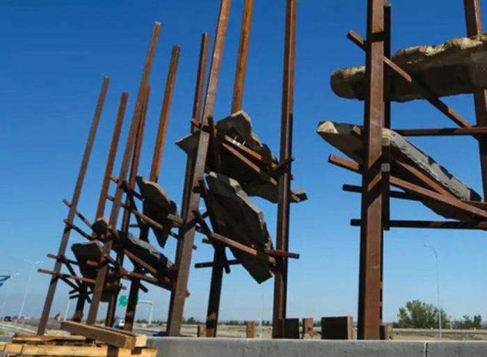
of northeastern British Columbia and northwestern Alberta where it hosts trillions of cubic feet of natural gas and billions of barrels of liquid hydrocarbon reserves.
How often are our reservoir rocks placed on a pedestal? Let’s put a positive spin on this situation and consider this artwork to be a celebration of both the geological formation itself and all the people and
companies who have worked to unlock these vast resources for our benefit. Let others think what they may.
Next time you drive by this public art display, take a minute to contemplate its significance and tip your hat to this unintentional tribute to the prolific unconventional reservoirs of Canada.


OPEN CALL FOR LECTURERS!


The CSPG University Outreach Committee is looking for lecture candidates who are fresh, energized and excited to spend time with the next generation of geologists. Our lecture tours are set up by geographical area ( East, West , Central). The lecture tours would typically happen between two timeframes: September/October, February/March. Potential lecturers would head out for a 7-day tour travelling to various universities across Canada.


If you are interested in being a lecturer please email Candace Jones at candace.jones@cspg.org today!


TECHNICAL ARTICLE 22 RESERVOIR ISSUE 6 • NOVEMBER/DECEMBER 2017
The Current State of Saskatchewan’s Oil and Gas Industry
SPEAKER
Melinda Yurkowsk, Saskatchewan Geological Survey, Saskatchewan Ministry of the Economy
November 21, 2017
11:30 am doors open
Marriot Hotel, Kensington Ballroom 110 9 Ave SE, Calgary AB T2G 5A6
Please note: CSPG member ticket price: $42.50+gst Non-member ticket price: $55+gst Please note: The cut-off for ticket sales is 1:00pm, five business days before the event. November 14, 2017. Each CSPG Technical Luncheon is 1 APEGA PDH credit. Tickets may be purchased online at www.cspg.org
ABSTRACT
The landscape of the Saskatchewan petroleum industry has changed dramatically over the past decade. In 2007, just over a quarter of the wells drilled in the province for oil and gas were horizontal, and almost a quarter of all the petroleum and natural gas wells drilled were for shallow gas. Since then, the province has seen over 26,000 wells drilled, of which nearly half have been horizontally drilled and ‘frac’d’ into the unconventional Bakken, Viking, Shaunavon, and Torquay plays. The Viking light oil play of west-central Saskatchewan has been the primary focus of oil drilling in the province over the past five years. To a slightly lesser extent, the Shaunavon oil play of southwest Saskatchewan and the Bakken, Torquay and Mississippian oil plays in the southeast corner of the province were also primary targets.
Saskatchewan’s petroleum industry saw a record year in 2014, with oil production reaching 172.9 million barrels (27.5 million cubic metres), and slightly reduced numbers since then, due to a depressed market. Still, the Mississippian in the southeast and Mannville in west-central continued to dominate Saskatchewan’s overall production.
With continued refinement of technologies required to access the petroleum resources of Saskatchewan, companies
will continue to delineate many of the known plays in the Viking, Mississippian, Bakken and Shaunavon, through infill and pool edge drilling. Companies will also increase production in the heavy oil pools through improved enhanced oil recovery technologies.
Though the bulk of activity in Saskatchewan is reliant on the known producers, many future prospects for deeper wildcat plays exist and include the Red River and the Winnipegosis inter-reef play, to name a few.
BIOGRAPHY
Melinda Yurkowski is currently the Assistant Chief Geologist, heading up the Petroleum Geology Branch in the Saskatchewan Geological Survey at Saskatchewan Ministry of the Economy. She completed her B.Sc. and her M.SC degrees in Geology at the University of Regina. Her Master’s thesis focused on understanding the reservoir conditions of the Devonian Winnipegosis pinnacle reefs in southeast Saskatchewan. She has worked in both private and public sectors and has been with the Saskatchewan Government since 1998. In 2002 she became a Senior Research Geologist with the Survey and worked primarily on the geology of the shallow and unconventional gas deposits of Saskatchewan and in 2010, took on her current role at the Subsurface Geological Lab in Regina. She is also fortunate to work a bit of geology into her schedule and is currently researching helium deposits in Saskatchewan.


1602
Calgary, AB T2E 7W3
Phone: 403-233-7729
www.tihconsulting.com
e-mail: tih@shaw.ca
RESERVOIR ISSUE 6 • NOVEMBER/DECEMBER 2017 23 TECHNICAL LUNCHEON
– 5th St N.E.
T.I.H. Consulting Ltd. Geologic Well -Site Supervision
ORGANIZATION AND REORGANIZATION OF RIVERS AND SEDIMENT ROUTING THROUGH TIME: EXAMPLES FROM THE GULF OF MEXICO MISSISSIPPI SYSTEM, GEOLOGIC PAST TO NEAR FUTURE
SPEAKER
Mike Blum, Department of Geology, University of Kansas. Lawrence, Kansas US
Time: 10:30 – 11:30 a.m.
Holiday Social, 11:30 Doors Open
Date: December 7, 2017
Location: TELUS Convention
Centre, MacLeod Halls C/D 120 Ave SE, Calgary, AB T2G 0P3
Please note: CSPG member ticket price: $60+gst Non-member ticket price: $65+gst
Please note: The cut-off for ticket sales is 1:00pm, five business days before the event. November 30, 2017. Each CSPG Technical Luncheon is 1 APEGA PDH credit. Tickets may be purchased online at www.cspg.org
The northern Gulf of Mexico (GoM) margin is dominated by the Mississippi River sediment-dispersal system. Mississippi source terrain stretches from the Rocky Mountains in the western US to the Appalachian Cordillera in the east. Sediment from this vast area is routed through the tributary system and main stem for ~5000 km to the well-known alluvial-deltaic plain of south Louisiana and the deep-water basin-floor fan. However, integration of a continental-scale Mississippi drainage is a Late Neocene phenomenon, and sediment routing to the GoM has changed significantly over time. This presentation illustrates largescale change in drainage, sediment routing, and sediment storage for the Mississippi system at 3 different time scales: (a) the last 200 Myrs, where tectonic and geodynamic processes dominate, (b) the last 200 Kyrs, where Milankovitch climate and sea-level changes dominate, and (C) the 200-yr period of the 20th and 21st centuries when human activities have fundamentally altered the sediment routing and dispersal system.
Phanerozoic drainage patterns in North America are becoming increasingly wellknown through a large number of detrital zircon studies. Following assembly of the late Paleozoic Appalachian Cordillera, much of North America drained generally west, then ultimately north to the Boreal Sea during the Late Jurassic and Early Cretaceous. This period of sediment routing, which produced much of the Mesozoic succession of the Western Canada Sedimentary Basin, met its demise with development and eastward migration of the Western Cordillera and its associated foreland-basin system, and Late Cretaceous flooding of the Western Interior Seaway. With withdrawal of the seaway, much of southern North America was then routed to the GoM, and an ancestral Mississippi was not likely present until the latest Cretaceous to early Paleocene. By this time, the Mississippi system had extended headwards into the US continental interior, with tributaries that extended from the Great Plains to the Appalachians, and was routing sediment to a large alluvial-deltaic plain and basin-floor fan in the northern GoM. However, the primary axis for GoM sediment input had its headwaters in the Western Cordillera, entered the GoM in what is now central Texas, and is now represented by the Paleocene-Early Eocene Wilcox Group of the GoM shelf and deep basin.
Milankovitch-driven global climate and sea-level changes are superimposed on these large-scale patterns of tectonicallyand geodynamically-driven drainage organization, and produce much of the details of the stratigraphic record in fluvial systems. For example, over the last 200 Kyrs, climate and sea-level changes at the glacialinterglacial scale have driven changes in discharge regimes and sediment loads that in turn have controlled morphodynamics and landscape evolution in the modern
Mississippi system. Prior to Late Neogene ice advance into the US midcontinent, much of the northern US drained to Hudson Bay and the Canadian Atlantic margin. However, ice sheets diverted Canadian and northern US drainage to the Mississippi system and the GoM, and the Mississippi adopted bipolar glacial-cold and interglacial-warm modes of behavior. The relatively long glacial periods (>70% of the time) have been characterized by cold climates with low shelf-margin sea-level positions, but also times when ice advanced from southern Canada into the Mississippi drainage, and the Mississippi River was transformed into Earth’s largest pro-glacial fluvial system, draining not only much of the US, but a large part of Canada as well. The glacial-period stratigraphic record consists of enormous braided-stream surfaces that dominate more than 1000 km of the alluvial valley: the largest and most extensive of these represent millennialscale periods of time during deglaciation, when the magnitude of meltwater floods that were routed through the Mississippi River are estimated to have been similar to the modern Amazon. The meandering systems and extensive muddy delta plain of the Holocene Mississippi are typical of the relatively short interglacial-warm periods with low global ice volumes and high sea level (<30% of the time).
Within the broader template outlined above, anthropogenic activities of the last 100 years have fundamentally altered the sediment dispersal system to the point where the lower Mississippi River and delta faces an existential crisis that will play out over the next 100 years. Sediment load has been reduced by ~50% from Holocene interglacial norms due to dam construction on upstream tributaries, and a continuous levee system along the lower Mississippi River prohibits sediment dispersal to flood basins and the subsiding delta plain.
24 RESERVOIR ISSUE 6 • NOVEMBER/DECEMBER 2017 HONORARY ADDRESS LUNCHEON
Interruptions in sediment dispersal have occurred at the same time as accelerated global sea-level rise, such that rates are now 3-4 times greater than at any time during the period of delta aggradation and progradation. Hence, in classical terms, accommodation is increasing and sediment supply is decreasing at the same time, and at rates of change that equal or exceed the extremes of natural forcing for an interglacial highstand delta system of this kind. Taking into account known rates of subsidence and conservative projections for cumulative global sealevel rise, the Mississippi now transports enough sediment to sustain only 25% of the delta plain, and a conservative estimate would be that the remainder will drown by the year 2100. With increased storm intensities from warmer oceans, as we have seen this year, the demise will more likely be step-wise and more rapid, and could be completed by the year 2050.
BIO
Mike Blum is the Scott and Carol Ritchie Distinguished Professor in Geology at the University of Kansas (KU). Mike received his bachelors, masters and PhD from the University of Texas at Austin where he developed his research interests in fluvial, coastal, and shallow-marine depositional systems, stratigraphic signatures of tectonics, climate and sea-level change, and source-to-sink routing of sediments to deepwater systems. Prior to joining KU, he was a Research Advisor at ExxonMobil Upstream Research in Houston from 20082014, where Calgary was his favorite place to visit and collaborate: his primary focus at ExxonMobil was on the development of quantitative and semi-quantitative source-to-sink concepts and models that would apply across exploration and production scales. Before joining ExxonMobil, he was Harrison Professor in Geology and Geophysics at Louisiana State University, where he worked on
evolution of the Mississippi valley and Gulf of Mexico shoreline. His current research group is something of a blend of these previous academic and industry efforts, and includes projects in various parts of the Gulf of Mexico basin, the Mesozoic US Western Interior, the Lower Cretaceous of the Western Canada Sedimentary Basin, and the Neogene to modern Himalayansourced Ganges-Brahmaputra River system and the associated deepwater Bengal Fan.


RESERVOIR ISSUE 6 • NOVEMBER/DECEMBER 2017 25
ADDRESS
Join us prior to the Honorary Address Luncheon for the annual geoLOGI C Holiday So cial Wine & Appetizers 10:30-11:30 Honorary Address 11:30 - 1:00 DECEMBER 7th, 2017
HONORARY
LUNCHEON
INTRODUCING THE CSPG OPERATIONS GEOLOGY DIVISION
Kurt Armbruster and Brad Powell, Co-Chairs
Operations Geology is an important sub-discipline in the practice of petroleum geology. Operations Geologists are uniquely involved in the drilling of a well from the initial planning stages to long after TD, when the data have been properly distributed to stakeholders, and lookbacks have been held.
Knowledge of one’s geological targets (conventional, heavy, or unconventional) is more important than it has ever been for well placement optimization, especially considering the increasing focus on horizontal drilling and multistage fracture stimulation. Beyond the typical geological capacity and experience, operations geologists must also be skillful in stakeholder management, deciphering regulatory process and approvals, well planning, drilling processes, HSE, reservoir engineering, petrophysics, production, wellbore analysis and others. These disciplines are sometimes in conflict during drilling, so prioritization and compromise of the well's objectives is also a skill.
Communication is another vital skill of the Operations Geologist. Not only does the Operations Geologist communicate with their drilling engineer, directional driller, wellsite geologist (if present), and geosteerer (if present), but also with their subsurface team, logging team, internal and external regulatory groups, as well as vendors and contractors. The Operations Geologist frequently acts as the first pointof-call in problem resolution for drilling related issues, and as a "translator" between disciplines.
A common misperception is that Operations Geology is not its own discipline. The above paragraphs suggest that the Operations Geologist is truly a generalist, and there are skillsets unique to the Operations Geologist beyond taking well calls in the middle of the night.
It is not uncommon for oil and gas
companies to place new-hire geoscientists into operations roles. Roles where they have to learn about regulatory agencies and rules, licencing wells, managing wellsite geologists, reading striplogs, the curves they see on an electronic drilling recorder screen and what curves are important to them. Operations Geology is not learned in school. It is learned through practice. It is a perfect example of the synthesis of technical proficiency and art.
The CSPG Operations Geology Technical Division is a place wherein operations geologists can meet, network, and share experiences and best practices, and provide mentorship to junior geoscientists. Our operational model follows that of the other divisions, with a meeting once per month (with summers off), with a speaker presenting to the group.
Topics are innumerable and based on real examples. They may include, but are not limited to:
• The role of an Operations Geologist in safety.
• Questions to ask your wellsite geologist to aid in your collective interpretation of well data.
• Reading/interpreting striplogs, cuttings, and cuttings technology.
• Basic training/discussion of geosteering and geosteering software.
• Critical Regulatory knowledge.
• Best practices
• Dealing with unforeseen events, stuck pipe, collapsed hole, etc.
• Logging technologies, open hole, MWN, LWD.
• Communication with drillers, directional hands, etc.
• Drilling technologies.
• Stakeholder management.
• Geohazards-identification, mitigation, avoidance.
• Data QC/QA.
• Pore Pressure/Fracture Gradient prediction.
• H2S Analysis and Regulatory
Requirements for sour wells.
• Data management and reporting.
If you have an idea for a division talk, please contact us at: cspgoperationsgeology@ gmail.com.
Please watch our website for upcoming talks in November and December:
http://www.cspg.org/CSPG/IMIS20/ Events/Division_Talks/Operations_ Geology/CSPGIMIS20/Technical/Tech_ Divisions/Operations_Geology.aspx
The CSPG Operations Geology Division has a LinkedIn group page. Join us in an online discussion at:
https://www.linkedin.com/ groups/13525146
TECHNICAL LUNCHEON 26 RESERVOIR ISSUE 6 • NOVEMBER/DECEMBER 2017


RESERVOIR ISSUE 6 • NOVEMBER/DECEMBER 2017 27 November 2nd, 2017 The Unicorn - 223, 8th Ave SW, Calgary, AB Time: 4:30 - 7:00 Free Registration for members $15 for non-members Young Geoscientists Networking Reception
31 is the deadline for making a charitable contribution for the year. Support programs that inspire and advance education, foster technical excellence and encourage awareness of petroleum geoscience; make a donation to the CSPG Foundation today to ensure you receive your charitable tax benefit for 2016. Visit www.cspg.org/foundation and click DONATE NOW. Support Geoscience Education DONATE TODAY
December
BASS TECHNICAL DIVISION TALK
Reactivation of Precambrian Basement Structures and its Effects on the Regional Sequence Stratigraphy Along the Judy Creek –Joarcam Paleoshoreline Trend, Viking Formation, Central Alberta
SPEAKER
Sarah K. Schultz, James A. MacEachern, and H. Daniel Gibson
Department of Earth Science, Simon Fraser University, Burnaby, B.C.
Time: 12:00 pm
Date: Wednesday, November 22, 2017
Location: geoLOGIC Room (2nd Floor), Aquitaine Tower, 540-5th Avenue S.W.
ABSTRACT
The Viking Formation is an internally complex succession, bounded by stratigraphic discontinuities and marking the shifting positions of the paleoshoreline throughout the Late Albian (Lower Cretaceous). Extensive research has been conducted on the formation, owing to its prolific hydrocarbon production from relatively thin, sand-rich intervals.
The study area encompasses deposits along one of the inferred forced regressive to lowstand paleoshoreline trends. The Viking is mapped along depositional strike from the Judy Creek Field (T65-63; R12-9W5) southeast towards the Joarcam Field (T51-49; R21-20W4). No published material currently exists for the intervening area between Judy Creek and Joarcam. The current study approaches the stratigraphic complexities of the Viking by using a sequence stratigraphic approach, assigning deposits using the four systems tract nomenclature. A stratigraphic framework has been proposed for the Judy Creek Field (MacEachern et al., 2012), and correlations extend southeast from this model to test the validity of the key stratigraphic contacts along strike. The reservoir deposits at Judy Creek have been interpreted to represent the lowstand position of a major relative sea-level fall. There, the remnants of a falling-stage systems tract (FSST) shoreface
passes seaward across a correlative conformity (CC) into the progradational and aggradational shoreface deposits of the lowstand systems tract (LST), and extends to its maximum regressive limit for that sequence.
Gradational stratigraphic contacts observed in the FSST and LST, such as the basal surface of forced regression (BSFR) and CC, are generally expressed as sandon-sand or mud-on-mud contacts, and tend to have cryptic physical expressions on wireline logs and in core. Conformable surfaces are identified by observing subtle facies changes that occur across the contacts. An integrated approach that includes geochemical, sedimentological, ichnological, and micropaleontological datasets have been collected, with the results from the studies intended to be used to propose a set of criteria for identifying such gradational contacts.
The Viking at Joarcam and Judy Creek are interpreted to have been deposited in a low-accommodation setting, with depositional thicknesses ranging from 15 – 25 m. However, in the intervening area, the Viking becomes anomalously thick (40 – 60 m), complicating correlations and recognition of stratigraphic surfaces along depositional strike. In order to remove the effects of post-depositional deformation, marine flooding surfaces are employed as stratigraphic datums above and below the Viking. However, as each successive datum is selected, other flooding surfaces become distorted and the resulting depositional geometries become unrealistic, indicating that there must have been syn-depositional structural readjustments that affected the accommodation space in this part of the basin. By selecting consecutive datums, parts of the Viking interval can be recognized to have accumulated prior to, during, and following structural
reactivation of basement structures that trend beneath this region. Only through such stratigraphic “serial slicing” can the geometries of the different sequences and their systems tracts be mapped accurately from Judy Creek to Joarcam.
BIOGRAPHY
Sarah Schultz is a PhD candidate at Simon Fraser University under the supervision of Dr. MacEachern. She graduated from the University of Alberta in 2014 with a BSc Specialization in Geology. Her undergraduate thesis on the Baldonnel Formation was published in the Journal of Sedimentary Research in 2016. In 2014, Sarah began her MSc at Simon Fraser University, and upgraded to her PhD in 2016. The results of these projects have been presented at 3 international conferences and 2 regional conferences.
DIVISION INFORMATION
BASS technical division talks are free. Please bring your lunch. For further information about our division, to join our mailing list, receive a list of upcoming talks, or if you wish to present a talk or lead a field trip, please contact either Steve Donaldson (BASS) at 403-808-8641, or Mark Caplan (BASS) at 403-975-7701, or visit our web page on the CSPG website at http://www.cspg.org.
28 RESERVOIR ISSUE 6 • NOVEMBER/DECEMBER 2017 DIVISION TALKS
BASS TECHNICAL DIVISION TALK
Impact of Entrained Hydrocarbon and Organic Matter Components on Reservoir Quality of Organic-Rich Shales
SPEAKER
Christopher R. Clarkson, Amin Ghanizadeh, Katherine M. Clarke, Zhengru Yang, Behrad Rashidi, Atena Vahedian, Chengyao Song, Chris Debuhr, and Behjat Haghshenas1
1 Department of Geoscience, University of Calgary, Calgary, Canada
Time: 12:00 pm
Date: Wednesday, December 6, 2017
Location: geoLOGIC Room (2nd Floor), Aquitaine Tower, 540-5th Avenue S.W.
ABSTRACT
Hydrocarbon storage capacity of organicrich shales depends on porosity and surface area for fluid (ad)sorption, whereas pore (throat) size distribution/ connectivity influences permeability. The pores in organic matter (OM) are expected to develop during thermal maturation as generated hydrocarbons are expelled from the kerogen. However, the ability of industry to optimize recovery from these reservoirs is still hampered by insufficient understanding of the effect of type/ content of entrained hydrocarbon/OM components on reservoir quality. The primary objective of the current study is therefore to investigate the impact of entrained hydrocarbon/OM on storage and transport properties of organic-rich shales. To accomplish this goal, a comprehensive dataset was collected for a diverse sample suite from a prolific Canadian organicrich shale reservoir, before and after sequential pyrolysis utilizing a new RockEval procedure (“extended slow heating” (ESH) cycle; Sanei et al., 2015). Using the ESH cycle, different hydrocarbon/OM components can be distinguished more easily during the pyrolysis process: 1) free light oil (up to 150 °C), 2) fluid-like hydrocarbon residue (FHR, 150-380 °C) and 3) solid bitumen (380-650 °C).
For a sample suite differing in organic
matter type/content (2.8-5 wt%), the evolution of petrophysical properties are quantified after being subjected to an ESH cycle. The characterization techniques at each stage are helium pycnometry (grain density, porosity); low-pressure gas (N2, CO2) adsorption (surface area, pore size distribution); crushed-rock gas (He, N2, CO2) permeability and rate of adsorption (ROA) analysis (N2, CO2) (Haghshenas et al., 2016). Organic petrology and scanning electron microscopy (SEM) analyses were further conducted to verify/support the petrophysical observations.
The present study is a continuation of previous works (Clarke et al., 2016, 2017), aiming to elucidate the impact of different type and content of entrained hydrocarbons/OM on reservoir quality of organic-rich shales. The quantification of these effects has important implications for targeting specific zones within the reservoir of interest with organic matter content/ type amenable to maximizing gas storage/ transport during cyclic solvent injection for EOR applications.
References
Sanei, H., Wood, J.M., Ardakani, O.H., Clarkson, C.R., Jiang, C., 2015. Characterization of organic matter fractions in an unconventional tight gas siltstone reservoir. Int. J. Coal Geol. 150: 296-305.
Haghshenas, B., Clarkson, C.R., Aquino, S.D., Chen. S., 2016. Characterization of multi-fractured horizontal shale wells using drill cuttings: 2. Permeability/diffusivity estimation. J. of Nat. Gas Sci. Eng. 32: 586596.
Clarke, K., Clarkson, C.R., Sanei, H., 2017. The evolution of petrophysical properties during thermal maturation: Examples from the Montney and Duvernay formations, Alberta, Canada. Presented at Geoconvention 2017 held in Calgary, Alberta, Canada, 7-9 May.
Clarke, K., Clarkson, C.R., Sanei, H., 2016. The evolution of petrophysical properties during thermal maturation: Examples from the Montney Formation, Alberta, Canada. Presented at Geoconvention 2016 held in Calgary, Alberta, Canada, 7-11 March.
BIOGRAPHY
Christopher R. Clarkson is a professor and the AITF Shell/Encana Chair in Unconventional Gas and Light Oil research in the Department of Geoscience and an adjunct professor with the Department of Chemical and Petroleum Engineering at the University of Calgary. His work focus in industry was on exploration for and development of unconventional gas (UG) and light oil (ULO) reservoirs. His research focus since coming to U of Calgary in 2009 has been on advanced reservoir characterization methods for UG-ULO, such as rate- and pressure-transient analysis, flowback analysis, and core analysis. He is also interested in simulation of enhanced recovery processes in UG-ULO, and how these processes can be used to reduce greenhouse gas emissions. Clarkson leads an industry-sponsored consortium called “Tight Oil Consortium”, focused on these (Continued on page 30...)
RESERVOIR ISSUE 6 • NOVEMBER/DECEMBER 2017 29 DIVISION TALKS
(Continued from page 29...)
research topics for unconventional light oil reservoirs in Western Canada.
Clarkson holds a Ph.D. degree in geological engineering from the U. of British Columbia, Canada, and is the author of numerous articles in peer-reviewed scientific and engineering journals. Clarkson was an SPE Distinguished Lecturer for the 2009/2010 lecture season, and is the 2016 recipient of the Reservoir Description and Dynamics Award (Canadian Region) from the SPE.
DIVISION INFORMATION
BASS technical division talks are free. Please bring your lunch. For further information about our division, to join our mailing list, receive a list of upcoming talks, or if you wish to present a talk or lead a field trip, please contact either Steve Donaldson (BASS) at 403-808-8641, or Mark Caplan (BASS) at 403-975-7701, or visit our web page on the CSPG website at http://www. cspg.org. We would like to thank geoLOGIC Systems for sponsoring the new classroom and AGAT Laboratories for sponsoring refreshments.
GEOMODELING DIVISION TECHNICAL DIVISION TALK
Geologically Consistent History Matching of SAGD Process Using Probability Perturbation Method
SPEAKER
Hojjat Khani , University of Calgary
Time: 12:00 pm
Date: Wednesday, November 29, 2017
Location: Husky Conference
Room A, 3rd Floor, +30 level, South Tower, 707 8th Ave SW
ABSTRACT
The overall objective of reservoir modeling is to reduce the uncertainty in the production forecasts by utilizing all available data to construct a calibrated reservoir model. Geological heterogeneities have a fundamental impact on the growth of the steam chamber and the performance of the SAGD. The objective of this work is to incorporate the geological heterogeneities into the history matching process using probability perturbation method (PPM) to preserve the geological consistency of the reservoir model.
PPM is a geological data integration framework which employs multiple point geostatistics (MPS) algorithm. The heart of this method is to systematically perturb the underlying probabilities used to generate the reservoir facies. PPM generally consists of two loops; an outer loop which is responsible for randomly generating a global configuration of the facies, and an inner loop which systematically perturbs the generated facies to match the dynamic data. The combination of these two iterations creates a set of realizations that preserve the geological information.
In this paper, a training image is built based on a 3D outcrop description of a meandering channelized reservoir that is analogous to some of the Canadian heavy-oil fields. All other available data including reservoir properties at well locations, seismic volumes and production data are also incorporated into the PPM framework for this history matching process. The reservoir model is characterized by three facies: clean
30 RESERVOIR ISSUE 6 • NOVEMBER/DECEMBER 2017 DIVISION TALKS
Figure 1: Perturbation of initial realization based on different perturbation parameters
sand, medium grained sandstone and silt, which have different porosity, horizontal permeability and vertical permeability. The SAGD performance is a function of steam chamber development, which depends on the level of heterogeneity in the reservoir.
The results show that the heterogeneity distribution has a large impact on the fluid flow at different stages of production.
Small scale heterogeneities influence the steam chamber development and fluid flow near the wellbore area, while large scale heterogeneities highly impact the oil recovery during the whole recovery process.
The results show that such complexities can be well preserved during the history matching process using PPM by generating the geological patterns depicted in the training image. PPM is shown to be an efficient approach for the history matching in presence of complex reservoir geology.
BIOGRAPHY
Hojjat is a PhD candidate at the Department of Chemical and Petroleum Engineering, University of Calgary. He is a member of “Reservoir Simulation, Advancing Energy Recovery Processes” and “Interactive Modeling, Visualization & Analytics” groups. Hojjat holds BSc and MSc degrees in Petroleum Engineering from Sharif University of Technology, Tehran, Iran. He has 4 years of industrial experience with Sinopec International Petroleum E&P Corporation, POGC and RIPI as a reservoir simulation engineer and programmer. His research interests are Reservoir Modeling and Simulation, Geostatistics, Machine Learning, Decision Making under Uncertainty, Reservoir Visualization and Analytics.
RESERVOIR ISSUE 6 • NOVEMBER/DECEMBER 2017 31 DIVISION TALKS
Figure 2: Schematic cross-section in a point bar (Deschamps et al., 2012)
Figure 3: Training image consisting of three facies
ALBERTA PALAEONTOLOGICAL SOCIETY DIVISION TALK
Exploring the fossils of the Middle East Anticlines
In addition to the main presentation by James Campbell, Robert Kuchinski will provide a brief presentation.
SPEAKER
Robert Kuchinski, retired sedimentary geologist, Calgary, Alberta
Time: 7:30 pm
Date: November 17, 2017, 7:30 pm
Location: Mount Royal University, Room B108
ABSTRACT
One of the most well-known features of Middle East geology are the numerous anticline structures that are common in many of the countries near the Persian Gulf. These anticlines, which formed due to the folding and thrusting of the Arabian plate and salt movements in the subsurface, are very well defined and form the immense petroleum traps in the region. They are also expressed on the surface, and are excellent places to explore the late Mesozoic and Cenozoic sediments and fauna of the Arabian plate.
For the most part, the sediments in the section are carbonates that formed on a large passive margin of Gondwana that was positioned in the equatorial waters of the ancient Tethys sea. Today, the arid climate of Arabia with the lack of vegetation and the slow rate of chemical weathering, make these outcrops well exposed and easy to view their areal extent.
Although this depositional environment is comparable to the Devonian and Mississippian of Western Canada, the fossils preserved in these rocks are much younger and represent ancestors to many of todays marine organisms. For that matter, the sediments of the same age in Western Canada are either representative of a different sedimentary environment, or not present due to erosion.
This presentation will introduce the basic elements of Middle East geology and discuss the various life forms that flourished in this region starting from about 70 million years ago to about 20 million years ago. Anticlines in both the United Arab Emirates and Qatar will be discussed with many informative photos and diagrams to illustrate the stratigraphy and structure of these interesting features. A few specimens of the fossils from these locations will be available to examine.
BIOGRAPHY
Robert Kuchinski received a BSc (Specialization in Geology) from the University of Alberta in 1979. He spent his entire career working in Formation Evaluation where he assumed various roles from doing field work to senior management positions with international service companies.
For 28 years until 2006, Robert was based out of Calgary and worked throughout the western Canada sedimentary basin doing wellsite geology and petrophysics. In 2006, he accepted a business development position with Weatherford International which led him to Dubai, UAE.
For the next 10 years, he traveled extensively throughout the Middle East, North Africa, and Asia working with oil companies on Formation Evaluation challenges. During this time, he was active in various professional societies and is currently the past president of the American Association of Petroleum Geologists, Middle East region.
He returned to Canada in 2016 and is currently retired and living in Calgary.
DIVISION INFORMATION
This event is presented jointly by the Alberta Palaeontological Society, the Department of Earth and Environmental Sciences at Mount Royal University, and the Palaeontology Division of the Canadian
Society of Petroleum Geologists. For details or to present a talk in the future, please contact CSPG Palaeontology Division Chair Jon Noad at jonnoad@hotmail.com or APS Coordinator Harold Whittaker at 403-2860349 or contact programs1@albertapaleo. org. Visit the APS website for confirmation of event times and upcoming speakers: http://www.albertapaleo.org/.
32 RESERVOIR ISSUE 6 • NOVEMBER/DECEMBER 2017 DIVISION TALKS
ALBERTA PALAEONTOLOGICAL SOCIETY DIVISION TALK
Plesiosaur (Reptilia: Sauropterygia) body size comparisons between marine and non-marine depositional environments
SPEAKER
James Campbell, Ph.D. candidate, University of Calgary
Time: 7:30 pm
Date: November 17, 2017, 7:30 pm
Location: Mount Royal University, Room B108
ABSTRACT
Plesiosaurs are a bizarre group of aquatic reptiles that lived from the Late Triassic to the Late Cretaceous, and achieved a global distribution. They were generally largebodied (up to 15 m), and ecomorphologically unique, with a proportionately short trunk and tail, four flippers for underwater flight, and a neck of variable length, including the longest ever evolved. Plesiosaurs are known predominantly from marine deposits, but are also known sparingly from non-marine units such as the Late Cretaceous (Campanian) Dinosaur Park Formation (DPF) of southern Alberta. The DPF represents a fluvial to estuarine environment, which was situated along the western shore of the expansive Western Interior Seaway (WIS) of North America.
The DPF includes an elasmosaurid (longnecked) plesiosaur assemblage composed of individuals of variable size, and likely growth stage, based on the differing degree to which their external features are developed. This assemblage is unusual, however, as large plesiosaur specimens, such as those found in the more offshore Bearpaw and Pierre formations of the WIS, are conspicuously absent. The relatively small-bodiedness of the DPF assemblage may be attributable to immaturity, or alternatively, to the presence of a smallbodied elasmosaurid taxon in this formation.
A preliminary assessment of some of the largest DPF specimens suggests that they may belong to the subadult to adult range,
which would indicate the presence of a smallbodied elasmosaurid taxon inhabiting a non-marine environment. However, this possibility requires further exploring and testing via ongoing histological analysis of plesiosaur specimens from the Dinosaur Park, Bearpaw, and Pierre formations of western Canada. This study represents a rare opportunity to study the palaeoecology of non-marine plesiosaurs, which may have had greater constraints on body size than those inhabiting deeper marine settings.
BIOGRAPHY
James is originally from Ottawa, where he completed his B.Sc. (2011) and M.Sc. (2014) in the Department of Earth Sciences at Carleton University. For his B.Sc. with Dr. Claudia Schröder-Adams, James examined a fossilized assemblage of foraminifera, which served to better constrain the age of a Cretaceous marine basin (Eagle Plain Basin, Yukon Territory) – part of the northern end of the Western Interior Seaway. During his fieldwork in the Yukon, he also discovered a fossil vertebra of a marine reptile, which turned out to be the first plesiosaur fossil from that territory. For his M.Sc. with Drs. Schröder-Adams and Michael Ryan, he conducted a systematic re-evaluation of the horned dinosaurs Chasmosaurus and Vagaceratops from the Late Cretaceous of Alberta. For his doctoral work in the Department of Biological Sciences at the University of Calgary, under the supervision of Dr. Jason Anderson, James is re-visiting plesiosaurs and studying body size differences between marine and nonmarine forms from the Late Cretaceous of North America. On the side, James enjoys camping, marathon running, and playing the bagpipes.
INFORMATION
This event is presented jointly by the Alberta Palaeontological Society, the Department of Earth and Environmental Sciences at Mount Royal University, and the Palaeontology Division of the Canadian
Society of Petroleum Geologists. For details or to present a talk in the future, please contact CSPG Palaeontology Division Chair Jon Noad at jonnoad@hotmail.com or APS Coordinator Harold Whittaker at 403-2860349 or contact programs1@albertapaleo. org. Visit the APS website for confirmation of event times and upcoming speakers: http://www.albertapaleo.org/.
RESERVOIR ISSUE 6 • NOVEMBER/DECEMBER 2017 33 DIVISION TALKS
STRUCTURAL GEOLOGY DIVISION TALK
The Hydraulic Fracture – Natural Fracture Network Configuration in Shale Reservoirs: Identifying Limiting Factors
SPEAKER
William Jamison, The Upper Crust Inc. & Ali Azad, Shell Canada
Time: 12:00 pm
Date: Wednesday, November 1, 2017
Location: Schlumberger, Second
Floor of the Palliser One Building, 125 9th Ave, Calgary T2G 0P6
ABSTRACT
When a hydraulic fracture (HF) is propagated in a shale reservoir, it may deflect and branch via intersections with natural fractures (NF) that exist in the shale, resulting in a dispersed HF-NF network and an enlarged simulated rock volume. This presentation explores geomechanical and geological factors that influence the HF-NF network configuration.
NF in unconventional shale reservoirs are commonly infilled with mineral cement or have extremely narrow apertures. They are poor conduits for fluid movement but can be weak surfaces in the rock body that may open during HF stimulation. A HF can dilate the NF and deflect into the plane of a NF that
it intersects only if the HF fluid pressure at the intersection exceeds the in situ normal stress resolved on the NF surface plus the strength of any mineral cement. The in situ stresses, the tensile strength of the NF and then net pressure (Pnet = HF fluid pressure -Shmin) at the propagating front of the HF set limits on the range of NF orientations that can dilate and deflect the HF. A resolved stress plot facilitates assessment of the many geomechanical factors affecting the HF-NF interaction.
The overall HF-NF network is composed of the main HF plus branches comprising NF that have dilated, connected by HF segments. A series of geometric models of NF populations demonstrate how the orientation and size distribution of the NF in the shale, and the intensity of their development, limit the lateral spread of these branches. A broad dispersion of the HF-NF network is favored by a low in situ differential horizontal stress (ΔSh = SHmax-Shmin) and a high intensity of large and weakly cemented NF that are favorably oriented for dilation. Contrary conditions narrow the potential dispersion of the HFNF network.
Reference: Jamison, W.R. & A. Azad, in press. The hydraulic fracture – natural fracture network configuration in shale reservoirs: Geological limiting factor. Journal of Petroleum Science and Engineering
BIOGRAPHY
William (Jamie) Jamison is a consulting structural geologist. He received his B.S. from Georgia Tech, M.Sc from University of Calgary and PhD from Texas A&M University. He spent 14 years in research and exploration with major oil companies and 6 years as an associate professor at MUN before establishing his consulting company, The Upper Crust Inc., in Calgary in 1996.
DIVISION INFORMATION
Talks are free; please bring your lunch. If you would like to be on the Structural Division e-mail list, or if you'd like to give a talk, please contact Darcie Greggs (darcie. greggs@huskyenergy.com) or Pat Fothergill (pfothergill9@gmail.com). Division policy is that no photos or videos of the presentations are permitted.

34 RESERVOIR ISSUE 6 • NOVEMBER/DECEMBER 2017 DIVISION TALKS
2017 CSPG Squash Tournament Save the Date! February 1-3, 2018 Registration will be open in December!
STRUCTURAL GEOLOGY DIVISION TALK
Horizontal detachments, planes of weaknesses and layer-parallel shortening in shale: recognition criteria and potential impact on hydrocarbon exploration and production
SPEAKER
Jean-Yves Chatellier
Time: 12:00 pm
Date: Thursday, December 14, 2017
Location: Schlumberger, Second
Floor of the Palliser One Building, 125 9th Ave, Calgary T2G 0P6
ABSTRACT
Shale units are commonly the place of predilection for horizontal detachments. Their occurrence during geological time or induced by human operations is reviewed. Their expression and our understanding of the mechanisms involved will be addressed using a series of examples from Canada, South America and South-East Asia.
Analogues include outcrops from the La Borracha Island (Venezuela), Miri anticline (Sarawak), Quito Road Cut, core observations from various locations and well data from the Western Canadian Sedimentary Basin.
Horizontal detachments can disrupt and misalign faults and fractures by displacing, the rock units or layers located above and below the detachment. These
displacements may have effects on sealing capacity, migration paths, fracture density, fracture orientation and fraccability; they also play an important role of locking other faults. Each of these issues will be reviewed with examples.
In rocks units adjacent to horizontal detachments, diagenesis associated with pressure solution and slickensides commonly affect negatively the reservoirs with quartz-cement precipitation; such highly cemented zones can create seals and in other cases hydraulic frac barriers.
High-density tensile fractures are also commonly associated with layer-parallel shortening along shale-bed interface. Such mechanisms are best observed and illustrated in cores and with image logs; however, the extent of the enhanced porosity zones i clearly revealed and mapped by recognition of some abnormal pattern on porosity logs.
Some mega detachments have been identified in the Western Canadian Basin. After palinspastic reconstruction along horizontal planes, well-defined aeromag structures and hydrocarbon pools are getting perfectly aligned. Blow-outs and very high pressure gas kicks could be
prevented as they are often associated with detachments and very low angle planes that can be “mapped” in 3-D.
BIOGRAPHY
Jean-Yves Chatellier graduated in geology from Lille, received an MSc in sedimentology from Calgary and MSc and PhD in structural geology from Paris. He worked around the world for Shell before taking a senior advisor position for the research lab of PDVSA in Venezuela. After seven rewarding years, and the discovery of two giant oil fields he left the country during the national strike to settle down in Calgary. There, at Talisman he worked on new play concepts and on unconventional plays of the Utica, Montney, Duvernay, Marcellus and Eagle Ford and has been recently involved in the Horn River and in the Permian Basin for various oil companies.
DIVISION INFORMATION
Talks are free; please bring your lunch. If you would like to be on the Structural Division e-mail list, or if you'd like to give a talk, please contact Darcie Greggs (darcie. greggs@huskyenergy.com) or Pat Fothergill (pfothergill9@gmail.com). Division policy is that no photos or videos of the presentations are permitted.
RESERVOIR ISSUE 6 • NOVEMBER/DECEMBER 2017 35 DIVISION TALKS
2017 – FROSTY SUNSHINE ARRIVES FOR THE CSPG MIXED GOLF TOURNAMENT
By: David Middleton & Brenda Pearson, 2017 co-chairs, CSPG Mixed Golf Committee
The 28th Annual CSPG Mixed Golf tournament was held 25 August under blue skies and plenty of sunshine. The day even warmed up to a pleasant 26° C after a 90 minute frost delay due to the overnight low of 6° C, which gave the greens time to warm up and receive attention from the Lynx Ridge ground crew. We are pleased to report on a successful tournament, despite both a drop in attendance due to many members being unable to participate, and a corresponding drop in sponsorship.
The 68 CSPG members, sponsors and guests finally managed to put driver to ball at 9:25 in the sunshine, and the Lynx Ridge course was in great shape and the best ball tournament concluded in a little over 4.5 hours. The team low net trophy and tournament winner was the team of Deno Adams, Darren Payne, Sam Quantz & Lois Zver. The low gross score trophy was taken by the team of Colin Thiessen, Terry Dey, Foon Der and Andrea Henry, and the Spirit Award “fossil coprolite” trophy went to the most honest team of Brenda Pearson, Bob Earle, Richard Nash and Don Zver.
While our industry is in trying times, our great sponsors came through, and we appreciate each and every one of them. The on-course beverage cart was sponsored by geoLOGIC Systems, who provided much appreciated drinks and food throughout the course. All teams enjoyed a hot breakfast provided by, used golf carts sponsored by Chinook Consulting Services, and benefited from visiting hospitality tents and skill/ challenge contests provided by AGAT Laboratories Hole-in-One contest and the BrokerLink meet and greet hole. Prize holes were additionally sponsored by Belloy Petroleum Consulting, Birchcliff Energy, MJ Systems, ProGeo Consultants and Sproule Associates Ltd. We certainly appreciated the prize donations by Baker Hughes, Cougar Consulting Inc, DigitCore Laboratories, Hawk Machine Works, Loring Tarcore, NOV Wellbore Technologies, Noyes Engineering,
36 RESERVOIR ISSUE 6 • NOVEMBER/DECEMBER 2017
SOCIETY NEWS
2017 High Gross Team
2017 Low Gross Team
Roke Technologies, Schlumberger Information Solutions, Sifton Petroleum, Trimble Engineering, Typhoon Energy, and the always popular Belloy Petroleum Consultants cooler filled with beer.
During the delicious banquet steak dinner, the pictures taken by GeoLOGIC were shown on the large screen for all to enjoy. Belloy Petroleum’s (Brian Fyke) weekend survival kit of a cooler filled with beer was won by David Middleton. Skill prizes were
awarded to golfers, and there was certainly some confusion as to which gender some members were putting their names down for awards, but the committee assigned the prizes to what was felt to be the valid winners at the events.
In the end, the members, guests, sponsor players and representatives enjoyed a great day catching up with colleagues, making new friends, and succeeded in raising over $1400 to support the educational and
outreach activities of the CSPG.
I would like to thank the many sponsors, golfers, and the greens-keeping, pro shop and catering team at Lynx Ridge Golf course and especially the fine organizing committee of co-chair Brenda Pearson (registration), Darin Brazel (sponsorship), Norm Hopkins (trophies), Jeff Boissonneault (signage) and our CSPG office support from Kristy Casebeer. A big thank you to our photographer, Adam MacDonald of Roke Technologies, and the geoLOGIC team for all the pictures taken. Hopefully, by the time this is published, all the pictures taken by various groups (thanks geoLOGIC) will be on the CSPG website.
Attending members and sponsors overwhelmingly expressed their enthusiastic support for continuation of the event, and we will plan for the tournament in 2018. We look forward to your attendance at next year’s tournament tentatively set for Friday, 24 August 2018 as we celebrate the 29th Annual tournament.
RESERVOIR ISSUE 6 • NOVEMBER/DECEMBER 2017 37 SOCIETY NEWS
SAVE THE DATE Gussow Conference 2018 - October 8 - 11, 2018 Closing the Gap III: Advances in Applied Geomodeling for Hydrocarbon Reservoirs Lake Louise, Alberta
2017 Low Gross Team
BULLETIN OF CANADIAN PETROLEUM GEOLOGY –EDITORIAL TRANSITIONS
It has often been noted that our Bulletin’s long publication history is a strongly positive aspect for authors to consider when deciding where to publish, as their publication will be part of an unbroken legacy of petroleum geology-related work.
The transition of the Bulletin from a print journal to a fully digital “e-journal” has occurred over the last decade due to the efforts of successive Bulletin co-editors, with the support of the Executive Committee of the CSPG. In previous “Editorial Comments” it was noted that the advent of the “e-journal” has given rise to many new petroleumrelated journals that compete with the Bulletin for author submissions. Due to the efforts of previous and present Bulletin co-editors, the Bulletin has maintained its status as a premier, peer-reviewed, scientific journal dealing with petroleum geologyrelated studies emphasizing Canadian examples. This could not have been possible without the able participation of more than twenty Associate Editors and the volunteer efforts of a great many reviewers for submitted manuscripts.
At present, editorial duties are shared by Hairuo Qing (U. of Regina), who has been co-editor for two years, and by Bernard Guest (Calgary). Dr. Guest has recently assumed the co-editorship of former coeditor David Morrow (Geological Survey of Canada) in a transition period extending through 2017. These editors oversee all manuscripts submitted to the Bulletin, as
well as having primary responsibility for the daily operation of the on-line editorial management system of the Bulletin.
CSPG members interested in submitting articles to the Bulletin should first carefully review the “BCPG Guidelines for Authors” for guidance in preparing a manuscript. These guidelines may be found under “Publications” and “Bulletin Submissions” on the CSPG website. Authors should also be aware that in addition to full-length articles, the Bulletin also publishes short topical articles (BCPG Explorations). The Bulletin is somewhat unusual in allowing publication of lengthy articles that exceed the length
requirements of many scientific journals.
Our editorial team is ready to help you achieve your goal of publishing in the foremost Canadian journal concerning petroleum geology. Our heartfelt thanks are extended to Bernard Guest for assuming the Calgary-based co-editorship role in managing the Bulletin, as well as to Hairuo Qing for his on-going co-editorship, and to David Morrow, the outgoing Calgary-based Co-editor. It is our fervent hope that in the future, others will provide their expertise and time to volunteer as co-editors and maintain the legacy of the Bulletin.
38 RESERVOIR ISSUE 6 • NOVEMBER/DECEMBER 2017
SOCIETY NEWS
Photo by: Hairuo Qing, Bernard Guest and David Morrow (Bulletin co-editors)
2017 CORE CONFERENCE WRAP UP
The 2017 CSPG Core Conference once again demonstrated the teamwork, creativity, and resilience of the Canadian petroleum geoscience community. On May 18th and 19th, 2017, N 616 geologists, geophysicists, geochemists, petrophysicists, students and more congregated at the AER Core Research Center to view and discuss 27 cores representing the diversity of potential in the Western Canada Sedimentary Basin.
Cores were presented from the Montney, Viking, Spirit River, Horn River, oil sands formations and more, displaying unconventional and conventional reservoirs, incorporating chemostratigraphy, petrophysics, x-ray fluorescence, steam dynamics, stratigraphy and facies characterization. As well, a few distinct topics represented the wide range of geologic work outside of exploration such as carbon capture and storage and overburden characterization.
Fuel for our curiosity was generously provided by Core Laboratories, AGAT, and Weatherford. The coffee and baked goods provided by Core Laboratories were enjoyed by everyone. The Weatherford BBQ lunches provided ample opportunity to discuss core and network with friends and colleagues across the industry. In order to avoid potential inclement weather, the AGAT Laboratories Core Meltdown was held in the University of Calgary Ballroom, where the award for best student presentation went to Scott MacKnight and his presentation on the
Lodgepole Formation Souris Valley Beds: A New Approach to Describing Fine-Grained Sedimentary Rock in Core, and best overall presentation went to James MacEachern and his talk on A Forced Regressive Asymmetric Delta of the Lower Cretaceous Viking Formation, Kaybob-Fox Creek Fields, Alberta.
The CSPG and the 2017 Core Conference Organizing Committee wishes to thank all of the presenters, all of the sponsors ( Tourmaline Oil Corp., AGAT Laboratories,
Weatherford, Loring Tarcore, Progress Energy and Core Laboratories), the volunteers, and of course the AER Core Research Center for making this incredible conference a reality. Preparation is underway for the 2018 CSPG Core Conference, continuing the this worldclass event, where you can see hundreds of metres of core, network and enjoy the company of colleagues, and celebrate the never-ending puzzles our industry gives us to solve
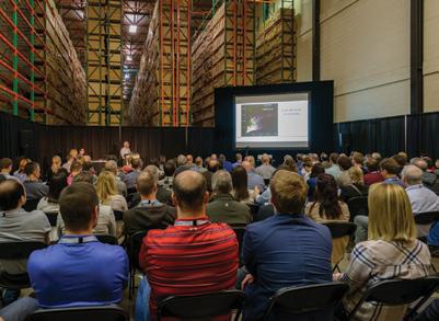
RESERVOIR ISSUE 6 • NOVEMBER/DECEMBER 2017 39 SOCIETY NEWS
Photo by: David Thorsell
Photo by: Zekai Jia
Photo by: Zekai Jia


Did you know there is over $20,000 available in CSPG awards and scholarships?! STUDENTS! Please visit www.cspg.org/students for more information Scholarship/Award Amount Available Application Deadline Regional Graduate Student Scholarships ($2,500 x 4) January 19, 2018 Undergraduate Student Awards ($1,000 x 4) January 19, 2018 Student Event Grants ($1,000 x 5) March 16, 2018 Andrew Baillie Award ($1,000 x 2) GeoConvention 2018
