


Focus, quality and value. We don’t build our reputation on volumes—instead, we earn it on the quality of the information we extract from that data. For more than 75 years, IHS has processed and analyzed vast amounts of raw data, concentrating it into the in-depth, actionable information that is used today to advance energy-critical business decisions. Energy information, refined.
ihs.com/refined-information/cspg


CSPG OFFICE
#600, 640 - 8th Avenue SW
Calgary, Alberta, Canada T2P 1G7
Tel: 403-264-5610 Fax: 403-264-5898
Web: www.cspg.org
Office hours: Monday to Friday, 8:30am to 4:00pm
Executive Director: Lis Bjeld
Email: lis.bjeld@cspg.org
Sponsorship & Outreach Coordinator: Alyssa Middleton
Email: alyssa.middleton@cspg.org
Publications Coordinator: Caitlin Young
Email: caitlin.young@cspg.org
Member Services Coordinator: Kasandra Klein
Email: kasandra.klein@cspg.org
Registration Coordinator: Dayna Rhoads
Email: dayna.rhoads@cspg.org
Convention Contacts:
Convention Manager: Aileen Lozie
Email: aileen.lozie@cspg.org
EDITORS/AUTHORS
Please submit RESERVOIR articles to the CSPG office. Submission deadline is the 23rd day of the month, two months prior to issue date. (e.g., January 23 for the March issue).
To publish an article, the CSPG requires digital copies of the document. Text should be in Microsoft Word format and illustrations should be in TIFF format at 300 dpi., at final size. For additional information on manuscript preparation, refer to the Guidelines for Authors published in the CSPG Bulletin or contact the editor.
Technical Editors
Ben McKenzie Colin Yeo (Assistant Tech. Editor) Tarheel Exploration EnCana Corporation
Tel: 403-277-4496 Tel: 403-645-7724
Email: bjmck28@shaw.ca Email: colin.yeo@encana.com
Coordinating Editor
Caitlin Young, Publications Coordinator, CSPG Tel: 403-513-1227, Email: caitlin.young@cspg.org
ADVERTISING
Advertising inquiries should be directed to Caitlin Young, Tel: 403-513-1227, email: caitlin.young@cspg.org. The deadline to reserve advertising space is the 23rd day of the month, two months prior to issue date.
The RESERVOIR is published 11 times per year by the Canadian Society of Petroleum Geologists. This includes a combined issue for the months of July and August. The purpose of the RESERVOIR is to publicize the Society’s many activities and to promote the geosciences. We look for both technical and non-technical material to publish. Additional information on the RESERVOIR’s submission guidelines can be found at http://www.cspg. org/publications/pubs-reservoir-submissions.cfm.
The contents of this publication may not be reproduced either in part or in full without the consent of the publisher. Additional copies of the RESERVOIR are available at the CSPG office for $6.50 each. No official endorsement or sponsorship by the CSPG is implied for any advertisement, insert, or article that appears in the Reservoir unless otherwise noted. All submitted materials are reviewed by the editor. We reserve the right to edit all submissions, including letters to the Editor. Submissions must include your name, address, and membership number (if applicable). The material contained in this publication is intended for informational use only.
While reasonable care has been taken, authors and the CSPG make no guarantees that any of the equations, schematics, or devices discussed will perform as expected or that they will give the desired results. Some information contained herein may be inaccurate or may vary from standard measurements. The CSPG expressly disclaims any and all liability for the acts, omissions, or conduct of any third-party user of information contained in this publication. Under no circumstances shall the CSPG and its officers, directors, employees, and agents be liable for any injury, loss, damage, or expense arising in any manner whatsoever from the acts, omissions, or conduct of any third-party user.


CSPG EXECUTIVE
PRESIDENT
Kirk Osadetz • Geological Survey of Canada, Calgary kosadetz@nrcan.gc.ca Tel: (403) 289-9022
VICE PRESIDENT
Robin Mann • AJM Petroleum Consultants rcmann@ajma.net Tel: (403) 648-3210
PAST PRESIDENT
John Varsek • Cenovus Energy john.varsek@cenovus.com Tel: (403) 645-5417
FINANCE DIRECTOR
Darren Aldridge • Baker Hughes Incorporated darren.aldridge@bakerhughes.com Tel: (403) 537-3400
ASSISTANT FINANCE DIRECTOR
Andrea Hood • geoLOGIC Systems Ltd.. ahood@geologic.com Tel: (403) 262-1992
PROGRAM DIRECTOR
Brett Norris • TransGlobe Energy Corp. brettn@trans-globe.com Tel: (403) 264-9896
ASSISTANT PROGRAM DIRECTOR
Jon Noad • Murphy Oil Corporation jon_noad@murphyoilcorp.com Tel: (403) 294-8829
SERVICES DIRECTOR
Chris Seibel • Nexen Inc. chris_seibel@nexeninc.com Tel: (403) 699-4558
ASSISTANT SERVICES DIRECTOR
Michelle Hawke • Apache Canada Ltd. Michelle.Hawke@apachecorp.com Tel: (403) 261-1200
COMMUNICATIONS DIRECTOR
Jim Barclay • ConocoPhillips Canada
Jim.E.Barclay@conocophillips.com Tel: (403) 532-3889
ASSISTANT COMMUNICATIONS DIRECTOR
Stephen Hubbard • University of Calgary steve.hubbard@ucalgary.ca Tel: (403) 220-6236
OUTREACH DIRECTOR
Steve Dryer • Whiskey Jack Resources Inc. whiskeyjackresources@telus.net Tel: (403) 969-2292
ASSISTANT OUTREACH DIRECTOR
Simon Haynes • Statoil Canada Ltd. sihay@statoil.com Tel: (403) 724-0364
A message from Finance Director, Greg Lynch
Going forward the CSPG is in good shape financially, registering a net surplus in 2010. This marks a much-needed recovery after two successive years of losses in fiscal 2008 and 2009. With the books now closed for 2010, the review engagement with Kenway Mack Slusarchuk Stewart LLP registered a tidy profit of $212,270 for the CSPG. This may sound like a lot for a non-profit society, but it does not entirely recover our recent losses. The break-even target is really just a smoothing of the highs and lows through a successive number of years, and needs to be framed within a mid-term perspective. You might wonder then, how have we managed our past losses and who pays the bills during deficit years? Unlike most oil and gas companies we have no real material assets, properties, or production to draw on. Instead we have what’s referred to within the Executive Committee as the ‘Rainy Day Fund’ (RDF), which is accessible for covering deficits, and was established through the prudence and wisdom of past Executive Committees. And am I glad they did – because after four years of serving on the Executive I know that the RDF has covered shortfalls on a number of occasions, a necessary tool to be sure. Presently the RDF is invested in stocks and bonds (40:60 split) and has a value of approximately $700K. This too might sound like a lot of money for an organization that has an annual revenue near two and a half million dollars. However, the RDF is at a level that would cover the CSPG’s uninsured financial exposure in terms of certain contracts, agreements, and commitments to staff or other. Disaster planning is in fact part of our responsibility, and after drawing up the ‘what if’ or risk register, the need for the RDF at these levels becomes evident. Should the RDF grow beyond its intended use then some of it could be redirected into new worthwhile initiatives such as in Outreach, office or capital needs, IT and the website, or if other special requirements arise in what is a rapidly changing energy world.
CSPG has also contributed to the CSPG Educational Trust Fund in the past and assists in current fundraising. Due for an overhaul and at the top of this list is the website, to which funds have been earmarked and work begun within the CSPG’s 2010 Technical Revitalization initiative. At this point I would certainly like to thank the CSPG staff, as it is important for the members to know that our financial turnaround is directly due to their contributions through running a better business, with cost cutting and augmenting operating revenues. This has come about as a team effort and by the clear direction, leadership, and financial acumen of Executive Director Lis Bjeld. Furthermore I would like to thank all the committees, divisions, programs, and convention for also contributing to a good financial performance by executing the plan and delivering on budget.
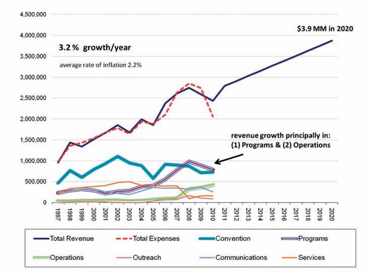
Speaking of the rapidly changing energy world, part of knowing where you are going is gained from looking back to where you have been. As such, for planning purposes, the Finance Committee recently compiled data from 2000-10 in order to project forward for the next decade, to 2020. Predicting the future is never easy (we would all be rich!), but strategy and planning are essentially a means of preparing for the future, if not shaping it outright. We all need direction. Typically the Executive Committee has two full-day strategy meetings each year, in the spring and fall, where we hole-up at the President’s house or other venue on a Saturday, with a too-big agenda. Compiled trends in finance have been quite revealing, and are summarized at a high level in the attached graph (Figure 1, page 7). Over the last decade total revenue and expenses have grown significantly, each starting at about $1.5 million in 2000, rising to over $2 million in 2010, a 30% increase. The rate of increase has been approximately 3.2% per year, which translates to accelerating increments of an additional $50-60K with each new budget.
(Continued on page 7...)

AAPG
AGAT LAborATories
APAche cAnAdA LTd.
APeGGA Arc FinAnciAL corPorATion
AryTon consuLTinG exPLorATion LTd.
bAker ATLAs
bLuebAck reservoir
boyd PeTroseArch
cAnAdA brokerLink
cAnAdiAn nATurAL resources LTd.
cAsey & AssociATes
cenovus enerGy inc.
cGG veriTAs
coLorAdo schooL oF mines
conocoPhiLLiPs cAnAdA LimiTed devon cAnAdA corPorATion
divesTco inc.
encAnA
enerPLus resources Fund
FuGro Airborne surveys corP.
FuGro – JAson
GeoedGes inc.
geoLoGic systems ltd.
GeomodeLinG TechnoLoGy corP.
GeosTrATA resources inc.
hALLiburTon enerGy services
hunT oiL comPAny oF cAnAdA husky enerGy inc.
ihs
imPeriAL oiL resources
LArio oiL & GAs comPAny
LiTTLe rock documenT services
LorinG TArcore LAbs LTd.
mJ sysTems
murPhy oiL comPAny
neurALoG
nexen inc.
Penn WesT enerGy TrusT
PeTrocrAFT ProducTs LTd.
PLusPeTroL
ProvidenT enerGy LTd.
rPs enerGy
schLumberGer cAnAdA LTd.
sensor GeoPhysicAL LTd.
sheLL cAnAdA LimiTed
sProuLe AssociATes LimiTed suncor enerGy inc.
TALismAn enerGy
ToTAL e&P cAnAdA LimiTed
TourmALine oiL corP.
Tucker WireLine LTd.
WeATherFord/omni
(...Continued from page 5)
surprisingly, as demonstrated in the graph this growth has occurred while our two principal income streams have remained flat; membership levels and fees have stayed the same, and there has been no growth in the Annual convention. The convention, of course, remains a cornerstone and we strive to deliver the best cost-effective product each year, but attendance has stabilized in tandem with membership numbers. e xpansion on the other hand has occurred in technical programs, short courses, and fieldtrips. For context, it is important to consider some of the external forces affecting these trends. First, the annual rate of inflation for the last decade has been maintained to near 2%, as managed by the bank of canada hitting its stated targets. so, a good portion of our revenue-expense growth has been simply that things cost more, we are keeping up with rising costs. note however, that growth of any sort in the last decade is somewhat surprising in light of how the markets performed, with the dow-Jones showing essentially no profit over this period, not that i need to remind anyone holding rrs Ps. n onetheless, activities relating more specifically to the oil and gas industry have grown over the last decade above and beyond inflation, and these are maybe a more appropriate barometer for tracking cs PG finance trends. For instance, the doe reports that World liquids production increased from 78 mmboe/d to 86 mmboe/d over the last decade, corresponding to a 1.1% increase in yearly production. canada, on the other hand, outstripped this rate, with yearly output rising on average by 3.2%, from
2.1 mmboe/d to 2.8 mmboe ( neb ). much of this relates of course to bitumen production here, but gas and liquids have held their own with the emergence of unconventionals during this period. We can see then that to a large degree financial growth at the csPG after inflation, is in step with increasing activity in the oil patch, and reflects our growing mandate and the changing needs of our members. not bad considering there has been no fee increases during this stretch. so where is this all going and can we expect more of the same? Future projections of oil and gas production are indeed closely studied by a number of organizations as it is central to economic planning. correspondingly, the doe has pushed its forecast all the way out to 2035 and, with no clear energy alternatives in sight, envisages World liquids output at 111 mmboe/d at that time, continuing the ~1.1% annual jumps in output. moderate growth is apparently in the cards. however, 2035 is a long way out and unforeseen innovations are likely as the chronicles of science would have it. Also, an important factor that will affect this projected trend in canada is the well-known demographic of the workforce: we are or will soon be losing professionals quicker than we gain them. certainly a lag in replacing these bodies will ensue, but there is nothing like a robust job market to boost university enrollment, which should eventually fix the situation, maybe. in the meantime, you might consider staying right where you are, as one of the most exciting decades in the history of our business has just kicked-off, with the csPG and its members well positioned to go along for the ride in the driver’s seat.
SPEAKER
Gerry Reinson Consulting Geologist
11:30 am, Thursday, January 13, 2011 Calgary TELUS Convention Centre Calgary, Alberta
Please note: The cut-off date for ticket sales is 1:00 pm, Monday, January 10, 2011. CSPG Member Ticket Price: $42.00 + GST. NonMember Ticket Price: $45.00 + GST.
Each CSPG Technical Luncheon is 1 APEGGA PDH credit. Tickets may be purchased online at https:// www.cspg.org/eSeries/source/Events/index.cfm.
Coastal and nearshore transgressive sandstone deposits form significant hydrocarbon-bearing reservoirs in Alberta and Saskatchewan, both in terms of number of pools, and with respect to the sheer volume of contained oil and gas. The Viking, Bluesky, Dina (Wabiskaw), Ostracod (Ellerslie), and Upper Shaunavon are hydrocarbon-rich stratigraphic units that contain predominantly transgressive reservoirs. These reservoirs are highly variable in terms
of size, geometry, and orientation, ranging from linear “ravinement” lag deposits and gradationally to sharp-based shorefaces, to channel-like point bars, tidal-deltas, and poorly defined ‘lobate’ sand deposits that fill reentrants and relative lows.
Occurrence (preservation) and variability of transgressive reservoirs are governed principally by the interaction of two controlling factors: 1) rate of relative sea-level rise (more specifically, whether sea-level rise is continuous or sporadic) and 2) paleotopography (more specifically, variable relief of the surface being inundated). High-relief, high-gradient, antecedent surfaces will tend to favor deeply dissected valleys (thick in-fills) and sharp-based, perched shorelines. In the foreland basin of Western Canada such transgressive reservoirs tend to be present on paleo-surfaces that represent major breaks in the stratigraphic record, such as at the Jurassic/ Cretaceous boundary in the Pembina Highlands region of Alberta, or above the regional Paleozoic unconformity surface straddling the Alberta-Saskatchewan border. Low-relief, lowgradient paleo-surfaces tend to produce thin but extensive, linear reservoir deposits (either gradationally or sharp-based), but dissecting valley-fills are common also, usually of smaller scale than in the high-relief situations. These low-relief, transgressive deposits tend to be present at inter-formational (i.e., Ostracod/ Ellerslie) or intra-formational (i.e., Viking) boundaries.
Exploration strategies for delineating these coastal/nearshore transgressive reservoirs must strongly consider the nature of the paleotopographic surface upon which the transgression is occurring. Reservoir continuity can be highly segmented or relatively continuous along strandline, on both regional and local scales, depending on the type of

paleo-surface being transgressed. Further, linear (directional) “trendology” should not be a preemptive assumption in the prospecting for such reservoirs, nor should it be included necessarily in reservoir development strategies on the more local scale. The Viking, Bluesky, Ostracod, Dina, and Shaunavon examples are illustrated here to clearly demonstrate the variable regional trendology aspect, and the range of properties that transgressive reservoirs exhibit with respect to scale, geometry, and orientation.
Gerry Reinson, Ph.D., P.Geol., has over 30 years experience in the fields of petroleum geology, environmental geology, and marine geology, having worked in both the public and private sectors as a research scientist, manager, and petroleum explorationist. His work experience includes employment with both major and junior oil companies and the Geological Survey of Canada. Dr. Reinson has been consulting for over 20 years, either independently or associated with a larger integrated firm. His expertise lies in the fields of clastic and carbonate sedimentology as applied to petroleum exploration and exploitation, petroleum resource assessment, and environmental geology. He has published extensively, and regularly conducts field and laboratory courses, and technical seminars, primarily in the areas of clastic sedimentology, modern sedimentary environments, and facies characterization of petroleum reservoirs.
Gerry Reinson is a registered Professional Geologist with the Association of Professional Engineers, Geologists and Geophysicists of Alberta (APEGGA). He is an active member of the Canadian Society of Petroleum Geologists (CSPG), American Association of Petroleum Geologists (AAPG), and the Society for Sedimentary Geology (SEPM).


SPEAKER
David A. Eberth
Royal Tyrrell Museum
11:30 am
Thursday, January 27, 2011 Calgary, TELUS Convention Centre Calgary, Alberta
Please note: The cut-off date for ticket sales is 1:00 pm, Monday, January 24, 2011. CSPG Member Ticket Price: $42.00 + GST. Non-Member Ticket Price: $45.00 + GST.
Each CSPG Technical Luncheon is 1 APEGGA PDH credit. Tickets may be purchased online at https://www.cspg.org/eSeries/source/Events/ index.cfm.
The Shishugou (Stone Tree Wash) Formation (Middle to Upper Jurassic) is famous for its fossilized vertebrates and silicified trees, and consists of alluvial and paludal deposits exposed along the flanks of the modern Kelameili Shan, northeastern Junggar Basin, Xinjiang Autonomous Region, China. The formation and its spectacular fossils first gained attention in the West as a result of the Canada-China Dinosaur Project in the late 1980s. Subsequent international expeditions have helped decipher the geologic history of the unit, and have revealed new, highprofile taxa of dinosaurs. Most interestingly, some of the patterns of fossil preservation provide unique insights into the Shishugou’s depositional history and paleoecology. Most of the work on the formation has taken place at Wucaiwan, made famous as the backdrop location in the opening scenes of Crouching Tiger, Hidden Dragon. There, the formation is ~400 meters thick, rests unconformably on the Xishanyao Formation, and is unconformably overlain by Cretaceous eolian sandstones and conglomerates of an unnamed formation.
A lower redbeds interval in the Shishugou Formation consists of upward-fining and -coarsening clastic successions deposited in alluvial plain and alluvial fan settings. The middle and most of the upper portions of the
formation consist of light-colored, tuffaceous sediments deposited in alluvial, paludal, and lacustrine-margin settings. Caliches and calcretes are common, suggesting a seasonally wet-dry climate. The uppermost 10-20 meters of the formation record a coarsening-upward transition back into distal alluvial fan deposits. Caliches are rare in these uppermost beds, possibly indicating less aridity, an increase in sediment supply, or both.
Although bentonites occur through most of the section, clinoptilolite-rich (zeolitic) tuffs are mostly limited to the upper onehalf of the formation, supporting our interpretation that wetlands and standing bodies of saline water were present. 40Ar/ 39Ar dating of sanidine crystals from the tuffs indicates an age range of 161-159 Ma for the upper one-half of the formation, and supports the interpretation that the Shishugou spans the Middle-Upper Jurassic boundary. The stratigraphic distribution of vertebrate fossils indicates a significant faunal transition through the middle of the formation, corresponding roughly to the inferred Middle-Upper Jurassic transition.
New dinosaurs from the Shishugou include Guanlong wucaii, the world’s oldest known tyrannosauroid; Limusaurus inextricabilis, a peculiar toothless ceratosaur (theropod) with gastroliths; and Haplocheirus sollers, the oldest known alvarezsaurid dinosaur, a group that evolved small arms, hands, and reduced numbers of fingers in parallel with birds.
Vertebrate fossils occur in a variety of preservational modes, underscoring paleoecological differences within the formation. In general, the quality of preservation is poorer in the lower Shishugou than in the middle and upper beds, with deposits that are rich in fragmentary aquatic and terrestrial vertebrates, including sauropod and theropod dinosaurs. This pattern likely reflects long exposure times and a greater degree of reworking typical of alluvial settings. Fossils from the middle and upper portions of the formation generally are better preserved with skeletons that are more complete. Skeletal remains often are found in association with sheets and lenticular deposits of massiveto-faintly-bedded mudstone and sandstone, as well as with caliches and calcretes. These associations suggest preferred preservation in sheetflood deposits and a variety of overbank settings including ephemeral water bodies and paleosols.
Webcasts sponsored by
Three newly discovered “death-pit” bonebeds in the middle to upper portion of the formation preserve articulated-toassociated skeletons in 1-2 meter thick deposits of locally deformed and mixed, alluvial and volcanic mudstone. Each bonebed contains four or more non-avian theropod dinosaurs that are stacked one on top of another. Evidence indicates that the “pits” were highly localized areas of soft-sediment deformation and liquefaction caused by sauropod trampling. We surmise that over a period of days and possibly weeks, small theropod dinosaurs, such as Guanlong and Limusaurs, became mired sequentially in the liquefied sediments filling the “tracks.” A bias for small theropods in these bonebeds, compared to their relatively low abundance in the Shishugou Formation overall, underscores that small theropods are under-represented in Mesozoic fossil assemblages collected from this and other ancient alluvial and paludal settings.
David A. Eberth
(Ph.D., University of Toronto; M.A., University of California, Berkeley) Royal Tyrrell Museum Senior Research Scientist
Sedimentary Geology and Paleoecology
Dr. David A. Eberth is a paleontologist and geologist at the Royal Tyrrell Museum in Alberta, Canada, where he studies ancient environments of fossil-bearing rocks. He has participated in projects throughout the USA, Mexico, Argentina, Germany, China, Mongolia, and Canada, including the arctic. His specialties include stratigraphy and sedimentology, taphonomy, chronostratigraphy, bonebeds, and the evolution-creation controversy. The author of more than 65 peer-reviewed papers, David Eberth is also co-editor and a contributor for two recently published books: Bonebeds, and New Perspectives on Horned Dinosaurs.
SPEAKER
Scott A. Barboza
ExxonMobil Upstream Research Company
Funded by the AAPG Foundation
SHORTER DST COURSE (3 1/2 days) January 25-28, 2011 & April 5-8, 2011
16 WAyS TO IDENTIfy ByPASSED PAy fROm DST DATA (more advanced, for those “comfortable” with DST charts) April 14-15, 2011 HyDRODyNAmICS (Oil and Gas Finding Aspects) April 26-29, 2011
11:30 am
Thursday, February 10, 2011 Calgary, TELUS Convention Centre Calgary, Alberta
Please note: The cut-off date for ticket sales is 1:00 pm, Monday, February 7, 2011. CSPG Member Ticket Price: $42.00 + GST. NonMember Ticket Price: $45.00 + GST.
Each CSPG Technical Luncheon is 1 APEGGA PDH credit. Tickets may be purchased online at https://www.cspg.org/eSeries/source/ Events/index.cfm.
The Brookian sequence of the North Slope - Beaufort Sea - Chukchi Sea area of Alaska comprises more than 7.5 km of Lower Cretaceous to Holocene clastics representing Brookian foredeep deposition. Northward advancement of Tertiary Stage II Brookian contraction resulted in basementinvolved thrusting across the North Slope of Alaska causing uplift and exposure of the Brookian sequence. A regional 3-D basin simulation illustrates the effect of uplift on the timing of hydrocarbon generation. The amount and timing of erosion were incorporated by constructing removedsection maps constrained by integrating thermal maturity and apatite fission track data from wells with shale velocity data from seismic. These data suggest that at least two erosional episodes removed up to 3km of sediment. Paleogene erosion was focused along the Brookian foothills and the Meade Arch. The northeastward migration of the Paleocene shoreline records the loss of accommodation space due to the effects of uplift and sedimentation. Neogene erosion was restricted to the Chukchi Sea. The basin simulations suggest that initial hydrocarbon generation from Mesozoic source rocks took place during the Upper Jurassic. Peak generation was coincident with Brookian foredeep deposition during the Middle Cretaceous and the generation window migrated northward during foredeep subsidence. Most generation ceased during the Upper Cretaceous, although Tertiary generation follows the northeastward migration of the Paleocene shoreline. Recent generation is restricted to
Webcasts sponsored by
the Neogene depocenter near the outlet of the modern Colville River.
BIOGRAPHY
Scott A. Barboza
Education:
Ph.D. Geology, University of Washington
M.S. Geology, University of Washington
B.S. Geology, University of California at Davis
Experience:
• 11 years with ExxonMobil as a research scientist and team leader
• Expertise in hydrocarbon systems analysis, basin modeling, basin analysis, computational fluid dynamics
• Regional evaluations of basins in North and South America, Africa, Europe, the Middle East, and Russia
• Nine scientific publications and numerous presentations
Barboza, S.A., Alway, R., Akpulat, T., Esch, W.L., Hicks Jr., P.J., and Gerdes, M.L. 2010. Stochastic evaluation of fluvial to marginal marine sealing facies. Marine and Petroleum Geology v. 4, p. 445-456.
Isaksen, G.H., Aliyev, A., Barboza, S.A., Puls, D., Guliyev, I. 2007. Regional evaluation of source rock quality in Azerbaijan from the geochemistry of organic-rich rocks in mudvolcano ejecta. In: Oil and Gas of the Greater Caspian Area. P.O. Yilmaz and G.H. Isaksen (eds.). AAPG Studies in Geology 55, p. 51-64.
Barboza, S.A. and Boettcher, S.S. 2000. Major and trace element constraints on fluid origin, eastern offshore Trinidad. Proceedings GSTT 2000 Society of Petroleum Engineers TG103, p. 1-11.
Dr. Barboza’s research spans the fields of geomechanics, transport theory, hydrocarbon phase equilibria, geostatistics, geochemistry, and petrology. He has applied these interests to understanding the physics of hydrocarbon migration and the pressure/temperature evolution of sedimentary basins. Dr Barboza’s work uses a range of analytical and modeling techniques, and is built upon the multi-disciplinary integration of observations. A key philosophical underpinning of his work is the recognition and propagation of uncertainty in data, analyses, and simulation results. Scott is an avid cyclist and orchid aficionado. He lives in Houston, Texas, with his wife, Margaret, and children, Danielle, Alexandra, Olivia, and William.
SPEAKER
James L. Coleman Jr.
U. S. Geological Survey, Reston, VA Funded by the AAPG Foundation
11:30 am
Tuesday, February 22, 2011 Calgary TELUS Convention Centre Calgary, Alberta
Please note: The cut-off date for ticket sales is 1:00 pm, Thursday, February 17, 2011. CSPG Member Ticket Price: $42.00 + GST. Non-Member Ticket Price: $45.00 + GST.
Each CSPG Technical Luncheon is 1 APEGGA PDH credit. Tickets may be purchased online at https:// www.cspg.org/eSeries/source/Events/index.cfm.
The Devonian Marcellus Shale is one of several, very-high-profile shale gas plays in the United States and is the most significant new play in the Appalachian Basin in several decades. The following key factors will probably determine whether or not this play will develop into a natural gas resource that meets national expectations:
(1) The volume of economically extractable resources. Assessments of the amount of undiscovered, technically recoverable gas vary and depend on the effectiveness of horizontal drilling and multi-stage
hydraulic fracture stimulation. Estimates of undiscovered, technically recoverable natural gas range from 0.8 to 3.7 trillion cubic feet by the U. S. Geological Survey (USGS) in 2002 to more than 100 times these amounts by industry consultants in 2008.
(2) The availability of sufficient fresh water for drilling, stimulation, and completion of the wells. Current shale gas well designs call for use of three to nine million gallons of fresh water per well to attempt a successful completion. Given the number of forecasted wells necessary to extract the resource, there is concern that there will not be enough fresh water available for the work.
(3) The capacity for effective disposal or reclamation of post-completion drilling and completion fluids and solids. All of the material pumped into the reservoir that is recovered back to the surface must be disposed or recycled. Currently, there is inadequate capacity to handle this flow-back material properly at the scale planned for full development.
(4) The potential for significant wildlife habitat fragmentation caused by drill-pad density and gathering, compression, and pipeline facilities. In areas of large, contiguous habitat, the activities associated with well-site construction, maintenance, and production activities may produce unintended consequences with respect to forest health and invasive species.
With collaborators, the USGS is studying the relative importance of these factors and the role they may play in the evolution of the Marcellus Shale gas play so that we can meet our mission obligation to improve the nation’s understanding of ecosystems and resources. Proper and prudent planning with foresight to managing the entire natural resource base will be necessary if the Marcellus shale gas play will reach its stated potential. The first steps in this planning effort involve examining and understanding the baseline conditions of these four factors.
Jim Coleman is the Director of the Eastern Energy Resources Science Center, U. S. Geological Survey (USGS), which conducts research and resource assessments on fossil fuel resources and examines the effects of their presence and use on human health and the environment. At the USGS, he has continued his research on unconventional gas systems and oil and gas resource assessments in
Webcasts sponsored by

the Appalachian, Gulf of Mexico, and ArkomaOuachita Basins. Before joining the USGS in 2003, Jim worked for 25 years with Amoco and BP on a variety of international and domestic oil and gas exploration and production and produced water management projects.
Jim has published articles on unconventional gas reservoirs, oil and gas resource assessments, basin and petroleum system evolution, deep water sandstone deposition and reservoir development, thrust- and fold-belt structural geology and petroleum accumulations, and carbonate sedimentology. His work comparing the American Petroleum Industry with the American Whale Oil Industry was recognized with the best presentation award for his talk at the Energy Minerals Division session at the 1994 Denver AAPG annual meeting. He received an M.S. in geology from Mississippi State University in 1978. He lives in Sterling, Virginia, with his wife Jane.
Recent publications relevant to lectures: Coleman Jr., J. L. 2008. Tight-gas sandstone reservoirs: 25 years of searching for ‘‘the answer’’. In: Understanding, exploring, and developing tight-gas sands. S. P. Cumella, K.W. Shanley, and W. K. Camp (eds.). 2005 Vail Hedberg Conference. American Association of Petroleum Geologists Hedberg Series, no. 3, p. 221-250.
Coleman, J. 2009. Tight-gas sandstone reservoirs: the 200-year path from unconventional to conventional gas resource and beyond: In Unconventional energy resources: making the unconventional conventional. T. Carr, T. D’Agostino, W. Ambrose, J. Pashin, and N. C. Rosen (eds.). 29th Annual GCSSEPM Foundation Bob F. Perkins Research Conference, December 6-8, 2009, Houston, TX, Proceedings CD, p. 397-441.
Coleman, J. L. and Swezey, C. S. 2009. Examination of potential factors affecting successful exploration and production of Devonian Marcellus shale gas, eastern United States (abstract). 2009 American Association of Petroleum Geologists Annual Convention and Exhibition, Denver, Colorado, June 7-10, 2009. AAPG Search and Discovery Article #90090. http://www.searchanddiscovery.net/ abstracts/html/2009/ annual/abstracts/coleman. htm.
SPEAKERS
Zeev Berger, Michelle Boast, and Martin Mushayandebvu Image Interpretation Technologies Inc.
12:00 Noon
Thursday, January 13th, 2011* Room B, +30 level, Husky Energy 707 - 8th Avenue S.W. Calgary, Albaerta
(*re-scheduled from November)
The Deep Basin and the southern edge of the Peace River Arch have seen an unprecedented increase in drilling activities that are focused primarily on the development of the following unconventional oil plays: the tight carbonate section of the Swan Hills reef complex, hydrothermal dolomite (HTD) reservoirs in the Wabamun and Debolt at the southern edge of the Peace River Arch, fractured carbonate along the Debolt and Pekisko Mississippian sub-crop edges, the fractured shale play of the Nordegg, and tight reservoir sand of the Viking and Cardium formations.
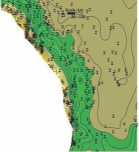
An integrated structural/tectonic study of the Deep Basin and the southern edge of the Peace River Arch area has demonstrated that basement features have exerted significant control on the development of “sweet spots” within many of these plays. For example, all the known oil shows in the Nordegg shale play are located at the intersection of basement faults with Devonian reef edges, such as: Simonette, Sturgeon Lake, Ante Creek, and the Leduc Fringing Reef of the Peace River Arch. Recent exploration activities
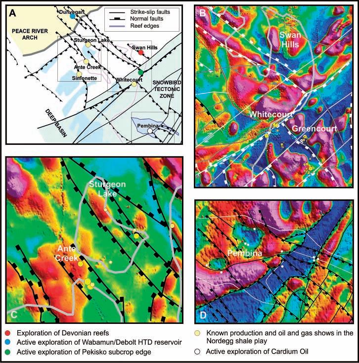
Figure 1. Examples of structural control on active oil plays in the Deep Basin and Southern Peace River Arch (Figure 1a). Basement structures that are interpreted from magnetic data and Devonian reef edges that have been mapped from well and seismic data clearly appear to exert a significant control on the location of known conventional Nordegg gas pools, such as Whitecourt and Greencourt ( Figure 1b), as well as key oil shows in the emerging Nordegg shale play (Figure 1c). Basement structure and topography also appears to exert control on the development of the Cardium oil play in the Pembina area (Figure 1d).
on the southern edge of the Peace River Arch are largely focused on exploitation of northwest-trending faults that are known to cause the development of HTD reservoir in the Devonian and Mississippian formations.
The methods used to establish the structural framework of the study area, and to identify the location of “sweet spots” for each of the plays, will be demonstrated in two luncheon talks of the CSPG structural division. The October talk focused on the emerging Nordegg oil shale play, and the Cardium tight oil sand play of Pembina. The January talk will cover exploration activities of the Wabamun and Debolt plays of the Peace River Arch, the Mississippian subcrop edge plays, and the development of the Swan Hills Reef Complex.
The presentation will be limited to 40 minutes and will be followed by an open discussion. Participants are encouraged to bring powerpoint examples to illustrate their views on the subject matter.
The Structural Geology Committee thanks Shell Canada Energy for their ongoing support in providing us with a talk venue for the past two years. We now move from gabbro facing to granite facing and Husky Energy is providing the venue for our 2011 talks. HEF Petrophysical continues to provide muchenjoyed refreshments. We greatly appreciate this corporate support.
SPEAKER
Laura Roskowski FMA Heritage Inc.
7:30 pm Friday, January 21st, 2011 Mount Royal University, Room B108 Calgary, Alberta
The Athabasca Oilsands area, north of Fort McMurray, Alberta, contains some of the densest archaeological deposits in Canada. Archaeological investigation at many of the sites in this area suggests that this region has been occupied for the past 10,000 years. This talk will focus on the archaeology that has been conducted in the area for the past 30 years, the types of sites recorded, and the artifacts recovered from those sites.
Archaeology in the Athabasca Oilsands area has generally been divided into those sites situated on the east of the Athabasca River and those located on the west. This is due to the varying type of sites and density of artifacts found on each side of the river. The archaeological sites present on the east side of the Athabasca tend to be dominated by a type of stone referred to as Beaver River Sandstone, yield dense deposits of waste material discarded during raw material extraction and early stage reduction, and are laterally extensive. In contrast, those sites on the west side of the river generally yield a variety of lithic raw material types, are sparse in nature, and are laterally confined.
The sites on the east side of the Athabasca are related to the Quarry of the Ancestors site complex located within Lease 90. The Quarry of the Ancestors is the primary location were pre-contact inhabitants of the area would come to extract Beaver River Sandstone to make tools for daily use. The quarry itself is characterized by incredibly dense archaeological deposits generally dominated by waste material discarded during extraction. Archaeological excavation conducted on a small portion of the quarry yielded millions of artifacts, most of which
were considered to be of low interpretive value. Moving away from the Quarry, the sites although slightly less dense, are also dominated by Beaver River Sandstone artifacts. These lithic workshops tend to yield artifacts in later stages of reduction or early tool production indicating that the pre-contact inhabitants were reducing the Beaver River Sandstone into a portable size for transport and use outside of the area immediately adjacent to the Quarry.
Archaeological sites encountered on the west side of the Athabasca River are characterized by small campsites and chipping stations rather than quarries or lithic workshops. These sites yield a higher percentage of tools and a low percentage of waste materials. Tools are considered to be of high interpretive value, allowing archaeologists to discern what types of activities were conducted at the site. The sites on the west side of the river are also generally laterally confined to a small area, making it easier to excavate a larger portion of the site. Many of these sites have produced hearth features critical for obtaining radiocarbon dates from which archaeologists derive the sites’ age. Hearth features are rarely encountered on the east side of the river leaving archaeologists to rely on projectile point styles for dating, which is somewhat unreliable.
This talk will focus on several archaeological sites to illustrate why artifacts recovered
Sponsored by
from both sides of the river are critical in understanding the pre-contact use of the Athabasca Oilsands region.
BIOGRAPHY
Laura Roskowski attended Eastern Michigan University where she completed her B.Sc. majoring in Geology, Anthropology, and History. She moved to Canada in 2001 to attend the University of Calgary for her Master’s degree in Archaeology. Her thesis focused on the Geoarchaeology of the Below Forks Site, Saskatchewan. On completion of her degree she began working for FMA Heritage Inc., where she has been employed for almost seven years. Working as an archaeological consultant she has travelled across Alberta, doing work on the prairies, in the parkland and boreal forest environments. Her expertise is in the archaeology of the boreal forest of Alberta where she has conducted both shoveltesting programs (yielding numerous sites) and mitigative excavations (totaling over 700 square meters).
This event is jointly presented by the Alberta Palaeontological Society, Mount Royal University, and the CSPG Palaeontology Division. For details or to present a talk in the future, please contact CSPG Paleo Division Chair Philip Benham at 403-691-3343 or programs@albertapaleo.org. Visit the APS website for confirmation of event times and upcoming speakers: http://www. albertapaleo.org/.
| By Colin Yeo
The fall is a busy time for the Society’s Executive. The annual review engagement is conducted, the annual report of activities is being compiled, committees are going in full force, convention planning is underway, and the Executive is preparing for the AGM and the incoming board. The President is especially busy as he prepares reports for the Past Presidents’ Dinner, Annual Report, the Reservoir, and the Annual General Meeting.
The Past Presidents’ Dinner is an annual event where former Society presidents listen to a State of the Society address from the current President and then impart their wisdom to the President based on their experiences and observations over the years. The one common characteristic of these former presidents who represent executives from the past 50 years is a deep commitment to the Society and its success. There are lots of stories about achievements and challenges their executives faced during their tenure, which are now fondly remembered and are useful in putting current issues into perspective.
President Varsek gave an upbeat and energetic overview of where the Society has come from over the last three years, its current situation, and where the CSPG is headed. Once he had finished, the former presidents lost no time in offering their opinions. Of the many suggestions and comments, three stood out for me.
Former President Bill Ayrton raised an extremely important issue affecting many of our members. The evolution of resource plays has demanded a new skill set from geologists but many are not prepared. Engineers, particularly reservoir and drilling and completion engineers, have stepped forward to direct and manage activity in these new plays.
Dr. Ayrton wanted to know what is being done now and what is planned in the future to help members adjust to this new reality. President Varsek pointed out the Shale Gas series running in the Reservoir and plans to develop continuing education courses that will help members understand this new and
unconventional resource. He also recognized that, sadly, some of our members may be unable or unwilling to change. Ultimately, our members are responsible for their own futures.
The issue of Society governance was a hot topic. All Executives since 2006 have been acclaimed and some of our past presidents found this to be at odds with our current Society bylaws and perhaps unhealthy as each Executive picks its successors. In practice, the Executive this year developed a roster of potential candidates for each position and recruited nominees until they had a full executive slate to be acclaimed. In this way, some candidates were preserved for future years and recruiting time was substantially reduced. The membership at large was invited to advance any competing candidate through the nomination process. This year, two Past Presidents recruited a candidate for Vice President and the Society will hold an election for that position. Interestingly, the two Past Presidents did not advance candidates for any other office, including the important position of Assistant Finance Director. There was
Reservoir Evaluation: Petrography, XRD, SEM, Paragenesis, Desorption, Resource Determination,
For presentation or discussion please contact: info@source-eval.com or Tel:
encouragement from the floor that these two Past Presidents should form the nucleus of a new nominating committee and strive to put forward a competitive slate of candidates each year for all positions.
Near the end of the evening, one Past President raised the issue of executive over-extension. President Varsek had listed 33 initiatives that were either completed, in progress, or being contemplated. The Past President felt that was just too many and progress would be impaired on any one initiative. President Varsek tried to explain that the CSPG had come through a tumultuous period of restructuring and that this year was one of setting a new agenda. Part of that process was to take an inventory of all the opportunities available to the Society and to start the renewal process by harvesting the lowest hanging fruit. Other Past Presidents joined in to reflect on a simpler time and wonder if the Society should return to that time. Other Past Presidents countered that our science, membership, and external relations with sponsors and partners are more complex than they have ever been. Becoming simpler means delivering less service to our members and when members feel they are not receiving value for their dues, they will leave the CSPG and join organizations they feel offer them more.
After the formal part of the evening, many Past Presidents approached President Varsek to offer congratulations on delivering stellar financial performance in a very challenging environment. They were very gracious.
The Past Presidents’ Dinner was timely as it occurred just before the Fall Strategy Session where the incoming executive members are introduced to the role and responsibilities of the Executive Committee and where they participate in developing a shared strategic plan for 2011. Incoming President Kirk Osadetz places great importance on jointly developing the strategic plan with the new directors as it creates ownership and commitment from all. While this year was marked by change, new ideas, and a vision of where the Society is headed, next year will be focused on consolidation and execution. Delivering value to our members is a key goal of the Society.
The 2011 Executive will be using some simple management tools to ensure they are doing the right things in a timely fashion to achieve specific goals. CSPG members should have a sense that they are receiving value by being a member such as keeping current technically, attending networking sessions, or accessing the extensive library
of publications. The CSPG must ensure it has the financial and organizational capability to provide programs, services, and products of interest to members. Because so much work is done within autonomous committees, there is a real need to establish a governance structure and policy framework within which these committees can work. In the past, some committees have bound the Society to financial and logistical obligations that have been difficult to meet or are out of scope for the CSPG. While this was done unintentionally, it becomes distracting and time-consuming for office staff and Executives to deal with the fallout. Governance and policy statements will allow committees to work within pre-defined boundaries so there are no surprises for anyone.
The CSPG’s outreach programs and liaisons with other societies and associations will become more effective in achieving their goals. Outreach programs will be designed to target specific groups for very specific reasons and will focus a committee’s energy, time, and money on specific tasks. It will also make life easier for committee members because they will know what they have to do within a period of time and within a specified budget. Relationships with other societies and associations will become clearer. In the past, we were sometimes unsure of why we participated with other organizations and sometimes found ourselves spending time and effort in areas that were peripheral to our mission. In 2011, the intent is for us to know why we are involved in an initiative, what we have to contribute, and how we will meet our obligations within a certain time frame.
The office staff will become more visible and proactive in supporting members and delivering programs and services to them. While members lead and direct the Society, the office is committed to helping them plan, develop, and execute their services and programs as efficiently as possible.
The new Executive is eagerly adopting the new strategies and directions they have had a hand in developing. This Fall Strategy Session marks the second time an Executive has begun their work ahead of taking office. In the past, these sessions would take place in February or March and by the time an Executive figured out what they had to do, the year would be half over, the summer would be upon them, leaving only four months for work. Also, starting work in the fall allows the incoming Executive an opportunity to work closely with outgoing directors for two months. By the time January rolls around and they officially take office, they will be running like a well-oiled machine. Good luck to them and we thank them for their service.
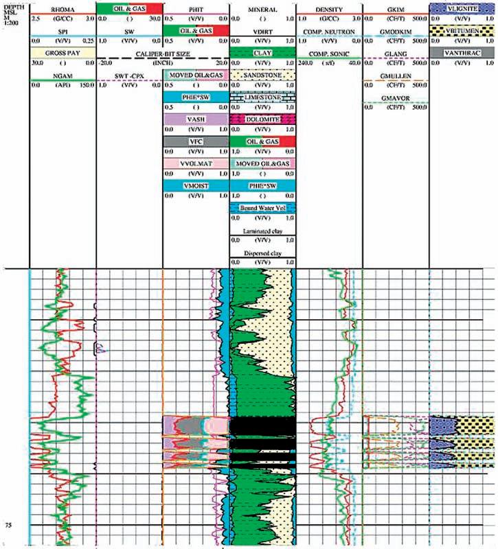
| By E. R. (Ross) Crain, P.Eng.
Unicorns are beautiful, mythical beasts, much sought after by us mere mortals. The same is true for petrophysical models for unconventional reservoirs. This is the third in a series of review articles outlining the simple beauty of some practical methods for log analysis of the unusual.
Coal bed methane (CBM) is an economic source of natural gas that is generated and stored in coal beds. It is a widely occurring exploitable resource that can be easily recovered and used near the well or where gas pipeline infrastructure currently exists.
Coal acts as both source rock and reservoir rock for methane. Methane is generated by microbial (biogenic) or thermal (thermogenic) processes shortly after burial, and throughout the diagenetic cycle resulting from further burial. Much of this gas is physically sorbed on coal surfaces. Some higher ends may also be produced by coal – such as ethane and propane – but are usually only a few percent of the total gas.
Adsorption is the process of gas adhering to a microporous surface. Desorption is the process of releasing gas from such a surface.
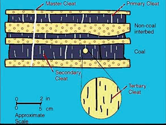
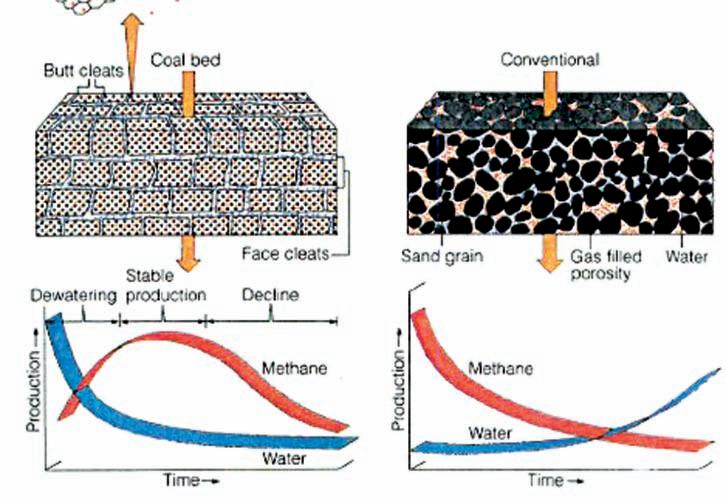
These surfaces are called cleats and range in size from obvious macrofractures to virtually invisible nanofractures. These cleat patterns are crucial for gas production
because they allow for the release of sorbed gas within coal beds and migration to the well bore (Figures 1, 2).
One gram of coal can contain as much surface area as several football fields and therefore is capable of sorbing large quantities of methane. One short ton (2,000 pounds mass) of coal can store about 1,300 m3 of methane. Depending on reservoir pressure, not all the storage capacity is filled with gas.
Coal-bed gas content must reach nearsaturation, either by biogenic or thermogenic gas-generation processes, to be economically viable. Cleats must be present to allow for connectivity between sorption sites. If the coal-bed horizons are buried deeply (>2,000 meters), cleats are closed because of overburden pressure acting on the structurally weak coal bed. Cleats can also be filled with other minerals, reducing their effective permeability.
Methane sorbed within coal beds is regulated by the hydrodynamic pressure gradient. Methane is maintained within the coal bed as long as the water table remains above the gas-saturated coal. If the water table is lowered by basin or climatic changes, then the amount of methane stored within the coal is reduced by release to the atmosphere.
Many coal beds need to be de-watered
before they can produce gas. Some coal beds have been de-watered naturally or by crossflows due to previous drilling for oil or gas in nearby wells. Poor quality cement jobs are a major cause of such crossflows.
CBM wells, unlike conventional oil and gas producers, usually show an increase in the amount of production (after initial dewatering). As a coal is de-watered, the cleat system progressively opens farther away from the well. As this process continues, gas flow increases from the expanding volume of de-watered coal. Water production decreases with time, which makes gas production from the well more economical.
Sorption isotherms indicate the maximum volume of methane that a coal can store under equilibrium conditions at a given pressure and temperature. The direct method of determining sorption isotherms involves drilling and cutting core that is immediately placed in canisters, followed by measurements of the volume of gas evolved from the coal over time.
The indirect method takes advantage of core or cuttings that have been stored and does not require fresh core, thus making this method more economical. Sorption isotherms are experimentally measured using
(Continued on page 18...)
a powdered coal sample whose saturated methane content at a single temperature is measured at about six pressure points.
Moisture content in a coal decreases the sorption capacity. Because coal loses moisture at a variable rate subsequent to removal from the bore hole, a standard moisture content is used when measuring sorption isotherms.
The Langmuir equation is used to predict the maximum gas storage capacity of a reservoir and the equilibrium pressure. Most CBM reservoirs are somewhat undersaturated, so the stored gas is less than the capacity of the reservoir (Figures 3, 4). A few are reported to be hyper-saturated. The equations are:
1: K1 = 0.21258 * Tf ^0.5
2: K2 = 2.82873 – 0.00268 * Tf
3: K3 = 0.00259 * Tf + 0.50899
4: K4 = 0.00402 * Tf + 2.20342
5: G max = 10^(K1 * log(Wfcarb / Wwtr) + K2)
6: PL = 10^(K3 * log(Wfcarb / Wwtr) + K4)
Where:
Gmax = gas volume at infinite pressure (ft3 /ton)
PL = Langmuir pressure, at which the sample’s gas content is ½ Gmax (atmospheres)
Tf = temperature (ºC)
Wfcarb = mass fraction of fixed carbon (fractional)
Wwtr = mass fraction of moisture (fractional)
Wfcarb and Wwtr are usually measured in the lab during a Proximate Analysis. Log analysis methods for obtaining these values are described at http:// www.spec2000.net/17-speccoal.htm.
Numerical Example: Given:
Then:
K1 = 1.2
K2 = 2.7
K3 = 0.6
K4 = 2.3
G max = 898.2 scf / ton
PL = 267.5 atm (100 atm = 1,466 psi = 10,132 kPa)
GAS CONTENT FROM CORE OR SAMPLE ANALYSIS
Finding the actual gas content, G c , in the lab can be done directly as part of the Procimate Analysis, or indirectly. Two gas content values are recorded. One is the actual gas content of the bulk coal; the second is related to the dry, ash-free state of the coal, as shown in Table 1 (see also figure 6, page 20).
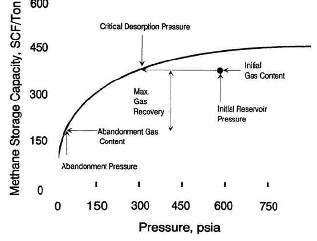
4. Typical sorption isotherm showing initial reservoir gas content vs. pressure, critical desorption pressure, and abandonment conditions Gas will not flow until reservoir pressure is less than critical pressure.
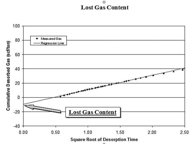
The desorption data obtained during the first several hours can be used to calculate the lost gas component. Cumulative desorbed gas is plotted against the square root of desorption time. A regression line is drawn through the first 4 to 6 hours of data points and extrapolated back to time zero. The intercept of the regression line at time zero is the lost gas, added to the actual desorbed gas volume to obtain the total actual gas. This value is further adjusted using the ash and water content from the proximate analysis to obtain the dry, ash-free value (Figure 5, page 20). Gas content (Gc ) results are usually given as scf/ton or g/cc. (Multiply Gc in g/cc by 32.18 to get Gc in scf/ton).
CBM GAS IN PLACE
Gas-in-place is calculated from the isotherm curve, or from the actual gas content found in the lab, by using coal-bed thickness and coal density as measured by well logs:
7: GIP = KG6 * G c * DENS * THICK * AREA
Where:
GIP = gas in place (Bcf)
G c = sorbed gas from isotherm or coal analysis report (scf/ton)
DENS = layer density from log or lab measurement (g/cc)
THICK = coal seam thickness (feet)
AREA (acres)
(Continued on page 20...)
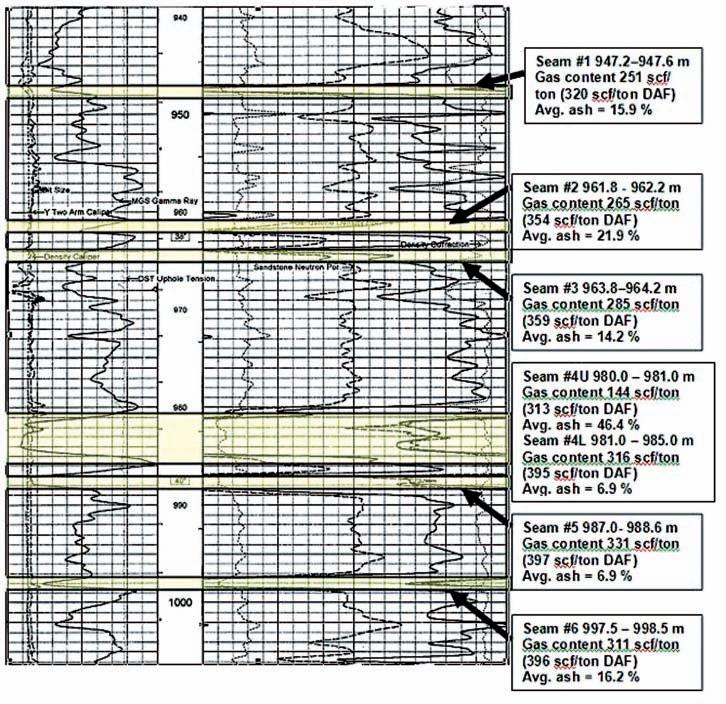
1. Gas content evaluation of coal beds. Notice that the dry, ash-free values are considerably higher than the actual measured values. As well, an estimate of the “lost gas” was made for each sample to account for gas evolved from the sample before the lab measurements were made.
Table 2. Summary table of gas desorption analysis.
KG6 = 1.3597*10^-6
If AREA = 640 acres, then GIP = Bcf/Section (= Bcf/sq. mile).
Multiply meters by 3.281 to obtain thickness in feet.
Multiply Gc in g/cc by 32.18 to get Gc in scf/ton.
Typical coal densities are in the range of 1.20 to 2.00 g/cc. Older density logs have a hard time reading less than 1.5 g/cc (FDC logs) but modern LDT logs can do it well. Some paper logs may not show the backup scale for density less than 2.0 g/cc, but this information may be included in the digital file. If density cannot be obtained from logs, use lab values or estimates.
CAUTION: If Gc is an actual measurement, the above equation gives reasonable results. If Gc is for the dry, ash-free case or a theoretical value, the GIP from equation 1 must be adjusted to represent the actual coal by multiplying GIP by (1 - Vash - Vwtr).
Note that free gas in the cleats is assumed to be negligible in most coals. In computer software, coal is usually triggered and PHIe set to zero, and conventional log analysis models used where there is no coal. Triggers are chosen based on density, neutron, sonic, or resistivity, or some combination of these. Recoverable gas can be estimated by using the sorption curve at abandonment pressure (G a ) and replacing Gc in Equation 7 with (Gc - G a ).
These approaches are used where measured Gc values are not available and involve more detailed analysis of the coal itself. This breakdown can be derived from analysis of core data, called proximate analysis, or by analysis of log data. Some of the following methods assume a complete coal analysis is available from log or core data (See table 2 [page 19] and table 3). Note that the various authors use a variety of units of measurement, so read their original papers carefully.
Mullen equation, based on some average data in New Mexico (San Juan Basin):
8: G c = 1053 – 542 * DENS coal
Mavor, Close, McBaner equation, based on some average data in Utah:
9: G c = 601.4 – 751.8 * Wash / (1.0 - Wwtr)
Kim Equation:
10: Ko = 5.6 + 0.8 * Wfcarb / Wwtr
11: No = 0.39 – 0.1 * Wfcarb / Wwtr
12: G c = 75 * (1 - Wwtr - Wash ) * (Ko *
Pf ^No - 0.14 * Tf )
Where:
G c = sorbed gas estimate (scf/ton)
Pf = formation pressure (atmospheres)
Tf = formation temperature (ºC)
Modified Kim Equation:
13: G c = 75 * (1 - Wwtr - Wash ) * (Ko * (KG7 * DEPTH/100)^No - 0.14 * KG8 * DEPTH/100 + KG9)
Where: SPmax = absolute value of maximum SP deflection in coal (mv)
THICK = coal bed thickness (ft)
KG10 = 3,100
Qg = gas rate (mmcf/d)
The parameter KG10 should be adjusted for each project area.
Numerical Example: Given:
Note 100 atm = 1,466 psi = 10,132 kPa
Mullen equation (San Juan Basin)
G c = 402.6 scf/ton
Mavor, Close, McBaner(Utah)
G c = 380.3 scf/ton
Kim Equation (See Figure 7)
Ko = 6.8
No = 0.2
G c = 588.1 scf/ton
Modified Kim using default gradients
G c = 586.1 scf/ton
E. R. (Ross) Crain, P.Eng. is a Consulting Petrophysicist and a Professional Engineer with over 45 years of experience in reservoir description, petrophysical analysis, and management. He has been a specialist in the integration of well log analysis and petrophysics with geophysical, geological, engineering, and simulation phases of oil and gas exploration and exploitation, with widespread Canadian and Overseas experience.
Where:
KG7 = pressure gradient (atm per 100 meters)
KG8 = temperature gradient (ºC per 100 meters)
KG9 = surface temperature (ºC)
DEPTH = average reservoir depth (meters)
Defaults: KG7 = 0.10, KG8 = 1.80, KG9 = 12
This equation uses local gradients relating
Pf and Tf to depth. Measured values are usually better but gradient values are useful when no measured data exists. Kim and modified Kim will give identical results if gradients match measured values.
Mullen’s correlation between SP development and deliverability : 14: Qg = KG10 * SPmax * THICK
His textbook, “Crain’s Petrophysical Handbook on CD-ROM” is widely used as a reference to practical log analysis. Mr. Crain is an Honourary Member and Past President of the Canadian Well Logging Society (CWLS), a Member of Society of Petrophysicists and Well Log Analysts (SPWLA), and a Registered Professional Engineer with Alberta Professional Engineers, Geologists and Geophysicists (APEGGA).

ByPhilipBenham
ByPhilipBenham
ByPhilipBenham
| by Philip Benham
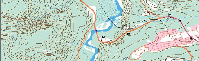
Trailhead: Drive 6.3 km north along Hwy 40 from 90 St in Grande Cache . Turn west on gravel road to Sulphur Gates Provincial Recreation area. Trailhead is an additional 6.3 km from Hwy and starts adjacent to a picnic area, which is also a staging area for local equestrians.
Trailhead: Drive 6.3 km north along Hwy 40 from 90 St in Grande Cache . Turn west on gravel road to Sulphur Gates Provincial Recreation area.
Trailhead is an additional 6.3 km from Hwy and starts adjacent to a picnic area, which is also a staging area for local equestrians.
Trailhead: Drive 6.3 km north along Hwy 40 from 90 St in Grande Cache. Turn west on gravel road to Sulphur Gates Provincial Recreation area. Trailhead is an additional 6.3 km from Hwy and starts adjacent to a picnic area, which is also a staging area for local equestrians.
Trailhead: Drive 6.3 km north along Hwy 40 from 90 St in Grande Cache . Turn west on gravel road to Sulphur Gates Provincial Recreation area. Trailhead is an additional 6.3 km from Hwy and starts adjacent to a picnic area, which is also a staging area for local equestrians.
Distance: The trail is a short excursion (600m return) with steps, handrails, and several spectacular viewing platforms. Blue line marks trail, arrow is on the access road.
Distance: The trail is a short excursion (600m return) with steps, handrails, and several spectacular viewing platforms. Blue line marks trail, arrow is on the access road.
Distance: The trail is a short excursion (600m return) with steps, handrails, and several spectacular viewing platforms. Blue line marks trail, arrow is on the access road.
Elevationgain:<50m Elevation gain:<50 m NTS Map Sheet; 083E14.
Elevationgain:<50m Elevation gain:<50 m NTS Map Sheet; 083E14.
Elevationgain:<50m Elevation gain:<50 m NTS Map Sheet; 083E14.
Distance: The trail is a short excursion (600m return) with steps, handrails, and several spectacular viewing platforms. Blue line marks trail, arrow is on the access road.
Elevation gain: <50 m. NTS Map Sheet: 083E14.
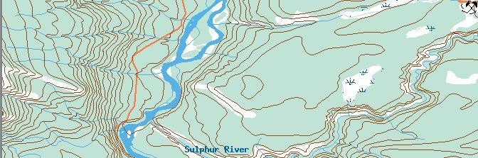
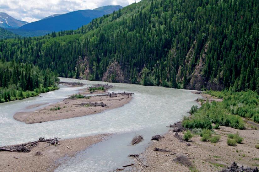
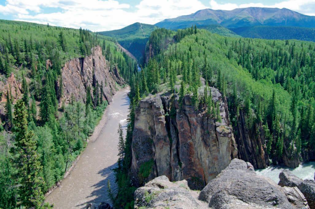
Sulphur Gates Provincial Recreation Area, also known locally as Hell’s Gate, provides easy access to dramatic views of vertically oriented lower Cretaceous strata. It is also the confluence of the Smoky and Sulphur Rivers. A short guided trail, which can be completed by anyone with reasonablemobilityleadstoseveralviewpointsof reasonable mobility, leads to several viewpoints of Sulphur Gates.
Sulphur Gates Provincial Recreation Area, also known locally as Hell’s Gate, provides easy access to dramatic views of vertically oriented lower Cretaceous strata. It is also the confluence of the Smoky and Sulphur Rivers. A short guided trail, which can be completed by anyone with reasonablemobilityleadstoseveralviewpointsof
reasonable mobility, leads to several viewpoints of Sulphur Gates.
Sulphur Gates Provincial Recreation Area, also known locally as Hell’s Gate, provides easy access to dramatic views of vertically oriented lower Cretaceous strata. It is also the confluence of the Smoky and Sulphur Rivers. A short guided trail, which can be completed by anyone with reasonablemobilityleadstoseveralviewpointsof reasonable mobility, leads to several viewpoints of Sulphur Gates.
Sulphur Gates Provincial Recreation Area , also known locally as Hell’s Gate, provides easy access to dramatic views of vertically oriented lower Cretaceous strata. It is also the confluence of the Smoky and Sulphur Rivers. A short guided trail, which can be completed by anyone with reasonable mobility leads to several viewpoints of Sulphur Gates.
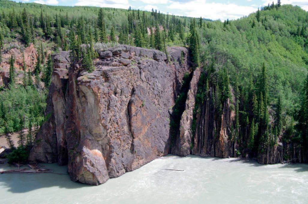
The locale lies in the transition between the Front Ranges and the Foothills of the Rocky Mountains. Extensive faulting and folding has exposed Cretaceous and Jurassic strata here. Perhaps 500m east of the main viewpoint, the Sulphur River Thrust surfaces. Strata in its hanging wall have been compressed into a complex series of folds, p , the largest of which is the Eaton Anticline. Folding has resulted in oversteepened, vertical, and even overturned strata adjacent to the fault. Upright, erosion-resistant conglomerates of the Lower Cretaceous Cadomin Fm create the constriction, known as the Sulphur Gates, at the confluence of the two rivers. The Sulphur River runs along the stratigraphictop of the Cadomin for up to two km before joining with the Smoky River. The Sulphur Rititfthdilti River gets its name from the discolourations caused by sulphur–rich springs upstream.
The locale lies in the transition between the Front Ranges and the Foothills of the Rocky Mountains. Extensive faulting and folding has exposed Cretaceous and Jurassic strata here. Perhaps 500m east of the main viewpoint, the Sulphur River Thrust surfaces. Strata in its hanging wall have been compressed into a complex series of folds, p , the largest of which is the Eaton Anticline. Folding has resulted in oversteepened, vertical, and even overturned strata adjacent to the fault. Upright, erosion-resistant conglomerates of the Lower Cretaceous Cadomin Fm create the constriction, known as the Sulphur Gates, at the confluence of the two rivers. The Sulphur River runs along the stratigraphictop of the Cadomin for up to two km before joining with the Smoky River. The Sulphur Rititfthdilti River gets its name from the discolourations caused by sulphur–rich springs upstream.
The locale lies in the transition between the Front Ranges and the Foothills of the Rocky Mountains. Extensive faulting and folding has exposed Cretaceous and Jurassic strata here. Perhaps 500m east of the main viewpoint, the Sulphur River Thrust surfaces. Strata in its hanging wall have been compressed into a complex series of folds, p , the largest of which is the Eaton Anticline. Folding has resulted in oversteepened, vertical, and even overturned strata adjacent to the fault. Upright, erosion-resistant conglomerates of the Lower Cretaceous Cadomin Fm create the constriction, known as the Sulphur Gates, at the confluence of the two rivers. The Sulphur River runs along the stratigraphictop of the Cadomin for up to two km before joining with the Smoky River. The Sulphur Rititfthdilti River gets its name from the discolourations caused by sulphur–rich springs upstream.
The locale lies in the transition between the Front Ranges and the Foothills of the Rocky Mountains. Extensive faulting and folding has exposed Cretaceous and Jurassic strata here. Perhaps 500m east of the main viewpoint, the Sulphur River Thrust surfaces. Strata in its hanging wall have been compressed into a complex series of folds, the largest of which is the Eaton Anticline. Folding has resulted in oversteepened, vertical, and even overturned strata adjacent to the fault. Upright, erosion-resistant conglomerates of the Lower Cretaceous Cadomin Formation create the constriction, known as the Sulphur Gates, at the confluence of the two rivers. The Sulphur River runs along the stratigraphic top of the Cadomin for up to two km before joining with the Smoky River. The Sulphur River gets its name from the discolourations caused by sulphur-rich springs upstream.
The Cadomin consists of chertpebbles derived hundreds of km westwards in BC. At its base is a major unconformity that cuts down-section eastwards. To the right of the Cadomin from the viewing platform and for most of the trail’s length are exposures of the terrestrial upper Nikanassin FormationThelensesofsandwithinthisformation
The Cadomin consists of chertpebbles derived hundreds of km westwards in BC. At its base is a major unconformity that cuts down-section eastwards. To the right of the Cadomin from the viewing platform and for most of the trail’s length are exposures of the terrestrial upper Nikanassin FormationThelensesofsandwithinthisformation
The Cadomin consists of chert pebbles derived hundreds of km westwards in BC. At its base is a major unconformity that cuts down-section eastwards. To the right of the Cadomin from the viewing platform and for most of the trail’s length are exposures of the terrestrial upper Nikanassin Formation. The lenses of sand within this formation are channel bodies.
Formation The lenses of sand within this formation are channel bodies.
The Cadomin consists of chertpebbles derived hundreds of km westwards in BC. At its base is a major unconformity that cuts down-section eastwards. To the right of the Cadomin from the viewing platform and for most of the trail’s length are exposures of the terrestrial upper Nikanassin FormationThelensesofsandwithinthisformation
Formation The lenses of sand within this formation are channel bodies.
Formation The lenses of sand within this formation are channel bodies.
Reference: McMechan, M.E. 1996. Geology and structural cross section, Grande Cache, Alberta. GSC Map 1904A.
Reference: McMechan, M.E. 1996. Geology and structural cross section, Grande Cache, Alberta. GSC Map 1904A.
Reference: McMechan, M.E. 1996. Geology and structural cross section, Grande Cache, Alberta. GSC Map 1904A.
Map from www.canmaps.com (source NRC).
Reference: McMechan, M.E. 1996. Geology and structural cross section, Grande Cache, Alberta. GSC Map 1904A.
Map from www.canmaps.com (source NRC).
Map from www.canmaps.com (source NRC).
Map from www.canmaps.com (source NRC).
The Reservoir Committee welcomes contributions from our readership to this series. If you wish to offer a submission to Go Take a Hike on your favourite hike of geological interest, email the Reservoir at caitlin.young@cspg.org for more information.
The Reservoir Committee welcomes contributions from our readership to this series. If you wish to offer a submissionto Go Take a Hike on your favourite hike of geological interest, email the Reservoir at caitlin.young@cspg.org for more information
The Reservoir Committee welcomes contributions from our readership to this series. If you wish to offer a submissionto Go Take a Hike on your favourite hike of geological interest, email the Reservoir at caitlin.young@cspg.org for more information
The Reservoir Committee welcomes contributions from our readership to this series. If you wish to offer a submissionto Go Take a Hike on your favourite hike of geological interest, email the Reservoir at caitlin.young@cspg.org for more information
by
SulphurGates. Sheet and channel sands of the Nikanassin Fm are conglomeratic Cadomin on left.
SulphurGates. Vertically oriented Cadomin is more resistant and To its right is the Nikanassin Fm. Channels are denoted by a ‘CH.’ a splash of summer colour.
SulphurGates. T he SulphurRiver flows along the contact between Note also the erosionalsurfaces internal to the Cadomin. and dark-grey chertpebbles of the Cadomin Fm. The tendency provide vital permeability in this tight reservoir rock.

TL: Looking down on Sulphur Gates. Sheet and channel sands of the Nikanassin Fm are overlain by the conglomeratic Cadomin on left.

TL: Looking down on SulphurGates. Sheet and channel sands of the Nikanassin Fm are overlain by the conglomeratic Cadomin on left.
TL: Looking down on SulphurGates. Sheet and channel sands of the Nikanassin Fm are overlain by the conglomeratic Cadomin on left.
channel sands of the Nikanassin Fm are
TR: Slightly upstream of Sulphur Gates. Vertically oriented Cadomin is more resistant and narrows at the confluence. To its right is the Nikanassin Fm. Channels are denoted by a ‘CH.’
TR: Slightly upstream of SulphurGates. Vertically oriented Cadomin is more resistant and narrows at the confluence. To its right is the Nikanassin Fm. Channels are denoted by a ‘CH.’
TR: Slightly upstream of SulphurGates. Vertically oriented Cadomin is more resistant and narrows at the confluence. To its right is the Nikanassin Fm. Channels are denoted by a ‘CH.’
Vertically oriented Cadomin is more resistant and Nikanassin Fm. Channels are denoted by a ‘CH.’ colour.
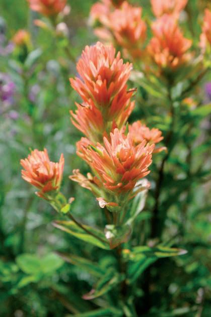
CR: Indian Paintbrush adds a splash of summer colour.
CR: Indian Paintbrush adds a splash of summer colour.
CR: Indian Paintbrush adds a splash of summer colour.
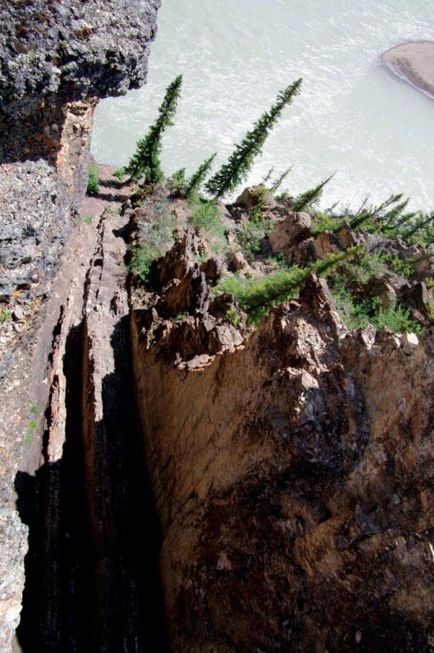
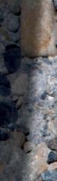
BL: View from atop the Sulphur Gates. The Sulphur River flows along the contact between Cadomin and Gething Fm. Note also the erosional surfaces internal to the Cadomin.
BL: View from atop the SulphurGates. The SulphurRiver flows along the contact between Cadomin and GethingFm. Note also the erosionalsurfaces internal to the Cadomin.
BL: View from atop the SulphurGates. The SulphurRiver flows along the contact between Cadomin and GethingFm. Note also the erosionalsurfaces internal to the Cadomin.
SulphurRiver flows along the contact between erosionalsurfaces internal to the Cadomin. chertpebbles of the Cadomin Fm. The tendency in this tight reservoir rock.
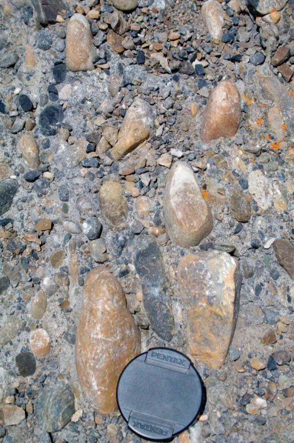
BR: Close up of white, light, and dark-grey chert pebbles of the Cadomin Fm. The tendency of the pebbles to fracture provide vital permeability in this tight reservoir rock.
BR: Close up of white, light, and dark-grey chertpebbles of the Cadomin Fm. The tendency of the pebbles to fracture provide vital permeability in this tight reservoir rock.
BR: Close up of white, light, and dark-grey chertpebbles of the Cadomin Fm. The tendency of the pebbles to fracture provide vital permeability in this tight reservoir rock. SulphurGates. Sheet and channel sands of the Nikanassin Fm are conglomeratic Cadomin on left.
SulphurGates. Vertically oriented Cadomin is more resistant and To its right is the Nikanassin Fm. Channels are denoted by a ‘CH.’ adds a splash of summer colour.


SulphurGates. T he SulphurRiver flows along the contact between Note also the erosionalsurfaces internal to the Cadomin.
light, and dark-grey chertpebbles of the Cadomin Fm. The tendency provide vital permeability in this tight reservoir rock.


February 3-5, 2011 World Health Club • 722 Edgemont Blvd NW
THERE IS A MAXIMUM OF 125 PLAYERS! GET YOUR ENTRY FORM IN EARLY TO AVOID DISAPPOINTMENT! Register online at www.cspg.org
EVENTS: Men’s & Women’s A, B, C, D, and Novice.
ENTRY FEE: $ 75.00 Members (Members of the CSPG and CSEG, Spouse/Par tner)
$120.00 Non-Members
• Two guaranteed matches (Saturday teams tourney), t-shirt, refreshments and food during the tournament, Saturday night dinner and draw prizes New award this year: Spirit Award in honor of Cynthia Riediger.
• Pre-tournament registration social will be at the Bow Valley Racquet Club (2nd Street and 5th Avenue S.W.) on Monday, January 31st at 5:00pm. Pick up your tournament kit and first draw time. Enjoy a free pint of ale with munchies. Generously sponsored by Sensor Geophysical Ltd.
• All door prize draws Saturday evening – must be present to win.
ENTRY DEADLINE: Early Bird Deadline January 3rd , 2011. Qualify for Early Bird Draw Prize. Registration Deadline January 26th, 2011. No refunds after this date.
REGISTRATION DETAILS:
CSPG CSEG Member# NonMember
This squash tournament is open to CSPG and CSEG members -
Name: _________________________________________________Email:
Company: ______________________________________________________________
Phone: Daytime: ____________________________ Evening: __________________________ Male Female Shir t size: S M L XL XXL
Level/Frequency of Play: A B C D Novice
Interested in Doubles Squash: ($25.00 extra for Doubles if playing singles as well) Yes No
Will you be attending dinner : Yes No Meal Preference: Meat Veggie
Guest Name: ______________________________________________________________________________________
Male Female
Shir t size: S M L XL XXL
Level/Frequency of Play: A B C D Novice
Interested in Doubles Squash: ($25.00 extra for Doubles if playing singles as well) Yes No
Will you be attending the dinner : Yes No Meal Preference: Meat Veggie
PAYMENT DETAILS (GST Included. GST# 118836295):
$ 75.00 Member/Spouse
$120.00 Non-Member
$ 25.00 Doubles
$ 35.00 Extra Meal Ticket (Non-playing guests Maximum 15 spots; first-come, first served).
TOTAL
VISA MC Cheque (Payable to Canadian Society of Petroleum Geologists) Card Number : ______________________________________________ Expiry: _______________________________
Name of Card holder (Please Print): _______________________________ Signature: _____________________________
REGISTRATIONS TO BE SENT TO: Canadian Society of Petroleum Geologists tnemanruoT hsauqS :nttA 600, 640 8 AVE SW, Calgary, AB T2P 1G7 8985-462 ) 304 ( 0165-462 ) 304 ( ne: P
| By R. J. Spencer1,3 , P. K. Pedersen1, C. R. Clarkson1, R. Aguilera2
1
Department of Geoscience, University of Calgary,
2 Department of Chemical
Recent studies have shown that process or delivery speed, represented by the ratio of permeability and porosity, is a continuum between conventional, tight, and shale gas reservoirs. This observation, based on core data from various North American basins, leads to distinctive flow units for each type of reservoir.
The approximate boundary between viscous and diffusion-dominated flow is associated with Knudsen number (Kn ). Viscous flow is present, for example, when the architecture of the rock is dominated by megaports, macroports, mesoports, and sometimes microports (port = pore throat). Diffusion flow on the other hand is observed at the nanoport level.
The process speed concept has been used successfully in conventional reservoirs for several years (Ebanks, 1987; Gunter et al., 1997). The same concept can be used for tight gas and shale gas reservoirs, ideally with the support of core data, and permits differentiating between viscous and diffusion-dominated flow. This is valuable, for example for forecasting production in those cases where the formation is composed of alternating stacked layers of tight sands and shales, or where there are lateral variations due to facies changes (Aguilera, 2010a).
Process or delivery speed, i.e., the ratio of permeability and porosity, provides a relative indication of storage and how quickly fluids can move through porous media. The concept has been shown to be powerful for characterizing conventional oil and gas reservoirs in various lithologies (Ebanks, 1987; Chopra et al., 1987; Gunter et al., 1997), and for predicting recoverable hydrocarbon volumes (Pickett and Artus, 1970). Recent work (Rahmanian et al., 2010; Aguilera, 2010a) suggests that the concept can also be used in the case of tight and shale gas reservoirs as illustrated in this article.
Process speed is related directly to flow (or hydraulic) units, a concept probably introduced by MacKenzie (1975) and used successfully by Ebanks (1987), as an aid to reservoir description for engineering projects. A flow unit is defined as a
and
Petroleum engineering,
stratigraphically continuous reservoir subdivision characterized by a similar pore type (Hartmann and Beaumont, 1999, p. 9-7). As such, the concept is powerful for helping define optimum layering/cell size in reservoir simulation work.
Each flow unit can be characterized by an approximate range of pore-throat (port) apertures. Particularly useful, from a practical point of view, is the pore-throat aperture at 35% mercury saturation (rp35 ) during a mercury injection/capillary pressure test. This corresponds to 35% cumulative pore volume. Pore-throat aperture (rp35 ) in microns can be calculated on the basis of permeability (k, mD) and porosity (φ, fraction) from (Aguilera, 2010a): (1)
Pore-size classes are grouped by Martin et al. (1997) on the basis of pore-throat (port) apertures as megaports (rp35 > 10 microns), macroports (2.5-10 microns), mesoports (0.5 to 2.5 microns), microports (0.1 to 0.5 microns), and nanoports (0.01 to 0.1 microns). As we move into commercial production from tighter rocks the introduction of picoports (< 0.01 microns) appears warranted. Ports can be integrated empirically with production rates leading to an important forecasting tool.
Part 4 of this series indicates that in the case of shale gas formations, natural gas is generated in the shale and remains within the shale. Consequently the shale is both source rock and reservoir rock. Gas is trapped and stored in shale in different ways: (1) as adsorbed gas into the kerogen material,
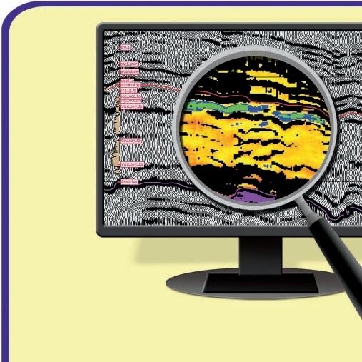


(2) free gas trapped in nonorganic interparticle (matrix) porosity,
(3) free gas trapped in microfracture porosity,
(4) free gas stored in hydraulic fractures created during the stimulation of the shale reservoir, and
(5) free gas trapped in a pore network developed within the organic matter or kerogen as shown on Figure 1 of Part 4 (Soeder et al., 1988; Guidri et al., 1995; Cluff et al., 2007; Bustin et al., 2008; Ruppeil and Loucks, 2008; Wang et al., 2009; Ambrose et al., 2010; this CSPG Series, and many more).
In the case of tight formations, natural gas is generated somewhere else (usually in a shale) and migrates to the tight reservoir where it is trapped and stored in interparticle (matrix porosity), dissolution, slot, and microfracture porosity. Grains and pores are smaller in shales as compared with tight and conventional gas formations (Ruppeil and Loucks, 2008; Wang et al., 2009).
Natural gas in tight formations can be trapped in a continuous accumulation or in a regular structural and/or stratigraphic trap. The continuous accumulation occurs throughout tens or even hundreds of miles. It is characterized by:
(1) lack of a water leg,
(2) continuous gas saturation,
(3) low permeability (typically a fraction of millidarcy), and
(4) abnormally low or high reservoir pressures (Law, 2002).
When gas is trapped in continuous accumulations, production of formation water is not generally an issue since there is not a water leg. However, liquid holdup in the wellbore has to be considered due to water of condensation (or gas condensate for wet gas reservoirs). When gas is trapped in regular structural and stratigraphic traps with very low permeability (tight formations) water production can become a very important operational, environmental, and economic issue.
Figure 1 is a semi-logarithmic cross-plot of permeability vs. porosity that includes data from the Utica shale, Horn River basin, and soft shales in Canada; Barnett, Fayettville, Marcellus, and Huron shales in the United States; the results of some crushed shale samples in the United States; and the tight gas Nikanassin Formation in
Figure 1. Flow units. Permeability vs. porosity cross-plot including shale data from the Utica shales (yellow circles), Horn River (HR) and soft shales in Canada; Fayettville (F), Barnet (B), Huron and Marcellus shales in the United States, and the Nikanassin tight gas formation in Canada. Information from Core Labs data includes the Fort Worth Barnett (B.FW), Delaware Barnett (B.DEL), and Barnett M1H well. Red circles, at the bottom of the graph represent crushed samples interpreted to correspond to matrix porosity (Wang et al., 2009; data from Cluff et al., 2007). Same might be true for purple diamonds and blue squares. Care must be exercised because this is a matrix porosity scaled to the bulk volume of only the matrix, not scaled to the bulk volume of the shale multipleporosity system (Source: Lavoie et al., 2010).
SPE 133611:
Chart can be used
Chart can be used for calibrating microsimulation at the pore throat level to estimate rp, k, phi, relative perms, capillary pressures, electrical properties, rock mechanics
level to estimate r phi, relative perms, capillary pressures, electrical properties,
Brittle?
Ductile?
CHART FOR ESTIMATING PORE THROAT APERTURE (Extension to Tight Gas and Shale Gas)

Viscous Flow

Brittle? Ductile? Type of Stimulation? Effect of Sw , mud Filtrate, leak-off on embedment?
Type of Stimulation? Effect of Sw, mud Filtrate, leak-off on embedment?
051015202530
POROSITY (%)
Source: GFREE Research Team, U of Calgary, 2009
Source: GFREE Research Team, U of Calgary, 2009
Canada. Lines for different values of rp35 (0.55 to 0.00005 microns) were developed with the use of equation 1. The lines provide distinctive flow units (rp35 ) for shales and tight gas formations, something that had been observed previously for conventional reservoirs (Kolodzie, 1980; Aguilera, 2003).


DiffusionBased Flow (NanoScale, pore and pore throats)


Figure 2. Integrated cross-plot of permeability vs. porosity showing flow units for conventional, tight gas, and shale gas reservoirs based on rp35 pore throat values. F = Fayettville, HR = Horn River, B = Barnett. Viscous flow is dominant in conventional and tight gas reservoirs down to microport size. Diffusion-based flow dominates at the nanoport scale, typical of shale reservoirs.
The result of an integrated graph that includes conventional, tight, and shale gas reservoirs is presented in Figure 2. The original concept for this graph was developed by H. D. Winland of Amoco. Viscous flow is present when the architecture of the rock is dominated by
megaports, macroports, mesoports, and sometimes microports. Diffusion flow on the other hand is observed at the nanoport and maybe picoport level, which is typical of shale gas reservoirs. The approximate boundary between viscous and diffusiondominated flow is estimated with the dimensionless Knudsen number (K n ). This number is defined as the ratio of the molecular mean gas mean free path length and ( λ) and pore diameter (d). Discussions of Knudsen number have been presented by Javadpour et al. (2007), Civan (2009), and Rahmanian et al. (2010).
The crushed samples represented by the red circles in Figure 1 show permeabilities much lower than all the other samples.
These samples represent only the matrix. They do not include the fractures and the porosity of the organic matter. Care must be exercised in the interpretation of this matrix porosity because it is associated only with the bulk volume of the matrix system, not the bulk volume of the composite porosity system (Aguilera, 2010) as shown on Part 4 of this series.
As we learn more about production distribution from shale gas reservoirs we will be able to integrate those data with the flow unit characterization described above. Figure 3 shows a distribution of normalized
cumulative gas vs. cumulative wells for parts of the Barnett shale (Devon) and Nikanassin tight gas formation (Area A, Solano et al., 2010). The concept for this type of graph was introduced by Nelson (2001). The actual data are matched using a variability distribution model (VDM) with the following equation (Aguilera, 2010b): (2)
where:
N p = Actual hydrocarbon cumulative production organized in ascending order
N pmax = Cumulative hydrocarbon production for the total field
v = Constant related to intensity of a given naturally fractured reservoir
Wp = Number of wells (arranged in ascending order)
Wpt = Total number of wells in the field
n = severity exponent associated with heterogeneity of the reservoir
The Barnett (Devon) theoretical curve in Figure 3 was generated using values of v and n equal to 0.085 and 23.60, respectively (Aguilera, 2010b). The Nikanassin curve was developed using v = 0.215 and n = 551.5 (Solano et al., 2010). Both fits are good with coefficients of determination (R 2 ) greater than 0.99. The result suggest a larger degree of relative fracturing (v = 0.215) and heterogeneity (n = 551.5) in the Nikanassin Formation (Area A) as compared with the portion (Continued on page 28...)

of the Barnett considered in the graph. The cross-plot shows that 50% of the wells in the Barnet (Devon) contribute approximately 40% of the cumulative gas, while 50% of the wells contribute less than 10% of cumulative gas in the Nikanassin Area A. A possible interpretation is that the Barnett has a more homogeneous natural fracture distribution; something that can help explain the dendritic elliptical distribution of induced hydraulic fractures generally observed in microseismic data. On the other hand, the Nikanassin Area A is located to the west of the eastern edge of the NW-SE trending thrust belt of the Canadian Rocky Mountains. Under this condition, larger natural fracture intensity and more heterogeneity can be expected. Equation 2 can also be used for studying the distribution of initial production rates.
The flow units discussed above have also been used for conventional oil reservoirs with a good level of success (Ebanks, 1987; Chopra et al., 1987; Gunter et al., 1997; Hartmann and Beaumont, 1999, p. 9-7). The same is true for the production distribution discussed in the previous
section (Nelson, 2001). An empirical observation by Martin et al. (1997) indicates that megaports can reach medium gravity oil production rates of 10s of thousands of barrels per day if “zonal thickness and other factors are constant” and without mechanical constraints, macroports can reach thousands of barrels per day, and mesoports hundreds of barrels per day. Microports can produce few to tens of barrels per day on pump. However, Martin et al. state that “microport flow units are decidedly non-reservoir in this comparative completion of moderate thickness and medium gravity oil without mechanical constraints. These flow units are of far more interest as potential seals for higher-quality reservoir downdip.” The same types of estimates are not available for shale oil at this time. However, there are indications that an interactive combination of reservoir modeling and hydraulic fracturing simulation can help to increase production from shale oil reservoirs via optimization of horizontal wellbores and hydraulic fracture spacing (Lolon et al., 2009; Taylor et al., 2010).
Aguilera, R. 2003. Geologic and engineering
aspects of naturally fractured reservoirs. Canadian Society of Exploration Geophysicists Recorder, v. 28, no. 2, p. 44-49.
Aguilera, R. 2010a. Flow units: From conventional to tight gas to shale gas reservoirs. Society of Petroleum Engineers Paper 132845 presented at the Trinidad and Tobago Energy Resources Conference held in Port of Spain, Trinidad, 27-30 June 2010.
Aguilera, R. 2010b. A method for estimating hydrocarbon cumulative production distribution of individual wells in naturally fractured carbonates, sandstones, shale gas, coalbed methane and tight gas formations. Journal of Canadian Petroleum Technology, August 2010.
Ambrose, R. J., Hartman, R. C., Diaz-Campos, M., Akkutlu, Y., and Sondergeld, G. H. 2010. New pore-scale considerations for shale gas in place calculations. Society of Petroleum Engineers Paper 131772 presented at the SPE Unconventional Gas Conference held in Pittsburgh, Pa., February 23-25 2010.
Bustin, R. M., Bustin, A. M. M., Cui, X., Ross, D. J. K., and Murthy Pathi, V. S. 2008. Impact of shale properties on pore structure and storage characteristics. Society of Petroleum
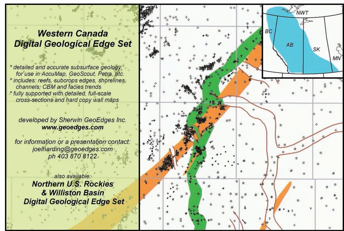
Engineers Paper 119892 presented at the SPE Shale Gas production Conference held in Fort Worth, Texas, November 16-18, 2008.
Byrnes, A.L, Cluff, R. M., and Webb, J. 2006. Analysis of critical permeability, capillary pressure and electrical properties for Mesaverde tight gas sandstones from western U.S. Basins. DOE Contract No. DEFC26-05NT42660. Contractor: University of Kansas Center for Research, Inc. 2385 Irving Hill Road. Quarterly Technical Progress Report, June 30, 2006.
Byrnes, A.L, Cluff, R. M., and Webb, J. 2006. Analysis of critical permeability, capillary pressure and electrical properties for Mesaverde tight gas sandstones from western U.S. Basins. DOE Contract No. DEFC26-05NT42660. Contractor: University of Kansas Center for Research, Inc. 2385 Irving Hill Road. Quarterly Technical Progress Report, September 30, 2006.
Chopra, A. K., Stein, M. H., and Ader, J. C. 1987. Development of reservoir descriptions to aid in design of EOR projects: Society of Petroleum Engineers Paper 16370, presented at the SPE California Regional Meeting, Ventura, California, p. 437-449.
Civan, F. 2009. Effective correlation of apparent gas permeability in tight porous media. Springer, published on line, July 3, 2009.
Ebanks, W, J. Jr. 1987. Flow unit concept –integrated approach to reservoir description for engineering projects. Abstract: American Association of Petroleum Geologists Bulletin, v. 71, no. 5, p. 551-552.
Gunter, G. W., Finneran, J. M., Hartmann, D. J., and Miller, J. D. 1997. Early determination of reservoir flow units using an integrated petrophysical method. Society of Petroleum Engineers Paper 38679 presented at the SPE Annual Technical Conference and Exhibition, San Antonio, Texas.
Gunter, G. W., Pinch, J. J., Finneran, J. M., and Bryant, W. T. 1997. Overview of an integrated process model to develop petrophysical based reservoir descriptions. Society of Petroleum Engineers Paper 38748 presented at the SPE Annual Technical Conference and Exhibition, San Antonio, Texas.
Hartmann, D. J. and Beaumont, E. A. 1999. Predicting reservoir system quality and performance. In: Exploring for oil and gas
traps. Beaumont, E. A. and Foster, N. H. (eds.). American Association of Petroleum Geologists Treatise of Petroleum Geology. Handbook of Petroleum Geology, p. 9-1 to 9-154.
Javadpour, F, Fisher, D., and Unsworth, M. 2007. Nanoscale gas flow in shale gas sediments. Journal of Canadian Petroleum Technology, v. 46, no. 10, October 2007.
Kolodzie, S. J. 1980. The analysis of pore throat size and use of Waxman Smit to determine OOIP in Spindle Field, Colorado. Society of Petroleum Engineers 55th Annual Technical Conference, SPE paper 9382, 10 p.
Kwon, B. S. and Pickett, G. R. 1975. A new pore structure model and pore structure interrelationships. Society of Petrophysicists and Well Log Analysts 16th Annual Logging Symposium.
Law, B. E. 2002. Basin-centered gas systems. American Association of Petroleum Geologists Bulletin, v. 86, p. 1891-1919.
Lavoie, J. Y., Marcil, J. S., Dorrins, P. K., Lavoie, J., and Aguilera, R. 2010. Natural gas
(Continued on page 30...)

potential in the Saint Lawrence Lowlands o f Quebec: A case study. Canadian Society for Unconventional Gas / Society of Petroleum Engineers Paper 137593 presented at the Canadian Unconventional Resources and International Petroleum Conference held in Calgary, Alberta, Canada, October 19-21, 2010.
Lolon, E. P., Cipolla, C. L., Weijers, L., Heskeths, R. E., and Grigg, M. W. 2009. Evaluating horizontal well placement and hydraulic fracture spacing/conductivity in the Bakken Formation, North Dakota. Society of Petroleum Engineers Paper 124905 presented at the Annual Technical Conference and Exhibition held in New Orleans, Louisiana, October 4-7, 2009.
Mackenzie, W. T. 1975. Petrophysical study of the Cardium sand in the Pembina Field. Society of Petroleum Engineers Paper 5541 presented at the 50th Annual Technical Meeting of SPE held in Dallas, Texas, September 28 – October 1, 1975.
Martin, A. J., Solomon, S. T., and Hartmann, D. J. 1997. Characterization of petrophysical flow units in carbonate reservoirs. American
Association of Petroleum Geologists Bulletin, v. 81, no. 5, p. 734-759.
Nelson, R. 2001. Geologic analysis of naturally fractured reservoirs. Second Edition, Butterworth-Heinemann, Woburn, Ma., 332p.
Pickett, G. R. and Artus, D. S. 1970. Prediction from logs of recoverable hydrocarbon volume, Ordovician carbonates, Williston basin. Geophysics, v. 35, no. 1, p. 113-123.
Rahmanian, M., Solano, N., and Aguilera, R. 2010. Storage and output flow from shale and tight gas reservoirs. Society of Petroleum Engineers Paper 133611 presented at the SPE Western Regional Meeting held in Anaheim, California, USA, May 27-29, 2010.
Ruppel, S. C. and Loucks, R. G. 2008. Black mudrocks: Lessons and questions from the Mississippian Barnett Shale in the southern midcontinent. Society for Sedimentary Geology, The Sedimentary Record, June.
Solano, N., Zambrano, L., and Aguilera, R. 2010. Cumulative gas production distribution on the Nikanassin tight gas formation, Alberta and British Columbia, Canada. Society of Petroleum Engineers Paper 132923 presented

at the Trinidad and Tobago Energy Resources Conference held in Port of Spain, Trinidad, June 27-30, 2010.
Taylor, R. S., Glaser, M., Kim, J., Wilson, B., Nikiforuk, G., Noble, V., Rosenthal, L., Aguilera, R., Hoch, O., Soliman, M, Storozhenko, K., Riviere, N. Palidwar, T., and Romanson, R. 2010. Optimization of horizontal wellbore and fracture spacing using an interactive combination of reservoir and fracture simulation. Society of Petroleum Engineers Paper 137416 presented at the Canadian Unconventional Resources and International Petroleum Conference held in Calgary, Canada, October 19-21, 2010.
Wang, F. P. and Reed, R. M. 2009. Pore networks and fluid flow in gas shales. Society of Petroleum Engineers Paper 124253 presented at the SPE Annual Technical Conference and Exhibition held in New Orleans, Louisiana, October 4-7, 2009.
• 2D, 3D and 4D processing
• Multi-component processing
• PP and PS modeling
• PP and PS registration
• Joint PP and PS inversion
• Stochastic inversion
• AVO/LMR analysis
• Fracture detection

www.sensorgeo.com
| By Anne Hargreaves
The Greek island of Santorini, also known as Thera, is part of the Cyclades group of islands in the Aegean Sea. Strikingly beautiful, the island’s towns of Oia and Fira seem to drip off the caldera walls 200 to 300 meters above the water. A tectonically active area, Santorini has been an active volcano for the last 1.5 million years. After an major earthquake in 1956, this island has been rebuilt and today boasts luxury accommodations built with fabulous caldera views, on a largely unconsolidated substrate of pumice, ash, and some ignimbrite.
The general geology of Greece and the Aegean Islands is fairly complex. The underpinning of the Aegean Sea consists of isopic zones and massifs. In brief, an isopic zone is a group of widespread rocks that share a common history, including the depositional environment and faulting and folding. Hundreds of kilometers long and several kilometers thick, these zones were originally continental bits, islands, oceanic ridges, and ocean floor. Massifs are blocks of metamorphic and plutonic rocks, which are from lower levels of the continental crust and have been exposed by faulting or erosion.
During the Alpine crustal compression, these isopic zones and massifs were piled one on top of the other. The age of the oldest ones stretch back to the Precambrian, some 600 million years ago (Figure 1, page 32). In more recent times, these rocks have been intruded by igneous rocks and affected by volcanism.
Approximately 190 million years ago in the mid-Jurassic period, Gondwanaland (Africa et al.) and Eurasia (Europe plus Asia) had joined with North America to form Pangaea. A wedge-shaped Tethys Ocean was located between the future Africa and Europe, and during this time, the limestones of the Aegean were deposited. During opening of the Atlantic Ocean, the south Atlantic opened first, resulting in the rotation of the African continent and the closing of the Tethys Ocean.
Then, in the mid-Cretaceous, approximately 110 million years ago, an east-west rift developed on the north margin of Africa and the Mediterranean Sea began to open up. This seafloor spreading began to push the Aegean Sea floor and islands northward into the European continent.
Subduction of ocean crust, because of this northward compression, began in the Neogene (Miocene) about 22 million years ago, with the African plate being subducted beneath the Aegean Plate. There was crustal extension associated with this subduction resulting in horst and graben topography, which played a part in the formation of some
of the Greek islands. Present day movement of plates and associated strike-slips fault zones are shown in Figure 2 (page 32).
The basement rock of Santorini is, in part, Triassic crystalline limestone grading to marble deposited during the time of the
(Continued on page 32...)
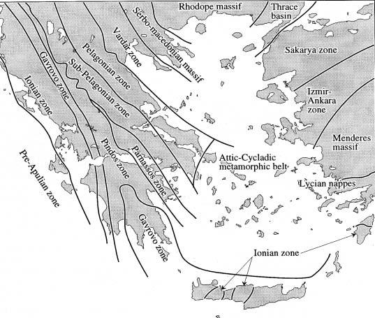
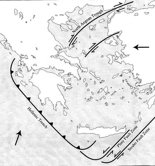
(...Continued from page 31)
Tethys Ocean. As well, on the inner side of the caldera near the port of Athinios, metamorphic rocks, including schists intruded with granite, are remnants of an ancient massif.
Approximately 1.5 million years ago, at the beginning of the Quaternary period, volcanism began in the area. Santorini’s complex volcanic history includes seven different active volcanic centres. The oldest volcanic rocks are in the Akrotiri region on the south part of the island, around Red Beach, which were deposited sometime between 1.5 and 0.6 million years ago (Figures 3, 4). Approximately 200,000 years ago, volcanism resumed in earnest. The most active centre was and is today south-west of Fira in the caldera below the two Kameni islands, Palaea and Nea. At least 12 major eruptions have occurred,
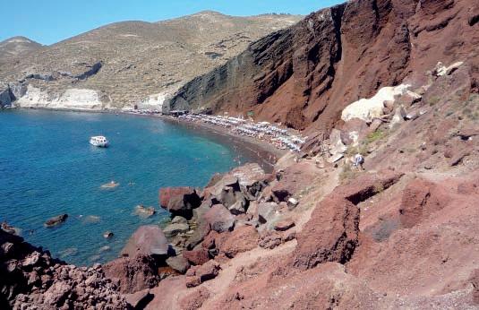
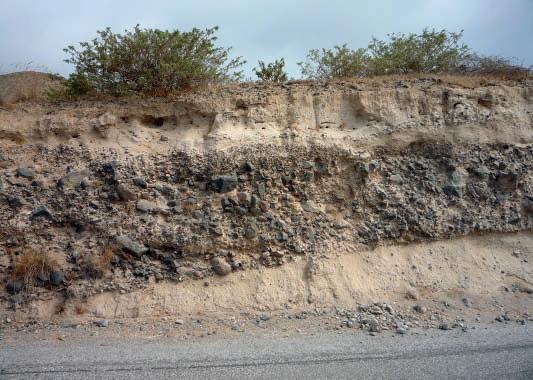
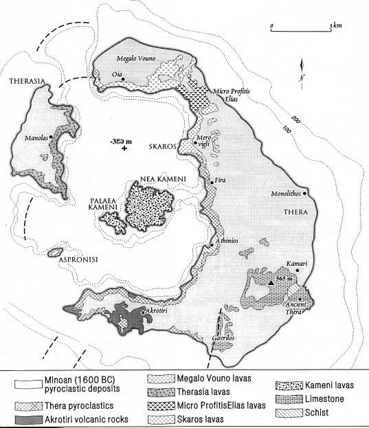
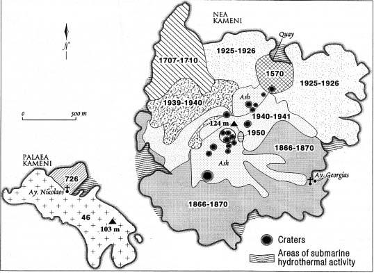
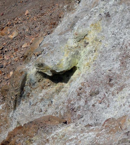
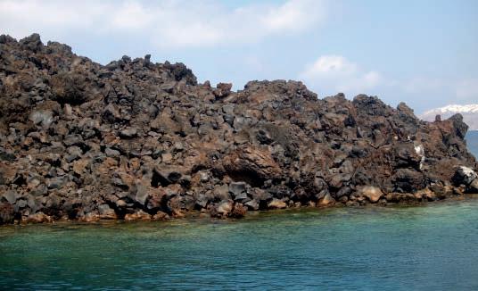
notably 100, 79, 54, 37, 18, and the most recent catastrophic eruption – the Minoan – 3.5 thousand years ago.
Besides Palaea Kameni and Nea Kameni, which are active cones, there is also an active underwater volcano 10 kilometers NNE of Santorini, which fits in well with the NNE-SSW orientation, possibly indicating a strike-slip fault associated with the subduction of the African plate beneath the Aegean plate. As well, the volcanic Christiana Islands are SSW of Santorini along the same trend (Figure 5).
The Minoan eruption was named after the civilization on Crete, and also Santorini, at the time of the eruption. The most recent archaeological and geological information for the area indicate that this eruption occurred approximately 3,600 years ago (1,600 B.C.) in the late Bronze age. It was massive, ejecting some 30 cubic kilometers of magma, largely rhyodacite (felsic to intermediate composition), pumice, and ash. To put this into perspective, the famous eruption of Krakatoa in Indonesia in 1883 resulted in ten cubic kilometers of ejecta, Mount Saint Helens in 1980 ejected 0.35 cubic kilometer, and Mount Pinatubo in 1991 ejected five cubic kilometers (Runnels and Murray, 2010)
The eruption began in the caldera about one kilometer from Fira and was of a Plinian nature. The Plinian phase occurs when magma boils in the subterranean conduit at depth, resulting in pumice and ash ejecting at high speed from the volcano and rising to heights of 30-40 kilometers. The next phase occurred as the fissure widened allowing sea water into the mix, creating steam and phreatomagmatic explosions that widened the vent even further. The ash deposited during this phase created large dunes. Next, pumice and blocks of rock were ejected in pyroclastic flows, mudflows, and/or by large phreatomagmatic explosions. Then, during the final phase, thick ash flows were deposited, some being hot enough to weld together and form the hard, dense rock called ignimbrite.
After the eruption, the dome collapsed inward creating a caldera floor approximately 400 meters below the surface of the water. This event caused a tsunami and in Israel, pumice has been found at a level of seven meters above sea level. On the island of Anafi, very close
(Continued on page 34...)
to Santorini, pumice has been found at an elevation of 40 meters above sea level, and a wave 12 meters high would have hit the island of Crete.
The ash deposited during this eruption covered Santorini and has also been found on the western Aegean Islands and in western Turkey. As well, thin layers have been found 800 kilometers away on the Nile Delta, suggesting the mention of darkness covering the sun in the book of Exodus in the Bible could be referring to this time.
Ice deposits in Greenland point to a year of 1,645 B.C. where layers of ice have abundant sulphuric acid, indicating that this substance was injected into the upper atmosphere by volcanic activity. Tree rings in California indicate a very harsh winter in 1,628 to 1,626 B.C., which could indicate volcanic ash in the atmosphere affecting the climate.
The islands of Nea Kameni and Palaea Kameni demonstrate the continued volcanic activity below the waters of the caldera. Rising from the caldera floor, they broke the surface of the water in 197 B.C. Numerous lava deposits are noted in Figure 6 (page 33).


The islands are a National Geological Park and can be reached by boat where there is a hiking trail up to the top, which takes about an hour-and-a-half to tour. Steaming vents in the crater at the top emit the classic sulphurous odor and show deposits of sulphur and gypsum at the surface (Figure 7, page 33). Tourists can swim in the hot springs near the dock on Palaea Kameni. The very rocky nature of these islands is due to the lava formations at time of deposit, most likely from lava plumes (Figure 8, page 33).


Was Santorini the legendary Atlantis that sank beneath the waves as told by Plato in 360 B.C.? His story tells of an advanced civilization which existed 11,000 years ago in the Atlantic Ocean, whose arrogant inhabitants were first defeated by the Athenians in battle and then swallowed up in a catastrophe that happened “in a day and a night.” Historians and archaeologists are much divided on the veracity of this story, as certain aspects have been proven to be completely incorrect. Plate tectonics and seafloor spreading rule out any existence of a sunken island in the Atlantic, and we know today through radio-carbon dating and heavily documented archaeological data, that modern civilizations did not exist 11,000 years ago. As well, there is absolutely no mention in any extant record with the name ‘Atlantis’ other than Plato’s. What could have happened is that the Minoan eruption on Santorini, of which there are no eye-witness accounts on record, somehow filtered down through 1,200 years orally, was heard by Plato, and immortalized as the Legend of Atlantis.
REFERENCES:
Higgins, M. and Higgins, R. 1996. A geological companion to Greece and the Aegean. Gerald Duckworth and Co.
Manning, S. W. and Sewell, D. A. 2002. 15 Volcanoes and history: a significant relationship? The case of Santorini. In: Natural Disasters and Cultural Change, Torrence, R. and Grattan, J. (eds.). London: Routledge. Accessed online via Questia November 21, 2010.
Mendrinos, D., Polyzou, O., and Karytsas, C. 2010. Geothermal Exploration in Greece. Centre for Renewable Energy, Pikermi, Greece.
Runnels, C., and Murray, P. 2001. Greece before history: An archaeological companion and guide. Stanford, CA. Stanford University Press. Accessed online via Questia November 20, 2010.


Jocelyn Lampron, P. Geol. President & CEO

Wellsite Geological Supervision
*Conventional Wells-Heavy Oil/SAGD
*Coal Bed Methane Wells www.hopewellpetroleum.com info@hopewellpetroleum.com
*Domestic & International Supervision 906, 505 6 St. SW Calgary, AB T2P-1X5
R. (Ross) Crain. P.Eng. Box 29 Site 3 RR 2, Rocky Mountain House, Alberta, Canada, T4T 2A2
*On & Offshore Geological Supervision

FARHATHYDERI,P.Geol President 226CopperfieldBlvd.S.E. Calgary,ABT2Z4R6
Tel4037260666 Fax4034515380 Cell4038192516 farhat@sableconsultants.com SABLECONSULTANTS.COM


Mentoring
afran@telusplanet.net www.serpaconsulting.com
The Canadian Society of Petroleum Geologists is proud to present the 2011 Executive Committee. Former Vice President Kirk Osadetz is taking the reins from 2010 President John Varsek to continue on the renewal strategy that the 2010 Executive Committee embarked on last year. The CSPG


is pleased to welcome new and returning members to the Executive Committee: Kirk Osadetz; Robin Mann; John Varsek; Darren Aldridge; Andrea Hood; Brett Norris; Jon Noad; Chris Seibel; Michelle Hawke; Jim Barclay; Stephen Hubbard; Steve Dryer and Simon Haynes. Together their vast range of
EDUCATION : B.Sc. Geology, University of Toronto (1978); M.Sc. (1983).
experience and demographics, they represent the industry sector today. The CSPG would like to welcome you all to the 2011 Executive Committee and we are looking forward to the exciting journey of 2011!
EXPERIENCE: Head, Energy Geoscience (formerly Energy and Environment) Subdivision at the Geological Survey of Canada (GSC): Calgary, a Division of Earth Sciences Sector (ESS) in Natural Resources Canada; leads the National Organic Geochemistry and Organic Petrology Laboratory in ESS’s Scientific Laboratory Network; Program Manager of ESS’s Gas Hydrates – Fuel of the Future Program; led geoscience research programs for the Office of Energy Research and Development and was a collaborating partner and co-investigator on research projects and activities funded by Energy Sector NRCan, the Yukon Geological Survey, AECL Research Ltd., the Canadian International Development Agency, the National Energy Board, the Australian Research Council, and the French Petroleum Institute; exploration departments of Gulf Canada Resources Inc. and Petro-Canada Exploration Inc.
RESEARCH INTERESTS:
Petroleum geoscience, natural gas hydrates, petroleum resource assessment, Arctic geosciences, and has contributed to both the Canadian Gas Potential Committee’s national assessment and the Petroleum Technology Alliance of Canada’s unconventional gas technology roadmap.
SOCIETY CONTRIBUTIONS: Director (Assistant Treasurer and Treasurer); Co-Chair of the Technical Luncheon/Program Committee; member of several Convention Committees (Technical Program Co-Chair and -Technical Program Committee Member); Associate Editor of the Bulletin of Canadian Petroleum Geology (2 terms); Lecturer in the CSPG Advantage educational program; Co-Leader (with Glen Stockmal, David Kisilevsky, and Daniel Lebel) southern Alberta Foothills Field Trips for CSPG and Joint AAPG-CSPG Conventions and the CSPG Structure Division; speaker and poster contributor at Technical Luncheons, Gussow Research Conferences, CSPG Division meetings, and Annual Conventions.
AWARDS: Coleman Gold Medal in Geology (University of Toronto); Chevron Scholarship (University of Toronto); CSPG Tracks Awards (2); CSPG Service Award; CSPG Hunter Volunteer Award; CSPG Annual Convention Best Poster Runner-Up Award; NRCan Earth Sciences Sector and Divisional Merit Awards (3).
VICE PRESIDENT – ROBIN MANN

EDUCATION : B.Sc. Geology (Honours), Dalhousie University (1977); M.Sc. Geology and Geophysics, Carleton University (1979).
EXPERIENCE: Amoco, Aquitaine, Fekete & Associates, and Westward Energy (1977–1997); Co-Founded Hume Mann & Associates, which eventually became AJM Petroleum Consultants (1984); CEO of AJM Petroleum Consultants (2004–Present).
PROFESSIONAL MEMBERSHIPS: CSPG; APEGGA, AAPG; Member of AAPG Division of Professional Affairs.
CSPG ACTIVITIES: Chairman of CSPG Insurance Committee (1999–2008).
AWARDS: CSPG Service Award (2005).

EDUCATION : B.Sc. Geophysics, University of British Columbia (1979); M.Sc. Geophysics (Seismology), University of Calgary (1984); Ph.D. Geology and Geophysics (Tectonics), University of Calgary (1992).
EXPERIENCE: Geophysicist, Canada-Cities Service (1979-1982): Geophysicist, Petrel Consultants (1984-1986); Geophysicist / Geologist, Petrel Robertson (1990-1993); Geophysicist / Geologist, Amoco Canada Petroleum Company (19931999); Exploration Geoscientist, BP Canada (1999-2000); Exploration Geoscientist, Alberta Energy Company (2000-2002); Group Lead, EnCana (2002-2008); Strategy Advisor, Cenovus Energy (2009-Present).
PROFESSIONAL MEMBERSHIPS: CSPG, AAPG, APEGGA, APEGS, CSEG, SEG.
CSPG ACTIVITIES: CSPG Structure Division Chair (1993); Bulletin Special Issue Editor (1994-1996); Medal of Merit Committee (1997-1998); Technical Chair GeoCanada 2000 Convention (1998-2000); Bulletin of Canadian Petroleum Geology Associate Editor (1999-2002); Conventions Committee (2001-2002); Co-founder Emerging Petroleum Resource Division (2000); Co-chair CSPG/CSEG 2007 Joint Convention (2006-2007); President 2010.
PUBLICATIONS: Published, as lead or co-author, nearly 30 papers on a variety of geological and geophysical topics and presented numerous papers at CSPG and CSEG conventions since 1985.
CSPG AWARDS: CSPG Service Award (1996); CSPG Tracks Award (2001); CSPG President’s Award (2008).

EDUCATION : B.Sc. Engineering, University of Calgary (1982).
EXPERIENCE: Wellsite Formation Evaluation Operations and Management, Canada, North Sea, N. Africa, Malaysia, Baker Atlas (1983-1998); Geoscientist, Canada, Baker Atlas (1998); Borehole Imaging (2003); Fractured Reservoir Characterizations (2004); Sales Manager, Canada, Baker Hughes (2006); Division Management, Canada, Baker Hughes (2008-Present).
PROFESSIONAL
MEMBERSHIPS: CSPG, CSEG, CWLS.
CSPG ACTIVITIES: Joint Annual Convention, Finance Chair (2006-2009).
AWARDS: CSPG Service Awards (2007-2009).
EDUCATION : Graduate in Hotel Management (1992); Various Courses at University Passau, Germany (1993) and SAIT (1996-1999).
EXPERIENCE: Immigrated to Canada 1996; Accountant, VIRTUAL Computing Services Ltd. (1996-1997); geoLOGIC systems ltd (1997-Present); Administrative Manager, (1997-2001); Account Manager (2001-2007); Vice President Business Development and Sales, geoLOGIC systems ltd. (2007-Present).
PROFESSIONAL MEMBERSHIPS: CSPG, CSEG, Associate Member SEG.
CSPG ACTIVITIES: Special Events Chair (2006 and 2007), CSEG Representative on JAC.
EDUCATION : B.Sc. Geology, University of Toronto (1986); M.Sc. Geology, University of Western Ontario (1989).
EXPERIENCE: Geologist, Esso Resources Ltd. (1988-1991); Geologist, Interra Petroleum Consulting (1991-1994); Geologist, Ranger Oil Ltd. (1994-1995); Lecturer (p/t), McGill University (1995-1996); Geological Consultant (1995-1997); Geologist, Anderson Exploration (1997-1998); Team Lead, Exploitation Manager, Nexen Inc. (1998-2003); VP Geosciences, Paramount Energy Trust (2003-2006); Exploitation Manager, TransGlobe Energy Corp. (2006-Present).

EDUCATION : B.Sc. Geology, Imperial College, London (1985); M.Sc. Sedimentology, Birkbeck College, London, (1993), Ph.D. Geology, University College, London, (1998).
EXPERIENCE: Mining Geologist, Gencor; Rand Mines, South Africa (1986-1990); Marine Geologist, British Telecom (1990); Production Geologist, Shell, Netherlands (1998); Professor at Delft University (2004-2006); Team Leader New Ventures, Shell Canada (2006-2010); Exploration Manager, Murphy Oil Corp. (2010).
PROFESSIONAL MEMBERSHIPS:
CSPG, President, British Sedimentology Research Group (BSRG), Geological Society of London, PESGB, Geologists Association.
CSPG ACTIVITIES: Volunteered at several CSPG conferences, ran numerous field trips.
AWARDS: Best Poster, CPSG conference (2008); CSPG Link Award (2009).
EDUCATION : B.Sc. in Geology, University of Regina (1999); M.Sc. in Geology, University of Regina (2002).
EXPERIENCE: Geologist, Nexen Inc. (2001-Present).
PROFESSIONAL MEMBERSHIPS: CSPG, AAPG, APEGGA.
CSPG ACTIVITIES: CSPG Technical Luncheon co-chair (2002-2010).
PUBLICATIONS: Authored and co-authored papers, posters, and presentations on the organofacies and source potential of the Ordovician Winnipeg Formation and Cambrian Deadwood Formation of southern Saskatchewan. Also co-authored a presentation and poster on the geoscience of the McMurray Formation at Nexen’s Long Lake SAGD project in Northeastern Alberta.
AWARDS: Andrew D. Baillie Award – Oral Paper (2001), Volunteer Award (2007), CSPG Link Award (2010).
EDUCATION : B.Sc. in Earth Science, University of Guelph (1994); M.Sc. in Environmental Earth Science, University of Guelph (1997); Ph.D. in Geology, University of British Columbia (2004).
EXPERIENCE: Suncor Energy (contract geologist, 2001-2005); BP Canada (2005-2010).
PROFESSIONAL MEMBERSHIPS: CSPG, AAPG, APEGGA.
CSPG ACTIVITIES: 2005 Gussow Conference Organizing committee, Emerging Petroleum Resources Chair (2005-2008).
PUBLICATIONS: Published several papers as principle or coauthor relating to organic petrography of peats and coals.
AWARDS: GSA Coal Division Student Award (1999); TSOP Student Presentation Award (2000); CSPG Volunteer Award (2005, 2007).

EDUCATION : B.Sc. Honours Geology, Carleton University (1976); Ph.D. Geology, University of Calgary (2000).
EXPERIENCE: Mineral Geologist, Norcen Energy Resources, Phillips Management Inc., Urangesellschaft Canada, (1975-1979); Sr. Geologist, Dome Petroleum (1979-1983); Sr. Petroleum Geologist, Geological Survey of Canada (1984-1994); Chief Geologist, Hardy Oil & Gas Canada (1994-1995); President, Springtide Energy Ltd. (1995-1996); Regional Geologist, Poco Petroleums/Burlington Resources (1996-2001); Exploration Manager, Ice Energy Limited (20012002); Consulting Geologist, Java Energy Inc (2002-2003); Vice-President Exploration, Southpoint Resources Ltd. (2002-2004); Sr. Staff Geologist, Burlington Resources/ConocoPhillips (2004-present).
PROFESSIONAL MEMBERSHIPS: CSPG, AAPG, APEGGA, CWLS, GAC.
CSPG ACTIVITIES: CSPG Assistant Communications Director (2010); CSPG Stratigraphic Nomenclature Committee (1991-present); Organizing Committee and Technical Program CSPG ‘Pangea’ Convention (1993); co-Chairperson Core Conference, CSPG-CSEG-CWLS Convention (2006); Associate Editor, CSPG Bulletin (2005-2007); Chairman Technical Program, 2002 CSPG 75th Anniversary Convention; Chairman and member, CSPG Medal of Merit (‘best paper’) Committee (1997-2006); CSPG Douglas Award Nominating Committee, for Dr. Graham Davies (2002); Organizing Committee and Chairman Core Workshop – 1999 International Congress on the Carboniferous and Permian; CSPG Executive (1996-1997); Critical reviewer of many CSPG and other publications, volunteer mentoring (1984-present).
PUBLICATIONS: 34 published geological papers; Many formal talks or posters or core displays given at conferences; Numerous informal talks given at oil companies, universities and schools.
AWARDS: CSPG Best Ph.D. Award (2001); CSPG Volunteer Award (2003); CSPG Service Award (2005); ConocoPhillips Special Recognition Award (2007); ConocoPhillips Special Recognition Award (2008).

EDUCATION : B.Sc. Geology, University of Alberta (1997); M.Sc. Earth and Atmospheric Sciences, University of Alberta (1999); Ph.D. Geological and Environmental Sciences, Stanford University (2006).
EXPERIENCE: Geologist, Shell Canada Ltd. (1999-2001); Assistant Professor, University of Calgary (2006-2010).
PROFESSIONAL
MEMBERSHIPS: CSPG, AAPG, EAGE, GSA, IAS, SEPM.
CSPG ACTIVITIES: Communications Director (2010); Fieldtrip Leader (2009-2010); Sedimentary Geology Division Co-Chair (2007-2009); Annual Meeting Session Chairman (2007-2009); Speaker Honorary Address (2008).
PUBLICATIONS: Published 30 peer-reviewed scientific papers and is co-author of more than 70 presentations at national and international conferences.
AWARDS: CSPG Honorable Mention, Best Canadian Petroleum Geology Paper (2003); CSPG Andrew Baillie Award (oral presentation) (2005); CSPG Andrew Baillie Award (poster presentation) (2005); CSPG Volunteer Award (2007, 2008); GSA Bulletin, Exceptional Reviewer Award (2008) Dept. of Geoscience, University of Calgary, Excellence in Research Award (2008).

EDUCATION : B.Sc., General Science, University of New Brunswick (1974); M.Sc., Geology, University of New Brunswick (1977).
EXPERIENCE: Exploration Geologist, PanCanadian Petroleum (1979-1994); Exploration Geologist, Ulster Petroleum (19941996); Exploration Geologist, Calahoo Petroleum (1996-2000); Exploration Geologist, AEC/EnCana (2000-2004); Exploration Geologist, Trifecta Resources (2004-2006); Consulting Geologist, Various clients (2006-Present).
PROFESSIONAL MEMBERSHIPS: CSPG, AAPG, APEGGA.
PUBLICATIONS: Dryer, Stephen and Logan, Alan. 1978. Holocene Reefs and Sediments of Castle Harbour, Bermuda. Journal of Marine Research, v. 36, no. 3, p 399-425.
EDUCATION : B.Sc. in Earth Science, Brock University (1998); M.Sc. in Geology, University of British Columbia (2003).
EXPERIENCE: Geologist, Terracon Geotechnique (1998-2000); Geologist, Shell Canada (2003-2010); Senior exploration geologist, Statoil (2010-present).
PROFESSIONAL
MEMBERSHIPS: CSPG, AAPG, APEGGA, GSC.
CSPG ACTIVITIES: University Outreach Committee, Ontario student chapters’ representative (2005-2009); University Outreach Committee Chair (2009-2010).
AWARDS: CSPG Volunteer Award (2007, 2008, 2009).
VISION: The CSPG Outreach program’s foundation is formed by a core group of committed volunteers that the CSPG must continue to encourage and support. We currently have a strong program in place that promotes the science of petroleum geology to university students and a general audience. We need to maintain our current program activities, while simultaneously planning new initiatives that increase our exposure to the general public, high school, and younger students. The final cornerstone for the CSPG is the attraction of new industry professionals, who may be unaware of the benefits and opportunities that come as a member of our organization.
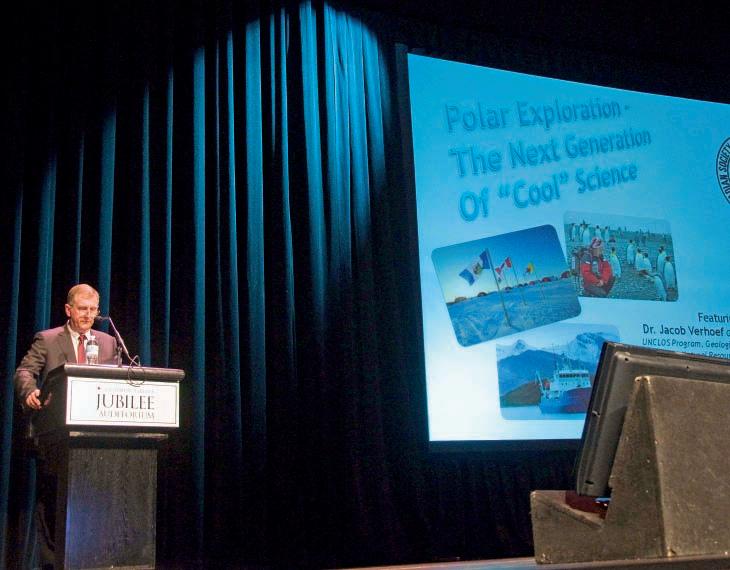
On October 26th, 2010 the CSPG Honorary Address took place at the Southern Alberta Jubilee Auditorium; this year’s topic was Polar Exploration – The Next Generation of “Cool” Science. The CSPG and the 2010 Honorary Address Committee would like to thank Dr. Jacob Verhoef and Susan R. Eaton for sharing the fascinating tales of their adventures in the Arctic and Antarctic, respectively.
Dr. Jacob Verhoef enlightened audiences about the ongoing research efforts to determine ownership rights to potential undersea oil and other submerged mineral resources of the Arctic. As Director of the UNCLOS Program (United Nations Convention on the Law of the Sea) for the Geological Survey of Canada, Dr. Verhoef has been working with other Canadian researchers on gathering and substantiating evidence that the Lomonosov Ridge, as well as the Alpha Ridge, and offshore parts of the Beaufort Sea bottom are a “natural prolongation” of the North American continent, extending Canada’s ownership limits and rights well beyond the arctic coastline. If eventually agreed to by the UN, this work could result in increasing Canada’s access to the potentially abundant resources of the Arctic.
As a professional geologist and geophysicist, Susan R. Eaton captured the attention and imagination of both the daytime and evening audiences with thrilling footage from the Force 10 storm she experienced
while at sea on the return trip home and also from an extraordinary encounter she had with a fur seal while snorkelling during the Elysium Visual Epic Expedition to Antarctica. Ms. Eaton had the privilege of taking part in this “adventure of a lifetime” as the official trip geologist and geophysicist of the 57-member expedition that re-traced the footsteps of Sir Ernest Shackleton, 100 years later.
The 2010 CSPG Honorary Address hosted 1,200 Junior High Students for the morning performance and 250 industry professionals and members of the general public at the evening performance. Those who attended in the evening also had an opportunity to peruse interesting lobby displays from APEGGA, the Arctic Institute of Canada, Calgary Science Network, Calgary Youth Science Fair, Canmore Museum and Geoscience Centre, City of Calgary – Water Wise, CSPG, CSEG, Geological Survey of Canada, Komarevich Originals, and TELUS World of Science. The 2010 Committee continued with the traditional silent auction which raised a total of $1,500.00, put towards funding for this worthwhile, annual public Outreach event.
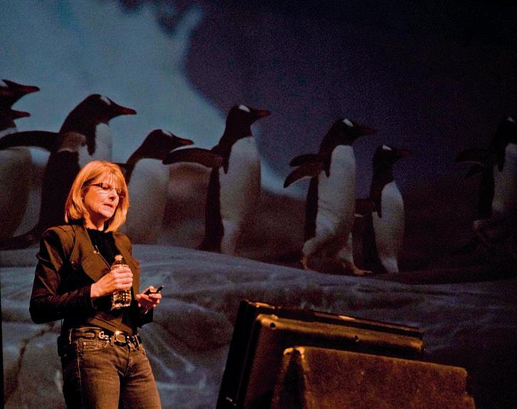
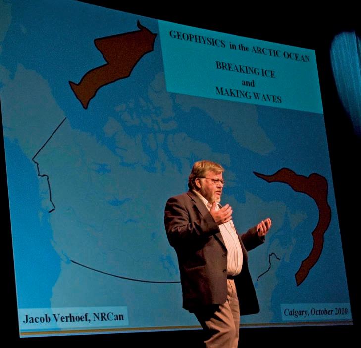
The CSPG Honorary Address is sponsored by APEGGA, the CSPG Educational Trust Fund, and the CSEG Foundation. However it would not be possible without the additional generous support received from the following corporate sponsors: Petrobakken, AJM Petroleum Consultants, Penn West Energy Trust, RPS Boyd PetroSearch, MGM Energy Corp, Daylight Energy, Sundog, AVW TELAV, and the Burgess Shale Geoscience Foundation. The support of these organizations is vital to the continuation of this program and allows for the CSPG to continue promoting geosciences to today’s youth and the general public.
A hearty thank you to the Honorary Address Organizing Committee and to all the other people working behind the scenes that made this event a success.
The 2010 Honorary Address Committee are: Mike DesRoches (Chair), Linden Achen, Ranald Gault, Shawn LaFleur, Annette Milbradt, Kyla Poelzer, Bob Riopel, Tom Sneddon, Marissa Whitaker, and Jay Williams.

Geoscientists for our future

| By Garrett Quinn, Queen’s University
There are a number of paths that bring geologists to Calgary to work as petroleum geologists. Maybe they got their start as well-site geologists, or maybe they were working in mineral exploration and decided to make a career change. Whatever the path, there were likely a couple of big breaks or chance encounters that made it possible.
Flying back from Calgary to Kingston for one more year at Queen’s University, I read Field Notes: The Story of the Canadian Society of Petroleum Geologist s. In it, 1976 CSPG President and SIFT founder Bill Ayrton is quoted, “I was influenced, and maybe you were too, in your career, by a few individuals or a few events and again maybe you can count those on the fingers of one hand.” Reading this led me to reflect on the people and experiences that brought me to Calgary for my first summer in the oil patch.
It began as a scheduling conflict that made me take clastic sedimentology at Queen’s. Taught by Dr. Bob Dalrymple, this course presented ideas at a level that prepared students to critically read scientific literature. On our five-day field trip to the Adirondacks in New York State, where we looked at outcrops from terrestrial to distal marine facies of a Paleozoic clastic wedge, I realized what I would specialize in. After this course, I was left looking for a way to crack into the petroleum industry, and to use and expand this new-found knowledge. Born and raised near Baltimore, I had no connections to the oil patch whatsoever. Enter the CSPG.
In the winter term, I experienced two of Bill Ayrton’s aforementioned “influential events.” Firstly, I was selected to represent Queen’s on the annual CSPG SIFT field trip; and secondly, given a summer job at Osum Oil Sands Corp. in Calgary.
I could easily write an entire article on how incredible SIFT is. SIFT is much more than an introduction to the technical aspects of the industry – it puts a face to the industry. The leaders and lecturers are a truly diverse group of people, and I was genuinely impressed by how much they loved their jobs and their roles as mentors. I met people I believe will be lifelong friends; the trip truly made me feel at home in Calgary.
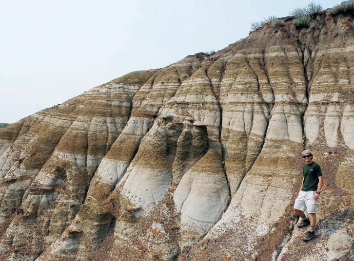
I was hoping to land a job through the SIFT jobs program when Jen Russel-Houston, the Geosciences Manager at Osum, came to my petroleum geology class on a CSPG Lecture Tour. A few days after a fascinating talk on the Grosmont Formation, a job offer was presented to our class. With Dr. Dalrymple as a reference, I came away from the interview feeling great, and as it happens, with a summer internship working under Senior Geologist Kelli Meyer on their Cold Lake project. The story got even sweeter when I heard that Osum founder, Vice President, and former CSPG President Peter Putnam, gave his blessing for an undergraduate thesis based on the work done during my internship, which is now well underway.
The job at Osum, like SIFT, was more than I could have hoped for. Working for a small company gave me the opportunity to make important contributions to a variety of projects including core logging and preliminary facies modeling with consultant Shawna Christensen, choosing petrographic samples, and assisting Operations Geologist Mark Rabin in choosing core for slotted liner tests. I also enjoyed writing a research proposal and calculating a budget for my undergraduate thesis, as this was my first
shot at independent research. The work is on carbonate concretions in the Clearwater Formation, near Cold Lake, Alberta, and the plan is to use techniques like laser ablation for stable isotopes and electron microprobe analysis in order to understand their composition and origin.
The mentoring I received was priceless, and it seems to me that it’s all about the extraordinary people working for extraordinary organizations deciding that part of their job was to find and nurture students who will eventually replace them as the next generation of geoscientists. They understand the importance of these jobs in a modern society, and want to see the supply of energy to the global market in good hands. More importantly, there is a basic impulse to pass on the knowledge accumulated over a lifetime, a value that my experiences have convinced me is also at the core of the CSPG. But whatever the reason, I’m grateful for all of these opportunities and cannot wait until it is my turn to pass on the torch. After this past year of career- and life-influencing events, I’m convinced I’ll be heading back out west.
The CSPG squash committee has been hard at work since October to prepare for the 28th Annual event. Some committee members have moved along but most are still with us and some we can’t get rid of.
The tournament will once again be held at the World Health Club in Edgemont on February 3, 4, and 5th 2011 Both singles and doubles play will be
offered again to all players entering the competition. Registration is up and running on the CSPG website at www.cspg.org. Look under the Events Tab under Social Events to find the squash link. Early Bird prizes are being offered to those people who are keen enough to get their entry in before January 3rd, 2011. Enter early as this event fills up quickly. The limit will be about 130 players plus or minus a few
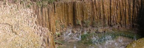
depending on which divisions need players. This tournament is open to all players and abilities. We typically have an A division for highly skilled players all the way down to E or Beginner level.
Look for great food and social opportunities at this 3-day tournament.
The CSPG Squash tournament has been a sold-out event for the past 12 years and continues to grow in popularity. The event hosts a variety of earth scientists, including a large number of geophysicists who entered last year. Students are always welcome and have been generously sponsored by Encana in the past.
Keep an eye out for TWO sponsored Practice Nights. One will be offered at the Bow Valley Club on Monday January 31st at 4:30 – 7:00pm (same night as Registration Night) The other practice night will be hosted at Bankers Hall on Thursday January 27th at 4:45 to 7:00 pm. Please contact David Caldwell 403-852-5571 or the CSPG office at 403-264-5610 for sponsorship opportunities.


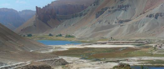

And join thousands of industry professionals at this year’s recovery 2011 convention in Calgary May 9 - 13, 2011 at the Calgary TELUS Convention Centre.
• Submit your abstract for oral presentation, poster presentation or core presentation online now. Abstract deadline is January 15, 2011
• Increase your company’s brand visibility among thousands of industry professionals - sponsor or advertise in our official publications
• Earn up to 6 PDH credits each day you attend
• Bring your company to the show floor. Space is almost SOLD OUT! Book now at exhibit@geoconvention.com
• Re-connect with friends, meet new contacts and take advantage of the opportunity to network with industry professionals at various social events including Luncheons and the Core Meltdown


RPS Boyd PetroSearch puts the pieces in place for affordable 3D earth modeling solutions.
Until now, only the largest players could access advanced earth modeling technology to simulate oil and gas reservoirs, leaving smaller companies scratching their heads.
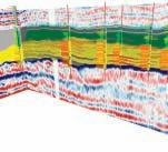
As part of our consulting services, RPS Boyd PetroSearch makes sophisticated reservoir modeling accessible to mid-tier companies, using the Paradigm GOCAD® and SKUA® platforms.
Learn how we can use GOCAD® and SKUA® to help your engineers, geologists and geophysicists put their heads together to extract more oil & gas from your reservoir.
Please call: Damien Thenin 403.543.5381 or Larry Herd 403.543.5362 Visit boydpetro.com or rpsgroup.com/canada
The AAPG 2010 International Conference and Exhibition was held in Calgary in September 12th - 15th, 2010.
During the pre-conference and postconference, in conjunction with other associations (AAPG, EMD, SEPM, and PTTC), CSPG ran three short courses and four field seminars. Delegates (136 including students) attending the conference, including CSPG members who normally attended our Fall Education Week, benefited from the international interaction. CSPG thanks CSPG instructors: Bill Amott, Russell Davies, Pat McLellan, Tom Moslow and JP Zonneveld, Greg Soule and Paul MacKay, Chris Collom and Randle Robertson, Dennis Meloche, and Dan Edwards. A special thanks to the CSPG Continuing Education Committee, especially Julia Baumeister from Compton Petroleum Corporation and Dennis Meloche from Devon Energy for organizing these events.
CSPG also hosted an International Core Conference on September 16th -17th and with the support of our sponsor, AGAT Laboratories, brought core from around the world to the Alberta Energy and Resource Conservation Board (ERCB) Core Research Centre. CSPG would also like to thank Weatherford for sponsoring the luncheon.
Nathan Bruder, Milestone Exploration and John Cody, StatOil, worked tirelessly soliciting core. The core was divided into four areas and each area had volunteers assist in securing core and manning the core educating 404 interested delegates. Special thanks to all the volunteers: John Hopkins, Stephen Hubbard, Christian Viau, Ryan Carnegie, Dan Kohlruss, Arden March, Jerome Biollo, John Miller, Peter Proverbs, Chuck Vorce, Fed Krause, Geir Helgesen, Dean Gagnon, Mark Radomski, James Carter, Chantel Bunnell, Julia Davison, and Dennis Meloche.
What a team! Graeme Bloy, CSPG Past President, certainly knew who to call on and was instrumental in guiding CSPG in maximizing attendance, exposing students, and assisting the team to completion.
rpsgroup.com
| By Caitlin Young
Avenue Calgary Magazine has named Ayaz Gulamhussein, 2010 Services Director at the CSPG, one of Calgary’s “Top 40 Under 40.” After speaking with Ayaz, it is easy to see why. The passion that Ayaz has for his profession and his volunteer work is evident. Dedicating over 1,000 volunteer hours annually to the Kids Up Front Foundation, the Aga Khan Foundation Canada, and the CSPG, it is Ayaz’s youth, energy, and passion that peg him as one of the top young geologists in the industry.
“Volunteering is extremely important to me; it is a huge part of my life. I started volunteering at a very young age; in my community it is just what you do. I started volunteering with the CSPG five years ago because I wanted to get involved with a scientific society that was technically challenging and promoted the professional development of geoscientists” Ayaz says. “I have found that being involved with the CSPG has been incredibly beneficial for me in my early career. It has allowed me to meet so many people from all different areas of the industry. In a city like Calgary, being able to network with your peers is crucial.”
Ayaz recommends that young professionals should participate in the community through volunteering, as they will learn leadership and organizational skills that they can use in their professional life. Not only will they learn new skills he says, but they will also have the opportunity to rub elbows with their peers, which could potentially help them break into the business. “When I talk to students and young graduates who are having trouble getting their foot in the door, I always tell them to volunteer with the CSPG. Getting involved and meeting senior members of the industry can be difficult if you do not know where to go or how to go about it.”
This is partly what prompted Ayaz to organize the CSPG U35 Networking Event at Arts Central this past September. After noticing a significant gap in the membership demographics within the CSPG, Ayaz wanted to know where all the young people were, and how to get them involved with the Society. “I realized that there really weren’t any events for students and young professionals to get together and network with one another, and that they were not aware of the benefits of being involved with CSPG. As a Society, we needed to shed light on the positive effect that being part of the CSPG would have on their careers.” By having an event specifically for students and young professionals, young geologists were able to meet and interact with one another, as well as mingle with several industry veterans who were also in attendance. Nearly 200 young professionals and students attended the first annual event! “I was not surprised with the success of the event,” Ayaz says, “We knew that these young people were out there, it was just a matter of reaching them and showing them how the CSPG is relevant to them and their careers.”
Many of the people that Ayaz has met through the CSPG have been industry veterans, which has proven to be incredibly valuable. “The people that have been in the industry for a long time, are amazing resources. In my experience they love being teachers and mentors to younger professionals in the business. After eight years in the industry, Ayaz says that not all learning can be done in the classroom. “In this business you learn from the people that you work with, and through the experiences that you receive. There is always something new to learn, and a lot of that learning can be done from industry veterans. They thrive off of teaching and sharing their stories with young people. They have so much information to impart and there is so much that we younger people can learn from them.”
The CSPG is extremely proud of Ayaz, and we are looking forward to seeing what successes and accomplishments are in store for this remarkable young professional down the road. Congratulations Ayaz on being selected as one of Calgary’s “Top 40 Under 40” by Avenue Magazine.
Track and monitor your Petrel projects with the new plug-in for Petrel – the Blueback Project Tracker.
A Petrel data managers dream come true:
• Acquire and maintain an overview of your Petrel projects on your discs
• Reveal data inconsistencies and duplications
• Monitor users and projects
• Measure migration of projects between Petrel version

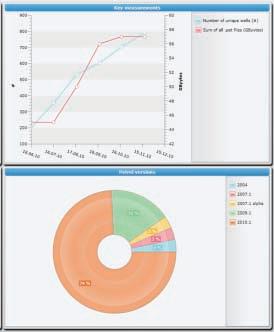
Learn more? Contact us at www.blueback-reservoir.com
sales@blueback-reservoir.com
+1 403 538 4821
www.blueback-reservoir.com
| By Aileen Lozie, Paul MacKay, Rob McGrory, and Satyaki Ray
With the Christmas season and 2010 behind us, it’s time to start looking forward to this year’s convention taking place May 9-13, 2011 at the Calgary TELUS Convention Centre.
Mark your calendars – important deadlines to make note of include:
Call for Abstracts closes Friday, January 14, 2011
Convention registration will open Tuesday, February 1, 2011
Registration for this year’s convention is expected to open February 1, 2011 at noon (MST). Take advantage of the early bird discounts and register early!
Make sure you register early to ensure you receive tickets for this year’s special events including Monday night’s icebreaker reception and after party, Tuesday night’s networking reception, core meltdown, and convention luncheons.
e xhibit h all
Looking to exhibit? Visit www.geoconvention. com for more information on how to submit your exhibitor application. The floor is almost sold out – so act quickly!
The convention’s success relies heavily on the support and dedication of committee volunteers. If you are interested in volunteering for this year’s convention, please email volunteer@geoconvention.com or visit the website for more information.
call for a bstracts recovery 2011 is looking for technical presentations from Canadians and International industry professionals and academia. The Call for abstracts is open and the deadline to submit your abstract for consideration is Friday, January 14, 2011. For more information on how to submit an abstract, and this year’s presentation topics of interest, please visit www.geoconvention.com and visit the call for abstracts page under conference.
Additional tickets for all events can be purchased in advance when you register to attend the convention – so feel free to invite your spouse, partner, co-worker, or potential clients to one or all of the social events.
sponsorship
For more information on this year’s upcoming convention, recovery 2011, please visit the website at www.geoconvention.com or email info@geoconvention.com.
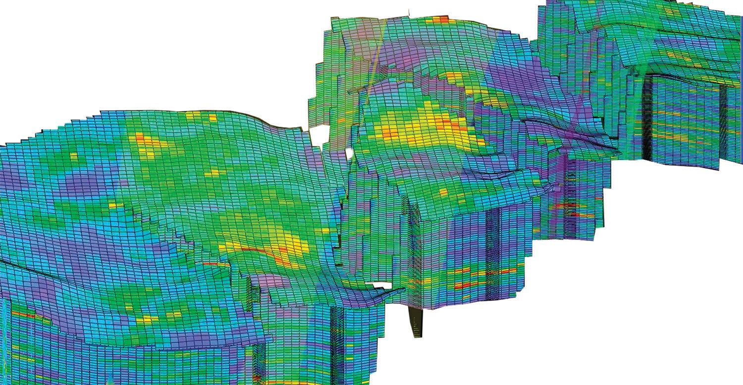


At APEGGA we know and understand that we live and practice in a complex world. The heavy lifting in the resource extraction industries, and in the environmental industry, is done by teams, often led by Professional Geoscientists. These teams include professionals, technologists and support staff both at headquarters in the city and at camp in the field.
There’s no question in our minds that geoscience projects require teams to manage questions surrounding the many varied issues including governance, tax impact, reporting and environmental concerns including land-use and ground disturbance.
Through consultation and communication, all these issues, and a multitude of others, are resolved to ensure the projects we work on benefit society. The Geoscience Professionals’ code of ethics and paramount responsibility to protect public safety and well-being must be recognized and acted upon.
P.Geol.s, P.Geoph.s and Professional Licensees (Geological and Geophysical) are team players. No doubt. Our work helps keep Alberta safe and strong and the only way we can achieve that goal is through teamwork amongst professionals.
Teamwork Pays. Visit www.apegga.org for more information or call Tom Sneddon, P.Geol., Geoscience Affairs Manager at 403-262-7714 or 1-800-661-7020.
Need a solution that will take you to oil faster?

Introducing the DecisionSpace® Desktop unified workspace
Now your entire asset team can collaborate in real time using one unified workspace. Accelerate analysis and interpretation by sharing a common subsurface framework. Reduce cycle time and improve accuracy by examining more scenarios faster. Improve your returns in the field and in the office with industry-leading science and unmatched usability. Learn more at Halliburton.com/decisionspacedesktop.
High Science Simplifiedsm