20 Drilling and Completions: A New Exploration Tool 27 Practical Sequence Stratigraphy VIII. The Time-Based Surfaces of Sequence Stratigraphy 35 Climate Change I: Global Warming Debate
43 2008 CSPG Awards
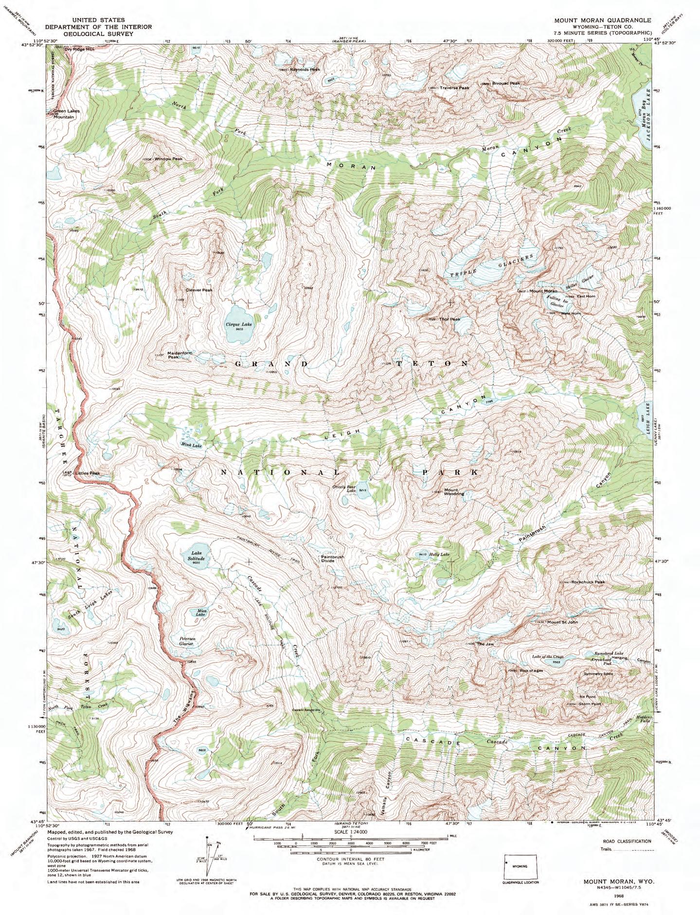
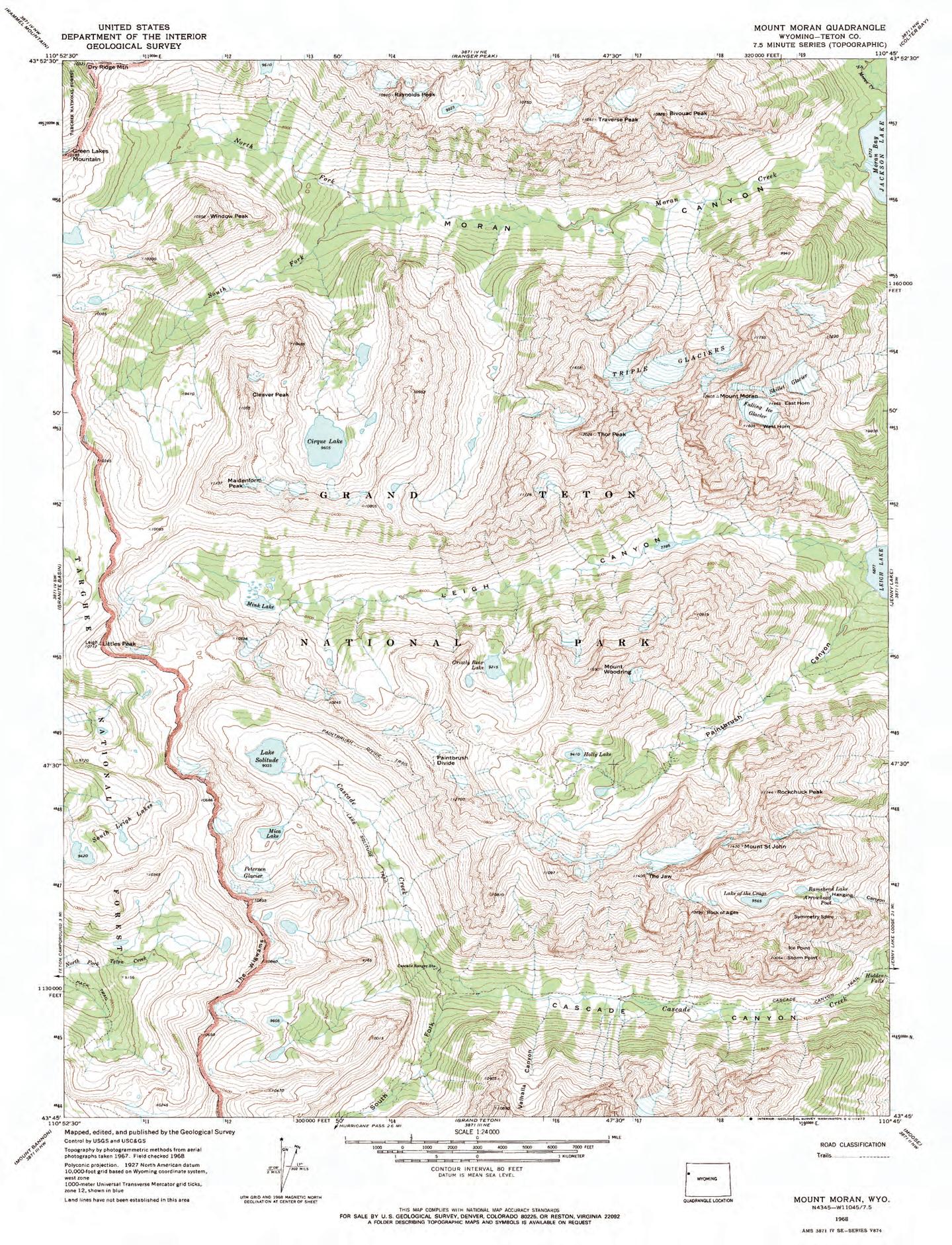
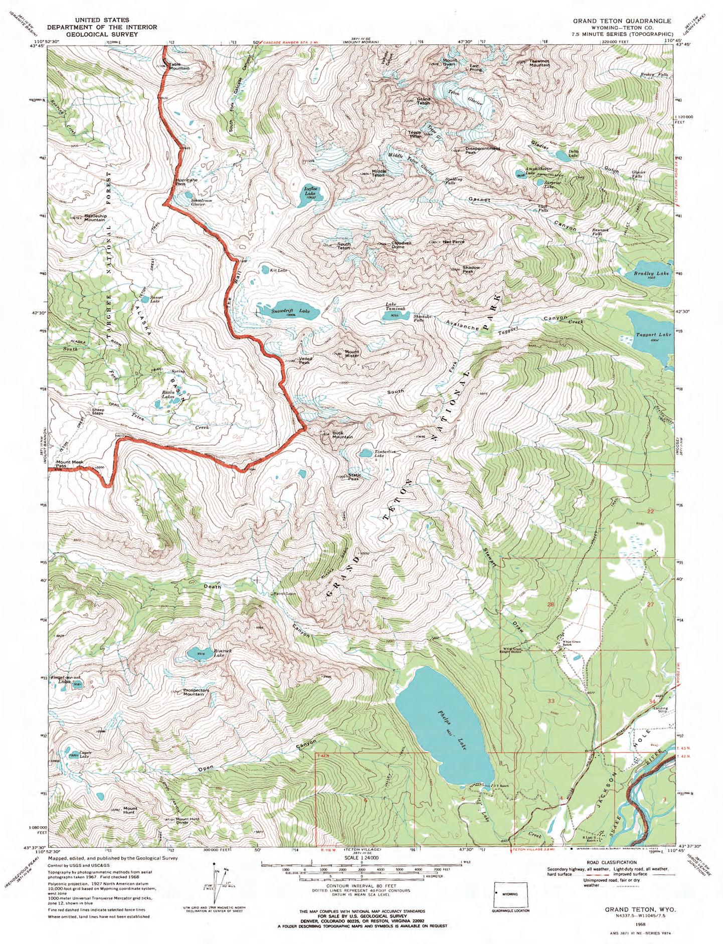
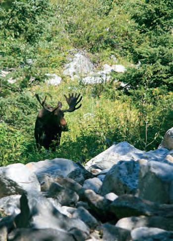
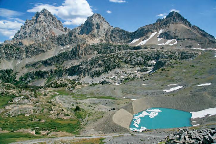
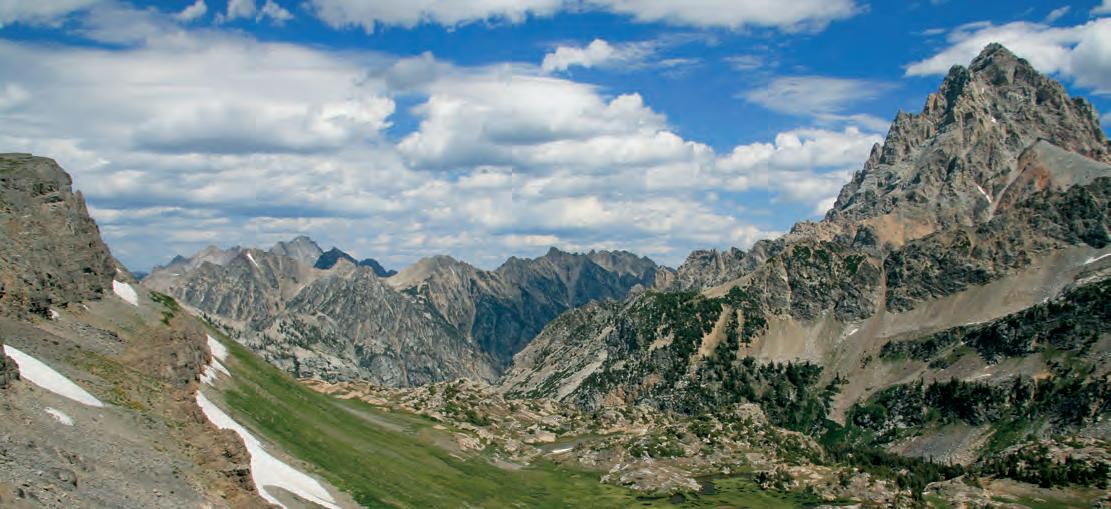
48 Go Take a Hike: Hurricane Pass, Grand Tetons, Wyoming
And you thought you were just buying IHS software…
Prakash Mandalia Customer Support Analyst IHS
When you invest in any one of the IHS software superstars like — AccuMap®, PETRA® or GeoSyn™ you get more than just easy-to-use, time-tested tools from a proven industry leader—tools that can dramatically simplify your search for oil and gas. You get a whole team of hometown professionals supporting your efforts—people just like Prakash. Got a “how-do-I-do-this” software question? Need training fast? Come to the source. At IHS you get more answers, more training, more resources, and more people—all working for you.
IHS. Great Products. Great People.
Connect to the source and get MORE. Call us today at 403.770.4646 or visit ihs.com/connect and find what MORE means to you.
Please submit RESERVOIR articles to the CSPG office. Submission deadline is the 23rd day of the month, two months prior to issue date. (e.g., January 23 for the March issue).
To publish an article, the CSPG requires digital copies of the document. Text should be in Microsoft Word format and illustrations should be in TIFF format at 300 dpi., at final size. For additional information on manuscript preparation, refer to the Guidelines for Authors published in the CSPG Bulletin or contact the editor.
Technical Editors
Ben McKenzie Colin Yeo (Assistant Tech. Editor) Tarheel Exploration EnCana Corporation Tel: 403-277-4496 Tel: 403-645-7724 Email: bjmck@telusplanet.net Email: colin.yeo@encana.com
Coordinating Editor
Heather Tyminski
Comunications and Public Affairs, CSPG Tel: 403-513-1227, Email: heather.tyminski@cspg.org
ADVERTISING
Advertising inquiries should be directed to Alyssa Middleton, Tel: 403-513-1233, email: alyssa.middleton@cspg.org. The deadline to reserve advertising space is the 23rd day of the month, two months prior to issue date.
The RESERVOIR is published 11 times per year by the Canadian Society of Petroleum Geologists. This includes a combined issue for the months of July and August. The purpose of the RESERVOIR is to publicize the Society’s many activities and to promote the geosciences. We look for both technical and non-technical material to publish. The RESERVOIR is not intended to be a formal, peer-reviewed publication. Additional information on the RESERVOIR’s guidelines can be found in the May 2008 issue (p.46-48; available at http://www.cspg.org/publications/reservoir/reservoir-archive-2008.cfm). No official endorsement or sponsorship by the CSPG is implied for any advertisement, insert, or article that appears in the Reservoir unless otherwise noted. The contents of this publication may not be reproduced either in part or in full without the consent of the publisher.
FRONT COVER
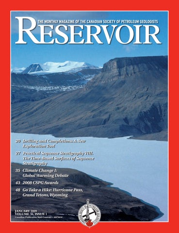
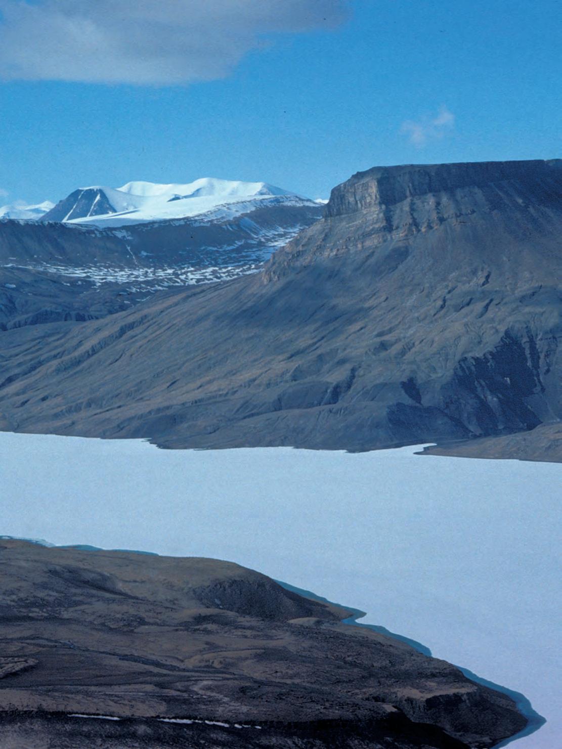
Sverdrup Basin, northern Ellesmere Island, Nunavut. Jurassic to Cretaceous sandstone intruded by Cretaceous basalt sills, situated by Ekblaw Lake, north of Tanquary Fiord. Photo by Thomas Frisch.
Proudly brought to you by Professionals in Geoscience and Engineering
Alberta’s Professional Geoscientists and Engineers provide Albertans with many of the essentials of daily living. The work that they do allows all of us to enjoy warmth, light, power, water and the ability to travel and communicate over distance.
Since 1920, Members of APEGGA, The Association of Professional Engineers, Geologists and Geophysicists of Alberta, have made a difference in the daily lives of millions of Albertans by bringing science and innovation to life.
The P.Geol., P.Geoph., P.Eng., and R.P.T. professional designations represent the highest standards of quality, professionalism and ethics in geoscience and engineering. APEGGA Members can take pride in the role they play and the contribution they make to Alberta. APEGGA and its over 47,000 Members are committed to public safety and wellbeing through the self-regulation of the geoscience and engineering professions in Alberta.
Visit www.apegga.org for more information.
Geologists Geophysicists Engineers
CSPG EXECUTIVE
President
Graeme Bloy • West Energy Ltd. gbloy@westenergy.ca Tel: (403) 716-3468
Vice President
John Varsek • EnCana Corporation john.varsek@encana.com Tel: (403) 645-2000
Past President
Lisa Griffith • Griffith Geoconsulting lgriffith@griffithgeoconsulting.com Tel: (403) 669-7494
Finance director
David Garner • Chevron Canada Resources davidgarner@chevron.com Tel: (403) 234-5875
This 2007-2008 year has demonstrated the fundamental resilience of the CSPG, and reinforced the importance of our volunteers.
Our core programs of Technical Division Talks, social events, and Technical Luncheons functioned smoothly, and these programs are essentially self-sustaining financially. The financial stability and content of the Reservoir continues to improve. Several recent initiatives – the Joint Annual Convention Committee (CSPG, CSEG, and CWLS), additional Continuing Education courses, consolidated CSPG Awards, and merged CSPG-GAC Student Chapters –are heading towards success. We are also continuing to support our alliances with other organizations, most prominently CSEG, the Canadian Federation of Earth Sciences (CFES), APEGGA, CWLS, and the Canadian Council of Professional Geoscientists (CCPG). Notably, the solid performance of these fundamental activities is especially commendable in view of recent serious health issues and high turnover within our office staff.
Building on this established foundation of activities, the Executive Committee is moving to imbed the strategic planning process into our annual cycle. Currently, one of the CSPG Executive’s biggest challenges is to find the right balance between day-to-day coordination and maintenance of complex portfolios, and planning for the future. Clear priorities, ratified annually, and tied to a business plan and the budget, will help to define the responsibilities of volunteers, staff, and the Executive.
T ODAy: SNAPSHOT OF THE SOCIET y
There are three areas I’d like to highlight to illustrate the health of our organization: finances, membership, and member participation.
On the financial side, the CSPG is predicted to end the year with a slight deficit (~4%) on an overall operational budget of $2.5 million. To put this into context, we are a not-for-profit society, and we do hover historically between slight profits and slight
deficits. The good news is that the Society has shown a healthy ~7% annual increase in operating revenue and expenditures over the last 10 years. Our two main revenue generating streams – membership dues and annual convention profits – each contribute about the same amount to our bottom line, and together cover 25-30% of our expenses. The CSPG should be proud to see that most of our programs are now largely self-sustaining. We also maintain a contingency fund in an investment portfolio. We are in the enviable position of having a diverse revenue stream and steadily growing financial activity.
You’ve heard the membership numbers before, and the good news is that they haven’t changed. We have maintained a membership of 3,100 – 3,500 since 1992, down from an all-time high in the 1980s of 4,400. The total of all memberships in 2007 was 3,374. Ideally, membership of the CSPG is a matter of professional pride. Realistically, it would also be beneficial to see financial advantages. It is just as easy and cheap for a non-member to attend all CSPG functions as a member. As a first step to address this issue, we have started differential pricing on Technical Luncheons to encourage people to join the CSPG. If the initiative is successful, we may broaden the scope of this approach.
Member participation is reflected in our continuing high participation rate for our courses, field trips, conferences, and Technical Luncheons. Another aspect of participation is the amazing number of members that volunteer on our 60 diverse committees. One of the privileges of presidency is the ability to look in awe at the dedication and competency of our volunteers. By this measure we are doing well, but with the increasing number of committees and the predicted decreasing number of members, we should be planning
(Continued on page 7...)
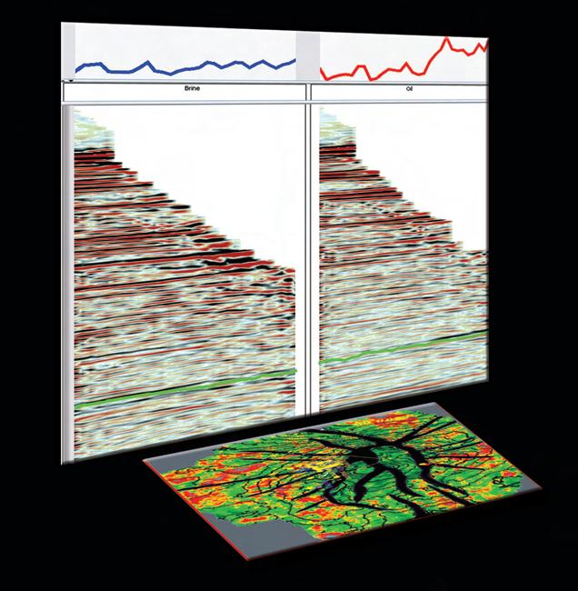
Pre-stack seismic data gives interpreters the ability to better understand reservoir potential. With Well Seismic Fusion™ technology, pre-stack seismic can be incorporated into core G&G interpretation workflows for rapid and accurate prospect validation. Providing fast and easy criteria for determining which prospects to pursue, Well Seismic Fusion tools can indeed dramatically improve your odds of success.
For complete details about Well Seismic Fusion software, please visit us at www.lgc.com
CORPORATE MEMBERS
ABu DHABI OIL CO., LTD. (JAPAN)
APACHE CANADA LTD.
BAKER ATLAS
BG CANADA ExPLORATION & PRODuCTION, INC.
BP CANADA ENERGY COMPANY
CANADIAN FOREST OIL LTD.
CANETIC RESOuRCES TRuST
CONOCOPHILLIPS CANADA
CORE LABORATORIES CANADA LTD.
DEVON CANADA CORPORATION
DOMINION ExPLORATION CANADA LTD.
DuVERNAY OIL CORP
ENERPLuS RESOuRCES FuND
FuGRO AIRBORNE SuRVEYS
geoLOGIC systems ltd.
GRIZZLY RESOuRCES LTD.
HuNT OIL COMPANY OF CANADA, INC
HuSKY ENERGY INC.
IHS
IMPERIAL OIL RESOuRCES LIMITED
LARIO OIL & GAS COMPANY
LITTLE ROCK DOCuMENT SERVICES LTD
MJ SYSTEMS
MuRPHY OIL COMPANY LTD.
NExEN INC
PENN WEST PETROLEuM LTD
PETRO-CANADA OIL AND GAS
PETROCRAFT PRODuCTS LTD.
PROVIDENT ENERGY LTD.
RPS ENERGY CANADA LTD.
SHELL CANADA LIMITED
SPROuLE
SuNCOR ENERGY INC
TALISMAN ENERGY INC.
TAQA NORTH LTD
TECK COMINCO LIMITED
TOTAL E&P CANADA LIMITED
WEATHERFORD CANADA PARTNERSHIP
AS OF OCTOBER 29, 2008
(...Continued from page 5)
ahead. We have “burned out” a number of key volunteers over the last couple of years. The Executive needs to address the difficult question of whether we reorganize, hire, or outsource more staff support for our hardworking volunteers, or drop programs.
T OMORROw: STRATEGIC PLANNING
The Executive continues to move the Society along the path from a primarily activity-based Society to one also focused on strategic goals. Colin Yeo established good line-of-sight between goals set in the 2005 Strategic Plan, and Executive meetings last year. The ongoing process certainly isn’t straightforward! Disruptions in the office staff this year have made it necessary for the Executive to once again take a more active role in operations. It is clear that the Executive needs to set priorities, communicate them clearly to the staff, and then jointly decide who is responsible for executing specific aspects of the plan. There also has to be more continuity in long-range goals set by successive Executives.
This year, I challenged the Executive to move one part of the 2005 Strategic Plan forward: making the CSPG more national. In addition, the 2009 President (Graeme Bloy) and I began to consider a proposition from the AAPG to sublet an office. Finally, I aimed to strengthen Executive ties to the staff in order to gain a better appreciation of the challenges facing the office, and so that the Executive and staff could perform as a team.
On the national front, each Director has highlighted portions of his/her portfolio that can go national. Current CSPG members in each province have been identified, and several key people contacted. Every person I’ve talked to has indicated interest in this area. Our next steps are to travel to selected cities to discuss a model for setting up CSPG Locals or Affiliates with interested geologists, and to see how we can help meet their professional needs.
With regards to the AAPG, discussions were held with a small panel of former CSPG Presidents to consider the advantages and disadvantages of sharing office space with the AAPG in Calgary. I attended the AAPG Leadership Conference in Tulsa in August 2008 to see how the proposed AAPG Calgary office fit into the AAPG overall strategy. During the meeting, the AAPG announced its intention to open offices in Calgary and South America in 2009. In September, Rick Fritz, the Executive
Director of the AAPG, clarified the AAPG’s goals and objectives for an office in Calgary.
These objectives include support of existing membership services, access to products, professional development with short courses and workshops (possibly as joint ventures with the CSPG), marketing and sales of AAPG books, collaborative conference efforts with sister societies and support for the AAPG’s annual or international meeting in Calgary, and administrative support for the AAPG Canada Region. They are also looking at setting up an AAPG charitable organization with some assurance that a portion of the funds raised would be used in Canada. The Executive is currently considering this proposal.
Finally, with respect to Executive and staff, it has become apparent that clarifying roles and setting priorities are the most important things we can do to improve the efficiency of the CSPG. For the first step in this process, the Executive participated in a fullday strategic planning session in September 2008. The top three areas of strategic focus, in order of priority, were: 1) maintaining the integrity of our current programs and social activities; 2A) clarifying staff-Executive roles; (tied with) 2B) volunteer management; and 3A) increasing the CSPG’s national presence; (tied with) 3B) membership. As part of the ‘role’ discussion, we are assessing the relative merits of the Executive Director and Business Manager roles, using a report commissioned by Colin Yeo and researched by a group of CSPG past Presidents.
ACk NOw LEDGEMENTS
This year has not been comfortable, speaking personally, but it has been rewarding. The enthusiastic, willing, and hard-working Executive made the challenges much easier to face. I would also like to thank the various past presidents who have been generous with their encouragement and advice. Finally, my gratitude is extended to the tenacious CSPG and JACC office personnel, including our current staff (Lis, Kim M., Heather, Dayna, Alyssa, Kasandra, Deanna, Shauna, and Tanya) and recent staff (Lori, Sarah, Tim, Kim C., and Kristina) – your positive attitude, teamwork, and flexibility enabled the CSPG office to continue functioning through a year of change.
technicaL Luncheons JANUARY
Paleontology, paleoecology, and climate
in an early Eocene, High Arctic swamp forest
SPEA k ER
Jaelyn
J. Eberle university of Colorado, Museum of Natural History, and Department of Geological Sciences
11:30am thursday, January 8, 2009 telus convention centre calgary, a lberta
the 2009 agm will be held at this technical luncheon.
Please note:
the cut-off date for ticket sales is 1:00 pm, monday, January 5, 2009. csPg member ticket price: $38.00 + gst. non- member ticket Price: $45.00 + gst.
Due to the recent popularity of talks, we strongly suggest purchasing tickets early, as we cannot guarantee seats will be available on the cut-off date.
The early Eocene marked the peak of global warming since onset of the Cenozoic Era (ca. the last 65.5 million years), when mid-latitude temperatures soared, and Canada’s High Arctic was home to lush swamp forests inhabited by alligators, giant tortoises, and a diverse mammalian fauna that included primates and tapirs. As the relevant fossil-bearing rocks of the Eureka Sound Group on central Ellesmere Island were well above the Arctic Circle during Eocene time, this environment experienced months of continuous sunlight and darkness – the Arctic summer and winter, respectively.
Results from over three decades of paleontological field research show the early Eocene (~52 million years ago) mammalian fauna from the Eureka Sound Group on Ellesmere Island comprises over 20 genera, ranging from tiny rodents to primates, tapirs, brontotheres, and hippo-like Coryphodon. Complementing the paleontology, stable isotope geochemistry – in particular, oxygen and carbon isotope analyses of vertebrate bone and tooth enamel – indicate a warm temperate paleoclimate and provide valuable paleoecologic insight into the early Eocene High Arctic vertebrate fauna. More specifically, oxygen isotope ratios from co-occurring mammals, turtle, and fish indicate a mean annual temperature (MAT) at approximately 9ºC, with a warm month mean temperature of up to ~20ºC and an above-freezing cold-month mean. Analyses of both carbon and oxygen isotope ratios of mammalian tooth enamel suggest that the large herbivorous mammals lived yearround in the Eocene High Arctic, and had an unusual diet over the dark winter months.
Year-round habitation of Arctic regions is a probable behavioral prerequisite for dispersal across northern high-latitude land bridges. Such migrations have occurred several times in the geologic past, and are hypothesized to explain the early Eocene appearance in North America of several modern mammalian orders presumed to have originated in Asia, including today’s ungulate or hoofed mammals (perissodactyls and artiodactyls) and primates. Such polar dispersals are predicated on climatic conditions in Arctic regions that are wetter and warmer than those of today. If current warming trends continue, year-round occupation of polar regions by plants and animals found today only at mid-latitudes is conceivable, and the Arctic may again become a corridor for intercontinental migration.
BIOGRAPH y
Jaelyn Eberle is a Canadian paleontologist with seven years’ field experience working in Canada’s High Arctic, including on Ellesmere, Axel Heiberg, Devon, and Banks Islands.
She is Curator of vertebrate paleontology at the University of Colorado Museum of Natural History and an assistant professor in the Department of Geological Sciences at the University of Colorado at Boulder.
TECHNICAL LUNCHEONS JANUARY LUNcheoN
The role of outcrop models in the subsurface characterization of deep-water reservoirs
SPEAKER
Michael H. Gardner
Montana State University
AAPG Distinguished Lecturer
11:30 am
Monday, January 19, 2009
Telus Convention Centre Calgary, Alberta
Please note:
The cut-off date for ticket sales is 1:00 pm, Wednesday, January 14, 2008. CSPG Member Ticket Price: $38.00 + GST. Non-Member Ticket Price: $45.00 + GST.
Due to the recent popularity of talks, we strongly suggest purchasing tickets early, as we cannot guarantee seats will be available on the cut-off date.
The derivative source of geology imaged by subsurface data imposes limitations on its veracity because we can only confirm that which we can measure directly. Seismic data is constrained by vertical resolution limits, artifacts and noise, and non-unique processing. Providing higher vertical resolution and direct measurements, the sparse distribution and spacing of well data limits its spatial correlation. Geostatistical and stochastic methods used to manage these uncertainties introduce random effects. For these reasons, the geology being modeled cannot be verified. Furthermore, the modeling procedures that most impact data retention, including information that must be preserved for verification, are largely unknown. Modeling subsurface geology is simply done with too little information; therefore, analogs and probabilistic approaches are used to generate multiple scenarios, which minimizes the risk of an uncertain geologic model.
The twelve-year (1995-2006) study of the Permian Brushy Canyon Formation (BCF) illustrates the application of
outcrop analogs to subsurface reservoir characterization. An integrated suite of three-dimensional geological, petrophysical, and geophysical models were generated from 488 sedimentological profiles and detailed mapping (20 metre-thick intervals) of continuous shelf-to-basin outcrops. Geologic mapping of this stratigraphy and sedimentary architecture across the multiple fault blocks that dissect the 245 km2 outcrop area provides a nearly complete three-dimensional view of the BCF sedimentary system. Advanced GIS technology and three-dimensional subsurface mapping software were used to build three-dimensional geological models with meter-scale, resolution for over half the outcrop. Conversion of the outcrop data to subsurface data formats facilitated outcrop to well and seismic data correlations (355 well logs and 3,300 kilometres of two-dimensional seismic) across the 33,500 square kilometers of the Delaware Basin in West Texas.
Generating outcrop models is substantially different from subsurface modeling because outcrops lack the geospatial framework embedded in the collection of subsurface data. Nonetheless, outcrop geologic models provide a verifiable reference case derived directly from the rocks. Displayed as digital, geo-referenced subsurface data, the BCF models can be used to evaluate how well subsurface modeling methods reproduce known sedimentary architecture. These models provide a target, or benchmark model of the outcrop transformed into subsurface well and seismic data. Because the outcrop geologic models can be verified, they can be interrogated to better determine how (1) model-building methods,
(2) different data sources, and (3) differences in geologic interpretation affect the model. These are key areas where the introduction and retention of geologic information most impacts modeling results.
BiogRAPhy
Michael H. Gardner is an Associate Professor at Montana State University in Bozeman, Montana and a geological advisor to Marathon Oil Company. He received his B.A. in Geology from the University of Colorado and his Ph.D. from the Colorado School of Mines. Refined through outcrop studies conducted since 1983, his applied research focuses on outcrop characterization of sedimentary architecture by integrating “old-school” field methods with three-dimensional, geospatial visualization technology.
Gardner teaches and leads the Slope and Basin Consortium at Montana State University, where his current research focuses on developing, testing, and verifying geological rules for deep-water reservoir prediction through the Geological Analogs and Information Archive (GAIA) project.
Electron Microscopy and X-ray Microanalysis for Geoscientists
Short Courses
Friday, Feb. 20, 2009
Introduction to SEM and X-ray Microanalysis
Monday-Tuesday, March 2-3, 2009 SEM and X-ray Microanalysis in the Petroleum and Mineral Industries (hands-on lab course)
For rates and course details, contact Robert Marr, Dept.of Geoscience, U of C tel: 403-220-6443 email: rmarr@ucalgary.ca
technicaL Luncheons FEBRUARY LUNCHEON
The Wembley Doig “ATSB” field
is anomolous no longer: a coastal barrier bar
prograding
off an antecedant
shelf
SPEA k ER
Jessica Beal
MegaWest Energy Corp.
CO-AUTHOR
Dr. John Harper
ConocoPhillips Canada,
11:30 am
t hursday, February 5, 2009 telus convention centre c algary, a lberta
Please note: the cut-off date for ticket sales is 1:00 pm, monday, February 2, 2009. csPg member ticket Price: $38.00 + gst. non- member ticket Price: $45.00 + gst.
Due to the recent popularity of talks, we strongly suggest purchasing tickets early, as we cannot guarantee seats will be available on the cut-off date.
Deposition of the Anomalously Thick Sand Body (ATSB) of the Wembley Field, in the Triassic Doig Formation, is a result of a prograding barrier bar off an antecedent shelf. The Wembley Field is a sand body that overlies and is laterally encased by Doig shale. Inter-Doig sand caps both the main Doig sand and the laterally adjacent shale; it separates the Doig sand and shale from the overlying Halfway shale.
The Wembley Field Reservoir was deposited during a relative sealevel stillstand. It widens and thickens to the south. The western edge has a distinct N-S linear trace. The eastern margin is serrate due to arcuate sand bodies verging eastward away from the linear western margin. The field extended southward as lobes of sand shingled the previous deposits. Shale lenses separate each lobe.
Several log signatures have been identified which can be simplified into four basic characters. They represent transitions eastward from the western margin blocky log shape as the massive sands intercalate with the eastern shale packages. Characteristic core sequences document this transition eastward into the shales. The main log character, a blocky gamma ray signature, is a continuous vertical sand body that overlies a basal thin interval of sand tongues, and is typical of the linear western margin of the field. The thickness of this unit increases southward. This character also defines the arcuate sand bodies which verge eastward from the western linear margin. Cores indicate the presence of high-angle breccias and slump deposits at the base of the section. The section passes transitionally upward into an interval of decreasing angle of dip and minor contorted sands with associated extensional faults. This interval lacks bioturbation, any significant deformation, or bioclasts.
The section then grades into very lowangle layering and lamination. Typically, this massive sand is capped with a leached layer, representative of a transgressive cap. Individual shale layers occur within the massive body, and are correlatable between closely spaced wells. These shales separate lobes of sand containing repeats of portions of the above sequence.
Both eastward from the western margin of the field, and normal to the trace of the arcuate sand bodies, cores indicate sands which interfinger with the lateral shales. Those sands record segments of the overall vertical sequence described above. The actual sequences identified in these individual sands reflect the depth position of the sands relative to the main sand sequence.
Lateral to the western margin of the Wembley sand body, the Doig shales can be subdivided into three units. The lowermost shale unit predates deposition of the Doig sand body, thinning westerly from an eastern platformal setting, and can be traced beneath the sand body. It is parallel laminated, with no obvious evidence of marine life or any significant sedimentary structures. The overlying second unit is the lower portion of the shale laterally equivalent to the main sand body itself. Slumping and deformation with high bedding angles, slump blocks, and a mud conglomerate are all observed within this shale unit. A shallower third unit of
shale younger than the Wembley sand body completes the filling of the interval lateral to that body. It has low to horizontal bedding angles, with no signs of slumping and very little deformation.
To the east of the sand body, the previously described shale unit, which predates the sand body, has thickened to the platform setting. An overlying second shale is age equivalent to the sand body. No slumping or deformation is observed in this second shale. Bedding is near horizontal within this unit. The third unit of shale is laterally adjacent but younger than the Wembley sand body and has evidence of intense burrowing as well as deposited bioclasts.
An erosional unconformity at the top of the Doig shale is marked by a pebblerich conglomerate layer. This unconformity resulted from a relative drop in sea level and was subsequently overlain by a thin sand unit, the inter-Doig sand. This unit is variously excluded or included with the Doig depending on the workers involved, but it is clearly post-unconformity sand and postdates the Wembley sand body. This unit has low amounts of shale and silt at both the base and top but has interbedded silt and sand in between. Sometimes the coarse interbedded intervals have a bioclastic-rich layer. Due to high levels of fragmentation, it is difficult to determine the origins of the bioclasts, although they are likely molluscan. Irregular orientation of the shell debris may be a result of storm deposits.
A second unconformity, at the top of the inter-Doig sand, is equivalent to a similar unconformity at the top of the main Doig sand body and is also marked by a conglomerate layer. This latter conglomerate represents a transgressive cap, which is part of the transgressive portion of the depositional cycle that ultimately was deposited over the entire area and heralds the beginning of Halfway deposition.
The integrated data are interpreted to represent longshore progradation of a barrier sand body off an antecedent shelf and into deepening water. Progradation occurred in a shingled fashion as beach ridges were added southward to the spit. Storm washovers resulted in the interbedding of the sands with the shales to the east. Spit curvature to the east was characterized by extension of the massive sands from the western margin creating the observed (Continued on page 12...)
Where Exceptional Data and Images Originate
Rely on CGGVeritas Data Library to maximize your Foothills exploration success. You’ll have access to the leading seismic imaging technologies, depth imaging, highly sought 2D and 3D data, themost advanced acquisition capabilities and a staff dedicated to helping you succeed.
Focus on Performance. Passion for Innovation. Powered by People. Delivered with Integrity.
serrate eastern side. Production verifies the linearity of the western margin and the arcuate nature of each lobe front. Each lobe is separated from the previous lobe by shale layering, which occurred during the subsequent lobe shift. Such shifts are interpreted to have occurred during major storm erosion along the coast, which would have provided significant volumes of sand for accelerated growth.
The rapid supply of sediment resulted in instability and slumping of sands into deeper water. Extensional faults are the
shallow record of the development of slump planes. Sands slumped along the spit front and interfingered with the lateral shales. Evidence of slumping is preserved in both the slumped sands and the deformed shales. The decrease in dip up-section reflects the increased tractional forces in the shallowing water.
A modern-day analogue to the Wembley field is that of a barrier bar prograding off an antecedent shelf at an angle to the coastline, as seen off the coast of Newfoundland (Davis and Harper, 2005). This modern barrier clearly records such slump fans
along its outer margin. This active barrier growth process has been documented with seismic, sidescan sonar, cores, historical aerial photography, and video, to name a few of the analyses undertaken.
This model is not suggested to replace previous interpretations of the ATSBs. It represents a detailed study of the Wembley field alone. Previous models may be correct for the specific areas to which they refer as there is probably more than one model that will account for the variations seen for the regional Doig. What this study shows is that high-resolution analysis of individual Doig fields is critical for regional understanding.
R EFERENCES
Davis, L. and Harper, J.D. 2005. Conglomerates: Interpretation of depositional environments and bounding disconformities. CSPG Luncheon Presentation, January 2005.
BIOGRAPH y
customsolution
Jessica Beal, B.Sc. Honours, graduated in 2006 from St. Francis Xavier University’s Earth Sciences Department in Geology. She is currently employed at MegaWest Energy Corp. exploring, developing, and producing the Pennsylvanianage Warner Sandstone of the Cherokee Basin in the USA. Prior to that, she consulted for HBK Resources where the majority of her projects were based on the McMurray Formation.
Beal has worked as a summer student with both ConocoPhillips Canada and Nexen Inc., working with the Doig and Bakken formations, respectively. Her B.Sc. Honours Thesis is an offshoot of her summer work with ConocoPhillips Canada. She is currently a member of the CSPG, AAPG, and the GAC.
There is no wrong answer.
At Divestco, we understand what it means to be a customer. You like to be able to depend on a service provider to act in your best interests, give you exactly what you need, and only what you want. Divestco’s integrated offering for geological professionals gives you the ability to choose from a wide range of geological products and services to suit your unique needs. Pick anything you want, choose a bundled offer or let our experts create a custom solution for you.
Call Jennifer Davies at 403.537.9904 or email jennifer.davies@divestco.com for more information.
John D. Harper, Ph.D., P. Geol., FGSA, FGAC, is presently Senior Geological Advisor, ConocoPhillips Canada Ltd. and Retired Full Professor, Petroleum Geology and Sedimentology (Carbonate and Clastics), and the first Director of the Centre for Earth Resources Research at Memorial University of Newfoundland. Formerly with Shell Development, Shell Oil, Shell Canada, and Trend Exploration, he has operational, management, and research credentials over the past 36 years in reservoir characterization and basin analysis for Canadian, US, and International onshore and offshore basins. His most recent activities have been in the Mackenzie Delta – Beaufort, Arctic Islands, Scotian Shelf and Deep Water, East and West Newfoundland, and the Grand Banks.
technicaL Luncheons FEBRUARY LUNCHEON
Early Cenozoic climate and carbon cycling: the sedimentary record of global warming and massive carbon input
SPEA k ER
Gerald Dickens
Rice university
AAPG Distinguished Lecturer
11:30 am tuesday, February 17, 2009 telus convention centre c algary, a lberta
Please note:
the cut-off date for ticket sales is 1:00 pm, monday, February 11, 2009. csPg member ticket Price: $38.00 + gst. non- member ticket Price: $45.00 + gst.
Due to the recent popularity of talks, we strongly suggest purchasing tickets early, as we cannot guarantee seats will be available on the cut-off date.
The “Greenhouse Earth” of the late Paleocene and early Eocene was generally characterized by warm temperatures and elevated CO2 Climate and carbon cycling were, however, far from equable during this interval, as once believed. Surface temperatures slowly warmed by about 5° C from 59 Ma to the Early Eocene Climatic Optimum centered about 50 Ma. This long-term warming generally coincided with greater inputs of carbon, presumably caused by volcanism. Superimposed on this background change
were a series of “hyperthermals,” the most pronounced corresponding to the Paleocene / Eocene Boundary ca. 55 Ma. These were geologically brief (<200 kyr) events that began with rapid warming across the globe and massive input of 13C-depleted carbon. They were also times of extreme variations in ecosystems and the hydrological cycle.
Our current understanding of the late Paleocene and early Eocene allows us to link disparate and unusual observations in strata from across the globe with a holistic perspective. In particular, the start of the PETM (Paleocene Eocene Thermal Maximum) is clearly identified in scores of sedimentary records by a prominent negative carbon isotope excursion in carbonate, organic carbon, or both. This excursion precisely coincides with profound mammal and plant migrations in the northern hemisphere, a mass extinction of benthic foraminifera, elevated terrigenous discharge to many continental margins, laminated sediment facies on continental slopes, and a carbonate dissolution horizon in the deep ocean.
Similar changes, though of lesser magnitude, appear to mark the other hyperthermals. Although cause-and-effect relationships during hyperthermals, as well as links between
them, remain uncertain, the hyperthermals and their sedimentary expressions are, without doubt, somehow related to extreme global warming and tremendous additions of carbon to the ocean and atmosphere. Speculative links will be discussed.
BIOGRAPH y
Gerald Dickens attained his Master’s in 1993 and his Ph.D. in 1996, both from the University of Michigan at Ann Arbor. From 1997 to 2001 he was a Lecturer at the Department of Earth Sciences, James Cook University in Australia. He has been Associate Professor and Professor at the Department of Earth Sciences, Rice University, since 2001.
He is the author or co-author of over 90 scientific papers. From 2006 to present he has served as the Chief Editor of Paleoceanography. In 20022003 he was named Distinguished Lecturer for the Joint Oceanographic Institutions / U.S. Science Advisory Committee.
Dr. Dickens’s professional interests include Cretaceous and Cenozoic Paleoceanography, the submarine methane cycle, and sedimentary responses to climate and sea-level change.
(More advanced, for those “comfortable” with DST charts) Apr. 15-16, 2009
HYDRODYNAMICS SEMINAR (Oil & Gas Finding Aspects) Apr. 20-24, 2009
In-house courses available. For course outline visit: www.hughwreid.com 262-1261
diVision taLKs CORE AND S AMPLE DIVISION
Improving drill cuttings quality using automated wellsite sample collection equipment
SPEA k ER
Will Rieberer
Sample Pro Ltd.
12:00 noon
tuesday, January 13, 2008
ercB core research centre 3545 research Way n.W. calgary, alberta
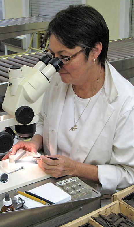
In recent years poor sample quality of drill cuttings obtained at wellsite has become a concern for geologists and petrographers.
The main reasons given for deteriorating sample quality are PDC drill bits, high penetration rates, and new mud systems. Various efforts have been made to design automated sampling devices to sample the flow of drill cuttings coming off the shale shaker to obtain the best sample possible. A review and video demonstration of some of these devices will be presented. This will be followed by an examination of cuttings produced from these devices and discussion about the effectiveness and future improvements of these devices.
I NFORMATION
Lunch will be provided. Please contact Doug Hayden (doug@doughayden.ca), Chair, CSPG Core and Sample Division to confirm your attendance. For more information concerning this Division, please contact the Division Chair, Doug Hayden, at (403) 615-1624 or via email at doug@doughayden.ca.
diVision taLKs INTERNATIONAL DIVISION
Deep-water deposits of Nigeria: quantitative integration of core data and applications to deepwater development
SPEA k ER
Siegfried Joiner
Nexen Petroleum International
12:00 noon
Wednesday, January 14, 2009
encana a mphitheatre, 2nd Floor e ast end of the calgary tower complex 1st street and 9th avenue s e calgary, a lberta
A methodology has been designed that captures rock properties as observed in deepwater cores in a classification scheme that is objective and non-genetic. This classification scheme utilizes “reservoir facies” determined from lithologic properties and is highly quantified. Because such rock properties as grain size and size sorting exert a controlling influence on reservoir properties such as porosity, permeability, saturation, and relative permeability, the reservoir facies have broad application in deepwater oil-field description, development, and management.
This set of reservoir facies has been specifically designed for application in deep-water deposits of the Niger Delta. The usefulness and validity of the methodology has been demonstrated in the description of tens of thousands of feet of core and the development and management of dozens of fields world-wide.
BIOGRAPH y
Siegfried (Sig) Joiner received his B.Sc. Honours from the University of Alberta in 1988, and his M.Sc. from the University of Calgary in 1992. Throughout his professional career with Husky, Mobil, Exxon, Imperial Oil, and Nexen, he has been interested in frontier / international petroleum exploration and development. He has worked on
sponsored by
petroleum systems on and offshore Canada, the Gulf of Mexico, the North Sea, Columbia, Caribbean, and most recently deepwater Nigeria. If you wish to contact him directly, he can be reached at Siegfried_Joiner@nexeninc.com.
January 14, 2009
Rock Shots – TBA
February 11, 2009
Rock Shots – TBA
Main Event – Andrew Leier
Reconstructing the Paleo-Elevation of the Central Andes
March 18, 2009
Rock Shots – TBA
Main Event – Paul MacKay
Fracture Systems in Carbonate Reservoirs – Gulf of Suez
INFORMATION
There is no charge for International Division talks. Please bring your lunch. The facilities for the talk are provided complimentary of EnCana and refreshments are provided by Geochemtech Inc. For further information or if you would like to give a talk, please contact Bob Potter at (403) 863-9738 or ropotter@telusplanet.net or Trent Rehill at (403) 615-2386 or trent.rehill@artumas.com.
A geologist examining drill cuttings.
diVision taLKs PALAEONTOLOGY DIVISION
Garden of Eden: how the great Rift Valley of East Africa influenced evolution
SPEA k ER
Philip Benham Shell Canada Energy
7:30-9:30 Pm
Friday, January 16, 2009 mount royal college, room B108 calgary, alberta
Africa’s Great Rift Valley is one of the largest geological structures on Earth, stretching over 6,400 kilometres from the Red Sea to the Kalahari Desert. Since initiation of the rift over 20 million years ago its growth has had such an impact on climate and topography that it has influenced the evolution of mammals, including early man. Famous volcanoes such
as Kilimanjaro, Ngorongoro, and Nyiragongo are testament to the huge volumes of lava extruded during this ongoing rifting event. The focus of this talk is a recent trip to Tanzania where I had the opportunity to examine the geology of the rift wall and ascend an active volcano to observe it in action.
Reservoir Characterization
Expertise in heavy oil & deep basin reservoirs
• AVO / LMR Analysis
• Neural Network Analysis
• PP & PS Registration
• Joint PP & PS Inversion
• Fracture Detection Analysis using Azimuthal AVO
• Spectral Decomposition
Time Lapse Analysis
Carmen Dumitrescu P.Geoph., M.Sc., Manager, Reservoir Geophysics
Direct: 403-260-6588 Main: 403-237-7711
www.sensorgeo.com
Ol Doinyo Lengai (Masai for “Mountain of God”) is the only active volcano in the world that erupts natrocarbonatite lavas. The lavas have a number of unusual properties including low temperature and lower viscosity than water. They also weather easily and are carried as dissolved mineral salts into nearby rift valley lakes. Lengai provides a good example of how volcanic activity has had both a local and a regional impact in East Africa.
BIOGRAPH y
Philip Benham has been employed by Shell Canada for fourteen years and during that time has worked Foothills, Mackenzie Delta, and offshore Newfoundland. He is currently Chair of the CSPG Paleontology Division. He is keen to share his love of science and actively volunteers for the Burgess Shale Geoscience Foundation and the Alberta Palaeontological Society. He enjoys photography and travel to geologically and culturally interesting places. Research is currently underway to find more obscure locations for future journeys.
I NFORMATION
This event is jointly presented by the Alberta Palaeontological Society, Mount Royal College and the CSPG Palaeontology Division. For details or to present a talk in the future please contact CSPG Palaeontology Division Chair Philip Benham at (403) 691-3343 or programs@ albertapaleo.org. Visit the APS website for confirmation of event times and upcoming speakers: http://www.albertapaleo.org/.
Cloud-shrouded Ol Doinyo Lengai erupts in background as expedition crew takes one last look before returning to base camp.
diVision taLKs HEAVY OIL DIVISION
Tar sands: key geologic risks and opportunities as related to “An Inconvenient Truth” or, hybrids, heartburn, and hope
SPEA k ER
Jack Century
J.R. Century Petroleum Consultants, Ltd.
8:00 am
t hursday, January 29, 2009
r P s e nergy c anada Ltd.
1400, 800 5 avenue s W c algary, a lberta
As conventional oil becomes scarcer, more exploration is occurring in heavy oil, tar sands, and bitumen deposits. While these contribute significantly to the global energy budget, they also contribute a greater share to the global carbon budget and to the detriment of the global environment. The balancing act between economics and environmental concerns is demonstrated on a grand scale in the evaluation of these geologic deposits.
This paper presents the concerns relating to the “carbon footprint” in the development of these deposits in northern Alberta (referred to as “tar sands” for brevity), and to outline opportunities for more balanced tar sands development by improved integration of geoscience and engineering disciplines.
Petroleum geologists, geophysicists, and engineers often consider they are only doing their professional jobs, while the public, commercial, industrial, and government consumers can choose which kind, how much, and in what manner energy is consumed. In the case of tar sand production, however, we geoscientists and engineers are making that choice ourselves, and releasing unacceptable amounts of
carbon into the atmosphere as a result. We must improve our professional practices in the oil patch to become more responsible citizens of the world.
Plans to develop the least carbon-rich tar sands with a practical transition of effective exploratory and development drilling for undiscovered, conventional light-medium oil and natural gas resources in the Western Canada Sedimentary Basin (WCSB) will conclude the presentation. This is done by taking into account the inevitable depletion of conventional, global oil supplies.
This interim transition can lead us into greener, economic, and sustainable wind, solar, geothermal, hydro, tidal, and appropriate biomass energy supplies for future generations. For this to work, energy conservation and efficiency by all levels of society are the most immediate ways to implement necessary changes for a healthier and prosperous Canadian energy / environmental life style.
Former Vice President Al Gore has been a world leader in making the public aware of the global climate crisis we and future generations are facing. His Academy Award-winning film, An Inconvenient Truth, has been of great help in focusing attention on the challenges and solutions of human-induced global warming and climate change.
In April, 2008, 250 volunteers from across Canada were selected to become Presenters of An Inconvenient Truth as part of The Climate Project-Canada program, located in Montreal. A review of this weekend training session, personally conducted by Mr. Gore and others will be discussed also. Dr. Andrew Weaver of the u niversity of Victoria is the science advisor to TCPCanada and Mr. Gore.
BIOGRAPH y
Jack Century has been active as a global petroleum, minerals and environmental geologist for over 56 years. In 1952 he earned a Master of Science degree in geology from the University of Illinois. His thesis was “The Animas Formation in the Northern Part of the San Juan Basin, Colorado.”
He began his career as an exploration geophysicist in the Anadarko Basin for Standard Oil of Indiana then switched to exploration geology in the Paradox Basin and other regions of the Colorado Plateau. In 1959 Jack was transferred to Calgary to explore for Devonian reefs and other carbonate reservoirs in the WCSB, eventually leading the Amoco Canada Geological Technical Group. He started his consulting company in 1973.
Century was the Founding Chair of the CSPG Environmental Geology Division in 1990 and in 1992 was a Charter Member of the AAPG Division of Environmental Geoscience. He is an Emeritus Member of the CSPG, AAPG, and a Life Member of APEGGA. In 2008 Century became an official Presenter of An Inconvenient Truth along with 30 Albertans selected for a weekend of training by TCP-Canada.
Canstrat Sample Logging Course
March 2-6, April 13-17 May 25-29, 2009
March 12-13, April 23-24, 2009
For complete course outline, please refer to our website www.canstrat.com/courses or phone (403) 284-1112
diVision taLKs ENVIRONMENT DIVISION
CO 2 capture and storage in Canada: the evolution of its development and potential deployment
SPEA k ERS
Bill Reynen Geological Survey of Canada
12:00 noon Friday, January 30, 2009 aquitaine Building
CO 2 Capture and Storage (CCS) has become an increasingly significant technology in Canada’s efforts to reduce GHG emissions.
Bill Reynen will provide a background to the development of this technology, Canada’s opportunities for deployment, issues, recent developments associated with its emergence on the Canadian policy platform, and how the Geological Survey of Canada is contributing to the deployment of this important climate change mitigation option.
BIOGRAPH y
Bill Reynen holds an Engineering Degree from Carleton University and a MBA from the University of Ottawa. He spent his early years after graduation working in Alberta in the petroleum industry in both production operations and reservoir engineering.
Upon returning to Ottawa, he held increasingly responsible positions in the energy field with the National Energy Board, the Office of the
Auditor General, Environment Canada, and Natural Resources Canada.
He is a member of the Executive Committee for IEA Greenhouse Gas Program and represents Canada as the Vice Chair of the Technical Group of the Carbon Sequestration Leadership Forum. Mr. Reynen is a regular speaker and panel member at conferences and symposia relating to CO2 Capture and Storage and he has recently returned to Alberta in the capacity of Director of the Geological Survey of Canada in Calgary, Alberta.
INFORMATION
All lunch talks are free and open to the public. Please bring your lunch. For information or to present a talk for the Environment Division please contact Andrew Fox at andrew.fox@ megenergy.com.
NeuraScanner
NeuraDB - NEW!
NeuraLaserColor - NEW! NeuraLog
NeuraSection NeuraMap - NEW!
DRILLING AND COMPLETIONS: A New Exploration Tool
| by Colin Yeo
As the quest for more unconventional resources gains momentum across North America, geologists are finding that highly sophisticated drilling and completion technologies are opening up basins and plays that would have been ignored ten years ago. u sing these new technologies, geologists can pursue tight gas, shale gas, and CBM. In the future, geologists may be pursuing gas hydrates. This series on the science of drilling and completion will focus on how these new technologies work and what geotechnical information is needed to enhance their effectiveness.
A F UTURE OF DIMINISHING R ETURNS
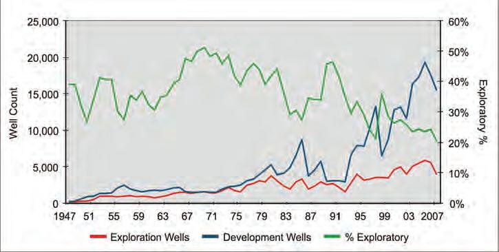
As geologists, we see the future of exploration in western Canada very clearly. High-reserve, high-deliverability plays are near exhaustion and, compared to 30 years ago, they are more difficult and more costly to find and develop. We have all seen the graphs of rates and reserves per metre drilled over time dropping as industry focuses on infill and outpost drilling. Figure 1 shows the dramatic increase in development drilling that has been accelerating since peak exploratory drilling in 1969. While the number of wells drilled per year increased to over 25,000 in 2005, exploration wells have dropped below 25% of the total.
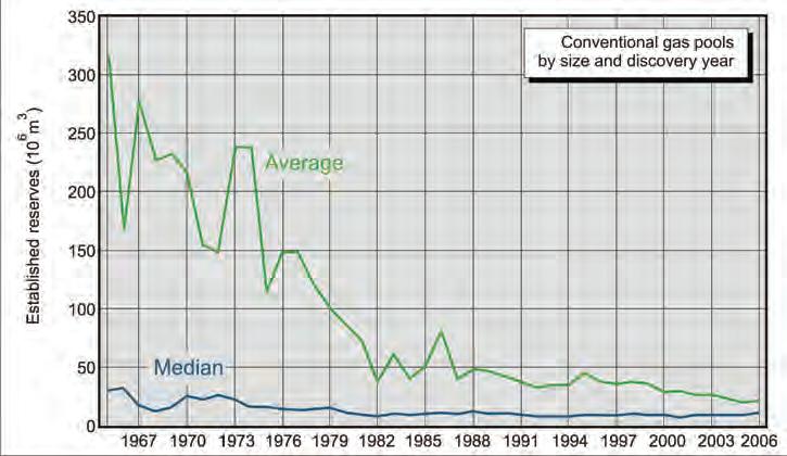
Exploratory drilling remained at about 45% of total drilling until 1990, except for the NEP and oil price collapse period during the 1980s, but oil and gas pool discoveries did not follow drilling intent. As shown in Figure 2, the last significant gas pool discoveries were made in the late 1970s. Since the biggest pools are found first and then followed by numerous smaller pools, diminishing pool sizes, despite continued effort, come as no surprise to explorationists.
Faced with smaller reserve additions that came at higher costs, major multi-national oil companies began exiting the WCSB to look for large reserve additions at lower cost elsewhere in the world. Intermediatesized companies quickly entered the vacuum by acquiring assets from the rationalizing majors and began the process of optimization and extension drilling. Royalty Trusts, a tax-efficient, low-cost, and low-
risk exploitation business model, began to dominate the oilpatch in the late 1990s by acquiring some of these intermediates and junior oil and gas companies until their taxable status was changed in 2006. This change was accompanied by a focus on net income and risk reduction but it also led to increased well counts with reduced well productivity.
L Ow ER QUALIT y R ESERVOIRS D ON ’ T E QUAL P OOR E CONOMICS
With gas demand growing, industry started to move down the resource triangle. Geologists have long known that certain parts of the basin were gas charged. High background gas readings and gas kicks were common within Cretaceous “overburden”
as wells were drilled to Leduc fringing reefs around the Peace River Arch. John Masters officially coined the term “Deep Basin Gas Trap” in 1979, describing how large parts of the sedimentary section contained significant gas resources with little or no producible water. Lower permeability sandstones were completed starting in the 1990s and, later, CBM became a new exploration target. This push into lower quality reservoir rock has inevitably led to development of gas shales, which historically had been ignored because of poor economics due to low gas flow rates. However, today, a combination of higher prices and improved drilling and completion techniques now makes these poorer quality reservoirs viable targets.
Figure 1. Canadian drilling licenses since 1947.
Figure 2. Alberta gas pool discovery profile.
Horn
Barnett Rock Creek
Fayetteville Nordegg
Woodford Lance
Haynesville Mesaverde Group
Bossier
Marcellus
Huron
utica
Antrim
New Albany Chattanooga
Mancos
Mowry
Additionally, these lower quality sandstone reservoirs are plentiful in the geologic section.
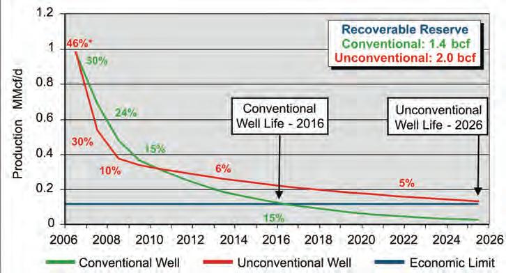
Some companies have recognized that the production profile of these low permeability sandstones is unusual. Rather than an exponential decline (which yields a straight line on a graph of cumulative production vs. the log of production rate), these reservoirs exhibit curvilinear behaviour where the magnitude of the negative slope (decline rate) decreases as produced volumes increase. Companies soon realized that shallower declines (Figure 3) meant less capital was required in future years to offset production losses as terminal declines were in the order of 5% rather than 15% associated with higher-quality reservoir rock. Increased real production growth can be achieved with less capital dollars than a series of conventional gas pools. Because of this low decline, the economic life of a lower permeability well can be twice as long as a conventional well, thereby exposing its gas production to changing energy prices and opportunities for enhanced workover technologies that could further increase production or further extend the life of the well.
However, another characteristic of low permeability reservoirs is that wellbore drainage areas often appear significantly less than higher permeability reservoirs. This means that more wells would be required to extract the same recoverable gas volumes as a higher quality reservoir system, which means higher capital costs that, in turn, lead to higher F&D costs overall.
R ISING TO THE C HALLENGE
So, the challenge facing industry is a large amount of gas in poor quality reservoirs that costs a lot of money to produce. Two significant factors have allowed industry to pursue this resource: gas price increases, and advances in drilling and completion technologies. Specifically, horizontal wells and multistage fracturing have commercialized tight gas sands and shale gas.
Advances in horizontal drilling technology have permitted operators to optimally place laterals to access specific rock types or to orient wellbores within stress fields. This allows more of the wellbore to be exposed to the productive zones and to intersect natural fractures. Completion technologies are focused on effectively contacting the reservoir through multistage fracs while
(Continued on page 22...)
Figure 3. Conventional vs. unconventional type curve production profiles.
Figure 4. Edson area – Rock Creek production.
Table 1. Potential development candidates through advanced drilling and completion techniques.
containing costs. Horizontal wells and multiple fracs cost more than vertical wells with a single zone completion, but initial productivity (IP) and ultimate recovery ( u R) more than offset the increased costs. Completion technology carefully considers frac fluid chemistry, frac size, proppant choice, and energy level. Sometimes, simpler is better, as seen with the introduction of slickwater fracs that use water with a friction-reducing additive and a reduced volume of proppant. These fracs have been shown to have a longer length and they can be cleaned up faster. Brines and chemical additives can be used to minimize damage to sensitive formations.
Advances in drilling and completion technologies have helped greatly in opening up shale basins in both Canada and the u nited States as exploration targets. Geologists recognize that lithology, mineralology, TOC level, thermal maturity, heterogeneity, porosity, depth, and natural fracturing control production, but until recent D&C advances, rates and recoveries from vertical wells in these reservoirs were still uneconomic. Table 1 (page 21) lists some marginal-quality formations that may now be economic to develop. As an example, a combination of brittle rock from high silica content and geologic structure makes parts of the Woodford Shale in the Arkoma Basin of Oklahoma potentially productive. Through careful placement of horizontal wells and by enhancing the permeability from natural fracturing and accessing more of the reservoir through a well designed frac stimulation, economic wells can now be drilled.
Shales are especially appealing as a resource target. They are extensive and thick and thereby contain large volumes of free and adsorbed gas. Once production control mechanisms have been identified and mapped, statistical type curves can be constructed to guide development and provide predictable production growth. The large number of wells that are drilled provide an opportunity to reduce costs through economies of scale and repetition. For example, in the last two years, costs per completed interval in the Montney Play of northeast B.C. have dropped 40%.
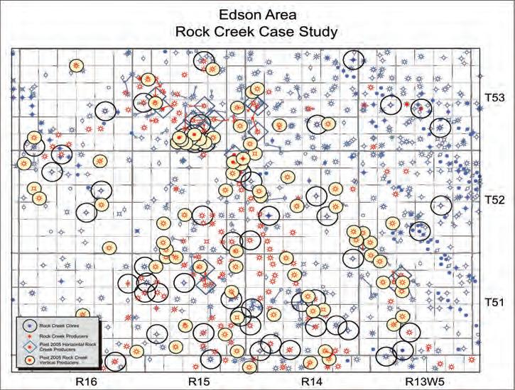
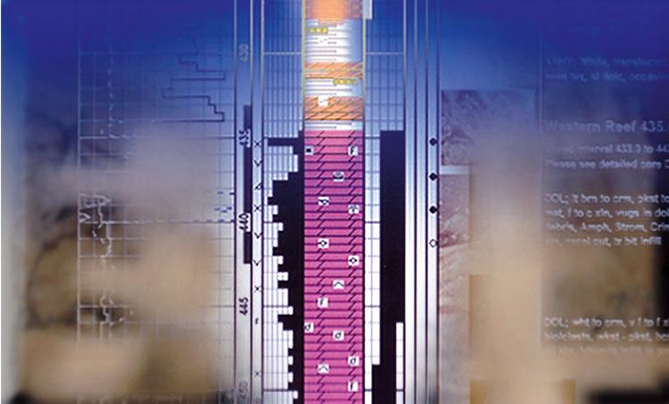
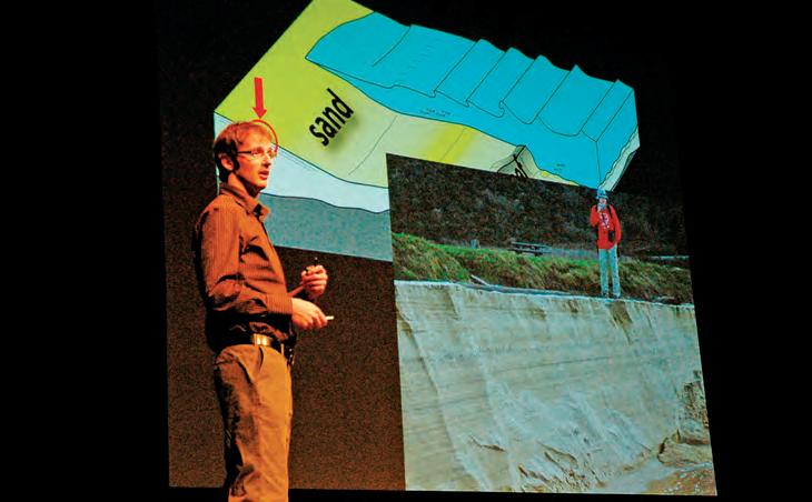
C ASE S TUDy: E DSON ROC k C REE k
The Rock Creek Formation is a shallow shelf, fine-grained sandstone, moderately to well sorted with interbedded silty, calcareous shale and variable porosity and permeability. An examination of production data from Rock Creek vertical and horizontal wells demonstrates the (...Continued
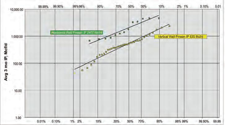
Figure 5. IP log normal distribution.
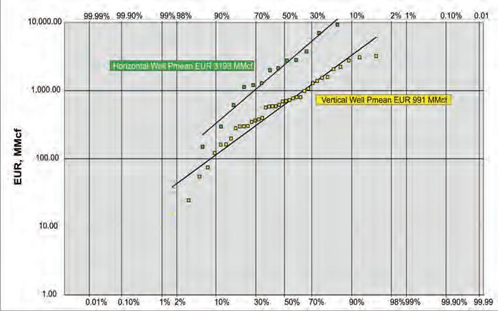
Figure 6. EUR log normal distribution.
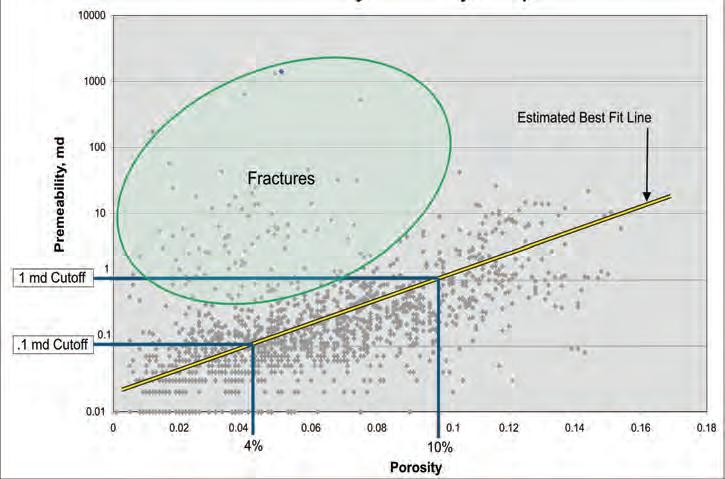
Figure 7. Core porosity vs. permeability crossplot.
significance of horizontal wells (Figure 4, page 21).
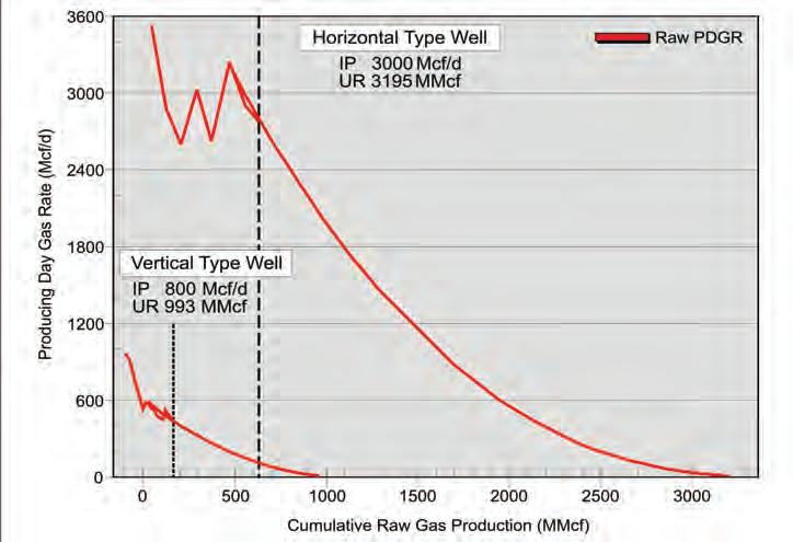
As seen in Figures 5 and 6, Pmean IP (initial productivity), and E u R (estimated ultimate recovery) per vertical wells drilled and on production since 2005 are 635 Mcf/d and 991 MMcf, respectively. However, horizontal wells have a Pmean IP of 2,407 Mcf/d and and an E u R of 3,193 MMcf. This three-fold increase in rate and reserves from horizontal wells is highly economic.
Core data from the field shows the relationship between porosity and permeability (Figure 7). One mD permeability, a common reservoir cutoff, equates to a porosity of about 10%. If the permeability threshold can be lowered to 0.1 mD, the corresponding porosity cutoff can be dropped to 4%. This lower porosity rock is gas-saturated but flow rates will be smaller because of reduced absolute permeability and the compounding effects of relative permeability.
A Rock Creek porosity distribution
(Continued on page 24...)
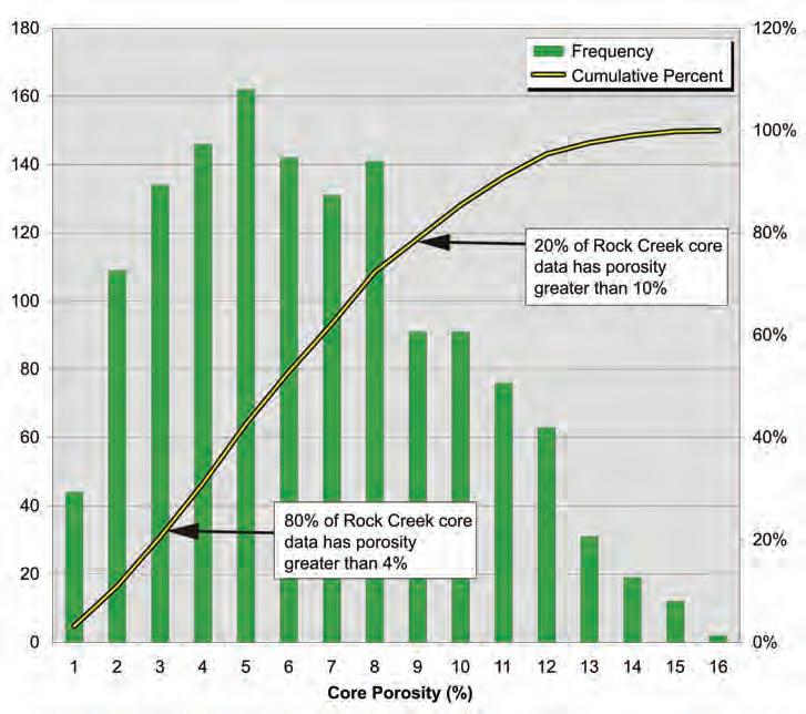
Figure 8. Core porosity histogram.
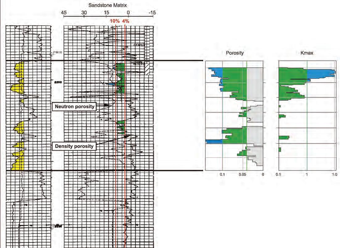
Figure 9. 00/10-17-053-13W5 log core display.
was generated from 133 cored wells throughout the area. Because of the lognormal distribution of this porosity (Figure 8), a reduction in porosity cutoff to 4% adds considerably more pore volume and original-gas-in-place within the section. 80% of Rock Creek core samples have a porosity greater than 4% but only 20% have a porosity greater than 10%.
Considering a specific example, well 00/10-17-053-13W5/0 has extensive core coverage over the Rock Creek interval (Figure 9).
Well logs show about 3m of net pay using a 10% porosity cutoff but 11m when a 4% cutoff is used. OGIP can double or triple by considering this lower-grade reservoir. Again, the challenge is generating economic flow rates and increasing recovery from the tighter reservoir.
Wellbore drainage area is another consideration within the Rock Creek in the Edson area. u sing an analytical single-well model, well 00/03-16-053-15W5/0 appears to be draining less than a quarter-section. Facies changes and diagenesis can create reservoir baffles and boundaries leading to limited reservoirs. These multiple small, low-permeability pools, uneconomic on a stand-alone basis, can become very economic in aggregate as horizontal drilling intersects multiple, discrete pools.
Horizontal wells and multiple fracs are key to effective exploitation of these lower quality reservoirs. By accessing more reservoir rock through a single horizontal leg and increasing the effective wellbore radius through multiple fracs, finding and development costs decrease (Figure 10).
The economics of this type of development is compelling. Type wells were constructed from 13 horizontal producers and 38 vertical producers drilled after 2005 (Figure 11).
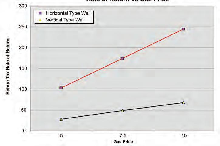
Based on these type wells, a discountedcash-flow model was run to determine the before tax rate of return (BT ROR) for each at various gas prices. The results are quite dramatic and clearly show how horizontal wells and multiple, staged fracs, despite higher capital costs, are far more economic than vertical wells (Figure 12).
The absolute value of the ROR should not be the focal point but rather the relative difference between the vertical and horizontal ROR.
(Continued on page 26...)
Figure 11. Edson area horizontal and vertical type wells.
Figure 12. Rate of return vs. gas price.
Figure 10. Staged horizontal fracs.
In celebration of the International Year of Planet Earth, the first annual WHERE Challenge is asking Canadian kids aged 10 – 14 years to discover the answers to these questions: WHAT on Earth is in your stuff and WHERE on Earth does it come from? Winners will be announced on Earth Day, April 22nd, 2009.
So think hard, get creative and find out interesting facts about your stuff. For more details on the WHERE Challenge or to learn about exciting careers in Earth sciences, please visit www.earthsciencescanada.com
(...Continued from page
T HE F UTURE IS U NCONVENTIONAL
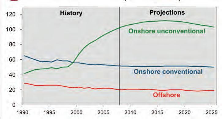
As the WCSB matures, delivering smaller rates and reserves, new technologies are rejuvenating old fields and making new ones economic. The future is unconventional as demonstrated by unconventional gas production growth in the u.S. over the last several years and the expectation of continued growth in the future (Figure 13).
ROCK SHOP
Drilling and completions engineers who have made important advances in the last several years are driving these new technologies. Their tools and techniques are powerful, but need to be focused in the right areas and refined with critical geotechnical information. Hitting it harder with a bigger hammer does not always optimize production. Rock properties, stress field, natural fracture data, lithology, mineralogy, and structure are key elements in a mechanical and
economic success. Key to this success is the geologists’ understanding of what is needed by engineers so that they can analyze and develop successful fracing “recipes” that are effective and economically efficient.
Armed with these very powerful tools, geologists can now scour the basin in search of the play which may very well be an existing producing field. After all, it’s about providing energy for people, profitably.
AC k NOw LEDGMENTS
Many thanks to my colleagues Jennifer Isbister, Dennis Gabinet, Dick Zeeuwen, and Lionel Derochie for their assistance, comments, and review of this material. Riley’s Design prepared all the figures.
Succeeding articles in this series are written by experts at Halliburton. Founded in 1919, Halliburton is a world leader in drilling and completion technology, serving the upstream oil and gas industry throughout the lifecycle of the reservoir. We thank them for sharing their expertise with Reservoir readers.
Figure 13. Nonassociated natural gas end-of-year reserves (Tcf) in the lower 48 states.
24)
PRACTICAL SEQUENCE STRATIGRAPH y VIII.
The Time-based Surfaces of Sequence Stratigraphy
| by Ashton Embry
I NTRODUCTION
In parts four, five, and six of this series, I described the six, material-based surfaces of sequence stratigraphy, which have been recognized and characterized over the past 200 years. Notably, each of these materialbased surfaces is defined on the basis of observable physical characteristics that include:
• the physical properties of the surface and of overlying and underlying strata and
• the geometrical relationships between the surface and the underlying and overlying strata.
These surfaces can be said to be modelindependent because they were empirically recognized before a model was proposed to explain or rationalize their existence. The delineation and use of such surfaces for correlation and for defining specific sequence stratigraphic units constitutes a materialbased approach to sequence stratigraphy.
Another approach to sequence stratigraphy, which is advocated by some authors (e.g., Hunt and Tucker, 1992; Helland-Hansen and Gjelberg, 1994; Posamentier and Allen, 1999; Catuneanu, 2006; Catuneanu et al., in press), is a time-based approach. In a time-based approach, some of the surfaces used for sequence stratigraphic analysis are defined on the basis of time rather than observable characteristics and geometrical relationships. Such an approach is indicated by Posamentier (2001) “Critical to a sequence stratigraphic analysis is the identification of time synchronous surfaces that punctuate rock successions”.
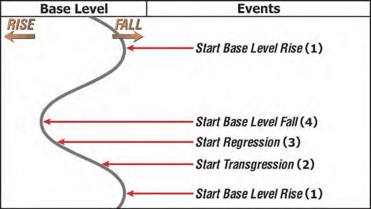
Time-based surfaces are known as chronostratigraphic surfaces and are defined on the basis of a specified event at an exact location. Basically, a chronostratigraphic surface represents a depositional surface that existed at the moment in time when the specified event took place. As stated by Catuneanu (2006) “Sequence stratigraphic surfaces are defined relative to the four main events of the base-level cycle”. Such events are related to a change in either the direction of base level change (e.g., falling base level to rising base level) or the direction of shoreline movement (e.g., landward movement to seaward movement).
As shown on Figure 1, four base level
cycle events are defined and utilized in the time-based approach, with the fundamental underpinning of this approach being the hypothesis that each event is associated with a specific, sequence stratigraphic surface. The four events and their assigned surfaces are:
• start base level rise (1) = correlative conformity,
• start transgression (2) = maximum regressive surface,
• start regression (3) = maximum flooding surface, and
• start base level fall (4) = basal surface of forced regression.
The time-based approach differs from the material-based approach in two main ways:
• a different way of defining some specific surfaces that are common to both approaches (e.g., maximum regressive surface) and
• the addition of two new surfaces which have no equivalents in the material-based approach.
These two, time-based surfaces were proposed (deduced) by Hunt and Tucker (1992) on the basis of the sequence stratigraphic model of Jervey (1988) rather than on empirical data. In contrast to the model-independent, material-based
surfaces, these two time-based surfaces are model-dependent (i.e., “no model –no surfaces”). They are best viewed as hypothetical surfaces which represent two events on the base level curve.
OLD SURFACES / NE w DEFINITIONS
Two important, material-based, sequence stratigraphic surfaces are the maximum regressive surface (MRS) and maximum flooding surface (MFS) and these surfaces were defined and described in previous articles. As was noted in those articles, both the MRS and MFS were empirically recognized many years (under different names) before sequence stratigraphic methodology and models were formulated and they are defined and delineated solely on the basis of their physical characteristics. As part of modern day, sequence stratigraphic theory, the MRS and MFS are interpreted to have formed due to the interplay of base level change and sedimentation although it must be emphasized that such interpretations play no role in their definition.
In the time-based approach, these two surfaces are defined on the basis of interpreted changes in shoreline direction. For example, Catuneanu (2006, p. 135) states “The maximum regressive surface
(Continued on page 28...)
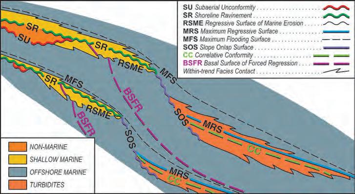
Figure 1. A sinusoidal base level change curve illustrating the timing of the four “events” that are used to define four, time-based surfaces of sequence stratigraphy:
Start base level rise = correlative conformity (CC)
Start transgression = maximum regressive surface (MRS)
Start regression = maximum flooding surface (MFS)
Start base level fall = basal surface of forced regression (BSFR)
is defined relative to the transgressiveregressive curve, marking the change from shoreline regression to subsequent transgression”. Similarly, Catuneanu, 2006, p. 142) states “The maximum flooding surface is also defined relative to the transgressive-regressive curve, marking the end of shoreline transgression.”
In reality, the distinction between the two methods – the material-based definitions being dependent on observable characteristics and the time-based ones being dependent on theoretical eventsdoes not have a significant effect on the final result. This is because the observable characteristics used for the material-based definition of a surface are used as proof of the occurrence of the given event associated with that surface. Thus, in most cases the same horizon is picked for a given surface by both approaches although, as will be discussed, this is not always the case. Regardless, it is important to understand the profound difference in the manner in which surfaces are defined in the two approaches as this difference has a significant impact with the introduction of two new surfaces in the time-based approach.
TwO N E w SURFACES
Two, time-based surfaces were introduced into sequence stratigraphy by Hunt and Tucker (1992) on the basis of two theoretical events – start base level fall and start base level rise. These surfaces had not been defined before the modeling work of Jervey (1988). One was named the basal surface of forced regression (BSFR) (Hunt and Tucker, 1992) and the other the correlative conformity (CC) (Helland-Hansen and Gjelberg, 1994). Subsequent books (e.g., Posamentier and Allen, 1999; Coe, 2003; Catuneanu, 2006) have advocated for the use of these conceptual, time-based surfaces for sequence stratigraphic unit definition and correlation.
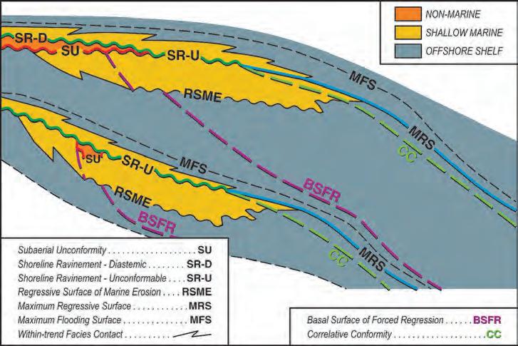
For illustrative purposes, I have added both a BSFR and a CC to model cross-sections which were constructed to show the relationships of the material-based surfaces of sequence stratigraphy. The models represent three different scenarios related to differences in physiography and speed of initial base level rise:
• ramp setting, fast initial base level rise (Figure 2),
• ramp setting, slow initial base level rise (Figure 3),
• shelf / slope / basin setting, SOS (slope onlap surface)-generated, fast initial base level rise (Figure 4).
Figure 2. A schematic cross-section for a ramp setting with a fast initial base level rise. Five material-based surfaces of sequence stratigraphy (SU, RSME, SR, MRS, and MFS) and two time-based surfaces (BSFR, CC) are illustrated on the cross-section. The time-based BSFR and CC occur within the coarsening-upwards succession between the material-based MFS and MRS. The BSFR is truncated updip by the SU / SR-U and the CC is truncated very near the basinward end of the SR-U. Neither of these hypothetical time surfaces is marked by any sedimentological changes and, because they are conformities, they are not distinguishable by any geometrical relationships.
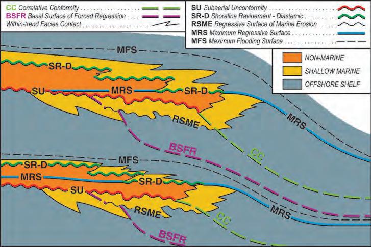
Figure 3. A schematic cross section for a ramp setting with a slow initial base level rise. Once again the BSFR and CC occur in the coarsening-upward succession between the MFS and MRS. In this model, the landward end of the CC adjoins the basinward termination of the SU. Unlike the fast initial rise model, the CC and MRS are separated by a substantial thickness of sediment and the SR does not erode the basinward portion of the SU. Also in this model, a time-based MRS is hypothesized to occur within nonmarine strata. As with the time-based BSFR and CC, no concrete criteria have ever been proposed for delineating a time-based MRS in nonmarine strata.
The relationships of the two hypothetical time surfaces to the six material-based surfaces for a shelf / slope / basin setting with a slow initial base level rise is essentially the same as that shown on Figure 4. It must be emphasized that the placement of these time-based surfaces on these model cross sections is based on theoretical reasoning and not empirical evidence.
B ASAL SURFACE OF FORCED R EGRESSION (BSFR)
Hunt and Tucker (1992, p. 5) defined a BSFR as “a chronostratigraphic surface separating older sediments…deposited during slowing rates of relative sea level rise… from younger sediments deposited during baselevel fall”. In short, it represents a time surface generated at the start of base level
fall. Plint and Nummedal (2000), Catuneanu (2006), and Catuneanu et al. (in press) characterize the BSFR as the clinoform (paleo-seafloor) present at the start of offlap (equals start base level fall at the shoreline) along a given transect perpendicular to the shoreline. From a theoretical point of view, a BSFR will be truncated updip by the Su, will be offset at the RSME and then will occur somewhere within a thick, upward-coarsening succession of shelf and slope strata. Basinward, it will approach the underlying MFS and may downlap onto it (Figures 2-4).
Because the BSFR is a time-based surface and does not correspond with any materialbased surface of sequence stratigraphy, the obvious question becomes – “Does such a hypothetical surface have any observable, characteristic features that would allow it to be delineated with reasonable objectivity so as to allow it to be used for correlation and bounding sequence stratigraphic units?”
This does not appear to be the case and I believe it is basically impossible to convincingly recognize “the first clinoform associated with offlap” in almost every conceivable geological setting. As shown on Figures 2-4, such a time surface occurs within a succession of coarsening-upward strata and no sedimentological variation or change in grain size trend has been identified or theorized to characterize the surface and allow its recognition in such a succession. This lack of criteria for the recognition of such a surface over most of a basin has been noted by Posamentier et al. (1992), Embry
(1995), Posamentier and Allen (1999), Plint and Nummedal (2000), and Catuneanu (2006) – among others. Posamentier et al. (1993, p. 1695) state “This surface becomes a cryptic surface, virtually impossible to identify, where the shoreface deposits become gradationally based”. Posamentier and Allen (1999, p. 90) state “it exists only as a chronohorizon, … precise identification … can be limited”. Plint and Nummedal (2000, p. 5) note that such a time surface is “difficult or impossible to recognize in outcrops or well logs”. Catuneanu (2006, p. 129) states “the basal surface of forced regression … has no physical expression in a conformable succession of shallow water deposits”. Thus it appears widely accepted that the BSFR has no characteristic physical attributes to allow its objective recognition in well exposed sections or in core.
Authors who advocate the use of the conceptual BSFR in sequence stratigraphic classification offer two ways of delineating such a surface. One is through the use of seismic data, and authors such as Posamentier and Allen (1999) and Catuneanu (2006) suggest a BSFR can be approximated by the seismic reflector that intersects the Su (subaerial unconformity) at the start of a downward trajectory of the Su (i.e., start offlap). In theory, this has some merit, but the main problem with such a proposal is that subsequent erosion on the subaerial unconformity during the entire time of base level fall destroys such a geometrical relationship. Consequently it is virtually impossible to identify on seismic sections or well log sections the “clinoform which
Figure 4. A schematic cross-section for a shelf / slope / basin setting showing the geometric relationships for the six material-based surfaces of sequence stratigraphy as well as the two time-based ones. Similar to the other models, the BSFR is truncated updip by the SU / SR-U. It occurs within the coarsening-upward succession between the MFS and MRS and, in some cases, will downlap onto the MFS basinward. The CC occurs in the basinal turbidites and may coincide with or lie just below the material-based MRS. It onlaps the slope onlap surface (SOS). The BSFR and CC placement on this and the other schematic cross sections is based solely on model-based deduction.
intersects the Su at the start of offlap” except in extremely rare cases.
The other strategy for delineating a BSFR is to use one of the material-based surfaces of sequence stratigraphy or, in some cases, a lithostratigraphic surface (within-trend facies change) as a “proxy” for it. Some authors have associated a BSFR with a regressive surface of marine erosion (RSME) (e.g., Posamentier et al., 1993). However, as described in part 4 of this series (Embry, 2008a), the RSME is a highly diachronous surface which forms during the entire time of base level fall and is almost entirely younger than the time-based BSFR (Plint and Nummedal, 2000).
Sometimes, in offshore shelf environments, sedimentation on the unconformable portion of an MFS is interpreted not to have begun until after base level starts to fall (i.e., outer shelf initially starved after the start of regression) and that portion of the MFS is sometimes labeled as a BSFR (e.g., MacNeil and Jones, 2006, Fig. 11; Catuneanu, 2006, Fig. 4.19). However, such a surface should be recognized as an MFS rather than a BSFR as a BSFR is a chronostratigraphic surface and thus cannot be an unconformity. In theory, the BSFR in the above-cited cases would have downlapped onto the MFS, although even this would be very difficult to demonstrate in a real-world situation.
Another material-based, sequence stratigraphic surface which is occasionally equated to a BSFR is the slope onlap surface (SOS) (e.g., Posamentier and Allen, 1999). Once again, such a comparison is inappropriate because an SOS always develops after the start of base level fall. For siliciclastics, this will almost always be a significant time after the start of base level fall. Furthermore, an SOS is often an unconformity (Embry, 2008b).
Two commonly used proxies for a BSFR involve the use of highly diachronous facies changes at the base of turbidite strata or at the base of shallow water carbonate or clastic strata (e.g., Hunt and Tucker, 1992; Plint and Nummedal, 2000; Mellere and Steel, 2000; Coe, 2003; Catuneanu, 2006, and very many others). The obvious pitfall in using the base of submarine fan deposits as an equivalent of a BSFR is that it is highly unlikely the first gravity flow deposits will coincide, or even be remotely close to coinciding, with the start of base level fall. Turbidite deposition can be initiated any time during fall and, in many cases, does not occur at any time during fall (Catuneanu, 2006). The same logic applies (Continued on page 31...)
PETROLEUM INDUSTRY COURSES
OVERVIEW OF THE OIL & GAS INDUSTRY IN WESTERN CANADA
Date: January 27 & 28, 2009
Cost: $945 (includes GST)
Instructor: Bill Ayrton
Effective for personnel just joining the oil patch, or for financial, accounting, and information systems personnel.
• Learn about the many facets of the industry.
• Oil finding, land acquisition, drilling, seismic, well completion, jargon and terminology.
GEOLOGY FOR NON-GEOLOGISTS
Date: February 17 & 18, 2009
Cost: $945 (includes GST)
Instructor: Bill Ayrton
WHO SHOULD ATTEND
New geologists, engineers, geophysicists and landmen, as well as summer students entering the industry fo r the f irs t time will find the courses a very beneficial introduction to the petroleum industry. T hese courses will be extremely useful to nonprofessional and support staff in the oil and gas industry, as w ell as accountants, lawyers, brokerage and financial personnel working primarily alongside the oil and gas industry.
TO REGISTER
To register or to obtain additional information regarding in-house and upcoming courses, please contact:
Ayrton Exploration Consulting Ltd.
Tel: (403) 262-5440
Email: ayrtonex@telusplanet.net
Or visit our website: www.ayrtonexploration.com
Effective for geological technicians or administrative staff, or for those who just want a better understanding of geology to appreciate the world around us.
• Learn about earth structure, geologic time-scale and processes, Western Canada geology, and interesting nearby locations.
• Participate in a r ock identification exercise , cross-section project and a mini-field trip in downtown Calgary.
GEOLOGY OF THE WESTERN CANADIAN SEDIMENTARY BASIN
Date: March 3, 4 & 5, 2009
Cost: $1365 (includes GST)
Instructor: Bill Ayrton
Ideal for those who wish to improve their geological understanding of where and how we look for oil and gas fields in Western Canada.
• To visualize what Western Canad a looked like throughout the stages of history, for example, the position of the sea versus land, what sediments were deposited, and what type of life that existed and evolved.
• To review the importance of each major stratigraphic unit, i.e. Devonian, Mississippian, Cretaceous, etc.
• Discuss the geological and seismic expression of typical oil and gas fields in each unit.
to the use of the highly diachronous, basal contact of a shallow marine deposit for a BSFR (e.g., Burchette and Wright, 1992). Such a facies contact forms throughout the entire interval of fall as the shallow water facies progrades basinward over deeper water facies. A serious problem of trying to equate a BSFR with inappropriate materialbased surfaces as discussed above is that such a practice can result in misleading and erroneous interpretations of depositional history.
Given the above arguments, a BSFR is best seen as a purely deductive construct (i.e., hypothetical surface) which has no characteristic physical attributes to allow its recognition in well exposed strata, in core, and on almost all seismic lines. Despite these issues, the BSFR has been proposed as both a sequence boundary (Posamentier and Allen, 1999) and a systems tract boundary (Hunt and Tucker, 1992; Plint and Nummedal, 2000; Catuneanu, 2006). The practicality of employing a “cryptic”, time-based surface as a unit boundary will be discussed in forthcoming articles that look at how sequence stratigraphic units are defined.
CORRELATIVE CONFORMIT y (CC)
Hunt and Tucker (1992, p. 6) characterized a correlative conformity, as “truly a chronostratigraphic surface” equivalent to the depositional surface (clinoform) at the end of base level fall (i.e., start base level rise). It represents the sea floor at the moment in time when base level fall gives way to base level rise. Like the BSFR, a CC is model-dependent and had not been described as a distinct surface before the Jervey (1988) model for explaining the origin and geometries of sequence stratigraphic surfaces was published. Hunt and Tucker (1992) did not provide any specific criteria which would allow the recognition of a CC except in areas of submarine fan deposition. Helland-Hansen and Gjelberg (1994), Helland-Hansen and Martinsen (1996), and Catuneanu (2006) have elaborated on this surface and advocated for its use in sequence stratigraphic classification.
From a theoretical point of view, the CC joins the basinward end of the subaerial unconformity (Su ) in a ramp setting for the slow initial rise model (described in part 7 of this series) (Figure 3). Basinward, it occurs within a coarsening-upward succession situated between the MFS below and the MRS above. In a ramp setting for the fast initial rise model, the CC will be truncated at the end of the unconformable shoreline
ravinement (SR- u ) (Figure 2). In a shelf / slope / basin model, where an SOS develops, and for either slow or fast initial base level rise, the CC will theoretically occur in a succession of basinal turbidites and will onlap the SOS (Figure 4).
To my knowledge, no one has ever published any observable criteria for recognizing the correlative conformity over most of a basin. This is not surprising given that no sedimentary break or change in sedimentation style or trend occurs over much of the marine area at the start of base level rise, especially when base level rises slowly at the start (Figure 3).
This lack of observable characteristics is recognized by Catuneanu (2006, p. 122) who states “The main problem relates to the difficulty of recognizing it in most outcrop sections, core or wireline logs.” As Catuneanu (2006) explains, the correlative conformity “develops within a conformable prograding package (coarsening upward trends below and above); lacking any lithofacies and grading contrasts”. The main problem associated with the correlative conformity is also enunciated by Plint and Nummedal (2000, p. 5) who succinctly state
“From a practical point of view, this marine surface will be difficult to impossible to identify.”
Catuneanu (2006) and Catuneanu et al. (in press) suggest that seismic data offer the best opportunity to identify and correlate a CC. A CC can be approximated by a basinward seismic reflector which joins with a more landward reflector that encompasses the Su and / or the SR- u. Catuneanu (2006) interprets such a seismic-based CC in his Figure 4.17. As shown in Figure 2, the MRS and the CC will theoretically almost coincide when the start of transgression occurs very soon after start of base level rise and perhaps more importantly, the MRS adjoins to the basinward end of the unconformity. In this case the seismic reflector which encompasses a theoretical CC will also encompass a material-based MRS. The question remains if a seismically recognized, time-based CC for a ramp setting is in actuality a material-based MRS. I suspect it is in most, if not all cases, but we need studies involving core and seismic to resolve the question of whether or not a CC is a real surface which has physical properties that can generate a seismic reflector.
26th ANNUAL CSPG SQUASH TOURNAMENT
February 5 – 7, 2009
World Health Club • 722 Edgemont Blvd NW
there is a maximum of 125 players! Get your entry form in early to avoid disappointment! Please visit our website at www.cspg.org
EVENTS: Men’s & Women’s A, B, C, D, and Novice.
ENTRY FEE: $65.00 Members (Members of the CSPG and CSEG, Spouse/Partner)
$100.00 Non-Members
• Two guaranteed matches (Saturday teams tourney), T-Shirt, refreshments and food during the tournament, Saturday night dinner and draw prizes.
• Pre-tournament Registration Social will be at the Bow Valley Racquet Club (2nd Street and 5th Avenue SW.) on Monday, February 2 at 5:00 pm. Pick up your tournament kit and first draw time. Enjoy a free pint of ale with munchies. Generously sponsored by Tucker Wireline Services.
• All door prize draws Saturday evening – must be present to win.
ENTRY DEADLINE: Early Bird Deadline January 5, 2009. Qualify for Early Bird Draw Prize. Registration Deadline January 16, 2009. No refunds after this date.
REGISTRATION DETAILS:
q CSPG q CSEG Member# ___________________________ q Non Member
Name of Card holder (Please Print): _______________________________ Signature: _____________________________
REGISTRATIONS TO BE SENT TO: Canadian Society of Petroleum Geologists Attn: Squash Tournament 600, 640 8 AVE SW, Calgary, AB T2P 1G7 Phone: (403) 264-5610 Fax: (403) 264-5898
The other material-based surface which is sometimes labeled as a CC on seismic is the slope onlap surface (SOS). The reason for such a portrayal is shown in Figure 4, which illustrates that the landward termination of the SOS adjoins the basinward termination of the basin flank unconformity (Su or Su / SR- u ). Thus the same seismic reflector that encompasses the S u / SR- u on the basin flank encompasses the SOS farther basinward.
Hunt and Tucker (1992) suggested that the change from a coarsening-upward succession of turbidites to a fining-upward succession might approximate such a boundary and this has theoretical support (Catuneanu, 2006). However, the material-based maximum regressive surface would also be placed at such a horizon of change in depositional trend (coarsening trend changing to a fining trend). Notably, Catuneanu (2006) and Catuneanu et al. (in press) would not put the time-based MRS at this horizon, but rather would place it stratigraphically higher at an often unrecognizable (“cryptic”) horizon within shaly turbidites. The position of this horizon depends on a specific sequence stratigraphic model.
This significant difference in the placement of the MRS in deep water strata highlights the essential difference between the two approaches to surface definition. The material-based approach uses an MRS with defined, observable criteria whereas the time-based approach uses a theoretical, model-dependent, indefinite horizon for the MRS.
In summary, the correlative conformity, although it has theoretical appeal, is a time-based, sequence-stratigraphic surface lacking defining characteristics which would allow such a surface to be recognized with reasonable scientific objectivity (i.e., with empirical observations) in most data sets. Despite these formidable problems, the CC has been proposed as both a sequence and systems tract boundary (Hunt and Tucker, 1992; Plint and Nummedal, 2000; Catuneanu, 2006). The practicality of such usage will be discussed in future articles in this series.
With this article, all the various specific types of sequence stratigraphic surfaces which have been recognized / proposed, including both material-based ones and time-based ones, have been described. Such surfaces provide the means for defining a variety of specific types of sequence stratigraphic units. Material-based sequence stratigraphic
units are defined by various combinations of bounding, material-based surfaces. Timebased sequence stratigraphic units employ the time-based surfaces discussed above, in addition to material-based surfaces, for defining unit boundaries.
The existence of both material-based units and time-based units has been a major source of confusion for those wanting to employ sequence stratigraphic units in their studies and to communicate their findings. In the next article, I will describe and evaluate the practicality of the different types of sequences, both material-based and time based, which have been proposed for use. In subsequent articles, I’ll tackle systems tracts, followed by parasequences.
R EFERENCES
Burchette, T. and Wright, V.P. 1992. Carbonate ramp depositional deposits. Sedimentary Geology, v.79, p. 3-57.
Catuneanu, O. 2006. Principles of Sequence Stratigraphy. Elsevier, New York, 375 p.
Catuneanu, O. et al. In press. Towards the Standardization of Sequence Stratigraphy. Earth Science Reviews.
Coe, A. (ed.) 2003. The sedimentary record of sea-level change. Cambridge University Press, New York, 287 p.
Cross, T. 1991. High resolution stratigraphic correlation from the perspective of base level cycles and sediment accommodation. In: Unconformity related hydrocarbon exploration and accumulation in clastic and carbonate settings. J. Dolson (ed.). Short course notes, Rocky Mountain Association of Geologists, p. 28-41.
Embry, A.F. 1995. Sequence boundaries and sequence hierarchies: problems and proposals. In: Sequence stratigraphy on the northwest European margin. R. J. Steel, F. L. Felt, E.P. Johannessen, and C. Mathieu (eds.). NPF Special Publication 5, p. 1-11.
Embry, A.F. 2008a. Practical Sequence Stratigraphy IV: The Material-based Surfaces of Sequence Stratigraphy, Part 1: Subaerial Unconformity and Regressive Surface of Marine Erosion. Canadian Society of Petroleum Geologists, The Reservoir, v. 35, issue 8, p 37-41.
Embry, A.F. 2008b. Practical Sequence Stratigraphy VI: The Material-based Surfaces of Sequence Stratigraphy, Part 3: Maximum Flooding Surface and Slope Onlap Surface. Canadian Society of Petroleum Geologists, The Reservoir, v. 35, issue 10, p 36-41.
Helland-Hansen, W. and Gjelberg, J. 1994. Conceptual basis and variability in sequence stratigraphy: a different perspective. Sedimentary Geology, v. 92, p. 1-52.
Helland-Hansen W. and Martinsen, O.J. 1996. Shoreline trajectories and sequences: description of variable depositional-dip scenarios: Journal of Sedimentary Research, v. 66, p. 670-688.
Hunt, D. and Tucker, M. 1992. Stranded parasequences and the forced regressive wedge systems tract: deposition during base level fall. Sedimentary Geology, v. 81, p. 1-9.
Jervey, M. 1988. Quantitative geological modeling of siliciclastic rock sequences and their seismic expression, In: Sea level changes: an integrated approach. C. Wilgus, B.S. Hastings, C.G. Kendall, H.W. Posamentier, C.A. Ross, and J.C.Van Wagoner (eds.). SEPM Special Publication 42, p.47-69.
MacNeil, A. and Jones, B. 2005. Sequence stratigraphy of a Late Devonian rampsituated reef system in the Western Canadian Sedimentary Basin: Dynamic responses to sea level change and regressive reef development. Sedimentology, v. 53, p. 321-359.
Mellere, D. and Steel, R. 2000. Style contrast between forced regressive and lowstand/ transgressive wedges in the Campanian of north-central Wyoming (Hatfield Member of the Haystack Mountains Formation). In: Sedimentary responses to forced regressions. D. Hunt, and R. Gawthorpe (eds.). Geological Society of London, Special Publication 172, p. 141-162.
Plint, A. and Nummedal, D. 2000. The falling stage systems tract: recognition and importance in sequence stratigraphic analysis. In: Sedimentary responses to forced regressions. D. Hunt, and R. Gawthorpe (eds.). Geological Society of London, Special Publication 172, p.1-17.
Posamentier, H. 2001. Sequence stratigraphy: Balancing the theoretical and the pragmatic (abstract). Canadian Society of Petroleum Geologists, The Reservoir, v. 28, issue 11, p. 14.
Posamentier, H. and Allen, G. 1999. Siliciclastic sequence stratigraphy – concepts and applications. SEPM Concepts in Sedimentology and Paleontology, no. 7, 210 p.
Posamentier, H., Allen, G., James, D., and Tesson, M. 1992. Forced regression in a sequence stratigraphic framework: concepts, examples and exploration significance. AAPG Bulletin, v. 76, p. 1687-1709.
ROCK SHOP
CLIMATE CHANGE I: Global Warming Debate
| by Dr. A. Neil Hutton
A while ago, it came to my attention that APEGGA was undertaking a survey of Members’ views on the subject of Climate Change. In reviewing responses to other surveys, such as those generated by AAPG, it was evident that the responders ranged over an entire spectrum of opinion. Many appeared not to be fully conversant with the range of current, related research or were relying only on the uncritical reporting by the media. On the whole, the media have done a remarkably poor job in reporting on global warming. Typically, the reports have been a simple regurgitation of the spin produced by the Intergovernmental Panel on Climate Change (IPCC).
The use of the term “spin” may seem an unusual way in which to characterize objective scientific reports. However the IPCC Summary for Policymakers (SPM), where the media generally obtain their information, does not always reflect the opinions in the scientific report and in some instances actually contradicts the conclusions of the scientists. For example, the IPCC Summary for Policy makers, (IPCC 2001b, p. 10) states that “there is new and stronger evidence that most of the warming observed in the last 50 years is attributable to human activities”. Although in the scientific report itself, (IPCC 2001a, Chapter 1, p. 97) the conclusion is quite different: “The fact that the global mean temperature has increased since the late 19th Century and that other trends have been observed does not necessarily mean that an anthropogenic effect on the climate system has been identified. Climate has always varied on all time scales, so the observed change may be natural.”
In an extraordinary move last spring the IPCC released the 21-page SPM for the Fourth Assessment Report (2007) more than three months ahead of the 1,600-page scientific report. This was to ensure that the scientific report was consistent with the SPM. In other words the science was not to conflict with the politics!
The general public and the media, apparently, are quite unaware of these contradictions and are much taken up with the emotional aspects of the reports of melting arctic ice, glaciers, and the snows of Kilimanjaro, as well as many other weather catastrophes appearing in the press. In the northern hemisphere there has been warming; however warming, in itself, does not prove the hypothesis of global warming as a result of the release of carbon dioxide in the atmosphere. Nevertheless, the manmade, or “Anthropogenic, Global Warming, Hypothesis” has been widely accepted by
the media and the public. Global warming studies have become big business. Indeed, it has attained near religious status among the green lobby, resulting in unwarranted personal attacks on some scientists’ credibility and integrity and attempts to place them in the same category as holocaust deniers. The objectivity and impartiality of peer review has been compromised while research funding
becomes more difficult to obtain for those expressing critical views.
At this point I will quote a comment by meteorologist Piers Corbyn in the Weather Action Bulletin, December, 2000: “The problem we are faced with is that the meteorological establishment and the global warming lobby research bodies which receive
2 0 0 9 -
Student-Industry
-
2 0 0 9 -
Student-Industry Training Day & Geoscience Mixer
Training Day & Geoscience Mixer Wednesday February 4, 2009
Student-Industry Training Day & Geoscience Mixer
12 – 4 p.m. Training 4 – 6:30 p.m. Mixer
12 – 4 p.m. Training 4 – 6:30 p.m. Mixer
Wednesday February 4, 2009
Downtown Calgary
Registration ends January 26
12 – 4 p.m. Training 4 – 6:30 p.m. Mixer
Registration ends January 26
Registration ends January 26
See website for more information https://platinum.secure-orders.net/schuld/secure/ applications/GeoSkills/
See website for more information https://platinum.secure-orders.net/schuld/secure/ applications/GeoSkills/
See website for more information https://platinum.secure-orders.net/schuld/secure/ applications/GeoSkills/
To register contact Flo Primeau at fprimeau@apegga.org or phone 780-426-3990 or 1-800-661-7020. - 2 0 0 9 -
To register contact Flo Primeau at fprimeau@apegga.org or phone 780-426-3990 or 1-800-661-7020. -
To register contact Flo Primeau at fprimeau@apegga.org or phone 780-426-3990 or 1-800-661-7020.
large funding are now apparently so corrupted by the largesse they receive that the scientists in them have sold their integrity”. It is worth mentioning here that even under President George Bush, the united States has spent $29 billion on climate research in the last six years. This is more than double what was spent on the Apollo Space Program.
The SPM of the IPCC Fourth Assessment Report made four basic points, none of which can be supported scientifically. In order to support their arguments, there has been a pattern of data manipulation in a highly unscientific attempt to confirm the anthropogenic (man-made) warming theory.
The four cornerstones of the of the IPCC global warming hypothesis are:
1. Carbon Dioxide, the most important anthropogenic greenhouse gas, increased markedly as a result of human activities, and its atmospheric concentration of 379 ppmv (parts per million by volume) in 2005 far exceeded the natural range of 180 to 300 ppmv over the last 650,000 years.
This conclusion is based entirely on proxy ice core data from Antarctica with monotonously low CO2 proxy values. The most striking relationship is the
drop in CO2 proxy values with depth. The burial pressure range of the ice cores is from 5 bars to 15 bars or 5-15 atmospheres, a maximum of about 220 psi. It appears that decompression results in CO2 depletion. Nevertheless, this rather invariant proxy data was inappropriately linked to observational data from the Mauna Loa Observatory in Hawaii. The result is a flat historic graph melded with the modern data scaled to provide a dramatic right angle and near vertical climb in modern CO2 values.
The curve is visually dramatic but conceals an unacknowledged change of age. The youngest proxy from the Siple Ice Core is 1890 with a value of 328 ppmv but the entire data set was arbitrarily moved to fit Mauna Loa data for 1973. This appears to have been done to conceal an inconveniently high pre-industrial value for CO2 of 328 ppmv.
2 Human activities have warmed the climate since 1750.
This is an unwarranted assertion which is not supported by facts.
3. The warmth of the last half-century is unusual. It is the highest in at least the past 1,300 years, and is “very likely” caused by increases in anthropogenic greenhouse gases.
This assertion is based on the infamous Mann hockey stick graph, which has been shown to be totally invalid in a number of scientific papers and by the Wegman Commission of the United States Congress. Not withstanding the scathing criticism of this work by many authors, it continues in widespread use by the IPCC with minor modification in the 2007 report. The IPCC has been shown to have violated its own rules in its 2007 attempt to rebut criticisms of the “hockey stick”. All this to evade acknowledging worldwide evidence of the Little Ice Age, the Medieval Warm Period, and the Roman Warm Period. Both of the latter periods of warming had temperatures greater than our present warming. This was brilliantly documented by H.H. Lamb in the late 1960s but, as is characteristic of IPCC, inconvenient evidence is simply ignored, manipulated, or evaded.
4. Predictions are made that anthropogenic warming will continue for centuries, and that by the end of the 21st century the global surface temperature will increase 1.1 to 6.4 degrees C. Various global catastrophes are prophesied as a result of warming if manmade emissions are not curbed by drastic political and economic decisions.
The obvious beneficial effects of warming for both man and the entire biosphere are discounted.
This is a curious omission when discussing a complex society living in what may be the last portion of an interglacial warm period. Cooling will initiate far more serious hazards to our civilization as anyone, who has considered the effects of minor cooling during the Little Ice Age, would know. Glacial onset would result in the loss of major northern croplands, including the breadbasket of the northern hemisphere, and eventually Canada would exist (once again) only as an ice-sheet.
Most of the statements from the SPM are unproven assumptions and a review of the literature on the basis of a truly multidisciplinary approach involving physics, geology, history, and archaeology leads to much different conclusions. It is disheartening to find that the geological profession, which certainly has the basic tools and knowledge to understand that climate has always varied on all time scales, can not reach a sound scientific position on this subject. In particular, it is regrettable that AAPG vacillated and backed off their original 1999 position of opposing the theory of Anthropogenic Global Warming. This resulted from a failure to find a consensus position among their membership. That may be democracy but it is not science. Conducting a survey of people’s opinions does not provide a scientific conclusion – on this basis, the sun would still be revolving around a flat world.
In the hope of stimulating some informed scientific debate on the subject, we plan to review the evidence set forth for the four IPCC propositions in a series of forthcoming articles, each considering what the science really shows. Certainly, what we have in scientific terms does not support the drastic actions now being considered by our politicians. Among all the potential hazards facing humankind, warming is the most benign compared to other potential disasters such as super-volcanic eruptions, asteroid collisions, or more likely, a new ice age. In the long term, the failure to challenge the so-called consensus will be detrimental to scientists and our future ability to legitimately influence public policy.
REFERENCES :
IPCC. 2001. Climate Change – The IPCC Scientific Assessment. Cambridge University Press, Cambridge.
IPCC. 2007. Climate Change: The Physical Science Basis, Summary for Policymakers. Fourth Assessment Report, Intergovernmental Panel on Climate Change, Geneva, Switzerland.
Jaworowski, Z. 2007. The Greatest Scientific Scandal of Our Time, EIR Science, March, 2007. p. 38-53.
Lamb, H. H. 1965. The Early Medieval Warm Epoch and its Sequel. Palaeogeography, Palaeoclimatology, Palaeoecology. p. 13-37.
UNLOCK
UNLOCK
THE PUZZLE
THE PUZZLE
OF RESERVOIR PERFORMANCE
OF RESERVOIR PERFORMANCE
Boyd PetroSearch puts the pieces in place for affordable 3-D earth modeling solutions.
Until now, only the largest players could access advanced earth modeling technology to simulate oil and gas reservoirs, leaving smaller companies scratching their heads.
As part of our consulting services, Boyd PetroSearch makes sophisticated reservoir modeling accessible to mid-tier companies, using the Paradigm GOCAD® platform.
Learn how we can use GOCAD to help your engineers, geologists and geophysicists put their heads together to extract more oil & gas from your reservoir.
Boyd PetroSearch
Please call: Damien Thenin 403.543.5381 Larry Herd 403.543.5362 or visit www.boydpetro.com Global Geophysical Consultants
Squash Tournament
SILVER SPONSORS:
Angle Energy Inc.
Black Knight
BlueCastle Corp.
DeGolyer and McNaughton
Earth Signal Processing
EnCana Corp.
geoLOGIC Systems Ltd.
HOTWELL Canada Ltd.
Hycall Energy Research Laboratories
Jimel Oilfield Scouting
MD TOTCO NOV
OYO Geo Space Canada
Pason Systems Corp.
RigSat Communications
RPS Energy Canada Ltd.
Sensor Geophysical Ltd.
TOTAL Gas Detetion
BRONZE SPONSORS:
AGAT Laboratories
Canadian Natural Resources Ltd.
Continental Laboratories Ltd.
Core Laboratories Canada Ltd.
fma insurance
Geological Rentals & Services
Keitech Geological Consultants
Kelman Technologies
LogTech (Canada) Ltd.
Matrix Geoservices Ltd.
Schlumberger Ltd.
Sigma Explorations
Statcom Ltd.
TD Meloche Monnex
Travers Ltd.
26TH A NNIVERSARy SQUASH TOURNAMENT
| by David Caldwell, 2009 Squash Committee Chair
Mark your calendars for this February 5, 6, and 7, 2009. Once again, the World Health Club in Edgemont will proudly host the longest-running squash tournament in Calgary. This year’s tournament has a lot to live up to after last year’s quarter century celebration. The committee, with a few new faces, seems to be up for the challenge. The committee is very happy to welcome back Kim MacLean from the CSPG Office. Dayna Rhoads from the CSPG will be helping out with the event registration.
The doubles event will once again run in conjunction with the singles play. Although it was a nightmare to schedule, it proved to be just too much fun to leave out. The response from last year’s players has ensured that it will remain a part of the tournament for years to come.
Look for new young talent to emerge again this year. Last year’s big winner is Men’s A, Ian Laycock, who gave many new young players hope that some of these wily veterans could finally be bested. Other players like Brian Rutherford, Jessie Mitton, Domi Diaz, and Chris May have worked hard and moved up the ranks as well.
The early bird registration deadline is January 5, 2009. The registration deadline is set for January 16, 2009. Registration for the pretournament will be Monday, February 2, 2009 at the Bow Valley Club from 4:30 to 7:00 pm. Look for pre-tournament practice nights again this year at the Bow Valley Club.
Please look for the 26th Annual Squash Tournament registration form on the CSPG Website under Events at http://www.cspg. org/events/events-social-squash.cfm The event fills up quickly every year. There is a
maximum player limit of 125. The tournament is open to all levels of players from “A” for
high-end players through “E” for beginners. We hope to see you there.
FARE w ELL TO TIM HOwARD
We would like to inform the CSPG Membership that tim Howard has parted company with the CSPG.
We thank him for his lengthy involvement with the Society as the Business Manager, and wish him best of luck in his future endeavours.
2008 Gussow-Nuna Geoscience Conference Oct
20 – 23,2008 ober
• The Banff Centre
Understanding the Climate System, and the Consequences of Climate Change for the Exploitation and Management of Natural Resources
Participants in the post-conference field trip standing on the landslide at the outflow from Moraine Lake.
Jack Wendte presenting his poster on temperature increase from 1850.
Andrew Miall, 2008 Gussow / Nuna Chair.
Your career will go places, too.
For more on field seminars and short courses, call 918-560-2650 or visit www.aapg.org/education.
FIELD SEMINARS
Modern Terrigenous Clastic Depositional Systems
April 5-12, 2009 / Begins in Columbia and ends in Charleston, SC
Leader: Walter J. Sexton, Athena Technologies, Inc.; Columbia, SC
Clastic Reservoir Facies and Sequence Stratigraphic Analysis of Alluvial Plain, Shoreface, Deltaic, and Shelf Depositional Systems
April 18-24, 2009 / Begins and ends in Salt Lake City, UT
Leader: Thomas A. Ryer, The ARIES Group, LLC, Katy, TX
Submarine Canyons, Channels, Fans and Deep-Water
Sequence Stratigraphy
April 19-22, 2009 / La Jolla, San Diego County, CA
Leader: John E. Warme, Colorado School of Mines, Golden, CO
SHORT COURSES
Seismic Interpretation in Fold- and Thrust-Belts Using Fault-Related Folding Techniques
March 23-26, 2009 / Houston, TX
Instructor: John H. Shaw, Harvard University, Cambridge, MA
Petroleum Exploration in Fold and Thrust Belts: Principles and Practices
April 15-16, 2009 / Houston, TX
Instructor: Peter B. Jones, International Tectonic Consultants Ltd., Calgary, AB, Canada
Basic Well Log Analysis
April 20-23, 2009 / Austin, TX
Instructors: George B. Asquith, Texas Tech University, Lubbock, TX; Daniel A. Krygowski, The Discovery Group, Denver, CO
Practical Salt Tectonics
April 22-24, 2009 / Austin, TX
Instructor: Mark G. Rowan, Consultant, Boulder, CO
LAST CHANCE – DON’T MISS THIS FEBRUARY TRAINING OPPORTUNITY
AAPG Winter Education Conference
February 9-13, 2009 / Houston, TX
Instructors: Twelve expert instructors in eleven technical and practical application courses.
Right When You Need
Open for business 24/7, Halliburton has the right open-hole technology—backed by our legendary reliability and service excellence—right now
Whether you need formation evaluation, imaging, testing, fluid sampling, acoustics/rock mechanics, NMR, hostile/slim hole, sidewall coring or any other open-hole service—Halliburton has exactly what you need, when you need it. For more information, call 1-888-775-6447. Or visit us at www.halliburton.com/wireline.
2008 CSPG Awards
The following is the list of recipients of the 2008 CSPG Awards. Full citations will be published in an upcoming Bulletin of Canadian Petroleum Geology. Please note that the awards are not listed in order of importance.
PRESIDENT’
Ian McIlreath
PRESIDENT’ S
Bruce Shultz
Tooney Fink
Brian Glover
Benoit Beauchamp
Dr. Donald Cook
David G. Smith
Bruce S. Hart
Bogdan L. Varban
Kurt J. Marfurt
A. Guy Plint
Gerry Reinson
Kirk Osadetz
Dr. Glen Stockmal
Darren Aldridge
Wes Bader
Laura Brick
Allan Carswell
Gela Crane
Graham Davies
Jon Dudley
Jennifer Dunn
Peter Fermor
David Garner
Aaron Grimeau
Ayaz Gulamhussein
Rich Harris
Ken Hedlin
Travis Hobbs
Dawn Hodgins
Krista Jewett
Scott Leroux
Adam MacDonald
Ross MacLean
Terry McCoy
Lori Meyer
David Middleton
Stuart Mitchell
Lyndsey Nicholas
Regan Palsgrove
Indy Raychaudhuri
Flo Reynolds
Kevin Root
Rob Scammel
Darren Singleton
Kathy Taerum
Keith Yaxley
Linden Achen
Jennifer Adams
Nabil Al-adani
Andy Anderson
Paul Anderson
Roger Baker
Kerrie Bann
Pratt Barndollar
Kim Bastedo
Selena Billesbeger
John Boyd
Peter Boyle
Frecia Buenaventura
Meg Bures
Marc Bustin
Graham Carter
Octavian Catuneanu
Robert Chelak
Andre Chow
Shawna Christensen
Dirk Kirste
Will Clark
John Cody
Lindsey Collins
Penny Colton
Andrew Cook
Joanna Cooper
Marcia Coueslan
Tom Cox
Erin Crerar
Sarah Cutten
David D’Amico
Shahin Dashtgard
Jim Davidson
Angela Dearin
Ian DeWolfe
Steve Donaldson
Tina Donkers
Angela Dowd
Taras Dziuba
Nanna Eliuk
David Emery
Cheryl Emett
Michael Enachescu
Joe English
Samantha Etherington
Ned Etris
John Evans
Julia Feltham
Roger Fife
Elvis Floreani
Hilary Foulkes
Carly Frank
Jason Frank
Jeremy Gallop
Murray Gingras
Ted Glenn
Bill Goodway
David Grinde
Arnim Haase
Matt Hall
Anne Halladay
Doug Hardman
John Harper
Simon Haynes
Steve Haysom
Devon Henderson
Denise Hodder
Brian Hoffe
Tamara Holmes
Stephen Hubbard
Victor Irwin
Dr. Dale Issler
Carrie Jeanes
Kris Jewett
Gareth Johnson
Deanne Katnick
Stephen Kotkas
John Kovacs
Dr. Larry Lane
Steve Larter
Jason Lavigne
John Lefebure
Debbie Legaspi
Nichole Lehocky
Erin Linley
John Logel
Therese Lynch
Fiona MacDonald
James MacEachern
Cory MacNeil
Blair Mattison
Dennis Meloche
Annette Milbradt
Marianne Molgat
Megan Namespetra
Rachel Newrick
Bill Nickerson
Guillaume Nolet
Godfrey Nowlan
Meghan O’Reilly
Mike Pacholek
Jeff Packard
Heath Pelletier
Stacey Perilli
Bob Menardv
Mike Perz
Dr. Guy Plint
Chris Podetz
Dr. Brian Pratt
Jim Reimer
Weishan Ren
Jonah Resnick
Megan Roche
Sandra Rosenthal
Maricio Sacchi
Justine Sagan
Lana Sharp
Claus Sitzler
Heather Slavinski
Tom Sneddon
Robert Stewart
Joe Stuhec
Gary Taylor
Daniel Trad
Stewart Trickett
Charles ursenbach
Craig Van Dongen
Chris Wallace
Angie Webster
Christa Welsh
Lawrence West
Jay Williams
Brett Wrathall
Alex Wright
Brian Zaitlin Ye Zheng
Dept. of Earth Sciences Faculty of Science
The Bill Bell Chair in Petroleum Geology at The University of Western Ontario
The Department of Earth Sciences is pleased to announce a search for a candidate for the Bill Bell Chair in Petroleum Geology. The starting date for the appointment will be July 1st, 2009, or thereafter and the appointment will be made at the rank of associate (Probationary (tenure track) or tenure) or professor (with tenure) commensurate with qualifications and experience.
The Department of Earth Sciences at The University of Western Ontario seeks a candidate with significant experience relevant to Petroleum Geology for The Bill Bell Chair in Petroleum Geology, made possible through a donation by Mr. Bill Bell. The Chair holder will have an established record in Petroleum Geology, and a history of interaction and/or employment with the petroleum industry.
Research in the Department of Earth Sciences is organized into the broad themes of Earth and Planetary Systems; Resource GeoScience; Tectonic Processes and Natural Hazards; and Earth and Climate Evolution. The successful applicant will be expected to establish and maintain a vigorous, independently funded research program in Petroleum Geology, and to collaborate with other faculty members in one or more of our broad research themes. Preference will be given to qualified applicants whose research supports the Faculty of Science Initiative to Enhance Economic and Energy Resource Geology (see www.uwo.ca). Applicants must be prepared to supervise graduate students at the MSc and PhD levels and to teach broadly-based as well as specialized courses in Petroleum Geology and related fields, both at the undergraduate and graduate levels.
The Department of Earth Sciences is a vibrant community of twenty-two full-time faculty members, nine support staff, 66 graduate students, and 10 post-doctoral fellows, research associates and instructors. The Department offers undergraduate and graduate programs in geology, geophysics, and environmental earth science, and is currently implementing a Professional Geoscience undergraduate degree program leading to registration, under guidelines published by the Canadian Council of Professional Geoscientists. The successful candidate will have access to a high calibre array of modern research facilities available within the newly renovated Biology and Geology Building, and research facilities in the Department of Physics and Astronomy and Surface Science Western, and the Nanofab Laboratory. More information about the Department is available at: www.uwo.ca/earth/
Review of applications will commence on March 1, 2009. A complete application includes a covering letter, a full curriculum vitae, the names, mail, email addresses, and phone/fax numbers of at least three referees, and a statement, not to exceed 500 words, explaining how background, experience and research accomplishments qualify you for this position, sent to:
Dr. R. Gerhard Pratt, Chair, Department of Earth Sciences, The University of Western Ontario, London, Ontario CANADA N6A 5B7
Positions are subject to budget approval. Applicants should have fluent written and oral communication skills in English. All qualified candidates are encouraged to apply; however, Canadians and permanent residents will be given priority. The University of Western Ontario is committed to employment equity and welcomes applications from all qualified women and men, including visible minorities, aboriginal people and persons with disabilities.
open letter
Calgary, September 28, 2008
The Right Honourable Stephen Harper, P.C., M.P Prime Minister of Canada
Langevin Block Ottawa, Ontario K1A 0A2
Dear Prime Minister,
Open Letter
The Right Honourable Stephen Harper, P.C., M.P
Prime Minister of Canada
Langevin Block Ottawa, Ontario K1A 0A2
Calgary, September 28, 2008
The Canadian Federation of Earth Sciences / Fédération Canadienne des Sciences de la Terre is pleased to learn that the Government of Canada has decided to increase funding for geologic mapping in Canada’s North. We cannot overstate the strategic importance of continuing the task of maintaining the basic geologic inventory of Canada’s land mass and continental shelf in light of the most recent developments in earth science knowledge and technology as a basis for economic investment. To carry out its tasks in a well•informed manner, each national government needs efficient and timely access to high quality, spatially defined geologic information across the whole country. Many functions of provincial and local government and the private sector cannot be undertaken effectively without liberal access to this information, acquired by government on behalf of its people. The Geological Survey of Canada is the Federal agency mandated to carry out the geological mapping tasks and assure the safe guarding and broadest possible access to the resulting archives and databases.
Dear Prime Minister,
be a first step towards bringing Canada’s geological survey work to a level commensurate with the social, strategic and economic importance of earth resources to the country.
Funding for geologic information management and acquisition, of which mapping is certainly a focus, has declined precipitously during the last two decades in Canada. The Geological Survey of Canada is significantly smaller than that of nations facing comparable issues. The GSC currently has a total staff of about 500 and an annual budget for basic geologic mapping of about $80m. The Australian Geological Survey (‘Geoscience Australia’) has about the same number of staff as the GSC, but its budget is roughly Can$147m. Australia has a landmass and population about 2/3 that of Canada and has similar mineral resources (it too, has extensive amounts of ‘shield’ with comparable mineral assemblages). Another circumpolar nation, Denmark (+Greenland), with a population and landmass of 1/5th of that of Canada and a continental shelf area of only 4% of that of Canada, has a geological survey organization with 300 staff and a budget of Can$57m. CFES/FCST considers this announcement by the federal government to be a first step towards bringing Canada’s geological survey work to a level commensurate with the social, strategic and economic importance of earth resources to the country.
The proposed budget injection for geologic mapping for northern Energy and Minerals will require additional staff. CFES/FCST believes that this will present the GSC with a serious challenge: a survey of the human resources needs of the Canadian Earth Science sector, carried out by CFES/FCST in ’07 ’08, indicates that the number of earth science graduates from our universities will be insufficient to keep up with the demand from the job market. In addition, the age distribution of staff in Canadian academia and geological survey organizations is significantly skewed to an older demographic.
The Canadian Federation of Earth Sciences / Fédération Canadienne des Sciences de la Terre is pleased to learn that the Government of Canada has decided to increase funding for geologic mapping in Canada’s North. We cannot overstate the strategic importance of continuing the task of maintaining the basic geologic inventory of Canada’s land mass and continental shelf in light of the most recent developments in earth science knowledge and technology as a basis for economic investment. To carry out its tasks in a well informed manner, each national government needs efficient and timely access to high quality, spatially defined geologic information across the whole country. Many functions of provincial and local government and the private sector cannot be undertaken effectively without liberal access to this information, acquired by government on behalf of its people. The Geological Survey of Canada is the Federal agency mandated to carry out the geological mapping tasks and assure the safe guarding and broadest possible access to the resulting archives and databases.
Labour shortages due to aging baby boomers are anticipated across the board in Canada, and in this too we are not unique in the western world. There is no quick solution to this problem. However, Canada owes a large portion of its wealth to its rich mineral and energy resources, and therefore, to meet the challenge of undertaking the proposed geological mapping of the North in a meaningful timeframe, CFES/FCST recommends that the government supports efforts of the Earth Science community to: i) increase the number of students majoring in this field, ii) improve opportunities for Aboriginal youth to pursue science based careers and iii) enhances the effectiveness of Canada’s immigration policies with respect to immigrant earth scientists.
The proposed budget injection for geologic mapping for northern Energy and Minerals will require additional staff. CFES/FCST believes that this will present the GSC with a serious challenge: a survey of the human resources needs of the Canadian Earth Science sector, carried out by CFES/FCST in ’07-’08, indicates that the number of earth science graduates from our universities will be insufficient to keep up with the demand from the job market. In addition, the age distribution of staff in Canadian academia and geological survey organizations is significantly skewed to an older demographic.
Labour shortages due to aging baby boomers are anticipated across the board in Canada, and in this too we are not unique in the western world. There is no quick solution to this problem. However, Canada owes a large portion of its wealth to its rich mineral and energy resources, and therefore, to meet the challenge of undertaking the proposed geological mapping of the North in a meaningful timeframe, CFES/FCST recommends that the government supports efforts of the Earth Science community to: i) increase the number of students majoring in this field, ii) improve opportunities for Aboriginal youth to pursue science-based careers and iii) enhances the effectiveness of Canada’s immigration policies with respect to immigrant earth scientists.
Again, we offer our congratulations to your government on this very important and positive news for our country.
Again, we offer our congratulations to your government on this very important and positive news for our country.
Funding for geologic information management and acquisition, of which mapping is certainly a focus, has declined precipitously during the last two decades in Canada. The Geological Survey of Canada is significantly smaller than that of nations facing comparable issues. The GSC currently has a total staff of about 500 and an annual budget for basic geologic mapping of about $80m. The Australian Geological Survey (‘Geoscience Australia’) has about the same number of staff as the GSC, but its budget is roughly Can$147m. Australia has a landmass and population about 2/3 that of Canada and has similar mineral resources (it too, has extensive amounts of ‘shield’ with comparable mineral assemblages). Another circumpolar nation, Denmark (+Greenland), with a population and landmass of 1/5th of that of Canada and shelf area of only 4% of that of Canada, organization with 300 staff of Can$57m. CFES/FCST considers this announcement federal government to
Ian Young
Ian Young
Bill Mercer President President elect
President
Bill Mercer
President elect
Cc: Hon. Gary Lunn, Natural Resources Minister; Ms Cassie Doyle, Natural Resources Deputy Minister; Mr Mark Corey, Earth Sciences Sector Assistant Deputy Minister; Drs David Boerner and Marc d’Iorio, Directors General Central & Northern and Atlantic & Western Branches respectively
May 4-8, 2009 CSPG CSEG CWLS CONVENTION
Roundup Centre & ERCB Core Research Centre, Calgary, Alberta
Convention Updates
The 2009 C3Geo Convention will move from four days to five this May, with Exhibits and Technical Program found, as always, at the Roundup Centre of Stampede Park, and the Core Conference divided between the ERCB Core Research Centre and the GSC building.
Special Events
Once again this year there will be two great Convention luncheon speakers: CBC Radio Canada personality Stuart McLean will speak Monday and Sheila Watt-Cloutier, Nobel Peace Prize nominee, will be featured on Tuesday. The Special Events Committee is also working on ways to make the evening events of the Convention, such as the Icebreaker and Beer n’ Bull, even better!
Technical Program
With three full days of technical talks at the Roundup Centre and a day and a half of Core presentations spread over the ERCB and GSC, this year’s technical program will be full of interesting and informative presentations. If you would like to submit an abstract for the Technical Program it's not too late – please be sure to contact one of the Technical Co-Chairs through www.GEOconvention.org today!
Registration
For the first time this year, delegates to the Convention will have to renew their Society memberships by March 1, 2009 in order to qualify for the member rate. This is one part of an ongoing effort to make on-site registration as seamless as possible for Convention attendees.
Exhibits
The Corral will once again play host to some amazing Field Equipment this year – exhibit applications are currently being accepted, so be sure to secure your place in the 2009 Convention before space runs out! For the first time this year, Exhibitors may view the floor plan at www.GEOconvention.org and request specific booth locations. This new technology will also allow delegates to get a bird’s eye view of the Exhibit Floor prior to the Convention and see the changes in real time as Exhibitors join the Convention.
For more updates and information, please visit www.GEOconvention.org – your link to everything happening this May!
To Jenny Lake To Jenny Lake
o verlying sediments
Figure 5. View up Hurricane Pass looking north.
dipping west
CascadeCanyon
Grande teton Intrusives
Figure 3. Typical scenery along Cascade Canyon.
Grande teton
Middle teton
South teton
trail
Moraine o utflow
Schoolroom Glacier
Figure 4. Three Tetons and Schoolroom Glacier from Hurricane Pass.
South teton
Headwall
Schoolroom Glacier
Figure 6. Trail up to Hurricane Pass: view to southeast of Schoolroom Glacier and the Headwall.
Figure 7. Schoolroom Glacier from outflow.
PROFESSIONAL A PATH y
| by Tom Sneddon
There is a not-so-funny old joke that goes “I was going to become apathetic once, but I couldn’t be bothered.” u nfortunately, that is a trend amongst practicing professionals that is contrary to what we are all about.
For instance, a Member recently resigned his role in an APEGGA committee. His reason? Apathy. Not on his part (he is a great committee member), but on the side of others he had to work with. Graduating students are offered APEGGA membership with the first year free, simply by applying. Barely half of the geoscience graduates bother to apply. Only a handful of Members showed up at the 2008 Annual General Meeting. Too few Members bothered to vote on the three resolutions put to the membership last spring enabling the APEGGA Council to proceed with (or drop, for that matter) enabling action. This included the resolution to create the Professional Geoscientist (P.Geo.) title that we all pretty well agree is a good idea.
Professional apathy is not restricted to
APEGGA activities. Colin Yeo, P. Geol., in the September, 2008 edition of the CSPG Reservoir noted there were too few members of that Society standing for election to executive positions to hold an election. He suggested that all executive positions become appointments, with only Counselors standing for election.
Elections in all democratic states are plagued with voter apathy. In a fit of despair over the situation, Australia made it illegal not to vote, only to discover a lot of people spoiled their ballots, voted for the first names on the list (they use Proportional Representation in Oz), or simply marked the ballot randomly. During the last Alberta Provincial election, 41.3% of eligible voters cast a ballot (Elections Alberta data, reported in Elections Alberta Survey of Voters and Non-Voters, Leger Marketing 2008 on the Elections Alberta website) although the survey conducted after the election indicated most people (73%) knew they were on the voter’s list and eligible to vote. Only 1% didn’t know.
A funny thing happened on the way to the Forum – most people I’ve talked to lately complained bitterly about the government we elected and none admitted to voting for the winning party!
The obvious question is why didn’t most people vote? Most of us were too busy or out of town that day or didn’t think our vote counted anyway, so why bother. Those of us of the Geoscience persuasion often are out of town (big time – out in the boonies, abroad, sitting a hole, et cetera) for both the Advance Poll and on Election Day. It certainly has happened to your obedient scribe. I’ve also lost both my APEGGA and APEGBC ballots on my desk at home and not found them until after the best before date, much to my ever loving’s none-too-sympathetic mirth.
APEGGA was listening to us and now allows voting by internet. It doesn’t matter if you are out in the tooly bushes smashing rocks / sitting a hole / chasing jug hounds –as long as you have an internet connection, you can vote. These days, it is a rare camp that doesn’t have a satellite link.
But we didn’t vote anyway. We also continued to whine about how powerless we are. The right to vote, to manage our own affairs, and be heard is a rare gift. It was bestowed by four generations of Canadians who fought those outside the country who would take away the gift and those within the country who would abuse it.
OK, we have another chance for the 2009 Council Election. Think about what the right to vote means. Then vote, volunteer for committees, participate in Association and CSPG activities, and write stuff for the PEGG and / or the Reservoir. Present a talk at a Branch luncheon or a Division brown bagger. Be proactive and get elected to Council.
Do it.
Thank you to
our
generous sponsors for making the 2008 CSPG Honorary Address a huge success
“Thank – you for showing us that presentation on geology. I especially liked the wave deposits. Thank you for showing us how cool rocks can really be if you look close enough at them!”
– Grade 7 student, Our Lady of Peace
“Thank-you for the presentation about wave deposits and surfing at the Jubilee Auditorium. It really helped me understand how rock layers can show if there was ever a river/lake flowing through.”
– Grade 7 student, Our Lady of Peace
“The Big Wave presentation was fantastic! Students were engaged and expressed enthusiasm with what they learned. The experience no doubt allowed them to make connections with curricular material and real life. This is the fourth year I’ve taken students, and every time has been exceptionally informative and interesting.”
– Teacher, Balmoral School
THE SCIENCE OF BIG wAVE SURFING
| by Linden Achen, 2008 Honourary Address Co-Chair
This year’s Honourary Address was held October 28, 2008 at the Jubilee Auditorium in Calgary, Alberta. The purpose of the event is to provide an exciting and dynamic scientific talk targeted to the 11- to 17-year old future geoscientists and the general public, and to raise interest in science, the geosciences in particular. Thus, the Address included a morning presentation for students, and an evening presentation for the interested public.
This year, the morning presentation was appreciated by 1,800 local school children. The evening event was attended by 1,000 individuals of many ages. As an experiment, the Committee this year expanded advertising of the evening event to include both television and daily and weekly magazines, in the hope of increasing future Honorary Address attendances and reaching additional individuals with the excitement of the geosciences.
The Honourary Address Committee would like to thank both Jeff Clark and Dr. Stephen Hubbard for their exciting and knowledgeable talks they presented at the 2008 Honourary Address. Dr. Hubbard began by illustrating that geologists are rock detectives and highlighting the fact that understanding current processes helps geologists identify past environments. Jeff Clark followed by explaining how he meticulously studied “Mavericks,” a famous and deadly surfing location in Northern California, surfed solely by Jeff for over 15 years. It was easy to see the passion of both speakers on the topic of big wave surfing.
From Jeff’s desire as a youth to understand why Mavericks existed, to the explanation of how the bathymetry of the underlying shoreface has a large bearing in the creation of the massive wave, their enthusiam shown through. Dr. Hubbard’s explanation on how studying current processes today, using Mavericks as an analogy, gives geoscientists invaluable knowledge in identifying ancient environments that geologists study in the oil and gas industry here in Alberta linked theory to practical use.
The Honorary Address is presented by the CSPG in partnership with APEGGA, CSEG, and the CSPG Educational Trust Fund. This event would not be possible without the
support of the following sponsors: Devon Canada Corporation, Weatherford, Nexen Inc., AJM Petroleum Consultants, and PetroCanada Oil & Gas. They were very gracious in their donations to our vision of raising interest in science, in particular geosciences, among junior high students and the general public.
Next year, in celebration of the 100th anniversary of the discovery of the Burgess Shale and the 150th anniversary of Charles Darwin’s publication of On the Origin of Species, the 2009 CSPG Honorary Address will feature Brian Keating of the Calgary Zoo to speak on the topic of evolution. The Address will take place either November 2 or 3, 2009, so stay tuned for more information. Of course every year there are individuals that put the Honorary Address together and we need to acknowledge and thank them for their hard work that made this event a success. The following people were responsible for organizing the 2008 Address: Alyssa Middleton, Frecia Buenaventura, David Grinde, Jason Frank, Penny Colton, Stacey Perilli, Alex Wright, Tom Sneddon, Annette Milbradt, David Middleton, Greg Lynch, Devon Henderson, Jay Williams, Shawn LaFleur, Stephen Kotkas, and Bret Wrathall.
The Committee also thanks the CSEG and APEGGA for their donations and assistance with this year’s event. We invite everyone to watch the event on our website: http://www. cspg.org/events/events-honorary.cfm.
Figure 1. Jeff Clark presenting on Mavericks, his surfing Mecca.
Figure 2. Dr. Stephen Hubbard explaining the science of Mavericks’ notorious waves.
C ANADA-w IDE SURVE y OF E ARTH SCIENTISTS:
A Preliminary Report on the State of the Discipline, the Fossil Fuel Industries, and Environmental Science
| by Charlene E. Miall, Department of Sociology, McMaster University, E-mail: miallce@mcmaster.ca
Andrew D. Miall, Department of Geology, University of Toronto, E-mail: miall@geology.utoronto.ca
A preliminary summary of the survey results has now been published in Geoscience Canada, and may be accessed at http://www. gac.ca/publications/geoscience/data.php. The following is the abstract of that paper.
In the paper, we report on the results of a survey of Canadian earth scientists, supported by the Geological Association of Canada and the Canadian Society of Petroleum Geologists, and funded by the Social Sciences and Humanities Research Council of Canada. The survey included 71 interviews with earth scientists working in universities, industry, and government in 15 Canadian cities, and survey results for another 355 earth scientists who completed an online survey. Respondents were nearly evenly divided between the GAC and CSPG.
First, in terms of earth science as a discipline, a majority of respondents agree that traditional geology departments in Canada are shifting to an interdisciplinary focus. A majority also agree that geology departments are shifting from a primary focus on the science of exploration and extraction of resources to a focus on environmental science and environmental remediation. Not surprisingly, then, a majority agree that there is a gap between the job requirements of the oil
ROCK SHOP
and gas industry and the training provided in earth science programs.
Second, a significant majority of our respondents believe that fossil fuel industries are perceived negatively by the general public as contributors to greenhouse gases. Notably, a significant majority of respondents support the implementation of programs like carbon dioxide sequestration, the prioritization of environmental remediation programs, and the adoption of a “Beyond Petroleum” perspective for the fossil fuel industries.
Third, in terms of the relevance of earth sciences for the study of climate change, although a significant majority responded that climate change over the last few decades has been driven by a combination of natural and human or anthropogenic processes, a significant majority of respondents also agreed that explanations for this climate change have not adequately taken into consideration paleo-climate data. A significant number of respondents indicated that the most influential sources in convincing them that global warming is currently occurring were scientific journal articles and conversations with other scientists. Notably, least influential were position statements by professional organizations, environmental groups, and the
film, An Inconvenient Truth.
Finally, in terms of the role of science and advocacy in informing public policy, a significant majority of respondents felt that public understandings and media representations of climate change are not based on good scientific knowledge and that politicians are more influenced by public opinion than science. A significant majority felt that earth scientists need to become more involved in speaking out about solutions to social problems based on their scientific expertise. An agenda for change should include the development of public position statements on issues of national importance, and a public education campaign about the work of the geosciences community.
It’s easy to switch to geoSCOUT. We’re
We know that almost everyone who tries geoSCOUT™ wants to use geoSCOUT. So, why hasn’t everyone already switched to geoSCOUT? Probably because, in general, people don’t like change. But, in this case we’ve got you covered, so change is good – very, very good. Just ask the thousands of landmen, engineers & geologists currently using geoSCOUT oil and gas mapping and analysis software to make solid decisions every day. Give us an hour for a demo – we know you’ll see the value. Call 403.262.1992 | Email info@geoscout.com | Online www.geoscout.com/demo
Another powerful suite of tools from geoLOGIC industry-leading customer service easy & efficient migration of existing data helping clients increase productivity
Seeing is believing!
Are you faced with difficult interpretation challenges?
� Would you give this zone a second look?
The Triple-combo logs (left side) show no clear indication this zone contains hydrocarbons.
� What if you could “see” the fluids contained in this zone to identify fluid type and quantity?
Now you can! The 2D NMR images from the MR ExplorerSM (MREXSM) service in tracks 4 & 5 identify gas condensate in this zone.
� Does it contain commercial quantities of hydrocarbon?
The fluid volumetrics measured by the MREX service (in track 6) indicate commercial quantities of hydrocarbon are present in this interval. This was confirmed by formation tests using the Baker Atlas Reservoir Characterization InstrumentSM (RCISM) service.
Image the fluids and know for sure.
The MREX service from Baker Atlas makes direct measurements of fluid type and volume.
2D NMR imaging enables you to “see” the fluids to ensure all potential hydrocarbon zones are identified for maximum recovery on every well.
For direct measurements of reservoir fluid type and volume, contact Baker Atlas today.