19 Your Experience Counts: Assessments for Professional Registration
20 Reservoir Engineering for Geologists Part 4
27 Mackenzie Delta/Beaufort Sea, NWT
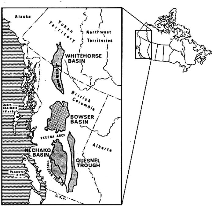
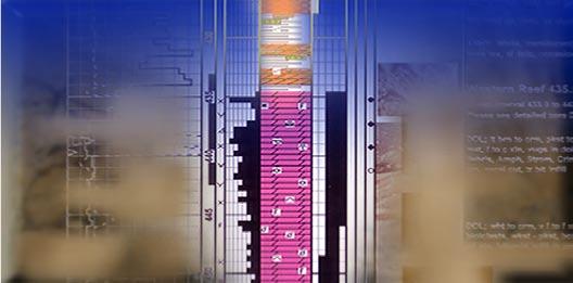
32 A Petroleum Events Chart for the Whitehorse Trough, Yukon
37 University of Saskatchewan Clastics Field Trip
43 Talking to Astrid
IHS AccuMap ®
“AccuMap encompasses speed, stability, efficiency and accuracy. As an intuitive and easy-to-use product, AccuMap serves a broad audience, from field users to the CEO.”
Darrel Saik Senior Geological Technologist Paramount Energy Trust
AccuMap is the most widely used and highly trusted oil and gas mapping software touching every segment of E&P, for every professional.
www.ihs.com/energy
Call toll free 1 877 495 4473
#600, 640 - 8th Avenue SW
Calgary, Alberta, Canada T2P 1G7
Tel: 403-264-5610 Fax: 403-264-5898
Web: www.cspg.org
Office hours: Monday to Friday, 8:30am to 4:00pm
Business Manager: Tim Howard
Email: tim.howard@cspg.org
Membership Services: Kristina Keith
Email: kristina.keith@cspg.org
Communications & Public Affairs: Heather Tyminski
Email: heather.tyminski@cspg.org
Corporate Relations: Kim MacLean
Email: kim.maclean@cspg.org
Corporate Relations Assistant: Dayna Rhoads
Email: dayna.rhoads@cspg.org
Conventions & Conferences: Shauna Carson
Email: shauna.carson@cspg.org
Conventions & Conferences Assistant: Tanya Santry
Email: tanya.santry@cspg.org
Reception: Kim Cowell
Email: reception@cspg.org
EDITORS/AUTHORS
Please submit RESERVOIR articles to the CSPG office. Submission deadline is the 23rd day of the month, two months prior to issue date. (e.g., January 23 for the March issue).
To publish an article, the CSPG requires digital copies of the document. Text should be in Microsoft Word format and illustrations should be in TIFF format at 300 dpi., at final size. For additional information on manuscript preparation, refer to the Guidelines for Authors published in the CSPG Bulletin or contact the editor.
Advertising inquiries should be directed to Kim MacLean. The deadline to reserve advertising space is the 23rd day of the month, two months prior to issue date. All advertising artwork should be sent directly to Kim MacLean.
The RESERVOIR is published 11 times per year by the Canadian Society of Petroleum Geologists. This includes a combined issue for the months of July/August.
Advertisements, as well as inserts, mailed with the publication are paid advertisements. No endorsement or sponsorship by the Canadian Society of Petroleum Geologists is implied. The contents of this publication may not be reproduced either in part or in full without the consent of the publisher.
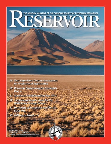
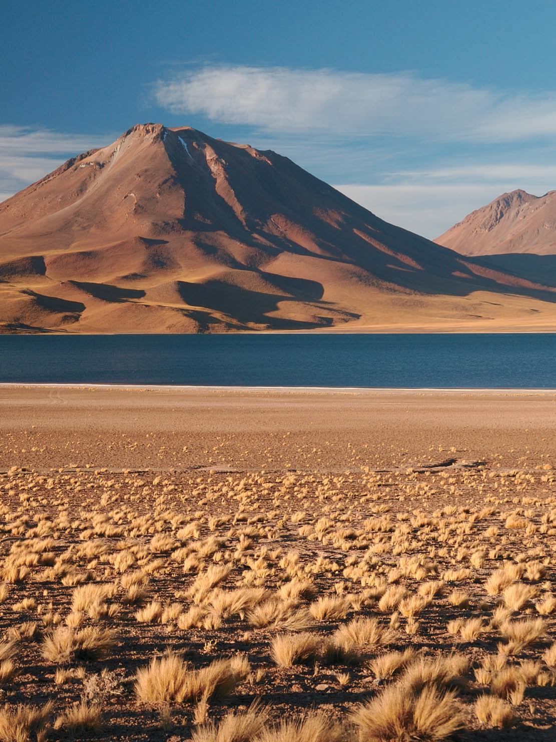
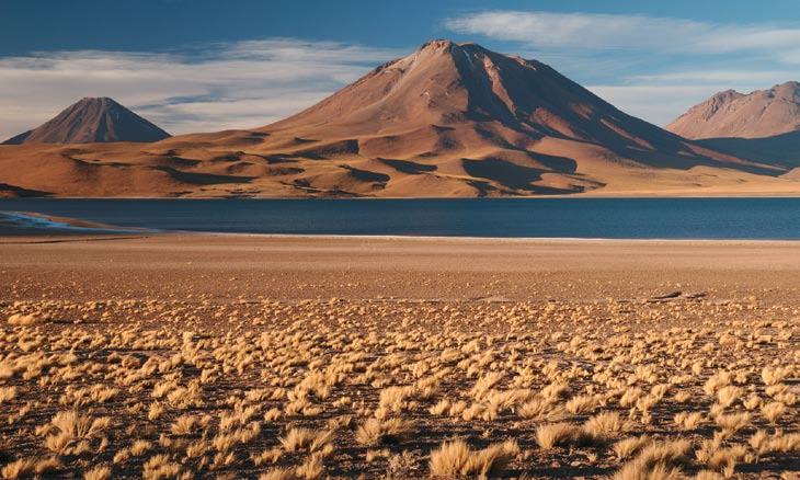
FRONT COVER Atacama Region, Chile. Miscanti Volcano. Photo by Marc Shandro.
Spend more time making decisions and less time managing data.
PETRA provides geoscientists and engineers the analysis tools needed for today’s exploration and exploitation challenges
IHS Enerdeq Desktop and IHS AccuMap directly export well and production data into PETRA projects
For the first time raster logs from IHS AccuLogs are available in PETRA for use with digital log data
Download a trial version at ihs.com/energy/petra
For more information visit: energy.ihs.com/petra
CSPG EXECUTIVE
President
Lisa Griffith • Griffith Geoconsulting Inc. lgriffith@griffithgeoconsulting.com Tel: (403) 669-7494
Vice President
Graeme Bloy • West Energy Ltd. gbloy@westenergy.ca Tel: (403) 716-3468
Past President
Colin Yeo • EnCana Corporation colin.yeo@encana.com Tel: (403) 645-7724
Finance director
James Donnelly • ConocoPhillips Canada james.donnelly@conocophillips.com Tel: (403) 260-8000
assistant Finance director
David Garner • Chevron Canada Resources davidgarner@chevron.com Tel: (403) 234-5875
Program director
Randy Rice • Suncor Energy Inc. rjrice@suncor.com Tel: (403) 205-6723
serVice director
Jen Vezina • Devon Canada Corporation jen.vezina@devoncanada.com Tel: (403) 232-5079
assistant serVice director
Ayaz Gulamhussein • NuVista Energy Ltd. Ayaz.gulamhussein@nuvistaenergy.com Tel: (403) 538-8510
A message from the Immediate Past President, Colin Yeo, P.Geol.
Good progress and some unfinished business
When I began my service as President, the CSPG Executive had a clear vision of what needed to be done: elevate the Executive Committee to set strategic direction, leave operational matters to our staff, recognize and reward our volunteers and strengthen our ties with other societies. The Executive Team has made good progress, but as with any ambitious endeavour, there is always room for improvement and not everything was accomplished.
When we reviewed the 2005 Strategic Plan, the Executive focused on the broad goal of advancing the professional development of our members. Our industry’s current direction is exploitative in nature: infill drilling and production optimization. An outpost location is now considered to be a wildcat. Our members need new skills and knowledge to be productive in today’s industry and we have responded through Programs and Communications.
We strongly support the excellent work of the Technical Luncheon Committee that brings in first-class presentations and has begun to experiment by inviting presentations on related topics such as government regulations, managing the boom, global petroleum economics, and climate change.
Continuing Education has expanded its roster of short courses and field trips and has run its first Education Week, designed to offer niche courses at low cost. Continuing Education is developing a comprehensive training matrix which will be very useful for recent graduates to effectively plan their professional development.
The Reservoir is now publishing serials on topics such as GIS and reservoir engineering which begins an emphasis on educating our members in a variety of related subjects designed to make them more aware of technologies and skills needed in this new
reality.
While this is a good start, success will be achieved when the Reservoir consistently publishes technology-related articles that instruct readers, and insightful pieces that inform, educate, and entertain. The new Communications Director will be increasing technical content from a variety of sources. Programs will continue to provide excellent technical luncheons, division talks, and continuing education courses.
Perhaps the biggest change we made this year was to transform the Executive from a committee focused on daily operational matters to one that sets direction and executes the strategic plan. We now only have one operational meeting a month based on the premise that ‘a busy Executive is not a meddling Executive’. The operational meetings are now progress reports as we implement strategies. We hold one planning meeting each quarter to ensure we are on track overall.
Despite significant absences and turnover, our staff is running day to day operations well, and is now focused on efficiency measures. Its effectiveness is seen in record Society revenues and a very professional presence with our industry sponsors, advertisers, and exhibitors. We will continue to have our staff run the Society’s operations while committees focus on soliciting technical material for the benefit of members.
The Finance Director and Assistant Finance Director made a significant improvement to our monthly financial review. We are now focused on long-range financial planning and much less on line item scrutiny. This has freed up an enormous amount of time for the Executive to deal with member services.
This initiative is working well and I believe that we should discipline ourselves to (Continued on page 7...)
CORPORATE MEMBERS
ABU DHABI OIL CO., LTD. (JAPAN)
APACHE CANADA LTD.
BAKER ATLAS
BG CANADA ExPLORATION & PRODUCTION, INC
BP CANADA ENERGY COMPANY
CANADIAN FOREST OIL LTD.
CANETIC RESOURCES TRUST
CONOCOPHILLIPS CANADA
CORE LABORATORIES CANADA LTD
DEVON CANADA CORPORATION
DOMINION ExPLORATION CANADA LTD
DUVERNAY OIL CORP
ENERPLUS RESOURCES FUND
FUGRO AIRBORNE SURVEYS
geoLOGIC systems ltd.
GRIZZLY RESOURCES LTD
HUNT OIL COMPANY OF CANADA, INC
HUSKY ENERGY INC.
IHS
IMPERIAL OIL RESOURCES LIMITED
LARIO OIL & GAS COMPANY
MJ SYSTEMS
MURPHY OIL COMPANY LTD.
NExEN INC
PENN WEST PETROLEUM LTD
PETRO-CANADA OIL AND GAS
PETROCRAFT PRODUCTS LTD.
PRIMEWEST ENERGY TRUST
PROVIDENT ENERGY LTD
RPS ENERGY CANADA LTD.
SHELL CANADA LIMITED
SPROULE
SUNCOR ENERGY INC
TAQA NORTH LTD
TALISMAN ENERGY INC.
TOTAL E&P CANADA LIMITED
WEATHERFORD CANADA PARTNERSHIP
AS OF NOVEMBER 24, 2007
continue to act strategically. The role of the Executive Committee may change as a result of the recommendations of a Presidential Task Force charged with evaluating the appropriateness of an Executive Director for the Society. The Task Force is not only determining if an Executive Director is needed, but will also detail roles and responsibilities if an Executive Director is recommended. We will consider their report and respond accordingly.
No matter what decision is made and despite current conditions in the office, it is very important that future Executive Committees not revert back to detailed task management but rather think and act strategically.
There is one area where we did not meet our expectations. We wanted to ensure that we are properly supporting and recognizing our volunteers for their efforts in running the Society. Whether it is writing papers for the Bulletin or articles for the Reservoir, leading our Technical Divisions, or participating in one of the Society’s 50 committees, it is our volunteers who make the CSPG the success it is. This year we had planned to simplify and automate our award nomination process and to improve the award presentation itself, however, we did not achieve this goal.
The Executive is committed to enhancing the entire award and recognition program. In the coming year, we will concentrate on implementing this very important strategy. A subcommittee of Executive members will analyze each step of the award’s process with the intent of confirming we have identified all volunteers and ensuring they are properly recognized. We acknowledge and thank all of our volunteers and supporters.
The final goal we had set for ourselves was to strengthen our ties with other technical societies and associations, and in that regard I believe we have succeeded. We are in the process of signing an agreement with the CSEG to form the Joint Annual Convention Committee. We will be extending the agreement to the CWLS, the result being that the three societies will hold a joint convention every year. This will lead to an enhanced convention with an excellent array of technical presentations, and we are very excited about this new committee. We have also reinforced our relationship with APEGGA and clearly defined our respective roles in the professional careers of our members.
We will continue to build our relationships with other earth science organizations. We have just begun our work with the Canadian Federation of Earth Sciences. There are many initiatives we share in common with CFES, and cooperatively we can achieve our common goals faster, with better results, and at a lower cost.
While we did not have a specific goal related to Outreach, the Director and Assistant Director implemented a series of programs targeting science education in the early grades and careers in petroleum geology to graduating university students. As usual, SIFT was a wonderful success and the “100 Jobs” initiative shows great promise and will have a significant impact on new entrants to the petroleum industry.
While I am generally pleased with our progress over the last year, there are several initiatives that I am committed to completing in my role as Past President. I will be working with the Communications Director to generate even more timely and informative articles for the Reservoir, with the Services Director to improve the awards process, and with the Assistant Services Director to implement our membership plan. Of course, my first priority is to advise and support Lisa Griffith, our new President, as she leads our Society next year.
It has been my pleasure to have served as President of this vibrant and dynamic organization. I have benefited greatly from the CSPG during my career in the petroleum industry and I strongly believe that I now have an obligation to repay the Society.
It has been an even greater pleasure to have worked with such a fine Executive Committee this year. Together, we have faced significant challenges, but we have worked through them in a spirit of cooperation and goodwill as a team, and we have made several significant achievements. As an Executive, I hope we have better served our members and further advanced the science of petroleum geology.
technical luncheons JANUARY LUNCHEON
Quin Kola: Tom Payne’s Search for Gold
SPEAKER
Dr. Alice V. Payne, C.M., M.SC., LL.D., P.Geol.
11:30 am
tuesday, January 8, 2008
** cs P g a nnual g eneral m eeting** telus convention centre c algary, a lberta
Please note:
t he cut-off date for ticket sales is 1:00 pm, t hursday, January 3, 2008. t icket Price: $34.00 + gst.
Due to the recent popularity of talks, we strongly suggest purchasing tickets early, as we cannot guarantee seats will be available on the cut-off date.
The story of Tom Payne is an adventure book, amazing, heroic, and true. Born to a prominent British physician, the young Tom’s restlessness led him to western Canada in 1912, where he first tackled the farming industry.
After a stint in northern Manitoba, freighting supplies for the developing base metal mines near Flin Flon, he drove a Linn tractor for the ill-fated MacAlpine expedition. This was one of the first attempts at aerial prospecting in the far north, but Tom ended up seal hunting on the ice of Hudson Bay with an Inuit friend. By the early 1930s, he moved to the portage at Fort Smith in northern Alberta where he succumbed to the lure of prospecting, inspired by Labine’s pitchblende discoveries at Great Bear Lake. Grubstaked by his employers, his first efforts at getting rich quickly met with disappointment and near starvation, but he would not give up.
Tom finally discovered a rich gold mine among the quartz veins in the shear zones at Yellowknife; he formed Quin Kola Gold
Mines Limited and made an historic mining deal with Cominco. Tom’s four claims became part of the ‘Con’ mine, which was one of Canada’s largest operating gold mines. Instead of retiring later in life, he found new partners and drilled an oil well in Alberta. His story illustrates the heady excitement of frontier exploration, with the persistence and luck required for success.
BIOGRAPHY
Consultants
Alice Payne, P. Geol., obtained her Bachelor of Science and Master of Science degrees from the University of Alberta in the early sixties. She spent fifteen years as a consultant in the mining industry and academia, and managed Ryan Gold Mines until it was sold in 1990. She worked another fifteen years in the oil patch, with Gulf Canada Resources, until her retirement in 1995. She is now the president of Arctic Enterprises Limited, her own company. Payne is a member of the Canadian Institute of Mining, Metallurgy and Petroleum; the Geological Association of Canada; the Association of Professional Engineers, Geologists and Geophysicists of Alberta; the American Association of Petroleum Geologists; and was the first woman to be president of the Canadian Society of Petroleum Geologists, in 1992. Payne has served on many boards and volunteer committees, and has been the recipient of several honours and awards, including the Paul Harris Fellowship, the YWCA Women of Distinction Award, a University of Calgary honorary doctorate, and the Order of Canada.
NOTE
Copies of Quin Kola: Tom Payne’s Search for Gold will be available for sale at the January 8, 2008 Technical Luncheon for $25.00 + GST. All proceeds of these sales will go to the CSPG Trust.
technical luncheons JANUARY LUNCHEON
Anisotropic seismic depth imaging tutorial and applications in fold and thrust belt exploration
SPEAKER
Don Lawton
Department of Geology and Geophysics, University of Calgary
11:30 am
t hursday, January 24, 2008 telus convention centre c algary, a lberta
Please note:
t he cut-off date for ticket sales is 1:00 pm, m onday, January 21, 2008.
t icket Price: $34.00 + gst
Due to the recent popularity of talks, we strongly suggest purchasing tickets early, as we cannot guarantee seats will be available on the cut-off date.
Exploration for hydrocarbons in fold and thrust belts can be challenging. Seismic imaging is often hampered by severe topography, outcropping carbonates, acquisition conditions and parameters, near-surface velocity variations, structural complexity, and sparse geological control from outcrops or wells. Thus it may be difficult for explorers to produce interpretations of subsurface structures in which they have confidence.
Correct seismic imaging of geological structures in thrust belts requires prestack depth migration due to significant lateral changes in seismic velocities that often occur. A further complexity arises in structural domains where sequences of dipping clastic strata overlie hydrocarbon targets. Structures beneath such sequences will be mispositioned if isotropic velocities are used during processing. Anisotropic prestack depth migration (APSDM) is necessary to position these targets correctly. The requirement for success in anisotropic depth imaging is constructing correct models of interval velocities, anisotropy parameters, and dip used in the migration.
A deterministic approach to model updating through minimizing residual move out in common-image gathers is used commonly, but discussions between data processors and interpreters are also critical for reducing ambiguity and yielding geologically realistic models that can be structurally balanced. All sources of geophysical and geological data must be integrated to optimize velocity model updating. Determination of anisotropy parameters from offset vertical seismic profiles and field refraction surveys will be demonstrated, and the use of other geophysical data, such as gravity, to provide constraints on the geological models and interpretations will be illustrated.
Interpreters need to understand the limitations of the seismic acquisition and processing methods while data processors must address the credibility of their velocity models in the geological context. Increased collaboration between geology and geophysics is the key to improving success in thrust-belt exploration.
BIOGRAPHY
Don Lawton is a Professor of Geophysics and
Chair in Exploration Geophysics in the Department of Geoscience at the University of Calgary. He previously served as Head of the Department from 1997 to 2002. He joined the department in 1979 after obtaining a Ph.D. in Applied Geophysics from the University of Auckland, New Zealand. His research interests include integrated geophysical and geological studies in fold and thrust belts, acquisition, processing and interpretation of multi-component seismic data, seismic anisotropy, and geological storage of CO2. He is a Director of the FoldFault Research Project (FRP) and an Associate Director of the Consortium for Research in Elastic Wave Exploration Seismology (CREWES), both of which are successful research consortia sponsored by industry. He is currently an Associate Editor of the Bulletin of Canadian Petroleum Geology and is a past Editor of the Canadian Journal of Exploration Geophysics. He was a recipient of a Meritorious Service Award from the Canadian Society of Exploration Geophysicists (CSEG) in 1996 and in 2000 he received the CSEG Medal, the Society’s highest honour. He is a member of CSEG, CSPG, SEG, AAPG, EAGE, ASEG, and APEGGA. He is serving as a 2007/2008 AAPG-SEG Intersociety International Distinguished Lecturer.
Carmen Dumitrescu P.Geoph., M.Sc., Manager, Reservoir Geophysics
Is the modern Belize carbonatesiliciclastic shelf an appropriate analog for exploration and development of Western Canada Devonian reservoirs?
SPEAKERS
Burr Silver
Olympic Exploration and Production
Nigel Watts, EnCana
CO-AUTHOR
Bill Martindale
W. Martindale Consulting
11:30 am
tuesday, February 12, 2008 telus convention centre calgary, alberta
Please note: the cut-off date for ticket sales is 1:00 pm, thursday, February 7, 2008. ticket Price: $34.00 + gst.
Due to the recent popularity of talks, we strongly suggest purchasing tickets early, as we cannot guarantee seats will be available on the cut-off date.
Modern clastic and carbonate settings of Belize are often used as analogs for Devonian sequences in the Western Canada Sedimentary Basin (WCSB) but are these analogs valid? Despite differences in age, components, and regional setting, we believe they are but as with any modern analog, should be used with caution.
The Belize shelf consists of coastal clastics and a lagoon/barrier-reef/atoll complex. Coastal clastics are derived from late Silurian granites and Pennsylvanian-Permian meta-sediments of the Maya Mountains. East-flowing rivers transport coarse-grained feldspathic sands from the Mayas to the coast where they are moved south by longshore currents. Middle Devonian analogs include terrigenous delta plain complexes that are closely associated with carbonates that fringe the Peace River Arch.
Between the Belizean coast and the barrier
reef are hundreds of individual reefs. These range from a few metres thick near the coast to nearly 30 m thick near the barrier and are constructed primarily of bulbous and branching corals. Analogous shelf reefs, constructed almost entirely by stromatoporoids, occur in the Beaverhill Lake, Leduc, and Nisku of western Canada.
The Belize barrier reef forms the eastern margin of the Belize shelf and is dominated by a variety of coral species distributed across deep to shallow water facies. The barrier is 250 km long, ranges from 0.7 to 1.2 km wide and is over 300 m thick. Similar high-relief fore-reef to back-reef facies, consisting of stromatoporoids and corals occur in Keg River, Slave Point, Swan Hills, and Leduc formations in western Canada.
Three large atolls occur basinward of the Belize barrier in waters over 400 m deep. Each is rimmed by reefs that enclose a central lagoon. Rim reefs are populated by all of the major reef builders whereas lagoonal patch reefs are dominated by finger and a few species of bulbous corals. Examples of detached Devonian basinal
(Continued on page 12...)
Full Cycle Multicomponent
CGGVeritas brings full cycle integrated experience to your multicomponent project, from acquisition through processing and reservoir characterization.
Acquisition
> extensive experience with over 150 multicomponent projects (2D, 3D and 4D) conducted since 2001
> over 11,000 multicomponent digital sensor units available
> innovative field solutions for multicomponent recording
ENVISION SUCCESS
Processing
> reliable results: processing teams with substantial experience in 3C, converted wave and 4D processing
> exclusive Adaptive Polarization Filtering process improves P-wave data by leveraging the full-wavefield recording
> pre-stack migration for both PP and PS data
Reservoir Characterization
> PP and PS data to characterize reservoir lithology, fluid type, and fracturing
> improved density estimates from joint inversion, for heavy oil
> fracture estimation from shear-wave splitting
Rely on CGGVeritas to maximize your exploration accuracy You’ll have access to leading seismic imaging technologies, highly sought 3D and 2D data, the most advanced acquisition capabilities and a staff dedicated to helping you succeed
Focus on Performance Passion for Innovation Powered by People Delivered with Integrity
atolls, constructed by stromatoporoids and corals, include Fenn/Big Valley, Judy Creek, Redwater, Golden Spike, and Wizard Lake.
Despite the similarities mentioned above, there are also significant differences between Belize reefs and their Devonian counterparts. These include: role of antecedent structure on reef location, types of reef builders, scale, magnitude of sea level change, and time. Antecedent Pleistocene topography dictated Holocene depositional patterns in Belize. In contrast, an underlying (basement?) structural control on Devonian reef development is still debated. Whereas corals are the dominant reef builders in Belize, western Canada Devonian reefs were dominated by stromatoporoids. Stromatoporoids and corals exhibit similar growth forms (bulbous, branching, and sheet) and probably occupied similar ecological niches, determined by water depth, light, and sediment load.
The growth form of Belizean and Devonian reefs is related to accommodation space, determined by relative sea level change. Aggradational growth forms dominate in Belize, where over 120 m of post-glacial sea level. rise has occurred over the last 18,000 years. In contrast, aggradational and progradational styles occur in the WCSB
Devonian, reflecting significant fluctuations in relative sea level.
Although depositional dip and relief across the Belize shelf margin exceeds that of most WCSB Devonian margins, scale of the Devonian complexes dwarf the Belize complex. The Belize shelf covers approximately 36 x 103 km2 . In contrast, the Devonian carbonate factory covered an area of 1,400 x 103 km2 . This vast difference is related to the relative absence of tectonic features on the pre-Devonian surface and the effects of relative sea level change over time.
Perhaps the most important difference between Belizean carbonates and those of the WCSB Devonian is time. The Holocene (about 10,000 years) is a snap shot in time when compared to the more than 45 million years represented by Devonian strata. It is possible that time will “flatten out” all of the Holocene observations with the result that the differences discussed above would become less significant. The appreciation of geologic time and its influence on the evolution of carbonate reservoirs is perhaps the greatest obstacle in paleoenvironmental interpretations. Rather than attempting to force-fit modern analogs into our reconstruction efforts, perhaps it is the processes that influence carbonate reservoirs that should be our
focus. This, we would argue, is where the greatest impact of the modern analog lies.
BIOGRAPHY
Burr A. Silver has experience with a major oil company research lab as well as its exploration, development, and corporate planning groups that included research and exploration in Alberta and several U.S. basins. Silver served on the faculties of two universities where he and his M.Sc. and Ph.D. candidates conducted research in modern carbonates located in the South Pacific, Jamaica, Puerto Rico, Bahamas, and Belize. Silver organized an independent exploration company but he has maintained his enthusiasm in our science by instructing seminars in exploration stratigraphy, seismic stratigraphy, and a field workshop and seminar in Belize.
Nigel Watts has worked in the exploration, production, and reservoir engineering groups of a major multi-national oil company as well as three large Canadian Independents. His area of expertise is the exploration for and the development of carbonate reservoirs in the WCSB. His experience also includes studies of ancient carbonate sequences in the US, Indonesia, Australia, Angola, Great Britain, and Europe as well as modern carbonates in Jamaica, Shark Bay – Western Australia, and Belize. He has taught in-house short courses on carbonate sedimentology as well as field seminars on the Devonian reefs in the Canadian Rockies.
technical luncheons FEBRUARY LUNCHEON
Subsidence
and sea-level
change
along
the northern Gulf of Mexico, response of the Mississippi River to the last glacial cycle, and the flexural ups and downs of the Mississippi Delta
SPEAKER
Mike Blum
Louisiana State University Talk Funded by the AAPG Foundation
11:30 am tuesday, February 26, 2008 telus convention centre calgary, alberta
Please note:
the cut-off date for ticket sales is 1:00 pm, thursday, February 21, 2008. ticket Price: $34.00 + gst.
Due to the recent popularity of talks, we strongly suggest purchasing tickets early, as we cannot guarantee seats will be available on the cut-off date.
Subsidence and sea-level change in the Mississippi delta region have seen renewed interest after Hurricanes Katrina and Rita. Subsidence and sea-level change include contributions from a number of interrelated processes, which operate over a variety of spatial and temporal scales. This presentation discusses a new component to land-surface dynamics in the delta region, and along the adjacent Gulf of Mexico shoreline, a cyclical flexural response to excavation of lower Mississippi valley sediments by meltwaters during the last deglaciation, when sea level was relatively low, and valley filling during Holocene sea-level rise.
Recent studies of the lower Mississippi valley provide a new and more detailed view
on valley evolution in response to glaciation, deglaciation and meltwater routing, and global sea-level change. These studies contribute to our understanding of the subsidence and sea-level change because they constrain the thickness and lateral extent of sediments that were removed during the last glacial period and subsequently replaced during the Holocene, as well as provide a chronology for excavation and filling.
Results of 1D steady-state and 3D viscoelastic models show the volume of sediments removed and replaced was sufficient to induce large-scale flexural uplift of the delta region, followed by flexural subsidence. Amplitudes of uplift and subsidence range from 12 metres in the valley center to 9 metres at the valley margins, and dissipate to negligible values over distances of >100 kilometres along the adjacent Gulf of Mexico shoreline.
This high-frequency, cyclical flexural signal has a number of implications for the analysis of subsidence patterns, as well as spatially varying views on sea-level change along the Gulf of Mexico shoreline. Moreover, incision and aggradation is a common response of large rivers to cyclical climate and sealevel change: cyclical, high-amplitude flexural
uplift and subsidence should therefore be an important component in large fluvialdeltaic systems elsewhere, today and in the stratigraphic record.
BIOGRAPHY
Mike Blum completed his Bachelor’s Degree in 1983 at the University of Texas at Austin, his Masters’ Degree in 1987 at the University of Texas, and his Ph.D in 1992 at the University of Texas. He is currently a Professor in the Department of Geology and Geophysics at Louisiana State University.
Some of his publications include “Climate change, sea-level change, and fluvial sediment supply to deepwater sysems” (co-written with J.H. Womack), “Fluvial evolution of the lower Mississippi River Valley during the last 100-kyr glavial cycle: Response to glaciation and sea-level change” (co-written with T.M. Rittenour), and “Signatures of climate versus sea-level change within incised valley successions: Quaternary examples form the Texas Coastal Plain and Shelf” (co-written with S.B. Marriott).
His professional interests include fluvial and coastal sedimentology, sequence stratigraphy of continental successions, and geologic responses to global climate and sea-level change.
CALL FOR ARTICLES
One of the goals of the Reservoir is to promote the petroleum industry – and the geosciences in general –by providing a platform for discussion and updates of current research, ideas, and events related to our profession.
The Reservoir is continually looking for technical articles that assists in this goal.
The Reservoir will pay an honorarium of $200 for any accepted technical article (minimum 1,500 words).
Please see page 3 for article guidelines or contact Ben McKenzie at bjmck@telusplanet.net
diVision talKs GEOFLUIDS DIVISION
Origin of brines in the Western Canada Sedimentary Basin as inferred from bromide and chloride ratios
SPEAKERS
James Freeman and Kaush Rakhit
12:00 noon thursday, January 17, 2008 conocoPhillips auditorium, 3rd Floor (above +15 l evel), 401 – 9th avenue sW calgary, alberta
Ions of bromine and chlorine are recognized as reasonably conservative tracers in natural waters. This quality has led to the use of bromide (Br-) concentrations and chloride (Cl-)/Br- mass ratios to infer the geochemical provenance of different groundwaters. For brines, Carpenter (1978) defined a “seawater evaporation trajectory” (the S-E-T) using cross plots of Cl- and Br- concentrations. On the S-E-T, the ratio of Cl- to Br- remains constant as water evaporates and becomes increasingly enriched, until the point of halite precipitation, at which point the Cl/Br- ratio decreases. The S-E-T can be used to infer the origin of a brine, whether due to
evaporative enrichment, halite dissolution, or mixing with other waters.
A recent compilation of Br- and Clconcentrations for the Western Canada Sedimentary Basin (WSCB) allows the interpretation of brine origins in the basin. At the bottom of the sedimentary section, oilfield brines in Middle Devonian formations have high TDS concentrations (greater than 100 g/L) and plot directly on the S-E-T. Published data from evaporite mines in Saskatchewan have higher TDS (greater than 200 g/L) and overlap with the oilfield brines. The Cl-/Br- mass ratios of these brines indicate evaporation past the point of halite precipitation.
Cl-/Br- mass ratios in brines from the top of the WCSB geological section, in clastic Cretaceous formations, indicate that these waters have undergone evaporative concentration of seawater. Mannville Group (and its equivalent) brines typically have TDS concentrations of 50-90 g/L and plot directly on the S-E-T. Some of the Upper Cretaceous brines from units above the Colorado Group contain as little as 5 g/L TDS and plot close to the S-E-T, but waters from this section are often Brenriched, suggesting an organic source of Br- in the shallow WCSB. Brines from Upper Devonian sediments indicate mixing with the underlying Middle Devonian, while Mississippian and Mesozoic sediments are often Cl- enriched, suggesting mixing with halite dissolution-derived brines.
Overall, Cl-/Br- mass ratios suggest that many of the brines in the WCSB have evidence of a syndepositional salt source that has mixed with other waters. This
mixing has been especially active within the Devonian and the post-Devonian sections, with less mixing between these units.
This paper was presented at a symposium entitled “Regional Groundwater Flow: In Honor of József Tóth”, at the Geological Society of America Annual Meeting in Denver (October 28-31, 2007).
BIOGRAPHY
James Freeman is a Principal Hydrologist at Matrix Solutions Inc., an environmental and engineering consultancy based in Calgary.
Kaush Rakhit is the President of Canadian Discovery Ltd. and the creator of the GEOFLUIDS database.
I NFORMATION
Upcoming talk, Thursday, Feb. 21, 2008
Understanding groundwater recharge in a sandy landscape: Observing the effects of disturbance is a step towards reclamation
SPEAKERS
Brian Smerdon , WorleyParsons Komex Carl Mendoza , University of Alberta Clara Qualizza , Syncrude Canada Ltd.
The lunch talks are free and everyone is welcome to attend. If you would like to suggest a technical topic or present a talk to the division, please contact the Division Chairs, Jennifer Adams, University of Calgary, at (403) 2203258 or via e-mail at adamsjj@ucalgary.ca, or Nina Ejezie, Imperial Oil, at (403) 237-2985 or via email at nina.u.ejezie@esso.ca.
CALL FOR VOLUNTEERS
The Reservoir is seeking additions to its editorial committee. We have the opportunity to greatly expand the scope and content of the Society’s news magazine, but need the people to make it happen. We are looking for volunteers that would be interested in coordinating or assisting in developing any of the following departments:
Exploration geology • Development geology • Geophysics • Petrophysics Government liaison • University liaison • Current publications
Please contact Ben McKenzie (bjmck@telusplanet.net) for more information
diVision talKs PALAEONTOLOGY DIVISION
Lean, mean, killing machines: the feeding behaviors and bite force of meat-eating dinosaurs
SPEAKER
Dr. François Therrien, Royal Tyrrell Museum of Palaeontology
7:30-9:00 P m , Friday, January 18, 2008 r oom B108, m ount r oyal c ollege
Meat-eating dinosaurs, the theropods, are often pictured as ambush predators attacking their prey with a slashing bite, a strategy similar to that of Komodo dragons. However, given the great diversity of theropod dinosaurs, various species would likely have adopted different hunting techniques to capture different prey, like modern mammalian predators do. To test this idea, a biomechanical approach (beam theory) was used to model the mandibles of theropods and compare them to those of modern predators, such as the Komodo dragon and crocodilians, to infer their killing strategies and bite force.
Theropods exhibit a high diversity of feeding behaviors, where five feeding categories are recognized:
1) Antrodemus, Majungatholus, and Carnotaurus share the mandibular properties of Komodo dragons, suggesting that they delivered slashing bites;
2) dromaeosaurids have mandibular properties reminiscent of Komodo dragons for slashing bites, but differences between dromaeosaurines and velociraptorines indicate that the former had a stronger bite than the latter and probably relied on it to capture and kill prey;
3) Suchomimus and Dilophosaurus both exhibit mandibular adaptations related to the capture of prey relatively smaller than themselves, the former probably practicing a bite-and-hold strategy whereas the latter finished its prey with slashing bites;
4) Ceratosaurus, Allosaurus, Acrocanthosaurus, and Giganotosaurus demonstrate adaptations of the anterior extremity of the mandible for prey capture and delivering powerful bites in order to bring down prey or deliver the final blow; and
5) tyrannosaurids, unlike any other theropod, exhibit mandibular adaptations to resist high torsional stresses at the anterior extremity of the mandible, related to prey capture and/or bone crushing capabilities. Bite force estimates also reveal that Tyrannosaurus rex had a bite three times more powerful than that of Giganotosaurus, approximately 16 times that of a modern alligator !
B IOGRAPHY
François Therrien earned a B.Sc. in Geology at the Université de Montréal in 1997. He then moved to the United States and obtained his M.Sc. in Geosciences from the University of Rhode Island in 1999 for his study on the paleoenvironments of Late Triassic theropods from the American Southwest. Subsequently, François moved to Baltimore to pursue his Ph.D. at the Johns Hopkins University, School of Medicine. Although he studied the latest Cretaceous dinosaur-bearing deposits of Transylvania for his dissertation, he also learned to apply biomechanical principles to the study of dinosaur behavior.
After obtaining his Ph.D. in 2004, François came to the Royal Tyrrell Museum and University of Calgary on an NSERC postdoctoral fellowship. In 2006, he was appointed Curator of Dinosaur Palaeoecology at the Royal Tyrrell Museu m.
I NFORMATION
This event is jointly presented by the Alberta Palaeontological Society, Mount Royal College and the CSPG Palaeontology Division. For information or to present a talk in the future please contact CSPG Paleo Division Chair Philip Benham at 403-691-3343 or programs@albertapaleo.org. Visit the APS website for confirmation of event times and upcoming speakers: http://www.albertapaleo. org/.
diVision talKs BASIN ANALYSIS AND SEQUENCE STRATIGRAPHY
Integration of SAGD fundamentals with reservoir characterization to optimize SAGD production
SPEAKER
Rudy Strobl
Enerplus Resources Fund
12:00 noon
Friday, January 25, 2008 encana amphitheatre, 2nd Floor, east end of the calgary tower complex 1st street and 9th avenue se , calgary, aB
Steam Assisted Gravity Drainage is truly in its infancy, with only a handful of insitu operations in Alberta that are fully
commercial in size and scope. Comprehensive case histories for production achieved by SAGD operators and associated successes or challenges are not currently in the public realm, which limits the amount of learning required to optimize in-situ recovery. Communication and sharing of knowledge in all aspects of SAGD is of mutual benefit at this early stage in Alberta’s in-situ oil sands industry.
Enhancement of bitumen production, associated decrease in steam oil ratios and methods of increasing profitability will undoubtedly require operations modified to specific reservoir types. Integrating a basic understanding of SAGD operations with reservoir characterization is now required to make production targets. Important basics include the role of subcool, production liner slot design, effects of top water or potential thief zones, top gas, start up procedures, and the effects of variable reservoir thickness on production along the length of the SAGD well pair.
Traditionally, operators work with a simple model of placing SAGD well pairs as close
If
to the base of pay as possible and expecting to minimize the effects of reservoir heterogeneity by going with longer well pairs. With an integrative approach, however, strategies may have to be modified to optimize production. One critical question is “What is SAGD pay?”
There appears to be no common definition for SAGD pay. Some operators define pay as a continuous bitumen interval, averaging at least 65% oil saturation by volume, with no mudstones greater than 1 metre thick. Other operators use a more conservative approach, limiting mudstones to less than 0.5 metre in thickness. Cross-bedded sands, commonly exhibit a vertical permeability range from 2 to 6 Darcy (D) units. In contrast, IHS lithofacies contain laterally continuous mudstone interbeds with 2 to 3 orders of magnitude reduction in vertical permeability (milliDarcy).
Depending on operating procedures, it is likely that geometry and lateral continuity of permeability barriers such as mudstone interbeds are more important than thickness. The top and base of the SAGD interval and the associated placement of SAGD well pairs will vary considerably, depending upon how pay is defined and interpreted.
Optimal well placement in combination with appropriate operating practices is emphasized to better understand the interaction of the oil sands reservoir, steam chamber and associated production fluids. In this presentation, concepts and ideas are offered for discussion purposes which will hopefully initiate discussion and learning.
BIOGRAPHY
Rudy Strobl obtained his B.Sc. (Honours) at the University of Manitoba followed by his M.Sc. at the University of Alberta. Rudy obtained a diverse background and experience in oil sands geology working with the Alberta Geological Survey, Alberta Energy Corporation, EnCana, and currently with Enerplus Resources Fund.
INFORMATION
BASS Division talks are free. Please bring your lunch. For further information about the division, joining our mailing list, a list of upcoming talks, or if you wish to present a talk or lead a field trip, please contact either Steve Donaldson at 403-645-5534, email: Steve.Donaldson@ encana.com or Mark Caplan at 403-532-7701, email: mcaplan@aosc.com or visit our web page at www.cspg.org/events/divisions/basinanalysis-sequence-strat.cfm.
diVision talKs HEAVY OIL/OIL SANDS DIVISION
Bugged barrels: geological controls on bitumen compositional heterogeneity in Alberta oil sands reservoirs
SPEAKER
Jennifer Adams University of Calgary
8:00-9:00 am
t hursday, January 31, 2008
r P s e nergy c anada l td., training r oom in 1400, 800 5 ave s W
The world oil inventory is dominated by heavy oils and oil sand bitumens in foreland basins generated almost entirely by the process of biodegradation. This process is a biologically driven, complex reactive diffusion-dominated, in-reservoir oil alteration process that occurs under anaerobic conditions (Aitken et al., 2004) driven by oil-water reactions, usually at the base of the oil column producing methane and CO2 as by-products and concentrating heavy oil components (Head et al., 2003).
Over geological time, progressive biodegradation leads to the development of both lateral and vertical compositional and fluid property gradients, which are commonly documented in conventional heavy oilfields and in super heavy oil. The shape and variability of these gradients is related to reservoir properties, oil charge history, reservoir mineralogy and water flow in the reservoir. The controlling factors on the development of these
gradients and the heterogeneity seen within some Alberta oil sand reservoirs will be discussed in the context of genesis and their impact on bitumen recovery strategies and sweet-spot targeting.
BIOGRAPHY
Jennifer Adams received a B.Sc. in Geology at the University of Waterloo and a M.Sc. in Hydrogeology at the University of Alberta. She worked on CO 2 sequestration and basinal fluid property estimation with the Alberta Geological Survey before starting doctoral studies in simulation of petroleum biodegradation and the evolution of fluid properties in heavy oilfields with Steve Larter at the University of Calgary.
David E.Brown dbrown@cnsopb.ns.ca
Grant D.Wach grant.wach@dal.ca
LOGISTICAL INFORMATION
Trudy D.Lewis trudy.lewis@ns.sympatico.ca
The EARTH ImagerSM service delivers high-resolution micro-resistivity images in oil-based mud with great hole coverage.
This proven micro-resistivity imager from Baker Atlas offers a vertical resolution of less than 7.5mm at a standard logging speed of 275 m/hr giving you details never seen before in oil-based mud images.
The EARTH Imager service operates in 152 to 533mm diameter boreholes. With its 6 pads mounted on individually articulated arms, it provides you with 63% borehole coverage in 200mm diameter holes while maintaining pad contact at all hole deviations.
Call us today to find out how you can use the EARTH Imager service in your next oil-based well to accurately identify structural and sedimentary features, rock texture, fracture orientation and estimate net-to-gross.
YOUR E XPERIENCE COUNTS: Assessments for Professional Registration
| by Deborah Spratt, Ph.D., P.Geol.
As part of CSPG President Colin Yeo’s strategic initiative to renew the collaborative relationship between the CSPG and APEGGA, he has asked me to explain APEGGA’s updated procedures for evaluating applicants.
A lot has changed since the early 1980s, when I applied to APEGGA and my own transcripts were assessed against an unpublished list of 30 science and geoscience requirements with 16 specified subjects and 14 more from a narrow range of options. If you applied to APEGGA and abandoned the process because you were asked to write a large number of exams, you should consider applying now because your experience counts.
Academic transcripts and work experience for Geoscience applicants are reviewed by Professional Geologists or Geophysicists, and, contrary to some rumours, not by office staff or Professional Engineers. These Professional Geoscientists make assessments and recommendations that are voted on by the APEGGA Board of Examiners as a whole.
The Geology syllabus is now flexible enough to accommodate a wide range of disciplines and paths to training. It is available online and includes a summary page that allows an informal self-assessment by any prospective applicant: www.apegga.org/Applicants/pdf/Examinations/ GEOLOGY.pdf
As there is no national or international accreditation system for Geoscience programs, transcripts are evaluated case-bycase and compared course-by-course to national geoscience knowledge requirements for professional practice adopted by the Canadian Council of Professional Geoscientists
(see www.ccpg.ca). APEGGA’s Geology and Geophysics syllabi match the national knowledge requirements and are reviewed every five years by academics and industry practitioners.
Exams continue to be assessed, however, if the transcripts do not match the APEGGA syllabus. In the next step a geoscience experience examiner looks for evidence of appropriate-level work experience and career progression, using the information provided by the applicant and confirmed by referees. This is to see if any or even all assessed exams can be waived by using the combination of academics and experience (this is commonly the case if there is extensive experience).
Applicants with foreign undergraduate geology degrees are normally assessed with confirmatory exams (which have an extensive choice of subjects). These too are considered for waiving if there are either additional degrees or sufficient work experience acceptable to the Board. The Board of Examiners applies a modern “looking
to exempt if competence can be demonstrated” approach to all applications and has eliminated past practices, such as adding penalty exams to failed exams (assessed exams can now be repeated until they are passed, or others chosen in some cases).
So, if it has been a while since you first applied to APEGGA, or if you have never applied, it is time to consider doing so now. As one of seven geoscience examiners on the APEGGA Board of Examiners, I can assure you that your years of experience will be taken into consideration by the Board. Exams that you may have been asked to write in the past may no longer be required. Like the old Cornflakes commercial used to say, “Try us again for the first time!”
For more information on registration matters, please visit: www.apegga.org/Applicants/Geoscientists/toc. html.
Part 4 – Production Decline Analysis
| by Lisa Dean P. Geol. and Ray Mireault P. Eng
Production decline analysis is a basic tool for forecasting production from a well or well group once there is sufficient production to establish a decline trend as a function of time or cumulative production. The technique is more accurate than volumetric methods when sufficient data is available to establish a reliable trend and is applicable to both oil and gas wells.
Accordingly, production decline analysis is most applicable to producing pools with well established trends. It is most often used to estimate remaining recoverable reserves for corporate evaluations but it is also useful for waterflood and enhanced oil recovery (EOR) performance assessments and in identifying production issues/mechanical problems. Deviations from theoretical performance can help identify underperforming wells and areas and highlight where well workovers and/or changes in operating practices could enhance performance and increase recovery.
To the geologist, production decline analysis of an analogous producing pool provides a basis for forecasting production and ultimate recovery from an exploration prospect or stepout drilling location. A well’s production capability declines as it is produced, mainly due to some combination of pressure depletion, displacement of another fluid (i.e.,
gas and/or water) and changes in relative fluid permeability. Plots of production rate versus production history (time or cumulative production) illustrate declining production rates as cumulative production increases (Figures 1-4).
In theory, production decline analysis is only applicable to individual wells but in practice extrapolations of group production trends often provide acceptable approximations for group performance. The estimated ultimate recovery (EUR) for a producing entity is obtained by extrapolating the trend to an economic production limit. The extrapolation is valid provided that:
• Past trend(s) were developed with the well producing at capacity.
• Volumetric expansion was the primary drive mechanism. The technique is not valid when there is significant pressure support from an underlying aquifer.
• The drive mechanism and operating practices continue into the future.
Production decline curves are a simple visual representation of a complex production process that can be quickly developed, particularly with today’s software and production databases. Curves that can be used for production forecasting include: a) production rate versus time, b) production rate versus cumulative production,
c) water cut percentage versus cumulative production,
d) water level versus cumulative production, e) cumulative gas versus cumulative oil, f) and pressure versus cumulative production.
Decline curves a) and b) are the most common because the trend for wells producing from conventional reservoirs under primary production will be “exponential,” in engineering jargon. In English, it means that the data will present a straight line trend when production rate vs. time is plotted on a semi-logarithmic scale. The data will also present a straight line trend when production rate versus cumulative production is plotted on regular Cartesian coordinates. The well’s ultimate production volume can be read directly from the plot by extrapolating the straight line trend to the production rate economic limit.
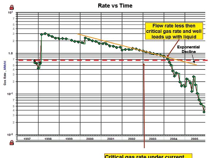
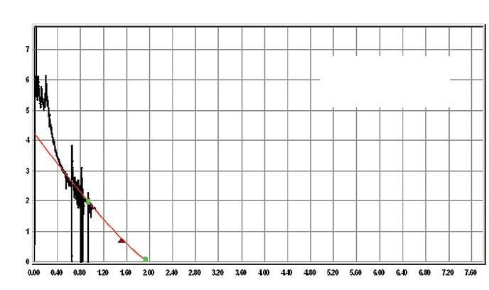
The rate versus time plot is commonly used to diagnose well and reservoir performance. Figure 1 presents a gas well with an exponential “straight line” trend for much of its production life. But in 2004 the actual performance is considerably below the expected exponential decline rate, indicating a non-reservoir problem. Wellbore modelling suggests that under the current operating conditions, the well cannot produce liquids to surface below a critical gas rate of about 700 Mscfd, which is about the rate when well performance started deviating from the expected exponential decline. Water vapour is probably condensing in the wellbore and impeding production from the well. Removing the water would restore the well’s production rate to the exponential trend.
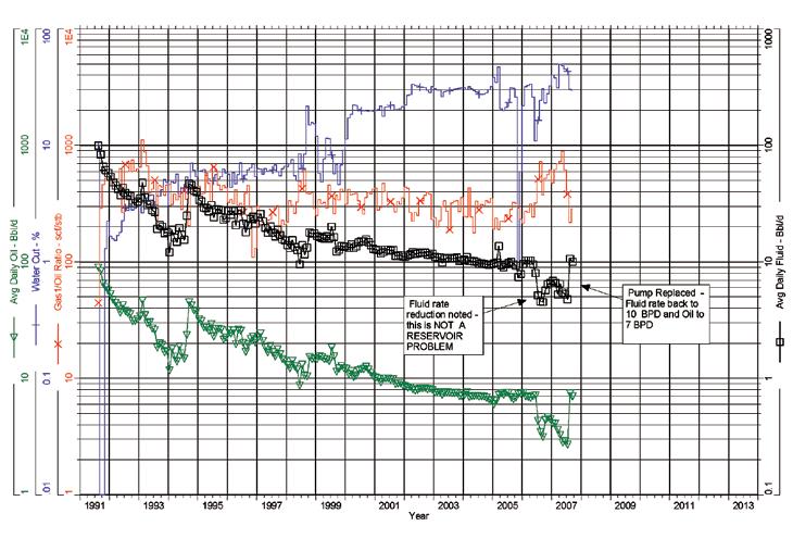
Figure 2 is an example of a pumping oil well that encountered a pump problem. A rapid decline in production rate to below the exponential decline rate cannot be a reservoir issue and must therefore be due to equipment failure and/or near wellbore issues such as wax plugging or solids deposition in the perforations. In this case, the pump was replaced and the fluid rate returned to the value expected for exponential decline.
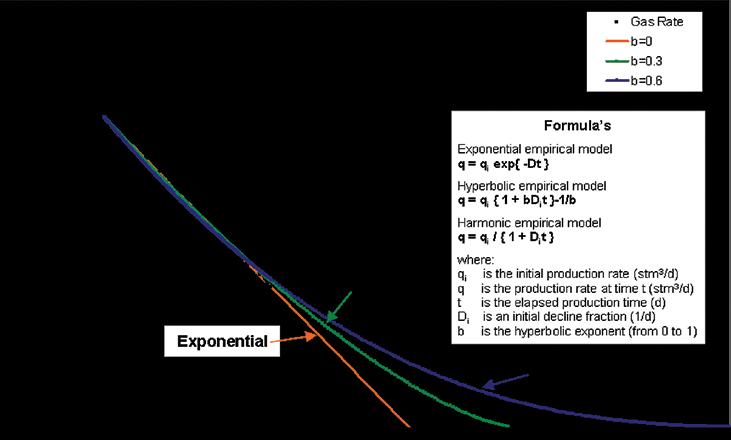
Arps (1945, 1956) developed the initial series of decline curve equations to model well performance. The equations were initially considered as empirical and were classified
as exponential, hyperbolic, or harmonic, depending on the value of the exponent ‘b’ that characterizes the change in production decline rate with the rate of production (see Figure 3 and equations at the end of the article). For exponential decline ‘b’=0; for hyperbolic ‘b’ is generally between 0 and 1. Harmonic decline is a special case of hyperbolic decline where ‘b’=1.
The decline curve equations assume that reservoir rock and fluid properties (porosity, permeability, formation volume factor, viscosity, and saturation) governing the flow rate will not change with time or pressure. While the assumption is not entirely correct, industry experience has proven that decline curves present a practical way to forecast well production in all but the most unusual circumstances.
Figure 3 illustrates the difference between exponential, hyperbolic, and harmonic decline when production rate vs. cumulative production is plotted on Cartesian scales. The “straight” orange line extrapolates an exponential decline from the data. The green and blue lines present hyperbolic extrapolations of the data trend with ‘b’ values of 0.3 and 0.6, respectively. Note that the curvature of the line increases as the ‘b’ value increases.
Figure 3 also illustrates the main challenges in decline analysis – data scatter and the type of extrapolation that is appropriate for the well under consideration. Data scatter is an unavoidable consequence of dealing with real data. In Western Canada, the permanent record of production and injection consists of monthly totals for
gas, oil, and water production; operated hours; and wellhead pressure. For oil wells at least, monthly production at the battery is routinely pro-rated back to the individual wells, based on sequential 1-2 days tests of individual well capability. Depending on the number of wells and test capability at each battery, it can take up to several months to obtain a test on each well in the group.
Factors that determine the rate of decline and whether declines are exponential, hyperbolic, or harmonic include rock and fluid properties, reservoir geometry, drive mechanisms, completion techniques, operating practices, and wellbore type. These factors must be understood prior to analyzing the production decline trends or serious errors in the ultimate production estimates can result (see Figure 4).
As stated previously, oil and gas wells producing conventional (>10 md) permeability reservoirs under primary depletion (or fluid expansion) generally exhibit exponential decline trends. But the performance of some waterfloods and unconventional low permeability gas reservoirs are better modeled using hyperbolic decline trends.
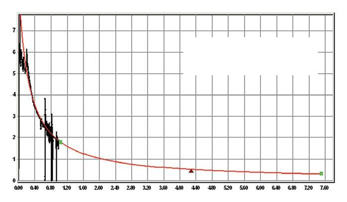
Figure 4 presents an example of well production from a “tight” gas reservoir. These reservoirs are becoming increasingly important to the industry but they typically have permeability below 0.1 md and are generally not productive without some form of mechanical fracture stimulation. From Fig 4A, a slightly hyperbolic (approximately exponential) extrapolation of the most recent production data yields an ultimate recovery of approximately 1.8 BCF. But the hyperbolic decline trend of Figure 4b provides a good fit for the complete production history and indicates an ultimate recovery of 7.6 BCF.
The typical range of ‘b’ values is approximately 0.3 to 0.8. A ‘b’ value of 2 represents an upper limit to the volume of gas that will ultimately be produced. The uncertainty in the trend that should be used to forecast well performance can be reflected in the assigned reserves as follows:
• Proven
• Proven plus Probable plus Possible 7.6 BCF
Based on the reserve definitions, the assignment suggests there is a 95% chance that the actual volume recovered will be greater than 1.8 BCF and less than 7.6 BCF. An estimate for the proven plus probable volume can be developed by integrating the well pressure history and material balance gas-in-place (OGIP) estimate with the decline analysis trend.
(Continued on page 22...)
Figure 3. Production history rate versus cumulative production with associated decline formulas.
Figure 2. Pumping oil well where pump capability is decreasing.
Canadian Institute of Mining, Metallurgy and Petroleum, Determination of Oil and Gas Reserves, Petroleum Society Monograph Number 1, Chapter 18, 1994 and 2004.
Canadian Oil and Gas Evaluation Handbook, First Edition, November 1, 2005, Volume 2, Detailed Guidelines for Estimation and Classification of Oil and Gas Resources and Reserves. Section 6: Procedures for Estimation and Classification of Reserves, 2005.
Stotts, W.J., Anderson, David M. and Mattar, Louis: “Evaluating and Developing Tight Gas Reserves – Best Practices”, SPE paper # 108183 presented at the 2007 SPE Rocky Mountain Oil and Gas Technology Symposium, Denver, CO, USA, 16-18 April, 2007.
FORMULAS:
The Exponential decline equation is: q = qi exp{ -Dt }
where:
q is the initial production rate (stm3 /d), q is the production rate at time t (stm3 /d), t is the elapsed production time (d), D is an exponent or decline fraction (1/d).
Solving for D and t gives:
D = - ln { q/qi } / t and t = - ln { q/qi } / D
The cumulative production to time t (Np) is given by:
Np = q dt = q exp{ -Dt } dt = (qi - q) / D
The Hyperbolic decline equation is: q = qi { 1 + bDi t } -1/b
where:
q is the initial production rate (stm3 /d), q is the production rate at time t (stm3 /d), t is the elapsed production time (d),
Di is an initial decline fraction (1/d), b is the hyperbolic exponent (from 0 to 1).
Solving for Di and t gives:
Di = [ (qi /q) b - 1 ] / bt and t = [ (qi /q) b - 1 ] /Di b
The cumulative production to time t (Np) is given by:
q i is the initial production rate (stm3 /d), q is the production rate at time t (stm3 /d), t is the elapsed production time (d), Di is an initial decline fraction (1/d).
Solving for Di and t gives:
Di = [ (qi/q) - 1 ] / t and t = [ (qi /q) -1 ] / Di
The cumulative production to time t (Np) is given by: Np = q dt = qi { 1 + Di t } -1 dt = { qi / Di ] } ln { qi /q }
Look for our next article on “Material Balance” in the February issue of the Reservoir.
This article was contributed by Fekete Associates, Inc. For more information, contact Lisa Dean at Fekete Associates, Inc.
ERRATA
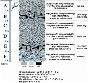
In last month’s installment of Fekete’s Reservoir Engineering For Geologists, Part 3 - Volumetric Estimation, the source reference for Figure 4 was inadvertently missed. The figure caption should have read, “Figure 4. Gross and Net Pay Distinction (Etris and Stewart, 2003). The source reference is: Etris, Ned, and Stewart, Bruce, 2003. Net-to-Gross Ratio. CSPG Reservoir, Vol. 30, Issue 4, pp. 24-25.
Figure 4. Tight gas well example illustrating minimum and maximum values for EUR depending on decline methodology.
JacK Porter VIGNETTES OF CANADIAN PETROLEUM GEOLOGY
J.B. Tyrrell’s introduction to the interior of Canada’s Precambrian Shield
(...Continued from the October, 2007 issue of the Reservoir)
The last week of Joseph Tyrrell’s summer survey of 1892 was spent on a segment of the Churchill River. A few historic highlights, relative to the events of Europeans, who were among the earliest to leave their mark on this great river, are worthy of mention.
The first European to have observed and reported the existence of what we now refer to as the Churchill River was the Danish explorer, Jens Munk. On May 9, 1619 he embarked from Copenhagen with two ships under his command – the frigate Unicorn, on which he traveled, and the sloop Lamprey, a much smaller, single-mast vessel (1965, Hansen, Thorkild: The Way To Hudson Bay, The Life and Times of Jens Munk; pub. A Helen and Kurt Wolff Book; Harcourt, Brace & World, Inc., New York, p. 218). Their combined crew consisted of 65 seamen, which included two Englishmen, William Gordon and John Watson, both having served as mates on the two ships (Ibid.: p. 228).
At the behest of King Christian IV of Denmark and Norway, Jens Munk was selected to cross the North Atlantic and enter Hudson Strait to access Hudson Bay and explore its west coast. Munk’s objective was to discover the conceptualized Anian Strait, later to be construed as the Northwest Passage. This would lead his expedition to the Southern Sea (Pacific Ocean), from where he could reach Cathay (Ibid.: p. 203).
On September 7, 1619, after 122 days at sea, while sailing up Hudson Bay’s west coast; Jens Munk fortuitously found safe shelter for his Unicorn and crew, after dropping anchor in the estuary of a river, which the Hudson’s Bay Company was to later name Churchill River (Ibid.: p. 246). Both vessels had been plagued by early winter snowstorms, pack ice and fog at the entrance to Hudson
Strait. This inclement weather pursued the two vessels during their crossing of Hudson Bay. For two nights following the Unicorn’s arrival in the estuary, an improvised beacon for the Lamprey was created by a very large bonfire on top of a headland. The Unicorn piloted the Lamprey into the inlet where she was later winched across the tidal flat and secured on the sheltered side of a rock promontory (Ibid.: pp. 246,247 and 250).
The scourge of scurvy was beginning to affect crew members of the Lamprey, however, Jens Munk recognized its symptoms. Aware that the disease could be remedied by ingesting fresh fruit and vegetables, he instructed the ship’s surgeon that his patients be fed local berries, including cloudberries (wild raspberries), cowberries (rose hips), crowberries (large cranberries), and gooseberries. The seamen shortly regained their health.
On September 18, 1619, Jens Munk met with his ships’ officers to discuss the expedition’s strategy. Because of the impending winter, all were unanimous in agreeing to winter at their present site (Ibid.: p.248). He christened their refuge Munk Haven and the country Nova Dania. The river (Churchill), associated with the estuary of their encampment, was named Danish River by Munk, later to be construed as Munk River (Ibid.: p. 295).
One of the 65 members of Munk’s expedition, a boatswain, had died on August 6, 1619 while the two vessels were icebound at Haresund (Hares’ Sound) – its location being on the southwest peninsula of Baffin Island, flanking the entrance to Hudson Strait. The seaman had been buried alongside of a cairn erected by Jens Munk to acknowledge Norway’s and Denmark’s claim to the country (Ibid.: pp. 237, 238). Unknowingly, Munk had laid claim to Martin Frobisher’s Meta Incognita (the unknown limits), a name given to the same peninsula by Queen Elizabeth I following Frobisher’s return to England from his second voyage to his “Frobishers Streytes” (Bay) in 1577.
The incident of incipient scurvy among the crew of the Lamprey, during the late summer and early fall of 1619, was to portend the dire ravages of this disease would inflict on the 64 seamen sequestered at Munk Haven during the ensuing winter and spring of 1620. The ship’s fare of the period, consisting of biscuit, salt pork, oatmeal, rice, cheese, vinegar, and honey – despite being rationed – was adequate,
but essentially devoid of vitamin C. Beer was the standard beverage until it turned sour.
The first fatality of scurvy occurred on November 21, 1619, its victim being a boatswain from the frigate, Unicorn. From the aforementioned date to June 4, 1620, 61 crewmen succumbed to scurvy. Three, including Jens Munk, remained alive. The last seaman to be buried was on May 12 and the remaining emaciated men were too weak to continue the task (Ibid.: 258, 277, and 278).
On June 10, Jens Munk left his cabin, not being able to bear the stench of putrefied bodies to sleep on the deck of the Unicorn
The next morning he was observed by two of his crew who had sought refuge on shore. They, equally wasted, crossed the ice-covered inlet and assisted him from the Unicorn to their improvised camp. The disappearance onshore of the winter’s snow had exposed the preserved remnants of fruit-bearing shrubs. Grubbing with their shriveled hands, they were able to salvage bilberries (a variety of blueberry) and cowberries (rose hips), as well as their leafy parts and roots, all of which they sucked on and slowly devoured. Apart from sleeping, the three pathetic figures continued this daily routine until June 18, 1620, when the ice covered estuary broke up. With renewed strength, they retrieved a flounder net from the Unicorn and netted six sea trout. The spring high tide had arrived, which enabled the three to refloat the Lamprey. With provisions and equipment transferred from the Unicorn, they eagerly set sail from Munk Haven’s estuary on July 16, 1620. After 68 days at sea, Jens Munk and his two fellow survivors set foot on land near Bergen, Norway on September 21, 1620 (Ibid.: pp. 289, 290, 294, and 208).
The treaty of Utrecht in1713 resulted in France ceding to England her former Hudson’s Bay Company’s Rupert’s Land possession as well as Newfoundland and Nova Scotia, but retaining Quebec and Louisiana. The formal transfer of France’s Fort Bourbon, to be reinstated as the Hudson’ Bay Company’s York Fort, took place on September 11, 1714. The principal participants involved in the surrender were the post’s French commander, Governor Nicolas Jeremie and the newly appointed Hudson’s Bay overseas governor, James Knight; the latter accompanied by his deputy, Henry Kelsey. Both Knight and Kelsey, in the company of the French
commissioner, J. B. Cullerer, had embarked together from the frigate Union, which had arrived at the mouth of the Hayes River on September 5, 1714 (Ibid.: 1939, Morton, Arthur S. --- p. 127).
James Knight, now approximately seventy years of age, had spent 38 years in the service of the Company, having risen from shipwright in 1676 to his appointment in 1713, as governor-in-chief of the posts in Hudson Bay. Initially, he set about restoring the fort to its former condition. He immediately recruited Cree natives to journey to the northern habitats of the Chipewyan natives as peace envoys, in order for these remote natives to trade at York Fort with impunity. The aggressive Cree, who served as middlemen, were the tormentors of the Chipewyan, having driven the latter out of their traditional hunting environs of the wooded Churchill River valley to the Barren Grounds.
Exaggerated reports, by natives visiting York Fort, extolling the abundance of native copper, hosted as placer deposits, in sands of the “copper river” and “yellow metal” ornaments worn by natives living along the borders of the western sea; so fueled James Knight’s imagination that he craved to search for their occurrences.
In June 1715, Cree natives, who visited York Fort, were met in council with Governor Knight. The native delegation told him: “of another sea (Lake Athabasca) which ran down into it; they showed him salt and brimstone from the region.” One of the delegates, a Cree chief known as The Swan, had been on a mission of peace, which was negotiated with the Beaver natives who inhabited the valley of the Athabasca River. In June, 1719, following an absence of four years, The Swan returned to York Fort, where Henry Kelsey was now governor, and presented him with a sample of; “ that Gum or pitch that flows out of the Banks of that River,” ( Ibid.: 1939, Morton, Arthur S. --- p. 134).
Governor James Knight had sent an emissary, William Stewart from York Fort in June 1715 to arrange a council of peace with the Chipewyan natives. Accompany him were a ban of Cree as well as a “Slave Woman”. Knight had purchased this Chipewyan woman from a Cree native who had brought her to York Fort. She was to be the fort’s first interpreter. Stewart’s party, after journeying 700 miles northwest of York Fort, diagonally crossed the “Baren Desarts” to the wooded area south of Great Slave Lake. The “Slave Woman” was able to entice ten of her countrymen to
return to York Fort, where they would be taught to speak the Cree language. Stewart’s party arrived back at York Fort on May 7, 1716 after nearly a year’s absence. The peace was to be short lived. By 1717, the troublesome Cree natives had resumed their attacks on the Chipewyans.
In an effort to prevent further hostilities, Governor Knight decided to establish a trading post at the mouth of the Churchill River, which would allow the Chipewyan natives to transport their furs from the Athabasca and Slave River regions with impunity. It offered, as well, a shorter travel
time. On July 10, 1717 he left Henry Kelsey in charge of York Fort and sailed north in the sloop, Good Success , accompanied with her sister sloop, Prosperous. On July 14 the two vessels arrived in the estuary of the Churchill River. After James Knight examined several potential sites for the erection of the fort he, ironically, was compelled to select Munk’s Point, the very location of Jens Munk’s Munk Haven where 97 years earlier 61 seamen suffered horrific deaths from scurvy, prolonged in a formidable and desolate environment. It was located four miles within the estuary, above a broad mud
(Continued on page 26...)
and stone tidal flat, on the estuary’s north bank (Ibid.: 1939, Morton, Arthur S. --- pp. 137, 138). James Knight initial examination of the site confirms his frustration, to quote “I never see such a miserable place in my life…Were they (London Committee) but here to see the Sculls & bones of Men as Lyes Scatter’d…it would put them into a feavor to think how they should Secure Themselves.” (1936, MacKay, Douglas: The Honourable Company, pub. McClelland & Stewart; Toronto, p. 72).
Notwithstanding Knight’s questionable endorsement of his proposed site, trading there commenced in 1719. At that time it was named Prince of Wales Fort and became The Company’s first permanent post located in the estuary of the Churchill River. It was abandoned in 1740, with its trading facilities transferred that same year to the massive stone fort located on Eskimo Point at the entrance to the harbour. Construction of the new Prince of Wales Fort (Fort Churchill) had started in 1731 to prevent attacks by the French. It was completed in 1771, only to be easily captured by La Perouse in August, 1782, with the surrender of Governor Samuel
Hearne and his 39 Englishmen. La Perouse forces were comprised of 300 marines and three ships. The buildings were ransacked, burned, and the canons spiked. His attempt to obliterate the formidable walls met with failure.
James Knight’s unabated gold fever to confirm the Chipewyans’ purported stories of copper and gold occurrences, lying northwest of his recently established Prince of Wales Fort, took him to England in 1718. His contract with the Hudson’s Bay Company, after some 40 years of service, had now expired and he was free to pursue his aspiration.
On March 20, 1719 he submitted a proposal to the London Committee that he would sail up the west coast of Hudson Bay to “…find out the Streight of Anian in order to discover gold, and other valuable commodities to the northward.” (Ibid: 1939, Morton, Arthur S. --- p. 142). He claimed “From these Indians (Chipewyans) he learned the source of the copper he saw among them and he concluded that, if the mine from which it came lay by a river flowing into the sea, then that mine should be capable of being reached by the sea.” (Letters From Hudson Bay 1703 — 1740:
The Hudson Bay Record Society; ed. K. G. Davies, pub. 1965, p; LVI).
Knight’s proposed voyage through the “Streight of Anian” to reach the mines was enthusiastically received and approved by the Committee on May 1,’1719. He was assigned the frigate, Albany, on which he shipped and the sloop, Discovery ; each with their respective captains, being George Berley and David Vaughan. The Governor and his Committee saw the two vessels embark from Gravesend on June 4, 1719. Tragically, none of the 27 seamen and officers aboard the two ships, including James Knight, their commander, was ever again seen alive (Ibid.: 1939, Morton, Arthur S. --- p. 142).
• 3D Merging
• PSTM with Common
Hart Janssen
B.Sc., Manager, Seismic Processing
Direct: 403-260-3372 Main: 403-237-7711
www.sensorgeo.com • Time Lapse (4D) Processing • 4D Cross Equalization • Multicomponent (3C, 4C) Processing
Some 48 years had elapsed from the time James Knight’s copper- and gold-finding expedition had embarked from Gravesend before the enigma surrounding their disappearance was resolved. Their final landfall occurred in the autumn of 1719 when the Albany and Discovery sought shelter from the pack ice by entering a harbour on the easternmost end of Marble Island. This small barren island lies 16 miles off Rankin Inlet’s coast, nearly 300 miles north of Prince of Wales Fort. The waters surrounding the island were a favorite habitat for black whales, which in 1767 were sought after by Hudson’s Bay Company’s whalers. The same year Joseph Stephens, captain of the whaler, Success, who, apart from Inuit, had entered a heretofore unoccupied harbour on Marble Island. The hulls of the Albany and Discovery were found beneath 30 feet of water, both having been crushed by pack ice while entering the harbour. When Samuel Hearne visited the site two years after Stephens, he was informed by an elderly Inuit that not only had his people traded with the white strangers trapped on the island but later, in their state of privation, had provided them with blubber and seal meat. The Inuit, on visiting Marble Island in the summer of 1721, found only five members of James Knight’s expedition alive. In the fall two remained, after burying their three companions. The two seamen resorted to sitting on a high ridge, emaciated and forlorn, while gazing south, in hope of being rescued by a passing ship. Following the death of one of the pair; the other died while attempting to bury his partner. (1899, Willson, Beckless: The Great Company; pub. The Copp, Clark Company Limited; Toronto, pp. 291 - 294). Privation and resultant starvation was the obvious cause of the deaths of the 27 seamen of James Knight’s doomed expedition, but scurvy may have been a contributing factor.
To be continued…
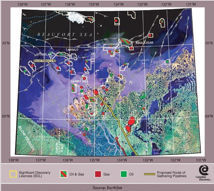
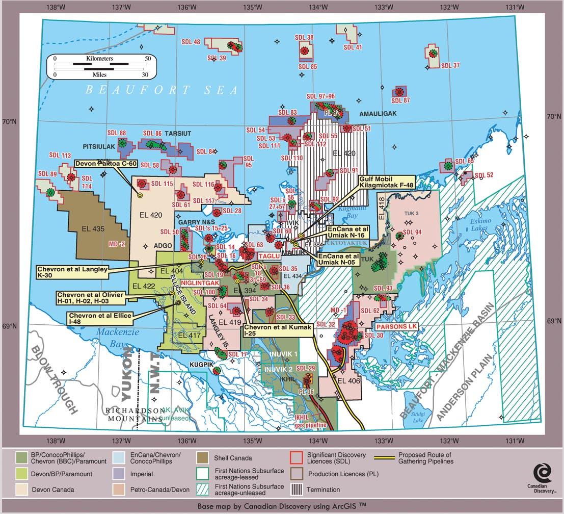
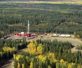
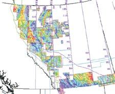
M ACKENz IE DELTA /BEAUFORT SEA , NWT
| by Canadian Discovery Ltd.
This article is reprinted with permission from Canadian Discovery’s CEO map series (Fall/ Winter 2006 Northern Canada Onshore & Offshore Regions). For information on products offered by CDL, please visit www. canadiandiscovery.com or call 269-3644.
DEVON A PPLIES FOR SIGNIFICANT DISCOVERY AT PAKTOA
During the winter of 2005/2006, all eyes were on Devon ARL’s drilling at Paktoa C60. That well was spudded in approximately 13 m of water in the eastern portion of EL 420 (see Table 1, page 29) and was the first well drilled in the Canadian Beaufort Sea in over 15 years. The 2,390 m exploratory well was begun December 5, 2005 and rig released on March 19, 2006 after having reached a final depth of 2,383 m. Under the original work commitment, four wells have to be drilled on EL 420 by August 2009. Completed on time and on budget, the C-60 well did encounter hydrocarbons (oil and gas), but not the gas volumes expected. In addition to not having found the reserves it was hoping for at Paktoa, the company could not secure the equipment necessary to drill a second Beaufort well in 2006/2007. In order to obtain permission from the federal government to postpone the second well normally required under its licence, the eastern portion of EL 420 (174,048 ha) was relinquished so that now the EL is reduced by half. Devon is also paying an additional $1 million deposit. In the longer term, the company said that it has no intention of pulling out of the Canadian Arctic. Devon has indicated that it is filing for a significant discovery licence (SDL) based on the C-60 result and is open to acquiring partners in its future Beaufort operations.
In northern Canada, the Federal Permit System (FPS) is a land grid used to locate and identify, among other spatial elements, oil and gas land licences and wells, and is based in part on the Canadian National Topographic System (NTS), i.e., latitude/longitude (Figure 1). In essence, major grid “squares” (which are generally not square and vary is shape and size depending on latitude) are made up of a number of sections (the number of which varies depending on latitude). In turn, each section is divided into 16 units. Table 2 (page 29) summarizes this information.
SIGNIFICANT DISCOVERY GRANTED FOR U MIAK
EnCana and partners Anadarko (now Chevron) and ConocoPhillips, which drilled
successful Umiak N-05 during 1Q 2005, applied for a SDL on December 19 2005 (see Table 3, page 30), on the basis of successful test results in that well. The results for the 3,625 m well are still confidential (a two-year confidentiality period applies to exploration wells in the NWT). That new oil and gas SDL comprises 16 sections (see explanation above) or 4,865 ha, and was granted on April 5, 2006 by the National Energy Board (NEB). An identification number for the new SDL has yet to be published by the NEB. Already-highgraded 53,961 ha Exploration Licence (EL) 384 issued in January 1997 expired in January 2006 (see Figure 2, page 28). The new SDL includes not only discovery Umiak N-05, but also adjacent Umiak N-16, drilled less than 3 km to the northwest, and the extensively tested but abandoned Kilagmiotak F-48. Umiak N-16 was drilled to 3,101 m (original licence 3,364 m) in February/March 2004, and re-entered for testing the following season. EnCana has reported that the well has encountered hydrocarbons, but as yet no additional information is available. The partners were likely encouraged enough by the N-16 results to drill N-05 during the winter of 2004/2005. Kilagmiotak F-48,
drilled in 1972, has much more information available and may offer a clue as to targets of EnCana and partners’ recent drilling. That vertical well was drilled by Gulf Canada (now ConocoPhillips Canada) and partner Mobil Oil (now ExxonMobil Canada) and ran a number of tests (including cased hole). The 4,772 m Tertiary test, which is situated about 9 km north of the N-05 discovery, penetrated clastic sequences down to and including the Paleocene-Eocene Reindeer Formation. All tests were conducted in that last reservoir interval below 2,960 m, where, at best, some gas-cut water and very small gas volumes were tested. Hannigan et al. (GSC Open File 5343, 2006) briefly describe the established Tertiary reservoirs section of the Beaufort-Mackenzie Basin, summarized in Table 4, page 30.
This latest SDL joins myriad other oil and gas SDLs (over 50, see Figure 2, page 28) in the Beaufort Sea and Mackenzie Delta, awaiting the advent of an economical exploitation system.
EL 434, 56,605 ha in area and immediately south of the new SDL, was awarded to (Continued on page 28...)
the EnCana/Anadarko/ConocoPhillips consortium on May 2, 2006, and interestingly is made up of a portion of now-expired EL 385 (January 2006) and a portion of the previously amputated EL 384. At the end of 2006, EL 434 represents the only exploration licence owned by the consortium now made up of EnCana/Chevron/ConocoPhilips.
A NADARKO SELLS C ANADIAN
NORTHERN A SSETS TO C HEVRON
In order to refocus its portfolio and reduce debt following the August 2006 acquisition of Kerr-McGee and Western Gas Resources (for US$22.5 billion, including cash plus debt), Anadarko sold its western Canadian assets to Canadian Natural Resources and under a separate deal divested its Canadian
arctic frontier interest to Chevron USA and Chevron Canada. In essence, that deal is an asset swap whereby Anadarko’s Mackenzie Delta, Beaufort Sea, and Yukon assets are exchanged for working interest in Gulf of Mexico deep water blocks and enhanced terms in a west Texas exploration joint agreement. Chevron is already a major player in the Beaufort Sea/Mackenzie Delta region, in partnership with other companies (see Figure 2).
In early October, partners Chevron and BP announced a plan to drill two wells in the Delta region. On January 17, well Chevron et al Kumak I-25 was authorized on the Delta by the NEB. That 2,000 m exploratory well was scheduled to spud February 1 and is located on EL 394,
offsetting Tertiary oil and gas discoveries made by Shell in 1974/1975 (SDLs 18, 31 and 59). The companies are 50:50 partners in three ELs at the western edge of the Delta totaling almost 150,000 ha. Chevron and BP are also in partnership, with ConocoPhillips, in adjacent EL 394 (73,155 ha). One well would be drilled at the north end of Langley Island, likely on EL 404 near the Ellice I-48 discovery (34 mmcf/d) and the three multilateral Olivier H-01 discoveries, all drilled to the Paleocene-Eocene Aklak Member of the Reindeer Formation during the 2004/2005 season by the Chevron/BP partnership. The partnership is preparing a Significant Discovery application for Ellice and Olivier, and has submitted an application for the Langley K-30 discovery drilled during 1Q/2Q 2003. The second 2006/2207 well is planned
for Camp Farewell, on EL 394, offsetting a number of oil and gas discoveries. As of December 15, no record of drilling licence application (and precise location) had been published by the NEB.
N EW K ID ON THE E XPLORATION BLOCK
In the Spring of 2006, the Chevron/BP partnership had revealed plans to “farm down” their 405,000 ha into four exploration licences. On October 19, shortly after Chevron and BP had made public drilling plans for the upcoming winter (see above),
Paramount Resources announced that it had concluded an area-wide farm-in agreement with the two partners in the Mackenzie Delta. The deal involves EL 394, EL 247 (a.k.a. ELs 404, 417, and 422), and Inuvik Concession
Blocks 1 and 2. In brief, Paramount becomes operator (after this winter’s drilling season, with Chevron as operator) and can earn a 50% interest by drilling 11 wells and shooting
a specified amount of 3D seismic over a period of four years. Upon satisfying these drilling commitments in full, Paramount will also earn a 50% interest in nearby Delta discoveries at Langley K-30, Olivier H-01 and Ellice I-48 (Paramount News Release, October 19). The company also announced in the same release the creation of a new public corporation, temporally called “Newco”, to manage Paramount’s future activities in the Mackenzie Delta and Colville Lake. It was announced later on January 5, 2007, that the new corporation will be called MGM Energy and have as President Henry Sykes, previously President of ConocoPhillips Canada.
E NC ANA GETTING OUT OF NORTHERN C ANADA
At the end of September 2006, EnCana announced that it was seeking proposals for its northern Canada assets located in the Mackenzie Delta/Beaufort Sea and the Arctic Islands. In the Mackenzie Delta/Beaufort Sea, these assets include EnCana-operated EL 434 and the new Umiak SDL, where the company has a 37.5% working interest, plus non-operated interests in 14 SDLs located mostly offshore and nearshore. In the Arctic Islands, the company holds various interests in 19 SDLs (including the major Drake Point and Hecla gas discoveries) plus one Production Licence (PL) for oil at Bent Horn, totaling over 600 bcfe net to EnCana. In November 2006, “divestiture activities” were underway for these northern assets, with CIBC World Markets acting as financial advisor and a data room opened in late October, 2006. EnCana expected the sale to close by “the end of 2006.”
O THER M ATTERS: C ALL FOR NOMINATIONS , SEISMIC
A Call for Nominations had been issued by INAC for 2007 in the Beaufort Sea/ Mackenzie Delta region, with a closing date of February 28. (in 2005, the Call for Nominations closed November 29 and was followed by a successful Call for bids in May 2006).
During the summer of 2006 the NEB approved 5,069 km of Beaufort 2D seismic acquisition by Gx Technology Canada. A total of 3,535 km of these data were shot between September 4 and October 5, 2006. It is not clear precisely where this seismic survey was acquired.
SDL 14+15 Chevron Garry
SDL 16 Chevron Niglinkgak
SDL 17 Shell Kugpik
SDL 18 Shell Kumak
SDL 19 Shell Niglinkgak
SDL 25+26
SDL 27
SDL 28
Nytis Exploration Garry
Nytis Exploration Ivik
Nytis Exploration Pelly
SDL 29 Altagas Marketing Ikhil
SDL 30 ConocoPhillips Kamik
SDL 31 Shell Kumak
SDL 32 ConocoPhillips Parsons
SDL 33 Shell Reindeer
SDL 34 Shell Titalik
SDL 35+36 Shell Ya Ya North
SDL 37 BP Havik
SDL 38 BP Koakoak
SDL 39 BP Kopanoar
SDL 40 BP Nektoralik
SDL 41 BP Nerlerk
SDL 47 BP Kenalooak
SDL 48 BP Kopanoar
SDL 49 BP Nektoralik
SDL 50 Imperial Adgo
SDL 51
SDL 52
SDL 53+54
Imperial Amerk
Imperial Atkinson Point
Imperial Isserk
SDL 55 Imperial Itiyok
SDL 56+57
Imperial Ivik
SDL 58 Imperial Kadluk
SDL 59
SDL 60
Imperial Kumak
Imperial Mallik
SDL 61 Imperial Netserk
SDL 62
SDL 63
SDL 64
SDL 65
Imperial Parsons
Imperial Taglu
Imperial Titalik
Imperial W. Atkinson
SDL 83 ConocoPhillips Issungnak
SDL 84 ConocoPhillips Kiggavik
SDL 85 ConocoPhillips Koakoak
SDL 86 ConocoPhillips Tersiut
SDL 87 ConocoPhillips Ukalerk
SDL 88 ConocoPhillips Pitsiulak
SDL 89 BP Adlartok
SDL 91
Imperial Arnak
SDL 92 Imperial Hansen
SDL 93 Imperial Imnak
SDL 94 Imperial Mayogiak
SDL 95 Imperial Nipterk
SDL 96+97 ConocoPhillips Amauligak
SDL 100 Shell Unipkat
SDL 110-112
Imperial Isserk
SDL 113 BP Kingark
SDL 114 BP Kingark
SDL 115
SDL 116+117
Imperial Minuk
Imperial Nipterk
SDL ? EnCana Umiak
PL 06 Altagas Marketing Ikhi
Table 4. Tertiary Reservoirs of the Beaufort-Mackenzie Basin.
Alberta’s Professional Geoscientists and Engineers provide Albertans with many of the essentials of daily living. The work that they do allows all of us to enjoy warmth, light, power, water and the ability to travel and communicate over distance.
Since 1920, Members of APEGGA, The Association of Professional Engineers, Geologists and Geophysicists of Alberta, have made a difference in the daily lives of millions of Albertans by bringing science and innovation to life.
The P.Geol., P.Geoph., P.Eng., and R.P.T. professional designations represent the highest standards of quality, professionalism and ethics in geoscience and engineering. APEGGA Members can take pride in the role they play and the contribution they make to Alberta. APEGGA and its over 47,000 Members are committed to public safety and wellbeing through the self-regulation of the geoscience and engineering professions in Alberta.
Visit www.apegga.org for more information.
Geologists Geophysicists Engineers
A PETROLEUM EVENTS CHART for the Whitehorse Trough, Yukon
| by G. W. Lowey
INTRODUCTION
Whitehorse Trough is the northernmost of four ‘Interior Cordilleran’ basins in northwestern Canada (i.e., from north to south, Whitehorse, Bowser, Nechako, and Quesnel basins, Figure 1) that exhibit similar patterns of sedimentary history and tectonic evolution, and have corresponding oil and gas potential (Teitz and Young, 1982). It forms a northward tapering belt (approximately 70 km wide and 600 km long) of Mesozoic volcanic and sedimentary rocks in south-central Yukon that is interpreted to have originated in Middle to Late Triassic time as a forearc basin, with the ancient North American margin on the east and the volcano-plutonic Lewes River arc on the west (Tempelman-Kluit, 1976; Bultman, 1979).
Petroleum exploration of the Whitehorse Trough began in the 1950s when Swartzman (1953) determined that the thermal maturation of coal samples from the basin was relatively low, implying that the
‘oil window’ had not been reached. This triggered a land rush in south-central Yukon that culminated in 1969-70 when various oil companies leased approximately 0.6 million hectares (1.5 million acres) of land within the basin. In 1970, Geoservices discovered dry gas in rock samples from the Whitehorse Trough, and Koch (1973) estimated that between 25 to 116 billion cubic metres (0.9 to 4.1 trillion cubic feet) of gas and possibly some oil may occur within the basin. Petro-Canada eventually sent a field party to the Whitehorse Trough, identifying potential source rocks, reservoirs, and seals, and suggested that the basin has fairly good prospects for gas and less so for oil (Gilmore, 1985; Gunther, 1986). Hannigan et al. (1995) and The National Energy Board (2001) subsequently undertook a detailed assessment of the hydrocarbon potential of the Whitehorse Trough. The National Energy Board (2001) identified several conceptual stratigraphic and structural gas and oil plays and concluded that the Whitehorse Trough is an immature, mainly gas-prone basin
containing a mean marketable natural gas estimate of 5,521x106m3 (196 Bcf) and a mean recoverable oil estimate of 1.29x10⁶m3 (8.12 MMBbl).
Although no wells have been drilled for gas or oil in the Whitehorse Trough, renewed interest in the hydrocarbon potential of this frontier basin is based on: 1) its similarity with the other Interior Cordilleran basins, all of which are known to contain gas and/or oil; 2) reported occurrences of oil shale, gas odors, and oil seeps; 3) the presence of coal; 4) favorable structure traps identified by a recent seismic survey; and 5) the proposed Alaska Highway pipeline. As a result, the Geological Survey of Yukon has undertaken a multi-disciplinary study of Whitehorse Trough to reassess the hydrocarbon potential of the basin (Long, 2005; Lowey, 2004, 2005; Lowey and Long, 2006; Piercey, 2005; White et al., 2006). Preliminary results of this study are presented herein as a petroleum ‘events chart’ (Figure 2), which shows the chronology of the four essential elements (i.e., source rock, reservoir rock, seal rock, and overburden rock) and two processes (i.e., trap formation and generation-migration-accumulation) of a petroleum system (Magoon and Dow, 1994). The events chart also shows the major rock units of the basin, and the critical moment best depicting that point in time for the generation-migration-accumulation of any potential hydrocarbons.
ROCK UNITS
Three stratigraphic units, termed the Lewes River Group, the Laberge Group, and the Tantalus Formation, are recognized in the Whitehorse Trough (Wheeler, 1961). The Lewes River Group (Upper Triassic-Lower Jurassic) is approximately 3,500 m thick and is informally subdivided into the lowermost Povoas Formation and the uppermost Askala Formation (which is informally subdivided into the Casca, Hancock and Mandanna members). The Povoas Formation consists of basalt flows and volcaniclastics, where as the Aksala Formation consists of deep-marine clastics and carbonates, reefal clastics, and shoreface to tidal flat deposits (TempelmanKluit, 1975, 1978, 1980, 1984). The Lewes River Group is unconformably overlain by the Laberge Group (Lower-Middle Jurassic), which is approximately 3,500 m thick and is informally subdivided into three units that include the Richthofen, Nordenskiold,
Figure 1. Location map for the Whitehorse Trough and map showing the four Interior Cordilleran basins (modified from Teitz and Young, 1982).
and Tanglefoot formations. The Richthofen Formation consists of conglomeritic submarine fan deposits, the Nordenskiold Formation represents subaqueous volcaniclastics, and the Tanglefoot Formation consists of coal-bearing deltaic deposits (Cairnes, 1910; Bostock, 1936; Bostock and Lees, 1938; Tempelman-Kluit, 1984). The Laberge Group is conformably overlain by the Tantalus Formation (Upper JurassicLower Cretaceous), which is approximately 1,500 m thick and consists of coal-bearing fluvial clastics (Lowey and Hills, 1988).
SOURCE ROCK
Over 400 rock samples from these units have been analyzed by programmed pyrolysis and combustion, which – together with coal rank, vitrinite reflectance, and the color of microfossils – indicates several potential source rocks. In the Lewes River Group, the Povoas Formation has no source rock potential and the Aksala is a poor source rock, probably gas-prone and postmature. In the Laberge Group, the Richthofen Formation is a poor to fair source rock, gasprone, and postmature; the Nordenskiold Formation has no source rock potential; and the Tanglefoot Formation (Figure 3) is a good to very good source rock, mainly gasprone with a possibility of oil, and mature. The Tantalus Formation (Figure 4) is also a good to very good source rock, mainly gasprone with a possibility of oil, and mature. Petroleum fluid inclusions are present locally in the Tanglefoot and Tantalus formations.
The Aksala and Richthofen formations are interpreted as spent source rocks, whereas the Tanglefoot and Tantalus formations are interpreted as potential source rocks and
possibly effective source rocks. Note that both the Tanglefoot and Tantalus formations mainly occur in the northernmost part of Whitehorse Trough; subsequently this is the most prospective area for hydrocarbon exploration.
RESERVOIR ROCK
Potential reservoir rocks exposed at the surface were used to estimate subsurface reservoir quality (Tobin, 1997). All lithologies in the Lewes River Group exhibit tight depositional facies and are interpreted as a high risk for reservoir quality, although limestone in the Aksala Formation (i.e., Hancock Member) is locally fractured. Medium- to thick-bedded feldspathic sandstone in the Tanglefoot Formation ranges from porous with minimal weathering to exhibiting abundant secondary porosity of uncertain origin, and is interpreted as a low and moderate to high risk for reservoir quality. Massive to thick-bedded, lithic sandstone in the Tantalus Formation is tightly compacted, but porous and weathered, and is interpreted as a moderate to high risk for reservoir quality.
SEAL ROCK
Rocks lacking porosity and permeability occur throughout the Lewes River Group and include basalt and volcaniclastics in the (Continued on page 34...)
Figure 3. Potential source rocks of the Tanglefoot Formation (staff is 1.5 m in length).
Figure 2. A petroleum events chart for the Whitehorse Trough, Yukon (P=Povoas, C=Casca, M=Mandanna, H=Hancock, R=Richthofen, and N=Nordenskiold).
(...Continued from page 33)
Povoas Formation and interbedded sandstone and mudstone in the Aksala Formation. Interbedded conglomerate, sandstone, and mudstone beds in the Richthofen Formation represent potential regional seals, whereas mudstone beds in the Tanglefoot Formation are potential local seals. Massive conglomerate in the Tantalus Formation is a potential regional seal and mudstone beds are potential local seals. The overlying volcanic flows of the Carmacks Group and Mount Nansen Formation are also potential regional seals.
OVERURDEN ROCK
Overburden rock for the Tanglefoot Formation includes the Tantalus Formation (~1,500 m thick), Carmacks Group (~1,000 m thick), and Mount Nansen Formation (~500 m thick). The Carmacks Group and Mount Nansen Formation are also overburden rock for the Tantalus Formation.
TRAP FORMATION
Potential stratigraphic straps in the Lewes River Group include reefs in the Aksala Formation (i.e., Hancock Member). Potential
stratigraphic traps in the Laberge Group include unconformities and pinchouts in the Tanglefoot Formation. Unconformities and pinchouts may also be potential stratigraphic traps in the Tantalus Formation. Structural traps include anticlines and high-angle faults that probably formed in Middle Jurassic time (~170 mya) and affected all strata in the basin.
GENERATION-MIGRATIONACCUMULATION
The generation-migration-accumulation of potential hydrocarbons is difficult to estimate without adequate subsurface data and a proper burial history chart. However, burial of potential source rocks is thought to have started in Late Jurassic time (~150 mya).
PRESERVATION
The preservation, modification, or destruction of any possible hydrocarbons probably began in Early Cretaceous time (~140 mya) and may be continuing today.
CRITICAL MOMENT
The critical moment, or point in time that best depicts the generation-migration-
accumulation of possible hydrocarbons in the Whitehorse Trough is estimated to be Early Cretaceous time (~145 mya).
CONCLUSION
Whitehorse Trough is a frontier basin that may contain gas and possibly oil. Based on Rock-Eval analysis, vitrinite reflectance, and the color of microfossils, the Tanglefoot and Tantalus formations are interpreted as potential source rocks and possibly effective source rocks. Fractured limestone in the Aksala Formation and sandstone in the Tanglefoot and Tantalus formations are potential reservoir rocks, where as the Povoas Formation and mudstone in the Aksala, Richthofen, Tanglefoot, and Tantalus formations are potential seal rocks. Stratigraphic traps (reefs and pinchouts) and structural traps (northward-trending anticlines and high-angle faults) are present, with structural traps forming in Middle Jurassic time. The generation, migration, and accumulation of potential hydrocarbons may have begun in Late Jurassic time, with the northernmost part of Whitehorse Trough the most prospective area for hydrocarbon exploration.
Figure 4. Potential source rocks of the Tantalus Formation (staff is 1.5 m in length).
REFERENCES
Allen, T., 2000. An evaluation of coal-bearing strata at Division Mountain (115H/8 easthalf, 105E/5 west-half), south-central Yukon. In: Yukon Exploration and Geology 1999, D.S. Emond and L.H. Weston (eds.), Exploration and Geological Services Division, Yukon, Indian and Northern Affairs Canada, p. 177-198.
Bostock, H.S., and Lees, E.J., 1938. Laberge map-area, Yukon. Geological Survey of Canada, Memoir 217, 32p.
Bultman, T.R., 1979. Geology and tectonic history of the Whitehorse Trough west of Atlin, British Columbia. Unpublished Ph.D. thesis, Yale University, 284p.
Cairnes, D.D., 1910. Preliminary memoir on the Lewes and Nordenskiold rivers coal district, Yukon Territory. Geological Survey of Canada, Memoir 5, 70p.
Gilmore, R.G., 1985. Whitehorse field party. Unpublished report, Petro-Canada, 16p.
Gunther, P.R., 1986. Geochemical evaluation of Whitehorse field party samples. Unpublished report, Petro-Canada, 19p.
Hannigan, P., Lee, P.J., and Osadetz, K.G., 1995. Oil and gas resource potential of the BowserWhitehorse area of British Columbia. Unpublished report, Geological Survey of Canada, 40p.
Koch, N.G., 1973. The central Cordilleran region. In: The future petroleum provinces of Canadatheir geology and potential, R.G. McCrossan (ed.), Canadian Society of Petroleum Geologists, Memoir 1, p. 37-71.
Long, D.G.F., 2005. Sedimentology and hydrocarbon potential of fluvial strata in the Tantalus and Aksala formations, northern Whitehorse Trough, Yukon. In: Yukon Exploration and Geology 2004, D.S. Emond, L.L. Lewis and G.D. Bradshaw (eds.), Yukon Geological Survey, p. 167-176.
Lowey, G.W., and Long, D., 2006. Summary of Rock-Eval data for the Whitehorse Trough, Yukon: Implications concerning the hydrocarbon potential of a frontier basin. In: Yukon Exploration and Geology 2005, D.S. Emond, G.D. Bradshaw, L.L. Lewis and L.H. Weston (eds.), Yukon Geological Survey, p. 207-230.
Lowey, G.W., 2005. Sedimentology, stratigraphy and source rock potential of the Richthofen Formation (Jurassic), northern Whitehorse Trough, Yukon. In: Yukon Exploration and Geology 2004, D.S. Emond, L.L. Lewis and G.D.
Bradshaw (eds.), Yukon Geological Survey, p. 177-191.
Lowey, G.W., 2004. Preliminary lithostratigraphy of the Laberge Group (Jurassic), south-central Yukon: Implications concerning the petroleum potential of the Whitehorse Trough. In: Yukon Exploration and Geology 2003, D.S. Emond and L.L. Lewis (eds.), Yukon Geological Survey, p. 129-142.
Lowey, G.W., and Hills, L.V., 1988. Lithofacies, petrography and environments of deposition, Tantalus Formation (Lower Cretaceous) Indian River area, west-central Yukon. Bulletin of Canadian Petroleum Geology, v. 36, p. 296-310.
Magoon, L.B., and Dow, W.G., 1994. The petroleum system. AAPG Memoir 60, p. 3-24.
National Energy Board, 2001. Petroleum resource assessment of the Whitehorse Trough, Yukon Territory, Canada. Oil and Gas Resource Branch. Department of Economic Development, Government of the Yukon, 59p.
Piercey, S.J., 2005. Reconnaissance geological and geochemical studies of the Joe Mountain Formation, Joe Mountain region (NTS 105D/15), Yukon. In: Yukon Exploration and Geology 2003, D.S. Emond and L.L. Lewis (eds.), Yukon Geological Survey, p. 213-226.
Swartzman, E., 1953. Analysis directory of Canadian Coals. Mines Branch, Department of Energy, Mines and Resources, Fuels Division, No. 836.
Teitz, H.H., and Young, F.G., 1982. Canadian hydrocarbon resource development up to the year 2000. Journal of Petroleum Geology, v. 4, p. 347-375.
Tempelman-Kluit, D.J., 1975. Carmacks maparea, Yukon Territory. In: Report of Activities, Geological Survey of Canada, Paper 75-1, Part A, p. 41-44.
Tempelman-Kluit, D.J., 1976. Transported cataclastite, ophiolite and granodiorite in Yukon: evidence of arc-continent collision. Geological Survey of Canada, Paper 79-14, 27 p.
Tempelman-Kluit, D.J., 1978. Reconnaissance geology, Laberge map-area, Yukon. In: Current Research, Part A, Geological Survey of Canada, Paper 78-1A, p. 61-66.
Tempelman-Kluit, D.J., 1980. Highlights of field work in Laberge and Carmacks map areas, Yukon Territory. In: Current Research, Part A, Geological Survey of Canada, Paper 80-1A, p. 357-362.
Tempelman-Kluit, D.J., 1984. Geology, Laberge
(105E) and Carmacks (115I), Yukon Territory. Geological Survey of Canada, Open File 1101.
Tobin, R.C., 1997. Porosity prediction in frontier basins: a systematic approach to estimating subsurface reservoir quality from outcrop samples. In: Reservoir quality prediction in sandstones and carbonates, J.A Kupecz, J. Gluyas and S. Bloch (eds.), AAPG Memoir69, p. 1-18.
Wheeler, J.O., 1961. Whitehorse map-area, Yukon Territory. Geological Survey of Canada, Memoir 312, 156p.
White, D., Colpron, M., Buffett, G., and Roberts, B., 2006. Structural constraints for oil and gas assessment in the Whitehorse Trough: New results from seismic profiling. In: Yukon Exploration and Geology 2005, D.S. Emond, G.D. Bradshaw, L.L. Lewis and L.H. Weston (eds.), Yukon Geological Survey, p. 315-323.
ACKNOWLEDGEMENTS
The interest, discussions, and analyses of various samples by D.G.F. Long, M.G. Fowler, V.D. Stasiuk, and A.R. Sweet are gratefully appreciated.
(More advanced, for those “comfortable” with DST charts) Apr. 22-23, 2008
HYDRODYNAMICS
SEMINAR
(Oil & Gas Finding Aspects) Apr. 28-May 2, 2008
In-house courses available. For course outline visit: www.hughwreid.com
U NIVERSITY OF S ASKATCHEWAN Clastics Field Trip
| by Jason Brasseur and Walker Neumann
The GEOL 343 sedimentary environments course at the University of Saskatchewan has been offered using a traditional in-class format for years, but this changed in 2006. Instead of studying from textbooks and specimens in a classroom, students were given the opportunity to go into the field to study outcrops first hand, giving them invaluable hands-on experience. The trip was organized by Professor Brian Pratt, who in the fall of that year took the first group of students to Texas and New Mexico. Focused on carbonates, students studied a variety of ancient settings, including: evaporate deposits, carbonate ‘mud mound’ reefs, framework reef systems, peritidal dolomites, and ramp facies. The class also received evening lectures based on the theoretical components of the facies being studied in the field.
The success of the first international field school in 2006 opened the door for the 2007 trip to Utah. The outcrops found in that state are world famous and provide peerless examples of eolian, fluvial, shoreface, and deltaic environments. So much so that oil companies from Calgary and around the world routinely send their employees to Utah for training in sedimentology and sequence stratigraphy. With this in mind, the Utah field course focused on clastics, and so Brian walked us through these environments with the help of his colleague Professor Luis Buatois, and Professor Darrel Long who was visiting from Laurentian University, Sudbury.
One of the formations we had the opportunity to study in detail was the Triassic Chinle Formation. We compared fluvial outcrops near Torrey and Moab that while superficially similar, had distinct genetic differences. By making our own observations of these outcrops, we learned that fluvial systems rarely fit perfectly into the traditional three models offered by textbooks, and that in many cases the lines between braided, meandering, and anastomosing are blurred; there really exists a continuous transitional spectrum of fluvial environments between the three
idealized models. This is a concept that is often hard to grasp in a classroom; the understanding of this became crucial in order to offer a logical interpretation of these outcrops. We also had the opportunity to walk out a complete deltaic sequence, and observe different shoreface environments at outcrops belonging to the famous Book Cliffs near Green River, Emery, and Price. The opportunity to study these environments on such a large scale greatly contributed to our understanding of both 3D bed geometries and how different environments undergo lateral transition. This of course will be a great aid to any of those in the class pursuing further academic study in sedimentology, or those who plan to join the petroleum industry and work on clastic reservoirs, as well as those interested in uranium exploration. These field trips have provided a great learning experience, and the younger students in the college look forward to their chance at going on future trips such as these.
We would like to thank the University of Saskatchewan for its financial support and for allowing this field school to be conducted during term time. Additionally, industry funding from Talisman Energy Inc., Shell Canada Ltd, and Areva Resources Canada Inc. made the trip more affordable for the students. So we would also like to give them a big thank you!
University of Saskatchewan Geology 343 Utah Field School Participants.
Geology 343 students at the Great Salt Lake.
25TH A NNIVERSARY SqUASH TOURNEY Making a Racquet!
| by David Caldwell
Well it’s time to dust off the squash gear and back on the courts. The 25th Annual CSPG Squash Tournament is just months away. The date has been set for February 7 – 9, 2008. Once again, the World Heath Club at Edgemont will proudly host the longest running squash tournament in Calgary.
Look for bigger and better things this year as the CSPG celebrates the 25th Anniversary of the Squash Tournament. New events may include Doubles Squash, as the doubles court nears completion at the World Heath Club in Edgemont. With very few facilities, such as the Bow Valley Club, offering doubles squash, it will not only be a great addition to the World Health Club but to our event.
The addition of doubles squash will allow people to play in more games and enjoy the fast and furious pace of this exciting version of squash. There are tentative plans to have a competitive and a recreational division in doubles squash, given that the courts are ready. This should add to the social aspect of the tournament and be great fun to watch. It will also allow the Squash Committee more opportunities to offer sponsors.
The Squash Committee has been hard at work since October planning all of the various activities at the event. The committee is very large again this year. It is comprised of: Jessie Gould, Travis Brookson,
Kris Jewett, Shawn Lafleur, and Kim Maclean. Colin Thiessen and David Caldwell have agreed to Chair the tourney again this year.
The committee is always looking at new ways to improve sponsorship recognition. Last year, a slide show was added with tournament pictures and corporate logos. This slide show ran throughout the entire weekend. This year, the committee hopes to
have a few new things that should please all of the dedicated sponsors.
One change to note for this year’s tourney is the date of the Registration Night. Traditionally it has been the Tuesday night before the tournament begins. It has now been moved to Monday February 4 to accommodate event scheduling conflicts with the Bow Valley Club.
Tucker Wireline Services will once again be leading the way as a Tournament Sponsor. Practice Nights have been set for Wednesday, January 23 and Tuesday, January 29 at the Bow Valley Club. As always, everyone is welcome to come down to the club for a few practice games, some snacks and beverages – all compliments of Tucker Wireline Services. It is also a good chance to size up the competition and/or socialize with some of your fellow squash enthusiasts.
Please look for the 25th Anniversary Registration form on the CSPG Website under Events at http://www.cspg.org/events/ events-social-squash.cfm.
The event fills up quickly every year. There is a maximum player limit of 125. Some people have begun to register already hoping to win the Early Bird prize. The registration deadline is January 18, 2008. The tourney is open to all level of players from “A” for High End players, through to “ E” for beginners. Hope to see you there.
Megan Barefoot, Kristy Howe, Ryan Barnett, Warren Dublonko, Megan Huckvale, Randy Smith,
Spectators enjoying the 2007 Squash Tournament.
Kim MacLean and Colin Thieseen showing off their pipes.
ROCK SHOP
HOT TALKS ON A COOL PLACE: The 2007 CSPG Honorary Address
| by Heather Tyminski
For the last 50 years the CSPG Honorary Address has taught kids about geology, and has promoted geosciences to the public; the 2007 CSPG Honorary Address was no different. Held on Wednesday, November 21, this year’s Honorary Address taught students and adults, non-geologists and geologists about the Arctic. Jeff MacInnis, the Polar Passage Explorer, captivated the audience with his story of his travels through the Northwest Passage, and Dr. Benoit Beauchamp, Director of the Arctic Institute of North America, excited the audience with his own presentation on what makes geology in the Arctic a “cool job in a hot place.”
As in previous years, the Honorary Address speakers first gave their presentations to an audience of students. 800 students attended the afternoon performance, and showed their enthusiasm to the presentation by peppering the speakers with questions afterwards. The numbers may have been lower than last year, but this was due to the shortage of bus drivers, among other reasons. However, the energy and excitement of the 800 kids was enough to fill the auditorium.
MacInnis’ presentation certainly incited this enthusiasm and excitement. MacInnis and a colleague became the first people in history to sail the Northwest Passage.
In an 18-foot catamaran, MacInnis and his colleague succeeded in a feat that had been
attempted and failed by many over the last 400 years. MacInnis talked about his encounters with polar bears, hurricaneforce storms, and unbearable weather that didn’t stop him from making his dream of conquering the passage come true.
While he recounted his adventure, he always related his experience to everyday life in order to impart some valuable life lessons to his audience. For example, he shared the fact that he originally knew nothing about sailing or navigating before the trip, and that he refused to let that stop him. This was important, for as he taught the audience, you can accomplish whatever you set your mind to.
Beauchamp’s address was equally fascinating, as he talked about the Arctic’s environment and geology. He discussed how climate change impacts the North the most; glaciers are visibly melting, which is changing the habitat at an extreme rate. For the elementary and junior
Jeff MacInnis captivating the audience with his arctic adventures.
Benoit Beauchamp explaining what makes arctic geology a cool job in a hot place.
high students in the audience, he also remarked on how especially fascinating the geology is in that region; because there is so little vegetation, the geology is easier too examine. Showing photographs of the Arctic wildlife, his Arctic hikes and his helicopter trips, his younger and older audience could understand the appeal of a career in Arctic geology.
As in past years, the Honorary Address also featured lobby displays and a silent auction before the presentations and during the intermission. The following companies had lobby displays, giving students and the general public a chance
to learn more about the geosciences: Arctic Institute of North America, APEGGA, Calgary Science Network, Calgary’s Youth and Science Fair, City of Calgary Waterworks CSEG, CSPG, Komarevich Originals, Shiny Little Things, and TELUS World of Science.
The silent auction this year was highly successful, as it collected over $1,900 for the CSPG Trust.
None of this could have been possible without the Honorary Address Committee, who volunteered their time to make this happen. The Committee includes:
Brett Wrathall of Caltex, Jay Williams of Tucker Wireline Services, Alex Wills of Montane Resources Ltd., Alex Wright of SOUND Energy Trust, Penny Colton of Exploratech Service Ltd., Shawn LaFleur of ConocoPhillips, Dieter Deines of ConocoPhillips, and Honorary Address Chair Jennifer Dunn of ConocoPhillips. The sponsors of this event are also important, as they supported the event.
The 50th annual CSPG Honorary Address was a resounding success, and we look forward to the 2008 Honorary Address.
Thank you to the following sponsors for their generous contributions and support of the 2007 CSPG Honorary Address.
Marquee Sponsor
Presenting Sponsors
Platinum Sponsors
Sponsors
Media Partners
CSPG VOLUNTEER PROFILE Talking to Astrid Arts
| by Heather Tyminski
A STRID A RTS , C HAIR OF THE E LECTRONIC
COMMUNICATIONS COMMITTEE
Number of Years as a CSPG Volunteer: 9 years
What are you responsibilities as Chair of the Electronic Communications Committee?
As the current Chair, my main role is the maintenance of the CSPG website (www. cspg.org).
The CSPG’s first website was developed in 1995 by Glenn Karlen. In 2005, I began work on a complete rebuild of the site. I first worked with the Public Affairs Committee and a graphic designer to create an “identity image” for the CSPG. That image can now be seen on the banner of the website as well as other CSPG material. My main role now is to keep information on the website current and relevant.
Beyond the website, the Electronic Communications portfolio also includes the ENewsletter, which I initiated in February 2005. I am also working on having more CSPG publications digitized and made available to members though AAPG Datapages and GeoScienceWorld. The
Bulletins are available now and the CSPG Memoirs are currently being converted to digital format.
What other volunteer positions have you held in the past at the CSPG?
I started volunteering for the CSPG in 1999, when I had a minor role in the CSPG Convention. I was Special Events Chair for the 2001 CSPG Rock the Foundation Convention, and then was the Publicity and Marketing Chair for the CSPG Diamond Jubilee Convention in 2002. During the 2001 and 2002 Conventions, I was also responsible for the Convention websites. From 2003 to 2005, I served on the board of the CSPG Trust and in 2004-2005; I was the Assistant/Services Director. I became Chair of the Electronic Communications Committee in 2004.
Why did you initially decide to volunteer?
People asked me to help. Regan Palsgrove asked if anyone wanted to help with the 2001 Annual Convention, and I said yes. Usually when you start volunteering, you want something small, but somehow I was suddenly in charge of all the convention social events and website. I thought I was in over my head! Then Gerry Reinson asked if I wanted to be a part of the 2002 Convention Committee. Who can say no to Gerry?
Why have you continued to volunteer for the CSPG?
I enjoy it: it’s a bit of a hobby for me. Since I have decided to stay at home for the next few years, it’s something I can do so I don’t feel completely out of touch. I have also met a lot of amazing people I wouldn’t have met any other way and continuing to volunteer allows me to stay in contact with them.
What are some memorable moments you have had as a volunteer?
The most memorable moment was when I got to meet Harrison Schmitt, Apollo 17 astronaut and the only geologist to have walked on the moon. I had watched the HBO series “From Earth to the Moon” and I thought he would be a “cool” speaker for the 2001 CSPG Convention. It was amazing tracking him down, meeting him, and getting him to speak at a Convention
Luncheon … it’s not everyday you get to meet someone who’s been to the moon.
Another memorable project for me was when I started the Hunter Award during my time on the Executive. It is quite humbling to consider the contributions made by Hunter Award recipients like Clint Tippett, Les Eliuk, Vic Panei, Ashton Embry, Jack Porter, and Ian MacIlreath. They have given thousands of hours to the CSPG over the past several decades. It was really nice to start an award to recognize the huge contributions these individuals have made and continue to make to the society.
Could you offer some words of wisdom to our CSPG members?
I think that if you take part in any CSPG activity, such as the luncheons, conventions or if you read the Bulletin or Reservoir, you should consider volunteering for the CSPG. Without volunteers, all these events and services would end.
If you want to start volunteering, participate in a CSPG Convention. You will meet a lot of people and while there may be a significant time commitment, there is a fixed end date to your obligation, so you can always see the light at the end of the tunnel. Volunteers get a lot of guidance from the Convention office staff (so you aren’t overwhelmed) and there’s also the wonderful social aspect to the Convention that you get to enjoy as an insider.
What is your opinion of current volunteerism in the CSPG?
I am amazed at the number of volunteers the CSPG has. It is nice to have so many people who give so freely of their time without expecting anything in return. As a society we really are leaders in the number of services and events we offer our members and we do most of it with volunteers. I think that in order to sustain what we currently do, we need more people in smaller roles. That way, each person will have a smaller time commitment but the work will still get done.
We also need more young volunteers. Our membership will decline greatly when the baby boomers retire and we will definitely need people to replace them and keep the society growing.
To us, it’s all about making your career a big success.
Choose from over 50 exciting field seminars and short courses all designed with the goal of helping you explore and better understand your industry. For complete details on any of the field seminars and short courses offered by the AAPG, call +1 918 560-2650 or visit http://www.aapg.org/education/
SHORT COURSES
Decision Methods And LNG Value Chain Management
March 1 – 2, 2008
Manama, Bahrain, in conjunction with GEO-2008 Meeting
William Haskett & Deborah Resley, Decision Strategies Inc., Houston, TX
(Note: Registration handled thru GEO-Bahrain website, NOT AAPG. Go to http://www.geobahrain.org/ for complete meeting and registration information)
Basic Petroleum Geology for the Non-Geologist
A joint course with AAPG and The University of Tulsa Continuing Engineering and Science Education Department
March 25-27; April 15-17, 2008
Oklahoma City, OK (March); Houston, TX (April)
Norman Hyne, The University of Tulsa, Tulsa, OK http://www.aapg.org/education/shortcourse/details.cfm?ID=26
Roger M. Slatt, Director, Institute of Reservoir Characterization, University of Oklahoma, Norman, OK; Charles G. Stone, Arkansas Geological Commission (ret.), Little Rock AR; Robert Davis, Schlumberger Oilfield Services, Oklahoma City, OK
For more info or to enroll call +1 918 560-2650 or visit http://www.aapg.org/education/
CSPG Awards 2007
The following is the list of recipients for the 2007 CSPG Awards. Please see your March 2008 Bulletin for full citations.
STANLEY S LIPPER GOLD M EDAL
TBA
RJW DOUGLAS M EDAL
Dr. Ed Landing
PRESIDENT ’ S S PECIAL AWARD
John Varsek
John Townsley LINK AWARD
TBA
HONORARY MEMBERSHIP
Phil S. Simony
Neil Hutton
M EDAL OF M ERIT
Graham Davies
Langhorne Smith
H. M. H UNTER AWARD
Bill Ayrton
Memory Marshall
TRACK AWARDS
Benoit Beauchamp
Jon Dudley
Kris Jewett
Gerry Reinson
S ERVICE AWARDS
Wes Bader
Tony Cadrin
David Caldwell
Greg Cave
Gela Crane
Peter Fermor
Fiona Katay
Ben Mckenzie
David Middleton
Kevin Root
Scott Rose
Don Simmons
Colin Thiessen
Clint Tippett
Godfried Wasser
Karen Webster
VOLUNTEER AWARDS
Jennifer Adams
Paul Anderson
Kathy Aulstead
Richard Bale
Ryan Barnett
Kim Bastedo
Philip Benham
Dan Boudreault
Peter Boyle
Travis Brookson
Mark Caplan
Mike Cardell
Al Carswell
Sylvstre Charles
Robert Chelak
Satinder Chopra
Penny Christensen
Carter Clarkson
Sheila Conner
Michael Crawford
Martin Dashwood
Jim Davidson
Graham Davies
Jeff Deere
Ian Dewolfe
Steve Donaldson
Angela Dowd
Jon Downton
Warren Dublonko
Ken Duckworth
Mark Dzikowski
Neil Ethier
Ned Etris
John Evans
Andrew Fox
Riona Freeman
Jeremy Gallop
Nilanjan Ganguly
David Garner
Hugh Geiger
Murray Gingras
Bill Goodway
Ian Gordon
Lisa Griffith
Ayaz Gulamhussein
Chris Haberny
Matt Hall
Anne Halliday
Brian Hargreaves
Tim Hartel
Michelle Hawke
Doug Hayden
Sean Hayes
Ken Hedlin
Fran Hein
Dawn Hodgins
John Hogg
Norm Hopkins
Steve Hubbard
Megan Huckvale
Heather Hunt
Lee Hunt
Jamie Jamison
Krista Jewett
Dennis Johnston
Sam Kaplan
Don Keith
Ian Kirkland
Cindy Koo
Craig Lamb
Malcolm Lamb
Ron Larson
Don Lawton
John Lefebure
John Logel
Greg Lynch
Therese Lynch
Adam Macdonald
Elizabeth Macinnes
Paul Mackay
Christine Manion
Andrea Marsh
Blair Mattison
Chris May
Ian Mcilreath
Kevin Meyer
Stuart Mitchell
David Mitrovica
Jessie Mitton
Cody Muhle
Megan Namespetra
Rachel Newrick
Guillaume Nolet
Kirk Osadetz
Mike Pacholek
Regan Palsgrove
Vic Panei
Brenda Pearson
Bob Potter
Indy Raychaudhuri
Weishan Ren
Cindy Riediger
Laurie Ross
Al Rutherford
Mauricio Sacchi
Rob Scammell
Chris Seibel
Wendy Shier
Stacia Skappak
Randy Smith
Jennifer Squance
Rick Steedman
Darren Steffes
Rob Stewart
Joe Stuhec
Kathy Taerum
Rainer Tonn
Tony Wain
Juefu Wang
Marian Warren
Kathy Waters
Rick Wierzbicki
Dick Willott
Hugh Wishart
Jolene Wood
Keith Yaxley
OUTREACH AWARDS Andrew D. Baillie Award - Paper Chad Glemser
D. Baillie Award - Poster
Michael Babechuk Reg
Tiffany Piercey
We will announce the recipients of the ConocoPhillips Glen Ruby Scholarship, The Cast Award, The J.B. Webb Award, and The CSPG Undergrad Awards at a later date
Whether it is fluid contact depths, permeability, faults and fractures or numerical inputs for flow simulation, there is always an element of uncertainty in one’s reservoir operations.
And yet, unlike playing roulette on the casino floor, uncertainty and luck doesn’t have to be inevitable. Roxar is seeing to that.
Through generating multiple scenarios, systematic analysis of the results and incorporating them into a dynamic, simulation environment, Roxar is helping oil and gas operators to better manage and quantify uncertainty within the reservoir.
And, unlike roulette, the end result will be that operators won’t have to rely on chance and luck to succeed but will be able to quantify uncertainty in their reservoir operations and more accurately determine the level of risk – often financial – in their decisions.
For more information on how Roxar is adding uncertainty capabilities to its industry-leading IRAP RMS™ modeling solution, contact us today.