

“Enerdeq Desktop is more robust than other programs in the market, enabling our company to become more efficient. What used to take hours, now can take under fifteen minutes with Enerdeq’s ease in exporting data.”
Betty Comperen Project Manager, Process Engineering Ltd.
Enerdeq is the next generation AccuMap® designed to integrate proprietary and public data sets, improve workflow, and increase productivity.
www.ihs.com/energy
Call toll free 1 877 495 4473

CSPG OFFICE
#600, 640 - 8th Avenue SW Calgary, Alberta, Canada T2P 1G7
Tel: 403-264-5610 Fax: 403-264-5898
Web: www.cspg.org
Office hours: Monday to Friday, 8:30am to 4:00pm
Business Manager: Tim Howard
Email: tim.howard@cspg.org
Membership Services: Sarah Barton
Email: sarah.barton@cspg.org
Communications & Public Affairs: Jaimè Croft Larsen
Email: jaime.croftlarsen@cspg.org
Corporate Relations: Kim MacLean
Email: kim.maclean@cspg.org
Conventions & Conferences: Shauna Carson
Email: shauna.carson@cspg.org
Conventions & Conferences: Tanya Santry
Email: tanya.santry@cspg.org
EDITORS/AUTHORS
Please submit RESERVOIR articles to the CSPG office. Submission deadline is the 23rd day of the month, two months prior to issue date. (e.g., January 23 for the March issue).
To publish an article, the CSPG requires digital copies of the document. Text should be in Microsoft Word format and illustrations should be in TIFF format at 300 dpi., at final size For additional information on manuscript preparation, refer to the Guidelines for Authors published in the CSPG Bulletin or contact the editor.
Coordinating Editor & Operations
Jaimè Croft Larsen, CSPG
Tel: 403-513-1227 Fax: 403-264-5898
Email: jaime.croftlarsen@cspg.org
Technical Editor
Ben McKenzie
Tarheel Exploration
Tel: 403-277-4496, Email: bjmck@telusplanet.net
ADVERTISING
Kim MacLean
Corporate Relations, CSPG
Tel: 403-513-1229, Email: kim.maclean@cspg.org
Advertising inquiries should be directed to Kim MacLean. The deadline to reserve advertising space is the 23rd day of the month, two months prior to issue date. All advertising artwork should be sent directly to Kim MacLean.
The RESERVOIR is published 11 times per year by the Canadian Society of Petroleum Geologists. This includes a combined issue for the months of July/August.
Advertisements, as well as inserts, mailed with the publication are paid advertisements. No endorsement or sponsorship by the Canadian Society of Petroleum Geologists is implied.
The contents of this publication may not be reproduced either in part or in full without the consent of


CSPG
EXECUTIVE
PRESIDENT
Colin Yeo • EnCana Corporation colin.yeo@encana.com Tel: (403) 645-7724
VICE PRESIDENT
Lisa Griffith • Griffith Consulting lgriffith@griffithgeoconsulting.com Tel: (403) 669-7494
PAST PRESIDENT
Jim Reimer • Result Energy Inc. jim@resultenergy.com Tel: (403) 539-5207
FINANCE DIRECTOR
Peter Harrington • Northrock Resources Ltd. harrington@northrock.ab.ca Tel: (403) 213-7665
ASSISTANT FINANCE DIRECTOR
James Donnelly • ConocoPhillips Canada james.donelly@conocophillips.com Tel: (403) 260-8000
PROGRAM DIRECTOR
Nadya Sandy • Esso Imperial Oil Resources Limited nadya.sandy@esso.ca Tel: (403) 237-3925
ASSISTANT PROGRAM DIRECTOR
Randy Rice • Suncor Energy Inc. RJRice@suncor.com Tel: (403) 205-6723
SERVICE DIRECTOR
Dave Newman • McDaniel & Associates Consultants Ltd. dnewman@mcdan.com Tel: (403) 218-1392
ASSISTANT SERVICE DIRECTOR
Jen Vezina • Devon Canada Corporation jen.vezina@devoncanada.com Tel: (403) 232-5079
OUTREACH DIRECTOR
David Middleton • Petro-Canada Oil & Gas middletn@petro-canada.ca Tel: (403) 296-4604
ASSISTANT OUTREACH DIRECTOR
Greg Lynch • Shell Canada Limited greg.lynch@shell.com Tel: (403) 691-2052
COMMUNICATIONS DIRECTOR
Ashton Embry • GSC - Calgary aembry@nrcan.gc.ca Tel: (403) 292-7125
CORPORATE RELATIONS DIRECTOR
Monty Ravlich • GRGO Holdings Ltd. ravlich@telus.net Tel: (403) 560-1701
A message from the Immediate Past President, Jim Reimer
Members of the CSPG, as outgoing President for 2006, it is my pleasure to provide you with a brief year-end report offering operational highlights, some well-deserved praise for our many volunteers and staff, a quick look forward, and to sum up – A Rant. On January 18, VicePresident Colin Yeo takes the leadership reins.
Our Society continues to enjoy excellent financial and operational health. 2006 turned out to be very busy on the operations front, yet despite many challenges we enjoyed another banner year:
• For the fiscal year ending August 31, the CSPG posted a net income of $271 thousand against total revenues of $1.993 million. Much of this income may be attributed to the overwhelming success of our annual convention, which generated a net profit to the CSPG of $464 thousand. As a result, we exceeded our budget by a wide margin. And, we now have more than $1 million in our contingency account.
• During August, the Society moved into new and expanded offices in the Western Union building. Our lease at the previous location had expired and we had desperately outgrown the space and floor-plate configuration. Initially, your Executive was concerned about the cost of new office space, given the current commercial market in Calgary.As it turned out, however, we were able to obtain an excellent and cost-effective lease which we are sharing with the CSEG. The subsequent build-out, furnishing, and move-in came in on-budget and on-time.
• In the first quarter, we rolled out the new CSPG “look,” an exciting, refreshed graphic that was driven by our website design. This freshened look has also been incorporated into our convention booth and the RESERVOIR. The byline – Since 1927 – is a wonderful reflection of our proud heritage.
• The CSPG finally has an official safety policy. The guiding document, which was prepared by an external safety consultant, invokes sensible procedures covering a wide range of Society activities from field trips to social events. We have also appointed the Vice-President in any given year as the executive officer responsible for safety. You may contact him/her regarding your concerns or comments.
Our accomplishments and our future plans are, of course, due to the dedication and hard work of our extensive volunteer base, the office staff, and our Business manager – Tim Howard. Once again you all have done a fine job, and on behalf of the Executive I thank you for a great year.
To my colleagues on the 2006 Executive team, I also extend the Society’s sincere appreciation for your commitment and contributions. I can say without hesitation, that it would be a pleasure and an honor to work with each of you again.
The Gussow conferences (and indeed all of our themed mini-conventions) represent one of the best ideas our Society has developed in recent years. These events are always well-attended and the feedback is frequently glowing. I expect 2007 will continue this tradition.
Beginning in March 2007, the Arctic and Antarctic regions will become the focus of a world-wide scientific event - the International Polar Year. Only four ‘polar years’ have previously been held and the last one was staged 50 years ago. Many countries, including Canada, have committed major resources to this event. The CSPG acknowledges the importance of the International Polar Year and is therefore dedicating its 2007 Gussow Conference to ‘Arctic Energy Exploration.’
(Continued on page 7...)


CONTOURING
Faultedcontours
Isopachs
Volumetrics
Gridoperations
Newflexingoptions
CROSS SECTIONS
NewUnassignedTops
Digitaland/orRaster
Geocolumnshading
Stratigraphic/Structural
Shadebetweencrossover
Dipmeterdata
MAPPING OPTIONS
ExpandedGISFunctions
Bubblemaps
Productioncharts
Logcurves
Posteddata
HighlightedSymbols
3D VISUALIZATION
Deviatedwellbores
Digitallogs
Gridsurfaces
Tops,ShowsandPerfs
Landgridoverlay
Mapimages
DECLINE CURVES
ComputeEUR,RR,etc.
Hyperbolicorexp.
Rate/TimeorCumP/Z
UserdefinedEcon.Limit
User defined Extrap.Time
How our vision supports yours
PETRA: Pioneer of easy, affordable PC solutions for today’s workflows.
IHS: The industry’s leading choice of E&P data and delivery systems to populate PETRA projects. The combination: Fast, confident prospect analysis for you.
Download a trial version at www.ihs.com/energy/petra, or call us at 888-738-7265 for more information. And stay tuned for more on our vision of streamlined data flows for prospect studies.


ABU DHABI OIL CO., LTD. (JAPAN)
APACHE CANADA LTD.
BAKER ATLAS
BG CANADA EXPLORATION & PRODUCTION, INC.
BP CANADA ENERGY COMPANY
BURLINGTON RESOURCES CANADA LTD.
CANADIAN FOREST OIL LTD.
CANETIC RESOURCES TRUST
CONOCOPHILLIPS CANADA
CORE LABORATORIES CANADA LTD.
DEVON CANADA CORPORATION
DOMINION EXPLORATION CANADA LTD.
DUVERNAY OIL CORP.
ENERPLUS RESOURCES FUND
geoLOGIC systems ltd.
GRIZZLY RESOURCES LTD.
HUNT OIL COMPANY OF CANADA, INC.
HUSKY ENERGY INC.
IHS
IMPERIAL OIL RESOURCES LIMITED
LARIO OIL & GAS COMPANY
MJ SYSTEMS
MURPHY OIL COMPANY LTD.
NCE RESOURCES GROUP INC.
NEXEN INC.
NORTHROCK RESOURCES LTD.
PENN WEST PETROLEUM LTD.
PETRO-CANADA OIL AND GAS
PETROCRAFT PRODUCTS LTD.
PRIMEWEST ENERGY TRUST
PROVIDENT ENERGY LTD.
RPS ENERGY
SHELL CANADA LIMITED
SPROULE ASSOCIATES LIMITED
SUNCOR ENERGY INC.
TALISMAN ENERGY INC.
TOTAL E&P CANADA LIMITED
WEATHERFORD CANADA
(...Continued from page 5)
The conference will be jointly hosted by the CSPG and the Arctic Institute of North America. It will examine the many possibilities for northern and Arctic oil and gas development in the 21st century, while exploring how business development should be conducted in a complex, yet fragile world. Keynote speakers will provide regional overviews on arctic geology, the history of arctic resource exploration, resource assessments, and engineering problems related to development and deliverability. Detailed, cross-disciplinary technical sessions are also planned for specific regions, including the Mackenzie Delta, Mackenzie Corridor, and Arctic Islands. This multidisciplinary emphasis is intended to attract participants from academic, government, and industry sectors. For additional details or, if you wish to volunteer, please contact the cochairs Benoit Beauchamp or Gerry Reinson. The conference is scheduled to run October 15 – 17 at the Banff Centre.
The CSPG and its many programs continue to grow. We aspire to become a truly national organization which we can proudly call the “Canadian” Society and not be cynically referred to as the “Calgary” Society. We want to reach out to the young people across our land and encourage them to take up a career in Geosciences. We want to offer more continuing education programs to fill an industry-wide training and development void. And, we want to expand our excellent lineup of conferences and conventions.
HOW DO WE ACCOMPLISH ALL OF THIS?
We have access to 4 key resources: i) Our financial assets and funding opportunities; ii) Our volunteer (membership) pool; iii) Our paid office staff; and iv) The Executive, CSPG Educational Trust Fund (CSPG Trust), and Business leadership of our Society.
Let’s consider each in turn: FUNDING:
When I gaze into my crystal ball, I am comfortable that the necessary funding will be forthcoming. The CSPG Trust is preparing its annual campaign and these monies will be used to cover a multitude of student outreach activities. We have also become financially disciplined, such that many of our programs break even or generate a modest profit. Our conferences continue to be well attended and they are projected to yield substantial profits into the foreseeable future. Our corporate relations team plans several years in advance and some of our sponsors are committed to multi-year and/or multi-event support.
Our Society depends on its many industry volunteers to conceive and run a myriad of programs and events. We are all keenly aware of the demographic bulge of working geoscientists, many of whom plan to retire over the next ten years. What will this mean to our volunteer base? I’m hopeful that such retirement will actually free up time for these folks to help out with their Society. Add to this the current increase in hiring of junior geoscientists and I believe that we will have a strong base from which to draw. We only need to ask them! It’s just an idea at present, but perhaps we can develop an informal volunteer mentoring arrangement, whereby a member of the senior group (savvy and experienced) and someone from the junior group (energetic and enthusiastic) team up to create a “volunteer pair.”
One of the biggest issues that recent Executive teams faced is the ongoing debate over office staffing (numbers, roles, cost). To put it bluntly, the CSPG simply can not function in its current or proposed fashion without significant full-time office help. Our business world has become exceedingly complex – everything from compliance, accounting and audit requirements, safety manuals and procedures, to fundraising initiatives – all seem to demand more man-hours than our volunteers can or are willing to devote to the many details. Our office staff is critical to the ongoing successful delivery of the Society’s programs, and I have no doubt that additional personnel will be required as we ramp up our growth plans.
In 2005, under the guidance of former president Craig Lamb, the Society developed a thoughtful and detailed long-range plan. When I look back at this document, there are numerous proposals and ideas which we have not followed up, debated, or acted upon. These remain missed opportunities. Added to this are: i) our desire to enhance the Society’s national focus, ii) collaborate with and influence other professional groups and the new CGC, and iii) the need to do some serious succession planning for our business manager (who is musing about retirement) – and we have the perfect rationale and OBLIGATION to consider structural leadership alternatives.
Under current practice, following ingrained (inbred?) tradition, your Society executive functions primarily as an operating committee. We are frequently distracted with issues that perhaps could have been resolved at the


Although post-evaporite brines are considered to be a major source for Mg-enriched fluids contributing to dolomitization in many basins, particularly for the Devonian of the WCSB, there are some basins where there are no preserved evaporites or where the age of evaporite formation is incompatible with timing of dolomitization. Further, with the increasing recognition that major dolomite trends (for example, the Ordovician LimaIndiana trend of the northeastern US) are hydrothermal in origin, huge volumes of fluid (or large volumes of recirculating fluids) must be involved to account for the volume of dolomite and source of Mg. Although these mass-balance problems are the same for large volumes of dolomite regardless of type, the connection between sags, basementrooted wrench faults, and thermal anomalies for hydrothermal dolomite (and other hydrothermal mineral deposits) suggests a possible linkage to other “non-seawater derived” sources of Mg. Further, there are questions still to be resolved concerning the pressure dynamics of fluid flow up faults. Published data for San Andres wrench faults in California indicate extremely high but episodic fluid flow rates, with implications for advective heat (and solute) transfer and non-equilibrium diagenetic conditions.
As exploration for structurally controlled HTD and leached limestones continues and/ or as this type of diagenetic control on carbonate reservoir development is more widely recognized, it is clear this is a highrisk play. This is inherent in the variability of reservoir characteristics in a fault-driven fluid-flow system. Original coarser-textured, shallower-water limestones in high-energy shelf and shelf-margin settings are preferred hosts for more porous and permeable HTD and leached limestone reservoirs. “A holistic approach involving field relationships, structural geology, seismic interpretation, stratigraphy, geochemistry, fluid inclusion analysis, petrography, hydrology, rock mechanics, and more” (L. Smith, NYSM, pers. comm., 2006) is necessary. Regional and highresolution aeromag (and gravity) mapping, structural mapping (with residuals), and 2D – or preferably – 3D seismic imaging with seismic anomaly mapping, are incremental steps in defining targets. Horizontal drilling, ideally directed oblique to linear (wrench) fault trends, may help to reduce risk of reservoir variability.
Graham Davies received his B.Sc. honours and Ph.D degrees from the University of Western Australia in Perth, W.A. His doctoral thesis
was on modern carbonates of Shark Bay, W.A., published in AAPG Memoir 13. After a postdoctoral fellowship with James Lee Wilson at Rice University in Houston, he joined the Geological Survey of Canada (GSC) in Calgary. After seven years with the GSC, Graham cofounded and became principal owner (and named the company!) of AGAT (Applied Geoscience and Technology) Consultants, later Laboratories, in Calgary, for a time with offices in Denver. Since 1983, he has operated through GDGC Ltd. Graham has published about 75 papers on the geology of Australia and Canada, and has authored or co-authored more than 650 consulting reports for the petroleum industry in Canada and internationally. He has received many awards and recognition for both published papers and oral presentations from the AAPG, the CSPG, and the GSA. In 2002, Graham received the R.J. Douglas Medal of the CSPG for 'outstanding and continuing' contributions to Canadian sedimentary and petroleum geology, mainly for his work on Arctic Paleozoic carbonates and evaporites, and on the Triassic of western Canada. He is co-editor of a special issue of the AAPG Bulletin (November, 2006) on hydrothermally-altered carbonate reservoirs, and is principal author of a major review paper on hydrothermal dolomite reservoirs in that volume. Graham's research in this field is supported by a grant from the Quest Foundation.
The Faculty of Science invites applications for the position of Head of the Department of Geology & Geophysics,with a starting date of July 1,2007.Candidates are expected to have an internationally distinguished record in teaching and research in any area of geosciences complementary to the Department’s research strengths,and to have a demonstrated aptitude for leadership as well as administration.The successful candidate must be eligible for appointment as a tenured full professor,and be able and committed to lead the Department in its ongoing planning and expansion.The incoming Head will be expected to advance the Department’s identity and vision,and articulate these to enable their furtherance and implementation.
Geology & Geophysics (www.geo.ucalgary.ca) is in the midst of an ambitious expansion,both in terms of student enrolment and staff.Recently initiated programs in petroleum geology and reservoir characterization are attracting students at the undergraduate and graduate levels to what is already the largest Department in terms of student enrolment in the country.Its research foci include energy, environment and solid earth geoscience,as well as geophysics,geochemistry,tectonics and petroleum geology.The Department is a major contributor to the University’s Institute for Sustainable Energy,Environment and Economy (ISEEE),is part of a major building development program at the University of Calgary and is well resourced from both internal and external funding sources with especially strong ties to the Canadian petroleum industry.The Department also has strong links to,and collaborative research and teaching activities with,the Department of Chemical and Petroleum Engineering,and Schulich School of Engineering,as well as other Departments in the Faculty of Science.The Head will be expected to understand and nurture the aspirations of all the constituent groups in the Department during this expansion program,while ensuring that the Department remains cohesive and contributes effectively to the overall goals of the University.
Applicants shouldsend a detailed resumé,adescription of their administrative experience and aptitude for the position,and statements on their Research Expertise and Teaching Philosophy to:
Dr.J.S.Murphree,Dean of Science,University of Calgary 2500 University Drive N.W.,Calgary,AlbertaT2N 1N4
Fax:(403) 282-9154,Email:scidean@ucalgary.ca
Candidates shouldalso arrange to have three referees send confidential letters to this same address.The initial closing date is February 1,2007,but applications will be accepted until the position is filled.
All qualified candidates areencouraged to apply;however,Canadians and permanent residents will be given priority.The University of Calgary respects,appreciates,and encourages diversity.To see all University of Calgary academic positions,please visit www.ucalgary.ca/hr/career
Rely on Veritas experience to maximize your exploration success. Using the most advanced equipment, we have acquired more digital sensor data in Canada than anyother company,and have earned an industry-leading QHSES record in the process.
Experience Veritas.
Calgary: 403.205.6000

Veritas brings full cycle integrated experience to your multicomponent project, from acquisition through processing and reservoir characterization.
Acquisition
>extensive experience with over 100 multicomponent projects (2D, 3D and 4D) conducted since 2001
>over 10,200 multicomponent digital sensor units available
>primary provider of Sercel DSU3 technology in North America
Processing
>reliable results: processing teams are experienced to handle the unique challenges of shear-wave processing
>exclusive Adaptive Polarization Filtering process
>improved P-wave data from leveragingyour full-wavefield recording
Reservoir Characterization
>PP and PS data provide a more informed characterization of your reservoir’slithology,fluid type, and fracturing
>more reliable than conventional P-wave AVO
>independent information to integrate with well log and geologic data
and climatic forcing of highfrequency sequence stratigraphy: processes and products in fluvial environments
SPEAKER
Andrew D. Miall
Department of Geology
University of Toronto
11:30 am
Thursday, January 25, 2007
Telus Convention Centre
Calgary, Alberta
Please note: The cut-off date for ticket sales is 1:00 pm, Monday, January 22nd. Ticket price is $31.00 + GST.
Stratigraphic studies are yielding increasing
evidence for sequence controls operating over time scales of 103-104 years. Highfrequency tectonism (in tectonically active basins) and high-frequency glacioeustasy generate sequences by the forcing of changes in accommodation.
Orbital forcing of climate change causes latitudinal shifting of climate belts, with consequent effects on sedimentary environments, including changes in temperatures, atmospheric and oceanic circulation, biological productivity, and other factors. In nonmarine settings, climatic fluctuations in rainfall lead to changes in vegetation and sediment yield, with effects on fluvial sedimentation patterns, including channel style, and overbank facies.
Orbital forcing has been called a sedimentary pacemaker, and offers potential for the development of a high-precision time scale. However, the building of an orbital time scale from the ancient rock record requires assumptions about the constancy of orbital periods and the completeness of the stratigraphic record which may not be possible to satisfy.
In the rock record, cycles driven by orbital forcing have long been recognized, going back to the definition of Mid-Continent cyclothems
in the 1930s. More recently, mapping in many basins, such as the Cretaceous of the Western Interior, has indicated that changes in climate, without any effects on eustatic sea level, have generated a high-frequency sequence stratigraphy. Such cyclicity may provide many markers for high-precision mapping, but in nonmarine settings the superimposition of autogenic channel migration and avulsion processes may be on a time scale unrelated to orbital forcing and may result in a highly fragmentary record of climatic cyclicity.
Andrew Miall obtained his B.Sc. at the University of London (UK) in 1965, and his Ph.D. at the University of Ottawa in 1969. He was employed by J. C. Sproule and Associates and by Shell Canada until 1972, at which time he joined the Arctic Islands section of the Geological Survey of Canada, Calgary, where he worked on regional basin studies. In 1979 he moved to the University of Toronto, and is founding incumbent of the Gordon Stollery Chair in Basin Analysis and Petroleum Geology. Andrew was elected a Fellow of the Royal Society of Canada and a Distinguished Fellow of the Geological Association of Canada in 1995. In 2004 he was a recipient of the American Association of Petroleum Geologists Grover E. Murray Distinguished Educator Award.


SPEAKER
Timothy Dixon
University of Miami
AAPG Distinguished Lecture
11:30 am
Thursday, February 20, 2007 Telus Convention Centre Calgary, Alberta
Please note: The cut-off date for ticket sales is 1:00 pm, Monday, February 15th. Ticket price is $31.00 + GST.
It has long been recognized that New Orleans is subsiding, potentially leading to
(...Continued from page 7)
subcommittee level. Those of you who have previously served as an executive will know what I am referring to. While this is not necessarily a bad thing, it does mean that we tend to get heavily bogged down in details, leaving a ‘strategic’ or ‘executive’ leadership void. Over the past year, we have attempted to overcome our operational obsession by scheduling every second executive meeting as a forum to debate matters of longer-term vision. In theory this sounded great, but in practice I feel it has been less than successful. We have struggled with sufficient preparation for these discussions and on many occasions it was difficult to resist the temptation to solve some pressing operational fire.
I offer several suggestions:
1) For a transitional period (1 – 2 years), consider reducing the number of executive meetings to one per month, canceling the second one altogether. Various subgroups of the executive could spend this (precious) freed-up time in smaller, more flexible working groups tackling various strategic issues and kick-starting new initiatives.
2) Consider hiring an Executive Director following Tim Howard’s retirement. The Executive Director would be a degreed Geoscientist with a strong business
catastrophic flooding. A new subsidence map for New Orleans based on space-based Synthetic Aperture Radar (SAR) shows high subsidence rates in parts of New Orleans, including levees adjacent to the MRGO canal that failed during Hurricane Katrina. This gives clues to the failure process: these levees may have been overtopped during peak storm surge due to subsidence of ~ 1 meter or more since levee construction, or high subsidence rates may indicate a weak substrate beneath the levees
BIOGRAPHY
Education:
1979, Ph.D. – Scripps Institution of Oceanography, University of California, San Diego
1974, B.Sc. – University of Western Ontario, London, Canada
Experience:
1992 – Present
Professor, University of Miami, Rosenstiel School of marine and Atmospheric Sciences.
Director of Geodesy Laboratory
background and an excellent professional network. He/she would function as the day-to-day voice of our Society, providing much–needed direction and coordination between our various subcommittees and the office staff. He/she would also provide overall business and financial leadership. And finally, this individual would devote significant time to building our national image. Some would suggest that these are the functions of our executive. True enough, but these activities demand a full-time effort to be effective, and our elected executives already have full-time careers! Others might suggest that we simply replace Tim with another nontechnical business person – a “Tim clone” if you will. Perhaps, but I view this as the easy way out. As a Society, we have the ideas and we have the financial resources to achieve great things. Over the past two years, I have become convinced that (ultimately) we will require a full-time Executive Director to get there.
3) Transform a subset of the current elected Executive into a classic ‘Board of Directors’ format, similar to the typical corporation model. Under this scenario, the CSPG Board would include the annually elected positions of President, Vice-President, Past-President, and Finance Director, plus
Co-Director of Center for Southeastern Tropical Advanced Remote Sensing (CSTARS)
1979–92
NASA, Jet Propulsion Laboratory, Pasadena, California
Publications and Awards: 2001 – Fellow of the American Geophysical Union
Professional Interests:
Research focuses on the application of space geodetic and remote sensing data to study of the Earth’s surface and sub-surface processes, including earthquakes and volcanic deformation, crustal deformation and mountain building, and coastal subsidence.
Dr. Timothy Dixon has been selected by the AAPG to perform a series of lectures throughout North America as a part of their distinguished lecturer program. The AAPG Distinguished Lecture Series was developed to offer outstanding speakers on current research and applicable geology.
the term-appointed positions of CSPG Trust Chairman and Executive Director. This Board would meet every two months to provide the strategic oversight to our Society.
4) Continue with an elected Operating Committee, but revise it to include the Vice-President plus representatives from Programs,Services,Finance,Communications, Corporate Relations, Outreach, the CSPG Trust, and Conventions, plus the Executive Director.This committee would continue to meet monthly, delivering the necessary dayto-day leadership and reporting functions.
Well, there you have it – my leadership rant. All of these ideas are, of course, important issues which require debate and input from the membership at large. Ultimately we may need to change some Society bylaws. So, as usual I welcome your feedback.
As a Society, we are embarking on a sea of change. My hope is that we are adequately prepared. And my goal as President was to begin turning the good ship CSPG in the right direction. It has been most enjoyable voyage to serve as your captain for 2006 – and for this opportunity, I thank you all.
Jim Reimer,
Past President
SPEAKER
Alex J. MacNeil
Anadarko Canada/CNRL
12:00 Noon
Thursday, January 10, 2007 Room 1116, Tower #1 Calgary Place 330-5th Avenue SW Calgary, Alberta
(If you are having difficulty accessing the room please contact security at ground level).
Superbly preserved limestones (~ 35 m thick) of the Late Devonian (Frasnian) Alexandra Reef System, exposed near Hay River in the Northwest Territories, include an array of reef biofacies. Stromatoporoids are generally the most abundant skeletal framebuilder, with tabulate and rugose corals as accessory framebuilders. Stromatolites, calcareous algae, and different calcimicrobes are variably present, and in some cases played an important role in binding skeletal debris and lithifying the reef framework.
Detailed study of the biofacies in the Alexandra Reef System has revealed a number of interesting variations in how the different reef biota occurred and associated with each other. Whereas laminar, tabular, and anastamosing stromatoporoids are common, more exotic stromatoporoid growth forms, including whorled-plate
SPEAKER
Dr. David Krause
Professor of Anatomical Science, Stony Brook University
7:30 PM
Friday, January 12, 2007
Mount Royal College Room B101
4825 Mount Royal Gate SW Calgary, Alberta
In 1993, Dr. Krause launched a reconnaissance expedition in search of Cretaceous dinosaurs, mammals, and other fossil backboned animals to Madagascar, a large island off the southeast coast of Africa that is home to some of the most bizarre plants and animals on the planet. Not in his wildest dreams did he anticipate
the paleontological riches that he and his colleagues would fi nd on that expedition, as well as on the eight fi eld campaigns since. Among the most significant finds are a 70-million-year- old skeleton that provides a crucial missing link between dinosaurs and birds, exquisitely preserved skulls and skeletons of previously unknown plant- and meat-eating dinosaurs, a diverse array of crocodiles, and, most recently, the largest and most complete skeleton of a Mesozoic mammal from the southern hemisphere. These discoveries have profound implications for addressing questions related to plate tectonics and biogeography, specifically the timing and sequence of fragmentation of the southern supercontinent of Gondwana during the Mesozoic and the origins of Madagascar’s extant fauna. Dr. Krause’s research in Madagascar, the fourth poorest country in the world, has led him to interact with the local peoples and, ultimately, to establish the Madagascar Ankizy Fund, a notfor-profi t organization (administered through the Stony Brook Foundation) whose mission is to build schools and provide temporary clinics for children living in remote areas of the country. Dr. Krause will present spectacular slides of some of his exciting discoveries in Madagascar, recount some of the extraordinary adventures involved in his field work, and detail how his work led him
sponsored by

complexes more than two metres across, concave-up growth forms of Actinostroma, and intricate plate-and-column associations, are also present in some areas. Integration of the different reef biofacies with their depositional environments, supported by sedimentary evidence and sequence stratigraphy, indicates that “normal” reef growth took place around fair-weather wave base and at greater depths. In situ stromatoporoids lacked the ability to grow into zones of high wave energy, and did not form a wave-resistant reef margin. Indeed, the densest stromatoporoid framestone is found in a transgressive systems tract, and probably accumulated in water depths of 20 – 30 m. Insight to the paleoecology of Devonian reefs, gained from analysis of the reef facies in the Alexandra Reef System, suggests that conventional facies models for Devonian reef systems in western Canada are in need of revision.
sponsored by

to give back to the country by assisting with education and healthcare.
Dr. David Krause is Distinguished Service Professor in the Department of Anatomical Sciences, Department of Geosciences, and Interdepartmental Doctoral Program in Anthropological Sciences at Stony Brook University (Stony Brook, NY); Research Associate of the Field Museum of Natural History (Chicago, IL); Founder and Executive Director of the Madagascar Ankizy Fund (www.ankizy.org); Member of the Advisory Board of the Institute for the Conservation of Tropical Environments; and former President of the Society of Vertebrate Paleontology. Born and raised on a cattle ranch in southeastern Alberta, Dr. Krause received his B.Sc. and M.Sc. from the University of Alberta (Zoology) and his Ph.D. from the University of Michigan (Geology, 1982). Dr. Krause is a 35-year veteran of field research in Canada, the United States, Pakistan, India, and Madagascar and has published over 160 research articles on fossil vertebrates. Dr. Krause has been a leader in the battle to protect fossil resources on U.S. Federal public lands from commercial exploitation. His research, humanitarian, and conservation work has been the subject of considerable media attention, including articles in National Geographic magazine, Newsday, the New York Times, USA Today, The Chicago Tribune, and various other major newspapers.
It has also been featured in several television specials (e.g., The Discovery Channel, The Learning Channel). Dr. Krause has made various appearances on CBC, NBC, CNN, and Fox newscasts and was featured in the journal Current Biography (February, 2002).
INFORMATION
This event is jointly presented by the Alberta Palaeontological Society, Mount Royal College, and the CSPG Palaeontology Division. For information or to present a talk in the future please contact CSPG Paleo Division Chair Philip Benham at 403-691-3343 or programs@albertapaleo. org. Visit the APS website for confirmation of event times and upcoming speakers: http://www. albertapaleo.org/
SPEAKER
Dr. Lisa Bohach
FMA Heritage Resources Consultants Inc.
7:30 PM
Friday, January 19, 2007
Mount Royal College Room B108
4825 Mount Royal Gate SW Calgary, Alberta
The Athabasca Oil Sands are an enormous oil deposit estimated at 137 billion cubic metres. The oil is situated in McMurray Formation sandstones that are close enough to the surface
for open pit mining north of Fort McMurray. In this area, the overlying Clearwater Formation is removed as overburden. As a result of oil sand mining, marine reptiles have been discovered in the Wabiskaw Member at the base of the Clearwater Formation. The assemblage is Lower Cretaceous (Albian) in age or about 100 million years old. Although these marine reptiles lived at the same time as the dinosaurs, they are not related, and represent two separate groups of land reptiles that returned to the ocean. The reptiles include ichthyosaurs and two types of plesiosaurs. Like marine mammals today, these marine reptiles breathed air and some gave birth to live young in the ocean. They were top predators in Cretaceous oceans.
Lisa has a B.Sc. (Geology/Zoology) from the
sponsored by

University of Alberta and a Ph.D. (Palaeontology) from the University of Victoria. Originally trained in Cambrian trilobite systematics and biostratigraphy, Lisa now focuses on Cretaceous to Paleocene flora and faunas. She works as a palaeontological consultant for industry providing impact assessments to ensure that oil, gas, and other developments do not negatively affect palaeontological resources.
This event is jointly presented by the Alberta Palaeontological Society, Mount Royal College and the CSPG Palaeontology Division. For information or to present a talk in the future please contact CSPG Paleo Division Chair Philip Benham at 403-691-3343 or programs@albertapaleo.org. Visit the APS website for confirmation of event times and upcoming speakers: http://www. albertapaleo.org/
The Department of Geology and Geophysics invites applications for the Tamaratt Teaching Professorship in Geosciences. The term of the professorship will be five years,with an option for another five-year renewal.The appointment will be held as an Instructor or Senior Instructor in the Department of Geology and Geophysics and will be tenure-track or tenured,depending on the experience of the appointee.Anticipated starting date is July 1,2007.
Candidates are expected to have a PhD in geology or geophysics,with an excellent record in geoscience teaching.It is expected that the Tamaratt Teaching Professor will implement innovation in teaching and will mentor graduate students and other faculty in developing teaching skills.Funding will allow the teaching professor to attend conferences,implement new teaching technologies, and purchase equipment for instruction.
The closing date for applications is January 15,2007 butapplications will be accepted until the position is filled.Please submit curriculum vitae togetherwith a teachingdossier,names and addresses of three referees,and examples of research contributions,especially those dealing with teaching pedagogy,to:
Dr.L.R.Lines
Head,Department of Geology and Geophysics
University of Calgary
2500 University Drive N.W.
Calgary,AB CanadaT2N 1N4
Fax:(403) 284-0074
E-mail:lrlines@ucalgary.ca
All qualified candidates are encouraged to apply;however,Canadians and permanent residents will be given priority.
The University of Calgary respects,appreciates,and encourages diversity.
Tosee all University of Calgaryacademic positions,please visit www.ucalgary.ca/hr/career
SPEAKER
Dennis Johnston
Devon Canada Corp.
12:00 Noon
Thursday, January 11, 2007
Petro-Canada
West Tower, Room 17B/C (17th floor) 150 – 6th Avenue SW Calgary, Alberta
Devon Canada has been actively exploring in the Mackenzie Delta and Beaufort Sea.Through drilling, seismic mapping, and fieldwork we have gained an intimate understanding of the structural history of the Beaufort-Mackenzie Basin. This talk will not delve into the earlier Cretaceous-aged rifting that created the Canada Basin, nor the Late Cretaceous to Tertiary Laramide folding and thrusting that overstepped the resultant passive margin. Rather the focus of this talk is the later,
Now available for import into ACCUMAP, GEOSCOUT, and other applications
1) Mississippian Subcrops and Devonian Reef Edges - AB, NE BC, NT and SK
2) Triassic Halfway, Doig, Charlie Lake - Peace River Arch, Alberta, NE BC
3) Rock Creek Subcrop Edge - Alberta
4) Glauconitic Channel Trends - AB & SK
5) Colony/Sparky/Lloydminster Reservoir Trends - East-central Alberta
6) Bluesky-Dunlevy Reservoir Trends - NE BC
7) Viking Fm. - Alberta
8) CBM - Horseshoe Canyon, Mannville
All edges are formatted as map features for use in Accumap and ESRI Shape files for other programs. For more information contact: Mike Sherwin 403-263-0594
email: mike@sherwingeological.com www.sherwingeological.com
perhaps ongoing, strike-slip deformation that overprints these earlier events.This late strikeslip deformation is a critical consideration in any risking of fault breach of oil or gas prospects in the Beaufort-Mackenzie Basin.
The tectonic driver for this strike-slip system is the ~30 Ma-to-present-day subduction of the Yakutat terrane into the ‘elbow’ region of the Aleutian Trench. This subduction has created the highest elevations in North America and the far field stress trajectories have been mapped into the Beaufort-Mackenzie Basin. Long linear faults, modern earthquake activity, and slickenlines provide evidence of strikeslip movement in the southern Richardson Mountains that directly links to the area we have studied in the Northern Richardson Mountains and Mackenzie Delta area.
The Donna River fault is a major, crustal-scale fault that forms the western boundary of the Aklavik Range in the Northern Richardson mountains. Gypsum pods along this fault contain exotic blocks that could only have come from stratigraphic levels far deeper than units exposed along either side of the fault. Thus, these pods are interpreted as tectonic lozenges that have been expressed from depth. Slickenlines in the gypsum pods indicate that at least the latest movement along the fault has been right-lateral strikeslip. This fault can be mapped northward to where it appears to tip out along the east flank of a relic extensional horst, the Tununuk High. Stratigraphic separation across this fault indicates modest displacement in the order of, at most, a few tens of kilometers. To the northwest, a separate strike-slip fault, with horizontal slickenlines and flower structures, tracks along the Big Fish River and extends northward to a seismically mapped strike-slip fault array that tips out along the western flank of the Tununuk High. Farther west in the Beaufort Sea, a seismically mapped en echelon strike-slip fault extends northward to the

Adlartok area, and from here links eastward through the Tarsuit-Amauligak fault system. Interestingly, large modern earthquakes occur at the east end of this fault system.
Attempts were made to see where the major Adlartok strike-slip fault extended southward and could be observed onshore. This is very remote country that called for very targeted fieldwork that was by no means exhaustive. We could not find evidence of where this fault could be extended southward into the Richardson Mountains.As a result, our favoured interpretation at present is that the Adlartok strike-slip fault tips out and does not extend onshore.
The regional-scale strike-slip faults outlined above, occurring over hundreds of kilometers from the southern Richardson Mountains north to the Tarsuit-Amauligak area, cannot be neatly linked end-to-end to form a long crustal-scale San Andreas type fault. Rather, these faults appear to form an en echelon, left-stepping, right lateral strike-slip system of modest displacement – perhaps greater displacement along the faults in the future will link them together. For now, those of us exploring in the Beaufort-Mackenzie Basin must bear in mind the possibility that the modest displacement along this system could result in partial or complete breach of hydrocarbon traps.
Dennis Johnston has been in the Frontier Exploration Group at Devon Canada group since 2001, and he is currently manager of the group. Dennis worked for Petro-Canada from 1997 to 2001, after returning to Calgary from eastern Canada where he obtained his M.Sc. and Ph.D. from Memorial University and the University of New Brunswick, respectively. In the late 1980s, Dennis obtained his B.Sc. from the University of Calgary while working for Canadian Hunter, Geotech. and Daymar Mudlogging. Dennis would like to thank Larry Lane (GSC) and Devon co-workers for many useful discussions that lead to the ideas presented in this talk.


SPEAKER
Keith Dewing Geological Survey of Canada
12:00 Noon
Monday, January 15, 2007
Nexen Annex Theatre +15 Level, North of C-Train Platform 801 – 7th Avenue SE Calgary, Alberta
About 50 wells were drilled into the lower Paleozoic succession in the Arctic Islands during the 1970s and 1980s. Despite large structural and stratigraphic closures and the presence of apparent source units, only one small discovery, at Bent Horn on Cameron Island, was made.
Six geological episodes control the hydrocarbon potential of the lower Paleozoic. 1) Deposition of Cambrian to Ordovician shelf carbonates, clastics, and evaporites; 2) step-back of the shelf margin and deposition of widespread Silurian shale; 3) north-south folding and thrusting of the Early Devonian Boothia Uplift; 4) progradation of the Mid to Late Devonian clastic wedge in front of the advancing Ellesmerian orogenic belt; 5) folding and thrusting of the Late Devonian-
Early Carboniferous Ellesmerian Orogeny; 6) rifting and deposition of the Carboniferous to Cretaceous Sverdrup Basin.
Geochemical data indicate that thick potential source intervals occur in Silurian shales of the Cape Phillips, Eids, and Bathurst Island formations. The total organic carbon content can be >2% over 300 m, with intervals of 4 to 5% TOC common. Rock-Eval pyrolysis indicates oil-prone, Type II kerogen.
Thermal maturity data indicate that maximum burial (and maximum hydrocarbon generation) in most areas occurred during burial by the Mid to Late Devonian clastic wedge. The thermal maturity of specific horizons is complicated, with high maturity in the west, central, and northeast parts of the islands, but decreasing thermal maturity towards the present-day edge of the Sverdrup Basin (i.e., northward).
Maximum burial occurred before the folding and thrust faulting that formed the Parry Islands and Ellesmere fold belts. Hydrocarbon migration appears to have occurred before trap development over much of the lower Paleozoic in the Arctic. Also, the old age of hydrocarbon generation (about 380 Ma) means that most hydrocarbons have likely been lost due to leakage or degradation. Only salt or anhydrite will form an effective seal over this length of time.
Two hydrocarbon plays can be envisaged. The first occurs on eastern Bathurst Island and adjacent water bodies. In this area, the Eleanor
SPEAKER
Steve Grasby
Geological Survey of Canada
12:00 Noon
Thursday, January 26, 2007
Husky Building, North Tower
+30 Level Conference Room A
707 – 8th Avenue SW Calgary, Alberta
Water resources are an increasingly important issue on a global scale. This presentation will examine the global water cycle and constraints on water availability for human development. The place of Canada in the world will be examined as well as the distribution and availability of freshwater with our boarders. Alberta is in the dry heartland of the country and with rapid economic and population growth we facing increasing water pressures. The constraints of water supply on Calgary’s growth will also be discussed. How Calgarians and Canadians deal with water issues mirrors problems faced on the Global scale.
BIOGRAPHY
Dr. Grasby completed his Ph.D. in aqueous geochemistry at the University of Calgary in
River Formation was folded into N-S trending folds during the Early Devonian Boothia Uplift. The Eleanor River Formation is overlain by thick evaporites of the Baumann Fiord Formation. If porosity occurs within the Eleanor River Fm., then hydrocarbons generated during Late Devonian burial of Silurian shales on western Bathurst Island could have migrated into these pre-existing folds and have been preserved by the salt seal.
The second play occurs on the Sabine Peninsula and elsewhere on northeastern Melville Island, Cameron Island, and an unknown distance below the Sverdrup Basin to the north. The Devonian clastic wedge was thin in this area and the Silurian shale retained a low level of thermal maturity with most of its hydrocarbongenerating potential intact. Burial by sediments of the Sverdrup Basin in the Triassic? or Cretaceous? may have been sufficient to drive Silurian strata back into the oil or gas window. This second hydrocarbon charge could be held in traps within the lower Paleozoic succession or in upper Paleozoic and Mesozoic traps.
BIOGRAPHY
Keith Dewing is a research scientist at the Geological Survey of Canada in Calgary where he works on the lower Paleozoic strata of the Arctic Islands. Prior to joining the GSC in 1999, Keith worked at MRDI building oil sand resource models and for Cominco Ltd. at Polaris Mine in Nunavut. Keith has a B.Sc. from Queen’s University, M.Sc. from Laurentian University and a Ph.D. from the University of Western Ontario.
1997. Since that time he has been working with the Geological Survey of Canada’s Groundwater Program. He currently leads the federal project on Assessment of Regional Aquifers, studying major aquifer systems in Manitoba, Alberta, and British Columbia. In addition he works on the origin and history of waters in oil- and gasbearing regions of Canada. In his spare time he is involved in cooperative studies with NASA on the biogeochemistry of thermal and mineral springs as terrestrial analogues for Europa.
INFORMATION
All lunch talks are free and open to the public. Please bring your lunch. For information or to present a talk for the Environment Division please contact Andrew Fox at andrew.fox@ megenergy.com.
SPEAKER
Gavin Jensen and Ben Rostron Earth and Atmospheric Sciences Univeristy of Alberta
12:00 Noon
Thursday, February 15, 2007
ConocoPhillips Auditorium
3rd Floor (above +15 Level)
401 – 9th Avenue SW Calgary, Alberta
Mississippian-aged strata (in particular the Madison Group) in the Williston Basin (Canada-USA) contain abundant hydrocarbon deposits that have produced over 1,500 MMBO during the last fi fty years. The Williston Basin contains an active groundwater fl ow system and previous research has shown that geochemistry (e.g., O & D isotopes, Br) of formation waters is useful for tracing fluid fl ow across the basin. To date, there has not been a systematic study of the geochemistry of formation waters in the main oil producing zone (Mississippian) in the basin. Problems with aquifer correlation across an international boundary combined with a vast number of producing wells have restricted a regional scale analysis of this zone.
Water and oil samples were collected from more than 150 producing wells from the Midale Beds (Charles Formation) across
the Williston Basin. Mapped results reveal large variations in geochemical and isotopic compositions across the basin. These results show: i) formation waters have distinct chemical fingerprints which can be applied in various petroleum exploration and production activities; ii) large variations in isotopic compositions indicate variable flow pathways within the aquifer; iii) some parts of the aquifer host formation waters with a composition very similar to original Mississippian seawater. We interpret the variations in geochemistry to refl ect a history of widely variable flow rates in the aquifer, over time. These new geochemical data indicate the Mississippian flow system is not a simple regional groundwater flow system. Rather, a highly-variable flow system across the basin, thus impacting petroleum migration and emplacement in this important hydrocarbon producing zone.
by
SPEAKER
Fran Hein
Alberta Energy and Utilities Board
12:00 Noon
Wednesday, February 28, 2007
EnCana Amphitheatre
2nd Floor, East end of the Calgary Tower Complex
1st Street and 9th Avenue SE Calgary, Alberta
Canadian oil sands cover an area >140,000 km 2 in northeastern Alberta. The Cretaceous Lower Mannville Group host sediments include: the Wabiskaw-McMurray for Athabasca; the Bluesky-Gething for Peace River; and the younger, Grand Rapids – Clearwater for Cold Lake. Structure associated with the regional salt-dissolution
front mainly affected Athabasca and Cold Lake, whereas controls at Peace River relate to the sub-Cretaceous unconformity. Infl uences of the salt-dissolution front included creation of extensive N-NW valley systems for the main Athabasca; E-W for eastern and southern Athabasca; and two superimposed N-S and NW-SE incised valley systems for Cold Lake. Other salt-dissolution effects in Athabasca and Cold Lake relate to the development of more regional bayfill deposits outside of the main incised valleys; local karstification and development of thick organic and deltaic successions. At Peace River, controls on the NE-SW incised valleys relate to paleotopographic effects, largely due to erosion on the subCretaceous unconformity. Other postdepositional effects for oil sands include: development of salt ‘roll-over’ and anticlinal structures, younger paleokarst, and local faulting, all of which resulted in combined stratigraphic-structural traps for much of the bitumen and associated water and gas reservoirs. Enhanced accommodation at Peace River allowed for the vertical and lateral separation of reservoirs, whereas more reduced accommodation at Athabasca and Cold Lake resulted in superimposed, inherently complex reservoir interconnections. Integration of regional geologic frameworks with local depositional features of the different oil sands deposits allows for efficient development of these vast resources.
Fran Hein received her B.Sc. from the University of Illinois at Chicago (1972), her M.Sc. from McMaster University (1974), and her Ph.D. also from McMaster (1979). She taught for 20 years (1980-2000) (full and part-time) at various universities, including the University of Southern California in Los Angeles, the University of Alberta, Dalhousie University in Halifax, and the University of Calgary. She also did contract work during that time, mainly for the Geological Survey of Canada (Ottawa, Dartmouth, Calgary, and St.-Foy offices). Fran has authored over 100 publications. In 1997 she joined the Alberta Energy and Utilities Board/Alberta Geological Survey in Edmonton; in 2006 she transferred full time to the Alberta Energy and Utilities Board Calgary Office. Fran has served as Senior Geologist in Oil Sands for the Survey and the Board, and has participated in Gas over Bitumen Hearings at the Board.
BASS Division talks are free. Please bring your lunch. For further information about the division, joining our mailing list, a list of upcoming talks, or if you wish to present a talk or lead a field trip, please contact either Steve Donaldson at 403-645-5534, email: Steve.Donaldson@ encana.com or Mark Caplan at 403-691-3843, email: Mark.Caplan@shell.com or visit our web page at www.cspg.org/events/divisions/basinanalysis-sequence-strat.cfm.
February 8 – 10, 2007
World Health Club • 722 Edgemont Blvd NW
THERE IS A MAXIMUM OF 125 PLAYERS! GET YOUR ENTRY FORM IN EARLY TO AVOID DISAPPOINTMENT!
Register online at www.cspg.org/events/events-social-squash-register.cfm
EVENTS: Men’s & Women’s A, B, C, D, and Novice.
ENTRY FEE:
$50.00 Members (Members of the CSPG and CSEG, Spouse/Partner)
$75.00 Non-Members
• Two guaranteed matches (Saturday teams tourney), T-Shirt, refreshments and food during the tournament, Saturday night dinner and draw prizes.
• Pre-tournament drop-in squash at Bow Valley Racquet Club (2nd Street and 5th Avenue S.W.) on Wednesday, January 24th and 31st from 6pm to 9pm. Generously sponsored by Tucker Wireline Services.
• Pre-tournament Registration Social will be at the Bow Valley Racquet Club on Tuesday, February 6th at 5:00pm. Pick up your tournament kit and first draw time. Enjoy a free pint of Ale with munchies. Generously sponsored by Tucker Wireline Services.
• All door prize draws Saturday evening – must be present to win..
ENTRY DEADLINE: Early Bird Deadline January 5, 2007. Qualify for Early Bird Draw Prize. Registration Deadline January 19, 2007. No refunds after this date.
REGISTRATION DETAILS:
CSPG ❑ CSEG Member# ___________________________
Daytime: ____________________________ Evening: __________________________
Male ❑ Female
Level/Frequency of Play:
Will you be attending the dinner: ❑ Yes
No Meal Preference: ❑ Meat ❑ Veggie
Guest Name: ______________________________________________________________________________________________
of
Will you be attending the dinner: ❑ Yes
PAYMENT DETAILS (GST Included. GST# 118836295):
$50.00 Member/Spouse
$75.00 Non-Member
$35.00 Extra Meal Ticket (Non-playing guests. Maximum 15 spots; first-come, first served). TOTAL
❑ VISA ❑ MC ❑ Cheque (Payable to Canadian Society of Petroleum Geologists) Card Number: ______________________________________________ Expiry: _______________________________________
Name of Card holder: ________________________________________ Signature: _____________________________________
REGISTRATIONS TO BE SENT TO: Canadian Society of Petroleum Geologists Attn: Squash Tournament 600, 640 – 8 AVE SW, Calgary, AB T2P 1G7 Phone: (403) 264-5610 Fax: (403) 264-5898
Continued from the December issue -
Following David Thompson’s near drowning and the loss of his provisions, including most of his clothing, he and his two Chipewyan guides, Kozdaw and Paddy, survived the remaining 300-mile journey by canoe to Fairford House. This Hudson’s Bay post was located on the north bank of the Churchill (Missinipi) River, one mile below its confluence with the southflowing Reindeer River. It was established by Thompson’s supervisor, Malcolm Ross in 1795 and was abandoned the next year.
Thompson reports that during their ordeal they survived on berries, for the most part crowberries, which afforded them little, if any, nourishment. They raided, not only a gull’s nest, from which they obtained three young gulls, but a Bald Eagle’s nest; capturing two young eaglets after repulsing their parents. Dismembering the two immature birds, they not only salvaged the outside meat but, as well, the yellow fat comprising most of the inards. Both substances were divided into three equal portions. Thompson and Paddy chose to immediately eat their share of the fat, reserving their allotment of the meat to be roasted and eaten the next day. Kozdaw, however, roasted his portion of the meat and after consuming it, commenced to anoint his body with the melted fat. During the night the condition of Thompson and Paddy deterioted, both becoming nauseous and, according to Thompson, strickened with “violent dysentry,” Kozdaw had refrained from eating the inside fat, since being mindful of the eagles’ diet of fish, he was also knowledgeable that in consuming their fat, such a dire consequence would inevitably occur. The following day of their journey, Thompson and Paddy’s debilating condition persisted. During the same evening, Thompson prepared a pungent Labrador tea, brewed in his pewter basin by utilizing heated stones, After drinking copious amounts they obtained temporary relief, which afforded them sufficient stamina to resume their journey for the next few days. However, on July 16th, 1796, both men, so weakened by their ingestion of the unpalatable eaglets’ fat, were contemplating giving up their struggle to reach Fairford House. This apparent resignation on the part
of Thompson and Paddy brought Kozdaw to tears, who fearing that should his two companions perish, believed he would be accused of murdering them. Imploring Thompson for help, he claimed that not only would the white men kill him as an act of retribution but, indeed, so would his own people. After Kozdaw revealed his reason to Thompson for his apprehensiveness, the latter, out of compassion, directed Kozdaw to strip some outer bark from a Birch tree, on which, in charcoal, Thompson would write a brief, but true explanation of the cause of his departure should he fail to survive the return journey to Fairford House. This he did, with the relieved Kozdaw expressing his gratitude to Thompson by stating, quote: “...now I am safe.” As destiny played out, the trio’s survival resulted from a chance meeting, on the following afternoon, with a group of Chipewyans. The natives, on viewing their wretched state, fed them broth, denying them meat until the following day. Thompson secured from these compassionate Chipewyans an old kettle, some provisions, a flint, nine rounds of ammunition, and three pairs of moccasins. The natives were
promised to be repaid for the items which Thompson received when next they visited his post for trade purposes. Regaining their fortitude and good spirits, Thompson and his two companions experienced an uneventful passage of the remaining segment of their journey to Fairford House. Thompson mentioned that they killed two swans during this period.
Arriving at the uninhabited post which was destitute of provisions, Thompson, Kozdaw, and Paddy busied themselves with hunting and fishing for the next 36 days. On August 26, 1796, Malcolm Ross, Thompson’s superior, arrived back to Fairford House from York Factory. His brigade, consisted of 14 white men, and two native women. They had been transported in four large canoes, each containing six hundred pounds of provisions and trade articles. Ross’ departure to York Factory, the great depot and administrative office of the Hudson’s Bay Company, located on the northern bank of the mouth of the Hayes River, commenced on May 29th, 1796. That same day, Thompson and his two (Continued on page 24...)
Chipewyan guides embarked in their 17-foot canoe to explore a navigable water route to the eastern end of Lake Athabasca.
Within the week following Malcolm Ross’ arrival at Fairford House, he and David Thompson, with sufficient provisions, supplies and trade goods, left the forementioned post for Reindeer Lake. Midway on its west shore, they constructed log huts, whose chimneys were built of coarse grass mixed with mud. They named their new post, Bedford House and remained there throughout the severly cold winter of 1796 - 1797. The inability of the poorly built chimneys’ to completely remove the smoke generated in the fireplaces from the huts’ rooms, made their residences somewhat less than livable (Ibid.: 1962, Glover, Richard, ed. c. introd. ; David Thompson’s Narrative 1784 - 1812 ---- pp, xxxii & 118-120).
Manitou Falls (Manito Fall), located two-andone-half miles downstream from Thompson Falls, was first reported by David Thompson on or about June 27th, 1796, during his descent of the eastern segment of the Fond du Lac (Stone/Black) River. He noted in his journal that these unique falls were named by the Nahathway (Cree) natives, who believed they possessed supernatural powers. They, in passing the site, left offerings, out of respect
for their Great Spirit, Manitou, Thompson further states that it was not the custom of the Chipewyans to make offerings at supernatural sites. Nevertheless, his two Chipewyan companions, not having previously visited the falls, were so awestricken that one left a ring and the other some tobacco (Ibid. : David Thompson’s Narrative ---- p. I15).
Following the exodus of the Nahathaway (Cree) to the south of the Churchill (Missinipi) River and into the Parkland Belt and Northern Plains; the Chipewyan natives had, in their turn, migrated south, from the fringes of the Barren Lands, into the Boreal Forest Belt, from which habitat they made their annual summer journeys into the Barrens to hunt the wandering Caribou.
Ninety-six years later, during Joseph Tyrrell’s ascension of Fond du Lac (Stone/Black) River, following his return from the eastern extremity of Lake Athabasca, he camped with his party, on August 11th, 1892, on the south bank of the river at the base of Manitou Falls near the commencement of the 120-yard portage around it. Tyrrell observed that its uniqueness stemmed from a large ledge of Athabasca sandstone jutting at a right angle into the river’s midstream. Above this obstruction, the river’s channel is constricted to a width of 25 feet, being
confi ned by bordering walls of sandstone for a distance of 120 yards. The partial blockade of the river by the sandstone ledge has caused the river’s channel to bifurcate, with one stream disappearing beneath its buttress for a distance of 20 yards (Thompson reports 200 yards), while the other stream, on the river’s south side, continues exposed to the top of the falls. After a precipitous drop of 15 feet, both streams coalesce in a shallow, whirlpool-filled basin (Ibid.: 1896, Tyrrell, J.B.: Athabasca Lake and Churchill River ---- p. 81). The charismatic attraction of Manitou Falls, having a portion of the river’s flow disappearing at the head of the falls, only to reappear at its base, is further heightened by the continuous roar made by the cascading water and the din of the white water as it courses over the rockstrewn, shallow river bed. Understandably, this seemingly unfathomable phenomenon of the disappearing water, could well have conjured up to the natives that the Manitou’s spirit inhabited the site.
In ascending the eastern segment of Fond du Lac (Stone/Black) River above Thompson Falls, Tyrrell reported the presence of thin beds of flat-lying Athabasca sandstone outcropping along its banks or flooring the river, usually at the sites of rapids. At Perpendicular Rock, 15-foot cliffs of sandstone flank both sides of the river. Near the outflow of Crooked Lake, Archaen rocks reappear, consisting of red foliated granites and gneisses. The forementioned lake is an expanded portion of the Fond du Lac (Stone/Black) River and lies some three miles above the river’s confluence with the northeast flowing Waterfound River. Hatchet Lake, an irregular-shaped lake with a length of 10 miles, lies midway between the much smaller Crooked Lake and the outpouring of water from Wollaston Lake into the beginning of the Fond du Lac (Stone/ Black) River. Tyrrell, in examining both the north and east side of the lake, noted massive exposures of reddish gray gneisses and red granites on its north side with biotite granites, rich in feldspar, on its east side. Dowling, in mapping the south shore of Hatchet Lake, found it to be boulder strewn, with limited exposures of reddish gray gneiss.
Tyrrell and Dowling, along with their assistants, had planned, after mapping the borders of Hatchet Lake, to meet at the southeast corner of this lake from where the Fond du Lac (Stone/Black River temporarily exits. Tyrrell and his party were first to arrive at this prearranged location. In the absence of Dowling, Tyrrell decided to make the remaining nine-mile ascent of the Fond du Lac (Stone/Black) River to its inception from a bay located on the northwest extremity of Wollastan Lake. Much of the river’s course,
through this uppermost section, spills over bolders, producing stretches of shallow rapids, which did not require portaging, but instead involved relatively easy poling. Midway in their ascent, Tyrrell reported the prescence of a 60-foot hill of reddish gray biotite gneiss, exposed on the north side of the river and which extended into midstream.
Tyrrell’s party arrived at Wollaston Lake on the evening of August 18th, 1892, to camp on the east side of the bay which connects the Fond du Lac (Stone/Black) River, From this vantage position, he anticipated intercepting Dowling and his party. The latter arrived on the following morning and together both parties proceeded southward, along the west side of the lake. After five days of surveying the section of the lake’s irregular coastline for a distance of 65 miles, Tyrrell’s combined party arrived at Nekweaza Bay, situated at the southwest extremity of Wollaston Lake. The rock assemblages examined were entirely of Archean age and were expressed as hills consisting predominantly of red orthoclase granites and dark gray to red foliated biotite gneisses. Erratic, angular blocks and boulders of Athabasca sandstone were evident along Wollaston Lake’s west coast, for a distance of 10 miles south of the lake’s outpouring into the entrance of Fond du Lac (Stone/Black) River. Tyrrell concluded that this evidence, coupled with the sandy nature of much of the rock cover, indicated the westward proximity to in situ Athabasca Formation.
After proceeding down to the southernmost arm of the bay, Tyrrell and Dowling’s party met up with a small band of Chipewyan natives, intent on net fi shing as well as duck and partridge shooting. Tyrrell, on inquiring if there was a canoe route which would take them to the Churchill River, was informed that a river which flowed into Nekweaza Bay was a short distance away from their present camp. Further, they reported to Tyrrell that this river was used to access the Churchill River many years ago. They claimed that after ascending it to its upper reaches, their people would portage to a south-flowing tributary of the Churchill. The natives painted a bleak picture to Tyrrell and Dowling, implying that numerous forest fires and resulting windfall would impede use of the old portage trails. This discouraging news failed to deter Joseph Tyrrell. He accepted the challenge and by doing so decided to split the party, allocating 10 days of rations for each man. He took one canoe and the three canoe men he had hired at Ile a la Crosse; namely a metis, Pierre Girard and Chipewyans, Ithingo and Heddery, to accompany him up the river discharging into Nekweaza Bay. Tyrrell named this
river, Geikie River, in honour of Professor James Geikie, a professor of geology at Edinburgh University, as well as serving on the Geological Survey of Scotland. Geikie had written a defi nitive text of the glacial period, which had been published in 1874.
Tyrrell assigned two canoes and four men to Dowling with instructions to continue his survey southward by way of the Canoe (Chee) River to Reindeer Lake. He would be able to replenish his provisions at the Hudson’s Bay post located on Big Island (Southend), at the southern end of the

lake. From there Dowling was to continue his survey down the Reindeer River to its confluence with the Churchill, proceeding up the latter to Stanley Mission and south to Lac la Ronge to Montreal Lake via Montreal River. From the south end of Montreal Lake he and his party would be conveyed by wagon to Prince Albert, being the terminus of the Qu’Appelle, Long Lake, and Saskatchewan Railway.
To be continued …

successful partner
RPSEnergy is an international consultancy providing supportand advice on the development of natural resources,the management of the environment and the health & safety of people.
| by T. Koning, R.H. Campbell, D.C. Hibbs, and G.W. Leonhardt, Texaco Canada Resources Ltd.
Currently a highly watched exploration well is drilling on the East Coast of Canada. It is the Chevron et al Great Barasway F-66 well, which commenced drilling this August in the deepwater Orphan Basin. The location is approximately 400 km northeast of St. John's. The well is located in a water depth of 2,400 meters and will be drilled to 7,400 meters at an estimated cost of $140 million. Besides Chevron Canada Resources (50%), the partners include Shell Canada (20%), ExxonMobil Canada (15%) and Imperial Oil Limited (15%). The Great Barasway well will be drilled on acreage, which in 2003 the oil industry paid a record-breaking $672 million.
However, 27 years ago, a well was drilled in iceberg alley in the far eastern reaches of the Orphan Basin which established a world record in terms of water depth and a Canadian record for its drill depth. The Texaco Shell et al Blue H-28 was drilled in 1,486 meters of water to a depth of 6,100 meters and was a dry hole.
Since Blue H-28 was one of a small number of dry holes drilled in the Orphan Basin and since little activity took place in the basin thereafter for the next two decades, Blue H-28's importance was gradually forgotten. However, now Blue H-28 is the key control well for the currently drilling Great Barasway F-66 well. In the next few months, another chapter in the history of the Orphan Basin will be concluded when Great
Barasway reaches total depth and proves to be either a dry hole or turns out to be a major oil or gas discovery which could have significant impact on Canada's petroleum industry.
In 1988, nine years after the drilling of Blue H-28, a paper was presented by the senior author at the Offshore Technology Conference (OTC) in Houston, Texas to explain why the well was drilled and to describe the significant geological and geophysical information revealed by Blue H-28. Copyright of this paper is with the OTC who kindly approved the republishing of this paper in the CSPG Reservoir.
An Exploration Case Study of a World Record Deepwater Wildcat Well Drilled in the Orphan Basin, Newfoundland: Blue 8-28.
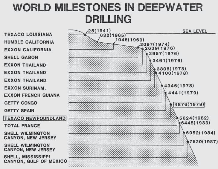
A rank wildcat well, Texaco Shell et a1 Blue H-28, was drilled offshore Newfoundland in 1979 in 1,486 m (4,876 ft) water and significantly extended the world water depth record for oil and gas drilling. Blue H-28 provided abundant geological and geophysical data which has advanced industry's assessment of the hydrocarbon potential of the almost unexplored Orphan Basin. Blue H-28 also proved industry's capability to drill a deepwater well in one of the world's most difficult drilling environments.
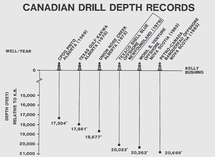
In mid-1979 the Texaco Shell et a1 Blue H-28 wildcat well was drilled on the continental slope of Newfoundland in 1,486 m (4,876 ft) of water and established a new world record water depth for oil and gas drilling. Prior to the drilling of Blue H-28, the world water depth record for oil and gas exploratory drilling had been held by a well drilled offshore Spain in early 1979 in 1,354 m (4,441 ft) of water (Fig. 1). Blue H-28 obtained additional distinction since it was drilled to a total depth of 6,103 m (20,023 ft) thereby setting a new Canadian drilling depth record (Fig. 2).
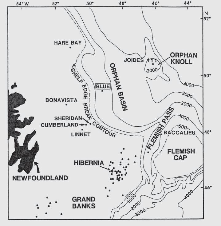
The Blue H-28 well was drilled 340 km northeast of St. John's, Newfoundland in the Orphan Basin. Only two oil and gas exploration wells and a Joides DSDP core hole had been drilled in the Orphan Basin prior to the Blue H-28 drilling project. The closest control well for Blue H-28 was the BP et a1 Bonavista C-99 well located 150 km southwestwards (Fig. 3). According1y, Blue H-28 represented a true pioneering effort to drill in an almost unexplored basin as well as to extend drilling technology beyond its proven capability.
Blue H-28 did not prove to be an oil or gas discovery; however the well did achieve two significant accomplishments. First, Blue H-28 provided a wea1th of stratigraphic, paleontological, and geochemical data pertinent to the geology of the Orphan Basin. Second, Blue H-28 proved that deep-water drilling could be efficiently performed in an operationally difficult area characterized by high seas and numerous icebergs.
REGIONAL TECTONIC ELEMENTS
A series of sedimentary basins onlap the southern flank of the Appalachian Orogen in Eastern Canada (Fig. 4). The basins contain up to 14 km of sediments of Mesozoic to Cenozoic age (Wade, 1981). Three major tectonic elements dominate the Canadian Atlantic margin: the Scotian Basin, the Avalon Uplift, and the East Newfoundland Basin. The general structural configurations of the basins and the intervening basement highs are outlined by a regional map of basement structure (Fig. 5).
REGIONAL BASEMENT STRUCTURE
The sedimentary basins have been subdivided by basement uplifts into a number of discrete “sub-basins.” The Orphan Basin occurs within the East Newfoundland Basin and is separated from the Jeanne D'Arc Basin by an east-towest trending basement ridge. The Orphan Basin covers 140,000 sq km; however only four wells, Bonavista C-99, Linnet E-63, Cumberland B-55, and Blue H-28 have been drilled into basement (Fig. 6).

The basement complex of the Atlantic Margin includes metasedimentary rocks of early Paleozoic age which are the seaward extension of similar age rocks outcropping in Nova Scotia and southeastern Newfoundland. The basement rocks were deposited in the Appalachian Geosyncline, which is a thick geosynclina1 sequence developed during Late Precambrian to Devonian time and extends from southeastern United States to beyond the
eastern Newfoundland Shelf (McWhae, 1981).
Numerous papers including those by McWhae (1981) and Wade (1981) have reviewed the relationship between the tectonic and stratigraphic history of the Canadian Atlantic margin and the development of the present day North Atlantic Ocean. Seafloor spreading in the North Atlantic area did not
occur until Cretaceous time. Throughout Permo-Triassic and Early Jurassic time the North Atlantic continents forged a single continental plate in which the present day North Atlantic Ocean did not exist (Naylor and Mounteney, 1975).
The Atlantic Margin was largely emergent during the Triassic resulting in deposition of rocks typified by continental red clastics.
Sporadic incursions by marine waters into the restricted Triassic basins resulted in widespread deposition of evaporites, especially salt. By early Jurassic time, shallow shelf seas occupied a series of downfaulted troughs which developed in response to the pre-rupture phase of tensional stress between the North Atlantic plates (Naylor and Mounteney, 1975). The Jurassic tensional tectonics resulted in an early Jurassic breakup
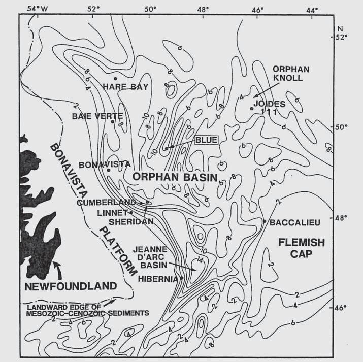
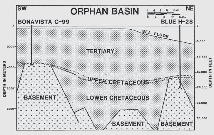
unconformity described by Given (1977). During the Jurassic, sedimentation occurred in a widening epicontinental sea resulting in the establishment of an open marine environment. Jurassic sediments range in lithology from deltaic sandstones and shales (e.g., Mic Mac Formation) to shelf carbonates (e.g., Abenaki Formation) to marine shales (e.g., Verril Canyon Formation).
The entire Atlantic Margin was well established as a depocentre by Cretaceous time and sedimentation consisted primarily of paralic siliclastic and shale sequences. Decoupling of the North American Plate from the European Plate occurred during the Early Cretaceous in a spreading centre located east of the Grand Banks (Jansa and Wade, 1975) resulting in the uplift of a major crustal block commonly known as the Avalon Uplift. The uplift was focused on the Grand Banks area and subsequent erosion peneplaned the elevated blocks, resulting in the formation of sub-basins such as the Whale and Jeanne D'Arc Basins which are separated by basement ridges (Fig. 5). A mid-Cretaceous unconformity is evident on seismic throughout the Orphan Basin. This unconformity is considered correlative with the Avalon Unconformity (McWhae, 1981). Post Middle Cretaceous deposition occurred without significant hiatuses throughout the Late Cretaceous and Tertiary.
H-28
During the early 1970s, Texaco Canada Limited developed an interest in the hydrocarbon potential of the Orphan Basin. Late 1960s to early 1970s vintage regional seismic data indicated the presence of a number of very large structures in the deep water areas of the Orphan Basin. The seismic was non-migrated and significant1y less definitive than the state-of-the-art seismic data recorded in recent years in the Orphan Basin. Preliminary interpretations of the early 1970s data suggested that the structures could represent massive reef buildups similar to the prolific Golden LaneReforma Lower Cretaceous reefs of Mexico. Several widely spaced data points on the East Newfoundland shelf provided additional support for the postulated reefs.
The primary encouragement was from the Joides DSDP corehole which was drilled on Orphan Knoll (Fig. 7). The Lower Cretaceous section penetrated at Orphan Knoll consisted of approximately 55 m (180 ft) of carbonate sands and shaley limestones deposited within an interpreted shallow water marine environment (Ruffman and Van Hinte , 1973). Furthermore, samples dredged from the Flemish Cap contained a Lower Cretaceous foraminifera,
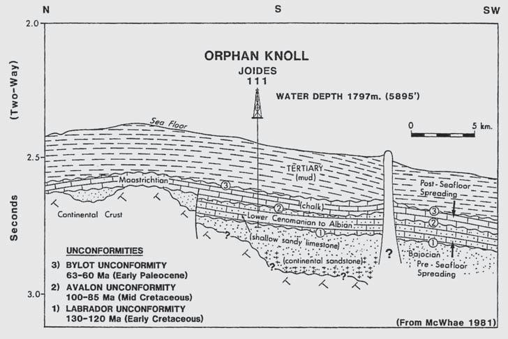
(...Continued from page 29)
Orbitolina Conoidea, which is indicative of a warm temperature, reefal environment (Gupta and Grant, 1971). In addition, the Adolphus K41 well, drilled in the Jeanne D'Arc Basin had also intersected Lower Cretaceous shallow marine clastics and carbonates. These three very widely spaced data points suggested that conditions conducive to reef growth did occur during the Lower Cretaceous time in the Gander area.
On the basis of the regional seismic, the abovementioned data points and geological concepts, Dome Petroleum, Home Oil, Hudson's Bay Oil and Gas, and Petro-Canada joined with Texaco to explore the 5.6 million acre Gander Block held by Shell. Approximately 1,760 km of 2400 percent CDP was recorded in 1976 and 1977. The seismic provided regional control and also confirmed the presence of the Gander Structure. Due to the large size of the Gander Structure, the exploration we11 was appropriate1y named "Blue" after the largest of sea creatures, the Blue Whale.
The Blue H-28 wellsite was located 340 km northeastwards from the port city of St. John's, Newfoundland, which served as the staging point for services and supplies. Accordingly, St. John's – North America's oldest city – became intimately associated with a world recordbreaking drilling project which used the newest state-of-the-art technology. Those involved in the Blue H-28 were aware of an additional relevant historical event: Blue H-28 was to be drilled within 900 km of the resting place of the Titanic and the unfortunate 1,503 passengers and crew members who perished in the icy seas. A reminder that the North Atlantic waters can be unforgiving to those who are unvigilant or unprepared.
The Gander Structure consists of a large, asymmetrical Paleozoic paleotopographic high which is fault-bounded to the west (Fig. 8). The Paleozoic structure was unconformably overlain by Lower Cretaceous sediments, however extensive erosion during the Middle Cretaceous peneplaned the Paleozoic structure and the overlying Lower Cretaceous section. Consequent1y, the Lower Cretaceous is absent over the crest of the Paleozoic structure and thickens up to 2,250 m (7,500 ft) on the flanks.
The angular unconformity formed by the mid-Cretaceous erosion is clearly evident on seismic. A map of time structure on the mid-
Cretaceous unconformity (Fig. 9) indicates some 240,000 acres under areal closure with up to 1/2 second, two-way time vertical closure, equivalent to 600 m (2,000 ft) depth. The Blue H-28 drill site was located slightly off the crest of the Paleozoic structure in order to fulfill two objectives, namely to test the up-dip truncation edge of the Lower Cretaceous section and to evaluate the Paleozoics at a near-crestal position.
The stratigraphic section penetrated by Blue H-28 is detailed on Figure 10 and is summarized as follows:
LITHOLOGY AND BIOSTRATIGRAPHY
1) Paleocene - Grey shales and thin indurated mudstones comprise the Paleocene section. Rare foraminifera and palynomorph taxa provide the Paleocene age date and also indicate deposition occurred in an open marine, probably deep water, outer shelf or slope environment.
2) Upper Cretaceous - The lithology is predominantly dark grey shales containing glauconite, pyrite, and thin limestone interbeds. The lithology becomes more arenaceous toward the base. The Upper Cretaceous is lithologically similar to the overlying Paleocene section. Planktonic foraminifera provide the Cretaceous (Maastrichtian) age determination and suggest open shelf or deeper slope depositional conditions.
3) Lower Cretaceous - This section consists of grey shales, thin calcareous mudstones, siltstones, and light grey sandstones.
(Continued on page 33...)
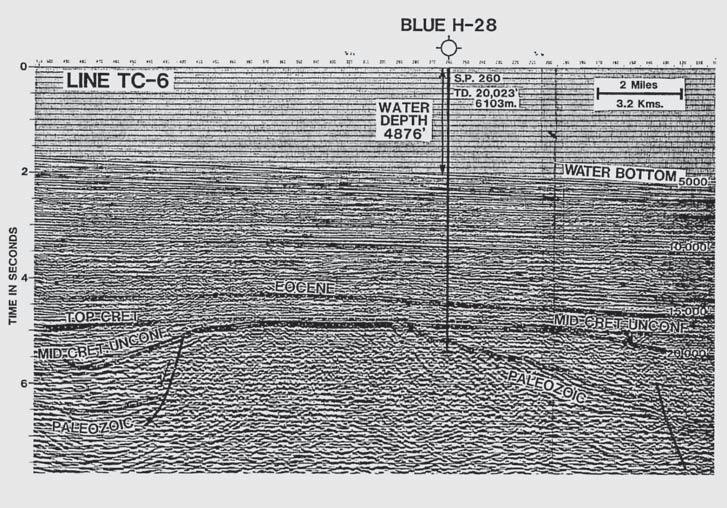


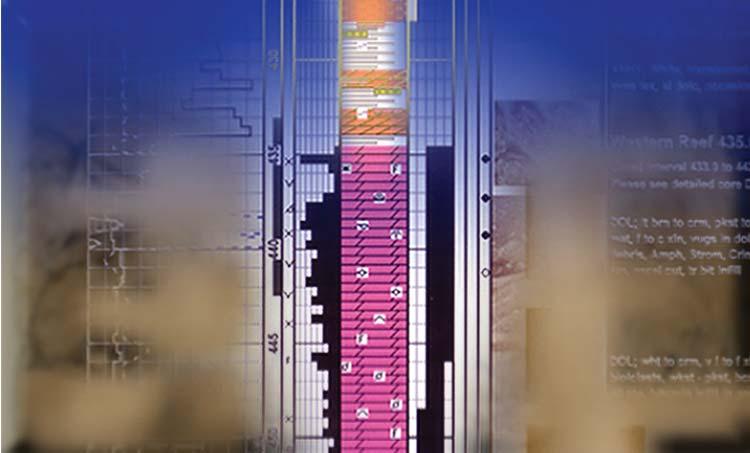


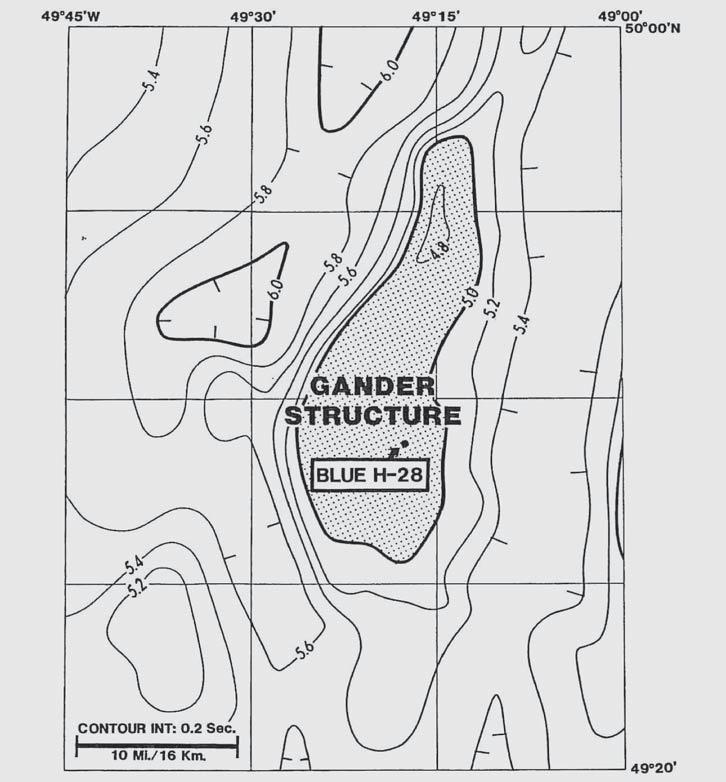
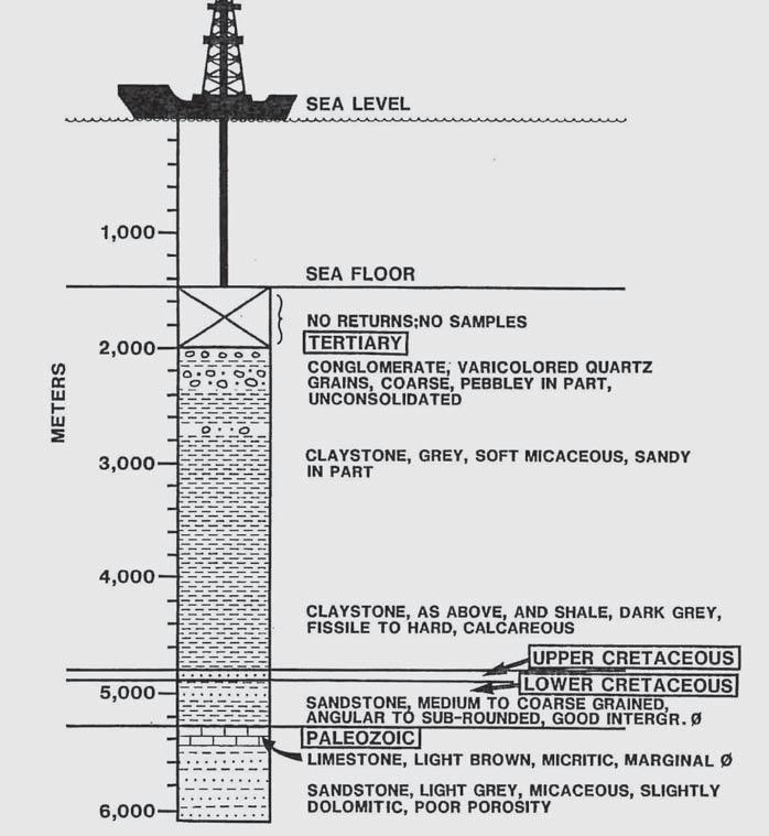
(...Continued from page 33)
The magnitude of the maturation break (Fig. 11) between the Cretaceous and the Paleozoics suggests that a substantial amount of section has been lost to erosion prior to deposition of the Cretaceous sediments.
RESERVOIRS
The Tertiary section in Blue H-28 contains minor porous sands and gravels which are not of significance since they are shallow and do not occur in a structural closure position. Approximately 55 m (180 ft) of clean, medium- to coarse-grained sandstones occur in the Lower Cretaceous. Electric logs indicate porosities of up to 19% however, the pore space is water saturated. The limestone interval at the top of the Paleozoics is a tight micrite; Paleozoic sandstones beneath the limestone are marginally porous.
HYDROCARBONS
No significant hydrocarbons were encountered in Blue H-28. Neither effective source beds nor evidence of migrated crude oil was present in any of the samples analyzed by the analytical contractor.
Gas shows consisting of methane and ethane were recorded on the mud log while drilling
through the Eocene and are consistent with migrated gas. Gas shows occurring in the Cretaceous may have been generated by several of the organic-rich intervals identified in the Cretaceous. Traces of migrated gas occur in the Paleozoic limestone beneath the unconformity. This gas was likely generated and migrated downwards from the over1ying basal Cretaceous source beds into the Paleozoic reservoirs.
Drilling a deep exploratory well in a record water depth in an area prone to violent storms and icebergs presented many challenges. Specific concerns were as follows:
The drilling vessel used to drill Blue H-28 was the dynamically positioned drillship Discoverer Seven Seas. Six 3,000 HP variablepitch, right-angle thrusters and two 8,000 HP main propulsion screws enabled the drillship to counteract the driving force imposed by North Atlantic winds and seas in combination with the strong Labrador Current. Positioning was controlled by a computerized Automatic Station Keeping system using a dual acoustic system as the primary reference and two
electrical riser angle indicators as back-up. Acoustic transmission in nearly 1,500 m of water was a concern, but the primary reference was lost on only one occasion when rough seas interfered with the transponder signal.
The extreme length of the marine riser raised concerns over support of the riser and lateral forces imposed by currents. The 473 mm (18.625 in) riser was equipped with 1,067 mm (42 in) O.D. flotation cans to provide a buoyant force which supported most of the riser's weight. The possibility of strong currents was anticipated, and therefore the riser analysis assumed an extreme current of 140 cm/sec (2.75 knots) at surface and 25 cm/sec (0.5 knots) at the seafloor. Maximum currents observed during the drilling of the we11 were 51 cm/sec (1 knot) at surface and 30 cm/sec (0.6 knots) at a depth of 1,200 m.
As a result of the high tensile load maintained on the riser, the conductor pipe was required to have sufficient strength to resist bending stresses imposed by vessel offset. The 762 mm (30 in) conductor pipe used in Blue H-28 was 44.4 mm (1.75 in) wall thickness, 780 kg/m (528 lb/ft) X-42 casing set to a depth of 104 m (341 ft) below the seafloor. The low fracture gradients, resulting from overburden pressures, which were very low relative to pore pressure, presented additional concerns. Cement densities on the conductor strings were kept low at 1,500 kg/m (12.6 lb/gal) to prevent formation breakdown. Low fracture gradients also resulted in a small differential between the formation fracture pressure and the hydrostatic pressure of the mud. The actual mud density used in the main hole section to control pore pressure was 1,605 kg/m (13.4 lb/gal).
Wellbore re-entry in nearly 1,500 m of water was anticipated to be a challenge. Limited visibility, vessel motion, current drag, and oscillations of the suspended pipe all combined to make the task difficult. While a sonar/TV reentry tool was available as back-up, all re-entries on the Blue well were facilitated using a manned submersible to monitor the position of the pipe relative to the well. Vessel movements were directed by underwater communication from the submersible, and, as may be expected, the considerable depth involved made communication difficult at times. Nevertheless, a total of eight re-entries were made with an average of only 4.25 hours required to run in with the sub, make the re-entry, and recover the sub.
Drilling in a record water depth was
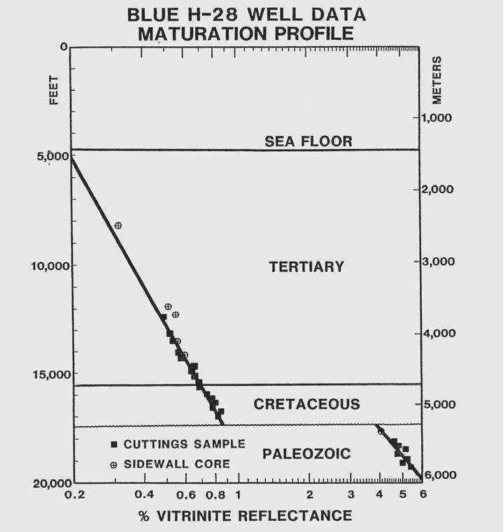
challenging enough without being complicated further by environmental factors. To minimize the possibility of problems, Blue H-28 was scheduled to spud in the latter part of April, after surface ice had receded from the location. An April spud date was desirable to ensure that the well could be drilled and tested before October when winter weather conditions were certain to result in increased downtime. Unfortunately, while weather conditions were more favorable during the spring and summer, this was also the time when icebergs drifted through the area. Use of a dynamically positioned drillship with emergency disconnect capability, ensured that the drilling vessel could move off location if necessary. However, 24 hours per day observation of iceberg movements and the constant presence of a support vessel equipped with 1,200m of 330 mm (13 in) circumference polypropylene tow rope, made this option unnecessary. During the drilling of the well, four icebergs approached within 19 km of the rig and were towed away by the support vessel.
The Blue H-28 well aptly fits the description of a well, which was an engineering and
geological success, albeit an economic failure. The well was drilled within 18 percent of the prognosis time schedule, The formation tops of the two primary objectives, the Cretaceous and Paleozoics, were intersected within 9% and 4%, respectively, of prediction. Reservoir sections were encountered as predicted, unfortunate1y no significant hydrocarbons were present.
Approximately nine years have now passed since the drilling of Blue H-28. During those nine years, some twelve wells have been drilled in water depths exceeding Blue H-28's water depth of 1,486 m (4,896 ft). With the passage of time, the significance of Blue H-28 seems to pale in comparison to recent exploratory drilling in water depths exceeding 2,300 m (7,500 ft). However the challenge of drilling Blue H-28 must be viewed in context of the status of deep water drilling in the 1970s. The geological and geophysical evaluation of the Gander Structure as well as the decision to drill Blue H-28 occurred in 1976, at which time the deepest oil well drilling had been carried out in only 640 m (2,100 ft) of water. Accordingly, the plan to drill in almost 1,500 m (5,000 ft) of water to drill depths of 6,000 m (20,000 ft) in the inhospitable North Atlantic waters off Newfoundland became a tremendous challenge for those involved in the Blue H-28.
(Continued on page 36...)
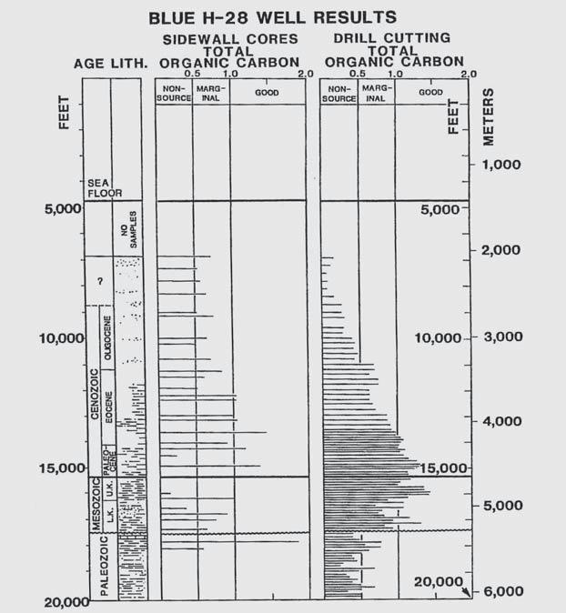
Blue H-28 provided a wealth of geological and geophysical information on the almost unexplored Orphan Basin. Such information cannot help but prove to be beneficial for our oil industry in our search for future hydrocarbon supplies.
The Gander Block exploration program was conceived and matured to a drillable prospect by a Texaco Canada exploration team consisting of A1 Hanners, John Williams, Peter Bower, Trevor Bell, Dave van der Lee, and Ray Howell. Certainly, Rennie Reghenas' six-week stint on the high seas of the North Atlantic as geophysical “boat rider” on the MV Arctic Explorer must also be acknowledged. The Blue H-28 well would never have been successfully drilled without the efforts and dedication of an engineering team consisting of, among others, Texaco's Neal Eggen and Jim Daley, and Shell Canada's Greg Lever. The authors appreciate the approvals received from the managements of Texaco Canada Resources, She11 Canada Limited, Dome Petroleum Limited, Home Oil Company Limited, and PetroCanada Resources to present this paper to the 1988 Offshore Technology Conference. We also extend our appreciation to Joan Dickson for word
processing and Ron Samuelson and his drafting team for the displays included herein.
AVERY, M. P., 1985, Vitrinite reflectance (Ro) of dispersed organics from Texaco Shell et a1 Blue H-28. Report No. EPGS - Dom. 15-85 MPA. Open file report, Department of Energy, Mines and Resources, Ottawa.
DOW, W. G. 1979, Geochemical analysis of Texaco Shell et a1 Blue H-28 well, offshore Newfoundland: Robertson Research (U.S.) Inc. Report No. 90, Project: RRUS/790/II/28 (Open file available from Canada Oil and Gas Lands Administration Branch, Dept. of Energy, Mines and Resources, Canada).
GIVEN, M. M., 1977, Mesozoic and Early Cretaceous Cenozoic geology of offshore Nova Scotia. Bulletin of Canadian Petroleum Geology, 25, p. 63-91.
JANSA, J. F., and WADE,J. A., 1975, Geology of the continental margin off Nova Scotia and Newfoundland. In: Offshore Geology of Eastern Canada, Geological Survey of Canada, Paper 74-30, 2, p. 51-105.
McWHAE, J. R. H., 1981, Structure and spreading history of the northwestern Atlantic region from the Scotian Shelf to Baffin Bay. In: Geology of the North Atlantic Borderlands. Edited by J. Wm. Kerr et al.
Canadian Society of Petroleum Geologists, Memoir 7, p. 299-332.
NAYLOR D., and MOUNTENEY, S. N., 1975, Geology of the North-West European Continental Shelf. Vol. 1, Graham Trotman Dudley Publishers Ltd., London, p. 1-162.
RUFFMAN A., and van HINTE, J. E., 1973, Orphan Knoll - a “chip” off the North American “plate.” Geological Survey of Canada Paper 71-23, p. 407-449.
SEN GUPTA, B.K., AND GRANT A.C., 1971, Orbitolina, a Cretaceous larger foraminifera from Flemish Cap: Paleooceanographic implications; Science, v. 173, p. 934-936.
WADE, J. A., 1981, Geology of the Canadian Atlantic margin from Georges Bank to the Grand Banks. In - Geology of the North Atlantic Borderlands. Edited by J.Wm. Kerr et al. Canadian Society of Petroleum Geologists, Memoir 7, p. 447-460.
Copyright 1988 Offshore Technology Conference. This paper was presented at the 20th Annual OTC in Houston, Texas. May 2-5, 1988. The material is subject to correction by the author. Permission to copy is restricted to an abstract of not more than 300 words.
BIRTH: Victoria, B.C. (1961)
EDUCATION: Geology & Geophysics, University of Calgary (1982); Continuing Education Petroleum Technology, Southern Alberta Institute of Technology (1987)
EXPERIENCE: 1980-84, Geological Research Technician, Petro-Canada Geological Research & Services; 1985-92, Exploration Technologist, Petro-Canada Foothills & Frontier Exploration; 1992-97, Geological Systems Coordinator, PetroCanada Geological & Geophysical Applied Technology; 1998-2004, Geoscience & Geomodeling Applications Specialist, Petro-Canada Upstream Information Systems; 2005 to present, Geomodeling Specialist, G&G Applied Technology, Petro-Canada Oil & Gas
PROFESSIONAL
MEMBERSHIPS: CSPG, AAPG, CSEG, SEG, SPE
CSPG ACTIVITIES: Mixed Golf Tournament Committee (2001-06); GeoModeling Division (2003-06)
AWARDS: CSPG Volunteer Award 2004
BIRTH: Deep River, Ontario (1960)
EDUCATION: B.Sc. Geology, University of Ottawa (1983); M.Sc. Geology, Washington State University (1985); Ph.D. Geology, University of Alberta (1989).
EXPERIENCE: 1989-1998, Research Scientist, Geological Survey of Canada, Vancouver & Quebec City; 1998-present, Exploration Geologist, Shell Canada Limited, Calgary.
PROFESSIONAL
MEMBERSHIPS: CSPG, APEGGA
CSPG ACTIVITIES: Student Industry Field Trip (SIFT) co-leader, 1999-2005; Associate Editor, Bulletin of Canadian Petroleum Geology, 2001-2003, 2005-2007.
PUBLICATIONS: Papers on Cordilleran and Appalachian geology; conference presentations on oil and gas geology.
AWARDS: CSPG Volunteer Appreciation Award; GSC Service Award
October 15 – 17,2007
The Banff Centre
A wealth of energy exploration and development possibilities exists north of 60˚ along the Mackenzie Valley,up to the Delta and the Beaufort Sea,throughout Alaska's North Slope and adjacent areas,and across the Arctic Islands and bordering continental shelves of Canada and Greenland.A renewed interest for northern and Arctic oil and gas exploration and future development is occurring at a time of remarkable change in the North as a sparse,yet growing population finds itself in the eye of a perfect storm brought by climate change, environmental stress,ground-breaking political developments and a desire for a sustainable economy.
Join us in October in Banff,Alberta as the 2007 GUSSOW Geoscience Conference delves into the geoscientific aspects of Arctic energy and examines how exploration,development and business should be approached and conducted in the changing North.
Benoit Beauchamp & Gerry Reinson,Chairs
CSPG Members:$800
Non-Members:$900
(Registration includes two nights single occupancy accommodation at the Banff Centre,Icebreaker Reception and all meals)
For more information please visit: www.cspg.org
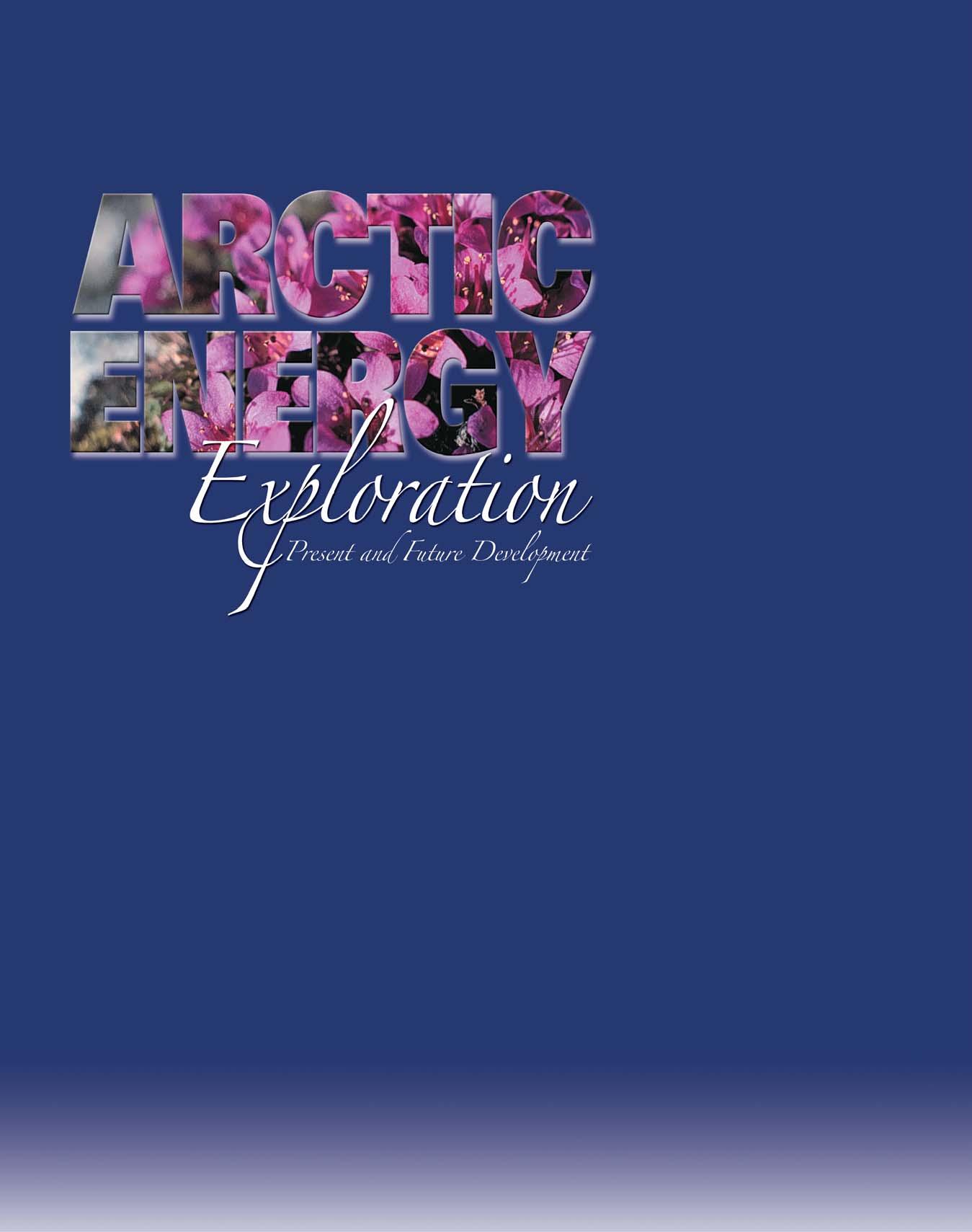
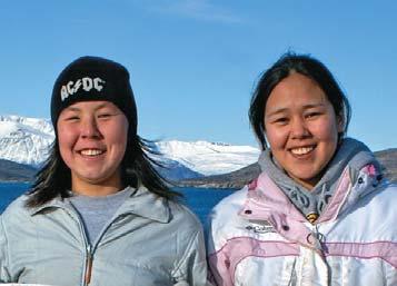
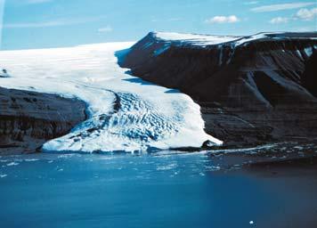
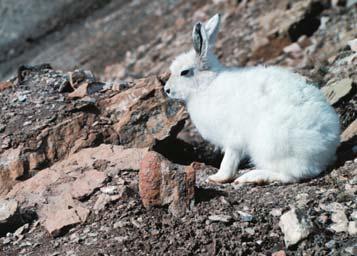
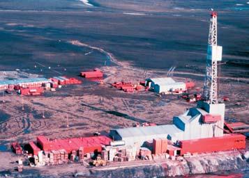
Integrated Petrography and Geochemistry of Carbonate Rocks and Its Application to Reservoir Studies
Date: March 12-13, 2007
Location: Dallas, Texas
Tuition: $690, AAPG Members; $790, non-members (increases to $790/890 after 2/12/07); includes course notes, plus lunch and refreshment s each day.
Content: 1.5 CEU
Instructors: Peter Scholle and Dana Ulmer Scholle, New Mexico Bureau of Geology and Mineral Resources, Socorro, New Mexico
Who Should Attend
Geologists and engineers interested in carbonate reservoir characterization, including understanding the depositional setting, diagenetic history, and origin and timing of porosity development or destruction in limestone and dolomite reservoirs.
Date: March 31-April 1, 2007
Location: Long Beach, California, with AAPG Annual Meeting
Tuition: $690 (increases to $790 after 3/2/07); includes course notes and refreshments.
Content: 1.5 CEU
Instructors: Richard G. Green, William Kazmann, LaRoche Petroleum Consultants, Dallas, Texas
Who Should Attend
The course is designed for personnel who wish to acquire a broad understanding of the factors that influence the production of oil and gas from reservoirs. The course presents information that can be applied to geologists, geophysicists, petrophysicists, land management specialists, and managers with no previous training in reservoir engineering. It can also serve as an introductory course for engineers who have not had previous training in reservoir engineering.
Date: March 31-April 1, 2007
Location: Long Beach, California, with AAPG Annual Meeting
Tuition: $650 (increases to $750 after 3/2/07), includes course notes and refreshments
Content: 1.5 CEU
Instructor: Jeffrey Yarus, Quantitative Geosciences, Inc., Houston, Texas
Who Should Attend
Date: March 31, 2007
Location: Long Beach, California, with AAPG Annual Meeting Tuition: $500 (increases to $600 after 3/2/07), includes course notes and refreshments
The class is appropriate for geoscientists, engineers and modeling technicians who would like a better understanding of what's behind the sophisticated 3D reservoir modeling software they are using.
Content: .7 CEU
Instructor: George B. Asquith, Texas Tech University, Lubbock, Texas
Who Should Attend
This is an advanced course in carbonate well logging designed for geologists, engineers and geophysicists who are interested in the detailed methods of carbonate log analysis. The course participant should come to the course with basic understanding of the principles of well logging and at least a few years of industry experience.
Leaders: Stephan Graham and Donald R. Lowe, Stanford University, Stanford, California
Dates: April 5-10, 2007, following the AAPG Annual Meeting
Location: Begins in Palo Alto and ends at the airport in San Francisco, California; Begins Thursday, 4/5, 5:00 p.m., and ends Tuesday mid-afternoon, 4/10.
Tuition: $2,675 (increases to $2,775 after 3/02/07), includes lodging, transportation during the seminar, lunches, guidebook and group dinner (1 night)
Limit: 20
Content: 5.5 CEU
Who Should Attend
Geologists, geophysicists, reservoir engineers, managers and anyone working with deep-water reservoir systems.
| by Robert Meneley, Canadian Gas Potential Committee
Understanding the assessment of undiscovered gas potential in the Western Canada Sedimentary Basin (WCSB), particularly the economic potential, requires knowing the pool sizes in which the undiscovered resources are expected. The pool size distribution of undiscovered resources is more important than the absolute volume estimated. The reports published by the Canadian Gas Potential Committee (CGPC 2005, 4 volumes + Data DVD; CGPC 2001) provide a unique source for this information.
The Canadian Gas Potential Committee used the Truncated Discovery Process Model (TDPM) developed by TransCanada (Logan, 2005) to conduct its assessment of undiscovered gas potential in the Western Canada Sedimentary Basin that is reported in their latest study (CGPC 2005). The application of this new resource assessment methodology makes it important to understand how the results compare with previous work (CGPC 2001). Such a comparison presents complex issues including, the differences in methodology and the results of exploration in the period between the two reports. The analyses presented contain important information regarding the undiscovered resource potential in the basin.
Figure 1 shows information from all of the Conventional Gas Pools in the Western Canada Sedimentary Basin (WCSB). It illustrates the cumulative difference between the number of undiscovered pools and the Original Gas in Place (OGIP) obtained by subtracting the results of CGPC 2001 from the results of CGPC 2005. For CGPC 2001 the file from the CD ROM Data\Chapter 01 - Summaries for Canada and Play Groups\ SUM-WCSB.xls was used. For CGPC 2005 the file WCSB 2005 Assessment Summary Tables.xls from the Data DVD has been used. For both the CGPC 2001 file and the CGPC 2005 file there are minor differences in the numbers between what is obtained from summing data from each individual play and the summary tables in these publications.
For reference, the size classes on Figure 1 are on a Log2 scale so each successive class is twice the size of the previous class. Class 11 ranges from 16 to 32 Bcf OGIP. Class 15 ranges from about 256 to 512 Bcf. Additional class limits are shown on Figure 1.
The solid black curve on Figure 1 shows a
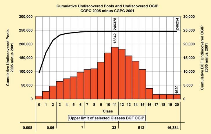
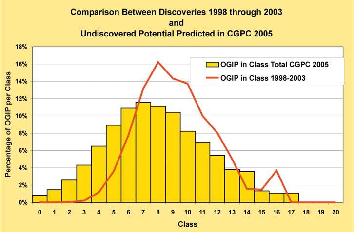
rapid rise in the difference in the number of pools in successive classes, which reaches a maximum of 246,328 more pools in CGPC 2005 than CGPC 2001 by the time Class 11 is reached. In classes larger than Class 11 the difference declines by 74 pools by the time Class 18 is reached. Neither of the reports predicted undiscovered pools larger than Class 17. The difference in cumulative undiscovered gas volumes, shown in red, rises more slowly and reaches a maximum of 18,482 Bcf in Class 11. From that peak the cumulative gas in place declines rapidly through Class 17 and the difference stabilizes at 1,620 Bcf OGIP (In CGPC 2005, p. 2-7
this difference is 768 Bcf for the reasons noted above).
The conclusion from this comparison of the two reports by the CGPC is that the undiscovered gas resources of 134,196 Bcf OGIP predicted in CGPC 2005 (Figure WC.1.8) is expected in a much larger number of smaller pools than were predicted in CGPC 2001. In the 2005 Report pools in Classes 0 through 11 contain 18.8 Tcf more gas than was predicted in CGPC 2001 while the classes above Class 11 contain 17.2 Tcf less. If only the totals are compared
(Continued on page 40...)
there appears to be little difference, but this conceals a dramatic shift in the Committee's estimate of undiscovered resources toward smaller pools.
The use of the TDPM program for almost all of the WCSB plays provided a consistent methodology that was designed to address the issue of economic truncation where fewer small pools are booked than would be expected to be present. The TDPM program uses the lognormal distribution of pools above the modal class to predict the number of pools per class below the mode. This program also provided a much more transparent and clearer view of the undiscovered potential over the entire range of pool sizes. As a result the main reasons for the shift to smaller pool sizes is the more accurate TDPM methodology that was used in CGPC 2005.
Another reason for the difference between the two CGPC reports is that exploration proceeded in the basin and 18.8 Tcf OGIP (CGPC 2005, Figure WC.1.12) was discovered in new pools in the period between the two publications. Figure 2 shows the comparison on a class-by-class basis between the pools discovered in
the period 1998 through 2003 and the predicted undiscovered pools in CGPC 2005. As one would expect, the discoveries made in 1998 through 2003 are skewed to the larger class sizes. This is the normal course of exploration. The lack of booked pools in the small class sizes shows that “economic truncation” is alive and well. Pool size appreciation in this cohort of discoveries will tend to exaggerate the difference.
The bad news is that, in the period 1998 through 2003, only 3.7 Tcf OGIP (CGPC DVD CGPC_Pools_2005 final.xls) was found in 50 pools larger than Class 11 (>32 Bcf OGIP). There are both fewer larger pools predicted in 2005 and a smaller resource in pools larger than 32 Bcf OGIP (Class 11).
There is a wealth of detailed information contained in the files on the Data DVD of the CGPC 2005 Report. For planners and economists, the shift in the undiscovered gas resources toward smaller pools will have important implications for the gas supply from the basin. Gas in smaller pools will require more drilling and infrastructure, which will adversely affect the development economics.
The number of undiscovered pools larger than 32 Bcf OGIP has a dramatic impact on the resource volumes in the basin and the economic value of such pools is huge. Explorers need to look at every established exploration play in the WCSB to see if there is a chance that a large gas pool, or even the largest pool in the play, remains undiscovered in spite of the maturity of the basin. Dig into the data that are available in the CGPC Reports and other sources and use your imagination to define what such targets would look like and where they might be located. The data is there to be used.
Robert Meneley has been a Senior Advisor / Chief Analyst to the Canadian Gas Potential Committee for 15 years. He may be reached at meneley@telus.net
The Canadian Gas Potential Committee is a volunteer organization of industry and government geoscientists whose purpose is to assess natural gas resources in Canada. Recently, they released their third report. Additional information about the reports or the Committee may be obtained from their website (cdngaspotential@shaw.ca) or by contacting the Committee's office at 297-7222.
PresidentColin YeoEnCana645-7724colin.yeo@encana.com
Vice PresidentLisa GriffithGriffith Consulting669-7494lgriffith@griffithgeoconsulting.com
Past PresidentJim ReimerResult Energy539-5207jim@resultenergy.com
Finance DirectorPeter HarringtonNorthrock213-7665harrington@northrock.ab.ca
Assistant Finance DirectorJames DonnellyConocoPhillips260-8000james.donnelly@conocophillips.com
Program DirectorNadya SandyEsso237-3925nadya.sandy@esso.ca
Assistant Program DirectorRandy RiceSuncor Energy205-6723RJRice@suncor.com
Service DirectorDave NewmanMcDaniel & Associates218-1392dnewman@mcdan.com.
Assistant Service DirectorJen VezinaDevon Canada232-5079jen.vezina@devoncanada.com
Outreach DirectorDavid MiddletonPetro-Canada296-4604middletn@petro-canada.ca
Assistant Outreach DirectorGreg LynchShell Canada691-2052greg.lynch@shell.com
Communications DirectorAshton EmbryGSC - Calgary292-7125aembry@nrcan.gc.ca
Corporate Relations Director Monty RavlichGRGO Holdings Ltd.560-1701ravlich@telus.net
PROGRAMS: Executive Liaison - Nadya Sandy and Rand Rice
Conventions & ConferencesShauna CarsonCSPG Staff264-5610shauna.carson@cspg.org
Convention AssistantTanya SantryCSPG Staff264-5610tanya.santry@cspg.org
Committee on ConventionsIan McIlreathEnCana645-2599ian.mcilreath@encana.com
Convention 2007John VarsekEnCana645-5417john.varsek@encana.com Convention 2008
Gussow Conference 2007Benoit BeauchampAINA220-7516bbeaucha@ucalgary.ca
Gussow Conference
2008Marian WarrenEncana645-2271marian.warren@encana.com
Technical LuncheonsTony CadrinThunder Energy303-3493tonyc@thunderenergy.com
Chris Seibel Nexen699-4558chris_seibel@nexeninc.com
Riona FreemanCanetic Energy806-3550riona.freeman@CaneticTrust.com
Kevin MeyerTalisman Energy237-1329kmeyer@talisman-energy.com
EducationKrista JewettBG Canada538-7400Krista.Jewett@bg-group.com
Travis HobbsEnCana645-5384travis.hobbs@encana.com
Technical Divisions
Basin AnalysisSteve DonaldsonEnCana645-5534 steve.donaldson@encana.com
Mark CaplanShell Canada691-3843mark.caplan@shell.com
Core & SampleDoug HaydenHayden Geo Cons254-9785haydengeo@telus.net
Emerging Petroleum ResourcesMichelle Hawke BP Canada289-8283michelle.hawke@bp.com
Environmental GeologyAndrew FoxMEG Energy770-5345andrew.fox@megenergy.com
GeomodelingDavid GarnerChevron Canada234-5875davidgarner@chevron.com
GeofluidsJennifer Adams UofC220-5841adamsjj@ucalgary.ca
InternationalBob PotterW.L. Gore & Associates863-9738 ropotter@telusplanet.net
PalaeontologyPhilip BenhamShell Canada691-3343philip.benham@shell.com
Reservoir DevelopmentDarren SteffesMustang Resources521-6305 d.steffes@pegasusoilgas.com
SedimentologyScott Rose Birch Mountain Resources 262-1838roses@birchmountain.com
Structural GeologyJamie JamisonHef Petrophysical269-3158jamie@hef.com
Membership ServicesSarah BartonCSPG staff264-5610sarah.barton@cspg.org
GulamhusseinShiningbank612-7242agulamhussein@shiningbank.com
Group InsuranceRobin MannAshton Jenkins Mann232-6206rmann@ajma.net
Volunteer ManagementKaren S. P. WebsterEnerplus298-1246 AWARDS CommitteeContactCompanyPhoneEmail CoordinatorHeather HuntAEUB297-7379heather.hunt@gov.ab.ca
President’s AwardColin YeoEnCana645-7724colin.yeo@encana.com Medal of MeritIan KirklandEncana645-6802ian.kirkland@encana.com Link AwardRick Steedman Thunder Energyrick.steedman@thunderenergy.com
Stanley Slipper John HoggBurlington260-8313jhogg@br-inc.ca
RJW Douglas Graham DaviesGDGC289-9156gdgc@telus.net
Honorary MembershipDon KeithBerens Energy303-3275dkeith@berensenergy.com
H.M. HunterCraig LambHusky 750-1499craig.lamb@huskyenergy.ca
Tracks, Service & VolunteerAmanda PerrotEncana645-5077amanda.perrot@encana.com
Open Golf TournamentDavid CaldwellBehr Energy444-6940david.caldwell@behrenergy.com
David MiddletonPetro-Canada296-4604middletn@petro-canada.ca
Squash Tournament Colin ThiessenHycal735-6459colint@hycal.com
David CaldwellBehr Energy444-6940david.caldwell@behrenergy.com 10K Road RaceChristine Manion283-8572chris@forsaw.ca
Hockey TournamentFrank PogubilaContinental Labs250-5125f.pogubila@continental-labs.ab.ca
Long Time MembersRegan PalsgroveTalisman Energy237-1423rpalsgrove@talisman-energy.com
Past President’s DinnerJim ReimerResult Energy539-5207jim@resultenergy.com
LIAISON: Executive Liaison - Lisa Griffith
AAPG DelegatesBob PhelpsCaribou Resources539-4328bphelps@cariboures.com
NACSNOctavian CatuneanuUniversity of Alberta492-6569octavian@ualberta.ca
OUTREACH: Executive Liaison - David Middleton and Greg Lynch CommitteeContactCompanyPhoneEmail
SIFTDon SimmonsSebring Energy266-4224dsimmons@sebringenergy.com
Honorary AddressJennifer DunnBurlington Resources260-1680 jdunn@br-inc.ca
Alex WillsHusky Energy298-7094 alex.wills@huskyenergy.ca
Special EventsNeil DawsonBurlington Resources260-1190ndawson@br-inc.com
University OutreachAaron GrimeauDevon Canada232-7437aaron.grimeau@devoncanada.com
Graduate ThesisAndre ChowBurlington Resources260-1194achow@br-inc.ca
Regional ScholarshipsShawna ChristensenPetrel Robert.218-1625schristensen@petrelrob.com
Undergrad AwardsVacant
Andrew D. Baillie Awards Annual Convention Awards Chair
COMMUNICATIONS: Executive Liaison - Ashton Embry
Communications DirectorAshton EmbryGSC - Calgary292-7125aembry@nrcan.ga.ca
Communciations & Public Affairs Jaimè Croft LarsenCSPG Staff264-5610jaime.croftlarsen@cspg.org
Publication InitiationMark CooperEncana645-2964mark.cooper@encana.com
BulletinGlen StockmalGSC 292-7173gstockma@nrcan.gc.ca
Reservoir - Coord. Editor/Operations Jaimè Croft LarsenCSPG Staff264-5610jaime.croftlarsen@cspg.org
Reservoir - Technical editorBen MckenzieTarheel Exploration277-4496bjmck@telusplanet.net
Public AffairsJon DudleyCNRL514-7516 jond@cnrl.com
CalendarMark DzikowskiEnCana645-2851mark.dzikowski@encana.com
Electronic CommunicationsAstrid ArtsConocoPhillips233-3049 astrid.e.arts@conocophillips.com
Index of PublicationsPeter HayLithomaps271-0684peterhay@shaw.ca
Stratigraphic NomenclatureAshton EmbryGSC292-7125aembry@NRCan.gc.ca
BUSINESS & CSPG STAFF: Executive Liaison - Peter Harrington and James Donnelly CommitteeContactCompanyPhoneEmail
AdvertisingNorbert AlwastFekete Assc.213-4247nalwast@fekete.com
AdvertisingTim BirdCNRL716-6607timb@cnrl.com
Business ManagerTim HowardCSPG Staff264-5610tim.howard@cspg.org
Membership ServicesSarah BurtonCSPG Staff264-5610sarah.barton@cspg.org
Communications & Public Affairs Jaimè Croft LarsenCSPG Staff264-5610jaime.croftlarsen@cspg.org
Corporate RelationsKim MacLeanCSPG Staff264-5610kim.maclean@cspg.org
Conventions & ConferencesShauna CarsonCSPG Staff264-5610shauna.carson@cspg.org
Convention AssistantTanya SantryCSPG Staff264-5610tanya.santry@cspg.org
CSPG TRUST (independent legal entity)
Board of
ChairmanBruce McIntyreSebring Energy Inc.266-4224bmcintyre@sebringenergy.com
SecretaryClaus SitzlerDuvernay Oil Corp.571-3670sitzler@duvernayoil.com
TreasurerChuck BuckleyHighpine Oil and Gas508-9535cbuckley@highpineog.com
Individual Fundraising DirectorJohn HoggConocoPhillips Canada233-5598John.R.Hogg@conocophillips.com
Corporate Fundraising Director Bob DickRPS Energy444-4810Dickb@rpsgroup.com
Government Fundraising Director Alice PayneConocoPhillips Canada233-3900alice.v.payne@conocophillips.com
CSPG Liaison - Outreach Director David Middleton Petro-Canada Oil & Gas 296-4604middletn@petro-canada.ca
Director at LargeJohn Cuthbertson Burnet, Duckworth & Palmer LLP 260-0305jhc@bdplaw.com
Director at LargeDan Krentz Canadian Natural Resources Ltd. 386-6518dan.krentz@cnrl.com
Director at LargeClint TippettShell Canada Limited691-4274clinton.tippett@shell.com
| by Crystal P. Mann, Earth and Planetary Sciences, McGill University
How does the Malaria parasite handle iron in the human blood? What is the ecological footprint of international trade? Do magma reservoirs undergo recharge of magmas with similar composition? Can top quark events be identified?
These research questions and more were discussed at the Interdisciplinary Graduate Student Research Symposium: Scientific Approaches to Complex Natural Systems, 16 – 17 March 2006, McGill University, Montréal, Québec, Canada. The event, which attracted 84 student presentations, was organized by graduate students for graduate students. Participants included McGill departments of Atmospheric and Oceanic Science, Biology, Chemistry, Earth and Planetary Sciences, Geography, Mathematics and Statistics, Natural Resource Science, Physics, Psychology, School of Computer Science, and School of the Environment and graduate students from Concordia, Centre de Recherche en Géochimie et en Géodynamique, Michigan Technological University, Queen’s University, Université de Montréal, University of Windsor, and Université du Québec à Montréal.
The objectives of the symposium were for students to 1) communicate their research across disciplines, 2) enrich their own research by exchanging ideas with researchers from different scientific backgrounds, 2) give and receive valuable feedback on presentation formats, and 4) develop skills to network with other researchers and industry personnel. To create a sense of continuity amongst the various disciplines the sessions were designed to reflect scale: nanoscale, microscale, macroscale, and planetary and cosmological scale. Students were asked to submit to the session which best described their research topic and objectives, to the scale at which their research is applicable or to consider the type of feedback they desired. Judges, recruited from both academia and industry, provided students with written feedback covering a range of criteria from soundness of research to presentation format. Cash awards were given out for outstanding oral and poster presentations.
The symposium opened with a keynote address from Dr. Don L. Anderson, a noted geophysicist and philosopher of science from California Institute of Technology. To choose the speaker, the organizing committee sent out a request for nominations amongst the invited McGill departments, compiled the names, and sent out the list of nominations for student vote. Dr. Anderson was the top student pick with over 100 votes.
The interdisciplinary graduate student symposium was conceived and organized by a group of graduate students doing science research. As a member of this committee, I can speak on behalf of my teammates when I say that our drive came from the importance of being stimulated by research outside our own discipline and the necessity of good communication and networking.
Was the event a success? You decide. Here are a few of my observations. During one question period a graduate student in the audience, offered a computer in his lab with the memory capacity needed, allowing his peer to tackle an outstanding research question, for which the resources were not previously available. Questions for the speakers were from fellow graduate students with different backgrounds forcing the speakers to think outside the “box”. A faculty member, excited about research being done by a graduate student in a different department, offered this student a post-doc position after graduation. Judges from industry gave business cards to students in their last term.
Without the much needed financial support from the Canadian Society of Petroleum Geologists, the Post Graduate Student Society, the Geological Association of Canada, the Environmental Sciences Research Centre, Falconbridge, Esso, GENEQ inc., McGill Institute of Advanced Materials, Fisher Scientific, Vancouver Petrographics Ltd., and the alumni from the Earth and Planetary Sciences department, this student initiative would not have been possible. We would like to acknowledge not just the financial support, but also
the continuous encouragement from the academic faculty within the different departments and the Dean of the Faculty of Science, Dr. Martin Grant.
Crystal Mann is a CSPG McGill Student Chapter member for 2006/2007. She is a Ph.D. candidate in volcanology at the Department of Earth and Planetary Sciences, McGill University, supervised by Dr. John Stix and co-supervised by Dr. Don Francis and Dr. Willy Williams-Jones. Her Ph.D. thesis is focused on the transfer of volatiles during recharge of a more mafic magma into a shallow magmatic reservoir. Crystal’s thesis area is the Soufriere Hills Volcano, Monterrat, West Indies. She received her M.Sc. at McGill and B.Sc. at the University of Washington, Washington State, United States. She is the recipient of the McGregor Scholarhip and an Alma Mater Travel Grant for the 2006/2007 academic year.
The most comprehensive study of Canada’s undiscovered conventional and unconventional natural gas resource potential available. The four-year study answers:
• How much gas is there?
• Where is the remaining gas?
• How large are the remaining pools?
• How many new pools can be expected?
For more information or to place an order for the Natural Gas Potential in Canada 2005 report, visit the Centre for Energy online bookstore at www.centreforenergy.com/bookstore or call the Centre for Energy at 403-263-7722, or 1-877-606-4636.
The following is the list of recipients for the 2006 CSPG Awards. Please see your March 2007 Bulletin for full citations.
STANLEY SLIPPER GOLD MEDAL
RJW DOUGLAS MEDAL
Margot McMechan
PRESIDENT’S AWARD
Mark Cooper
PRESIDENT’S SPECIAL AWARD
Roy Benteau
Kevin Marsh LINK AWARD
HONORARY MEMBERSHIP
Alice Payne
James MacDonald MEDAL OF MERIT
S. George Pemberton
Murray Gingras
H. M. HUNTER AWARD
Jack Porter
Ian McIlreath TRACK AWARDS
Mike DesRoches
Bob Dick
Godfried Wasser
SERVICE AWARDS
Darren Aldridge
Elizabeth Atkinson
Jim Barclay
Doug Cant
Greg Cave
Pauline Chung
Gela Crane
Jim Gardner
Brad Hayes
Adam Hedinger
Kris Jewett
Ken Jones
Fiona Katay
Ian Kirkland
George Langdon
Eric Mountjoy
Andy Newson
Elizabeth O’Neill
Kirk Osadetz
Andrea Reiserer
Mike Seifert
Darren Singleton
John Varsek
Jeannette Watson
VOLUNTEER AWARDS
Wes Bader
Ryan Barnett
Diego Barrenechea
Friederike Baumeister
Travis Brookson
Allan Carswell
John Cody
Danielle Demmans
Ian Dewolfe
Marianne Doehler
Warren Dublonko
Mark Dzikowski
Carly Frank
Wim Jalink
Glenn Karlen
Jeff Lukasik
Elizabeth MacInnes
Mark Mallamo
Chris May
Nolan Moore
Marilyn Neary
Guillaume Nolet
Terry Poulton
Domenico Ranieri
Al Rutherford
Randy Smith
Kimberly Tanasichuk
Jolene Wood
OUTREACH AWARDS
Andrew D. Baillie Award - Paper
Renee Burton-Ferguson
Andrew D. Baillie Award - Poster
Radomski
Sarzalejo
Renee Ferguson Reg Undergrad Scholar - West
Michelle K. Deakin
Reg Undergrad Scholar - East
Matthew MacInnis
CONOCOPHILLIPS
Alexander Haluszka
CONOCOPHILLIPS GLEN RUBY SCHOLARSHIP – 3RD YEAR
Blaine Stewart
CONOCOPHILLIPS GLEN RUBY SCHOLARSHIP - 2ND YEAR
Andrea Wolter
Jill L. Dreger Reg Undergrad Scholar - Central
Wilson Erik Katvala
Cook
Emilie Bonnet
Bronwyn Azar
Karine Cliché
Ryan Martin
Joshua Shaw
Andres Kalev Altosaar
Julia King
Heidi McKee
Catherine Critchley
Andrea Wolter
Rowan Martindale
Jared Butler
Lydia Calhoun
Marthe Larsen Haarr

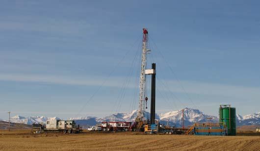
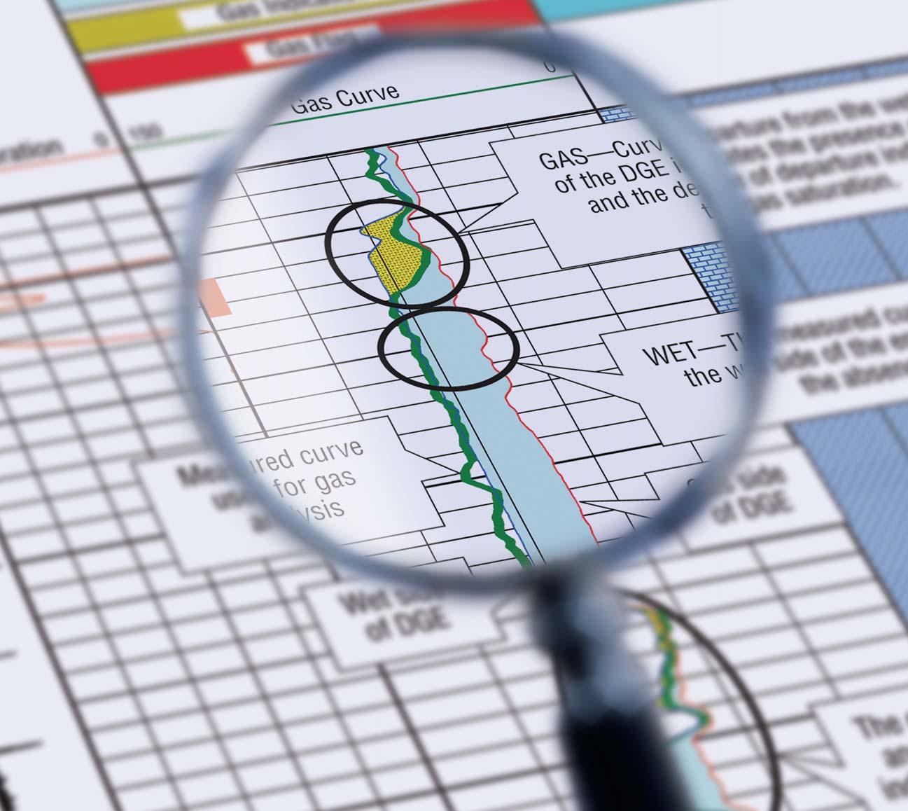
Now there is a better method for identifying gas and measuring gas saturation in cased holes. Baker Atlas is proud to introduce the GasViewSM service, a high-resolution measurementand analysis service that produces an exceptionally clear picture of reservoir gas.
Using Baker Atlas’ RPMSM pulsed neutron system, the GasView service can be used to measure reservoir gas in virtually any well. Applications range from identifying by-passed pay in wells nearing abandonment to openhole log replacement for new wells.
Contact your Baker Atlas representative today to learn how the GasView service can help you produce more gas with greater efficiency.