Please submit RESERVOIR articles to the CSPG office.Submission deadline is the 23rd day of the month,two months prior to issue date. (e.g.,January 23 for the March issue).
To publish an article,the CSPG requires digital copies of the document.Text should be in Microsoft Word format and illustrations should be in TIFF format at 300 dpi.For additional information on manuscript preparation,refer to the Guidelines for Authors published in the CSPG Bulletin or contact the editor.
COORDINATING EDITOR & OPERATIONS
Jaimè Croft Larsen
CSPG
Tel:403-264-5610 Fax:403-264-5898
Email:jaime.croftlarsen@cspg.org
TECHNICAL EDITOR
Ben McKenzie
Tarheel Exploration
Tel:403-277-4496
Email:bjmck@telusplanet.net
ADVERTISING
Kim MacLean
Corporate Relations,CSPG
Tel:403-264-5610,Ext 205
Email:kim.maclean@cspg.org
Advertising inquiries should be directed to Kim MacLean.The deadline to reserve advertising space is the 23rd day of the month, two months prior to issue date.All advertising artwork should be sent directly to Kim MacLean.
The RESERVOIR is published 11 times per year by the Canadian Society of Petroleum Geologists. This includes a combined issue for the months of July/August.
Advertisements,as well as inserts,mailed with the publication are paid advertisements.No endorsement or sponsorship by the Canadian Society of Petroleum Geologists is implied.
The CSPG Rock Shop is an attractive and affordable way to target the CSPG readership. Spaces are sold at business card sizes (3.5” wide by 2” high).To reserve space or for more information,please contact Kim MacLean at 403-264-5610,ext.205.
The contents of this publication may not be reproduced either in part or in full without the consent of the publisher.
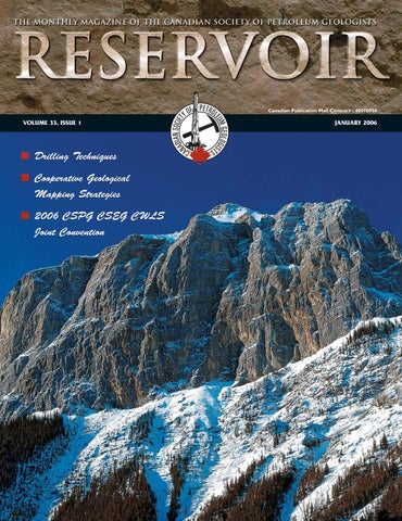
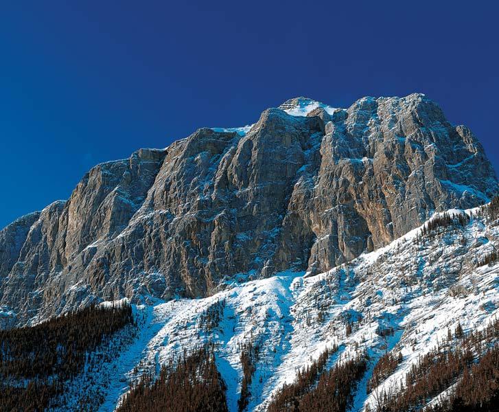
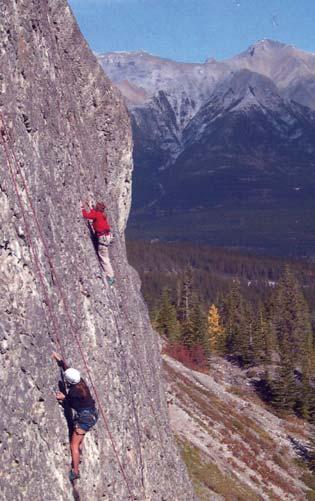
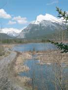
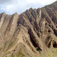
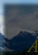
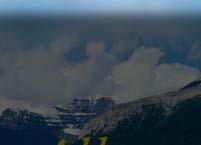
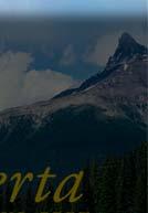
FRONT COVER Canmore,Alberta. EEOR (East End of Rundle),above Canmore,Alberta – a famous locality for rock-climbing enthusiasts.Bedded,Upper Devonian Fairholme Group carbonates at the base (partially treed and snow-covered), overlain by massive,cliff-forming Palliser Group limestones,with Carboniferous Banff Formation calcareous shales forming the peak.Viewed from the Bow River Valley,looking west.Photo by Jason Sullivan.Caption by Grant Mossop.
THE ROLE OF THE CSPG ON THE NATIONAL GEOSCIENCE STAGE
When I first came on to the executive in January of 2004,someone inquired of me what issue I was going to make my own – in short, what achievement would mark my presidential term.I must say the question completely caught me off guard.After mumbling some gibberish and quickly changing topics – I found myself reflecting further on the question.I had no master plan,no great agenda.All I really wanted to provide,with the help from the more experienced members of the executive, was solid stewardship of the Society – actually mere survival without impeachment didn’t strike me as setting the bar too high.But alas, nature,as they say,abhors a vacuum.If I was unwilling to seek out a mission,then apparently a mission would come looking for me.But I digress...let me start at the beginning.
# of Yearly Capital geoscientistsexpended ($B) Energy5,0006.00
Minerals4,0000.50 University2 4500.10
Government Agencies1,2000.13 Environmental1,5000.20
The non-renewable minerals and petroleum resource sectors in Canada spend approximately $6.5B in capital on an annual basis.Approximately 9,000 geoscientists (with a minimum of a B.Sc.) are employed in these industries,without whom,to state it bluntly but accurately,these industries could not exist.We are absolutely critical cogs in the upstream resource industry.We have found, mapped,then guided the development of, mineral,uranium,hydrocarbon,and coal resources whose cumulative production value has reached some $1.1T1.– and on annual basis represents 3.5% of Canada’s GDP.We are,as a profession,charged with exploring for and developing the resources that will sustain Canada’s economy and standard of living into the 21st century and beyond – a heady mandate! For all that,we virtually have no voice on the national stage. Our profession is literally “not on the radar screen of decision makers in Canada” (to quote a highly-placed bureaucrat in Ottawa – but the same is probably true for Edmonton).
In very approximate terms,the breakdown of geoscientists in Canada are shown in the following table:
Canada has had a national umbrella organization for the earth sciences since 1972. The Canadian Geoscience Council (CGC) was created by an order-in-council as a followup to recommendations from a report written by Dr.R.A.Blais,then affiliated with the Science Council of Canada.The CGC is the sum of its parts,that is,the constituent geoscience societies and/or organizations and their collective will and effort (i.e.,CSPG, CSEG,GAC,CWLS,PDAC,GSC,etc.).The 33-year history of the CGC is far from monochromatic,both good years and bad years,successes and failures have marked its existence.More recently,despite successful outreach and international coordination efforts,the CGC as a whole has been slowly sliding into irrelevance.The CSPG has had an ambivalent relationship to the CGC.We first joined in 1973,withdrew our membership from 1995 to 2002,and tentatively joined up again in 2003.From our society’s perspective, the CGC was generally viewed as neither effective,nor representative.
It seems almost unthinkable that a country such as Canada,with an economy critically linked to the non-renewable resource sector, would not have a vibrant and effective national (and international) voice for the geosciences. So,what to do - give up,or be part of the solution? The CSPG has decided on the latter, indeed we are now playing a pivotal leadership role in trying to effect positive and truly substantial change.John Hogg and Craig Lamb initially and cautiously brought us back to the table and Gerry Reinson in 2004 agreed to serve as a director on the CGC during this transition/renewal period.
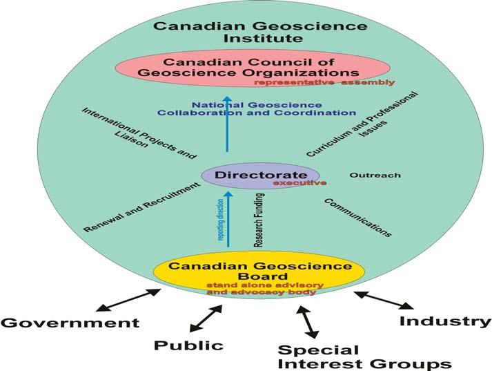
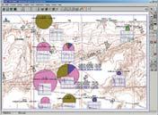
It is probably premature to state with confidence what will ultimately emerge (phoenix-like!),but I would like to share with you what is on the table at present.We have proposed a structural/organizational model that was “agreed to in principle” by key representatives of nearly all the major earth science-related societies in Canada at a meeting in Calgary this past June (Figure 1).
THE CSPG GRATEFULLY ACKNOWLEDGES ITS CORPORATE MEMBERS:
THE CSPG GRATEFULLY ACKNOWLEDGES ITS CORPORATE MEMBERS:
ABU DHABI OIL CO., LTD. (JAPAN)
BAKER ATLAS
BG CANADA EXPLORATION & PRODUCTION, INC.
BP CANADA ENERGY COMPANY
BURLINGTON RESOURCES CANADA LTD.
CALPINE CANADA
CANADIAN FOREST OIL LTD.
CONOCOPHILLIPS CANADA
CORE LABORATORIES CANADA LTD.
DEVON CANADA CORPORATION
DOMINION EXPLORATION CANADA LTD.
DUVERNAY OIL CORP.
ECL CANADA
geoLOGICsystems ltd.
GRIZZLY RESOURCES LTD.
HUNT OIL COMPANY OF CANADA, INC.
HUSKY ENERGY INC.
IHS ENERGY
IMPERIAL OIL RESOURCES LIMITED
LARIO OIL & GAS COMPANY
MJ SYSTEMS
MURPHY OIL COMPANY LTD.
NCE RESOURCES GROUP INC.
NEXEN INC.
NORTHROCK RESOURCES LTD.
PENN WEST PETROLEUM LTD.
PETRO-CANADA OIL AND GAS
PETROCRAFT PRODUCTS LTD.
PRECISION ENERGYSERVICES
PRIMEWEST ENERGY INC.
SAMSON CANADA
SHELL CANADA LIMITED
SPROULE ASSOCIATES LIMITED
STARPOINT ENERGY LTD.
SUNCOR ENERGY INC.
TALISMAN ENERGY INC.
TOTAL E&P CANADA LIMITED
The new organization has to be relevant, effective,representative,accountable,and “owned,” and the structure is designed to facilitate such an outcome.
The “Canadian Geoscience Institute” is merely a placeholder name for the new organization. The spokes on the wheel are the major standing committees (e.g.,Outreach, Communications),of which the most important is the one entitled National Geoscience Collaboration and Coordination. In all likelihood,the Geological Association of Canada will be given the key responsibility to staff and oversee this standing committee.All standing committees report to a Directorate (executive) that manages the overall business and programs of the organization.
The position of chairman/president of the Directorate will rotate between the five key sectors (see foregoing Table) every year.Each sector in turn will thus be responsible for nominating a president.For example,the Energy Sector would choose a candidate by means of consensus between the major Energy-related societies (CSPG,CSEG, CWLS) in consultation with CAPP and GSC Calgary.This nominee would then be ratified by a vote of the Canadian Council of Geoscience Organizations,which acts as the representative assembly of the new organization and meets approximately twice a year.In this way no one sector has undue influence.
The Canadian Geoscience Board is a semiautonomous arm of the new organization that
reports to the Directorate.Its role is primarily one of advocacy and advice (directed toward, or in response to,government and public policy),but it will also be the principal interface of the new organization with industry,special interest groups,and the general public.The Board will be composed of a blue-ribbon panel of distinguished and widely-respected geoscientists,one volunteer from each of the five sectors,coordinated by a paid executive-director.
To be sure there is much more hard work that needs to be done.Finding satisfactory funding mechanisms remains a major hurdle,but progress is being made.In short,there is a mood of optimism in the air and CSPG can be proud of the part it has played so far in bringing together (“de-fragmenting” is the buzz word),our rather disparate Canadian geoscience communities.
The CSPG is the largest geoscience technical society in Canada.As such,I firmly believe we have a responsibility,if not a moral obligation, to support and help nurture an effective national umbrella organization.This is a “mission” worth undertaking.
(Footnotes)
1.Data from 1886 to 2002 from Natural Resources Canada.This number is extremely misleading,as it does not take into account inflation.In terms of constant dollars and if today’s commodity prices were employed,the total would be truly staggering.
2.Numbers include faculty and post-doctoral fellows. They do not include undergrads or graduate students.
CORPORATE MEMBERS AS OF NOVEMBER 24, 2005
Figure 1.Schematic of proposed new national umbrella organization for the earth sciences.
FOR PINPOINTING NEW TARGETS
FOR PINPOINTING NEW TARGETS
Boyd PetroSearch gives you a decisive exploration advantage.
As leaders in geophysical interpretation for over 25 years, Boyd PetroSearch helps you make decisions with far greater accuracy and confidence than ever before.
Find out how we can improve your ability to drill on target by revealing complex interrelated geological features and reservoir patterns with unprecedented resolution and detail.
Please call:
TECHNICAL LUNCHEONS
JANUARY LUNCHEON
CSI:Dinosaur Provincial Park
SPEAKER
David A.Eberth
Royal Tyrrell Museum of Palaeontology
11:30 am Tuesday,January 10,2006
Annual General Meeting
TELUS CONVENTION CENTRE CALGARY, ALBERTA
Please note:
The cut-off date for ticket sales is 1:00 pm,Thursday,January 5th. Ticket price is $28.00 + GST.
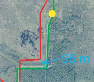
Since the onset of the Great Dinosaur Rush in 1910,the strata exposed at Dinosaur Provincial Park (upper Belly River Group, Upper Cretaceous) have yielded tens of thousands of vertebrate fossils,including hundreds of complete-to-partial articulated dinosaur skeletons.By any measure, Dinosaur Provincial Park is one of the richest Mesozoic dinosaur ‘graveyards’ in the world! Why such fossil abundance and species richness? Multidisciplinary taphonomic and geologic studies conducted during the past 20 years by paleontological and geological ‘CSIs’ can now answer this question.
Skeletons of large dinosaurs are common, whereas those of small dinosaurs and other vertebrates are rare.Dinosaur skeletons are overwhelmingly associated with paleochannel facies and,thus,represent animals that probably died in,or were quickly washed into paleochannels following death.The frequent presence of skin impressions suggests significant numbers of geologically instantaneous,meter-thick burial events.Isolated bones are orders of magnitude more abundant than articulated or associated skeletons.They occur in both overbank and paleochannel facies,but are most common in paleochannel lags.
Two kinds of bonebeds are present at the Park:multitaxic and monodominant.More than 200 multitaxic bonebeds are known and consist largely of poorly sorted channelhosted bone assemblages.Bonebed assemblages are interpreted as having been ‘dumped’ and buried in paleochannels during meandering or avulsion.At least 20
monodominant bonebeds,consisting mostly of bones from ceratopsian (horned) dinosaurs,have been documented at the Park.Intensive study has shown that they are derived from herds of ceratopsians that were episodically overcome by floods.
Catastrophic coastal plain flooding is the most parsimonious explanation for the taphonomic patterns observed at Dinosaur Park,and is also the best explanation for the cause of death for many of the Park’s dinosaurs.Under the influence of severe coastal tropical storms and associated storm surges,southern Alberta’s very-lowgradient coastal plain was episodically submerged by fresh water 200 km up-dip from the coastline.These regional floods episodically annihilated the dinosaurs,but probably spared many smaller aquatic, volant,and arboreal vertebrates.As water receded,significant numbers of bloated dinosaur carcasses were either swept into channels or stranded on the flood plain. Over a period of days to weeks,high rates of decomposition and sedimentation favored the rapid burial of many of the channel-hosted carcasses.
Across the coastal plain,carcasses of solitary dinosaurs littered the landscape. Sparse groups of carcasses from dinosaur “family” groups were also present,and,very occasionally,football-field size death assemblages of migrating centrosaurs were present.In the warm temperate to subtropical Campanian climate,a few seasons of scavenging,trampling,and rotting on the coastal plain resulted in the nearly complete disarticulation of carcasses.Over many years,meandering channels and channel avulsions reworked large areas of the floodplain,dumping partial skeletons and isolated bones into the channels,creating channel-lag bonebeds.
Crime scene evidence from the Park’s dinosaur victims is critical in unraveling the mystery of ‘who done it’ at the Park. Accordingly,it probably pays to think like a CSI when interpreting the depositional history of any vertebrate-fossil-rich unit.
BIOGRAPHY
David A.Eberth is a Research Scientist and the Curator of Geology at the Royal Tyrrell Museum in Drumheller,Alberta,where he has worked for the past 20 years.He received a B.Sc.in Zoology from the University of Massachusetts
in 1977,an M.A.in paleontology from the University of California,Berkeley,in 1981,and a Ph.D.in Geology from the University of Toronto in 1987.His primary research interests include the study of dinosaur paleoenvironments and vertebrate taphonomy (the influences on vertebrate fossil preservation).He has conducted field research in Canada,Argentina, Germany,China,Mexico,and the USA,and is currently engaged in three multi-year studies:
(1) the paleoenvironments and faunal changes in the Edmonton Group of southern Alberta, (2) the stratigraphy and paleoenvironments of middle and upper Jurassic strata in the Junggar Basin of northwestern China,and (3) the stratigraphy and paleoenvironments of upper Cretaceous non-marine strata in Coahuila,Mexico.
He is currently enjoying the ongoing interest in Alberta’s dinosaurs and upper Cretaceous gas-bearing formations.
HUGH REID’S
HUGH REID’S
JANUARY LUNCHEON
Real-time drilling,horizontal well geo-navigation: a planning,monitoring,and geo-steering road map
SPEAKER
Rocky Mottahedeh United Oil and Gas Consulting Ltd.
11:30 am Tuesday,January 24,2006
TELUS CONVENTION CENTRE CALGARY, ALBERTA
Please note:
The cut-off date for ticket sales is 1:00 pm,Thursday,January 19th. Ticket price is $28.00 + GST.
Convergence of improved directional drilling technology and advanced communication systems with real-time geo-model mapping tools has made geo-navigation while drilling possible. Geo-navigation and geo-steering while drilling have the potential to increase focused geologic placement of horizontal wells and lead to improved production recoveries with reduced operating cost per BOE.
A pre-drill/static geo-model framework and dynamic updates while drilling to the
geo-model provide the context for predrill planning and real-time geo-navigation of drilling horizontal wells.Real-time WD data from systems such as Pason Data Hub’s WITSML is incorporated to the geomodel at required frequencies.When structure deviation from the expected horizontal well prognosis is detected,a geo-model can be updated within minutes to provide a forward-looking window of the drilling process in a geologic context. Fast updates to the geo-model can facilitate focused geologic placement of horizontal wells within a short stratigraphic target reservoir window.
Minimums of three components are required for success of the process:
• An agile geo-model to keep up with changes in the structure while drilling,
• Location of the bit at any time using the WD survey and stratigraphic positioning of the bit using the Gamma Ray and other rock property MWD logs.
• Real-time communication technology such as WITSML and advanced directional drilling
Project wells will illustrate how data can be brought into a geo-model while drilling to update a geo-navigation roadmap in real
time and facilitate geologically focused well placement.The impact of the frequency of real-time geo-model updates will be discussed.Concerns of collision avoidance are addressed with incorporation of cones of uncertainty around the horizontal wells. An economic case for the geo-navigation process and its impact will be reviewed with emphasis on operational improvements,collision avoidance,and mitigation of gas and water in oil reservoirs.The paper will demonstrate how geo-navigation can improve the drilling success of a range of resource types such as gas,tight gas,oil,and heavy oil in horizontal well placement applications.
BIOGRAPHY
Rocky Mottahedeh,P.Eng.,P.Geol.,is the President of United Oil & Gas Consulting Ltd. He graduated University of Toronto,1981 with a B.Sc.in Geological Engineering.Rocky has 23 years of oil and gas experience with emphasis on new technology and integrated reservoir studies in gas,CBM,oil sands,and heavy oil at E&P companies in Canada and internationally.In the past eight years,Rocky has been involved in technology development focused on geo-modeling and geo-navigation through his company,United Oil and Gas Consulting Ltd.
The Veritas Experience
Veritas is a leading provider of integrated geophysical information and services worldwide. In Canada, our comprehensive suite of technologies and unmatched experience maximize your drilling success,optimize image quality, and minimize your exploration risk
When you need results, call Veritas. Calgary: 403.205.6000
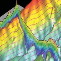
Land Depth Imaging
Before spudding your next well, work with Veritas to obtain a superior structural image and experience the advantages of effective collaboration between interpreter and imager.
Expertise
>largest team of depth imaging specialists in Canada
>largest in-house geophysical R&D team in Canada
>most experience acquiring and processing Foothills and Deep Basin data
Service
>dedicated processors, supported by industry-recognized imaging experts
>visualization facilities for effective QC and interactive analysis
>leverage communication and teamwork to achieve your goals
Technology
>advanced 2D and 3D model building tools
>anisotropic imaging algorithms designed for land data
>thousands of CPU nodes enable large throughput capacity
FEBRUARY LUNCHEON
Modern and ancient methane clathrate hydrate accumulations:comparative sedimentology of Mesozoic deposits from the Western Interior Seaway of North America
SPEAKER
Federico Krause University of Calgary
11:30 am Tuesday,February 7,2006
TELUS CONVENTION CENTRE CALGARY, ALBERTA
Please note:
The cut-off date for ticket sales is 1:00 pm,Thursday,February 2nd. Ticket price is $28.00 + GST.
Below modern seafloors,at water depths exceeding both storm wave-base and photic basement,methane clathrate hydrates are widespread.However,because
methane clathrate hydrates are inherently unstable,the prevailing historical consensus maintains that these materials lack a stratigraphic record.This presentation will illustrate that a variety of biological, chemical,and physical features have indeed been preserved.
Geophysical studies along modern continental margins and interior basins have identified vast tracts of sediments that contain clathrated hydrate gases,and columnar zones where gas evolution is active and ongoing.In some cases,the sediment interval containing clathrated gas hydrates can exceed 400 meters in thickness,and can extend laterally for many kilometers,well beyond zones of focused cold seepage.The volume of sediment below the seafloor that is saturated with variable quantities of gas and gas clathrate hydrates is therefore immense.
At the sites of active methane gas evolution and clathration,conditions near and below the seafloor typically are anaerobic and/or hypoxic,and nearby fluids are sulfidic and methanic.Significantly,underwater investigations conducted with human and remotely operated submersibles have confirmed that numerous benthic, chemosynthetic,and chemosymbiotic organisms live at these locations. Furthermore,the clathration of methane hydrates also results in the precipitation of a variety carbonate minerals that often are strongly depleted in 13C.This signal arises from the diagenesis of carbon in methane and is based on the fractionation between 12C and 13C isotopes.
In the Mesozoic Western Interior Seaway, calcite that is strongly depleted in 13C has been identified in limestone nodules of the Teepee Buttes Member of the Pierre Shale Formation of South Central Colorado.This formation is marine in origin and accumulated during the Campanian Stage (approximately 70 to 80 Ma ago).The limestone nodules are encased in shale and consist of an immense number of coquinoid,infaunal,nymphalucinid bivalves; pellet grainstones,packstones,wackestones and mudstones;and centimeter-sized, irregularly nodular spar-filled vugs.
The coquinoid nymphalucinid bivalves found in the Teepee Buttes Member belong to a well-known group of chemosymbiotic, infaunal pelecypods,the Lucinidae.In modern oceans this bivalve group is very
successful,occupying almost every possible marine seafloor environment known,as they are capable of living under anaerobic conditions.In contrast to other chemosymbiotic organisms,lucinids are mixotrophic opportunists.Modern lucinids combine siphonate filter feeding and chemosymbiosis with sulfate oxidizing bacteria,a behaviour that allows them to exploit sediment zones of anaerobic methane oxidation and sulfate reduction.
The sparry nodular vugs consist of three primary calcite cement phases that in paragenetic order are high-magnesium, botryoidal fibrous;ferroan “dendrolublinite;” and ferroan blocky.The botryoidal fibrous cements have 13CPDB ratios that range from -41.5‰ to -46.3‰,a signal that is strongly indicative of a methanogenic carbon source for these cements. 13CPDB ratios of dendrolublinite and blocky calcites have greater separation,ranging from -12.6‰ to -40.8‰ and -15.1‰ to -44.5‰,respectively. These cements also originate from the diagenesis of methane, but followed a geochemical path that incorporated the reduction of iron.All three sparry cements grew from “free surfaces” into open space.The petrographic pattern observed points to the presence of a precursor material that displaced the encasing shales and pelletal and nymphalucinid carbonates,and which subsequently “disappeared” in stages.In modern marine shales the clathration of methane gas is often nodular and displacive,and is also accompanied by carbonate mineral precipitation.
In conclusion,Teepee Butte Member limestone nodules preserve biological, chemical,and physical evidence indicative of active methane gas diagenesis and clathrate hydrate consolidation and dissociation during sedimentation in the late Mesozoic foreland basin of North America.
BIOGRAPHY
Federico (Fed) Krause is a professor in the Department of Geology and Geophysics at the University of Calgary who worked in the petroleum industry and government prior to joining the university.He is working with a great group of students on a number of projects,including carbonate mud-mounds and petrifactions from gas clathrate hydrates.
FEBRUARY LUNCHEON
Collisional fold-and-thrust belts detached on salt
SPEAKER
Mark G.Rowan
Rowan Consulting Inc.
11:30 am
Tuesday,February 21,2006
TELUS CONVENTION CENTRE CALGARY, ALBERTA
Please note:
The cut-off date for ticket sales is 1:00 pm,Thursday,February 16th. Ticket price is $28.00 + GST.
Collisional fold-and-thrust belts detached on salt can be divided into two subsets: those where the pre-kinematic section is undeformed,and those where diapirs and minibasins were established prior to the onset of shortening.Examples from the Sierra Madre Oriental of Mexico,the Flinders Ranges of South Australia,and the Zagros Mountains of Iran are used to illustrate the very different geometries that result.
In cases where pre-shortening deformation is absent,structural styles are relatively simple,characterized by regular wavetrains of parallel,elongate detachment folds that are broadly symmetrical.Individual folds are typically cylindrical over much of their lengths and then conical and more open where they plunge gently toward their terminations. Thrust development,variations in fold orientation,and anomalously steep plunges on some folds are attributed to the spatial and thickness distribution of the décollement layer.
In fold-and-thrust belts where salt withdrawal and diapirism predated the shortening,the pre-existing structural architecture and the consequent variable strength of the overburden control the deformation and yield much more complex geometries.Modelling by B. Vendeville of circular minibasins separated by a polygonal pattern of salt ridges,with diapirs at the ridge intersections,shows that the weak diapirs are squeezed,the intermediate-strength ridges form a complex pattern of contractional structures,and the strong minibasins simply translate and may rotate.The result is a polygonal array of folds,thrusted
folds,strike-slip faults,and even extensional structures that typically intersect at,and plunge away from,the diapirs.
If early salt withdrawal and diapirism lead instead to linear salt walls and elongate withdrawal basins,later shortening structures have the same preferred orientation.Moreover,strong strata around the tips of salt walls result in a strike-parallel strain gradient in which the centers of the walls shorten more than the ends.With enough shortening,steep salt welds form that link two remnant diapirs at the tips of the walls.Further shortening leads to folding above the welds,producing geometries where diapirs are located at fold terminations rather than culminations.
BIOGRAPHY
Mark received his B.S.Biology from the California Institute of Technology in 1976,his M.Sc.in Geology from the University of California at Berkeley in 1982,and his Ph.D.
in Geology from the University of Colorado at Boulder in 1991.While persuing his academic career Mark gained industry-related experience with Sohio Petroleum Co.(198285),Geo-Logic Systems (1985-89),and Alastair Beach Associates,Glasgow Scotland (1989-92).After successfully defending his Ph.D.,Mark joined the University of Colorado as a research associate and professor from 1992-1998.He is presently President of his own company,Rowan Consulting Inc.,in Boulder Colorado.
Mark’s professional interests include styles and processes of salt tectonics,salt-sediment interaction,geometry and kinematics of fold-and-thrust belts,and applications to petroleum exploration.He is currently a member of the American Association of Petroleum Geologists,Geological Society of America,and International Association of Structural/ Tectonic Geologists.
DIVISION TALKS INTERNATIONAL DIVISION
Petroleum geology of the Kutei Basin,Indonesia
SPEAKER
David Paterson
Consultant
12:00 Noon
Monday,January 16,2006
Encana Amphitheatre
2nd floor, east end of the Calgary Tower Complex 1 Street and 9th Avenue S.E. Calgary, Alberta
The Kutei Basin,located onshore and offshore eastern Borneo,is the most productive basin in Indonesia with discovered volumes of 15.5 bboe.There have been four phases of petroleum exploration,beginning in 1897 with the successful drilling of oil seeps located along onshore anticlines.
The start of the PSC system in the late 1960s saw the discovery of two giant oil fields and three giant gas/condensate fields along two outboard subsurface fold trends, parallel to the onshore productive anticlines.These large structures have multiple stacked Miocene deltaic channel sands with gross hydrocarbon columns of 10,000 ft.
Further offshore,application of sequence stratigraphy concepts and 3-D seismic data imaging in the early 1990s led to the discovery of two giant gas/condensate fields in combination structural/stratigraphic traps.A further phase of onshore exploration at this same time was only marginally successful.
Over the past seven years,UNOCAL has had a series of deepwater discoveries drilled on a low-cost basis using their SX engineering/ geology methodology.They are bringing into production the first of their deepwater oil fields this year and have found 15 TCF of gas reserves to feed the eight LNG trains at Bontang terminal in the future.
The aim of this presentation will be to provide a stratigraphic,structural,and petroleum system framework of Kutei Basin Tertiary geology from central Borneo to the deepwater.The basin provides many
unique geological models that may have application in other areas of the world.For example,what are the kinematics when regional contraction inverts the syn-rift grabens lying below a detached deltaic growth fault and toe thrust section? Or, what are the source rock properties of the Miocene deltaic coals and carbonaceous shales,and what changes when this material is reworked during lowstands and is deposited with deepwater sands as an imbedded source rock – a model recently proven successful from deepwater Sabah to the Tarakan.Or what is the sandstone reservoir facies distribution in a delta system where tidal influence is the principal factor?
BIOGRAPHY
David Paterson has a Combined Honours Degree in Geology and Geophysics from UBC. His career began 30 years ago with HBOG in Calgary and continued with LASMO in London,Calgary,Halifax,Jakarta,and London
again.David has been consulting for the past four years,providing both geophysical and geological interpretation services on projects in North Africa,Brazil,Colombia, Turkmenistan,Pakistan,Malaysia,and the U.K.For the past two years he has been based in Calgary.
The material for this presentation comes from his five years as Exploration Manager of VICO and LASMO operations on Borneo.He has published several papers on the Kutei Basin, covering such diverse topics as petroleum systems,sand provenance,biostrat pitfalls, carbonate reservoirs,and structure.
INFORMATION
There is no charge.Please bring your lunch. Refreshments are provided by Encana and Glendower International Limited.For more information or to give a talk in the future, please contact Ken Jones at 532-1883 or ken.jones@fuel-x.ca.
SEDIMENTOLOGY DIVISION
Simple modeling of quartz cement can lead to exploration success
SPEAKER
Jean-Yves Chatellier (Consultant)
12:00 Noon
Wednesday,January 18,2006
Nexen Annex Theatre
+15 Level, North of C-Train Platform 801 - 7th Avenue SW
Calgary, Alberta
Deep clastic plays are commonly associated with quartz cement precipitation. Understanding the quartz cement distribution can lead to successful drilling in difficult but sometimes rewarding areas.Whereas diagenetic modeling is often associated with complex fluid flow equations,a simpler modeling approach has proven to be very reliable in many basins around the world.The main difference with traditional diagenetic modeling is that we assume the amount of silica in the system to be sufficient to produce quartz precipitation with no outside sourcing. Essentially,the amount of quartz cement
depends on the length of time of exposure to temperature above 80 degrees celsius and on the grain size and composition of the considered sandstone.Timing of the hydrocarbon migration is a crucial parameter as hydrocarbon emplacement stops the diagenetic process and preserves the remaining porosity from further deterioration.
The best results are obtained after calibrating the following four essential input parameters: quartz cement quantitatively estimated by cathodoluminescence,thin-section-based mineralogical composition,expected grain size and vitrinite-based burial history.Predictions can be made on a formation basis and can incorporate lateral facies variations.Forward modeling through time allows the ability to combine porosity evolution,tectonic deformation,trap emplacement,and hydrocarbon migration.
Such modeling has led to significant oil discoveries in other parts of the world.The method described has direct applicability to the Western Canada Sedimentary Basin.
BIOGRAPHY
Following postgraduate studies in sedimentology in
Calgary and in tectonics in Paris,Jean-Yves Chatellier worked around the world for Petroconsultants and Shell International before accepting a job as senior research geology advisor for Petroleos de Venezuela.His first and main task was to address the problem of reservoir prediction in deep basin and develop methods to predict quartz cement distribution and diagenesis.The work resulted in the discovery of the giant Tomoporo Field in the Zulia oriental region.The latter part of his seven years in Venezuela was associated with solving complex thrust belt problems.
Jean-Yves is a presently a Calgary-based geological consultant working mostly on the WCSB and focusing on plays that integrate sedimentation, diagenesis,and tectonics.
INFORMATION
Talks are free – don’t forget to bring your lunch! Coffee and donuts will be provided.If you are interested in joining the Sedimentology Division e-mail listing which currently provides luncheon reminders,or if you care to suggest a technical topic or present a talk to the division,please contact Scott Rose at (403) 875-7673 or scott.rose@cspgsedimentology.org.
ENVIRONMENTAL GEOLOGY DIVISION
The City of Calgary - an overview of environmental issues
SPEAKERS
Marty Bobyn and Rey Calosing Utilities and Environmental Protection Department,The City of Calgary
In recent years,the City of Calgary has experienced rapid population growth.The magnitude and scale of growth has resulted in an increased demand for the development of residential,commercial,industrial,and recreational land use along with supporting utility servicing and roadway infrastructure. Managing environmental issues associated
with the City’s rapid growth has presented major challenges for City of Calgary staff.A significant environmental issue consists of impacts to the City’s soil and groundwater regime from current and/or historical land use activities including oil refineries,pipelines, landfills,railways,and other industrial and commercial operations.This presentation will provide an overview of environmental impacts within the City of Calgary and will describe how City staff identify and mitigate these issues to ensure the environmental condition of land is suitable for the intended use.Specific focus will be on environmental issues associated with land development proximal to active and abandoned oil and gas facilities and on recent environmental initiatives undertaken by the City to address these issues.Case studies,where applicable, will also be presented.
BIOGRAPHY
Marty Bobyn is an Environmental Specialist with over 15 years of experience in managing environmental issues associated with
STRUCTURAL DIVISION
Fracture characterization in low permeability reservoirs
SPEAKER
Satyaki Ray
Schlumberger Data and Consulting Services
12:00 Noon
Thursday,January 12,2006
Petro-Canada
West Tower,room 17B/C (17th floor) 150 6th Ave SW Calgary,Alberta
Fracture classification and characterization is becoming increasingly important –particularly from a hydrocarbon reservoir economics and permeability point of view. However,there still exists a host of terminology related to fractures which are geometric,descriptive,genetic or hybrid. Some terms originate in engineering and some in geology.The abundance of terms can be daunting for relatively less experienced analysts.In this talk,an attempt has been made to categorize fracture terms based on their origin,and references have been made to old and new work done in this area.This
should help the user with some basics of fracture analysis using geoscientific data.It should also help in differentiating natural from induced fractures.
Natural fractures are significant contributors to oil and gas production from both conventional and non-conventional geological strata.The reservoirs in these geological strata could have moderate to high porosity and permeability as well as low porosity and permeability.Open natural fractures in all reservoirs may act as boons to producibility. Sometimes they may act as risks causing early water breakthrough in hydrocarbonproducing wells.This is particularly critical for low permeability sandy and shaly reservoirs when primary porosity is either obliterated by diagenesis or reduced by stresses.The permeability in such cases is driven mostly by natural fractures.Coals often have genetic fractures called cleats which contribute to producibility of methane gas.The challenge is often manifested in the form of lack of resolution in formation evaluation tools for the subsurface and the scale of these features.
In this talk,a brief discussion covers the scale and relative occurrence of fractures in various
contaminated sites.Since 2001,Mr.Bobyn has been with the City of Calgary where he has been part of a multi-disciplinary team involved with the investigation,assessment and remediation of contamination on City lands.Mr.Bobyn holds Bachelor of Science degrees in Geology and Geography from the University of Saskatchewan.
Mr.Rey Calosing is an Environmental Specialist with nine years of experience in the management of contaminated sites and with regulatory compliance.Currently,Mr.Calosing is responsible for reviewing development applications and resolving any outstanding associated environmental issues.Mr.Calosing is a registered Professional Engineer with APEGGA and graduated with a Bachelor of Science degree in Environmental Engineering from Montana Tech.
INFORMATION
All lunch talks are free and open to the public. Please bring your lunch.For information or to present a future talk for the Environment Division contact Andrew Fox at andrew.fox@ megenergy.com.
PROUD SPONSORS
types of low permeability reservoirs and how to describe them in the subsurface using highresolution borehole images,logging while drilling,outcrops,sonics,and seismics.The aim is to demonstrate global and local examples of analysis and visualization of fractures using electrical and acoustic images in the subsurface.This information could be integrated with other reservoir engineering information to accurately model the reservoir.
BIOGRAPHY
Satyaki Ray,P.Geol.,works as a Senior Geologist for Schlumberger Data and Consulting Services (DCS) in Calgary,Alberta, Canada.He has 16 years industry experience, with 8 years in oil and gas E&P and 8 years with Schlumberger (conventional,heavy oil, and CBM analysis).Author of several international papers,Satyaki specializes in Geosteering,Logging while drilling,fracture, structure,and sedimentary analysis of rocks using outcrops,borehole FMI / OBMI images and advanced well log data.He is a professional geologist with APEGGA and is also active in geological and petrophysical consulting for shallow gas,CBM,and heavy oil in Canada and worldwide.
(Continued on page 38...)
GEOMODELING DIVISION
Bridging the missing-scales:
New developments in small-scale heterogeneity modeling
SPEAKER
Renjun Wen
Geomodeling Technology Corp.
12:00 Noon
Wednesday,January 25,2006
ConocoPhillips Auditorium
3rd Floor- above Plus 15+ level
401 9th Avenue SW Calgary, Alberta
Reservoir heterogeneity exists at multiple scales,from pore structures,bedding structures,internal stratification,litho-facies, to fault blocks.Conventional reservoir modeling workflows do not consider multiscale heterogeneity in an integrated manner, which results in unrealistic and inaccurate reservoir models.Applying such models in reservoir simulations increases the uncertainty in history matching and reserve predictions.
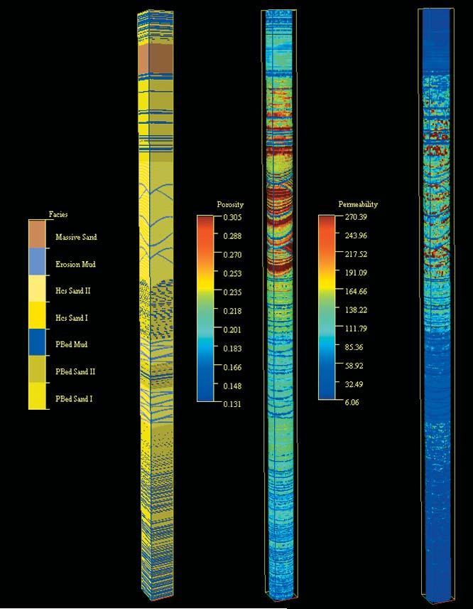
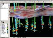
The original small-scale modeling approach was developed in order to model the heterogeneity at bedding structure scales (Wen et al.,1998),which bridge the scale gaps in core data and well log data.The near wellbore models (e.g.,Figure 1) simulated from the process-oriented modeling method can be used to improve the estimation of petrophysical properties from well log data and core data.Case studies demonstrate that this geological modeling approach can be used to estimate facies-dependent permeability anisotropy, such as kv/kh in heterolithic reservoirs (Elfenbein et al.,2005;Nordhal et al.,2005, Ringrose et al.,2003;Ringrose et al.,2005; Ruvo et al.,2005).
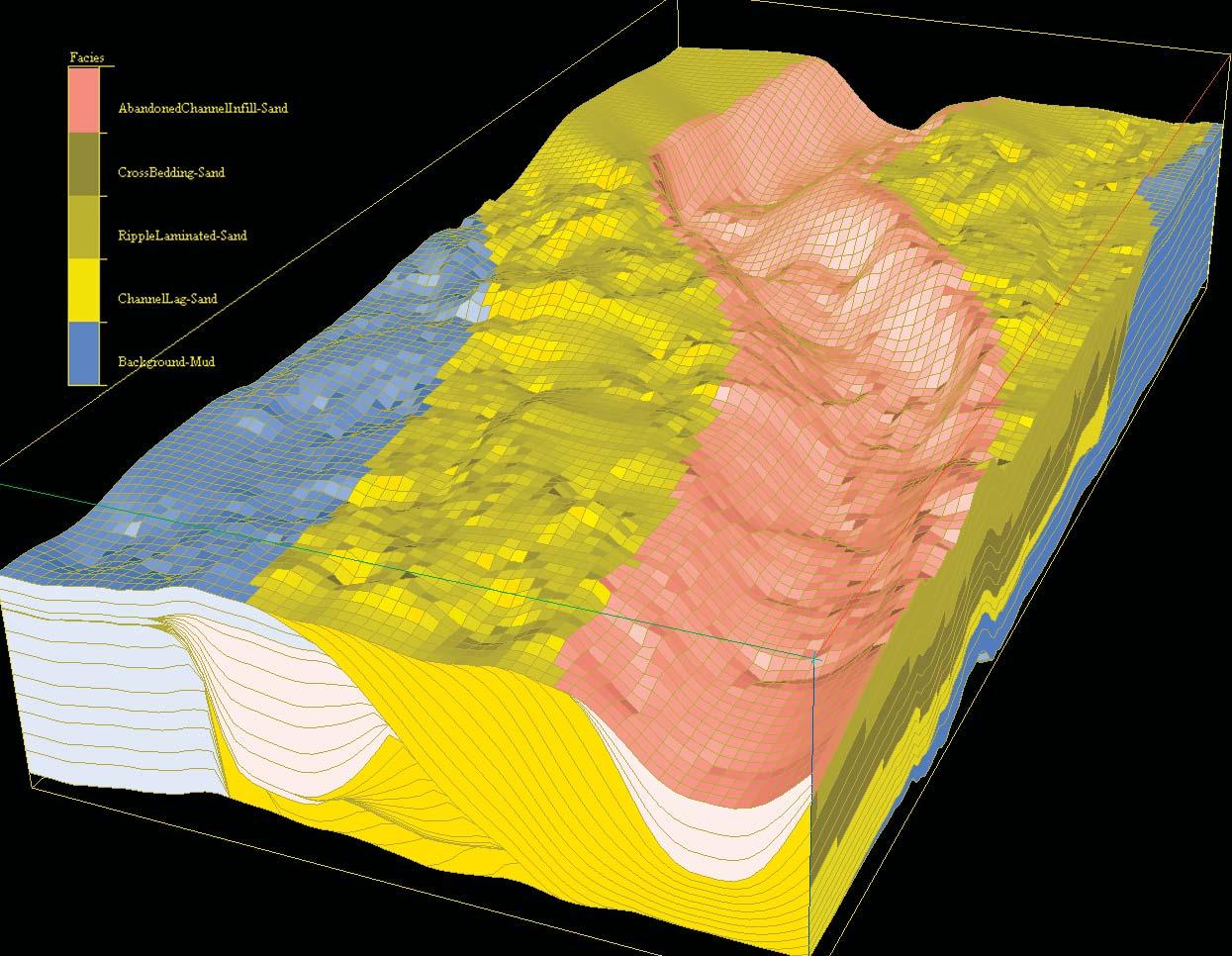
Recent developments have extended the original process-oriented method to simulate larger scale geological models,such as channel infill architectures,depositional lobes,and bar forms.The resulting models more realistically represent reservoir heterogeneity in terms of fluid flow properties.These new developments provide the modeling methodology to bridge the scale gaps between well log data and seismic data.More realistic uncertainty estimates can be obtained from this type of modeling (Barton et al.,2003).Simulations of stratigraphic features at sub-seismic
scales,i.e.< ~ 30 m,(Figure 2) can also be applied to the interpretation of seismic attributes (Wen,2004).
Another new development in the processoriented modeling approach is the direct upscaling of reservoir properties (saturation,porosity,and absolute and relative permeability) from both bedding structure models and sub-seismic stratigraphic models.This allows geologists and reservoir engineers to evaluate distribution of flow properties from all possible geological scenarios by considering multi-scale heterogeneity,thereby improving the prediction of reserve volumes and production profiles.
REFERENCES
Barton,M.,Van der Vlugt,F.,and Slik,P.2003: Modeling Uncertainty in Discount Factors for Turbidite Channel Reservoirs (abs.).Presented at the AAPG Annual Meeting 2003,Salt Lake City,Utah,USA,May 11-14,2003.
Elfenbein,C.,Husby,Ø.,and Ringrose,P.S.2005: Geologically-based estimation of kv/kh ratios:an example from the Garn Formation,Tyrihans Field,Mid-Norway.In A.G.Doré and B.A.Vining, (eds.):Petroleum Geology:Northwest Europe and Global Perspectives,Proceedings of the 6th Petroleum Geology Conference,Geological Society,London,537-544.
Nordhal,K.,Ringrose,P.S.,Wen,R.2005:
(Continued on page 20...)
Figure 1.A near-wellbore model generated with bedding structure modeling software,SBEDTM.Such models have successfully been used to estimate kv/kh from very heterolithic reservoirs.
(...Continued from page 20)
Petrophysical characterization of a heterolithic tidal reservoir interval using a process-based modelling tool.Petroleum Geoscience,v.11, 17-28.
Ringrose,P.S.,Skjetne,E.,and Elfenbein,C. 2003:Permeability Estimation Functions Based on Forward Modeling of Sedimentary Heterogeneity.SPE paper 84275.Presented at the SPE Annual Technical Conference and Exhibition,Denver,Colorado,USA, October 5-8,2003.
Ringrose,P.S.,Nordahl,K.,and Wen,R.2005: Vertical permeability in heterolithic tidal deltaic sandstones.Petroleum Geoscience,v.11,29-36.
Ruvo,L.,Scaglioni,P.,Cozzi,M.2005:A new approach to the petrophysical characterization of thin layered reservoirs (abs.).Presented at
the EAGE 67th Conference & Exhibition, Madrid,Spain,June 13-16,2005.
Wen,R.,Martinius,A.W.,Næss,A.and Ringrose, P.S.1998:Three-Dimensional Simulation of Small-Scale Heterogeneity in Tidal Deposits – A Process-Based Stochastic Simulation Method.In A.Buccianti,G.Nardi,and R.Potenza,(eds.): Proceedings of the 4th Annual Conference of the International Association of Mathematical Geology,Ischia,De Frede,Naples,129-134.
Wen,R.,2004:3D Modeling of Stratigraphic Heterogeneity in Channelized Reservoirs: Methods and Applications in Seismic Attribute Facies Classification.CSEG Recorder, March,38-45.
BIOGRAPHY
Renjun Wen obtained a Ph.D.in Petroleum Geology from Norwegian University of Science
and Technology in 1995 and a B.Sc.from Yanzhe University in China in 1983.He has published over 30 research papers in the fields of reservoir modeling,mathematical geology, and seismic interpretation.Dr.Wen has collaborated with major international oil companies to develop new reservoir modeling methodology and software since he move to Calgary from Norway in late 1996.
INFORMATION
There is no charge.Non-members of the CSPG are also welcome.Please bring your lunch. For details or to present a talk in the future,please contact David Garner at 403-233-3126,e-mail:David.Garner@Conoco Phillips.com or Peter Dankers at 403-770-0350, e-mail Peter.Dankers@divestco.com
Figure 2.A reservoir-scale geological model that includes sub-seismic-scale stratigraphic surfaces generated with SBED StudioTM.Channel infills are not represented by objects, but by stratigraphic layering,thus making it possible to represent important flow barriers,such as shale drapes.
EMERGING PETROLEUM RESOURCES DIVISION
Valuing information in unconventional reservoirs
SPEAKER
M.Kent Burkholder
Decision Frameworks
12:00 Noon
Wednesday,January 18,2006
ConocoPhillips Auditorium
(3rd Floor – west side of building) 401-9th Avenue SW
Gulf Canada Square Calgary, Alberta
In order for information to add value to a project,it must have the potential to change a future decision.Unlike traditional hydrocarbon plays,the big uncertainty we are often evaluating in unconventional reservoirs is not whether hydrocarbons exist but rather whether we can develop them economically. The decisions that might change with new information are most often optimization decisions,like well spacing and well positioning to maximize productivity.These “How do we develop?” problems can be difficult to evaluate correctly for unconventional reservoirs.
This presentation will review how to value information and how to recognize the basic patterns involved in doing so in unconventional plays.Two case studies will be included:
• Valuing a cased-hole pressure test to decide whether to downspace a tight gas development,and
• Valuing an expansive seismic program to better design a complex,tight gas field development.
Both examples underscore the difficult task of valuing information in unconventional reservoirs and highlight the nuances involved in doing so correctly.
BIOGRAPHY
Kent Burkholder is a Director of Decision Frameworks - a unique decision analysis training, consulting and software firm with offices in Houston,USA and Calgary,Canada.Founded in 1999,Decision Frameworks uses a team-based, functional approach in bringing practical decision analysis to the petroleum industry.
Mr.Burkholder is an advisor and consultant with broad experience in petroleum economics,decision analysis framing,economic modeling,and implementation.He is highly skilled in decision facilitation and has developed and conducted many decision analysis,economic modeling,and
value of information workshops and courses, covering a wide range of topics including exploration,appraisal,and development strategy; refinery expansion;and new technology research and application decisions.His industry experience in the oil and gas sector allows him to provide a high level of support to executive and business unit decision-makers.
Mr.Burkholder has worked in the petroleum industry for over twenty years been with a strong history in both reservoir engineering and petroleum
economics.He holds a B.A.Sc.in Mechanical Engineering,is a professional engineer and member or the Society of Petroleum Engineers.
INFORMATION
EPRD noon-hour talks are free and do not require registration.Non-CSPG members are also welcome to attend.Please bring your lunch.If you would like to join our email distribution list, suggest a topic,or volunteer to present a talk, please send a message to Michelle.Hawke@ bp.com or fredhyland@mcleay.ab.ca
JACK PORTERVIGNETTES OF CANADIAN PETROLEUM GEOLOGY
J.B. TYRRELL’S AND DONALDSON DOWLING’S JOINT INVESTIGATION OF THE MESOZOIC AND PALEOZOIC STRATIGRAPHY OF MANITOBA 1887-1891
Joseph Tyrrell’s and Donaldson Dowling’s Geological Map of North Western Manitoba and portions of the District of Assiniboia and Saskatchewan,dated 1891,illustrates,not only the surface expression of the prePleistocene distribution of undifferentiated Silurian and Devonian strata,designated F and E respectively,but as well,a stratigraphic differentiation of the Cretaceous sequencies. The terminologies applied to their subdivision of this system,as portrayed on their map,are the same formational names introduced by Meek and Hayden (1862), namely:Dakota,Benton,Niobrara,and Pierre, whose type sections are located in Nebraska, Montana,and South Dakota in proximity to the Missouri River.
The basal Lower Cretaceous Swan River Group (Kirk,1930),a predominately sand facies,exposed along the Swan River,was identified by Tyrrell as the Dakota Formation,although its type section,near the town of Dakota,Nebraska was dated as Upper Cretaceous.He classified the overlying black marine shale sequence of the Ashville Formation (Kirk,1930) as Benton.Immediately above the Ashville Formation are two speckled shale zones; the lower being the Favel Formation (Wickenden,1945) and the upper known as the Boyne Member (Kirk,1930) of the Vermilion River Formation (Kirk,1930). These two biostratigraphic zones are recognized in the subsurface as the “first speckled shale” and the “second speckled shale.” The white calcareous “specks” are due to the flocculation of foraminifera.The Favel Formation exhibits,in outcrop,thin beds of fossiliferous limestone,which Tyrrell identified as the Niobrara Formation.He omitted to include the upper Boyne Member.He further assigned the Upper Cretaceous marine shale sequence of the Riding Mountain Formation to the Pierre Formation.Coarse clastics,sourced by the Laramide orogeny and associated with the Pierre (Belly River Group of Dawson and McConnell,1884) were gradually replaced eastward by marine shale over a distance of some 500 miles from their provenance.
The American-derived terminology,as depicted on their forementioned map, includes,as well,a qualifying alphabetical/ numerical symbolic designation,namely in ascending order:K2C (Dakota),K3a (Benton),K3b (Niobrara),and K3c (Pierre). Such symbolic naming was borrowed from George M.Dawson’s and R.G.McConnell’s Geological Map of the Region in the vicinity of the Bow and Belly Rivers,North West Territory,dated 1884 by the Geological and Natural History Survey of Canada.Their legend,in respect to Cretaceous strata,list the names of the following sequences with a corresponding symbolic designation which,in ascending order,are:Lower Dark Shales (K3a),Belly River Series (K3b),and Pierre,including Fox Hill (sic) (K3c). Dawson’s and McConnell’s Lower Dark Shales (K3a) would appear to include both the Benton and Niobrara formations;their Belly River Series (K3b),suggests the lower Pierre and their Pierre (K3c) being the upper Pierre (Bearpaw formation,Hatcher and Stanton,1903).
Tyrrell (1892) had introduced the terms Millwood and Odanah formations for Upper Cretaceous shale beds,both of which he inferred are stratigraphically related to his Pierre (K3c) subdivision.His Millwood formation has proven to be difficult in tracing, apparently incorporating strata ranging from within the Vermilion River Formation into the Riding Mountain Formation.His overlying Odanah Formation,a hard siliceous shale,is associated with the Riding Mountain Formation and appears to represent an erratic lithologic phase (Kirk,1930).For these reasons,the two names have become obsolete (Wickenden,R.T.D.;Mesozoic Stratigraphy of the Eastern Plains,Manitoba and Saskatchewan,Memoir 239,Geological Survey of Canada,pub.Edmund Cloutier, Ottawa,pp.2,6 and 48).
The stratigraphic identification of exposed bedrock described by pioneer geologists in regions,where little if any geologic investigation had been undertaken,required formal names,usually taken from geographic entities or physiographic features associated with or in proximity to the outcrops described.However,to assign a temporary nomenclature,utilizing a combination of an alphabetic symbol and number,afforded some flexibility for future revision,pending eventual formal naming and approval by a stratigraphic committee.With the surge in
exploratory drilling in the Western Canada sedimentary basin following the discovery of the Leduc oil field in February,1947 as well as subsequent discoveries of Jurassic oil fields in southwestern Saskatchewan;this symbolical designation was applied to subsurface strata.Invariably,the affiliated system of the stratigraphic units described were prefaced with a capitalized letter,i.e., “D” for Devonian,“J” for Jurassic,etc.The qualifying formational names were given a numerical designation in reversed chronological order to those devised by Dawson and McConnell (1884) and Tyrrell and Dowling (1891).Notable was Imperial Oil’s initial numerical naming of some Upper Devonian formations,in descending order, namely:DI (Wabamun),D2 (Nisku) and D3 (Leduc).Again,in southwestern Saskatchewan,following the early oil discoveries from Jurassic reservoirs,the subdivision for formations and their associated members were tentatively approved by the Nomenclature Committee of the Saskatchewan Geological Society in the following descending order:J1a,J1b,and J1c (Vanguard formation in upper,middle,and lower members);J2a and J2b (Shaunavon Formation,upper and lower members);J3 (Gravelbourg Formation) and J4 (Watrous Formation).The formal names were subsequently introduced by Milner and Thomas (1954).
Interestingly,the first subdivision of Cretaceous strata in the north-central region of the American Plains,was undertaken by F. V.Hayden in 1853 along the Upper Missouri River and adjoining badlands,in what is now western North Dakota and northeastern Montana.The region,at that time,was part of Nebraska Territory.He continued his reconnaissance survey the following two field seasons,relying on Missouri River paddle steamers and keelboats as well as John Jacob Astor’s American Fur Company for transportation and protection.Hayden made, apart from his stratigraphic descriptions, extensive collections of fossils,for the most part obtained from the banks of the Missouri River.This combined data became,initially,the basis for his five-fold numerical terminology, which was subsequently replaced with formal stratigraphic names.They,in ascending order, are as follows:Dakota (No.1),Fort Benton (No.2),Niobrara (No.3),Fort Pierre (No.4), and Fox Hills (No.5) (1945,Fenton,C.L.and Fenton,M.A.:Giants of Geology,Doubleday and Co.,New York,p.229).
Tyrrell’s and Dowling’s,1891 geological map contains at its base a combined topographic and stratigraphic cross-section entitled A – B whose horizontal scale of eight miles to the inch conforms with the map’s scale.The section is based on a sea level datum having a vertical scale of 2,000 feet to the inch.Its orientation is southwest – northeast and is titled:Section from Porcupine Mountain to the mouth of the Saskatchewan River. Topographically,it exhibits a profile of the bedrock surface of the Cretaceous expressed Porcupine Mountain with its east-facing 1,500 foot escarpment across a six-mile slope.This incline is an expression of the fairly abrupt erosional edges of successively older Cretaceous formations, whose disappearance marks the relatively flat surface of the Interlake area.Here,the exposed lower Paleozoic rocks occur at surface elevations averaging 850 feet above sea level.The gradual erosional attenuation, eastward,of the exposed Devonian (F) and Silurian (E) strata is apparent in the crosssection.The top of the buried CambroSilurian (Ordovician) strata represents the oldest stratigraphic boundary shown on the section.
During Joseph Tyrrell’s investigation of exposures of Devonian strata along the south shore and islands of Dawson Bay,Lake Winnipegosis in July,1889;he was able to ascertain the stratigraphic boundary separating the Middle Devonian assemblage from its overlying Upper Devonian counterpart.It was his discovery of a genus of a large brachiopod known as Stringocephalus burtini,which dated its host rock as Middle Devonian age.This key index fossil was found,in association with varieties of many other fossils,described by Tyrrell as being imbedded in a matrix of “saccharine” (granular) and “vesicular” (vuggy) dolomite (reef facies).Tyrrell named this Middle Devonian section the Winnipegosan Formation.Baillie’s (1953) Winnipegosis Formation incorporates Tyrrell’s Winnipegosan with the underlying Elm Point Formation (Kindle,1914),the latter being the platform for the reef or inter-reef facies. Tyrrell (1889) named his Upper Devonian the Manitoban Formation,describing it as a “basal red and grey shale (“Second Red Beds”),overlain by “hard limestone” and capped by “red argillites” (First Red Beds), which in turn,is overlain by “light grey brittle limestone.” Baillie’s Dawson Bay Formation (1953) is restricted to Tyrrell’s “basal red and grey shale” (“Second Red Beds”) and overlying “hard limestone” bed. Notwithstanding,Warren and Stelck (1950) “tentatively include the Dawson Bay in the Stringocephalus zone,the presence of this
(Continued on page 25...)
ShortCourses
E&P
Methods and Technologies: Selection and Applications
Date: April 7-9, 2006
Location: Houston, Texas, with AAPG Annual Meeting
Tuition: $995 (increases to $1095 after 3/10/06), includes course notes and refreshments
Content: 2.3 CEU
Instructors: Alistair R. Brown, Rich Chambers, Fred Hilterman, Michael Hudec, John Johnson, James A. MacKay, Dave Marschall, Randall S. Miller, Henry Posamentier, Rawdon Seager, and David A. Wavrek
Who Should Attend
This is a broad spectrum course that targets members of integrated teams through middle managers, up to and including business unit leaders. Anyone who must design and select exploration and development teams will benefit from this course. The course will have value not only to geoscience professionals, but also to reservoir engineers and managers of all disciplines who supervise oil-finding teams.
Strategic Play Analysis
Date: April 8-9, 2006
Location: Houston, Texas, with AAPG Annual Meeting
Tuition: $600 (increases to $700 after 3/10/06), includes course notes and refreshments
Content: 1.5 CEU
Instructors: P. Jeffrey Brown, Decision Strategies, Inc., Houston, TX; Marshall W. Titus, Platte River Associates, Inc., Houston, TX
Who Should Attend
This course is designed to provide a succinct review of petroleum system and geologic play elements and processes, as well as all the information necessary to conduct a strategic play analysis, based upon an admixture of geologic and strategic variables. This course is suitable for geoscientists, engineers, planners, and managers. The math is algebraic and should pose no major hurdles to participation.
Modern Terrigenous Clastic Depositional Systems
Leader: Walter J. Sexton, Athena Technologies, Inc., Columbia, South Carolina
Dates: April 23-30; May 22-29; September 18-25, 2006
Location: Begins in Columbia and ends in Charleston, South Carolina
Tuition: $2,400 (increases to $2500 one month prior to each start date), includes ground transportation to Charleston, water transportation, guidebook, beach cookout, modern core workshop, lunch on the fluvial day, and CD-ROM
Limit: 27
Content: 5.6 CEU
Who Should Attend
Geoscientists and engineers who need to understand the sedimentology, facies architecture, and sequence stratigraphy of modern terrigenous clastic depositional systems in tidal estuarine, incised valley, shelf, shoreface barrier island, fluvial and alluvial environments.
Clastic Reservoir Facies and Sequence Stratigraphic Analysis of Alluvial Plain, Shoreface, Deltaic, and Shelf Depositional Systems
Leader: Thomas A. Ryer, The ARIES Group, LLC, Katy, TX
Date: April 23-29, 2006
Location: Begins and ends in Salt Lake City, Utah
Tuition: $1,800 (increases to $1900 after 3/24/06), includes field transportation, lunches in the field, guidebook
Limit: 15
Content: 5.0 CEU
Who Should Attend
Exploration and development geologists, geophysicists, reservoir engineers, log analysts, and managers of exploration and development programs who want a better understanding of the facies variations that control the distribution of clastic reservoirs.
Plan Now for April Education with AAPG!!
Geologic Field Trip to Trinidad & Tobago
Leader: Patrick J. Gooding, Kentucky Geologic Survey, University of Kentucky, Lexington, KY
Dates: April 26 – May 2, 2006
Location: Begins in Port of Spain, Trinidad on April 27th at 7:00am and ends in Scarborough, Tobago on May 1st
Tuition: $2,000 (increases to $2100 after 3/15/06), includes field trip transportation, 5 lunches, 1 dinner, entry fees, welcome reception, field trip guidebook and boat travel to Tobago for the group
Limit: 30
Who Should Attend
Like other AAPG GeoTours, the trip will integrate geology, culture, history, and social activities for the geologists, spouses/partners and children (12 years or older) interested in an overview rather than detailed learning. The trip will be entertaining, recreational as well as learning experience about the islands of Trinidad and Tobago.
genus has been verified in at least one locality in the Dawson Bay of the Saskatchewan subsurface” (Ibid.,1960,Workman,L.E.: Lexicon of Geologic Names --- p.95).
During the field season of 1888 Tyrrell and Dowling examined the “Cambro-silurian” on the bank of the Red River at Lower Fort Garry,as well as the Garson and Tyndall quarries located near East Selkirk.Across the Red River,at West Selkirk,they took delivery of their sailboat,which had been freighted by Canadian Pacific Railway from Collingwood, Ontario.The boat,a fishing smack,was to be utilized by the two geologists for accessing bedrock exposures along the shore and islands of Lake Winnipeg.Sailing north,some 16 miles,Tyrrell and Dowling arrived at the mouth of the Red River.Proceeding north,for 56 miles,they reached an Icelandic settlement, located on Black Island.It was here,on the south shore of the northeast end of the island,that they examined a Precambrian iron ore deposit,consisting of red oolitic hematite. At the time,the claims to the property were held by International Smelting and Mining Company of Winnipeg.From here they sailed northward 10 miles to Deer (Punk) Island and Grindstone Point,where they found an exposure of Trenton (Red River) limestone underlain conformably by “white, interstratified sandstone.” Tyrrell postulated that this Paleozoic sandstone,later named Winnipeg Formation (Dowling,1895),was representative of the Chazyan stage,or basal Middle Ordovician,it being coeval with the St. Peter Sandstone of Minnesota.
The absence of strata of Carboniferous age, lying between the Devonian and Cretaceous systems,as evident from Tyrrell’s and Dowling’s regional surface geological mapping of Manitoba,resulted in Tyrrell’s hypothesis for what he believed to support its absence.His explanation in 1888 is as follows:“At the south end of Swan Lake (Sec.20,Twp.39,Rge.22 WPM) a small brine spring is flowing on the shallow,muddy beach,while a short distance back in the woods a hill rises to a height of between 200 and 300 feet.On its terraced sides thick deposits of white sandstone of the Dakota group” and “it has been thought that the bitumen-bearing sands on the Athabasca River are also of the same age.” Further,“The sandstones are here found not to be bituminiferous,however,and no bitumen is seen in the underlying limestones,as there is said to be in the limestones on the Athabasca. Their position,immediately overlying the horizontal Devonian limestone,also for this district practically settles in the negative the question of the existence or non-existence of intermediate Carboniferous rocks” (Geological and Natural History Survey of Canada,vol,IV,1888-1889,pp.22A,23A).
An anecdote relating to one of Joseph Tyrrell’s lengthy traverses not on foot, horseback,buckboard,boat,or canoe,but by a railway velocipede;a foot-pedaled rail vehicle,amusingly know by rail maintenance crews of the day as a “bone-shaker.” Such a vehicle was placed at his disposal by W.R. Baker,General Superintendent of the Manitoba and North-Western Railway on June 13,1887.He secured the contrivance in Minnedosa,as well as a man to do the pedaling,following the arrival of his party from Portage la Prairie.To quote Tyrrell:he “examined all the cuttings on the railway (line) between Minnedosa (Manitoba) and
Langenburg (Assiniboia) (a distance of 110 miles) and the material (cuttings) thrown out of the wells at and between the different stations.”
The occurrence of immature,asphaltic-type petroleum,associated with dark grey to black marine shales of the Vermilion River formation,exposed in the Vermilion River valley,may have been the incentive for the incorporation of an entrepreneurial exploration company,known as the Manitoba Oil Company.In the spring of 1887,they spudded an exploration well on the west bank (...Continued
(Continued on page 38...)
Senior Research Petroleum Geologist (MCP07)
Saskatchewan Industry and Resources is seeking a senior research geologist to join the Petroleum Geology Branch. As the successful candidate, you will join a small team of geoscientists who, based at the core storage and examination facility in Regina, encourage and support the exploration, development and effective management of Saskatchewan's petroleum and natural gas resources by assembling, analyzing and reporting on geological and geophysical well log data submitted to government through regulation. You will provide consultative services to the hydrocarbon industry when called upon. You will undertake your own research projects which will focus on the province's sedimentary strata, particularly siliciclastic rocks of Mesozoic age, commonly making results available in digital format, and will keep abreast of related geoscience and GIS activities elsewhere.
To qualify for this position you will require a Masters of Science degree in Geology and be registered (or eligible for registration) in the Association of Professional Engineers and Geoscientists of Saskatchewan.
The successful candidate will be a self-motivated individual capable of working both independently and in a team environment and will be thorough, conscientious and attentive to detail.
GEO000124, Regina, Industry and Resources
CLOSING DATE: JANUARY22, 2006
Please apply online at www.careers.gov.sk.ca or contact the Public Service Commission with any questions at 1-866-319-5999 or 787-7575 if calling from Regina. We appreciate your interest in a career with the public service.
Deaf or Hard of Hearing TTY: (306) 787-7576
Visually Impaired Info: (306) 933-7079
DRILLING TECHNIQUES
On August 27,1859 at 12 o’clock noon, drilling finished on a well at Titusville, Pennsylvania.The depth reached by the borehole was 69.5 feet.This was the first well in the world to have been specifically and successfully drilled for oil production.
As drilling techniques and materials improved since that initial well,the depths reached by the bit have progressively increased.The currently deepest productive (gas) well is in Texas (Pecos County) and reached a total depth of 21,793 feet.Another well reached 31,441 feet depth,but was abandoned as dry.
The early wells were drilled by the “Cable Tool” or “Percussion System” in which a chisel-shaped tool,heavily weighted,was raised and dropped so that it punched a hole into the earth.This was a cheap,simple,and effective method for sinking shallow boreholes,but progress was slow and there was no provision for controlling the flow of oil or gas when encountered under pressure. Consequently,many wells blew out of control and sprayed a cascade of petroleum over the surrounding area.Such gushers were extremely dangerous and led to numerous fires and injuries.
Today,the “Rotary System method” is most commonly used.The bit is not used as a punch but is revolved at the end of the drill pipe.
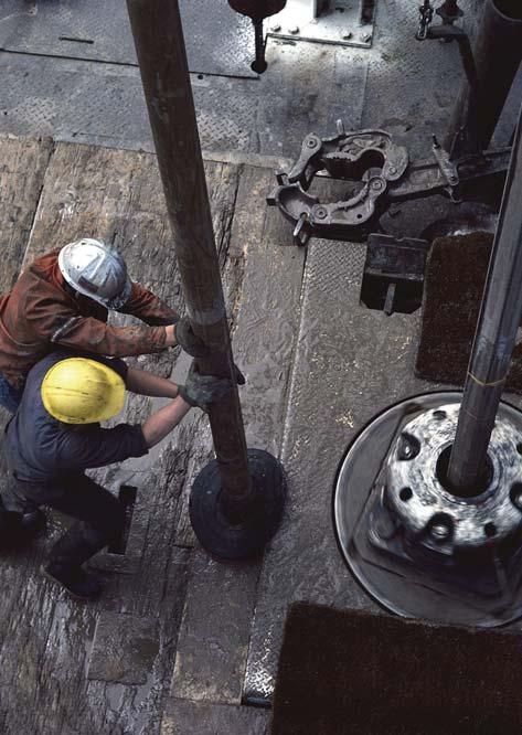
DRILLING EQUIPMENT
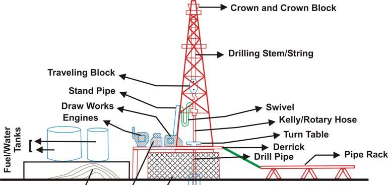
DERRICK:
The most conspicuous component of a rotary drilling rig is the derrick itself.This is a steel scaffold,resembling an outsized electricity-grid pylon from which is suspended the “hoisting gear” and drilling string.Drilling rigs intended for drilling to depths of 10,000 feet have a 30x30 squarefoot floor (Platform) with a derrick up to 140 feet in height towering above the ground.The derrick is able to carry a load of about 350 tons.In the case of deeper drilling,the derrick may be 200 feet or more in height.
HOISTING EQUIPMENT AND DRAWORKS: The top of the derrick is mounted by: 1) Crown Block (Pulleys), 2) Traveling Block, 3) Hook,and 4) Swivel (rotating joint to which drilling string is secured).
These four components are suspended on wire ropes.This is the “Hoisting Equipment” used for raising and lowering the drilling
BY WASIM PARACHA
string (drillstem) and casing.The hoisting equipment is powered by the drawworks.
The drilling string can be subdivided into four sections as:
The Kelly is a 40-foot-long hollow steel tube with a hexagonal or square cross-section shape that fits into a similarly shaped hole in the rotary table on the platform.The rotary table is turned by the main power unit,which supplies several thousand horsepower to run the drill rig.
The Drill Pipe is a 30-foot-long hollow,soliddrawn,thick-walled steel pipe whose diameter is dependent on the size of borehole being drilled.It is screwed on the lower end of the Kelly and as the borehole increases in depth, the Kelly and drilling string are lowered through the rotary table until a short length of Kelly remains above the aperture.Then another section of drill pipe is attached.
In order to add another section of drill pipe, the Kelly is raised until the first drill pipe connection is above the rotary table.The Kelly is unscrewed and a new length of pipe is attached.The Kelly is re-coupled and drilling resumed.Periodically,however,as for instance when a bit needs replacing,the entire drill string has to be pulled clear of the hole.On a rig drilling at 15,000 ft depth,it may take five hours to pull out the string and
another three hours to run it back.The longer time taken for pulling-out is due to the great weight of the combined sections of drill pipe,which can total well over a 100 tons.
The Drill Collar is the section of the drilling string immediately above the bit.These are strong,heavier lengths of pipe as compared to rest of the string.They give weight and rigidity to the whole string.Only a small portion of the total weight of drilling string is allowed to bear on the bit via the drill collars. The balance is carried by the traveling block and controlled by a brake on the draworks. Just how much weight is imposed on the bit and the speed at which the bit is rotated depends upon the nature of the rock formations encountered.As a general rule,a high-weight load and slow rotating speed are used for hard rocks and lighter loads with faster rotating speeds for softer rocks.
Figure 1.Typical drill-rig set-up.
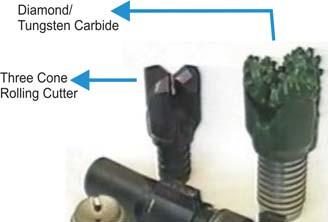
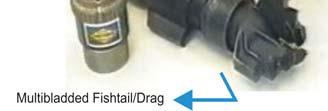
The Drilling Bits are the operating point of the drilling string.The types of bit used in drilling depend upon the nature (soft/hard) of the rock expected to be encountered.The following three commonly used types of drill bits are:
1) Multi-bladed Fishtail or “Drag” (for soft rocks),
2) Three-Cone Rolling Cutter (for hard rocks),and
3) Diamond or “Tungsten Carbide” (for Very hard rocks).
A bit in normal condition will need replacement after 10-12 hours depending upon average rate of drilling and nature of rock being encountered.In ideal conditions,a bit can drill several hundred feet per hour.On the other hand,in hard rock or while directionally drilling,the rate can drop to one foot or less per hour.
Casing is steel pipe permanently cemented in place in a well and has three main functions. The first casing to be set is the surface casing,which serves to stabilize the hole in the typically unconsolidated near-surface sediments and to prevent communication with shallow aquifers.Depending on the depth of the well and nature of the rocks penetrated,additional casing (intermediate) may be set to prevent the wall of the hole from caving in during drilling.The third use of casing is to allow for the eventual production of the well.As seen in Figure 2,the size of the final casing is dependent upon that of the preceding strings.
After the drill string has been removed, lengths of casing – often in 30ft sections like drill pipe – are screwed together and lowered into the well.Then cement is pumped down the casing and flows back to surface between the borehole and outside of the pipe.This forces the drilling mud out of the hole,seals off the different formations,and permanently sets the casing.After the cement hardens, initial tests are made to ensure that the casing is leak-proof.Drilling can then be resumed, using a bit of slightly smaller diameter than the inside of the casing.
A well which started with a 23-inch diameter bit will be completed by 5 5⁄8 inch bit for a 15,000 feet deep well.A typical casing program would be 18 5⁄8 inch diameter to 500 feet,13 3⁄8 inch diameter to 4,000 feet,9 5⁄8 inch to 7,000 feet and 5 5⁄8 inch to completion.
ANGLES OF BOREHOLES
The importance of maintaining the correct inclination is shown in the fact that a steady 5°drift in a 5,000 ft borehole would result in
(Continued on page 29...)
Conceptual well planning—manage your risk, improve your well placement.
In the time it takes to design a single well plan using conventional tools, Osprey* Risk drilling risk prediction model can help design multiple well scenarios, analyze them, and quantify the alternatives in terms of risk, time, and cost. From there, make incremental improvements in your well design to arrive at the best conceivable drilling plan.
In the drilling world, success is defined by reduced risk, efficient use of time, and money saved.
In the world of conceptual well design, that means Osprey Risk.
sisinfo@slb.com
www.slb.com/ospreyrisk
amalgam with a number of chemical constituents incorporated for specific purposes.The mud fluid is circulated during drilling for different reasons:
1) It flushes out and returns to surface, the rock chippings from the base of the hole,
2) It plasters up the sides of the borehole and prevents continual caving,
3) It controls the pressure set up by the water,oil,and gas librated from the formations penetrated,and
4) It lubricates and cools the bit during drilling.
The mud is stored in surface containers from which it is pumped through flexible hose coupled to the rotary swivel.It travels down through the Kelly and the hollow drill pipe into the bit and is then forced back to the wellhead between the outside of the drill pipe and the walls of the borehole.On return,it is passed over a vibrating screen, which separates out the rock chippings and then it goes again back to the container for recirculation.The behavior of mud during circulation can indicate the presence of oil, gas,or saltwater while further tests confirms the presence of oil and gas.
DRILLING PROBLEMS
Some problems during drilling occur when there is an abrupt increase in drilling speed or when there is a sudden acceleration in the rate at which the drilling mud is being forced back to the surface.In either case,the drilling engineer may order an immediate closure of the blow-out prevention valves.This closure will allow him to check the degree of pressure building-up in the borehole and to calculate the weight and force which must be imported by the drilling mud to keep this pressure under control.He may use a special heavy fluid in which barite has been blended for this purpose.This fluid is circulated to control the pressure surge and normal work can be resumed.
(...Continued from page 27)
its bottom-hole location being more than 400 feet offcentre from the wellhead.This could easily result in missing the target.
One prime concern of the drilling engineer is that of keeping the borehole vertical.This problem increases with the depth and rate of operation and holes are continually checked to be as vertical.If the borehole has shifted and is making any angle,this will be known through the instruments which are lowered down the wellbore and corrective measures can be taken.
Sometimes it is necessary to drill a nonvertical well.Deliberately drilling at a pre-
determined angle for technical reasons is called “Directional Drilling” This is done to reach some desired underground location where the surface conditions prevent the erection of a drilling rig directly overhead. The same technique is used when it is more economic to sink a number of wells from the same central position,as in underwater operations involving fixed drilling platforms. In directional drilling,a deviation of 40°or more can be built up at a rate 2°or 2.5°per 100 feet of hole.Slant,S-type,or J-type are variations based on the shape of the borehole (see Figure 3).
Mud is one of the prime factors in drilling. The drilling mud is often a highly complex
FISHING
Occasionally,the drilling string or bit becomes stuck or breaks and forms an obstruction to the drilling process.This may result from defects in the bit or pipe,use of the wrong bit for the type of rock encountered,improper drilling techniques, etc.If a problem occurs,drilling is stopped and immediate action will be taken by the driller.If the problem is simple,e.g.,pipe stuck in the borehole,it may be possible to work it loose.However,a more serious break may require the use of specialty “fishing” tools to latch on to the stuck pipe so that it can be removed.In the worst-case scenario of stuck
(Continued on page 30...)
Figure 2.Multiple casing strings.
Figure 3.Common methods of directional drilling.
tools or pipe down the hole,the hole would have to be abandoned.
LOSS OF DRILLING FLUID
Another headache sometimes faced by drillers is due to unusually porous or fissured rock encountered during drilling. When this happens,instead of coming back to surface,the drilling mud flows into the porous rock or fissure and is referred to as lost circulation.Lost circulation increases the chances of getting stuck in the hole and of having blowouts.Until the circulation is restored,drilling has to be suspended.This problem can be solved by adding special ingredients to the mud to increase its ability to plug the pores and fissures.Once the problem has been overcome,it may be necessary to set casing before drilling can be resumed.
LOGGING AND CORING
As the drilling progresses,periodic readings or “logs” may be taken by various instruments to determine the nature of the rock formations being penetrated.These readings give valuable information as to the porosity and hydrocarbon-bearing potential. If circumstances warrant it,the geologist
may ask for a core sample to be cut. Retrieving an actual sample of the rock allows for more accurate testing to be performed,which can then be used to calibrate the geophysical log readings.
FORMATION TESTING
When a potentially hydrocarbon-bearing formation is reached,testing must be conducted under conditions as close to those in the reservoir as possible.Typically this involves use of special tools like a Drill stem tester,which is lowered by the drill string into position.The drill stem tester contains a valve system,controlled from the surface,which prevents any mud entering the drill pipe as it is run in.Once in place, the main valve is opened and any oil or gas present in the formation can enter the drill pipe under its natural pressure.The degree of flow will indicate the pressure of the reservoir.
COMPLETION
Assuming the logs or formation tests prove favorable,the final stage is completing the well.If the producing rock is reasonably consolidated it may be left uncased.This is known as a “bare-foot” completion.If there is a risk of caving-in,casing must be inserted.
Once in place,this casing must be perforated so that oil or natural gas can percolate into the well.A well-head assembly of valves and pipes is installed and the production can then be tied into the gathering system for transportation to its final destination.
BIOGRAPHY
Wasim Paracha is an Exploration Geophysicist with Calvalley Petroleum Inc.,Calgary where one of his major areas of interest is the mapping of near-basement granite wash sediments in structural/stratigraphic studies of the Yemen region.Wasim has a Ph.D.from Sweden in Geology and Geophysics and over 10 years of professional experience in basin analysis,prospect generation,and structural studies in the WCSB,Canadian Arctic,North Sea,and Himalayas.
In addition to exploration and teaching at SAIT, Wasim is an expert in seismic/sequence stratigraphy/facies mapping with 3D/2D modeling,depth imaging studies,AVO,reservoir evaluation,and well log analysis and has authored 7 books and 25 articles and reports. He can be reached at drwasimparacha@ shaw.ca or 403-273-4395.
depths
CONTOURING
Faulted contours
Isopachs
Volumetrics
Grid operations
New flexing options
CROSS SECTIONS
New Unassigned Tops
Digital and/or Raster
Geocolumn shading
Stratigraphic/Structural
Shade between crossover
Dipmeter data
MAPPING OPTIONS
Expanded GIS Functions
Bubble maps
Production charts
Log curves
Posted data
Highlighted Symbols
3D VISUALIZATION
Deviated wellbores
Digital logs
Grid surfaces
Tops, Shows and Perfs
Land grid overlay
Map images
PETRA® delivers the industry’s only easy-to-use and affordable integrated solution for today’s workflows. It provides multi-user access to large projects through geological, petrophysical and engineering analysis tools. The PetraSeis™ option extends PETRA® into 2D/3D seismic interpretation with practical tools such as RasterSeis™ Download a trial version at www.geoplus.com, or call us at 888-738-7265 (Houston: 713-862-9449 / Calgary: 403-264-9523) for more product information.
DECLINE CURVES
Compute EUR, RR, etc.
Hyperbolic or exp.
Rate/Time or Cum P/Z
User defined Econ. Limit
User defined Extrap. Time
ROCK SHOP
Heavy Oil Specialists
• SAGD/Horizontal
• Coring Programs
Conventional Wells
• Horizontal/Directional
• Gas Detection
Coal Bed Methane
Wellsite Geological Supervision since 1980
C. Alex Francoeur, P.Geol.
President
Tel/Fax: (403) 281-6694
Cell: (403) 861-6753
Email: afran@telusplanet.net
COOPERATIVE GEOLOGICAL MAPPING STRATEGIES
BY LES FYFFE AND IRWIN ITZKOVITCH (CO-CHAIRS,NATIONAL GEOLOGICAL SURVEYS COMMITTEE1)
Cooperative Geological Mapping Strategies:a new Canada-wide vision for public geoscience
Canada’s rich energy and mineral resources play a critical role in its economic and social well-being.These resources are fundamental to the advancement of society and the support of communities in all regions of the country.As Canadians,we have grown accustomed to the contributions of the energy and mineral sectors to our daily lives, but new resources must found in order for them to be sustained.However,important energy supply issues have emerged in the last decade,and metal reserves have declined dramatically.
What can be done? Governments can step forward,as they have done in the past,to encourage the private sector to invest in finding new energy and mineral resources in Canada2.Historically,governments have invested in geological survey mapping and data stewardship to provide geoscience data and knowledge to the energy and mining industries.Now,at the request of the Mines Ministers of Canada,many of whom are also Ministers of Energy,a new public geoscience initiative is being developed with input from the federal,provincial,and territorial governments;industry representatives;and other interested parties.
“Cooperative Geological Mapping Strategies Across Canada” (CGMS) is a 10-year vision statement prepared by the National Geological Surveys Committee in response to direction from all of Canada’s governments. The CGMS vision focuses on the continuing need for reliable geoscience knowledge relating to energy,groundwater and mineral resources.The CGMS vision statement, approved by all of Canada’s jurisdictions in 2000,identifies geoscience knowledge as a key competitive advantage,essential to maintaining Canada as a pre-eminent global destination for exploration investment.Industry pointed out to all of Canada’s governments that our competitive advantage has been put at risk because the past decade has seen a progressive decrease in funding for geological surveys in this country (Fig.1).
Between Spring and Fall 2003,as an initial step in developing the CGMS concept,the federal, provincial,and territorial geological survey organizations initiated a collective discussion of Canada’s energy,mineral,and public good geoscience gaps and needs.This collaborative
Figure 1:Funding levels for geological surveys in Canada.The marginal increase since 1999 reflects federal and provincial funding contributions to sunset programs such as the Targeted Geoscience Initiative,Operation Treasure Hunt in Ontario, along with provincial/territorial “down-payments”to the Cooperative Geological Mapping Strategies Across Canada initiative.
approach built upon the existing cooperation across jurisdictional boundaries,and facilitates priority setting at the broadly regional and national scales.Clearly,some of the principal geoscience issues are best addressed through multi-jurisdictional, regional strategies.Energy-related water issues regarding CBM and oil sands development,as well as enhanced oil and gas recovery,are just one example from a very long list.Figure 2 (page 34) is an example of a cooperative geological mapping project:many more such maps are needed if Canada is to sustain a competitive climate for exploration investment.
So,where is CGMS headed? Geological surveys are increasingly presenting public geoscience as an important but underutilized tool to address government issues and priorities - in other words,as a contribution to the “Public Good”.In the context of CGMS,this means fostering the responsible sustainable development of energy, groundwater,and mineral resources.It means reducing the risk related to their exploration and development,and ensuring that industry, government,and society at large have a sound scientific basis for determining how,where, and when resource development should take place.Potential CGMS geoscience programs could include projects to stimulate exploration in frontier areas and development of unconventional energy resources as well as studies to determine how to mitigate the potential environmental impact of resource development.
What are governments doing to make CGMS a reality? Provincial,territorial,and federal jurisdictions have successfully worked together to develop a set of “Strategies”,to determine the collective scope of “Cooperative Geological Mapping”,and to formulate where a 10-year CGMS Implementation Plan should lead Canada.The Implementation Plan,which outlines how CGMS can produce realistic roadmaps to the responsible discovery and recovery of energy,groundwater,and mineral resources,and related environmental geoscience,was endorsed by Canada’s Mines Ministers at their 2004 annual conference where they agreed to work toward making CGMS a reality.It is hoped that the Ministers will renew their committment to seek funding for CGMS when they meet again in New Brunswick in September of this year.For more information,please contact the head of your federal,provincial,or territorial geological survey (see Table on page 34 for e-mail and phone coordinates).
1 The National Geological Surveys Committee comprises the Earth Sciences Sector’s Geological Survey of Canada and the geological survey organizations of all provinces (except Prince Edward Island) and the three territories.Les Fyffe,Director,Geological Surveys Branch,Department of Natural Resources,Hugh John Flemming Forestry Centre,P.O.Box 6000,Fredericton, NB,E3B 5H1,Irwin Itzkovitch,Assistant Deputy Minister,Earth Science Sector,Natural Resources Canada,580 Booth St,Ottawa,Ont.K1A 0E4
2 For example:Targeted Geoscience Initiative (TGI) Shallow Gas Studies
Figure 2:A 2005 Surficial Geology map of Northwestern Alberta that serves energy industry users looking for ultra shallow gas,groundwater sources,pipeline and facilities planning,road planning and aggregate material sources and at the same time serves mineral industry explorationists and a multitude of other users.The map was produced jointly by the Geological Survey of Canada and the Alberta Geological Survey with cooperation of the British Columbia Ministry of Energy and Mines as part of the Targeted Geoscience Initiative (TGI 2) that ended in 2005.
JURISDICTIONCONTACT
Federal Government
Newfoundland
Nova Scotia
New Brunswick
NAME AND COORDINATES
Murray Duke, Director General, Geological Survey of Canada, Natural Resources Canada
Simon Hanmer, Federal CGMS coordinator and Interim Targeted Geoscience Initiative Program Manager, Geological Survey of Canada, Department of Natural Resources Canada
Frank Blackwood, Director, Geological Survey of Newfoundland and Labrador, Department of Mines and Energy
Michael Cherry, Director, Geological Services Division, Nova Scotia Department of Natural Resources
Leslie Fyffe, Director, Geological Surveys Branch, New Brunswick Department of Natural Resources and Energy
Ontario Andy Fyon, Director, Ontario Geological Survey, Ministry of Northern Development and Mines
Manitoba Ric Syme, Director, Manitoba Geological Survey, Manitoba Industry Trade and Mines
Saskatchewan Gary Delaney, Director & Chief Geologist, Northern Geological Survey Branch Saskatchewan Industry and Resources
Alberta Rick Richardson, Provincial Geologist and Manager, Alberta Geological Survey, Alberta Energy and Utilities Board
British Columbia
Dave Lefebure, Director & Chief Geologist, Geological Survey Branch, British Columbia Ministry of Energy and Mines
Derek Brown, Executive Director, Resource Development and Geoscience Branch, Oil and Gas Division, British Columbia Ministry of Energy and Mines
Yukon Territory Grant Abbott,Chief Scientist, Yukon Geological Survey, Department of Energy, Mines and Resources
Northwest Territories Dr. Carolyn Relf, Manager, Northwest Territories Geoscience Office
Nunavut Don James, Chief Geologist, Canada-Nunavut Geoscience Office
E-Mail: Mduke@NRCan.gc.ca
Tel: 1 (613) 995-4093
E-Mail: shanmer@NRCan.gc.ca
Tel: 1 (613) 992-4704
E-Mail: rfb@zeppo.geosurv.gov.nf.ca
Tel: 1 (709) 729-6541
E-Mail: cherryme@gov.ns.ca
Tel: 1(902) 424-8135
E-Mail: les.fyffe@gnb.ca
Tel: 1(506) 453-3874
E-Mail: andy.fyon@ndm.gov.on.ca
Tel: 1 (705) 670-5924
E-Mail: rsyme@gov.mb.ca
Tel: 1 (204) 945-6556
E-Mail: gdelaney@ir.gov.sk.ca
Tel: 1 (306) 787-1160
E-Mail: rick.richardson@gov.ab.ca
Tel: 1 (780) 427-1980
E-Mail: dave.lefebure@gems8.gov.bc.ca
Tel: 1 (250) 952-0374
E-Mail: Derek.Brown@gov.bc.ca
Tel: 1(250) 952-0432
E-Mail: grant.abbott@gov.yk.ca
Tel: 1 (867) 667-3200
E-Mail: carolyn_relf@gov.nt.ca
Tel: 1 (867) 669-2635
E-Mail: DJames@NRCan.gc.ca
Tel: 1 (867) 979-3539
2006 CSPG CSEG CWLS JOINT CONVENTION
SCHEDULE OF ACTIVITIES – WHATÕS NEW?
As the industry changes so must the convention format to fit the needs of our delegates.The technical presentations and exhibition will again be housed in the Round Up Centre,Stampede Park.However,the convention has been reduced from a full week of activities to 4 days! This allows our exhibitors,sponsors and delegates to fit more in during a shorter time period – which we all need during these busy times in industry.
A full technical programme of oral and poster presentations is scheduled to begin on Monday,May 15th and wrap up at noon on Wednesday,May 17th.Special Sessions will be held on that Wednesday afternoon as well as the Core Conference beginning at the AEUB Core Research Centre.The Core Conference will continue on May 18th and the convention will wrap up that afternoon by the always anticipated Core Meltdown!
It is hoped that our exhibitors,the technical programme,and the social events will showcase our theme WHAT’S NEXT? Where is our industry heading? and light the way forward.
TECHNICAL PROGRAMME OUTLINE SCHEDULE
Overwhelming response to Abstracts!
The 2006 Joint Convention Abstract Submission opened on November 1,2005 and we have had an overwhelming response!
The goal in creating a solid scientific,technical and business presentation that address “What’s Next?” will be achieved with the high quality of abstracts received.To maintain a high quality within the 2006 Technical Programme,abstracts are being accepted based on the review and recommendations of the session chairperson and the availability of oral and poster session slots.
The deadline to submit abstracts for oral,poster,and core presentations is JANUARY 31,2006.Late submission will NOT be accepted – and at this rate we may fill up before the deadline!
• 3D Seismic Imaging
• Acquisition/Magnetic/Resistivity
• Are recent discoveries a template for the future?
• AVO Case Studies
• AVO Methods
• Can the dolomite problem be solved?
• Can the promise of the Frontiers be fulfilled? - Session I Mackenzie Corridor and Mackenzie Delta
• Can the promise of the Frontiers be fulfilled? - Session II Other Basins (Oceanic Margins,High Arctic,Intermontane,etc.)
• Geophysical Papers
• Heavy Oils and Tar Sands - What are the promises and limits?
• How are the Cordillera and the Foreland linked?
• How can Data and Information Management add value?
• How do we get new petroleum from old basins?
2006 CSPG CSEG CWLS JOINT CONVENTION
• How do we insure access and achieve sustainability?
• How will petroleum systems analysis facilitate future developments and discoveries?
• How will we extract value in the future?
• International Session - What is happening outside of Canada and where is it going?
• Migration Techniques
• Multi-component and Time Lapse Processing
• Petrophysics I:Tight Gas and CBM
• Petrophysics II:Case Studies
• Seismic Processing
• What are the promises and limits of Unconventional Gas?
• Where do we go next in the Foothills?
• Where is sequence stratigraphy going?
• Wireline,LWD,and Core:New Technology and Techniques
This is going to be the best one stop exhibition in 2006!
As predicted,the 2006 Exhibition is also showing high demand of interest from companies wishing to profile their products and services.
With the CSPG,CSEG and CWLS partnering once again,exhibiting at WHAT’S NEXT? Where is our industry heading? is the best one-stop opportunity to meet key geoscientists.
Western Canada Geological Edge Set 2006 Version
Now available for import into ACCUMAP, GEOSCOUT and other applications
1) Mississippian Subcrops and Devonian Reef Edges - AB, NE BC, NT and SK
The delegate traffic flow in the exhibition hall is being enhanced by positioning the poster sessions throughout the exhibition hall,having access to the Archie Boyce Lecture Hall only through the exhibits, placing the coffee stations in key areas on the floor and creating an internet café and business centre where everyone can quickly check into the office instead of traveling back downtown – allowing a variety of opportunities for delegates to visit the exhibition!
Invest in this year’s joint convention!
Sponsorship is critical to the success of any conference.In order to facilitate a meaningful exchange of ideas and information the CSPG, CSEG,and CWLS require the support of our sponsors for the upcoming Conference.Without the support of our industry companies,we would not be able to fulfill the mandates to promote the Earth Sciences,especially as they relate to the exploration and exploitation of petroleum and natural gas.
Position your organization as an industry leader and strategically align yourself with these three societies to provide a premier technical event for Canadian geoscience professionals.
Sponsorship opportunities include the Keynote Luncheon,Delegate Bags,Technical Halls,Student Sessions,Speakers’ Breakfast,Ice Breaker, Special Events and more!
(...Continued from page 17)
Satyaki began his career in 1989 as a wellsite geologist and core analyst for ONGC India (Oil & Natural Gas Corporation Ltd.),and subsequently worked in their reservoir mapping and geostatistical modeling group. He joined Schlumberger Wireline & Testing in 1997 as an Interpretation Development Geologist in Bombay,India,followed by an assignment as Schlumberger Data Services Coordinator for onshore and eastern India, before getting transferred to Canada.He has worked in clastics,carbonates,and coals of Asia,Middle East,and North America.Satyaki earned an M.S.degree in Applied Geology from the Indian Institute of Technology in Roorkee,India with a First Class Gold Medal and a Master of Technology degree in Geoexploration from the Indian Institute of Technology in Bombay.
INFORMATION
Talks are free;please bring your lunch. Goodies and drinks are provided by HEF Petrophysical Consulting,and the room is provided by Petro-Canada.If you would like to be on the Structural Division e-mail list,or if you’d like to give a talk,please contact Elizabeth Atkinson at (403) 296-3694 or eatkinso@petro-canada.ca.
(...Continued from page 25)
of the Vermilion River (SW 1/4,Sec 22,Twp 23,Rge 20 WPM) in the hope of discovering an oil reservoir beneath the surface indications.Apparently,Tyrrell and Dowling visited the drillsite and conferred with the drillers and operator the same summer. Director Selwyn made the following reference to their visit (Selywn,1889) in his summary report of 1887-1888;“During the season of 1887,a number of enterprising gentlemen of Manitoba sank an eight-inch borehole on the banks of the Vermilion River to a depth of 300 feet in the hope of obtaining a supply of petroleum.Mr.Tyrrell was then consulted,and they were told they would have to bore through Cretaceous shales to at least 420 feet below the surface, below which they would in all probability shortly strike the Devonian limestones.If petroleum was to be found,as far as there was any evidence to show,it would be in beds immediately overlying this limestone.” Tyrrell deduced this on the basis of the Dakota (McMurray) sand hosting the bitumen along the Athabasca River.On the basis of this advice,albeit gratis,Joseph Tyrrell has the distinction of being the first consulting petroleum geologist in Western Canada.
To be continued...
The EARTH ImagerSM service delivers high-resolution micro-resistivity images in oil-based mud with great hole coverage.
This proven micro-resistivity imager from Baker Atlas offers a vertical resolution of less than 8mm at a standard logging speed of 274m/hr giving you details never seen before in oil-based mud images.
The EARTH Imager service operates in 149mm to 533mm diameter boreholes. With its 6 pads mounted on individually articulated arms, it provides you with 64.9% borehole coverage in 200mm diameter holes while maintaining pad contact at all hole deviations.
Call us today to find out how you can use the EARTH Imager service in your next oil-based well to accurately identify structural and sedimentary features, rock texture, fracture orientation and estimate net-to-gross.