


The global industry leader in critical information and insight, IHS continues to invest in the progress of the Canadian energy market so you can get from discovery to drilling in record time. By updating, improving and streamlining our Canadian products and services, we have delivered workflow integration between IHS PETRA® and IHS AccuMap®; created solutions for better access to global resources, from well log databases to subject matter experts; and continued to provide transparency and insight to Canadian energy businesses that need actionable information.
See how IHS is investing in Canada at www.followihs.com.


CSPG OFFICE
#110, 333 – 5th Avenue SW
Calgary, Alberta, Canada T2P 3B6
Tel: 403-264-5610
Web: www.cspg.org
Office hours: Monday to Friday, 8:30am to 4:00pm
Executive Director: Lis Bjeld
Tel: 403-513-1235, Email: lis.bjeld@cspg.org
Member Liaison: Bea McDowell
Tel: 403-513-1226, Email: bea.mcdowell@cspg.org
Communications and Publications: Caitlin Young
Email: caitlin.young@cspg.org, Tel: 403-513-1230
Programs Development: Aileen Lozie
Tel: 403-513-1227, Email: aileen.lozie@cspg.org
Accounting and Office Administration: Kasandra Klein
Tel: 403-513-1233, Email: kasandra.klein@cspg.org
Corporate Sponsorship: Lis Bjeld
Tel: 403-513-1235, Email: lis.bjeld@cspg.org
Please submit RESERVOIR articles to the CSPG office. Submission deadline is the 23rd day of the month, two months prior to issue date. (e.g., January 23 for the March issue).
To publish an article, the CSPG requires digital copies of the document. Text should be in Microsoft Word format and illustrations should be in TIFF format at 300 dpi., at final size. For additional information on manuscript preparation, refer to the Guidelines for Authors published in the CSPG Bulletin or contact the editor.
Technical Editors
Ben McKenzie Colin Yeo (Assistant Tech. Editor) Tarheel Exploration EnCana Corporation Tel: 403-277-4496 Tel: 403-645-7724 Email: bjmck@live.com Email: colin.yeo@encana.com
Coordinating Editor
Caitlin Young, Publications Coordinator, CSPG Tel: 403-513-1230, Email: caitlin.young@cspg.org,
ADVERTISING
Advertising inquiries should be directed to Caitlin Young, Tel: 403-513-1230 email: caitlin.young@cspg.org. The deadline to reserve advertising space is the 23rd day of the month, two months prior to issue date.
The RESERVOIR is published 11 times per year by the Canadian Society of Petroleum Geologists. This includes a combined issue for the months of July and August. The purpose of the RESERVOIR is to publicize the Society’s many activities and to promote the geosciences. We look for both technical and non-technical material to publish. Additional information on the RESERVOIR’s submission guidelines can be found at http://www.cspg.

At APEGGA we know and understand that we live and practice in a complex world. The heavy lifting in the resource extraction industries, and in the environmental industry, is done by teams, often led by Professional Geoscientists. These teams include professionals, technologists and support staff both at headquarters in the city and at camp in the field.
There’s no question in our minds that geoscience projects require teams to manage questions surrounding the many varied issues including governance, tax impact, reporting and environmental concerns including land-use and ground disturbance.
Through consultation and communication, all these issues, and a multitude of others, are resolved to ensure the projects we work on benefit society. The Geoscience Professionals’ code of ethics and paramount responsibility to protect public safety and well-being must be recognized and acted upon.
P.Geol.s, P.Geoph.s and Professional Licensees (Geological and Geophysical) are team players. No doubt. Our work helps keep Alberta safe and strong and the only way we can achieve that goal is through teamwork amongst professionals.
Teamwork Pays. Visit www.apegga.org for more information or call Tom Sneddon, P.Geol., Geoscience Affairs Manager at 403-262-7714 or 1-800-661-7020.


CSPG
EXECUTIVE
PRESIDENT
Robin Mann • AJM Deloitte rcmann@deloitte.ca Tel: (403) 648-3210
VICE PRESIDENT
Paul MacKay • Shale Exploration Ltd. Paul.Mackay@shalepetroleum.com Tel: (403) 457-3930
PAST PRESIDENT
Kirk Osadetz • Geological Survey of Canada, Calgary kosadetz@nrcan.gc.ca Tel: (403) 292-7022
FINANCE DIRECTOR
Andrea Hood • geoLOGIC systems ltd. ahood@geologic.com Tel: (403) 262-1992
ASSISTANT FINANCE DIRECTOR
Samantha Etherington • CNRL samantha.etherington@cnrl.com Tel: (403) 386-6459
PROGRAM DIRECTOR
Jon Noad • Murphy Oil Corporation jon_noad@murphyoilcorp.com Tel: (403) 294-8829
ASSISTANT PROGRAM DIRECTOR
Dave Russum • AJM Deloitte drussum@deloitte.ca Tel: (403) 648-3228
SERVICES DIRECTOR
Michelle Hawke • Apache Canada Ltd. Michelle.Hawke@apachecorp.com Tel: (403) 261-1200
ASSISTANT SERVICES DIRECTOR
Mike Seifert • Canadian Discovery mseifert@canadiandiscovery.com Tel: (403) 269-3644
COMMUNICATIONS DIRECTOR
Jim Barclay • ConocoPhillips Canada Jim.E.Barclay@conocophillips.com Tel: (403) 532-3889
ASSISTANT COMMUNICATIONS DIRECTOR
Curtis Evans • ERCB curtis.evans@ercb.ca Tel: (403) 297-8386
OUTREACH DIRECTOR
Simon Haynes • Statoil Canada Ltd. sihay@statoil.com Tel: (403) 724-0364
ASSISTANT OUTREACH DIRECTOR
Dawn Hodgins • Imperial Oil Resources daun.c.hodgins@exxonmobil.com Tel: (403) 232-5931
EXECUTIVE DIRECTOR
Lis Bjeld • CSPG lis.bjeld@cspg.org Tel: (403) 513-1235
A message from 2011 Finance Director, Darren Aldridge
Financial Growth continued for the CSPG in 2011, and we are now a three-million-dollar business with portfolios run by Directors while using the President, Vice President, and Past President to oversee operations and directly handle affiliate Society agreements, governance, strategy, and steer new initiatives.
These growing balance sheet and income statements reflect the changing budgets of the committees themselves that individually contribute to the success of the Society as a whole. As a result, actuals are run against the fiscal budget for each committee, so that clarity and relevance are provided as a tool to aid them in progressing with their committee agenda. The Finance Committee has introduced operating guidelines easing decision making with approved budgets. On to more of that later, let’s get down to some of the detail of this year’s success:
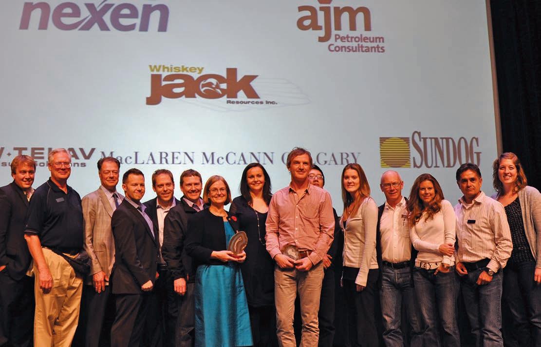
During the fiscal 2011 year, CSPG operated the joint annual convention, recovery 2011, on behalf of our affiliated Societies: CSEG and CWLS. Revenues from recovery exceeded $2MM. The convention saw 4,400 attendees, a full exhibit floor, and 47 sponsoring companies. The success of this convention allowed CSPG to instigate new initiatives; such as the office move, migrating to new technologies for the website and in-house database, new equipment, and expanding the education offerings. Recovery alone contributed $403,706 to these initiatives.
Including our share of the recovery profit, CSPG finished the year at a surplus of $434,921. This is directly in line with our mandate, which is to maximize service to members and reserve convention profits to drive new initiatives that will benefit members in the future. This also reduces risk as it is only after the funds are received from convention that they are allocated.
With our goal of operating CSPG at
breakeven we continue to maximize service to members. This year we introduced nonfinancial performance indicators, tracking trends over ten years.
The Finance Committee is comprised of me, Andrea Hood, and Lis Bjeld. At the request of our President, Kirk Osadetz, we were asked to focus on some keys issues we saw as fundamental to the Finance Portfolio. At that time we crafted out what we thought were key deliverables for the Finance Committee. As we essentially left 2010 with Greg Lynch giving us a new forward look to 2020, we wanted to focus on two main goals for 2011 to keep that trend going. Our first goal was that CSPG stakeholders (that’s each of you as members) have confidence in the stewardship of our financial resources. Our second goal was to advance initiatives through continued financial success.
Focusing on transparency down to the committee level, we introduced a process clarifying financial decision-making called Committee Approvals Request (CAR). This has helped contribute to a breakeven with the profits of the Convention equivalent to the net profits of our Society. We look at convention profits as funds that can be put to work expanding existing programs or developing new ones; setting up new committees as required that reflect what you as members want from the Society. This was a tremendous effort, for which I would like to recognize and thank the recovery 2011 team, all CSPG committees and divisions for executing their budgets as planned, and to our office staff under the direction of Lis Bjeld.
In this volatile economy, we also wanted to look at our Rainy Day Fund (RDF) to ensure it had stability in this unpredictable environment. Like everyone else we just went through a recession, so how do our investments look? Governments globally are in huge debt and now are subject to (Continued on page 7...)

February 2 - 4, 2012 World Health Club • 722 Edgemont Blvd NW
This squash tournament is open to CSPG and CSEG members
THERE IS A MAXIMUM OF 125 PLAYERS! GET YOUR ENTRY FORM IN EARLY TO AVOID DISAPPOINTMENT! Register online at www.cspg.org
EVENTS: Men’s & Women’s A, B, C, D, and Novice.
ENTRY FEE: $75.00 Members (Members of the CSPG and CSEG, Spouse/Par tner) $120.00 Non-members
• Two guaranteed matches (Saturday teams tourney), t-shirt, refreshments and food during the tournament, Saturday night dinner and draw prizes
• Practice night will take place at Bankers Hall on Thursday, January 26 at 5:00pm
• Pre-tournament registration social will be at Local 522 (522 6 Avenue SW) on Tuesday, January 31 at 5:00pm. Pick up your tournament kit and first draw time. Enjoy a free pint of ale with munchies. Generously sponsored by Sensor Geophysical Ltd.
• All door prize draws Saturday evening – must be present to win.
ENTRY DEADLINE: Early Bird Deadline January 2nd, 2012. Qualify for Early Bird Draw Prize.
Registration Deadline January 20th, 2012. No refunds after this date.
REGISTRATION DETAILS: CSPG CSEG Member# ___________________________ Non-member
Interested in Doubles Squash: ($25.00 extra for Doubles if playing singles as well) Yes No
Will you be attending dinner : Yes No Meal Preference: Meat Veggie
Guest Name: ______________________________________________________________________________________ Male Female
Interested in Doubles Squash: ($25.00 extra for Doubles if playing singles as well) Yes No
Will you be attending the dinner : Yes No Meal Preference: Meat Veggie
PAYMENT DETAILS (GST not Included. GST# 118836295):
$75.00 Member/Spouse
$120.00 Non-member
$25.00 Doubles
$35.00 Extra Meal Ticket (Non-playing guests Maximum 15 spots; first-come, first served).
TOTAL VISA MC Cheque (Payable to Canadian Society of Petroleum Geologists) Card Number : ______________________________________________
Name of Card holder (Please Print): _______________________________

CORPORATE SPONSORS
DI A MON D
IHS
GEOLOGIC SYSTEMS LTD
SCHLUMBERGER CANADA LTD
PL ATINUM
AGAT L ABORATORIES
CENOVUS
CONOCOPHILLIPS
NEXEN INC .
TALISMAN ENERGY
POGGENPOHL
GOLD
APEGGA
CSPG EDUCATIONAL TRUST FUND
DEVON CANADA
ENCANA
IMPERIAL OIL
SHELL
WEATHERFORD L ABORATORIES
SILVER
ARC FINANCIAL CORPORATION
ENERPLUS
JEWEL SUITE
ROX AR
BRONZE
ATHABASCA OIL SANDS
BLUEBACK RESERVOIR
PARADIGM
GEOVARIANCES
CSEG FOUNDATION
RPS BOYD PETROSEARCH
HALLIBURTON ENERGY SERVICES
SUNCOR ENERGY
SUNDOG PRINTING
TUCKER WIRELINE SERVICES
AS OF DECEMBER 10, 2011
(...Continued from page 5)
large spending cuts. One of the questions we asked ourselves was: Is CSPG’s own financial investment plan sound enough to combat this uncertainty and take into account our overall risk tolerances and timeline? As with any non–profit society, we wanted to have our investment classified as a lower risk investment. As we finished 2010, the investment split built up to a 40:60 Stock/bond split (a bit more of a moderate risk, than where we want it to be). Typically, non-profit societies have investments in the 20/80 split; the 20% to allow some portion of equities to compensate for inflation. We wanted to have this secure as this is essentially the fall-back for our Society. The board approved a motion by the Finance Committee to change to a 20/80 split. I am happy to report that our rainy day fund has $434,766 in fixed income and $297,429.19 in cash. Looking forward into fiscal 2012, 20% will be invested in equities. In November 2011, CSPG increased the cash amount by $150,000. With these adjustments we are well on our way to achieving the Investment Fund target of $1MM to ensure long-term security of the Society
I’d also like to acknowledge the success of the Technical Programs – Technical Luncheons,
Continuing Education, Technical Divisions, and the International Core Conference. These programs were reshaped by Directors Brett Norris and Jon Noad and committees with the assistance of Graeme Bloy and Dennis Meloche on the AAPG Ice Conference and International Core function, and helped contribute to our financial success in 2011.
We saw a dip in our membership in 2011, something we anticipated from our changing demographic study. This is the driving factor of our vision and goal for 2012: to build eminence for CSPG.
Communications and publications grew; thanks to new CSPG publications and a growth in advertising revenue. Networking and social events introduced new functions while Outreach penetrated new territory, reaching out to additional university and high school students as well as new energy geoscientists.
It was an impressive year! With financial stability, transparency, and strengthening internal operations we are well positioned for growth and our financial picture is truly Rock Solid!
E-Symposium: Eagle Ford Shale Prospecting with 3D Seismic Data within a Tectonic January 20, 2012 and Depositional System Framework. 2:00 p.m., CST Online
Winter Education Conference February 13-17, 2012 Houston, Texas Earlybird discount expires January 9th!
Basic Well Log Analysis March 26-30, 2012 Austin, Texas
Practical Salt Tectonics
March 28-30, 2012 Austin, Texas
Shale Gas Reservoir Assessment April 21-22, 2012 Long Beach, CA (with AAPG Annual Convention)
Field Safety Course for Field Trip Leaders March 28-29, 2012 Houston, Texas
Deep-Water Siliciclastic Reservoirs April 27-May 2, 2012
Northern California
Clastic Reservoir Facies and Sequence Stratigraphic Analysis of Alluvial-Plain, Shoreface, Deltaic, April 28-May 4, 2012 and Shelf Depositional Systems
Utah
Seismic Reservoir Characterization of U.S. Shales: An Update February 9, 2012 Online 2:00 p.m., CST
Joellen L. R ussell Department of Geosciences, University of Arizona
11:30 am
Tuesday, January 10, 2012
C algary, TE L US Convention Centre
C algary, A lberta
Please note: The cut-off date for ticket sales is 1:00 pm, Thursday, January 5, 2012.
CSPG Member Ticket Price: $42.00 + GST. Non-Member Ticket Price: $45.00 + GST.
This luncheon is also the CSPG Annual General Meeting
Each CSPG Technical Luncheon is 1 APEGGA PDH credit. Tickets may be purchased online at https://www.cspg.org/eSeries/source/Events/ index.cfm.
The vast Southern Ocean region surrounding the Antarctic continent is the only place in the global ocean where water upwells from more than two kilometers to the surface before sinking again. The deep of the Southern Ocean holds the key to the rate of warming of our atmosphere, because enormous amounts of heat and carbon can be stored in this ocean reservoir. In paleoclimate model simulations, wind position and
the overturning of deep water in the Southern Ocean explain some of the more puzzling features of glacial-interglacial carbon dioxide cycles, including the tight correlation between atmospheric carbon dioxide and Antarctic temperatures, the lead of Antarctic temperatures over carbon dioxide at terminations and the shift of the ocean’s 13C minimum from the North Pacific to the Southern Ocean. Cold glacial climates seem to have equatorward-shifted westerlies that allow more respired carbon to accumulate in the deep ocean. Warm climates like the present have poleward-shifted westerlies that flush respired carbon dioxide out of the deep ocean.
In glo bal-warming simulations of future climate, poleward-intensified westerlies maintain a robust deep-water overturn around Antarctica even as rising atmospheric greenhouse gas levels induce warming that reduces the density of surface waters in the Southern Ocean. These results imply that the polewardintensification of the Southern Hemisphere Westerlies may prop open the Southern Ocean door to the deep ocean, allowing the ocean to remove relatively more heat and anthropogenic carbon dioxide from the atmosphere, slowing the rate of warming of the atmosphere.
BIOGRAPHY
Joellen Russell received her bachelor’s degree at Harvard University in Environmental Geoscience before earning her Ph.D. at Scripps Institution of Oceanography, UCSD in Oceanography. Her fieldwork in the Southern Ocean studying the biogeochemistry of Mode and Intermediate Water led to a Postdoctoral Fellowship at the University of Washington’s Joint Institute for the Study of Atmosphere and Ocean. Prof. Russell then became a Research Scientist at Princeton University working at NOAA’s Geophysical Fluid Dynamics Laboratory during the intensive preparations for the Intergovernmental Panel on Climate Change Fourth Assessment. Prof. Russell’s work there on the westerly winds led to her greatest research accomplishment so far: the creation of a new paradigm in climate science, namely that warmer climates produce stronger westerly winds. This insight solved one of the long-standing climate paradoxes, the mechanism responsible for transferring onethird of the carbon dioxide in the atmosphere into the ocean and then back out again during our repeated glacial-interglacial cycles. She continues active collaboration with the
Webcasts sponsored by

GFDL Earth System Model and Climate Model Development Teams on the latest ultra high-resolution model. Prof. Russell is currently serving as a member of the U.S. CL IVAR Office, Process Studies and Model Improvements Panel.
Prof. Russell joined the faculty in the Department of Geosciences at the University of Arizona in 2006 and has expanded her research on the role of the westerly winds in global climate to patterns of drought in the continental US during the last 1,000 years, the present, and the future, as well as the circulation of the methane atmosphere on Saturn’s moon Titan with members of the Cassini Mission. Prof. Russell’s current research is focused on the joint venture between ExxonMobil and the UA Department of Geosciences, Convergent Orogenic Systems Analysis (COSA), exploring the interactions between climate and orography. Prof. Russell won the UA Provost’s Teaching Award in 2010 while successfully teaching introductory oceanography to over 1,000 undergraduates in a single class, the most popular science class on campus. She lives in Tucson with her husband and their two children.
SPEAKER
R on Steel Jackson School, University of Texas at Austin
11:30 am
Tuesday, January 24, 2012 C algary, TE L US C onvention C entre C algary, A lberta
Please note: The cut-off date for ticket sales is 1:00 pm, Thursday, January 19, 2012. CSPG Member Ticket Price: $42.00 + GST. Non-Member Ticket Price: $45.00 + GST.
Each CSPG Technical Luncheon is 1 APEGGA PDH credit. Tickets may be purchased online at https://www.cspg.org/eSeries/source/Events/ index.cfm.
(3 1/2 days) April 10-13, 2012
(Oil and Gas Finding Aspects) April 30-May 3, 2012
Shelf-edge deltas are the outermost end member of deltas that vary in size and character between the bayhead and shelfedge areas of shelf to shelf-margin systems. These deltas are the sediment delivery system transiting the shelf in response mainly to sediment flux, sea-level behavior, and process regime. Surprisingly frequent repeated shelf transits of these shorelines (regressions and transgressions) are the main mechanism of shelf-margin growth, and are the fundamental components of stratigraphic sequences. The shelfedge delta has the potential to be a sand pipeline arriving repeatedly at the shelf margin, but variable wave, tide, and river processes on the front of the delta can significantly hinder or enhance the deepwater delivery of sediment. Recognition of the stratigraphic signals of process regime, as well as of supply and sea-level behavior will be reviewed. The presence of upper-slope conduits has long been accepted as important for downslope sand delivery, but the additional importance of understanding process regime at the shelf edge has been neglected.
Ron Steel is Professor and Davis Centennial Chair at University of Texas at Austin and Sixth-Century Chair of Sedimentary Geology at University of A berdeen, Scotland. He was previously Chief Geologist for Norsk Hydro (1995-2000) and Professor of Reservoir Geology at the University of Bergen. He has published approximately 170 papers, edited seven books, and has graduated 100 M.Sc. and Ph.D. students from the universities of Bergen, Wyoming, and UT Austin. Current interests are in the growth of shelf margins and the sourceto-sink partitioning of sediment budgets across such transects. He has held Distinguished and Endowed Lectureships for AAPG, Japan Society for Promotion of Science, and University of Texas at Austin. He is Associate Editor for Marine and Petroleum Geology and is currently Chair of the Department of Geological Sciences at the Jackson School.
Are shales really that dull? Shining light into dark places and the
SPEAKER
Joe H.S. M acquaker Department of Earth Sciences Memorial
11:30 am
University of Newfoundland
M onday, February 6, 2012
C algary, TE L US Convention Centre C algary, A lberta
Please note: The cut-off date for ticket sales is 1:00 pm, Tuesday, January 31, 2012.
CSPG Member Ticket Price: $42.00 + GST Non- Member Ticket Price: $45.00 + GST
Each CSPG Technical Luncheon is 1 APEGGA PDH credit. Tickets may be purchased online at www.cspg.org.
Fine-grained sedimentary rocks are currently the subject of a great deal of research. In spite being very common, they are poorly known, relative to other sedimentary rock types. Most geologists consider them to be the product of deposition in low-energy environments, and if they are source rocks, below anoxic bottom waters. Recent petrographic studies of marine mudstones have shown that they are typically organized into very thin, sharp-based beds and commonly contain a wide variety of microsedimentary structures including: gutter casts, compacted ripples, triplet fabrics, organo-minerallic aggregates, aggregate grains, and diminutive burrows. The presence of these fabrics forces a radical reappraisal of the conditions under which they were deposited and the processes responsible for organic carbon enrichment of the sediment.
Using micro-textural data derived from classic fine-grained successions (e.g., Kimmeridge Clay, Mancos Shale, Whitby Mudstone, and Marcellus Shale), the sedimentological processes responsible for mudstone deposition in these units
will be reviewed. The presence of a wide diversity of microfabrics suggest that prior to b eing deposited the components of the mudstones were:
a) delivered to the sea floor as organominerallic aggregates and
b) then dispersed both in bedload and as fluid mud by processes such as wave-enhanced sediment gravity flows and geostrophic flows, prior to
c) being burrowed by diminutive organisms that were living close to the sediment-water interface.
These data suggest that mudstones, and source rocks in particular, were deposited in much more dynamic conditions than most researchers have assumed, and that the deep water, predominantly low energy, anoxic model that is typically the default setting for interpreting their origin needs to be revisited. They also demonstrate that these rocks contain a great deal of useful, but largely unrecognized stratigraphic information, and that they reward careful study.
Webcasts sponsored by
Joe H.S. Macquaker is presently an Associate Professor in Petroleum Geology at the Department of Earth Sciences, Memorial University of Newfoundland (St. John’s, Canada). Previous to that, he was a Faculty Member at the University of Manchester. Prior to becoming an academic he was a Post-Doctoral Researcher at the Universities of Manchester and Sheffield. He received both a Ph.D. and Honours degrees from the University of Bristol.
His main research interest has been focused on investigating the fundamental causes of the variability preserved within fine-grained sedimentary rocks. He has more than 45 papers published in international peer-reviewed journals in this research area. Joe is currently a member of the SEPM Research Council. He has been an Associate Editor for the Journal of Sedimentary Research since 1989 and was an Editor for the Journal of the Geological Society of London from 2000 to 2004.
SPEAKER
R andall S. M iller
Integrated Reservoir Solutions
11:30 am
Tuesday, February 21, 2012
C algary, TE L US Convention Centre C algary, A lberta
Please note: The cut-off date for ticket sales is 1:00 pm, Tuesday, February 14 2012 CSPG Member Ticket Price: $42.00 + GST. Non- Member Ticket Price: $45.00 + GST.
Each CSPG Technical Luncheon is 1 APEGGA PDH credit. Tickets may be purchased online at www.cspg.org.
Post-frac production performance from source rock reservoirs varies significantly between various formations, regionally within a shale formation, and even within a field area. Are these variances caused by differences in reservoir quality, stimulation efficiencies, or both? In order to understand this problem and manage well performance expectations, it is essential to determine the key reservoir-quality parameters that correlate with production performance, and be able to evaluate the stimulation efficiency. By benchmarking reservoir quality to production performance, underperforming wells can be identified and the stimulation can then be optimized. This is best accomplished by evaluating a number of cored, vertical pilot wells and their corresponding laterals.
Webcasts sponsored by
lateral direction, lateral length, lateral landing point, toe up or toe down, number of stages, stage spacing, cluster spacing, perforation orientation, fluid systems, proppant type, fluid volumes, proppant volumes, pump rates, and more. In order to properly evaluate the stimulation, the engineer has a number of post-frac tools that are available. These include proppant tracers, chemical flow-back tracers, production logging, micro-seismic monitoring, and production analysis. The use of these technologies allows the engineer to determine if proppant went into all the perforation clusters, flow-back efficiency of the various stages, which stages are contributing to production and which may not be, fracture-height growth, effective frac length, drainage area, and the producing permeability.
A case history demonstrates that reservoir quality is the primary driver to production performance and that optimizing the fracture stimulation treatment has a secondary impact. The concept of the Shale Reservoir Quality Index (SRQI) is introduced and it is shown to correlate well with cumulative production. The resulting model also allows the identification of poorly stimulated wells.
♦ ♦
♦
♦
Source-rock reservoir quality is influenced by a number of parameters. These have been reported in the literature to include TOC, geochemical maturity, porosity, matrix and system permeability, fractures, mineralogy, brittleness, thickness, reservoir pressure, vertical and lateral heterogeneity, and closure stress. All of these parameters may have an impact on reservoir quality, however, in each shale play a few of the parameters dominate significantly over the others as drivers of production. The goal is to then determine which ones are the drivers in the play.
The goal of the completion engineer is to optimize the fracture stimulation in terms of production rate and ultimate recovery at an economic cost. The challenge for the completion engineer is t hat there many parameters to optimize. These include
Randall S. “Randy” Miller is President of Integrated Reservoir Solutions, a division of Core Laboratories located in Houston, Texas. Randall Miller received his B.A. in Chemistry and Geology from the University of California at San Diego and pursued graduate studies at Scripps Institute of Oceanography and the University of Houston. He has 29 years of experience in the analysis and evaluation of reservoirs both domestically and internationally. He has conducted and directed over 50 joint industry projects including a Tight Gas Sands of North America – Reservoir Characterization and Fracture Stimulation Optimization; G as Shales – Reservoir Characterization and Production Properties; and Regional Evaluations of the Haynesville, Bossier, Marcellus, Eagle Ford, Montney, and now the Duvernay Shale. His special interests are integrating geology, petrophysics, stimulation, and production analysis for optimizing the exploitation of unconventional reservoirs. He is a member of the American Association of Petroleum Geologists, Houston Geological Society, Society of Professional Well Log Analysts, and Society of Petroleum Engineers.

Multiple Components – More Information – Better Decisions
CGGVeritas has the advanced technology, knowledge and experience to offer optimum tailored solutions for all unconventional oil reservoirs. We are the recognized leader in multicomponent acquisition, processing, imaging and reservoir characterization, utilizing:
• Sercel DSU3 Digital Sensor Units for high-quality multicomponent data acquisition
• State-of-the-art technology designed to aid quantitative interpretation and reduce exploration risk
• PP-PS registration and Joint PP-PS Inversion that allow for better estimation of fluid and rock properties
• Decades of multicomponent processing experience to address the array of challenges that arise
SPEAKER
Andrew C. N ewson, P.Geol. Senior Technical Consultant, Moose Oils Ltd., Calgary, Alberta
12 noon to 1pm Thursday, January 5, 2012 Conference Centre Room A, +30 level, Western Canadian Place (Husky E nergy), 707-8th Avenue S.W. Calgary, Alberta
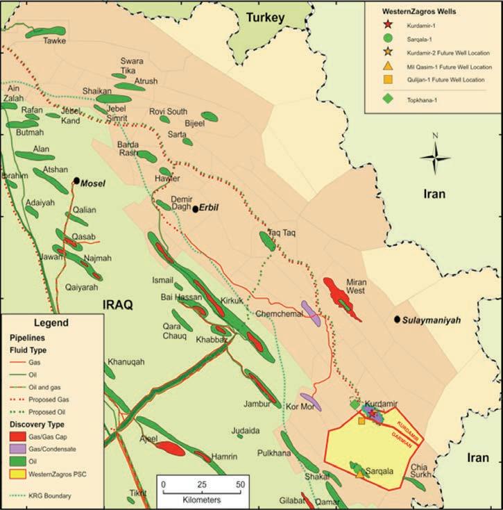
The Zagros is one of the oldest and richest oil and gas provinces in the world. It lies in Kurdistan, a province of Iraq. For a variety of geopolitical reasons the northwest end of this mountain belt, the Kirkuk embayment, has been under-explored in recent years. The focus of this talk will be this tectonic embayment and, in particular, the position of the Mountain Front Fault within it.
The Zagros fold and thrust belt lies on the boundary of the Arabian and the Eurasian Plates. It is oriented SE to NW and runs from the Arabian Sea in southeastern Iran to the Taurus fold and thrust belt on the Iraq-Turkey border. It is made up of three zones of variable width that run sub-parallel with the Main Zagros Suture. The most proximal zone to it is the High Zagros, which is followed by the Zagros Foreland and then the Zagros Foredeep as you progress towards the Mesopotamian block on the Arabian plate. Together they make up a zone of deformation about 300 km wide and 2,000 km long.
The High Zagros is bounded by the Main Zagros Suture and the High Zagros Fault. It
is at an elevation of 3,000 to 4,000 meters. It has duplexed Palaeozoic metamorphic rocks at surface with a structural wavelength of 10 to 15 km. Outboard of this is the Zagros Foreland that is bounded to the southwest by the Mountain Front Faults. This is lower, with an elevation of 2,000 meters. The younger Paleogene A smari and Pila Spi carbonates are mapped at the surface with the structures being dominated by detachment folds with a wavelength of 3 to 4 km. Lastly, the most distal zone is the Zagros Foredeep. It has an elevation of about 1,000 meters. It has recent sediments at surface with Miocene rocks forming anticlines in the hanging wall of thrusts. This zone has a more variable wavelength of about 20 to 40 km.
The structural style of the area is the result of the Cainozoic continental collision between the two plates. This episode of shortening has affected a 10 to 12 km thick sedimentary succession of Cambrian to Early Miocene platform sediments (mainly carbonates), the Gachsaran evaporites and the Mio-Pliocene foredeep clastic deposits. The direction of transport is NE to SW with the major anticlinal axis and faults orthogonal to this direction. This fold and thrust belt is complicated by the interaction of an old deep-seated strike-slip system that runs NE to SW. It originates in the autochthonous basement of the Mesopotamian block in front of the Zagros and is seen as major lateral discontinuities and minor fracture swarms throughout the Zagros Foreland and Foredeep.
The width of the Foreland zone is variable. In map view there are two prominent reentrants defined by the mountain front fault. These are the Dezfur and the Kirkuk embayments. Both of these structures play a prominent part in defining the potential for oil and gas exploration.
To provide a regional geological setting in which exploration can progress a deformation model was needed. This was determined by drawing a regional crosssection across the Mountain Front Fault that defines the boundary between the Foreland and Foredeep Zones in the Kirkuk Embayment. It was built incorporating remote sensing, geological field mapping, and modern sesimic. The section drawing and balancing software Move 2010* was used. This allowed the incorporation of the surface data and the seismic, in both depth and time, into one usable model.
On a regional scale the cross-section had to address the concerns of thick- versus thin-skinned tectonics. This modelling resulted in a complex deformation model. It provided some answers as to the large-scale thick- versus thin-skinned discussion. At a more local level, a variety of decollemont surfaces are found in the fold belt dominated by detachment folds. In addition, we have examples of out-ofsequence thrusting with hinterland vergent thrust defining a triangle zone.
This information was then used to constrain the seismic interpretation at the surface. In addition, it provided a geological crosssection suitable for conversion to a velocity model for use in the time-to-depth conversion of the recently acquired highfold 2D seismic.
*Move 2010 is produced by Midland Valley Exploration, Glasgow, Scotland
BIOGRAPHY
Andrew Newson has 35 years of experience in the geological and geophysical evaluations of overthrust belts. He is a Professional Geological Consultant registered in the province of Alberta and is currently living in Calgary. Andrew graduated in 1972 with a B.Sc. (Hon) in geology from London University, England. Since then he has worked as a structural geologist specializing in the exploration and exploitation of hydrocarbon prospects in overthrust belts around the world.
In 1972 he started his career in New Zealand working on the overthrust belt of the Taranaki Basin. Later, he moved to Canada to work on seismic crews and field-mapping projects in the Foothills of Alberta and British Columbia, Yukon, and NWT. Since then he has worked domestically and internationally, to develop his expertise in evaluating complex deformation styles.
As a consultant for nearly 20 years, Andrew has been involved with numerous projects for clients among the major, intermediate, and junior oil and gas companies. To facilitate this, he incorporated Moose Oils Ltd. in 1994. Through Moose Oils Ltd. he teaches in-house workshops on fold-and-thrust play evaluation techniques and regularly leads field trips for industry to the Canadian Rocky Mountains. He is closely involved in developing balanced cross-section and dipmeter analysis software packages to assist in the structural interpretation of thrust and fold plays. Recent projects include: (Domestic) exploration and
development projects in Montana, Alberta, British Columbia, Yukon, and Northwest Territories; (International) Argentina, Colombia, Kurdistan, Syria, and Turkey.
Andrew has been recipient of numerous awards. Among them was the Canadian Society of Petroleum Geologists’ Link Award for his talk “Foothills, The Future for Exploration.” His company Moose Oils Ltd. has also received an award from NSERC and the Conference
board of Canada for its contribution to the Fold-Fault Research Project. In addition to his consulting, Andrew has contributed to the industry in numerous professional associations such as the CSPG, CSEG, CIM, SEG, AAPG, and PESGB. He is a regular speaker at conferences both domestically and internationally and has undertaken numerous roles as technical editor and chairperson for the CSPG structural geology group. Andrew is also the past chairperson for the Douglas Medal Awards Committee.
INFORMATION
Structural Division talks are monthly and cover a diversity of structural themes. Our Structural Division sponsors are Hef Petrophysical and Husky Energy. All are welcome and no registration is required. For additional information, to be placed on the Division e-mail list or to present a talk, please contact Darcie Greggs, Darcie.Greggs@huskyenergy.com.


www.rpsgroup.com/energy


SPEAKER
Dr. George Pinckney V.P. Exploration & Development, WesternZagros Resources Ltd.
12:00 N oon
Wednesday, January 11, 2012
N exen Plus 15 Conference Centre
N exen Annex Building 7th Ave. & 7th Street SW
Calgary, Alberta
ABSTRACT
Oil and gas exploration in the Kurdistan region of Iraq is fraught with technical, political, and financial risks, but they are overshadowed by the excellent hydrocarbon potential of the area. Kurdistan is one of the
most prospective onshore areas for hydrocarbon exploration in the world, but is underexplored. Since 2004 over 40 PSC’s have been awarded, approximately 20 wildcats have been drilled, and several giant fields have been discovered in the region. The geological success rate is over 75%. Key geotechnical risks include predicting oil versus gas, understanding geological structures at depth, and understanding fractured reservoirs. Seismic is often poor quality. Lowcost geology fieldwork is an especially valuable exploration tool. From a drilling perspective, risks are high with common well problems, geopressure and wellbore stability issues, and limited offset well data available to refine well prognoses and better predict drilling problems. Logistics and securing high-quality oilfield services are challenging due largely to the remoteness of the region, perceived security concerns, and the immaturity of the oil and gas service industry in the area. Of note, careful planning and community relations work are critical components to being a successful player in the region.

SPEAKER
Renjun Wen
Geomodeling Technology Corp.
12:00 N oon
Thursday, January 12, 2012
ConocoPhillips Auditorium
Gulf Canada Square 401 - 9th Ave. S.W. Calgary, AB
We have developed a new workflow to predict full-field-scale reservoir permeability through realistic sub-metre-scale modeling of sedimentary heterogeneity. Unlike conventional reservoir modeling workflows, this modeling approach accounts for the small-scale geological structures that have a large impact on fluid flow, especially in heterolithic reservoirs such as the McMurray Formation in the Western Canada Sedimentary Basin.
We simulate the sedimentary features that are too small to be represented in a full-field reservoir model, such as laminations, bedding structures, sand-body geometries, and shale drapes in channel infill architecture. Our simulations are “process-oriented,” meaning that the simulations mimic the geological processes that created those sedimentary features (e.g., deposition, erosion, and migration). We then apply numerical simulation of fluid flow to each small-scale sedimentary model. The upscaling results from each model provides the input to the next immediatescale model, therefore making it possible to predict effective permeability from core measurements through to a full-field reservoir model, without simplifying the geologic reality of the reservoir.
We illustrate the multi-scale modeling and upscaling workflow in a channelized
Sponsored by
reservoir model. First, we build a corescale heterogeneity model. Directional permeability is upscaled from the corescale model, which then provides the input to the second scale model: the channel infill architecture model. The third scale model is the conventional geocellular model built from seismic interpretation or well correlations. Upscaling of the third scale model provides the input to the production simulation model. Since heterogeneities are modeled at multiple scales and upscaled step-by-step, the effective permeability calculated from these models capture fluid flow at the sub-grid scale. Compared with conventional workflows that ignore sub-grid scale heterogeneity, our multiscale modeling and upscaling workflow not only results in geologically consistent permeability models, but also improves the forecasting of production rates and recovery factors, thereby reducing uncertainty in reservoir management.
BIOGRAPHY
Renjun Wen is the founder of Geomodeling Technology Corp, an international geosciences software company in Calgary, Canada. He holds a Ph.D. in Petroleum Geology from Norwegian University of Science and Technology, Norway (1995), and a B.Sc. in Petroleum Geology from Jianghan Petroleum Institute, China (1983). He has published papers in the fields of reservoir modeling, sub-seismic fault modeling, geostatistical application in image processing, and seismic attribute analysis. Since 2000, Dr. Wen has collaborated with major international oil companies to develop innovative reservoir modeling software in the SBED consortium. He is a registered Professional Geologist in Alberta (APEGGA), and is a member of SEG, CSEG, CSPG, AAPG, SPE, EAGE, and IAMG.
INFORMATION
BASS Division talks are free. Please bring your lunch. For further information about the division, joining our mailing list, a list of upcoming talks, or if you wish to present a talk or lead a field trip, please contact either Steve Donaldson at 403-766-5534, email: Steve.Donaldson@ cenovus.com or Mark Caplan at 403-817-2603, email: mcaplan@aosc.com or visit our web page at www.cspg.org/events/divisions/basinanalysis-sequence-strat.cfm.

SPEAKER
Tetsuto M iyashita, University of Alberta Graduate Student
7:30 PM
Friday, January 20, 2012
Room B108
M ount Royal U niversity Calgary, Alberta
It always was, and ever will be, a long way from amphioxus. Despite centuries of work on vertebrate origins, we still wonder: From what kind of animal did our grand ancestors with backbones arise? A popular song still persists in college biology classes: It’s a Long Way from Amphioxus (to the tune of It’s a Long Way from Tipperary).“It’s a long way from amphioxus to the meanest human cuss…but we all came from there.” It has been a long way indeed, in both
evolutionary and historical contexts. Now that amphioxus – the once glorious missing link – turned out not to be the closest relative of vertebrates, and now that sea squirts – odd pumps in the sea – have taken up that role, the search for the origin of vertebrates has gone back to square one. A little way up the Tree of Life, the order of branching is still contentious. Sitting near the base of the vertebrates is hagfish, often portrayed as the ocean’s most disgusting creature. Is a hagfish a vertebrate? It lacks many vertebrate characteristics, including bones, jaws, fully developed inner ears, and paired fins. However, hagfish may just mimic the ancestral conditions by having shed their vertebrate traits over 600 million years as they survived as slimy, eyeless, benthic scavengers. The position of hagfish is important. If hagfish truly retain ancestral conditions, they can help decipher what ancestral vertebrates looked like. If hagfish are instead degenerated vertebrates, their position among vertebrates forces weird evolutionary patterns among early vertebrates. Between living primitive lineages (hagfish and lampreys) and living jawed vertebrates (sharks, bony fish, etc.)
comprehensive domestic and international geophysical workstation support specialists
Seismic Data Room Rental Service (two secure private data rooms)
Divestiture Seismic Data Room Support (four portable workstations)
Seismic Project Conversions (between interpretation software)
Seismic Data Loading Service
Synthetic and 2D Model Generation
Georeference Service (Coordinate Transformation of Raster Images)
Geographic Coordinate Conversion Service
Well Location Plat Generation
Seismic Data Management Service
Professional Montage Display
Sponsored by
lie a vast diversity and a series of radiations that resulted in enigmatic fossil jawless vertebrates, some of which looked like swimming spatulas. We have little consensus on how these animals were related to one another. How can we break this series of uncertainties? Data have to be mined from where they have not been: anatomy, development, and phylogenetic resolution of hagfish. This endeavor will culminate a twocentury-long search for hagfish embryos. Even with these embryos, though, that will only be the beginning of exploration to the vista of early vertebrate evolution: from brain-less to brainy, from fleshy to bony, from jawless to jawed. The road from “amphioxus to the meanest human cuss” could turn out to be much more torturous than ever imagined.
Tetsuto Miyashita is M.Sc. student at the University of Alberta. A book by the prominent Canadian dinosaur paleontologist Philip Currie – a Christmas gift from parents when he was ten – sparked his dream of becoming a paleontologist. He moved to Drumheller, Alberta, at age 16 to volunteer for Royal Tyrrell Museum of Palaeontology. Subsequently, during four years of undergraduate and two years of graduate school at the University of Alberta, he has been under caring supervision by Philip Currie, invertebrate zoologist Rich Palmer, developmental biologist Sally Leys, ichthyologist Alison Murray, and marine ecologist Richard Strathmann. In their labs, he got his hands on various projects, including anatomy of early vertebrates, systematics of tyrannosaurs, soft tissues in ankylosaurs, biomechanics of marine invertebrate larvae, ecology of intertidal snails, and development of fishes. He has spent the last two field seasons leading a team of students and collecting Daspletosaurus from Milk River Natural Area.
This event is jointly presented by the Alberta Palaeontological Society, Mount Royal University and the CSPG Palaeontology Division. For details or to present a talk in the future please contact CSPG Paleo Division Chair Philip Benham at 403-691-3343 or APS Coordinator Harold Whittaker at 403-286-0349 or contact programs@albertapaleo.org. Visit the APS website for confirmation of event times and upcoming speakers: http://www.albertapaleo. org/


| By Tom Sneddon, Manager of Geoscience Affairs, APEGGA Calgary
Management of the public perception of geologists does not imply control of public opinion. Any attempt to do that would be futile and definitely counterproductive. The best any industry group can hope for is to put the best available information before the public and be prepared to answer all shades of opinion and interpretation the public will engender.
Geoscientists of all flavours must get the best available information about the earth and earth processes in front of the public, along with a clear and transparent description of how that will affect them and also some idea of what we do for a living. Geoscience is more than just a job, of course. Most of us consider it an avocation as well and we collect rocks for their intrinsic worth. Pretty well all of us have a couple of outstanding examples of petrology on our mantles and our awards are generally of the same ilk.
People do seem to have a pretty positive impression of geoscientists. The Association of Professional Engineers and Geoscientists of British Columbia published the results of an opinion survey of public perceptions in the September/ October 2011 edition of Innovation, their chronicle of Association affairs. A ranking of ten professions (Table 1) put geoscientists in seventh place behind accountants and ahead of journalists, lawyers, and politicians. In the interest of precision, the question posed was “Generally Speaking, do you tend to have a great deal of respect, a fair amount of respect, not much respect or very little respect for each of the following professions?”
Follow-up questions in the APEGBC survey discovered that 72% of the public knew what engineers do for a living; only 34% knew what professional geoscientists do.
The Innovation article speculates that one reason geoscientists ranked lower than engineers was the lower level of public awareness of the geoscience profession. A similar survey was conducted in 2008, and while the rankings were similar, the level of awareness of geoscientists had actually declined from 52%.
By the way, if you are a Professional Member of APEGGA and they have a valid email address for you, you will already have received an invitation from the firm Ipsos Reid to participate in an online survey of Members. Ipsos Reid is also conducting a public survey to gauge attitudes and perceptions of Albertans regarding professionals in geoscience and engineering. If you receive an invitation, please take the time to offer your insights.
The results from the APEGBC research suggest to me the need for geoscience
Derived from: APEGBC Innovation, September/ October 2011, pp. 22 - 25
Table 1. Public Perception of Professionals – British Columbia
professionals to make geoscience better known by the public at all levels.
One of the more important elements of public information about geoscience is the annual Honourary Address event
sponsored by CSPG, CSEG, and APEGGA. The November 2011 edition of the event was entitled “Fire + Ice: Adapting to Planetary Change”. Dr. Catherine Hickson, P.Geo. (BC), Vice President and Chief Geologist of Alterra Energy Corp., a geothermal energy development firm; and a glaciology specialist, Jeff Bond of the Yukon Geological Survey, teamed up to present their specialties and how they often interact to sculpt the landscape. This year the event for middle school/junior high students was held in both Edmonton and Calgary. The Calgary version was also presented in the evening for the general public. In all, about 3,000 middle school/ junior high students and 500 members of the public attended the lectures.
Did the Honourary Address achieve its goals? This writer thought so. The questions from the audience were many and surprisingly sophisticated. Conversations overheard while the students filed out from both Edmonton and Calgary sounded positive and most centred on what the audience heard and their response to it. Watching the audience during the presentations, most participants seemed engaged and listening
intently. The audience in both cases was well behaved and respectful.
A quick survey following the Edmonton presentation amongst school teachers who brought their students to hear our message suggested a quite different interpretation and the organizing committee will need to study those results carefully to determine the best way to improve delivery in the future to meet the needs of both students and teachers.
Did you attend Fire + Ice? If so, I would like to have yo ur opinion on how the sponsoring associations can improve this crucially important component of our joint outreach program activities. Please respond to me directly via tsneddon@ apegga.org. If you would prefer anonymity, send your advice through the Reservoir editor, Caitlin Young at caitlin.young@ cspg.org.


| By Colin Yeo, P.Geol. and Lionel Derochie, P.Eng.
In the last article, Understanding Reserves and Resources Part 4, reference was made to deterministic and probabilistic reserves that were based on a drainage area of 640 acres. In fact, the drainage area should have been set at 320 acres so that volumetric reserve estimates, both deterministic and probabilistic, could be compared to reserves established by production decline analysis, which show evidence of drainage areas that are 320 acres or less.
The following italicized text should replace the second paragraph beginning on page 20 of the December issue of the Reservoir.
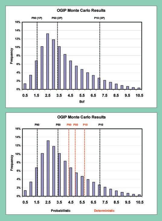
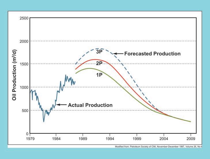
Figure 4 is the distribution of estimated reserves from a Monte Carlo simulation using data from a collection of wells in and around Section 26. This is a lognormal distribution that has a mean value of 3.9 Bcf, a median value of 3.4 Bcf and a mode value of about 2.5 Bcf. The median value of 3.4 Bcf is also the P50 (2P) reserves value whereas the P90 (1P) value is 1.6 Bcf and the P10 (3P) value is 7.1 Bcf (3P). In summary, this distribution plot would suggest that there is a 90% probability that all the wells in the group will reach or exceed 1.6 Bcf. It also indicates that each well in the group has a 50% chance of reaching or exceeding the P50 value of 3.4 Bcf. In other words, half of the wells will fall below the P50 value and half will fall above. The deterministic 1P, 2P, and 3P values of 4.3, 4.8, and 5.7 Bcf that were calculated for the Section 26 wells are also plotted on the histogram for comparison. It is immediately apparent that the deterministic reserve estimates for the Section 26 wells are higher than the probabilistic P50 values.
Figure 4 should be replaced with the corrected version to the right.
The following italicized text should replace the text beginning on page 21, line 5.
As was seen in Figure 4, the spread of reserve estimates using a Monte Carlo simulator was quite large but did incorporate the deterministic estimates. The P50 (2P) value of 3.4 Bcf for the distribution is less than the proven plus probable (2P) value of 4.8 Bcf using the deterministic method but the range of possible reserve outcomes predicted by the
So far in this series on reserves and resources, we have considered the difference between reserves and resources and focused on the calculation of reserves both deterministically and probabilistically. In this, the last article in the series, we turn our attention to two lesser used but equally important methods of reserve determination, the “statistical or type well” and reservoir simulation modeling.
Type wells are particularly suited for reserve estimation in resource plays. As we wrote in “Petroleum Economics for Geologists,” resource plays are characterized by high
simulation did include the 4.8 Bcf estimated deterministically even though the probability of achieving that value was low.
We regret this miscommunication.
geological success but variable production profiles. Type wells are generated by normalizing the production data to a common start date (normalized time plots) for each of the wells in a group and then calculating an arithmetic average for the group for each point in time. The resulting single, average production profile for the group is considered to be statistically representative of what would be expected on average from a large drilling program into a play with similar characteristics. It is important that wells within the group be selected from similar formations with similar operating conditions and well vintage.
When a well is not producing, it is not used in calculating the type curve and is dropped from the well count. When the well count drops below a certain percentage of the well group, the production averaging methodology is no longer considered to be statistically accurate. The percentage cutoff is usually 70%. While statisticians often consider 30 samples to be representative of the population, reserve evaluators prefer a sample size of more than 70 wells to provide that high degree of confidence required for proven reserves.
The resulting type well production profile provides important parameters that will be
used to build a multi-segment forecast for new wells. Each segment has an initial flow rate, a decline exponent, a final flow rate, and a set length of time to maintain the forecast segment. The final rate of any given segment is usually the initial rate for the segment to follow. Any number of segments can be used to construct the type well that replicates the group average.
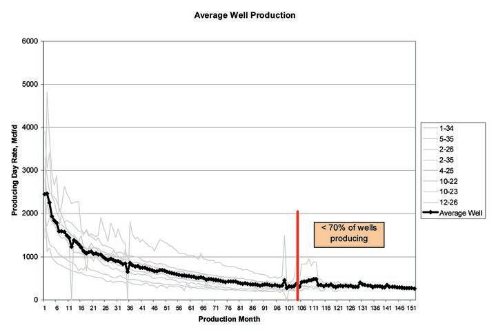
Figure 1 is a normalized time plot of the eight wells on and around Section 26. Individual well production is shown as faint grey lines with initial production set as the first production month. The heavier, dark line is the arithmetic average of the producing day rate. There are two types of flow rates calculated from monthly production data. The producing day rate (also called daily rate) is defined as the monthly production from the well divided by the number of hours the well produced during that month multiplied by 24 hours. The calendar day rate is the monthly production from the well divided by the number of days in that month. The producing day rate is considered a better representation of reservoir performance because the effect of production downtime due to wellbore and/ or facility constraints has been eliminated. However, wells that come on stream late in their first month of production may show abnormally high producing day rates in that month because production for the first few days will be very high compared to production over a 30-day period. Also, wells that regularly experience downtime are best forecast using a calendar day rate as that will be the expected production over time. Discretion needs to be applied when selecting either producing day or calendar day rates to generate a type well.
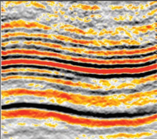
It should be noted that the eight wells that are used in this example have been on production for varying amounts of time and as such in Figure 1, at the 105th producing month, the well count drops from seven wells to four which happens to be two wells below the threshold of six that represents 70% of the sample. The red vertical line in Figure 1 marks the end of the statistically significant portion of the type well. Curvefitting algorithms can be used to generate a forecast of future production anchored by matching earlier data.
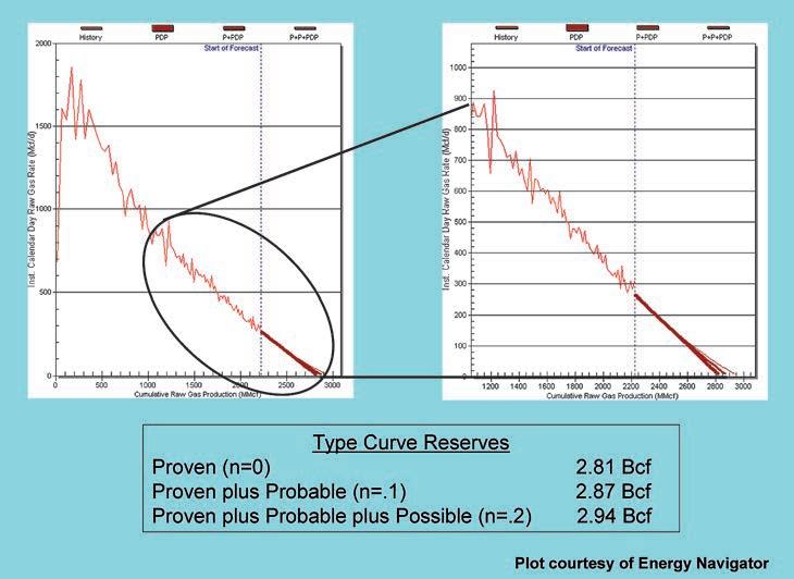
The average well shown in Figure 1 is plotted on a rate cumulative plot in Figure 2 using Energy Navigator’s Value Navigator decline analysis software. The left-hand plot shows the entire type well calendar day rate plotted against cumulative production. The right-hand plot is an enlargement of
later time, pseudo-steady state production. Three forecast lines are shown in the lower right-hand corner of the enlarged graph. The heaviest red line has a decline exponent of zero (exponential decline) and is the most conservative estimate. It is deemed to be proven (1P) reserves. The intermediate red line has a decline exponent of 0.1 (slightly hyperbolic) and is considered to be the best estimate of proven plus probable (2P) reserves. The light red extrapolated forecast line has a decline exponent of 0.2 (slightly more hyperbolic) and is classed as proven plus probable plus possible (3P) reserves. The reserves associated with each
reserve category are shown in the table on Figure 2. Although this example has used only eight wells for illustrative purposes, a larger well group would more closely approximate the true characteristics of the entire population.
In plays where there are a large number of producing wells with long producing lives, evaluators may choose to analyze these producing wells and begin establishing geographic areas that can be accurately represented by a type well. Areas are (Continued on page 24...)
(...Continued from page 23)
created to minimize the standard deviation around the type well. In some cases where infill drilling or downspacing is occurring, a second, or even third, type well representing new infill wells will be constructed and used. Average drilling, completion and tiein costs, operating expenses, royalties, and taxes that are representative of the area can be assigned to the type well and type well economics can then be run. If the NPV > $0, then any well drilled within the area will be assigned reserves. The evaluator only needs confirmation that wells have actually been drilled and type well reserves are automatically assigned.
Evaluators will monitor results and performance of the area, to ensure the type curve continues to accurately represent the incremental drilling program, but individual wells are not systematically reviewed until months or years after they are drilled.
Type wells are particularly useful in CBM or tight oil and gas resource plays where hundreds or even thousands of wells are drilled each year. There is often little variation in production profiles as reservoir characteristics, drilling and completion programs, and facility operations are consistent over specific geographical areas and over time.
Reservoir simulation is a tool often used in production forecasting. A large amount of rock property, pressure, fluid, and production data is gathered and loaded to models for production history matching and
projecting future pool performance. Black oil or compositional models can be used to simulate waterflood, miscible, polymer and thermal recovery schemes. Usually, this modeling is done to assess the economic merits of applying an enhanced recovery scheme. The result of this modeling is an incremental production profile above a base case, which is usually a blowdown production case. The incremental production wedge above the base case represents the reserves that would be expected to be booked based on the model study.
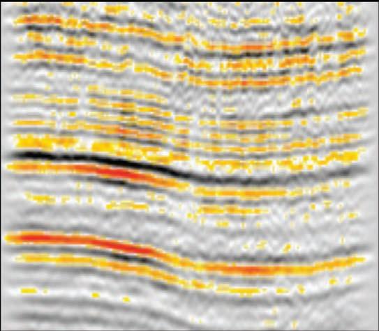
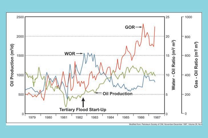
In considering what reserves should be booked, evaluators will first and foremost look for whether or not a production response is evident as a result of the scheme being implemented. Figure 3 was included in a JCPT paper written in 1986 and is a time plot of the oil production, gasoil ratio, and water-oil ratio for the West Waterflood area of the South Swan Hills Unit. A tertiary hydrocarbon miscible flood was initiated in 1982 with the black arrow indicating the start of the miscible flood. Figure 4 shows the actual oil production history for the project area up to 1986 as well as a forecast (blue dashed line) that was generated for the tertiary project area using a 2-D black oil model. As can be seen in both Figures 3 and 4, oil production did increase after the tertiary flood was implemented and appeared to be on trend with the forecast. The water-oil ratios also decreased and, combined with the increase in oil production, provided clear evidence that the reservoir was exhibiting tertiary response to the hydrocarbon miscible injection. Miscible floods inject a solvent slug into the reservoir followed by a slug of dry gas and these slugs are usually injected with alternating water injection. The chemical composition of the solvent is designed to contact the reservoir oil and mix with the oil to form a single-phase fluid in the reservoir. Slugs of water and dry gas are injected to push the solvent/ oil mixture through the reservoir from the injection wells towards the producing wells. If the scheme is working, it is expected
that oil production would increase with a corresponding decrease in the water-oil ratio and an eventual increase in the gasoil ratio as the solvent and dry gas breaks through to the producers. As can be seen in Figure 4, the expected response did occur and was on trend with the forecast and therefore, based on this response, the evaluator can book reserves provided the scheme has an NPV greater than zero. However, the evaluator will use discretion as to how much will be booked given the data available at that point in time. If the actual response of the miscible flood was muted or if it was deemed to be too early to see results, the evaluator may assign reserves based on analogous pools and schemes and would likely not book reserves to the level of what the model is forecasting.
In this particular case, the actual oil production did increase and followed the trend that was forecasted by the 2-D model but only up until about 1985 at which point the production trend started to deviate from the prediction. The model predicted that production would continue to increase and reach a peak rate of about 1,800 m3 /d in 1992 and then begin to decline. However, oil production actually peaked at about 1,200 m3 /d in 1985 and then began to decline. Performance such as this would cause the evaluator some concern. While no doubt the flood was working, was some question at the point when the paper was being written whether the response was going the peak production rates that were forecasted. The author did comment additional 3-D multi-layer compositional model studies were initiated in an to refine the forecast. Differences and forecasted production can occur there is a difference in how a modeled versus how it is actually in the field. When there is a between actual performance and generated by a simulator, the may choose to assign only a the forecasted reserves. In this example, would have been prudent for the to book as proven reserves conservative production forecast the production profile shown by line in Figure 4 and similarly, another as probable (red line) and the as possible (blue dashed line). always consider the expected pool factor when assigning proven, and possible reserves and compare recovery factors to analogous similar enhanced recovery schemes. any reserve estimating technique, and revisions are regularly made
evaluator can then adjust the reserve categories appropriately as the scheme continues to operate.
Estimating reserves and resources is a very important process and must be taken seriously. Creditors, investors, and companies themselves depend on highquality assessments for decision making and risk mitigation. While reserves provide the foundation for cash-flow projections and financial decisions by companies, resource assessment provides an insight into the inventory available for future reserve
growth. A variety of techniques are available to estimate reserves and comparing results from different techniques gives a sense of confidence in reserve numbers. Reserve evaluators use their experience to ensure reserves are not overstated or underestimated. Accuracy matters when assigning reserves. Too many people are counting on it.
Derochie, L. J. 1987. Performance of South Swan Hills Tertiary Miscible Flood. The Journal of Canadian Petroleum Technology, v. 26, no. 6, p. 76-81.


| By Jay Williams, Committee Chair
The CSPG squash committee has been hard at work since October to prepare for the 29th Annual event. The tournament will once again be held at the World Health Club in Edgemont on February 2-4, 2012. Both singles and doubles play will be offered again to all players entering the competition. Registration is up and running on the CSPG website at www.cspg.org. Look under the Events Tab under Social Events to find the squash link. Early Bird prizes are being offered to those people who are keen enough to get their entry
in before January 2, 2012. Enter early as this event fills up quickly. The limit will be about 130 players plus or minus a few depending on which divisions need players. This tournament is open to all players and abilities. We typically have an A division for highly skilled players all the way down to E or Beginner level. Look for great food and social opportunities at this three-day tournament. The CSPG Squash tournament has been a sold-out event for the past 12 years and continues to grow in popularity. The event hosts a variety of earth scientists, including a large number of geophysicists who entered last year. Students are always welcome and have been generously sponsored by Encana in the past. Practice night will be hosted at Bankers Hall on Thursday January 26th at 4:45 to 7:00 pm. Please contact Jay Williams 403-978-5647 or the CSPG office at 403-264-5610 for sponsorship opportunities.
joelharding@geoedges.com www.geoedges.com
Western Canada: Slave Point, Swan Hills, Leduc, Grosmont, Jean Marie, Horn River Shales, Elkton, Shunda, Pekisko, Banff, Mississippian subcrops and anhydrite barriers in SE Sask., Bakken, Three Forks, Montney, Halfway, Charlie Lake, Rock Creek, Shaunavon, BQ/Gething, Bluesky, Glauconitic, Lloyd, Sparky, Colony, Viking, Cardium, Horseshoe Canyon and Mannville CBM, Oilsands Areas, Outcrops
US Rockies & Williston: Red River, Mississippian subcrops & anhydrite barriers (Bluell, Sherwood, Rival, etc), Bakken, Three Forks, Cutbank, Sunburst, Tyler, Heath, Muddy, Dakota, Sussex, Shannon, Parkman, Almond, Lewis, Frontier, Niobrara, Mesaverde shorelines, Minnelusa, Gothic, Hovenweep, Ismay, Desert Creek, Field Outlines, Outcrops
North American Shales: Shale plays characterized by O&G fields, formation limit, outcrop, subcrop, structure, isopach, maturity, stratigraphic cross-sections. Includes: Marcellus, Rhinestreet, Huron, New Albany, Antrim, Utica-Collingwood, Barnett, Eagleford, Niobrara, Gothic, Hovenweep, Mowry, Bakken, Three Forks, Monterey, Montney, Horn River, Colorado
Appalachian Basin: PreCambrian, Trenton, Utica-Collingwood, Medina-Clinton, Tuscarora, Marcellus, Onondaga Structure, Geneseo, Huron, Antrim, New Albny, Rhinestreet, Sonyea, Cleveland, Venango, Bradford, Elk, Berea, Weir, Big Injun, Formation limits, Outcrops, Allegheny Thrust, Cincinatti Arch, Field outlines
Deliverables include:
-Shapefiles and AccuMap map features
-Petra
-bi-annual
-technical
The CSPG and all CSPG members are members of the Canadian Federation of Earth Sciences (CFES – www.geoscience. ca). The CFES, was established in 2006 to succeed the Canadian Geoscience Council. It brings together 14 affiliated member societies of earth scientists in industry (minerals, petroleum, environmental/geotechnical), government (Federal and Provincial/Territorial Geological Surveys), and Academia, representing a total of about 20,000 earth scientists in Canada. CFES provides a unified voice for earth science in Canada. It increases awareness of the importance of earth science in Canada and the lives of Canadian. It enhances the understanding and appreciation of the earth sciences in securing and responsibly developing Canada’s energy, mineral, and water resources and provides awareness of the earth sciences in environmental, natural hazard, and climate studies. Three dollars,
or 3%, of each regular members annual dues are transferred to the CFES, making CFES one of the most significant elements of the CSPG’s outreach program. Consider visiting the CFES website to learn more about what the CFES provides for the earth sciences in Canada and the CSPG and its members in particular.
One of the great successes of the CFES is the Canadian Geoscience Education Network (CGEN – www. geoscience.ca/cgen), which is concerned universally with geoscience education in Canada. CGEN encourages the efforts of the Canadian geoscience community for the purpose of increasing public geoscience awareness. Recently CGEN has produced and released a series of Earth Science career videos (http://careercrate.com/ group/cgen/videos/24). Consider visiting the URLs in this article and to learn more about how the CFES helps CSPG project a
2012 membership fees are now due - renew your membership online today!
Here’s how:
1. Go to www.cspg.org
2. Click Log On at the top of the webpage
national presence and achieve its societal outreach goals.
At the CSPG we are also trying to develop programs for our U-35 members. U -35 Members, as CFES members can also participate in the Young Earth Scientists Network. Y ES Canada is the Canadian National Chapter of the Young Earth Scientists Network. CFES supports Y ES Canada. Yes Canada can found at http://yesnetworkcanada.blogspot.com/. Y ES Canada membership is FREE for any CSPG earth scientist under the age of 35. Consider joining, participating, and learning more about how Y ES can contribute to both your career and personal goals as a young earth scientist. Contact Sarah Saad at Geological Survey of Canada Calgary (sarah.saad@nrcan. gc.ca) to learn more about Y ES Canada.

3. Logon is your membership number; password is the first four letters of your last name plus your membership number (no spaces, all lowercase)
4. Go to “Members” on the black menu bar across the top of the page then “My Account” and then click on “Billing”
5. Follow the prompts to pay your dues with VISA or MasterCard
6. You will receive confirmation by ema il of your payment
Please consider making a donation to the CSPG Educational Trust Fund which funds educational programs to inspire individuals to pursue a career in petroleum geoscience. You can make a donation at the same time as your membership renewal.
If you are having trouble logging in please send an email to CSPG Member Liaison, Bea McDowell, bea.mcdowell@cspg.org
Has your contact information changed? Please make the necessary updates in your online profile.
Membership is on an anniversary basis
| By Rob MacNaughton, Bulletin Editor-in-Chief.
Change is afoot at the Bulletin of Canadian Petroleum Geology. The coming year will see some changes in our editorial leadership as well as the celebration of an anniversary. This note will bring the members of CSPG up to date on these changes.
By the time this note is published, Denis Lavoie will have stepped down as an Editor-in-Chief. Denis began his service in 2008, at the beginning of a challenging time that included a transition to primarily online publication, forced by the financial circumstances faced by CSPG. With his dedication, enthusiasm, and experience from other journals, Denis has helped the Bulletin maintain a high scientific standard through that and other challenges. Merci beaucoup, Denis! Ce fut un plaisir et un privilège de travailler avec toi. Rob MacNaughton will not be carrying on alone, for the CSPG executive recently approved the appointment of two new Editors-in-Chief. Dave Morrow joined the editorial team in November, 2011. Dave is no stranger to editorial work, having been an Associate Editor of the Bulletin and also having co-edited the “Diagenesis” review series in Geoscience Canada in the
1980s. He is currently a volunteer at the Calgary office of the Geological Survey of Canada, where he enjoyed a long career prior to his retirement.
Dave and Rob will be joined in mid-2012 by Burns Cheadle. Since 2009, Burns has been the inaugural Bill Bell Chair in Petroleum Geology at the University of Western Ontario. Prior to taking up that position, he spent twenty-three years in industry, including six as President and Director of Outrider Energy Ltd., a privately held oil and gas exploration company based in Calgary.
Rob will stay on board as an Editor-in-Chief until the end of 2012. This is to help ensure a smooth transition for Dave and Burns, but also to help mark next year’s anniversary. During 2012, not only will the Bulletin publish its 60th volume, but this will be the 50th volume published under its present title. In 1953, the Alberta Society of Petroleum Geologists published the first issue of what then was called the ASPG News Bulletin. The first two volumes were much like the Reservoir of today. With the third volume, the name changed to the Journal of the Alberta Society of Petroleum Geologists. With volume 11 (1963), the name was changed to
the Bulletin of Canadian Petroleum Geology, in acknowledgment of the journal’s growing geographic and geologic scope. The editors at that time also began to implement a modern system of peer-review.
Whether 2012 marks one or two milestones for the Bulletin, we plan to celebrate a little bit. To honour the occasion, we will premiere a new “look” for papers published in the Bulletin, and we will also introduce some new paper series. Details are being finalized, so watch the Reservoir and the Bulletin for updates. If you have ideas for other ways to mark the anniversary, please let us know via email (Robert.MacNaughton@NRCan-RNCan.gc.ca).
Welcome aboard, Dave and Burns! Thanks again, Denis. And, as always, thanks to our readers for their interest and support .
Rob MacNaughton is an Editor-in-Chief of the Bulletin of Canadian Petroleum Geology. He is a Research Scientist at the Calgary office of the Geological Survey of Canada. Thanks to Denis Lavoie, Dave Morrow, and Burns Cheadle for their comments on this report.

| By Darin McBeath
Students from six earth science departments in Atlantic Canada gathered in St. John’s, Newfoundland for the 61st Atlantic Universities Geoscience Conference (AUGC) from Oct 20th – 22nd, 2011. AUGC is the oldest scientific conference in Canada that is entirely fundraised and organized by students. It provides students with an opportunity to showcase their own research and to broaden their exposure to earth science topics that other students are researching. The conference was well rounded with field trips, seminars, and of course, social activities.
Students, professors, and industry representatives met on Thursday night to kickstart the conference with an ice breaker at the Johnson Geoscience Centre on Signal Hill. The energetic mob made its way to the legendary George Street afterwards.
A focus of the AUGC is to highlight the local geology; several fieldtrips that focused on the geology of “The Rock” were offered. We chose to visit the core depository in St. John’s, a small but definitely growing facility on the edge of city, where we looked at several cores from the Hibernia and White Rose fields. The oil and gas industry is certainly alive and well on the East Coast. Other options included a “St. John’s Local Geology” walking tour and a trip north to Bell Island to visit the famous Cambrian-Ordovician strata well known for the abundant and popular trilobite trace fossils. Participants from the various field trips met up that night for a student pub crawl on George Street.
The CSPG had a booth at the conference (held at the Inco Innovation Center, Memorial University) where University Outreach representatives chatted with geology and geophysics students about the oil and gas industry. We handed out several calendars, issues of the Reservoir, and our newly printed CSPG t-shirts. The shirts were a big hit and went fast. We also signed up over 150 new student members.
Poster and formal presentations were given throughout the final day. The winner of the “Best Presentation Related to Petroleum Geology” was Derrick Midwinter from Dalhousie University for his presentation, “The Depositional Regime of Early Triassic
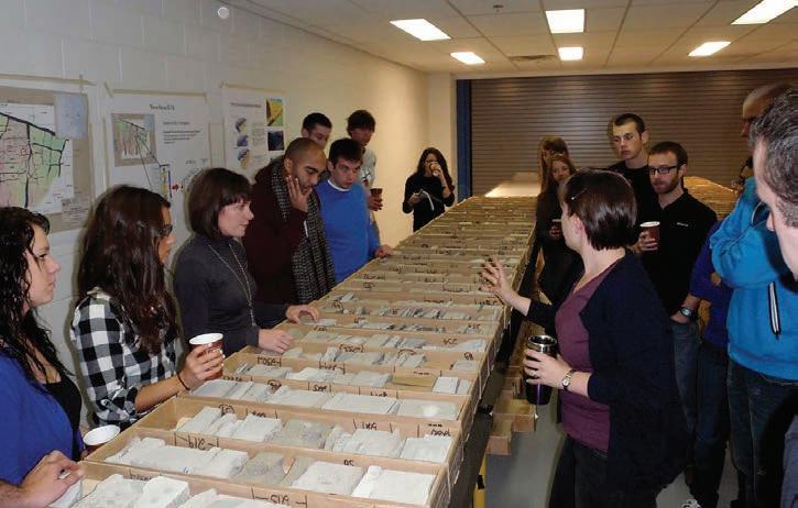
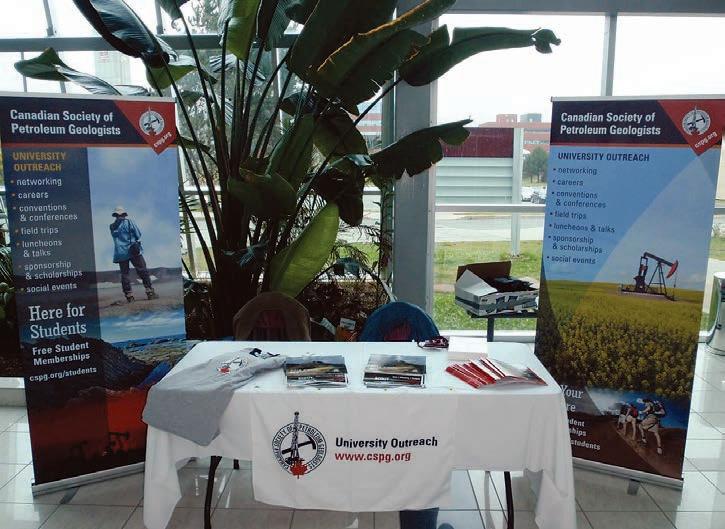
Sedimentation in the Bjorne Formation on the Eastern Margin of the Sverdrup Basin, Ellesmere Island, Nunavut, Canada.”
Derrick wrote:
“The AUGC was amazing along with the hospitality of St. John’s. I’d like to thank the CSPG for recognizing undergraduate research. There are also many individuals I’d like to acknowledge, but in particular Dr. Keith Dewing (GSC) for all his valuable insight over the years.”
Overall the conference was a great event and it was valuable for the CSPG to have a visible presence on the East Coast. Conference attendees learned, socialized, and made some of the industry and peer contacts that are so important to starting a career. The people of St. John’s were especially hospitable, as Newfoundlanders are known to be. Congratulations to the student organizers from Memorial University and especially to Sheldon Barron for hosting such a great event.
| By Philip Benham and Yingchun Guan

Trailhead: Marble Canyon parking lot is 7 km west of the provincial boundary on Hwy 93. The Paint pots are a further 2.5 km west.
Distance: Marble Canyon is a 1.5 km circuit, which takes longer than you expect because of numerous viewing stops along the way. The trail to the Paint Pots is 3 km return. It is particularly wet in the spring. Wear shoes that you don’t mind getting covered in sticky orange mineral muds. A connector trail approximately 3 km long joins these two hikes.
Elevation G ain: There is minimal elevation gain in either trail.
Marble Canyon and Paint Pots trails offer two very contrasting views, yet are linked closely by geology. Multiple bridges across Marble Canyon give you good views of the rocky depths. The walls of the canyon (actually a gorge, cut not in marble, but in Cathedral Formation dolomite) are so narrow that in places the waters 60m below are not visible. If you look closely you will observe fracture sets in the rock, parallel to the canyon path. A thrust fault further up Prospector’s Valley is exactly parallel to Tokumm Creek. It dies out southwards into the vicinity of Marble Canyon as a series of fracture planes with minor offset. The fractures may have been a focus of karst dissolution in the past allowing the formation of a cave system (Gadd, 2008). Glaciers occupied the valley and melt-waters at their base exploited the weakness in the rock, scouring out the narrow canyon before you. At the upstream end of Marble Canyon you can find white dolomitized patches with lead-zinc sulphide stringers. This mineralization is similar to that associated with the Kicking Horse Mines. The mineralization may be related to the Ice River Complex (which is about 15 km NNW of here) or a similar intrusion. The sulphide mineralization is largely restricted to the basinward side of the Cambrian platform collapse that formed the Cathedral Escarpment.
The short hike to Paint Pots takes you across the Vermillion River (named for the iron oxide stains on its pebbles) and then on a muddy route past the areas mined in decades past to the source of the springs themselves. The site is a sacred site for several First Nations groups who used dried balls of ochre to colour their clothes and draw on rocks to denote important events and mark spiritual centres. Subsequent to the spring’s “discovery” by James Hector in 1858 the ochre was actively dug, laid in elongate mounds to dry (still visible about halfway along the route) and then transported to Calgary as a colour component of paint. Remnants of the equipment used to mine and move the ochre prior to the establishment of Kootenay N.P. in 1920 are scattered about the site. The Paint Pots consist of three active cold mineral springs ringed by iron oxide buildups. The typical browns, oranges, and red colours take on garish greens where a small stream trickles into the largest Paint Pot. Sludgy oxides wash down the slope and spread onto a small plain, colouring it orange. The waters are rich in Fe, Mn, Zn, and Pb; have low pH (3.2-4.0); and are often anoxic (van Everdingen, 1970). The algae and liverworts growing in these waters are similar to those growing in acid mine drainage and are tolerant of conditions fatal to most vegetation (Wehr and Whitton, 1983). Some of the metals are deposited as oxides but most make it to Vermillion River where they are diluted by the larger water mass.
References: Gadd, Ben. 2008. Canadian Rockies Geology Road Tours.
Price, R.A, Mountjoy, E.W., and Cook, D.G. 1979. GSC Map 1476A, Mt Goodsir, East Half. Wehr, J.D. and Whitton, B.A. 1983. Hydrobiologia, v. 98, no. 2, p. 97-105.
Van Everdingen, R.O. 1970. Canadian Journal of Earth Sciences, v. 7, no. 3, p. 831-852.

by

The view upsteam of Marble Canyon, and west to the Southern Ridge of Mount Oke. Tokumm Creek runs straight southeast down Prospector’s Valley, its path cut along the plane of a fault. The limestones, argillaceous dolomites, and slates of the lower and Middle Chancellor Group (CH) rest atop the Cathedral Formation (CA). A dead stand of trees is mute witness to the lightning-triggered fire of 2003.
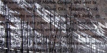
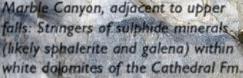
Marble Canyon, adjacent to upper falls: Stringers of sulphide minerals (likely sphalerite and galena) within white dolomites of the Cathedral Fm.
Spring melt pours from the mossdraped gorge walls. It is this active movement of water that could enlarge fractures by dissolving limestone to form caves.

Upstream, the gorge narrows to a scalloped cleft, the water barely visible. The arrow points to a “stranded” pothole.

Iron oxides turn the plains downstream of the Paint Pots brown and orange. The toxic waters of the shifting streams kill most vegetation, leaving abundant driftwood
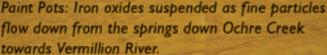
Paint Pots: Iron oxides suspended as fine particles flow down from the springs down Ochre Creek towards Vermillion River.

The mildly toxic spring waters are soapy, probably a mixture of the mineral content and decaying vegetation. This spinning island of foam bubbles is one such ephemeral product.
The three active Paint Pots (blue arrows). The springs deliver an abundant supply of iron oxides that deposit as a solid buildup at the rim of the springs. The areas surrounding the Paint Pots and downstream consist of a sticky acidic muck that kills trees and makes for treacherous footing.

Remnants of equipment used to extract and transport ochre are scattered about the site.
PRESIDENT – ROBIN MANN


EDUCATION: B.Sc. Geology (Honours), Dalhousie University (1977); M.Sc. Geology and Geophysics, Carleton University (1979).
EXPERIENCE : Amoco, Aquitaine, Fekete & Associates and Westward Energy (1977-1997); Co-Founded Hume Mann & Associates which eventually became AJM Petroleum Consultants (1984); CEO of AJM Petroleum Consultants (2004-2011); Energy Resources Advisory Services, Partner, Deloitte (2011-present).
PROFESSIONAL MEMBERSHIPS: CSPG, APEGGA, AAPG, Member of AAPG Division of Professional Affairs.
CSPG ACTIVITIES: Chairman of CSPG Insurance Committee (1999-2008).
AWARDS: CSPG Service Award (2005).

EDUCATION: B.Sc. (Honours, Geological Sciences), Queen’s University, Kingston, Ontario (1980); Ph.D. in Geology, University of Calgary (1991).
EXPERIENCE: Geologist/Geophysicist, Amoco Canada (1980-1993); Structural Geologist, Morrison Petroleum (1993-1996); Exploration Manager-Foothills, Northstar Energy (1996-1999); Principal, GeoConsultants Ltd. (1999-2010); President, Shale Exploration/Petroleum (2010-present); Adjunct Professor, University of Calgary (2005-present). Lecturer for numerous industry courses on Structural Geology and Fractures (1995-present).
PROFESSIONAL MEMBERSHIPS: CSPG, AAPG, APEGGA, CSEG.
CSPG ACTIVITIES: Speaker at several conferences and luncheons; Structural Division Chair (1993-1994); Visiting Petroleum Lecturer (1995, 2010), Editor (Bulletin), Triangle Zone Volume – Special Issue (1996); Canadian Petroleum CSPG Executive, Program Director (2000-2001); CSPG/CSEG/CWLS Annual Convention Co-Chair – Recovery (2011); GeoConvention (JAC) steering committee (present).
AWARDS: CSPG Service Award; CSPG Tracks Award; CSEG/CSPG/CWLS Best-Integrated Geology and Geophysics Paper for the National Convention Geotriad; GeoCanada (2010), National Convention for the CSPG, CSEG, CWLS, GAC/MAC – Best Geology Paper.


EDUCATION: B.Sc. (Hons. Geology), University of Toronto (1978); M.Sc. (1983).
EXPERIENCE : Exploration Department, Gulf Canada Resources Inc.; Petro-Canada Exploration Inc.; Collaborative work with Energy Sector NRCan, Yukon Geological Survey, AECL Research Ltd., Canadian International Development Agency, the National Energy Board, Australian Research Council, and the French Petroleum Institute; Head, Energy Geoscience Subdivision at the Geological Survey of Canada (GSC): Calgary, in Earth Sciences Sector (ESS) of Natural Resources Canada (NRCan); Leads the National Organic Geochemistry and Petrology Laboratory in ESS’s Scientific Laboratory Network; Recently assumed management of both ESS’s, Gas Hydrates and Geoscience for Future Energy Resources programs, and contributes scientifically to ESS’s GeoMapping for Energy and Minerals program.
RESEARCH INTERESTS:
Petroleum systems geoscience including natural gas hydrates, petroleum resource assessment, and Arctic geoscience; Contributed to the Canadian Gas Potential Committee, the Petroleum Technology Alliance of Canada’s unconventional gas technology roadmap, and the Alberta Regulatory Framework Assessment for Carbon Capture and Storage.
CSPG ACTIVITIES: Past President (2012); previously served as President, Vice-President, Finance Director, Assistant Editor and a member of several Technical Program Committees.
AWARDS: Coleman Gold Medal in Geology (University of Toronto); Chevron Scholarship (University of Toronto); CSPG Tracks Awards (2); CSPG Service Award; CSPG Hunter Volunteer Award; CSPG Annual Convention Best Poster Runner-Up Award; NRCan Earth Sciences Sector and Divisional Merit Awards (3).

EDUCATION: Graduate in Hotel Management (1992); Various Courses at University Passau, Germany (1993) and SAIT (1996-1999).
EXPERIENCE: Immigrated to Canada 1996; Accountant, VIRTUAL Computing Services Ltd. (1996-1997); geoLOGIC systems ltd (1997-Present); Administrative Manager, (1997-2001); Account Manager (2001-2007); Vice President Business Development and Sales, geoLOGIC systems ltd. (2007-Present).
PROFESSIONAL MEMBERSHIPS: CSPG, CSEG, Associate Member SEG.
CSPG ACTIVITIES: Special Events Chair (2006 and 2007), CSEG Representative on JAC.

EDUCATION: B.Sc. Geology, University of Calgary (1998); M.Sc. Earth and Atmospheric Sciences, University of Alberta (2004).
EXPERIENCE: Geologist, Canadian Natural Resources (2006-Present); Anadarko Canada (2002-2006).
PROFESSIONAL MEMBERSHIPS: CSPG, APEGGA.
CSPG ACTIVITIES: Treasurer Continuing Education Committee 2008-2011.
EDUCATION: B.Sc. in Earth Science, University of Guelph (1994); M.Sc. in Environmental Earth Science, University of Guelph (1997); Ph.D. in Geology, University of British Columbia (2004).
EXPERIENCE: Suncor Energy (contract geologist, 2001-2005); BP Canada (2005-2010); Apache (2010-present).
PROFESSIONAL MEMBERSHIPS: CSPG, AAPG, APEGGA, APEGBC.
CSPG ACTIVITIES: 2005 Gussow Conference Organizing committee, Emerging Petroleum Resources Chair (2005-2008).
PUBLICATIONS: Published several papers as principle or coauthor relating to organic petrography of peats and coals.
AWARDS: GSA Coal Division Student Award (1999); TSOP Student Presentation Award (2000); CSPG Volunteer Award (2005, 2007).


EDUCATION: Dip. Reservoir Engineering, SAIT (1983), B.Sc. Geology, University of Calgary (1990).
EXPERIENCE: Technical Sales and Services, Digitech (1990-1992); Manager, Log Library, Riley’s Datashare International (1993-1996); Sales Manager, International Datashare Corporation (1996-2002); Sales Manager, RECON Petrotechnologies (2002-2011); Technical Advisor, Canadian Discovery (2011-Present).
CSPG ACTIVITIES: Transportation Committee GeoTriad (1998), Exhibits Chair CSPG / CSEG Convention (1999), Sponsorship Chair, Joint Annual Convention (2004 and 2005).
AWARDS: CSPG Service Awards (various years).
(Continued

EDUCATION: Ph.D. Geology, University of Calgary (2000); B.Sc. Honours Geology, Carleton University (1976).
EXPERIENCE: Mineral Geologist, Norcen Energy Resources, Phillips Management Inc., Urangesellschaft Canada, (1975-1979); Sr. Geologist, Dome Petroleum (1979-1983); Sr. Petroleum Geologist, Geological Survey of Canada (1984-1994); Chief Geologist, Hardy Oil & Gas Canada (1994-1995); President, Springtide Energy Ltd. (1995-1996); Regional Geologist, Poco Petroleums/Burlington Resources (1996-2001); Exploration Manager, Ice Energy Limited (20012002); Consulting Geologist, Java Energy Inc. (2002–2003); Vice-President Exploration, Southpoint Resources Ltd. (2002–2004); Sr. Staff Geologist, Burlington Resources/ConocoPhillips (2004-present).
PROFESSIONAL MEMBERSHIPS: CSPG, AAPG, APEGGA, CWLS, GAC.
CSPG ACTIVITIES: CSPG Assistant Communications Director (2010); CSPG Stratigraphic Nomenclature Committee (1991 – present); Organizing Committee & Technical Program CSPG “Pangea” Convention (1993); co-Chairperson Core Conference, CSPG-CSEG-CWLS Convention (2006); Associate Editor, CSPG Bulletin (2005-2007); Chairman Technical Program, 2002 CSPG 75th Anniversary Convention; Chairman & member, CSPG Medal of Merit (“best paper”) Committee (1997-2006); CSPG Douglas Award Nominating Committee, for Dr. Graham Davies (2002); Organizing Committee & Chairman Core Workshop - 1999 International Congress on the Carboniferous and Permian; CSPG Executive (1996-1997); Critical reviewer of many CSPG and other publications, volunteer mentoring (1984-present).
PUBLICATIONS: Published 34 geological papers; many formal talks or posters or core displays given at conferences; numerous informal talks given at oil companies, universities, and schools.
AWARDS: CSPG Best Ph.D. Award (2001); CSPG Volunteer Award (2003); CSPG Service Award (2005); ConocoPhillips Special Recognition Award (2007); ConocoPhillips Special Recognition Award (2008).
EDUCATION: B.Sc. Geology, University of Calgary (1989).
EXPERIENCE: Consultant Coal Geologist (1989-1995); ERCB Coal Geologist (1995-present).
PROFESSIONAL MEMBERSHIPS: CSPG, APEGGA.
CSPG ACTIVITIES: Session chair CSPG conference.
PUBLICATIONS: Few formal talks or posters in convention programs; chapter co-author WCSB Atlas 1994.

EDUCATION: B.Sc. Geology, Imperial College, London (1985); M.Sc. Sedimentology, Birkbeck College, London, (1993), Ph.D. Geology, University College, London, (1998).
EXPERIENCE: Mining Geologist, Gencor; Rand Mines, South Africa (1986-1990); Marine Geologist, British Telecom (1990); Production Geologist, Shell, Netherlands (1998); Professor at Delft University (2004-2006); Team Leader New Ventures, Shell Canada (2006-2010); Exploration Manager, Murphy Oil Corp. (2010).
PROFESSIONAL MEMBERSHIPS: CSPG, President, British Sedimentology Research Group (BSRG), Geological Society of London, PESGB, Geologists Association.
CSPG ACTIVITIES: Volunteered at several CSPG conferences, ran numerous field trips.
AWARDS: Best Poster, CPSG conference (2008); CSPG Link Award (2009).

EDUCATION: B.Sc. Geology, University of Manchester, England (1973).
EXPERIENCE: Geologist, Amoco Canada Petroleum Company (1974-1991); Manager of Geology, Crestar Energy (1991-1998); President, Geo-Help Inc. (1999-2004), Manager of Geoscience, AJM Petroleum Consultants (2005-2011), Director of Geoscience, AJM Deloitte (2011 to Present).
PROFESSIONAL MEMBERSHIPS: CSPG, AAPG, APEGGA.
CSPG ACTIVITIES: Co-chair of Continuing Education Committee (2003-2006), Presented numerous papers, posters, and luncheon talks at various CSPG events.

EDUCATION: B.Sc. in Earth Science, Brock University (1998); M.Sc. Geology, University of British Columbia (2003).
EXPERIENCE: Geologist, Terracon Geotechnique (1998-2000); Geologist, Shell Canada (2003-2010); Senior exploration geologist, Statoil (2010-present).
PROFESSIONAL MEMBERSHIPS: CSPG, AAPG, APEGGA, GSC.
CSPG ACTIVITIES: University Outreach Committee, Ontario student chapters’ representative (2005-2009); University Outreach Committee Chair (2009-2010).
AWARDS: CSPG Volunteer Award (2007, 2008, 2009).

EDUCATION: B.Sc. Geology and Geophysics, University of Calgary (1999); M.Sc. Geology and Geophysics, University of Calgary (2005).
EXPERIENCE: Geologist, Talisman Energy (2000-2002); Geoscientist, Imperial Oil Resources (2003-Present).
PROFESSIONAL MEMBERSHIPS: CSPG.
CSPG ACTIVITIES: SIFT:Student Industry Field Trip (1998-present), SIFT Committee Chair (2010, 2011).

The CSPG Squash Tournament is one of the largest industry sponsored racquet tournaments in Calgary This year is our 29 th year and we are still going strong . The event draws a large number of earth scientists and has oversold the limit of 130 players for the past 10 years.
Early Bird Deadline: January 2, 2012
Qualify for Early Bird Draw Prize
Registration Deadline: January 20, 2012 No refunds after this date. Register online at www.CSPG.org
Please


CORPORATE MEMBERS
APACHE C ANADA LTD
APEGGA
BAKER ATLAS
BDO C ANADA LLP
C ANADIAN NATURAL RESOURCES LTD
C ASE Y & ASSOCIATES
CONOCOPHILLIPS C ANADA LIMITED
DEVON C ANADA CORPORATION
E NERPLUS CORPORATION
E XXON MOBIL UPSTREAM RESEARCH COMPANY
GEOLOGIC SYSTEMS LTD
GEOSTRATA RESOURCES INC.
H UNT OIL COMPANY OF C ANADA
HUSKY ENERGY INC.
IHS
IMPERIAL OIL RESOURCES
JEWELSUITE
LITTLE ROCK DOCUMENT SYSTEMS
MJ SYSTEMS
MURPHY OIL COMPANY
NEXEN INC
PENN WEST PETROLEUM LTD.
PETROCRAFT PRODUCTS LTD
PLUSPETROL S.A
ROX AR
RPS ENERGY C ANADA LTD
SCHLUMBERGER
S HELL C ANADA LIMITED
S PROULE ASSOCIATES LIMITED
SUNCOR ENERGY INC
TALISMAN ENERGY INC .
TOTAL E&P CANADA LTD.
TOURMALINE OIL CORP
AS OF DECEMBER 10, 2011
CSPG welcomes our 2011 Corporate Members!
The benefits of being a corporate member include:
• Recognition in the monthly Reservoir and quarterly Bulletin
• One associate membership
• Reserved tables at the technical luncheons with your company logo
• One free pass to the CSPG Core Conference
…and more! Contact Kasandra Klein at kasandra.klein
@cspg.org to be a corporate member today!
| By Andrew Millar
This year, as part of the Exposure: Calgary, Banff, and Canmore Photography Festival, I’m presenting a series of rock images at Inglewood Fine Arts in Calgary.
Year-round I’m travelling the roads and trails of Alberta and British Columbia looking for eyecatching subjects, in an attempt to show people the world they live in from a different perspective. While I like the organic and constantly changing landscape, it needs to be contrasted with the angular and synthetic nature of human occupation. Weather, as much as a last-minute inspiration, points me in the directions I travel to capture images. Over the years I have collected quite a few intriguing images of rocks, some of which will be part of this exhibition.
“It’s Sedimentary” at I nglewood Fine Arts, 1223B-9th Ave. S.E., Calgary, AB, Ph: 403-262-5011. Opening reception February 4th, show runs through to February 19th. Open Wednesday to Saturday 10:30am – 5:00pm, Sunday 12:00pm – 4:00pm.
Top: Spherolith, Red Rock Coulee, Alberta, Top Right: Golden Cut, Exshaw, Alberta, Bottom Right: Contemplation (Rock Face Series), Myra Canyon, British Columbia, Bottom Left: Carved in Stone, Marble Canyon, British Columbia.


Blueback Reservoir is a fast growing technology company specializing in providing consulting services and software solutions for the global exploration and production industry
Geomodeling Consulting Services
• Onsite Consultants
• Remote and/or ad hoc modeling support
• Customized modeling solutions
• Mentoring
Software Products
• Innovative and efficient plug-ins for Petrel* to optimize and increase your efficiency
Software Development Services
• Schlumberger Preferred Ocean* Development Partner
• Development of plug-in applications for Petrel
• Development services as a consultancy