19 Geomechanics For Everyone, Part 1: Geomechanical Risk Factors Associated with Hydrocarbon Containment 28 CSPG Student Field Trip 32 Go Take a Hike $10.00 SEPTEMBER 2013 VOLUME 40, ISSUE 8 Canadian Publication Mail Contract – 40070050

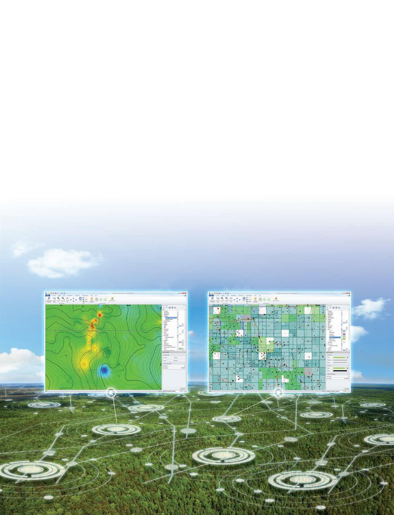
Developed with extensive industry feedback, a complete user interface refresh enables easy navigation with the addition of the Microsoft® Office Ribbon and mouse-driven pan and zoom functionality. Mapping and plotting are now enhanced with editable contours, flexible postings, and transparency for all layers, including Land. Expanded engineering capability increases reservoir knowledge with both the Classic Production Graph and the new Material Balance Graph.
Gives the user so much more freedom and control over how the map works
–Geoscience Professional during a Sneak Peek of the new AccuMap®


CSPG OFFICE
#110, 333 – 5th Avenue SW
Calgary, Alberta, Canada T2P 3B6
Tel: 403-264-5610
Web: www.cspg.org
Office hours: Monday to Friday, 8:30am to 4:00pm
Executive Director: Lis Bjeld
Tel: 403-513-1235, Email: lis.bjeld@cspg.org
Event Coordinator: Kristy Casebeer
Tel: 403-513-1226, Email: kristy.casebeer@cspg.org
Geoscience Coordinator: Kelsey Green
Tel: 403-513-1225, Email: kelsey.green@cspg.org
Member Services:
Tel: 403-264-5610, Email: membership@cspg.org
Publications and Website: Emma MacPherson
Email: emma.macpherson@cspg.org, Tel: 403-513-1230
Co-Manager, GeoConvention 2014: Aileen Lozie
Tel: 403-513-1227, Email: aileen.lozie@cspg.org
Database Administrator and Accounting: Kasandra Amaro
Maternity leave until January 2014
Corporate Sponsorship: Lis Bjeld
Tel: 403-513-1235, Email: lis.bjeld@cspg.org
Controller: Eric Tang
Tel: 403-513-1232, Email: eric.tang@cspg.org
EDITORS/AUTHORS
Please submit RESERVOIR articles to the CSPG office. Submission deadline is the 23rd day of the month, two months prior to issue date. (e.g., January 23 for the March issue).
To publish an article, the CSPG requires digital copies of the document. Text should be in Microsoft Word format and illustrations should be in TIFF format at 300 dpi., at final size. For additional information on manuscript preparation, refer to the Guidelines for Authors published in the CSPG Bulletin or contact the editor.
Technical Editors
Hugh S. Mosher Colin Yeo (Assistant Tech. Editor) Nunaga Resources Ltd. Encana Corporation M.: 403-809-9997 Tel: 403-645-7724
Email: hsmosher@telus.net Email: colin.yeo@encana.com
Coordinating Editor
Emma MacPherson, Publications Coordinator, CSPG Tel: 403-513-1230, emma.macpherson@cspg.org,
ADVERTISING
Advertising inquiries should be directed to Emma MacPherson, Tel: 403-513-1230 email: emma.macpherson@cspg.org. The deadline to reserve advertising space is the 23rd day of the month, two months prior to issue date.
The RESERVOIR is published 11 times per year by the Canadian Society of Petroleum Geologists. This includes a combined issue for the months of July and August. The purpose of the RESERVOIR is to publicize the Society’s many activities and to promote the geosciences. We look for both technical and non-technical material to publish. Additional information on the RESERVOIR’s submission
(You may never return to the office)

Now, get geoLOGIC’s value-added data almost any place, any time, any way you want it. Available through gDCweb on your tablet, smartphone or computer.
With 30 years of data experience behind it, gDC is the source for high quality, value-added well and land data from across Western Canada and the Northern United States. Another plus – our data is accessible through an expanding range of industry software utilizing our own easy-to-use gDC GIS and our geoSCOUT software.
View, search, import and export well, land and production data, documents, logs and more from almost anywhere. For more information visit our website at www.geoLOGIC.com
Leading the way with customer-driven data, integrated software and services for your upstream decision-making needs.
geoSCOUT | gDC | petroCUBE at www.geoLOGIC.com


President
Paul MacKay • Shale Petroleum Ltd. paul.mackay@shalepetroleum.com Tel: 403.457.3930
President elect
Dale Leckie • Nexen Inc. daleleckie@nexeninc.com Tel: 403.613.0458
Past President
Robin Mann • AJM Deloitte rcmann@deloitte.ca Tel: 403.648.3210
Finance director
Samantha Etherington • Barrick Energy SEtherington@barrick-energy.com Tel: 403.386.6459
Finance director elect
Gord Stabb • Durando Resources Corp. gstabb@durando.ca Tel: 403.819.8778
director
Dave Russum • AJM Deloitte drussum@deloitte.ca Tel: 403.648.3228
director
Alexis Anastas • Nexen Inc. alexis_anastas@nexeninc.com Tel: 403.699.4965
director Mike Seifert • Canadian Discovery mseifert@canadiandiscovery.com Tel: 403.269.3644
director
Weishan Ren • Statoil Canada Ltd. wren@statoil.com Tel: 403.724.0325
director
Curtis Evans • ERCB curtis.evans@ercb.ca Tel: 403.297.8386
director Dawn Hodgins • Imperial Oil Resources dawn.hodgins@exxonmobil.com Tel: 403.232.5931
director
Andrew Fox • MEG Energy Corp. andrew.fox@megenergy.com Tel: 403.770.5345
e xecutive director
Lis Bjeld • CSPG lis.bjeld@cspg.org Tel: 403.513.1235
Fall 2013 is going to be a busy time for the CSPG full of technical events, courses, and conferences.
The theme for the 2013 Gussow Geoscience Conference is Importance of Rock Properties in Unconventional Reservoirs It is very topical given the global interest in exploring and developing hydrocarbon resources from unconventional reservoirs. With this new energy frontier comes challenges in developing resources entrapped in low porosity-permeability rocks and doing so economically on large scales. The conference sessions will be led by an exceptional panel of subject matter experts and focus on subsurface topics, sedimentology, petrophysics, geophysics, geomechanics and reservoir engineering, which aim to elucidate the nature of these complex reservoirs. The conference will close with an interactive panel discussion with the subject matter experts to address current and future ideas and vision while enabling attendees to further their own knowledge from the collective feedback.
For more information on the topics, speakers, and how to register visit www. cspg.org.
E DUCATION wEE k
Through September and October CSPG will be offering several Field Seminars and Short Courses. Topics cover a wide range including, “Glacial Sedimentology for Oil Sands Geologists,” Rock Creek Stratigraphy, Sedimentology, and Petroleum Geology,” Networking: Real Worlds and Real Time Connections – Creating Powerful New Circles of Influence,” and Practical Geomechanics for Unconventional Oil & Gas”.
For full course descriptions and information on registration, please visit www.cspg.org.
May 12 – 16, 2014
Call for Abstracts will be opening up for Geoconvention 2014 in late fall. For more information, please visit www. geoconvention.com
There are seven technical lunches scheduled for Fall 2013. Titles for the luncheons include “The Necessity of Research: R&D Projects that allowed for Improved Detection of Reservoir in Deepwater Depositional Systems” – (September 10th), “Stratigraphy, Sedimentology and Paleogeography of the Peace River Formation” – (September 24th), “Detrital Zircon Signatures in the Cambrian of Northern Canada” – (October 2nd), and “Holocene Environmental Resconstructios based on Fluvial Deposits of Cauca River, Columbia” – (November 18th).
For more information on the topics, speakers, and how to register visit www. cspg.org.


CORPORATE SPONSORS
Diamon D
GeoLOGIC Systems Ltd.
Platinum
APEGA
Cenovus Energy
ConocoPhilips Canada
Nexen
GolD
Devon Energy Corp.
IHS
Imperial Oil Ltd.
PLS
Shell Canada Limited
Statoil
Silver Arc Resources
Athabasca Oil Corporation
CNRL
CSEG Foundation
CSPG Educational Trust Fund
Encana Corporation
Enerplus
EOG Resources
LED Signs
MEG Energy Corp.
Roke Technologies Ltd.
TAQA North Ltd.
Bronze
AGAT Laboratories
Apache Canada
Husky Energy Inc.
Loring Tarcore
Poggenpohl
RIGSAT Communications
RPS Energy
Schlumberger Canada Limited
Sensor Geophysical Ltd.
Suncor Energy
Talisman Energy
As of August 2013
A Special Thanks to Geologic Systems Ltd.,
C SPG ’s Top Sponsor of the Month
(...Continued from page 5)
September 5 - 7
September 10
September 11
September 11 - 13
September 17 - 20
September 18
September 20
September 24
September 25
October 8
October 9
October 15 - 17
October 16 - 18
October 18
October 21 & 22
October 22
October 23
October 23 & 24
October 23 & 24
October 24
October 24 & 25
November 5
November 15
November 18
December 10
Field Seminar: Geology of the Athabasca Oil Sands
Technical Luncheon
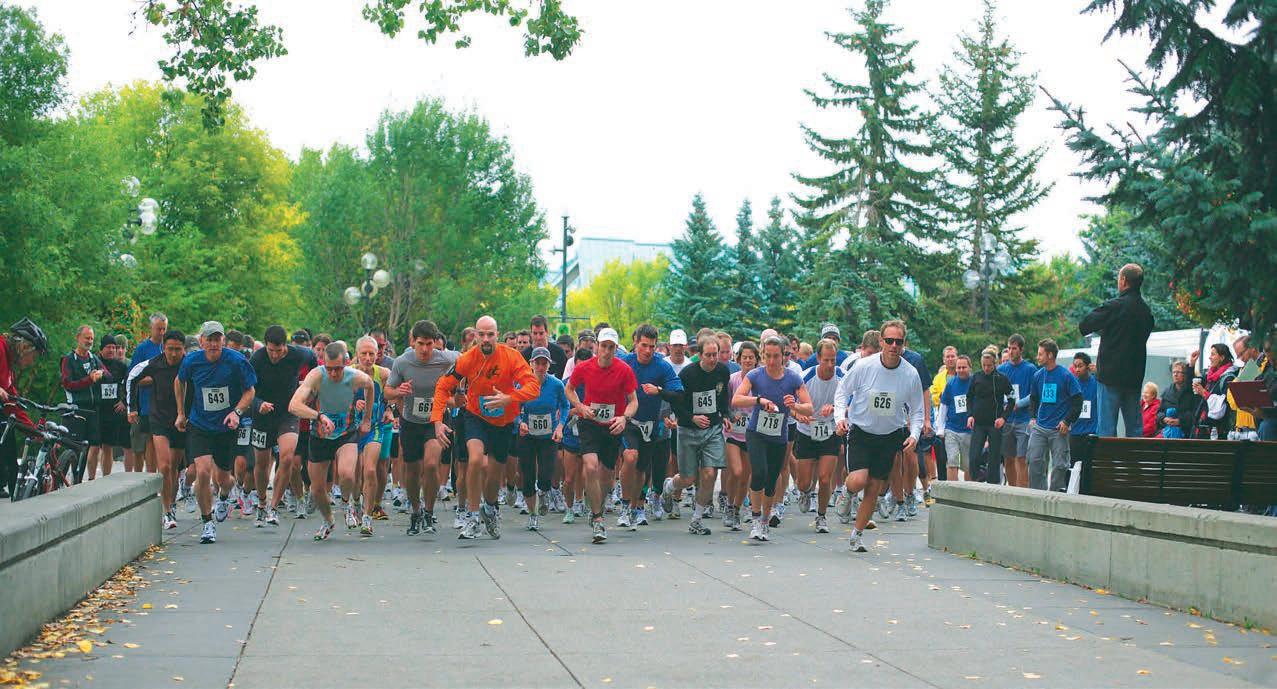
10K/5k Road Race & Fun Run
Field Seminar: Glacial Sedimentology for Oil Sands Geologists
Field Seminar: Gironde Estuary and Aquitaine Coast: a Modern-Day Analougue for the Oil Sands of McMurray Formation
International Division Talk
Palaeontology Division Talk
Technical Luncheon
Geomodeling Division Talk
Technical Luncheon
International Division Talk
Gussow Conference: Importance of Rock Properties in Unconventional Reservoirs
Short Course: Manville Stratigraphy, Sedimentology & Petroleum Geology
Palaeontology Division Talk
Short Course: Drilling & Production Fundamentals
Technical Luncheon
Short Course: Rock Creek Stratigraphy, Sedimentology and Petroleum Geology
Short Course: Conflict Resolution Within the Realm of Oil & Gas
Short Course: Fluvial Stratigraphy
Short Course: Networking: Real Worlds & Real Time Connections - Creating Powerful New Circles of Influence
Short Course: Practical Geomechanics for Unconventional Oil & Gas
Technical Luncheon
Palaeontology Division Talk
Technical Luncheon
Technical Luncheon & Christmas Social
For more information on upcoming events and to register visit www.cspg.org
The necessity of research: R&D projects that allowed for improved detection of reservoir in deep-water depositional systems
SPEA k ER
Dr. andrea Fildani Statoil11:30 am tuesday, september 10, 2013 calgary, telus convention centre Macleod Hall c / d calgary, a lberta
Please note: The cut-off date for ticket sales is 1:00 pm, three business days before event. (Thursday, September 5,2013). CSPG Member Ticket Price: $45.00 + GST. Non-Member Ticket Price: $47.50 + GST.
Each CSPG Technical Luncheon is 1 APEGA PDH credit. Tickets may be purchased online at https://www.cspg.org/eSeries/source/Events/ index.cfm.
New geological conceptual models are fundamental to help energy industry performance for the decades to come. Arguably, with “easy” oil already in hand, R&D investments are vital to sustain future production from poorly understood reservoirs. With different models in mind (either in-house R&D and/or outsourcing to university consortia), it is clear that robust R&D can only better the industry as a whole. However, quantification of research impact to capital investment remains elusive and justification of funding lacks tangible economic impact.
R&D projects attack problems at different scales, from exploration (basin scale) to reservoir management (depositional bed scale). New and elegant geological models

can bring to light new opportunities at the exploration scale, such as the prediction of reservoir presence and quality in the deepwater Wilcox Formation (Gulf of Mexico), and at reservoir-scale by optimizing reservoir performance and lengthening the life-cycle of mature fields (enhanced production with improved geological models, which reduces costs of operation, infrastructure, and the number of wells).
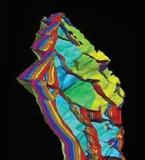
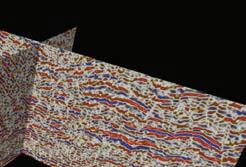
Here we focus on integrated R&D studies that helped answer key questions related to the fundamental formation of strata in the deep-marine environment and propose new models to improve exploration and reservoir management. The Lucia Chica channel system is a project fully funded by Chevron in collaboration with MBARI (Monterey Bay Aquarium Research Institute) and Stanford University. This highresolution seafloor image, with 1 m lateral resolution and 0.3 m vertical resolution, reveals unexpected seafloor rugosity and low-relief (<10 m), discontinuous conduits across a 70 km2 area. This dataset is integrated with outcrop observations and numerical modeling and offers insights into questions about deep-water channel inception and development in deepsea environments and the way channel sinuosity changes (i.e., the formation of bars in deep-water). We present a general
model for channel inception and evolution in the deep-sea by integrating observations from two datasets.
The Lucia Chica system offers a unique opportunity to observe four recognizable channels (or channelized features) with varying planform morphologies and stratigraphic architectures. A morphologic transition from a single continuous channel up-dip to a distributive pattern of lower relief channels is observed across an avulsion node. The channels imaged on the seafloor record channel evolution because adjacent channel features preserved on the seafloor individually represent different stages of channel maturity. The stratigraphically oldest channel is characterized by a narrow thalweg and well-developed levees while the younger “channelized features” are broader and bound by low-relief levees or no levees at all. We corroborate our model with another exquisite seafloor example, the San Mateo system. The San Mateo dataset shows clear insights into channel inception and maintenance, with supporting numerical model.
By combining these two datasets, we observe that an initial erosional template extends into a basin as the “condicio sine qua non” for creation of channels in deepsea environments. Channel narrowing and
levee growth seem to follow rather than promote channel focusing, representing a mature stage of channel evolution. Observations from high-resolution outcrop mapping and from analysis of the Lucia Chica seafloor images and seismicreflection data are corroborated with numerical analysis, experimental work, and previous interpretations of additional outcropping strata and seafloor examples. Erosion at inception firmly separates deep-sea channel processes from those in fluvial environments, where initial confinement is possible by levee formation alone and has implication for overall reservoir connectivity (enhancing vertical connectivity).
Furthermore, the Lucia Chica channel system provides imaging of small-scale morphologies associated with deep-water channel migration. Detailed mapping and measurements along channels, here numbered from oldest (1) to youngest (4), indicate that the sinuous Channel 2 shifted position in discrete lateral steps, typically associated with erosion and new channel incision. Where channel fill was not removed by incision, a bench,
morphologically defined as a relatively flat, higher area adjacent to the axial channel, resulted from each lateral shift. Inner-bend levees were deposited on each bench and draped over the previous levees as flows traveled through the new channel position. A conceptual model of punctuated lateral migration, associated with inner-bend benches formed during axial-channel and outer-bend erosion is favored instead of that of fluvial “point bar like” features, associated with gradual lateral accretion. Greater erosion during punctuated migration as compared to lateral accretion has important implications for reservoir distribution and connectivity.
Andrea Fildani was born and raised in Roma, Italy. He received his Laurea (M. Sc. equivalent) in Geological Sciences from the University of Roma “La Sapienza” and his Ph.D. in Geological and Environmental Sciences from Stanford University. In 2004 he joined Chevron’s Quantitative Stratigraphy R&D Team in San Ramon, California, later called the Clastic Stratigraphy R&D team. In June 2013, Andrea moved to Austin, Texas, to join the new Statoil Research Centre.
Andrea’s research interests encompass different scales (from depositional bed to sedimentary basin; from exploration-scale to reservoir characterization) and span from fundamental principles such as stratigraphy, sedimentology, and depositional processes to sequence stratigraphy and seismic stratigraphy, marine geology, and basin analysis. Andrea has worked several sedimentary basins around the globe (Gulf of Mexico, West Africa, Arctic Ocean, Indonesia, South America, Australia) and he has collaborated with Business Units to address all sorts of problems. Andrea has led field workshops in Patagonia, South Africa, the Spanish Pyrenees, and beautiful coastal California. He has authored and co-authored more than 30 manuscripts in peered-reviewed journals.

• rock mechanics fundamentals
• in situ rock stresses & thermal stresses
• geomechanics of thermal processes
• geology
• geomechanics: minifracs, lab, analyses
• workflow methodology
• instrumentation & monitoring for engineers, geologists, geophysicists, managers, site personnel, & regulators
• monitoring
SPEA k ER
robin Buckley Husky
11:30 am
tuesday, september 24, 2013
calgary, telus convention centre Macleod Hall c / d calgary, a lberta
Please note: The cut-off date for ticket sales is 1:00 pm, three business days before event. (Thursday, September 19, 2013). CSPG Member Ticket Price: $45.00 + GST. Non-Member Ticket Price: $47.50 + GST.
Each CSPG Technical Luncheon is 1 APEGA PDH credit. Tickets may be purchased online at https://www.cspg.org/eSeries/source/Events/ index.cfm.
AbSTRACT
The Middle to Upper Albian Peace River Formation was deposited in the Western Canada Foreland Basin and consists of three members: the Harmon Member is a broadly transgressive marine mudstone that is overlain by broadly regressive shoreface

sandstones of the Cadotte Member. Sandstones of the Cadotte are capped by a subaerial unconformity that defines the base of the Paddy Member.
The basis for this talk is an M.Sc. thesis completed at the University of Western Ontario in 2011 under the supervision of Dr. Guy Plint. The thesis is a regional study based on detailed correlation of 17 allomembers using over 800 geophysical well logs, 15 outcrop sections and 21 cores covering an area of over 38,000 km2
Changing patterns and rates of flexural subsidence during deposition of the Peace River Formation are indicated by progressive changes in stratal geometry within depocentres, and by spatial changes in depocentre location and orientation. Flexural subsidence during deposition of the Harmon Member resulted in a wedge-shaped body of rock that thins over 250 km from 108 m in the foredeep to 2 m near the forebulge. In contrast, the Cadotte Member has an almost tabular geometry that thins from 58 to 13 m across the basin, and was deposited during a phase of minimal differential subsidence,
possibly related to limited thrust activity, and/or erosional unloading in the adjacent sector of the fold and thrust belt. Lower Paddy allomembers are wedge-shaped and imply deposition during a time of more rapid flexural subsidence; in contrast, upper Paddy allomembers are much more tabular, suggesting deposition during another phase of relative tectonic quiescence.
The progradational limits of the Paddy and Cadotte shorelines were probably controlled by underlying extensional structures associated with the Peace River Arch. The thickest accumulations of sand in the Paddy and Cadotte Members are coincident with underlying grabens suggesting that syndepositional subsidence resulted in greater accommodation rates.
High frequency (~100 ky) sea-level fluctuations, indicated by regionally-mappable flooding surfaces, provided accommodation for a succession of at least three stacked, progradational shoreface sandstones within the Cadotte Member. These sea-level changes, probably attributable to eustasy, also resulted in stacked shallow marine and lagoonal sequences in the Paddy Member.
The Cadotte and most of the Paddy are composed of chert-rich lithic arenite of Cordilleran provenance. In the eastern part of the basin however, parts of the Paddy consist of essentially chert-free quartz arenite, typically comprising very well-rounded quartz sand. It seems likely that the quartz arenites were derived from erosion of Lower Cretaceous strata in eastern Alberta, that ultimately were of cratonic provenance. Erosion in the east may indicate forebulge uplift, dynamically linked to a phase of flexural subsidence in the west that generated accommodation for the entire Paddy wedge.
bIOGRAPH y
Robin Buckley is a geologist at Husky Energy. She is currently working on Husky’s Gas Resource Development team in the Western Canada Sedimentary Basin. Robin received her B.Sc. (Hons.) degree from Dalhousie University in 2009 and graduated from the University of Western Ontario in 2011 with her M.Sc. in Geology. Her thesis “Stratigraphy, Sedimentology and Paleogeography of the Middle to Upper Albian Peace River Formation, Northwest Alberta and Northeast British Columbia, Canada” was awarded the CSPG Graduate Thesis Award for best M.Sc. thesis in 2012.
SPEA k ER
thomas Hadlari
Geological Survey of Canada
11:30 am
Wednesday, o ctober 2nd, 2013 c algary, telus convention centre, Macleod Hall c / d c algary, a lberta
Please note: The cut-off date for ticket sales is 1:00 pm, three business days before event. (Thursday, September 26, 2013). CSPG Member Ticket Price: $45.00 + GST. NonMember Ticket Price: $47.50 + GST.
Each CSPG Technical Luncheon is 1 APEGA PDH credit. Tickets may be purchased online at https://www.cspg.org/eSeries/source/Events/ index.cfm.
New detrital zircon U-Pb age spectra are representative of two distinct sediment sources for locally sourced Cambrian strata of northwest Canada. Compilation of published detrital zircon ages from Cambrian and Neoproterozoic strata, filtered at 5% discordance and sorted based on those two age spectra, indicate remarkable provenance consistency across northern Laurentia. Widespread distribution of those two sources is attributed to:
(1) similar crust forming events of the Archean cratons and Paleoproterozoic orogens at the core of Laurentia; and
(2) post-orogenic uplift of the Grenville orogen and pancontinental sediment dispersal of Mesoproterozoic grains, prior to mid-Neoproterozoic rifting of the supercontinent Rodinia that led to the break out and drift of Laurentia.
The rift to drift phase provided negligible sources of detrital zircon to Cambrian strata. The synthesized detrital zircon age
data are used as reference spectra for Cambrian passive margins of Laurentia for comparison with, and confirmation of, exotic ages such as the 700-500 Ma zircon grains found within the Devonian clastic wedge of northern Canada.
Thomas Hadlari received a B.Sc. geology degree from the University of Saskatchewan in 1998. His Ph.D. thesis on sequence stratigraphy and basin tectonics of a Proterozoic rift basin was
Webcasts sponsored by
completed at Carleton University in 2005. He worked as a stratigrapher at the Northwest Territories Geoscience Office between 20062009 studying Phanerozoic stratigraphy of the northern Mackenzie Mountains. Since joining the Geological Survey of Canada in 2009 he has expanded that work to cover the northern Canadian mainland and Arctic Islands.

SPEA k ER
Dr. Peter Putnam, P. Geol. Chairman and Chief Executive, Central European Petroleum Ltd (CEP)
12:00 n oon
Wednesday, September 18th, 2013 n exen Plus 15 Conference Centre n exen a nnex Building 7th ave. & 7th Street SW Calgary, a lberta
A b STRACT
Germany is a very large petroleum consumer with daily use of ~2 mmbo and 8 Bcf. Internal production is currently ~1 Bcf/d and 50,000 bopd with nearly all production coming from reservoirs
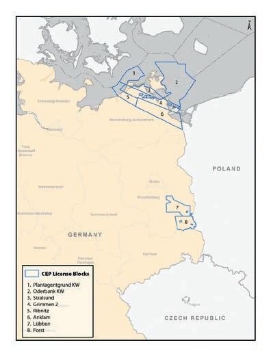
found west of the Elbe River and lifted by a handful of large western petroleum companies. East of the Elbe River within the former German Democratic Republic are found numerous petroleum accumulations within Permian reservoirs, nearly all abandoned, with most discoveries made in the 1960s-1980s by the former communist national petroleum company of the GDR. The great majority of these finds were made prior to the acquisition of modern seismic data. Prior to the presence of Central European Petroleum Ltd there had been no 3D seismic acquired or horizontal wells drilled. Furthermore, many highly prospective areas in eastern Germany were not evaluated or drilled due to geopolitical considerations in effect during the 20th Century.
Germany offers one of the world’s most unique petroleum regimes. Unlike the rest of the European Union, individual German states control all land leasing and operational activities. In turn, all these actions are governed by German Mining Law. Outsiders investigating details of the German upstream industry are commonly frustrated in that, with some notable exceptions, all subsurface information is confidential forever and all acreage licenses are applied for, and awarded, under strict confidentiality.
CEP considered the preceding and created its portfolio of upstream opportunities within eastern Germany by linking an understanding of historical context with regional petroleum systems in Permian
strata that extend from Poland to the southern North Sea. Using the rules governing exploration licenses, CEP has amassed 3.7 mm acres of land in two contiguous holdings found within the states of Mecklenburg-Vorpommern and Brandenburg with all targeted acreage focused on the pursuit of light oil (ie, 3248 API). In addition, through a combination of much forensic work, creative deals, and its own activities, CEP has acquired a substantial data set over all of its core holdings.
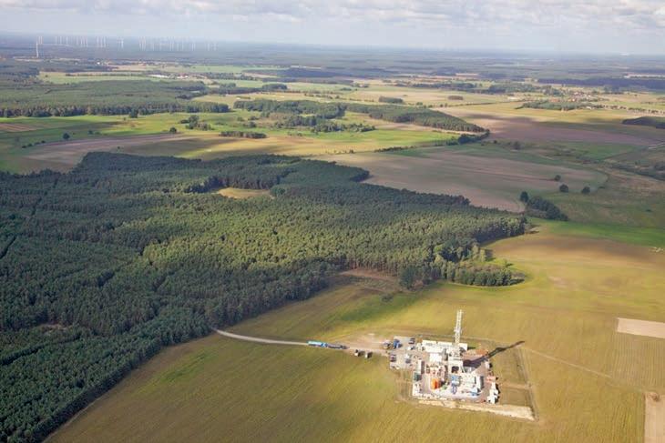
Based on an (ongoing) evaluation of available databases, the range of light oil prospects present within CEP’s acreage include large onshore and offshore conventional targets in structured plays, a regional oil accumulation in tight self-sourced carbonates, toe-of-slope prospects, and brownfield redevelopments. All of the prospects currently within CEP’s portfolio have substantial productive analogues within either eastern Germany or Poland. CEP has been the most active operator in eastern Germany since German reunification. Since 2008, the company has acquired 8 seismic programs, including the first 3D survey to be acquired for an upstream petroleum purpose in the region. Four wells have been drilled, including the first horizontal well ever drilled in eastern Germany, with three oil discoveries hosted in tight carbonates. Some of the key findings to date will be described and discussed along with the nature of near-term future activities.
(Continued on page 14...)
b IOGRAPH y
Peter Putnam is a geologist with 34 years of varied global experience at both technical and executive levels. His endeavors have covered the areas of exploration, development
(inclusive of primary, secondary and thermal recovery), operations, reserves assessments, research and training. Over his career he has been, at various times, an employee, an advisor to technical and management teams as well as boards of directors, a board member, and a founder of new companies.
SPEA k ER
Cornelius Rott
Central European Petroleum (SAME TIME AND LOCATION AS INTERNATIONAL DIVISION TALk, SEPTEMBER
A graduate of Brock University (BSc) and the University of Calgary (MSc, PhD), his career initially began at Husky Oil Operations where he spent 5.5 years in technical and supervisory roles dealing mainly with exploration and development undertakings. For the subsequent 21 years he was at Petrel Robertson Consulting Ltd (PRCL) where he ultimately rose to the position of chief executive and chairman and he remains the non-executive chairman of the firm today. His last few years as an executive at PRCL were focused on the creation of opportunities for new start-up petroleum ventures. Since 2006 Dr. Putnam’s time has been spent taking two of PRCL’s creations, Osum Oil Sands Corp and Central European Petroleum Ltd (CEP) through the formative concept and into financing, resource capture, and upstream operations. Peter is currently the Chairman and Chief Executive at CEP.
Beyond corporate activities, Dr. Putnam is a past-president of the Canadian Society of Petroleum Geologists. Peter has been a councilor of the Association of Professional Engineers, Geologists and Geophysicists of Alberta and he also served 6 years as an adjunct professor within the Department of Geological Sciences at the University of Calgary. Dr. Putnam is widely published as an author of scientific articles dealing with various facets of petroleum geology.
There is no charge. Please bring your lunch. The facilities for the talk are provided complimentary of Nexen, coffee by IHS and refreshments by Geochemtech Inc. The speakers are provided with gifts by Drilling Information and Quad Operations. For further information or if you would like to give a talk, please contact Bob Potter at (403) 863-9738 (ropotter@geochemtech. com), Kevin Morrison at (403) 536-3788 (morrison@antrimenergy.com),Jűrgen Kraus (jkraus@me.com) or Aaron LeBlanc at (403) 264-8877 (aleblanc@serinusenergy.com) or visit our Face Book page (“CSPG International Division”).
Canadian Discovery in partnership with Graham Davies Geological Consultants and Trican Geological Solutions launch a new multi-client study evaluating the Geomechanics, Hydrocarbon Systems and Geological Setting of the Devonian Duvernay Formation in the Kaybob to Willesden Green Area. Interim deliverables available December 2013.
The study will include:
» Implications of stress regime on drilling, completions and productivity
» Hydrocarbon phase distribution and the relationship to geochemistry and thermal history
» Characterization of the Duvernay reservoir
SPEA k ER
David a . e berth
Royal Tyrrell Museum of Palaeontology
7:30 pm
Friday, September 20th, 2013 m ount r oyal u niversity, r oom B108 Calgary, a lberta
The Upper Cretaceous Edmonton Group (Horseshoe Canyon Formation (HCFm), Battle and Scollard Formations) has yielded 209 partial-to-complete dinosaur skeletons and thousands of isolated elements. Considered in a stratigraphic and paleoenvironmental framework, these fossils reveal a high-resolution biostratigraphy that can help identify ecological and evolutionary responses among dinosaurs to a wide variety of environmental changes leading up to the k-T extinction event (e.g., climate, sea level, mountain building). Biostratigraphic analysis reveals a least three dinosaurian assemblage zones in the HCFm, each characterized by a unique assemblage of ornithischians. These are:
1) Edmontosaurus regalis-Pachyrhinosaurus canadensis (lower zone);
2) Hypacrosaurus altispinus-Saurolophus osborni (middle zone); and
3) Eotriceratops xerinsularis (upper zone).
Whereas the lowest two faunal zones (E. regalis-P. canadensis, H. altispinus-S. osborni) are based on numerous specimens of a least two taxa, the validity of the uppermost zone (E. xerinsularis) is tentative because it is based on a single specimen and the absence of dinosaur taxa. The transition from the E. regalis-P. canadensis zone to the H. altispinus-S. osborni zone was a response to climatic change in southern Alberta that witnessed
the replacement of a warm-and-wet saturated deltaic setting with a cooler, coastal-plain landscape, characterized by more strongly seasonal rainfall and betterdrained substrates. Changes in mean annual temperature and proximity to shoreline had little influence on this change; it most likely reflected changes in rainfall and substrate response. We speculate that the transition from the H. altispinus-S osborni zone to the E. xerinsularis zone was also a response to paleoenvironmental change back to wetter-and-warmer climatic conditions, and the re-establishment of poorly-drained substrates. Thus, the two ‘faunal turnovers’ in the HCFm represent responses to paleoclimate and are not reflective of significant and widespread evolutionary events (rapid diversification events or extinctions at the genus level or higher) such as those that distinguish the Dinosaur Park, Horseshoe Canyon, and Scollard Formations ‘faunas’ and are the basis of the Judithian, Edmontonian, and Lancian LVAs. Dinosaur assemblage zones have also been identified in the dinosaur-rich Dinosaur Park Formation (DPFm, Upper Campanian, Alberta), but are different than those in the HCFm:
(1) there is no evidence for significant climatic changes during deposition of the DPFm;
(2) the HCFm biozones are of much greater duration (1.6-1.9 Ma) with each one more-or-less encompassing the full duration of the DPFm (1.5Ma); and
(3) faunal turnovers in the HCFm appear to involve more distantly-related taxa.
This suggests a greater degree of anagenic evolution in DPFm ornithischians (possibly due to rapid socio-sexual selection) contrasted with longer-term morphological stasis in HCFm ornithischians and significant climate-change-driven dinosaur migrationevents into and out of the Drumheller area.
bIOGRAPH y
David A. Eberth (Ph.D. University of Toronto; M.A., University of California, Berkeley), Royal Tyrrell Museum, Drumheller, Alberta Senior Research Scientist, Sedimentary Geology & Paleoecology
Dr. David A. Eberth is a paleontologist and geologist at the Royal Tyrrell Museum in Alberta, Canada. He studies stratigraphy and ancient environments of fossil-bearing rocks, and has participated in field projects around
the world. His specialties include the study of ancient physical environments, the age of the rocks, and how ancient plants and animals are preserved. He also has a deep interest in the causes for the revival of American creationism. Dave’s research sheds light on Earth’s ancient environments and how advances in the earth sciences impact society and culture.
Dave has written and presented more than 100 papers in a career that, so far, spans 33 years. He has organized and hosted symposia at the Royal Tyrrell Museum, and is the coeditor and a contributor for two recently published scientific books on bonebeds and horned dinosaurs. He is now co-editing a third book about duck-billed dinosaurs.
This event is jointly presented by the Alberta Palaeontological Society, Mount Royal University Earth Science Department, the CSPG Palaeontology Division and Cenovus Energy. For details or to present a talk in the future please contact CSPG Paleo Division Chair Philip Benham at 403-691-3343 or APS Coordinator Harold Whittaker at 403-2860349 or contact programs1@albertapaleo. org. Visit the APS website for confirmation of event times and upcoming speakers: http:// www.albertapaleo.org/
SPEA k ER
olivier Bertoli
Geovariances
12:00 noon
Wednesday, Sept. 25th 2013 Jamieson Place, Conference room B on the third floor 308 4th ave. SW, Calgary, alberta
Near surface production from oil sand deposits has many similarities with actual mining processes. Therefore, the application of geostatistical methodologies commonly used in the mining industry to perform resource estimation is totally possible to be adapted. The main hurdle to implementing these mining methodologies in what is still perceived to be an oil and gas context is one that remains cultural. This seems unfortunate as these methodologies are definitely complementary to the geological modeling process traditionally implemented
for oil sands. Integrating them will definitely add value to the business by providing robust benchmarks of existing resource models and alternative project valuations based on an optimal use (estimation) of the available information.
The purpose of a recoverable resource is to determine for a series of thresholds the proportion of selective mining units (‘SMU’) above a threshold within a panel, and the grade of that portion that is above the specified threshold. There is a range of techniques available to handle both:
(a) Support effect i.e. the deterioration of the grade tonnage curves with increasing selective volumes and,
(b) Information effect i.e. the impact of information density on the errors on the final estimates that are used for making ore/waste allocation decisions.
The purpose of the talk is to present one of these techniques (‘Uniform Conditioning’, UC) that can be shown to be adapted to the mineralization style of the Athabasca oil sands, and that perfectly capable of handling complex lateral and vertical facies variations provided by the input geological interpretations.
The talk would emphasize the primary benefits of the UC method:
1. The methodology is robust to degraded stationarity conditions, where conditional simulation may be more sensitive to departure from optimal stationarity conditions; and,
2. Once the size of the SMU has been established, the estimation process is relatively straightforward, making resource model updates (to include new information or updated geological interpretation) much quicker and more efficient;
3. The local grade tonnage curves established by UC are made for a range of cut-offs. It is allowing sensitivity to the choice of the cutoff to be performed very quickly.
Olivier’s high-level training in applied mathematics, mining engineering and geostatistics from the Paris School of Mines is broadened by 18 years practical experience as a professional geostatistician. These include five years as technical director of Tenzing Pty Ltd. Olivier who specializes in staff training in the form of handson co-piloting sessions, has specific expertise in advanced geostatistical modeling including non-linear methods, conditional simulations, multivariate analysis and non-stationary modeling. Olivier also has extensive experience in the application of geostatistical techniques to coal resource modeling, gained through project work for Anglo Coal, BMA, BHP Billiton, Rio Tinto and Xstrata Coal since 2003.
INFORMATION
There is no charge for the division talk and we welcome non-members of the CSPG. Please bring your lunch. For details or to present a talk in the future, please contact Weishan Ren at (403) 724-0325, e-mail: wren@statoil.com.
“This pioneer and explorer in geology, engineering and natural gas technology bequeathed a fundamental knowledge, years ahead of his time and was considered by many a virtual Leonardo da Vinci of the Petroleum Industry. Slipper, our First President, deserved the honour (unbeknownst to him) of our highest award in the Canadian Society of Petroleum Geologists” (Aubrey Kerr).
The Stanley Slipper Medal is the CSPG’s highest honour.
The gold medal is presented annually by CSPG for outstanding contributions to oil and gas exploration in Canada. The contributions of the winner of this award should encompass a number of activities related to aspects of petroleum exploration. Such activities include: initiating and/or leading exploration programs, significant discoveries on new or existing exploration trends, teaching and/or training of explorationists, and involvement in and leadership within geological societies and professional organizations.
The committee is currently calling on the CSPG membership to provide additional nominations for this prestigious award. The award winner must be a CSPG member and should be able to attend the awards presentation to be held in the spring of 2014.
Please include an updated bibliography and letters in support of your nominee.
Nominations should be mailed, faxed or emailed before October 15 to:
CSPG Stanley Slipper Committee – Clint Tippett
110, 333 – 5 Ave SW Calgary, AB T2P 3B6
Email: clinton.tippett@shell.com and membership@cspg.org Phone: 403-264-5610 Fax: 403-264-5898


•Seven paradigms of data integration in reservoir modeling
•Multi-scale reservoir characterization and history matching within a probabilistic framework
•Current bottlenecks in geomodeling workflows and ways forward
•Strategies for modeling with multiple-point simulation algorithms
•Optimization of SAGD process accounting for geological uncertainties using proxy models
•Integrated shale gas study workflow
This past July I attended an AAPG Geosciences Technology Workshop on “Geomechanics and Reservoir Characterization of Carbonates and Shales.” Although small (as the GTWs are designed to be), attendance was certainly impressive from a quality standpoint. There were some very prominent names in geomechanics and rock mechanics there. After two days of presentations and discussions, we summed up the workshop by identifying five themes that had emerged and which we feel describe the current state of our discipline:
1. Prediction is the goal. One of the biggest questions industry is asking is what drives production in unconventional reservoirs and, whatever that happens to be, how they can predict it so as to optimize production in their wells. Unfortunately this is likely to be a complex combination of factors rather than a single one. (We summarily put brittleness from logs/seismic to rest at the workshop. In the words of a colleague, “I think people will look back at the brittleness debate as an example of how spurious correlations (and the search for a “magic bullet”) were a huge setback in chasing these plays.”)
2. Integration is key. Given the complexity we face, answers are only going to possible by integrating disciplines, integrating data, and integrating analyses.
3. This ain’t our parents’ geomechanics. Geomechanics in tight plays is not the same as geomechanics in conventional plays. We are seeing new approaches and emerging (for us) technologies, often drawing from other disciplines such as the medical industry and manufacturing.
4. The pace of change is VERY fast. As a discipline we are struggling to keep up with the demand for answers. What do you do when your faucet leaks and you can’t get a plumber? You try to fix it yourself. Well there’s a lot of plumbing being done out
there by non-plumbers, and as I once read on a plumber’s truck, “We repair what your husband fixed.”
5. Let’s get back to basics. In the flurry of activity resulting from #4, we feel that some of the basic principles of physics, rock mechanics, fracture mechanics, etc. have been left in the dust. I can’t remember who it was, but one attendee said, “In general, people don’t dig that deep.”
While hindsight is 20/20, the way forward is not so clear. We spent a lot of time debunking things and far less time paving the road ahead. One conclusion we did come to is that we need to get the word out and educate people. I like to think that this series is a small step in the right direction!
Our first technical article is great, because it not only gets back to some geomechanics basics, but it also applies them to some problems that are new and some that aren’t so new but now need to be looked at in a different way. If you are new to geomechanics, it will introduce you to the fundamentals such as in situ stresses, pore pressure and geomechanical wellbore failure. If you already know a thing or two about the discipline, it may enlighten you about some relevant applications. Enjoy!
As always, if you have questions or comments, please don’t hesitate to contact me at afox@ canadiandiscovery.com.
Hydrocarbon containment has long been recognized within the oil and gas industry as an important issue to be considered in every operation from exploration to abandonment. Recently, however, it has also become a hot-button public issue due to events that have occurred offshore at Macondo (where losses were compounded by high fluid overpressure) and onshore at Joslyn (where the precise cause is considered by many to be ambiguous1), and to perceived risks associated with the rapid and highly visible growth of on-land operations in shale gas and oil plays. In addition to the risks
1 http://www.ceaa.gc.ca/050/documents/45468/45468E.pdf)
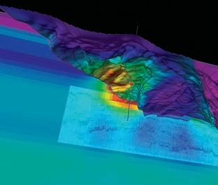
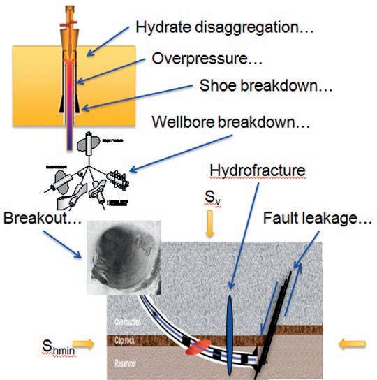
associated with anomalous pore pressure which we will not discuss in detail here, sources of containment risk generally fall into two categories –risk associated with processes taking place far from a well, and risk associated with the effects of the stress concentration which develops near a wellbore during drilling and completion, and which can further be modified by thermal effects of production and injection. Regardless of where these effects occur, geomechanical understanding plays an important role in risk mitigation. Figure 1 illustrates some of the geomechanical processes that might result in loss of hydrocarbon containment. 2
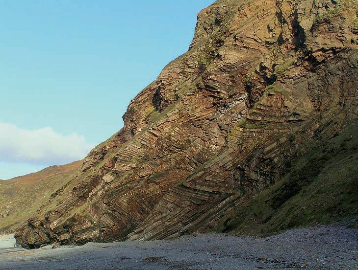
Natural hydrocarbon containment is key both to the presence of hydrocarbons in conventional reservoirs and, it might be argued, to the persistence of hydrocarbons in source rock, the production of which has led to the current “shale gas boom.” Natural leakage of hydrocarbons to the surface is ongoing in a wide variety of settings including in California3, where beachgoers in Santa Barbara sometimes have to wash tar off their feet after a day at the beach, and where the La Brea tar pits are a well-known source of fossil remains of animals that were trapped in pools of hydrocarbons that collected above natural hydrocarbon seeps4 What is less well known is that faults, which are ubiquitous in these areas, provide the most likely escape paths for hydrocarbons to reach the surface.
The state of stress in the earth can be defined by knowing the magnitudes and orientations of three principal stresses, one of which (S v) usually acts (approximately) vertically, and the others (S Hmax and S hmin) act in mutually perpendicular (approximately) horizontal directions.* In nearly all sedimentary basins the minimum stress acts horizontally. In most offshore environments the maximum horizontal stress is less than the vertical stress (a “normal faulting” stress state). In many on-shore environments in which
(Continued on page 20...)
2 Containment risk is not limited solely to release of hydrocarbons - similar processes have been suggested to explain a 2006 mud eruption which flooded a village in Java (http://www.nature.com/news/indonesia-s-mud-disaster-probably-had-natural-causes-1.13421?WT.ec_id=NEWS-20130723)
3 http://soundwaves.usgs.gov/2008/04/fieldwork2.html
4 http://en.wikipedia.org/wiki/La_Brea_Tar_Pi
(...Continued from page 19 )
hydrocarbons are produced from mature source rock S Hmax is greater than the vertical stress (a “strike-slip faulting” environment), and in rare instances (for example, onshore at shallow depth, within “toe thrust” regimes at the base of continental slopes, within the interior of some continents such as Australia and in continental collision zones such as the Himalayas) both horizontal stresses can be greater than the vertical stress (a highly compressive “reverse faulting” environment). It may be no surprise that environments such as the Himalayan foothills have a reverse faulting stress state. Many people are surprised, however, that in many onshore environments the stress state at shallow depth is reverse, at intermediate depth is strike-slip, and at greater depth is normal. This change with depth in the relative magnitudes of the horizontal stresses relative to the vertical stress is possible because at the surface, where the vertical stress goes to zero, the horizontal stresses can be finite, and because in most parts of the world the vertical stress increases much more rapidly with depth than the horizontal stresses, as illustrated in Figure 3. The situation is quite different in active sedimentary basins, where all three stresses are equal to the fluid pressure at the sea floor, and differential stresses are low until the depth beneath which sediments begin to become consolidated.
* Stress is a 2nd rank tensor whose
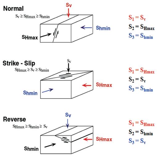
2. Anderson classified the stress state in the earth in terms of the relative magnitudes of the horizontal stresses with respect to the vertical stresses, which dictate the orientations of faults which are most likely to be active (figure courtesy of Baker Hughes).
components are tractions on three perpendicular planes defining a Cartesian coordinate system. The axis orientations can be chosen arbitrarily, however there is one set of axes in which the shear tractions on the perpendicular planes are zero. In the earth one of these principal stress axes is usually vertical and so the three so-called principal stresses are referred to as the vertical stress (S v), the maximum horizontal stress (S Hmax) and the minimum horizontal stress (Shmin) . In such cases, four parameters must be constrained to determine the full stress tensor – the magnitudes of the three stresses and the orientation of S Hmax
Most geological materials are permeable to varying degrees, allowing fluid migration through the rock matrix which is usually more efficient parallel to bedding than across it; hydrocarbon leakage through such permeable layers generally occurs slowly, and can be understood without considering geomechanics. Containment losses associated with geomechanical processes, which sometimes can be catastrophic, fall into two general categories – risks of fluid escape through tensile fractures and risks of fluid escape along faults or networks of shear fractures. In both cases the conditions for fluid escape can be determined using geomechanical principles, given the appropriate information. In the case of escape through tensile fractures all
that is needed is to know the orientation and magnitude of the least principal stress. In the case of fluid escape along faults, the magnitudes and orientations of all three principal stresses and the orientations of suspected faults must also be known.
Tensile fractures open in the most energetically favourable direction – that is, perpendicular to the least stress orientation. Because the least stress is horizontal in most reservoirs, hydraulically induced fractures are vertical. In a reverse faulting environment, where S v is the least stress, tensile fractures will be horizontal. What does that mean in terms of hydrocarbon leakage to surface in many onshore environments? It means that although hydrocarbons can escape upwards through induced fractures and into overlying rock from many reservoirs, there is a limit to how close to the surface such fractures can extend before physics forces them to become horizontal – to reach the surface additional pathways must be available, either through permeable layers, along poorly constructed wellbores, or along faults.
Faults can be seals which entrap hydrocarbons or can be leakage pathways that allow their escape. Because faults are weak relative to intact rock those faults
that are optimally oriented for slip are often in a state of near equilibrium with applied stresses in which the wrong perturbation of fluid pressure or stress can lead to fault slip. Slip, in turn, can open pathways for fluid escape along and adjacent to the fault on which it occurs.
A fault slips when the shear stress acting across the fault plane exceeds both its natural strength and the extra strength caused by the effective normal stress holding it closed. knowing the stress state, the orientation of the fault that would slip at the lowest fluid pressure (which first becomes “critically stressed” such that the shear stress is large enough to cause slip) can be predicted (see Figure 2).
In a normal faulting environment the first faults on which slip could occur as fluid pressure increases have trends that are parallel to the S Hmax direction, which is also the direction in which a hydraulic fracture would propagate, and have steep (near 60 degrees) dips. In a strike-slip environment the likeliest faults to slip are vertical and trend +/- 30 degrees to the S Hmax direction. In a reverse faulting environment the lowest pressure is required to trigger slip on faults with shallow dips (near 30 degrees) trending parallel to S hmin . Therefore, if one assumes that leakage into overlying formations is most likely to occur along faults that most efficiently conducts fluids upwards, then a strike-slip environment poses the greatest
risk. Normal faulting and reverse faulting environments are correspondingly less likely to allow rapid vertical escape. The direction in which fluids are most likely to migrate horizontally along a single fault plane also depends on the relative stress magnitudes, and is generally towards SHmax in a normal faulting environment and +/- 30 degrees to S Hmax in a strike-slip environment.
Increasing the fluid pressure within the fault lowers the effective normal stress, thus anything which raises in situ fluid pressure could trigger fault slip. The pressure required to trigger slip on a preexisting fault is a function of its strength, of its orientation with respect to the principle stresses, and of the principle stress magnitudes. The pressure required to trigger slip on a well-oriented fault is lower than the pressure that would be required to propagate a hydraulic fracture. This means that the maximum safe injection pressure may be lower than the least stress. Because escaping fluids have to traverse both the reservoir and the surrounding rock, the maximum safe pressure must be established both in the reservoir and also in the regions that surround the reservoir. Production or injection will change the stress state in different ways depending on location within and surrounding the production zone; predicting these changes requires geomechanically coupled reservoir simulation of the reservoir and the surrounding rock.
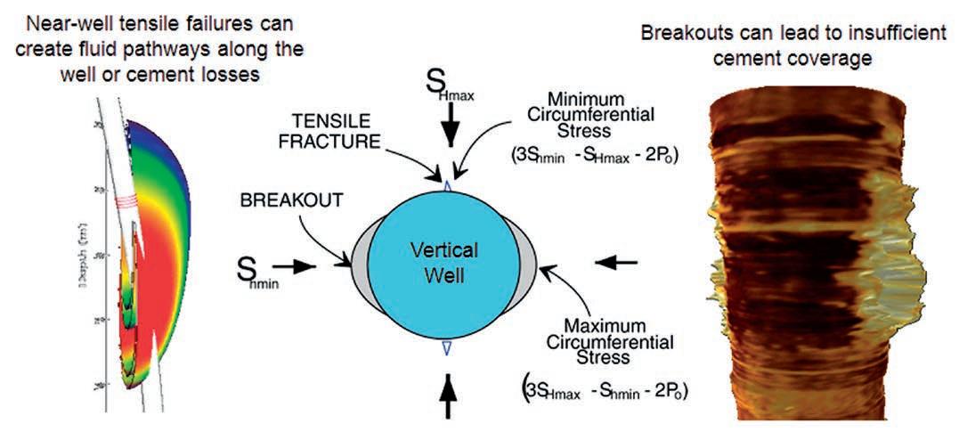
Both the processes of drilling and of completing a well alter the near-well state of stress leading to a stress concentration which extends several wellbore radii away from the wellbore wall. The difference between the minimum and the maximum stress acting around the wellbore wall can be as much as four times the difference between the far-field stresses. This can lead to an increased likelihood of failure of the rock close to the well (see Figure 3). During drilling, compressive failure of the rock leads to creation of wellbore breakouts – enlargements of the wellbore radius – leading to an increase in cuttings, an increased risk of wellbore collapse, and an increase in the wellbore volume. The wellbore stress concentration can also lead to shear slip on weak planes such as bedding, fractures and faults which cross the well. Tensile failure of the intact rock can also occur.
Raising the pressure of the wellbore fluid, e.g., by raising mud weight while drilling, provides support to the wellbore wall and lessens the likelihood of breakout formation and the size of breakouts. It increases the likelihood of tensile failure, however, and over time it can also lead to enhanced shear slip on weak planes and to time-dependent breakout growth. These time-dependent effects can often be mitigated by reducing
(Continued on page 22...)
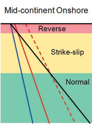
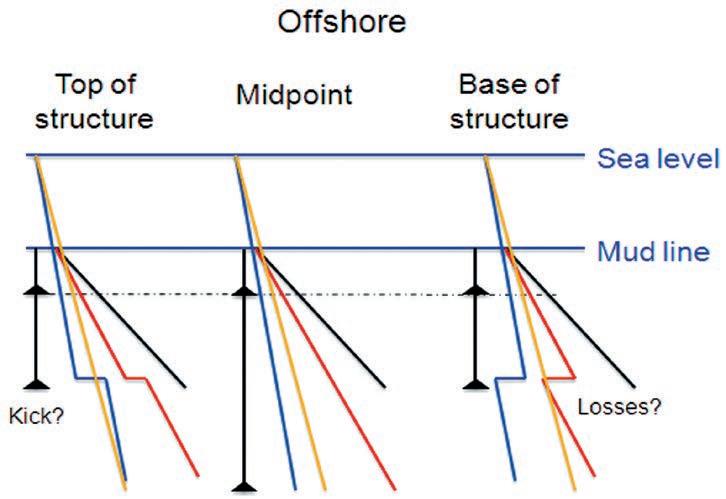
Figure 3. Profiles of stress magnitudes onshore and offshore can be quite different. Offshore (a) in active depositional settings, all three stresses are equal to the pore fluid pressure at the mud line; onshore, (b) near-surface horizontal stresses can be much larger than the overburden stress. Elevated pore pressures can occur on- (not shown) or off-shore but the mechanism for sustained overpressure in consolidated rock is likely to be quite different than the mechanism that maintains elevated pressure in compacting sediments. Offshore, the centroid effect can lead to significantly different stress and pore pressure profiles at the top, midpoint, and base of high-relief structures and hence wells in these different positions require radically different casing designs to prevent lost circulation, kicks or excessive wellbore failure. Red lines are Shmin and (dashed where shown) S Hmax; blue is pore pressure and black is overburden.
(...Continued from page 21)
fluid losses into the near-well region by using appropriately sized lost-circulation materials and/or by modifying mud osmotic properties.
NEAR-w ELL INTEGRIT y PRObLEMS
Du R ing DR illing
During drilling, high fluid pressures due to excessive mud weight or the elevated pressure required to maintain circulation of viscous mud in a horizontal wellbore can exceed the critical stress to cause slip on fractures, and also can reach or exceed the pressure required to initiate a tensile fracture at the wellbore and propagate a hydrofracture into the far field. Although pressures large enough to trigger slip on fractures sometimes cause finite losses, large volume losses generally require pressures above the least stress that cause drillinginduced fractures to propagate away from a well. Once initiated, the newly created fractures generally follow the wellbore. Well integrity can be compromised if the fracture propagates upwards past the previous casing shoe. If during the process lost circulation lowers the mud pressure to a value which is below the reservoir pressure, a blowout can occur. Even if the well is shut in flow can continue undetected if the previous casing shoe was breached or if the newly created fracture connects a high pressure fluid source to lower pressure formations.
The effect of an influx of light hydrocarbons due to insufficient mud weight is well known. Entrainment of lighter reservoir fluids lowers the density of the drilling mud, increasing the pressure difference
driving the influx. After the well is shut in, the wellhead pressure often increases as the pressure in the well equilibrates to the new conditions. Pressure at the previous casing shoe can also increase; if enough light reservoir fluid has entered the well this pressure increase can be large enough to fracture the shoe, leading to an underground blowout. Because of this risk, increases in mud volume that occur when mud pumps are turned off to make connections are carefully monitored, as these increases are assumed to be due to an influx of gas caused by removal of the extra backpressure on the formation caused by viscous pressure losses during circulation. When this is recognized the first reaction is to increase the mud weight to stop the influx. If, however, the volume return is due to fluid returning from incipient drilling induced fractures or ballooning shear fractures, an increase in mud weight will trigger a lost circulation event. Careful monitoring of mud volume and the shape of the pressure changes during connections is critically important, as it allows differentiation of these two effects for which the solutions are exactly opposite to each other. On the one hand a mud weight increase is required; on the other hand it might be best to decrease the mud weight.
During completion, high pressures created while cementing can increase the risk of tensile fracture of the rock surrounding the well, and if the pressure is large enough to exceed the least principal stress can lead to large cement volume losses into cementinginduced fractures. Excessive breakouts increase the wellbore volume such that more
cement is needed to fill the annulus. Both of these effects can reduce the length of the cemented interval, lowering the top of the cement sheath and thereby compromising wellbore integrity. Breakouts may also cause loss of integrity of the cement-formation interface, poor cement sheath integrity due to entrained materials, or an increased risk of incomplete cement coverage. Ledges and wellbore irregularities due to intermittent breakout can damage or prevent running in of the casing to design depth. Stress and temperature changes during cement curing can cause near-well damage or fracture. These effects can be modeled; however close communication is required between engineers and geomechanical experts on both the drilling and the completion sides of the operation to ensure their avoidance.
Production operations juxtapose fluids at depth with shallower strata across the casing/cement sheath. This can be particularly problematic in places where maintaining ambient temperature is critical to avoiding altering the state of the surrounding rock and fluids. In places where methane or other hydrocarbon hydrates occur, elevated temperatures near the well can lead to hydrate disaggregation. The combined decrease in rock strength and pressure increase may exert large axial and radial stresses on the wellbore and casing. The accompanying release of hydrocarbons from the hydrate, coupled with the potential for creating pathways for fluid escape along the wellbore, can lead to hydrocarbon escape to the surface. It is also possible
(Continued on page 24...)
New geologists, engineers, geophysicists and landmen, as well as summer students entering the industr y for the first time will find the courses a very beneficial introduction to the petroleu m industry . These courses will be extremely useful to nonprofessional and support staff in the oi l and gas industry, as w ell as accountants, lawyers, brokerage and financial personnel working primarily alongside the oil and gas industry.
To register or to obtain additional information regarding in-house and upcoming courses, please contact:
Ayrton Exploration Consulting Ltd.
Tel: (403) 262-5440
Email: ayrtonex@shaw.c a
Or visit our website: www.ayrtonexploration.com
Date: October 29th and 30th, 2013
Cost: $1050 (includes GST)
Instructor: Bill Ayrton
Effective for personnel just joining the oil patch, or for financial, accounting, and information systems personnel.
• Learn about the many facets of the industry.
• Oil finding, land acquisition, drilling, seismic, well completion, jargon and terminology
Date: November 12th and 13th, 2013
Cost: $1050 (includes GST)
Instructor: Bill Ayrton
Effective for geological technicians or administrative staff, or for those who just want a better understanding of geology to appreciate the world around us.
• Learn about earth structure, geologic time-scale and processes, Western Canada geology, and interesting nearby locations.
• Participate in a r ock identification exercise , cross-section project and a mini-field trip in downtown Calgary.
Date: December 3rd, 4th, and 5th, 2013
Cost: $1575 (includes GST)
Instructor: Bill Ayrton
Ideal for those who wish to improve their geological understanding of where and how we look for oil and gas fields in Western Canada.
• To visualize what Western Canada looked like throughout the stages of history, for example, the position of the sea versus land, what sediments were deposited, and what type of life that existed and evolved.
• To review the importance of each major stratigraphic unit, i.e. Devonian, Mississippian, Cretaceous, etc.
• Discuss the geological and seismic expression of typical oil and gas fields in each unit.
• To review the variety of “unconventional” oil and gas plays currently being pursued.
that these changes can reactivate faults or fractures leading to additional casing integrity problems or damage to surface structures.
Hydraulic fracturing, water or steam flooding, waste or CO 2 injection, compaction, differences in productionrelated volume change between adjacent strata, and production-related stress changes both inside and surrounding the reservoir can change the pressure and stress state within affected regions such that weak planes that previously were stable can slip, resulting in sheared casing or loss of cement integrity of wells drilled across those planes. This effect can occur both within and away from the immediate area of operations or at the interface between the reservoir and the cap rock. Predicting these effects and determining the maximum distance to which they extend requires both an accurate 3-D geomechanical model and geomechanicallycoupled reservoir simulation.
Regardless of the mechanism (tensile crack propagation or fault slip) a variety of subsurface operations can cause
containment loss far from wells. Failure of integrity of the wellbore itself often can often be corrected e.g. by performing a cement squeeze, but once a pathway to the far field is created mitigating the problem requires operational changes based on a geomechanical understanding.
Exploitation of many plays requires hydraulic fracturing. In low-permeability reservoirs such as shale oil or gas plays it also requires stimulation of networks of connected fractures that connect the reservoir to the newly created hydrofrac. Opponents of these operations highlight a number of issues, some of which deserve our consideration. One that does not, however, is the risk of contamination of drinking water by fluids propagating upwards along induced hydraulic fractures in the far field. This is for three main reasons. Firstly, hydraulic fractures have finite heights due to inability to cross planes which are weak or have contrasts in physical properties. Secondly, because geological materials are permeable, the overpressure inside the hydrofrac which drives its growth also causes leak-off of fracturing fluid which becomes more rapid as the fracture area increases. This reduces the extent of fracture development, especially
5 http://fracfocus.org/hydraulic-fracturing-how-it-works/hydraulic-fracturing-process
if suspended solids (proppants) are being transported. Perhaps more importantly is that a reverse-faulting stress state exists close to the surface above many onshore reservoirs. This shallow reverse faulting stress field will cause induced fractures to become horizontal before they can reach the surface. Studies of height growth of microseismic clouds during stimulation of shale gas plays in North America clearly indicate that height growth is extremely limited and stimulated volumes never come close to overlying aquifers5. Since stimulated networks are restricted to relatively small volumes surrounding the primary hydraulic fracture, it is unlikely that these networks by themselves could compromise integrity or cause escape.
During stimulation, creation of fluid loss zones along intermediate scale pre-existing features can occur. This can be recognized by anomalous microseismic event trends (shear faults have different orientations than hydraulic fractures), by occurrence of larger magnitude microseismic events (because these require larger pre-existing surfaces), or by rapid propagation of events to excessively large distances away from the stimulated well. Usually, when microseismic monitoring reveals these behaviours, the
stimulation is stopped to avoid wasting energy or connecting the producing well to sources of undesirable fluids. Because stimulation involves short period injection and finite fluid volumes, the risk for loss of hydrocarbon containment at the time of stimulation is low. However, it is possible that these loss zones could later become problematic, or, that stimulation could trigger slip on faults that may connect stimulated wells to nearby wells with compromised or unknown integrity. Pre reservoir development subsurface surveys can assist with identifying offset wells and potential downhole geohazards.
Du R ing long-te R m F lui D injeCtion
Secondary recovery operations such as water or steam flooding, waste water injection, CO2 sequestration, and permitted waste water well disposal operations all require long-term injection of fluids into the earth. Geomechanical risks associated with these operations are the same as those associated with shorter-term injection for reservoir stimulation. The risks are much greater during long-term injection, in comparison to the risk associated with reservoir stimulation, because the latter involves smaller volumes of fluid and shorter injection periods. Large volumes of fluid and long time periods
during which these fluids are injected are more problematic because they allow stress and fluid pressure perturbations to extend much larger distances from the injection site. Thermal and poro-elastic effects are much larger during long-term injection, and these can change the stress state enabling frac propagation or fault activation at lower pressures than expected based on models which fail to account for those effects. This is a well-known issue in the geothermal industry.
Pumping pressures for long-term injection are usually much lower than for stimulation, because limits are placed on pressure and rate to avoid injecting at conditions above the least stress and thereby to prevent creation and propagation of induced fractures which could cause reductions in sweep efficiency or injection profile. This reduces the likelihood of losses through hydraulicallyinduced fractures. Unfortunately, the pressure required to initiate shear failure of optimally oriented faults is often lower than is required to propagate induced fractures. Failure to design injection programs to avoid stimulating faults can lead to containment problems if the injected pressures create or re-activate natural fracture/ fault networks. If injection triggers slip on these pre-existing features, they could become conduits for
fluid flow to surface, or the shear slip could cause casing damage where activated faults intersect wellbores. If those wellbores have compromised casing integrity, rapid fluid escape can occur, requiring immediate well remediation. Constraining the maximum pressures and rates for safe long-term injection therefore requires numerical modeling including coupling results from a geomechanical simulator with results from a reservoir simulator as well as a thorough study of active and inactive wells in the field.
It is seldom possible to completely determine the geomechanical state of the subsurface, in part because measurements are restricted both in terms of where they can be made and how far away and what they actually measure. We cannot always directly determine the parameters we need to know, thus we must rely on increasingly sophisticated 3-D coupled with numerical models to extrapolate observations into regions within which we have limited data and to predict the changes which accompany oilfield operations.
Geomechanical modeling must always (Continued on page 26 ...)
We are looking for enthusiastic geoscientists who have an interesting topic that they would like to present and discuss with their geoscience colleagues over coffee.
Geocafé Sessions—held in the CSPG classroom with up to a dozen attendees, it’s FREE to attend and Tim Horton’s coffee and refreshments are always provided.
If you are interested in this new opportunity beginning this Fall please contact Kelsey Green at the CSPG - e: kelsey.green@cspg.org , p: 403 -513-1225

proceed in the context of our lack of precise information. A preferred approach, rather than estimating parameter uncertainties, is to determine what conditions are impossible based on our observations, and, paraphrasing Sherlock Holmes, to assume that all other conditions may be possible. By building models to test the impact on operations of the full range of possible conditions we can assess whether we know enough to proceed or if we need to make additional measurements to further restrict the range of possible conditions. We must also, for each set of measurements, evaluate whether they are what we think they are. For example, when distinguishing whether a fracture on an image log could be drillinginduced rather than pre-existing, we must test whether it could have been created by the stress state which matches independent observations. We also must take advantage of what is available, whether it is a traditional data input such as a wellbore image log or closure stress determination, or if it is an indication of an impending event such as a pit loss or gain.
Through knowing the magnitudes and orientations of the in situ stresses, and the orientations, distributions and properties of natural fractures and faults, and through modeling their effects using appropriately coupled models, operational decisions can be evaluated to determine the risk of occurrence of any of the above containment loss events. Measurement programs can then be put in place to monitor conditions so that we can predict them before they occur, and act to change operating parameters to avoid them. Recent implementation of “traffic light” risk mitigation schemes during stimulation are one example of using monitoring in this way.
Dr. Daniel Moos received his PhD from Stanford University in 1983 and was a co-founder of the L-DGO Borehole Geophysics Group at Columbia University. He returned to Stanford in 1987, and in 1996 was a co-founder of GeoMechanics International. GMI was acquired by Baker Hughes’ Reservoir Development Services in 2008 and in 2010 was elected a Baker Hughes Technology Fellow. He has published extensively, co-chaired and served on organizational and
professional committees, developed and taught courses in geomechanics, and holds patents in geomechanics, rock physics and pore pressure prediction. His recent focus is on development of an integrated approach for application of geomechanical principles to shale reservoirs.

Ms. Laura Hynes, B.Sc., P.Geo., obtained her degree in Geology, with a petroleum concentration, from the University of Calgary, in Alberta, Canada in 2009. During her university career Ms. Hynes worked in Houston, Texas with GeoMechanics International as an intern in 2007 and 2008. GMI was acquired by Baker Hughes Reservoir Services, and she joined the team full time in 2009. Presently Ms. Hynes has re-located back to Calgary and has extensive experience in image analysis, geomechanical modeling, and geomechanical applications such as wellbore stability analysis, natural fracture permeability, and caprock integrity. Her interests also include bringing awareness and collaborating with different parts of the Baker Hughes organization on geomechanical related topics.
Ph.D. AWARD
Win $2,500.00 and a framed certificate; and a one-year membership with the CSPG for: the Doctoral thesis that makes the most significant contribution to Canadian sedimentary geology in 2013.
M.Sc. AWARD
Win $2,000.00 and a framed certificate; and a one-year membership with the CSPG for: the Master’s thesis that makes the most significant contribution to Canadian sedimentary geology in 2013.
Winning thesis topics in recent years have included: detailed integrated studies of the Falher, Paddy, Hondo, and Gog; a stratigraphic re-interpretation of the Alexandra Reef
Complex, which has led to new insights into the nature of Devonian reefs; new thoughts about the classic Carboniferous section at Joggins, Nova Scotia; structural re-interpretation of the Livingston Range anticlinorium; detailed sedimentologic study of the Cenozoic geology in Trinidad; biogenic shale gas potential of the Upper Colorado Group; and evaporite diapirism in the Canadian Arctic Archipelago.
Deadline for submissions is September 14, 2013.
For submission, an electronic copy (PDF format if possible) of the thesis is preferred but a hard copy if properly bound will be accepted. Submitted hard-copy theses will be returned in late January 2014 after judging.
Eligible theses are either produced in a Canadian university, regardless of project location, or deal with a Canadian sedimentary/petroleum geology topic, regardless of the university of origin. Theses entered for the 2013 awards must have been submitted to a recognized university inside or outside Canada, and must have formed part of the requirements for degrees awarded at the Fall 2011 or Spring 2013 convocations. Candidate theses must be well written, and clearly and adequately illustrated.
PLEASE SEND ThESiS SubMiSSioNS foR juDgiNg To: Canadian Society of Petroleum Geologists (CSPG) Graduate Thesis Awards Committee c/o Andre Chow
Pengrowth Energy Corporation 2100, 222 – 3rd Avenue SW Calgary, AB T2P 0S4
Phone: (403) 213-3713 • Fax: (403) 234-6886
Email: andre.chow@pengrowth.com
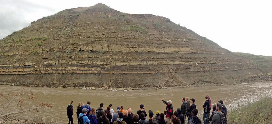
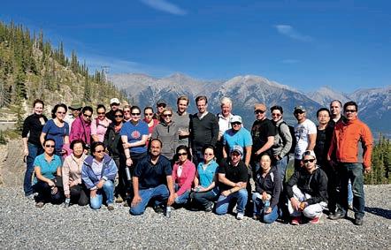
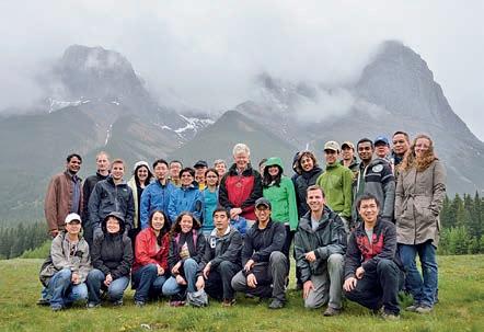
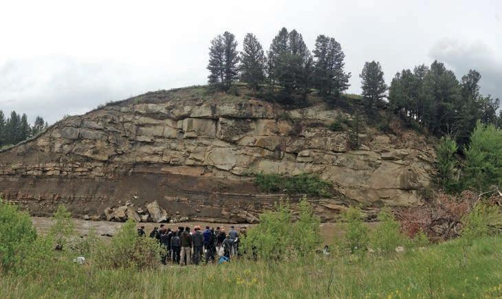
In June, 32 students working summer jobs in the oil and gas industry set out from Calgary under the leadership of Dr. Derald Smith, an emeritus professor of geography at the University of Calgary. The destination was the Porcupine Hills just southwest of Nanton, Alberta. The exposures of the Tertiary Porcupine Hills Formation are fantastic for teaching about anastomosed river systems and their deposits.
After a morning lecture, the students were able to see the three major depositional elements of this system firsthand: channel fills, crevasse splays, and overbank deposits. They were able to get a sense of the scale of the aggradational channels and the thickening of sandstone bodies due to channel stacking. The outcrops also showed the lateral continuity of the thin splay sandstones. The attendees hopefully left with the impression that while these systems can be mud dominated there can be good connectivity between sandstones because of the lateral continuity of the spays and channel stacking. Other highlights of the trip included the scenery of rolling southern Alberta ranch land complete with cows, calves, and horses.
Understanding the anastomosed fluvial architecture of the Porcupine Hills Formation is important for exploring and developing shallow gas reservoirs in Western Canada where this style of deposition is very common in the Cretaceous and Tertiary. While these plays are not receiving much attention with current gas prices, some of the students
on the trip could help lead a resurgence of these plays in Western Canada.
Derald was an enthusiastic and knowledgeable field trip leader and all the students found him very approachable and engaging.


Mudstone Sedimentology
Geomechanics and Natural Fracture Characterization
Petrophysics in Unconventional Reservoirs
Seismic Attributes and Microseismic Advances
Multidisciplinary Studies
Canada’s Energy Geoscientists
Geology of the Athabasca Oil Sands
Mike Ranger & Murray Gingras—September 5-7th
Glacial Sedimentology for Oil Sands Geologists
Nick Eyles—September 11-13th
Gironde Estuary and Aquitaine Coast: Modern-Day Analogue for the McMurray Fm
Hugues Fenies—September 17-20th *Limited Spots Available!
Mannville Stratigraphy, Sedimentology and Petroleum Geology
Doug Cant—October 16-18th
Subsurface Methods in Clastic Sediments
Doug Cant—October 21-22nd
Drilling and Production Fundamentals
David Hill—October 21-22nd
Rock Creek Stratigraphy, Sedimentology and Petroleum Geology
Doug Cant—October 23rd
Conflict Resolution Within the Realm of Oil & Gas
David Hill—October 23-24th
Fluvial Stratigraphy
John Holbrook—October 23-24th
Networking: Real Worlds & Real Time Connections - Creating Powerful New Circles of Influence
Bruce Lee—October 24th
Practical Geomechanics for Unconventional Oil and Gas
Pat McLellan—October 24-25th For More Information and Registration: www.cspg.org/education, 403-264-5610, kelsey.green@cspg.org

trailhead: A small gravel parking area (P) directly off the 1A Highway, 15 km west of the intersection with Highway 1X at Seebee. If you pass the cement quarry (Q) you have gone too far.
Distance: 2 km return, parking lot to the entrance to Rat’s Nest Cave. Approximately 20 minutes each way, and allow 3 hours for caving. Elevation Gain: ~150 m.
The hike into Rat’s Nest Cave can only be considered worthwhile if you have never hiked in the Rockies. However, your reward for 20 minutes of moderate effort is to gain the entrance to the cave, which was designated a Provincial Historical Site in 1987. The cave entrance is currently gated and locked, and access may only be obtained with a guided tour. We recommend going with a reputable company such as Canmore Cave Tours (http://www. canmorecavetours.com), who offer a variety of tour types and lengths. Rat’s Nest Cave offers an unparalleled view of a karst system in the Livingstone Formation, and an interesting mix of geology, archaeology, and physical adventure.
From the parking lot below Grotto Mountain, cut left and head north, up along a trail through sparse tree cover. After 5-10 minutes, you will intersect a cut line for hydro power. Turn right (east), and then left (north) again after 20 metres to resume the trail up through the woods. You will soon notice a small canyon appearing to the left. You will cross over this streambed and continue following it’s path up until you encounter a sign attached to a rock in the riverbed that reads “Violators will be Prosecuted.” About 20 metres past this anthropogenic landmark, you will come to a small clearing. The entrance to Rat’s Nest Cave is to your upper right. There is a tarpaulin set up below the cave entrance that you can hang your knapsack, and if you are with a guide and intend to tackle the cave system, change into coveralls, kneepads, helmet and headlamp. If you have simply come for the hike, there is a nice view to the south across the Bow Valley towards the Three Sisters on your return to the parking area.
You can use the ropes attached to the gate to pull yourself into the mouth of the cave. Once inside the cave entrance, there are two ways on. To the left is a 15m pit (requires specialized equipment and knowledge of vertical caving), which follows narrow, steeply sloping passages along, up and down a fault plane to the deepest (-160m) and highest (+80m) points relative to the cave entrance. The route to the right is less technical and involves a climb down to a large chamber, after which there are several ways on via passages that involve walking, crawling, sliding and scrambling to reach the Grand Gallery and the Grotto area, which is well decorated with calcite ‘flowstone’ and ends in a sump, where the cave passage continues beneath the water and is only accessible to cave divers.
r e FerenC e S :
Burns, J.A., 1989. Canadian Caver : (Spring) 41-3. Price,R.A., 1971a. Geology of Canmore (West half) GSC Map 1266A. Price, R.A., 1971b. Geology of Canmore (East Half). GSC Map 1265A. Yonge, Charles J. 2001. Under Grotto Mountain : Rats Nest Cave. Rocky Mountain Books Ltd, 144 pp.
The parking lot, with Grotto Mountain in the background. Mississippian carbonates of the Livingstone Formation provide the cap. The tiled strata are bound by the Rundle and Lac Des Arcs Thrust Faults in the west and east respectively. (Price 1971a & b).Bones of various mammals are found along dipping limestone beds of the Livingstone Fm. The bones were left by First Nations people who used the cave as a disposal site. Record of ancient human presence is limited; summing one dart tip and one projectile point. The oldest bone dates no farther back than 7,000 years, well after the end of the Ice Age. Some of the bones exhibit gnawing by the pack rats in search of minerals.
Bone beds near the entrance of the cave include over 30 different animals that either fell down the shaft or were brought here by predators including the swift fox (locally extinct), passenger pigeon (extinct in the 1930’s), snakes, frogs , toads and fish (Burns, 1989). The bones illustrated belong to bison, elk and deer.
stalactites (soda
Cross section through the Bow Valley and Rats Nest Cave (Yonge 2001)
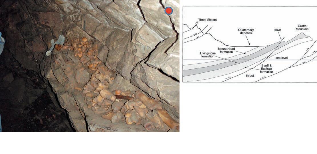
Rat’s Nest Cave has been eroded from the limestones of the Livingstone Formation. Meteoric water movement focussed along a thrust fault and associated fracture system at the base of Grotto Mountain from as early as Miocene times, although the main phase of cave development was throughout the Pleistocene glaciation, during which time the cave would have been in the phreatic zone. As the ice sheets retreated approximately 13,000 years ago, there was significant vadose development and most of the known cave was left above the water table (Yonge 2001). Throughout this 4km long cave system you can observe a number of unique geological features such as stalactites, stalagmites, curtains and pillars. Collectively, these are known as speleothems. Of note, the temperature in the cave is approximately 5° C, and the conditions are somewhat damp. There is a fair degree of scrambling involved, so participants should be in reasonable physical condition (i.e. up to the effort of moderate hiking). Rat’s Nest Cave is worth visiting, as it is only an hour’s drive from Calgary, is accessible year-round, and offers a truly unique experience.
The Reservoir Committee welcomes contributions from our readership to this series. If you wish to offer a submission to Go Take a Hike on your favourite hike of geological interest, email the Reservoir at Emma.MacPherson@cspg.org for more information.
Deposits of carbonate minerals form mammillary speleothems adjacent to clear pools.
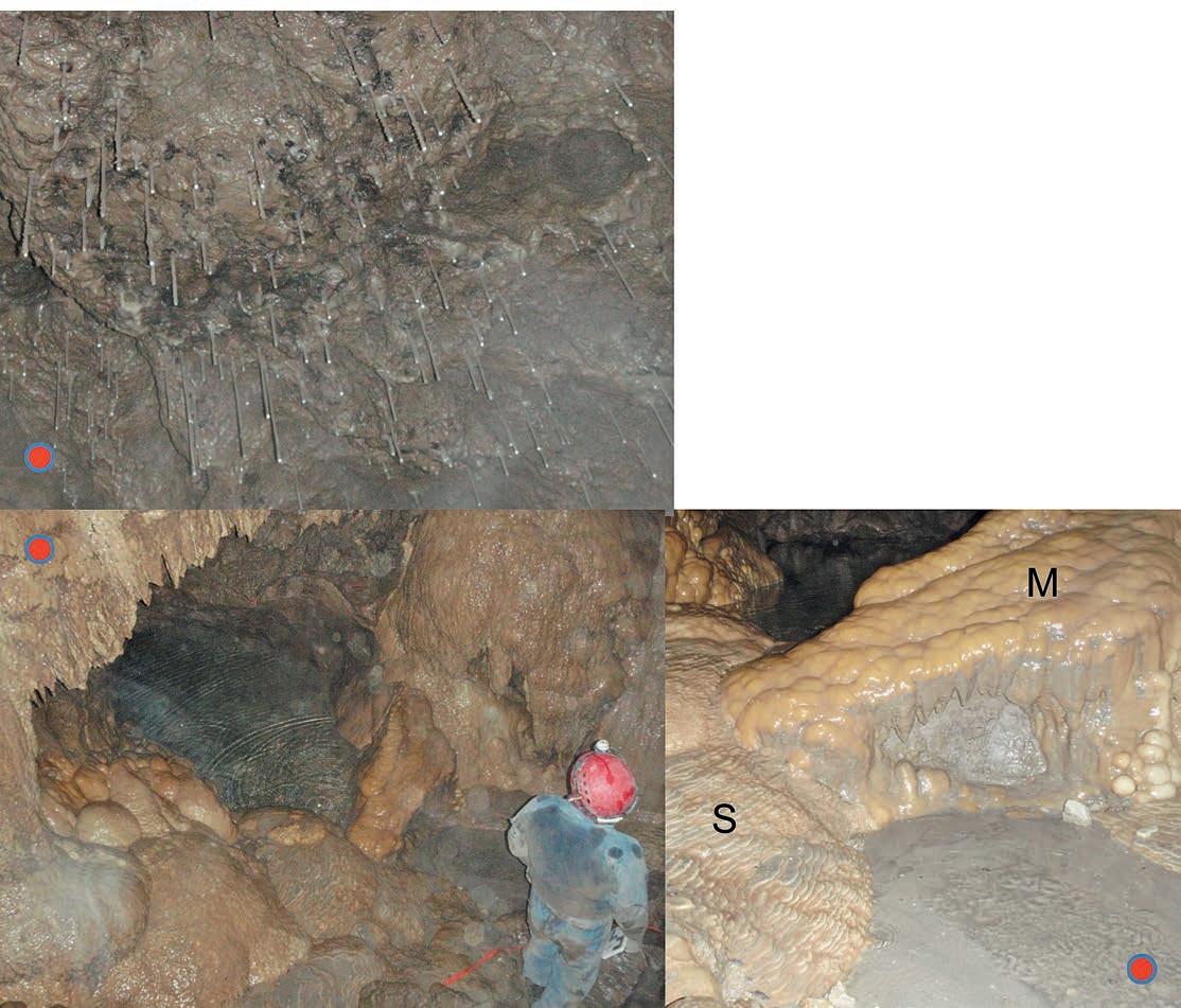
Bottom right: Mammillary speleothems (M) form underwater, indicating that water levels in the cave were once much higher. Rimstone dams or sinter (S) , looking like miniature stone rice paddies formed as thin layers of water flow over the rock surface . Thin films of water are prone to loss of CO2 and therefore calcite cements are commonly deposited in these settings as a byproduct. These features must have formed subsequent to the mammillary speleothems.
Pencil-thin straws) hang from the roof of the Grand Hall.AGAT Laboratories
Apoterra Seismic Processing Ltd.
ARC Resources Ltd.
Arcis Seismic Solutions
Cabra Consulting Ltd.
Canadian Natural Resources Ltd.
CGG Veritas Services Inc.
Compass Directional Services
Continental Laboratories Ltd.
Cossack Land Services Ltd.
Crescent Point Energy Trust
Datalog Technology Inc.
Edge Technologies Inc.
Exova Canada Inc.
Explor
GeoTir Inc.
GLJ Petroleum Consultants Ltd.
IHS
Kulczyk Oil Ventures
LXL Consulting Ltd.
McDaniel & Associates Consulting Ltd.
MOH & Associates Oilfield Consultants
National Oilwell Varco
Nickpoint Environmental Services
Olympic Seismic Ltd.
Paradigm Geophysical Corp.
Pason Systems Corp.
Perpetual Energy Inc.
Pioneer Professional Group
Pro Geo Consultants
ProActive Health
Pulse Seismic
Regent Resources Ltd.
Rigsat Communications
RPS Energy Canada Ltd.
SAExploration
SeisWare
Sensor Geophysical Ltd.
Sigma Explorations Inc.
Sourcex
Total Gas Detection Ltd.
Trident Exploration Corp.
Western Geco
AS OF AUGUST 10, 2013
CSPG
•
•
•
•
Klein at kasandra.klein@cspg.org to be a corporate member today!
The Association of Professional Engineers and Geoscientists of Alberta (APEGA), Canadian Society of Exploration Geophysicists (CSEG), Canadian Society of Petroleum Geologists (CSPG) and the Canadian Well Logging Society (CWLS) are excited to be organising the fourth annual Earth Science for Society (ESfS) exhibition on March 16-18 at the Big Four Building, Stampede Park. This is a free, family-friendly event and you are all invited to visit our four themed pavilions including Energy for Us, Resources and You, One Dynamic Earth and Our Future.
ESfS showcases hands-on, interactive exhibits demonstrating the importance of the Earth Sciences in our everyday lives. It helps students and the public to understand the critical role Earth Sciences play in the responsible development of our country’s rich natural resources and how these resources are utilized in our everyday lives. Junior high school students are guided around the exhibits by geoscience volunteer guides and have the opportunity to learn
about career opportunities in the Earth Sciences.
The Earth Science for Society committee believes that increased science literacy is especially essential for the students of today as they are the decision-makers of tomorrow and the future caretakers of the Earth.
event Details
When: m arch 16-18, 2014
Where: Big Four Building, e xhibit Hall B, Stampede Park Free admission
C ALLING ALL VOLUNTEERS
Do you enjoy volunteering with youth? ESfS needs volunteer guides to escort junior high students throughout the exhibit. If you would like to volunteer or for more information, please contact us at esfscanada@gmail.com.
More information at www.esfscanada.com
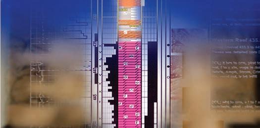
www.apega.ca
The Association of Professional Engineers and Geoscientists of Alberta (APEGA) is pleased to assist internationally educated graduates through our Internationally Educated Graduate (IEG) Integration and Liaison Manager.
With the support of the Registration Department, Guillermo Barreiro, P.Eng., can
• assist IEG applicants one-on-one to help them understand APEGA’s registration process and policies;
• help IEG applicants complete their work experience documents to meet the Board of Examiners’ requirements; and
• coordinate outreach activities with immigrant-servicing agencies to better explain the APEGA registration process and policies to newcomers to Canada.
An IEG himself, Guillermo joined APEGA after being in the engineering profession for 10 years in Colombia and Canada.
Are you an IEG who needs assistance with or advice on your APEGA application? Contact Guillermo at gbarreiro@apega.ca or at 780-426-3990 or 800-661-7020 ext. 2227.
For more information visit www.iegatapega.ca
 Guillermo Barreiro, P.Eng.