
$10.00 SEPTEMBER 2015 VOLUME 42, ISSUE 08 Canadian Publication Mail Contract – 40070050 RETURN UNDELIVERABLE CANADIAN ADDRESSES TO: CSPG – 110, 333 - 5 Avenue SW Calgary, Alberta T2P 3B6 Addressee Additional Delivery Information Street Address Postal Box Number and Station Information Municipality, Province/Territory Postal Code 14 2015 Student Industry Field Trip 16 New contributions in Baffin Bay/ Labrador Sea petroleum exploration and development geoscience 24 Go Take A Hike 27 Geoconvention Awards
«

«
Switch to High DefinitionWorkflows for Shale with Paradigm
Your Unconventional Workflow
EVALUATE THE RESERVOIR WELL PLANNING AND DRILLING
Develop a comprehensive shale model of fractures, stresses, mineralogy, brittleness, and TOC using well logs, image logs, core data, and full azimuth seismic imaging and inversion methods
Effectively steer the well into the sweet spot using real-time data (WITSML, LWD)
What Paradigm Solutions Deliver
DESIGN COMPLETION AND FRAC JOBS
Develop a single earth model using all available data – seismic attributes, interpretation, microseismic and geological data to identify sweet spots, plan wells and optimize completions
» Patented full azimuth imaging and characterization technology for in-situ, precision fracture and stress determinations in depth
» Multi-survey interpretation to accommodate acreage and asset expansion with built-in Quantitative Seismic Interpretation (QSI) tools to enhance sweet spot detection
» Fully integrated petrophysical and formation evaluation suite for fracture determination, rock fabric modeling (brittleness, mineralogy, stress), and TOC estimation.
» Optimized horizontal drilling through petrophysical or geomechanical models
» Integrated earth modeling to accommodate all supporting field development data including seismic data, microseismic data, engineering data, well log data, and core data with animations of all time-dependent data
» Discrete fracture network modeling, fracture probability modeling, facies modeling, chronostratigraphic modeling, and a unique stimulation fracture path modeling solution to better model hydraulic flow as a function of time
PRODUCTION AND OPTIMIZATION
Monitor effectiveness of drilling and production through analysis of microseismic for well orientation, reservoir depletion for spacing and frac effectiveness and placement
Backed by world-class technology (EarthStudy 360 ®, SeisEarth®, Geolog®, SKUA-GOCAD™), Paradigm solutions and High Definition workflows are used by geoscientists and engineers to avoid non-productive acreage, optimize well planning and well spacing, target sweet spots, and improve hydrocarbon recovery.
Traditional Microseismic Analysis
HD Stimulated Fracture Network
Learn More at PDGM.com
PDM_Unconventional_CSPG_FullPg-July2015.indd 1 7/23/2015 4:00:54 PM
CSPG OFFICE
#110, 333 – 5th Avenue SW Calgary, Alberta, Canada T2P 3B6
Tel: 403-264-5610
Web: www.cspg.org
Please visit our website for all tickets sales and event/course registrations Office hours: Monday to Friday, 8:00am to 4:30pm
The CSPG Office is Closed the 1st and 3rd Friday of every month.
OFFICE CONTACTS
Membership Inquiries
Tel: 403-264-5610 Email: membership@cspg.org
Technical/Educational Events: Biljana Popovic
Tel: 403-513-1225 Email: biljana.popovic@cspg.org
Advertising Inquiries: Kristy Casebeer
Tel: 403-513-1233 Email: kristy.casebeer@cspg.org
Sponsorship Opportunities: Lis Bjeld
Tel: 403-513-1235 Email: lis.bjeld@cspg.org
Conference Inquiries: Candace Jones
Tel: 403-513-1227 Email: candace.jones@cspg.org
CSPG Foundation: Kasandra Amaro
Tel: 403-513-1234 Email: kasandra.amaro@cspg.org
Accounting Inquiries: Eric Tang
Tel: 403-513-1232 Email: eric.tang@cspg.org
Executive Director: Lis Bjeld
Tel: 403-513-1235, Email: lis.bjeld@cspg.org
EDITORS/AUTHORS
Please submit RESERVOIR articles to the CSPG office. Submission deadline is the 23rd day of the month, two months prior to issue date. (e.g., January 23 for the March issue).
To publish an article, the CSPG requires digital copies of the document. Text should be in Microsoft Word format and illustrations should be in TIFF format at 300 dpi., at final size.
CSPG COORDINATING EDITOR
Kristy Casebeer, Programs Coordinator, Canadian Society of Petroleum Geologists
Tel: 403-513-1233, kristy.casebeer@cspg.org
The RESERVOIR is published 11 times per year by the Canadian Society of Petroleum Geologists. This includes a combined issue for the months of July and August. The purpose of the RESERVOIR is to publicize the Society’s many activities and to promote the geosciences. We look for both technical and non-technical material to publish. The contents of this publication may not be reproduced either in part or in full without the consent of the publisher. Additional copies of the RESERVOIR are available at the CSPG office.
No official endorsement or sponsorship by the CSPG is implied for any advertisement, insert, or article that appears in the Reservoir unless otherwise noted. All submitted materials are reviewed by the editor. We reserve the right to edit all submissions, including letters to the Editor. Submissions must include your name, address, and membership number (if applicable).The material contained in this publication is intended for informational use only.
While reasonable care has been taken, authors and the CSPG make no guarantees that any of the equations, schematics, or devices discussed will perform as expected or that they will give the desired results. Some information contained herein may be inaccurate or may vary from standard measurements. The CSPG expressly disclaims any and all liability for the acts, omissions, or conduct of any third-party user of information contained in this publication. Under no circumstances shall the CSPG and its officers, directors, employees, and agents be liable for any injury, loss, damage, or expense arising in any manner whatsoever from the acts, omissions, or conduct of any third-party user.
Printed by McAra Printing, Calgary, Alberta.
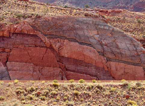
Subsidiary faulting in the damage zone adjacent to the main Moab normal fault (~1000 m throw), Arches National Park visitor center roadcut, Utah. In this photo, conjugate normal faults offset redbed sandstones of the Triassic Moenkopi Formation.
FRONT
COVER
Photo by: Gary Prost SEPTEMBER 2015 – VOLUME 42, ISSUE 08 ARTICLES 2015 Student Industry Field Trip ............................................................................................ 14 New Contributions In Baffin Bay/Labrador Sea Petroleum Exploration And Development Geoscience 16 Honorary Member Dr. Ian Hutcheon ................................................................................... 19 Go Take A Hike ........................................................................................................................... 24 Geoconvention Awards ............................................................................................................ 27 Summer Student Field Trip 30 DEPARTMENTS Message from the Board ............................................................................................................ 5 Technical Luncheons ................................................................................................................... 8 Division Talks ............................................................................................................................... 11 Rock Shop 29 RESERVOIR ISSUE 08 • SEPTEMBER 2015 3
knowledge IS POWER.
Francis Bacon

Power your upstream decision-making with customer-driven data, integrated software and services from geoLOGIC.
At geoLOGIC, we help turn raw data into actionable knowledge. That’s a powerful tool to leverage all your decision making, whether it’s at head office or out in the field. From comprehensive oil and gas data to mapping and analysis, we’ve got you covered. Get all the knowledge you need, all in one place with geoLOGIC.
For more on our full suite of decision support tools, visit geoLOGIC.com
geoSCOUT
gDC Upstream knowledge solutions
|
CSPG BOARD

PRESIDENT Tony Cadrin president@cspg.org Tel: 403.303.3493

PRESIDENT ELECT
Greg Lynch • Shell Canada Ltd presidentelect@cspg.org Tel: 403.384.7704

PAST PRESIDENT
Dale Leckie pastpresident@cspg.org

FINANCE DIRECTOR
Astrid Arts • Cenovus Energy directorfinance@cspg.org Tel: 403.766.5862

FINANCE DIRECTOR ELECT
Scott Leroux • Long Run Exploration directorfinanceelect@cspg.org Tel: 403.802.3775

DIRECTOR
Mark Caplan • Athabasca Oil Sands Corp. mcaplan@atha.com Tel: 403.975.7701

DIRECTOR
Milovan Fustic • Statoil Canada Ltd. publications@cspg.org Tel: 403.724.3307

DIRECTOR
Michael LaBerge • Channel Energy Inc. memberservices@cspg.org Tel: 403.301.3739

DIRECTOR
Ryan Lemiski • Nexen Energy ULC youngprofessionals@cspg.org Tel: 403.699.4413

DIRECTOR
Robert Mummery • Almandine Resources Inc. affiliates@cspg.org Tel: 403.651.4917

DIRECTOR
Darren Roblin • Kelt Exploration corprelations@cspg.org Tel: 587.233.0784

DIRECTOR
Jen Russel-Houston • Osum Oil Sands Corp. Jrussel-houston@osumcorp.com Tel: 403.270.4768

DIRECTOR
Eric Street • Jupiter Resources street@jupiterresources.com Tel: 587.747.2631

EXECUTIVE DIRECTOR
Lis Bjeld • CSPG lis.bjeld@cspg.org Tel: 403.513.1235
Message from the Board
A
message from Bob Mummery Director Affiliate Societies
A National Voice for Earth Science?
Does Canada need a “co-ordinated voice” for Earth Science? I believe that the answer is: yes! Many social and political issues facing Canadians require input from earth science to help decision makers make good choices. Understanding earthquakes, tsunamis, water as a resource, mineral extraction and the exploitation of petroleum & natural gas resources are critical areas where earth scientists can contribute. Geologists are familiar with the Principle of Uniformity: The present is the key to the past, a geological maxim developed by James Hutton, the father of modern geology. We have an opportunity today to use the study of past climate changes to help us understand the impact they will have in the future. It is critical that politicians have input from industry, university and government scientists when making policy decisions on these issues. Unfortunately most of what is reported in the media is distorted by short term, localized observations rather than longer term, global trends. Risk assessment of resource extraction projects need to be put into bigger perspective. There is a need to encourage more public discussion on the impact of various types of stimulation methods and what alternatives are available. We need to study how nature has dealt with natural occurring oil seeps. It is time to bring earth science observation into the mix.
CSPG was a founding partner of the Canadian Federation of Earth Sciences (CFES) whose mandate is to be “the coordinated voice of Canada’s Earth Science Community, ensuring that decision makers and the public understand the contributions of Earth science to Canadian society and the economy”. The CFES website (http://www. cfes-fcst.ca/) goes on to state: “CFES is a federation of Earth science member societies across Canada. We represent about 20 000 Earth scientists. Established in 2006 as the successor to the Canadian Geoscience Council, the CFES brings together 13 member societies
of Earth scientists in industry, government and academia. We advocate on behalf of the Canadian Earth Sciences community with government, the public, and the international Earth Science community. CFES was the successor to the Canadian Geoscience Council established in the early 1970’s.”
Diversity within earth science is broad. Petroleum geology represents a small but important component of this field. My personal involvement with CFES began more than 15 years ago as CSEG representative for the precursor organization (CGC). At that time CSPG had withdrawn its support for CGC. My activities continued over a period of six years and increased substantially when I became the CGC Executive Officer in early 2002. During this period there was a significant effort to make CGC relevant to industry based societies. The end result was a re-vitalized and renamed organization, CFES. Industry groups such as CSPG, PDAC (Prospector and Developer Association of Canada) and CIM (Canadian Institute of Mining) provided Board members and presidential candidates for the next several years. Unfortunately relevancy to and participation from “industry groups” waned after 2010 and subsequently CFES lost those voices.
Upon joining the CSPG Board in 2014, I became aware of CSPG’s withdrawal of support for CFES. Other industry based societies had similar concerns and had also withdrawn. During the CFES 2014 spring meeting in Calgary, conditions were laid out by CSPG and CSEG as preconditions for rejoining CFES. Last spring, the majority of those conditions were met. In July 2015, I talked with current CFES president Scott Swinden during a meeting with CSEG president Rachel Newrick. Scott emphasized that it is critical for organizations from the resource sectors be
(... Continued on page 7)
RESERVOIR ISSUE 08 • SEPTEMBER 2015 5
WEDNESDAY NOVEMBER 18th
SPEAKERS: MATT GOLOMBEK
Mars Exploration Rover Project Scientist
Jet Propulsion Laboratory
California Institute of Technology
DON HLADIUK
Past-President
Royal Astronomical Society of Canada
DOORS OPEN: 4:30 PM
APPETIZERS/CASH BAR: 5:00 PM
EVENT: 6:00 PM
ARTS COMMON 205 - 8th Avenue SE Calgary AB
Adults: $25.00
Students: $10.00 Children (12 & under) FREE
www.cspg.org

MacdonaldCole Inc.
SPONSORS:
2 0
1 5
CORPORATE SPONSORS
SAMARIUM
geoLOGIC systems ltd.
DIAMOND
AGAT Laboratories
CSPG Foundation
TITANIUM
Tourmaline Oil Corp.
APEGA
PLATINUM
Cenovus Energy
Imperial Oil Resources
GOLD
IHS Global Canada Limited
Suncor Energy
Nexen ULC
SILVER
Loring Tacore Labs Ltd.
Weatherford Canada Partnership
Seitel Canada Ltd.
Devon Energy Corp
Enerplus Corporation
Paradigm
Canadian Natural Resources Ltd
GLJ Petroleum Consultants Ltd.
Husky Energy Inc.
BRONZE
Chinook Consulting
Talisman Energy
Long Run Exploration
Qatar Shell GTL Limited
Osum Oil Sands Corp.
Halliburton
Pro Geo Consultants
Pengrowth Corporation
Exxonmobil Exploration Co. Ltd.
Crescent Point Energy Trust
Belloy Petroleum Consulting
Ikon Science Ltd.
Geomodeling Technology Corp.
Baker Hughes Calgary
MJ Systems
Streamsim Technologies, Inc.
As of Juky 31, 2015
A Special Thanks to Geologic Systems Ltd.,
CSPG’s Top Sponsor of the Month.
(... Continued from page 5)
part of the national voice of earth science. He requested industry societies consider providing candidates to serve on the CFES Board and also as presidential candidates. This would ensure ongoing communication between member organizations and the CFES. Our sister society, CSEG committed to providing Board members. PDAC representing the mineral industry has rejoined with a similar commitment. I believe that CSPG, as one of the strongest earth science technical societies in Canada, should be part of this national group of earth science organizations.
Why should CSPG support CFES? Currently CFES is the only “group” in Canada with representation from government, universities and industry in the field of earth science. Other stakeholders are at the table, we should also be there. Currently the petroleum sector is represented by CSEG and CWLS. I feel that CSPG, as one of the significant earth science technical societies in Canada, should participate as a member of “the coordinated voice for Canadian Earth Science” (the vision statement for CFES).
CFES will be the sponsor of an International Union of Geological Sciences (IUGS) conference to be held in Vancouver in 2018. The theme for this conference will be “Resourcing Future Generations”. PDAC and CSEG will be contributing program ideas. CSPG should also be playing a role in the promotion of and contribution to this international event. This is an opportunity for CSPG to participate in this global “resource” theme. In addition, CFES maintains close ties with Geoscientists Canada (GC), the national equivalent of APEGA’s PGeo. Many of our members work in a variety of provincial jurisdictions and GC provides the framework for inter-
provincial relationships for professional geoscientists. CSPG members have a contribution to make.
CFES also can help the CSPG goals of outreach and education through current programs such as CGEN (Canadian Geoscience Education Network) and PAGES (the Partnership group for Science and Engineering) which informs politicians and federal departments of significant developments in science and engineering. CFES is the founding member of the Science Media Centre of Canada which provides journalists with science-based information for their stories. These are areas where CSPG can contribute. CFES recently copublished the book “Four Billion Years and Counting: Canada’s Geological Heritage”. Several CSPG past presidents and membersat-large contributed financially to ensure this excellent review of Canada’s geology became available to the public at an affordable price (copies are available at the CSPG Office).
An important point to remember is that CFES has no capability to undertake projects on its own. Project ideas normally come from member organizations and the role of CFES is to coordinate overlapping efforts between member associations to maximize efficiency and impact. The mandate of the CFES is carried out through committees who rely on volunteers from member societies to accomplish their objectives.
In summary, I believe that there is a need for a coordinated national voice for geoscience in Canada. I also believe that CSPG should be part of that voice. Rephrasing a famous quote from John Kennedy, we should not be asking what can CFES do for CSPG, but rather what can we do for CFES? If you are interested in learning more about opportunities to serve on the CFES Board, please contact me directly at mummery1@telus.net for further information and discussion.
Rock Shop

RESERVOIR ISSUE 08 • SEPTEMBER 2015 7
TECHNICAL LUNCHEONS SEPTEMBER LUNCHEON
Connectivity within and between fluvial channel belt reservoirs:
A trip down the Mississippi
SPEAKER
John Holbrook
Texas Christian University, Co-Investigator, Fluvial Research Group
11:30 am
Tuesday, September 15th, 2015 Calgary, TELUS Convention Centre, MacLeod Hall C/D, Calgary, Alberta
Please note: The cut-off date for ticket sales is 1:00 pm, three business days before event. [Thursday, Sept 10, 2015].
CSPG Member Ticket Price: $45.00 + GST. Non-Member Ticket Price: $47.50 + GST.
Each CSPG Technical Luncheon is 1 APEGA PDH credit. Tickets may be purchased online at www.cspg.org
ABSTRACT
Assessment of potential for draining unpenetrated but closely stacked channel-belt reservoirs from an existing belt penetration depends upon an understanding of the methods of and the likelihood for connectivity between otherwise isolated reservoirs. Knowledge of
both the variability in scour depth beneath belts and the belt lithofacies and architecture is critical for making such assessments, yet is very poorly understood. We reviewed a collection of over 300 driller’s records and over 300 hand-augered boreholes along a 75 mile stretch of an active Mississippi River meander belt. We divided the lithofacies into genetic units and recorded the depth of significant surfaces between units.Two trends are evident: 1) The variability of the basal scour surface of the belt mimics the variability of the modern channel thalweg depth through the studied belt, and 2) While the Mississippi River is the classic example of a mud dominated fluvial system with abundant abandoned meanders, much of the lower abandoned channel fill is not composed of passive-fill clays, but rather a grittier mix of active-fill mud and sand of variable permeability. Our results suggest that, if channel-belt reservoirs are vertically separated by the thickness equivalent of one-half the average thalweg depth (average channel-fill or belt thickness as proxy) they should be able to connect through the scour surface across 15% of the overlapping belt area.As the thickness of the separating unit approaches the equivalent of the average thalweg depth, the likelihood of connectivity between potential reservoirs decreases to less than 1%. Once connected by the scour surface, communication between stacked channel-belts also depends on the reservoir quality. Our study shows that, even in muddy systems, the material into which a fluvial surface scours is likely to have sufficient quality to permit reservoir communication. In addition, channel fills typically contain sand in the lower portions that facilitate connectivity between point bar reservoirs within channel belts. This abstract is from
the PhD dissertation of Neal Alexandrowicz, supervised by John Holbrook.
BIOGRAPHY
Dr. John Holbrook is a Professor in the Department of Geology and the Energy Institute at Texas Christian University. He previously served as a Professor at University of Texas at Arlington and Southeast Missouri State University. His research interests are field oriented, focusing mostly on both modern and ancient fluvial systems and physical stratigraphy. Current interests include basin permeability architecture and connectivity of flow paths, mechanics of discontinuity surfaces, and tectonic and climatic impact on river processes. He applies his research widely across petroleum, geothermal, and environmental issues. He gained his B.S. at the University of Kentucky, his M.S. at the University of New Mexico, and his Ph.D. at Indiana University, all in Geology. He chairs the NSF Research Coordination Network for research in geothermal energy from sedimentary basins. He has served on several committees at SEPM, GSA, and AAPG. He is a member of GSA Council, past Chair of the GSA Sedimentary Geology Section, and is a GSA Fellow. He has served SEPM on SEPM Council and as President of Gulf Coast and Mid-Continent section, and he teaches short courses and serves/chairs committees for AAPG. He recently served as vice chair on the Board of Geologist Registration in Missouri.
Dr. Holbrook’s research interests are broad, but have a common theme centered about fluvial sedimentology. Most particularly, current research interests focus on the factors controlling fluvial geomorphology and resultant fluvial depositional architecture. As such, a high concentration is placed on the factors linking fluvial surficial processes and preservation of fluvial sediments.
8 RESERVOIR ISSUE 08 • SEPTEMBER 2015
Webcasts sponsored by
TECHNICAL LUNCHEONS
Reservoir Geochemistry Tools to Support Engineering Practices: A review of the State of the Art
SPEAKER
Norka Balliache
Professor of Natural History & Director of the Interdisciplinary Centre for Ancient Life, University of Manchester 11:30 am
Tuesday, September 29th, 2015 Calgary, TELUS Convention Centre, MacLeod Hall C/D, Calgary, Alberta
Please note: The cut-off date for ticket sales is 1:00 pm, three business days before event. [Thursday, Sept 24, 2015]. CSPG Member Ticket Price: $45.00 + GST. Non-Member Ticket Price: $47.50 + GST. Each CSPG Technical Luncheon is 1 APEGA PDH credit.Tickets may be purchased online at https:// www.cspg.org/eSeries/source/Events/index.cfm.
ABSTRACT
Most processes in petroleum systems generate heterogeneous fluids in space and time. Main controls on oil composition in the reservoir include source facies, source(s) maturity, multiple phases of petroleum charging, in reservoir alteration and PVT fractionation during migration. An understanding of the distribution of fluids in the reservoir allows designing and optimizing recovery strategies. Reservoir geochemistry provides practical tools to support reservoir engineering practices (Larter and Aplin, 1995; Larter et. al., 1997; England, 2005). Applications of reservoir geochemistry aim at increasing the level of understanding of compositional gradients across the reservoir, identifying barriers to the fluid communication that could impact oil and gas production, production allocation and monitoring recovery, among others. To take full advantage of geochemistry applications to reservoir characterization and management, a detailed baseline study before starting the production operations is strategic.
The integration of data available from multiple disciplines is also key in generating solutions. Commonly utilized geochemical analytical
techniques include gas chromatography oil fingerprinting, oil molecular composition by gas chromatography mass spectrometry, isotopic composition of gases and liquids, bulk oil composition and metals analysis. Reservoir geochemistry also allows the use a variety of sample types, such as produced oil, water and gases, core extracts and cuttings.
This presentation will review reservoir geochemistry methods and applications in the context of reservoir characterization and engineering problems. Case studies from around the world will be discussed to illustrate the concepts.
BIOGRAPHY
Norka Marcano is a petroleum geochemist with more than ten years of experience in petroleum reservoir characterization. She holds a Ph.D. degree from the University of Calgary. Her research and technical interests include: petroleum systems evaluation, oil post-expulsion alternation processes, oil charge mixing analysis, monitoring thermal recovery of heavy oil and oil sands using oil molecular composition and biodegradation modeling. Prior to working at Schlumberger, Norka was project manager with Gushor Inc., and worked as a geochemist at PDVSA, the Venezuelan national oil company.


 PSTM in Depth
Structure Stack in Time
PSDM in Depth
TECHNOLOGIES The definitive depth migration solution. Depend on it. AVO COMPLIANT STRUCTURE & STRATIGRAPHIC 5D INTERPOLATION 4D TIME LAPSE 3D PRESTACK TIME MIGRATION 3D MERGE 2D PRESTACK DEPTH 2D MARINE MULTICOMPONENT
the noise.
the way. Cut to the chase. Edge offers effective seismic processing solutions for clear data results. EDGE TECHNOLOGIES INC. Call/text Garry Kelman: +1.403.560.5390 or Mike Hall: +1.403.852.3038 Office: +1.403.770.0440 • info@edge-tech.ca • edge-tech.ca The On-Shore Seismic Specialists
A LEADER IN SEISMIC PROCESSING
Eliminate
Clear
Webcasts sponsored by RESERVOIR ISSUE 08 • SEPTEMBER 2015 9
SEPTEMBER LUNCHEON
TECHNICAL LUNCHEONS NOVEMBER LUNCHEON
The “New” Hydrogeology: Renewed
Importance of Water to the Petroleum Industry in the 21st Century
SPEAKERS
Brad Hayes
Petrel Robertson Consulting Ltd
Jamie Wills
Waterline Resources Inc.
11:30 am
Wednesday, November 4th, 2015 Calgary, TELUS Convention Centre
Macleod Hall C/D Calgary, Alberta
Please note: The cut-off date for ticket sales is 1:00 pm, three business days before event. [Friday, October 30, 2015]. CSPG Member Ticket Price: $45.00 + GST. Non-Member Ticket Price: $47.50 + GST.
Each CSPG Technical Luncheon is 1 APEGA PDH credit. Tickets may be purchased online at https://www.cspg.org/eSeries/source/Events/ index.cfm.
ABSTRACT
Our presentation focus is twofold: to launch the new Hydrogeology Division of the CSPG, and to highlight the fundamental importance of water to current and future oil and gas development. It is applicable to a wide audience, including company directors, senior financial and technical managers, project-based geoscience and engineering staff, and operations staff including risk-based decision makers and environmental specialists.
Water has always been an essential component of petroleum exploration and development. In exploring for conventional oil and gas pools in the mid- to late 20th century, we needed to understand regional aquifers as drivers for the migration and trapping of oil and gas deposits. Produced waters had to be managed, and waterflood schemes put into place. As heavy oil and oil sands projects emerged, large water volumes were required for thermal recovery and bitumen processing.
At the turn of the 21st century, we switched our focus to finding and understanding “tight” reservoirs, many in hydrocarbon-saturated, basin-centred (Deep Basin) settings. A decade into this new game, our success at exploiting tight reservoirs using horizontal wells and multi-zone frac completions depends on our ability to access large water volumes and secure disposal zones to support field operations, particularly for high-volume slickwater fracs.
At the same time, changing climate patterns and increasing demands for water for agricultural and domestic uses has focused societal concerns on water availability and quality over the long term. It is thus increasingly complex for the petroleum industry to secure long-term water supplies, and to safely and economically dispose of produced and flowback waters. Other considerations, such as the risks posed by aging infrastructure to useable water resources, the environment, and to other key receptors, place additional pressure on industry to manage the collective liability.
It is often stated “no water, no project”. Thus, as an industry we must develop a much more comprehensive understanding of water resources – the “New” Hydrogeology of the 21st century. Saline waters in deep aquifers, non-saline groundwater, and surface waters are all in play. Our renewed discipline must incorporate the knowledge of petroleum and physical hydrogeologists, contaminant hydrogeologists, and surface water hydrologists. Those whom embrace the new water paradigm will maximize their individual and corporate success.
The first steps are being taken to address these issues, including the completion of integrated regional water resource assessments as a framework to understand, plan, finance, manage, and execute assetlifetime water management from the boardroom to the field. In our presentation we’ll review some of these efforts, tools and drivers. We will also suggest how the renewed CSPG Hydrogeology Division can play a lead role in successfully addressing 21st century water issues in the WCSB and around the world.
BIOGRAPHY
Brad Hayes - Brad Hayes is President of Petrel Robertson Consulting Ltd., a consulting firm engaged by clients including industry,
Webcasts sponsored by
government agencies, and legal and financial organizations, to address conventional and unconventional hydrocarbon exploration and development.
Much of Brad’s work on unconventionals during the past few years has focused on characterization of subsurface aquifers as potential water source and disposal zones. He has led PRCL in regional subsurface aquifer projects in Horn River Basin, the BC Montney fairway, Central Mackenzie Valley and Deh Cho areas of NWT, and several projects in Alberta. Much of this work has been done with members of the Integrated Water Resources team, including Waterline Resources, Foundry Spatial, and Kerr Wood Leidal.
Brad received a PhD from the University of Alberta, and a B.Sc. from the University of Toronto, and has been with PRCL since 1996. Brad is an active member of the CSPG, and served as its President in 2001. He is also a member of AAPG, GAC, and APEGBC, and currently sits on APEGA Council. He is also on the Board of Directors for the Canadian Society for Unconventional Resources.
Jamie Wills - Mr. Wills is president and co-founder of Waterline Resources Inc., an Alberta and BC-based hydrogeology and environmental consulting firm providing services to the industrial, commercial and government sectors in western Canada.
Jamie has almost 30 years of experience on groundwater exploration, development and management, including water resource and contaminant hydrogeology projects in Western Canada and internationally. He has extensive experience on regional assessments, including preparing baseline and EIAs for in-situ projects in Alberta’s oil sands regions. He is increasingly being asked by clients to assist them with strategic water management plans for unconventional plays, as well as risk management associated with aging O&G infrastructure.
Jamie received a B.Sc. in honours geology, and a M.Sc. in hydrogeology, from the University of Waterloo. He is a past-President of the Canadian Chapter of the International Association of Hydrogeologists. He has chaired and presented at numerous conferences over the last several decades, most recently hydrogeology sessions at GeoConvention 2015.
10 RESERVOIR ISSUE 08 • SEPTEMBER 2015

International Division Talk
Possible Ramifications of a Current Halt to Oil and Gas Exploration Activity to Oil Prices and Company viability 5 to 10 years down the road.
SPEAKER: Douglas J. Carsted, CD, P.Geol.
Executive Vice-President, Chief Technology Officer and Director
Sproule Worldwide Petroleum Consultants
Date: Wednesday 16th September, 2015 | 12:00 Noon
Location: Nexen Annex Theatre
Sustained low oil prices are having a devastating effect on the upstream oil and gas business outside of the Middle East. We encourage our members to attend our season opening talk
RESERVOIR ISSUE 08 • SEPTEMBER 2015 11
DIVISION TALKS STRUCTURAL DIVISION
Stratigraphic expression of intra-point bar deposit erosion and rotation: Horseshoe Canyon Formation, Alberta, Canada
SPEAKER
Paul Durkin
University of Calgary
112:00 Noon
Tuesday 22nd September, 2015
Conoco Phillips Auditorium, Gulf Canada Square, 401 - 9th Ave. S.W. Calgary, AB
ABSTRACT
Meander belts are characterized by a complex amalgam of point bars and associated depositional elements, such as oxbow lake fills. Point bar deposits are composite elements often characterized by complex scroll bar patterns formed in response to processes of expansion, rotation and translation of a meander bend. Intra-point bar erosion is commonly observed in modern river systems, yet its product is rarely described from the ancient record. Late Cretaceous meander belt deposits, consisting of a point bar to counter point bar deposit transition, as well as an associated abandoned channel fill, crop out in south central Alberta, Canada. The strata are characterized by widespread evidence for intra-point bar deposit erosion and punctuated rotation (Figure 1; Durkin et al., in press).
In the stratigraphic record, intra-point bar deposit erosion and punctuated rotation is expressed by steeply dipping discordant surfaces (up to 20°),
Webcasts sponsored by
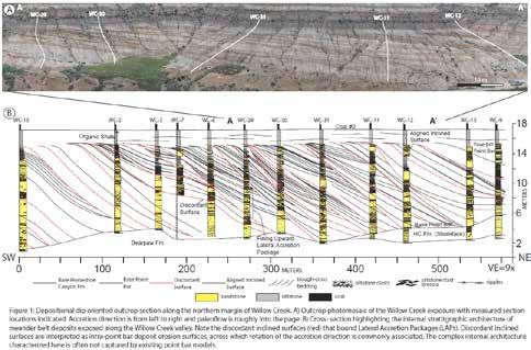
which truncate previously deposited lateral accretion packages. Across these surfaces the direction of bar migration often rotates significantly, up to 50°. Subsequent accretion surfaces onlap intra-point bar deposit erosion surfaces. The study also provides a detailed record of the lateral transition from point bar to counter point bar (concave bank) deposits, which has also proved elusive in the ancient record.
The analysis reveals that the point bar surfaces are formed through a complex interplay of erosional and depositional processes along the length of a bar, resulting in stratigraphic surfaces that may be highly composite. This study departs from more simplistic process models of point bars that consider the strata to be the sole product of continuous lateral accretion, and as such has important implications for paleoenvironmental reconstructions and subsurface reservoir characteristics.
REFERENCES
Durkin, P.R., Hubbard, S.M. Boyd, R.L., and Leckie, D.A., 2015, Stratigraphic expression of intra-point
bar erosion and rotation. Journal of Sedimentary Research, Accepted Manuscript.
BIOGRAPHY
Paul Durkin completed his B.Sc. at McMaster University, before moving to the University of Calgary to do a Ph.D. with Dr. Stephen Hubbard. His thesis focuses on fluvial meander belt processes, including point bar evolution, sedimentology and stratigraphic architecture as well as geocellular modelling. Paul has completed two internships with Oil and Gas companies and upon completion of his Ph.D., will be heading to Houston to work for ConocoPhillips in their Geological Technology group.
INFORMATION
BASS Division talks are free. Please bring your lunch. For further information about the division, joining our mailing list, a list of upcoming talks, or if you wish to present a talk or lead a field trip, please contact either Steve Donaldson at 403-808-8641, or Mark Caplan at 403-975-7701, email: mcaplan@atha.com or visit our web page on the CSPG website at http://www.cspg.org.
ISSUE CONTENTS
Process ichnological analysis of the Lower Cretaceous Bluesky Formation, Alberta
S.E. Botterill, S.G. Campbell, S.G. Pemberton and M.K. Gingras
Determining the age and depositional model of the Doig Phosphate Zone in northeastern British Columbia using conodont biostratigraphy
M.L. Golding, M.J. Orchard, J.-P. Zonneveld and N.S.F. Wilson
Petroleum geology of Carboniferous volcanic weathered crust in northern Xinjiang, China L. Hou, C. Yang, J. Wang, F. Yang, X. Lou & Y. Wei
Stratigraphic framework and depositional controls on reservoir occurrence, Big Valley Formation, southern Alberta
J. Colborne, G. Reinson and M. Bustinna
Check out the newest issue of the CSPG Bulletin online today at www.cspg.org
NEW ISSUE OF THE BULLETIN NEW ISSUE OF THE BULLETIN
12 RESERVOIR ISSUE 08 • SEPTEMBER 2015
Reflections on Fifty Years in a Small Corner of Geostatistics
SPEAKER
Professor Gordon Kaufmani (Sloan School of management, MIT)
12:00 Noon
Tuesday 6th October, 2015
ConocoPhillips Auditorium, Gulf Canada Square, 401 - 9th Ave. S.W. Calgary, AB
ABSTRACT
In 1958 Jan Arps and T.G. Roberts published a pioneering APPG article describing how oil field discovery sizes evolve as function of exploratory drilling over time. Their study of drilling and discovery in the Lower Cretaceous on the East Flank of the Denver-Julesberg Basin gave birth to a new approach to measuring returns to discovery effort we now call discovery process modeling. At roughly the same time Ferdinand Blondel, a French geologist and the French economist
Maurice Allais (later to become a Nobel Laureate) published studies suggesting that the Lognormal distribution is a sensible candidate to adopt for the size distribution of oil fields in a petroleum play.
I will discuss how these ideas fused and evolved over time into a suite of probabilistic models and methods designed to project the distribution of sizes of accumulations remaining to be discovered in an oil and gas play as a function of the discovery record, along with computational and modeling challenges faced by users and modern versions of discovery process modeling such as those deployed by the Canadian Geological Survey and the U.S. Department of Interior’s Bureau of Ocean and Energy Management and Resource Evaluation.
Use of probabilistic models of discovery to project remaining undiscovered oil and gas in petroleum plays stands in contrast to subjective probability approaches like those used by the U.S. Geological Survey in1975 to appraise undiscovered oil and gas in U.S. petroleum provinces, an approach still employed by the USGS. My introduction to this approach came in 1961 from an exploration manager at CONOCO who likened it to “… weighing hogs in Arkansas!”…. I will explain.
In conclusion we outline some future modeling initiatives that may improve our ability to compute
probabilistic projections for guiding exploration strategy at the play level.
BIOGRAPHY
Gordon is the Morris A. Adelman Professor of Management Emeritus at the Sloan School of Management, MIT. His interest in oil and gas exploration began in the early 1960s. Gordon wrote his doctoral thesis at Harvard (Statistical Decision and Related Techniques in Oil and Gas Exploration, Prentice Hall Inc. 1963) and continues! He is a Fellow of the American Association for the Advancement of Science, The American Statistical Association and the International Society for Bayesian Analysis. Gordon is the International Association of Mathematical Geologists Distinguished Lecturer.
INFORMATION
BASS Division talks are free. Please note that lunch will be provided for this talk. For further information about the division, joining our mailing list, a list of upcoming talks, or if you wish to present a talk or lead a field trip, please contact either Steve Donaldson at 403-808-8641, or Mark Caplan at 403-975-7701, email: mcaplan@atha.com or visit our web page on the CSPG website at http://www. cspg.org.
GeoConvention 2016

GeoConvention is a geosciencefocused annual convention with over 4000 delegates, 110 exhibitors, 300 technical talks, networking events, poster sessions and courses. The theme this year is “Optimizing Resources.” Please join us as an exhibitor, sponsor or attendee to learn from, and network with a premier community of geoscientists.
Sponsorship, Advertising and Exhibit opportunities are available!


With low commodity prices and an ever changing economic and business environment, it is imperative that the industry optimize the way in which it operates. Whether enhancing recovery methods or finding the optimal path for a horizontal well; maximizing the return of capital employed or simply, Optimizing Resources, the theme for GeoConvention 2016, is key to success. Please join us and contribute as speaker, exhibitor or sponsor.
www.geoconvention.com
GeoConvention News
Call for Abstracts closes November 6th MARK YOUR CALENDAR: GeoConvention 2016 is March 7 – 11! RESERVOIR ISSUE 08 • SEPTEMBER 2015 13
sponsored by
DIVISION TALKS BASS DIVISION Webcasts
2015 STUDENT INDUSTRY FIELD TRIP
| By Carson Brown & Noel Devere-Bennett
With so much flux in our ever-changing industry, sometimes it’s nice to keep some things the same. In the spring of 2015, the CSPG with the support of many generous industry sponsors and dedicated volunteers, was able to host the 38th year of the (in) famous Student Industry Field Trip; more commonly known as SIFT. From May 3rd –16th students from 31 universities across Canada were hosted in Calgary for an intense, challenging and cited by many as ‘life-changing’, crash course on the Canadian oil and gas industry and soft-rock geoscience.
At the core of the SIFT program is the volunteer committee. The committee, composed of over 20 members from across the industry, are passionate about sharing their knowledge and supporting a program designed to introduce the next generation of keen geoscientists to the petroleum industry. As a testament to the effectiveness of the program the overwhelming majority of volunteers within the SIFT organizing committee are a product of the program itself; often referred to as SIFTEES (ourselves included!).
Another crucial piece of any student outreach program is the generous sponsors. This year, to the surprise of none, was a very difficult year for sponsorship. Many companies revoked their sponsorship dollars to the
program. We are incredibly thankful to those sponsors who continue to support programs such as SIFT, even in the hard times. It is important to recognize that while commodity prices may vary our need to recruit talented young minds for the future does not.
The sponsors for this year include: Imperial Oil, Devon Energy, Canadian Natural Resources, Nexen Energy ULC, Husky Energy, Cenovus Energy, APEGA, Talisman Energy and Suncor Energy. We are also fortunate for the many in-kind donations we received through RigSat Communications, AGAT Laboratories, University of Calgary, geoLOGIC and Pengrowth Energy. The students, volunteers, and the CSPG thank all of our sponsors! A special thank you to the CSPG Foundation for recognizing the importance of programs such as SIFT and filling the sponsorship gap required to meet the program’s needs.
This truly world class program puts students through a spectrum of lectures, hands-on core sessions, a one day trip to Dinosaur Provincial Park, a four day trip through the Rockies and the challenge of the notorious “Petroleum Exploration Game”. By the end of the two weeks these exhausted students have formed lifelong bonds with their peers and learned more than they ever could have imagined. Each year the students excel at the challenges set before them and never fail to make it an
exciting two weeks. The testimonials from several of our veteran industry volunteers and leaders demonstrated that this year we had an exceptionally bright bunch.There were well thought out questions in the field and a fierce competition during the Exploration Game, which demonstrated the remarkable ability of the group this year.
Since the inception of this program the main focus has been to expose students from across the country to the Canadian oil and gas industry, as well as scout out the top minds for the future of the industry. We take advantage of this concentrated talent pool by seeking to place students among petroleum companies through our job program. Again, to no one’s surprise it was a difficult year for students looking for work in Calgary. We are pleased that we were able to successfully place one student with a summer work experience, but continue to search for more opportunities for these and future students. If your company feels they could benefit from taking on students who are work ready, having learned critical O&G concepts in the field and through industry-taught lectures, are experienced log interpreters and are acquainted with the high-stakes exploration aspect of our industry, please contact the CSPG to get involved.
Having experienced the program and volunteered in various roles prior to our positions as co-chairs, Noel Devere-Bennett and I are honoured and humbled to have been able to run a successful 2015 SIFT. The final wine & cheese windup party, open to all industry sponsors, is always bittersweet. A look back at the program makes it clear the true uniqueness and impact two weeks can have. With teary-eyed goodbyes these students will not soon forget the passion they’ve felt from the industry, the friendships they’ve made and the incredible amount of knowledge they have gained.
Noel and I look to the future: to the returning committee, the new volunteers, the industry support, and of course, the students. We expect another difficult year ahead of us but knowing that for nearly 40 years, through the good times and the bad, this program has held up through the support of the industry and the CSPG we are confident 2016 will again be successful program. We are excited to chair the program next year and again wish to extend a giant thank you to all of our sponsors, committee members, industry volunteers and our students!
14 RESERVOIR ISSUE 08 • SEPTEMBER 2015
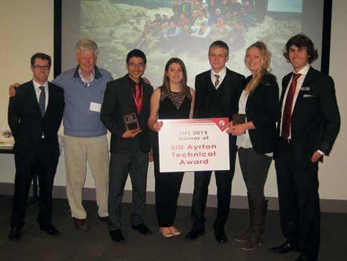
The winning team of the 2015 SIFT petroleum game for their geological interpretation: Playmaker Oil. From Left: Carson Brown (SIFT Co-chair), Bill Ayrton, teammates: Andres Cristancho, Megan Glenn, Philippe Trudel, Sienna Johnson, and other SIFT co-chair Noel Devere-Bennett
Call for Abstracts Open
24 September 2015 Earn recognition and increase the exposure for you, your company’s and/or your institution’s ideas, research theories, case studies and concepts by presenting at the prestigious AAPG 2016 Annual Convention & Exhibition. Submit Your Abstracts at ACE.AAPG.org RESERVOIR ISSUE 08 • SEPTEMBER 2015 15
Deadline:
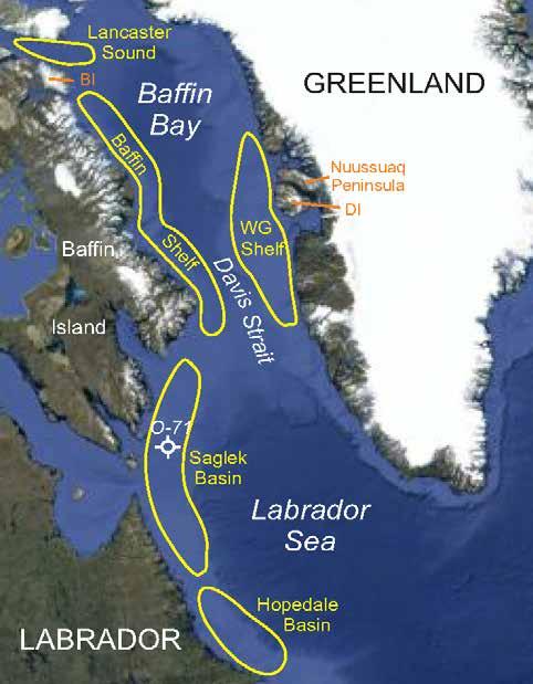
NEW CONTRIBUTIONS IN BAFFIN BAY/ LABRADOR SEA PETROLEUM EXPLORATION AND DEVELOPMENT GEOSCIENCE
Introduction to a Special Issue of the Bulletin of Canadian Petroleum Geology
| By James W. Haggart, Natural Resources Canada
Vol. 62 Issue 4 (December 2014) of the Bulletin of Canadian Petroleum Geology was a special issue on the Baffin Bay/Labrador Sea.This introduction provides an insight into the scope of this special publication. If you are interested in finding out more about this issue visit the Bulletin Archives page on www.cspg.org. From there, members can access our database of archives on either AAPG Datapages or GeoScience World.
INTRODUCTION
Baffin Bay and Labrador Sea encompass a vast marine region straddling the international jurisdictions of Canada and Greenland (Fig. 1). Together, these marine bodies encompass more than 1 500 000 km2 and they are bounded by a vast and geographically-complicated shoreline characterized by long fiords and deep channels. Sea-ice forms in much of Baffin Bay in winter, while icebergs originating from glaciers descending from the Greenland icecap create a constant hazard across the marine region during summer. Although much of the surrounding coastline is precipitous, a significant extent of continental shelf is present in these marine basins, characterized by accumulations of clastic strata, principally of late Mesozoic to Cenozoic age. Recent assessments of petroleum potential of the region have suggested that Baffin Bay may hold 1555 MMbbl of oil and 9.3 TCF of gas (Gautier et al., 2011), while shelf areas of the Labrador Sea may contain recoverable resources of 4.2 TCF of natural gas and 123 MMbbl of oil (Government of Newfoundland and Labrador, 2000).
While onshore exposures of MesozoicCenozoic strata are extremely rare along the Labrador coast, significant onshore successions are found in the Baffin Bay region on Nuussuaq Peninsula and Disko Island and adjacent areas of West Greenland, and on Bylot Island and adjacent areas of northeast Nunavut. These successions provide accessible outcrops that serve as analogues for stratigraphic sequences preserved in the offshore. While extensive study of the Greenland succession has been undertaken recently, and a comprehensive lithoand biostratigraphic framework for these rocks established (Dam et al., 2009), similar studies of the Canadian side of the Baffin Bay are vintage 1970s. As well, some 100 000 line-kilometres of seismic have been run along the offshore area of West Greenland since the 1970s, and
14 wells have been drilled, 8 by Cairn in 2010 and 2011 alone. This stands in contrast to the Canadian side of Baffin Bay where only about 16 000 line-kilometres of seismic exist, most all of it of older vintage, and no exploration wells have been drilled; a single ODP well has been drilled, but not on the shelf. The situation along the Labrador Shelf of Labrador Sea is somewhat better, where approximately 136 000 line-kilometres of 2-D seismic exist and 27 exploratory wells have been drilled, 21 in
Hopedale Basin, and the rest in Saglek Basin. Still, the contrast with modern exploration activity in West Greenland is striking.
To help address gaps in the petroleum geoscience knowledge base for western Baffin Bay and Labrador Sea, Natural Resources Canada, through the Geological Survey of Canada, has recently initiated renewed study of the hydrocarbon potential of the Baffin Bay region, through its Geo-mapping for Energy
16 RESERVOIR ISSUE 08 • SEPTEMBER 2015
and Mapping (GEM) Program. This program has involved new geophysical surveys and geology studies, and collaborative research with colleagues working around the Baffin Bay region, in particular with the Geological Survey of Denmark and Greenland (GEUS), University of Aberdeen, Scotland, and Memorial University Newfoundland. This Special Issue of Bulletin of Canadian Petroleum Geology highlights some of the recent research contributions from the Baffin Bay region resultant under the GEM program of Natural Resources Canada, as well as programs of GEUS.
Onshore exposures along the margins of Baffin Bay provide opportunity to study sedimentary successions that have correlatives in the offshore. The Cretaceous-Paleocene sedimentary succession of the Nuussuaq Basin of West Greenland is perhaps the best studied of these onshore successions. Pedersen and Nøhr-Hansen have examined key stratigraphic
sections of the Nuussuaq Group and have supported the lithostratigraphic interpretation with a refined biostratigraphy, constrained principally by palynology. Both marine and nonmarine facies are present in the succession and the palynology provides a critical tool for correlation across them and into the offshore. The biostratigraphic framework allows interpretation of multiple palynoevents in the basin, more precisely constraining the tectonic and uplift history of the basin, as well as interpretations of Cretaceous paleogeography. The biostratigraphic framework for the onshore Nuussuaq Basin provided by palynology is known to apply for wells offshore West Greenland and is expected to extend into the successions of northern Baffin Bay.
MacLean, Williams and Zhang demonstrate the value of palynology in correlating offshore strata of the Baffin shelf area of western Baffin Bay. Their analysis is based on re-examination
of reprocessed samples collected by shallow drill-coring in the 1970s and 1980s, in light of modern biostratigraphic thinking. The palynological data more precisely constrain the ages of sampled successions in both marine and non-marine facies. These authors also use Rock-Eval and vitrinite reflectance data to show that the Cretaceous strata of the shelf contain gas-prone Type III organic matter and are marginally mature locally. These data, in combination with the presence of active oil seeps on the coastal shelf off Scott Inlet, demonstrate that petroleum systems are present on the Baffin shelf.
To better understand the potential sources of Cretaceous-Paleocene strata of the Labrador Shelf and Davis Strait region, and to assess sediment dispersal patterns and potential reservoirs, Thrane has undertaken U-Pb provenance analysis of detrital zircon populations present in nine offshore wells. Thrane has documented that mid-Cretaceous, Upper Cretaceous, and Paleocene strata of the wells all contain detrital zircons likely derived from local sources present in eastern Nunavut or elsewhere in eastern Canada, with some input in the Paleocene suggesting that more southerly sources in the Appalachian Orogen may have been accessed at that time. In general, Cretaceous sedimentation was northward directed, presumably related to marine current patterns in the incipient Baffin Bay and Labrador Sea region. For each level in the Cretaceous and Paleocene, however, local sedimentation patterns varied considerably, with northerly and southerly sources alternating. Detrital zircon analysis provides a powerful tool for establishing sedimentation regimes present during Cretaceous and Paleocene time and helps to understand development of potential reservoir strata in the basin.
Development of the sedimentary basins of Baffin Bay and Labrador Sea was related mainly to late Mesozoic and Cenozoic rifting. McGregor, Nielsen and Stephenson have utilized new geophysical and existing vitrinite reflectance data to model the thermal and subsidence history of several wells on the West Greenland and Baffin/Labrador margins, and to infer the associated tectonic history of the region. Subsidence and thermal modelling results across the study area are consistent with observed stratigraphic and thermal data. The Southeast Baffin Shelf is interpreted to have experienced more intense rifting than the West Greenland and Labrador margins, prior to Late Cretaceous-early Paleocene times. McGregor et al. have established that maximum subsurface temperatures varied across the region, with maxima established at different times during the Cenozoic depending on local conditions of sedimentation, surface temperatures and heat flow. Their results demonstrate the
(... Continued on page 18)
Figure 1. Map of Baffin Bay/Labrador Sea region showing principal geographic features and areas of focus of the contributions in the Special Issue. BI = Bylot Island; DI = Disko Island.
RESERVOIR ISSUE 08 • SEPTEMBER 2015 17
importance of fully documenting local thermal and depositional histories when developing a regional model for exploration.
Jauer, Oakey, Williams and Wielens present a case study examining petroleum potential of one of the major sedimentary basins along the Labrador margin, the Saglek Basin. The basin has been drilled previously, with nine wells penetrating the Cretaceous to Pleistocene succession, and a significant discovery license has been let for the Hekja O-71 well. Despite the fact that hydrocarbons had been noted in several of the wells, and active seeps are present on the sea surface, previous assessment of the basin had suggested it has only minimal petroleum potential due to insufficient thermal maturation of source rocks. Jauer and colleagues have reassessed seismic and potential field data as well as satellite imagery from the basin and have undertaken more extended source rock analysis of samples from the wells. Using 4-D basin modelling, they conclude that the thermal regime has been previously underestimated and that there is good potential for significant natural gas and minor petroleum development, potentially hosted in successions preserved along the western side of the basin. Jauer et al.’s analysis demonstrates the value of taking a new look at basins once considered nonprospective, in light of modern assessment technology.
Recognizing that responsible development of
petroleum resources in western Baffin Bay will require comprehensive understanding of the geohazards and possible risks to development, Bennett, Campbell and Furze examined high-resolution seismic data and bottom sediment samples to better understand the shallow stratigraphy and geomorphology of the sea bottom of the Northeast Baffin Shelf and Lancaster Sound region. They note the abundance of glacially-produced features characterizing the sea bottom of the shelf in most regions, and document various geohazards, including uneven seabed, hydrocarbon venting features, seabed instability and local sediment transport along glaciallyeroded transverse troughs. They note that the effects of iceberg scour and sea-ice are widespread and significant, underscoring the challenges to responsible development in the hostile Arctic regions.
The diverse contributions in this Special Issue of Bulletin of Canadian Petroleum Geology highlight the wide variety of petroleum geoscience research that is currently underway in the Baffin Bay/Labrador Sea area, a region of stark beauty and exciting geology spanning international boundaries. These and future contributions will generate new high-quality baseline data about the resource potential of this important frontier region and will provide new perspectives and tools in the hunt for viable resources, proving of value to exploration geologists and policy makers alike.
References
Dam, G., Pedersen, G.K., Sønderholm, M., Midtgaard, H.H., Larsen, L.M., Nøhr-Hansen, H. and Pedersen, A.K. 2009. Lithostratigraphy of the Cretaceous–Paleocene Nuussuaq Group, Nuussuaq basin, West Greenland. Geological Survey of Denmark and Greenland Bulletin 19, 171 p.
Gautier, D.L., Bird, K.J., Charpentier, R.R., Grantz, A., Houseknecht, D.W., Klett, T.R., Moore, T.E., Pitman, J.K., Schenk, C.J., Schuenemeyer, J.H., Sørensen, K., Tennyson, M.E., Valin, Z.C. and Wandrey, C.J. 2011. Oil and gas resource potential north of the Arctic Circle. In: Arctic Petroleum Geology. A.M. Spencer, A.F. Embry, D.L. Gautier, A.V. Stoupakova and K. Sørensen (eds.). Geological Society, London, Memoirs, 35, p. 151–161.
Government of Newfoundland and Labrador. 2000. Sedimentary basins and hydrocarbon potential of Newfoundland and Labrador. Newfoundland and Labrador, Department of Mines and Energy, Energy Branch, Report 2000-01, 62 p.
Tang, C.C.L., Ross, C.K., Yao, T., Petrie, B., DeTracey, B.M. and Dunlap, E. 2004. The circulation, water masses and sea-ice of Baffin Bay. Unpublished report prepared for Fisheries and Oceans Canada, Bedford Institute of Oceanography, Dartmouth, Nova Scotia, 60 p.
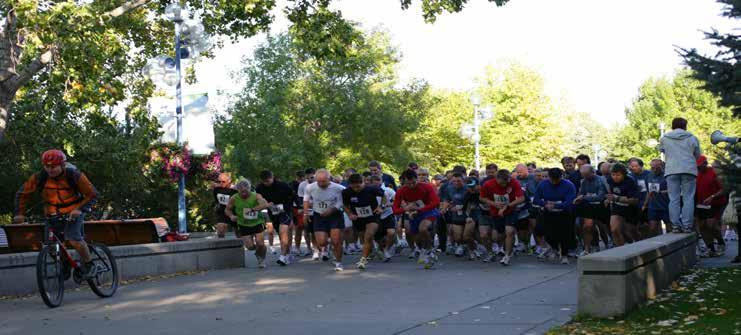

CSPG/CSEG Road Race is on September 23rd, 2015 5Km and 10 Km distance Registration is now OPEN on the CSPG website. To register please go to www.cspg.org REGISTRATION RATE: CSPG, CSEG, CAPL Member rate: $40.00 Non-member Rate: $50.00 Student Rate: $40.00 Deadline to register is Wednesday September 16th. No late registrations or changes will be accepted. (... Continued from page 17) 18 RESERVOIR ISSUE 08 • SEPTEMBER 2015
HONORARY MEMBER
Dr. Ian Hutcheon
Dr. Ian Hutcheon received his Honours B.Sc. from the University of British Columbia in 1969, and earned his M.Sc. and Ph.D. in Geochemistry from Carleton University in 1971 and 1977. He joined the CSPG in 1978, and earned the Medal of Merit for Best Paper in 1981. He then joined the Medal of Merit Committee the next year, and earned the Distinguished Lecturer Award in 1984. Dr. Hutcheon became the Editor of the Bulletin in 1987, a role he held for five years. In 1992, he was the Vice Chair of the Calgary AAPG/SEPM annual meeting. He served on the Educational Advisory Committee in 1995, and the Educational Trust Fund Committee from 1995 to 1997. He earned three more awards: a Tracks Award in 1993, a Link Award in 1997 and the Andrew Baillie Award for best technical presentation at the annual meeting in 1998. His three year Executive term was centred on his 2000 Presidential year. During his tenure, he worked diligently to initiate nationwide discussions and made an effort to get student chapters going in the far reaches of Canada. He forced the Society to develop a long term financial view recognizing that a total reliance on convention revenues, without a long term convention committee and plan in place, was not sustainable. In 2014, Ian joined the CSPG Ambassador Program in British Columbia.
Ian is also very active in other professional activities. He has been involved with the Geological Society of America, the Geological/ Mineralogical Association of Canada, the Alberta Oil Sands Technology and Research Authority, the Natural Sciences and Engineering Research Council of Canada, the International Association of Geochemistry and the American Association of Petroleum Geologists. He has been honored by the AAPG with the Matson Award for Best Technical Presentation at the 1989 annual meeting and as a Distinguished Lecturer in 1996 – 1997. In 2014, the IAG
awarded him the Vernadsky Award for Lifetime Contributions to Geochemistry. He has been a Visiting Scientist at Shell (1989 –1990) and Oslo University (1991), as well as a Discussion Moderator at the Royal Society of London. He has sat on several boards, including the Advisory Board to Energy, Mines and Resources (1985 – 1988), Editorial Board of Geofluids with Blackwell-Science (2002 –2010) and Salares Lithium Inversiones Board of Directors (2009 – 2011).
Dr. Hutcheon started his career as a Physical Scientist at the Geological Survey of Canada in 1972, and after finishing his Ph.D., returned as a Research Scientist. He became a Professor at the University of Calgary in 1978, and in 2002 became a Professor Emeritus in Department of Geoscience at the UofC. During his time at the university, Ian has taught more than 20 different courses at all levels and has supervised 26 M.Sc. students, 13 Ph.D. students and 8 postdoctoral students. Dr. Hutcheon has been a research leader for more than 25 years, and has sourced significant funding from Canadian and international government and industry sources. He has also taught diagenesis and oil field water issues at various companies,

including PanCanadian, BP–Amoco, ICP Ecopetrol, Shell and PetroBras, and at various international Universities including: Bergen, Norway; Sao Paulo, Brazil; and Melbourne, Australia.
Dr. Hutcheon has written and co-authored extensively: more than 120 peer-reviewed journal publications, over 100 abstracts and reviews, and 20 published short course notes and Field Guides, on topics ranging from CO2 injection and monitoring, geochemical monitoring of fluid-rock interaction, shale diagenesis and fluid flow. He has been the Keynote Speaker at Geofluids II in Belfast (1997) and Geologische Vereinigung (Swiss Geological Society) (1997), and has given too many talks to list.
Dr. Ian Hutcheon is a distinguished scholar and scientist, with a long history of professional involvement and mentorship. Ian has a strong work ethic, and incredible stamina at whatever he tackles and he upholds the most stringent personal ethics: he always considers the greater good, even if it is to his personal detriment.The CSPG is pleased to welcome Dr. Ian Hutcheon in to the ranks of Honorary Members.
RESERVOIR ISSUE 08 • SEPTEMBER 2015 19
CONTINUING EDUCATION
Fluvial systems and their deposits –from point bars to stra�graphy In honour of Derald G. Smith
23 ‐ Sept ‐ 15
Sco� & Stephen Hubbard
16 Hours
Topics: Fluvial and uvial‐estuarine sedimentology
Loca�on: Dinosaur Provincial Park (near Brooks)
All costs for the eld seminar are included in the registra�on: Hotel, transporta�on, lunches, dinner, printed manual… We will leave Calgary for Dinosaur Provincial Park on the morning of Wednesday, Sept. 23 and return in the early evening of Thursday, Sept. 24.
Course Content:
Inspired by the work of Professor Derald G. Smith, this course inves�gates uvial and uvial‐estuarine deposits in spectacular outcrops at Dinosaur Provincial Park, and applies this knowledge to mapping subsurface reservoirs in analogous deposits. Recogni�on of various heterolithic deposits is emphasized, including their effects on uid ow. Examples from the 3‐D exposures of the Dinosaur Park Forma�on, including Derald Smith’s classic outcrops at Steveville, will be applied to interpre�ng core and subsurface logs from the Belly River Group and McMurray Forma�on. Field stops are within areas of the Park accessible only by permi�ed researchers.
The examples viewed in outcrop begin with braided channel deposits (Oldman Fm.), through sandy laterally accre�ng channel deposits, to the meandering uvial system deposited during a transgression of the Western Interior Seaway (Dinosaur Park Fm.). Meandering channel sandstone bodies are up to ~20 m thick and associated with the complex stra�graphic architecture characteris�c of meanderbelts over an area of 5 km2. Sandy point bar deposits are interspersed with other more heterolithic meanderbelt elements including abandoned channel lls and counter point bar deposits. Collec�vely, these units represent a typical meanderbelt succession, such as that present in the McMurray Forma�on of the Athabasca Oil Sands.
Characteriza�on of the outcrop belt emphasizes dis�nguishing sedimentological and ichnological informa�on from the various meanderbelt components. The origin of facies is linked to developing an understanding of forma�ve sedimentary processes, including the controls on morphology of surfaces and resultant stra�graphic architecture. The controls on uvial systems will be considered, including paleotopography, tectonics, and sea level. This course places the details into context for the various uvial‐estuarine examples considered.
START DATE
LENGTH
INSTRUCTORS
PDH
Register online today at www.cspg.org
2 days
Jenni
Credits
Upcoming CSPG Field Seminar
20 RESERVOIR ISSUE 08 • SEPTEMBER 2015
CONTINUING EDUCATION
Upcoming CSPG Short Course
SAGD‐Reservoir Engineering for Geo‐scien�sts & Non Reservoir Engineers
Course Descrip�on
Dr. Hussain Sheikha
This course is designed to provide basic understanding of thermal recovery of bitumen. The unique physical proper�es of bitumen. Basic understanding of thermal recovery methods like Cyclic Steam S�mula�on (CSS), Steam Flood, and Toe‐to‐Heel Air Injec�on (THAI). It covers the prac�cal aspects of commercial development of SAGD pads, pads layout, drilling, comple�on, and produc�on. All phases of SAGD produc�on like start up and wind‐down are covered in this course. SAGD’s wellpair produc�on rate using Butler’s equa�on and steam requirement to produce bitumen. Reservoir simula�on of SAGD process and the key components of geological and simula�on models. How simula�on model results guide pad development.
Special a�en�on is paid to SAGD enhancement processes, new technologies, steam proper�es, steam trap, different well comple�on congura�on and smart wells, sand control, SAGD side‐track, reservoir surveillance and management, and surface components of pads and central process facility.
SAGD geo‐mechanics, role, effects, deni�on of cap rock and how it is tested are also examined in this course. What are the key performance indictors of SAGD. The success and challenge of SAGD will be demonstrated by two SAGD eld cases.
Who Should A�end
This course is designed to provide basic understanding of subsurface bitumen recovery methods and also the fundamental concepts of thermal recovery. This course is indented for professional with no formal petroleum training. This course is ideal for G&G personal, Engineers in Training, Facility Engineers, coop students, non‐reservoir engineering disciplines, non‐technical personnel and those who new to oil and gas industry, or business units who may want a basic understanding of the SAGD process.
Note: A�endees will receive a comprehensive manual
Instructor Informa�on
Dr. Hussain Sheikha is currently a Senior Reservoir Engineer with Denbury Resources, reservoir management of EOR CO2 oods. Prior to joining Denbury he worked with Suncor Energy from 2010‐2015, Firebag and MacKay River Asset Teams as a development and op�miza�on Engineer. His work has been very diversied covering conven�onal and heavy oil reservoirs proper�es, primary, secondary and ter�ary opera�ons, and reservoir development of brown and green projects. He worked for Penn West Explora�on with EOR team from 2007 to 2010 in development of hydrocarbon miscible ood, waterood, polymer and CO2 injec�on. He was a faculty member of Petroleum Engineering Department at the Bright Star University of Technology from 1994 to 2000 where he taught different petroleum engineering courses. He also taught several industry training courses in thermal and enhanced oil recovery. He graduated with a Ph.D. in petroleum engineering from the University of Calgary. He is a Registered Professional Engineer in the Province of Alberta, a member of Canadian Heavy Oil Associa�on, SPE, and associate member of Canadian Society of Petroleum Geologists.
START DATE 28 ‐ Oct ‐ 15 LENGTH 2 days INSTRUCTORS
PDH Credits
Hours Register online today at www.cspg.org
16
Register online at www.cspg.org RESERVOIR ISSUE 08 • SEPTEMBER 2015 21
CONTINUING EDUCATION
Upcoming CSPG Short Course
Resources and reserves are largely misunderstood by all but a small por�on of the engineering community and yet they are a vital scorecard for oil and gas companies. Understanding the principles, the �ming of reports, as well as ensuring the best informa�on is provided are cri�cal to appropriate evalua�ons. All disciplines need to be involved in this process. This short course is designed to provide geoscien�sts with the informa�on they need to provide effec�ve input to these evalua�ons.
This 1 day course will cover the regulatory requirements of evalua�ons, resource and reserve categoriza�on, risk, produc�on forecas�ng and the impact of pricing. Prac�cal examples from conven�onal and unconven�onal reservoirs in the Western Canada Sedimentary Basin will be used as learning tools.
Instructor Informa�on
Dave Russum has spent his career nding and developing oil and gas for E&P companies (Amoco and Crestar Energy) and providing independent evalua�ons and advice (Geo‐Help Inc., AJM Petroleum Consultants and Deloi�e). His background provides a very broad view of the industry and the expansion of unconven�onal ac�vity. He is a former Technical Director of the CSPG and a member of the CSPG, AAPG and APEGA. He is currently Director of Geoscience for Deloi�e Resource Evalua�on and Advisory where he and his team provide geoscience services in North America and on a global basis.
Andrew Bo�erill is a graduate of the University of Calgary with nearly 15 years of experience in reservoir engineering with AJM Petroleum Consultants and Deloi�e. He is a former partner in AJM Petroleum Consultants and is currently a Senior Manager in Deloi�e’s Resource Evalua�on and Advisory prac�ce. He has evaluated oil and gas assets for more than 160 interna�onal and domes�c clients. He is an expert in probabilis�c resource evalua�on and provides advisory services for many clients par�cularly in the area of mergers and acquisi�ons. Andrew also leads the team that prepares Deloi�e’s quarterly oil and gas price forecasts.


Prac�cal Risk, Resource and Reserves for Geoscien�sts START DATE 18 ‐ Nov ‐ 15 LENGTH 1 day INSTRUCTORS Dave Russum & Andrew Bo�erill PDH Credits 8 Hours Register online today at www.cspg.org
Course Descrip�on
Theme 10: Redefining Reservoir Core Values Visit ACE.AAPG.org to submit your abstract today! Call for Abstracts | TITLE SPONSOR IN CONJUNCTION WITH 22 RESERVOIR ISSUE 08 • SEPTEMBER 2015
2015 Ph.D. and M. Sc. CALL FOR THESES
Ph.D. AWARD
Win $5,000.00, a framed certificate and a one-year CSPG membership for the Doctoral thesis that makes the most significant contribution to Canadian sedimentary geology in 2015.
M.Sc. AWARD
Win $4,000.00, a framed certificate and a one -year CSPG membership for the Master’s thesis that makes the most significant contribution to Canadian sedimentary geology in 2015.


Winning thesis in recent years have included: a detailed stratigraphic, sedimentologic and geochemical study of the mudstone dominated Carlile Formation in Eastern Alberta with a focus on advancing the model for the deposition of mudstones; a sedimentological and neoichnological examination of a modern mixed energy estuary at Tillamook Bay on the coast of Oregon; a re-interpretation of the classic Silurian reefs in Southern Ontario and Michigan; an integrated analysis of the evolution of the passive continental margin off the coast of Nova Scotia incorporating the extensive seismic data set acquired in the last 25 years; evaporate diapirism in the Canadian Arctic Archipelago; and detailed integrated studies on the Upper Cretaceous Peace River, Lower Cambrian Gog and Upper Devonian Hondo formations.
DEADLINE FOR SUBMISSIONS IS SEPTEMBER 18, 2015
For submission, an electronic copy (PDF format if possible) of the thesis is preferred but a hard copy if properly bound will be accepted. Submitted hard -copy theses will be returned in late January 2016 after judging.
Eligible theses are either produced in a Canadian university, regardless of project location, or deal with a Canadian sedimentary/petroleum geology topic, regardless of the university of origin. Theses entered for the 2015 awards must have been submitted to a recognized university inside or outside of Canada and must have formed part of the requirements for degrees awarded at the Fall 2014 or Spring 2015 convocations.
Candidate theses must be well written and clearly and adequately illustrated.
PLEASE SEND THESIS SUBMISSIONS FOR JUDGING TO:
Canadian Society of Petroleum Geologists (CSPG) Graduate Thesis Awards Committee c/o Andre Chow
Pengrowth Energy Corporation 2100, 222– 3rd Ave SW Calgary, AB T2P 0B4
Phone: (403) 213-3713 | Fax (403) 234-6886
Email: andre.chow@pengrowth.com
RESERVOIR ISSUE 08 • SEPTEMBER 2015 23
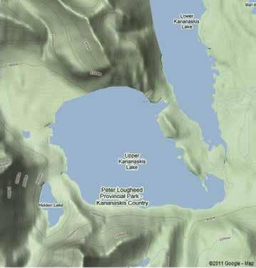
GO TAKE A HIKE
Upper Kananaskis Lake, Kananaskis Country, Alberta
Upper Kananaskis Lake, Kananaskis Country, Alberta
Philip Benham, Margot E. McMechan and Yingchun Guan
Upper Kananaskis Lake, Kananaskis Country, Alberta
| By Philip Benham, Margot E. McMechan and Yingchun Guan
Philip Benham, Margot E. McMechan and Yingchun
Guan
Trailhead: Proceed 50km south of Hwy 1 on Hwy 40, turn right on Kananaskis Lakes Trail. Drive 15km to Upper Lake parking lot (P).
Trailhead: Proceed 50km south of Hwy 1 on Hwy 40, turn right on Kananaskis Lakes Trail. Drive 15km to Upper Lake parking lot (P).
Trailhead: Proceed 50km south of Hwy 1 on Hwy 40, turn right on Kananaskis Lakes Trail. Drive 15km to Upper Lake parking lot (P).
Distance: ~16 km loop. Walk counter-clockwise around the Upper Kananaskis Lake for best lighting of peaks. The trail around the lake is clearly marked as a maintained, but unpaved trail. Fall colours are spectacular.
Distance: ~16 km loop. Walk counter-clockwise around the Upper Kananaskis Lake for best lighting of peaks. The trail around the lake is clearly marked as a maintained, but unpaved trail. Fall colours are spectacular.
Elevation Gain: 60 m over the crest of the Palliser
Distance: ~16 km loop. Walk counter-clockwise around the Upper Kananaskis Lake for best lighting of peaks. The trail around the lake is clearly marked as a maintained, but unpaved trail. Fall colours are spectacular.
Elevation Gain: 60 m over the crest of the Palliser rockslide
Elevation Gain: 60 m over the crest of the Palliser rockslide
Upper Kananaskis Lake, Kananaskis Country, Alberta
Philip Benham, Margot E. McMechan and Yingchun Guan
Upper Kananaskis Lake is one of a series of waterways dammed to provide hydroelectric power to Calgary. The trail around the lake provides an opportunity to observe middle and upper Paleozoic strata, some beautiful folds and a large landslide. A series of small waterfalls grace the SW corner of the trail loop.
Upper Kananaskis Lake is one of a series of waterways dammed to provide hydroelectric power to Calgary. The trail around the lake provides an opportunity to observe middle and upper Paleozoic strata, some beautiful and a large landslide. A series of small waterfalls grace the SW corner of trail loop.
Upper Kananaskis Lake is one of a series of waterways dammed to provide hydroelectric power to Calgary. The trail around the lake provides an opportunity to observe middle and upper Paleozoic strata, some beautiful folds and a large landslide. A series of small waterfalls grace the SW corner of the trail loop.
Trailhead: Proceed 50km south of Hwy 1 on Hwy 40, turn right on Kananaskis Lakes Trail. Drive 15km to Upper Lake parking lot (P).
Distance: ~16 km loop. Walk counter-clockwise around the Upper Kananaskis Lake for best lighting of peaks. The trail around the lake is clearly marked as a maintained, but unpaved trail. Fall colours are spectacular.
Elevation Gain: 60 m over the crest of the Palliser rockslide 1
Upper Kananaskis Lake is one of a series of waterways dammed to provide hydroelectric power to Calgary. The trail around the lake provides an opportunity to observe middle and upper Paleozoic strata, some beautiful folds and a large landslide. A series of small waterfalls grace the SW corner of the trail loop.
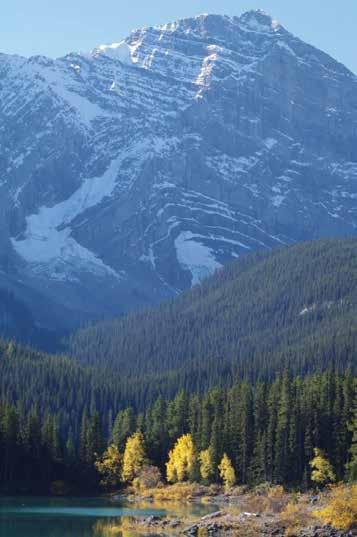
The Upper Devonian Palliser (limestone, dolostone and near top bedded the black shales and silty dolostone of the Upper Devonian and Lower Mississippian Exshaw, the Lower Mississippian Banff (bedded chert, limestone, and black shale) and Livingstone formations (light gray limestone and silty brown dolostone are all exposed along the trail route. The Middle Mississippian Mount Head Formation (recessive silty brown dolostone, and cherty skeletal limestone) conformably overlie the Livingstone and can be seen capping mountains such as Lyautey on the SW side of the lake. All this strata has brought to the surface by the Bourgeau Thrust Fault. The fault has carried rock tens of km north-eastwards and compressed the hanging-wall into of folds. The fold axes are NNW-SSE oriented and are bisected by the lake providing perfect view into the folds as one walks around the lake. The Bourgeau Thrust is one of the longest in the Canadian Rockies, extending well north of Banff to near the US border.
The Upper Devonian Palliser (limestone, dolostone and near top bedded chert), the black shales and silty dolostone of the Upper Devonian and Lower Mississippian Exshaw, the Lower Mississippian Banff (bedded chert, limestone, and black shale) and Livingstone formations (light gray limestone and silty brown dolostone are all exposed along the trail route. The Middle Mississippian Mount Head Formation (recessive silty brown dolostone, and cherty skeletal limestone) conformably overlie the Livingstone and can be seen capping some mountains such as Lyautey on the SW side of the lake. All this strata has been brought to the surface by the Bourgeau Thrust Fault. The fault has carried the rock tens of km north-eastwards and compressed the hanging-wall into a series of folds. The fold axes are NNW-SSE oriented and are bisected by the lake providing perfect view into the folds as one walks around the lake. The Bourgeau Thrust is one of the longest in the Canadian Rockies, extending from well north of Banff to near the US border.
The Upper Devonian Palliser (limestone, dolostone and near top bedded chert), the black shales and silty dolostone of the Upper Devonian and Lower Mississippian Exshaw, the Lower Mississippian Banff (bedded chert, limestone, and black shale) and Livingstone formations (light gray limestone and silty brown dolostone are all exposed along the trail route. The Middle Mississippian Mount Head Formation (recessive silty brown dolostone, and cherty skeletal limestone) conformably overlie the Livingstone and can be seen capping some mountains such as Lyautey on the SW side of the lake. All this strata has been brought to the surface by the Bourgeau Thrust Fault. The fault has carried the rock tens of km north-eastwards and compressed the hanging-wall into a series of folds. The fold axes are NNW-SSE oriented and are bisected by the lake providing perfect view into the folds as one walks around the lake. The Bourgeau Thrust is one of the longest in the Canadian Rockies, extending from well north of Banff to near the US border.
The Upper Devonian Palliser (limestone, dolostone and near top bedded chert), the black shales and silty dolostone of the Upper Devonian and Lower Mississippian Exshaw, the Lower Mississippian Banff (bedded chert, limestone, and black shale) and Livingstone formations (light gray limestone and silty brown dolostone are all exposed along the trail route. The Middle Mississippian Mount Head Formation (recessive silty brown dolostone, and cherty skeletal limestone) conformably overlie the Livingstone and can be seen capping some mountains such as Lyautey on the SW side of the lake. All this strata has been brought to the surface by the Bourgeau Thrust Fault. The fault has carried the rock tens of km north-eastwards and compressed the hanging-wall into a series of folds. The fold axes are NNW-SSE oriented and are bisected by the lake providing perfect view into the folds as one walks around the lake. The Bourgeau Thrust is one of the longest in the Canadian Rockies, extending from well north of Banff to near the US border.
At the north end of Upper Kananaskis Lake, the trail will take you up and over the confusingly named Palliser Landslide (at the foot of Mount Indefatigable). Steeply inclined Livingstone limestone in the limb of the Sarrail Creek Syncline tends to slip at the contact with the less competent cherty Banff Formation. Based on the weathering, variable lichen and tree growth it appears that there were at least two major landslides on Mount Indefatigable since the last Ice Age. The inclination of the beds and steep rock faces in the Livingstone on Indefatigable suggest that more are likely in the future. The slide rubble allows observation of ripples, burrows
At the north end of Upper Kananaskis Lake, the trail will take you up and the confusingly named Palliser Landslide (at the foot of Mount Indefatigable). Steeply inclined Livingstone limestone in the limb of the Sarrail Creek Syncline tends to slip at the contact with the less competent cherty Banff Formation. Based on the weathering, variable lichen and tree growth it appears that were at least two major landslides on Mount Indefatigable since the last Age. The inclination of the beds and steep rock faces in the Livingstone Indefatigable suggest that more are likely in the future. The slide rubble observation of ripples, burrows and marine invertebrates such as brachiopods and crinoids. Some of the older slide material exhibits karst features or differential weathering; look for closely spaced rills and weathered knife
At the north end of Upper Kananaskis Lake, the trail will take you up and over the confusingly named Palliser Landslide (at the foot of Mount Indefatigable).
Steeply inclined Livingstone limestone in the limb of the Sarrail Creek Syncline tends to slip at the contact with the less competent cherty Banff Formation. Based on the weathering, variable lichen and tree growth it appears that there were at least two major landslides on Mount Indefatigable since the last Ice Age. The inclination of the beds and steep rock faces in the Livingstone on Indefatigable suggest that more are likely in the future. The slide rubble allows observation of ripples, burrows and marine invertebrates such as brachiopods and crinoids. Some of the older slide material exhibits karst features or differential weathering; look for closely spaced rills and weathered knife edges
At the north end of Upper Kananaskis Lake, the trail will take you up and over the confusingly named Palliser Landslide (at the foot of Mount Indefatigable). Steeply inclined Livingstone limestone in the limb of the Sarrail Creek Syncline tends to slip at the contact with the less competent cherty Banff Formation. Based on the weathering, variable lichen and tree growth it appears that there were at least two major landslides on Mount Indefatigable since the last Ice Age. The inclination of the beds and steep rock faces in the Livingstone on Indefatigable suggest that more are likely in the future. The slide rubble allows observation of ripples, burrows and marine invertebrates such as brachiopods and crinoids. Some of the older slide material exhibits karst features or differential weathering; look for closely spaced rills and weathered knife edges
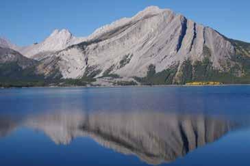
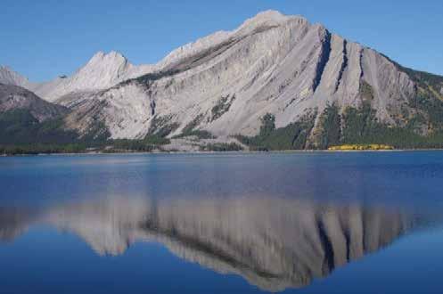
 Right: Cross-lake view of Mt Indefatigible with light-gray, cliff-forming skeletal limestone of Livingstone Fm sitting on “ribbed” Banff Fm with Exshaw and Palliser at base. Axis of Sarrail Creek Syncline runs parallel to mountain (axis defined by blue arrows). Palliser landslide is outlined in orange.
Below Left: View of folded Banff and Livingstone Fm in Warspite Anticline.
Right: Cross-lake view of Mt Indefatigible with light-gray, cliff-forming skeletal limestone of Livingstone Fm sitting on “ribbed” Banff Fm with Exshaw and Palliser at base. Axis of Sarrail Creek Syncline runs parallel to mountain (axis defined by blue arrows). Palliser landslide is outlined in orange.
Below Left: View of folded Banff and Livingstone Fm in Warspite Anticline.
1 km P
Below Left: View of folded Banff and Livingstone Fm in Warspite Anticline.
1 km P DMex
rockslide
Below Left: View of folded Banff and Livingstone Fm in Warspite Anticline.
Right: Cross-lake view of Mt Indefatigible with light-gray, cliff- f Fm with Exshaw and Palliser at base. Axis of Sarrail Creek Syncline runs parallel to mountain (axis defined by blue arrows). Palliser landslide is outlined in orange.
Mlv Mbf Dpa
km
P DMex
Palliser Landslide debris
24 RESERVOIR ISSUE 08 • SEPTEMBER 2015
Below Left: View of folded Banff and Livingstone Fm in Warspite Anticline.
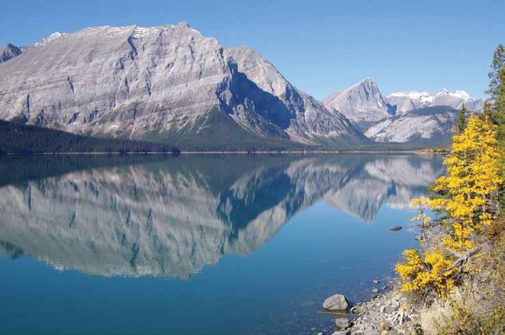
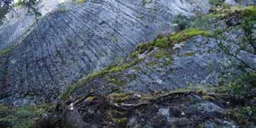
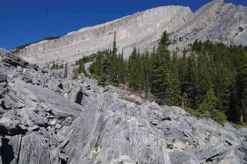
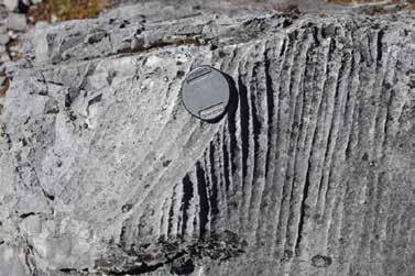
View up Mount Indefatigable from a mid-slide position. Arrows point to landslide slip surfaces on steeply inclined beds. Slide blocks in foreground consist mostly of rippled and burrowed silty Livingstone carbonates. Bottom Right: one of the small waterfalls along the trail.
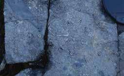
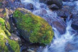 View of Mount Lyautey on western side of lake seen from near trailhead. The face of the mountain consists of the Palliser (Dpa), Banff (Mbf) and Livingstone (Mlv) formations. It is capped by the recessive brownish limestone of the Mount Head Formation (Mmh).
Nodular to bedded chert and limestone of the Upper Devonain Palliser Fm on south side of Mount Indefatigable
Mbf
Dpa
Mt Warspite Mlv Mmh
Mbf
Mlv
Rillenkarren (larst dissolution feature) on fallen limestone block, Palliser landslide
Crinoids, brachiopods and rip-up clasts (dotted line) in upper Banff Formation.
Brachiopod
Crinoid columnal
View of Mount Lyautey on western side of lake seen from near trailhead. The face of the mountain consists of the Palliser (Dpa), Banff (Mbf) and Livingstone (Mlv) formations. It is capped by the recessive brownish limestone of the Mount Head Formation (Mmh).
Nodular to bedded chert and limestone of the Upper Devonain Palliser Fm on south side of Mount Indefatigable
Mbf
Dpa
Mt Warspite Mlv Mmh
Mbf
Mlv
Rillenkarren (larst dissolution feature) on fallen limestone block, Palliser landslide
Crinoids, brachiopods and rip-up clasts (dotted line) in upper Banff Formation.
Brachiopod
Crinoid columnal
RESERVOIR ISSUE 08 • SEPTEMBER 2015 25
Mt Lyautey
GEOCONVENTION AWARDS
The GeoConvention Partnership Board would like to thank all of our sponsors, exhibitors, presenters, session chairs, and volunteers who helped us exceed expectations in delivering a best-in-class technical program along with amazing exhibits, networking and luncheon events.
Below you will find a listing of the oral presentations and posters that were identified as worthy of special recognition. Throughout the convention, oral presentations were judged by session chairs and delegates within the audience. Each poster presenter gave a brief presentation at their poster and these were evaluated by volunteer judges. These votes were tabulated to identify the best and honourable mentions for both industry and student presenters. In the past, awards were given based on the subject area of the presentation, however, this year the awards are given independent of discipline. In addition, the CSPG Foundation Baillie Award recognizes the best student geological oral presentation and poster.
Although it seems that GeoConvention 2015 has just finished we are already looking forward to GeoConvention 2016 taking place March 7-11, 2016. Our technical program and exhibition floor are at the Telus Convention Centre from March 7-9 with additional activities and events planned for March 10th and 11th. With low commodity prices and an ever changing economic and business environment, it is imperative that the industry optimize the way in which it operates. Whether enhancing recovery methods or finding the optimal path for a horizontal well; maximizing the return of capital employed or simply, Optimizing Resources, the theme for GeoConvention 2016, is key to success. Please join us and contribute as speaker, exhibitor or sponsor.
Abstract submission is now open for GeoConvention 2016 so submit your abstract now and join this list next year!
2015 Best Oral Presentation Awards
Reading Between the Lines II: A NEBC Shale Gas Quantitative Interpretation Case Study Incorporating Multi-component Data
Laurie M.Weston Bellman*, Andrew Nicol, Jennifer Leslie-Panek,Pamela Reid, and Eric Von Lunen
AVA from prestack 3DVSP images
W. Scott Leaney
Elemental (XRF), mineralogical (XRD), and organic geochemical (programmed pyrolysis) analyses used to determine the contribution of reservoir quality to differential wellbore production of single-pad, multi-lateral wells in the Eagle Ford, South Texas, USA.
Christopher C. Matson*, Bruce MacPherson, Bruce Rowley, and Mark Jaeger
Multi-attribute fracture analysis of the Washout Creek 3C-3D data set
Michael J. Perz*, Xinxiang Li, Wendy Ohlhauser, Ritesh Kumar Sharma, Peter Cary, and Satinder Chopra
Keeping it real: deterministic geomodel of the Little Bow Upper Mannville I Pool: simulating layered behavior in a valley fill sequence to optimize ASP flood design
J. Anne Thomson
2015 Best Oral Presentation –Honourable Mention
Stratigraphic Controls of Quaternary Aquifer Deposits in the Primrose and Wolf Lake Oil Sands Development Areas, Northeast Alberta Kristyn Adams
Multidisciplinary approach to identify open fracture systems and assess their impact on hydraulic fracturing and microseismic
Jean-Yves Chatellier*,Tammy Chow and Jennie Wong*
Elnora D2B Pool - A new Central Alberta Nisku Reef Conventional Light Oil Discovery Ted McFeely, Ken Hayes* and Marlo Baydala*
(... Continued on page
CRAINʼS LOG ANALYSIS COURSES For Engineers, Geologists, Geophysicists, and Technologists Every April and Octoberin Calgary Details /Registration at www.spec2000.net/00-coursedates.htmSlide Shows, Reference Manuals, and Exercises Included AV-01 Practical Quantitative Log Analysis AV-02 Advanced Quantitative Log Analysis AV-03 Analysis of Unconventional Reservoirs Details / Order Onlineat: www.spec2000.net/00-av-training.htm Single-User, Corporate, and Academic Licenses Available Individual Reference Manuals and Slide Shows Available Separately Shareware Petrophysical Encyclopediaat www.spec2000.net 50+ Years OfExperience AtYour Fingertips === E. R. (Ross) Crain. P.Eng. 1-403-845-2527 ross@spec2000.net === === RESERVOIR ISSUE 08 • SEPTEMBER 2015 27
28)
Evidence for hyper-extended continental crust in the East Orphan Basin from seismic reflection data and potential field forward modelling and inversion
J. Kim Welford*, Deric Cameron, James Carter and Richard Wright
Devonian Petroleum Systems and Exploration Potential, Southern Alberta, A Review in Three Parts (Part 1)
Rick Wierzbicki & Andy Mort Leonard Stevens
2015 Best Poster Award
Recent Updates to the Bedrock Topography Model of Alberta
Kelsey E. MacCormack*, Steve Lyster, and Nigel Atkinson
2015 Best Poster Honourable Mention
The Garbutt shale of the B.C. Liard Basin: A potential liquids-rich play?
Filippo Ferri*, Margot McMechan, Omid Haeri Ardakani, and Hamed Sanei
Climate Cycles Drive Aquatic Ecologic Changes in the Fort McMurray Region of Northern Alberta, Canada
Lisa A. Neville*, Paul Gammon, Timothy R. Patterson, and Graeme T. Swindles
2015 Best Student Oral Presentation Award
Gravity monitoring of 4D fluid migration in SAGD reservoirs incorporating sedimentology
E Judith Elliott* and Alexander Braun
Effect of Pressure on Electrical Conductivity and Formation Factor in Sandstone
Tariq E. Mohammed*, Simon Gonzales-Sirois, Bernard Giroux, Doug R. Schmitt, and Cornelia Schmidt-Hattenberger
2015 Best Student Oral Presentation – Honourable Mention
Prediction of stratigraphic units from spectral co-occurance coefficients of well logs
Ben B. Bougher
Seismic wave scattering in viscoelastic media: Born approximation
Shahpoor Moradi* and Kristopher A. Innanen
Basin Modeling in Western Newfoundland Using Oil Seep Samples
Martin Schwangler*, Nicholas B., Harris, and John W. F., Waldron
2015 Best Student Poster Award
Comparing step-length calculation using well logs with a line search method
Babatunde Arenrin*, Gary Margrave, and John Bancroft
GEOEDGES INC.
Detailed and accurate geology at your fingertips in Petra, GeoGraphix, ArcGIS, AccuMap, GeoScout and other applications
Western Canada Geological Edge Set
Northern US Rockies & Williston Basin Geological Edge Set Eastern US / Appalachian Basin Geological Edge Set
North American Shales Geological Edge Set (all colors)
Texas & Midcontinent US
2015 Best Student Poster –Honourable Mention
Petrophysical characterization of the Upper Cretaceous Second White Specks alloformation, Willesden Green – Gilby area, Alberta
Kienan Marion* and Dr. Burns Cheadle
CSPG Foundation Baillie Awards
Best Student Geology
Oral Presentation
Paleochannel migration history and characterization of resulting point bars, counter point bar, and abandoned channels from an Upper Cretaceous fluvial meander belt, Dinosaur Park Badlands, Alberta
Paul R. Durkin
Best Student Geology
Poster Presentation
A Study of Jurassic Paleoenvironment and Paleoclimate in the Western Canadian Sedimentary Basin Using Foraminiferal Assemblages
Leanne M. Tingley* and Melissa Sawyer
for information contact: Joel Harding at 403 870 8122 email joelharding@geoedges.com www.geoedges.com
Western Canada: Slave Point, Swan Hills, Leduc, Grosmont, Jean Marie, Horn River Shales, Elkton, Shunda, Pekisko, Banff, Mississippian subcrops and anhydrite barriers in SE Sask., Bakken, Three Forks, Montney, Halfway, Charlie Lake, Rock Creek, Shaunavon, BQ/Gething, Bluesky, Glauconitic, Lloyd, Sparky, Colony, Viking, Cardium, CBM, Oilsands Areas, Outcrops
US Rockies & Williston: Red River, Mississippian subcrops & anhydrite barriers (Bluell, Sherwood, Rival, etc), Bakken, Three Forks, Cutbank, Sunburst, Tyler, Heath, Muddy, Dakota, Sussex, Shannon, Parkman, Almond, Lewis, Frontier, Niobrara, Mesaverde shorelines, Minnelusa, Gothic, Hovenweep, Ismay, Desert Creek, Field Outlines, Outcrops
Texas & Midcontinent: Granite Wash, Permian Basin paleogeography (Wolfcampian, Leonardian, Guadalupian), Mississippian Horizontal Play, Red Fork, Morrow, Cleveland, Sligo/Edwards Reefs, Salt Basins, Frio, Wilcox, Eagleford, Tuscaloosa, Haynesville, Fayeteville-Caney, Woodford, Field Outlines, Outcrops, Structures
North American Shales: Shale plays characterized by O&G fields, formation limit, outcrop, subcrop, structure, isopach, maturity, stratigraphic crosssections. Includes: Marcellus, Rhinestreet, Huron, New Albany, Antrim, UticaCollingwood, Barnett, Eagleford, Niobrara, Gothic, Hovenweep, Mowry, Bakken, Three Forks, Monterey, Montney, Horn River, Colorado
Eastern US / Appalachia: PreCambrian, Trenton, Utica-Collingwood, MedinaClinton, Tuscarora, Marcellus, Onondaga Structure, Geneseo, Huron, Antrim, New Albny, Rhinestreet, Sonyea, Cleveland, Venango, Bradford, Elk, Berea, Weir, Big Injun, Formation limits, Outcrops, Allegheny Thrust, Cincinatti Arch, Field outlines
Mexico: Eagle Ford-Agua Nueva, Pimienta, Oil-Gas-Condensate Windows, Cupido-Sligo and Edwards Reefs, Tuxpan Platform, El Abra-Tamabra facies, Salt structures, Basins, Uplifts, Structural features, Sierra Madre Front, Outcrops, Field Outlines
Deliverables include:
-Shapefiles and AccuMap map features
-hard copy maps, manual, pdf cross-sections
-Petra Thematic Map projects, GeoGraphix projects, ArcView map and layers files
-bi-annual updates and additions to mapping
-technical support
28 RESERVOIR ISSUE 08 • SEPTEMBER 2015
Geological Edge Set
Mexico Geological Edge Set (... Continued from page 27)


elizabeth macey, B.A., cartographer . 993. 0055 emacey@telus.net www3.telus.net/elizabethmacey . . presentations posters graphics . maps technical illustrations RESERVOIR ISSUE 02 • FEBRUARY 2015 9 • Domestic and International wellsite supervision • Conventional and Unconventional wells • Extensive Hz experience • Customized corporate solutions available (403) 250-3982 sales@clconsultants.ca www.clconsultants.ca Wellsite Geologists Inc. the Rock Solid Choice Wellsite Supervision Project Management Graphic Well Profiles Verticals / Horizontals EUB Sample / Core Studies Conventional / Un-conventional 1350, 734 - 7th Ave SW Calgary, AB T2P 3P8 B 403.234.7625, www.WellsiteGeologists.com C 403.660.9883, info@WellsiteGeologists.com 1602 – 5th St N.E. Calgary, AB. T2E 7W3 Phone: 403-233-7729 www.tihconsulting.com e-mail: tih@shaw.ca T.I.H. Consulting Ltd. Geologic Well-Site Supervision
CORPORATE SUPPORTERS
RIGSAT Communications
Pason System
Big Guns Energy Services
Earth Signal Processing Ltd.
Golder Associates
Birchcliff Energy Ltd.
Canada Brokerlink Inc.
Little Rock Printing
Nalcor Energy
Paramount Resources
Pulse Seismic Inc
Compass Directional Services
EV Cam Canada Inc.
Lee Energy Systems
Roke Technologies Ltd.
Explor
Japan Canada Oil Sands Ltd.
RPS Energy Canada Ltd.
Sproule Associates Limited
Waterline Resources
Serpa Petroleum Consulting Ltd.
Cabra Consulting Ltd.
McDaniel & Associates Consultants Ltd.
National Oilwell Varco
Signature Seismic Processing Inc.
Geovariances
Hurry Hydrocarbons
Navigator Resource Consulting
NExT- A Schlumberger Company
Valeura Energy
Statoil Canada
Mundiregina Resources Canada
Mcleay Geological Consultants Ltd.
Enviro-Tech Surveys Ltd
Tucker Energy Services Canada
Gaffney, Cline & Associates
Bounty Developments Ltd.
Franconia Geoscience
GeoChemTech Inc.
Prospect Drivers Inc.
Company Patron
Journey Energy Inc.
Rife Resources Ltd.
SUMMER STUDENT FIELD TRIP
| Jane Marzetti, CSPG University Outreach Committee
The 2015 CSPG Summer Student Field Trip, organized by members of the University Outreach Committee, was not deterred by the rain on June 17, 2015. Thirty students participated; they spent the day learning about the Horseshoe Canyon formation from trip leader Jason Lavigne of CNRL.
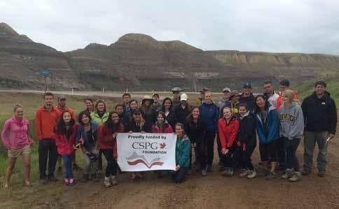
The field trip entitled “Marginal marine depositional environments of the Bearpaw-Horseshoe Canyon Formation Transition, Drumheller, Alberta,” took the participants to several outcrops in the Red Deer River Valley. After a brief stop overlooking the valley to make introductions and discuss the geologic framework of the valley sediments, the bus descended into the Red Deer River Valley and out to East Coulee. This was the first major stop on the field trip, where the participants got a chance to get up close and personal with several trace fossils.These trace fossils helped define the differences between the pro delta, delta front and the coastal plain. After boxed lunches at the hoodoos, the next stop was Willow Creek to look at the tidal-influenced deposits. The final two stops were brief but gave the participants a chance to observe stacking patterns of channel deposits in the area. It goes without saying that on the bus ride back home many of the students took advantage of Jason’s willingness to share his knowledge and experience.
Thank you to Jacey Neumann for helping to organize the field trip, Astrid Arts for assisting Jason, Kasandra Amaro for coordinating registrations and of course Jason Lavigne for his expertise and enthusiasm for leading the field trip. The trip was graciously funded by the CSPG Foundation.
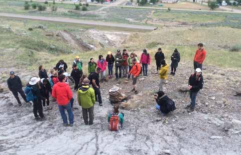
AS OF JULY 31, 2015
30 RESERVOIR ISSUE 08 • SEPTEMBER 2015
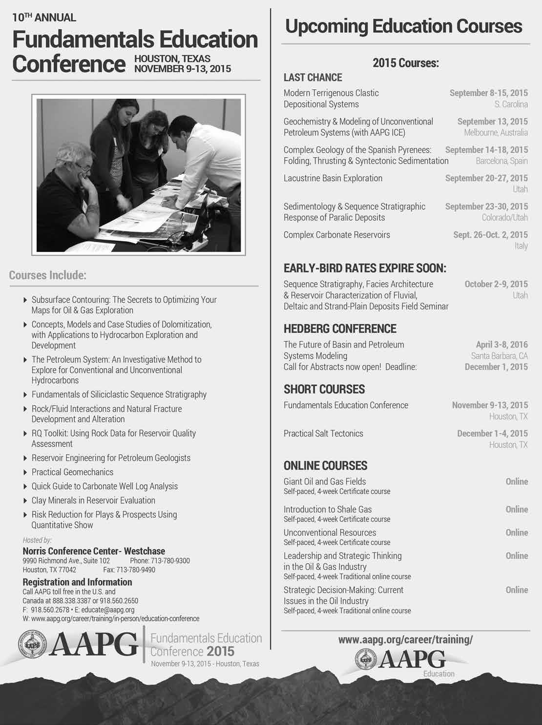
RESERVOIR ISSUE 08 • SEPTEMBER 2015 31
Who will be HONOURED?
It’s up to you!

Without nominations from people like you, deserving Professional Geoscientists will go unrecognized at the annual, preeminent event of our professions — The Summit Awards Gala.
Nominate greatness so our accomplished geoscientists can be celebrated for their contributions to our professions and society’s needs. Our new shareable digital nomination form makes it easier than ever!

SUmmit AWARDS NOmiNAtiONS Final submissions due October 15, 2015. Nominate Now! For more information visit apega.ca/summitnominations
