RETURN UNDELIVERABLE CANADIAN ADDRESSES TO: CSPG – 150, 540 – 5th Ave SW Calgary, AB, T2P 0M2 $7.00 SEPTEMBER/OCTOBER 2017 VOLUME 44, ISSUE 5 Canadian Publication Mail Contract – 40070050 Academic Issue In This Issue... Where and Why Do Large Tides Occur? Potential Reservoir Characterization of the Fluvial Reach To Inner Estuary, Ogeechee River Estuary, Georgia, USA Discussion: Shallow Thinking in Deep Time Mountjoy Wrap-up GeoWomen of Calgary Partners with the CSPG


THANK-YOU TO ALL OF OUR SPONSORS


SAMARIUM SPONSOR


TITANIUM SPONSORS


GOLD SPONSORS


BRONZE SPONSORS


CORPORATE SUPPORTERS
Chinook Consulting Services
Belloy Petroleum Consulting
XRF Solutions Ltd
RIGSAT Communications
IHS Markitt
Canada Brokerlink Inc.
CMC Research Institutes, Inc.
Encana
LXL Consulting Ltd.
MJ Systems
RS Energy Group


Schlumberger Canada Limited
Birchcliff Energy Ltd.
Canadian Natural Resources Ltd.
Pulse Seismic Inc
Cabra Consulting Ltd.
RPS Energy Canada Ltd.
CAPL
Earth Signal Processing Ltd.
McDaniel & Associates Consultants Ltd.
MEG Energy Corp.
Saguaro Resources


SILVER SPONSORS PLATINUM SPONSORS


*As of July 31st
Siftgrid
TAQA North Ltd.
Midwest Surveys
Navigator Resource Consulting
Synterra Technologies
Baker Hughes Calgary
Signature Seismic Processing Inc.
Tectonic Energy Consulting Inc.
Bannatyne Wealth Advisory Group
BOARD OF DIRECTORS 2017
CSPG OFFICE
#150, 540 - 5th Ave SW
Calgary, Alberta, Canada T2P 0M2
Tel: 403-264-5610
Web: www.cspg.org
Please visit our website for all tickets sales and event/course registrations Office hours: Monday to Friday, 8:30am to 4:00pm
The CSPG Office is Closed the 1st and 3rd Friday of every month.
OFFICE CONTACTS
Membership Inquiries
Tel: 403-264-5610
Email: membership@cspg.org
Advertising Inquiries: Emma MacPherson
Tel: 403-513-1230
Email: emma.macpherson@cspg.org
Sponsorship Opportunities: Lis Bjeld
Tel: 403-513-1235
Email: lis.bjeld@cspg.org
Conference Inquiries: Kristy Casebeer
Tel: 403-513-1233
Email: kristy.casebeer@cspg.org
Accounting Inquiries: Nancy Mosher
Tel: 403-513-1232
Email: nancy.mosher@cspg.org
Executive Director: Lis Bjeld
Tel: 403-513-1235, Email: lis.bjeld@cspg.org
EDITORS/AUTHORS
Please submit RESERVOIR articles to the CSPG office.
Submission deadline is the 23rd day of the month, two months prior to issue date. (e.g. January 23 for the March/April issue)
To publish an article, the CSPG requires digital copies of the document. Text should be in Microsoft Word format and illustrations should be in TIFF format at 300 dpi., at final size.
CSPG COORDINATING EDITOR
Emma MacPherson, Programs Coordinator, Canadian Society of Petroleum Geologists
Tel: 403-513-1230, emma.macpherson@cspg.org
The RESERVOIR is published 6 times per year by the Canadian Society of Petroleum Geologists. The purpose of the RESERVOIR is to publicize the Society’s many activities and to promote the geosciences. We look for both technical and non-technical material to publish.
The contents of this publication may not be reproduced either in part or in full without the consent of the publisher. Additional copies of the RESERVOIR are available at the CSPG office.
No official endorsement or sponsorship by the CSPG is implied for any advertisement, insert, or article that appears in the Reservoir unless otherwise noted. All submitted materials are reviewed by the editor. We reserve the right to edit all submissions, including letters to the Editor. Submissions must include your name, address, and membership number (if applicable).The material contained in this publication is intended for informational use only.
While reasonable care has been taken, authors and the CSPG make no guarantees that any of the equations, schematics, or devices discussed will perform as expected or that they will give the desired results. Some information contained herein may be inaccurate or may vary from standard measurements. The CSPG expressly disclaims any and all liability for the acts, omissions, or conduct of any third-party user of information contained in this publication. Under no circumstances shall the CSPG and its officers, directors, employees, and agents be liable for any injury, loss, damage, or expense arising in any manner whatsoever from the acts, omissions, or conduct of any third-party user.
Printed by CBN Commercial Services, Calgary, Alberta.


PRESIDENT
Mark Cooper
Sherwood Geoconsulting Inc. president@cspg.org
PAST PRESIDENT
Greg Lynch
Shell Canada Ltd. pastpresident@cspg.org
FINANCE DIRECTOR ELECT
Jim Barclay
directorfinanceelect@cspg.org
DIRECTOR
John Cody
Statoil Canada Ltd. industryrelations@cspg.org
DIRECTOR
Kevin Parks
Alberta Energy Regulator kevin.parks@aer.ca
EXECUTIVE DIRECTOR
Lis Bjeld
CSPG lis.bjeld@cspg.org


PRESIDENT ELECT
Clint Tippett presidentelect@cspg.org
FINANCE DIRECTOR
Shelley Leggitt
NAL Resources Ltd. directorfinance@cspg.org
DIRECTOR
Mark Caplan conferences@cspg.org
DIRECTOR
Alex MacNeil
Osum Oil Sands Corp. AMacNeil@osumcorp.com
DIRECTOR
Michael Webb
Suncor Energy mwebb@suncor.com
RESERVOIR ISSUE 5 • SEPT/OCT 2017 3


Knowledge has TO BE improved, CHALLENGED, AND INCREASED constantly, OR IT vanishes. geoSCOUT | gDC Upstream knowledge solutions Power your upstream decision-making with customer-driven data, integrated software and services from geoLOGIC. At geoLOGIC, we help turn raw data into actionable knowledge. That’s a powerful tool to leverage all your decision making, whether it’s at head office or out in the field. From comprehensive oil and gas data to mapping and analysis, we’ve got you covered. Get all the knowledge you need, all in one place with geoLOGIC. For more on our full suite of decision support tools, visit geoLOGIC.com
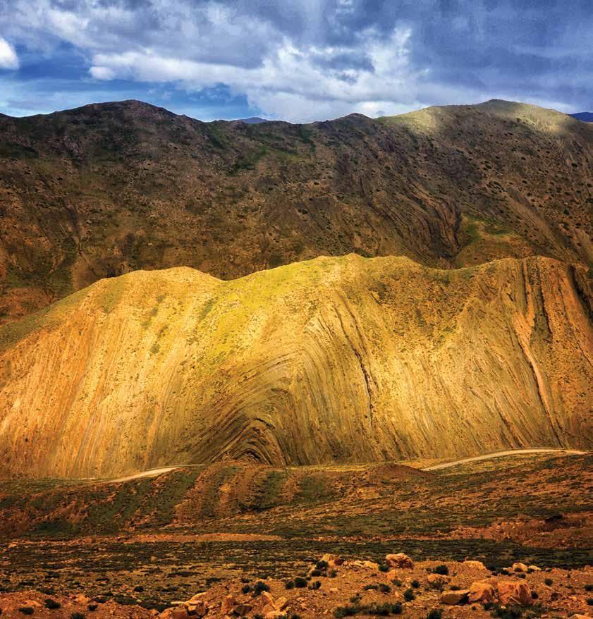
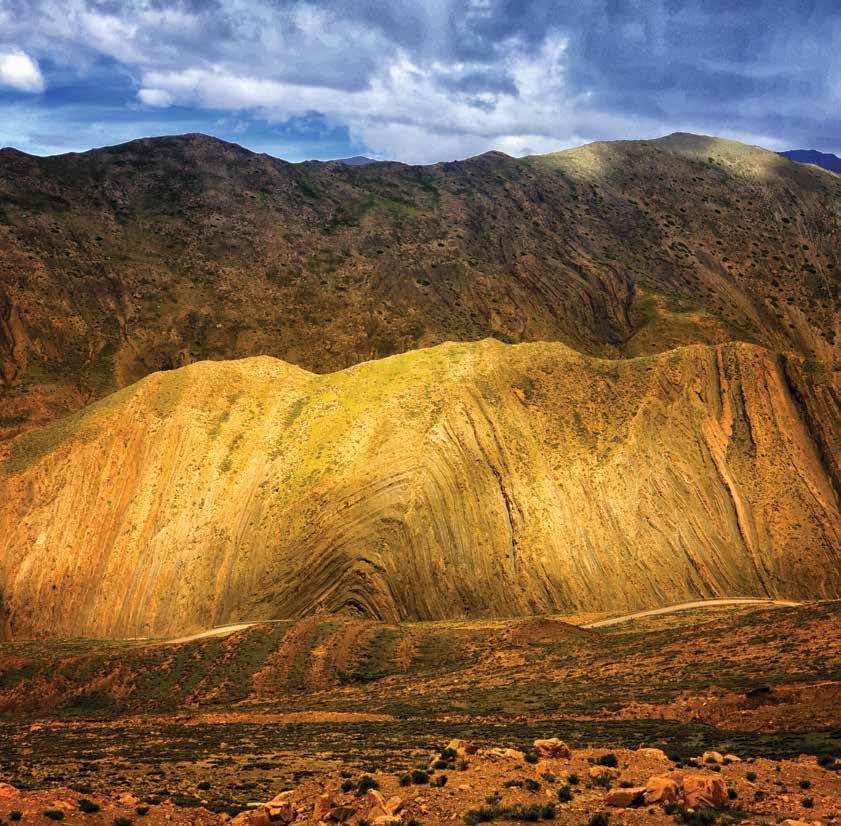
RESERVOIR ISSUE 5 • SEPTEMBER/OCTOBER 2017 5 FRONT COVER Mt. Qomolangma National Park, Tibet. Folds and faults in the Dingjie Formation, Tingri Group, Tibet, China. These strata are Middle to Upper Jurassic in age. They sit 4590m above sea level on the Tibet Plateau along the gravel road to a basecamp on Mt. Everest. The Dingjie Formation is more than 400m thick and is composed of yellow-green sandstone and dark gray shale alternating with quartz sandstone. Zekai Jia SEPTEMBER/OCTOBER 2017 – VOLUME 44, ISSUE 5 MONTHLY SPONSORS 4 MESSAGE FROM THE BOARD 7 MESSAGE FROM THE EDITORS 8 ACADEMIC ARTICLES Where and Why Do Large Tides Occur? ...............................................................10 Potential Reservoir Characterization of the Fluvial Reach to Inner Estuary, Ogeechee River Estuary, Georgia, USA 15 Discussion: Shallow Thinking in Deep Time 20 UPCOMING EVENTS Technical Luncheons..............................................................................................23 Division Talks ..........................................................................................................28 SOCIETY NEWS Mountjoy Wrap-up .................................................................................................34 GeoWomen of Calgary partners with the CSPG ...................................................36 Go Take a Hike 38 2017 Classic Golf Wrap-up 42 Stanley Slipper Medal Call for Nominations 43 TABLE OF CONTENTS
2017 Ph.D and M. Sc. CALL FOR THESES
Ph. D. AWARD
Win $5,000, a framed certificate, and a one -year CSPG membership for the Doctoral thesis that makes the most significant contribution to Canadian sedimentary geology in 2017.
M. Sc. AWARD
Win $4,000, a framed certificate, and a one -year CSPG membership for the Masters thesis that makes the most significant contribution to Canadian sedimentary geology in 2017.

Winning thesis in recent years have included: A study which developed a new and robust method of interpreting complex tidal successions using the Bluesky -Gething interval in the Peace River area as the study area; a field based outcrop study of the Lower Lajas Formation in the Neuquen Basin of west -central Argentina; a detailed stratigraphic, sedimentological and geochemical study of the mudstone dominated Carlile Formation in Eastern Alberta with a focus on advancing the model for the deposition of mudstones; a sedimentological and neoichnological examination of a modern mixed energy estuary at Tillamook Bay on the coast of Oregon; a re-interpretation of the classic Silurian reefs in Southern Ontario and Michigan; an integrated analysis of the evolution of the passive continental margin off the coast of Nova Scotia incorporating the extensive seismic data set acquired over the last 25 years; and evaporate diapirism in the Canadian Arctic Archipelago
DEADLINE FOR SUBMISSIONS IS SEPTEMBER 22, 2017
For submission, an electronic copy (.pdf format) of the thesis is preferred but a hard copy if properly bound will be accepted. Submitted hard -copy theses will be returned in late January 2018.
Eligible theses are either produced in a Canadian university, regardless of project location, or deal with a Canadian sedimentary/petroleum geology topic, regardless of the university of origin. Theses entered for the 2017 awards must have been submitted to a recognized university inside or outside of Canada and must have formed part of the requirements for degrees awarded at the Fall 2016 or Spring 2017 convocations.
Candidates theses must be well written and clearly and adequately illustrated
Please submit electronic copy of thesis for judging to:
Canadian Society of Petroleum Geologists (CSPG) Graduate Thesis Awards Committee
c/o Andre Chow amcchow@gmail.com
For submission of a hard copy thesis or additional information please contact Andre Chow at the above email or tel: 587-777-2154
TFINANCES, INFLATION AND CSPG MEMBERSHIP DUES
By Mark Cooper (President))
he CSPG starts a new fiscal year on September 1. As you are all aware, the downturn in the industry has had an impact on the finances of the CSPG and on those of many of our members. The challenge for the CSPG over the last twelve months has been to strike a balance between maintaining the services that we provide to the membership, on the one hand, and striving for a balanced budget, on the other. To this end, we have adopted a strategy to ensure that core member services are maintained. These include the operations of the various Technical Divisions, the Technical Luncheons, specialized conferences and workshops, SIFT, Professional Development opportunities through training courses, the Reservoir and the Bulletin, the Long Time Members Reception and the various sporting and social events that occur throughout the year. We have achieved this goal by being creative in how we manage our costs and have reduced our overhead as much as possible. This will continue to help us into the future. For the last financial year we have halved our losses from the previous year - but we need to improve that further. We need to continue along the path back to a balanced budget and ultimately to a surplus so that we can replenish our financial reserves.
GeoConvention 2017 in May, of which CSPG is a partner with CSEG and CWLS, exceeded the previous year’s results and contributed revenue to the CSPG which is an encouraging sign of industry recovery. The CSPG Core Convention also provided healthy revenues for the Society as did the Gussow and the Geothermal and Carbon Capture and Storage meetings last fall. The Spring Education week had 204 registrants and exceeded budget expectations by 12%. This also suggests that a gentle return to some level of normalcy has started as companies begin to send staff on training courses again to fulfil professional development needs. These outcomes indicate that there is demand for a wide spectrum of meeting
options and that people will attend if we get the “product” right.
I would like to take this opportunity to thank on behalf of CSPG all those individuals involved with the organizing committees of these events. Through their efforts the Society has put together an excellent range of activities that our members have clearly found relevant.
I also want to let you know that this program of activities has been delivered by a significantly smaller number of staff in the CSPG office. The reduction was the result of some redundancies and of two staff being on maternity leave. The impact on the remaining staff has been an increased workload which was managed by some efficiencies but also through longer hours. We are appreciative of the dedication of our office staff to the Society.
I would also like to thank all our sponsors. Without them, we would be a much smaller Society and our technical programs would be significantly more expensive for CSPG to deliver! This also impacts all our Outreach areas from the Ph.D. and Masters level down to school children. Our sponsors greatly assist us in representing Canada’s Energy Geoscientists across the country and we value them as Partners! Our sponsors have stood behind us for many years and continue to do so. In addition to our sponsors, the CSPG Foundation also puts your charitable donations to work by supporting CSPG Outreach programmes.
As a part of our review of our future financial plans the issue of membership dues was
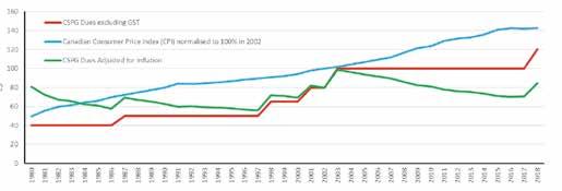
brought forward. Dues were last increased fifteen years ago - in 2002. In the interim we have been able to function at that level due to the generally robust nature of the other revenue streams generated for us by industry. Since that point in time there have been significant increases in costs. I have included a graph that shows the levels of CSPG dues since 1980. The major jumps occurred in 1998 and 2002. To provide some context, the graph also includes the Canadian Consumer Price Index over the same time frame (the CPI is set to 100% in 2002/3).
In view of the pressures on our finances, the Board therefore took the decision that as part of rebalancing our budget it was necessary and very reasonable to increase CSPG dues for full members to $120 per year + GST as of 1st September 2017. This still leaves the Society short of where the dues should be to fully offset the increase in CPI since 2002 - but on an inflation adjusted basis it does at least return the real value of the dues back to where they were in 1980.
Finally, I would like to remind in-transition members that their dues are waived until the end of 2018. The Board also passed a motion to extend that option to lapsed members in transition who can rejoin the Society for an administration fee of only $25 + GST and then take advantage of the free membership until end 2018. Please visit the CSPG website for details and please note that to take advantage of this benefit you will need to call the office staff directly to be set up correctly in the membership system.
RESERVOIR ISSUE 5 • SEPTEMBER/OCTOBER 2017 7 MESSAGE FROM THE BOARD
Jason Frank is a Professional Geologist who holds a B.Sc. and M.Sc. from the University of Alberta. He has over 16 years of experience in oil and gas including technical and leadership positions in exploration and development both on and offshore. Past experience includes Shell Canada Ltd., Burlington Resources Ltd., ConocoPhillips Canada Ltd., and Talisman Energy Inc. Jason has volunteered for the Society in the past, most recently chairing the Duvernay session at the Society’s annual convention (2014) and the Honourary Address Committee.
Travis Hobbs is an undergraduate from University of Calgary with a graduates degree from Simon Fraser University in Geology. Professionally has worked both domestically and internationally for 19 years in the Oil & Gas industry, and is currently celebrating 15 years with Encana. Industry roles have included development, exploration, management and business development. Prior to the Reservoir, Travis has held previous roles on convention committees and six years as the Chair of Continuing Education. As free time permits Travis enjoys cycling, cross-country skiing and teaching his two daughters violin.
ACADEMIC ISSUE
Welcome to the September / October edition of the Reservoir – the ‘fall academic edition.’ The crisp, clear mornings, the changing colours of the leaves all remind me of a new academic year; turning the page from the dog days of summer, to the new routine of class schedules, packed lunches and of course exams and papers.
In this edition of the Reservoir we highlight some of the great academic work that has been presented at conferences in and around Calgary. We are very fortunate to have some very fine Universities to draw from, and we have made an attempt to sample some of the great work our students and academic staff are currently working on. Janok Bhattacharya and James MacEachern provide a discussion on “Shallow Thinking in Deep Time” as a response to Dennis Meloche’s paper that was published in the Challenging Doctrine Theme. Robert Dalrmple and Laurie Padman explain some of the controlling factors on “Where and Why do Large Tides Occur.” And finally we have a paper from Alina Shchepetkina, Murray Gingras and George Pemberton that describes the reservoir characterization of the Ogeechee River estuary in Oregon.
One idea we are currently looking for input on is “Great Geological Field Trips.” We’d like to get a story from you on what you thought a truly great field trip was. With this idea in mind, we’d like to hear about some personal stories on what made the field trip great – the people that lead or attended the trip, perhaps the amazing logistical obstacles that needed to be overcome, or any other stories you have. We all love to study rocks, but with this series of articles, we’d like to break away from the purely technical and highlight some of the personal aspects of a great field trip.
We hope that you continue to find the articles in the Reservoir worthwhile. Our invitation still stands, please contact us with any ideas you may have for future papers, or themes within the Reservoir –we’d love to hear your ideas. So sharpen those pencils, enjoy the packed lunches, and keep enjoying the wonderful science of Geology.
Jason and Travis
8 RESERVOIR ISSUE 5 • SEPTEMBER/OCTOBER 2017
Jason Frank
Technical Editor for the CSPG Reservoir Sr. Geologist at Athabasca Oil Corporation
Travis Hobbs
Technical Editor for the Reservoir Professional Geologist at Encana
MESSAGE FROM THE EDITORS
FALL EDUCATION

Carbonate and Shale Plays, Rocky Mountains, West Central Alberta **Field Trip
Instructor: John Weissenberger
October 11th, 2017
Fundamentals of Reserve Estimation in Unconventional Plays
Instructor: Trisha MacDonald, P.Eng
October 12th - 13th, 2017
Well Logging & Log Interpretation
Instructor: Peter Kubica
October 16th, 2017
Petroleum System Charge Analysis for Unconventional Resource Plays
Instructor: Michael Abrams
October 16th - 20th, 2017
Clastic Exploration School
Instructor: David James
October 17-18th, 2017
Basics of Geomodeling- An Overview
Instructor: David Garner
October 18th, 2017
Advanced Geosteering Training
Instructor: Igor Kuvaev
October 19th, 2017
Tight Rock Core Analysis
Instructor: Christopher Clarkson

in Work and Life
Instructor: Michelle Hargreaves & Catherine Burdett
October 20th, 2017
Introduction to Carbonate Resource Plays and Associated Shale Reservoirs
Instructor: John Weissenberger
October 20th, 2017
The Resilience Advantage Workshop
Instructor: Michelle Hargreaves & Catherine Burdett
October 26th - 27th, 2017
Introductory borehole image log interpretation
Instructors: Kris Vickerman, Dr. William Jamison, Kent Barrett
October 31st, 2017
Mudstone depositional processes and stratal architecture
Instructor: Dr. Per Kent Pedersen
November 3rd, 2017
Sedimentology, stratigraphy, reservoir characterization and fairways of the Tight Oil Cardium Play
Instructor: Dr. Per Kent Pedersen
November 22nd-23rd, 2017
Fundamentals of Geostatistics
Instructor: David Garner
RESERVOIR ISSUE 5 • SEPTEMBER/OCTOBER 2017 9
WHERE AND WHY DO LARGE TIDES OCCUR?
By Robert W. Dalrymple, Queen’s University, Kingston, Ontario, Canada and Laurie Padman, Earth & Space Research, Corvallis, Oregon, USA
Introduction
The petroleum industry has a love-hate relationship with tides. On the one hand, tides generate strong currents that can deposit well-sorted sands with good reservoir properties. On the other hand, the stop-start nature of the reversing currents commonly leads to the accumulation of deposits containing abundant mud layers that act as baffles or barriers to fluid flow. Many tidal deposits are incredibly complex architecturally, leading to problems in their exploitation. Our understanding of the nature of these deposits has grown significantly over the last few decades (see Dalrymple (2010) and Davis and Dalrymple (2012) for recent reviews), although much remains to be learned about the architecture and length-scale distribution of mud
layers in such deposits. Significant gaps in understanding also exist at the basin scale, particularly about where (geographically and stratigraphically) tidal deposits will occur. Such knowledge is likely to be especially important in exploration, and particularly in frontier basins where little is known in advance about the types of deposits that might be encountered. Here, we examine some of the large-scale controls on the distribution of tidal range, which is an imperfect first-order proxy for the strength of the tidal currents (Dalrymple, 2010) that determine the nature of the deposits. We especially focus on tides in high-latitude areas. This report is a condensed version of a more extensive review presented in Dalrymple and Padman (in press). Animations of the tidal dynamics of the
Arctic and Antarctic are also available in Dalrymple and Padman (2016).
Theory
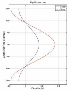
Most sedimentology courses teach that tides are generated by the gravitational attraction of the Moon and Sun acting together with the centrifugal force of the Earth-Moon couple as it rotates about its common centre of mass. The so-called “tidal bulges” generated by these forces are located on opposite sides of the Earth, on a line that passes through the centre of the Earth and the tide-generating body. Because the orbits of the Moon and Sun lie close to the equator, these bulges have their maximum height in equatorial latitudes, with their height decreasing toward the poles (Figure 1). This has led to the myth that tidal ranges, and hence tidal
TECHNICAL ARTICLE 10 RESERVOIR ISSUE 5 • SEPTEMBER/OCTOBER 2017
Figure 1: Elevation of the water surface on a water-covered Earth, predicted using equilibrium tidal theory, for the gravitational attraction of the Moon and Sun, as seen along a line of longitude that passes directly beneath the Moon or Sun (i.e., through the crest of the tidal bulge). Because the declinations of Moon and Sun are constantly changing, the 0o point in the figure does not correspond to a fixed latitude.
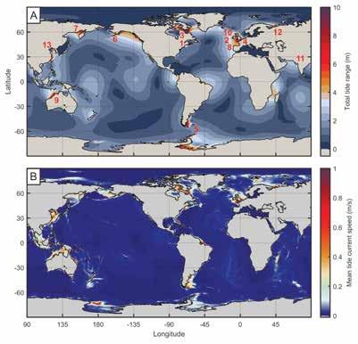
Figure 2: Global distributions of the amplitude of the total tide (A) and maximum tidal-current speeds (B) predicted by the TPX07.2 tidal model. Amplitudes are in metres and current speeds in metres/second. Areas with fast tidal currents (B) generally correlate with areas with large tidal amplitudes, but there are mismatches (e.g., north coast of Australia and Torres Strait, and the Ross Sea, Antarctica) because tidal current speeds are determined by the tidal prism, which is only partially determined by the tidal range (Dalrymple, 2010).
1 Bay
of
Fundy,
Canada 13.3
m
Passive
margin;
Shelf
Edge
(km)
currents, are negligible at high latitudes and can, therefore, be ignored in any modeling of sedimentary environments in these areas. In reality, however, tides do not behave in this simplistic way, because this “equilibrium tidal theory” on which the above picture is based is a poor representation of the real tides due to the failure to take into account the morphology of the ocean basins, bottom friction, and the presence of the Coriolis effect that influences the movement of the tidal wave. The much more complex “dynamic tidal theory” takes these factors into account, but can only be applied by means of complex numerical modeling.
Reality
The output from one such tidal model, TPXO7.2 (updated from Egbert and Erofeeva, 2002), provides an excellent match with measured tidal data; Figures 2 and 3 show the global distribution of tidal range generated by this model. Clearly, there is almost no correspondence with the latitudinal distribution that would be expected from the prediction of equilibrium tidal theory alone (Figure 1). In reality, the tidal energy associated with the predicted
Locations with tidal ranges >
with their spring-tide range, latitude, tectonic setting and distance of the location of the maximum tidal range from the shelf edge; for
locations, see Figure 2A. Tidal-range data from Archer and Hubbard (2003); the value for the Gulf of Cambay is shown with a question mark because the area with the largest tides might not have been instrumented. Values in parentheses for the Bay of Fundy and Ungava Bay are the predicted extreme ranges, based on simultaneous measurements at the two sites (Arbic et al., 2007).
equatorial tidal bulge flows poleward away from the crest of the equatorial bulge. As these tidal waves travel, they are steered by the continents and the Coriolis effect. Most importantly from the point of view of sedimentation in shallow-water coastal environments, the tidal wave is amplified, and the associated tidal-current speeds increase, as the tidal wave propagates onto the continental shelf from the deep ocean. The tidal wave is amplified even more in locations where it passes into landwardtapering embayments. As a result, the tidal range and tidal-current speeds in shallow water are strongly dependent on the local coastal morphology and bathymetry, which is the reason for the highly irregular variation of tidal range with latitude (Figure 3).
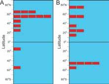
The influence of coastal morphology can be illustrated by examining the latitudinal distribution of areas with tidal ranges greater than 8 m today (Figures 2 and 4A; Table 1). These are clearly not clustered around the equator, but instead occur predominantly in the 50o-70o N belt. As discussed at greater length in Dalrymple and Padman (in press; see also Archer and Hubbard (2003); Archer (2013)), almost all of the areas with especially large tidal ranges occupy structurally controlled embayments, the main exceptions being the northwest coast of Australia and the Patagonia shelf. However, every one of the 13 cases occurs at the landward margin of a very wide continental shelf (generally > 500 km from the shelf edge to the coast; Table 1). As a result, the vast majority of the examples occur
RESERVOIR ISSUE 5 • SEPTEMBER/OCTOBER 2017 11
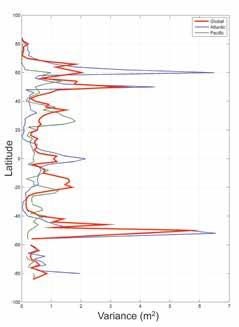
Figure 3: Latitudinal variation in the tidal range, averaged in 5o latitude bands for areas with water depths less than 100 m as obtained from the TPX07.2 tidal model. Note that the latitudinal distribution of values does not correspond with the pattern predicted by equilibrium tidal theory (Figure 1).
Table
1 Location Spring
Tidal
Range Latitude Tectonic
Setting Distance
from
(17.0
m) 51o N Passive
Triassic
550
Bristol
Channel,
England 13.3
m 51o N Passive
reactivated
structure 625
Ungava
12.2
m
(16.8
m) 59o N
Precambrian
continental block
suture;
Cenozoic rifting 550 4 Gulf
of
St.
Malo,
France 11.5
m 49o N Passive
margin;
reactivated
Paleozoic
structure 675 5 Patagonia,
Argentina 11.0
m 52o S Passive
margin;
Cenozoic
rifting
related
to
nearby
active
margins 950 6 Cook
Inlet,
Alaska 10.2
m 61o N Active
margin;
backarc
basin 550 7 Sea
of
Okhotsk,
Russia 9.2
m 62o N Active
margin;
backarc
basin 1775 8 English
Channel,
England 9.1
m 52o N Passive
margin;
reactivated
Paleozoic
structure 750 9 NW
Australia 9.0
m 16o S Passive
margin 500 10 Liverpool
Bay,
England 8.8
m 54o N Passive
margin;
reactivated
Paleozoic
structure 800 11 Gulf
of
Cambay,
India 8.8
m
(?) 21o N Passive
margin;
Mesozoic
rift 450 12 Gulf
of
Mezan,
Russia 8.6
m 65o N Passive
margin;
Paleozoic
thrust
front
1400 13 Gyeonggi
Bay,
Korea 8.3
m 37o N Passive
margin;
back arc
sag;
Mesozoic
structures 1025
1:
8 m,
(Continued on page 12...) TECHNICAL ARTICLE
margin;
exhumed
rift
2
margin;
Paleozoic
3
Bay,
Canada
Table
geographic
(Continued from page 11...)
(B)
Early Cretaceous (Aptian),
numerical model results of Wells et al. (2010). For graphical purposes, occurrences have been plotted at the center of the 10o latitude interval in which they fall.
on passive continental margins, with only Cook Inlet and the Sea of Okhotsk occurring on tectonically active margins. On a global scale, this is reflected by the fact that only 3 of the 13 areas occur around the Pacific Ocean which is characterized by narrow shelves, whereas 8 of the 13 occur around the Atlantic Ocean, which is bordered on both sides by wide passive continental margins (Figure 2; Table 1). The unusual concentration of occurrences at 50o-70o N in the Atlantic (6 of 13 cases; Figure 4A) is due to the geological accident of having especially wide and complex shelf areas on both sides of the ocean at this latitude (i.e., surrounding the British Isles, and in the Bay of Fundy and Ungava Bay), which have been flooded during the current eustatic highstand. Presumably this latitudinal peak would not have existed when the shoreline was at the shelf edge during that last glacial lowstand.
Thus, the distribution of especially large tides (and of tide-dominated sedimentation) is contingent on the tectonic and sea-level history of continental margins; even old structures, if reactivated, can exert a strong influence on tides (e.g., the Gulf of Mezan; Table 1). There is no control by latitude. To illustrate that the latitudinal distribution of large tides is not fixed but changes through geologic time, we have extracted the locations of the areas in the Early Cretaceous (Aptian) that have been predicted to have
tidally influenced. See Nyberg and Howell (2016) for more details of the methodology used. From Nyberg and Howell (2016). Reproduced with permission of Elsevier.
tidal ranges > 4 m (Wells et al., 2010, their Figure 8A). As shown in Figure 4B, it is clear that the latitudinal distribution of areas with large tides is dramatically different from that of today, with the largest peak occurring at 40o-50o S.
Polar tides
One of the reasons why the myth that tides are latitudinally dependant persists is the fact that tides in the Arctic Ocean and around Antarctica today are almost exclusively microtidal (i.e., < 2 m range; Figure 2). This raises the question: “Why are tides at polar latitudes small if there is no influence of latitude?” In both cases, it is the specific geomorphology of the ocean basin and continental margins that fail to amplify the small tidal wave that occurs in all open-ocean settings. In the case of Antarctica, the continental shelves around most of the continent are narrow and deep as a result of the isostatic depression caused by the icecap; consequently, no amplification of the tidal wave occurs along most of the Antarctic coast. However, the two major embayments along the Antarctic shoreline, the inner parts of the Ross and Weddell Seas, do experience significant tidal amplification. In particular, the southeastern Weddell Sea has a tidal range exceeding 7 m (Doake, 1992) under the Ronne Ice Shelf at a latitude of nearly 80o S. The Arctic has small tides for a very different reason. Like the Mediterranean, it is a semi-enclosed
basin with a limited connection to the open ocean. As the tide moves northward in the Atlantic, it decreases in amplitude abruptly as it cross the shallow Iceland-Faroe Ridge and is further attenuated as it passes across the extensive shallow shelves of the Russian Arctic (see movie in Dalrymple and Padman, 2016). The Arctic Ocean is also too small for a significant tide to be generated by direct astronomical forcing. As a result, the tidal energy in the Arctic is small, although it should be noted that tidal ranges up to 8.6 m do occur in Mezan Bay at a latitude of 65o N (site 12 on Figure 2; Table 1) because of the local coastal morphology that accentuates the tide.
Influence of Latitude on Tides
Although the primary control on tides at the coast is the local and basin-scale morphology, latitude does exert a secondary influence by way of latitude-dependant variations in the strength of the Coriolis effect, and climate through its control on the formation of ice.
The poleward increase in the Coriolis effect influences tidal dynamics in various ways (Dalrymple and Padman, in press), but the most important with respect to coastal sedimentation is the deflection of the tidal wave to the right of its direction of motion in the northern hemisphere and to the left in the southern hemisphere. As a result, there is an asymmetry in the tidal range on either
TECHNICAL ARTICLE 12 RESERVOIR ISSUE 5 • SEPTEMBER/OCTOBER 2017
Figure 4: (A) Latitudinal distribution of areas with present-day tidal ranges greater than 8 m. Each rectangle is one occurrence from Table 1.
Latitudinal distribution of areas with lunarsemidiurnal (M2) tidal ranges greater than 4 m during the
based on the
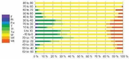
Figure 5: Variation by latitude of the 9 coastal types indicated at the left: F – fluvially dominated; Ft –fluvially dominated, tidally influenced; Fw – fluvially dominated, wave influenced; T – tidally dominated; Tf – tidally dominated, fluvially influenced;Tw – tidally dominated, wave influenced;W – wave dominated; Wf – wave dominated, fluvially influenced; and Wt – wave dominated,
side of an ocean basin, with larger ranges to the right of the tidal wave’s motion in the northern hemisphere and smaller ranges on the left side. Examples are provided by the Yellow Sea, where tidal ranges reach > 8 m on the Korean (right-hand) coast, but only ~4 m on the adjacent Chinese coast, and by the North Sea in which tidal ranges are higher on the England coast (to the right of the southward-propagating tidal wave) than along the Danish and Norwegian coasts. Such an asymmetry has also been modeled to have existed in the through-going Western Interior Seaway in the Late Cretaceous, with larger tides on the eastern side because the tidal wave propagated northward from the Gulf of Mexico (Erickson and Slingerland, 1990). A southward-propagating tidal wave in the Canadian portion of the Western Interior Seaway would, in general create larger tidal ranges on the western side of the basin. Such an asymmetry is non-existent at the equator and should increase toward the poles.
The effect of ice on the tides is complex. The lifting of floating ice requires no work because the weight of the ice is equal to the weight of the water it displaces. However, friction generated by water moving past floating sea ice (1-5 m thick) and by collisions between ice floes is thought to reduce the tidal range by 3-10% (Prinsenberg, 1988; Kowalik and Proshutinsky, 1994), with the affect being greatest in shallow water. Floating ice shelves (up to several hundred metres thick), by contrast, generally increase the tidal range and tidal current speeds because the tidal wave is compressed into a smaller cross-sectional area as they pass beneath the ice shelf (Fricker and Padman, 2002; Padman et al., 2002).
Concluding Remarks
It is clear from the foregoing that the primary control on tidal range is the local to basinscale bathymetric configuration, with wide continental shelves and embayments leading to the amplification of the open-ocean tide (range 1-2 m) to values that can reach > 16 m (Table 1). In the present-day continental configuration and sea-level highstand, the main tidal “hotspots” (i.e., areas with ranges > 8 m) are concentrated in the North Atlantic Ocean, in the latitude range of 50o-70o N, not near the equator as the overly simplistic equilibrium tidal theory would suggest. The latitudinal distribution of large tides also changes over geological time because
of plate-tectonic movement and sea-level change. Latitude does exert a secondary influence in that the poleward increase in the Coriolis deflection of the tidal wave causes a cross-basin asymmetry of tidal ranges. Ice can either decrease tidal ranges slightly (floating sea ice) or amplify the tides (floating ice shelves). Predicting the tidal range and the associated currents in a particular setting with any precision requires the use of an accurate paleo-geographic reconstruction and the application of a numerical tidal model (e.g., Wells et al., 2010), something that typically requires collaboration with an expert in tidal modeling.
In this report, we have focused on the factors that control tidal range because tidal range is the most obvious and well-known of tidal characteristics, but it is important to appreciate that tidal range by itself is not the only, nor necessarily the most significant factor controlling the nature of coastal deposits, even in areas with large tidal ranges. As noted by Dalrymple (2010), it is the tidal currents that are directly responsible for sediment deposition, and the speed of those currents is determined by the tidal prism, which is the volume of water moving past a point on each half tidal cycle. This volume is calculated by multiplying the tidal range by the area being flooded and drained on each tide; thus, the tidal range is only one of three physical dimensions controlling the strength of the tidal currents, so its influence is not as direct as one might like. Furthermore, Nyberg and Howell (2016) determined that, in the modern world, tide-dominated environments are most abundant in equatorial areas (i.e., from 40o N to 30o S), a distribution that is inconsistent with the distribution of large tides (Figures 3 and 4A). Therefore, at the general level, larger tidal ranges do not correspond with areas of tide-dominated sedimentation! We agree with the suggestion by Nyberg and Howell (2016) that this is due to the latitudinal distribution of wind strength and the intensity of the resulting waves: weak winds and small waves in equatorial areas allow tidal dominance even if the tidal range is not large, whereas strong winds and large waves at mid-latitudes counteract the generally larger tidal ranges that occur there. This suggests that, at a global scale, the distribution of wave energy exerts a fundamental control on the type of coastal environment, although areas with especially
large tidal ranges (typically > 4 m) do tend to be tide dominated at river mouths. Coastal areas between river mouths are generally wave-dominated, regardless of the tidal range (Dalrymple, 2010).
References
Arbic, B.K., St-Laurent, P., Sutherland, G., and Garrett, C., 2007, On the resonance and influence of the tides in Ungava Bay and Hudson Strait. Geophys. Res. Lett., v. 34, L17606, doi:10.1029/2007GL030845.
Archer, A.W., 2013, World’s highest tides: Hypertidal coastal systems in North America, South America and Europe. Sed. Geol., v. 284-285, p. 1-25.
Archer, A.W. and Hubbard, M.S., 2003, Highest tides of the world. In: Chan, M.A. and Archer, A.W. (Eds.), Extreme Depositional Environments: Mega End Members in Geologic Time: Geological Society of America Special Paper, 370, p. 151–173.
Dalrymple, R.W., 2010, Tidal depositional systems. In: N.P. James and R.W. Dalrymple (eds). Facies Models 4. St. John’s, Geol. Assoc. Canada, pp. 201-231.
Davis, R.A., Jr. and Dalrymple, eds., R.W., 2012, Principles of Tidal Sedimentology. New York, Springer, 607 p.
Dalrymple, R.W. and Padman, L., 2016, Are tides controlled by latitude? AAPG Search and Discovery, Article #51305, http:// www.searchanddiscovery.com/pdfz/ documents/2016/51305dalrymple/ndx_ dalrymple.pdf.html
Dalrymple, R.W. and Padman, L., in press, Are tides controlled by latitude? In: Latitudinal Controls on Stratigraphic Models and Sedimentary Concepts. C.M. Fraticelli, A.W. Martinius, P. Markwick, and J.R. Suter (eds.), SEPM (Society for Sedimentary Geology), Special Publication 108.
Doake, C.S.M., 1992. Gravimetric tidal measurements on Filchner Ronne Ice Shelf. Filchner-Ronne Ice Shelf Program, Rep. 6, pp. 34-39, Alfred Wegener Inst., Bremerhaven, Germany.
Egbert, G.D. and Erofeeva, S.Y., 2002, Efficient (Continued on page 14...)
RESERVOIR ISSUE 5 • SEPTEMBER/OCTOBER 2017 13
TECHNICAL ARTICLE
(Continued from page 13...)
inverse modeling of barotropic ocean tides. J. Atmos. Oceanic Tech., v. 19, p. 183–204.
Erickson, M.C. and Slingerland, R., 1990, Numerical simulations of tidal and winddriven circulation in the Cretaceous Interior Seaway of North America. Geol. Soc. Amer. Bull., v. 102, p. 1499-1516.
Fricker, H.A. and Padman, L., 2002, Tides on Filchner-Ronne Ice Shelf from ERS radar altimetry. Geophy. Res. Lett., 29, doi: 10.1029/2001GL014175.
Nyberg, B. and Howell, J.A., 2016, Global distribution of modern shallow marine shorelines. Implications for exploration and reservoir analogue studies. Mar. Petrol. Geol., v. 71, p. 83-104.
Padman, L., Fricker, H.A., Coleman, R., Howard, S. and Erofeeva, L., 2002, A new tide model for the Antarctic Ice Shelves and seas. Ann. Glaciol., v. 34, p. 247-254.
Prinsenberg, S.J., 1988, Damping and phase advance of the tide in western Hudson Bay
by the annual ice cover. Jour. Phys. Ocean., v. 18, p. 1744-1751.
Wells, M.R., Allison, P.A., Piggott, M.D., Hampson, G.J., Pain, C.C., and Gorman, G.J., 2010, Tidal modeling of an ancient tidedominated seaway, Part 1: Model validation and application to global Early Cretaceous (Aptian) tides. Jour. Sed. Res., v. 80, p. 393410.


TECHNICAL ARTICLE 14 RESERVOIR ISSUE 5 • SEPTEMBER/OCTOBER 2017
29th Annual CSPG/CSEG/CAPL 10km/5km Road Race and Fun Run Wednesday, September 20, 2017 Register NOW! To register please go to www.cspg.org Member Rate: $40+gst | Non-member rate: $50+gst | Student & In-Transition rate: $25+gst
POTENTIAL RESERVOIR CHARACTERIZATION OF THE FLUVIAL REACH TO INNER ESTUARY, OGEECHEE RIVER ESTUARY, GEORGIA, USA
ByAlina Shchepetkina, Murray K. Gingras, S. George Pemberton, Ichnology Research Group (IRG), Department of Earth and Atmospheric Sciences, University of Alberta, Edmonton, Alberta, Canada, T6G 2E3
1. INTRODUCTION
Recognition of facies differences across the fluvial reach into the fluvio-tidal transition zone and the inner estuary can significantly contribute to reliable subsurface facies interpretation and modeling. The fluviotidal transition (FTZ) in estuaries is a sedimentologically complex zone, where fluvial and tidal currents interact, inducing abrupt to gradational changes in sedimentary facies distributions. Researchers define the FTZ as bounded on the landward end by the effective tidal limit, where tidal currents still influence sedimentation, and the seaward limit is considered to occur at the bedload convergence zone (Dalrymple and Choi, 2007). From the sedimentological perspective, the FTZ is defined as part of the river located between the landward limit of appreciable effects of tidal-induced flow deceleration on fluvial cross-bedding at low flow in the river and the most seaward expression of the fluvial signature related to the high flow in the river (van den Berg et al., 2007).
Due to the presence of large volumes of oil in deposits that are at least in part comprised of ancient FTZ, such as, for example, the McMurray Formation (Jablonski and Dalrymple, 2016; Martinius et al., 2015; Shchepetkina et al., 2016b), the Clearwater Formation (McCrimmon and Arnott, 2002), and the Horseshoe Canyon Formation (Ainsworth et al., 2015), the associated reservoir characteristics of the FTZ are of interest to geoscientists.
The Ogeechee River estuary is an example of a sand-dominated, micro- to mesotidal, mixed-energy estuary with a well-developed FTZ. Numerous fluvial to tidally influenced bars are available for scrutinizing and collecting sedimentological, ichnological and spatial information. This paper is devoted to facies recognition criteria
within the upper reaches of the tideinfluenced system and determination of its reservoir characteristics, such as reservoir heterogeneity, distribution and dimensions.
2. STUDY AREA AND METHODS
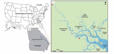
The Ogeechee River estuary is located in Georgia, USA and flows southeast from the Piedmont area across the low-lying coastal plain into the Atlantic Ocean (Fig. 1). The river is 400 km long (Benke and Meyer, 1988) and 90% of its drainage comes from the coastal plain area (Dorjes and Howard, 1975; Gadow, 1972; Windom et al., 1971). The Ogeechee River meanders freely across the coastal plain and erodes sandy paleochannel and eolian paleodune deposits (Leigh and Feeney, 1995; Swezey et al., 2013). The valley floor contains sand with isolated silt and clay deposits (Leigh and Feeney, 1995). The Ogeechee sandsized material consists of quartz with lesser amounts of feldspars (Windom et al., 1971),
and is mainly sourced from the incised Pleistocene and Quaternary deposits (Howard and Frey, 1975a; Swezey et al., 2013). Fine-grained material is composed of montmorillonite and kaolinite, and is supplied from the Piedmont area (Windom et al., 1971).
The tides in the Ogeechee River estuary are semi-diurnal with a mean tidal range of 2.4 m, however during spring or storm tides the tidal range can increase up to 3.4 m (Howard and Frey, 1975b). The estuary is mixed-energy with a significant tidal prism and waves affecting the estuary mouth (Greer, 1975). The Ogeechee river and the estuary upper reaches are surrounded by pine and deciduous/ cypress forest, whereas the lower reaches and the coastline are bordered by extensive salt marshes (Dorjes and Howard, 1975; Howard and Frey, 1975a). The waters in the estuary are turbid due to the abundance of organic detritus sourced
to the Atlantic coast, channel bars (in brown), and expanses of salt marshes and forests (in green). The Ogeechee River estuary exhibits the meandering pattern and debouches into the Ossabaw Sound. The study location is bounded by red arrows. (Continued on page 16...)
RESERVOIR ISSUE 5 • SEPTEMBER/OCTOBER 2017 15
TECHNICAL ARTICLE
Fig. 1. (a) Map of the continental United States with the location of the state of Georgia (in grey). (b) Position of the Ogeechee River estuary within the state of Georgia. The study site is marked by a red rectangular. (c) Re-drafted satellite image with a network of estuaries (in blue) oriented perpendicular
(Continued from page 15...)
from the marshes and forested areas (Odum and De la Cruz, 1967).
The river’s mean annual discharge is 66.8 m3/s, and ranges from 3.7 to 850 m3/s depending on the season (Benke and Meyer, 1988; Meyer, 1992). The highest river discharge occurs from February to April, and more rarely in July (Benke and Meyer, 1988; Edwards and Meyer, 1987; Meyer et al., 1997).
This study is focused on the inner estuary, the FTZ and into the fluvial reach (Fig. 1c). Fluvial to tidally affected bars were accessed by boat during the spring low tide in June 2014. Grab samples from the bar tops and the channel thalweg were obtained for grain-size analysis. Measurements of the maximum channel depth within the channel
thalweg were taken from the Tybee Island to Doboy Sound depth chart 11509 (scale 1: 80 000). The channel width was measured using Google Earth and field observations. Reservoir geometry is suggested based on visual observations of the bedforms on the channel bars and channel floor, observations of physical sedimentary structures from suction cores, box cores, and in shallow trenches. The morphological data for the study was not complimented by seismic or ground-penetrating radar. For more detailed information on the Ogeechee River estuary characteristics and research methods the readers are referred to Shchepetkina et al. (2016a).
3. RESERVOIR CHARACTERIZATION
Based on previous work by Shchepetkina et al. (2016a), the upper reaches of the
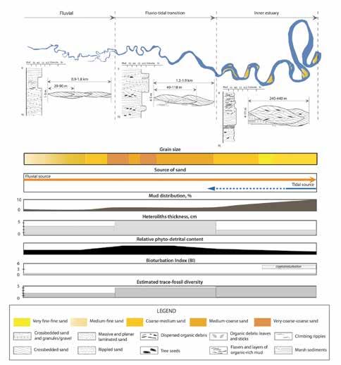
Ogeehee River estuary were subdivided into three areas: the fluvial reach, the FTZ, and the inner estuary. The current study follows this subdivision and builds upon the model (Fig. 2).
3.1 Fluvial reach
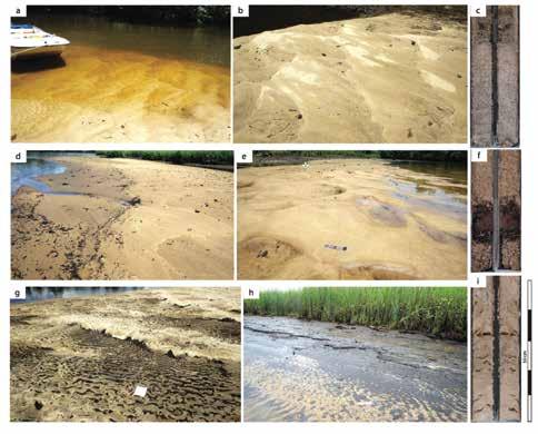
The fluvial reach of the Ogeechee River estuary (Fig. 2) is located >63 km inland from the estuary entrance. The river is narrow (~29-90 m) and up to 3 m deep, with the meander belt reaching 1.8 km in width. Therein, the fluvial point bars occupy the majority of the channel width, and are characterized by the predominance of coarse-medium sand. However, further upriver (>73 km from the estuary entrance) grain size diminishes and medium-fine sand may become predominant. The sediment is purely fluvially sourced. The point bar and channel floor are covered by sinuous dunes with superimposed linguoidal current ripples and organic detritus collected at the dune troughs (Fig. 3a-b).
The point bars display unidirectional planar and trough cross-bedding with rare layers/ lenses of organic-rich mud (0.5-3 cm thick) and rip-up clasts (Fig. 3c). Up-river, predominance of finer-grained sand dictates presence of unidirectional cross-bedding and current-ripple cross-stratification. The fluvial reach of the Ogeechee River estuary is virtually barren of bioturbation (BI 0-1), except for the tracks and trails of birds (Fig. 3b) and snails, forming Mermia-like traces on the point-bar top. Surrounding forested area may contain crayfish domes and chimneys, forming Camborygma-like traces.
3.1.1 Fluvial reach reservoir characteristics
The reservoir characteristics represented by the fluvial sediments at the head of a sanddominated, mixed-energy estuary would be characterized by interconnected thin sandstone bodies (30-90 m wide and up to 3 m thick) made of clean sand with high initial porosity, and rare thin mudstone layers (0.5-3 cm thick) and rip-up clasts. If these sandstone bodies are stacked and not significantly constrained from migration by the overbank deposits, they can be found within the channel belt up to 0.91.8 km wide. Thin and sporadic mudstone (~0-2 %) and organic-rich beds will result in low heterogeneity of the reservoir, and would likely contribute to comparably
TECHNICAL ARTICLE 16 RESERVOIR ISSUE 5 • SEPTEMBER/OCTOBER 2017
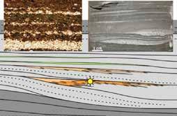
Fig. 2. Schematic representation of vertical sequences, reservoir heterogeneity and dimensions, as well as summary of sedimentological and ichnological trends across the fluvial reach, the fluvio-tidal transition zone and into the inner part of the Ogeechee River estuary, Georgia, USA.
isotropic permeability distributions. Consequently, high primary porosities and permeabilities within homogeneous and isotropic reservoirs suggest that fluvially dominated bars (of the Ogeechee scale) present attractive reservoir targets. That said, reservoir distribution may be complex, difficult to predict and, in general, analogous reservoir targets would be thin..
3.2 Fluvio-tidal transition zone (FTZ)
The fluvio-tidal transition zone (Fig. 2) is situated ~48-63 km inland from the estuary entrance. The channel itself ranges from 49118 m in width with a maximum channel depth of around 4-5 m. The fluvio-tidal channel has a meander belt from 1.2-1.9 km in width. Bank-attached fluvio-tidal bars reside in sinuous channels and consist predominantly of very coarse- to coarse-grained sand with some granules and pebbles. The sediments are both fluvially derived and locally sourced from the eroding channel margins. The point bars contain ebb-oriented dunes covered by current ripples and abundant plant debris (Fig. 3d-e) scattered throughout the bar surface. The channel floor is represented by large-scale dunes 30-40 cm in height and superimposed on those are smaller sinuous dunes 5-7 cm in height. The dune troughs are commonly marked by linguoidal current ripples (Fig. 3e). Mud content within the FTZ is low (0-3%), however it increases towards the channel margins and up laterally accreting bars. Clay-sized material is locally sourced from the adjacent cut-banks, forested areas and marshes. Infrequent mud layers up to 5 cm thick can be observed within the channelbar margins.
Sedimentary structures include ebbdominated large-scale trough- and planar cross-stratification with rare bidirectional bedforms, poorly defined ripple crosslamination, planar horizontal lamination, and abundant layers and lenses of phyto-detrital material (Fig. 3f). Bioturbation intensity within the FTZ is low (BI 0-1) with Siphonichnus- and Lockeia-like traces produced by freshwater mussels and surface tracks and trails formed by dragonfly larvae and leeches. Surrounding peaty substrates may contain Psilonichnus constructed by fiddler crabs.
3.2.1 Fluvio-tidal transition zone (FTZ) reservoir characteristics
The reservoir analogues of the Ogeechee FTZ
planar
and
to coarse-grained
muddy and organic-rich intervals. (d-f) Bedform distribution and sedimentary structures of the FTZ: d) reworked dunes and coarse phytodetrital material on the tidally influenced bar; e) sinuous dunes and organic material within the dune troughs; f) slabbed core from the FTZ: coarse, very-coarse sand and granules with unidirectional bedding and plentiful organic debris. (g-i) Bedform distribution and sedimentary structures of the inner estuary: g) ebbdominated sinuous dunes with superimposed linguoidal current ripples, mud rip-up clasts and organics within the ripple troughs; h) increase in organic and mud content towards the channel margin; i) slabbed core from the inner estuary: fine to very fine sand with bi-directional trough cross-bedding, abundant mud rip-up clasts and flasers.
would comprise stacked, interconnected laterally accreted bar sandstone units 4-5 m thick and ~50-120 m wide: i.e. twice as thick and as large as the reservoirs presented by the fluvial channels. Sand bed permeabilities would be potentially high, owing to the abundance of clean verycoarse- and coarse-grained cross-bedded sandstone where granules, pebbles and coarse phyto-detrital material could mark the dune toesets. Stacked sandstone bodies would be spread within the meander belt of ~1.2-1.9 km. Relatively thin and scattered mudstone beds (up to 5 cm) and organicrich layers (up to 10 cm thick) may locally compromise vertical permeability, but overall the reservoirs would be homogenous and isotropic enough to present overall excellent reservoir characteristics.
3.3 Inner estuary
Inner estuary (Fig. 2) is located ~22-48 km inland from the estuary mouth and was previously subdivided into the lower and upper parts (Shchepetkina et al., 2016a). However, for the purposes of this paper, it is described as a single sedimentary environment. The channel width within the inner estuary is 240-440 m wide, a channel depth ranges from 4 to 15 m. In this zone, increasingly tidally influenced bars are present on the inside of the meanders and also in the mid-channel position. The channel-bars consist of sinuous and straight-crested dunes up to 15 cm in height overprinted by ebb-oriented linguoidal/ rhomboidal current ripples (Fig. 3g). Silty clay, organic debris, and mud rip-up clasts can be found within the ripple and dune
RESERVOIR ISSUE 5 • SEPTEMBER/OCTOBER 2017 17
(Continued on page 18...) TECHNICAL ARTICLE
Fig. 3. (a-c) Bedform distribution and sedimentary structures of the fluvial reach: a) sinuous dunes, linguoidal current ripples and organic debris marking the channel floor; b) reworked sinuous dunes with the bird tracks on the fluvial point bar; (c) slabbed core from the fluvial reach: medium-
sand with
horizontal
trough cross-bedding,
(Continued from page 17...)
troughs (Fig. 3g-h). The estuary bars primarily are composed of coarse-medium sand in the upper inner estuary and medium-fine sand in the lower inner estuary. The grain size also decreases towards the channel-bar margins, wherein the mud content increases (Fig. 3h). The amount of mud within the inner estuary constitutes ~10%, with mud-bed thickness ranging between 0.5 and 2 cm. The sand is dominantly sourced from the fluvial reach. Mud is derived from upstream sources, adjacent salt-marshes, cutbanks and adjacent coastal-plain estuaries that are influenced by both fluvial and tidal transport and are dominantly deposited during slack tide.
The sediments from the inner estuary point- and mid-channel bars are apparently structureless (due to bioturbation or air bubbles), show abundant flaser and wavy bedding, bi-directional and unidirectional trough cross-stratification, current-ripple lamination, and horizontal planar bedding (Fig. 3i). The bedding contacts are often marked by concentrated organic debris and mud rip-up clasts. The inner estuary is practically barren of bioturbation (BI 0-1), however cryptobioturbation by amphipods may be observed (BI 3-5). Mermia- and Gordia-like traces produced by amphipods/ insects can be found on the point-bar tops. At the channel margins, semi-consolidated marsh deposits contain Psilonichnus associated with burrowing crab activities.
3.3.1 Inner estuary reservoir characteristics
Reservoirs associated with analogous inner estuarine sediments would contain reservoir bodies that are thicker and larger than the landward deposits—in the Ogeechee example, the deposits would be 240-440 m wide and up to 15 m thick, somewhat laterally constrained and incased in dense marsh sediments. If present, sand body stacking would increase the total thickness of the reservoir. Preservation of interfingering intertidal marsh sediments and heightened mud content (~10%) of the main reservoir body might cause some reservoir compartmentalization. Since impermeable baffles may be encountered more commonly within the inner estuary compared to the upstream locales, horizontal permeability would dominate the vertical permeability. In summary, the inner estuary bars stand to have more volume but can be expected to have higher heterogeneity. And
if not subjected to diagenic cementation, the sediments of the inner estuary would form a fine reservoir.
4. CONCLUSIONS
The Ogeechee River estuary provides a good analogue to consider reservoir distributions and quality in a sand-dominated, mixedenergy, micro- to mesotidal system. In short, transition from the fluvial reach to the inner estuary will be characterized by a range of bar sizes and thicknesses.
The fluvial reservoir should comprise amalgamated and thin sandstone units (~29-90 m wide by 3 m thick) consisting of clean coarse-medium and mediumfine sandstone. The units will display unidirectional planar and trough crossbedding, current-ripple cross-stratification, rare mudstone/ organic-rich layers and ripup clasts. The rather unconstrained nature of the fluvial channel means that stacked fluvial deposits could be found within the channel belt 0.9-1.8 km wide.
The fluvio-tidal reservoir would show an increase in bar thickness and width (49-118 m wide by 4-5 m thick) and be made of clean very-coarse and coarse-grained sandstone with granules and pebbles. The preserved sedimentary structures may include ebbdominated and rarely bi-directional largescale trough- and planar cross-stratification, ripple cross-stratification, planar horizontal lamination, and abundant layers/ lenses of phyto-detrital material.
The inner estuary reservoirs are predictably thicker and larger (240-440 m wide by 10-15 m thick), and might be encased in dense marsh-formed mudstone. The tidally influenced bars will be structureless, contain flaser and wavy bedding, bidirectional and unidirectional trough cross-bedding, current-ripple crossstratification, horizontal planar bedding, concentrated organic debris and mud ripups. Importantly, in the transition to tidally influenced sedimentation, the presence of mud beds will contribute to increasingly heterolithic reservoir and overall lower vertical permeabilities.
ACKNOWLEDGEMENTS
The authors thank Grayson Bilak for field assistance, and local hosts Michael Richter and Harry Carter from the Skidaway Institute
of Oceanography for help with housing, logistics and boats. Mark Labbe and Martin Von Dollen are sincerely thanked for technical and logistical aid at the University of Alberta, Canada. NSERC Discovery Grants to M. Gingras and S.G. Pemberton funded this project.
REFERENCES
Ainsworth, R.B., Vakarelov, B.K., Lee, C., MacEachern, J.A., Montgomery, A.E., Ricci, L.P., and Dashtgard, S.E. 2015. Architecture and evolution of a regressive, tide-influenced marginal marine succession, Drumheller, Alberta, Canada. Journal of Sedimentary Research, v. 85, p. 596–625.
Benke, A.C. and Meyer, J.L. 1988. Structure and function of a blackwater river in the southeastern U.S.A. Verhandlungen der Interationalen Vereinigung fur theoretische und angewandte Limnologie, v. 23, p. 1209–1218.
Dalrymple, R.W. and Choi, K.S. 2007. Morphologic and facies trends through the fluvial-marine transition in tide-dominated depositional systems: A schematic framework for environmental and sequencestratigraphic interpretation. Earth-Science Reviews, v. 81, p. 135–174.
Dorjes, J. and Howard, J.D. 1975. Fluvialmarine transition indicators in an estuarine environment, Ogeechee River-Ossabaw Sound. In: Senckenbergiana Maritima. Estuaries of the Georgia Coast, U.S.A.: Sedimentology and Biology. G. Hertweck and S. Little-Gadow (eds). Senckenbergische Naturforschende Gesellschaft, v. 7, p. 137–179.
Edwards, R.T. and Meyer, J.L. 1987. Metabolism of a sub-tropical low gradient black water river. Freshwater Biology, v. 17, p. 251–263.
Gadow, S. 1972. Provenance and distribution of heavy minerals. In: Senckenbergiana Maritima. Georgia Coastal Region, Sapelo Island, U.S.A.: Sedimentology and Biology. G. Hertweck (ed). Senckenbergische Naturforschende Gesellschaft, v. 4, p. 15–45.
Greer, S.A. 1975. Sandstone geometry and sedimentary facies at the estuary-marine transition zone, Ossabaw Sound, Georgia: a stratigraphic model. In: Senckenbergiana Maritima. Estuaries of the Georgia Coast,
TECHNICAL ARTICLE 18 RESERVOIR ISSUE 5 • SEPTEMBER/OCTOBER 2017
U.S.A.: Sedimentology and Biology. G. Hertweck and S. Little-Gadow (eds). Senckenbergische Naturforschende Gesellschaft, v. 7, p. 105–135.
Howard, J.D. and Frey, R.W. 1975a. Regional animal-sediment characteristics of Georgia estuaries. In: Senckenbergiana Maritima. Estuaries of the Georgia Coast, U.S.A.: Sedimentology and Biology. G. Hertweck and S. Little-Gadow (eds). Senckenbergische Naturforschende Gesellschaft, v. 7, p. 33–103.
Howard, J.D. and Frey, R.W. 1975b. Introduction. In: Senckenbergiana Maritima. Estuaries of the Georgia Coast, U.S.A.: Sedimentology and Biology. G. Hertweck and S. Little-Gadow (eds). Senckenbergische Naturforschende Gesellschaft, v. 7, p. 1–31.
Jablonski, B.V.J. and Dalrymple, R.W. 2016. Recognition of strong seasonality and climatic cyclicity in an ancient, fluvially dominated, tidally influenced point bar: Middle McMurray Formation, Lower Steepbank River, north-eastern Alberta, Canada. Sedimentology, v. 63, p. 552–585.
Leigh, D.S. and Feeney, T.P. 1995. Paleochannels indicating wet climate and lack of response to lower sea level, southeast Georgia. Geology, v. 23, p. 687–690.
Martinius, A.W., Jablonski, B.V.J., Fustic, M., Strobl, R., and Van den Berg, J.H. 2015. Fluvial to tidal transition zone facies in the McMurray Formation (Christina River, Alberta, Canada), with emphasis on the reflection of flow intensity in bottomset architecture. In: Fluvial-Tidal Sedimentology. P.J. Ashworth, J.L. Best, and D.R. Parsons (eds). Developments in Sedimentology, p. 445–480.
McCrimmon, G.G. and Arnott, R.W.C. 2002. The Clearwater Formation, Cold Lake, Alberta: a worldclass hydrocarbon reservoir hosted in a complex succession of tide-dominated deltaic deposits. Bulletin of Canadian Petroleum Geology, v. 50, p. 370–392.
Meyer, J.L. 1992. Seasonal patterns of water quality in blackwater rivers of the Coastal Plain, south- eastern United States. In: Water Quality in North American River Systems. C.D. Becker and D.A. Neitzel (eds). Battelle
Press, p. 249–276.
Meyer, J.L., Benke, A.C., Edwards, R.T., and Wallace, J.B. 1997. Organic matter dynamics in the Ogeechee River, a blackwater river in Georgia, USA. Journal of North American Benthological Society, v. 16, p. 82–86.
Odum, E.P. and de la Cruz, A.A. 1967. Particulate organic detritus in a Georgia salt marsh-estuarine ecosystem. In: Estuaries. G.H. Lauff (ed). American Association for the Advancement of Science, p. 383–388.
Shchepetkina, A., Gingras, M.K., and Pemberton, S.G. 2016a. Sedimentology and ichnology of the fluvial reach to inner estuary of the Ogeechee River estuary, Georgia, USA. Sedimentary Geology, v. 342, p. 202–217.
Shchepetkina, A., Gingras, M.K., Pemberton, S.G., and MacEachern, J.A. 2016b. What does the ichnological content of the Middle McMurray Formation tell us? Bulletin of Canadian Petroleum Geology, v. 64, p. 24–46.
Swezey, C.S., Schultz, A.P., González, W.A., Bernhardt, C.E., Doar, W.R., Garrity, C.P., Mahan, S.A., and McGeehin, J.P. 2013. Quaternary eolian dunes in the Savannah River valley, Jasper County, South Carolina, USA. Quaternary Research (United States), v. 80, p. 250–264.
van den Berg, J.H., Boersma, J.R., and van Gelder, A. 2007. Diagnostic sedimentary structures of the fluvial-tidal transition zone - Evidence from deposits of the Rhine and Meuse. Geologie en Mijnbouw/Netherlands Journal of Geosciences, v. 86, p. 287–306.
Windom, H.L., Neal, W.J., and Beck, K.C. 1971. Mineralogy of sediments in three Georgia estuaries. Journal of Sedimentary Petrology, v. 41, p. 497–504.
RESERVOIR ISSUE 5 • SEPTEMBER/OCTOBER 2017 19
TECHNICAL ARTICLE
DISCUSSION: SHALLOW THINKING IN DEEP TIME
By Janok P. Bhattacharya1 and James A. MacEachern2
1. School of Geography and Earth Sciences (SGES), McMaster University, 1280 Main Street West, Hamilton, ON, L8S 4L8, bhattaj@mcmaster.ca
2. ARISE, Dept. Earth Sciences, Simon Fraser University, Burnaby, BC, V5A 1S6,
Introduction:
We read with some confusion the recent CSPG Reservoir article by Meloche (2017) purporting to question previous paleo-environmental and stratigraphic interpretations of the Turonian-age Cardium Formation in Western Canada. The article begins by implying that the paradigms used for interpreting clastic sedimentology and stratigraphy worldwide have been conducted by a "handful of highly persuasive Canadian geologists in western Canada", a notion which we hope to demonstrate is, at the very least, highly subjective. There is a universally accepted protocol for acceptance of scientific discovery. It is called the scientific method. New ideas are nurtured, tested and then accepted or rejected by peers within the scientific community through peerreviewed publications. Meloche (2017) certainly presents some unusual ideas, but herein we take issue with the implications and difficulties that these ideas pose.
A main conclusion of the article is that the Cardium Formation is a deep-water transgressive deposit, probably formed in 100-200 m water depth, as a consequence of the reworking of previously existing sediment by oceanic internal waves forming a deep-water "internal beach" that migrated landward to produce coarsening-upward facies successions. Despite a plethora of well-studied linked shoreline/shelf to slope clinoforms and their deepwater systems (e.g., Collinson et al., 1991; Helland-Hansen, 1992; PlinkBjorklund et al., 2001, Catuneanu et al., 2002; Diebert et al., 2003; Martinsen et al., 2003; Petter and Steel., 2006; Soniabre et al., 2011; Carvajal and Steel, 2012), no examples of upward-coarsening facies successions with similar sedimentary structures or ichnofacies to the Cardium Formation have ever been described in the deeper parts of these clinoforms.
Meloche (2017) claims that hummocky cross stratification is not formed by storm
waves in relatively shallow water (i.e. < 40 m), but rather reflects formation in depths closer to 100-200 m as a consequence of wavy undulations of the pycnocline boundary separating deep oceanic from shelf marine waters. He then claims that there is no experimental documentation of the formation of hummocks and that hummocky bedforms have never been documented in any modern setting. He also suggests that the Cretaceous Seaway extended and deepened all the way across eastern North America and was directly linked to the North Atlantic Ocean.
We will not detail, point-by-point, all of the concerns with the basic science in this article, but we will provide a critique of the aspects that we consider to be egregiously incorrect.
Definition and stratigraphic context of HCS
Harms, Southard, Spearing and Walker originally defined hummocky cross stratification in 1975. We note that three of the four authors of this landmark SEPM publication are American. John Harms and Dar Spearing were highly respected “industrial scientists” in the petroleum industry, and John Southard was at MIT, but perhaps they were not as "highly persuasive" as the English-Canadian lastauthor Roger Walker? The main example initially used to illustrate HCS was from the Turonian Gallup Sandstone in the San Juan Basin of New Mexico. Harms et al. (1975) also noted that HCS was present in the Maastrichtian Fox Hills Sandstone in Wyoming, the Campanian Book Cliffs successions in Utah (including the Star Point and Blackhawk formations), and the Mesa Verde Formation in Colorado. We note that no Canadian examples were initially described in this landmark publication.
Although the specifics of the occurrence of these examples were not initially presented in great detail, all of these examples include
multiple outcrops of medium-bedded, veryfine grained hummocky cross-stratified sandstone beds, interstratified with thinner bedded muddy heterolithic units. There is a uniform observation that the HCS facies occur within conformable, 10-30 m thick upward-coarsening facies successions, which pass from laminated silty to sandy heterolithic mudstones and HCS sandstones at the base into cliff-forming sandstones above. The upper parts of the facies successions comprise dune-scale cross-bedded upper shoreface sandstones capped by low-angle to flat stratified sandy foreshore deposits, commonly penetrated by roots with overlying coals, carbonaceous shales and other paralic facies indicative of a coastal plain setting. The common occurrence of infaunal burrows (e.g., Conichnus, Diplocraterion, and Skolithos) recording filter feeding behaviours wholly support the persistence of currents and waves operating in nearshore positions (e.g., MacEachern and Bann, 2008; Pemberton et al., 2012).
In other examples, the shoreface or delta front successions are capped by distributary channels or incised valleys. Accounting for compaction of the sandstone, and assuming a normal succession conforming with Walther's Law, the cliff-forming sandstones are interpreted as prograding shoreface-to-beach or distal-to-proximal delta front deposits. The heterolithic facies containing the HCS beds typically lie directly below the shoreface deposits and are consequently interpreted to have been deposited just below fair-weather wave base, in water depths of between 10-35 m.
These observations have been replicated in countless examples globally. More recent examination of the heterolithic mudstone-dominated facies below the medium bedded HCS facies illustrate progressive thinning into thin to very thin bedded and laminated wave- to combinedflow rippled sandstones, siltstones, and claystones, rather than larger-scale HCS.
TECHNICAL ARTICLE 20 RESERVOIR ISSUE 5 • SEPTEMBER/OCTOBER 2017
These thin-bedded facies may also contain graded and inverse graded turbidites and hyperpycnites (e.g., Hamblin and Walker, 1979; Bhattacharya and MacEachern, 2009; Li et al., 2015).
Examples of HCS beds associated with deltaic environments are likewise ubiquitous globally, and include the Dunvegan Formation in Western Canada (Bhattacharya, 1994; Plint, 2000), the Bow Island Formation (Raychaudhuri and Pemberton, 1992), and Belly River Formation (Hansen and MacEachern, 2007) of the Alberta Basin, the Fox Hills sandstone in Wyoming (Olariu et al., 2012), and the Permian Snapper Point, Pebbley Beach, and Wasp Head formations in the South Sydney Basin of Australia (Bann et al., 2008; MacEachern and Bann, 2008). Regional mapping of the Dunvegan, and Fox Hills show well-developed clinoforms (Asquith, 1970; Bhattacharya, 1994, Plint, 2000; Carvajal and Steel, 2012). Clinoform heights in the Dunvegan show a depositional relief of about 100-150 m, from topset fluvial deposits to bottomset condensed sections, suggesting water depths on this order. Observed HCS beds do not occur in clinoform bottomsets, but appear to be confined to the upper 40 meters of the interval. Clinoforms in the Fox Hills - Lewis Shale system show about 250 m of relief (Asquith, 1970; Winn et al., 1987; Olariu et al., 2012). Deep-water turbidites and hyperpycnites are described from the bottomsets (e.g., Winn et al., 1987; Pyles and Slatt, 2000; Soyinka and Slatt, 2008) but HCS is primarily found in the topset successions (Olariu et al., 2012), again at a stratigraphic position of about 20-30 m below the paleo-shoreline. Outcrops of the Kakwa Member of Cardium Formation also show HCS lying about 20 m below rooted horizons, marking the top of the foreshore, with associated lagoonal coastal plain mudstones and other non-marine facies (Plint et al., 1987).
In lower energy settings, wave-formed HCS has been observed at depths as shallow as 5 m or less. For example, the Cadotte Member contains the distinctive toe-of-the-beach assemblage of Macaronichnus segregatis, which resides within 2 metres of overlying rooted sandstones of the foreshore. HCS and SCS beds occur no more than 5 metres below the Macaronichnus segregatis
horizon (e.g., Saunders et al., 1994). Observations of modern ichnocoenoses of Macaronichnus segregatis tracemakers likewise places the association firmly within the low intertidal zone (Clifton and Thompson, 1978; Saunders et al., 1994; Pemberton et al., 2008), constraining HCS and SCS to shallow-water depths within 10s of metres of that position, not 100's of metres as suggested by Meloche (2017).
To summarize, there is overwhelming observational evidence that HCS is deposited, preserved, and observed at depths of only a few metres to up to 35 m below the marine to non-marine transition in shallowing-upwards facies successions. This is entirely consistent with the wellestablished interpretation of deposition in shallow shelf depths, immediately below fair-weather wave base. In contrast, there is almost no evidence of formation or preservation of HCS in deeper water, as Meloche (2017) contends.
There is also a rich literature that documents and explains the preservation of these shallowing-upward facies successions as a consequence of shoreline trajectory and accommodation succession (e.g., HellandHansen and Martinsen, 1994, HellandHansen, and Gjelberg, 1994; Hampson, 2000; Hampson et al., 2001; Bhattacharya and Willis, 2003; Neal and Abreu, 2009, Bhattacharya, 2011). These studies show that topset preservation is decreased during falling stages of sea level, characterized by a degrading accommodation successions, and significant top-truncation may occur by wave-erosion during subsequent transgression. What is important is that the preserved lower parts of top-truncated facies successions are essentially identical in sedimentary structures, bioturbation, and bedding style to the top-preserved successions. It is, of course, the topsetpreserved successions that allow more accurate estimates of the depth of HCS beds to be documented. In top-truncated systems, the depth of HCS can be inferred by comparison to fully preserved successions.
HCS bedforms
There is a significant body of literature that documents hummocky bedforms in modern depositional environments (e.g., Li and Amos, 1999; Hanes et al., 2001; Kleinhans et al., 2004; Vermass, 2010).
Many of these studies identify Large Wave Ripples (LWR), which become increasingly 3 dimensional as orbital velocities increase and grain sizes decrease. These LWR bedforms are understood to be essentially synonymous with hummocks. Of course, hummocky cross-stratification can be produced by other processes (e.g., Cheel and Leckie, 1993), but stratigraphic context also plays a role in its interpretation in ancient successions, as explained above. Greenwood and Sherman (1986) for example, documented HCS in the shoreface of modern Lake Ontario.
There is also a significant body of experimental flume work that has made 3-dimensional hummocky bedforms (e.g., Southard et al., 1990; Arnott and Southard, 1990; Dumas et al., 2005; Dumas and Arnott, 2006; Tomohiro, 2007). It is clear that as orbital velocities increase (and wavelengths and periods increase), small 2D wave ripples evolve into 3D small wave ripples (SWR) and eventually into LWR and hummocks. At extreme velocities, these bedforms become washed out and the plane bedding is stable.
The statement by Meloche (2017) that HCS "...has never been observed in the process of formation on modern shelves, has never been recognized unequivocally from any recent marine sediment, and has never been formed experimentally" is difficult to reconcile with the substantial body of literature that states otherwise, as discussed above. Perhaps the only aspect of this statement that is literally true is that hummocks have not been observed in the “process of formation” on a modern shelf. We suspect that the main reason for this is the simple fact that oceanographers' value their lives and have not found a way to safely observe shallow seafloor processes in the middle of a hurricane or typhoon!
The Disappearing Appalachians?
In order for the proposed oceanic current mechanism to work, Meloche (2017) hypothesizes that the Cretaceous Interior Seaway progressively deepened from west to east, and was directly connected to the North Atlantic Ocean, thus implying that the Appalachian Mountains somehow ceased to exist. This would require wholesale revisions to every paleogeographic map ever published of the Cretaceous Seaway,
RESERVOIR ISSUE 5 • SEPTEMBER/OCTOBER 2017 21
TECHNICAL ARTICLE
including reconstructions by Williams and Stelck (1975), Kauffman (1977), Cobban et al. (1994), Bhattacharya et al. (2016), and of course the web-based reconstructions of R. Blakey (http://deeptimemaps.com) and Chris Scotese (Paleomap; http:// www.scotese.com). Unfortunately, Meloche (2017) did not provide a revised paleogeographic map, underpinned by paleontological, stratigraphic/ biostratigraphic and sedimentologic data by which all such reconstructions are based, in order to illustrate his hypothesis, nor does he provide a geodynamic mechanism to explain how the Appalachians could disappear during the Turonian and then reappear as we see them today.
Fortunately, there is a significant body of literature that documents the sedimentary successions, paleontology, and environments of deposition of Cretaceous strata on the onshore Atlantic margin of North America (e.g., Owens et al., 1970; Herendeen et al., 1994; Grimaldi, and Agosti, 2000; Grimaldi et al., 2000). Turonian strata in onshore New Jersey contain abundant non-marine facies and fossils, including examples of ants preserved in amber (Grimaldi, and Agosti, 2000; Grimaldi et al., 2000). There has also been extensive study of the offshore strata (e.g., McIver, 1972; Petter, 1976; Olsson, 1991; Miller et al., 2004; Pe-Piper et al., 2008). De-Piper et al. (2008), for example, show that sediments in the Scotia Basin were derived from Appalachian sources to the west. A few isolated examples of Cretaceous deposits have also been recognized in the Hudson Bay Lowlands, but they are purported to connect the Western Interior Seaway to the Labrador Sea on the northeast coast of Canada, nowhere near the Appalachians or the Atlantic Ocean (White et al., 2000).
The Appalachians formed during the assembly of Pangea, associated with the Ordovician Taconic Orogeny (Faill, 1997). Large slabs of oceanic crust were obducted onto the North American Plate, forming the Table Mountains in Western Newfoundland (Dewey and Bird, 1971). At the culmination of Pangean assembly, a truly magnificent mountain belt ran down the entire eastern margin of North America (Williams, 1978). Despite the 250 million years since the breakup of Pangea and a number of recent
glaciations, the Appalachians stand where they always have, a stark reminder of their role as a major paleogeographic barrier throughout the Mesozoic.
In the same issue as the Meloche article, Blum (2017) shows the paleogeography of the Albian McMurray Formation, demonstrating that these Cretaceous rivers drained the Appalachian Mountains. The lack of preservation of eastern shorelines during the subsequent Cenomanian to Turonian transgression likely reflects later peripheral bulge tectonics, a process first documented by Jacobi (1981) in the Appalachians, rather than disappearance of the Appalachian Mountains themselves. These observations conclusively demonstrate that the Appalachian mountain belt formed a major drainage divide that delivered sediment into the Atlantic Ocean and represented the eastern margin of North America.
Lastly, Meloche (2017) claims that there is no evidence for sea-level changes in the Cretaceous, nor tectonic controls, again seemingly ignoring or dismissing a large body of literature based on lithostratigraphy, sequence stratigraphy, and paleontological data that refutes this view, and all of which show an important Turonian base level fall and regression (e.g., Haq et al., 1988; Gale at al., 2002; Miller et al., 2003; 2004, 2005; Vakarelov et al., 2006; Plint and Wadsworth, 2003; Zhu et al., 2012).
Challenging Paradigms
While we appreciate the value of challenging orthodox views, alternative hypotheses must better explain observations and present improved and more holistic explanations that integrate the regional geology. The alternate hypotheses presented by Meloche (2017) for the Cardium Formation results in more problems than they solve. For example, a deep-water eastern Turonian Seaway, directly connected to the North Atlantic Ocean would require an as yet unknown geodynamic mechanism to explain how the Appalachian Mountains and its underlying continental lithosphere could subside into deep water. The deep-water Appalachian hypothesis would also have to reconcile the observations of non-marine formations on the eastern seaboard. If
Meloche (2017) believes that his hypothesis is viable, he would have to explain away the well-documented terrestrial and shallow-marine paleontology, of Turonian Formations along the east coast (could there be deep marine ants?). The hypothesis Meloche presents does not explain how > 10 metre thick upward-coarsening facies successions are produced during transgression. Nor does it explain how or why the conglomerates in the Cardium lie on top of these successions, particularly if they were delivered by debris flows. Conglomeratic debris flows in deep-water successions are typically poorly sorted and would be expected to be more randomly distributed. This is in stark contrast to the well sorted and imbricated beachlike conglomerates capping coarseningupward successions, well documented in the Cardium by Hart and Plint (1995).
Finally, if Meloche (2017) contends that HCS is not formed in shallow water, then he must reconcile the ubiquitous observation of HCS positioned 20-35 m below rooted shoreface deposits in numerous examples worldwide.
Acknowledgememt
We acknowledge generous funding for this study from the Natural Science and Engineering Research Council of Canada NSERC Discovery Grant program. JPB also acknowledges funding as part of the Susan Cunningham Research Chair in Geology and from BP through the McMaster Quantitative Sedimentology Consortium. We also thank Dale Leckie, Andrew Miall and Guy Plint for their comments and reviews of an earlier version of this manuscript, although we take all responsibility for any shortfalls within.
References
For a Full List of References please visit the CSPG website.
TECHNICAL ARTICLE 22 RESERVOIR ISSUE 5 • SEPTEMBER/OCTOBER 2017
Permian Basin (Prototype Super Basin) and Other Superbasins: Discovery Thinking, Innovation and Lessons
SPEAKER
Charles Sternbach, AAPG President 2017-2018
September 12, 2017
11:30 am doors open
Fairmont Palliser Hotel, Crystal Ballroom
133 9 Avenue SW, Calgary, Alberta T2P 2M3
Please note: CSPG member ticket price: $42.50+gst Non-member ticket price: $55+gst Please note: The cut-off for ticket sales is 1:00pm, five business days before the event. September 5, 2017. Each CSPG Technical Luncheon is 1 APEGA PDH credit. Tickets may be purchased online at www.cspg.org
ABSTRACT
The Permian “SuperBasin” of Texas and New Mexico is comprised primarily of a thick sequence of Permian sediments deposited in the foreland of the Ouachita-Marathon Thrust Belt. It is a composite feature made up of the better-known Delaware Basin, the Central Basin Platform and the Midland Basin. Although a prolific hydrocarbon province with productive wells dating back to 1921, its recent emergence has only been since 2008. Perhaps most remarkably and for a range of reasons, it has become virtually the only area of the United States that has not experienced a decline of either drilling or production in the midst of the industry’s current low price environment. It is “super” in more than just a geological sense.
Charles will enlighten on what makes this “superbasin” tick. He will include Discovery Thinking lessons from other superbasins and petroleum rich areas. The audience will be provided with geological and technological fodder that can be used in the rejuvenation of the Western Canada Sedimentary Basin, a sister “superbasin”.
Charles began his career with Shell Oil in a variety of assignments between 1984 and 1997. He managed an Exploration Office in
Houston for Tom Jordan 1997-2004. He is now the President of Star Creek Energy in Houston. He begins his terms as President of the AAPG in July 2017. He is perhaps best known for his organizational role in the establishment and continued success of the innovative “Discovery Thinking” sessions featured at each year’s AAPG Annual Convention and Exhibition.
BIOGRAPHY
Charles A. Sternbach has explored for and discovered Energy in the US and around the globe for 35 years. He was Staff Geologist for Shell Oil Company, Exploration Manager for Tom Jordan (Jordan Oil and Gas), President of First Place Energy (International frontier exploration) and is currently President of Star Creek Energy. Charles has a PhD (and MS) in Geology from Rensselaer Polytechnic Institute and a BA in geology from Columbia University. He is also proudly a member of AAPG and CSPG.
Charles has focused his efforts on Exploration Creativity, studying how explorers and their teams have found giant fields. He created and leads the popular AAPG Discovery Thinking Forums which have been standing room only events at annual AAPG conventions in North America (ACE) and around the world (ICE). These impactful programs integrate geology, geophysics and engineering into case studies of business success.
There have been 18 Discovery Thinking Forums since 2008 with about 10,000 attendees. About 115 speakers have permitted their video presentations to be posted on the AAPG Search and Discovery Website with 40,000 viewings around the globe. In addition, Charles created the AAPG Playmaker program in 2012. These 1 day forums on exploration creativity have been presented 10 times in the US, Canada, and Europe. More than 1,500 professionals have attended and presentations have received 10,000 web views around the world. More of these forums are planned.
Charles believes case histories of successful
explorers and their discoveries is a short cut to wisdom. Every geologist around the globe raises the level of collective intelligence for all by sharing information and techniques. Critical insights fall into patterns that can be recognized and anticipated. The legacy of exploration literature forms a syllabus for future explorers. Technology enables preservation and communication of critical knowledge via the internet through programs like Search and Discovery, Datapages, and GIS spatial related databases. He is a co-editor with Dr. Robert Merrill on the fifth installment of the AAPG memoir series Giant Fields of the Decade 2000-2010 (Memoir 113, in press).
Charles resides in Houston, Texas. His wife Linda is also a distinguished geophysical advisor. Charles is a leader in the global geological community: presidentelect AAPG, past president Gulf Coast Association of Geological Societies, past president Houston Geological Society, and past president of AAPG’s Division of Professional Affairs. He is an Honorary Member of AAPG, HGS, and DPA.
RESERVOIR ISSUE 5 • SEPTEMBER/OCTOBER 2017 23 TECHNICAL LUNCHEON
Anatomy of a Petroleum Source Rock
SPEAKER
Barry Jay Katz, Chevron
October 24, 2017
11:30 am doors open
Marriot Hotel, Kensington Ballroom
110 9 Ave SE, Calgary AB T2G 5A6
Please note: CSPG member ticket price: $42.50+gst Non-member ticket price: $55+gst Please note: The cut-off for ticket sales is 1:00pm, five business days before the event. October 17, 2017. Each CSPG Technical Luncheon is 1 APEGA PDH credit. Tickets may be purchased online at www.cspg.org
ABSTRACT
With the growing global attention in shale gas and shale oil plays there has been a renewed interest in source rock geochemistry. This has resulted in a number of key questions concerning source characterization, including: 1) how much internal variability might be anticipated; 2) what is the potential impact of the variability on resource assessment; and 3) how best may a source be sampled to "fully" understand its variability? These questions were examined, in part, through the detailed sampling of the Kimmeridge Clay at the type locality. A representation of variability was obtained from basic source rock data collected on fresh outcrop samples. Total organic carbon contents, for this world-class source rock, varied between 0.88 and 21.35 wt.%, with a mean of 9.13 wt.%. Samples with greater than 1.0 wt.% TOC had total pyrolysis yields ranging between 6.31 and 126.65 mg HC/g rock, with a mean of 54.16 mg HC/g rock. Hydrogen index values ranged from 240 to 611 mg HC/g TOC, with a mean of 516 mg HC/g TOC. Even these ranges do not fully capture the variability of the source, if data from elsewhere in the North Sea region are included. For example, TOC values exceeding 40 wt% have been measured. Although the hydrogen index values suggested similar liquid hydrocarbon products at Kimmeridge Bay across the outcrop the variability across the North Sea suggests that there are regions that are more gas-prone character. The differences in organic carbon content and hydrocarbon yields, which range by more than an order of magnitude, would
have direct impact on estimates of both conventional and unconventional resources, if assessments were based on individual discrete samples. Discrete sampling either from an outcrop or a core commonly results in bias. Historically, these biases have been skewed toward the more organically enriched samples. This can be overcome through an increase in the number of samples and the incorporation of lithologic information, so that weighted averages can be generated to obtain a better representation of the unit. The analysis of cuttings samples introduces a different suite of problems, associated with representativeness and positioning. Regional variation also needs to be incorporated through an examination of the depositional systems of the unit, ensuring that the key environments are sampled accounting for the impact of factors such as sedimentary dilution, influence of storms, and oxygen content of the water column.
BIOGRAPHY
Barry Katz received his B.S. in geology from Brooklyn College in 1974 and his Ph.D. from the University of Miami in 1979 in marine geology and geophysics. He received the Perlmutter Award from the Brooklyn College geology department for environmental geology. At the University of Miami he received the F. G. Walton Smith Prize for outstanding dissertation in marine sciences. After receiving his doctorate he joined Texaco’s Bellaire Research Center where he held numerous technical and supervisory positions. He continued with Chevron after the merger in 2001, where he has been part of Chevron’s Energy Technology Company. He currently serves as a team leader for basin modeling and geochemistry. His work has focused on the applications of geochemistry, petroleum systems, and lacustrine basins. He has been engaged in both research and technical support activities and has worked in approximately 50 basins onshore and offshore six continents. Barry has authored more than 75 papers, has edited five books, and has presented at numerous international conferences. Dr. Katz has served on M.S. and Ph.D. committees at the University of Houston, University of Miami, and the University of Oklahoma. He has organized multiple Hedberg Research Conferences on such topics as lacustrine basin exploration, the South Atlantic margin, the Monterey
Formation, and petroleum systems of pre-Devonian systems. He has served as editor-in-chief of The Open Geology Journal, elected-editor of the Houston Geology Society Bulletin, a member of the editorial board of the Journal of Mining and Geology, as a senior associate editor of the AAPG (American Association of Petroleum Geologists) Bulletin and is currently editor for the AAPG Bulletin and the GCAGS Journal. He has served as a technical reviewer for an additional ten international journals. Barry is a member of the American Geophysical Union, AAPG, European Association of Organic Geochemistry, Geochemical Society, Geological Society of America, Houston Geological Society, International Association of Geochemistry, and the Society of Sedimentary Geology. Dr. Katz has served on the Ocean Drilling Program’s Pollution Prevention and Safety Panel and has been chairman of Integrated Ocean Drilling Program’s Environmental Protection and Safety Panel. He has also served as chairman of the AAPG Research Committee and has served on the AAPG Publication, Marine Geology, and Technical Program committees. He was technical program chair for the AAPG International Conference in 2001. He has received multiple best paper awards from the Nigerian Association of Petroleum Geologists. He was co-recipient of the Robert H. Dott Memorial Award for best AAPG special publication. He received the Distinguished Service Award from AAPG and has been granted Honorary Membership by AAPG. He has also been named a Chevron Fellow for his contributions to both the corporation and the industry as a whole.
TECHNICAL LUNCHEON 24 RESERVOIR ISSUE 5 • SEPTEMBER/OCTOBER 2017
The Current State of Saskatchewan’s Oil and Gas Industry
SPEAKER
Melinda Yurkowsk, Saskatchewan Geological Survey, Saskatchewan Ministry of the Economy
November 21, 2017
11:30 am doors open
Marriot Hotel, Kensington Ballroom 110 9 Ave SE, Calgary AB T2G 5A6
Please note: CSPG member ticket price: $42.50+gst Non-member ticket price: $55+gst Please note: The cut-off for ticket sales is 1:00pm, five business days before the event. November 14, 2017. Each CSPG Technical Luncheon is 1 APEGA PDH credit. Tickets may be purchased online at www.cspg.org
ABSTRACT
The landscape of the Saskatchewan petroleum industry has changed dramatically over the past decade. In 2007, just over a quarter of the wells drilled in the province for oil and gas were horizontal, and almost a quarter of all the petroleum and natural gas wells drilled were for shallow gas. Since then, the province has seen over 26,000 wells drilled, of which nearly half have been horizontally drilled and ‘frac’d’ into the unconventional Bakken, Viking, Shaunavon, and Torquay plays. The Viking light oil play of west-central Saskatchewan has been the primary focus of oil drilling in the province over the past five years. To a slightly lesser extent, the Shaunavon oil play of southwest Saskatchewan and the Bakken, Torquay and Mississippian oil plays in the southeast corner of the province were also primary targets.
Saskatchewan’s petroleum industry saw a record year in 2014, with oil production reaching 172.9 million barrels (27.5 million cubic metres), and slightly reduced numbers since then, due to a depressed market. Still, the Mississippian in the southeast and Mannville in west-central continued to dominate Saskatchewan’s overall production.
With continued refinement of technologies required to access the petroleum resources of Saskatchewan, companies
will continue to delineate many of the known plays in the Viking, Mississippian, Bakken and Shaunavon, through infill and pool edge drilling. Companies will also increase production in the heavy oil pools through improved enhanced oil recovery technologies.
Though the bulk of activity in Saskatchewan is reliant on the known producers, many future prospects for deeper wildcat plays exist and include the Red River and the Winnipegosis inter-reef play, to name a few.
BIOGRAPHY
Melinda Yurkowski is currently the Assistant Chief Geologist, heading up the Petroleum Geology Branch in the Saskatchewan Geological Survey at Saskatchewan Ministry of the Economy. She completed her B.Sc. and her M.SC degrees in Geology at the University of Regina. Her Master’s thesis focused on understanding the reservoir conditions of the Devonian Winnipegosis pinnacle reefs in southeast Saskatchewan. She has worked in both private and public sectors and has been with the Saskatchewan Government since 1998. In 2002 she became a Senior Research Geologist with the Survey and worked primarily on the geology of the shallow and unconventional gas deposits of Saskatchewan and in 2010, took on her current role at the Subsurface Geological Lab in Regina. She is also fortunate to work a bit of geology into her schedule and is currently researching helium deposits in Saskatchewan.


RESERVOIR ISSUE 5 • SEPTEMBER/OCTOBER 2017 25 TECHNICAL LUNCHEON
1602 – 5th St N.E. Calgary, AB T2E 7W3
403-233-7729 www.tihconsulting.com e-mail:
T.I.H. Consulting Ltd. Geologic Well -Site Supervision
Phone:
tih@shaw.ca
We thank
EXHIBITORS
RESOURCES AND YOU
• Canadian Natural Resources Ltd.
• Yukon Dan
• Mining Matters
• Let’s Talk Science
• Calgary Rock and Lapidary Club
• CREWES, University of Calgary
ENERGY FOR US
• Canadian Society of Exploration Geophysicists (CSEG)
• Pacific Museum of Earth
• Canadian Nuclear Society (CNS)
• Society of Petroleum Engineers (SPE) – Calgary Section
• Canadian Rockies Earth Science Resource Centre (CRESRC)
• Alberta Geological Survey / Alberta Energy Regulator
• ESfS Fossil Station
ONE DYNAMIC EARTH
• Frank Slide Interpretative Centre
• Royal Tyrrell Museum
• Department of Geoscience, University of Calgary
• Ocean Networks Canada
• Canmore Museum and Geoscience Centre / USO Mount Royal University
• Association of Women Geoscientists (AWG)
• Alberta Paleontological Society
OUR FUTURE!
• Charbonneau Cancer Institute, University of Calgary
• Women in Science and Engineering (WISE)
• Explor Geophysical Ltd.
• Canadian Geothermal Energy Association (CanGEA)
• Grow Calgary
• Royal Astronomical Society of Canada – Calgary Chapter
• Rothney Astrophysical Observatory
• Arctic Institute of North America (AINA)
OTHER EXHIBITORS
• Canada from Space Canadian Geographic Giant Floor Map
• WHERE Challenge
• Foundations Project: The Science Beneath the Art
• Geoscience Activity Table
esfscanada.com
SAVE
26 RESERVOIR ISSUE 5 • SEPTEMBER/OCTOBER 2017
THE DATE for next year! Earth Science for Society Exhibition: March 18–20, 2018
thank you...
SPONSORS
HOSTED BY:


RESERVOIR ISSUE 5 • SEPTEMBER/OCTOBER 2017 27
BASS TECHNICAL DIVISION TALK
The Lower Montney Turbidite Complex of Northwest Alberta and Northeast British Columbia Evolution of an Oil and Gas Play From Conventional to Unconventional
SPEAKER
Richard D. Sereda, M.Sc. P.Geol. (Leucrotta Exploration Inc.)
Time: 12:00 pm
Date: Thursday, September 14, 2017
Location: geoLOGIC Room (2nd Floor), Aquitaine Tower, 540-5th Avenue S.W
ABSTRACT
The Lower Triassic Montney formation is one of western Canada’s most lucrative unconventional hydrocarbon plays. With a thickness in excess of 300m, aerial extent covering approximately 130,000 km2, the National Energy Board of Canada estimates the Montney Formation contains marketable resources of 449 TCF of gas, 14.5 billion barrels of NGL’s and 1.13 billion barrels of oil.
The Lower Montney Formation in the Peace River Arch region of northwest Alberta and northeast British Columbia was one of the first areas of the Montney exploited for hydrocarbon beginning in 1980. The initial discoveries were made in turbidite channel complexes, using 3D seismic and conventional vertical drilling and completion methods. The reservoir are highly porous ( 15%) and permeable (1-5 md) fine grained channel sands. The channels facies is very prolific but limited in aerial extent.
Beginning in 2006, with the advent of horizontal drilling and multi-frac completion technology, it now became possible to economically exploit the thicker more aerial extensive, fan portion of the turbidite complex. These rocks are fine grained laminated siltstones with lower porosity (3-10%) and lower permeability (less than 0.1 md) but, extremely thick (3070 m).
Detailed geological mapping reveals that the deposition and the thickness of the fan is structurally controlled by underlying Paleozoic fault systems that define the Fort St. John graben complex. Isotope geochemistry of the hydrocarbons reveals that they are internally sourced, and their distribution display a normal thermal maturity distribution with dry gas being found in the deepest portion of the basin, transitioning to wet gas condensate and light oil concentrated along the basin margin. The fan can be mapped into 3 cycles ranging in thickness of 15m to 25m. Each cycle has a preferred landing zone which contains more highly porous and permeable rock which local operators target. Thru time the more proximal portion of the fan has been exploited but with the further advancement of drilling and completion techniques, more distal portions of the fan complex are economically being exploited.
BIOGRAPHY
Richard D. Sereda is currently Sr. Vice President Exploration for Leucrotta Exploration Ltd. He has over 30 years of experience in the exploration, development acquisition and divestiture of oil and gas plays and properties.
Richard began his career as a summer student at Home Oil in 1986 where his technical work lead to the discovery of the West Eagle Montney A Pool, the first discovery of Montney oil in BC. Following a summer working at Canadian Hunter Richard joined Shell Canada in 1989 and began working in the Play Development Group as an exploration geologist. Over the next 10 years Richard attained exploration and managerial experience at Northrock Resources , Berkley Petroleum and Anadarko Canada exploring and developing properties across Western Canada from Manitoba to the NWT. In 2003 Richard joined Chamaelo Energy a junior
E&P start up that has morphed into a series of E&P start-up which include Chamaelo Exploration, Crocotta Exploration and Leucrotta Exploration.
Richard has explored the complete western Canadian stratigraphic column in both carbonate and clastic reservoirs. Over the last 10 years he has adopted the advances in drilling and completion technology to successfully develop horizontal multifrac resources in the Middle Devonian Gilwood, Mississippian Exshaw/Banff, Triassic Montney and Cretaceous Bluesky and Cardium.
Richard holds a B.Sc. and M.Sc. from the University of Saskatchewan (1983 and 1991). He is a register professional geologist in both Alberta and BC (APEGA and APEG). He is also a member of the CSPG, AAPG and CSUR.
INFORMATION
BASS technical division talks are free. Please bring your lunch. For further information about our division, to join our mailing list, receive a list of upcoming talks, or if you wish to present a talk or lead a field trip, please contact either Steve Donaldson (BASS) at 403-808-8641, or Mark Caplan (BASS) at 403-975-7701, or visit our web page on the CSPG website at http://www. cspg.org.
28 RESERVOIR ISSUE 5 • SEPTEMBER/OCTOBER 2017 DIVISION TALKS
CSPG HEAVY OIL / OIL SANDS TECHNICAL DIVISION TALK
Incised Valley Fills in the Oil Sands and Elsewhere in Alberta
SPEAKER
Jon Noad / Director – DigitCore Institute for Learning
Time: 8:00 am
Date: Wednesday, September 24, 2017
Location: Halliburton
Training Centre (Room 1830, 645 – 7th Ave SW)
ABSTRACT
The Lower Cretaceous Mannville Group, and other Cretaceous formations of Alberta, host an extraordinary number of incised valleys. Selected seismic amplitude slices show a spaghetti-like mass of channels cutting into the stratigraphy. These valleys were incised during periods of relative sea level fall, and can erode up to 60 m or more into the underlying strata. The fills of these features are surprisingly varied, ranging from fluvial to estuarine to marine, and from thinly interbedded to massive in character.
Some of the valley fills host oil or gas, and
indeed incised valley fills are considered to be the main reservoir of the Upper Mannville Group. The presence of hydrocarbons is dependent, at least in part, on the presence of a working seal overlying the incised valley. The type of hydrocarbon fill can usually be deduced from the associated well logs. The incised valleys and their associated sequence boundaries are relatively easy to identify on logs, but more difficult to correlate in the intervening highs, requiring careful attention.
This presentation will examine a variety of these features, and demonstrate how to recognize them from core, logs and seismic data. We will discuss the variety of valley fills in terms of their thickness and character, the interpreted range of associated channel dimensions, and how to differentiate between channel fills and valley fills. Selected case studies will be used to show how to identify relative lowstands on logs, and hence correlate between valleys. We will also look at how to map incised valleys, which obviously has implications for hydrocarbon exploration, and finally examine the burning question
of why Alberta has such a uniquely high density of these features.
BIOGRAPHY
Jon is a geologist with more than 25 years of experience. After graduating from Imperial College in 1985, he worked in mining for five years in South Africa, before a spell as a marine geologist analyzing subsea cable routes. He returned to London University to complete an MSc. and PhD., the latter examining Miocene shoreface systems in eastern Borneo before joining Shell in 1998. There he worked on production (Sakhalin Development) and then on several Middle East exploration projects. He was also seconded to Delft University for a year, where he ran the Masters in Petroleum Geology. Jon moved to Shell Canada in 2006. In 2010, Jon took on the role of Exploration Manager at Murphy Oil Canada, managing a team of eight technical professionals. He moved to Husky Energy in 2012, running all subsurface peer reviews and then managing the G&G new graduates while operating as Husky’s clastic sedimentologist for Western Canada.
GEOMODELING DIVISION TECHNICAL DIVISION TALK
Optimum Permeability Modeling with Image Logs
SPEAKER
Mehdi Rezvandehy, Centre for Computational Geostatistics, University of Alberta, rezvande@ualberta.ca
Time: 12:00 pm
Date: Monday, September 25, 2017
Location: Husky Conference
Room A, 3rd Floor, +30 level, South Tower, 707 8th Ave SW
ABSTRACT
Production forecasts are extremely
sensitive to the spatial distribution of certain reservoir parameters, especially permeability that controls fluid flow and steam/solvent efficiency in most heavy oil recovery methods such as steam-assisted gravity drainage (SAGD). Modelling permeability is challenging due to biased measurement sampling, dilation effects and sample disturbance. Calibration of core-plug permeability measurements with well test data is problematic because of the vast differences in scale. Moreover, it may not be possible to measure permeability by well tests in oil sands.
Image logs and core photos represent detailed high-resolution information regarding heterogeneities and could be used for accurate permeability estimation. This paper presents novel approaches to improve permeability prediction with image logs (or core photos). The image is first digitized and converted to sand-shale indicators based on appropriate cutoffs. Automatic variogram modeling is performed over a set of moving windows to simulate sand-shale indicators along the vertical direction, capturing the local varying anisotropy
(Continued on page 30...)
RESERVOIR ISSUE 5 • SEPTEMBER/OCTOBER 2017 29 DIVISION TALKS
(Continued from page 29...)
in terms of variogram ranges, azimuth, dip and plunge angles. Uncertainty in the histogram of core measurements and well log data are quantified to calibrate the bivariate distributions between porosity, permeability and shale volume; this leads to represent full uncertainty in heterogeneity distribution of acquired data. The millimeter-scale model is built and upscaled to the centimeter scale via steady-state flow-based upscaling. This process is repeated until the final flowsimulation scale is attained: histogram uncertainty is also considered in this step and updated in geostatistical simulation. Resulted relationships with full uncertainty lead to model permeability for the area of interest for flow simulation. The entire methodology is applied within individual facies with distinct spatial correlations of the petrophysical properties.
A realistic case study is presented in this paper to model permeability for five facies by image log. Figure 1 shows a schematic of acquired permeability log from high resolution micro-resistivity imaging (HMI). The original image is first cropped to the desired intervals, and then converted to ASCII format that is the portable gray scale (see Figure 1). The image can be subsequently accessed and readable by common software and programming packages. Open source image editors are used in this study. The sand-shale indicators are calculated by defining optimum locally varying cutoffs, which minimize the mismatch between the petrophysical volume of shale (Vsh) calculated from the image and GR log. Once a reasonable match between these two logs is achieved, 3D sand-shale is constructed for the entire wellbore. Vsh is calculated for each cell of the 3D sand-shale model by a moving 3D grid block centered at the location of the desired cell. The vertical size of this block should be consistent with the vertical scale of Gamma Ray log. Micromodeling (stage 1) is performed to achieve effective porosity, horizontal and vertical permeabilities at the scale of conventional well log data. Next, minimodeling (stage 2) is performed to achieve effective porosity, horizontal and vertical permeabilities at the scale of flow simulation grid block. Figure 2 shows the final relationships: porosity-horizontal permeability (left figure) and horizontal permeability-vertical to horizontal
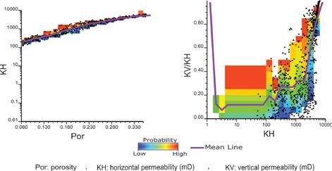
permeability (right figure). Uncertainty in the relationships is considered to simulate horizontal and vertical permeabilities based on porosity for the area of interest for flow simulation. The entire methodology could be applied for many realizations to achieve realistic permeability estimation with reasonable uncertainty assessment.
INFORMATION
There is no charge for the division talk and we welcome non-members of the CSPG. Please bring your lunch. For details or to present a talk in the future, please contact Weishan Ren at renws2009@gmail.com.
30 RESERVOIR ISSUE 5 • SEPTEMBER/OCTOBER 2017 DIVISION TALKS
Figure 2: Resulted relationships. Porosity-horizontal permeability (left figure) and horizontal permeabilityvertical to horizontal permeability (right figure). Uncertainty in the relationships is considered by cloud transformation.
Figure 1: Schematic example of modeling permeability log from HMI image.
ALBERTA PALAEONTOLOGICAL SOCIETY DIVISION TALK
A Paleozoic Origins of Modern Amphibians
SPEAKER
Jason D. Pardo, Ph. D. Candidate, Department of Comparative Biology and Experimental Medicine, University of Calgary, Calgary, Alberta
Time: 7:30 pm
Date: October 20, 2017
Location: Mount Royal University, Room B108
ABSTRACT
Modern amphibian diversity belongs to three major lineages: frogs (Anura), salamanders (Caudata), and caecilians (Gymnophiona). Each lineage is extremely distinct, with very few features that unite the three groups. The earliest definitive members of each lineage are Mesozoic in age, but generally already exhibit an overall body plan consistent with that seen in modern members of each group. Because the earliest members of each lineage are already highly derived, placing modern amphibians into the diversity of Paleozoic tetrapods has traditionally proven a difficult task. Three possibilities have been suggested: that all amphibians evolved from a large semiaquatic ancestors (temnospondyl hypothesis), that all amphibians evolved from small elongatebodied ancestors (lepospondyl hypothesis),
or that some amphibians evolved from temnospondyls whereas others evolved from lepospondyls (amphibian polyphyly). In recent years, a flurry of papers have examined the New approaches, especially use of microscopic computed tomography (µCT), have provided new ways of looking at this problem, with some surprising results. New data strongly reject the lepospondyl hypothesis and suggest that tetrapod and amphibian origins both involved a number of important evolutionary novelties. Furthermore, these data call into question whether ‘lepospondyls’ are a natural group at all. At least one group of lepospondyl, the serpentine aïstopods, appear to be extremely basal tetrapods from within the Devonian fin-to-limb transition, suggesting that the earliest tetrapods may have been more diverse than previously thought. Finally, new temnospondyl fossils from the Triassic are showing that there may be more than one viable ‘temnospondyl hypothesis,’ suggesting that the search for amphibian origins has not yet finished.
BIOGRAPHY
Jason Pardo grew up in Pittsburgh, Pennsylvania. He completed his undergraduate education at the University of Colorado in Boulder, where he conducted undergraduate research in developmental genetics of fish with Dr.
David Stock and paleontology with Bryan Small and Dr. Dena Smith. He completed a M.Sc. in Ecology and Evolutionary Biology with Dr. Jason Anderson at the University of Calgary in 2014, in which he used micro-CT to investigate skull anatomy and relationships of a group of early tetrapods, the lysorophians. He is currently pursuing a PhD at the University of Calgary studying the developmental biology of tooth regeneration in salamanders. His research interests include Late Palaeozoic vertebrate evolution, origins of modern amphibians, and development of the vertebrate head
DIVISION INFORMATION
This event is presented jointly by the Alberta Palaeontological Society, the Department of Earth and Environmental Sciences at Mount Royal University, and the Palaeontology Division of the Canadian Society of Petroleum Geologists. For details or to present a talk in the future, please contact CSPG Palaeontology Division Chair Jon Noad at jonnoad@hotmail.com or APS Coordinator Harold Whittaker at 403-2860349 or contact programs1@albertapaleo. org. Visit the APS website for confirmation of event times and upcoming speakers: http://www.albertapaleo.org/
RESERVOIR ISSUE 5 • SEPTEMBER/OCTOBER 2017 31 DIVISION TALKS
ALBERTA PALAEONTOLOGICAL SOCIETY DIVISION TALK
Memories of Montana – Photos from Bozeman
In addition to the main presentation by Jason Pardo, Daegan Kovacs will provide a brief presentation.
SPEAKER
Daegan Kovacs, grade 10 student, Homeschooled, Calgary, Alberta
Time: 7:30 pm
Date: October 20, 2017
Location: Mount Royal University, Room B108
ABSTRACT
The year was 2015, the month was July, and with my mom and brother we went to Bozeman in Montana. Why? Because I’ve wanted to go to Montana State University's Museum of the Rockies ever since I was a little kid. Montana's geology is similar to Alberta's, except Montana has more Early Cretaceous and Eocene rock. and
in the far south some rocks that date back to the Late Jurassic. I went there for a Paleontology camp where I slept under the Tyrannosaurus display, went to a Jurassic dig site where they were excavating a Diplodocus and a Stegosaurus, and met none other than Jack Horner! Inside the Museum they had many interesting displays such as a display showing a Deinonychus attacking a Tenontosaurus, T rex and Triceratops growth series, and a diorama showing the burrowing dinosaur Oryctodromeus. We also visited the Spokane Bar Sapphire Mine near Helena, which is the capital of Montana, where we found both sapphires and fossils.
BIOGRAPHY
Daegan is a homeschool student who is going into grade 10 and aims to become a Palaeontologist. He has been a member of the APS for 4 years now and wants to continue to be a member far into the future.
B.A.S.S. DIVISION TALK
Montney – From the Rock to the Log II
SPEAKERS
Godfried Wasser, Dana Kinnaird, and Shpetim Cobaj, Eucalyptus Consulting Inc.
Time: 12:00 pm
Date: October 30, 2017
Location: geoLOGIC Room (2nd Floor), Aquitaine Tower, 540-5th Avenue S.W.
ABSTRACT
Our work method follows our motto: From the Rock to the Log. We examine core and cuttings to learn what a reservoir is about. What makes it tick? Then we extrapolate our learnings using wireline logs.
We presented Phase 1 of our Montney
Evaluation at the 2017 CSPG Core Conference. Following the stratigraphic nomenclature proposed by Graham Davis and Tom Moslow in 1997, the Montney of Alberta’s Deep Basin was subdivided into 6 unconformity bounded cycles (Montney A through D; we expanded with E and F) and many sub cycles. Also, a Middle Montney interval was recognized.
Core work indicated that the Montney comprises deep water shales with abundant quartz (30-35%) and dolomite (20-30%); minor to no bioturbation and 30% average clay content. They are also associated deep water turbidite deposits comprising very fine siltstones (30-50 microns); with moderate clay content (Vclay 16-29%), quartz (20-35%), dolomites (20-40%),
This presentation is part of his curricula for high school credit in Special Projects 20: Paleontology. He is an avid microfossil sorter, is also very interested in entomology, and has several pets including a bearded dragon.
INFORMATION
This event is presented jointly by the Alberta Palaeontological Society, the Department of Earth and Environmental Sciences at Mount Royal University, and the Palaeontology Division of the Canadian Society of Petroleum Geologists. For details or to present a talk in the future, please contact CSPG Palaeontology Division Chair Jon Noad at jonnoad@hotmail.com or APS Coordinator Harold Whittaker at 403-2860349 or contact programs1@albertapaleo. org. Visit the APS website for confirmation of event times and upcoming speakers: http://www.albertapaleo.org/.
and porosities ranging from 3 to 13%. Although very fine grained, the turbidites have conventional, low permeability reservoir characteristics. These deposits occur together with interbedded very fine-grained siltstones and shales of similar composition as described above. They contain little bioturbation but have common wavy laminations and smallscale wave ripples. We interpreted the depositional environment as proximal shelf to transition zone.
A second group of facies range from deep water shales to shallow marine deposits and carbonate rich soils. The soils occur as a dolomitic siltstone facies characterized by intense chaotic structures often resulting from synsedimentary
32 RESERVOIR ISSUE 5 • SEPTEMBER/OCTOBER 2017 DIVISION TALKS
deformation. Thin section analysis showed the presence of some early expansive anhydrite cementation replaced by calcite, and the abundant occurrence of dolomite sedimentary rock fragments. The latter commonly recrystallized into blocky dolomite cement (22-30%). Porosities are often 12 to 22% with particle sizes typically being coarse silt.
Above these soil deposits are some coquina debris beds also rich in primary dolomite fragments that are often recrystallized into blocky dolomite cement with leached vuggy porosity. The porosity of the coquina can be up to 25% and permeabilities reach the darcy level. We interpreted these coquina beds as berm like deposits washed during storm onto the soils. The soils grade down into highly porous, medium to coarse siltstones comprised of quartz with dolomite (particles and replacement cement) and some calcite cement interbedded with shale. The clay content of both the shale and siltstone was found to be 30 to 9%. Sedimentary structures are mostly small-scale ripples and wave ripples with some synsedimentary deformation as well as some indications of tidal influences. It is imported to distinguish between clay volume and the shale/rock ratio. In this interbedded facies, the latter ranges from 20 to 75%. We interpret these deposits as tidally influenced mudflats that grade down into the aforementioned deep water shales.
Intercalated with the mudflat sediments is a facies that has thin to massive bedded siltstones with sharp contacts and some Bouma-like successions of sedimentary structures. Top bed contacts are often gradational into shale. Bed thickness varies from 20cm to 2 meters. Vclay is typically 5% or less in the siltstones and up to 35% in the shales. Porosities are as high as 26% and permeabilities may be up to 10s of millidarcies. In some rare cases, the ‘siltstone’ beds increase in grain size to very fine sand (60-70 microns) and permeability as high as a darcy. We interpret this facies as shallow marine storm beds.
The subsequent petrography and petrophysics focused on defining algorithms of clay volume (Vclay) rather than the more traditional shale volume (Vsh), grain size distribution, porosity, formation water distribution, etc. Wireline
logs of close to 1400 wells were normalized and the algorithms derived from the rock work were applied during petrophysical analysis to determine porosity, Vclay, water saturation and OOIP distributions within the Montney overall and its subdivisions.
The results were used to generate a wide variety of maps for the Montney and its cycles throughout the study area (Twp 70 to 80, Rge 19W5 to 13W6). Several clay volume, porosity, water saturation and OOIP distribution trends were identified.
At the presentation, we will also introduce our Detailed Horizontal Well Reviews which integrate our petrophysical knowledge, rock data such as cuttings, mapping combined with MWD data to place the wellbore more precisely in the producing zone, as well as calculate porosity, grain size, composition, water saturation and brittleness along the wellbore. This should help with completion planning; remedial work; explanation of production performance. This method is a very affordable alternative to running a full wireline logging suite to measure a well’s potential.
The Montney in the study area comprises mostly low permeability conventional reservoirs that produce from pool to pool a variety of hydrocarbons ranging from condensate and gas liquids to light oil. Some reservoirs also produce large volumes of water. Eucalyptus has just launched a regional Montney Phase II evaluation which covers Twp 58 to 69, Rge 16W5 to the Alberta Border.
BIOGRAPHY
Godfried Wasser studied at the State University of Utrecht in the Netherlands. He has a B.Sc. in geology and an M.Sc. in Sedimentology. He has worked in the Canadian oil patch since 1979 for companies such a PanCanadian Petroleum (now Encana), Canadian Natural Resources, PennWest Exploration and as owner/president of Eucalyptus Consulting Inc. He specializes in clastic reservoir geology working both on the pool level and on regional evaluations. His working experience ranges from conventional oil and gas, heavy oil, secondary and enhanced recovery and on low permeability (unconventional) reservoirs such as the Viking in Saskatchewan and Alberta, the
Nikanassin (Minnes Gp) in N.E. B.C.; Cardium oil and gas in the Deep Basin and south of Keystone as well as the Spearfish (Lower Amaranth) in Manitoba. Godfried also has worked in Indonesia and taught various courses through the CSPG ranging from Belly River field school to Reservoir Geology in Sandstones. He has also taught reservoir geology internationally.
Godfried has won a CSPG Tracks Award and several service awards. He has published on various topics at conferences, the CSPG Core Conference and various CSPG Divisions. Currently Godfried is President of Eucalyptus Consulting which does reservoir geological evaluations integrating geology, sedimentology, petrography, petrophysics, reservoir engineering and operations geology. Eucalyptus is currently working for small clients and on Phase II of a multi-client Montney regional reservoir geological evaluation. The company’s motto is: “From the Rock to the Log”
DIVISION PROFILE
The Division's mandate is to provide a CSPG forum for members who are interested in seeing the "wood" when they are looking at the "trees". Most of us deal with small areas in our daily work. A good understanding of the big geologic picture in which our areas are located will facilitate better geological interpretations and predictions, which will translate into higher drilling success rates. The aim of the Basin Analysis and Sequence Stratigraphy Division is to be innovative, inspiring and practical. We will try to introduce new concepts and methodologies of basin analysis and sequence stratigraphy to our group. We would also like to share inspiring interpretations of historical Canadian data. In particular, we encourage speakers to offer learnings that we can take home and apply in our daily work. The Division is also interested in running field trips or joint talks with other Divisions in the future.
RESERVOIR ISSUE 5 • SEPTEMBER/OCTOBER 2017 33 DIVISION TALKS
MOUNTJOY WRAP-UP
The SEPM-CSPG Mountjoy II Meeting took place June 25th- 29th, 2017 at the J.J. Pickle Campus of the Bureau of Economic Geology in Austin, Texas. This meeting is named in honour of Dr. Eric Mountjoy and his goal for the conference was to bring together geoscientists from industry, government, and academic institutions to share results from applied research on topics related to the characterization and modeling of carbonate reservoirs. Given his reputation as a professor and supervisor of over fifty graduate theses from the 1960s through to the early 2000s, it was of no surprise that Eric would have wished that the meeting specifically include the opportunity for students and early career professionals to interact with other scientists and to share their research. In fact, 70% of the presenting (first) authors were identified as a Student or Young Professional.
The meeting kicked-off Sunday evening an Icebreaker. Participants picked up their badges and greeted old friends, colleagues and acquaintances to catch-up. The Chair of the organizing committee, (Paul) Mitch Harris also used this ice-breaker as an opportunity to introduce students and young professionals to the rest of the participants. Presenters represented 16 different countries including Australia, Belgium, Brazil, Canada, China, Denmark, France, Malaysia, Saudi Arabia, Scotland,
South Africa, Switzerland, Turkey, UAE, UK and the USA. Approximately 64% of the meeting delegates were from academia, 32% from industry and about 4% from government. This was a sharp turnaround from the first meeting where approximately 60% of attendees were from industry, reflecting the continued downturn of the petroleum industry. The male to female demographic was approximately 70% male and 30% female.
On Monday morning the technical portion of the meeting commenced with introductory remarks from Mitch Harris where he thanked the sponsors of the meeting for providing funds to support the attendance of students and academics. He went on to thank the plethora of volunteers who served on various organizing committees that put together the conference. Mitch also emphasized that the intent of the conference was to provide a forum to: (a) share the latest advances in our fields, (b) interact within this unique opportunity for networking that the format of the conference provides, and (c) build new and lasting research partnerships and friendships.
The theme of the 2017 meeting was Carbonate Pore Systems and the program put together by the technical Chairs Don McNeill and Eugene Rankey was excellent. Technical sessions on Monday included talks and posters that focussed
on: (1) Sedimentologic, Stratigraphic, and Diagenetic Controls on Development of Carbonate Pore Systems, (2) Multiscale Prediction and Upscaling of Carbonate Porosity and Permeability, and (3) Interactions in Multi-Modal Pore Systems. Oral presentations included speakers from several countries and reservoirs ranging from conventional carbonates (such as Karachaganak field in Kazakhstan) to Unconventional (the Duvernay and Mississippi Lime Formations), from ancient (Devonian) to the modern (West Caicos Island). The poster session had a similar range of topics and also included mini “previews” of the Core Workshop to be held on Wednesday.
Tuesday’s program was a break from the technical presentations and participants headed out to the field! Thanks to Astrid Arts and Chris Zahm for putting together the selection of the four field trips. Participants could choose from a visit to Pipe Creek where Laura Zahm presented the Albian-age Pipe Creek rudist build-ups and impact of touching and non-touching vugs on reservoir characterization, a visit to the Cretaceous of central Texas where Chris Zahm presented Fractures and pores within evaporite paleokarst systems, a visit to the Longhorn Caverns (and relief from the heat of Texas in late June) with Bob Loucks who presented Fractures, faults and karst caverns: architecture of the non-
34 RESERVOIR ISSUE 5 • SEPTEMBER/OCTOBER 2017
SOCIETY NEWS
matrix reservoir elements or a visit to the Hidden Valley Fault in central Texas where David Ferrill and Ronald McGinnis showed participants the Fault zone deformation and displacement partitioning in mechanically layered carbonates.
Tuesday evening brought all the participants back together again at our formal dinner in honour of Eric Mountjoy. Dinner was held at Abel’s on the Lake where participants enjoyed mixing and mingling along with a buffet dinner at a wonderful lakeside venue. Conversations from the day picked up again in this more casual setting and colleagues shared stories from their respective trips.
On Wednesday, participants were split into two groups. In the morning, one group focused on poster presentations while the other group focused on the amazing Core Workshop that was put together under the leadership of Laura Zahm. The groups then switched around for the afternoon. The poster presentations were from the technical sessions that included: Microporosity in Conventional and Unconventional Carbonate Reservoirs and Visualization, Quantification and Modeling of Carbonate Pore Systems and their Fluid Flow Behavior. The Core Workshop featured eight (8) cores ranging from the Upper Cambrian to the late Cretaceous and from far-flung locations in the world (Kazakhstan and Canada) to several from various places in Texas. Kudos to all the core presenters who went through their presentations 8 times in the morning and again 8 times in the afternoon! Their voices certainly needed a break at the end of the day.
The oral and poster technical sessions resumed Thursday with presentations on microporosity, a theme that seems to be increasingly more important from the industry perspective. Several presentations focused on ways to characterize and document microporosity as well as case studies on the importance and impact of microporosity on production. The afternoon concluded with talks that focused on modeling porosity, whether that was modeling the evolution of permeability in carbonates or the 3D pore network or understanding the impact of pore heterogeneity on the reservoir modeling. The end of the day concluded with the final poster session and informal farewells
amongst the participants.
A highlight of the entire conference was the attendance of Anita Mountjoy. She participated in all events – staying for all the technical presentations and even going on a field trip. Numerous participants commented on the lovely conversations they had with Anita. She particularly sought out all the students and younger scientists for chats. Anita has probably learned more geology than any of us at these conferences. She is an inspiration to all of us! We even had a special presentation from Sherry Becker who gave Anita her rock hammer to replace Eric’s hammer which was lost this past winter! (She uses the rock hammer to chip away at the ice on the front porch). Fortunately Sherry made it through airport security with her hammer.
At the end of the meeting, the technical committee solicited papers from the participants for a Special Publication that is expected to follow. If anyone would like to participate, please contact Don McNeill at dmcneill@rsmas.miami.edu. The next Mountjoy conference will be held in 2021 with CSPG taking the lead for organization. If you are interested in helping out with this event please contact Lis Bjeld at lis.bjeld@ cspg.org to volunteer. Look for details in the coming few years for the next Mountjoy meeting – see you there!
RESERVOIR ISSUE 5 • SEPTEMBER/OCTOBER 2017 35
SOCIETY NEWS
GEOWOMEN OF CALGARY PARTNERS WITH THE CSPG
Facing one of its worst crises in a generation, the oil industry is trying to open up - to women. As the oil industry's gloss is fading further with a collapse of oil prices to the lowest levels in more than a decade, executives realize something needs to change to widen the talent pool.
Dimitry Zhdannikov – Davos, Switzerland, January 20 2016
In February 2017, the CSPG Board unanimously passed a motion to designate GeoWomen as a committee of the CSPG. Founded in 2014 by professional geologists, Jocelyn Keith-Asante, Mandy Williams and Robynn Dicks, GeoWomen’s objective is to advance women working in the geoscience professions in Calgary. GeoWomen is a Member Program of the AWSN (Alberta Women’s Science Network) – a non-profit umbrella organization supporting STEM programs in Alberta that foster diversity and inclusion.
GeoWomen is a networking group that aims to support women in geoscience in Calgary progress from new graduate to retiring at the top of their game. Anyone in the geoscience and energy community in Calgary is welcome.
Since our inception, we have organized and
presented talks and discussions that include soft skills topics such as employment terminations, maternity & parental leaves, work/life balance, resume writing, job search guidance, career navigation, leveraging diversity, successful negotiations, and different work arrangements for women.
The number of women geoscientists in companies drops as their careers progress. Women are not as likely to progress into technically higher levels, management, or the board of directors in any size company. We gather to share knowledge and strategies to change this. While our audience is predominantly women, anyone is welcome to attend. It is by developing a strong knowledge base as well as educating allies that our vision will be realized.
When women succeed in an industry the industry succeeds. On average, companies with the highest percentages of women board directors outperformed those with the least by 53% for Return on Equity, 42% for Return on Sales and 66% for Return on Invested Capital. (Catalyst.org)
GeoWomen’s website and LinkedIn Group are administered by Yulini Arediningsih. Events will be advertised through the CSPG website and geowomen.org. You are also
invited to join the GeoWomen of Calgary LinkedIn Group for updates on future events.
Join us on October 5 2017 at 11:30am for a presentation on Building Your Financial Strength with Vanessa Stockbrugger, Founder of Womencents (www. womencents.ca).
GeoWomen would like to acknowledge Dr. Francis Hein, PhD, P. Geo., recipient of the 2017 Canadian Professional Geoscientist Award from Geoscientists Canada. The award is given to a person to “recognize exceptional contribution to the development and practice of professional geoscience and who has advanced public recognition of the profession in Canada in his/her capacity as a registered professional geoscientist.
The citation for the 2017 award, which will be presented at an APEGA event at a later date, reads as follows: “for tireless service toward public understanding of geoscience and scientific influence on regulation of hydrocarbon resource development, through her teaching, research, and publications”. Congratulations Dr. Hein for being an excellent role model for girls and women who want to have a consequential career in geoscience.
36 RESERVOIR ISSUE 5 • SEPTEMBER/OCTOBER 2017
SOCIETY NEWS


Join
GeoWomen
of
Calgary for
a
noon hour
event
with:
Vanessa
Stockbrugger
–
Founder
of
Womencents
Building
Your
Financial
Strength
-‐
Building
your
financial
awareness,
knowledge
and
confidence
-‐
Tips
for
improving
your
overall
financial
health
and
the
positive
impacts
this
can
have
on
your
life
today
and
compounded
into
the
future
-‐
Decreasing
your
financial
risk
against
future
life
challenges
Thursday
October
5 2017
GeoLogic
Classroom,
+15
level,
Aquitaine
Tower 540
–
5
Avenue
SW
11:30AM
Networking
12:00
Presentation
by
Vanessa
Stockbrugger
Free
Event
–
No
registration
required Women
and
men
are
invited
to
attend
Bring
your
lunch
and
your
questions
For
more
information
on
GeoWomen
of
Calgary,
please
visit
www.geowomen.org
GeoWomen
of
Calgary
is
a
GeoCommunity
of
the
CSPG www.cspg.org
GeoWomen
of
Calgary
is
a
member
of
AWSN www.awsn.org
If
you
would
like
updates
on
future
events,
please
join
our
GeoWomen
LinkedIn
Group

Vanessa
Stockbrugger is
the
Founder
of
Womencents.
Both
her
education
and
career
have
been
focused
in
the
field
of
Finance. Vanessa
holds
a
Business
Administration
Degree
with
Great
Distinction,
majoring
in
Finance.
Vanessa
spent
a
decade
of
her
career
as
an
Investment
Banker
at
a
major
Canadian
Bank.
As
a
Vice
President
and
Director,
she
was
responsible
for
helping
her
clients
make
important
strategic
and
financial
decisions
to
add
value
and
meet
their
financial
goals.
Vanessa
has
a
keen
interest
in
personal
finance,
always
looking
to
expand
her
knowledge
and
loves
to
help
others
realize
their
financial
goals.
Through
a
rewarding
career,
her
education
and
personal
life
experiences,
she
has
developed
a
unique
expertise
in
personal
finance
and
on
women
gaining
financial
security
and
independence.
She
lives
with
her
husband
and
two
daughters
in
Calgary,
Alberta.
Womencents
provides
independent,
unbiased
information
and
does
not
sell
financial
products
RESERVOIR ISSUE 5 • SEPTEMBER/OCTOBER 2017 37
SOCIETY NEWS
GO TAKE A HIKE
Ngebol Mud Volcano, Sarawak, Malaysia.
By Philip Benham, Sarawak Shell Berhad
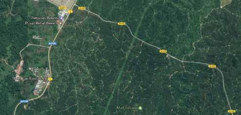
Trailhead:About46kmwestof Miriis theBekenuJunctionbetween Route1 (AH150)andRoute4109.2kmsouth of thejunctiononRoute4109 towards LoaganBunutNationalParkis the accesspointtothemudvolcano. The siteisonSarawakOilPalm Berhad (SOPB)propertyand permission shouldbeobtainedbeforeaccessing Distance:.Thewalkisabout ~1km withnoelevationgain.Though the distanceisshort,waterand sun protectionarestronglysuggested. The locationismarkedwithayellow dot. The “caldera” ofthevolcanocan be treacherouswithbottom-lesspits of fluidmudbeingimmediately adjacentto andvirtuallyindistinguishable from moresolidcrusts.Takecare!
Mud volcanoes are common feature in North West Borneo, particularly in offshore Sabah where the pock mark the seafloor above oil and gas accumulations. They form where hydrocarbons generated from a deep source rise and vent to the surface as a sort of pressure relief valve. Most mud volcanoes have two elements in common; firstly, the presence of over-pressured and mobile clays at depth and secondly a compressive tectonic setting (Cullen, 2012). Compression results in a fold, fault or a diapir that concentrates the migrating hydrocarbons as they flow up past an imperfect seal. The constant movement of the gas and oil mixes the soft sediment near the surface creating a slurry that flows out of the vents, creating small flattened cones (m ud volcanoes). Through much of their life they grow slowly due to constant seepage or bubbling but sometimes large slugs of gas can create “eruptions.’ A good example of this is Pulau Tiga (also known as Survivor Island as the site of the first season of the iconic reality series). Pulau Tiga formed on September 21st, 1897 when an earthquake centred on Mindanao, Philippines first triggered an upwelling of sediments and gas to form an island about 20m across. Over ensuing decades more eruptive events formed several other islands which have subsequently joined together to form the current Pulau Tiga. The last eruption there was in 1941 and the volcanoes have settled down to a steady seep. Now tourists can go bathe in the therapeutic mud pools.
One of the more accessible mud volcanoes in Borneo is Ngebol, located a short walk within the oil palm plantation belonging to SOPD. Within it are variably active gas seeps which churn and liquefy the muds. Local people call the place "Ngebol", meaning "seepage". The area was of import to hunters because the permanent water source and available salts and minerals attracted birds and other wildlife to the site. The larger area is called "Setap", a name that has been used by geologists to characterize the mudstone dominated formation outcropping in the area.
Ngebol mud volcano consists of a roughly circular, low relief caldera, perhaps 100m across. The caldera consists of three components:
1) a dry moderately solid crust with no active seeps,
2) a semi-solid zone, spongy to the step with numerous vents, and
3) an area where the gas seepage is sufficiently active over a wide area to liquefy the fine grained sediment.
The extruded mud is cool, but the fluids are very saline (with high Cl, Na, K, Ca and Mg content), so that as long as the volcano is active very little vegetation will grow on it (T ing & Poulson, 2009). While the active muds hinder normal jungle plants, other organisms thrive. The standing pools of watery mud have microbial mats of bacteria and algae growing on their rims and floating freely as rafts. These mats often take up a bubbly appearance as they trap the rising gas. The primary gas escaping the volcano is methane. In some cases the rate of seepage is such that it can be temporarily lit on fire. The oily sheen glinting in the sunlight is also evidence of the seeping hydrocarbons that the bacteria feed upon. The entire caldera is quite dynamic; even though it doesn’t change size or shape, seasonal rains do result in an expansion of the watery area and an increase in mud volcano activity within the caldera. In drier weather mud volcano activity diminishes and many of the vents become inactive. If there is sufficiently dense sediment being carried up the vent then successive degassing cycles build up a shallow cone with radiating flows from the vent. The volcanoes generally reach a maximum height of approximately 50 cm and diameter of 2m before switching to a new vent at lower elevations. If the mud is not viscous enough to solidify at the vent, it flows or washes away it leaves just a vent with no build up. In dry season, as water level drops, sculpted vents becomes visible.
38 RESERVOIR ISSUE 5 • SEPTEMBER/OCTOBER 2017 GO TAKE
HIKE
A
200m PA Copyright 2010 Google
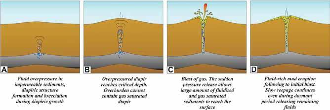
Why is Ngebol mud volcano located here?
The West Baram Line (and its onshore cousin the Tinjar Line, which runs just east of this location), form the boundary between the Luconia carbonate platform in Sarawak (west) and the Baram Delta (east). The WBL is more of a zone of fault blocks that drop away towards the deeper basin in Brunei and Sabah over a width of about 50 km. The nature of the WBL is subject of much debate but appears to consist of faults with both strike slip, extensional and compressional components. Some of the structural deformation extends west into the area of the Ngebol mud volcano, resulting in an anticlinal fold which was the focus of exploration by Shell in the 1950’s. The last, well Bulak Setap #3 was drilled to a depth of 11600 feet encountered primarily shale with a few thin streaks of sand. Its surface casing can be observed a few hundred metres from the mud volcano. Uplift and movement along the West Baram Line appears to have continued into the Plio-Pleistocene (Kessler and Jong, 2015) but it is uncertain how long the series of mud volcanoes reported along it (Cullen 2012) have been active.
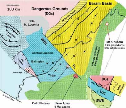
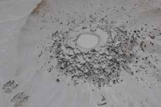
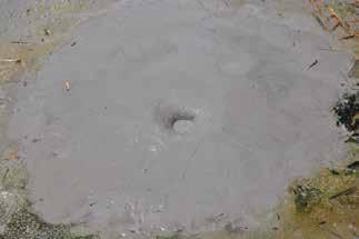
RESERVOIR ISSUE 5 • SEPTEMBER/OCTOBER 2017 39
Figure above: Cartoon showing the evolution of a mud volcano, from sometimes explosive origins when the “cork” pops to later stage prolon ged seepage (Mazzin, 2009). Figure below: Map below from Cullen (2012): showing the position of the West Baram Line (or WBL) and the slight offset of the Tinjar Line onshore. The yellow dot shows the location of the Ngebol mud volcano, the blue star is the location ofMiri. The dashed lined running SW to NE is the present day shoreline. Bottom Left: a spatter cone from an active vent with more viscous mud. Compare to the bottom right with a nearby cone that has a more fluid mud and a low relief shield volcano has built up.
GO TAKE A HIKE
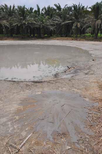
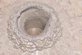
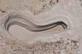

at least to 2500 BC in Mesopotamia. Today some clays are
40 RESERVOIR ISSUE 5 • SEPTEMBER/OCTOBER 2017 GO TAKE A HIKE
Image Top Left: View of Ngebol mud volcano with the active pool and a small volcano in the foreground erupting through the dry crust within t he caldera. The salts and active nature of the volcano keep the vegetation at bay. Top Right and Above right: view into inactive vents during dry period. Note the sculpting. Above: Bubbles of methane venting from an active zone in the Ngebol mud volcano. The constant churning of sediment results in very fine clay particles. The use of medicinal clays and mud baths dates back
considered to have antibiotic effect and be useful in treating skin ailments. Bottom Right: Mud volcanoes are considered to have healthy properties and some (such as the example below at Pulau Tiga) are developed as tourist attractions. Ngebol Volcano, however, is a bottom less pit beyond the dry crust… do not attempt to bathe here! Image source : http://www.exodusborneo.com/wp-content/uploads/2015/05/pulau-tiga-mud-volcano.jpg
Bottom Left: Elephants seeking mud ( a high SPF sunblock!) and salts at the Lipad mud volcano in the Tabin Reserve, Sabah. Image source: (http://www.whoaadventures.com/sites/default/files/imagecache/gallery/gallery/2012/09/Elephants%20in%20the%20Mud%20Volcano%203 .jpg
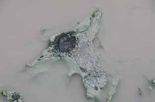
References:
• Cullen, A., 2012. Nature and Significance of the West Baram Line, NW Borneo. Search and Discovery Article #30252 (2012). Adaptedfrom extended abstract prepared in conjunction with oral presentation at AAPG International Convention and Exhibition, Singapore, 16-19 September
• Jong, J, Frank Kessler, Steve Noon and Tran Quoc Tan, 2016. Structural Development, Deposition Model and Petroleum System of Paleogene Carbonate of the Engkabang-Karap Anticline, Onshore Sarawak. Berita Sedimentologi, January 2016, Pages 4-24.
• Kessler, F.L. and Jong, J., 2015. Tertiary Uplift and the Miocene Evolution of the NW Borneo Shelf Margin. Berita Sedimentologi,33, p. 21-46.
• Kessler, F.L., Jong, J., Tran, Q.T. & Kusaka, H., 2011. The Karap Mud Volcano imaged on new 2D seismic –implications for basin analysis. PGCE presentation abstracts, Warta Geologi, 37, p.57-58.Berita Sedimentologi Number 34 – January 2016
• Mazzin. A, 2009. Mud Volcanism: Processes and Implications. In Marine and Petroleum Geology 26 (2009) 1677-1680.
• Ting TM & Poulsen AD, 2009. Understory Vegetation at Two Mud Volcanoes in Northeast Borneo . Journal of Tropical Forest Science 21(3): 198–209 (2009)
RESERVOIR ISSUE 5 • SEPTEMBER/OCTOBER 2017 41
GO TAKE A HIKE
Image Top Left: Methane bubbles trapped in a mat of bacteria and algae on the rim of a pool. Main image above; broad, low relief mud volcano. The orange and green patches in the top right of the picture show areas where bacteria (orange) and algae preferentially grow Above Left: floating bacterial-algal raft in a mud pool. Above right: colour variations around a small vent, showing subtle variations in conditions such as salinity, moisture content or perhaps increased methane seepage at the vent are influencing the growth of the microscopic eco system of bacteria and algae.
2017 CLASSIC GOLF WRAP-UP
By: Foon Der
The 56th CSPG Classic Golf Tournament was held on a sunny June day. The morning of the tournament started out overcast and cool with a few drops of liquid sunshine. The weather improved and was sunny and warm by mid-morning resulting in a day gorgeous golf weather. Under the current format the tournament can only accommodate 72 players. The tournament was full with a waiting list of both players and sponsors. We urge anyone who plans to participate in the 57th Annual CSPG Classic Tournament to held on June 21, 2018 to sign up as soon as registration opens in March, 2018 to avoid disappointment.
The Paskapoo Flight winners are considered the Tournament Champions. For the 56th Annual Tournament the winners of the Paskapoo Flight are the team of Mike Bell and Dave Nordin. Congratulations for playing well.
The tournament was bolstered by the sponsorship of 20 sponsors ranging from providing a golf shirt, food and refreshments on the course, breakfast and post-game dinner, wine, printing services and a variety
of sponsored prizes.
The following sponsors did their part is making the tournament successful:
AGAT Labs, Belloy Consulting, Cambria Business, Chinook Consulting, Cordax Evaluation, Cougar Consulting, geoLOGIC Systems, Geo-Steering Solutions, Keitech Consulting, Little Rock Document, Loring Tarcore Labs, MJ Systems, Pason Systems, PROGEO Consultants, RBC Securities, RigSat Communications, Schlumberger Canada, Trimble Engineering, Typhoon Energy Ltd, Weatherford Canada
The tournament has incorporated a charitable component into the Tournament during the past decade. Since 2012 the charity selected by the Committee has been the CSPG Educational Trust Fund which was repurposed several years ago, as the CSPG Foundation. The CSPG Classic was able to contribute to the Foundation by holding a putting contest. The winner of the putting contest this year is Jeff Kris who contributed his $200 prize back to the Foundation. The total raised for the Foundation was $1120, thank you to all the players who participated.
The Committee is cognizant of the current economics of the industry and thanks the players and sponsors for making this year’s tournament a success, the players for their participation and the sponsors for providing the extras as well as financial sponsorship so that the cost of registration remains affordable. The Committee has met to review the failures and successes of this year’s tournament and look forward to hosting next year’s tournament on June 21st 2018 at Elbow Springs. While one can point to shortcomings of the course they have been very cooperative in adapting to our needs and especially being able to allow us to take a lunch break. This tournament is about networking and the lunch break enable everyone to mingle prior to dinner. See you next year.
42 RESERVOIR ISSUE 5 • SEPTEMBER/OCTOBER 2017
SOCIETY NEWS
Front: Jeorg Wittenberg, Back: Terry Day, Brenda Pearson, Leanne Ewashen Left to right: Julianne Fic, Britany Gilbreath, Jon Horner, Parry Cooper
“ This pioneer and explorer in geology, engineering and natural gas technology bequeathed a fundamental knowledge, years ahead of his time and was considered by many a virtual Leonardo da Vinci of the Petroleum Industry. Slipper, our First President, deserved the honour (unbeknownst to him) of our highest award in the Canadian Society of Petroleum Geologists”
- Aubrey Kerr
The Stanley Slipper Medal is CSPG’s Highest honour.
The gold medal is presented annually for outstanding contributions to oil and gas exploration in Canada. The contributions of the winner of this award should encompass a number of activities related to aspects of petroleum exploration. Such activities include: initiating and/or leading exploration programs, significant discoveries on new or existing exploration trends, teaching and/or training of explorationists, and involvement in and leadership within geological societies and professional organizations.
The committee is currently calling on the CSPG membership to provide additional nominations for this prestigious award. The award winner must be a CSPG member and should be able to attend the awards presentation to be held in the spring of 2018.
Please include an updated biography and letters in support of your nominee. It is recommended that potential nominations be vetted with the Committee Chair early in the process in order to avoid, if possible, duplicate nominations for the same person.
Nominations should be mailed or emailed before October 16 to:
CSPG Stanley Slipper Committee – Clint Tippett
150, 540 – 5 Ave SW
Calgary, AB T2P 0M2
Email: clintontippett88@gmail.com
 2016 Stanley Slipper Recipient Edward (Ted) Bogle
Stanley Slipper Medal
2016 Stanley Slipper Recipient Edward (Ted) Bogle
Stanley Slipper Medal
October
Banff, AB Canada

This year's Gussow Research Conference aims to address the holy grail of petroleum systems research!
We welcome a panel of expert speakers covering the physical principles of petroleum migration, geochemical (biomarker and isotope) tools, laboratory experiments, numerical simulation, and case studies.

5 diverse sessions of world-class lectures and discussion will address petroleum migration from pore to basin scale, reservoir leakage, and entrapment in tight oil plays.
Registration includes Conference Accommodations
2 breakfast, 3 lunches Ice Breaker Conference Dinner
CSPG Members $1085 CAD
Non Members $1380 CAD


Organizing Commi ee:
Mar n Fowler, PhD. mar n.fowler@aptec.ca (Applied Petroleum Technology)
Milovan Fus c, PhD. milovan.fus c@canada.ca (Natural Resources Canada)
Andy Mort, PhD. andy.mort@canada.ca (Natural Resources Canada)
10-12, 2017
To view the technical program and to register go to www.cspg.org/gussow2017
