Streetwise Rotterdam: The city at eye level
better way to connect Rotterdam‘s diversity, reassessing the missing links in the city map with the aim of creating natural routes through the city and improving the experience people have in the streets. This requires meticulous precision in design and programming – and that precision is exactly what has been underappreciated in Rotterdam‘s tradition of sweeping transformation. In recent years, improvements in how people experience the quality of public space have been directly related to the renaissance of a number of streets. This offers an extra incentive to shift from a top-down planning tradition to the street view at eye level. The street offers a new lens to rethink the city of Rotterdam - especially in view of more largescale interventions planned for the future.
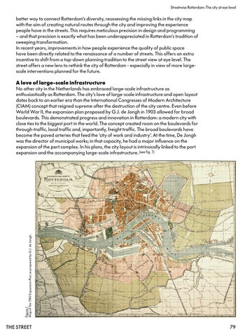
Figure 1 Map of the 1903 Expansion Plan as proposed by G.J. de Jongh.
A love of large-scale infrastructure No other city in the Netherlands has embraced large-scale infrastructure as enthusiastically as Rotterdam. The city‘s love of large-scale infrastructure and open layout dates back to an earlier era than the International Congresses of Modern Architecture (CIAM) concept that reigned supreme after the destruction of the city centre. Even before World War II, the expansion plan proposed by G.J. de Jongh in 1903 allowed for broad boulevards. This demonstrated progress and innovation in Rotterdam: a modern city with close ties to the biggest port in the world. The concept created room on the boulevards for through-traffic, local traffic and, importantly, freight traffic. The broad boulevards have become the paved arteries that feed the ‘city of work and industry‘. At the time, De Jongh was the director of municipal works; in that capacity, he had a major influence on the expansion of the port complex. In his plans, the city layout is intrinsically linked to the port expansion and the accompanying large-scale infrastructure. (see fig. 1)
the street
79