

Master Plan for Parks Recreation and Trails


TABLE OF CONTENTS
Nacogdoches Parks, Recreation and Trails Master Plan
Introduction ..................................................................................................... 1 Master Plan Purposes ......................................... ....................................................... 1 Location and Climate ......................................... ............................................................ 2 Location ..................................................... .......................................................... 2 Climate and Natural Resources .................................................................................. 3 Demographics .................................................. .............................................................. 4
TABLE 1.1: Historical Population .............................................................. .............. 4
FIGURE 1.1: Race Composition of Population, 2010‐2014 ..................................... 6 Local Assets and Resources ................................... ........................................................ 6 Historic and Cultural Resources ........................................................................... 6 Local Facilities and Attractions ............................. ............................................... 8 Area Economy ................................................. ..................................................... 9 City Role in Provision of Parks and Recreation Facilities and Programs ....................... 10 Master Plan Overview ................................................................................................... 11
Goals and Objectives ........................................................................................ 1
Concepts and Standards .................................................................................... 1 Local Standards .............................................. ............................................................... 1
TABLE 3.1: Local Standards and Their Potential Implications ................................ 1 Site Selection Criteria ...................................... 3 Location and Access .......................................... ......................................................... 3 Topography ................................................... ............................................................. 4 Soils ........................................................ ............................................................... ..... 4 Vegetation ................................................... ............................................................... 4
Area and Facility Inventory ............................................................................... 1 Public Parks Inventory ....................................... ............................................................ 1
TABLE 4.1: Inventory of City Parks ............ 1
TABLE 4.2: Park Classifications ................. 2 City of Nacogdoches Public Parks Map ............................................................... .... after 2 Park Features and Improvements ............................... ............................................... 4 Recreation Center ............................................ .......................................................... 4 Youth and Adult Athletics .................................... ...................................................... 5
TABLE 4.3: Park Features and Improvements ......................................................... 6 Park Map Series ........................................ after 6 Public Trails Inventory ................................................................................................... 7 Lanana Creek Trail ........................................... ........................................................... 7 Banita Creek Trail ........................................... ............................................................ 8 Trail Map Series ........................................ after 8 Other Community Recreation Assets ............................................................................ 9 Stephen F. Austin State University ............................................................................. 9 Nacogdoches ISD .............................................. ......................................................... 10 Nacogdoches County ........................................... ...................................................... 10 Non‐Profit Facilities ......................................... ........................................................... 10 Private Facilities ........................................... 11

Needs Assessment ............................................................................................ 1 Quantity of Parkland ......................................... ............................................................ 1 Nacogdoches Population Outlook ...............................
Population Implications for Park Acreage Needs ...................................................... 2
TABLE 5.1, Park Acreage Need Based on Varying Population‐Based Standard ...... 2 Geographic Coverage .......................................... .......................................................... 2 Findings from Service Area Evaluation ........................ .............................................. 3
FIGURE 5.1, Existing Park Service Areas .............................................................. ... 4 Community Input to Needs Assessment .......................... ............................................. 5 Needs and Wants .............................................. ......................................................... 5 Gauging Public Sentiment ..................................... ..................................................... 5 Trail Network Needs ..........................................
Sports Facility Needs ........................................ ............................................................. 9
FIGURE 5.2: Trail Network Potential ......... 10
FIGURE 5.3: Sports Facility Enhancements Scenario .............................................. 11 Sports Facility Observations ................................. ......................................................... 12
Priorities and Implementation .......................................................................... 1 TABLE 6.1, Project Priorities and Implementation Considerations ......................... 3 Other Potential Improvements .................................................................................. 7 Site‐Specific Improvements ...................................
Potential Priorities for Next Master Plan Update ...................................................... 10 Funding for Implementation ................................... ...................................................... 11 Federal and State Funding Programs ........................... .............................................. 11 Foundation Program Examples .................................. ................................................ 14
APPENDIX: Public Involvement Summary .......................................................... 1 Master Plan Stakeholders Group (Meeting 1) ............................................................... 1 City Discussion Series Meeting ............................... ....................................................... 4 Meeting with Sports Groups ......................................................................................... 7 Meeting with Trails Committee ................................ ..................................................... 9 Meeting with Parks Advocacy League (PAL) ................................................................. 10 Master Plan Stakeholders Group (Meeting 2) ............................................................... 12 Master Plan Stakeholders Group (Meeting 3) ............................................................... 13 Public Open House Event ...................................... ........................................................ 14 Master Plan Stakeholders Group (Meeting 1) ............................................................... 16
Introduction
Nacogdoches Parks, Recreation and Trails Master Plan
This document provides the City of Nacogdoches an updated master plan for the ongoing expansion and enhancement of its system of public parks, recreational facilit ies, trails, and other sites and open spaces managed by the City for the use and enjoyment of citizens and visitors. Although the plan focuses primarily on City‐owned assets, it also considers other recreational resources within the community and the various public, private and non‐profit partners with which the City coordinates efforts.
The City prepared and adopted a full Parks Master Plan in 2003 in conjunction with an update of the City’s Comprehensive Plan. Interim plan updates have occurred periodic ally, including more extensive updates in 2009, especially regarding implementation considerations and prioritization of needs, wants and specific projects for near‐term and longer‐term action (2009‐2012, 2013‐2015 and 2016‐2023). This new plan version is also reframed as a Parks, Recreation and Trails Master Plan to encompass a broader and more integrated view of public recreation needs and priorities in Nacogdoches. While some cities maintain separate master plans for parks and trails, this master plan looks beyond the core public park system to incorporate the results of concurrent trail system and sports facility planning.
Parks and recreation amenities are an essential part of a healthy, quality and sustainable community environment. They provide for relaxation and exercise outside of the home, after work and beyond school activities. Whether for passive or active use, parks, trails and recreation areas and facilities are an important part of everyday life for many residents. Much like streets and sidewalks, water and wastewater systems, drainage facilities, police and fire stations, and other municipal facilities and services, parks, trails and open space are an integral part of the municipal infrastructure. Therefore, they warrant an equal level of attention and adequate commitment of resources to acquire, construct, operate and maintain them.
Master Plan Purposes
This plan is a guide for public policy and private decision‐making related to the availability, location, type, scale and quality of recreation opportunities to meet the needs of Nacogdoches residents and visitors. The plan considers needs and priorities in both the City’s corporate limits and its extraterritorial jurisdiction (ETJ) and based on the current and projected distribution of population and development within these jurisdictional boundaries.
Typical purposes for preparing and updating a system‐level mast er plan for a community’s parks, trails and other recreation areas and facilities are to:
Assess current and future needs for improving the existing parks and recreation system.
Involve community leaders, residents and stakeholder groups in capturing (or renewing) a vision and setting priorities for the future parks and recreation system.
Provide an update‐to‐date reference document with useful information on local recreational assets for decision makers, advisory boards, recreation and trail enthusiasts, and all residents.
Set strategic direction regarding necessary improvements to parks and recreation facilities to respond to issues and gaps identified through needs assessment, and to frame policies and standards for eliminating existing deficiencies and seizing on opportunities.
Generate a prioritized action agenda to guide ongoing efforts for acquiring, designing, developing, upgrading and maintaining particular sites and components within the overall public parks and recreation system, within associated near‐term and longer‐term timeframes.
Provide the basis for pursuing grants and other external funding opportunities and for generating community support for local funding options, including potential voter‐approved initiatives.
Align this plan with the City’s overall Comprehensive Plan and other means for anticipating and responding to community growth and change, thereby linking this plan to broader objectives for enhancing livability, promoting economic development and tourism, preserving local natural, historic and cultural assets, and improving community image and appearance.
Location and Climate
Location
The Nacogdoches Economic Development
Ensuring an “Acceptable Plan” for Grant Opportunities
In addition to meeting local needs in Nacogdoches, this Master Plan is organized, has the appropriate content, and reflects the leadership, community and stakeholder input necessary for it to be reviewed and deemed an “acceptable plan” by the Texas Parks and Wildlife Department (TPWD). TPWD has assisted hundreds of communities across Texas with their outdoor recreation needs since 1965 through its grant assistance programs, which enable the local acquisition and/or development of public recreation areas and facilities.
TPWD does not require applicants to have a jurisdiction‐wide master plan to be eligible for its grant programs. However, an applicant may gain additional points in the TPWD scoring system when the proposed project advances priorities identified in a locally‐adopted master plan that is found acceptable by TPWD. The added points are valuable given a highly competitive grant process.
Among the elements of an acceptable plan itemized in the Master Plan Guidelines promulgated by TPWD:
› Proof of adoption by the local governing body.
› Planning for the City’s entire corporate limits and ETJ.
› At least a 10‐year plan outlook, with plan updates occurring every five years at most.
› Specified plan content as contained in this Master Plan (i.e., introductory items and background, goals and objectives, documentation of the plan development process and public input, up‐to‐date inventory of recreation areas and facilities, concepts and standards for the same, needs assessment, and prioritization of needs and plan implementation details).
SOURCE: TPWD Grants and Assistance. http://tpwd.texas.gov/business/grants/. Retrieved September 22, 2016.
Corporation (NEDCO) describes Nacogdoches as situated “in the heart of East Texas” amid the pine forests prevalent in this part of the state. Nacogdoches is approximately 50 miles west of the Louisiana border at the Sabine River and is approximately two hours’ drive time north‐northeast of Houston and less than three hours southeast of Dallas and the rest of the Metroplex. The community is along US 59—the future Interstate 69—which connects to Lufkin and eventually Houston to the south and Marshall and eventually Texarkana to the north. Other Texas cities accessible from Nacogdoches via highway connections, in clockwise directions around the city, include:
Henderson and Kilgore to the north via US 259, as well as Longv iew just north of Interstate 20.
Center and eventually the Louisiana state line to the east via SH 7.
San Augustine (plus Sam Rayburn Reservoir, Angelina National Forest, Toledo Bend Reservoir and the Sabine National Forest) to the east via SH 21.

Crockett (and Davy Crockett National Forest and the westernmost portion of Angelina National Forest) to the southwest via SH 7 or west via SH 21.
Eventual connections to the cities of Rusk, Jacksonville and Palestine to the west‐northwest via SH 21 and other routes.
Union Pacific Railroad is another way that Nacogdoches is connected to other cities and the state, U.S. and global economies, especially via the Port of Houston, the Dallas‐Fort Worth Metroplex and other hubs for international goods movement in the middle of the nation. I n earlier times Nacogdoches was at the intersection of the historic El Camino Real de los Tejas and the La Calle del Norte and was recognized as the gateway to Texas in the 1800s.
Today, Nacogdoches is the county seat of Nacogdoches County and a cherished college town as the home of Stephen F. Austin State University, which was established as Stephen F. Austin Teachers College in 1923 and became a university in 1969.
SOURCES:
In the Heart of East Texas. http://nedco.org/. Retrieved September 22, 2016. History of Nacogdoches. http://www.ci.nacogdoches.tx.us/index.aspx?NID=601. Retrieved September 22, 2016. Handbook of Texas Online, Archie P. McDonald, "Nacogdoches, TX." http://www.tshaonline.org/handbook/online/articles/hdn01. Retrieved September 22, 2016.
Climate and Natural Resources
The Texas Parks and Wildlife Department (TPWD) identifies 10 natural regions or “ecoregions” across the massive Lone Star State. As a result, Texas has widely varying climates and landscapes. The state is situated at the convergence of eastern and western U.S. habitats and of southern subtropical habitats with northern temperate ones. Annual rainfall can range from eight inches in the deserts of far west Texas to 56 inches per year in the swamps of east Texas.
Nacogdoches is within the Piney Woods ecoregion in easternmost Texas. TPWD provides this ecoregion description:

SOURCE: Texas Parks and Wildlife Department
Rolling terrain covered with pines and oaks, and rich bottomlan ds with tall hardwoods, characterize the forests of the east Texas Piney Woods. This region is part of a much larger area of pine‐hardwood forest that extends into Louisiana, Arkansas, and Oklahoma. The average annual rainfall of 36 to 50 inches is fairly uniformly distributed throughout the year, and humidity and temperatures are typically high. The soils of the region are generally acidic and mostly pale to dark gray sands or sandy loams. Elevations range from 200 to 500 feet above sea level. The Piney Woods region can be described as pine and pine‐hardwood forests with scattered areas of cropland, planted pastures, and native pastures. Timber and cattle production are important industries in the region. Farms and ranches are relatively small in size compared to the state average.
Lanana and Banita creeks are local water features within the city and eventually converge into a single stream that flows south to the Angelina River. Altitudes across the city range from 150 to 600 feet above sea level.
According to sources used by NEDCO for its community profiles, key characteristics of the local climate include:
Average high temperature (July) 93° F
Average low temperature (January) 37.2° F
Average annual rainfall 46.9 inches
Average annual snowfall 0.2 inches
Average precipitation days 97 days
Average clear days 215 days
SOURCES:
Texas Ecoregions. https://tpwd.texas.gov/education/hunter‐education/online‐course/wildlife‐conservation/texas‐ecoregions. Retrieved September 22, 2016.
Climate. http://www.nedco.org/community‐profile/climate. Retrieved September 22, 2016. Handbook of Texas Online, Archie P. McDonald, "Nacogdoches, TX." http://www.tshaonline.org/handbook/online/articles/hdn01. Retrieved September 22, 2016.
Demographics
This section provides selected highlights of local demographics in Nacogdoches. More detailed community profiles and other data resources are available from NEDCO, amo ng other local sources.
4,000
The approximate number of additional residents in Nacogdoches since the Parks Master Plan of 2003. The City of Nacogdoches had 29,914 residents as of Census 2000, a few years prior to the Parks Master Plan effort that led to plan adoption in July 2003. The newest available population estimate for Nacogdoches from the U.S. Census Bureau is 33,894 as of July 1, 2015. [Soon before adoption of this master plan, the Census Bureau released its 2016 estimate for Nacogdoches, which was 33,932, only 38 higher than the 2015 estimate.] The Texas Demographic Center, the state‐level Census Bureau affiliate, had a slightly higher estimate of 33,915 as of January 1, 2015. A round number figure of 33,900 in 2015 would represent 13.3 percent growth since Census 2000. Table 1.1, below, provides previous population numbers back to 1970, which also reflect changes in the City’s incorporated area over time.
SOURCES:
Annual Estimates of the Resident Population: April 1, 2010 to July 1, 2015 (May 2016 release). U.S. Census Bureau, Population Division.
Texas Demographic Center (University of Texas at San Antonio), Population Estimates and Projections Program (May 2016 release).
TABLE 1.1: Historical Population, 1970‐2010
Year Population # Added % Change 1970 22,544 9,870 77.9% 1980 27,149 4,605 20.4% 1990 30,872 3,723 13.7% 2000 29,914 (958) (3.1%) 2010 32,996 3,082 10.3%
SOURCE: U.S. Census Bureau.
INTRODUCTION (ADOPTED 10.17.17) | Page 4 of 12
24.4
The median age of Nacogdoches residents based on a five‐year estimate for 2010‐14. This compares to a much higher median age of 33.9 years statewide and 37.4 years nationally. Notably, the median age in Nacogdoches at Census 2000, as noted in the City’s 2003 Comprehensive Plan, was also 24.4. The Census Bureau also provides the following age‐related indicators for communities:
15.2 old‐age dependency ratio, which is based on the population age 65 and over (10.3 percent) relative to the adult population between ages 18 to 64. The Texas ratio is 17.5.
31.5 child dependency ratio, which is based on the population u nder age 18 (21.6 percent) relative to the adult population between ages 18 to 64. The Texas ratio is 43.0.
46.7 age dependency ratio in Nacogdoches, which is based on the combined senior and youth populations relative to the adult population between ages 18 to 64. The Texas ratio is 60.5.
The age dependency ratio is skewed downward by the fact that, as a college town, Nacogdoches has nearly one‐third of its population (30.3 percent) in the age range from 18 to 24. Stephen F. Austin State University (SFA) reported that its Fall 2016 enrollment increased to 12,742 compared to 12,606 in Fall 2015. After raising admission standards in 2012, SFA had an expected decline in incoming freshmen, which has since recovered and led to an eight‐point increase over five years in the undergraduate retention rate (71.4 percent as of Fall 2016). Greater student success also shows up through SFA graduating classes that each successive year are the largest in school history. All of these indicators mean more students coming to and staying in Nacogdoches for their college years.
Additionally, data from the Nacogdoches Independent School District (NISD) for the 2015‐16 school year showed 6,464 total students enrolled. Of this total, just under half (46.7 percent) were at the elementary level in Kindergarten through grade five. The high school grades, nine through 12, accounted for 26.9 percent, and 20.9 percent of enrolled students were in the middle school grades, six through eight.
Another 5.5 percent were in pre‐Kindergarten and early education.
SOURCES:
U.S. Census Bureau, 2010‐2014 American Community Survey 5‐Year Estimates.
“SFA reports increased enrollment for fall 2016,” University Marketing Communications, Stephen F. Austin State University, September, 16, 2016.
Nacogdoches Independent School District, 2015‐16 Student Enrollment, report dated January 13, 2016.
$31,442
The median household income in Nacogdoches based on a five‐year estimate for 2010‐14. This compares to a statewide median household income of $52,576. Additionally, 30.4 percent of the population was considered below the poverty level locally relative to 17.7 percent across all of Texas, and down slightly from 32.3 percent at the time of Census 2000. Additionally, NISD enrollment data showed that 80.9 percent of students were eligible for free or reduced‐price meals during 2015‐16.
SOURCES:
U.S. Census Bureau, 2010‐2014 American Community Survey 5‐Year Estimates.
Nacogdoches Independent School District, 2015‐16 Student Enrollment, report dated January 13, 2016.
18.7%
The share of Nacogdoches residents who identified themselves as being of Hispanic or Latino origin based on a five‐year estimate for 2010‐14. The percentage statewide was more than double this, at 38.2 percent. However, as across Texas and many areas of the nation, the proportion in Nacogdoches
SOURCE: U.S. Census Bureau, 2010‐2014 American Community Survey 5‐Year Estimates.
FIGURE 1.1: Race Composition of Population, 2010‐2014


SOURCE: U.S. Census Bureau, 2010‐2014 American Community Survey 5‐Year Estimates.
Local Assets and Resources
Historic and Cultural Resources
The earliest settlers of Nacogdoches were a local Caddo tribe called the Nacogdoche who came to East Texas around 800 A.D. Nacogdoches is considered to be the oldest town in Texas once it was founded in 1779 by Don Antonio Gil Y’Barbo after earlier years of French and Spanish exploration and establishment of missions in the area b y Spain. Over the course of its history, Nacogdoches has had nine different flags rather than the six for the rest of Texas (Spain, France, Gutierrez‐Magee Rebellion, Dr. James Long Expedition, Mexico, Fredonia Rebellion, Republic of Texas, Confederate States of America, and United States of America). The City of Nacogdoches was incorporated in 1837.

INTRODUCTION (ADOPTED 10.17.17) | Page 6 of 12 has increased steadily from 10.8 percent in Census 2000 and 17.6 percent in Census 2010. Figure 1.1, below, shows the broader racial composition in Nacogdoches over this recent five‐year period (where persons of Hispanic or Latino origin also indicate one or more racial categories into which they fall).
Nacogdoches has five National Register Historic Districts, as well as several sites that are individually designated as historic properties. Properties located in any of these districts are eligible for an annual Historic Restoration Grant for work done on the exterior of the property and are also eligible for the Historic Preservation Award. Among the many local historic and cultural assets in Nacogdoches are:
SOURCE: City of Nacogdoches
Charles Bright Visitor Center in Historic Downtown Nacogdoches, operated by the Convention and Visitors Bureau
Durst Taylor Historic House and Gardens (circa 1835, managed by City)
Millard's Crossing Historic Village Museum (reconstructed historic village and museum complex with a sampling of 19th century East Texas structures relocated to and restored at the site, initiated in 1968)

SOURCE: City of Nacogdoches
Oak Grove Cemetery (first marked grave dated 1837, final resting place of many legendary Texans including four signers of the Texas Declaration of Indep endence)
Old University Building (National Register of Historic Places from Nacogdoches University chartered in 1845, only surviving original building of a university chartered by the Republic of Texas)
Railroad Depot Museum (1911 by Southern Pacific Railways, National Register of Historic Places in 1992, managed by City)
Sterne‐Hoya House and Museum (1830, managed by City since donation in 1958)
Stone Fort Museum (1936 replica of a circa 1788‐1791 Spanish Colonial home, located on the SFA campus)
Zion Hill Baptist Church (1914, African American social and religious center until congregation moved in 1987, Texas Historic Site managed by City)
The City of Nacogdoches Historic Survey provides information on numerous other historic sites and structures in the community and is maintained on an SFA website. The survey was first conducted in 1986, again in 1992 and most recently in 2010, and is ongoing effort. The City also maintains another “story map” website with an interactive map and visuals of local histo ric resources.
The City of Nacogdoches has a Historic Landmark Preservation Committee that advises City Council and supports the City’s historic preservation efforts. The City’s Director of Community Services also serves as its Historic Preservation Officer and oversees a Historic Sites Department that is directly responsible for four City‐owned historic buildings, among various other educational and support activities. The Main Street Program is another significant mechanism for preserving and promoting Historic Downtown Nacogdoches.
SOURCES:
History of Nacogdoches. http://www.ci.nacogdoches.tx.us/index.aspx?NID=601. Retrieved September 22, 2016. Handbook of Texas Online, Archie P. McDonald, "Nacogdoches, TX." http://www.tshaonline.org/handbook/online/articles/hdn01. Retrieved September 22, 2016. Historic Sites. http://www.ci.nacogdoches.tx.us/index.aspx?NID=692. Retrieved September 22, 2016. Historical Landmarks. http://www.visitnacogdoches.org/page.php?id=16&category=What%20To%20Do#.V‐V1YvArLDc. Retrieved September 22, 2016.
City of Nacogdoches Historic Sites Survey. http://www.sfasu.edu/heritagecenter/622.asp. Retrieved September 22, 2016. City of Nacogdoches Historic Sites. http://maps.ci.nacogdoches.tx.us/shortlist_historic_struct/index.html. Retrieved September 22, 2016.
Historic Preservation. http://www.ci.nacogdoches.tx.us/index.aspx?NID=883. Retrieved September 22, 2016. Mainstreet. http://www.ci.nacogdoches.tx.us/index.aspx?nid=729. Retrieved September 22, 2016.
Local Facilities and Attractions
In addition to the tourism generated by Nacogdoches’ historical sites and activities, the community offers a wide variety of leisure amenities and attractions for both residents and visitors, including:
Antiques and shopping opportunities itemized in a free shopping guide available at the Charles Bright Visitor Center in Downtown and online.
Art galleries Downtown (Cole Art Center at the Old Opera House) and at SFA.
Birdwatching at various area parks, forest trails, lakes and other habitat areas in and around Nacogdoches as documented by the Pineywoods Audubon Society and others.
East Texas routes and destinations highlighted through the Texas Forest Trail Region, which is part of the Texas Historical Commission’s Texas Heritage Trails Program, and through the Texas Forest Country tourism promotion effort.
Numerous gardening‐related sites, nurseries, farms and events that earned Nacogdoches an official designation as Garden Capital of Texas through action of the Texas Legislature in 2013.
Lamp‐Lite Theatre, which has offered stage productions since 1971.
Nacogdoches County Exposition and Civic Center.
Nacogdoches Statue Trail, which involves a series of five statues erected at separate locations which commemorate important individuals and events in local and Texas history.
Self‐guided tours of the downtown historic district, local arch itectural highlights and fall foliage routes.
SFA fine art exhibits, stage performances, other College of Fine Arts offerings, and Lumberjack athletic events involving numerous sports.
SFA nature resources, including the Pineywoods Native Plant Center (40‐acre garden and trails), Ruby M. Mize Azalea Garden (largest in Texas at eight acres), Mast Arboretum (19 acres along a portion of the Lanana Creek Trail), and SFA Experimental Forest and Interpretive Trail (two trails spanning three miles within the Angelina National Forest, approximately seven miles past Loop 224 to the southwest).
SFA Planetarium operated by the University’s Department of Physics and Astronomy since 1983.
Splash Kingdom Waterpark along University Drive.
Water recreation and fishing at Lake Nacogdoches (west), Lake Naconiche (northeast) and Sam Rayburn Reservoir (southeast).
Woodland Hills Golf Club, d esigned by Don January.
Year‐round festivals and special events, including the Azalea Trail and Nacogdoches County Championship Rodeo in March, the Heritage Festival / Taste of Nacogdoches and Texas Blueberry Festival in June, Freedom Fest in July, SFA Parents Weekend in September, Pineywoods Fair in October, and holiday‐related events in November‐December.
The most up‐to‐date information about local attractions and special events is always available online via websites of the Nacogdoches Convention and Visitors Bureau, Nacogdoches County Chamber of Commerce, City of Nacogdoches, and Stephen F. Austin State University, among others.
SOURCES:
What to Do in Nacogdoches. http://www.visitnacogdoches.org/. Retrieved September 22, 2016.

What to See and Do. http://www.nacogdoches.org/page.php?cat=avisit&id=1. Retrieved September 22, 2016.
SOURCE: City of Nacogdoches
Quality of Life. http://www.nedco.org/community‐profile/quality‐life. Retrieved September 22, 2016.
Area Economy
Highlights on the area economy are available from data and overviews prepared by the Nacogdoches Economic Development Corporation (NEDCO) and Nacogdoches County Chamber of Commerce, including:
Nacogdoches serves as a regional hub for businesses and employment, education, medical care, retail shopping and services, and leisure activities.
The Nacogdoches Economic Market consists of seven counties with more than 300,000 people who live within 35 miles of downtown Nacogdoches, including some 65,000 in Nacogdoches County.
Nearly 15 percent of the local workforce is involved in manufacturing as Nacogdoches is home to diverse businesses that make or assemble a variety of products locally.
Nacogdoches County ranks eighth out of 254 Texas counties in agricultural production, especially from poultry, cattle and timber activities.
In addition to its many small businesses, Nacogdoches has more than 20 companies with 100 or more employees, and two have more than 1,500 employees.
Job growth in recent years has been driven, in part, by more than $80 million in capital investment by area businesses since 2012.
Public sector employment is also significant in the area, with SFA, NISD, Nacogdoches Hospital District and the City of Nacogdoches all among the Top 10 area employers, and Nacogdoches County at number 11 in a recent ranking.
Educational attainment in Nacogdoches is relatively high, with 85 percent of residents having at least a high school degree (81.6 percent statewide), 29 percent having attained a bachelor’s degree or higher (27.1 percent statewide), and 12 percent with graduate degrees (9.1 percent statewide).
In a cost of living ranking for 2015 cited by NEDCO, Nacogdoches had a cost of living index of 97.9, which compared to the highest index of 227.4 in New York City (Manhattan) and a low of 78.3 in McAllen. Cities such as Longview, San Angelo, Odessa, Midland, Texarkana and Corpus Christi were in a similar range as Nacogdoches, as were the much larger Texas cities of Houston, Dallas and Austin.
Nacogdoches was one of the first three communities in Texas to be recognized as a Certified Retirement Community, which is a Texas Department of Agriculture program that promotes places desirable to retirees in terms of meeting their living, employment/volunteer, health, entertainment, education and safety needs.
SOURCES:
Community Profile. http://nedco.org/community‐profile/. Retrieved September 22, 2016.
Major Employers. http://www.nedco.org/community‐profile/major‐employers. Retrieved September 22, 2016.
Nacogdoches Economy. http://www.nacogdoches.org/page.php?cat=economy&id=1. Retrieved September 22, 2016.
Cost of Living. http://www.nedco.org/community‐profile/cost‐liv ing. Retrieved September 22, 2016.
U.S. Census Bureau, 2010‐2014 American Community Survey 5‐Year Estimates.
City Role in Provision of Parks and Recreation Facilities and Programs
The City of Nacogdoches has a Parks and Recreation Department that is overseen by the City’s Director of Community Services (also responsible for City cemeteries, histo ric sites and the public library). The Parks and Recreation Department interacts with various other City departments, but especially with Engineering for capital projects and with Planning regarding the overall growth and development of Nacogdoches and implications for parks and recreation system planning and services. The Department offices are in the City’s C.L. Simon Recreation Center at 1112 North Street. According to its webpage:
The Nacogdoches Parks and Recreation Department strives to enrich the lives of Nacogdoches citizens by providing quality parks and facilities as well as diverse recreational and educational opportunities.
As detailed further in this master plan, the Department is responsible for maintaining all City parks and recreation areas, including the Temple Park Spray Station, as well as athletic fields, the Recreation Center and Liberty Hall (a City‐owned facility on E. Main near Lanana Creek that is available for meetings and events). The Departmen t also manages reservations for 15 covered pavilions at City parks across the community and at Lake Nacogdoches to the west.
Community Services periodically publishes a compilation of classes and activities available for youth and adults at the Recreation Center and the City’s Judy B. McDonald Public Library, which is housed within the Recreation Center. Along with sports and fitness options, the Fall 2016 Activity Guide itemizes opportunities ranging from dance and

Among the City’s appointed Boards and Commissions is a Parks and Recreation Advisory Board, which is comprised of seven members who serve three‐year terms. The Board meets as needed and is staffed by Community Services. The City website describes the Board’s duties and responsibilities:
The Parks and Recreation Advisory Board shall be consulted regarding advice on operation and general administration of the parks, park playgrounds and other recreational property and facilities as may be requested by City Council. The Board shall never obligate the City in any manner or for any purpose. The B oard works closely with the Director of Community Services, or designee on matters involving parks, trails and other recreation activities in the City of Nacogdoches.
Master Plan Overview
In accordance with Texas Parks and Wildlife Department guidance for achieving an “acceptable plan” for grant application purposes, the remainder of this master plan includes the following sections:
Goals and Objectives
This section spells out a series of seven overarching goals and related objectives that established a framework for updating the master plan, especially for expanding it into a broader Parks, Recreation and Trails Master Plan. The goals and objectives will provide ongoi ng guidance for decision‐making as the new plan is implemented in the years ahead.
Concepts and Standards
This section considers general concepts for park and recreation facility design and identifies local standards that provide a foundation for this plan, along with t he goals and objectives in the previous section. These concepts and standards were then considered in conducting the needs assessment later in the plan and when determining near‐term action priorities for implementing this plan.
Area and Facility Inventory
This section documents the current availability of parks, trails and other recreation assets for the enjoyment of Nacogdoches residents and visitors through an inventory of existing site locations, sizes and site‐specific features and improvements. The inventory information is an essential input to the next plan section, which focuses on the need for new, expanded or upgraded sites and facilities based, in part, on the condition and adequacy of the existing system assets.
Needs Assessment
This section provides an updated assessment of current and future needs in Nacogdoches related to parks, trails, recreation areas and related facilities. This assessment is an essential input to the next step of defining specific potential projects and improvements to address the identified needs, as well as for prioritizing candidate projects to arrive at a near‐term action agenda for plan implementation.
Priorities and Implementation
This final section lays out an action agenda for expanding, improving and enhancing the City’s system of parks and recreation facilities, trails and sports complexes. A table itemizing priority projects also
INTRODUCTION (ADOPTED 10.17.17) | Page 11 of 12 gymnastics to martial arts, arts and crafts, and music. The Guide also provides a directory of City parks and information on historic sites and activities, rental facilities, and City contacts.
highlights key considerations for each, potential financial and other resources for accomplishing them, and potential partners who may lead, cost‐share or otherwise assist the City in advancing a specific project.
APPENDIX: Public Involvement Summary
This appendix section documents and provides highlights from the various leadership, stakeholder and community engagement activities that were completed in support of the master plan update process. These activities occurred from October 2016 through August 2017, after which a final proposed plan was the subject of a City Council public hearing in early September and then considered by Council for adoption as an official master plan of the City (adopted on October 17, 2017).
GOALS AND OBJECTIVES Nacogdoches Parks, Recreation and Trails Master Plan
Goals and objectives provide guidance for the development and implementation of the Nacogdoches Parks, Recreation and Trails Master Plan. The needs and desires expressed by the community are reflected in what this plan is expected to accomplish. By providing direction for decision makers, goals and objectives assist the Parks and Recreation Department and City Council to make the necessary decisions directly related to the park and recreation system. These goals and objectives are established for the area‐wide jurisdiction, the City and its extraterritorial jurisdiction, as required by the Texas Parks and Wildlife Department and other potential sources of funding.
Goals are statements of the needs and priorities of the citizens. In developing goals, the community and interested parties with diverse backgrounds and interests are provided the opportunity to collectively agree on common directions to achieve a desirable park, recreation and open space system. Establishing goals enhances awareness as to the interests of the population and encourages communication and consensus for a unified approach to implementation. Goals are b ased on a series of planning principles to ensure a balance between the interest of the public and private sectors; indoor and outdoor opportunities; and the management of space, services and facilities. These principles include:
All people should have equal access to recreational areas, activities, services and facilities regardless of personal interest, age, gender, income, cultural background, housing environment, or disability;
Public parks and recreational programming should promote public gatherings and community interaction, including for university students and their visiti ng families during their time in Nacogdoches;
Public recreation should be highly coordinated with other publi c institutions and private entities to encourage cooperation and avoid duplication;
Public recreation should incorporate public services such as education, health and fitness, transportation, cultural amenities and public art, and other leisure activities and should include affordable and family‐oriented activities;
Facilities should be well planned and coordinated to ensure adequate adaptability to future needs and requirements, including consideration of the maintenance implications of each new or renovated facility;
The availability of financial resources should be considered in all phases of planning, acquisition, development, operation and maintenance of spaces and facilities;
Public participation is critical to the ongoing success and effectiveness of the parks and recreation system in responding to user needs and interests and should, therefore, be included in all stages of the process;
The process should offer continuous opportunities for incremental evaluation and review;
Other existing plans that affect the area should be integrated into the final recommendations and ultimately in implementation;
There should be established procedures for acquiring land for future park and recreation areas and facilities, including through partnership opportunities with other public agencies and private entities as appropriate; and,
The design of spaces and facilities should encourage the most efficient utilization of land, water and energy resources and consider the needs, desires and opinions of the intended users.
The design of overall sites and specific features should utilize themes, motifs and elements that reflect Nacogdoches’ history and the local environment and physical context, consistent with community branding and beautification objectives.
A comprehensive and integrated parks and recreation system that is well maintained; takes advantage of the area’s natural resources; accommodates existing and future recreational needs of residents and visitors; and protects and enhances the natural environment will result as the goals and objectives are addressed and applied.
Objectives are strategies or actions to attain the community's desires envisioned by the statement of goals. They are means for achieving the goals. Objectives answer the question of "how" the goals are achieved. They are generally long term and will take time to accomplish. Actual projects that are the outcomes of the objectives will be implemented when the City can afford to proceed.
Building on the mission of the Parks and Recreation Department –
The Nacogdoches Parks and Recreation Department strives to enrich the lives of Nacogdoches citizens by providing quality parks and facilities as well as diverse recreational and educational opportunities
– the following are the goals and objectives developed for this updated Master Plan. They are based on sound planning principles and the results of various community and stakeholder engagement activities as documented in the Public Involvement Summary appendix to this plan.
GOAL 1: A wide range of parks and recreation facilities that will accommodate the current and future needs of residents and visitors.
Objective 1A: Assure an even geographic distribution of parks and recreation facilities that will provide equitable opportunity activities and access for all citizens by identifying areas that are underserved.
Objective 1B: Provide parks and recreation opportunities for all segments of the population including low income, elderly, youth, youth‐at‐risk and disabled citizens, recognizing the importance of accessible public facilities.
Objective 1C: Provide for a variety of recreational opportunities including cultural and community activities and special events that meet the passive and active recreational needs of residents and visitors.
Objective 1D: Provide facilities for active and passive recreation activities based on the local needs and desires identified through the Master Plan update process and ongoing community engagement.
Objective 1E: Inform and educate citizens and tourists about the City's parks and recreational facilities through varied and targeted outreach methods, including online and social media avenues for ongoing communication and feedback.
Objective 1F: Coordinate within City government and consult the City’s Future Land Use Plan to determine appropriate locations for new recreational facilities.
Objective 1G: Partner with local religious, educational and non‐profit entities by sharing existing facilities to better serve communities and to ensure that no child is turned away from a recreational program in which they wish to participate.
GOAL 2: Appropriate outdoor recreation facilities.
Objective 2A: Acquire incrementally and develop parkland (through lease agreements, donations and/or partnerships) to meet local requirements and needs for park acreage for the projected population in 10 years.
Objective 2B: Develop facilities (through lease agreements, donations and/or partnerships) in areas that are considered deficient in specific types of parks.
Objective 2C: Develop a new softball complex to expand capacity for this sport and consolidate at one location, thereby enabling associated expansions and upgrades to the Nacogdoches Baseball Complex and the Clint Dempsey Soccer Complex.
Objective 2D: Consider the need for parks and recreation facilities in any areas being annexed into the city, depending on the extent of residential population and proximity of such areas to existing park locations.
Objective 2E: Develop a second spray station location on the north side of th e city to complement the Temple Park location on the south side.
GOAL 3: Appropriate indoor recreation facilities.
Objective 3A: Use existing City owned properties for parks and recreation facilities.
Objective 3B: Develop indoor recreation facilities as needed and desired by the community.
Objective 3C: Partner with local religious, educational and non‐profit entities by sharing existing facilities to better serve communities and to ensure that no child is turned away from a recreational program in which they wish to participate.
GOAL 4: Natural resources and open spaces that are conserved through park and recreation and acquisition, open space preservation and environmentally sensitive planning.
Objective 4A: Encourage the preservation of open space by individuals, corporations, non‐profits and public agencies to enhance the livability, aesthetic value and natural beauty of the community.
Objective 4B: Continue to incorporate local natural features, including creeks, lakes and wooded areas into parks and recreation planning and development.
Objective 4C: Incorporate educational opportunities, including information on native plants and wildlife, in developing parks and recreation facilities.
Objective 4D: Preserve natural areas for wildlife viewing, birding and camping.
Objective 4E: Focus on securing and establishing new or extended trail segments in areas where such opportunities for long‐term conservation and public use may be lost to urban development or other near‐term factors.
GOAL 5: A pedestrian and bicycle network of sidewalks, trails and bikeways which connects residential areas to parks, schools, workplaces, shopping, major open spaces and other destinations, providing alternative routes for circulation and access.
Objective 5A: Continue to monitor opportunities to acquire and develop greenbelt corridors, bicycle and pedestrian trails and routes, and linear parks that can provide a safe secure connection between homes and parks, recreation areas and facilities, as well as schools, the university and local businesses and activity centers.
Objective 5B: Continue to incorporate historic identification markers into walking trails and at City parks to promote Nacogdoches' historic resources and significance.
Objective 5C: Ensure that all public trails offer segments that are Americans with Disabilities Act (ADA) compliant for access and enjoyment by disabled residents and visitors.
GOAL 6: A parks, recreation and open space system that is maintained, enhanced and operated in a cost‐effective manner, with adequate resources to maintain the system in line with citizen expectations.
Objective 6A: Continue to maintain and implement a parks and recreation improvement program which identifies and prioritizes added improvements or upgrades for each of the current City facilities, along with periodic maintenance inspections and equipment repairs/replacements to ensure user safety.
Objective 6B: Partner with local schools, churches and organizations in maintaining and enhancing existing parks and facilities, including through periodic community service work days and ongoing “adopt‐a‐park/trail” volunteer efforts.
Objective 6C: Support the creation of an "Adopt a Park" or "Friends of the Pa rk" volunteer program to supplement and assist in the maintenance and upkeep of parks and park facilities.
Objective 6D: Continue routine coordination with the Nacogdoches Police Depar tment to ensure user safety and prevent vandalism or other inappropriate behavior in and around park and recreation facilities.
Objective 6E: Continually explore alternative and innovative ways to finance park improvements and activities through user fees, fund‐raising, sponsorships, partn erships and cost‐sharing, and other sound fiscal methods.
GOAL 7: Use of cooperative agreements and coordinated efforts with other governmental jurisdictions, school districts and private sector entities to advance the goals and priorities of this Master Plan.
Objective 7A: Continue to build on mutually beneficial relationships with the school district, county, university and other appropriate public, private and non‐profit entities, including for joint acquisition of land or joint development, operation and maintenance of buildings and facilities as appropriate.
Objective 7B: Seek public‐private partnerships to fund development and ongoing operation and maintenance of major facilities.
These goals and objectives are intended to be long range and subject to appropriate funding. As they are accomplished and new and different opportunities arise, they will require reevaluation and amendment.
Concepts and Standards Nacogdoches Parks, Recreation and Trails Master Plan
This Master Plan section considers general concepts for park and recreation facility design and identifies local standards that provide a foundation for this plan, along with the goals and objectives in the previous plan section. These concepts and standards were then considered in conducting the needs assessment later in this plan and when determining near‐term action priorities for implementing this plan.
While planning standards are ultimately derived locally, they take into account statewide and national benchmarks and guidelines as applicable to Nacogdoches, including those disseminated by the National Recreation and Park Association among other resources. Customization of standards reflects demographic, economic, physical, environmental and other local factors that may vary from conditions elsewhere, as well as local values and preferences as captured through the community and leadership input to this plan.
Local Standards
Presented in Table 3.1, below, are statements that reflect local values and preferences for parks and recreation facilities. The second column itemizes siting and design considerations and potential improvements that might be pursued based on these local standards.
TABLE 3.1: Local Standards and Their Potential Implications
Local Standard
Provide a wide variety of outdoor recreation activities and facilities that will reach all residents.
Potential Implications for Siting, Design and Improvements
› System components (e.g., parks, trails/ trailheads, sports facilities, etc.) distributed geographically across the community.
› Diversity of park and facility types and designs.
› Wide‐ranging recreational programming.
› Age‐appropriate designs and features for different age levels of children and youth, senior populations, etc.
› Water‐oriented features and play opportunities (e.g., splash pads).
› Trail linkages from adjacent neighborhoods, local streets and cul‐de‐sacs, and across physical barriers such as busy streets, creeks, etc.
› Loop trails and other trail/sidewalk cross connections.
› “Outdoor classroom” areas and other environmental education and stewardship elements and programming.
› Potential co‐location and joint use arrangements with school campuses, utility corridors and easements, railroad corridors.
› Wayfinding signage.
Local Standard
Offer facilities and activities for special interest groups (e.g., trail users, sports associations, nature enthusiasts, etc.).
Provide handicapped accessibility to all park and trail facilities, both new and existing.
Upgrade facilities in areas where there are a large number of "at‐risk" youth.
Potential Implications for Siting, Design and Improvements
› Sport‐specific facilities (e.g., baseball, soccer, softball).
› Stretching and exercise stations/equipment, mileage markers on trails.
› Water‐oriented features and play opportunities (e.g., splash pads).
› Disc golf course upgrades.
› Trailheads.
› Trail widths, surfacing, single‐ and shared‐use designs.
› Family‐oriented improvements and programming.
› Covered pavilions for group gatherings.
› Gardens for passive enjoyment and hands‐on community gardens.
› Dog parks.
› Interpretive/educational signage.
› Coordination of road/bridge improvements with trail continuity and long‐distance running/biking considerations.
› Accessible design of: ‐ athletic field viewing/seating areas ‐ concessions areas ‐ dog park entries ‐ drinking fountains ‐ fishing piers ‐ gardens ‐ indoor recreation facilities ‐ picnic tables and grills ‐ parking areas ‐ playscapes ‐ restrooms ‐ sidewalks and loop trails within parks ‐ splash pads and other water recreation ‐ sport courts ‐ trail segments
› Signage regarding accessibility levels at park and trail access points.
› Age‐appropriate facilities and programming/activities.
› Potential co‐location and joint use arrangements with youth/teen centers.
› Public Wi‐Fi and device charging kiosks.
› Community gardens and other hands‐on activities.
› Evening programming/activities.
› Arts and creativity elements, programming.
› Visibility, lighting and other Crime Prevention Through Environmental Design (CPTED) principles.
› Youth involvement in all stages of design, programming, operation and maintenance, including employment and volunteer opportunities.
Local Standard
Modernize old parks by replacing unsafe, obsolete and damaged equipment.
Improve neighborhood parks to where they are inviting, hospitable and safe venues for outdoor recreation.
Potential Implications for Siting, Design and Improvements
› Fall zone size, design and materials.
› Other injury prevention considerations and features.
› Naturalistic playground designs.
› Creative and sensory learning playground designs.
› Natural or installed shade features.
› Landscaping.
› Visibility and other Crime Prevention Through Environmental Design (CPTED) principles.
› Benches.
› Picnic tables (open and sheltered) and grills.
› Restrooms.
› Drinking fountains.
› Lighting.
› Fencing where needed near or around certain activity areas (e.g., playgrounds, spray stations, basketball courts, etc.).
› Sidewalks and crosswalks in park vicinities.
› Bike racks.
› Emergency call boxes.
› Emergency vehicle access.
Site Selection Criteria
Various factors influence the siting of parks and recreation areas. Among the criteria for site selection are the surrounding land use characteristics (e.g., type and scale of development, potential sensitivity to envisioned recreational activities, etc.), the size and anticipated use(s) of the proposed park/recreation area, site accessibility (e.g., street network and sidewalk and other non‐vehicular access options), and potential physical development opportunities and constraints (e.g., water features, floodplain, sensitive habitat areas, historic or cultural resources, etc.). General site selection criteria and considerations for park and recreation facilities include the following factors:
Location and Access
All sites should be readily accessible to their envisioned users and convenient for pedestrians, bicyclists, and motorists, as appropriate.
Sites should generally be accessible from collector (secondary) streets rather than arterial (primary) roadways, except for high‐intensity facilities with likely significant vehicular trip generation such as a sports complex.
Sites should be close to a transit route, where available and appropriate, but away from designated truck routes.
Parks should be located adjacent to trails and greenways, and vice versa, to provide linkages to neighborhoods and other areas of the community.
Land of historic or cultural significance may be attractive for parks or trail development as a conservation tool.
Joint use of sites for public recreation and school‐related recreational and sports uses is highly desirable to maximize the public benefit and to be efficient in the expenditure of public resources.
Topography
The site should have an appropriate land surface configuration (relief) to accommodate its intended uses such as sports fields, open play areas or hike/bike trails.
Some topographic variety, even if created through cut and fill, is desirable to create visual interest and to offer additional opportunities for more intensive recreational uses such as mountain biking and fitness hiking and running.
The site should have sufficient slope to allow for adequate sto rm water drainage from sports fields and other developed areas.
Sites with low areas that retain water or with undevelopable floodplain or wetland areas may still be attractive for passive recreation uses (e.g., bird watching, nature hikes and picnics, etc.).
Desirable views into and away from the site should be preserved and protected.
Soils
Depending on the nature of the potential park/recreation use, topsoil on the site should be suitable for turf grasses and trees.
The site should be conducive to minimal or cost‐effective measures to minimize soil erosion during construction and designed to avoid erosion upon completion (e.g., through storm water best management practices, retaining walls or other physical measures where necessary, etc.).
Vegetation
The site should have natural vegetation or be conducive for planted vegetation that will include hardy, low‐maintenance species, including xeriscaping approache s that will minimize required irrigation and maintenance in the context of the local climate.
Significant individual specimens and unique wildlife habitats a re desirable.
Depending on the nature of the potential park/recreation use, the site should be conducive for irrigation systems for intensively used areas (e.g., sports fields) and landscaped areas that will require more frequent watering.
The site should feature mature natural vegetation or appropriate conditions for plantings that will provide necessary shade, especially in proximity to areas envisioned for sports fields and courts, picnic areas, playgrounds, walking paths/trails, etc.
Area and Facility Inventory
Nacogdoches Parks, Recreation and Trails Master Plan
This Master Plan section documents the current availability of parks, trails and other recreation assets for the enjoyment of Nacogdoches residents and visitors through an inventory of existing site locations, sizes and site‐specific features and improvements. The inventory focuses primarily on City‐owned and maintained sites and facilities as the foundation of a community parks and recreation system. This is supplemented by summary information on other public and private recreational opportunities in the area, especially those associated with and available to the public at Stephen F. Austin State University and at Nacogdoches Independent School District (NISD) campuses. The inventory information is an essential input to the next Master Plan section, which focuses on the need for new, expanded or upgraded sites and facilities based, in part, on the condition and adequacy of the existing system assets.
Public Parks Inventory
The City of Nacogdoches operates and maintains 22 locations within the local public park system. Of these, 15 are more traditional parks of varying types and sizes while the remainder are special use facilities (e.g., athletics emphasis, meeting/event focus, etc.). The system has a combined acreage of 391.3 acres, 90 of which are undeveloped at the SportsPlex site in northwest Nacogdoches. Two of the City‐maintained parks are located approximately 10 miles west of the city on the east and west shores of Lake Nacogdoches, which is a drinking water reservoir encompassing 2,210 acres to the north of FM 225.
The 22 locations are itemized in TABLE 4.1, Inventory of City Parks, and displayed on the City’s Public Parks map included in this section. Explanations of the park classification categories of Mini/Pocket parks, Neighborhood parks, Community parks, Regional parks and Special Use Facilities, which appear in Table 4.1, are provided in TABLE 4.2, Park Classifications. Classification of individual sites requires judgement as some have characteristics of multiple categories. But size is the basic determinant along with consideration of how far users come to reach and enjoy the facility, such as a site that has the acreage of a Community park but is used mostly by residents of the immediate area (e.g., Robert McCrimmon Park on Woden Road in southeast Nacogdoches).
TABLE 4.1: Inventory of City Parks
Name Location Size (Acres) Mini/Pocket Parks
Ab’s 1121 Pearl St 1.8 Blount 1200 N. Mound 1.0 Eugenia Sterne 700 E. Main 1.0 Temple Park Spray Station 1100 Martin Luther King Jr. Blvd 1.0 Neighborhood Parks
Lakeside 4800 Pearl St 6.0 Ritchie Street 800 Ritchie St 6.0 Robert McCrimmon 2130 Woden Rd 14.0
Name Location Size (Acres)
Community Parks
Banita Creek 501 Pearl St 12.0 Festival 507 S. Pecan 18.0 Maroney 2110 Maroney Dr 17.5 Mill Pond 1628 John St 26.0 Pecan Acres 826 Starr Ave 23.0 Pioneer 501 Lenwood St 30.0
Regional Parks
Lake Nacogdoches East Side 127925 S. FM 225 3.0 Lake Nacogdoches West Side 127905 S. FM 225 40.0
Special Use Facilities
Clint Dempsey Soccer Complex 600 Pilar St 24.0 Coy Simms Softball Complex 801 Martin Luther King Jr. Blvd 16.5 Dog Park Nacogdoches 501 Pearl St (at Banita Creek Park) 0.7 * Liberty Hall / El Camino Real 805 E. Main 1.5 Nacogdoches Baseball Complex 3715 Old Tyler Rd (NW Loop 224) 31.0 Pete Smith Athletic Complex 3715 Old Tyler Rd (NW Loop 224) 18.0 SportsPlex 727 FM 3314 / Lonestar Rd 100.0 ** Total Acreage 391.3
SOURCE: City of Nacogdoches Parks and Recreation Department. * 0.7 acre at Dog Park is included within the 12 acres at Banita Creek Park. ** 10 of 100 acres developed to date at SportsPlex.
Mini / Pocket Parks
Specialized facilities that address unique, limited or isolated recreational or public space needs (and/or the needs of a specific population group). Often found in higher‐density areas or in conjunction with unique attractions/ developments.

TABLE 4.2: Park Classifications
Service Area
Development in close proximity
Desirable Size 1 acre (or less) minimum
Example Features
› Sitting areas/benches
› Landscaping
› Pedestrian‐level lighting
› Bicycle racks
› Educational signage/kiosks
› Performance stage/area
› Public art
› Water fountain

Neighborhood Parks
Small parks that serve neighborhood residents within walking distance, with facilities for both active use (e.g., playgrounds, sports) and passive use (e.g., walking, picnicking, open space).
Service Area
Primarily serve neighborhood residents within 1/4 to 1/2 mile
Desirable Size
5‐10 acres minimum (varies based on nearby population and density, property availability, method and timing of acquisition, and intended use)
Example Features
› Centrally located within a residential neighborhood for convenient and safe access
› Evenly distributed across city (one‐mile separation ideally)
› Sometimes joint school/city facilities (similar scale)
› Active and passive facilities suitable to the neighborhood served
› Facilities and activities to promote healthy living
Community Parks
Larger parks that still serve nearby residents but also draw others from elsewhere in the community for a wider range of facilities and activities.
Service Area
Primarily serve residents within 1‐2 miles, but available to all residents
Desirable Size 10‐25 acres minimum
Regional Parks
Facilities designed to accommodate large numbers of visitors from across the city and the broader region, especially to provide access to natural amenities for fishing, boating, camping, nature observation, and conservation activities, etc.
Service Area
Citywide and surrounding region
Desirable Size
Typically 150‐200 acres minimum, but varies by size of community and regional population
Example Features
› Located for visibility and convenient access by residents nearby and from farther distances (often near an arterial street)
› Evenly distributed across city (two‐mile separation ideally)
› Large‐scale athletic fields and court complexes for active recreation and sports leagues (plus swimming pools, walking/jogging paths, exercise stations, open play areas, playgrounds)
› Lighting for evening use
› Outdoor spaces and other facilities such as community centers for passive recreation and leisure activities (picnic areas, bird watching, strolling)
› Nature features
› Restrooms
› Adequate on‐ and off‐street parking
Example Features
› Located for visibility and convenient access by many visitors (often near a highway and/or major arterial street)
› Often acquired and designed to preserve special natural or cultural resource areas (and, therefore, often buffered from nearby urban development)
Regional Parks
Special Use Facilities
Facilities that serve the entire community or broader area for specialized recreational or leisure activities (e.g., performance venue).
Service Area
Available to all persons (may draw visitation from long distances depending on nature and scale)
Desirable Size
Varies by type
› Specific features and facilities vary widely based on location and region served, but typically include a wide range for active and passive recreation, including unique activities (e.g., model aircraft flying)
› May include facilities for hosting regional special events (fairs, concerts, exhibitions)
Example Features
› Unique additions to a traditional parks and recreation system (e.g., civic center, amphitheater, water park, museum, arboretum, professional sports stadium or amateur tournament complex)
› Typically emphasize one or two specific uses (e.g., golf) versus a mix of active and passive facilities
SOURCE: Kendig Keast Collaborative.
Park Features and Improvements
Summarized in TABLE 4.3, Park Features and Improvements, are typical park offerings found at multiple sites, as well as unique features only at particular sites within the Nacogdoches public park system. For example, various parks have playgrounds and picnic tables. Pecan Acres Park is unique in having a free book collection available on‐site. The City’s athletic facilities for baseball, softball and soccer all include a concessions area, which benefits spectators and players while also providing a valuable source of revenue to support the related sports associations. Immediately following Table 4.3 is a series of aerial views of each individual park site with notations on site‐specific features.
Recreation Center
In addition to the outdoor recreational opportunities available through the local park system, the City of Nacogdoches operates and maintains the C.L. Simon Recreation Center at 1112 North Street, where the Parks and Recreation Department also has its offices. Features of the Recreation Center include:
Arts and crafts room
Dance room
Gymnasium
Gymnastics area
Meeting rooms
Weight room
The Recreation Center also accommodates various classes and activities enjoyed by all ages throughout the year. At the time of this Master Plan, the Recreation Center was open to the public from 9:00 a.m. to 9:00 p.m. on Monday through Friday, and through 5:00 p.m. on Saturday (closed on Sunday).
Youth and Adult Athletics
The City of Nacogdoches maintains a website that provides a portal to a wealth of information and resources on a range of athletic leagues and sports programs available to both youth and adults (at the time of this Master Plan: http://www.teamsideline.com/nacogdoches). In addition to events held at City athletic facilities (e.g., Pete Smith Athletic Complex) and the C.L. Simon Recreation Center, some sports activities occur at Nacogdoches ISD facilities such as Beall Gym (at Thomas J. Rusk Elementary School, 411 N. Mound St), Brooks‐Quinn‐Jones Elementary School (9007 N. Sanders St), McMichael Middle School (4330 S.E. Stallings), Mike Moses Middle School (2801 Park St), and Nacogdoches High School (4310 Appleby Sand Rd).
NOTE: Asterisk () indicates a feature is present at a site, but the specific amount or other detail is undetermined.


Open Play/Multi‐Purpose Field
Playground/Playscape
TRAIL(S)
Walking/jogging/nature hike
Fitness (exercise stations)
WATER FEATURE(S)
Boat ramp
Fishing pier
Swimming area
Garden(s)
Monument(s)/Plaque(s)
Public Art/Statue(s)

TABLE 4.3: Park Features and Improvements


Pavillio n
Public Trails Inventory
Expectations for the extent and level of improvement of public trails and trail networks vary across communities based on the basic priority of trails relative to o ther recreation needs and desires, as well as the public resources available for trail acquisition and development. Some City parks, as in Nacogdoches, include internal walking/jogging paths or perimeter trails. More continuous trails for longer‐distance hiking, jogging, biking, skating—and, in some cases, horseback riding—are sometimes located within publicly‐owned greenways or other linear open space corridors where public access is allowed (e.g., some utility easements, the fringe area of a public roadway right‐of‐way, drainage easements along creeks, former railroad corridors subject to Rails‐to‐Trails conversions, etc.).
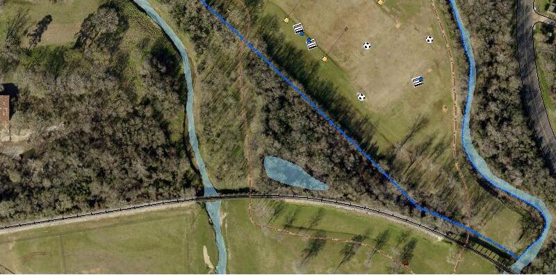
Trails can also link individual sites within a public park system, such as how Lanana Creek Trail in Nacogdoches connects Pecan Acres Park, Liberty Hall/El Camino Real (and nearby Eugenia Sterne Park and the Nacogdoches County Master Gardeners Demonstration Garden), Clint Dempsey Soccer Complex and Coy Simms Softball Complex—with links to other City parks along Banita Creek through the interconnection between the Lanana and Banita Creek trails in the Soccer Complex vicinity. City‐maintained trail systems are sometimes linked to and supplemented by other primary or auxiliary/loop trails maintained by other public or non‐profit entities (e.g., Stephen F. Austin State University in Nacogdoches).
Ideally, a City trail system might bring a majority of residents within at least one mile of a trail access point near their homes, and preferably less where side trails and direct links to neighborhoods eventually occur. As in Nacogdoches, some trail segments are so unique or attractive that they draw community‐wide, regional and tourist interest, especially when visible trailhead locations with parking are available. No set standard exists for trail length, but at least a one‐half mile segment begins to provide some continuity to build on over time. Likewise, there is no definitive standard for the quantity of public trail miles relative to a community’s population. As noted above, it is firstly a matter of available resources and then needs to reflect the level of community interest and likely use, proximity to population concentrations, and opportunities for both continuous linear stretches and loop trails. While the focus here is on recreational use, some trails and off‐street pathways also serve mobility needs and provide connectivity benefits (e.g., work commutes, links between neighborhoods, and access to school campuses, civic facilities and retail areas), especially if routed under or over busy streets.
Lanana Creek Trail
This mostly wooded trail parallels its namesake creek from E. Austin Street on the north to Martin Luther King Jr. Boulevard on the south, at Coy Simms Softball Complex. A northward extension toward N.E. Stallings Drive/Loop 224 exists in rough form and will be improved upon soon with grant support from the Texas Parks and Wildlife Department. Routing of the trail under multiple roadways has enhanced both trail continuity and user safety, including under the roadway bridges at E. Austin Street, E. College Street, E. Starr Avenue, Park Street and E. Main Street, as well as a path under the railroad between Clint Dempsey Soccer Complex and Coy Simms Softball Complex. Green‐painted crosswalks benefit trail users crossing Martinsville Street and Park Street (where an under‐bridge path is also available).
A brochure distributed by the Healthy Nacogdoches organization describes Lanana Creek Trail as “the fulfillment of a dream of Dr. Francis E. ‘Ab’ Abernathy, professor of English at Stephen F. Austin State University” (for whom a new City park near Banita Creek was also recently named). The trail, which traces historical footpaths, began as a U.S. Bicentennial project in 1976 and continued as a Texas Sesquicentennial project in 1986 and beyond. Volunteer efforts have been crucial to the ongoing

improvement of Lanana Creek Trail over the years, as well as the newer Banita Creek Trail, with support from service clubs and the City’s Parks and Recreation Department. Both trails offer almost instant escape from an urban environment into a near wilderness setting, even where close to busy City streets and commercial areas.
Much of the trail has unpaved “natural” surfaces while some segments feature wheel‐friendly paved surfaces, such as certain stretches through the Stephen F. Austin State University campus and related garden trail areas, and within portions of the City’s soccer and softball complexes. Drinking fountains and emergency phones are available at several locations along the trail. Restrooms are near the trail within Pecan Acres Park and Coy Simms Softball Complex. Off‐street parking is available at City park locations along the trail, as well as parking reserved for students and visitors on the Stephen F. Austin State University campus.
The map series on the next several pages illustrates the trail alignment and context, in segments from north to south.
Banita Creek Trail
The northern portion of the current Banita Creek Trail extends from near the western terminus of Ellington Street, adjacent to River Side Apartments, southward to the Nacogdoches Farmers Market site on the west side of Pearl Street at West Main Street. Most of this segment is unpaved “natural” surface through wooded areas on the east side of Banita Creek, except where the trail effectively becomes a winding concrete walking path through Banita Creek Park, from Powers Street to the Farmers Market. One gap exists in this trail segment, from just south of the new Ab’s Park to Powers Street, where the creek area is inaccessible behind private properties and structures. The northern, non‐park segment of Banita Creek Trail is most easily accessed from the west end of Rusk Street, where multiple parking spaces are available, and through the new Ab’s Park along Pearl Street.
Efforts are under way, by citizen trail advocates in coordination with City staff, to eliminate the current trail gap along the portion of Banita Creek between the Farmers Market and Festival Park. This segment traverses a very urban environment within Downtown Nacogdoches, including the Union Pacific rail yard area and related structures just west of the creek along Old Tyler Road, and then under the South Street bridge. The trail route picks up again along the south bank of Banita Creek through Festival Park, where signage directs trail users to follow a portion of Church Street north and then Mound Street east to the next trail segment that continues along the southern edge of Clint Dempsey Soccer Complex (now on the north side of Banita Creek). The trail eventually takes users under the railroad that runs between the soccer complex and Coy Simms Softball Complex, and the trail converges with the Lanana Creek Trail within the softball complex.
Users of the southern portion of Banita Creek Trail may park at Festival Park or the soccer or softball complexes, and the trail is also not far from Downtown streets and parking. Drinking fountains are in Festival Park and the softball co mplex, and Festival Park also has restrooms. Users of the trail segment north of E. Main Street can access restrooms and a drinking fountain at Banita Creek Park.
The map series on the next several pages illustrates the trail alignment and context, in segments from north to south.
Lanana Creek Trail (North)

Sources: Esri, HERE, DeLorme, Intermap, increment P Corp., GEBCO, USGS, FAO, NPS, NRCAN, GeoBase, IGN, Kadaster NL, Ordnance Survey, Esri Japan, METI, Esri China (Hong Kong), swisstopo, MapmyIndia, © OpenStreetMap contributors, and the GIS User Community
City of Nacogdoches, Texas Parks & Wildlife, Esri, HERE, Garmin, INCREMENT P, Intermap, USGS, METI/NASA, EPA, USDA | City of Nacogdoches
Lanana Creek Trail (North Central)
Sources: Esri, HERE, DeLorme, Intermap, increment P Corp., GEBCO, USGS, FAO, NPS, NRCAN, GeoBase, IGN, Kadaster NL, Ordnance Survey, Esri Japan, METI, Esri China (Hong Kong), swisstopo, MapmyIndia, © OpenStreetMap contributors, and the GIS User Community
City of Nacogdoches, Texas Parks & Wildlife, Esri, HERE, Garmin, INCREMENT P, Intermap, USGS, METI/NASA, EPA, USDA | City of Nacogdoches
Lanana Creek Trail (South Central)
Sources: Esri, HERE, DeLorme, Intermap, increment P Corp., GEBCO, USGS, FAO, NPS, NRCAN, GeoBase, IGN, Kadaster NL, Ordnance Survey, Esri Japan, METI, Esri China (Hong Kong), swisstopo, MapmyIndia, © OpenStreetMap contributors, and the GIS User Community
City of Nacogdoches, Texas Parks & Wildlife, Esri, HERE, Garmin, INCREMENT P, Intermap, USGS, METI/NASA, EPA, USDA | City of Nacogdoches
Lanana Creek Trail (South)
Sources: Esri, HERE, DeLorme, Intermap, increment P Corp., GEBCO, USGS, FAO, NPS, NRCAN, GeoBase, IGN, Kadaster NL, Ordnance Survey, Esri Japan, METI, Esri China (Hong Kong), swisstopo, MapmyIndia, © OpenStreetMap contributors, and the GIS User Community
City of Nacogdoches, Texas Parks & Wildlife, Esri, HERE, Garmin, INCREMENT P, Intermap, USGS, METI/NASA, EPA, USDA | City of Nacogdoches
Banita Creek Trail (North)

Sources: Esri, HERE, DeLorme, Intermap, increment P Corp., GEBCO, USGS, FAO, NPS, NRCAN, GeoBase, IGN, Kadaster NL, Ordnance Survey, Esri Japan, METI, Esri China (Hong Kong), swisstopo, MapmyIndia, © OpenStreetMap contributors, and the GIS User Community
City of Nacogdoches, Texas Parks & Wildlife, Esri, HERE, Garmin, INCREMENT P, Intermap, USGS, METI/NASA, EPA, USDA | City of Nacogdoches
Banita Creek Trail (Central)
Sources: Esri, HERE, DeLorme, Intermap, increment P Corp., GEBCO, USGS, FAO, NPS, NRCAN, GeoBase, IGN, Kadaster NL, Ordnance Survey, Esri Japan, METI, Esri China (Hong Kong), swisstopo, MapmyIndia, © OpenStreetMap contributors, and the GIS User Community
City of Nacogdoches, Texas Parks & Wildlife, Esri, HERE, Garmin, INCREMENT P, Intermap, USGS, METI/NASA, EPA, USDA | City of Nacogdoches
Banita Creek Trail (South)

Sources: Esri, HERE, DeLorme, Intermap, increment P Corp., GEBCO, USGS, FAO, NPS, NRCAN, GeoBase, IGN, Kadaster NL, Ordnance Survey, Esri Japan, METI, Esri China (Hong Kong), swisstopo, MapmyIndia, © OpenStreetMap contributors, and the GIS User Community
City of Nacogdoches, Texas Parks & Wildlife, Esri, HERE, Garmin, INCREMENT P, Intermap, USGS, METI/NASA, EPA, USDA | City of Nacogdoches
Other Community Recreation Assets
For purposes of this Master Plan, it is important to document other area recreation assets that are available to residents and visitors, and to consider these when evaluating where the City should focus its energies and resources in seeking to upgrade the City parks and recreation system. These other recreation options are available through other public entities, as well as non‐profit organizations and private commercial operations as itemized below.
Stephen F. Austin State University
SFA Gardens. A 128‐acre forest with miles of shaded trails for walking, hiking, running and biking. (The gardens border Lanana Creek as it runs through the campus of Stephen F. Austin State University.)
Mast Arboretum. The first arboretum at a university in Texas, this garden covers 10 acres and is along a portion of the Lanana Creek Trail. Dedicated to testing and promoting a diverse collection of plants for the landscape and nursery industry in the South, the arboretum has more than 7,500 different plants and features more than 20 theme gardens. (1924 Wilson Drive)
Pineywoods Native Plant Center. A 42‐acre garden with a mixture of uplands, mesic mid‐slopes and wet creek bottoms. The Tucker House serves as the central feature of the property, which is surrounded by two miles of accessibl e trails through a native bottomland hardwood forest and diverse gardens, including the Lady Bird Johnson Wildflower Demonstration Garden, which grows more than 100 species native to the East Texas Pineywoods, and the Healing Garden, a space for quiet reflection. (2900 Raguet Street)
Ruby M. Mize Azalea Garden. The largest azalea garden in Texas, on eight acres amid a loblolly pine forest, and the highlight of the Nacogdoches Azalea Trail. (Nacogdoches was named the first "Azalea City of America" by the Azalea Society of America in 2004 and was recertified in 2012.) The garden includes 1.25 miles of accessible trails, 50 benches and 46 planting beds with more than 550 varieties of rhododendron, 100 varieties of camellia, more than 200 varieties of hydrangea, Japanese maples and other unique collections. (2107 University Drive)
Kingham Children’s Garden. A Monarch Waystation garden with nectar and host plants surrounding a timber‐frame pavilion. (Near E. College Street and N. University Drive)
Gayla Mize Garden. Mix of Chinese fringe trees, deciduous hollies, deciduous azaleas, redbuds, dogwoods and camellias in a tall‐ canopied, informal setting. The garden features a seven‐course, stone labyrinth in addition to walking trails and benches. (1523 E. Starr Avenue)
Jimmy Hinds Park. This park‐like setting features a boardwalk through wetlands, wildflowers, a large muscadine grape variety trial, and curious tree circles planted in native bald cypress. (At the northern edge of the SFA Gardens along Austin Street)
Sprout Garden. SFA’s horticulture lab gardens, which include small farm‐production and commercial‐sized plots, as well as several raised beds. Used for research projects on sustainable vegetable production practices. (Adjacent to the SFA Agriculture building on Wilson Drive) SFA Recreational Trails and Gardens. More than eight miles of mountain bike trails through loblolly pine. Rated at difficult and expert by MTB Project, a website with information on mountain bike trails nationwide and in other countries. The SFA site may be accessed through the trailhead at University Drive and College Avenue, or users can pick up the trail in the northeast corner of the Gayla Mize Garden.
SFA Interpretive Trail. Two scenic trails covering three miles within the Angelina National Forest, where some 150 species of birds and 80 species of butterflies may be seen. (Along FM 2782, 6‐7 miles southwest from Loop 224)
SOURCES:
Nacogdoches Convention and Visitors Bureau, https://www.visitnacogdoches.org. Retrieved February 2, 2017.
Stephen F. Austin State University, http://www.sfasu.edu/. Retrieved February 2, 2017, and supplemented by additional and updated information from an SFA Gardens representative.
Nacogdoches ISD
Nacogdoches ISD has 12 school campuses, including six elementary and two middle schools and Nacogdoches High School, plus other specialty facilities. The campuses are generally accessible for public use of outdoor play and sports areas and other open spaces outside of school hours. One exception is the varsity football field and track area at Nacogdoches High School given the quality of surface and level of investment in maintaining this facility for official use. The e lementary campuses typically have one or more playgrounds and open grassy spaces, and sometimes benches or other outdoor seating. Thomas J.
Rusk Elementary near Downtown also has a basketball court and soccer field adjacent to it.
Mike Moses Middle School, on Park Street, has a large field area behind the school. McMichael Middle School, on S.E. Stallings Drive/Loop 224, has a lighted athletic field with bleachers and a track around the field. Along with the district football/track stadium, the Nacogdoches High School campus has quality lighted baseball and softball fields with bleachers, eight ligh ted tennis courts with bleachers, and multiple open field areas for practice use and non‐varsity sports.
SOURCE:
Nacogdoches Independent School District, http://www.nacisd.org/schools. Retrieved February 2, 2017.
Nacogdoches County
Lake Naconiche Park. A 692‐acre lake formed from Naconiche and Telesco creeks, with an adjoining 35‐acre park area. The lake opened in 2012 after 50 years of dreaming and planning for it. Features include swimming and diving areas, a boat ramp, fishing pier, and restrooms, as well as skiing and sailboat areas on the lake and adjacent lands where hunting is allowed. (Along County Road 137 just north of U.S. 59, 14 miles northeast of Nacogdoches)
SOURCES:
Nacogdoches Convention and Visitors Bureau, https://www.visitnacogdoches.org. Retrieved February 2, 2017.
Nacogdoches County, http://www.co.nacogdoches.tx.us/. Retrieved February 2, 2017.
Non‐Profit Facilities
Nacogdoches Boys and Girls Club. Recreational and other activities, focused on character and leadership development, provided through after‐school and school holiday programming for children and youth enrolled in first grade through age 18. Activities include arts and crafts, boxing, team sports, archery, tutoring, low organized games, educational classes, special interest groups, special trips, camping and more. (2712 Park Street)
Nacogdoches County Master Gardeners Club Demonstration Garden. A 7.3 acre tract on the site of the old Aqua Vitae Park that includes a butterfly garden, a Good Bug Garden, a bulb garden, a vegetable garden, a Memory Walk surrounded by roses, azalea and camellia beds and several varieties of bald cypress, maple, oak, sycamore and crape myrtles. Also a rainwater collection system, multiple benches and a gazebo. (Southwest corner of E. Main Street and University Drive)
Also numerous other local garden sites featured on the Garden Capital of Texas portion of the Nacogdoches Convention and Visitors Bureau website and other local websites.
SOURCES:
City of Nacogdoches, http://www.ci.nacogdoches.tx.us/index.aspx?NID=1066. Retrieved February 2, 2017. Nacogdoches Convention and Visitors Bureau, https://www.visitnacogdoches.org. Retrieved February 2, 2017.
Private Facilities
Meadow Ridge Archery and Gun Range. An indoor 3D archery and pistol range. Meadow Ridge also offers classes, training and rentals (1090 County Road 231)
North Forest Putting Course. An 18‐hole miniature golf course, open seasonally. (3505 North Street) Piney Woods Country Club. A private club that celebrated 90 years in 2016, with golf, swimming pool and other recreational offerings for members. (3001 U.S. 59)
Roselake Ranch. Guided horseback riding on wooded, open meadow and creekside routes. (312 Roselake Drive)
Skate‐O‐Rama. Indoor rolling skating rink. (1208 Douglass Road)
Splash Kingdom Water Park. Family‐oriented water park open seasonally. (401 N. University Drive) Texas Pro Bowl Bowling Center. Bowling lanes. (3800 North Street) Woodland Hills Golf Club. An 18‐hole course designed by Don January and opened in 1971, with natural rolling hills and tree‐lined fairways. (359 County Road 5021)
Zip Nac / Zip Camp. Zip lining in a forest setting on dual tandem 900‐foot lines, along with a sky bridge amid the trees. Also primitive camping opportunities on 60 acres, including 40 acres of pine forest with hiking trails and a catch‐and‐release fishing pond. (199 Brother John Road)
SOURCES:
Nacogdoches Convention and Visitors Bureau, https://www.visitnacogdoches.org. Retrieved February 2, 2017. Piney Woods Country Club, pineywoodscountryclub.com. Retrieved February 2, 2017. Splash Kingdom Water Park, http://www.splashkingdomwaterpark.com/nacogdoches/. Retrieved February 2, 2017.
Needs Assessment
Nacogdoches Parks, Recreation and Trails Master Plan
This Master Plan section provides an updated assessment of current and future needs in Nacogdoches related to parks, trails, recreation areas and related facilities. This assessment is an essential input to the next step of defining specific potential projects and improvements to address the identified needs, as well as for prioritizing candidate projects based on factors such as cost/benefit, complexity, availability of partners, and potential infusions of grant dollars or other external funding.
The needs assessment in this section combines two approaches—one based on national and localized parkland acreage and facility standards and another focused on user interest in and demand for specific facility types, from community input during the plan update process.
Quantity of Parkland
Needs assessment begins with consideration of benchmarks for park acreage relative to population. This is followed by consideration of the geographic coverage of park service areas given where various types of parks are currently located across the community.
Nacogdoches Population Outlook
As noted in the Introduction section of this plan, Nacogdoches had an estimated population of just under 34,000 residents in 2015‐16 according to the newest available federal and state estimates. This indicated a population increase of roughly 2,000 additional residents since the Census 2010 count of 32,996. This also represented growth from just under 30,000 residents at Census 2000, several years before the City’s previous Parks Master Plan in 2003.
At that time in 2003, it was projected that Nacogdoches would have up to 34,000 residents 20 years later. So, the community appears to be approaching this population threshold already, roughly 15 years into the 20‐year timeframe. The City’s Comprehensive Plan of 2003 also highlighted that the population of Nacogdoches relative to the county‐wide total had been steadily declining for three decades, from a high point of 62 percent in 1970 to 58 percent in 1980, 56.4 percent in 1990, and 50.5 percent by 2000.
However, at Census 2010, the City population share had increased to 51.1 percent, and it was 51.9 percent by 2015 based on the newest City and Nacogdoches County population estimates.
The City‐County population link is important as one way for projecting future City population, known as the “step‐down method.” If Nacogdoches were to maintain an appr oximate 52 percent share of the County population in the years ahead, then the potential City p opulation in 2040 would be just over 45,800. This is based on a projected 2040 population of 88,150 in Nacogdoches County from the Texas Demographic Center, the state‐level affiliate of the U.S. Census Bureau. The County projection reflects the Center’s middle‐ground growth scenario for Texas and its counties from among three scenarios the Center uses. The scenarios make certain assumptions about birth and death rates and especially potential variation in net migration (incoming versus outgoing population). The Center recommends using its middle “0.5” scenario in most cases.
The Texas Water Development Board is another beneficial resource for population considerations. In support of its water supply planning mandate, the Board periodically releases updated statewide, regional and community‐level population projections. The newest projections are for 2020 through 2070. Interestingly, the Board’s 2040 projection for Nacogdoches—45,930—is very close to the step‐down result above, which was 45,838.
Population Implications for Park Acreage Needs
The City’s 2003 Park Master Plan applied a benchmark of 5‐6 acres of parkland per 1,000 residents, which is common for various Texas cities. However, the plan also noted that Nacogdoches would prefer to attain an even higher standard of 10‐12 acres per 1,000 as some Texas communities strive for.
Assuming that Nacogdoches will be approaching 46,000 residents by 2040, the numbers in Table 5.1, Park Acreage Need Based on Varying Population‐Based Standard, show the range of developed parkland quantities the City should have in its inventory at that point depending on the per‐1,000 standard that is applied. The table also shows the standard‐based acreage amounts relative to the City’s current parkland quantity of 301.3 developed acres and an estimated 2015 population of 34,000.
TABLE 5.1: Park Acreage Need Based on Varying Population‐Based Standard Developed 5 Acres per 6 Acres per 10 Acres per 12 Acres per Population Acres in 2017 1,000 Residents 1,000 Residents 1,000 Residents 1,000 Residents 34,000 (2015) 301.3 acres 170 acres 204 acres 340 acres 408 acres 46,000 (2040) ‐‐ 230 acres 276 acres 460 acres 552 acres
Regarding the 2015 quantities, the midpoint of the range from 170 acres to 408 acres is 289. This means the current inventory of 301.3 acres is above the midpoint, at the 55th percentile within the target acreage range. Interestingly, the midpoint of the 2040 range, from 230 to 552 acres based on 46,000 residents, is 391 acres. This is exactly the total park acreage the City currently has when counting the entire 100 acres at the SportsPlex, including 90 undeveloped acres there. To maintain at least the same 55th percentile within the 2040 target range, the City would need to add 100 developed acres to reach a new inventory total of 401 acres.
Into the future as today, the City’s own public park offerings will continue to be supplemented by the presence of public trails like the Banita Creek and Lanana Creek Trails, plus Nacogdoches ISD (NISD) school campuses and the amenities, gardens and trails associated with Stephen F. Austin State University (SFA) which local residents are able to enjoy.
Geographic Coverage
Along with the parkland acreage considerations in the previous section, a geographic evaluation is also essential to determine how well the existing and future park system will serve the community’s residents. Park sites should be distributed across the City’s jurisdiction and located strategically so they are conveniently accessible to all populated areas. While a City’s park inventory may have plenty of land from an acreage standpoint, a service area evaluation illustrates whether there is sufficient geographic coverage and where new or enlarged parks are needed to address any under‐served areas.
The service area evaluation involves drawing a service area buffer around each Mini/Pocket, Neighborhood and Community park site. The larger the park, the larger the associated service area. A 1/4‐mile primary service area is applied to each Mini/Pocket park. Each Neighborhood park has a 1/2‐mile primary service area, and each Community park a two‐mile primary service area.
Taken together, the two‐mile service areas of all Community parks should encompass nearly all existing neighborhoods and areas planned for future residential development. Neighborhood parks usually have more targeted locations to serve particular residential developments and other population concentrations. However, they should still have a relatively even distribution across the community to
NEEDS ASSESSMENT (ADOPTED 10.17.17) | Page 2 of 14
ensure that most all residents can enjoy basic park amenities in fairly close proximity to home. In areas where population is more dispersed, a well‐located Community park also helps to fulfill the Neighborhood park function.
Findings from Service Area Evaluation
Displayed in Figure 5.1, Existing Park Service Areas, is the geographic coverage provided by the City’s current inventory of public parks. Associated observations include:
The City’s six Community level parks, shown in dark green, provide good coverage of most of the current populated areas in Nacogdoches through their two‐mile service areas.
As a community that has focused more on Community level parks as it has grown, Nacogdoches’ three current Neighborhood parks, shown in orange, serve their immediate 1/2‐mile vicinities in the north (Lakeside), west (Ritchie Street) and southeast (McCrimmon) areas of the city.
Likewise, four current Mini/Pocket parks, shown in yellow, serve mainly some core areas of the city with their 1/4‐mile service areas.
While residential areas in north central Nacogdoches have no nearby Neighborhood or Mini/Pocket parks, they benefit most directly from SFA campus a menities and trails, as well as Lanana Creek Trail and several Community level parks.
Playgrounds and open fields on various NISD school campuses supplement the current assortment of City‐maintained parks across the community.
Future annexation activity by the City and/or significant residential development beyond current populated areas will require further consideration of the existing service area coverages to plan for appropriate geographic adjustments in the City’s provision of parks and recreation services.

FIGURE 5.1: Existing Park Service Areas


SOURCE: Kendig Keast Collaborative
NEEDS ASSESSMENT (ADOPTED 10.17.17) | Page 4 of 14
Community Input to Needs Assessment
This element of the needs assessment phase incorporates the perspectives and opinions of Nacogdoches residents who are users of local parks, trails and other recreational facilities and programming. Even if not frequent users, due to age or other factors, some citizens generally value this aspect of municipal services and have certain expectations for what types and levels of parks and recreation service should be available to residents, as well as for visitors to the community.
Needs and Wants
According to the Merriam‐Webster Online Dictionary, a “need” is defined as “something that a person must have; something that is needed in order to live or succeed or be happy.” Meanwhile, a “want” is defined as “something that is desired or needed.” Clearly, there is some overlap between these definitions, but the “must have” aspect of a need is one way to distinguish from the “wish list” nature of a want.
A principal responsibility of local government is to promote public health, safety and welfare. To the extent that park sites and recreational facilities are maintained in good condition, then examples of public safety issues that may arise include when a piece of playground equipment needs repair, when a trail segment needs shoring up after a flooding episode to prevent any erosion‐related hazards to trail users, or when the police department is made aware of and takes steps to alleviate a security concern at a particular public location.
With regard to public health, a core function of local parks and recreation systems is to promote physical fitness, enable residents of all ages to play and enjoy leisure time outdoors, and provide opportunities for both youth and adults to participate in sports and other “active” recreational pursuits. Access to public parks and preserved natural areas within cities has always had a mental health component as well, especially in providing “passive” recreation options as a respite from hectic lives, busy streets and other characteristics of an urban environment.
Public welfare is a broader concept that builds on health and safety to include the general livability and attractiveness of a community. This is also where local parks, trails and sports facilities can contribute to the economic success of a city, as appealing “quality of life” elements and as another driver of tourism and visitation, including the spending and revenues that come with hosting sports tournaments locally.
Gauging Public Sentiment
The appendix to this plan titled Public Involvement Summary documents input obtained through:
A community meeting, during October 2016, as part of the City’s ongoing Discussion Series, that focused on the upcoming Master Plan update.
Individual meetings early on with key stakeholder groups, inclu ding leaders of local baseball, softball and soccer associations; trails advocates and enthusiasts; and leaders of the Parks Advocacy League (PAL).
A series of meetings, through the fall and spring, with an informal group of stakeholders and representatives of other partner organizations.
A public open house event, in May 2017, to highlight the latest status and direction of the Master Plan update process and to seek further input on potential action items to be highlighted within the plan.
As a supplement to the Discussion Series public meeting, the City posted an online survey with many of the same questions that were included on a questionnaire completed by meeting attendees. The survey was available on the City website through November and drew 183 responses. Below are the results from several basic survey questions (the full survey results are on file with City staff):
Top Priorities for Parks?

Top Priorities for Trails?

Use Parks/Trails to:
(1) Preserve Environmental Resources (left chart)?
(2) Promote History Awareness?


Ever Go to School Campuses for Recreation?

The Public Involvement Summary captures various requests and ideas from Nacogdoches residents about what is needed to enhance the City’s parks and recreation system, along with compilations of other desires and expectations for the future. Some of this input would translate to the City doing more of some things it already does (e.g., continued demand for more youth/adult sports programming), less of other things (e.g., repurposing of tennis courts that are less used than in the past), and some entirely new things (e.g., adding a naturalistic “challenge” playscape somewhere within the park system). Below is a combined and wide‐ranging list of needs and wants identified through community input, recognizing that the distinction between a “need” and a “want” varies from person to person depending on their background, affiliations and interests.
Accessibility improvements to parks, trails and areas around sports fields for better accommodation of disabled residents and visitors.
Amphitheater.
Beautification plantings (flowers, trees), and use of low‐maintenance landscape options (including edible).
Bike racks with creative designs.
Butterfly waystation.
Children’s garden/park with creative use of space and play activities.
Community gardens.
Disc golf improvements (concrete tee pads, better informational/navigation signage).
Dog park enhancements (separate areas by size of dogs).
Drinking fountains (more).
Event venue at Goodman Bridge in Pecan Acres Park.
Family‐oriented activities and programming (including low‐cost options).
Fencing where needed around certain activity areas (e.g., playgrounds, spray stations, basketball courts, etc.).
Fountain(s) (aesthetic water features versus drinking fountains).
Geocaching (better information and spots).
Giant chess/checkers games, including downtown.
Lighting (of more sports fields).
On‐/off‐street improvements that would promote a more bikeable and walkable city.
Outdoor theater for live music and movies, plays, etc.
Parking (Baseball Complex).
Pavilions (updated).
Playscapes designed for adults and seniors, to provide more outdoor exercise opportunities.
Playscapes with creative designs/elements and sensory learning features.
Playscapes with naturalistic designs (water features, rocks, etc.).
“Pocket prairie” installations and other special landscape plantings and garden areas.
Public art.
Rails to Trails.
Restrooms (more, better, safer).
Riparian restoration on Banita Creek and other park creeks.
Sand and water play area.
School play/field areas (greater informal public use beyond school hours).
Seating (more for girls’ softball).
Shade features (trees/vegetation or structural).
Shooting range (in an appropriate and safe location).
Skate park.
Skate/bike park.
Smoke/tobacco‐free parks.
Softball complex (new), which would enable conversion of the Pe te Smith Athletic Complex fields to additional baseball fields and conversion of the Coy Simms Complex fields to additional soccer fields, thereby benefitting and expanding all three sports programs.
Spray/splash pads, especially with interactive features.
Swimming pool with deep end and wading area.
Trailhead locations (parking, restrooms, drinking fountains, etc.).
Trail continuity/extensions.
Trail enhancements (e.g., mileage markers, benches, interpretive/educational signage, stretching/exercise stations, etc.).
Trail loop(s).
Trails designed for multi‐use (wide enough for both hikers and bikers).
Trails left in a more natural state.
Trash receptacles (more, plus for recyclables).
Tree house.
Trees (more).
Under‐utilized facilities (transition to new uses, such as tenn is courts at Maroney Park).
Unofficial fields (more for practices with backstops, informal sports play, random use).
Water park (municipal versus private).
Wi‐Fi and device charging kiosks (solar‐powered).
The final Implementation section of this Master Plan identifies near‐ and longer‐term action priorities based on this Needs Assessment section, and after weighing various factors that drive priority setting.
Trail Network Needs
Standards and benchmarks for municipal park systems are more prevalent than for public trails. Generally, trails can put another form of recreational asset within reach of populations that may not have a park nearby. Trails are most accessible for convenient and frequent use when they are within one‐quarter to one‐half mile of neighborhoods (and other population concentrations), and depending on their route and design, can serve a linear park function for those in close proximity.
Along with the universal need to improve accessibility to trails and other recreational sites for disabled persons, the compilation of needs in the previous section included the following items specifically related to trails:
Trailhead locations (parking, restrooms, drinking fountains, etc.).
Trail continuity/extensions.
Trail enhancements (e.g., mileage markers, benches, interpretive/educational signage, stretching/exercise stations, etc.).
Trail loop(s).
Trails designed for multi‐use (wide enough for both hikers and bikers).
Trails left in a more natural state.
The Public Involvement Summary appendix includes further background from a meeting in October 2016 with a local Trails Committee comprised of trails advocates and enthusiasts. From all of this input and discussion that focused on trail needs and aspirations, a series of potential steps was identified as depicted in Figure 5.2, Trail Network Potential.
Sports Facility Needs
As with the trails focus above, the earlier compilation of needs included various items specifically related to sports facilities:
Accessibility improvements to areas around sports fields for better accommodation of disabled residents and visitors.
Lighting (of more sports fields).
Parking (Baseball Complex).
Restrooms (more, better, safer).
Seating (more for girls’ softball).
FIGURE 5.2: Trail Network Potential


STEP 1: Connect existing Banita Creek Trail through the Union Pacific rail yard area on the west side of Downtown, from Banita Creek Park to Festival Park.

STEP 2: Direct Banita Creek Trail users along Pearl and Ruby Streets, between Ab’s Park and Banita Creek Park, due to an inaccessible portion of the creek.

STEP 3: Extend Lanana Creek Trail southward from the Coy Simms Softball Complex, at MLK Jr. Boulevard, to Loop 224 / SE Stallings Drive.

STEP 4: Extend Banita Creek Trail northward to the vicinity of Creek Bend Boulevard.

STEP 5: Eventually “close the loop” on the north side while avoiding at‐grade crossings of major roadways.
SOURCE: Kendig Keast Collaborative
NEEDS ASSESSMENT (ADOPTED 10.17.17) | Page 10 of 14
Unofficial fields (more for practices with backstops, informal sports play, random use).
The Public Involvement Summary appendix includes further background from a meeting in October 2016 with leaders of the local baseball, softball and soccer associa tions. From all of this input and discussion that focused on sports facility needs and aspirations, a dominoes analogy was used to describe a series of potential steps as depicted in Figure 5.3, Sports Facility Enhancements Scenario
FIGURE 5.3: Sports Facility Enhancements Scenario
New softball facility enables conversion of current fields at Pete Smith Athletic Complex for Baseball Complex expansion.


Discontinued use for softball enables conversion of Coy Simms Complex to soccer fields (a good use of flood‐ prone land).


Added soccer fields at former softball facility results in expanded Clint Dempsey Soccer Complex, linked by two Creek trails.


Rehabilitated existing soccer fields at SportsPlex continue to be reserved and maintained at a higher level for league play.


Sports Facility Observations
As part of the Needs Assessment portion of the master plan update process, project consultant Kendig Keast Collaborative was assisted by subconsultant Sports Design Group (SDG) of McKinney, Texas. SDG focuses especially on sports facility design and ongoing maintenance and management for school districts, municipalities and other public and private clients in Texas and elsewhere. In February 2017, SDG personnel completed a tour of the City’s sports facilities and related discussions with City staff and sports association representatives. Among the many topics covered through this interaction, this led to the following observations on current conditions and future possibilities relevant to the sports facility portion of this master plan:
Field Conditions. Visual inspection of representative softball, baseball and socc er fields indicated subpar condition of some surfaces from a combination of over‐use and inadequate care. If the City wants to improve upon this, to satisfy the expectations of its sports user groups and to make the fields more attractive to visitors, then it needs to pursue some or all of the next four items regarding basic maintenance protocol, staff training and support, partnerships, and targeted efforts. Also, adding lighting enhances the usability of existi ng fields, but extended hours of use and even greater wear and tear can take conditions beyond a point of no return, in maintenance terms (with City staff pointing out that the soccer fields at the SportsPlex were removed from use for two years to recover from intensive use).
Basic Maintenance. Basic field maintenance regimens need to be enhanced, which is partly a function of staffing levels and the extent of their overall parks/recreation maintenance responsibilities. City staff noted that the Clint Dempsey Soccer Complex fields and the adult softball fields at the Baseball Complex received only minimal turf care in past years, and that Soccer Association volunteers were mostly mowing their own fields until recently.
Enhanced Capabilities. City maintenance personnel—and potentially interested sports association volunteers as well—should receive advanced training, especially from instructors experienced in sports turf care and athletic grounds keeping relative to general parks maintenance. This would be a wise investment by the City and its partners to get a better return on the time and effort already devoted to sports facility maintenance. The instructors can also provide support by conducting audits of existing equipment, collecting samples of irrigation water for analysis, and coordinating with the City’s field maintenance contractor, especially as the same company is used by both the City and SFA. A more systematic maintenance program can also be established, addressing the types and frequency of methods used (e.g., field surface aeration,
NEEDS ASSESSMENT (ADOPTED 10.17.17) | Page 12 of 14
Tapping into SFA Expertise. Nacogdoches has the combination of a local university with programs and expertise in soil science, horticulture and related specialties, plus sports programs with a level of field maintenance and care that is visually evident, including in the quality of even intramural soccer fields on campus. Recognizing the history of facility sharing and maintenance agreements between the City and SFA, this partnership still offers the best potential for upgrading the quality of the City’s fields at the Baseball Complex—and lessons learned there could be applied at other sports venues. There is a clear visual difference between the quality of SFA’s self‐maintained fields relative to the City‐maintained fields. Dollars and capabilities are clearly behind this difference (along with overseeding). But visual inspection of the site also confirms there is no significant difference in physical factors (i.e., same soil, irrigation water, general environment) to explain the quality variation. Therefore, the City should continue to pursue opportunities to partner more extensively with SFA on cost‐, equipment‐ and knowledge‐sharing as the SFA fields reflect a higher level of maintenance investment, methods and frequency of care. Similar opportunities likely exist with NISD judging from the quality of the varsity football, baseball and softball fields at the high school campus. Various Texas universities and athletics officials at other levels are also active with the Sports Turf Managers Association, which is an excellent resource for information, conferences, and networking with those in similar situations.
Focus on Fewer Fields. One scenario when implementing new techniques and faced with limited resources is to focus on a pilot field to experiment, quantify labor inputs and other costs, and monitor results of the maintenance activities undertaken. This can be a good opportunity for University intern support as well. For a baseball pilot, one of the City fields nearest to the SFA baseball and/or softball fields could be used to facilitate interaction between City and SFA personnel and potential coordinated maintenance activities and equipment sharing (with the City and/or baseball association paying for more of the same maintenance inputs used on the SFA fields). Certain fields at the various facilities can also be treated as signature fields and receive an enhanced level of maintenance relative to standard fields. The same fields should be first in line for enhanced amenities as well, such as shade structures over bleachers, improved restrooms and concessions, etc.
Small Steps. Where challenges are large (e.g., site drainage, parking) and resources are limited, small, supplemental “fixes” need to be prioritized and implemented. Especially if the existing condition of numerous fields within a floodplain area is not go ing to change, such as at the Clint Dempsey Soccer Complex. Maintenance priorities also need to be triaged continually. Partnerships and coordinated efforts are even more important in such circumstances, such as aligning the timing of sports field aeration between the City, university and school district in a potential labor‐ and equipment‐sharing arrangement.
Pros/Cons of Sports Fields in Flood‐Prone Areas. Because of where the Clint Dempsey Soccer Complex is located, between Lanana and Banita creeks and near their confluence, the City must devote extra resources to cleaning up fields and removing rocks, mud and other debris from driving, parking and walking areas after significant rainfall events that result in high water. This adds to the challenge of ongoing and overall parks and recreation system maintenance given the limited funding the City has historically allocated to capital investment in and maintenance of its sports facilities, looking to the individual sports association s to raise funds and garner sponsorships as the main facility users. Soccer fields are a relatively good public use for a flood‐prone site, but the periodic post‐flooding maintenance burden i s the associated trade‐off. The
NEEDS ASSESSMENT (ADOPTED 10.17.17) | Page 13 of 14 asset inventories), along with the timing of periodic inspectio ns to gauge progress and identify issues, and follow‐up activities to achieve the intended results. The instructors can provide ongoing remote support beyond the training phase and during implementation.
conversion of the Coy Simms Softball Complex to additional soccer fields, as envisioned in this master plan, would be a highly beneficial and positive step as softball fields are even more difficult and costly to restore after flooding, and the existing fences around the softball fields would be removed as part of the change to a soccer configuration. Planning and design of better drainage provisions and ongoing storm water management must also be factored into any plans for adding more fields or parking to the Soccer Complex.
Synthetic Fields Option. Synthetic fields are seen at various sports complexes across Texas as they enable all‐weather play (i.e., quicker drainage and readiness for use after storms), provide relief for heavily‐used grass fields, and their higher up‐front installation cost is offset by reduced field maintenance costs over time. Some large facilities are designed to where field and fence/backstop configurations are easily and quickly changed for multi‐sport use of the same synthetic surfaces, although grass fields are often preferred for baseball. Another design variation is synthetic infields and grass outfields. Synthetic fields are not appropriate in fl ood‐prone areas, which is an important consideration given the location of some sport facili ties in Nacogdoches.
Do it Right, or Don’t Do It. The City and its partners should pursue a new sports facility only if there will be adequate resources for an effective design (e.g., to manage drainage appropriately) and a sustained commitment to proper maintenance and “taking ca re of the basics.” A new softball complex should also be designed with a better configur ation that reduces walking distances between parking areas and fields/seating, improves vehicular circulation and parking management, and enhances on‐site circulation of users between activity areas. Nacogdoches also needs to achieve a higher level of basic amenities at its facilities (e.g., restrooms, drinking fountains, shade over seating areas, etc.).
Priorities and Implementation Nacogdoches Parks, Recreation and Trails Master Plan
This final Master Plan section lays out an action agenda for expanding, improving and enhancing the City’s system of parks and recreation facilities, trails and sports complexes. This agenda follows from all the previous sections of this plan that considered the local characteristics and context of Nacogdoches, its demographic trends and population growth outlook, local goals and standards for provision of public parks and recreation opportunities, the current inventory of available sites and facilities, and needs identified for the system based on both planning analysis as well as public input.
The agenda is presented in Table 6.1, Project Priorities and Implementation Considerations, which includes the following information:
What is the relative priority of each project? In accordance with Texas Parks and Wildlife Department guidance for local master plans, five highest‐priority projects to pursue in the near term (Years 1‐5) are listed first in Table 6.1. These and all other projects are also presented in a potential chronological order, including other “early win” projects in Years 1‐5 and projects beyond the initial five‐year implementation focus that could occur in the mid term (Years 6‐10) or long term (beyond 10 years).
What type of project is it? This Master Plan update has focused on outdoor recreation needs and opportunities, which is the first type of project categorization (Outdoor/Indoor). Then, projects are classified as involving entirely new improvements, some form of enhancement of existing sites, or more significant renovation or redevelopment of current facilities. The Texas Parks and Wildlife Department defines “renovation” as “work on existing facilities to completely renew, update, or modernize such facilities so the finished product will meet present‐day standards and be comparable with newly constructed similar facilities.” Projects classified as “redevelopment” go even further as they involve “the removal of obsolete facilities and construction of new ones.”
What are key considerations for each project? Such considerations involve reasons a project is needed, potential benefits that justify for its relative ranking, and other factors that may make implementation easier or more difficult compared to other projects.
What are potential resources for accomplishing the project, both financial and otherwise?
This column in Table 6.1 identifies typical funding sources as highlighted by the Texas Parks and Wildlife Department, including City funds (some possibly generated through a bond program), in‐kind labor and other forms on non‐monetary support, grant opportunities (whether from state and federal agencies, foundations or other non‐profit entities), and sponsorships and donations (whether from large or small businesses, partner organizations or individual philanthropic donations).
Who are potential partners to lead, cost‐share or otherwise assist the City in advancing a specific project? Partnership possibilities can come in all forms, so the ones listed in Table 6.1 are often the most obvious but should be only a starting point for project implementation efforts.
What is the potential project cost? Table 6.1 includes planning‐level cost estimates at this early stage, pending more details on project design and other specific cost factors. The low end of each cost range reflects if a project were pursued initially without certain enhancements.
The year cited for each project in Table 6.1 indicates when the project would potentially be initiated, where preliminary steps have not already begun (e.g., efforts already under way to accomplish a new spray station at Maroney Park). Steps that start a project in motion can include preliminary design, budgeting, grant applications and other fundraising, new and renewed partnerships, etc. Some relatively inexpensive and “low hanging fruit” projects can be completed relatively quickly while others will require multiple years of determined effort before a ribbon cutting can be scheduled.
#2
TABLE 6.1: Project Priorities and Implementation Considerations
A new softball complex would also benefit baseball and soccer by enabling conversion of existing softball fields at the Pete Smith Athletic Complex to additional baseball fields and conversion of the Coy Simms Complex softball fields to additional soccer fields.
Extent of youth and adult participation in all three major sports, and the opportunity to expand service capacity and gain better facilities in the process.
With better facilities, including concessions, softball would be able to generate more financial resources to support its own operations and maintenance expenses, as well as funds for future facility upgrades and improvements.
Better positioning of Nacogdoches to host tourism‐ and revenue‐generating softball tournaments, which also draws families to the community as visitors.
Potential siting and land acquisition options already explored. Intend to start with basics (i.e., fields, concessions, parking) and enhance over time (e.g., RV area).
A second municipal‐operated spray station on the north side to complement an existing south side spray station at Temple Park.
Good location in a popular Community level park.
Investment in a water‐oriented recreation facility in place of a municipal pool and as a public amenity to complement the Lehmann Swim Center at the Boys & Girls Club and a private water park in the city.
Extent of interest expressed through public input, interested constituency of likely users.
Benefits to small children and youth, and a family‐oriented activity.
City funds (potential bond project)
Association support and in‐kind volunteer labor
Sponsors / donors
Nacogdoches Youth Softball Association
Adult Softball partners and participants
Nacogdoches ISD (Lady Dragons softball program)
Stephen F. Austin State University (Ladyjacks softball program)
Regional/State/National youth softball organizations (e.g., USA Softball of Texas, District 38)
Nacogdoches Convention & Visitors Bureau (Sports Committee)
$2.8 ‐ $3.6 million
Which assumes:
8 new fields with lighting
Parking for nearly 400 vehicles
Restroom and concessions facilities
Design and contingency costs
City design support
City labor and maintenance support
Sponsors / donors
Parks Advocacy League (PAL)
$500,000 ‐ $675,000
Which assumes:
Splash pad installation
Restroom facility
Tables and shade structures
Water and sewer service line replacements
Paving
Design and contingency costs #3
Outdoor Expand Renovate Soccer Complex Expansion
A new softball complex would enable conversion of the existing Coy Simms Softball Complex to additional soccer fields as a southward expansion of the adjacent Clint Dempsey Soccer Complex.
Additional lighted fields and practice fields would also benefit youth soccer.
Extent of participation in youth soccer, and the opportunity to expand service capacity.
City funds (potential bond project)
Association support and in‐kind volunteer labor
Sponsors / donors
Nacogdoches Youth Soccer Association
Nacogdoches ISD (Dragons and Lady Dragons boys/girls soccer programs)
Stephen F. Austin State University (Lumberjacks and Ladyjacks men’s/ women’s soccer programs; Little Kickers program)
Regional/State/National youth soccer organizations (e.g., North Texas Soccer, US Youth Soccer)
Nacogdoches C&VB (Sports Committee)
$1 ‐ $1.35 million Which assumes:
Demolition of existing softball fields
Re‐grading / earthwork
6 new turf soccer fields
High mast lighting
Parking lot resurface
Design and contingency costs
New Enhance Naturalistic Playscape
Interest in a non‐traditional playground design, with challenge, creative and sensory elements.
Potential development within an existing City park as a signature feature for community‐wide use— but the chosen park must have adequate parking to accommodate likely high level of interest and use.
Extent of interest expressed through public input, interested constituency of likely users.
Benefits to small children and youth, including those with special needs, and a family‐oriented activity.
City funds and labor
In‐kind volunteer labor
Sponsors / donors
#5 Year 5 Outdoor Expand Renovate Baseball Complex Expansion
A new softball complex would enable conversion of existing softball fields at the Pete Smith Athletic Complex to additional baseball fields for the Baseball Complex.
Extent of participation in boys’ baseball, and the opportunity to expand service capacity.
Additional parking is also a priority for the Baseball Complex.
Year 1 Outdoor New Enhance Lanana Creek Trail South Extension Relative ease of extension along linear route adjacent to Lanana Creek that is already largely owned and maintained by City, from Martin Luther King Jr. Boulevard south to Loop 224/SE Stallings Drive.
Enhanced access to current Coy Simms Softball Complex (and potential expanded Clint Dempsey Soccer Complex) from south side of city.
Further extension of a north‐south, continuous off‐street path (via both the Lanana and Banita Creek trails) for walkers, joggers and cyclists primarily interested in covering long distances.
Year 1 Outdoor Enhance Dog Park Upgrades Continue to build on this popular park system feature.
Along with expanding the square footage of the current dog park, consider other improvements such as seating within the dog run areas and installation of dog agility equipment.
City funds (potential bond project)
Association support and in‐kind volunteer labor
Sponsors / donors
Parks Advocacy League (PAL)
Healthy Nacogdoches Coalition
Nacogdoches Historical Foundation if designed with a historical theme and elements
Local environmental organizations (e.g., Resilient Nacogdoches, Pineywoods Audubon Society)
$250,000 ‐ $325,000 Which assumes:
Playscape hardware and features installation
Hardscape improvements (walkways, paving, etc.)
Design and contingency costs
Nacogdoches Boys Youth Baseball Association
Nacogdoches ISD (Dragons baseball program)
Stephen F. Austin State University (Lumberjacks baseball program)
Regional/State/National youth baseball organizations (e.g., Dixie Youth Baseball)
Nacogdoches Convention & Visitors Bureau (Sports Committee)
City funds and labor
In‐kind volunteer labor
Sponsors / donors
Trails Committee
Nacogdoches Running Club
Nacogdoches Endurance Training (NET)
Nacogdoches Bicycle Club
Healthy Nacogdoches Coalition
$30,000 ‐ $60,000 Which assumes:
Conversion of existing softball fields to meet baseball standards
Contingency costs
Year 1+ (Ongoing) Outdoor New Enhance Public Art in Parks Initiative
Advance local cultural, community image and beautification goals through the City parks system, as well as providing another passive recreation option.
Interest in “climbable,” interactive art pieces to maintain the play aspect for children while making art more approachable for all demographics.
Ongoing focus and track record of tangible results in Nacogdoches (e.g., Statue Trail).
Excellent partnership and donor possibilities.
City funds and labor
In‐kind volunteer labor
Sponsors / donors
City labor and maintenance support
Hotel Occupancy Tax funds (potential for visitor‐focused informational materials)
In‐kind volunteer labor
Grants
Sponsors / donors
Dog Park user community
Nacogdoches Convention & Visitors Bureau
Keep Nacogdoches Beautiful
Stephen F. Austin State University
$100,000 ‐ $140,000
Which assumes:
Land or easement acquisition (1,900 linear feet)
Gravel trail construction (5,700 linear feet)
Creek crossings
Design and contingency costs
$15,000 ‐ $20,000
Which assumes:
Relatively basic upgrades as described
$100,000 ‐ $240,000
Which assumes:
Donated art exhibits
Hardscape improvements at exhibit sites (e.g., ADA walkways, seating)
Contingency costs
Year 2 Outdoor Enhance Disc Golf Course Upgrades
Year 2 Outdoor New Pocket Prairie Demonstration
Interested constituency of users, who expressed the need for concrete tee pads as at Lake Nacogdoches, course overview/information signage at first tees and additional navigation signage, and drainage solutions at Pioneer Park as desirable upgrades (some improvements already done at Pioneer Park).
Make Nacogdoches even more attractive for hosting disc golf tournaments and drawing other enthusiasts.
Promote public safety and greater trail utilization by implementing measures such as directional signage and on‐street paint applications (e.g., trail icons, markers, arrows, striping) to guide trail users between the Banita Creek Trail segments in Ab’s Park and Banita Creek Park, entirely along Pearl Street via the Powers Street intersection or via Lewis and Ruby Streets.
Treat as a relatively low‐cost, easy‐to‐accomplish interim solution until more direct trail link options may become available in the future in this location.
A next logical step following the recent establishment of and improvements to Ab’s Park.
Interested constituency of likely users, partners for volunteer maintenance.
Available site already under consideration just north of Austin Street, near where northward extension of Lanana Creek Trail begins.
Likely incorporation of an “outdoor classroom” educational component.
City funds
Sponsors / donors
City funds, and labor and maintenance support
In‐kind volunteer labor
Sponsors / donors
Disc golf enthusiasts Healthy Nacogdoches Coalition
$20,000 ‐ $32,000 Which assumes:
Concrete tee pads (including grading)
Course signage
Course drainage and grading improvements
Contingency costs
Trails Committee
Healthy Nacogdoches Coalition
$20,000 ‐ $32,000 Which assumes:
Pavement striping
Directional signage
Ramps and sidewalk connections
Contingency costs
City labor and maintenance support
Partner funds (SFA, NISD)
In‐kind volunteer labor
Sponsors / donors
Stephen F. Austin State University (SFA Gardens)
Nacogdoches ISD
Keep Nacogdoches Beautiful
Nacogdoches County Master Gardeners
Nacogdoches Convention & Visitors Bureau (Garden Capital of Texas)
$7,000 ‐ $8,200 Which assumes:
Plantings
Hardscape improvements
Contingency costs Year 2+ (Ongoing) Outdoor Enhance Off‐Street Loop Running Courses Within Parks
Address the desire for safer, longer‐distance (i.e., 5K, 8K, 10K) running/jogging courses that could be wholly contained within one or more of the City’s Community level parks to avoid on‐street running and crossing of busy streets (i.e., promote public safety).
A relatively low‐cost and easy‐to‐accomplish improvement by differentiating turf mowing along the running course in level, grassy areas of parks, along with discreet course and distance markers and informational signage at the start of the course.
Previous City experience with laying out and preparing such a course within Pecan Acres Park.
Potential implementation in Pecan Acres and Pioneer Parks as the most conducive for this treatment.
City funds, and labor and maintenance support
In‐kind volunteer labor
Sponsors / donors
Nacogdoches Running Club
Nacogdoches Endurance Training (NET)
Stephen F. Austin State University (track and cross country programs)
NISD (track and cross country programs)
Healthy Nacogdoches Coalition
Nacogdoches Convention & Visitors Bureau
$24,000 ‐ $60,000
Which assumes:
Minor path grading (16,400 linear feet)
Creek crossings
Directional signage
Design and contingency costs
Interested constituency of likely users, partners for volunteer maintenance.
Mid Term (Years 6‐10) Outdoor New
Off‐Street Loop
Running Courses Within Parks (continued)
Skate Park
Would enhance the community’s ability to host both competitive running activities and charitable “fun run” events involving large numbers of runners and walkers.
Potential repurposing of existing City‐owned property for this use.
Divert random skateboard activity from public and private properties to a managed and safe public facility.
Interested constituency of likely users, partners for volunteer maintenance.
Positive youth and fitness activity.
Models with demonstrated success in (and lessons to learn from) nearby communities.
City funds (potential bond project)
Grants
Sponsors / donors
Mid Term (Years 6‐10)
University Drive Trailhead for Lanana Creek Trail
Along with finishing the improved northern extension of Lanana Creek Trail to Loop 224, also provide a trailhead location with parking, restrooms, drinking fountains, informational/educational signage, lighting and other amenities for users/visitors accessing the new northern trail segment.
Availability of a site and good location for a trailhead, accessed from a major local roadway.
City funds (potential bond project)
Hotel Occupancy Tax funds (potential for visitor‐focused informational materials)
Grants
Sponsors / donors
Further extension of a north‐south, continuous off‐street path (via both the Lanana and Banita Creek trails) for walkers, joggers and cyclists primarily interested in covering long distances.
Desire for both trails in more natural settings plus more accessible trails with improved surfaces.
Quality of natural setting and passive recreation experience, but also access considerations and relative remoteness from streets and developed areas as Banita Creek north of Austin Street is farther west from North Street.
Will take time as acquisition is necessary given that all land north of Rusk Street is privately owned. Also, sanitary sewer work in the vicinity of Banita Creek that could facilitate trail improvements are not expected to occur for some time.
City funds and labor
In‐kind volunteer labor
Sponsors / donors
Trails Committee
Stephen F. Austin State University
Healthy Nacogdoches Coalition
Nacogdoches Convention & Visitors Bureau
Which assumes:
Skate park construction
Parking for 25 vehicles
Restroom facility
Benches
Ramps and sidewalk connections
Design and contingency costs
$140,000 ‐ $162,000
Which assumes:
Parking for 25 vehicles (recycled asphalt lot)
Small restroom facility
Water and sewer service
Benches and tables with cover
Design and contingency costs
Trails Committee
Healthy Nacogdoches Coalition
Nacogdoches Convention & Visitors Bureau
$100,000 ‐ $225,000
Which assumes:
Land or easement acquisition (15,000 linear feet)
Rustic natural trail construction (same length)
Creek crossings
Design and contingency costs
Other Potential Improvements
The Needs Assessment section of this plan included a longer “needs and wants” list. Some are ambitious “big ticket” items that will remain for longer‐term consideration after more immediate priorities are satisfied through the action agenda above, or until some change in circumstances (e.g., emergence of a willing and eager partner/financier) that causes a reassessment of priorities through a later Master Plan update. Example items that fit this description include:
Enhanced outdoor venue at Festival Park for live music and movies, plays, etc.
Shooting range (in an appropriate and safe location).
Tree house structure for climbing.
Other items on the “needs and wants” list are smaller‐scale ideas or special interest features that might be incorporated as a component of larger projects or pursued on their own when certain factors are in place (e.g., a definitive funding vehicle, a willing and eager partner, a targeted donation, etc.). Example items that fit this description include:
Bike racks with creative designs.
Butterfly waystation.
Geocaching (better information and spots).
Playscapes designed for adults and seniors, to provide more outdoor exercise opportunities, along with senior‐oriented fitness stations within parks or alo ng trails.
Sand and water play area.
Also important not to overlook in this Master Plan are “the basics” of park design, site amenities and recreational programming that should be incorporated across the parks and recreation system where most needed, appropriate and affordable. Example features include:
Accessibility improvements to parks, trails and areas around sports fields for better accommodation of disabled residents and visitors.
Beautification plantings (flowers, trees), and use of low‐maintenance landscape options (including edible).
Drinking fountains (more).
Family‐oriented activities and programming (including low‐cost options).
Fencing where needed near or around certain activity areas (e.g., playgrounds, spray stations, basketball courts, etc.).
Lighting (including of more sports fields).
Parking (including more at Baseball Complex).
Pavilions (updated).
School play/field areas (greater informal public use beyond school hours).
Seating.
Shade features (trees/vegetation or structural).
Trail enhancements (e.g., mileage markers, benches, interpretive/educational signage, stretching/exercise stations, etc.).
Trail loop(s).
Trees (more).
Trash receptacles (more, plus for recyclables).
Unofficial fields (more for practices with backstops, informal sports play, random use).
Finally, public and stakeholder discussions for this Master Plan included regular mention of more and better restrooms as a common desire for the City park system. Addressing this desire would be another potentially major commitment for the City, along with the various projects listed above in Table 6.1. One potential scenario, for preliminary cost estimation purposes, would range from $900,000 to nearly $1.2 million assuming:
Construction of 2 large restroom facilities and 4 small restroom facilities at selected locations.
Related water and sanitary sewer service extensions.
Installation of ramps and sidewalk connections.
Design and contingency costs.
First priority for restroom improvements should be the City’s Community level parks, such as Pecan, Maroney and Festival parks, given their higher public and visitor utilization. Next priorities might be sports complexes and high‐profile trailhead locations (e.g., the potential University Drive trailhead). All new restrooms should be designed to streamline maintenance time and effort, and with emphasis on lighting, visibility and other security‐focused design elements.
Site‐Specific Improvements
Itemized below are additional improvement needs for individual parks and recreation sites as identified in coordination with City staff. Various items go beyond the mo re significant initiatives in Table 6.1, and some fall within the category of “repairs and maintenance” that are not eligible for grant assistance through the Texas Parks and Wildlife Department, although other partners, sponsors or donors may take interest in assisting with particular items.
Mini / Pocket Parks
Temple Park Spray Station
Restrooms
More parking
Improved parking surface
Neighborhood Parks
Lakeside Park
Enhanced play area
Construct small fishing pier with lights
Ritchie Street Park
Build off‐street parking lot
Cover and light basketball court
Cover bleachers behind backstop
Rework jogging trail surface
Robert McCrimmon Park
Drinking fountain
Partial fence or other barrier between basketball court and Woden Road
More paved parking
Upgraded, larger restrooms
Community Parks
Banita Creek Park
Upgrade football/soccer field
Resurface roller hockey rink
Festival Park
Cover and light basketball court
Enhanced event venue (stage, seating, etc.) at south end
Maroney Park
Re‐use options for tennis courts
Larger covered group pavilion near community‐built playground
Rebuild existing jogging/exercise trail and add lighting for night use
Mill Pond Park
Pave road and parking lot at pavilion
Cover and light basketball court
Install additional lighting for security
Pecan Acres Park
Install lights along nature trail
Pave parking lot off Logansport Road and install lights Pioneer Park
Repaving needs
Install additional lighting for security
Regional Parks
Lake Nacogdoches East Side
Upgrade picnic tables
Improve swimming area
Add shade structures
Lake Nacogdoches West Side
Improve swimming area
Rework fishing pier
Special Use Facilities
Clint Dempsey Soccer Complex and Coy Simms Softball Complex
Lighting under railroad bridges and on trails near bridges
More parking (and more of it paved)
Liberty Hall / El Camino Real
Improve building/facility given its rental function
Pave parking lot
Add lighting for security
Improve trailhead features
Nacogdoches Baseball Complex
Upgrade lighting
Pete Smith Athletic Complex
Build road around complex for medical emergencies
Cover bleachers at all fields
SportsPlex
Add restrooms
Add seating at soccer fields
Enhance landscaping, partly to shift parking to nearby lot versus along fields
Potential Priorities for Next Master Plan Update
As part of the stakeholder discussions for this Master Plan update, some topics and information requests arose that were beyond the scope and budget of the update effor t. Several key items are noted here for consideration in future update rounds, or as action items that might be pursued in the interim based on this newest plan version:
Staffing Assessment. Complete an analysis of current City parks and recreation staffing relative to overall departmental responsibilities and operations and maintenance demands, with comparison to staffing arrangements at comparable cities with similar parkland, facility and recreational programming scenarios.
Recreational Programming Assessment. As the current Master Plan update focused primarily on outdoor recreation sites and physical facilities and improvements, conduct an in‐depth assessment of the City’s recreational programming activities, especially as this may help clarify additional partnership opportunities (e.g., with the Boys and Girls Club) and grant possibilities to pursue through the Indoor Recreation portion of the Local Parks Grant Program administered by the Texas Parks and Wildlife Department.
Metrics for Tracking Plan Implementation Progress and Results. Explore ways to quantify the demand/need for, utilization of, and “bang for the buck” from the City’s park, recreation and sports facilities (e.g., economic return on public investments, miles driven by users, number of participants, concession sales, unmet demand based on number turned away from activities, etc.), including potential funding of an economic impact study in partnership with SFA, the Nacogdoches Economic Development Corporation, the Nacogdoches Convention and Visitors Bureau, the Nacogdoches County Chamber of Commerce, and/or others.
Funding for Implementation
This final section highlights examples of other funding sources, besides the City’s own financing tools and revenue streams, that may be relevant to implementation of this Master Plan.
Federal and State Funding Programs
Land and Water Conservation Fund
The Land and Water Conservation Fund was enacted in 1964 (Public Law 88‐578) to “create and maintain a nationwide legacy of high quality recreation areas and facilities.” LWCF provides funding for: (1) land acquisition for federal land managing agencies; and (2) ma tching grants to state and local governments for planning (states only), acquisition and development of park and recreation areas and resource‐based facilities. Of the amounts appropriated in any given fiscal year for the state grants program, 40 percent is divided equally between states and 60 percent is allocated to the states by a population/need‐based formula. All state and local grants require at least a 50 percent match by the non‐federal partner. The grantee assumes all operation and maintenance costs in perpetuity.
For more program information, go to:
http://www.nps.gov/ncrc/programs/lwcf/fed_state.html
The Texas Parks and Wildlife Department oversees the Recreation Grants program in Texas as detailed in the sidebar in this section.
National Park Service – River, Trails and Conservation Assistance
City Bond Financing Option
The Needs Assessment section of this Master Plan includes highlights from the responses to a public survey the City posted online during October‐November 2016, which drew 183 responses. One survey question, in particular, was aimed at gauging potential public support for a City bond election that includes financing for high‐priority projects in this plan: Voter‐Approved Debt to Pay for Specific Identified Improvements Over Time is a Good Way to Accomplish Major Park/Trail/Sports Projects?

The RTCA program offers local groups staff assistance and consultations for locally‐led conservation projects. Projects may include developing trails and greenways or protecting rivers and open space. Regional RTCA offices provide application information and assistance.
For a list of regional and state office contacts, go to: http://www.nps.gov/ncrc/programs/rtca/contactus/cu_offices.html
For more program information, go to:
http://www.nps.gov/ncrc/programs/rtca
Information about applying for Community Assistance in Conservation and Outdoor Recreation is at: https://www.nps.gov/orgs/rtca/apply.htm
Next Local Park Grants Round in Fall 2017
At the time this Master Plan was heading toward final adoption, the Texas Parks and Wildlife Department (TPWD) was advertising the next annual application round for its Local Parks Grant Program. This program is highly popular with—and very competitive among—cities and other local units of government statewide that provide public recreation services (e.g., counties, river authorities, municipal utility districts and other special districts). With a next application deadline of October 1, 2017, the grant program supports local acquisition and/or development of public recreation areas and facilities.
The program provides 50 percent matching grants on a reimbursement basis to eligible applicants. All grant‐assisted sites must be dedicated as parkland in perpetuity, properly maintained and open to the public. Program funding comes from a portion of the state sales tax on sporting goods, supplemented by federal offshore gas royalties through the Land and Water Conservation Fund. Nacogdoches is eligible for the Local Parks Non‐Urban Outdoor grant program, which is for jurisdictions with 20,000 to 499,999 residents as of Census 2010. The maximum possible grant request in the October 1 round is $500,000.
The application process is handled entirely online (search for “Texas Rec Grants Online”). The Department evaluates submitted applications using its Priority Scoring System, and funding recommendations are presented to the Texas Parks and Wildlife Commission for final grant award decisions. All related program information and contacts for assistance are available at: http://tpwd.texas.gov/business/grants/recreation‐grants/#outdoor
Other TPWD‐administered grant programs, in addition to boating‐related funding opportunities, include:
› Recreational Trails, which has a February 1 application deadline. The reimbursable grants can cover up to 80 percent of project cost, with a $200,000 maximum for non‐motorized trail grants and $400,000 maximum for motorized (off‐highway vehicle) trail grants. Funds may be used to acquire trail corridors, construct new recreational trails, improve existing trails, and to develop trailheads or trailside facilities. TPWD administers the National Recreational Trails Fund in Texas under the approval of the Federal Highway Administration (FHWA). Program funding is from a portion of federal gas taxes paid on fuel used in non‐highway recreational vehicles. More information on the overall federal Recreational Trails Program is available at: https://www.fhwa.dot.gov/environment/recreational_trails/.
› Local Parks Non‐Urban Indoor Recreation, which also has an October 1 application deadline, with maximum possible grant requests of $750,000.
› Community Outdoor Outreach Program (CO‐OP), which has a February 1 application deadline, with maximum possible grant requests of $50,000. Funds may be used by local governments and non‐profit organizations for involving under‐served populations in outdoor recreation, conservation and environmental education programs. Target audiences include females, ethnic minorities, physically/mentally challenged and low‐income individuals, and youth.
National Park Service – Federal Lands to Parks
The National Park Service's Federal Lands to Parks Program helps communities create new parks and recreation areas by transferring surplus Federal land to state and local governments. This program helps ensure public access to properties and stewardship of the properties' natural, cultural and recreational resources.
https://www.nps.gov/ncrc/programs/flp/index.htm
Federal Highway Administration – Transportation Alternatives Set‐Aside
Transportation Alternatives (TA) funds from the federal governm ent help implement community‐based projects that expand travel choices and enhance the transportation experience by integrating travel modes and improving the cultural, historic and environmental aspects of U.S. transportation infrastructure. TA projects must relate to surface transportation and involve one of 10 eligible activities that were previously funded as “Transportation Enhancements,” including projects that fall under the Recreational Trails Program and the Safe Routes to Schools program. For example, projects can include creation of bicycle and pedestrian facilities, streetscape improvements, refurbishment of historic transportation facilities, and other investments that enhance communities, connections and access. The TA program was established by Congress in 2012, and it is funded through a proportional set‐aside of the core Federal‐aid Highway Program. Eligible activities include most activities historically funded as
For more program information, go to:
https://www.fhwa.dot.gov/environment/transportation_alternatives/ Texas Department of Transportation – Highway Safety Improvement Program (HSIP)
The Highway Safety Improvement Program (HSIP) is for corrective safety projects that eliminate or reduce the number of fatalities and serious injuries on all public roads. It is limited to improvements that address the crash types identified in the Texas Strategic Highway Safety Plan (SHSP). The SHSP has identified bicyclists and pedestrians as roadway system users that require special protections to enhance roadway safety. Funds are provided for construction and operational imp rovements both on and off the state highway system. Cities and counties are among those eligible for funding in close coordination with their respective TxDOT districts. Among the nine categories of projects, a Pedestrians category was added in 2017 to fund improvements that will prevent crashes involving persons on foot. Potential projects include installation of new or improved pedestrian signals, pedestrian crosswalks, sidewalks and pedestrian over/under passes. Other project categories can lead to various types of safety improvements at intersections, grade (vertical) separation of highway intersections (including a highway intersection with a local City street), and installation of rumble strips along a roadway edge, such as where cyclists and/or pedestrians may be present. The most recent TxDOT call for project proposals was in May 2017, with a PDF overview available at:
https://ftp.dot.state.tx.us/pub/tx dot‐info/trf/hsip/overview.pdf
U.S. Department of Agriculture – Natural Resources Conservation Service Conservation Technical Assistance
The purpose of the program is to assist land users, communities, units of state and local government, and other federal agencies in planning and implementing conservation systems. The purpose of the conservation systems are to reduce erosion, improve soil and water quality, improve and conserve wetlands, enhance fish and wildlife habitat, improve air quality, improve pasture and range condition, reduce upstream flooding, and improve woodlands. The program is also used as a means to collect, analyze, interpret, display, and disseminate information about the condition and trends of the nation’s soil and other natural resources so that people can make good d ecisions about resource use and about public policies for resource conservation. Information collecte d through the program is used to develop effective science‐based technologies for natural resource assessment, management, and conservation. For more program information, go to: http://www.nrcs.usda.gov/programs/cta/
Technical assistance is provided at the state level by State Conservationists. Contact information for each State Conservationist is available at:
https://www.nrcs.usda.gov/wps/portal/nrcs/detail/national/about/org/?cid=nrcs143_021421 Corporation for National Service
AmeriCorps
AmeriCorps seeks to strengthen communities through projects that address education, public safety, the environment, and other unmet human needs. More information on AmeriCorps grant programs is at: http://www.americorps.gov/for_organizations/apply/national.asp
Foundation Program Examples
National Fish and Wildlife Foundation: Grants for Conservation Projects
The National Fish and Wildlife Foundation (NFWF) is dedicated to promoting conservation and sustainable use of natural resources through environmental education, natural resource management, habitat protection, ecosystem restoration, and public policy development. NFWF funds a variety of wildlife and habitat preservation projects: Bring Back the Natives, FMC Corporation Bird and Habitat Conservation Fund, National Wildlife Refuge Support Group Grant Program, Native Plant Conservation Initiative, The Pathways to Nature Conservation Fund, Pulling Together Initiative, and Restore Our Southern Rivers.
For further information, go to: http://www.nfwf.org/whatwedo/grants/pages/home.aspx
Tony Hawk Foundation Funding for Skateboard Parks
Through its grant program, the foundation seeks to fund the construction of skate parks that are designed and built by qualified and experienced skate park contractors; include local skaters in the design process; are in low‐income areas or areas with a high population of “at‐risk” youth; can demonstrate grassroots commitment to the project; have a creative mix of street obstacles and transition/vert terrain; do not require skaters or their parents to sign waivers; encourage skaters to look after their own safety and the safety of others; are open during daylight hours throughout the year; are free of charge; and are in areas that currently have no skateboarding facilities. Grant amounts range from $5,000 to $25,000. To be eligible, applicants must be a 501(c)(3) public charity or a state or local agency (including public school systems or public projects).
For more information, go to:
http://tonyhawkfoundation.org/grant‐application/
APPENDIX: PUBLIC INVOLVEMENT SUMMARY Nacogdoches Parks, Recreation and Trails Master Plan
This appendix section documents and provides highlights from the various leadership, stakeholder and community engagement activities that were completed in support of the master plan update process. These activities occurred from October 2016 through August 2017, after which a final proposed plan was the subject of a City Council public hearing in early September and then considered by Council for adoption as an official master plan of the City (adopted on October 17, 2017). City Council also had received an interim project briefing on February 7, 2017, which included some audience comments and interaction after the presentation.
Master Plan Stakeholders Group (Meeting 1)
The Stakeholders Group met for the first time on Monday, October 10, 2016. Along with several City staff and consultant team members, the 13 attendees included representatives of:
Baseball (youth).
Disc golf.
Garden Capital of Texas.
Keep Nacogdoches Beautiful (KNB).
Nacogdoches Independent School District (NISD).
Parks Advocacy League (PAL).
Pilgrim’s Pride (major employer).
Rotary Club.
Soccer (adult/youth).
Softball (adult/youth).
Stephen F. Austin State University (SFA) gardens.
Trails Committee.
City of Nacogdoches Planning and Zoning Commission.
[Representative for Endurance Training not able to attend.]
The initial orientation portion of the meeting included introdu ctions, background on the Master Plan and Texas Parks and Wildlife plan guidelines, project timeline and meetings, and role of the group. The remainder of the meeting focused on discussion of two main item s as summarized below.
Major Accomplishments since Last Master Plan in 2003
Among the items cited through the group discussion:
Ab’s Park.
Banita Creek Trail.
Baseball Complex upgrades (private fundraising, improvements completed by City).
Business / Rotary support.
Centralized playgrounds (plus some equipment and fall zones for safety).
Disc golf (club and four courses within City parks).
Dog park.
Exercise trails at Clint Dempsey Soccer Complex (Boy Scouts).
Farmer’s Market adjacent to Banita Creek Park and linked to Banita Creek Trail.
Festival Park improvements, including cluster of historical markers.
Garden Capital of Texas designation by Legislature.
Gardens at E. Main and University (aesthetic upgrade from former chicken plant site).
Goodman Bridge (historical roadway bridge) relocated by County to Pecan Acres Park.
Lighting of more soccer fields.
Maroney Park community‐built playground.
Organized advocacy (PAL).
Park cleanups, volunteerism.
Plantings in Banita Creek Park, Pecan Acres Park.
Public art / sculptures.
SFA amenities / gardens / trails (and Sculpture for All public art exhibition/competition).
Soccer fields at SportsPlex.
Texas Parks and Wildlife Department grant (for accessibility improvements to north Lanana Creek Trail).
Tree/vegetation planting.
Vision of loop around City (Trails Committee).
The Pilgrim’s Pride community representative, recently arrived from Crockett, commended all the energy within the group and the “gold mine” of opportunities to capita lize on in Nacogdoches.
What You Would Like to See from the Master Plan
Each attendee was asked to address this question individually:
New adult softball fields.
More youth baseball fields from conversion of current softball fields (bigger Baseball Complex, age‐specific fields).
Benefits of a plan—a prioritized list to start from, a sequence of activities, collaboration opportunities.
All lines on the map becoming trails, and identifying obstacles to achieving this (e.g., land/ easement acquisition, creek crossings, etc.)—determining the “low‐hanging fruit” and specific projects to pursue.
Achieving a more bikeable and walkable city (importance of sidewalk connections).
More kids playing soccer, addressing the needs of random (non‐organized) users who currently wear out official fields, more alternate venues for practices and random use.
More activities to plug business volunteers into for service hours.
Recognize the Keep Texas Beautiful program as a potential umbrella for various activities (promotion of outdoor recreation, playgrounds, trails).
Also go for a Cultural District designation through the Texas Commission on the Arts.
Tell this community’s story and provide custom tours to overcome negative perceptions of Nacogdoches (e.g., from new Pilgrim’s Pride employees).
Improved playgrounds and trails—make them assets of which the community is proud.
More splash pads starting with Maroney Park (need water‐related amenities for lower‐income population with no municipal pools or aquatic complex and given cost of SFA facilities and new water park).
Upgrade playground equipment and make playgrounds safer.
Clean, useable bathrooms versus port‐a‐potties at City parks.
More functional parks (e.g., shade, benches, picnic tables), including through fundraising efforts.
Make it all beautiful, which attracts people. Live up to Garden Capital of Texas designation. Do it using low‐maintenance plantings. Add a full‐time horticulturist and/or forester to City staff.
Achieve usable, beautiful assets. Overcome being embarrassed by older playground equipment.
Public art.
Naturalistic playscapes, including in floodplain areas.
Trees and flower planting to develop pride.
Plan for a series of projects and to support coordinated fundraising (and to provide assurance to donors).
A new softball complex built the right way (bathrooms, concessions for more revenue to make ongoing improvements, RV park).
A strategy for playground upgrades given limited new or upgraded playgrounds.
Revamp all existing bathrooms.
Establish a true maintenance budget and staffing.
Overcome loss of playground equipment at Banita Creek Park (a Rotary Club interest, along with other specific potential projects to which the Rotary Board might commit).
Better utilization of NISD facilities, especially during the summer months, through partnership efforts, as well as other “leisure” facilities and programs (e.g., fine arts).
The City needs to invest in quality of life and commit the necessary dollars to fund parks and recreation like streets, police, etc. Should develop a wish list but then pursue a bond initiative for specific viable projects. Nothing in life is free!
Recent park improvements by the County at Lake Naconiche were also cited as a positive example.
City Discussion Series Meeting
This meeting on the evening of Tuesday, October 11, 2016, was part of an ongoing series of City outreach meetings on particular topics, in this case focused on the master plan effort. The meeting drew approximately 50 attendees, who heard an overview presentation and then were asked to complete several interactive activities.
Graffiti Wall
Attendees were invited to add to a “graffiti wall” of blank paper with varied color markers to address: “Tell us about something GREAT you have seen in another city.” The responses included:
Adult playscapes.
Amphitheater.
Benches along trails, creeks.
Better geocaching information and spots.
Better restrooms (plentiful, modern).
Better signs for disc golf for navigating course.
Better trash receptacles, recycling.
Bike lanes.
Bike trails wide enough for hikers and bikers that connect to downtown and parks.
Butterfly waystation.
Children’s garden/park with creative use of space and play activities.
City pools are great for swim lessons, lap swims—a life‐long sport.
Combination bike/walk trail (paved).
Community gardens.
Connecting trails to parks.
Creative bike racks.
Creative playground equipment (lots of climbing, manipulate structure elements).
Klyde Warren Park in Dallas Arts District (something similar).
Disc golf with concrete tee pads.
Dr. Seuss Park (Abilene).
Edible vegetation.
Fountain.
Four square tetherball—co uld use tennis courts.
Frontier Texas museum (Abilene).
Giant chess/checkers games, including downtown.
Green bike corridor.
Handicap access park.
Interactive splash pads (Dallas Arboretum has unusual sculptures at splash pad).
Interpretive signage on trails.
Less grass, more interesting, diverse and usable vegetation.
Municipal (versus private) water park (Montrose CO).
Native plants.
Natural playscapes (water features, rocks, etc.).
Natural trails.
Outdoor theater for live music and movies, plays, etc.
Public art.
Rails to Trails.
Resilient, low‐maintenance edible landscaping.
Sand and water play area (Dad Clark Park in Highlands Ranch CO).
Sculpture and art in parks.
Seniors playground.
Sensory learning park (replace Banita playground with natural “playscaping”—big boulders, pebble pit, logs to build with, fun climbing trees; water feature with hand pump, water wheels, rock garden that kids can operate; solar panel lighting, ecological demonstration site, edible landscaping and community garden beds, musical learning station with whisper wall and xylophone).
Skate park.
Skate/bike park.
Smoke/tobacco‐free parks.
Splash pads, including downtown.
Swimming pool with deep end and wading area.
Texas Tree Trails.
Topographically interesting multi‐age/tier playground (Bergfeld Park in Tyler).
Trail loop.
Tree house.
Water fountains.
Wi‐Fi and device charging kiosks (solar‐powered).
Other written comments included:
A shaded picnic area in the green space of library parking lot, complete with garden boxes for children to plant.
Equal access for all sports organizations to fields.
Goodman Bridge event venue.
Modern playground equipment.
More landscape parks for creeks.
More trees.
More/working water fountains on trails.
Prairie creation/restoration along Lanana north (wildlife viewing opportunities, pollinator habitat, monarch flyway, wildlife habitat).
Riparian restoration on Banita Creek (and other park creeks). Stop mowing! Stabilize with riparian plantings. Allow to heal. Move disc golf areas away from edge. Don’t mow up to edge— establish a boundary to prevent further erosion.
Safe restrooms.
Updated pavilions.
Map Exercise related to Park Utilization
Attendees were invited to put two colors of sticker dots on City maps that highlighted existing park and trail locations: (1) one sticker color (orange) for all sites they have ever visited, and (2) one sticker color (blue) for their favorite park or trail. The exercise yielded the following tallies:
Favorite Park / Trail
1. Pecan Acres Park (10 stickers)
2. Maroney Park (8)
3. Ab’s Park / Banita Creek Trail (2‐tie) Festival Park (2‐tie) Soccer Complex (2‐tie)
6. Lake Nacogdoches (1‐tie) Pioneer Park (1‐tie) [Plus 4 stickers on SFA facilities] Parks / Trails Visited
1. Maroney Park (23 stickers‐tie) Pioneer Park (23‐tie)
3. Pecan Acres Park (22)
4. Banita Creek Park (20)
5. Festival Park (18‐tie) Soccer Complex (18‐tie)
7. Baseball Complex (16)
8. Lake Nacogdoches (14‐tie) Lakeside Park (14‐tie)
10. Mill Pond Park (12)
11. Temple Park Spray Station (10)
12. Softball Complex (9)
13. Blount Park (8)
14. Ab’s Park / Banita Creek Trail (7)
15. Ritchie Street Park (6)
16. McCrimmon Park (4)
17. SportsPlex (2)
18. Eugenia Sterne Park (1‐tie) El Camino Real / Liberty Hall (1‐tie) [Plus 8 stickers on SFA facilities]
Meeting with Sports Groups
This meeting was completed on Tuesday, October 11, 2016, with representatives of local baseball, softball and soccer interests.
All Sports
Issues discussed pertinent to all the sports groups included:
Baseball was always a better partnership for City and was treated as “golden child” for a long time while soccer and softball had to ask, ask, ask. Much better City relationship with soccer and softball now.
All sports collaborating now (e.g., all aerate fields at same time).
Need more practice fields.
Field with backstop at southeast corner of Loop 224 and US 59 in on private property and has been inactive lately after Hispanic baseball teams used it previously.
Fields by Sorority Row (Steen Drive) in north Nacogdoches are sometimes used. Two backstops there, although one falling down.
Fields for baseball and soccer in Lufkin are horrible.
Need entertainment for kids during tournaments if families accompany teams (more with baseball than softball).
Also need alcohol sales to be successful with adult softball tournaments.
Youth baseball and softball generate concessions revenue more than soccer.
Current seating is good for baseball, also for adult softball with fewer spectators, but girls’ softball could use more seating.
There is some overlap in sports participation by multi‐sport kids, coaches coordinate to accommodate them—more fields and lighted youth fields would help.
Positives for all sports include:
› Have four youth softball tournaments.
› Have better fields now versus earlier sand mixture.
› All complexes have nice grass from combined City and Association investments.
› Pilgrim’s Pride provides scholarships to enable more kids to participate.
› Things are getting better in general.
Need to compile wish lists of specific needs/items donors could support.
City provides infrastructure support, but City funds not available to build facilities.
Nacogdoches ISD wants to partner. Practice fields with backstops would be a priority. Also would want to do scheduling coordination through district versus putting that burden on volunteers/coaches to avoid conflicts.
Baseball
Issues discussed pertinent mainly to baseball included:
Need for additional parking (crunch time with 5:30 game starts):
› Currently overflows along Old Tyler Road and near Loop 224.
› Could gain some additional parking if footbridge put over creek to access nearby land.
› Moving Parks barn would also open up room for some additional p arking.
› Opportunity for more parking toward Austin Street with new softball complex.
No practice is allowed on official fields.
Nacogdoches has best facilities in this part of state along with Longview and Tyler but is not seen as a good tournament destination:
› Limited hotel options, and location relative to Complex.
› No major sporting goods store other than Academy in Lufkin if replacement equipment needed.
› Limited options for coaches/dads to spend down time and get relief from heat like Buffalo Wild Wings in other places (e.g., to watch college football on Saturdays in fall).
Teams from outside Nacogdoches participate especially in fall baseball.
Baseball has some new scoreboards (from SFA), but need repairs to be operable.
Softball
Issues discussed pertinent mainly to softball included:
Top priority is a new softball complex to serve both adult and youth needs with more and better fields.
New complex should include concessions to generate revenue for ongoing improvements. Also some covered area.
Need to meet specifications to host state‐level championships (e.g., number of fields in same location to accommodate different age groups, lighted fields, etc.). Lufkin is one field short. Longview is leading site in this part of state, then all the way to Beaumont. Opportunity there for Nacogdoches.
Want to attract adult tournaments and associated revenue (would also attract Lufkin people).
Current complex all drains to one point in middle, has just one port‐a‐pottie with regular bathrooms far away, no concessions.
New restrooms built for youth softball.
Soccer
Issues discussed pertinent mainly to soccer included:
All fields at complex now have irrigation. Fields also get supplemented beyond what City does for better turf conditions.
No fences possible at complex due to floodplain.
Complex has loop trail and Lanana Creek Trail nearby, exercise equipment was installed via Boy Scout projects.
Issues with homeless persons at complex, near trails.
Soccer spaced start times by one‐half hour to spread out traffic and parking demand.
Field with lights getting beat up from additional use this allows.
Have to monitor fields to avoid random use for informal soccer, flag football, etc., including when fields are wet. Also had to talk to SFA officials about us e by student groups and for informal play. Would not run off just a dad and kids playing, and hate to turn away anyone from playing, but have to protect investment in fields and for organized use. Need more basic fields for practices, recreational sports and informal play. Elementary school campuses had those types of fields in years past, but no longer backstops as in past.
Two fields at SportsPlex (old race track) are for competitive versus recreational soccer, which brings revenue.
Started club soccer and managed to keep recreational soccer numbers at about same level.
SFA coaches are involved with Little Kickers program.
Have age 18+ and 30+ co‐ed opportunities.
Also starting indoor futsal league.
In North Texas area for soccer, south to Angelina River.
Hispanic leagues operate differently and, therefore, are often a less expensive option for those players than typical $65 fee to cover insurance, referees, etc. (same situation in Lufkin). They put more funds toward uniforms. Also do well on concessions.
Meeting with Trails Committee
This meeting was completed on Tuesday, October 11, 2016, with a group of local trails advocates and enthusiasts. Initial discussion included the following points:
Retired in Nacogdoches because of trails.
An eventual loop trail is preferred over just one‐way trails like Lanana and Banita. Opportunities to complete the loop are available on the north side but involve some longer distances and other potential obstacles (e.g., crossing of major roads).
Discussion of surface options (e.g., concrete, asphalt, crushed granite, etc.), their respective pros/cons, and where best used.
Discussion of local funding constraints (real and/or perceived) and other obstacles. Low‐cost approaches may suffice in some locations (e.g., painted line on a street to indicate trail system connections).
Opportunity for new and upgraded trail segments along Banita Creek with eventual need for major sanitary sewer line work.
Currently coordinating with Union Pacific Railroad regarding how best to achieve trail continuity between Banita Creek Park and Festival Park along edge of intensive rail area on west side of downtown.
Interest in other communities with trail systems also linked to streams and water bodies (e.g., Georgetown, Kerrville, College Station, Greenville SC).
The remainder of the meeting involved gathering around and discussing a working map the Committee continues to refine that displays existing trails and sidewalks, potential new trails and sidewalks, and other considerations for trails planning (City park locations, locations of restrooms and parking, other local points of interest, sewer line easements, and stream locations).
Meeting with Parks Advocacy League (PAL)
This meeting was completed on Wednesday, October 12, 2016, with volunteer leaders of this local advocacy and service group. This wide‐ranging discussion included the following points:
PAL focuses on the City’s parks budget and the need to fund adequate staffing levels and maintenance, recreational programming, etc. More receptiveness to this now on City Council. Council needs to hear more about staffing needs, maintenance challenges from the community and not just from staff. Volunteer maintenance commitments and service hours are “gravy,” but the City needs to fund more of the basics.
Sports received the most City attention previously, especially baseball.
Grant management is another responsibility placed on staff (tracking grant timelines, applying, winning, finalizing, overseeing, etc.).
PAL helped lay the groundwork for the parks master plan update and wants to have input and provide support for big picture priorities. Different interests can rally around consensus goals. Corporate sponsors can be approached once the plan is more refined.
Nacogdoches’ greatest assets are its parks, trails, forests and other green areas. Need greater awareness of what the area has to offer—“And, yes, you can get in Banita Creek at the park!”
PAL’s vision is people outdoors, together, all ages.
Have seen a change in parks utilization, with more focus on scheduled activities versus impromptu park visits. Kids need outdoor recreation, especially with more time spent using technology and social media.
PAL also encourages greater use of all City parks. Need to change perceptions in some cases and get residents to realize that all the parks are their parks. Many residents don’t know about the Temple Spray Station and that the pool is gone from that location.
Would also like to see—and encourage—greater use of play areas on Nacogdoches ISD campuses (“Spark Park” program in Houston involves partnerships between schools, non‐profits, private sector sponsors and the City).
Water‐related fun and sports are increasingly popular (new splash pads cited in Lufkin, Center). Working toward next local spray pad (conceptual planning, cost estimates, etc.). Need to
determine whether the water will be re‐used as “gray water” or drained given the cost implications.
Beyond the splash pad initiative, Maroney Park could be a model park with a recreation focus that provides a hub for different family members. Maroney’s assets include proximity to Nacogdoches High School, already fenced, quiet setting with lots of trees, good access relative to car‐oriented SportsPlex.
Playground design should involve an appropriate scale and types of structures that do not overwhelm the surrounding environment. Also levels of challenge by age, especially for older kids. Also playscapes with a naturalistic design using water features, wood, boulders, etc., and offering adventure and risk play. The SFA Recreation Center has a rock climbing wall.
Need to fund replacement of play equipment. Not good enough to just maintain and recycle older equipment.
Need a family‐oriented dog park with a kids’ play area and separate areas for different sizes/types of dogs. (City staff noted that, with limited staff, dog parks are another maintenance burden as advocates for them have high expectations, but then volunteer support goes away once the project is done.)
Other random topics included:
› Playground at Banita Creek Park.
› Park use by home school families.
› Family‐oriented and affordable activities and programming (e.g., family walk on trails, movie nights at Festival Park), including sponsored versus pay‐to‐enter/participate activities.
› Challenges and time required by volunteers to secure sponsorships.
› Park use by rural residents around Nacogdoches.
› Advocacy for the needs of disabled residents and park users via the Mayor’s Committee on People with Disabilities.
› Ways to fund and improve the quality and appearance of park restrooms (e.g., at Maroney Park to go along with new splash pad).
› Community volunteerism by college students through SFA’s Make a Difference Day.
› Potential for an appropriately located and safe shooting range component (beyond archery) within a local park?
› Roller hockey rink at Banita Creek Park also used for dancing.
› Amphitheater potential.
› Outreach via PAL Facebook page.
› Resilient Nacogdoches group (community‐oriented, focused on sustainability and environmental resources, volunteer opportunities, community gardening, farmers market, advocacy activities).
PAL needs more volunteer involvement and support, including at a leadership level to avoid volunteer burnout. Grandparents and seniors can provide financial and other forms of support besides hands‐on involvement. The City’s Parks and Recreation Advisory Board also has challenges (e.g., not making quorum) and is not as effective as it should be.
Master Plan Stakeholders Group (Meeting 2)
The Stakeholders Group met for the second time on Monday, December 5, 2016. Along with City staff and consultant team members in attendance, 11 people attended representing the City’s Planning and Zoning Commission, City Recreation programs, Garden Capital, KNB, NISD, PAL, Rotary Club, SFA gardens, as well as representatives of baseball, disc golf and softball interests. The soccer representative arrived toward the end of the meeting, and an SFA biology faculty member accompanied the SFA gardens representative.
This meeting focused mostly on context for the updated Master P lan based on highlights from all community and stakeholder input to date, review of the draft plan Introduction section, and review of the goals and objectives from the current Master Plan. The wide‐ranging discussion spurred by these topics included the following points:
Volunteer Support
The possibility of reviving a volunteer coordination committee to help plug in community volunteers where they are most needed in parks and recreation programs.
Ways to communicate specific areas in need of volunteers (e.g., help with day‐to‐day Dog Park cleanliness via the Facebook page for the Dog Park).
Playgrounds and Natural Playscapes
Regarding the creekside “beach” area in Banita Creek Park, this is a relatively natural and water‐oriented play area residents already can enjoy. Signage could raise awareness while also advising parents and individuals to be careful for submerged glass or debris. Some means for better access to the water would be good for small children.
A possible new signature playground does not have to be fancy or expensive. But it should be unique and consistent with Nacogdoches’ image and branding—something easily promoted.
Placement of boulders and other playscape features within flood‐prone areas (e.g., Festival Park) is possible, within limits and with proper mitigation.
Skate Park
Have to be careful to avoid concrete damage when bikes are allowed access to a well‐designed skate park.
Prairie Restoration and Vegetation
The City and SFA are coordinating on a prairie restoration demonstration area adjacent to the new Lanana Creek Trail north extension, just north of E. Austin Street. This example and other vegetation planted at Banita Creek Park and Ab’s Park provides a low‐maintenance landscaping and beautification approach. The Lanana Creek location will ben efit passive recreation, including a viewing platform to enable better views of birds, butterflies and other wildlife attracted to the area. Environmental education and awareness will also be promoted through school visits.
Public Access to Play/Field Areas on NISD Campuses
Interested in promoting general public use especially during th e summer months when the outdoor areas mostly go unused.
The high school football field and track area are not good for public use given the need to protect the quality of field surface there, but most other campus areas are fine. Although use of indoor facilities (e.g., gyms) would be trickier.
An unofficial, word‐of‐mouth approach is preferred for now relative to formal agreements, signage, online information, etc.
Will need to raise awareness. Even though access gates are usually unlocked, fences around outdoor areas contribute to a perception that these campus areas are not available for evening and weekend public use.
At the conclusion of the meeting, the group was encouraged to compare the current master plan goals and objectives against the list of accomplishments compiled during the first meeting in October to appreciate results achieved in recent years. Comparison of the goals and objectives against the many wants and needs identified through the community and stakeholder input to date will also indicate where new or revised goal and objective language is needed. It was noted that, with a combined Parks, Recreation and Trails Master Plan to result from the current plan update effort, there will likely be more coverage of trails and sports facilities needs and aspirations in the updated goals and objectives. The goals and objectives portion of the Master Plan will remain a work in progress, to be revisited periodically as the rest of the Master Plan sections are reviewed and updated. At the end of the process, whatever items rise to the top as near‐term action priorities need to be consistent with the goals and objectives and reflect the community input documented for the plan. City staff also noted that the input to this point has been more realistic relative to some overly ambitious items in the 2003 plan goals and objectives.
Master Plan Stakeholders Group (Meeting 3)
The Stakeholders Group met for the third time on Monday, February 6, 2017. Along with City staff and consultant team members in attendance, 13 people attended representing the City’s Planning and Zoning Commission, City Recreation programs, Garden Capital, KNB, NISD, PAL, Pilgrim’s Pride, SFA gardens, Trails Committee, as well as representatives of baseball, disc golf, soccer and softball interests. An SFA biology faculty member accompanied the SFA gardens representative.
This meeting focused on review and discussion of two Master Plan sections drafted since the group’s December meeting: (1) Concepts and Standards, and (2) Area and Facility Inventory. A preview of the next important section, Needs Assessment, followed. The group also received an update on upcoming meetings the next day between City staff, consultants and representatives of the baseball, softball and soccer associations regarding the sports facilities component of the Master Plan. Finally, the group watched an eight‐minute video from the Texas Parks and Wildlife Department that provided real examples of “pocket prairie” projects, which SFA and the City will be implementing just north of E. Austin Street, behind the Kroger shopping center, along the northern extension of Lanana Creek Trail.
The meeting discussion focused mainly on the park features and improvements detail within the draft Inventory section, along with aerial images of each park site t hat were displayed during the meeting and will be included with the Inventory section. Other discussion points during the meeting included:
Ways to quantify the demand/need for, utilization of, and “bang for the buck” from the City’s park and recreation facilities, with some of these possibilities going beyond the Master Plan scope (e.g., economic return on park investment, miles driven by users, number of participants, concession sales, number turned away from activities). One reason is to impress upon local businesses the people that are drawn to Nacogdoches from the co unty for parks, recreation and sports activities. Another is to illustrate how local residents are being served while also bringing tournament activity that generates revenue to further improve local facilities. It was suggested that a volunteer parent who is an accountant might be enthusiastic about compiling some of this information.
When demand on sports facilities is high, that leaves little cushion for working around rain‐outs and rescheduling.
Some potential sites for park/facility expansions or improvements are constrained due to creeks under federal jurisdiction which cannot be crossed or impacted.
The upcoming “pocket prairie” project and other native landscaping, xeriscaping and gardening efforts in Nacogdoches feature a combination of resource conservation, public/youth education and partnerships that is attractive for Texas Parks and Wildlife grant programs and other potential external funding sources (e.g., foundations).
If the City’s Parks and Recreation staff have less traditional landscape to maintain, then more time and resources can go toward maintenance and repair of physical facilities.
The attendees were reminded to forward to Community Services Director Brian Bray any specific feedback or written comments on the draft Master Plan materials so he can compile them for the plan consultant.
Public Open House Event
This event was conducted from 5:00 to 6:30 PM on Monday, May 1, 2017. It was designed to highlight the latest status and direction of the City’s upcoming Parks, Recreation and Trails Master Plan. The event had an open house format so attendees could come and go at any time throughout the duration, view a series of displays, and interact with City representatives and consultant personnel in an informal atmosphere— before final public comments are accepted more formally through an eventual public hearing at City Council. A particular focus for this event was to seek public i nput on action items that should be of highest priority in the near term once the plan is adopted. The displays were set up in the lobby area of the City’s Recreation Center, which also provides access to the City Library.
While some attendees were individuals who had been to previous project meetings and have been tracking the process (including multiple members of City Council), the open house format and location, as intended, attracted other people to stop by and provide input on their highest priorities for action. Attendees were also asked to place a sticker dot on a map to indicate where they live in or around the city, and the map had 26 dots after the event. Of the 26, 12 individuals (46 percent) were from locations outside the city. Of the 14 within the city, the geographic distribution was:
One resident from north of Loop 224;
Four north central residents (north of Austin Street);
Three northeast residents (east of University Drive);
One east side resident (along Loop 224);
Two southwest residents (one outside and one inside of Loop 224); and
Three residents of central Nacogdoches near Downtown.
Voting on Near‐Term Action Priorities
The final display—labeled “What Should We Do First?”—invited attendees to help in arriving at a short list of near‐term (next five‐year) project priorities that should be pursued first following plan adoption.
The display already narrowed the possibilities to eight items that had come up frequently in plan discussions to date, and attendees were asked to select two items from this list. The voting results were:
13 votes (tie) Eliminate gaps in existing public trails and extend trail leng ths.
13 votes (tie) [Implement] sidewalk extensions/improvements, on‐street bike la ne striping and/or bike route signs, and wayfinding signage to improve accessibili ty to the Banita Creek and Lanana Creek Trails.
11 votes Design a signature playscape with challenge, creativity and/or sensory features.
10 votes Install a water amenity at another City park location, following completion of the Maroney Park splash pad.
8 votes Build an outdoor skate park, possibly as a combined skate/ bike park, as appropriate to the location and available funding.
3 votes Design and build a new softball facility, enabling facility expansions and upgrades for baseball and soccer as well.
2 votes Establish a 5K/10K loop path within a larger City park to enable longer‐distance exercise without crossing major roadways.
0 votes Upgrade the City’s disc golf courses given their popularity and level of local and visitor use.
The display also pointed out the ongoing need to address basic amenities at more parks, such as drinking fountains, new or better restrooms, more shade, and upgraded playgrounds. These items were not included in the voting exercise for this reason, as well as to focus the exercise on items that might be more appropriate for potential grant applications or other external funding opportunities beyond local City resources.
These additional comments were received from attendees:
The City park system should emphasize variety, with each park having a special focus rather than trying to “be all things to all people” at every park.
Regarding the “sidewalk extensions/improvements” item, avoid building sidewalks to nowhere. Put sidewalks where there are well‐worn paths in the grass, indicating the level of pedestrian activity and the need for a sidewalk. Safer conditions for pedestrians and bicyclist are especially needed around the SFA campus.
Regarding the “signature playscape” item, the Children’s Park in Tyler is a good example to emulate.
Regarding the “water amenity at another City park” item, the volunteer‐led effort to install a splash pad at Maroney Park is still navigating through fundrais ing and other challenges and is not yet a reality.
Regarding the skate park item, the new skate park in Lufkin is well used. One observation is needing to manage the situation when teenagers and young children are both present, as the younger kids need some time and space to enjoy the facility at their skill level while the teens need adequate space for more challenging maneuvers without endangering the smaller children.
Regarding the 5K/10K loop item, one attendee said people who want that should use the SFA trails where they can cover plenty of distance and with a fair amount of tree cover and shade.
Regarding the disc golf courses item receiving no votes, that could partly be because people see those courses as being in relatively good shape while other elements of the City park system
need more immediate attention and improvement. Several attendees also commented that they viewed the sports facilities item as “a given” or “an obvious need” and chose to use their two votes for other items.
Master Plan Stakeholders Group (Meeting 4)
The Stakeholders Group met for the fourth time on Monday, May 1, 2017. Along with City staff and consultant team members in attendance, seven people attended representing the City’s Planning and Zoning Commission, City Recreation programs, KNB, NISD, PAL, Rotary Club, Trails Committee, as well as.
An SFA biology faculty member also attended, along with the new Chief Executive Officer of the Boys & Girls Club. It was noted that attendance was down due to sports representatives being busy with program activities this time of year.
This meeting focused on review and discussion of two more components of the draft Needs Assessment section involving parkland acreage benchmarks relative to City population and the geographic coverage of park service areas. The group also discussed the near‐term action priority voting results from the public open house event held just prior to the meeting. Related discussion points included:
The Maroney Park splash pad initiative is still a work in progress, so the project should be identified as a Master Plan implementation priority if still at this stage when the plan is considered for adoption. It was also noted how those involved have come to realize that ongoing attention from City Water Utilities staff will be required for a new facility that involves recirculation of water for public recreational use.
Ongoing coordination between the City and SFA is needed regarding the potential prairie restoration project along Lanana Creek north of E. Austin Street to enable fundraising and other related planning efforts to move forward.
City officials need to understand the maintenance implications of any new or expanded facilities or projects. Development of an operations plan should be a next step as it is not addressed in detail by the current Master Plan effort. More detailed evaluation and planning for indoor recreational programming is another potential focus beyond the current Master Plan effort.
The need for the Master Plan to provide a “big picture” system‐level perspective while also getting into more specifics through the near‐term action priorities it identifies, which should be revisited every five years at most along with the entire plan. The plan should have enough specifics to support particular grant and funding requests whil e being general enough to not preclude any future opportunities. It was also noted that nothing is “set in stone” by the plan, and the City and its partners can always adjust for new funding and partnership opportunities.
Finally, the group met the new Boys & Girls Club CEO and heard about his intent to make the Club fields and facility more available for general public use beyond the Club’s own programs. The group planned to meet again with City staff for further review and discussion before an overall proposed Master Plan goes to City Council for consideration.