Powering the Future: How GIS is Lighting Up Narok County, Kenya From Coordinates To Compliance: The Legal Landscape Of Gis Data The Future of Informal Settlements: Challenges, Innovations, and Sustainable Pathways
EXECUTIVE EDITOR
Prof. Gordon Wayumba
HEAD OF CONTENT
William Kiarie
CONTRIBUTING EDITORS
Sharon Kivuva
Patricia Sila
Karen Muchiri
Grace Njeri
Gerald Nyanjua
The magazine and related website provide topical overviews and reports on the latest news, trends and developments in geomatics all around the world. Afrospatial is orientated towards a professional and managerial readership, those leading decision making, and has a worldwide circulation.
Subscriptions
Afrospatial is available six times per year on a subscription basis. Geospatial professionals can subscribe at any time via https://www.afrospatial.com/subs Subscriptions will be automatically renewed upon expiry, unless Afrospatial receives written notification of cancellation at least 60 days before expiry date.
Advertisements
Information about advertising and deadlines are available in the Media Kit. For more information please contact our marketing advisor: marketing@afrospatial.com
Navigating New Frontiers – Geospatial Insights for a Changing World
April-May 2025 Edition
Welcome to the April-May 2025 edition of Afrospatial Magazine! As we turn the page to a new season, the geospatial landscape continues to evolve, offering bold solutions and raising critical questions about how we shape our world. This edition dives into the intersections of architecture, law, and opportunity, spotlighting the role of Geographic Information Systems (GIS) in addressing some of today’s most dynamic challenges. From the rooftops of informal settlements to the fine print of data compliance, we’re exploring how geospatial tools are not just mapping spaces but redefining possibilities.
In this issue, we’re thrilled to present “The Future of Informal Settlements: Challenges, Innovations, and Sustainable Pathways,” a deep dive into how architecture and GIS are converging to transform urban margins. Across Africa and beyond, informal settlements house millions, yet they often remain invisible in traditional planning frameworks. This article showcases how geospatial technologies—think drone mapping, 3D modeling, and real-time data— are empowering architects and communities to design sustainable, resilient futures. It’s a story of innovation born from necessity, where coordinates become blueprints for equity and hope.
Complementing this, “From Coordinates to Compliance: The Legal Landscape of GIS Data” tackles a less visible but equally vital frontier. As GIS data drives decisions in urban planning, resource management, and beyond, questions of ownership, privacy, and accountability loom large. This piece unpacks the legal complexities
of geospatial information, offering a roadmap for practitioners to navigate this terrain responsibly. It’s a timely reminder that the power of GIS comes with a duty to wield it ethically—a theme that resonates with our mission to foster a thoughtful, inclusive geospatial community.
Beyond these features, our news section brings you the latest updates from the geospatial world—think breakthroughs in satellite tech, policy shifts, and more—while our careers spotlight opens doors to the next wave of opportunities in this fast-growing field. Whether you’re a seasoned GIS professional, an architect dreaming up sustainable cities, or a student plotting your path, there’s something here for you.
This edition builds on the legacy of our past issues, where we’ve celebrated GIS as a tool for sustainability, resilience, and connection. But it also pushes us forward, asking: How do we design cities that work for everyone? How do we ensure the data shaping our world is both powerful and just? The answers lie in collaboration—between technologists, architects, policymakers, and communities—and in the innovative spirit that defines the geospatial revolution.
At Afrospatial Magazine, we’re committed to illuminating these intersections and sparking the conversations that matter. This April-May edition is your guide to navigating new frontiers—where maps meet meaning, and data drives change. Let’s explore, reflect, and build together.
From Coordinates To Compliance: The Legal Landscape Of Gis Data
By Julia Njenga
In today’s world of vast data and cutting-edge technology, Geographic Information Systems (GIS) have become integral in mapping, analyzing, and visualizing geographical and spatial data.
However, with the increasing reliance on locationbased data comes an undeniable challenge in protecting individuals’ privacy while maximizing the potential of geospatial technologies. The interplay between GIS and data protection has never been more critical, as the integration of geographic data with personal information raises significant privacy concerns.
Generally, geographical information systems do not always provide the ability to identify individuals. As such, geospatial information will not usually fall within the scope of privacy and data protection. However, the versatility of
geographical information whereby one data set can be used for various applications leaves it open for misuse. Where said data is about individuals or allows for the identification of individuals, it automatically becomes personal data. The increased scope and quality of data in geospatial information has further blurred the divide hence the intricate relationship between geospatial information systems and data protection.
The Constitution of Kenya 2010 guarantees the right to privacy as a fundamental right in Article 31. To safeguard the privacy, the Data Protection Act 2019 was enacted as the primary legislation governing data protection in Kenya. The Act regulates the collection, use and dissemination of personal data, outlines principles of data collection, the rights of data subjects and imposes obligations on data controllers and processors. The act also established the Office of the Data Protection Commissioner which ensures compliance with data protection laws.
authority, agency or other body which alone, or jointly with others determines the purpose and means of processing personal data.
The one deciding why and how the data is used (the why)
•Data Processor- A natural or legal person, public authority, agency or other body which processes personal data on behalf of the controller.
The one actually handling or processing the data (the how)
The next key thing is to establish the role of the Geospatial Information which will differ according to the business model. Below are several scenarios that are likely to occur to geospatial information providers.
I.A client (Third party) requires geospatial information. When issued with the ‘raw data’, the client adds information that renders it personal
To understand data protection, you need to identify and distinguish the following three parties.
•Data Subject- An identified or identifiable natural person who is the subject of personal data.
The person the data is about (the who)
•Data Controller- A natural or legal person, public
data or uses it to identify an individual. Example: A mapping data provider supplies raw geospatial data (like satellite imagery or topographic maps) to a private company. The client, a real estate agency, overlays property owner details and pricing information onto the map, making it personal data.
Legal Implication: The real estate agency becomes the data controller, while the GIP remains a neutral
data provider with no direct privacy obligations.
II.The geospatial information provider itself creates personal data. In this case, it becomes the data controller and may use it for its own purposes or sell it.
Example: A smart city initiative (e.g., a government GIS department) collects and processes realtime location data from surveillance cameras and public transport GPS systems. This data includes identifiable movement patterns of individuals, making it personal data.
Legal Implication: The GIP is the data controller and must comply with privacy laws. It must ensure data minimization, security, and lawful processing.
III.The geospatial information provider is hired to perform services that entail the processing of personal data. They then become data processors.
Example: A logistics company hires a geospatial analytics firm to track delivery drivers in real time and analyze their routes for efficiency. The logistics company provides driver GPS data, which the analytics firm processes but does not control.
Legal Implication: The geospatial analytics firm is a data processor, meaning it must process data only as instructed by the logistics company (the data controller).
IV.The geospatial information provider collaborates with a 3rd party to create an application or offer a service through which data is processed. They become joint controllers.
Example: A fitness app company partners with a geospatial service provider to develop a running route recommendation feature based on users’ location data. Both companies decide why and how the geospatial data is processed.
Legal Implication: They are joint controllers, meaning both companies are responsible for ensuring privacy compliance, including obtaining user consent and providing transparency.
V. The geospatial information provider supplies non-personal data. This is the ideal case as there are no legal obligations stemming from privacy and data protection.
Example: A weather service provider supplies satellite imagery and climate patterns without personal data. Businesses use this non-identifiable geospatial data for environmental studies, farming predictions, or disaster management.
Legal Implication: Since the data has no personal identifiers, there are no privacy-related obligations under data protection laws.
As a data controller or data processor, you have a legal obligation to observe the principles of data protection. This means that you should ensure that the personal data is:
(a) processed in accordance with the right to privacy of the data subject;
(b) processed lawfully, fairly and in a transparent manner in relation to any data subject;
(c) collected for explicit, specified and legitimate purposes and not further processed in a manner incompatible with those purposes;
(d) adequate, relevant, limited to what is necessary in relation to the purposes for which it is processed;
(e) collected only where a valid explanation is provided whenever information relating to family or private affairs is required;
(f) accurate and, where necessary, kept up to date, with every reasonable step being taken to ensure that any inaccurate personal data is erased or rectified without delay;
(g) kept in a form that identifies the data subjects for no longer than is necessary for the purposes for which it was collected; and
(h) not transferred outside Kenya, unless there is proof of adequate data protection safeguards or consent from the data subject.
Innovation and privacy can indeed coexist, but only if each player is fully aware of their role and obligations—and diligently fulfills them. Without this, increasingly complex technology will only exacerbate data protection challenges, leading to a myriad of legal issues arising from potential data breaches.
Powering the future: How GIS is lighting up Narok county, Kenya
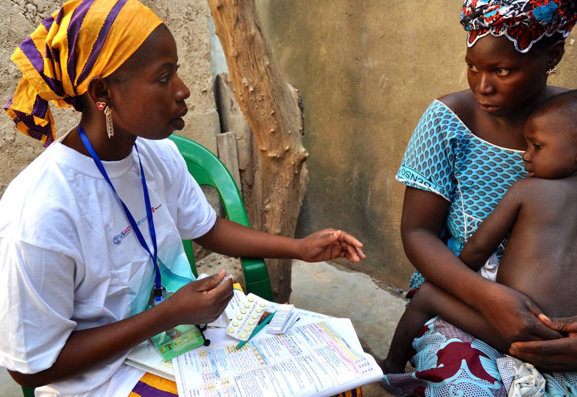
The application of geographic information systems (GIS) technology for healthcare decisions leads to major enhancements through its multi-capabilities of spatial data analysis, organization and collection.
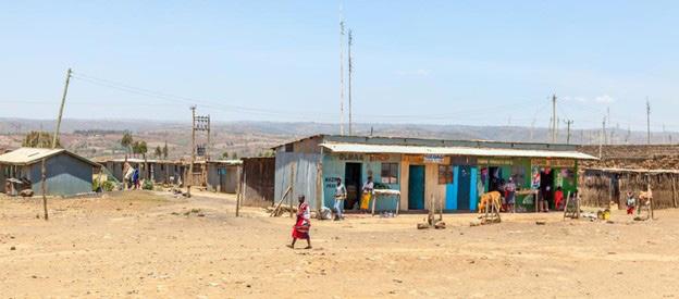
In the heart of Kenya’s Rift Valley lies Narok County, a sprawling landscape of golden savannahs, rolling hills, and the iconic Maasai Mara, a global treasure teeming with wildlife and cultural heritage. But beyond its postcard-perfect vistas, Narok is a microcosm of a challenge
that reverberates across sub-Saharan Africa: the quest for universal energy access. As of April 2025, millions of Africans still live in the shadows of unreliable or nonexistent electricity, a reality that stifles economic growth, dims educational opportunities, and dims the promise
of modernity. Yet, in Narok, a quiet revolution is underway, one powered not just by ambition, but by cutting-edge geospatial technology and a commitment to inclusive, data-driven energy planning.
Enter the World Resources Institute (WRI), a global research powerhouse that’s been turning big ideas into actionable change for over four decades. In a groundbreaking case study published on their site, “Application of GIS in Sub-National Energy Planning in Kenya”, WRI, alongside partners like Strathmore University and local stakeholders, has harnessed Geographic Information Systems (GIS) to map out a brighter, electrified future for Narok County. This isn’t just a technical exercise; it’s a story of innovation meeting necessity, of satellites and solar panels
swathes of the population reliant on kerosene lamps or nothing at all.
Narok’s energy landscape is as diverse as its terrain. Home to over a million people, the county blends semi-arid plains with pockets of fertile farmland. Its population density varies wildly, from the bustling streets of Narok Town to remote villages where the hum of a generator is a rare luxury. Historically, extending the national grid to such areas has been a costly gamble. Transmission lines stretch thin across rugged landscapes, and the return on investment for utilities can feel like a distant dream. Enter offgrid solutions: solar home systems, mini-grids, and renewable innovations that promise to leapfrog traditional infrastructure. But where to start? How do you prioritize when resources are finite and needs
converging to illuminate homes, schools, and clinics in one of Kenya’s most dynamic regions.
The Energy Gap: A Continental Challenge with Local Roots
Across sub-Saharan Africa, the energy access gap is staggering. The International Energy Agency (IEA) reports that over 600 million people lack electricity, with rural areas bearing the brunt of this deficit. Kenya, often hailed as an East African success story, has made strides. Electrification rates have soared from 16% in 2005 to over 50% by 2019, according to Kenya National Bureau of Statistics (KNBS) data. Yet, beneath these national averages lies a patchwork of progress. In counties like Narok, where pastoralist communities roam alongside burgeoning urban centers, the grid often stops short, leaving vast
are infinite?
GIS: The Cartographer of Change
This is where GIS steps in, a tool as transformative as it is unassuming. For the uninitiated, GIS is the science of mapping. Think Google Maps on steroids, layered with data on everything from population density to solar potential. In Narok, WRI’s team wielded GIS like a modern-day compass, integrating primary data into a least-cost electrification model called OnSSET (Open Source Spatial Electrification Tool). The result? A blueprint that doesn’t just guess where power should go, it knows.
The process began with a data treasure hunt. WRI and its partners scoured Narok for ground-truth
insights, collecting primary data on households, businesses, and infrastructure. They tapped into open-source platforms like Energy Access Explorer (EAE), a WRI brainchild that aggregates geospatial datasets, think population maps, power lines, and renewable resource availability, into a user-friendly interface.
Satellite imagery revealed solar and wind potential, while field surveys pinpointed unserved communities. The team layered this with national data on transmission lines and substations, creating a vivid, multi-dimensional portrait of Narok’s energy ecosystem.
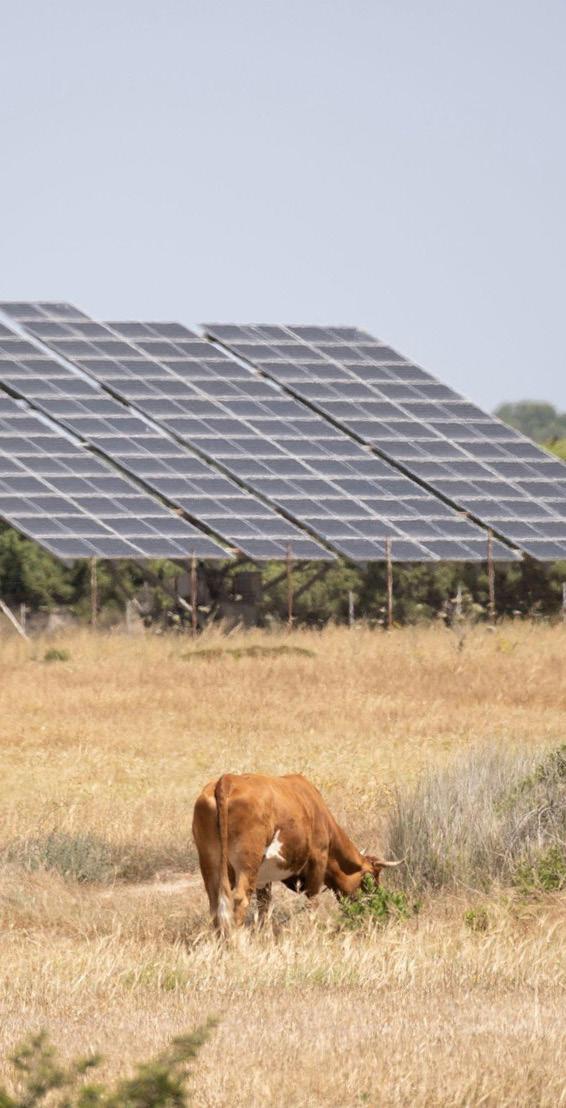
What emerged was a revelation. In Kilgoris, a rural hub in western Narok, GIS analysis showed high population density paired with ample solar irradiance, perfect for off-grid solar systems.
Meanwhile, near the Maasai Mara, sparse settlements and challenging terrain pointed to mini-grids as the smarter bet. OnSSET crunched the numbers, weighing costs against impact to recommend a mix of grid extensions and decentralized renewables. It’s a Goldilocks approach: not too broad, not too narrow, but just right for Narok’s unique needs.
Narok’s Energy Awakening
The implications are profound. Take healthcare, a lifeline in any community. Narok’s clinics, often powered by flickering diesel generators, can now look to solar panels for reliable electricity keeping vaccines cold and lights on during emergencies. Schools, too, stand to gain; imagine students studying past dusk, their futures no longer tethered to daylight hours. For farmers and small businesses, from maize growers to Maasai bead artisans, affordable power could mean new machinery, better storage, and a ticket to broader markets.
This isn’t pie-in-the-sky optimism, it’s happening. Kenya’s Energy Act of 2019 mandates that all 47 counties develop their own energy plans, a devolved approach that recognizes local context as king. Narok is among the pioneers, joining a handful of counties like Makueni, where WRI has also flexed its GIS muscle. In Makueni, a solar PV system at the county referral hospital now offsets a third of its energy needs, saving millions of shillings annually. Narok’s plan, still unfolding, promises similar wins, with GIS ensuring every watt is strategically placed.
Beyond Narok: A Blueprint for Africa
Zoom out, and Narok’s story is a microcosm of Africa’s energy renaissance. The continent is at a crossroads, with renewable energy poised to redefine its trajectory. Solar, wind, and hydropower abound. Kenya alone boasts some of the highest solar potential globally, with Narok’s sunny plains a case in point. Yet, the challenge isn’t just resources; it’s coordination.
Too often, energy planning has been a top-down affair, with national grids chasing urban centers while rural hinterlands languish. GIS flips the script, empowering sub-national governments to take the reins.
WRI’s work in Narok builds on a broader legacy. Since launching Energy Access Explorer in 2019, the platform has expanded to seven countries, from Tanzania to Nepal, training over 1,000 stakeholders to wield geospatial tools. In Uganda, it’s pinpointed hydropower hotspots; in Ethiopia, it’s informed electrification financing.
million Africans out of energy poverty, boosting GDP and slashing carbon emissions. Kenya’s offgrid solar boom, 19% of homes solar-powered by 2019, shows what’s possible when innovation meets intent.
Narok’s GIS-driven plan is a stepping stone, proving that sub-national action can scale up to national impact.
The ethos is open-source and collaborative, data isn’t hoarded but shared, inviting local governments, entrepreneurs, and donors to cocreate solutions. For Narok, this meant partnering with Strathmore University’s energy experts and Narok’s own county officials, ensuring the plan wasn’t just imported but homegrown.
The Human Element
Behind the maps and models are people. Pastoralists herding cattle under the equatorial sun, mothers cooking over smoky fires, kids dreaming of lives beyond their villages. Energy access isn’t just about wires and watts; it’s about dignity, opportunity, and resilience. In Narok, where climate change looms large, droughts parching fields and floods upending lives, clean energy offers a buffer. Solar-powered irrigation could sustain crops; mini-grids could keep communities connected when storms hit.
The numbers back this up. The IEA estimates that universal energy access by 2030 could lift 670
The Road Ahead
Of course, challenges remain. Funding is a perennial hurdle. Geospatial wizardry doesn’t pay for itself, and Narok’s ambitions need investment from government coffers, private players, and international donors. Capacity, too, is a bottleneck; only six Kenyan counties have completed energy plans since 2019, with 30 yet to start. WRI’s training efforts aim to bridge this gap, but scaling up requires political will and grassroots momentum.
Still, Narok shines as a beacon. It’s a testament to what happens when technology meets tenacity, when global expertise dances with local knowledge. For Afrospatial readers, it’s a call to action: Africa’s energy future isn’t a distant dream, it’s being mapped, modeled, and built, one county at a time. In Narok, the lights are flickering on, and with GIS as the guide, they’re here to stay.
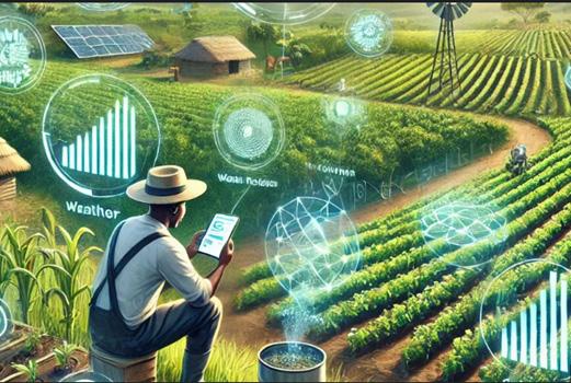
Harnessing Geospatial Technology for Africa’s Sustainable Future
Africa stands at a pivotal moment in its development journey, where geospatial technology is emerging as a game-changer for sustainable progress. From mapping population dynamics to optimizing agricultural yields, geospatial tools are revolutionizing how African nations collect, analyze, and utilize data to drive informed decision-making. In this edition of Afrospatial Magazine, we explore how geospatial technology is reshaping the continent’s statistical systems and paving the way for a data-driven future.
The Geospatial Revolution in African Statistics
Geospatial technology, encompassing tools like Geographical Information Systems (GIS), remote sensing, satellite imagery, and drones, is transforming the way African countries gather and interpret location-based data. Oliver Chinganya, Director of the Africa Center for Statistics (ACS) at the Economic Commission for Africa (ECA), emphasizes its critical role: “Geospatial technology is an invaluable tool for generating high-resolution, location-specific data that supports sustainable development.”
Traditional statistical methods in Africa have often struggled with aggregated data that lacks granularity. Geospatial tools address this by enabling precise, real-time data collection from diverse sources—mobile phones, satellite scans, and drones. This data can be instantly analyzed and shared online, offering actionable insights for policymakers. For example, satellite imagery can map water points and transport networks, while drones capture detailed visuals of remote areas, creating geostatic maps that reveal intricate trends and patterns.
A Case Study: Burundi’s 2024 Census
One of the most compelling examples of geospatial technology’s impact is Burundi’s 2024 Population, Housing, and Agriculture Census. By leveraging GIS and remote sensing, Burundi developed a dwelling framework and database for 2.5 million households. This approach slashed data collection time from 18 months to just 5 months and reduced costs from millions of dollars to a mere $40,000. The result? A scalable, costeffective model that other African nations can emulate for large-scale initiatives like censuses and demographic studies.
Applications Beyond Statistics
Geospatial technology’s versatility extends far beyond statistical systems. According to ECA Statistician Ayenika Godheart Mbiydzenyuy, its applications include:
●Urban Planning and Infrastructure: Mapping road networks and water points to improve access and connectivity.
●Agriculture and Food Security: Using satellite data to monitor crop health and optimize farming practices.
●Environmental Management: Tracking deforestation, desertification, and climate patterns with remote sensing.
●Resource Exploration: Conducting geological surveys for minerals using advanced imaging techniques.
These applications empower African nations to address pressing challenges with precision and efficiency, from urban sprawl to climate resilience.
Democratizing Data for a Sustainable Future
Geospatial technology is also a catalyst for data democratization. By linking statistical data to precise geographic locations, it breaks down traditional silos and makes information accessible to diverse stakeholders. This is particularly crucial for initiatives like population censuses, which require comprehensive, location-specific data to inform policy.
However, challenges remain. Limited infrastructure and a shortage of skilled personnel hinder the continent’s ability to fully harness geospatial tools. Chinganya notes, “Africa’s development is no longer just about number-crunching but about analyzing diverse geographic scales. We must invest in capacity-building to unlock this potential.”
The Road Ahead
As Africa moves deeper into the 21st century, geospatial technology offers a pathway to transform abstract ideas into tangible solutions. By bridging data gaps and enabling precise, location-based insights, it empowers governments, communities, and organizations to tackle complex challenges, from poverty alleviation to climate adaptation.
In the words of Chinganya, “With geospatial technology, we can identify problems and devise solutions that are rooted in the realities of our landscapes.” For Africa to realize its sustainable development goals, embracing these tools is not just an option, it’s a necessity.
Latest News In GIS
GIS professionals are gathering in Nairobi and showcasing cutting-edge mapping solutions at the Africa Geospatial Expo and Conference on October 23–24, 2025. Exhibitors are showcasing leading-edge technologies and sharing innovative ideas while sharing a unifying theme of turning geospatial challenges into opportunities. The event is bringing to the forefront the power of innovative mapping and inspiring collaborative innovations across the industry.
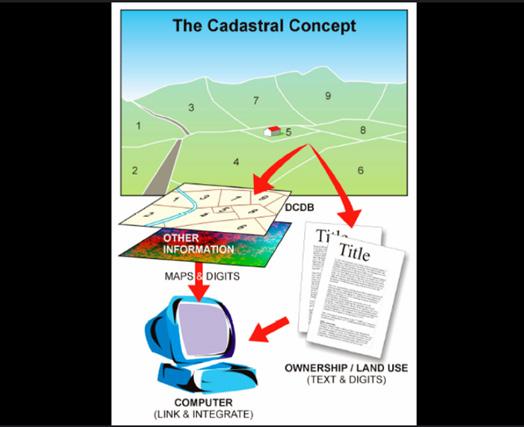
KENYA MODERNIZES LAND DATA MANAGEMENT.
Government agencies are digitizing land records and upgrading spatial data infrastructures, substituting conventional paper-based systems for dynamic digital stores. They are consolidating information from various sources and making access to accurate land information more straightforward. The effort is making land records more transparent and improving the reliability of records, as well as allowing officials to manage land resources better. Meanwhile, government agencies are embracing new GIS-based systems to enhance urban planning and resource management.
They are applying advanced mapping technologies and processing real-time spatial information to make informed land-use decisions. This is fueling smarter development strategies and facilitating sustainable urban and rural growth, revolutionizing the way communities manage and interact with their surroundings.
Nigerian officials are launching a trailblazing dronepowered surveying pilot program in Abuja in 2025, capturing high-resolution 3D images and creating digital twin maps of the capital city. The drones will help in mapping urban spaces, supporting realtime planning and infrastructure development, while foreign experts are collaborating to process aerial data and enhance geospatial models— overhauling traditional surveying methods in the process.
SÃO TOMÉ AND PRÍNCIPE REFORMS GIS MANAGEMENT THROUGH COMPUTERIZING CADASTRAL INFORMATION
In 2025, São Tomé and Príncipe government departments are computerizing cadastral
KENYA HOSTS THE AFRICA GEOSPATIAL EXPO AND CONFERENCE.
NIGERIA PUTS UP DRONE-POWERED URBAN MAPPING REVOLUTION
information and mapping urban and littoral areas, integrating satellite imaging with ground surveys to monitor environmental changes and
guide sustainable development initiatives. The municipal governments are instituting state-ofthe-art GIS applications and refining spatial data infrastructures, enabling real-time observation of land use, climate adaptations, and coastal erosion.
THE GOVERNMENT OF SEYCHELLES EMBRACES GIS FOR SUSTAINABLE URBAN AND COASTAL CHANGE.
Seychelles governmental bodies computerized land data, map the coastal zones and urban areas, and integrate advanced GIS software to monitor environmental changes. The Parks and Gardens Authority takes ArcGIS Pro training, exhibits new mapping techniques, and develops spatial infrastructures, whereas the Ministry of Habitat and Lands optimizes real-time data capture and enables sustainable development projects.
of Pretoria and government institutions are holding pioneering GIS conferences and employing next-generation spatial platforms to chart urban transformation and monitor infrastructure challenges in 2025. Scientists are merging satellite imaging with field surveys, enhancing geospatial models, and rationalizing urban planning procedures while city governments are digitizing data and developing more effective mapping systems. All these activities are addressing the challenge of rapid urbanization, climate impacts, and infrastructure decay as well as driving new public service management practices.
MOROCCO DIGITIZES LAND REGISTERS AND INTEGRATES SATELLITE IMAGERY WITH ADVANCED GIS SYSTEMS IN 2025
The Moroccan government institutions are digitizing land registers, mapping rural and urban terrain, and integrating satellite imagery with advanced GIS systems to monitor environmental change and enhance urban planning. They are upgrading spatial data infrastructures and deploying new geo-analytics tools, thereby enhancing resource management and addressing challenges like natural disasters and urban sprawl.
TANZANIA STRENGTHENS GIS CAPABILITY TO MODERNIZE LAND MANAGEMENT
Tanzanian government agencies are computerizing decades-old land records and modernizing cadastral systems as part of a multifaceted drive to modernize the nation’s land management system. Through collaboration, the authorities are leveraging drones and high-tech surveying equipment, creating accurate digital maps, and adding real-time data to support resilient urban planning while attracting foreign investments through a revamped National Land Policy.
SEVERAL SOUTH AFRICAN UNIVERSITIES TAPS IN TO HOST VARIOUS GIS CONFERENCES
South African universities for instance University
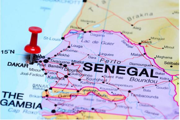
SENEGAL BRINGS GIS FORWARD FOR NATION-
AL TRANSFORMATION
Senegalese government agencies are digitizing national records and integrating advanced GIS systems into strategic national planning in 2025. They are mapping urban and rural landscapes, strengthening spatial data infrastructures, and advancing transparent land governance—all while aligning geospatial innovation with the Senegal Digital Strategy to support sustainable development.
ETHIOPIA TRANSFORMS ITS GIS ENVIRONMENT THROUGH (DIGITIZING, LAUNCHING, AND INTEGRATING)
The Ethiopian Space Science and Geospatial
Institute (SSGI) is digitizing massive data sets and inaugurating a new national geospatial data platform, integrating satellite imaging with ground surveys, and mapping of essential infrastructure for urban planning and climate resilience. Government agencies are improving spatial data systems, making data analytics more efficient, and enabling evidence-based decision-making, thereby enhancing the nation’s drive for digital transformation and sustainable development.
KENYA IMPLEMENTS GENERATIVE AI TO REVOLUTIONIZE GIS
Generative AI is transforming GIS in Kenya through natural-language, intuitive interaction with spatial data, without the need for a lot of programming or manual querying. With AIpowered tools, users can now query, for example, “Show flood-risk areas in Nairobi” and receive dynamic visualizations and relevant analytics.
Such functionality fosters efficiency in urban planning, environmental sustainability, and disaster response by allowing professionals to read spatial relationships quickly and gain insights. AI-driven GIS solutions also automate the cleaning of data, feature extraction, and predictive modeling, significantly improving decision-making accuracy. With the further evolution of generative AI, its use in geospatial intelligence will increase, fostering more open, intelligent, and adaptive mapping solutions.
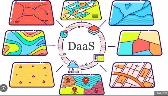
THE GEOSPATIAL INDUSTRY IN KENYA ENFORCES
REAL-TIME GEOSPATIAL INTELLIGENCE WITH DAAS (DATA AS A SERVICE)
DaaS is revolutionizing GIS by providing transparent, API-enabled access to real-time geospatial data, without the need for manual collection and storage. Organizations can now access updated satellite imagery, traffic flow, or environmental metrics instantly, enabling more efficient urban planning, disaster response, and ecological monitoring.
Through the integration of DaaS into GIS environments, decision-makers can enhance predictive modeling, optimize resource allocation, and enrich spatial analysis without substantial infrastructure investment, thus facilitating data access as faster, scalable, and cost-effective.
KENYA BRINGS SPATIAL DATA TO LIFE THROUGH STORYTELLING
Geospatial storytelling is transforming the way complex spatial data is communicated, making GIS more interactive and understandable to larger audiences. With the integration of dynamic visualizations, interactive maps, and artificial intelligence-based insights, organizations can offer geographic stories that engage users,
whether in disaster response, environmental conservation, or urban planning.
These approaches help to transform raw geospatial data into compelling stories that shape awareness, policy-making, and civic engagement. As GIS evolves, geospatial storytelling bridges the gap between technical understanding and ground-level effect, and spatial data is rendered understandable, relevant, and acted upon successfully.
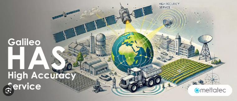
KENYA ADMINISTERS PRECISION NAVIGATION WITH GALILEO HAS
The Galileo High Accuracy Service (HAS) is revolutionizing location-based technologies with centimeter-level precision, significantly enhancing industries relying on geospatial accuracy. Autonomous driving systems are enhanced with more precise route mapping and obstacle detection, reducing navigation errors and enhancing safety.
Drone operations also now have more precise flight trajectories for utilization in services such as surveying, delivery, and disaster response. With real-time corrections and minimized positional drift, Galileo HAS is improving geospatial applications in agriculture, logistics, and smart city planning, and innovating autonomous mobility and spatial intelligence.
Technology in the Evolution of Maps
By Patricia Sila
Maps have been vital in human civilization as we seek to understand the world around us. The art and science of cartography have evolved and significantly transformed from the ages of cave wall carvings to the present digital maps. Technology has been at the centre of this revolution, playing an essential role in advancing from pen-and-paper maps to the animated maps we have today.
In ancient times, map-making was a tedious process that involved manually drawing and calligraphing maps. The primitive maps were relied on for mapping trade routes and planning military activity using materials such as animal skins to outline landmarks. Even though it was an impressive form of art, this method was prone
to human error and unsustainable due to the dynamic nature of the world. The early voyagers also used compasses and celestial bodies to estimate direction, which were sometimes unreliable.
Around the 16th century, integral advancements set the foundation for modern cartography. The development of projection techniques by Geredus Mercator formed the basis for accurately translating the spherical earth into a flat surface. The advent of aerial photography in the 19th century revolutionized cartography, providing a bird’s-eye view of the earth with great detail. Over time, the 3D concept emerged by adding terrain data such as elevation to create
topographical maps representing landforms in 3D on paper.
Technological advancements have propelled the evolution of maps. We now have interactive maps with 2D, 3D, and 4D visualization, made possible by innovation and the enhancement of computer hardware and software. Computers have been a key component in the digitization of maps, enabling the visualization of complex information that would otherwise be difficult to read and comprehend. Visualization techniques such as animation have created an immersive experience, making maps sophisticated and fun to interact with.
Advancements in remote sensing have enabled efficient capturing of the earth, providing readily available information and facilitating updates such as new roads and buildings. High-resolution satellite imagery and Light Detection and Ranging (LiDAR) technology continue to revolutionize earth observation with enhanced detail and accuracy. Geographic Information System (GIS) has also enriched maps with layers of various information types, contributing to the interactive nature of modern maps.
While physical maps were the only way to get to places in the past, we now have the Global Positioning System (GPS) which gives precise locations to guide us when exploring new destinations. The system was originally used for military purposes only but was opened up to civilians in the late 1990s. GPS has enabled access to real-time navigation through smartphones and GPS devices, making paper maps almost obsolete. Satellites have played a huge role in modern mapping by supporting sensors for earth observation and enabling real-time navigation through GPS signals.
Applications such as Google Maps have utilized crowdsourcing for real-time mapping. Users can contribute data such as photographs and reviews to improve accuracy and give more information. Modern maps have vast applications in various sectors, including urban planning and navigation in apps such as Uber.
Geospatial Technologies In The Healthcare Sector
By Christine Wahome
The application of geographic information systems (GIS) technology for healthcare decisions leads to major enhancements through its multi-capabilities of spatial data analysis, organization and collection.
Through spatial data integration, GIS technology enables experts to make better choices that let them detect patterns in their findings. The core function of GIS in healthcare relies on developing spatial infrastructure to understand health-related phenomena. Health providers gain comprehensive insights into all levels, including regional health systems by using GIS information and technology to investigate area-based diseases along with environmental hazards and healthcare resource distribution patterns. GIS analysis generates improved knowledge about how spatial health variables affect each other through geographic element analysis.
In this sector, GIS is frequently used for disease mapping. The technique enables GIS technologies to display clusters visually while operating with a time-based disease spread monitoring system that
adds health data maps for improved assessment. The distribution of medical resources can reach maximum efficiency when healthcare experts collaborate with policymakers and epidemiologists through this information to design specific intervention programs.
The optimization of healthcare facility locations becomes more efficient through GIS information and technologies because it unites demographic distribution information with accessibility factors and population density measurements. For example, healthcare facilities can determine optimal site selection for their facilities through spatial analysis of areas that lack adequate access to healthcare to optimize solutions.
A case scenario where GIS can help with disease mapping is mapping malaria-related factors and trends. Malaria is still responsible for fatal cases and mortalities, remaining a crucial health issue among developing nations. As environmental elements make up most risk factors for developing diseases, GIS can help map how the transmission of malaria depends directly on environmental factors. These elements directly affect its patterns and characteristics, particularly humidity, temperature, vegetation and precipitation.
Mapping malaria occurrence and trends is required for assessing public health at all levels, including nationwide. Geographical representations of maps
definitions for malaria epidemiology while establishing its environmental factors’ relationship. Spaceborne earth-observation imagery enables much easier access to vast and remote regions’ data, and this technique has advanced research on illness prevalence and its correlation with vector distribution.
Human migration directly affects the spread of infectious diseases together with medication resistance development and pathogen formation. GIS provides a platform to monitor human movements and their time of movement by creating simulations of distribution pathways and locations of both affected zones and people.
enable the identification of locations with increased disease rates and notable pattern distributions. Geospatial analysis has emerged as a fundamental method that public health sector uses for epidemiology and public health projects because of escalating health problem intricacies.
The impact of this resource extends to medical facility resource management and healthcare institutions’ planning processes. These systems enable dataset manipulation, interpretation, display, collection, management, analysis, and integration with spatio-temporal reference. Healthcare experts establish important risk parameters during the process of disease spread estimation and mapping through system assessment protocols. These systems fulfill essential roles by creating
With this method, healthcare experts and scientists can determine the risk status of fast disease spread. The analysis of travel time serves as a great method to determine vulnerable population groups alongside affected geographical areas. The geographic system in travel time calculation performs a network distance measurement between two sites that operate through transportation networks. The actual travel time depends on speed standards together with threeroute constraints and point specifications and length requirements. Travel time serves as the main tool in the public health sector to determine healthcare facility accessibility. The two distinct methods to evaluate medical facilities’ geographic accessibility use distance- and area-oriented approaches.
The travel time or distance determines distanceoriented metrics. On the other hand, the areaoriented metrics outline distinct territorial units such as states or towns. GIS calculates travel times through road-quality adjustments and typebased evaluations for network transportation investigations. Network analysis in GIS generates maps that present the siting information for health services.
GIS technology enables efficient scheduling of health services through route-modeling and estimation of transportation elements which allows better delivery of home treatment programs such as polio vaccinations. The analysis of road connections allows ambulances to reach patients in a suitable timeframe. Online dynamic maps provide patients with an effortless method to identify health services located near their residential or workplace areas.
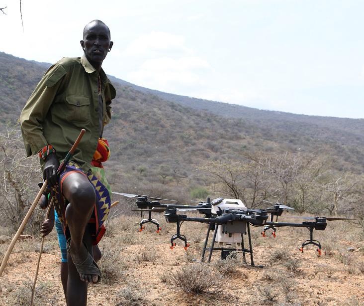
Healthcare facilities and services are unevenly and unfairly distributed throughout the world, especially in low-income areas. Healthcare services encounter these problems the most: infrastructure and the physical features or structure of land. Drone technology represents the best geospatial technology solution for such incidents. Unmanned aerial vehicles (UAVs) serve data collection needs for nations with isolation measures in place across inaccessible regions like dense forests.
These services are provided by health organizations and institutions in conjunction with technologybased organizations. These collaborations result in social application models and prototypes across different sectors. A case scenario is a drone prototype design that was made to serve as a life-saving delivery system. The drone contained innovative IoT and AI elements alongside an independent camera device and sensor system and
two-way radio system and video screen and was used to reach emergency victims before directing them to proper healthcare services. Drone signals can enable doctors to deliver emergency treatment directions to victims from their positions in hospitals and clinics. Drones can play a role in supplying compact aid supplies after national or environmental disasters strike. Medical personnel can employ drones to distribute medical materials across difficulty-accessed areas.
According to reports the number of people needing organ transplants in developing nations continues to escalate rapidly. Drone technologies will prove to be lifesaving tools under such emergency conditions. The implementation of such geospatial technologies leads to broader patient networking across the globe while enabling access to physically impossible services. The current medical system needs an appropriate system that is effectively established and implemented to enhance health standards and standardize personalized quality care in bigger patient networks for this technological fusion to succeed.
Wearable technology (WT) is one new development that is significantly influencing patient healthcare transformation systems. It is becoming more portable, which means that new alternatives to conventional ways of providing patients with services like interaction, medical testing, treatment delivery, and data collection are coming up.
Geospatial technological devices are becoming a savior for memory loss, autistic, Parkinson’s, disoriented, and Alzheimer’s patients. Wearables, together with GPS tracking services, enable the finding of senior citizens in a more sucure and faster way. Mindme, Project Lifesaver, and Safe Link are some new solutions that help keep patients with dementia safe and secure while addressing wandering.
Some developed countries’ governments are paying for the hardware installations and services associated with GPS tracking devices for children with severe autism and others in similar situations due to the growing number of applications for these devices. Children on the autism spectrum, who cannot identify primary facial emotions, are also benefitting greatly from the use of geospatial technologies. For example, prominent research institutions worldwide are utilizing Google Glass to assist kids in differentiating between unique facial gestures.
Restricted information related to hospital staff and patient demography and populace and the availability of healthcare equipment, directly worsens the patient’s status, in turn increasing the medical procedure completion time and mean hospital stay duration. All these directly affect the overall efficiency of the healthcare institution and system.
A geospatial-related system is one of the main solutions to these problems. The collected and stored information can be used in a hotspot analysis to analyze areas, departments, or patients that are improving the most, that are stagnant, and those that are the least performing.
For example, through the use of geospatial-based key performance indicators (KPIs), healthcare institutions can significantly enhance their comprehension and assessment of demand status by breaking down data stored in various categories, such as patient wait times and case numbers, and then dividing the data into easily comprehensible
groups with varying time frames. The process of hiring a sufficient number of medical support personnel is improved by this solution, helping reduce the cost and satisfy the demands of higher demand on crucial days, keeping medical standards at optimum performance and lightening the resource pressure.
Hospital and clinic-based medical staff need to understand their communities for better treatment assessment of their potential patient base. Geospatial-based data analysis tools have proven themselves to be a substantial improvement in decision frameworks for implementing this type of analysis. Healthcare systems employ geospatial services for population identification when determining areas needing private healthcare services and facilities.
The system delivers beneficial information through visuals about a region’s different population groups and their attitudes toward public and private healthcare facilities, together with existing healthcare systems and facilities. The analytical tools help demonstrate data demographics thus allowing developers to establish a database management system that determines important areas lacking both hospital networking systems and medical facilities.
Private health sector institutions and healthcare experts are developing their use of different geospatial technology domains through observation of public health sector applications in medical service management and planning. GIS analysis of population data in combination with facility evaluations, regulatory criteria, and service needs assessment generates valuable information that drives improvement in community health, which in turn drives development in other life aspects.
GIS stands as an essential medical tool that enhances disease monitoring and tracking, resource planning, disaster recovery, infrastructure management and planning, and emergency response. It also improves environmental health management and precise care provision. GIS also facilitates telemedicine and other mobile and internet-based solutions. It also encourages healthcare-related innovation and creativity because users can visualize and process integrated spatial data.
The healthcare sector will experience an explosive growth of GIS capabilities since its core capabilities keep expanding. Healthcarerelated GIS development will undergo substantial advances because of real-time information and ground-breaking technologies. GIS systems can better enhance health outcomes when data privacy breaches, standardization concerns, and interdisciplinary coordination concerns are correctly resolved.
Understanding the limitations of GIS tools regarding data quality and analytical constraints means researchers must correctly interpret results through multiple research methods to achieve substantial healthcare findings. Despite their utility in healthcare delivery and planning the complete realization of GIS in public health through the elimination of these obstacles demands continuous technological improvements and training. GIS establishes an essential role in developing effective healthcare solutions when healthcare systems adopt data-based and community-oriented models and techniques.
Careers
How did you first get into the world of GIS, and what made you stay?
I got into the world of GIS in October 2020 when I was admitted to The Technical University of Kenya to pursue a bachelor’s degree in Geoinformation Technology.
At the time, I honestly didn’t fully understand what “Geoinformation Technology” meant. I had chosen the course mainly because it had the word “Geo” in it, and I had a strong passion for Geography back in high school it was one of my favorite subjects. During my first year, we took foundational units like Introduction to Geoinformation Technology and Cartography, and that’s when everything started to click.
I began to understand what I had gotten myself into and I loved it. Out of curiosity and a desire to understand my career path better, I joined LinkedIn and began reaching out to professionals who had studied the same course. I would ask them questions like, “Where do you work now?” and “What are the career opportunities in this field?”
One response that really stuck with me was from someone who said, “The Ministry of Lands belongs to me.” That sparked something in me. I became even more curious and started immersing myself in geospatial spaces attending conferences, networking with professionals, and exposing myself to opportunities beyond the classroom.
At the same time, I started encouraging my classmates not to switch courses, even when they were unsure about it. I told them, “We’re in the right place; we just need to understand the potential this field holds.” I shared everything I learned from my interactions and experiences outside school to guide them.
What made me stay in GIS was the inspiration I got from seeing professionals at conferences who had walked the same academic path. I would tell myself, “In a few years, I want to be up there too speaking, presenting, and spreading the GIS gospel to the world.”
As we progressed in the course, we were introduced to even more exciting concepts like remote sensing, geospatial data acquisition, and spatial modeling. These topics not only deepened my understanding of GIS but also solidified my confidence that this was the right career path for me and for many of my classmates who, thanks to some early guidance, stuck with it too.
What has been the most impactful GIS project you’ve worked on, and how did it benefit the community or industry?
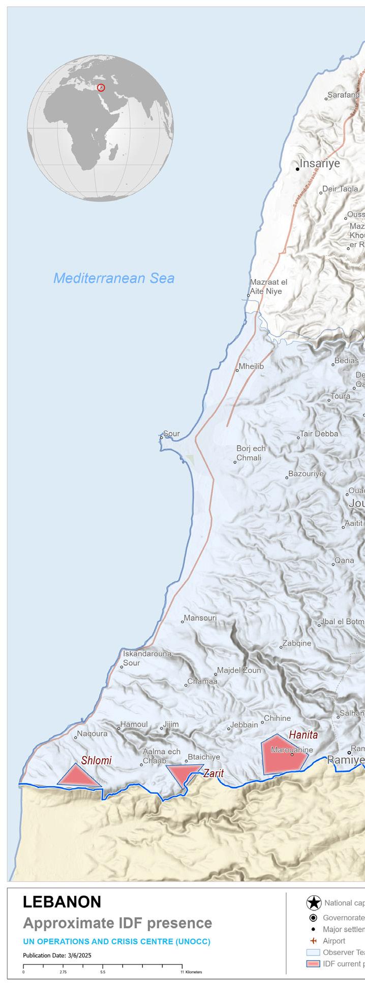
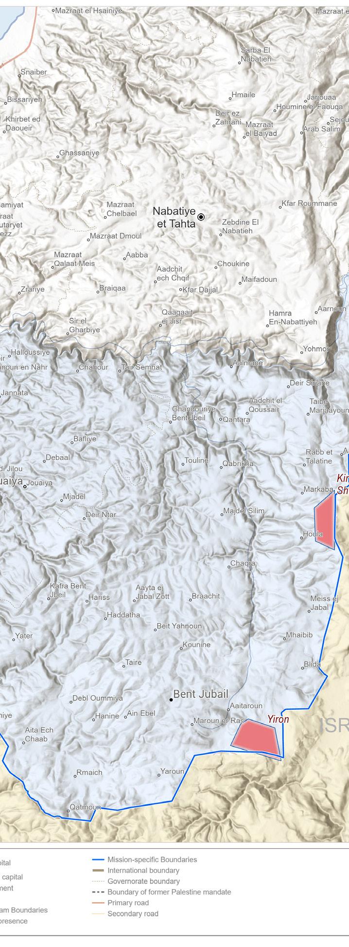
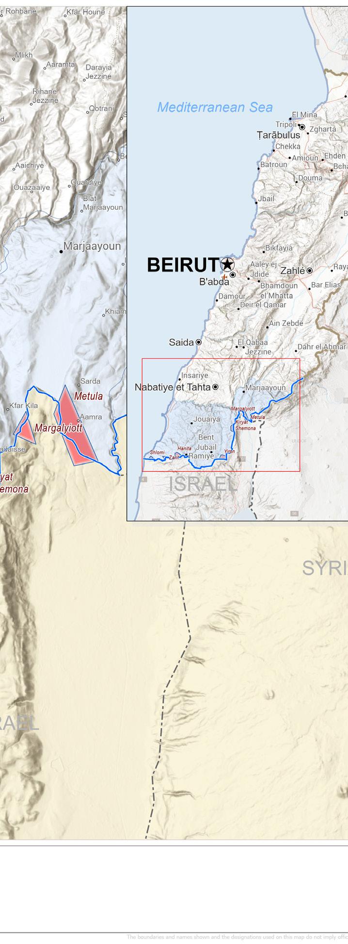
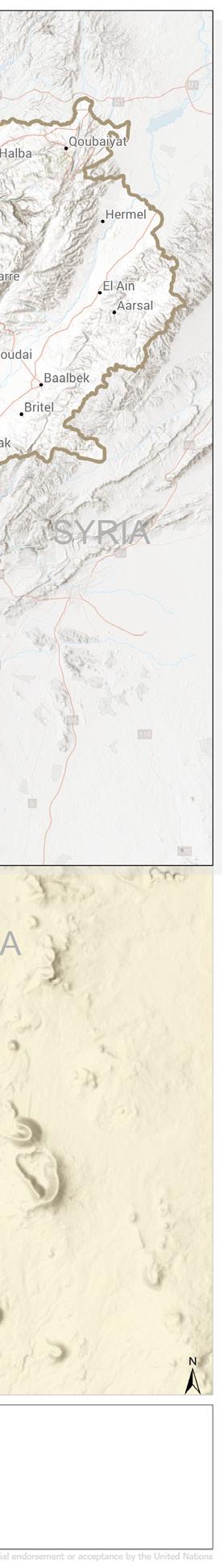
One of the most impactful GIS projects I’ve worked on is part of my current internship with the United Nations Department of Political and Peacebuilding Affairs (DPPA) at the Security Council, under the Executive Office of the Secretary-General. I was involved in a high-level geospatial analysis project focusing on the presence of the Israel Defense Forces (IDF) in southern Lebanon.
Using spatial data, we developed a detailed situational map that visualizes the approximate locations of IDF presence, buffer zones, UNIFIL boundaries, and proximity to civilian areas.
The map helps inform briefings at the highest diplomatic levels and supports evidence-based decision-making in conflict monitoring and peacekeeping operations. This project was impactful because it contributes directly to the Security Council’s understanding of geopolitical tensions in the region, supporting efforts to uphold peace agreements and protect civilians. The visualization enables key stakeholders to quickly assess the geographic dynamics of military presence something that is critical in conflict- sensitive environments like Lebanon’s southern border.
Being part of this initiative was empowering as it affirmed the real-world power of GIS in supporting diplomacy, security, and humanitarian response on a global scale.
In your opinion, how can geospatial technology contribute to solving some of the pressing challenges facing Africa today?
Geospatial technology can help solve poverty in Africa by identifying underserved areas, tracking access to basic services, and guiding targeted development programs. In Africa, it can also address insecurity through real-time conflict mapping, early warning systems, and crisis response planning supporting peacekeeping and humanitarian efforts. To tackle illiteracy in Africa, GIS can map school coverage, highlight education gaps, and guide the placement of new schools and resources in marginalized areas.
What skills do you consider essential for aspiring GIS professionals to master?
Technically, you need strong skills in spatial analysis, remote sensing, cartography, and tools like ArcGIS, QGIS, Google Earth Engine, plus programming (Python or R).
On the soft skills side, problem-solving, communication, critical thinking, and the ability to tell stories with data are key to making your work impactful and understandable.
Can you share a career risk you took in GIS that paid off significantly?
One major risk I took was consistently applying for international GIS opportunities, especially with the United Nations, even without prior global experience. I’ve always dreamed of building an international GIS career, so I kept applying, even after facing very many rejections while continuously improving my skills, networking, and building my portfolio.
That persistence finally paid off when I secured an internship with the UN Secretariat in New York, United States, under the Department of Political and Peacebuilding Affairs (DPPA). This milestone became a turning point. It not only gave me exposure to high-level, impactful GIS work, but it also led to consultancy opportunities with organizations like Esri Eastern Africa.
For the first time, I was assigned physically outside my country on a GIS project in Ethiopia, which truly launched my international career. I now collaborate with professionals from across the globe, and this experience has brought my career to the international stages, something I had long envisioned and worked tirelessly toward.
Quick-Fire Fun
Coffee or tea? Paper maps or digital? City grids or wilderness trails?
Tea, always.
Digital maps, more dynamic and powerful. Wilderness trails, I like natural landscapes.
If you could instantly teleport to any coordinates on Earth, where would it be?
The Caribbean for coastal mapping, the Amazon for biodiversity, Mexico for urban GIS, Argentina for agriculture, Netherlands for flood control, UK for policy, West Africa for land use, and the Philippines for disaster mapping.
What’s your go-to song when working late on GIS projects?
“I Just Can’t Stop” by Don Carlos — the reggae song keeps me calm, focused during those long mapping sessions.
On a scale of 1-10, how lost would you be without GPS?
Even as a GIS professional, I rely on GPS daily. Without it I would be completely lost
If your GIS career had a tagline, what would it be?
One map at a time, from Kenya to the world. Bold & Buzzworthy
What’s one common misconception about GIS that you’d like to clarify?
People think that GIS is just about Google Maps only. It’s not. GIS goes way beyond that; it’s about analyzing spatial data to solve real-world problems.
For example, during my internship with the UN, I worked on mapping military presence to support peacekeeping decisions. That’s GIS in action serious work with real impact.
If you could use GIS to tackle one global challenge, what would it be and why?
I’d use GIS to tackle climate change. It affects food security, water resources, disasters, and health. GIS can help map risks, monitor changes, and guide smarter decisions to protect both people and the planet. It’s one of the most powerful tools we must adopt.
Who in the GIS world do you look up to, and what’s one question you’d ask them?
I look up to Jack Dangermond, the President and Founder of Esri. He built one of the most influential GIS organizations in the world, and his vision has shaped how we use geospatial technology today.
One day, I hope to lead a global GIS organization like he does. If I had the chance to meet him, I’d ask: “What kept you going in the early days when GIS was still unknown and what advice would you give to someone like me who wants to lead and inspire globally through GIS
What’s the most unusual or fascinating thing you’ve ever mapped?
The most fascinating thing I’ve ever mapped was the spread of Fall Armyworm in maize farms using a species distribution model. Seeing how a tiny pest could be predicted across space and time using environmental data was eye-opening.
If you could collaborate with any GIS innovator—artist, scientist, or activist— who would it be, and what project would you work on together?
I’d love to collaborate with Jack Dangermond on a youth-led climate action platform, a project that empowers young people across Africa to map local climate issues, share stories through dashboards, and drive grassroots solutions using GIS. It would combine technology, mentorship, and impact all in one.
Unscramble the GIS Terms
ANSWERS
1. SARETR RASTER
2. PAM MAP
3. TACROHOGRYPA CARTOGRAPHY
4. REOTVC VECTOR
5. EGNOFECING GEOFENCING
6. OPISITNOING POSITIONING
7. DRALI LIDAR
8. VEIYRNGSU SURVEYING
9. TTEISLAL SATELLITE
10. NAOTDIIOCNR COORDINATION
11. ENOSNIG SENSING
12. GEOTASINORY GEOSTATIONARY
13. TMSRPA TRAMPS
14. ATADLIMODENG DATA MODELING
15. ONHOCORF CHOROF
16. ONAAITVIGI NAVIGATION
17. DETAREOTNC COORDINATE
18. PGLAOTHIROWY TOPOGRAPHY
19. TETRIMAOCS CARTOMETRICS
20. YRAOPPOTG TOPOGRAPHY
AfroSpatial Sudoku Challenge Answer
Geo-MythBusters: Two Truths,
One Lie!
Think you know GIS?
Some facts map the truth—others go off course. In each set below, two statements are real, one’s a total myth. Can you spot the lie? Let’s bust some geo-myths!
Question 1: GIS 101
GIS blends maps with data to reveal hidden patterns.
GIS can only work with black-and-white paper maps.
GIS helps cities plan where to build new roads.
Question 2: Sky-High Tech
Satellites send GIS images of forests and oceans.
GIS uses drone footage to map hard-to-reach places.
GIS tracks every bird in the sky in real time.
Question 3: Daily Life
GIS powers the weather app on your phone.
GIS can magically fix a broken GPS signal.
GIS maps where diseases spread to protect communities.
Question 4: Data Magic
GIS layers roads, rivers, and buildings on one map.
GIS analyzes data to predict flood zones.
GIS only uses data from the 1800s.
Question 5: Big Picture
GIS helps farmers choose the best spots for crops.
GIS charts shipping routes across the sea.
GIS can make maps glow in the dark.
Which one’s are myths?
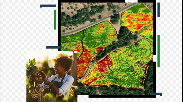
The Future of Informal Settlements: Challenges, Innovations,
and Sustainable
Pathways
By Gerald Nyanjua
This article examines how informal settlements will evolve by studying both prevailing obstacles alongside revolutionary improvement strategies that enable them to merge into official urban development frameworks. Through two successful case studies in Kenya and Brazil, the article demonstrates how specific strategies develop inclusive urban development that remains sustainable and equitable.
Challenges Facing Informal Settlements
The social and economic importance of informal settlements stands in opposition to various structural and legal, and environmental barriers that restrict their sustained development.
Insecure Land Tenure
Informal settlements experience severe legal challenges because residents lack legitimate property titles that would enable home and community development investments as well as traditional credit possibilities. Lacking proper property rights systems causes residents to face repeated eviction threats alongside conflicts over land property rights, as well as municipal planning exclusion.
Limited Access to Basic Services
The residents of informal settlements face difficulties in receiving clean water and proper sanitation, and transportation of electrical power and waste disposal services. The inadequate infrastructure remains harmful to health by
enabling contagious diseases, including cholera, as well as respiratory infections. The absence of proper educational and healthcare centers drives residents into marginal status.
Environmental and Climate Risks
Most informal housing clusters establish their settlement areas in regions that face environmental dangers, including near floodprone lands and steep slopes, and industrial spaces, and hazardous zones. Hackney Wick, along with similar neighborhoods, experiences elevated vulnerability to environmental dangers because of their location in danger zones that suffer from pollution and faulty drainage systems.
Socioeconomic Exclusion
Informal settlement residents encounter discrimination together with a lack of employment and restricted economic opportunities, because of their disadvantaged position. Workers who earn their income through informal activities lack both employment guarantees and public protection benefits, because of which they stay trapped in poverty cycles.
Innovative Approaches to Address Informal Settlement Challenges
Various new strategies are now helping officials solve informal settlement problems while building inclusive cities across urban areas:
Community Mapping and GIS Technology
Accurate planning of informal settlements becomes possible through the application of Geographic Information Systems (GIS) technologies. The collection of data through this method permits teams to recognize service deficiencies so they can design infrastructure improvements and create formal land ownership systems. Food mapping programs started by the community members grant residents the power to participate in decision-making activities throughout the planning stages.
Participatory Planning and Co-Design
The inclusion of residents during planning decisions provides solutions that address their essential requirements. Public engagement
through design workshops, stakeholder meetings, and co-housebuilding brings together residents to establish urban areas with inclusive characteristics that are both sustainable and culturally suited for the community.
Affordable and Sustainable Housing Solutions
Employing modular housing techniques and methods using bamboo along with earth materials and automated 3D-printing technology provides cheap, environmentally compatible solutions to upgrade slum districts. Dwellers enact incremental housing projects successfully with municipal assistance as they construct their homes step by step in numerous urban areas.
Public-Private Partnerships (PPP) and Policy Interventions
The financing of housing projects together with infrastructure development and service delivery comes through a partnership between public authorities and private sector enterprises with NGO support. Urban development becomes sustainable through municipal policies that establish ways for informal settlements to join municipal structures through regularizations and inclusive zoning regulations.
Case Studies: Success Stories in Informal Settlement Upgrading
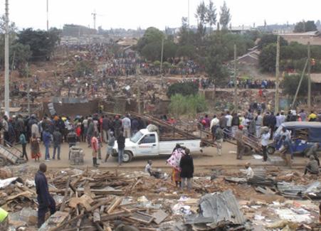
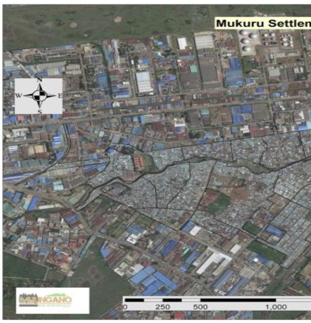
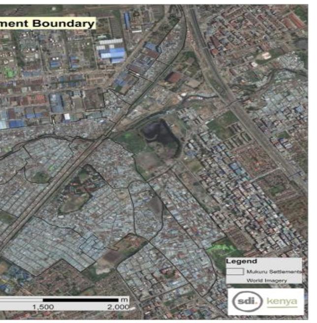
1.Mukuru Special Planning Area (Kenya)
Mukuru is home to some of Nairobi’s largest informal settlements, totaling around 10% of the city’s population. For several years, many organizations have been leading efforts to support residents in Mukuru to improve their living conditions. Since 2012, the International Development Research Centre (IDRC), from Canada, supported two rounds of research in Mukuru to identify practical knowledge and solutions to a host of challenges related to informal land tenure, governance, and human rights related to access to basic services.
This has contributed directly to initiating the largest urban upgrading effort globally, covering 650 acres and benefiting over 100,000+ urban poor households.
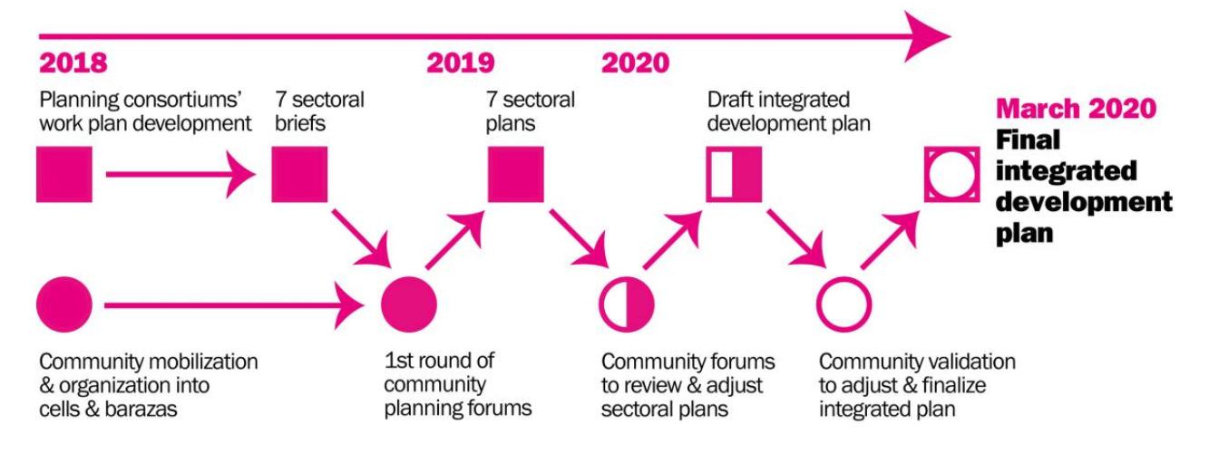
Through ongoing engagement with Nairobi County, the county government declared a Special Planning Area for Mukuru in 2017, which froze all development in the settlement. During the second round of research, 2016-19, the team developed an integrated plan to redevelop Mukuru, with a consortium of 40+ organizations. The Kenyan government is now implementing the plan, as part of a high-level political response to Covid-19.
These developments have helped many residents of Mukuru to ‘catch the dream’ of one city for
all. However, the planning process is still not complete, and much work lies ahead to make the dream a reality. For instance, resolving questions related to privately held lands in Mukuru requires urgent resolution.
The virtual Roundtable is co-hosted by the Canadian High Commission for Canada and IDRC, in collaboration with the Deputy-General of the National Municipal Services. Participants will consist of representatives from Embassies, bilateral and multilateral donors, the private sector and philanthropy, and civil society. The overall goal is for participants to ‘catch the dream’ about the Special Planning Area process in Mukuru and:
Present the Mukuru story, and most recent progress in implementing the SPA, with a spotlight on the role of research; Raise awareness about Government of Kenya’s commitment to access to services and social justice; Highlight outstanding gaps and opportunities for support and investment; Highlight the potential for scaling these experiences at a city, national and regional level.
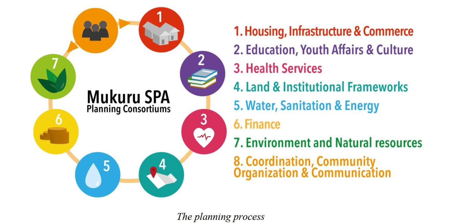
Over 40 organizations worked with Nairobi County on the SPA planning process — from academics and civil society groups to government officials, utilities agencies, and private firms.
Their consultation and planning work was organized into 8 consortiums. Each consortium was led by a corresponding department from Nairobi’s County Government.
The planning process
Each consortium contributed to the inclusive integrated development plan by: collecting and analyzing situational data, consulting the community and seeking feedback on draft proposals, and developing solutions that integrated community knowledge and aspirations with finance, legal, and spatial realities.
The Nairobi County Government established Mukuru as a Special Planning Area (SPA) in 2017, while making it one of Kenya’s biggest informal settlements. Integration planning processes became possible through this designation to coordinate the development of housing together with infrastructure and social services systems.
Key achievements include:
•Countless residents received formal rights to the land they inhabited.
•Providing environmental changes that make
the favela look like a “normal” neighborhood. Introducing visual symbols of the formal city as a sign of identification as a neighborhood: paved streets, plazas, urban furniture and public services.
•Implementation of sustainable water, sanitation, and waste management systems.
•People from the community actively take part in development planning and management.
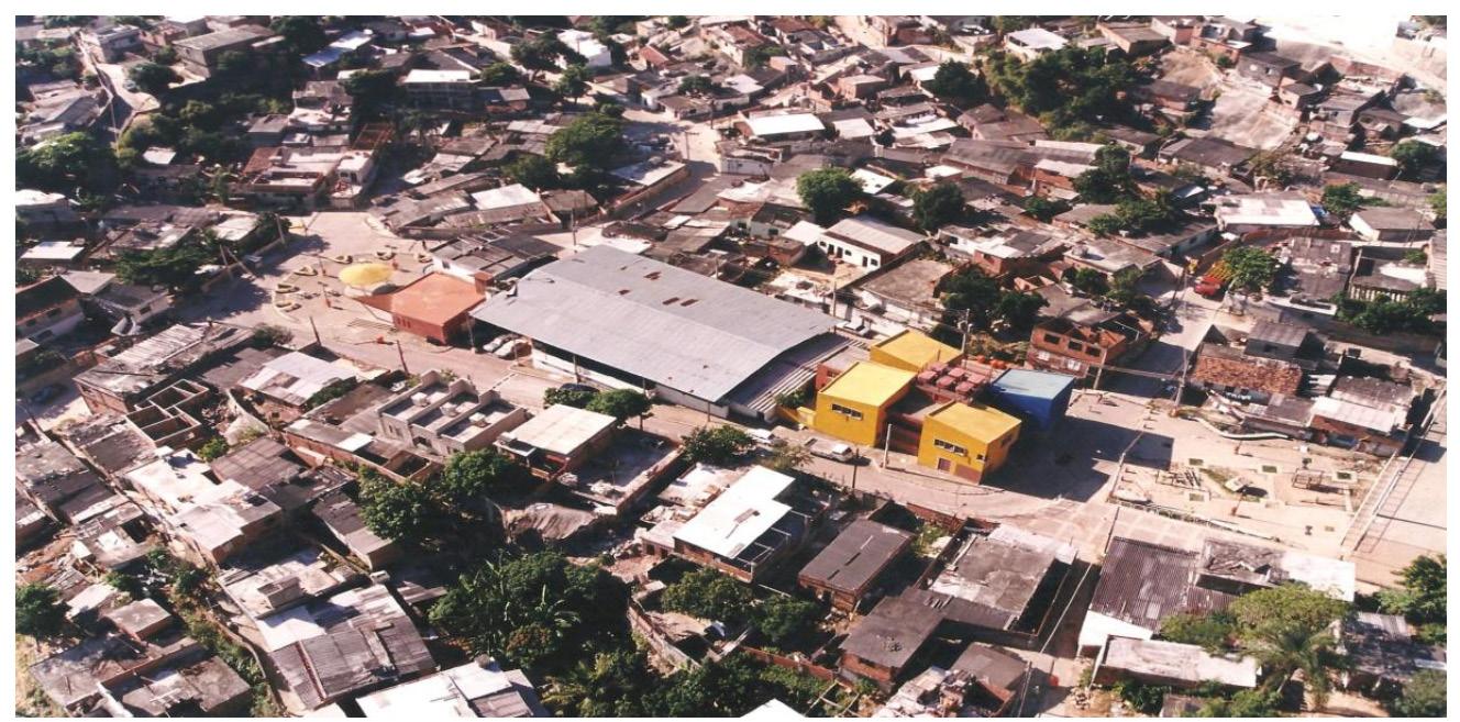
2.Favela Upgrading Program (Brazil)
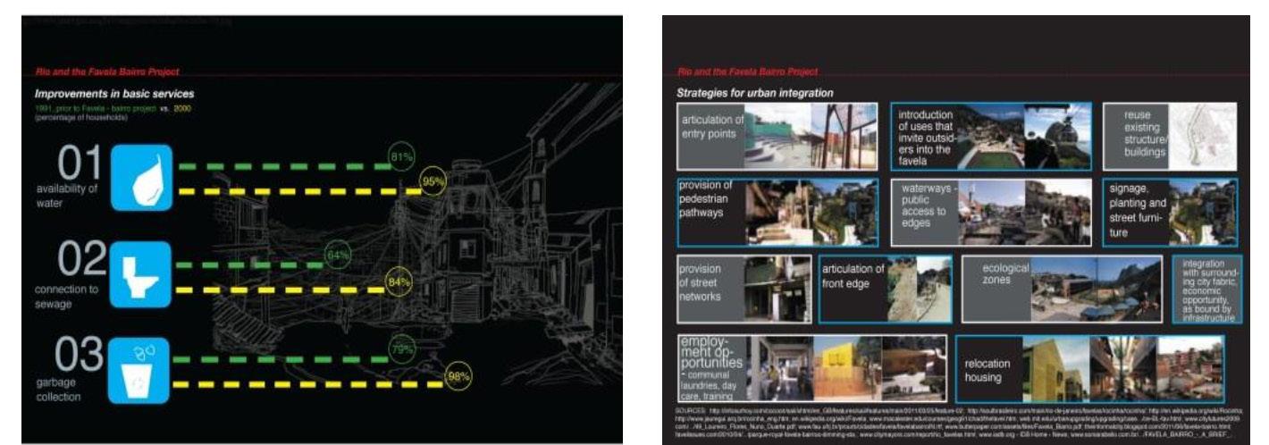
The Favela Upgrading Program of Brazil focused specifically on Rio de Janeiro and São Paulo, has demonstrated effective improvements to informal settlements. By implementing the program Favela Bairro (from slum to neighborhood) is a policy conceived and implemented by the Government of the City of Rio de Janeiro in 1994.
This program received national and international recognition because of its efficient state intervention in urban housing through government investment. The program aims to integrate slums into the legal city by providing access for the population of the favelas to basic urban and social services, as well as the regularization of its public and private spaces.
Completing or constructing the key main urban infrastructure which includes
•Consolidating the insertion of the favelas into the planning process of the city.
•implementing activities of a social nature, such as setting up daycare centers for children, income generation projects, training programs, and sports, cultural and leisure activities.
•Promoting the legalization of land subdivision and providing individual land titles
Due to high density and the consolidated nature of the favela’s buildings, the designers employed three basic principles for their plan:
a)To pay special attention to the boundaries between the favela and the surrounding area and to emphasize points of entry from Avenida Niemeyer.
b)To penetrate the favela with a street system that would break up the traditionally introverted orientation of the area, facilitate multiple connections between new spaces and social functions and permit vehicular access to the highest areas.
c)To create, in this peripheral space, a development pole that would echo the quality of the existing image in the border zone along Avenida.
As the land is flat and part of the layout was planned and organized, the internal street system in the rear sections of the favela and along the railway line display a certain regularity. The key focus of development for the project was the irregular and curvilinear course of the Faria River,
which turned into a virtual mud hole during the rainy season. The channeling of the river and the creation of a canal-side avenue with trees were the basic elements of the transformation of the favela
Infrastructure Investments In Roads, Drainage, And Sanitation.
The programs concentrated on providing education together with health services and job opportunities. The inclusion of informal communities into the formal urban design does not involve forced population displacement from their current settlements.
Future Pathways For Informal Settlements
Numerous cities must combine informal and formal urban structures during the upcoming years if they want to achieve inclusive urban areas that demonstrate resilience. Future approaches should focus on:
Inclusive Urban Planning
Municipal master plans need to officially include informal settlements as real urban areas. The development of informal settlements depends on combined zoning between residential and commercial uses and adaptable building rules and tax strategies that support their evolution.
Smart Technologies And Digital Inclusion
The integration of technology into service delivery and mobile banking, as well as digital land records and online education services, improves life quality within informal settlements.
Climate-Resilient Infrastructure
The installation of sustainable infrastructure components such as water-collection facilities and flood-safe homes, and renewable power stations will assist slum areas in managing climate shifts.
Strengthening Social And Economic Inclusion
The implementation of vocational training programs with microfinance services and business support services will enable residents to gain better economic empowerment.
Conclusion
Affected informal settlements will become sustainable, resilient cities that integrate with urban communities in the future. The transition between informal settlements and formal urban systems can be achieved by collaborative planning techniques and creative technologies, and beneficial policies crafted together by stakeholders and governments. Proper support for Kenyan and Brazilian informal settlements, as shown through case studies, leads to their transformation into thriving communities, which boost citywide social and economic development across the world.
City revitalization through Landscape Architecture
By Gerald Nyanjua
The rapid growth of urbanized areas worldwide generates higher demand for land resources while derelict urban spaces get transformed into operating urban settings. Urban expansion causes numerous industrial sites alongside neglected areas to become useless, which creates planning and design difficulties for both urban planners and designers
The practice of landscape architecture presents distinctive solutions to transform dysfunctional areas, thus creating lively, sustainable communities that welcome everyone.
Landscape architecture-based urban regeneration ensures the fundamental development of ecological stability with economic sustainability combined with social equality. Landscape architects implement green infrastructure together with participatory planning processes and climate-adjusted design practices.
to living. The transformation initiative converts formerly unusable sites as well as dated foundations along with contaminated waterfront locations into parks and combined purpose developments alongside cultural attractions.
Through ecological restoration, sustainable design practices, and community engagement, landscape architecture promotes environmental development that helps people while benefiting natural systems. Landscape architecture in urban regeneration handles problems from
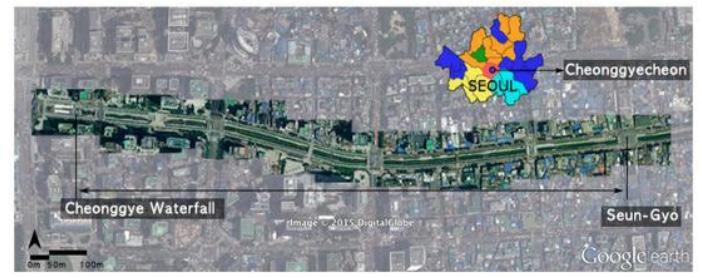
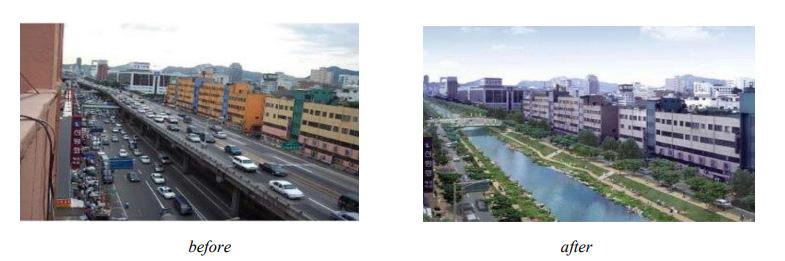
This article examines how landscape architecture contributes to urban renewal by covering essential approaches and two examples, such as the Cheonggyecheon Stream restoration in Seoul, and the Karura Forest conservation project in Nairobi. This text provides an analysis of financial and policy obstacles before presenting solutions to overcome these challenges.
The concept of Urban Regeneration, together with Landscape Architecture, functions as the central focus
The concept of urban regeneration involves transforming neglected spaces alongside distressed or desolate properties to establish better operational areas that are also amenable
climate adaptation to biodiversity protection and social fusion for developing cities that combat environmental and socioeconomic risks.
Urban renewal projects necessitate interprofessional team effort, which brings together architects along with engineers and urban planners, and ecologists. The collective work of landscape architects results in wholecity design approaches that place sustained environment preservation at the same value as current urban construction requirements.
Urban underused areas depend on landscape architects for their complete transformation. Landscape architects make empty locations serve multiple functions through designs that preserve nature and provide access and profit potential to convert vacant areas into active mixed- use developments. Professionals within this field create dual-use environments that combine economic development practices with natural protection methods alongside security enhancements.
Strategic urban planning requires exact focus on constructing separate infrastructure needs, which vary between residential developments and transport systems alongside recreational facilities and environmental defense concerns. The method adopted by landscape architects unites assessments of sustainable ecological structures and built infrastructure with human operations and long-term durability. Their work often involves:
Site assessment requires professionals to analyze soil status alongside groundwater and natural plant varieties as they determine designfriendly solutions. The assessments, together with feasibility examinations, verify that every project upholds the criteria set by sustainable development.
Successful environmental performance enhancement occurs when urban forests function with bioswales and rain gardens, and green roofs under the system of green infrastructure. The implemented tactics lower air pollution while producing climate control advantages that protect native species diversity in the affected area.
Social connectivity will increase because both pedestrian-friendly streets and inclusive parks alongside plazas function to bring communities together for cultural involvement. Accessible public spaces created for inclusivity serve all economic backgrounds of citizens and individuals with physical abilities.
The progress of economic growth requires developing spaces suitable for attracting business investments and tourism and maintaining environmental stability. Urban economic growth improves due to pleasant landscapes designed by landscape architects, thus creating benefits for
both local markets and property values.
Sustainable Approaches to Urban Renewal
Sustainable urban renewal principles concentrate on developing green networks while using design that responds to the climate and working to repair damaged land areas. Landscape architects employ several key strategies:
Green Infrastructure and Ecological Networks
Urban renovation heavily depends on green infrastructure to achieve renewal goals. The integrated system unites natural ecosystems with engineered infrastructure to promote biological diversity with water management and climate protection measures.
Key components include:
Green Corridors that link parks together with wetlands and forests to generate wildlife habitats while building recreational areas combined with parks. Through these corridors, ecological connectivity improves because various species need them for migration, and they help species adapt to changes in their environment.
Strategic tree plantations in urban areas serve multiple functions by cleansing the air while giving shade and lowering temperatures through the urban heat island reduction. Urban forest planning done correctly makes them act as natural protectors during storm events while providing multiple environmental benefits.
Permeable Surfaces working with Bio swales absorb rainwater to achieve two goals: it decreases water-caused floods and enhances water penetration into the soil. Sustainable water management benefits from these solutions because they stop high volumes of urban runoff from entering drainage systems.
Green roofs alongside vertical gardens make maximum use of building spaces to increase green infrastructure within crowded urban zones. The combination of these surfaces consumes energy less effectively for both heating and cooling building facilities.
Waterfront Regeneration and Reclaimed Site Operations
A majority of towns possess waterfront areas that need restoration since these sites could develop into shared resources for public use. Successful waterfront redevelopment includes:
Conducting the Restoration of Natural Hydrological Systems Involved the Elimination of Concrete Channels and the Recovery of Streams and Rivers to restore Mother Nature’s Water Systems. The transformation generates both aquatic habitat solutions and better water conditions.
The development of recreational pathways and the establishment of riverbank and coastal parks, as well as public squares, provides the opportunity for people to enjoy physical activities. The establishment of public spaces near waterfronts builds community connection since they create welcoming areas accessible to entire societal groups.
Case Studies in Urban Revitalization
1. Cheonggyecheon Stream Restoration, Seoul
The City of Seoul is in the process of an important paradigm shift, changing from an auto-centric development-oriented urban landscape to one that values the quality of life of its people and the importance of functioning ecosystems. By demolishing an elevated freeway and uncovering a section of the historic Cheonggyecheon Stream, the Cheonggyecheon Restoration Project created both ecological and recreational opportunities along a 3.6-mile corridor in the center of Seoul.
The project has proven catalytic, spurring economic growth and development in an area of Seoul that had languished over the last several decades
A typically traffic-choked elevated highway was taken down and turned into a waterway, and a public recreation area to make the city more ecofriendly and sustainable. The change in the face of the region is shown in the pictures given below.
The transformation of former industrial zones into three different functional spaces includes building parks alongside developing mixed-use developments and implementing ecological reserves. A complete redevelopment of these sites demands both soil contaminants removal and pollutant management practices to guarantee environmental safety standards.
Rapid population growth, urban development, economic growth, and automobile consumption caused Seoul to have a major traffic problem. The Cheonggyecheon highway was a major carrier of the city’s traffic. Therefore, there was a lot of fear regarding the replacement of this crucial road with a public waterway, since it was thought that this would exacerbate the traffic problem in the city.
However, to everyone’s surprise, traffic flow sped up around the region, with travel times reducing. This can be explained using Braess’ Paradox. This is based on driver motives. In the presence of the highway (with ‘optimum’ drive time), all drivers would prefer to use the road, thus congesting it. However, in its absence, this traffic would get
scattered across several other roads, which would reduce total travel time.
However, all the success cannot be attributed to just the Braess’ Paradox. Factors such as the government’s increased investments in public transit systems would also have played a part in this. More so, human decisions wouldn’t always be the same as expected, and that is the beauty
of this being a social science. For example, on a particular day, more drivers may just happen to choose one route over the other, changing optimum travel routes and times. However, the general overview and consensus is that the Braess’ paradox had a major part to play in the lessening of traffic in Seoul, and multiple restoration projects around the world are following its lead.
Landscape Performance Benefits Environmental
Provides flood protection for up to a 200-year flood event and can sustain a flow rate of 118mm/ hr.
Increased overall biodiversity by 639% between the pre-restoration work in 2003 and the end of 2008 with the number of plant species increasing from 62 to 308, fish species from 4 to 25, bird species from 6 to 36, aquatic invertebrate species from 5 to 53, insect species from 15 to 192, mammals from 2 to 4, and amphibians from 4 to 8.
Reduces the urban heat island effect with temperatures along the stream 3.3° to 5.9°C cooler than on a parallel road 4-7 blocks away. This results from the removal of the paved expressway, the cooling effect of the stream, increased vegetation, a reduction in auto trips, and a 2.27.8% increase in wind speeds moving through the corridor.
Reduced small-particle air pollution by 35% from 74 to 48 micrograms per cubic meter. Before the restoration, residents of the area were more than twice as likely to suffer from respiratory disease as those in other parts of the city.
Social
Contributed to a 15.1% increase in bus ridership and 3.3% in subway ridership in Seoul between 2003 and the end of 2008.
Attracts an average of 64,000 visitors daily. Of those, 1,408 are foreign tourists who contribute up to 2.1 billion won (USD 1.9 million) in visitor spending to the Seoul economy.
Economic
Increased the price of land by 30-50% for properties within 50 meters of the restoration project. This is double the rate of property increases in other areas of Seoul.
Increased the number of businesses by 3.5% in the Cheonggyecheon area during 2002- 2003, which was double the rate of business growth in downtown Seoul; increased the number of working people in the Cheonggyecheon area by 0.8%, versus a decrease in downtown Seoul of 2.6%.
When rapid urbanization unfolded during the 1950s, Cheonggyecheon became entirely buried beneath both roads and an expressway. The administration of Seoul initiated a substantial restoration initiative to revive and expose the stream during the early 2000s. Dismantling the elevated highway was the initial step for this project, which then enabled better water circulation together with the development of green spaces surrounding its banks.
The project directors needed to find solutions for maintaining traffic flow and maintaining water cleanliness in the stream after removing the highway structure. Through its completion, the project brought multiple positive effects to the region.
1. Enhanced biodiversity and ecological restoration.
2. The combination of green spaces with water cooling effects provides urban areas with decreased heating levels.
3. Economic growth through increased tourism and commercial activity.
4. Improved pedestrian accessibility and quality of urban life.
Karura Forest Conservation, Nairobi
The authorities of Karura Forest struggled with extensive deforestation, together with unauthorized land takeover during the 1990s. Wangari Maathai, alongside environmental activists together with Nobel Laureate Wangari Maathai guided the forest conservation initiative, which centered on tree planting, followed by legal protection and eco-tourism initiatives.
The restoration process involved:
The restoration of biodiversity occurred through, the planting of native trees, the installation of public walking trails together with picnic sites promotes sustainable utilization of the territory.
Forest management should follow a program that is governed by members of the local community.
Lawmakers fought land grabbers while seeking assistance from governmental bodies. Today Karura Forest exists as a growing ecological space which enriches both local economic conditions and provides recreational opportunities.
Conclusion
Urban development requires sustainable cities through the restoration of urban areas by landscape architecture. Special designs combined with community-oriented approaches transform abandoned areas into exciting urban resources according to the case research findings. Strategic cooperation between officials and designers, and community members will continue to be crucial for achieving sustainable development of urban areas.