L ATENT CIT Y
A Framework for Urban Adaptability
Adam Hollings
Latent City: A Framework for Urban Adaptability by
Adam Hollings
Bachelor of Architectural Science, Ryerson University, 2020 Master of Architecture, Ryerson University, 2022
A thesis presented to Ryerson University
In partial fulfillment of the requirements for the degree of Master of Architecture in the Program of Architecture.
Toronto, Ontario, Canada, 2022 © Adam Hollings, 2022
II
AUTHOR’S DECLARATION FOR ELECTRONIC SUBMISSION OF A THESIS
I hereby declare that I am the sole author of this thesis. This is a true copy of the thesis, including any required final revisions, as accepted by my examiners.
I authorize Ryerson University (renaming to Toronto Metropolitan University in progress)* to lend this thesis to other institutions or individuals for the purpose of scholarly research.
I further authorize Ryerson University to reproduce this thesis by photocopying or by other means, in total or in part, at the request of other institutions or individuals for the purpose of scholarly research.
I understand that my thesis may be made electronically available to the public.
* In April 2022, the university announced our new name of Toronto Metropolitan University, which will be implemented in a phased approach.
III
IV
Latent City: A Framework for Urban Adaptability Adam Hollings Ryerson University Department of Architectural Science
Abstract
Cities are facing uncertainty and change to which they must learn to adapt. Traditionally these pressures have been addressed through technical and efficiency-oriented solutions which function within limits created by the urban systems of the city. These limits do not imagine another stable state for the city to shift to and so reduce the ability for a city to change and adapt. Resilience theory can help to understand how cites address or adapt to change and uncertainty. It can help to recognize the limitations set by current frameworks and concepts, and help to reconsider how to create adaptability based versions that work beyond those limits. Through an urban system framework informed by resilience theory we can imagine a city, and by extension architecture, that can effectively adapt to the pressures placed on it.
V
VI
Acknowledgments
I would like to thank:
My supervisor Will Galloway for his guidance and critique throughout the development of this thesis.
My thesis committee for their helpful input.
Connor Gagnon for his helpful pointers and guidance throughout the thesis process. and most importantly
My partner Leilani Patterson for her unending love and support.
VII
VIII
Preface
Introduction - Addressing Uncertainty 2 Chapter Summaries
Chapter 1 - Resilience Theory and Planning 6 Engineered Resilience 6 Ecological Resilience 7 Planning with Resilience 8
Chapter 2 - Planning with Engineered Resilience 10 Olmsted and Engineered Resilience 10 Modernism and Engineered Resilience 11 Engineered Resilience Planning in Toronto 14
Chapter 3 - Planning with Ecological Resilience 16 Adaptability and Scales 16
Ecological Resilience Planning in Tokyo 17
Jane Jacobs and Urban Ecological Resilience 19 Ecological Resilience in David Sim’s Soft City 21 New Urbanism and Resilience 23 The Ecological Layer 24 Urban Ecological Resilience in Summary 24
Chapter 4 - Engineered Resilience Planning Continued? 26
Chapter 5 - Latent City 31 Framework Rules 32 Latent City 40
Chapter 6 - A Changing City 50 Scenario 1: Population Increase 51 Scenario 2: Population Decrease
Scenario 3: Ecological City
Chapter 7 - Conclusions
Reflections
Appendices
Appendix A1
A2
B
C1
C2
C3
Appendix C4
Appendix C5
Bibliography
IX Table of Contents Abstract V Acknowledgments VII Glossary of Terms XI
XIX
5
54
57
60
61
63
64 Appendix
66 Appendix
68 Appendix
74 Appendix
76 Appendix
78
80
82
85
X
Glossary of Terms
Ecology: The study of ecologies, and also refers to an ecological system.
Ecological Resilience: The potential for a system to transition into another stable state when faced with changing pressures.
Engineered Resilience: A single imagined state of a system which when faced with change pressures is maintained through expended effort and resources.
Greenery/ Greenspace: Refers to ecosystems, areas inhabited by plants and ecosystems.
Greenway: A carved out path of wilderness and dense biodiversity that runs through an urban environment.
Natural systems: Ecosystems, formed from the interaction of plants, animals, water, soil, etc.
System: A entity formed from the complex interaction of parts that make up a whole. Ex. buildings, streets, and park in a city, or plants, animal, soils, water, that make up an ecosystem.
Uncertainty: The unpredictable nature of future conditions created by current or eventual pressures.
Urban systems: Buildings, streets, neighbourhoods, infrastructure, or the interaction of elements that form a city.
Urban context: The city environment Wilderness: Unmaintained greenery and ecosystems.
XI
XII
List of Figures
Figure 1 Engineered versus ecological resilience imagined through cups and rolling balls. 7
Source: Redrawn by author. Based on original by Thoms et al.
Figure 2 Resilience and planning. 9
Source: By author.
Figure 3 Olmsted’s plan for Central Park, New York City. 11
Source: https://betterwaterfront.org/the-legacy-of-central-park-how-downing-vauxand-olmsted-set-the-standard-for-american-parks/
Figure 4 A drawing from Le Corbusier’s Radiant City modernist planning concept. 13
Source: Retrieved from: https://www.archdaily.com/411878/ad-classics-villeradieuse-le-corbusier
Figure 5 The wide open plazas of Brasilia 13
Source: Retrieved from: https://www.archdaily.com/938140/from-utopia-to-realitybrasilias-60th-anniversary
Figure 6 Toronto’s Zoning Plan map. 15
Source: https://urbantoronto.ca/news/2017/04/densecity-part-1-where-torontobuilds-density-and-why
Figure 7 Nagakin Capsule tower, showing age having failed to exercise its concept of adaptability. 18
Source: Retrieved from: https://www.dezeen.com/2021/07/16/nakagin-capsuletower-dismantled-news/
Figure 8 Tokyo’s Zoning system zones and categories. 18
Source: Retrieved from: Galloway, Will. Scaling M-NEX Ideas and Tokyo Urbanism, 2022.
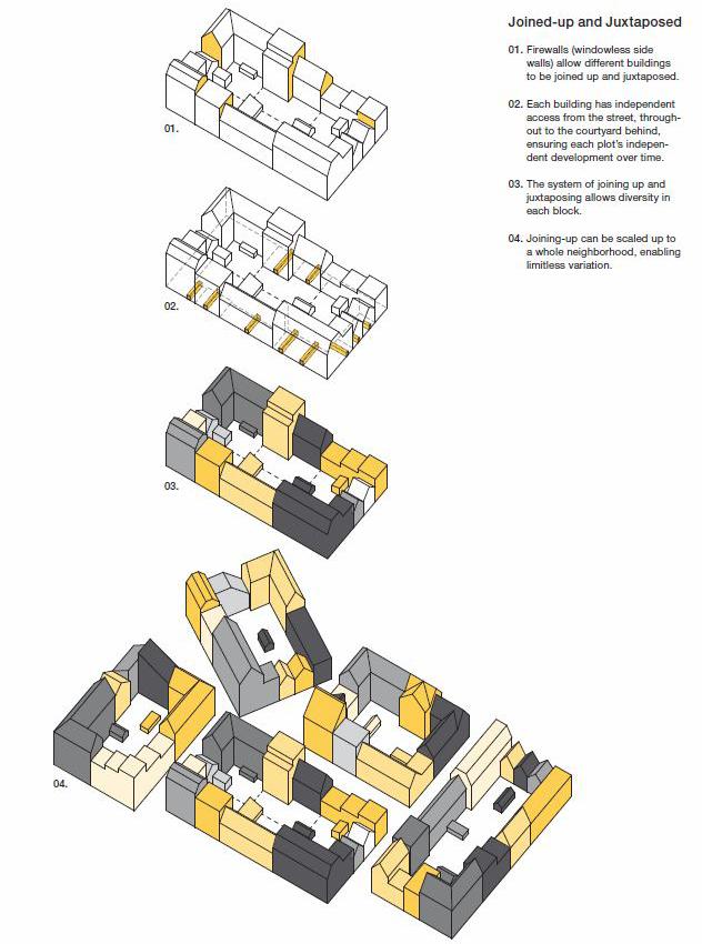
Figure 9 David Sim’s block concept with smaller subdivided individual buildings. 22
Source: Sim, David. Soft City : Building Density for Everyday Life, Island Press, 2019.
Figure 10 David Sim’s divided individual buildings and their flexibility from his Soft City concept. 22
Source: Sim, David. Soft City : Building Density for Everyday Life, Island Press, 2019.
Figure 11 New Urbanism transect planning model. 23 Source: https://www.strongtowns.org/journal/2019/7/25/how-urban-change-is-likeecological-succession
Figure 12 Aerial rendering of the of the proposed Port Lands Redevelopment. 27
Source: City of Toronto, and Waterfront Toronto. Port Lands Planning Framework. City of Toronto, 2017.
Figure 13 Master plan drawing of the proposed Port Lands Redevelopment. 27
Source: City of Toronto, and Waterfront Toronto. Port Lands Planning Framework. City of Toronto, 2017.
Figure 14 Desired neighbourhoods within the Port Lands plan. 28
Source: City of Toronto, and Waterfront Toronto. Port Lands Planning Framework. City of Toronto, 2017.
Figure 15 Basin Media Hub design proposal. 28
Source: https://www.toronto.ca/news/city-of-toronto-and-createto-announcedevelopment-partner-for-the-250-million-basin-media-hub/
Figure 16 Quayside development along the Toronto waterfront. 29
Source: Retrieved from: https://www.dezeen.com/2022/02/23/adjaye-mass-timberplants-for-toronto-waterfront/
Figure 17 Adjaye Associates in the Quayside development. 29
XIII
Source: Retrieved from: https://www.dezeen.com/2022/02/23/adjaye-mass-timberplants-for-toronto-waterfront/
Figure 18 Diverse use of spaces in the framework buildings. 32 Source: Author.
Figure 19 Dividing larger blocks into smaller individual buildings. 33 Source: Author.
Figure 20 Three types of streets and public space. 34 Source: Author.
Figure 21 Ecological layers and connections in the street. 35 Source: Author.
Figure 22 Buildings designed for deconstruction. 36 Source: Author.
Figure 23 Increased density and height in exchange for provided greenery or public space. 37 Source: Author.
Figure 24 Removed buildings replaced with greenery. 38 Source: Author.
Figure 25 Connections with greenways to be maintained when buildings are built on the edge. 39 Source: Author.
Figure 26 Latent City as a framework for an adaptable and changing urban system. 41 Source: By Author
Figure 27 Latent City as a framework for an adaptable and changing urban system. 42 Source: By Author
Figure 28 Latent City initial form aerial view. 43 Source: By Author
Figure 29 Original Port Lands plan form. 44 Source: By Author
Figure 30 Ecologically resilient urban form. 45 Source: By Author
Figure 31 Latent City initial urban form. 47 Source: By Author
Figure 32 View on Commissioner’s Street looking towards the Don River redirection greenway. 48 Source: By Author
Figure 33 View of Latent City‘s greenway and green streets. 49 Source: By Author
Figure 34 Scenario 1: Population Increase. 51 Source: By Author
Figure 35 Scenario 1 Commissioner’s Street view. 52 Source: By Author
Figure 36 Scenario 1 greenway view. 53 Source: By Author
Figure 37 Scenario 2: Population Decrease. 54 Source: By Author
Figure 38 Scenario 2 Commissioner’s Street view. 55
XIV
Source: By Author
Figure 39 Scenario 2 greenway and green streets view. Wilded greenery has increased its presence. 56
Source: By Author.
Figure 40 Scenario 3: Ecological City. 57
Source: By Author
Figure 41 Scenario 3 Commissioner’s Street view. 58 Source: By Author
Figure 42 Scenario 3 farmer’s market view. 59 Source: By Author
Figure 43 Examples of horizontal street divisions and their respective liveliness from Jan Gehl. 65
Source: Gehl, Jan. Cities for People. Washington, DC: Island Press, 2010.
Figure 44 Toronto’s Surface Coverage (left) vs. Toronto’s Greenspace (right) 67
Source: (Top and bottom left): https://www.semanticscholar.org/paper/Gettingclosure%3A-The-role-of-urban-forest-canopy-in-Greene-Millward/5e13e6628 9062eaa50158b6bd3b463cf264b5cb3/figure/1
Source: (Top right): https://www.researchgate.net/figure/The-Greenspace-mapof-the-city-of-Toronto-constructed-from-the-Geographical-Information_ fig7_279989471
Source: (Bottom right): https://ecologicaldesignlab.ca/site/uploads/2018/05/MRP_ Final.pdf
Figure 45 1882 plan drawing of Toronto. Ashbridges bay and Don River outlet marshlands are visible in the current location of the Port Lands. 69 Source: http://oldtorontomaps.blogspot.com/2013/02/1882-city-engineers-officeplan-of-city.html
Figure 46 Historic changes to the Toronto waterfront. 70
Source: https://www.researchgate.net/figure/Geographic-Evolution-of-TorontosShoreline_fig2_304013762
Figure 47 Port Lands and Lower Don Lands at the outlet of the Don River. Work towards the Don Outlet flood management project can be seen. 71 Source: Retrieved from Google Maps.
Figure 48 Don Outlet Flood Protection plan and Villier’s Island Redevelopment. 72 Source: https://portlandsto.ca/media-library/?media-page=2
Figure 49 Public and green spaces throughout the Port Lands Plan. 73 Source: https://urbantoronto.ca/news/2017/05/new-details-emerge-transformationport-lands
Figure 50 Transit system plan for the redevelopment. 73 Source: https://urbantoronto.ca/news/2017/05/new-details-emerge-transformationport-lands
Figure 51 Collage of process work for Latent City form and concepts. 75 Source: Author.
Figure 52 Collage of process work for Latent City streets and greenery. 77 Source: Author.
Figure 53 Collage of process work for Latent City further detail development. 79 Source: Author.
Figure 54 Collage of process work for Latent City further detail development and scenarios. 81
XV
Source: Author.
Figure 55 Collage of process work for Latent City and scenarios further detail development. 83
Source: Author.
XVI
XVII
XVIII
Preface
This thesis began through an interest in exploring adaptability in architecture. The continuing turmoil of the past two years inspired me to consider how we might make the built environment adapt to current and future pressures.
Initially I started out focusing on adaptability in architecture. This was done through theoretical research on what makes architecture able to change. In this line of thinking I explored the idea of an imperfect architecture as something that could accept change effectively. Something that is viewed as perfect would not be able to change and so perhaps imperfect things could change.
The research into imperfect architecture revealed some problems when exploring adaptability in architecture. One being that often adaptable architecture is somewhat of a gimmick and are usually never fully realized as adaptable. Another is that all architecture is adaptable and changeable through construction and demolition. These factors made me consider that the adaptability of architecture is rather a larger more complex issue than just individual buildings.
This line of thinking led me to explore system scales larger than architecture with city planning and urban design. Architecture was realized to be a part of a larger, more complex, and potentially adaptable system, the city. It was realized that a city’s planning framework is what will determine if the city, and the architecture within it, are adaptable. At this point in the research the idea of imperfect architecture was dropped as the focus shifted into addressing the creation of adaptable cities. Through realizing where adaptability can be created in architecture and cities this thesis shifted from something focused on architectural design to one focused on urban planning.
Urban and city planning was a new realm of research for me. I was typically accustomed to theoretical architectural research. Nevertheless, I’ve become fascinated by the realm of urban planning through the research experience of this thesis, and I hope to engage with it further in my future work.
- Adam
XIX
L ATENT CIT Y
A Framework for Urban Adaptability
1
1. . Ontario Population Projections. ontario. ca. https://www. ontario.ca/page/ ontario-populationprojections.
Introduction - Addressing Uncertainty
The focus of this thesis is to develop urban systems and architecture that have more capacity to manage and adapt to change - more latency. Properly speaking, latency refers to the potential for a property to emerge in a system when circumstances change around it. The property is not immediately present, but is assumed to be embedded as a potential within the system and not something that needs to be created from the outside. A recent example of latency can be seen in the way Toronto’s sidewalks and roadsides adapted to become restaurants during pandemic related lock-downs. There was latency present in the sidewalk space for the city to adapt to the changing pressures of the pandemic. This was realized by creating space for restaurants and businesses to continue operating.
The reason these concepts of latency and adaptability are important today is the amount of uncertainty that architects and planners are expected to respond to and plan for, both in the short term and in the long term. For instance, a changing global climate, or, in the case of Ontario, the population is projected to increase by 35.8% over the next 25 years.1 At the same time, we have seen a shock in the way Toronto and other cities around the world have responded to the ongoing Covid-19 pandemic, in many cases retreating from the city center, which became a challenging place to live when services and social life were closed for a long time. If the world experiences a similar occurrence there is no certainty that what we are building now will be sufficient to the task. With this in mind, it is important to have a planning and architectural strategy that can meet uncertainty straight on.
As architects and planners, we often imagine ourselves as designers and organizers of the future. This sentiment is admirable; however, the challenge is that the future is uncertain and unpredictable. In which case, we need a way to define an intent for the future that allows concrete plans to be made, but at the same time has enough room to adapt, or even be reconstituted into multiple forms. How can we make plans that are unambiguous and concrete, but also open ended?
This question is particularly challenging when we recognize that long term thinking is itself a skill that we are losing. The sociologist Zygmunt Bauman describes this loss in future planning ability in a quote from his book Liquid Times: Living in an Age of Uncertainty:
“the collapse of long-term thinking, planning and acting, and the disappearance or weakening of social structures in which thinking, planning and acting could be inscribed for a long time to come, leads to a splicing of both political history and individual lives into a series of short-term projects and episodes which are in principle infinite, and do not combine into the kinds of sequences to which concepts like
2
‘development’, ‘maturation’ , ‘career’ or ‘progress’ (all suggesting a preordained order of succession) could be meaningfully applied... Past successes do not necessarily increase the probability of future victories, let alone guarantee them; while means successfully tested in the past need to be constantly inspected and revised since they may prove useless or downright counterproductive once circumstances change. A swift and thorough forgetting of outdated information and fast ageing habits can be more important for the next success than the memorization of past moves and the building of strategies on a foundation laid by previous learning.”2
Although Bauman implies that it is difficult to plan for the future, large scale projects like urban planning and architecture require a certain amount of confidence about what the future might bring. In his view, long term planning is challenging because assumptions need to be checked continuously. With that in mind, we can speculate on what kinds of tools are needed in order to develop long-term plans that can be checked, adjusted, and modified as circumstances change.
Historically speaking, planning strategies reflect a range of ambitions, from the ideological, to the aesthetic, to pure practicality. For the discussions of this thesis, we will limit ourselves to more recent considerations, beginning with the transformation of cities to their modern form, which began in the 1850s with the Sanitary movement. More recently it can be argued that modernist planning has had the most influence on the current city, along with market-based incentives. This can be seen in the dominance that efficiency and order have as tools of measurement for many aspects of urban planning.3 While this approach has grown out of a need to solve serious problems, such as the population explosion of the 1960s, and the integration of layers of infrastructure related to sanitation, cars, and other technology, it is not without its problems.
If we acknowledge that modern cities grew out of real needs, it is equally important to recognize that needs have changed and that in retrospect the deterministic models that we used to develop urban planning came with consequences that need to be addressed. Chief among this is that modernist planning, which has influenced much of the design of the contemporary North American City, is too rigid. We will see this discussed further in the following chapters.
Reactions to recent political, social, and economic turmoil have demonstrated a reminder that often people react negatively to uncertainty and change. Changes can be viewed as stressors when comfortable existing situations are altered. An example of this could be NIMBYism (Not In My Back Yard), where people don’t wish to see development changes near their neighborhood and so protest, or organize to make sure things don’t change. Another recent and widespread example is the mixed responses to the uncertainty of the pandemic. Some people complied with public health rules put in place while others protested changes introduced into their lives.
While change is often viewed with negative reactions, there are some that champion ideas for an acceptance-based response. In Architecture Depends Jeremy Till discusses uncertainty through the concept of contingency, in which there is the possibility for things to change from the way they are. Till references Bauman to argue that contingency and uncertainty should not be viewed as negatives going against the urban systems in place. Rather, he argues change should be viewed through potential opportunities. Till states that there is a “transformative potential latent in uncertainty and the freedom that comes with it. Where order and certainty close things down into fixed ways of doing things, contingency and uncertainty open up liberating possibilities for action. In this light contingency is more than just fate; it is truly an opportunity.”4
Till’s attitude is about using change as a potential. But accepting change is a difficult thing to do for most, and, as will be discussed in the following chapters, planning is often not designed with it in mind. In this realm it is difficult to apply Till’s ideals of embracing
2. . Bauman, Zygmunt. Liquid Times: Living in an Age of Uncertainty. Cambridge: Polity Press, 2017, pg. 3.
3. . Scott, James C. Seeing like a State: How Certain Schemes to Improve the Human Condition Have Failed. Yale University Press, 1998.
4. . Till, Jeremy. Architecture Depends. MIT Press, 2009, Till, pg. 55.
3
uncertainty and change to urban planning. But, perhaps there are ways in which we could consider working with Till’s ideals by addressing change pressures and uncertainty with adaptable urban systems. Till’s specific line the “transformative potential latent in uncertainty” highlights how to address change and uncertainty, specifically through latent potential, or latency. This involves planning for future change and uncertainty in cities through implementing built in adaptability.
To understand the nature of addressing adaptability, change, and uncertainty in cities, this thesis uses resilience theory, a concept borrowed from the study of ecologies. The theory is used to develop a critique of contemporary North American city development and efforts to build. Resilience theory is also used to form design concepts which imagine the development of an adaptable and resilient urban system.
4
Chapter Summaries
This thesis is divided into seven chapters discussing the potential of developing resilient and adaptable urban systems. Chapters 1 to 4 involve a discussion of planning concepts and theories centered on resilience. Chapters 5 to 7 test those ideas with a theoretical urban plan in Toronto, Ontario, and suggests conclusions that can be taken from that exercise. The exercise makes use of an adaptable urban planning framework that I am calling the Latent City.
Chapter 1 - Resilience Theory and Planning
Resilience theory is defined through both engineered resilience and ecological resilience. The theory is used to describe approaches to city planning and to understand an approach to urban adaptability.
Chapter 2 - Planning with Engineered Resilience
North American city planning is analyzed through the understanding of engineered resilience and its relation to past urban design efforts.
Chapter 3 - Planning with Ecological Resilience
Thinking beyond the current state of the North American city towards greater adaptability and flexibility. Urban design efforts that engage with ecological resilience are discussed. Potential theory and concepts to design with ecological resilience are outlined. This conception of design leads to the development of a new standard of design for the city.
Chapter 4 - Engineered Resilience Planning Continued?
The City of Toronto’s redevelopment of the Port Lands is used to describe engineered resilience planning in the city. This redevelopment site provides an area to consider creating an ecologically resilient and adaptable urban system.
Chapter 5 - Latent City
An adaptable urban system is imagined in the Port Lands. This plan, titled Latent City, is created through a planning framework of rules developed from the concepts established from the discussion on ecological resilience-based planning. This framework both guides the current state of the plan as well as its potential for future adaptability.
Chapter 6 - A Changing City
The future adaptability of the Latent City urban system is explored through a series of potential future scenarios.
Chapter 7 - Conclusions
Final observations are made on the importance of resilience planning and adaptable future planning.
5
Chapter 1 - Resilience Theory and Planning
5. . Thoms, M. C., H. Piégay, and M. Parsons. “What do You Mean, ‘resilient Geomorphic Systems’?” Geomorphology (Amsterdam, Netherlands) 305, (2018;2017;): 8-19.
Resilience theory is a concept stemming from the field of ecology used to understand the complex organization, stability, and capacities of ecological systems. Originally coined by the ecologist C. S. Holling, resilience is defined “in terms of system change, where ‘resilience is the amount of change a system can undergo (its capacity to absorb disturbance) and remain within the same regime that essentially retains the same function, structure and feedbacks”.5 Resilience theory posits that a system, like an ecology, can manage or adapt to a level of changing pressures until it reaches a point where the system is disrupted, overloaded, or shifts into a new state.
The complex and changing nature of ecological systems bears similarities to the complex changing relationships of cities and urban systems. This similarity has led some architects and planners to consider the application of resilience theory to planning and design. C.S. Holling himself even began the comparison in a text written with M.A. Goldberg titled Ecology and Planning in 1971.
Resilience theory makes use of two definitions of resilience. Both describe the capacity for flexibility and the amount of pressure a system can take before it is overloaded. These two concepts are known as engineered resilience and ecological resilience.
6. . Thoms et al.
Engineered Resilience
Engineered resilience focuses on maintaining a steady state by resisting changing pressures.6 This approach addresses changing pressures by controlling the system so that it remains in an enduring and stable state. This system experiences collapse when it is overloaded and can no longer resist or otherwise manage the pressures placed on it. Engineered resilience is predicated on a perfect prediction of all variables. When those variables shift the only option is to spend resources to maintain the boundaries. In our world that means burning oil, spending money, or suppressing behaviors in order to keep within a specific and predetermined range of activity. A real-world example is one where air conditioners are made more efficient in order to mitigate CO2 levels. Another example is to adapt to high temperatures by installing more air conditioners. It is useful to recognize that resilience is not equivalent to sustainability by any means. Engineered resilience works as long as the system is not stressed beyond its capacity.
Engineered resilience has its place, and is entirely reasonable in many scenarios,
6
especially when variables are easily known and controlled for, such as a factory floor. It is less tenable when unexpected adaption is required. Chris Reed and Nina Marie Lister, in their article Ecology and Design: Parallel Genealogies describe the limits of engineered resilience and the need for adaptability in the face of current changing and uncertain environmental conditions. They warn “that our management practices (planning, policy, governance and day-to-day activities) must adapt themselves to this new scientific understanding of the world — that principles of order, control and limits will eventually doom the very things we want to protect.”7
Figure 1. Engineered versus ecological resilience imagined through cups and rolling balls.
Source: Redrawn by author. Based on original by Thoms et al.
Ecological Resilience
To address uncertainty, resilience theory also includes ecological resilience. Ecological resilience is based on the observation that ecosystems often shift from one state to another, resisting change until a tipping point is reached, after which stability is found in another form. It is worth noting that the shift can go backward just as easily as forward. A forest can change to grassland and back to a forest again. Considering tolerance in a system, ecological resilience allows a system to manage change by accommodating multiple steady states within it. Alternatively to engineered resilience, which resists change and maintains one system state, the system reaches a tipping point as it is placed under pressure, but instead of collapsing as it does with engineered resilience, it shifts to a different but stable state and thereby continues to function.8
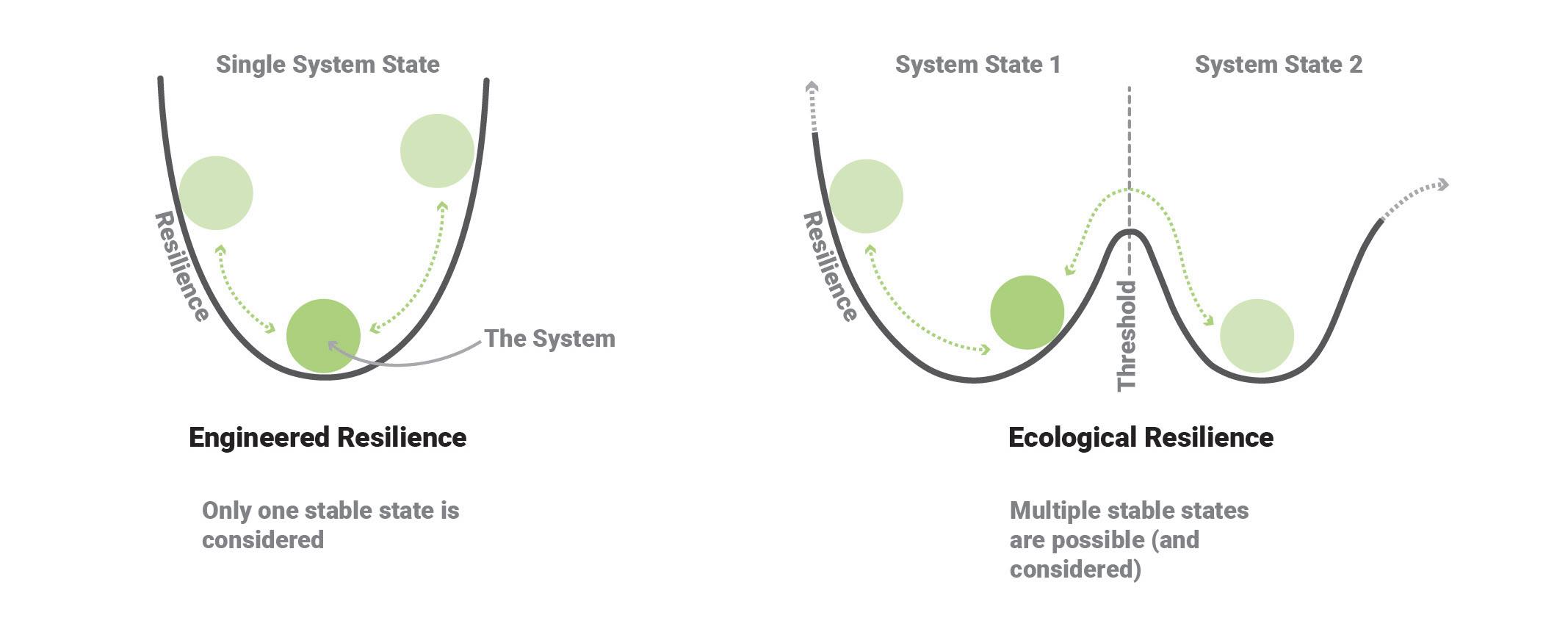
The difference between engineered resilience and ecological resilience is shown in Figure 1 where a system is imagined as a rolling ball inside a curve. The flexibility of a system state is demonstrated by how much the system can move within the curve. The slopes of the curve represent the resilience that keeps the ball within the stable state. If the slopes are overcome by the rolling ball (the system) in the case of engineered resilience the system collapses. Faced with stress the option is only to buttress the system. In the case of ecological resilience when the system is stressed beyond a tipping point it shifts to a new stable state.9
Over the course of this thesis, ecological resilience and ecologies are both discussed. Ecologies are not to be confused with ecological resilience as ecological resilience is describing the function of an adaptable system. When ecologies are mentioned, the label refers to ecological systems made up of interconnected relationships of plants and animals. For instance, ecologies would be systems like forests, wetlands, or grasslands, etc.
7. . Reed, Chris & Lister, Nina-Marie. Ecology and Design: Parallel Genealogies, Places Journal, April 2014
8. . Thoms et al.
9. . Thoms et al.
7
Planning with Resilience
In discussing the development of ecological resilience theory Reed and Lister compare “systems that attempt to achieve a predictable equilibrium or steady-state condition to systems typically in states of change, adapting to subtle or dramatic changes in inputs, resource and climate. Adaptation, appropriation and flexibility became understood as the hallmarks of “successful” systems. It is now widely accepted (if not fully understood) that an ecosystem’s ability to respond to changing environmental conditions makes persistence possible.”10 Reed and Lister describe in their article past projects and thinking that have considered the application of ecological resilience theories to urban planning and design. However, discussions and previous attempts tend to be abstract and policy oriented. In this case we can see the potential for the development of urban planning and architectural design based on those theories.
Briefly exploring resilience theory in relation to planning and architecture we can recognize two distinct planning strategies that reflect the difference between engineered and ecological resilience. (Figure 2)
The ordered ideas of modernism, which have contributed largely to the development of North American cities, have a strong affinity with engineered resilience. Modernism is a simple and ordered system of thought that relies on the physical manifestation of a limited set of ecologies, human or otherwise. Order is maintained by removing so-called extraneous or unwanted layers of complexity from the system.11 Urban systems under modernism, especially in its most ideologically pure expression, are maintained within the limits of technology and efficient function. In this understanding, the system exists as a final and ordered state from its inception, and is intended to remain fixed, with a narrow range of variation over time. While so-called high modernism reached its peak in the last century, it can be argued that the basic concepts of modernism continue to pervade our society, from the way we build and manage cities to the way we grow food and organize the systems that maintain our daily lives. A key signal of that reality is the pride of place that we give to efficiency and the related trend towards the concentration of control in ever larger companies.
Planning cities with ecological resilience offers a flexible alternative. Instead of a single system state there are multiple futures for the urban system, all of which are considered stable and viable. With these multiple possibilities a city can be more adaptable, built with multiple latencies within it. Each future is accessible when a tipping point is reached.
While it is possible that a model based on engineered resilience can include both human and non-human ecologies, the tendency until now has been to separate them, as if they were not connected. Ecological resilience is particularly useful because it inherently allows for complex interactions and can therefore allow for non-human ecologies to exist within urban forms. These too can change over time and need not be constrained in the way a traditional park might be for instance. Taking that as a starting point, it is possible to imagine quite complex and open-ended urban forms through ecological resilience.
Reflecting now on the commentary of Bauman, we can see that there is a framework that we can use to include more open-ended long-term planning in the development of our cities. This is an important addition, as Bauman offered more critique than actionable insight.
The use of engineered resilience and ecological resilience in different planning strategies will be expanded upon in the following chapters.
8
10.
. Reed and Lister.
11.
. Scott.
Figure 2. Resilience and planning.
Source: By author.

9
Chapter 2 - Planning with Engineered Resilience
12. . Fisher, Thomas. Frederick Law Olmsted’s Campaign for Public Health. Places Journal, November 1, 2010. https://placesjournal. org/article/fredericklaw-olmsted-andthe-campaign-forpublic-health/?cnreloaded=1.
13. . Fisher.
Planning with engineered resilience can be understood as solving problems through creating a robust single imagined system. In engineered resilience planning, strategies are imagined and implemented within the limits established by socioeconomic norms. This is not to say that planning with engineered resilience is a problem. Often the ideas and solutions to come from it do help to address or solve problems in the city. But, the concept works when all variables are known, a potentially problematic requirement when faced with uncertainty. With this in mind, it can be argued that engineered resilience is the understanding by which much of past and contemporary North American cities have been planned and built.
Olmsted and Engineered Resilience
In western planning and thinking there has been a long-standing view of a separation between nature and humanity. This distinction is used to establish ecologies as a separate entity from humans and the city. Traditionally, the relationship between nature and the city has been used to bolster resilience within cities. Ecological spaces and parks were treated as a form of relief for the challenges faced by city dwellers.
As any cursory history of modern urbanism makes clear, cities have not always been healthy places to live. Disease and unhealthy living conditions characterized early industrial urban living conditions.12 At the time one of the theories regarding the cause of poor health in cities was the miasma theory, which posited that the unclean air of urban environments led to sickness. Fredrick Law Olmsted the famed landscape architect, lived during the period when this concept was prevalent, and used this line of thinking to justify the establishment of parks within the city. “Echoing the miasma theory, still in popular circulation, Olmsted argued that great public parks, such as his proposed Greensward, would function as the “lungs of the city” — green open spaces where city dwellers could breathe clean air.”13 Olmsted is best known as the founder of Landscape Architecture in North America and designed highly influential parks and suburbs in pursuit of his ambition to provide relief from the negative influence of urbanity. His designs include Central Park (Figure 3), The Columbus exposition, Prospect Park, the suburban community, Riverside Illinois, among others. These park spaces in his understanding acted as a relief space for the city if not a cure for the health problems it created.
To address the health-related problems involved in the city, the sanitation movement
10
established waste treatment systems such as sewers and the requirements for waste systems like toilets in urban living spaces.14 Even with the sanitation movement addressing the unhealthy conditions of the city, the relief function of urban park spaces championed by Olmsted continues within cities even today. In a way, the idea has become somewhat vestigial, or even a shorthand, as parks are built alongside new urban developments as if the main function is only to have open space. By that measure they are sufficient, however even Olmsted did not design parks solely with that rudimentary intention. It begs the question, what are parks for in the contemporary city when disease is no longer connected so directly to urban form?
Green spaces like Central Park have been viewed and treated as separate from the city but simultaneously as a necessary, even infrastructural support system. In a way they can be seen as a formal way to build resilience in the social structures of cities. Separated park spaces can be viewed as a fixed designated ecological space within the city. In their form they make a clear distinction between green and natural spaces and city spaces. Because of this they function as a form of engineered resilience in the city, restricted to their designated area in the city and unable to change outside of it.
Figure 3. Olmsted’s plan for Central Park, New York City.
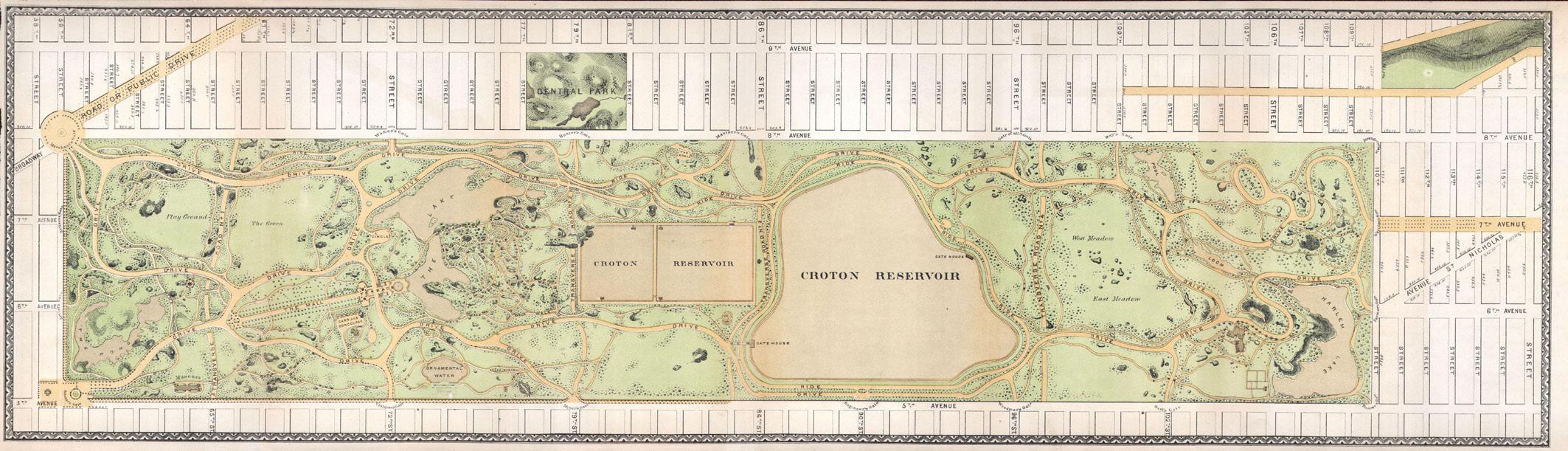
Source: https:// betterwaterfront.org/ the-legacy-of-centralpark-how-downingvaux-and-olmstedset-the-standard-foramerican-parks/
14. . Fisher.
Modernism and Engineered Resilience
The ideas that Olmsted followed came directly from the sanitation movement.15 In practice that meant the creation of open space and connections between parks, in a kind of idealized manifestation of how a city could be designed to combat its own worst outcomes. However, there were fundamental shifts that took place at that time that had a much more long-term outcome. Specifically, the shift was from a city where people lived almost anonymously to one where each household was marked and measured as it was plugged into the sanitation network. Arguably that is the beginning of the modern city, where infrastructure defines urbanity as much as the obvious built form.16
Decades later the same concept was extended to include automobiles and other forms of transit, each layer fundamentally changing how cities function. That this was of benefit to many is undeniable, however the approach comes with a negative impact as well, as described most clearly by James C. Scott. In his view, modernism and the modern city, are methods of making sense of uncertainty through ordered systems.17 That goal is not in itself problematic. It becomes an issue is when systems are used to erase uncertainty by forcing simplicity on the world. It can be argued from that point of view that modernism as a movement is a form of engineered resilience. It was a design movement based on the concepts of engineered resilience where problems are solved with technical and organized solutions and imagined within one functional state, where all factors are known, controlled, and planned for.
15. . Fisher.
16. . Galloway, Will. Scaling M-NEX Ideas and Tokyo Urbanism, 2022.
17. . Scott, pg. 134.
11
The modernist movement came about through a reaction to the turmoil created by a rapidly industrialized world of the late 19th and early 20th centuries. The technological innovation allowed for societies and planners to organize themselves in newly complex and technical ways. Some of the historical events of the period like the two world wars, or economic hardship in between them, necessitated further mobilization and organization in order to address those problems.18 This was almost inevitable as both sides of an industrial world war, like the first and second, would have to undergo massive societal organization and mobilization in an effort to beat the other side. The additional turmoil caused by these conflicts spurred further desire for planners to order and fix the disordered and unhealthy nature of society and cities.19 The technology, efficiency, and order of modernist thinking and planning were to fix all of the societal and urban problems faced by the people of the time period.
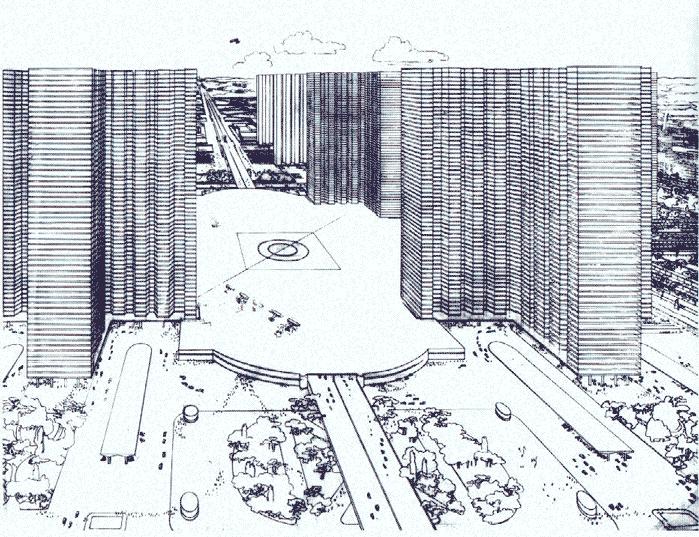
Covering the development and ideas of the modernist movement, James C. Scott’s book Seeing Like A State discusses the ways in which modernist thinking imposed organizational ideals on to societies, in the effort to make them more efficient and easier to manage. He argues that the organizational measures, like modernist city planning, work to ensure the effectiveness of the system, but in the process negate the often disorderly but necessary human needs of the people that inhabit it. In the realm of architecture and planning Scott looks at the works of Le Corbusier to understand some of the origins of modernist planning ideals (Figure 4). Scott describes Corbusier’s high modernist planning as a “dictatorship of the planner” in which the human and social elements of urban systems have a single solution with no compromises or alternative solutions.20
The city is viewed as a machine in high modernist planning, in which, building use typologies are organized with a large overall vision and separated into functional districts. “There would be separate zones for workplaces, residences, shopping and entertainment centers, and monuments and government buildings.”21 These simplify the planning of cities.
“The logic of this rigid segregation of functions is perfectly clear. It is far easier to plan an urban zone if it has just one purpose. It is far easier to plan the circulation of pedestrians if they do not have to compete with automobiles and trains. It is far easier to plan a forest if its sole purpose is to maximize the yield of furniture-grade timber. When two purposes must be served by a single facility or plan, the trade-offs become nettlesome. When several or many purposes must be considered, the variables that the planner must juggle begin to boggle the mind. Faced with such a labyrinth of possibilities, as Le Corbusier noted, ‘the human mind loses itself and becomes fatigued.’”22
Though order driven planning, like modernism, makes organizing systems to be simpler, it leaves no room for the fluid, often unpredictable, and complex social interactions that form the urban systems of a city. Scott illustrates the implementation of high modernist ideals, like those of Le Corbusier, in the built example of the city of Brasilia in Brazil (Figure 5). Brasilia is often talked about as an example of segregated, ordered, and rigid modernist planning. Architects often enjoy the aesthetics of the empty wide-open plazas and clean forms of the architect Oscar Niemeyer, but these plazas in their clean and empty state are actually demonstrating serious flaws. They do not allow for un-orchestrated activities, many of which are considered essential to the creation of community and a resilient social structure. Indeed, the Modernist design of the city - with its massive spaces and hyper-rational organization - is apparently created to eliminate the random activities and encounters that might be found in a more traditional urban form. “Functional simplification demands that the rationale for the square as a public visiting room be designed out of Brasilia. This plaza is a symbolic center for the state; the only activity that goes on around it is the work of the ministries. Whereas the vitality of the older square depended on the mix of residence, commerce, and administration in its catchment area, those who work in the ministries must drive to their residences and then again to the separate commercial centers of each residential area.”23 The character and complex liveness of spaces in cities
12
18. . Scott, pg. 97. 19. . Scott, pg. 106. 20. . Scott, pg. 113. 21. . Scott, pg. 109. 22. . Scott, pg. 110. 23. . Scott, pg. 121.
Figure 4. A drawing from Le Corbusier’s Radiant City modernist planning concept.
Source: Retrieved from: https://www.archdaily. com/411878/adclassics-ville-radieusele-corbusier
Figure 5. The wide open plazas of Brasilia
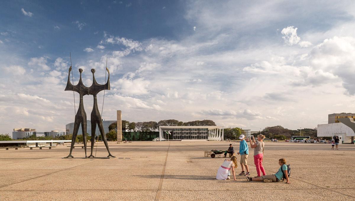
Source: Retrieved from: https://www.archdaily. com/938140/ from-utopia-toreality-brasilias-60thanniversary
is what makes them enjoyable to spend time in. Scott states that Brasilia, as a beacon of modernist ideal, “lacks the bustle of street life, that it has none of the busy street corners and long stretches of storefront facades that animate a sidewalk for pedestrians. For them, it is almost as if the founders of Brasilia, rather than having planned a city, have actually planned to prevent a city. The most common way they put it is to say that Brasilia ‘lacks street corners,’ by which they mean that it lacks the complex intersections of dense neighborhoods comprising residences and public cafés and restaurants with places for leisure, work, and shopping. While Brasilia provides well for some human needs, the functional separation of work from residence and of both from commerce and entertainment, the great voids between superquadra, and a road system devoted
13
. Galbraith, Sean. Toronto Planning Issues. Ryerson University AR8207 Guest Lecture. Lecture presented at Ryerson University AR8207 Guest Lecture,
exclusively to motorized traffic make the disappearance of the street corner a foregone conclusion.”24 Scott makes a clear statement that the life of the city is what makes it socially resilient, and the restriction of functional separation and order do not properly allow for it to happen.
Brasilia serves as a distilled version of the concepts of modernist planning. It provides an instance to look at the absolute form of the same concepts that also informed the development of contemporary North American cities. Modernism can be seen as a kind of manifestation of the concept of engineered resilience, and that it is problematic because there is not much room for movement beyond what is known and what is planned for. This means there are limitations set up in the systems of the city.
Since modernism as a movement ended around 50 years ago it might be wondered why discussing its connection to engineered resilience is relevant today. The reality is that modernism has contributed to both the way cities have been formed and the way we design and think today.25 Architecture and planning are still approached through the technical efficiency aspirations of modernism and engineered resilience. We can see this in things like the approach to sustainable design, in which building formats and typologies are imagined within the same system state but braced through technical sustainability solutions. More efficient glazing systems on a glass tower for instance.
As mentioned previously, there are limits to a system designed with engineered resilience. Since the contemporary North American city has been, and is still being, designed with engineered resilience, it is showing limitations. We can see these in planning and infrastructure related problems like the recent supply chain issues, limitations from high fuel costs, or housing crises. These problems are due to the limitations of the infrastructural systems they function within. Supply chain problems are caused when certain functions are limited by pandemic related disruptions. High fuel costs demonstrate the limitations of car centered urban design, which assumes the accessibility of vehicles and an affordable fuel cost to function. Housing crises demonstrate density and growth limits set by urban planning zoning restrictions.26
Galbraith.
Engineered Resilience Planning in Toronto
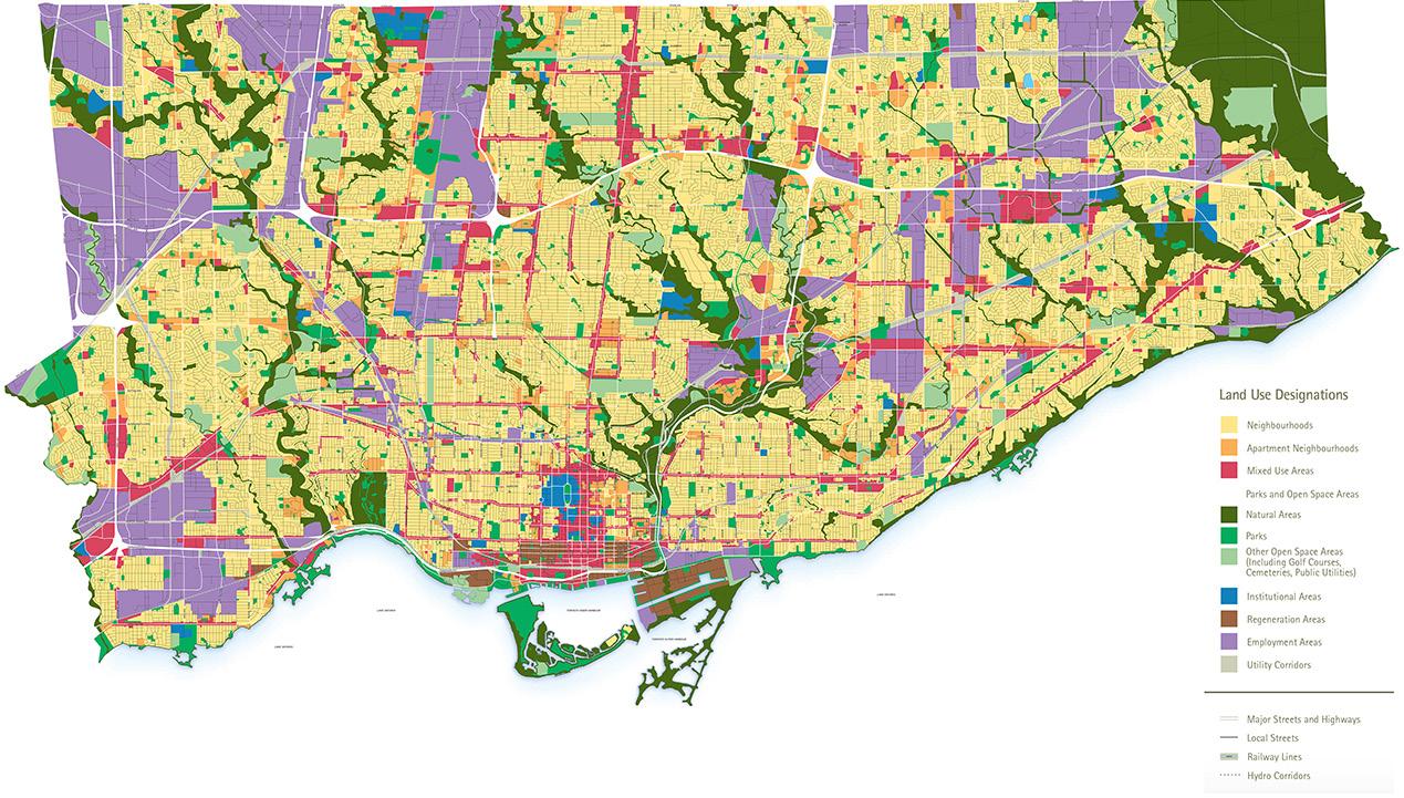
Focusing on Toronto as an example, the housing crisis has become one of the greatest contemporary issues faced by the city. We can look to Toronto’s planning zoning as a root of the housing crisis problem. The zoning system has established large areas of the city restricted to only single-family housing development. We can see these areas in yellow on the zoning map of the city (Figure 6). The maintenance of these zoned neighborhoods has limited the areas where density can be created and where change can happen in the city.27
Though there are limitations for development in areas protected under zoning, Toronto is still undergoing large amounts of development in the areas where the zoning plans allow. Areas where dense urban development is allowed have become dotted with massively tall condo towers. These areas for dense development are shown in red, orange, and brown in the zoning map (Figure 6). The yellow single family zoning areas have set limits for the city’s housing stock to only be built up in these red, orange, and brown areas. Additionally, these zoning restrictions create a sharp contrast of either super tall dense areas or lowdensity low-rise housing. What’s missing is an in-between of low to mid rise density, more evenly distributing population density across the city.
We can consider the housing stock of Toronto and the restrictions placed on it by the current zoning districts to be a system organized with engineered resilience. This system is currently experiencing pressures from the housing crisis. Building more condos in developable areas without adjusting zoning restrictions is like strengthening the sides of the resilience curve, maintaining the city within the limits set by the zoning system. Adjusting
14
24. . Scott, pg. 126. 25. . Scott, pg. 90. 26.
2021. 27. .
the restrictive zoning would be to imagine the city within a slightly different system state, allowing for more diversified typologies and densities within the current restricted areas of the city. Instead of being limited to the restriction of single-family housing, those areas could take on different urban characters based on the less rigid changes allowed in them. This would additionally open up the restricted areas to form better distributed density and more diverse local typologies and services.
For Toronto to shift from an engineered resilience planning style to one rather based around ecological resilience, one of the things it would need to alter is its zoning framework. This also brings up further questions on how we might consider ecological resilience style planning in general. Where and what can we work with? This question will now be explored in the following chapter.
Figure 6. Toronto’s Zoning Plan map. Source: https:// urbantoronto.ca/ news/2017/04/ densecity-part-1where-toronto-buildsdensity-and-why
15
Chapter 3 - Planning with Ecological Resilience
Moving beyond planning with engineered resilience we consider planning with ecological resilience. As we have seen in the previous sections, it can be concluded that where resilience planning is present in North America it usually takes the form of engineered resilience. In that form it is not surprising that it often does not include deep consideration for adaptability. Given the context of change that is likely to push beyond what we have planned for, it is useful to consider how to plan for entirely unexpected shifts in how we will live in the future. Ecological resilience offers a useful framework to that end. By planning with ecological resilience, we imagine a new system state for the city in which the future adaptability of the system drives the design.
Adaptability and Scales
Resilience theory is applicable to both the study of ecologies and the built environment, as both are made up of complex interconnected scales of smaller parts. For example, some of the noticeable parts that make up ecological systems include plants, animals, water, and soil. Some parts that make up urban systems include small buildings, large buildings, neighbourhoods, and infrastructure. These smaller parts then interact at different scales to compose the larger systems of ecologies or cities. It can be observed that the different scales formed by the interaction of the different parts change at different rates, starting with the smaller parts changing faster. As either the parts, or recognized groups of parts, get larger in scale they tend to change at a slower rate. This difference of change rate in relation to scale in both ecologies and cities is noted by Richard T.T. Forman in his book Urban Ecology, where he describes these systems of scales as:
“Natural processes and human activities serve as mechanisms producing a scale pattern, and then maintaining or changing it. Each spatial scale in an urban region can be planned and sustained using a combination of incentives, regulations, laws, care/stewardship, social action, market investments, or government action. Such a hierarchy of spatial scales is common in urban areas. A hierarchy or hierarchical system has higher levels with larger, slowly changing units (entities), and lower levels with smaller, fast-changing units. Large objects have more inertia and are harder to change than are small ones. Thus, stability and predictive ability are greater at the higher level or broad scale. Small units normally fluctuate more and are less predictable. In addition, the upper levels typically constrain the lower-levels, while the lower level initiates changes affecting upper levels, though in both cases the
16
opposite may occur. Conditions of a unit at one scale thus are affected by inputs or signals from both the scale above and the scale below. Furthermore, the unit is affected by competitive or collaborative conditions of other units at the same scale. Thus a particular unit is controlled by three scales, upper, same, and lower levels.”28
Forman additionally points out that these different scales of parts within ecological and urban systems inform the changes and effects that occur at all levels within the system. Changing smaller parts affects the character of the larger systems while simultaneously making changes to larger systems can affect the smaller parts within it.
Architecture can be a changeable scale through construction, demolition, and modification. Infrastructure in the city is as well, but at a much slower rate. Through a faster ability to be altered with building and demolition it is easier to modify small scale built objects rather than large scaled ones. The changes of both architecture and infrastructure together alter the nature of the city. Ecological resilience can be introduced in urban and ecological systems by working with the different rates of change that comprise them. In architecture and planning there is latency for adaptability at different scales. A smaller scale of architecture maintains a latent potential for adaptation through its ability to be altered at a faster pace than larger scales. However, in considering this adaptability of architecture and scales it is important to note that changes can happen only if the larger planning systems that regulate them allow for it.
28. . Forman, Richard T.T. Urban Ecology. Cambridge University Press, 2014, pg 33
Ecological Resilience Planning in Tokyo
As we saw in the previous section, adaptability has the most significant impact at the scale of systems. With regards to architecture one of the more relevant systems is the one that regulates planning. There is a history of approaching flexibility and adaptation at the architectural scale, however it needs to be considered as part of a larger system. An example that illustrates both the power and shortcoming of tackling adaptability at the scale of a single building is the Nakagin Capsule tower, by Kisho Kurokawa (Figure 7). This adaptability in the architecture was imagined through adding on more capsules or modules making the building, in theory, expandable for the future. Building typologies like the Nakagin Capsule Tower, however, did not come to be realized as adaptable. They stayed in the same state after construction without additional capsules or modules being added. These design systems didn’t expand further, even though the system of modules was intended to change. No new variations of the capsules were produced and so the apparent adaptability was a mirage. There was no infrastructure in place to allow any significant adaptation with modular based architecture like the Nagakin Capsule tower. The building could change, but it had to be done in a very specific manner controlled by the capsule limits of the system. In order to consider adaptation in a flexible manner a system must be allowed to change with enough breadth that it can remain relevant over time.
An interesting observation on adaptability comes from comparing the Nagakin Capsule tower with the surrounding Tokyo urban context. As stated before, though Nagakin was intended to be adaptable within its system restriction, it was never realized. If we look at the Tokyo urban context however, we see a different story in which adaptation and change are a constant force. Tokyo’s buildings, specifically the suburban neighborhoods, will change 30% of its buildings every 30 years.29 The reason for this rate of change is due to the planning and zoning systems in place in Tokyo (Figure 8).
Japan’s zoning system is divided into 13 categories which regulate aspects like building size, use, and sunlight access to both the building and neighbours.30 However, regulation of building size does not dictate the density of a site, merely height. For example, a single-family home could be next to a small apartment building. Additionally, building use regulation has stipulations for mixed uses throughout the categories, allowing, for instance,
. Galloway.
. Galloway.
17
29.
30.
Figure 7. Nagakin Capsule tower, showing age having failed to exercise its concept of adaptability.
Source: Retrieved from: https://www.dezeen. com/2021/07/16/ nakagin-capsuletower-dismantlednews/
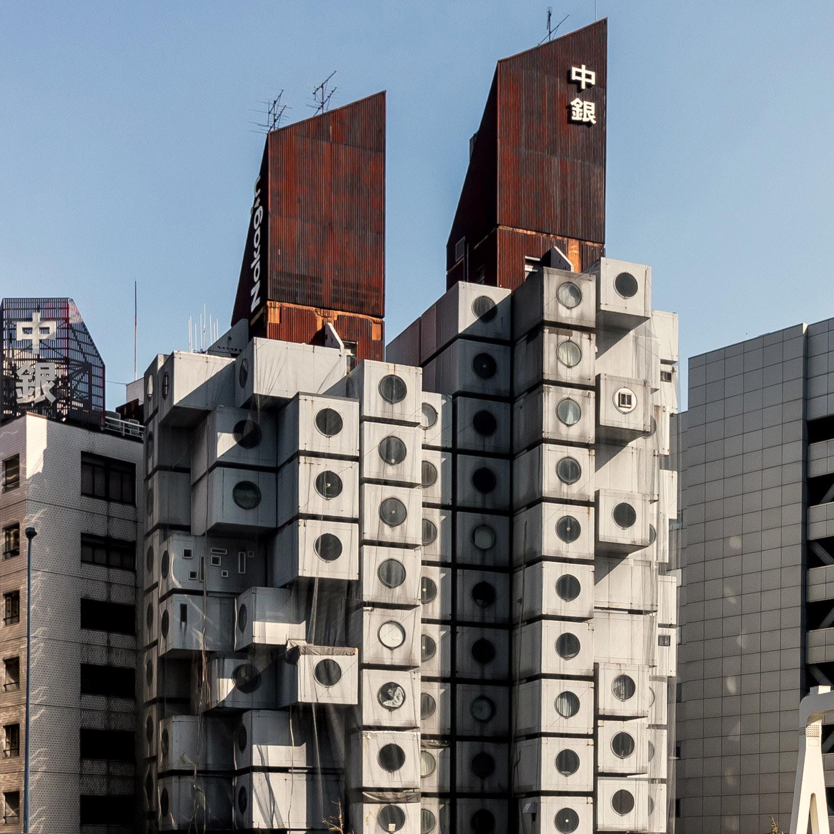
Figure 8. Tokyo’s Zoning system zones and categories.
Source: Retrieved from: Galloway, Will. Scaling M-NEX Ideas and Tokyo Urbanism, 2022.
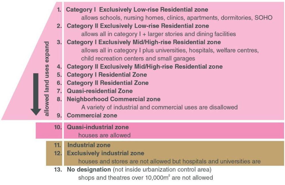
18
restaurants in residential neighbourhoods. This zoning system, in which some aspects are controlled but others are given freedom, gives the urban context of Tokyo a form of builtin latent adaptability, through possible varied building uses and changing densities.31 The urban context of Tokyo has its rate of change because the infrastructure system of zoning provides enough flexibility for it to do so. From this we can understand that adaptability in cities is not necessarily about the architecture itself, but also the infrastructure and planning infrastructure that shapes the buildings, streets, and systems.
With Tokyo’s zoning system in mind, we can draw comparisons with Toronto’s to get a sense of North American city planning. Both systems show differing approaches to their planning systems and as a result have differing urban outcomes. It should be noted that Tokyo, unlike Toronto, does not have a housing crisis.32 This is because the allowed density in neighbourhoods provides for enough construction to meet housing stock demand. We can compare to how certain large areas of Toronto are limited from densifying through single family zoning rules. In addition, the neighbourhoods of Tokyo “are potentially as walkable and as well served as central urban settings when it comes to services, from medical care to restaurants.”33 Whereas the suburban neighbourhoods and certain areas of downtown in Toronto exist in a much more car focused and less walkable state. Zoning has created areas for business and areas for living stretching out the distance between services and housing. These typologies are controlled by zoning restrictions put in place. Zoning in Tokyo allows the creation of dense, diversified, walkable neighborhoods, and zoning in Toronto creates functional separations, limited or imbalanced density, and car focused planning.
In comparing the zoning and planning system of Tokyo and Toronto we can see a difference in adaptability of the two systems. Toronto demonstrates a planning system designed to be engineered resilient, in which the system works at a certain population level, and often if the citizens have cars. When those requirements are pushed by things like a population increase you get a housing crisis. Tokyo, however, demonstrates a more ecologically resilient form of city through its zoning system. An area of the city can change into a different urban state and thats not a problem. The buildings of the city can adapt to meet needs, whether for density or typologies, and this is because the zoning system allows for it to happen.
We can describe the Tokyo urban context as having latency meaning the city is latent with an ability to change and adapt.34 Something that has the potential for adaptability in the future can be thought of as having latency. Latency can exist within architecture, urban systems, and ecological systems as the unrealized potential for change, adaptation, and flexibility, so long as these systems allow for it. Ecological resilience informs latency in architecture and planning. The system being designed with it in mind is latent to accept change through the flexibility and adaptability built and planned within. As such, a city designed with ecological resilience can be considered a Latent City.
Jane Jacobs and Urban Ecological Resilience
The discussion of Tokyo’s zoning system explores ecologically resilient urban systems through the framework of top-down planning decisions. This leaves us to consider if a bottom-up approach to achieving ecologically resilient cities is possible. To explore this, we will now look to the works of Jane Jacobs.
The urban planning critic and writer Jane Jacobs wrote her most famous work The Death and Life of Great American Cities in the 1960s. The book was written as a defense of urban neighbourhoods that were being threatened by large scale urban development projects at the time. These projects included new expressways or modernist housing block
19
31. . Galloway. 32. . Galloway. 33. . Galloway. 34. . Galloway.
. Scott, pg. 144.
developments. The neighbourhoods that Jacobs described were urban communities, formed gradually, generally lower income, which she praised for their liveliness, activity, and diversity in their streets, shops, and houses. To protect them from being replaced or damaged by the developments, Jane Jacobs argued the liveliness and changing character of traditional cities and neighbourhoods is what ultimately made them successful social communities and urban spaces.35 She favoured a bottom-up community organization approach to city planning that was shown in these communities. This was in opposition to the top-down organizational planning in style at the time. James Scott quoting Jacobs wrote that:
. Scott, pg. 144.
“While recognizing that no urban neighborhood can ever be, or should be, static, she stresses the minimal degree of continuity, social networks, and “street-terms” acquaintanceship required to knit together an urban locality. “If self-government in the place is to work,” she muses, “underlying any float of population must be a continuity of people who have forged neighborhood networks. These networks are a city’s irreplaceable social capital. Whenever the capital is lost, from whatever cause, the [social] income from it disappears, never to return until and unless new capital is slowly and chancily accumulated.” It follows from this vantage point that even in the case of slums, Jacobs was implacably opposed to the wholesale slum-clearance projects that were so much in vogue when she was writing. The slum might not have much social capital, but what it did have was something to build on, not destroy. What keeps Jacobs from becoming a Burkean conservative, celebrating whatever history has thrown up, is her emphasis on change, renewal, and invention. To try to arrest this change (although one might try to modestly influence it) would be not only unwise but futile.”36
37. . Saunders, Doug. Opinion: Jane Jacobs’s Afterlife: Revisiting the Death and Life of Great American Cities, 60 Years Later. The Globe and Mail. The Globe and Mail, October 25, 2021. https://www. theglobeandmail. com/opinion/ article-jane-jacobssafterlife-revisiting-thedeath-and-life-of-greatamerican/.
. Saunders.
. Saunders.
Jacobs’ writing on diverse urban communities celebrated the qualities of “change, renewal, and invention” that those neighbourhoods exhibited. Because of the balance of both change and stability, the urban system of neighbourhoods recognized by Jacobs was one based in ecological resilience. The neighbourhoods maintain stable states in their gradual changing of use, inhabitants, and buildings of the city and as such can adapt over time to new pressures within the community. From this we can learn some ideas on how to engage with ecological resilience in planning, which involves the creation of a living and changing social community, continuously built up over time.
While the urban community format that Jacobs wrote about demonstrated a form of an ecologically resilient city, it is important to keep in mind that her discussion is now 60 years old. Overtime the form of neighbourhoods that Jacobs had written about have eventually become something that no longer changes at the same rate that it did when she was writing. The evolution of attitudes of living in the city and the cost of the housing market has turned these dynamic neighbourhoods into static museum pieces in some instances.37
Saunders.
In conjunction to this stagnation, the lively and changing neighbourhoods talked about by Jacobs are no longer capable of happening on their own in developing or troubled neighbourhoods today.38 Contemporary developing neighbourhoods are a different form than the ones described by Jacobs. They are suburban homes and apartments built in the later 20th century, and designed primarily for vehicle use on the street. Whereas the form Jacobs refers to is a different, more walkable, 19th century format.39 These current developing neighbourhoods often lack accessible infrastructure services like shops and businesses that support the housing systems and create the lively walkable streets of Jacobs’ writing. Additionally, at a planning level the neighbourhoods of Toronto also lack the ability to change or implement those support systems because of the yellow area zoning rules mentioned in Chapter 2. Without the support system of community infrastructure such as businesses, shops, and employment within an easily accessible range it is difficult to create a lively and changing community. This means that the bottom-up approach to planning that Jacobs championed must be supported by some top-down interventions in order to function.40
20
35.
36.
38.
39.
40. .
Doug Saunders wrote in a Globe and Mail piece about this need for infrastructural support in order to achieve Jane Jacobs’ urban character. In it he summarized that:
“While the last century’s Jane Jacobs campaigned against the interventions of planners, this century’s successors need to be campaigning for them. No amount of local committee meetings will create easy foot traffic between poor and wealthy suburban blocks; simple protests won’t straighten the streets and fill the empty spaces with shops and more housing and bring employment into the centre of high-rise districts, even when it becomes legal to do so. The entire planning and development-approval process needs to be reoriented to serve the potential future residents of neighbourhoods, not their current ones.”41
Though the applicability of implementing Jacobs’ writing has shifted over the years, her ideas for what makes community successful through variety, changeability, and liveliness are still applicable as goals for urban areas. All that is left is for planners to figure out how to get contemporary cities to that point, perhaps this can be done through implementing a planning system that incorporates both top-down and bottom-up approaches to its planning and change management.
Ecological Resilience in David Sim’s Soft City
The work of Jan Gehl and David Sim is focused around “cities for people” and “human scaled” planning. In their ideas of planning, the city is made resilient by designing urban spaces to be similar to the thinking of the traditional small scale, changing, diverse, and walkable neighbourhood forms praised by Jane Jacobs. Having worked together for years, Sim works with the planning theories of Jan Gehl found in some of Gehl’s books like Cities for People
Sim’s thesis Soft City creates an urban planning design based around creating cities centered around people, social liveliness, and diverse activity. Soft City describes multiple options to generate social cities including the ideal scale, organization, and composition of architecture and public spaces. The concepts of Soft City are summarized in Sim’s final chapter of the book as “Nine criteria”. These state that a city should: 1. have a diversity of built forms, 2. have a diversity of outdoor spaces, 3. have flexible buildings and public space, 4. be of a human scale, 5. be walkable, 6. provide a sense of control and identity to the inhabitants, 7. create pleasant microclimates in courtyards and streets, 8. have a reduced carbon footprint, and 9. create a better biodiverse setting for plants and animals within the city.42
Applying these concepts, Sim has come up with his ideal building form. These take shape as larger courtyard blocks that are subdivided into smaller plots. The larger city block is formed out of the compilation of a series of buildings that are placed up against each other (Figure 9). The divided blocks intend for the architecture built in them to reflect a diversity of experience and use in a human scale with a mix of shops, businesses, and housing. Additionally, the building heights are maintained at a low to mid rise height and are laid out in at a walkable distance.
Sim points out that dividing the larger blocks into smaller individual buildings allows for the flexibility for the spaces and uses to change over time (Figure 10). “Together, you get a system of independent fractals with limitless permutations. Each individual building has the potential to adapt and change, in its own way and responding to the unique and specific circumstances of its users. The totality can make a resilient system, accommodating difference and tolerant to change over time.”43 Sim’s block design converts a less flexible scale of a larger courtyard building to a more adaptable form by subdividing it into smaller
. Sim, pg. 87.
21
41.
. Saunders.
42.
. Sim, David. Soft City : Building Density for Everyday Life, Island Press, 2019.
43.
Figure 9. David Sim’s block concept with smaller subdivided individual buildings.
Source: Sim, David. Soft City : Building Density for Everyday Life, Island Press, 2019.
Figure 10. David Sim’s divided individual buildings and their flexibility from his Soft City concept.
Source: Sim, David. Soft City : Building Density for Everyday Life, Island Press, 2019.
22
separate buildings. These smaller and separate buildings then still form a courtyard block, but can change at a faster rate than if they were one large building.
By ensuring that his planning system can change and adapt Sim is designing an urban system that utilizes ecological resilience. Soft City allows for, if not encourages, change within its envisioned form, and by maintaining a similar form, the design can continue to change and adapt in the future. In this, Sim’s ideas echo the previously discussed planning strategies of Tokyo, Jacobs, and Saunders, in which a planning system is creating a situation for adaptability and ecological resilience to form. Soft City aims to establish the system described by Saunders, in which the planning system creates and supports the type of communities Jacobs praised, and allows a form of bottom-up planning in its community management concepts.
New Urbanism and Resilience
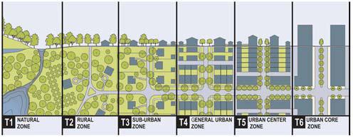
The urban resilience created with a diversity of typologies and activity described by Jacobs, Sim, and Gehl was similarly attempted by the New Urbanists in the development of the transect urban plan model. (Figure 11) The model is based on the pattern of ecological succession, where cities are imagined in different zones of density and complexity. The zones start from natural and rural peripheries and gradate to dense urban city centers. The intention of this scheme is to emulate the result of a city which has developed over time and the resilient diversity that can come with it. However, the transect model fails to fully engage with an ecologically resilient urban model. This is because the transects, though they offer a diversity of urban environment, do not allow change beyond their established state.44 Without allowing for change the New Urbanist transect system is no longer an ecologically resilient model that the goal of urban typology diversity would suggest. Rather the New Urbanist system behaves like the organizational separations of modernist planning, making it a single imagined state, and so an engineered resilient system.
44. . Hélie, Mathieu. How Urban Change Is like Ecological Succession. Strong Towns. Strong Towns, July 30, 2019. https://www. strongtowns.org/ journal/2019/7/25/ how-urban-changeis-like-ecologicalsuccession.
Figure 11. New Urbanism transect planning model.
Source: https://www. strongtowns.org/ journal/2019/7/25/ how-urban-changeis-like-ecologicalsuccession
23
45. . Ahern, Jack.
“Urban Landscape Sustainability and Resilience:
The Promise and Challenges of Integrating Ecology with Urban Planning and Design.”
Landscape Ecology 28, no. 6 (2012): 1203–12.
The Ecological Layer
The concepts and design ideas discussed in this chapter so far demonstrate the beginnings of planning with ecological resilience. These take the city beyond engineered resilience, but there is still something lacking from a full consideration of ecological resilience.
Beyond a brief mention from Sim, what is lacking is these concepts do not discuss the ecological dimension of the city. Natural spaces and parks are often still treated as separate entities from the city. Still functioning in a similar fashion as the relief park spaces designed by Olmsted. To fully address ecological resilience in planning and architecture then green spaces and ecologies must be able to change and adapt in tandem with the city.
Achieving ecological resilience involves considering cities and ecologies to be one system. This means that cities would allow ecologies to develop resilient and functioning systems intertwined with the built environment of the city. To allow for the ecological system to function effectively, it needs to be able to form a bio-diverse, continuous, connected, and flexible environment.45 Often the expanse of the city negatively effects and limits ecological space by either taking over land or disconnecting interacting ecological systems. As such to establish ecological resilience the ecological systems must be allowed to interconnect through the built forms of the city to create a complex bio-diverse new layer in the city.
Ecologies become another important layer and scale of the city to consider in an ecologically resilient urban system. This understanding changes the way cities have been formed from a consideration of a separate binary of humans and “nature” to an interwoven singular system. It is through designing with ecological resilience in the combined built environment and natural environment that we can realize adaptable ecological resilience for the city.
Urban Ecological Resilience in Summary
The examples of urban ecological resilience covered so far in this chapter have shown that there are some aspects of both urban and architectural design that allow for ecological resilience to be created in cities.
The discussion of scales highlighted how we can consider the smaller scaled objects that make up the city to be more adaptable. Architecture can be considered an adaptable scale getting progressively slower to change the bigger it gets.
Looking at Tokyo provided an example and understanding of how adaptability in cities is heavily controlled by the planning systems that regulate them. In order for the buildings, streets, and systems of a city to adapt to change, then the planning infrastructure of the city must allow for it to do so. Tokyo serves as an example for a planning system that creates ecological resilience by allowing for the buildings of the cities to change, densify, and adopt different diverse uses.
Exploring the writings of Jane Jacobs provided insight into how the traditional urban neighborhoods she wrote about exhibited a form of ecological resilience in their diverse, active, and changing nature. Saunders’ critique of Jacob’s applicability today established that, to achieve Jacobs’ form of adapting and resilient city, a planning framework must create the systems to support it.
The writing and ideas of David Sim’s Soft City demonstrated developing an ecologically resilient planning system. The scale and typology freedom of his buildings allow for the
24
city blocks to change and adapt to new uses and situations. This creates a urban system similar to the Tokyo model or Jane Jacobs model.
The discussion of ecologies in the city explained how if we are to fully achieve ecological resilience then we must consider the ecological dimension of the city. Natural systems and the city must coexist and be considered as one changing system to ensure both can become resilient.
If we combine what is learned from these discussions and examples, we can imagine a planning framework based in ecological resilience that intends to create an adaptable urban environment. To achieve this, the imagined planning framework describes zoningstyle rules for the parts of the system to follow. These include rules which inform building scale, flexible density, diverse typologies, public space, and ecology integration. We will be exploring this proposed framework further in Chapter 5.
25
Chapter 4 - Engineered Resilience Planning Continued?
The discussions so far on resilience planning has led to some ideas on what factors decide if a city is planning with engineered or ecological resilience. As we touched on in Chapter 2, North American cities have been and still are being planned with engineered resilience. To explore this statement further, and using Toronto as an area of focus, we can look to some contemporary development plans for the city. Two areas of large scale current and future development come to mind which are the Port Lands and Quay side redevelopments.
The Port Lands redevelopment plan in its current state was produced by the City of Toronto planning department. The plan is a part of a greater report released by the city, titled the Port Lands Planning Framework, which outlines the infrastructure, streets, public spaces, building character, and building typologies envisioned in the redevelopment of the area (Figures 12, 13, & 14)). A key area of the plan currently under construction on the west side of the Port Lands is the Villier’s Island development and Don River Outlet Flood Protection Project. This part of the redevelopment is a major reworking of the Don River outlet into the Toronto Harbour, to combat flooding issues caused by the overloaded Keating channel and straightened lower Don River. By redirecting the river, the project takes the shape of a naturalized river floodplain and park space. Villier’s Island is created by the river redirection which includes a future urban area, with housing and community functions on its north side along the Keating channel. The new river floodplain additionally connects south to the shipping channel through a greenway which functions to allow flooding spillover. The Planning Framework states that the greenway is also intended to connect the ecological spaces of the Don River with the Leslie Street spit to the south of the Port Lands.
The eastern side of the plan at the end of the shipping channel, and around the turning basin, is slated for continued industrial and shipping uses at least for the foreseeable future. In the middle of the Port Lands redevelopment area is a future planned live, work, and media production community. This area stretches along the shipping channel and turning basin and is centered around the future main intersection of Commissioners Street (east-west) and Broadview Avenue (north-south). These two streets make up the major thoroughfares and streetcar transit routes through the Port Lands area. The central area in the design is laid out with large high rise condo blocks in mind for housing, along with a large park, possible office buildings, and media production studios. The Basin Media hub (Figure 15) located along the north side of the shipping channel and southwest corner of the turning basin is a planned media production zone featuring large sound stages and offices. This hub along with the existing Pinewood Studios make up the media production
26
Figure 12. Aerial rendering of the of the proposed Port Lands Redevelopment.
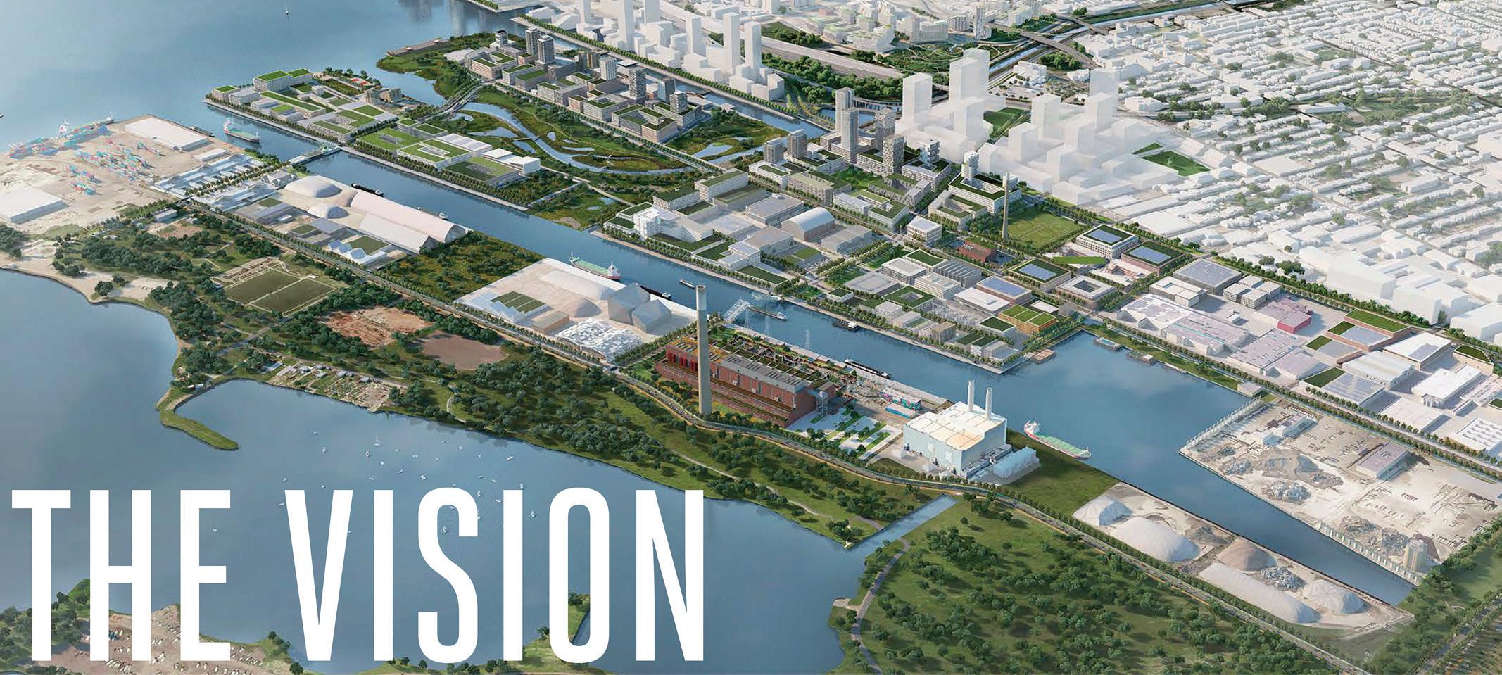
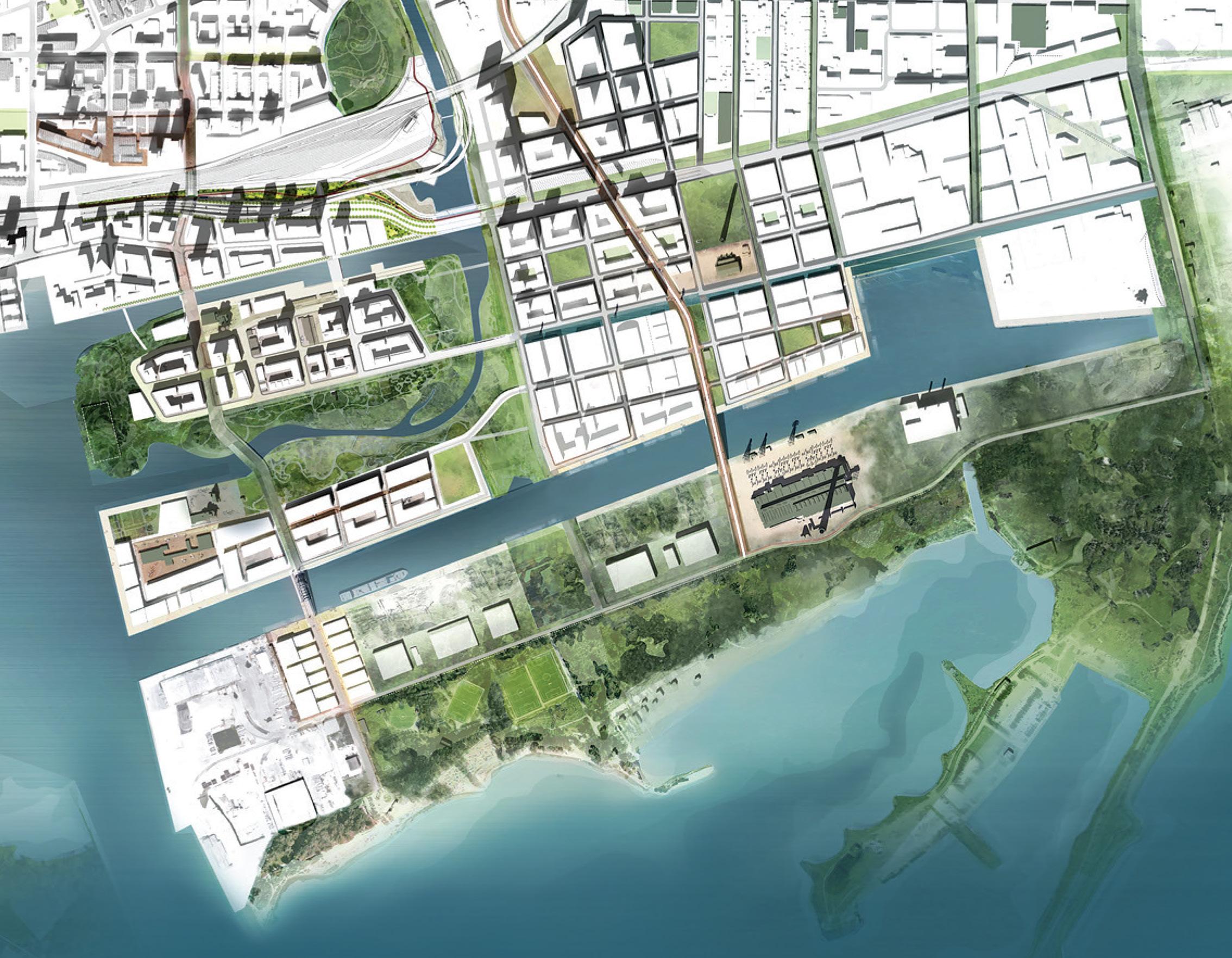
Source: City of Toronto, and Waterfront Toronto. Port Lands Planning Framework. City of Toronto, 2017.
Figure 13. Master plan drawing of the proposed Port Lands Redevelopment.
NSource: City of Toronto, and Waterfront Toronto. Port Lands Planning Framework. City of Toronto, 2017.
typologies within the area described by the plan. Additional existing buildings within the City’s plan include the Hearn, a decommissioned mid-20th century power station preserved for its industrial heritage, and the Commissioners Waste Transfer Station building, also recognized for representing the past industrial heritage of the area.
The Don River outlet redirection part of the Port Lands redevelopment plan is a major feature of the design. The ravine serves a functional purpose as infrastructure for river flood management. It also functions as an ecological relief space for the city similar to the park spaces of Olmsted. The buildings imagined in the development are street block
27
Figure 14. Desired neighbourhoods within the Port Lands plan.
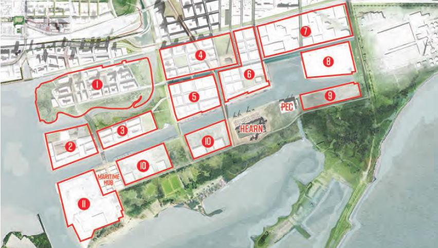
Source: City of Toronto, and Waterfront Toronto. Port Lands Planning Framework. City of Toronto, 2017.
Figure 15. Basin Media Hub design proposal.
Source: https://www. toronto.ca/news/ city-of-toronto-andcreateto-announcedevelopment-partnerfor-the-250-millionbasin-media-hub/
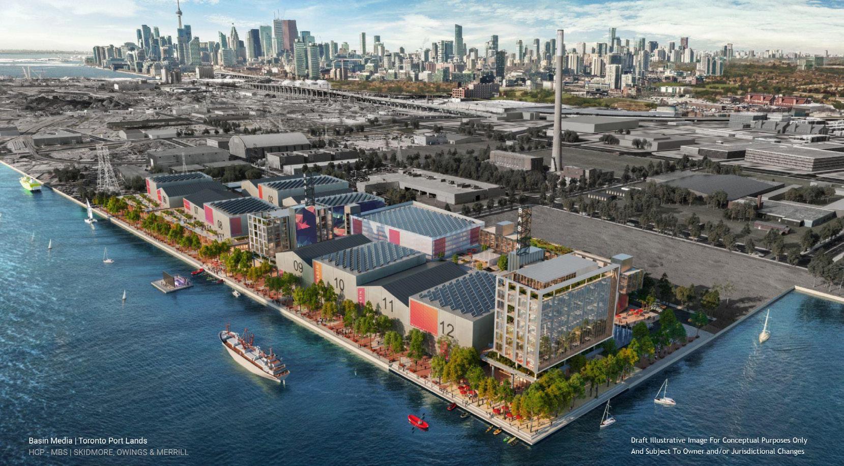
sized condominium buildings, something that is typically found in downtown Toronto. Additionally, the streets of the plan are designed primarily for car use
Located Northwest of the Port Lands is the Quayside redevelopment site (Figure 16). Previously this area was the site of the Sidewalk Labs project which envisioned a sustainability driven high tech “smart city”. That scheme however was canceled and has since been replaced with a new development proposal. This new proposal intends to develop the area with high density housing, public spaces, and sustainability driven construction. The new form is a reflection of a more typical downtown Toronto tower
28
Figure 16. Quayside development along the Toronto waterfront.
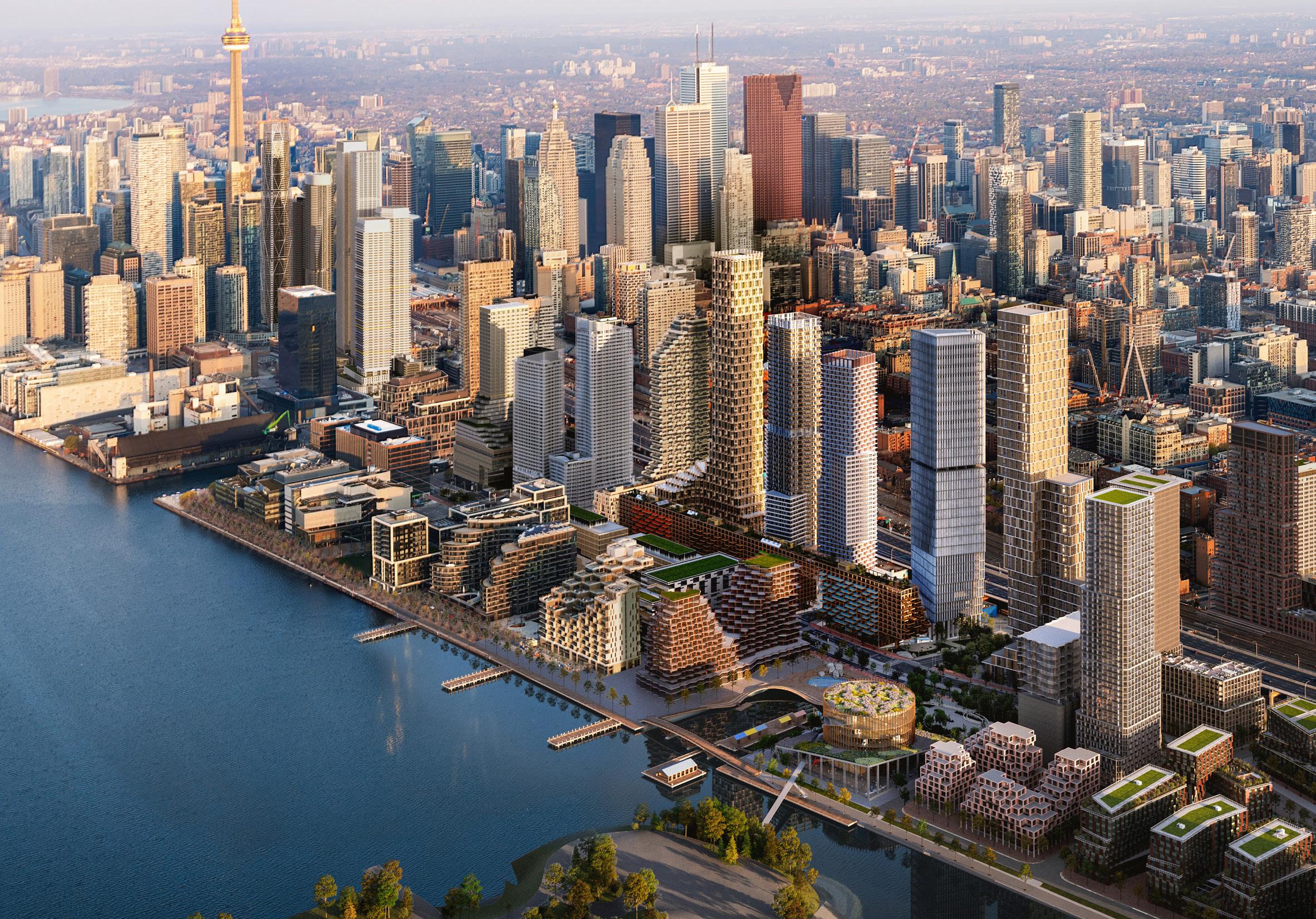
Source: Retrieved from: https://www.dezeen. com/2022/02/23/ adjaye-mass-timberplants-for-torontowaterfront/
Figure 17. Adjaye Associates in the Quayside development.
Source: Retrieved from: https://www.dezeen. com/2022/02/23/ adjaye-mass-timberplants-for-torontowaterfront/
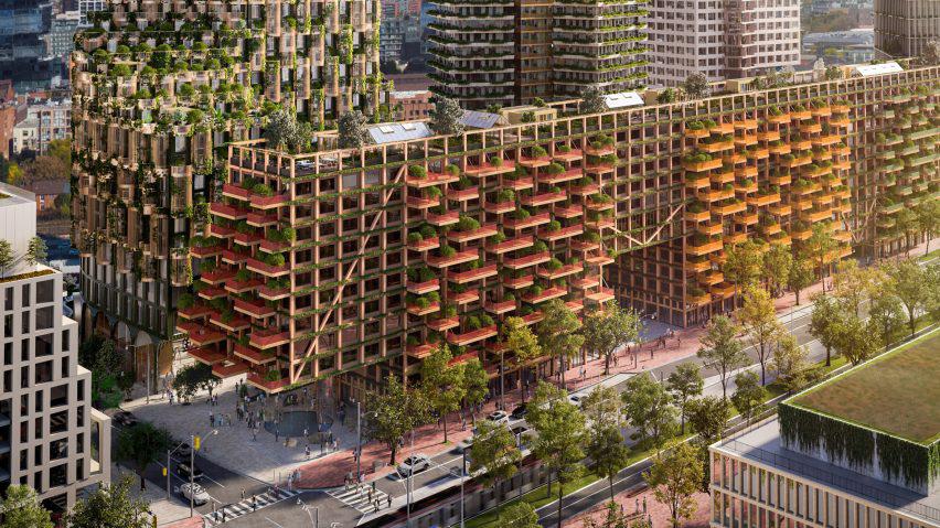
format over the ideas proposed by Sidewalk Labs. The development’s design aims to create a community in the area constructed at a net zero carbon emission standard with a large implementation of plantings and greenery (Figure 17).
Looking at these two plans we can understand some aspects the make the developments to be engineered over ecologically resilient. These aspects include the separated treatment of the ravine ecology space, the functionally separated areas like the Basin Media Hub or tower and podium building forms, and the massive block sized buildings featured in the plan. We can understand this in further detail by looking back to some of the ecologically resilient city concepts that were discussed in Chapter 3.
The Don River outlet redirection is an impressive feature of the design, and it acts to
29
. Galbraith.
establish some ecological resilience for the river ecology through its biodiversity. However, there is a disconnect between the ecological resilience of the ravine landscape and the engineered resilience of the rest of the Port Lands plan buildings and urban system. The Port Lands plan, and similarly Quay side, both utilize buildings of a larger scale that are harder to change. Through this scale, and the function separations in the buildings, there is no intention for them to change beyond the state they are initially imagined. This makes the change dynamics of an ecologically resilient urban environment, like seen in Tokyo, difficult for the plans to achieve.
It is important to note that these plans, and the density shown in them, continue to work within the unchanged zoning system of Toronto, which we established is an engineered resilient system. Both the Port Lands and Quayside show how areas of Toronto that are allowed density are constructed. In looking at the tower developments of downtown Toronto contrasted with the single-family zoned areas, we can see how the city lack a middle area of density.46 Density is hyper concentrated in develop-able areas like the Port Lands but also highly spread out in the yellow zones.
Though there is an intention to create street activity at the ground level, the diversity of spatial uses in the building suffer from a typical Toronto model of separating functions of housing and business. This can be seen in the tower and podium form of condominium architecture, that has come to characterize Toronto’s downtown, and is prevalent in these waterfront development projects. The form creates a clear division between housing and services, and highly limits the amount of businesses and services that can serves the high density of the towers.
48. . Sim, pg. 86.
47. . Holling, C.S. and M.A. Goldberg. Ecology and Planning. In Projective Ecologies. Edited by Chris Reed and NinaMarie Lister, New York: Actar and the Harvard Graduate School of Design: 106-125. [1971] 2014, pg. 118.
Outside of the buildings we can also see typology separation in the plan through function based area like the Basin Media Hub. This is an area focused primarily on media production. As described in Chapter 3, a highly diversified use of spaces for a mixture of housing and services is described as essential for creating a resilient and dynamic community both by Jane Jacobs and David Sim. Urban systems are like ecologies in necessary complexity and diversity for them to be successful. A monoculture ecosystem is not very resilient ecology just as a mono-culture of urban building typology limits the liveliness, self-reliance, and resilience of a community.4748
Though the Port Lands and Quayside plans demonstrate an intent in addressing issues like sustainability the strategies still work within the limits of engineered resilience. The strategies used like planters, green-roofs, mass timber construction are tied to building forms which we discussed are engineered resilient. Sustainability strategies in situations like this act to continue extending the boundaries of the stable system state. These strategies are still useful as an additional layer, but to address sustainability in an ecologically resilient plan would imagine a city system in which nature and wilderness are able to coexist in the immediate context more effectively. This means that instead of the current form of the Don River outlet redirection that is treated as a contained wilderness park in the plan, the city could allow for the ecologies and natural systems of the river to blend with the urban system better. This acts to further strengthen the ecological resilience of the natural systems of the river by allowing more connective space within the city context. Additionally, by considering this natural system as another layer of the city, we can imagine a combined ecologically resilient system in which the city and natural systems ebb and flow rather than isolate in their designated area as they are in the current plan.
Some of the discussion on the Port Lands and Quayside plans so far have alluded to ideas on how to make those plans a more ecologically resilient format. If Toronto is to adapt to future change and uncertainty effectively then the city should look to become more ecologically resilient. This warrants a reconsideration of the Port Lands redevelopment plan into an ecologically resilient model. The following chapters will aim to approach this reconsideration through an ecologically resilient urban system framework informed by the lessons learned in Chapter 3.
30
46.
Chapter 5 - Latent City
The discussion on adaptability and latency in this thesis has established that when it comes to creating adaptable cities, it is the planning infrastructure system that has the most impact to create adaptable potential. An urban planning framework can determine if an urban area stays stagnant or undergoes major changes. Ultimately it is through creating an urban framework that we can consider creating adaptable elements of the city, like architecture.
Through reconsidering the planning of the Port Lands, we can imagine an adaptable and therefore ecologically resilient vision for the area. This urban framework envisioned is titled Latent City. The name is informed by the framework concepts which create a city form that has latent adaptability built into its systems.
The urban form shown in this chapter describes an initial ecologically resilient starting point imagined for the Port Lands, where a dynamic urban system can change and adapt over time. The design is informed by the ecologically resilient urban concepts that were established in Chapter 3 through exploring Tokyo’s planning system as well as the writings of Jane Jacobs (with Saunders’ alterations) and David Sim.
To effectively establish a changing urban system, a framework of zoning-style rules is imagined. These rules act to guide the initial design form, and future changes that happen to the city, both in the interest of maintaining a continuing adaptable character.
31
Figure 18. Diverse use of spaces in the framework buildings.

Source: Author.
Framework Rules
Diverse Typologies
To create a diverse and active urban environment, buildings in the framework can allow for a variety of uses for the space. This applies to both the exterior and interior of buildings. Typologies like housing, businesses (as in services like restaurants, offices, workshops, studios), and institutions like schooling or medical services, are all integrated into the spaces of the framework’s buildings. However, industrial facilities, and other large scaled public venues, are left out from the Port Lands redevelopment area exploration of this thesis but could be integrated in a different site.
32
Divided Blocks

Echoing the thinking of Sim’s building blocks, buildings are to be horizontally divided into a smaller human scale. This ensures several things happen: Buildings are maintained at a smaller and therefore more adaptable scale. Diversity is maintained in the street experience with an increased density of various businesses lining the street. The streets are more walkable, and therefore active, with a higher concentration of businesses on the street compared to large buildings (see appendix A1). If a building becomes a larger size over time, it must maintain this horizontal division scale at the street level.
Source: Author.
33
Figure 19. Dividing larger blocks into smaller individual buildings.
Figure 20. Three types of streets and public space.
Source: Author.
Public Space and Streets
Streets in the framework take 3 forms: major transit routes, secondary side streets, and pedestrian streets. Aside from the major transit routes, the street scape is made up of a continuously level surface. This makes the street a pedestrian first public space with occasional vehicle traffic.

34
Ecological Layers
To provide for natural systems in the city, ecologies are to be considered a layer of infrastructure. In addition to strengthening the ecosystems of the city, the increased ecological presence helps to reduce both urban temperature and air pollution. This can be seen in a correlation of a series of data maps from the city of Toronto (see appendix A2). The street in the framework is seen as a dual public and ecological space where street surfaces are gradated through wilderness area, public green spaces, green paved streets (paved surfaces that allow plants to grow in them), and paved public streets. The density of greenery and biodiversity in these areas is determined by how busy public activity is. Busy areas will have more dense public activity and be paved, whereas less busy areas will have denser greenery. Streets and buildings must provide space for plant and animal systems and allow for those spaces to connect throughout the urban environment. This means that buildings and streets shouldn’t create barriers that divide wilded spaces and green spaces, and solutions to connect them should be introduced.

35
Figure 21. Ecological layers and connections in the street.
Source: Author.
Figure 22. Buildings designed for deconstruction.

Source: Author.
Addressing Changes
Since the intention of the Latent City framework is to create an adaptable urban system then some criteria must additionally be established for some likely changes.
Design for Deconstruction
In the interest of making adaptation easier, building should be designed in the principles of design for deconstruction. This means that elements of the building are assembled in ways where they can be disassembled, and then either recycled for material, or reused in another building. This also lessens the environmental impact the building changes would have.
36
Increasing Density
To adjust to an increased population the Latent City would have to introduce greater density. To do this, buildings can increase their height and size so long as they provide more spaces or features for the ecological systems and/or public spaces of the city. The requirement for horizontal street division, mentioned in the rule on divided blocks, is also applicable in this scenario of increased density and building size.
Figure 23. Increased density and height in exchange for provided greenery or public space.
Source: Author.

37
Figure 24. Removed buildings replaced with greenery.
Source: Author.
Decreasing Density
If buildings are removed without another replacing it, then greenery is to replace the missing buildings.

38
Building Along Greenways
If buildings are to be added into the greenway space, then they must allow for enough connection between the green spaces of the built area and the greenway. These buildings must also hinder the greenway natural space as little as possible.
Figure 25. Connections with greenways to be maintained when buildings are built on the edge.
Source: Author.

39
Latent City
By applying the framework rules, we generate a Latent City form for the Port Lands. Latent City serves as the starting point of an ecologically resilient, dynamic, and changing urban system (Figures 26 & 27). The form shown in this chapter represents an initial state generated and guided by the framework rules (Figures 28 & 31). Because of the latent adaptability built into the urban system by the framework rules, the initial form adapts and changes over time to suit the pressures placed on it.
Exploring this Latent City form (Figure 28), the original Don River outlet greenway is expanded upon increasing the ecological density of the area. This expansion serves as the base connection to which the greenery throughout the city links. The streets are envisioned as walkable pedestrian-first areas intermixed with a layer of greenery and biodiverse planted areas. The two major axis roads of the original Port Lands plan are included but with modifications to allow for plants and animals to connect through them. These two roads function as the major traffic and transit route through the plan. The buildings of the initial urban form are comprised of a series of mid to high rise blocks horizontally divided into separate buildings to allow them a more flexible rate of change.
We can draw some comparisons between the Latent City form and the original Port Lands plan to understand the difference between the two. Looking at both developments we can compare both floor space in the buildings and publicly accessible green space to understand the balance of density versus planted spaces. Green space areas for a data comparison includes wild space, park lawn spaces, and hybrid green-paved surfaces. Data from the Port Lands plan was taken based off the visualizations provided in the Port Land planning framework. In its initial state we see a 25% reduction in floor area from the Port Lands plan to the Latent City form. In exchange, the Latent City form increases green space coverage by roughly 7.5 times that of the original Port Lands plan. This initial reduction in floor area for the Latent City is justifiable through the large increase in public green space in its initial form. Additionally, Latent City can achieve a greater density from this starting point through changes and growth in the buildings. It should also be considered that in a scenario where the City of Toronto adjusted their zoning strategies to a more ecologically resilient model, density could be spread out throughout the city rather than focused in highly dense areas, like the planned development for the Port Lands.
To further explore the detailed elements of the Latent City plan we can look to a sample area of focus taken from it (Figure 29). We will use this area of focus as the base for comparing the Port Lands plan, an ecologically resilient urban form, and the Latent City framework. This selected area is located along Commissioner’s Street at the edge of the greenway, and was chosen because the area effectively demonstrates many aspects of the framework form. Each of the examples covered have had area data taken from them to better allow a comparison of each scenario. The data includes building floor area, public spaces (including both greenery and paved ones), green spaces (greenery accessible to the public), and wild spaces (areas of biodiverse planting).
40
Figure 26. Latent City as a framework for an adaptable and changing urban system.


 Source: By Author
41
Figure 27. Latent City as a framework for an adaptable and changing urban system.

 Source: By Author
42

43
Figure 28. Latent City initial form aerial view.
Source: By Author
Area
Spaces
Spaces
Spaces
Original Port Lands plan form.
By Author
Original Port Lands Plan
Toronto’s Port Lands plan features large courtyard blocks, around 10 floors in height at the base podium, with occasional towers on top. There are some publicly accessible green spaces located inside the courtyard blocks, with a strip of green space that runs along Commissioner’s Street. For transit in the area, a streetcar line runs along Commissioner’s Street. The plan uses wide vehicle-based streets lined with sidewalks. In this version of the area, we see a limited amount of publicly accessibly green space that is a typical low biodiversity grassy lawn landscape.
Through the scale of the buildings, vehicle focused form of streets, lawn public park space, and previously mentioned separation of typologies, this is an engineered resilient urban planning form.

Area data: Floor area 129 565 sqm Public spaces
sqm Green spaces 2717 sqm Wild spaces 241 sqm
44
4547
Figure 29.
Source:
Floor
Public
Green
Wild
Ecologically Resilient Urban Form
Re-imagining the original plan for the area utilizing ecologically resilient planning concepts, the result shifts away from an engineered resilient system form. This version is an ecologically resilient urban form which demonstrates how the framework concepts informed by David Sim, Jan Gehl, Jane Jacobs, and Tokyo’s planning system could come together to shape an urban system.
This form exhibits the built elements of Latent City’s ecologically resilient urban system. It includes the divided building blocks, changeable building scale, and typology diversity that contribute to form an adaptable urban environment. The streets of the plan are formed as one continuous public space, with public green spaces are dotted throughout the area. Biodiversity is integrated into the city through naturalized planting on green roofs of the buildings, and the greenway of the Don River outlet is expanded upon creating a larger natural system.

Area data:
area
Figure 30. Ecologically resilient urban form.
Source: By Author
45
Floor
73 095 sqm Public spaces 29 823 sqm Green spaces 21 350 sqm Wild spaces 22 884 sqm
Floor Area Public Spaces Green Spaces Wild Spaces
When we compare the data of the Ecologically Resilient Urban Form with Toronto’s Port Lands plan, we can recognize a reduction of building floor area. This is done in exchange for an increase in public space, green space, and wild space.
This form represents an ecologically resilient built environment but is still limited from a full realization without a more thorough integration of ecological systems with the built environment.
Latent City
Latent City is created by introducing a layer of ecological infrastructure into the urban system (Figure 31). This further increases the ecological resilience of the city by bolstering a biodiverse and interconnected ecological layer. This layer is integrated with the Ecologically Resilient Urban Form to create one interconnected system.
Natural systems and spaces are integrated into the urban system through the streets, buildings, and infrastructure (Figures 32). The streets are treated as a dual public and ecological space (Figure 33). They contain a gradient of ecological density and diversity from wilderness areas (both in the greenway ravine and dotted throughout the plan), public park lawn spaces, green paved areas (paved surfaces that allow planting to grown in them), and finally paved public space (sidewalks along shops and public squares). In this framework form all these levels of the ecological density gradient are accessible to the public to create a fully interwoven environment.
The ecological layer throughout the urban system is connected back to the larger and denser ecological space of the Don River outlet redirection greenway. With this connectedness and space, the ecological system is able to form better bio-diverse, continuous, connected, and flexible systems in tandem with the urban systems of the city. Ecological connections are formed through the streetscape of the plan as well some of the building roofs and facades. Channels and tunnels are used to connect the ecological system through built infrastructure such as the major transit roads. Creating interconnected and bio-diverse spaces throughout the plan allows for ecologies to develop adaptable and resilient systems together with the built environment.
46
Floor Area
Public Spaces Green Spaces Wild Spaces
Figure 31. Latent City initial urban form.
Source: By Author
47
Source: By Author
Area data: Floor area
095 sqm Public spaces

823 sqm Green spaces
010 sqm Wild spaces
839 sqm
Comparing the Latent City initial form with both Toronto’s Port Lands plan and the Ecologically Resilient Urban Form; we see a further increase of green spaces and wild spaces due to the introduction of the ecological layer in the streets of the city. With an interconnected and biodiverse ecological layer added to the built layers we can realize an ecologically resilient system of a combined urban and ecological environment. We can justify a reduction of floor area from the Port Lands plan through two factors: First, Latent City brings an increased ecological presence and diversity in the city. Second, the Latent City form is a changeable and adaptable starting state rather than a completed final state like in the Port Lands plan.
48
Figure 32. View on Commissioner’s Street looking towards the Don River redirection greenway.
73
29
34
32
The Latent City design form has so far been described as an initial state for the urban environment. This is because the Latent City is the starting point for a changing and adapting urban system created by the framework. Over time the city can change depending on the pressures or scenarios it faces. To understand this changing nature, we can explore some potential future scenarios where the city might adapts to the pressure placed on it.

49
Figure 33. View of Latent City‘s greenway and green streets.
Source: By Author
Chapter 6 - A Changing City
There are an endless number of possibilities for future scenarios of the Latent City, depending on the pressures the system may face. Public attitudes change, economies shift, climates alter, and populations change. The future is hard to fully predict, and uncertainty demonstrates this well. Out of possible options for change we can select some for the discussion of this thesis. Three scenarios for changes happening to the Latent City form were chosen. These include population increase, population decrease, and denser ecosystems. It is important to note that these scenarios are demonstrating a potential outcome rather than a prescribed result. What happens in the scenarios is influenced by the Latent City framework rule system established. The form shown in each scenario is not necessarily what the changes would look like, rather how they could look like. Future scenarios could end up as a combination of each other, they are not necessarily an end state of the system but a snapshot of its change.
50
Floor Area
Public Spaces
Green Spaces
Wild Spaces
Scenario 1: Population Increase
Scenario 1 explores how the Latent City could address pressures from a population increase. To respond to this, the buildings increase in density and height. Following the direction of the framework rules, these larger towers maintain a human scale divided street level. To increase the height and size of the buildings they provide either public space or ecological space back to the city. In the case of these buildings many of them create planting systems in their facades and utilize green roofs. Both features extend the ecological density of the urban environment while increasing the population density (Figure 35). Other buildings also give back to the public ground space either providing new public spaces or allowing the public and ecological space to pass underneath the building.
Figure 34. Scenario 1: Population Increase.
51
Source: By Author
Some new buildings are introduced into the space of the greenway (Figure 36). This is possible by fulfilling two requirements: efforts must be made to minimize intrusion as much as possible and to maintain a physical and visual connection for both natural systems and public access. One of the ways this can be achieved is by introducing buildings on stilts or blending the surrounding ground level spaces with the greenery of the greenway. Second, they must ensure that the greenway and urban environment maintain a physical and visual connection for both natural systems and public access.

52
Figure 35. Scenario 1 Commissioner’s Street view.
Source: By Author
Area data: Floor area
Public spaces
Green spaces
Wild spaces
We can explore how the Latent City form has adapted in this scenario based on the area data collected from it. When compared to the Latent City initial form, there has been an increase of floor area while simultaneously an increase of both public space and wild space. This is a result of the planting areas and public spaces provided by the new building forms. Through the increase of density, the Latent City form can achieve a building floor area closer to that of the original Port Land’s plan. This demonstrates that the Latent City framework can support an increased population.
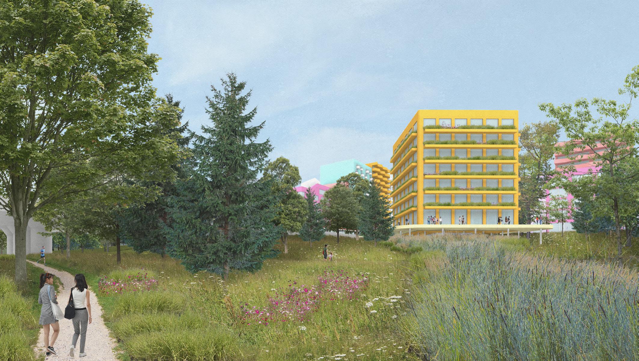
53
Figure 36. Scenario 1 greenway view.
Source: By Author
107 674 sqm
31 015 sqm
34 052 sqm
39 277 sqm
Scenario 2: Population Decrease
Scenario 2 describes a potential future state in which the population of the city decreases. This could be a result from several possible causes such as changing attitudes, future pandemics, or decentralized cities forming. In this situation the density of the city is reduced. Buildings that are no longer useful are deconstructed and replaced by more biodiverse wilderness spaces in the plan.

54
Figure 37. Scenario 2: Population Decrease. Source: By Author Floor Area Public Spaces Green Spaces Wild Spaces
Those buildings are removed to best suit a continued functioning urban community, maintaining areas with denser business and services as public active spaces (Figure 38). Based on the reduced public activity on some of the back street areas, the greenway increases it presence into the urban system (Figure 39). Additionally, some of the vehicle lanes of Commissioner’s Street are converted into more wild space, strengthening the ecologically connective infrastructure of the road in the process.
Source: By Author
55
Figure 38. Scenario 2 Commissioner’s Street view.
Figure 39. Scenario 2 greenway and green streets view. Wilded greenery has increased its presence.
Source: By Author.
Area data: Floor area
495 sqm Public spaces
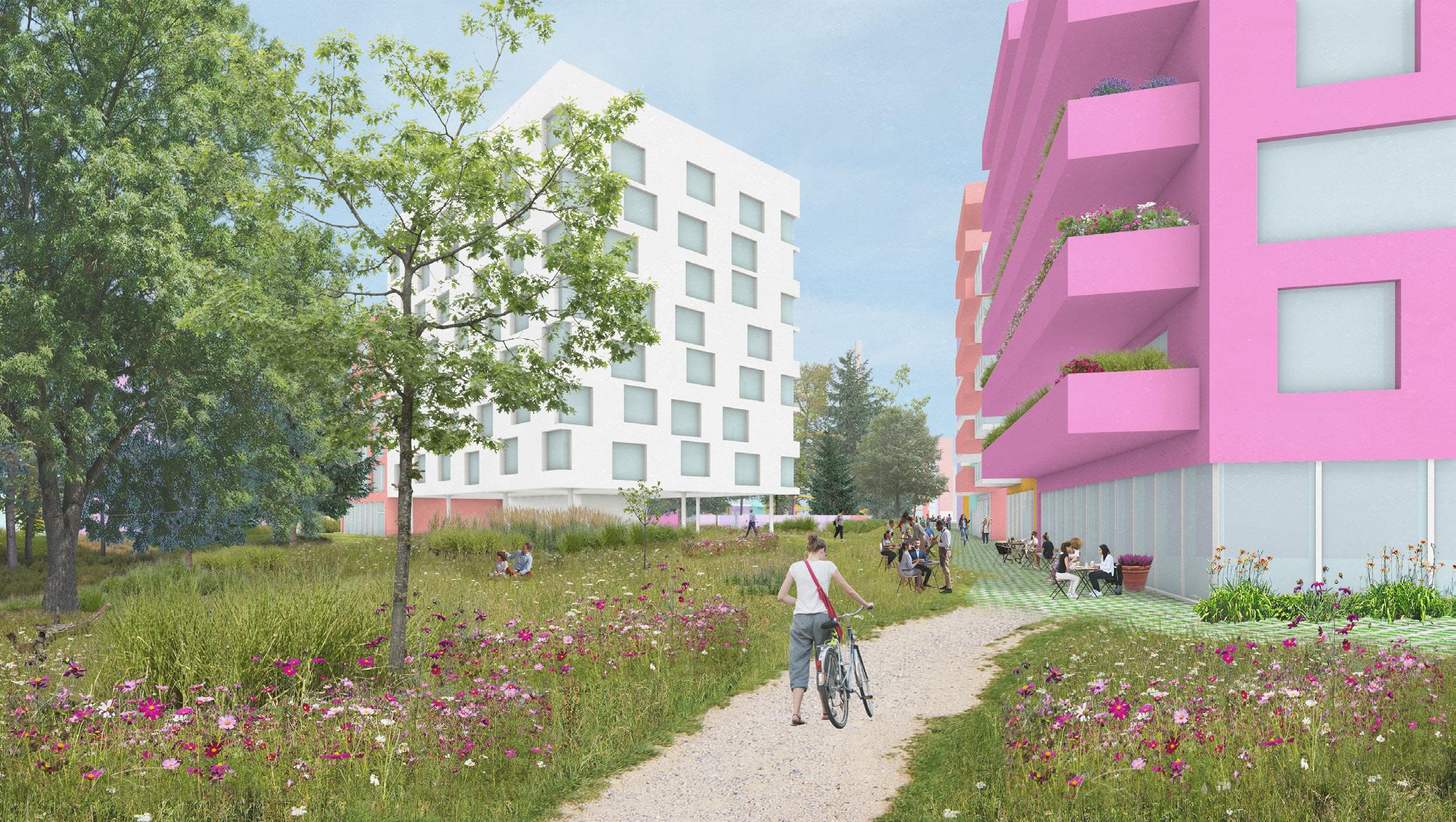
943 sqm Green spaces
581 sqm Wild spaces
728 sqm
The area data from this scenario shows a reduction in floor area from the Latent City initial state because of the decrease in density. It also shows an increase of public spaces, green spaces, and wild spaces as the removed buildings are replaced by a mixture of green spaces and planting.
56
61
30
37
38
Floor Area
Public Spaces Green Spaces
Wild Spaces
Scenario 3: Ecological City
Scenario 3 considers a possibility in which the city seeks to integrate further with natural systems. Planting systems are introduced into the buildings in a similar fashion to Scenario 1 and greenery spaces are increased and further connected on the street level, similar to Scenario 2.
In this third scenario natural landscapes outside of the city are restored and protected and urban sprawl is halted. To address these conditions, the Latent City form increases its density slightly through some buildings similar to Scenario 1 and introduces urban farming strategies into its built context. Urban farming buildings and greenhouses are intermixed with the buildings of the city. The city produces its food locally which is then sold through newly introduced farmer’s market pavilions (Figure 42). A pavilion can be seen on the edge of the greenway and serves as both a public gathering place and market space.
57
Figure 40. Scenario 3: Ecological City. Source: By Author
41. Scenario 3 Commissioner’s Street view.
Source: By Author
Area data: Floor area
sqm Public spaces
sqm Green spaces
sqm Wild spaces
sqm
In the area data of this scenario, we can see an increase in floor area to address the more concentrated density of the city from reduced urban sprawl. The data also shows a large increase in wild spaces as the ecological density of the city is increased both in the buildings and streets.
58 Figure
82 845
30 859
37 440
45 707
These scenarios have demonstrated how the Latent City framework is the starting form of an adapting urban system. They show how the buildings, streets, public space, and green space might change depending on the pressures that the city needs to adapt to. Having explored the framework design, and how it might adapt in the future, the following chapter will provide some final thoughts on the exploration of this thesis.
Figure 42. Scenario 3 farmer’s market view.
 Source: By Author
59
Chapter 7 - Conclusions
The discussion and framework design exploration of this thesis has been centered around how to address change and uncertainty. Resilience theory, specifically engineered resilience and ecological resilience, have been used to help define how certain systems, planning frameworks, and designs, address change and uncertainty. We can recognize that strategies based in engineered resilience are limited based on their inability to imagine different states for a system to shift to.
It was recognized that adaptability in cities is addressed at a planning framework system level. We can consider adaptable architecture to address uncertainty, but architecture is ultimately beholden to the limitations set by the planning framework system. If we wish to consider creating adaptable architecture, and by extension an adaptable city, then we must reconsider the framework of the urban system.
Toronto is rooted in engineered resilience-based planning systems, as seen in the zoning framework of the city, and the proposed development of the Port Lands. The zoning system has limited the city’s capacity to change by maintaining its envisioned system state. As a result, the city is now faced with issues such as a housing shortage and affordability crisis, and an imbalanced distribution of urban density. Toronto only allows for change in certain areas of the city, like the Port Lands. In doing so the hyper density and massive buildings built in those areas don’t allow for change beyond that inflexible building scale. This results in further unchangeable areas of the city. These hyper dense areas of the city in their unchanging scale echo the ideas of high modernism that were covered in Chapter 2. Both the hyper dense and lower dense areas of the city are limited in adaptability and change by the zoning framework in place. If the city wishes to create an adaptable urban environment, and simultaneously address the imbalanced density and housing crisis, then it must reimagine its zoning framework.
To create an adaptable city we can base our framework systems in ecological resilience rather than engineered resilience. This involves creating rules that ensure that the parts of the urban system are adaptable. This means that building sizes are limited within adaptable scales, building typologies are allowed to mix, ecological systems are integrated into the city, and building density is not limited by single family requirements.
By adjusting the zoning framework of Toronto, we would balance the density of the city over the entire built area rather than the small changeable areas of the current plan. This would create a middle range of density that is often described as missing from Toronto’s
60
context. This middle level of density fulfills the scale, diversity, and density flexibility requirements of adaptable and ecologically resilient cities.
The Latent City framework demonstrates how a zoning system would be formed to create an ecologically resilient urban form. The form demonstrated in this thesis is what might result from implementing said framework in a development. Latent City offers a different consideration from the engineered resilient zoning and planning systems in place in Toronto.
Going forward the city of Toronto is faced with two options to address the pressures it faces. It can choose to keep the current zoning framework in place and maintain a state of uneasy engineered resilience, living with a density imbalance, unaffordable housing, and limited green space. Or the city could address these problems by adjusting its zoning framework into something informed by adaptability and ecological resilience.
Reflections
Latent City offers a beginning exploration of an ecologically resilient urban system. To take this project and framework further would involve the exploration of additional factors that could influence it. These could involve: A further detailed exploration of the architecture in the framework. An exploration of varied or larger scaled building typologies and how they would integrate into the framework. The discussion of how the changing urban system would address economic and capital related pressures. Or what form of regulating body would need to be enacted to ensure the system can continue to change, or even what changes happens where.
There is a challenge in implementing something that is open-ended. The result can be either great or dangerous depending on how changes pan out. Regulation in a system like Latent City would have to allow for freedom within a controlled system. Without controls then the result of the changes could end up in ways not ideal for the urban system.
If we are to consider a realization of the Latent City, then these additional considerations would have to be implemented into a more detailed rendition of the framework. This would be a similar level of detail to realized zoning systems.
61
62
Appendices
63
Appendix A1
Horizontal street divisions and street activity from Jan Gehl.
64
Figure 43. Examples of horizontal street divisions and their respective liveliness from Jan Gehl.
Source: Gehl, Jan. Cities for People. Washington, DC: Island Press, 2010.
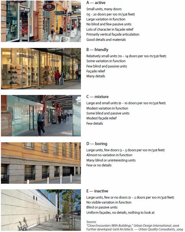
65
Appendix A2
Maps from the city of Toronto showing correlations of green spaces and tree coverage with reduced temperatures.
66
Figure 44. Toronto’s Surface Coverage (left) vs. Toronto’s Greenspace (right)
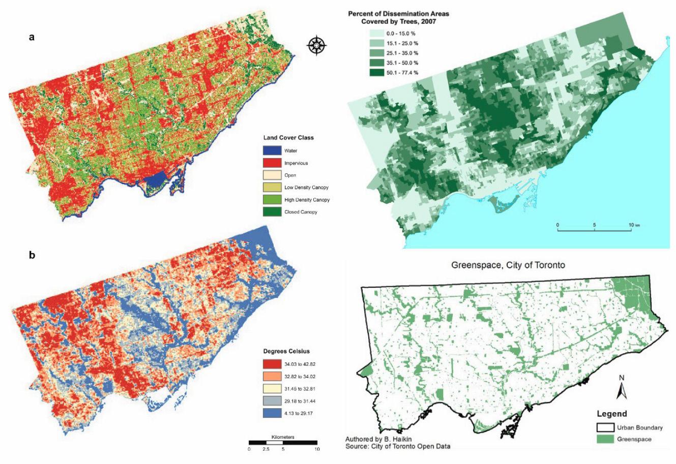
Source: (Top and bottom left): https://www.semanticscholar.org/paper/ Getting-closure%3A-The-role-of-urban-forest-canopy-in-Greene-Millwa rd/5e13e66289062eaa50158b6bd3b463cf264b5cb3/figure/1
Source: (Top right): https://www.researchgate.net/figure/TheGreenspace-map-of-the-city-of-Toronto-constructed-from-theGeographical-Information_fig7_279989471
Source: (Bottom right): https://ecologicaldesignlab.ca/site/ uploads/2018/05/MRP_Final.pdf
67
Appendix B
Additional gathered research material on the Port Lands history and future redevelopment.
68
Figure 45. 1882 plan drawing of Toronto. Ashbridges bay and Don River outlet marshlands are visible in the current location of the Port Lands.
Source: http:// oldtorontomaps. blogspot. com/2013/02/1882city-engineers-officeplan-of-city.html
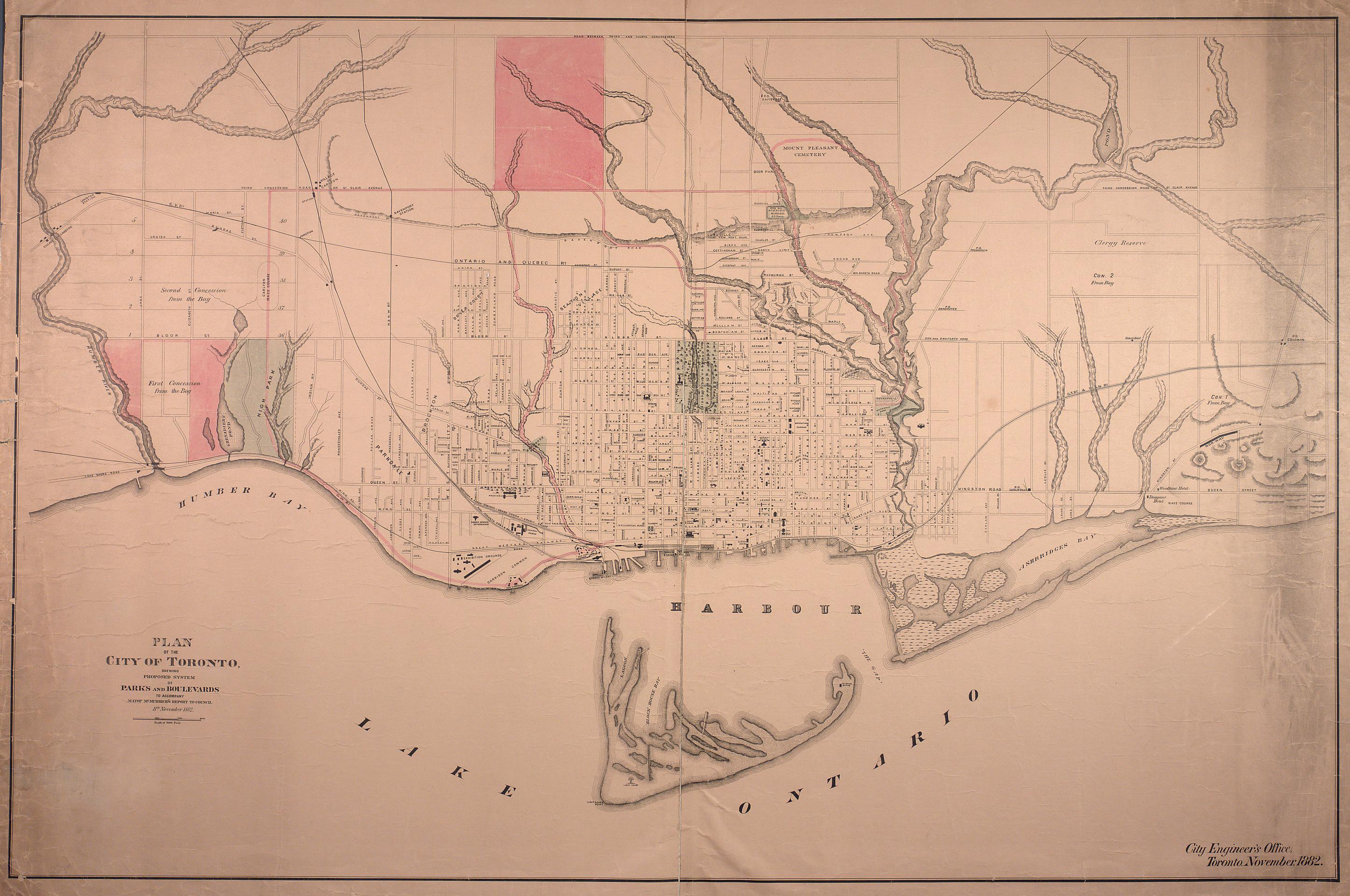
69
Figure 46. Historic changes to the Toronto waterfront.
Source: https://www. researchgate.net/ figure/GeographicEvolution-ofTorontos-Shoreline_ fig2_304013762
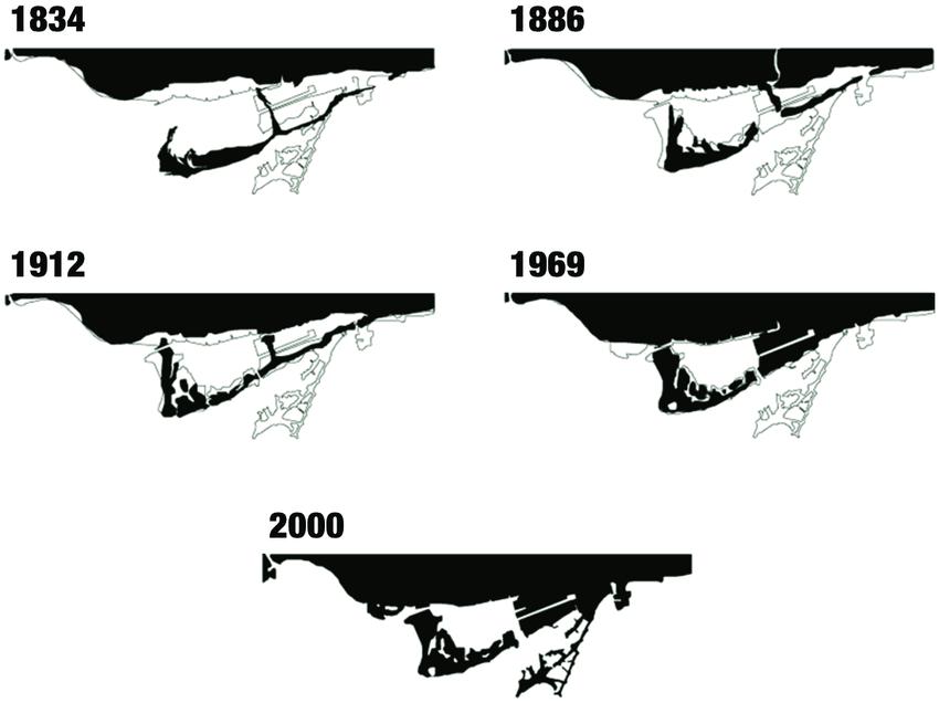
70
Source: Retrieved from Google Maps.

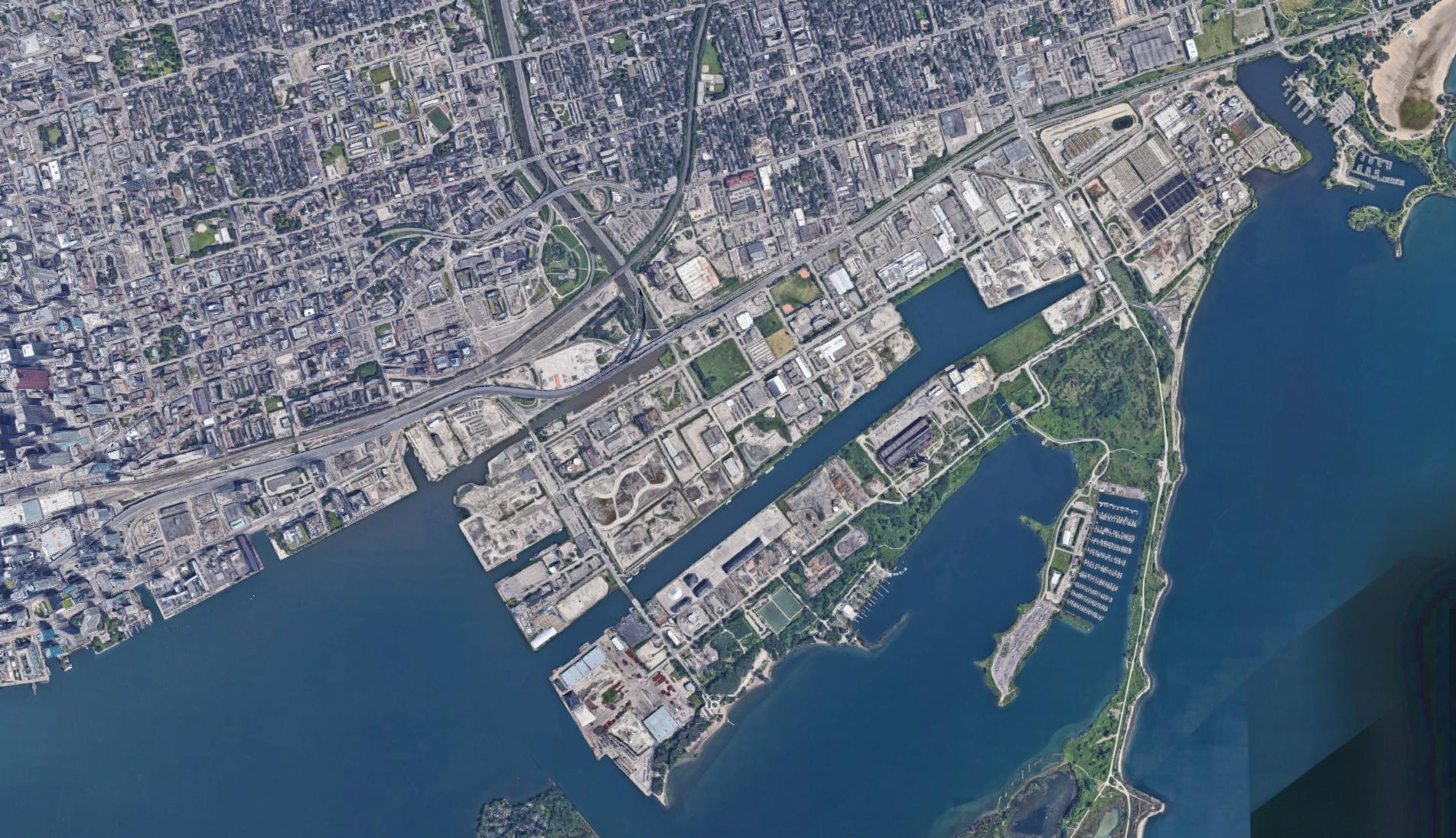
71
Figure 47. Port Lands and Lower Don Lands at the outlet of the Don River. Work towards the Don Outlet flood management project can be seen.
Imagery ©2021 Google, TerraMetrics, Imagery ©2021 CNES / Airbus, First Base Solutions, Maxar Technologies, Map data ©2021 200 m N
Figure 48. Don Outlet Flood Protection plan and Villier’s Island Redevelopment.
Source: https:// portlandsto.ca/ media-library/?mediapage=2

72
Figure 49. Public and green spaces throughout the Port Lands Plan.
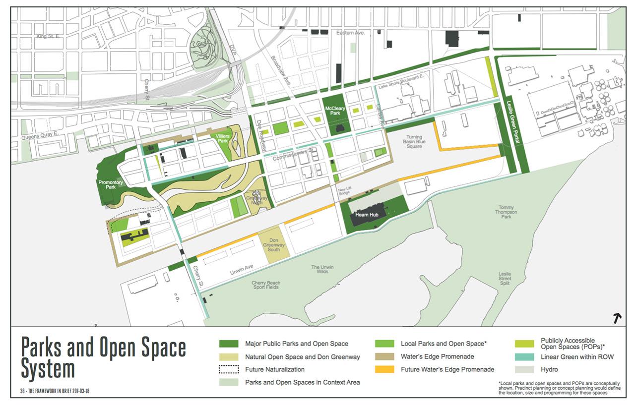
Source: https:// urbantoronto.ca/ news/2017/05/ new-details-emergetransformation-portlands
Figure 50. Transit system plan for the redevelopment.
Source: https:// urbantoronto.ca/ news/2017/05/ new-details-emergetransformation-portlands
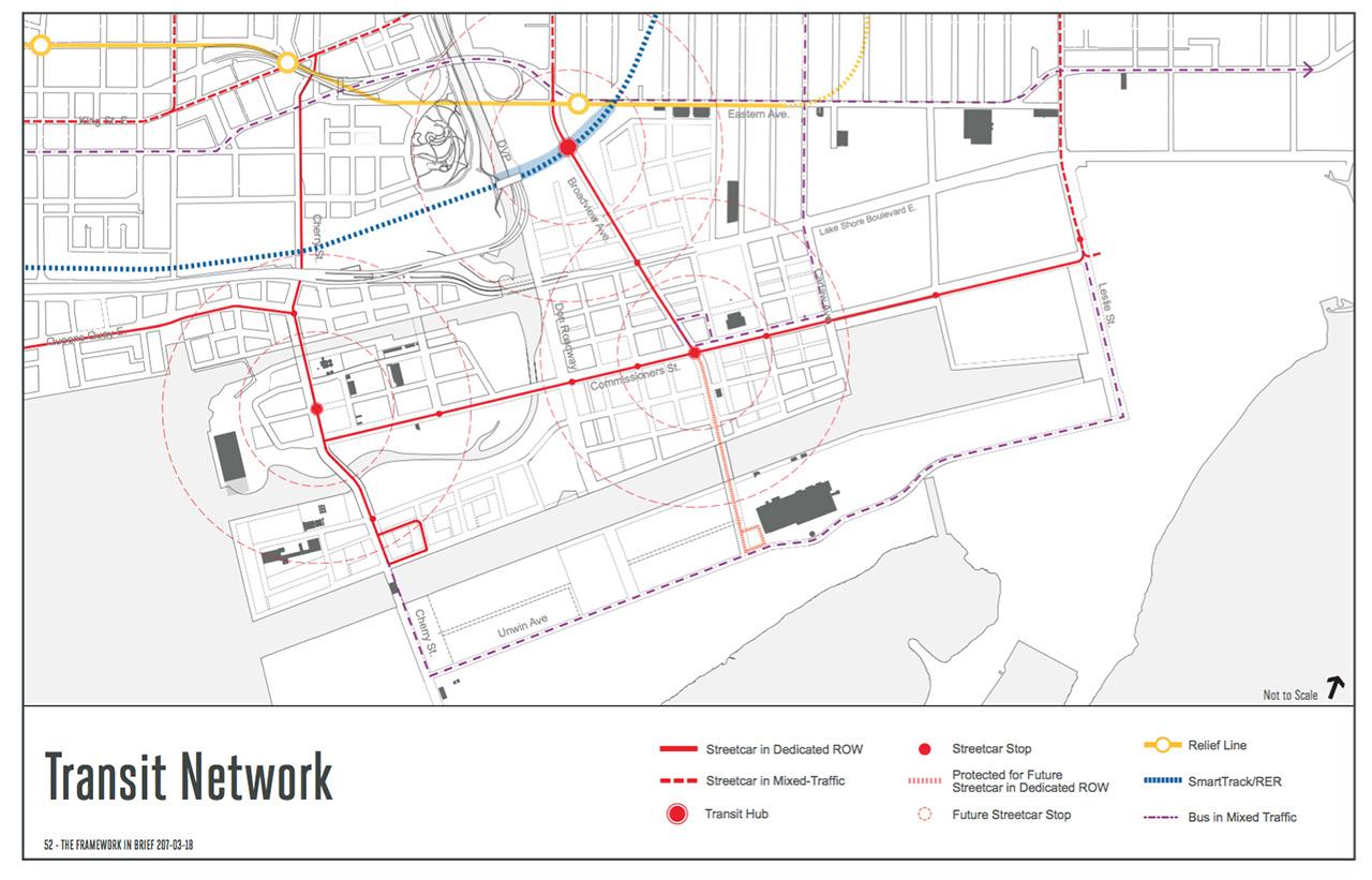
73
Appendix C1
Process sketches and images along with reference material demonstrating the development of the Latent City form concepts.
74
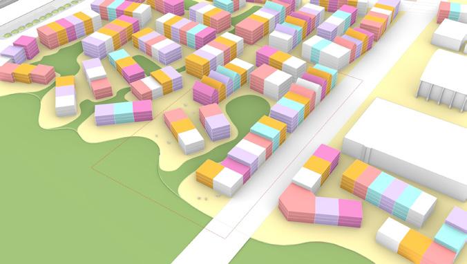
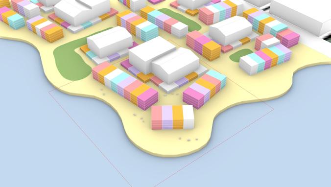
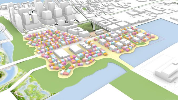
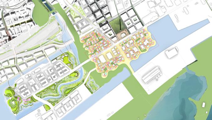
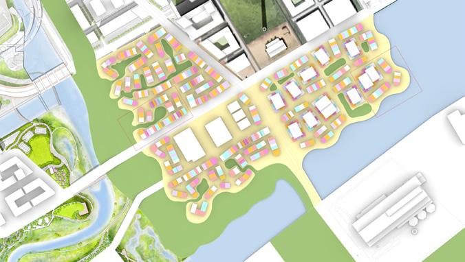
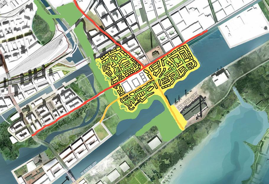
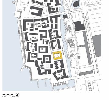
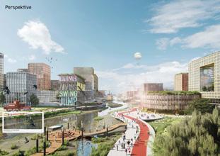
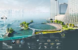
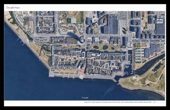
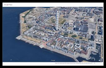
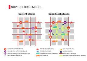
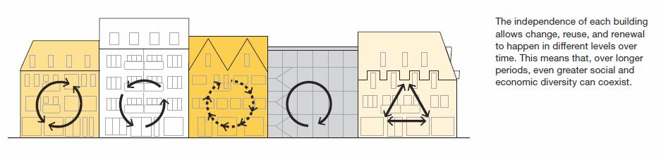
75 working with necessary larger typologies to ensur public and scale exibility at least at the gr buildings are divided vertically to ensure human scaled horizontal repetition some streets double as public green space and street space connecting to the larger greenway buildings address street or greenway through either a business or soft edge ground floor housing ground floor can be either soft edge or hard edge apts mid
Figure 51. Collage of process work for Latent City form and concepts.
Source:
Author.
Appendix C2
Process sketches and images along with reference material demonstrating the development of the Latent City street and ecology concepts.
76
Figure 52. Collage of process work for Latent City streets and greenery.
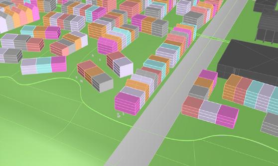
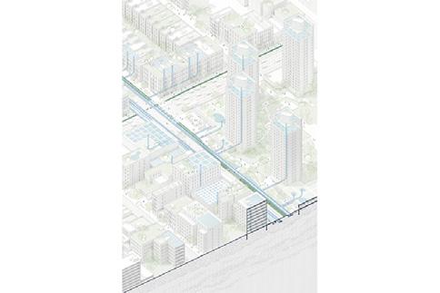
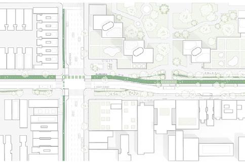
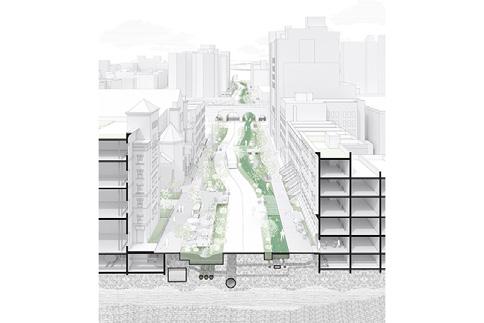
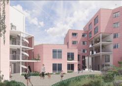
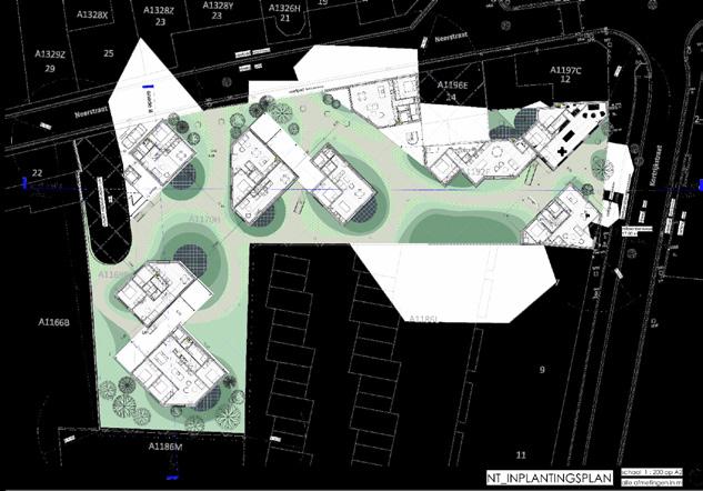
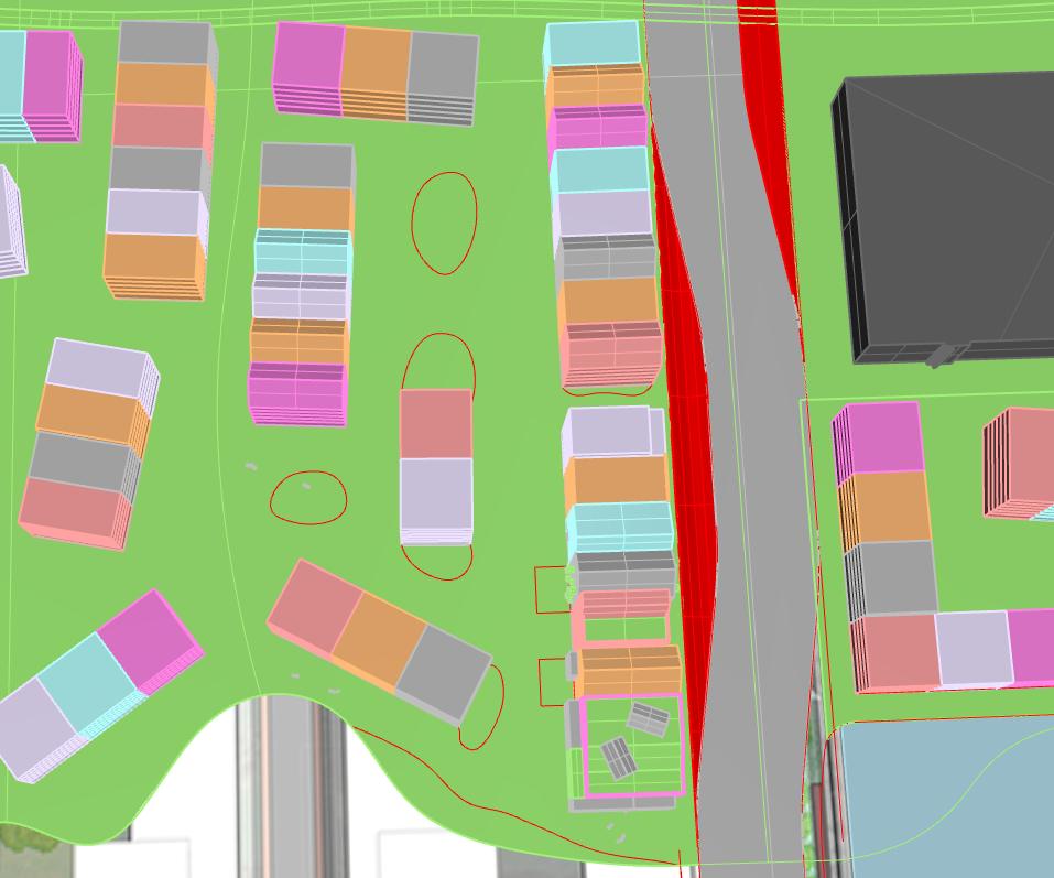
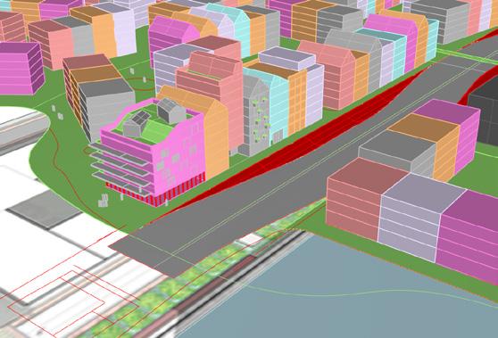

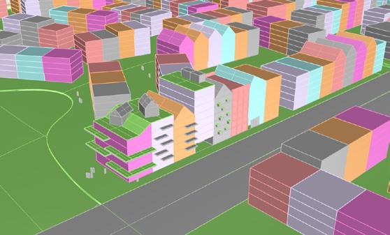
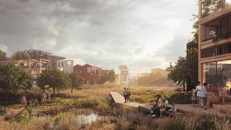
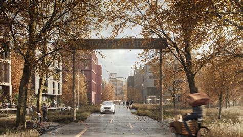
Source: Author.
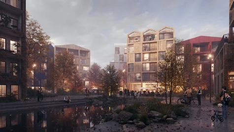
77 nature and street combination naturalized areas 2 lane car roads
Appendix C3
Process sketches and images demonstrating the development of the Latent City streets, buildings, and greenery spaces.
78
Source: Author.
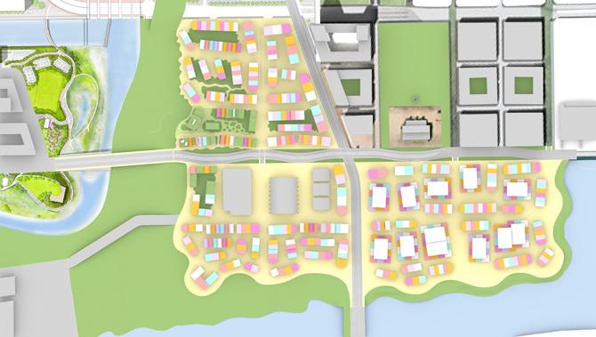
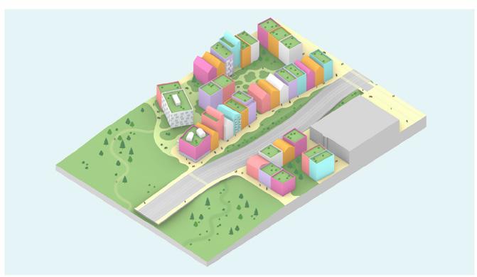
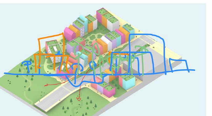
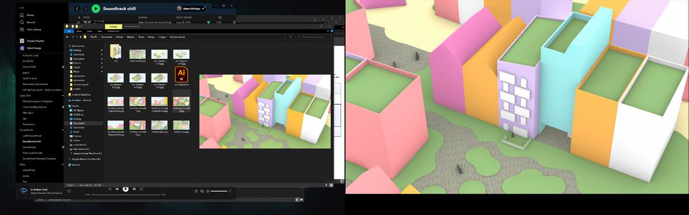
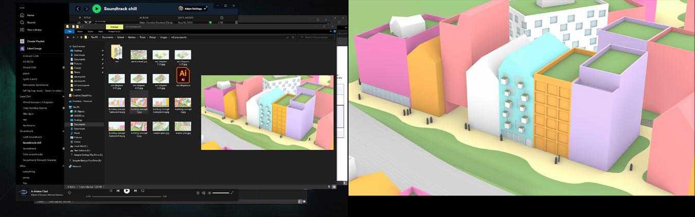
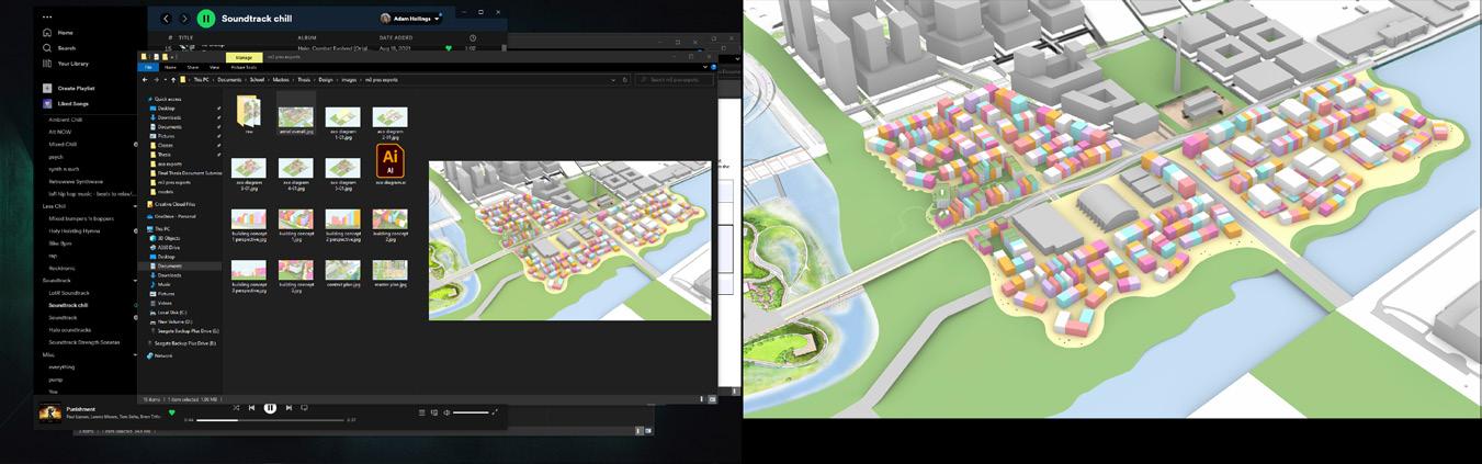
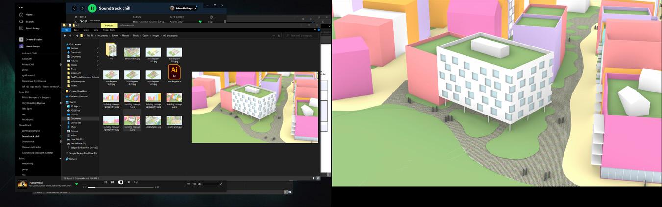
79
Figure 53. Collage of process work for Latent City further detail development.
Appendix C4
Process sketches and images demonstrating further development of the Latent City streets, buildings, and greenery spaces. Additionally showing the development and introduction of future scenario models.
80
Latent City
Latent City
Scenario 1
Scenario 2
Figure 54. Collage of process work for Latent City further detail development and scenarios.
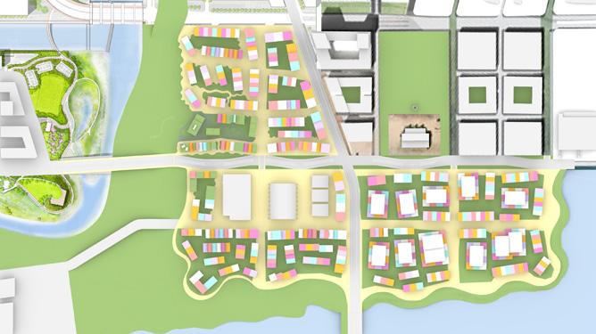
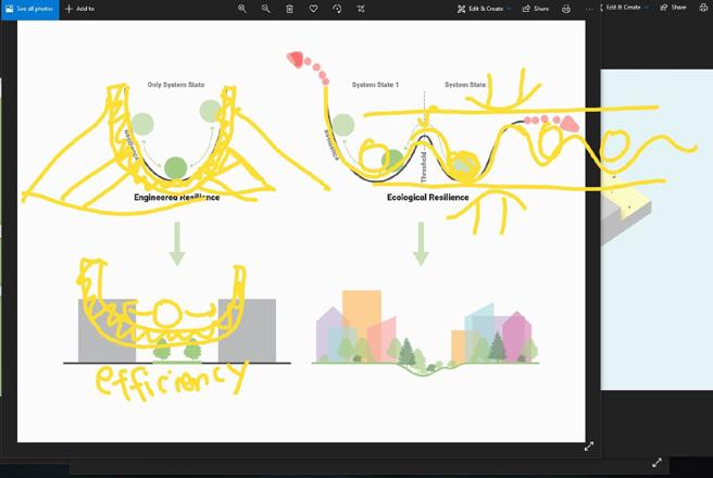

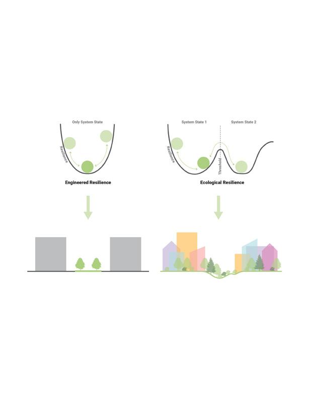
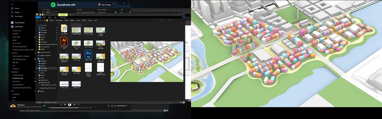
Source: Author.
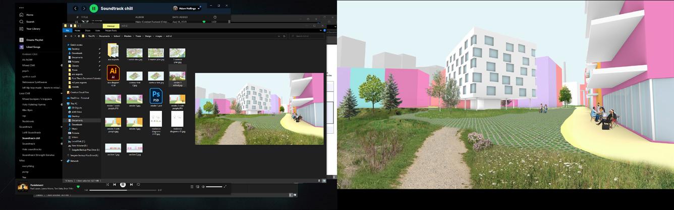
81
Appendix C5
Process sketches and images demonstrating further development of the Latent City streets, buildings, and greenery spaces. Additionally showing the further development of future scenario models.
82
Latent City
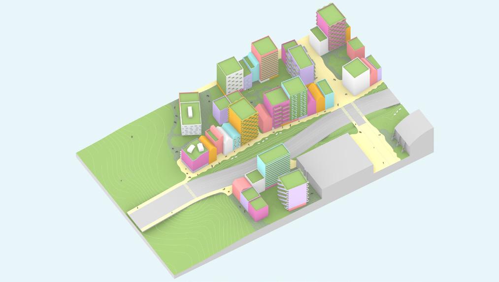
Figure 55. Collage of process work for Latent City and scenarios further detail development.
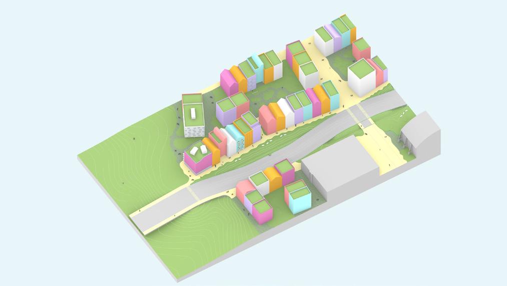
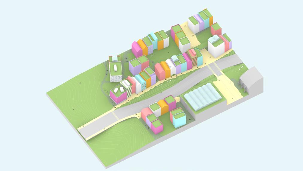
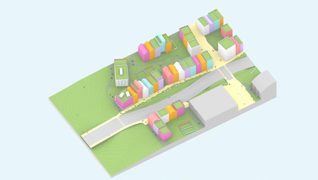
83 this greats a bridge to cross the street, the raod can aslo be a pedestrian space run the comparison numbers for the immediate axo buildings streetcar station green bridge is just on the ground, cars shown going through anyway make this tower taller as the trade off height and ground space rule applies to it playground Scenario 1
Scenario 2 Scenario 3
Source: Author.
84
Ahern, Jack. “Urban Landscape Sustainability and Resilience: The Promise and Challenges of Integrating Ecology with Urban Planning and Design.” Landscape Ecology 28, no. 6 (2012): 1203–12.
Allen, Stan, Marc McQuade, Mirko Zardini, and Princeton University. School of Architecture. Landform Building: Architecture’s New Terrain Lars Müller Publishers, 2011.
Bauman, Zygmunt. Liquid Times: Living in an Age of Uncertainty. Cambridge: Polity Press, 2017.
Benjamin, Walter. “On the Concept of History /Theses on the Philosophy of History.” Walter Benjamin on the concept of history /theses on the philosophy of history. https://www.sfu. ca/~andrewf/CONCEPT2.html.
Brand, Stewart. How Buildings Learn: What Happens after They’re Built. London: Penguin Books, 1994.
Bozikovic, Alex. “Toronto Planning Report Signals Real Changes Coming to Open the Door to New Neighbours in House-Centric Areas.” The Globe and Mail, November 25, 2021. https:// www.theglobeandmail.com/canada/toronto/article-toronto-planning-report-signals-realchanges-coming-to-open-the-door/.
Cairns, Stephen, and Jane M. Jacobs. Buildings Must Die: A Perverse View of Architecture. MIT Press, 2014.
City of Toronto, and Waterfront Toronto. Port Lands Planning Framework. City of Toronto, 2017.
Fisher, Thomas. Frederick Law Olmsted’s Campaign for Public Health. Places Journal, November 1, 2010. https://placesjournal.org/article/frederick-law-olmsted-and-the-campaignfor-public-health/?cn-reloaded=1.
Forman, Richard T.T. Urban Ecology. Cambridge University Press, 2014.
Fujimoto, Sou. Primitive Future. Tokyo: INAX, 2008.
Galbraith, Sean. Toronto Planning Issues. Ryerson University AR8207 Guest Lecture. Lecture presented at Ryerson University AR8207 Guest Lecture, 2021.
Galloway, Will. Scaling M-NEX Ideas and Tokyo Urbanism, 2022.
Gehl, Jan. Cities for People. Washington, DC: Island Press, 2010.
Gelernter, Mark. Sources of Architectural Form: A Critical History of Western Design Theory. Manchester: Manchester University Press, 1995.
Green, Jared. The Injustices of the South Shaped Olmsted’s Vision of Landscape Architecture. THE DIRT, June 26, 2021. https://dirt.asla.org/2021/06/22/the-injustices-of-the-south-shapedolmsteds-vision-of-landscape-architecture/.
85 Bibliography
Gunderson, Lance H. Ecological Resilience - In Theory and Application. Annual Review of Ecology and Systematics 31 (2000): 425–39.
Handa, Rumiko. Allure of the Incomplete, Imperfect, and Impermanent: Designing and Appreciating Architecture as Nature. New York: Routledge, 2015.
Hélie, Mathieu. How Urban Change Is like Ecological Succession. Strong Towns. Strong Towns, July 30, 2019. https://www.strongtowns.org/journal/2019/7/25/how-urban-change-is-likeecological-succession.
Holling, C. S. From Complex Regions to Complex Worlds. Ecology and Society 9, no. 1, 2004.
Holling, C.S. and M.A. Goldberg. Ecology and Planning. In Projective Ecologies. Edited by Chris Reed and Nina-Marie Lister, New York: Actar and the Harvard Graduate School of Design: 106125. [1971] 2014.
Hough, Michael. Cities and Natural Process. London: Routledge, 2004.
Jacobs, Jane. The Death and Life of Great American Cities. New York: Random House, 1961.
Kallipoliti, Lydia. History of Ecological Design. Oxford Research Encyclopedia of Environmental Science. 26 Apr. 2018.
Koolhaas, R., Mau, B., & Office for Metropolitan Architecture. Small, medium, large, extra-large . New York, N.Y.: Monacelli Press,. (pp. 494517),1998.
Koren, Leonard. Wabi-Sabi for Artists, Designers, & Philosophers. Berkley, CA: Stone Bridge Press, 1994.
Kotkin, Joel. What Jane Jacobs Got Wrong about Cities. What Jane Jacobs Got Wrong About Cities | Newgeography.com, August 2, 2015. http://www.newgeography.com/content/005011what-jane-jacobs-got-wrong-about-cities.
Mirabelli, Julian. DenseCity Part 1: Where Toronto Builds Density and Why. Urban Toronto, April 25, 2017. https://urbantoronto.ca/news/2017/04/densecity-part-1-where-toronto-buildsdensity-and-why.
Monjo, Miguel Angel Borrás. “Superblocks.” Architecture Walks and Tours in Barcelona, May 24, 2016. https://barcelonarchitecturewalks.com/superblocks/.
Ontario Population Projections. ontario.ca. Accessed August 4, 2022. https://www.ontario.ca/ page/ontario-population-projections.
Reed, Chris & Lister, Nina-Marie. Ecology and Design: Parallel Genealogies, Places Journal, April 2014
Roggema, Rob, and Dirk Sijmons. Nature Driven Urbanism. Contemporary Urban Design Thinking. Cham: Springer Nature, 2020.
Ruskin, John, 1819-1900. The Nature of Gothic : A Chapter of the Stones of Venice. England: Printed by William Morris at the Kelmscott Press and published by George Allen, London and Sunnyside, Orpington, 1892, 1892.
86
Saunders, Doug. Opinion: Jane Jacobs’s Afterlife: Revisiting the Death and Life of Great American Cities, 60 Years Later. The Globe and Mail. The Globe and Mail, October 25, 2021. https://www.theglobeandmail.com/opinion/article-jane-jacobss-afterlife-revisiting-the-deathand-life-of-great-american/.
Schiff, Karen. Redefining Wilderness: How Designers Are Grappling with the Radical Interconnectedness of Nature and Culture. Harvard Graduate School of Design. Department of Landscape Architecture, June 14, 2022. https://www.gsd.harvard.edu/2022/05/designing-fora-new-wilderness/?mc_cid=dbaab5cc9c&mc_eid=6f03bd3506.
Scott, James C. Seeing like a State: How Certain Schemes to Improve the Human Condition Have Failed. Yale University Press, 1998.
Sim, David. Soft City : Building Density for Everyday Life, Island Press, 2019.
Sinclair, Brian R. Agility, Adaptability Appropriateness: Conceiving, Crafting & Constructing an Architecture of the 21st Century. Enquiry (Washington, D.C.) 9, no. 1: 35-43, 2012.
Spuybroek, Lars. The Sympathy of Things : Ruskin and the Ecology of Design. London: Bloomsbury Publishing Plc. ProQuest Ebook Central. 2016
Thoms, M. C., H. Piégay, and M. Parsons. “What do You Mean, ‘resilient Geomorphic Systems’?” Geomorphology (Amsterdam, Netherlands) 305, (2018;2017;): 8-19.
Till, Jeremy. Architecture Depends. MIT Press, 2009.
Toronto and Region Conservation Authority . Future Climate. ArcGIS StoryMaps. Esri, September 8, 2021. https://storymaps.arcgis.com/ stories/6bdd5b1d96c94792bf5eba5a73c2d6d0.
Yan, Wanglin ; Galloway, Will. Understanding change through the lens of resilience. Rethinking Resilience, Adaptation and Transformation in a Time of Change. Springer International Publishing, 2017. pp. 3-20
87
System
Resili ence Threshold
Resilience Ecological Resilience
Adam Hollings
State 1 System State 2

