ARCHITECTURE PORTFOLIO

FACULTYOFENGINERING,TECHNOLOGY&BUILTENVIRONMENT

SCHOOLOFARCHITECTURE&BUILTENVIRONMENT

ZEIN
SEM-06 UNIT-C OMAR
CONTENT
PROJECT 1
PROJECT 1A- FRAMEWORK
PROJECT 1B- SECTIONAL DRAWING
PROJECT 2
PROJECT 2A- SITE ANALYSIS OF TANJONG MALIM
PROJECT 2B- URBAN STRATEGY
PROJECT 2C- BUILDING STRATEGY
PROJECT 3
PROJECT 3A- DESIGN DEVELOPMENT
PROJECT 1A- FRAMEWORK
What is Transit-Oriented Development?
defined as “walkable, compact, mixed-use, higher-density development within walking distance of a transit facility.”
provides a mix of residential and commercial uses and is designed to make public transit successful, enhance the convenience and safety of walking and cycling, and provide for a vibrant, livable community.
Universal, relational and regional definitions of TOD
The Transit on Demand (TOD) concept aims to maximise the efficiency of existing public transport services by focusing development around stations, stops, and exchanges. Many studies have focussed on the three Ds of the concept - density, diversity and design - but there are many different ways to conceptualise TOD.
It includes public transport accessibility level, net residential density, net employment density, land use mix, intersection density, and cul-desac density.
A relational understanding of TOD means that it tries to create a built environment that is generally more supportive to public transport, cycling and walking.

Walking distance and catchment area definitions
A walking distance to a public transport station is often defined as being within 400 –600 metres (2000 feet) of a station. In Copenhagen the 'station proximity principle' is a key concept for integrating public transport and land use planning (Pettersson and Sørensen, 2019).
Bike access could increase the catchment areas of public transport stations in the range of 1,6 km up to 10 km. For time based definitions of how long people are willing to bike they also found a variation ranging from 7 minutes up to 25 minutes. { msp of TM stations to the sites }
Universal, relational and regional definitions of TOD
The Transit on Demand (TOD) concept aims to maximise the efficiency of existing public transport services by focusing development around stations, stops, and exchanges. Many studies have focussed on the three Ds of the concept - density, diversity and design - but there are many different ways to conceptualise TOD.
It includes public transport accessibility level, net residential density, net employment density, land use mix, intersection density, and cul-desac density.
A relational understanding of TOD means that it tries to create a built environment that is generally more supportive to public transport, cycling and walking.
Universal density definitions
Density is another indicator frequently used to define TOD areas. Calthorpe (1993) argued that a lower threshold for residential zones outside of the primary areas should remain in the range of 25–62 units per hectare.
Relational density definitions
In the US the urban pattern is related with sprawl, in the sense of low density, car dependent, monofunctional residential development. In Europe, the urban pattern has followed the form of territories-in-between, mixed open and urban land of varying density, intersected by infrastructure including public transport. In Europe urban development has tended to be less monofunctional with mixed uses, especially at the regional scale.
In other words, TOD, is a more typical planning approach across regions in Europe, whereas in North America it marks a very significant departure from typical land use patterns (territories-in-between is a concept developed to better match the prevailing land use structures characterised by being neither fully urban, nor rural).
TOD as a planning concept
Ideas for how to ramp up the three Ds (density, diversity and design) can be applied at both a regional and local level. Regional approaches to TOD are bound to include station areas in minor suburbs, small towns or rural areas where the principles for local TOD may be less relevant. { TM already has 1 station, ( check other public transportation, cycling lane, good sidewalks ) and respond to it by ART work ) } .
TOD as an a spatial strategy for economic development
Transport-oriented urban development (TOD) is a concept for creating more sustainable and livable urban environments. It is also seen as a spatial planning strategy for promoting economic development, at a national and regional scale. By concentrating jobs and economic activities around public transport nodes,
it is seen as crucial building block for high performing urban agglomeration economies
.
In a world of increasing spatial obility, transportation nodes become strategic locations since these are places where the knowledge economy and leisure economy exchange takes place. TOD is seen as an urban development concept more suited to postindustrial , service-based economies.
Summary
As a planning and development concept, TOD firstly aim to both reduce the need for transport, and to increase the modal shares of public transport, cycling and walking at the expense of transportation by car. Secondly, TOD seeks to generate more livable neighbourhoods with high urban design quality. Thirdly, TOD is understood to be a driver of, or even a tool for economic development.
TOD can improve public health.
Benefits of Transit-Oriented Development
A community with a strong and dependable transit system and streetscaping elements can discourage vehicle dependence and congestion.
TOD can create a more sustainable community.
TOD can strengthen local economies.
TOD promotes a compact community and uses existing infrastructure.
The Center for TransitOriented Development reported in Planning for TOD at the Regional Scale that transportation contributes about 28 percent of all greenhouse gas (GHG) emissions. However, TOD has the potential to reduce annual GHG.
Improving local public transit can cut vehicle transportation costs and time spent on commuting. With reduced commuting times and costs, people will be able to spend their time and money at restaurants, shops, and museums in the local area.
Sprawl development is costly because it requires the expansion of public infrastructure and utilities. TOD promotes a compact community and uses existing infrastructure. A transit-dependent community saves money on repairing infrastructure as vehicle use decreases.
TOD can improve public health.
By providing pedestrian-friendly conditions, bike infrastructure, and comfortable and safe public transport, cities can help balance car use.


TOD can create a more sustainable community.


A new framework for guiding TOD plans, by simultaneously assessing the “three values” (3V) of transit stations and surrounding areas:
The node value describes the importance of a station in the public transit network based on passenger traffic, connections with other transport modes, and centrality within the network.
The place value reflects the quality and attractiveness of the area around the station. Factors include the diversity of land use; the availability of essential services such as schools and healthcare; the proportion of everyday amenities that can be accessed by walking or cycling; pedestrian accessibility and also the size of urban blocks around the station.
The market potential value refers to the unrealized market value of station areas. It is measured by looking at the major variables that can influence the demand for land (current and future number of jobs in the vicinity of the station, number of jobs accessible by transit within 30 minutes, current and future housing densities) as well as the supply (amount of developable land, possible changes in zoning policy, market vibrancy, etc.).
Local Governments Can Begin Planning for TOD
To support TOD, local governments should review their regulatory framework. Comprehensive plans and master plans should incorporate the need for TOD and path for policy implementation. In addition, zoning and land development ordinances need to encourage and support transit-supportive development patterns and redevelopment strategies.
How
Location
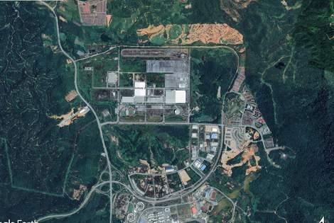
Tanjong Malim is a town located at the south of Perak Darul Ridzuan. The town borders with bordering Selangor Darul Ehsan and topographically bordering Pahang Darul Makmur. Having the Titiwangsa Range as its background and the Bernam River to its side, it is an intersting gateway town to visit.
History of Tanjong Malim
Geography Present Name origin
Tanjong Malim is a gently sloped valley, surrounded by hills (Titiwangsa Range) located 84 km north of Kuala Lumpur and 145 km south of Ipoh, the capital city of Perak. The university was set up in 1922 as the Sultan Idris Teaching College.
Tanjong Malim has the potential to become a developed town at the southern of Perak. Based upon the existing economic activities and industrial planning such as the automobile, agricultural and manufacturing. this was in the pipline but was strengthened by the construction of the national car factory, Proton.
Tanjong Malim Town start from a cape (a high land formed by the river erosion and sticking out into the sea) The early settler was an ulamak (a religious man), Tuan
Haji Mustafa bin Raja Kemala. Sir List (the representative of the Straits government) and Raja Itam named the town Tanjong in conjunction with the location of its large cape.
Tanjong Malim Twin Train Station

Transportation of Tanjong Malim
KTMB was established in 1948 for public use. It provides commuter and inter-city train services to various destinations along the East Coast and the West Coast routes
Slim River Twin Railway Station

Tanjong Malim Bus Station

KTM ETS services. Built in 1903, the original station is among the oldest of the railway stations in Malaysia.In March 2007, it was rebuilt, with the old station building being retained.
The Tanjong Malim Bus Station is located at the heart of Tanjong Malim town. Apart from the Starcouch bus company, there are also several other bus companies that offer bus services at this station.
Lata Sungai Bil

Lata Sungai Bil is a famous picnic area for locals and visitors from outside the Muallim district. The pristine river and tranquil atmosphere had drawn in visitors to have picnics and to bathe in this river.
Places of Interest at Tanjong Malim
YDP Lake The Proton City

Embayu Lake The Pergola Park Ulu Slim Hot Springs

Y.D.P. Lake was originally an abandoned ore mine. The Tanjong Malim District had taken the initiative to develop this location as a recreational area.

Embayu Lake Garden is located in Proton City. It is a man-made lake equipped with modern facilities for visitors' recreational needs. Various activities have been held here such as Futsal, Paintball and Eco Challenge that drew the interest of the surrounding residents.

This park is furnished with children's playground and jogging track, making it suitable for any recreational activities. The existence of this park enables Slim River residents to carry out recreational activities with the whole family.

The pond was cleared and developed by Tanjong Malim District Council with facilities such as rest stops and overhead walkway over the pond making it interesting and beautiful. The temperature of this pond reaches 104°C.

TOD promotes a compact community and uses existing infrastructure.
As defined by the TOD Standard, the key basic elements of TOD should comprise eight core principles:
Walk: Develop neighbourhoods that promote walking
Cycle: Prioritise non-motorised transport networks

Connect: Create dense networks of streets and paths

Transit: Locate development near highquality public transport
Mix: Plan for mixed use
Densify: Optimise density and transit capacity

Compact: Create regions with short commutes
Shift: Increase mobility by regulating parking and road use
A community with transit-oriented development has five key characteristics:
It contains a walkable,high-quality pedestrianenvironment that integrates streetscaping.
The highesthousingdensities are located closest to the transitcenter in order to decrease sprawl and promote compactness. The transitcenter is also atthecenter of a destination that has a diverse, mixed-use development.
Parking is carefullylocated, designed, and managed.
Most importantly, the community has quality publictransitfacilities and service.
RESIDENTIALLANDS
RESIDENTIALLANDS
RESIDENTIALLANDS
RESIDENTIALLANDS
ART WORK IN RESPONSE TO THE FRAMEWORK AND TO SUPPORT NEW TRANSPORTATION SYSTEM
MIXEDUSELANDS
COMMERICIALLANDS COMMERICIALLANDS MIXEDUSELANDS
MIXEDUSELANDS MIXEDUSELANDS
PROJECT 1B- SECTIONAL DRAWING
RE-IMAGINNING KLPAC


AS IF IT WAS IN TANJONG MALIM

GDFLOOR 1STFLOOR
2NDFLOOR

PROJECT 2A- SITE ANALYSIS OF TANJONG MALIM
the grey curvey shape represents. how the settlements first started along sungai bernam


represents the mountains chain of tanjung malim
represents mualim and upsi's rule and all the philosophers and teachers who graduated from there
represents railway's rule throughout the history
tanju history
represents two streets of shophouses that built in the early 20th century
PLEASE SCAN THIS QR TO ACCESS YOUTUBE VIDEOS WILL SHOW SOME PARTS OF THE TOWN
# IN THE NEXT 2 PAGES, 4 IDEAS OF MASTER PLANNING STUDIES WILL BE SHOWN
CURRENT CONDITION
AIM&RESULTS
taking advantages of the river future boats commuting { green commuting } businesses opportunity along the river side { dive-through } which will benefit the locals enhance the tourism enhance the economy enhance the land prices enhance town's appearance increase density grab the highway's travellers attention from the outside add excitement and adventure in the youth's life
enjoy and explore the tropical nature { new railway system }

CURRENTCONDITION
AIM&RESULTS
protoncitycontinuedeveloping takeadvantageoftheexistingcarfactories job opportunity for the locals, students, outsiders enhancethetourism enhancetheeconomy enhancethelandprices enhancetown'sappearance

increasedensity
as the town located almost in the middle of east malaysia cut down travelling distance, trafficinthebigcities,savegas,reduceco2 willputtanjungmalimontheglobalmap offer the particpents to explore the heritage andthenature multi used project { food courts, galleries, events,multipurposefacilities}


a b MASTER PLANNING | WATERFRONT, SUNGAI BERNAM
MASTER PLANNING | CARS EXHIBITION, PROTON CITY
s te site site
CURRENT CONDITION
AIM&RESULTS
entertainmentcenterasthetownlacksalot reuseupsi'sland{centeroftown}
job opportunity for the locals, students, outsiders
enhancethetourism{families,athletes,youth}
enhancetheeconomy
enhancethesurroundedlandprices
enhancetown'sappearance
increase density and give more options to stay in town
as the town continue developing will benefit the othersmallkampungs


createhealthycommunity
multi used project { food courts, galleries, events, multipurpose facilities, park, spa, sport academy}


strength and bound friendships among students andlocals
CURRENT CONDITION AIM&RESULTS
entertainmentcenter
natureexploring siteobservation job opportunity for the locals, students, outsiders
enhance the tourism { families from all aroundmalaysia,global}
enhancetheeconomy
enhancethelandprices
enhance town's appearance and community services
increase density and give more options to stayintown
as the town continue developing will benefit theothersmallkampungs
multi used project { food courts, local shops, galleries,events,multipurposefacilities}

site below site down site up MASTER PLANNING | ORIENTAL TOWN & SKY BRIDGE
langkawi, sky bridge
s te
MASTER PLANNING | RECREATION PARK & CENTER, UPSI
site
PROJECT 2B- URBAN STRATEGY
LEGEND
MixedUsedLands
EducationCenters
RiverPath
KTMRalway
ExistingRoads
BusStop
JalanKL-TM
Residential JalanDato'JunusWahid
Behrang-TM
JalanKetoyong
JalanSegarUtama
JalanBernam
LingkaranBudman
JalanLokeYew
SITEPLAN

1:7000

LEGEND
ExistingRailway
ProposedCargoShippingLane


FromPROTONCityToSekinchan
WhatisParallelSystem?
Theautonomousbattery-electricrailvehiclestransportstandardshippingcontainersasasingleordoublestacked load.Thevehiclescanself-assembleenrouteasplatoonsonthenation’sexistingrailinfrastructure.Moreflexible thantraditionaltrains,therailvehiclesenablemoreresponsiveserviceandawiderrangeofroutes.


WhataretheadvantagesofParallel?
Zeroemissions:energyefficiencybecauseitislighterandmoreaerodynamicthanfreighttrains.Lessenergymeans smallerbatteries,lessstrainonthegrid,andlowercharginginfrastructurecosts.
Autonomyonrail: vehicle’sabilitytorapidlydetecthazardsandstopaplatoonupto10xquickerthanatrain Platooning:Therailcars,whichareindividuallypowered,canjointogethertoformplatoonsorsplitofftomultiple destinationswhileenroute
Therailvehiclesenableanearcontinuousflowofcontainersthroughterminals,reducingthewaitingtimes associatedwithaccumulatingcargoandloadinglongtrains.

TRANSPORTINGCARSANDOTHER PRODUCTSFORTHEFACTORIESAT PROTONCITY TAKEADVANATGESOF THEEXISTINGRAILWAYANDSUPPLY PRODUCTSALONGTHEWESTCOAST NEWPORTWLLREDUCETHE
GLOBALTRADING HIGHWAY LEGEND EXISTINGRAILWAY PROPOSEDRAILWAY NEWRAILWAYWILLTAKEHALFORLESSOFTHE ORGINALTMEANDWLLREDUCETHETRAFFIC FROMTHEHGHWAYS REDUCETHERSKONTHE ROADS,REDUCECO2NTHEARSAVEFUEL NCREASSUSTNABLITY DISTANCE:52KM 01 02 03 04 05 06 B44HIGHWAYWILLTAKEAROUND1HR25MINIF THEREISNOTRAFFIC DISTANCE:93KM 01.BUKITNHAZZ
PROTONFACTORY BUKITNHAZZ 02.BUKITTAMANKGSERIGALA DISTANCE 0.7KM BUKITTAMAN KGSERIGALA 03.BUKITTAMANKGSERIGALA
KM BUKITTAMAN KGSERIGALA 04.TERUSANBESAR DISTANCE:0.05KM 05.KAMPUNGROAD,2LANES DISTANCE 0.03KM 06.SHORTDISTANCESANDBEACH DISTANCE:0.07 KM SANDBEACH 2LANESROAD CANAL
TRADINGPREASSUREONKLANGS PORTANDPENANGSPORTFOR
DISTANCE 2KM
DISTANCE:2
LEGEND
ExistingRailway
ProposedHyperlooplanes

NewTrainStations&Coverage
WhatisHyperloopandhowitworks?
Itisasystemofmagneticallylevitatingcapsules(pods)thattravelsathighspeedsthroughlow-pressuresteeltubes withoutanyfriction.
Theprincipleofmagneticlevitation(Maglev)isusedtopropelthepodsinsidethetubesandtheairbearingsare implementedtolevitatethepods.
Thepodwouldinitiallybelaunchedwithanelectricmotorbeforemagneticlevitationtakesplaceandthepodcan glideatcruisingspeedinthelow—pressureenvironment.
Itcandrawenergyfromanysourceincludingsolarpanels,windmillsorevennuclearreactors.
WhataretheadvantagesofHyperloopTechnology?
Speed,Environment-friendly,Economical,EnergySource,ResistanttoEarthquake,Immunetobadweatherconditions
LEGEND
ProposedCycling&ScotersLanes
Parking&Stations


WhatisE-Scooterandhowitworks?
Amotorizedscooterisastand-upscooterpoweredbyeitherasmallutilityinternalcombustionengineorasmall electrichubmotorinitsfrontand/orrearwheel.Classifiedasaformofmicro-mobility,theyaregenerallydesigned withalargecenterdeckonwhichtheriderstands
WhataretheadvantagesE-Scooters?
Environmentallyfriendly:Electricscootersproducezeroemissions,makingthemamoreeco-friendlyoptionthan carsormotorcycles.
Affordable:Scooterscostlessandbemoreaffordabletooperatethancarsormotorcycles.Manycanberentedfor onlyafewdollarsaday.
Easytoride:Electricscootersareveryeasytoride,andmostpeoplecanlearnhowtooperatetheminjustafew minutes
Convenient:Electricscootersareconvenienttouse.Theyareeasytooperateandyoucangetaroundquicklyon them.Theyarealsofuntorideandcanbeagreatwaytogetsomeexercise.
Easytopark:Electricscootersofvarioustypesarebeingwidelyutilizedasaconvenientwayofcommutingaround amunicipality,andtheymayalsobeusedtogettoone’sdestination.
ILLUSTRATION TO SUPPORT URBAN STUDIES AND THE CONNECTIONS ALONG THE TOWN AS UN UNDERGROUND TUNNELS AND HANGED TRACK TO CARRY ANOTHER TRANSPORTATION SYSTEM

VISION OF TANJONG MALIM

IF THE NEW TRANSPORTATION SYSTEMS INSTALLED


PROJECT 2C- BUILDING STRATEGY

PROJECT 3A- DESIGN DEVELOPMENT

US VALLEY
TANJONG MALIM, PERAK
FOR A BETTER LIVING AND LOGESTICS SERVICES
PROJECT BREIF
THE PROPOSAL LOCATES AT TANJONG MALIM, PERAK, MALAYSIA. THE MAIN CONCEPT COMES AFTER DOING URBAN STUDIES ON THE SITE AND ITS CONTEXT WITH THE PEOPLE THERE AND AFTER COMPLETING THE FRAME WORK UNDER TRANSIIT TURNS OUT THE SITE LACKS OF PUBLIC TRANSPORTAIONS AND BY PROBOSING A TRANSPORTAION HUB THE TOWN WOULD BE CONNECTED BY AN HYPERLOOP TRAIN SYSTEM TO COVER UPSI'S STUDENTS COMMUTING AROUND THE DISTRICT AND OTHER SERVICESS AS WELL, ALSO FOCUSING ON THE ECONOMICAL LINKAGE BETWEEN THE TOWN AND PROTON CITY WHICH HELD MANY CARS FACTORIES TO SERVE THAT SECTOR AN UNDERGROUND TRANSPORTING SYSTEM MANAGED BY A LOGISTIC DEPARTMENT WHICH WILL LEAD TO MANY JOB VACANCY, INCREASE OF THE ECONOMY AND MORE SAFE ROADS. THE BUILDING IS DEVIDED INTO 3 BLOCKS, AND A COURTYARD WITH A REACH ACCECIBILITY TO IT.

ALONG THE COURTYARD THERE ARE FEW SHOPS TO SERVE THE RESIDINTIAL BLOCK AND THE TOWN AS WELL THE DESIGN FOCUS ON NATURAL VENTILATION, GREEN BALCONIS AND GREEN SPACES AS WELL, AND PUBLIC SERVICES. FACADE ELEMENTS ARE DESIGNED TO FIT THE CONTEXT AND TO ADD SHADOW AND LIGHT TO CREATE SPECIFIC AMBIANCE THROUGHOUT THE DAY . LANDSCAPE FEATURES DESIGNIED TO ALLOW CALM VIBES AND HEALTHY INTERACTIVE COMMUNITY.


SITE PLAN 1: 700

MASJEDJAMEK 08 13 02 03 04 05 06 07 09 10 01 42 43 44 14 14 48 47 45 46 50 C B B C A A 15 16 21 23 22 20 19 17 18 33 37 38 39 34 35 36 41 25 24 26 29 28 40 27 32 31 30 49 12 11 01 1.FOYER 2.IMPORTSERVICES 3.EXPORTSERVICES 4.FINANCE/HR 5.MALESURAU 26.MAINTAINANCEROOM 27.E-SCOOTERPARKING 28.E-SCOOTERSTORAGE 29.E-SCOOTERSERVICES 30.E-SCOOTERSHOP 41.LOBBY 42.YOGASTUDIO 43.STATIONRYSHOP 44.MINIMART 45.PETSHOP 6.FEMALESURAU 7.ACCESSTOUG2030 8.CEOROOM 9.RECIPTION 10.WAITINGROOM 31.REPAIRINGSHOP 32.BIKE/E-BIKESHOP 33.COFFESHOP 34.LAUNDARYSERVICES 35.TRTENAGAROOM 11.FASTFOODSHOP 12.BAKERYSHOP 13.COFFESHOP 14.PUBLICSHADEDSPACE 15.HYPERLOOPENTRANCE 36.SRTENAGAROOM 37.MANAGEMENT 38.FINANCE 39.REFUSECHAMBER 40.GUARDROOM 16.TOKENMACHINES 17.CUSTEMERSERVICES 18.CONTROLROOM 19.FEMALESURAU 20.MALESURAU 46.BARBERSHOP 47.FLORIST 48.ENTRANCE 49.PUBLICTOILET 50.RESERVEDPARKING 21.HYPERLOOPFOYER 2030 22.FEMALESURAU 23.MALESURAU 24.PRIVATEENTRANCE 25.E-SCOOTERMANAGEMENT MASJEDJAMEK DEVELOPMENT BALAIPOLIS PUBLIC
PRIVATEHOUSE BOMBA SHOPS GD FLOOR 1: 700
TOILETS
E-SCOOTER/E-BIKESPARKINGANDCHARGINGSTATION
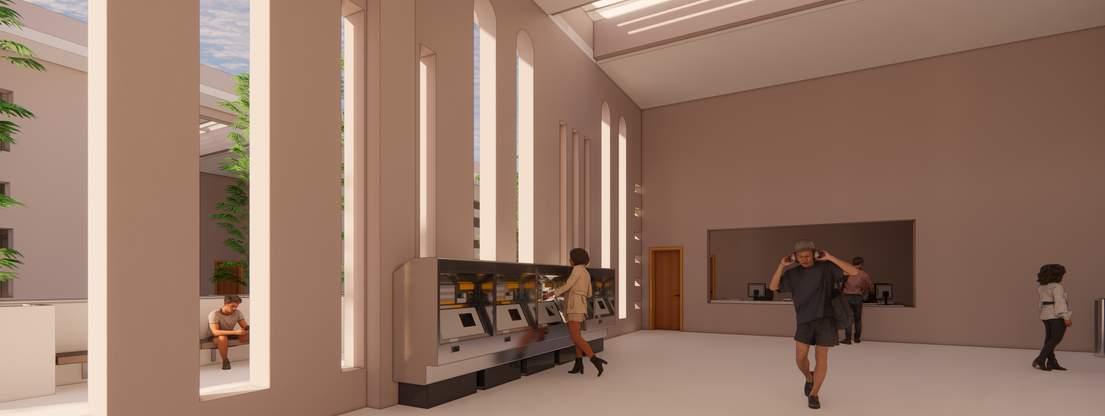
HYPERLOOP STATION CUSTMER SERVICE
COURTYARDVIEW


IMPORTOFFICEATLOGISTICSDEPARTMENT
EASTERNWALKWAYBETWEENLOGISTICDEPARTMENTANDHYPERSTATION
YOGASTUDIO/STATIONRYSHOP


01 02 03 04 05 06 07 08 09 10 1.FOYER 2.LIBRARRY 3.DIGITALROOM 4.STAIRS 5.REFUSECHAMPER 6.APARTMENT01 7.APARTMENT02 8.APARTMENT03 9.APARTMENT04 10.OUTDOORFACILITY HYPERLOOP 2030 DEVELOPMENT 1ST FLOOR 1: 700 C C B B A A
SKYBRIDGEONTOPOFCOURTYARD


KING SIZE BEDROOMR UNITS
ACCOMEDATIONSCOMMONCORRIDORANDPLAYGROUND
DIGITALROOM
LOBBYWITHSUNRISESUNLIGHT
LIBRRARYDOUBLEVOLUMEFORRESIDENCES


1.FOYER 2.LIBRARRY 3.DIGITALROOM 4.STAIRS 5.REFUSECHAMPER 6.APARTMENT01 7.APARTMENT02 8.APARTMENT03 9.APARTMENT04 01 02 03 04 05 06 07 08 09 2ND FLOOR 1: 700 C C B B A A
GREENBALCONIESFORTHEENVIRONMENTANDINDIVIDUALECOSYSTEM SINGLE BEDROOMS UNITS


PRIVATEREADINGROOMSTOBEBOOKEDWITHTTHEMANAGEMENT


01 04 03 02 1.SWIMMINGPOOL 2.GYM 3.REFUSEROOM 4.SHOWERSECTION 3RD FLOOR 1: 700 C C B B A A
SWIMMINGPOOL
HEALTH CLUB AND GYM


HEALTHCLUBANDGYM


02 07 03 06 04 05 01 1.LOBBY 2.PARKING 3.PARKINGSECURITY 4.STORAGE 5.REFUSECHAMPER 6.STORAGE 7.2WAYSRAMP UNDERGROUNDLOGISTIC LINKAGEBETWEENPROTONCITY ANDTM2030DEVELOPMENT BASEMENT 1: 700 C C B B A A

BLOCKA
COURTYARD BLOCKC ROOF PLAN 1: 700 C C B B A A
BLOCKB
 SECTION BB
SECTION AA
SECTION CC
1: 700
1: 700
1: 700
SECTION BB
SECTION AA
SECTION CC
1: 700
1: 700
1: 700

EAST ELEVATION WEST ELEVATION NORTH ELEVATION SOUTH ELEVATION 1: 700 1: 700 1: 700 1: 700


EXPLOADEDISOMETRIC GF 1ST 2ND 3RD ROOF

ENTRANCE
HYPERLOOP STATION
EASTERN WALKWAY VIEW BETWEEN LOGISTIC DEPARTMENT AND HYPERLOOP STATION
COFFE SHOP VIEW AT COURTYARD
COURTYARD VIEW

 COMMON CORRIDOR AT LOGISTICS DEPARTMENT
HYPERLOOP STATION'S VIEW FROM SCOOTER'S DEPARTMENT
COMMON CORRIDOR AT LOGISTICS DEPARTMENT
HYPERLOOP STATION'S VIEW FROM SCOOTER'S DEPARTMENT


FINANCE / HR OFFICE AT LOGISTICS DEPARTMENT
NORTHERN WALKWAY VIEW BETWEEN RESIDENTIAL PARKING AND RETAIL SHOPS
LAUNDRY SERVICES AT RESIDENTIAL BLOCK
OZ
THANK YOU
