Nevis' s Temporary Climate Bothy Landscape
Name Xiangyi Zhu Advanced Landscape Design 2 - BARC0113 MLA Landscape Architecture Year 2 Studio Studio 5 ABRI Ben

A SHELTER; A CAVITY IN A HILLSIDE; A SHELTER ON THE SIDE OF HILL WITH AN OVERHUNG ROCK AS ITS ROOF.

the
analysis
Water is a fundamental but highly variable component of the natural world. It often appears in different forms such as: rain, fog, frost, snow, ice and melt-water. The state of all these has a huge physical and visual impact on the landscape, plants, animals and people of Ben Nevis.
Ecological issues such as climate change and global warming have had a range of irreversible effects on Ben Nevis, such as reduced snowfall, reduced snowpack, shorter snow periods, etc. Unpredictable and rapid changes in temperature also lead to natural disasters such as melt-water streams, avalanches and landslides. This puts nature, its inhabitants and visitors at risk .
As Ben Nevis is the UK's highest peak and has a complex terrain, it attracts a large number of tourists and outdoor enthusiasts every year for outdoor sports such as hiking, rock climbing, mountain biking and so on. In winter, the extreme weather conditions lead to a large number of accidents each year. On the one hand, the question of how to provide a safe and fun experience for visitors has become a worthwhile one. On the other hand, the large number of visitors boosts the local economy and at the same time puts some ecological pressure on Ben Nevis. The question of how to balance nature and tourism is therefore worth exploring.
This project therefore responds to a range of environmental issues in relation to climate change. The project is dedicated to exploring how a landscape approach can ensure the safety of visitors and enhance their experience in extreme environments. At the same time, the project explores the dynamic changes and boundaries between the natural and the unnatural.

 Ben Nevis
Ben Nevis is the highest mountain in Scotland and the British Isles. At 1,345 metres above sea level, the summit is the highest land mass in any direction for 739 kilometres. The summit is the collapsed dome of an ancient volcano and contains the ruins of an observatory, which was used for observations from 1883 to 1904.
The summit of Ben Nevis includes a large stone platform of about 40 hectares (100 acres). An emergency shelter has been built on top of the observatory for those stranded by bad weather.
Fort William is a town in Lochaber in the Scottish Highlands, on the eastern shore of Loch Linn. It is the second largest settlement in the whole of the Scottish Highlands. Fort William is a major tourist centre. It is a centre for hillwalking and climbing due to its proximity to Ben Nevis and many other mountains. It is also known for its nearby downhill mountain bike trails.
It is estimated that Ben Nevis attracts 125,000 full ascents and a further 100,000 partial ascents each year, most of which are made by walkers using the well-built mountain track (Pony Track) from Gran Nevis on the south side of the mountain. The main attraction for climbers and mountaineers is the 600m (2,000ft) high cliffs on the north face. Amongst the highest cliffs in the UK, they boast some of the best scrambles and climbs of all difficulties and are one of the leading locations for ice climbing in the UK.
 The view of Ben Nevis and Glen Nevis from Fort William
 The view of Half Way Lochan on Ben Nevis
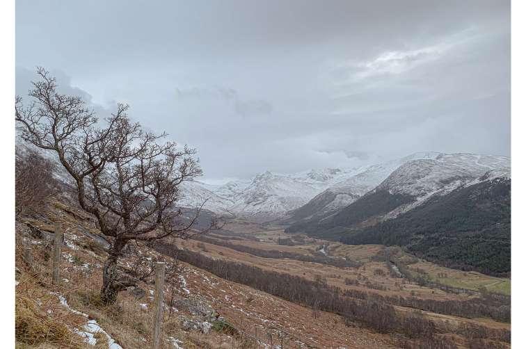
 The view from Half Way Lochan


Ben Nevis has a highland (alpine) maritime (marine) polar climate. The average winter temperature is about -5°C and the average monthly temperature throughout the year is -0.5°C. According to observations made at the summit observatory between 1883 and 1904, fog was present on the summit nearly 80% of the time between November andW January. In an average year there are 261 high winds and 4,350 mm of rainfall on the summit. Ben Nevis receives approximately twice as much rainfall in winter as it does in spring and summer. There is snow on the mountain almost all year round.


According to observations made at the summit observatory between 1883 and 1904, fog was present on the summit nearly 80% of the time between November and January and 55% of the time in May and June. In an average year, there are 261 gales and 4,350 mm (171 in) of rainfall on the summit.
0: 0 h/year >12: 139 h/year


>0: 61 h/year >17: 94 h/year
>3: 260h/year >24: 63 h/year
>7: 211 h/year >31: 36 h/year >38 mph: 20 h/year

The Pony Trail to the summit remains the easiest and most popular climbing route. It starts at Akinti on the east side of Glen Nevis, about 2 km from the centre of Fort William. The trail climbs steeply to Lochan Meall an t-Suidhe (often referred to as the 'midway lake') at 570m and then ascends the remaining 700m in a series of zigzags.
A popular route for experienced climbers starts at Torundi on the A82 a few miles north-east of Fort William, along the Allt a' Mhuilinn trail. It then continues along the Càrn Mòr Dearg Arête to the summit of Ben Nevis. This route involves a total climb of 1,500 metres and requires the ability to climb to the summit.


A bothy is a basic shelter, usually left unlocked and available for anyone to use free of charge. Bothies are found in remote mountainous areas of Scotland, Northern England, Ulster and Wales. They are particularly common in the Scottish Highlands, but related buildings can be found around the world.

The location of bothy in UK

A cairn is a man-made pile (or stack) of stones raised for a purpose, usually as a marker or as a burial mound. In modern times, cairns are often raised as landmarks, especially to mark the summits of mountains. Cairns are also used as trail markers. They vary in size from small stone markers to entire artificial hills, and in complexity from loose conical rock piles to elaborate megalithic structures.

Any man-made structure is an unnecessary intrusion into a remote landscape. These cairns should be removed.
“mini c airns” on S cottish mountains has become a popular way for walkers to leave a memorial, c reate a photo opportunity, or hide their rubbish However, the ever inc reasing piles of rocks are ruining B

and other
warned.
in


Highlands, offi
igational
path
airns
already in place on many S cottish
ially to stick above the snow
the
to the John Muir Trust conser vation charity, B en Nev is, which stands at 4,409ft (1,344m), as well as peaks near L och Ness, have been blighted by new DIY c airns, which not only detract from the scener y but also present a hazard by misdirecting other walkers.
In the worst c ases, v isitors are even leav ing exc rement under the stones. The most bizarre items found under unoffic ial B en Nev is c airns in recent years include a wheelchair and a piano
ials
Fran L ockhart of the John Muir Trust said rangers have had to remove hundreds of the mini c airns on B en Nev is. “ There are offic ial c airns built to stick up above the snow in w intertime to help people nav igate,” she said. “But people have begun building additional c airns in various parts which c an be misleading. It is our job to take them down.
The cairns proliferation could give people a false sense of security which is not an adequate replacement for map reading skills necessary in poor weather conditions.


The first part of the background analysis of the location, weather, history and economy set the direction for the rest of the research, Ben Nevis is the highest mountain in the UK and has long been a haven for outdoor enthusiasts, attracting many visitors to the area on a daily basis, which has boosted the local economy. Due to the
rugged terrain, unpredictable weather and difficult natural conditions on Ben Nevis, visitors are put in dangerous situations every year due to the substandard conditions. Therefore, enhancing the Ben Nevis experience was the next step in my design process. On the other hand, through preliminary research, I found that Ben Nevis has
a strong connection with four natural elementssnow, ice, fog and wind - which pose problems and possibilities for the site.
The flowchart below shows the conceptual design process, design strategy and some of the design details for enhancing the experience of visiting Ben Nevis.


the
of Ben


According to Met Office (2016), on average, the western and northern parts of northern Scotland are the windiest areas of the UK, fully exposed to the Atlantic Ocean and closest to the low pressure passages. The frequency and depth of these lows is greatest during the winter months of the year, particularly from December to February, when average speeds and gusts (short duration peaks) are
at their strongest. In order to eliminate the dangers posed by these wind effects and to rationalise the effects. I refer to the following quoted sources and analyse them in relation to the location and topography of the area. And a physical model was made to analyse the wind environment to arrive at the most suitable model for this area.
Reference: Bioclimaticaarq. blogspot.com, 2014.


The West Coast of Scotland typically benefits from lots of snowfall accompanied by strong winds and temperatures that can change by 10 degrees Celsius in just a few hours. Repeat the thawingfreezing process several times and it will freeze into a stronger ice.
For every 1000 metres of altitude, the temperature drops by approximately 6.5°C, which is known as the vertical rate of temperature decline. The higher the altitude, the less heat is supplied by the ground.

During the winter, the weak rays of the sun are simply not powerful enough to heat the lower atmosphere sufficiently for the dew points to rise and the fog to clear. And besides that, in many sheltered and deep glens the rays of the sun can't even reach the bottom.
The reason D - Topography


For a country where one can never be more than 30 miles from ocean, interior Scotland can show a surprising amount of continentality. During periods of winter weather, it may get surprisingly cold in some sheltered.

Snow blanket is also good news for rare mountain species. The snow blanket can protect the rare plants.
It can help slow the melting of glaciers, but it is not cheap and difficult to implement.


The snow surface temperature is controlled by the air temperature above. The colder the air above, the colder the snow layers near the surface will be, especially within the top 30 to 45 centimeters. Snow near the ground in deeper snowpack is warmer because it is close to the warm ground. Thus, now is a good insulator, moderating soil temperatures, and protecting plants fromfrost damage.

section of

A snow cave is a shelter built in the snow by way of wildlife, human mountaineers, ice recreationists and ice survivors. It has a thermal equivalent to an igloo and is particularly powerful in providing safe winds and bloodless temperatures. Even if the temperature outside the door is -40°C (-40°F), the interior of a well-made snow cave can reach 0°C (32°F) or higher.

Construct a snow cave by digging snow so that the door of the tunnel is below the main area to keep the hot air in. Construction is simplified by building on a steep slope and digging barely up and horizontally on the slope.


They slide down the entire surface of the slope outside the particular channel.


An avalanche is a rapid flow of snow down a slope, which includes a hill or mountain range. Avalanches may be spontaneous, with the help of factors such as accelerated precipitation or weakening snowpack, or by external means, including humans, animals and earthquakes. Avalanches consist mainly of flowing snow and air, and large-scale avalanches have the


function of seizing and moving ice, rocks and trees.
What causes an avanlanche?
Angle: Slope steeper than 30 degree. Instability: Strong snow packed above weaker snow.
Trigger: A force or object to trigger it.
Temperatures within the upper snow layer drop from -10°C to -20°C.
This type of avalanche moves down narrow gullies, ravines and eroded gullies.
Jumping
These free-falling avalanches move along the ledge.
The snow layer near the ground maintains a temperature close to 0 (-2) degrees Celsius. A temperature difference develops between the upper and lower snow layers.
Consolidated snow
Evaporation starts under the lower snow layers. The stability (cohesion) of the lower and upper snow layers is destabilised.

The most unstable area on the slope. Cracks in the snow on the surface and sliding down the fracture line.
Avalanche track
On the descent, snowy passages come with it. Snow and rubble stop movingvisitors are most likely to be buried here.
Reference: Skijas, 2021.

The Summit Plateau: 1200m to summit
Geology: Lavas (fairly basic). In The Summit Plateau there is very little vegetation on the summit plateau apart from mosses and
The Zig Zags: 700m to 1200m
Geology: A fine-grained granite (mildly acidic) then lavas (fairly basic). In the Zigzags Zone, the conditions of the ground, weather and exposure are sufficiently severe that vegetation cover diminishes quite rapidly above roughly 900 metres. A few sturdy plants survive in the partial shelter of the Red Burn gully, in crevices

Halfway Lochan: 400m to 700m
Geology: Coarse-grained granite then a fine-grained granite (both mildly acidic). In the Halfway Lochan Zone, the habitats are particularly associated with water: wet heath is the predominant
lichens on boulders. These are limited to those adapted to the harsh environmental conditions, many are arctic-alpine species. and in damp flushes. Wind-pruned heath is overtaken by weathershattered scree on the steep slopes where occasional plants of spiked wood-rush, parsley fern or matt grass may be observed; higher up mosses and lichens are the main plants growing on the scree.
Geology: Schists moving on to coarse-grained ouIter granite (mildly acidic). In the Glen Nevis Zone, the main path passes through alder wood land by the river Nevis, scattered birch
habitat, there are many wee burns crossing the path, and wateradapted plants in and around Lochan Meall an t-Suidhe(The Halfway Lochan).
woodland, an area with planted native Scots pine, and hill pasture grassland with patches of bracken on the slopes of Meall an t-Suidhe (Hill of the seat).
Reference:


 GROUND CONDITION: GLEN NEVIS
PLANTING ANALYSIS: GLEN NEVIS
GROUND CONDITION: GLEN NEVIS
PLANTING ANALYSIS: GLEN NEVIS


 GROUND CONDITION: GLEN NEVIS


commune Pinus sylvestris


Sphagnum spp.
“It is very absorbent, far more than cotton wool, and has remarkable deodorizing power.”

-Lieutenant-Colonel E.P. Sewell
For wounded humans, the result is that sphagnum bandages produce sterile environments by keeping the pH level around the wound low, and inhibiting the growth of bacteria.


This model experiment shows the evolution of the bothy. By mimicking snow and wind with flour and a hairdryer respectively to explore what shapes would reduce the impact of wind on visitors. The impact of wind conditions on the sheltered areas of the bothy landscape was quickly and efficiently simulated through 3D printing techniques.
experiments, the shape of the bothy landscape was determined under different conditions.


During the spring and summer periods, some mosses grow by being able to absorb and store snowmelt water, while also regulating the water balance of the nearby soil and helping other plants to grow.

In winter, plants are covered in snow, which protects them from the cold, windy natural environment outside due to the thermal properties of the science. At the same time, the snow accumulates deeper in the lowlands, which protects the plants better.


At the end of construction spread a layer of soil and seeds on the surface of the gabion or plant greenery. As time changes, the gabions will be covered with greenery. This facilitates the integration of the gabion with the natural environment. It can also attract other creatures and provide habitat and food for birds and other animals. It also enhances the ecological diversity.


The choice of plants is based on altitude, ecology and functionality. Low lying areas are designed to help collect snowmelt water while avoiding damage to plants from high winds, so this area will be relatively rich in plants.

Zoom 1
This moss accumulates to store water and can absorb about 8 times its own weight in water. This moss was also used as a wound dressing during the Second World War. It can be used for emergency treatment of accidental injuries.
Zoom 2
This is a traditional insect repellent. Also this plant has been used as a treatment for stomach aches, fevers, bronchial diseases and liver.


Sundew contains chemicals with anti-inflammatory properties. It may also reduce cramps. Outdoor athletes can use sundew for emergency treatment of accidental injuries.

Zoom 3
Bog Myrtle


Parsley Fern is a pioneer species on acidic mountain slopes. Parsley Fern grows in acidic rocks, in snowy places until late in the year. It is a pioneer species on stable scree slopes and also occurs on cliffs and dry stone walls.


Deer grass provides bird food, nesting material and mulch for mammals, as well as grazing. This ornamental grass is often referred to as deer grass, but deer will usually avoid it. Sturdy, heat and drought tolerant and easy to care for.

MyrtleSundews Bog MyrtleBog Asphodel Starry Saxifrage Bog Asphodel Parsley Fern
(Reference: Lafoy, 2022)
There are three types of avalanche
including
avalanche bothy, and avalanche barriers, of which the avalanche
are mainly referenced to Avalanche architecture of Lafoy (2022), which provides protection for the CIC Hut located in the north of Ben Nevis. The following section will focus on the avalanche fence, avalanche bothy landscape.


The planting design strategy for the avalanche landscape is similar to that of the bothy landscpae. The planting area was divided into three sections, including the lowland area (zoom 4), the bothy

surface (zoom 5) and the fence avalanche area (zoom 6). The plant species for the three zones were selected by analysing the different growing conditions and functional requirements. At the same
time, the topography was adapted and designed to provide a more suitable living environment for the plants to grow. In addition, the variety of plants is constantly adjusted to the altitude.


Step
Transporting the material on the mountain.
Assembling the gabions.

Collecting stones and filling the gabions.
Step 4

Reconstructing the terrain to provide a suitable and firm base.

Combining
sacks


The fabric is very soft and nonabsorbent. Several repetitions of spraying and freezing did not hold the water. The structure is fragile and tends to distort when the weight of the ice reaches a certain level. Also, if the weather starts to warm up, the ice will easily melt away.


 Meall an t- Suidhe
Creag a' Chall
Allt Coire an Lochain Allta' Mlhuilinn
Lochan Meall an t-Suidhe
Carn Dearg
CIC Hut
Carn Dearg Meadhonach
Carn Mor Dearg
Ben Nevis
Glen Nevis
Meall an t- Suidhe
Creag a' Chall
Allt Coire an Lochain Allta' Mlhuilinn
Lochan Meall an t-Suidhe
Carn Dearg
CIC Hut
Carn Dearg Meadhonach
Carn Mor Dearg
Ben Nevis
Glen Nevis
 Meall an t- Suidhe
Lochan Meall an t-Suidhe Zoom B
Meall an t- Suidhe
Lochan Meall an t-Suidhe Zoom B


