PORTFOLIO

XIANGYI ZHU
SELECTED WORKS 2019 - 2022
Xiangyi
Zhu Flat
Sep 2020 - Sep 2022 UK
University College London
Master of Landscape Architecture MLA Landscape Architecture Merit

Xiangyi
Zhu Flat
Sep 2020 - Sep 2022 UK
University College London
Master of Landscape Architecture MLA Landscape Architecture Merit
Sep 2015 - July 2019 China
Bachelor of Environmental Art Design
Overall GPA: 85.1/100
Professional Experience
Hunan Hanjingtiancheng Landscape Engineering Co., Ltd. Hunan, China Nov 2020 - Feb 2021
Intern Landscape architect
• Participated in a variety of project scales, including 5 landscape architecture projects for single-family home, shopping mall, schools and industrial park.
• Performed general drafting work such as site plans, sections, renderings and working sketches.
• Created and modified 2 landscape designs in SketchUp.
• Developed solutions to technical and design problems following established standards.
• Prepared project information for presentations.
• Worked independently as well as part of a multi-disciplinary team.
• Excellent verbal, written and graphic communication skills
Changsha Shanda Space Exhibition Design Engineering Co., Ltd. Dec 2019 - Jan 2020
Intern designer
• Participated in 2 museum exhibition design projects.
• Collected and collated a large number of relevant documents.
A re-imagination of a fish lives on Primrose Hill
Ben Nevis' s Temporary Climate Bothy Landscape
JAN 2022 - AUG 2022
Hunan, China
• Performed general drafting work such as site plans, sections, renderings and working sketches.
• Possessed the ability to collaborate as part of a diverse team.
• Prepared project information for presentation.
Award
Re-constructed community
JAN 2021 - JUN 2021
• A strong sense of commitment, a willingness to learn and a desire to work in a dynamic, goal driven team environment.
• Proficiency in AutoCAD, SketchUp, Rhino, Lumion, Enscape and V-Ray.
• Proficiency in Adobe Suite: Photoshop, Illustrator, and InDesign. June 2019 Excellent Graduation Design / Chongqing University of Posts and Telecommunications June 2019 Outstanding Dissertation / Chongqing University of Posts and Telecommunications Sep 2018 Third Prize / User Experience Design Award
Master Year 2 https://issuu.com/xiangyi_zhu/docs/xiangyizhu_portfolio_year2_term1
https://issuu.com/xiangyi_zhu/docs/xiangyizhu_portfolio_year2_term2_3
Strategic urban design for sea-level rise
SEP 2019 - DEC 2019
SEP 2021- DEC 2021
The project is named ‘Fish out of water’, which is an idiom used to refer to a person who is in unfamiliar, and often uncomfortable, surroundings. Due to climate change, the living environment is not suitable for many fishes, so they have to move somewhere else. It is similar to the people who live in the areas influenced by climate change. In fact, not only fish and humans but also many plants and animals are suffering from the negative effects of climate change.
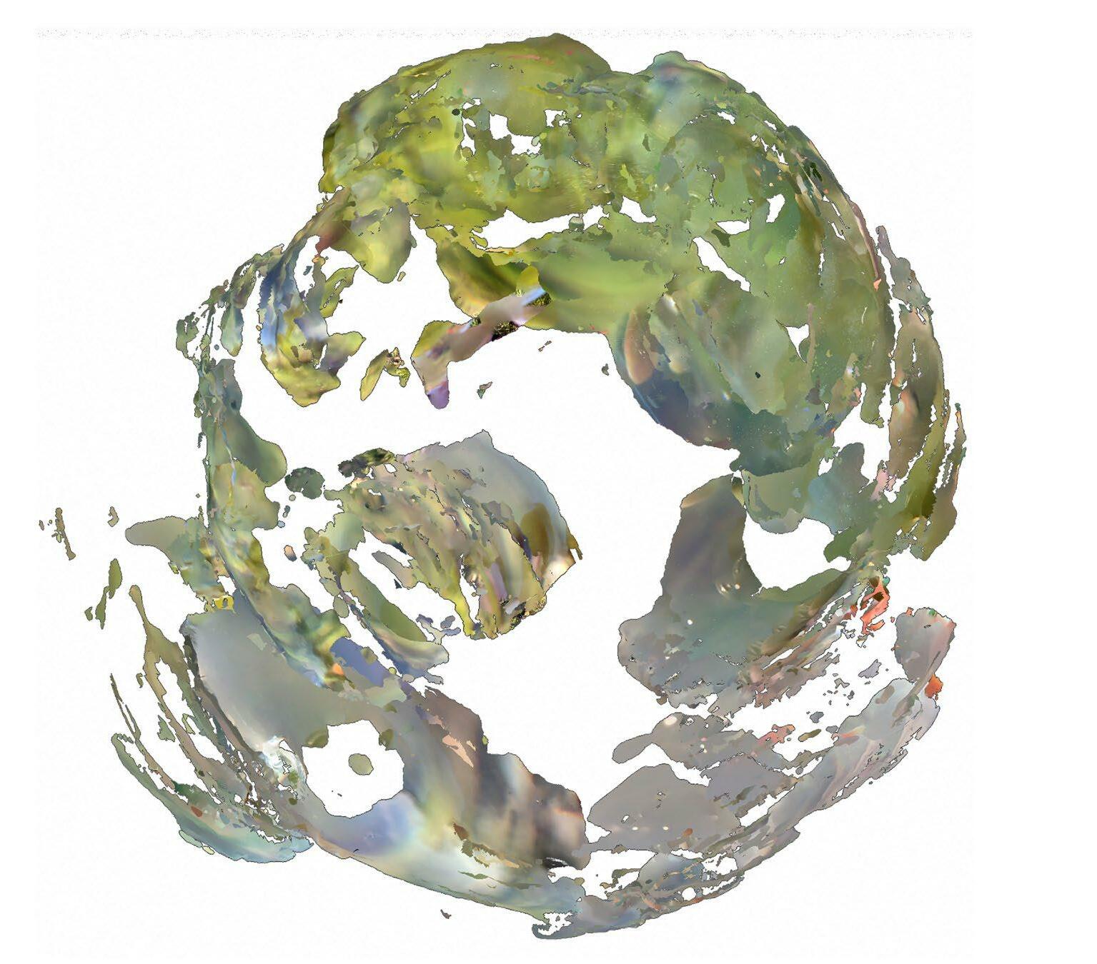
This project begins with the study of fish, analysing what the world looks like from the fish. The view of the fish is then simulated through the ice ball and the landscape is viewed 3D scanned through the ice ball. The 3d scanning projects can help us to record cultural, geological and environmental treasures at risk from climate crisis.
The device is used for field ice ball observation and provides a good view to observe how the surroundings change during the melting of the ice. The unit consists of five main parts, four metal strips forming the support section, which can be adapted to various ground conditions and provide stable support. The last part is the ice ball holder, which provides an open view for easy observation.


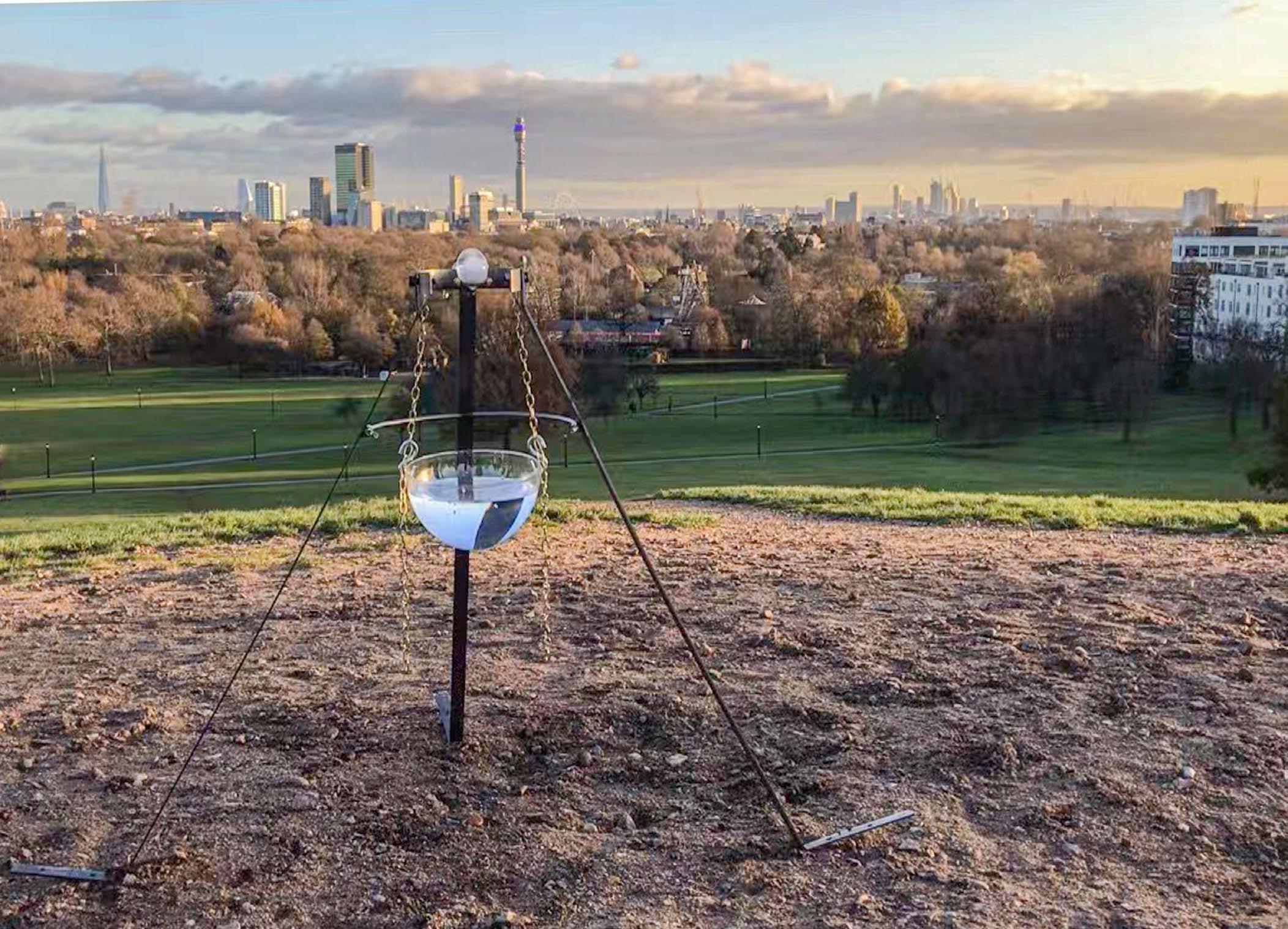
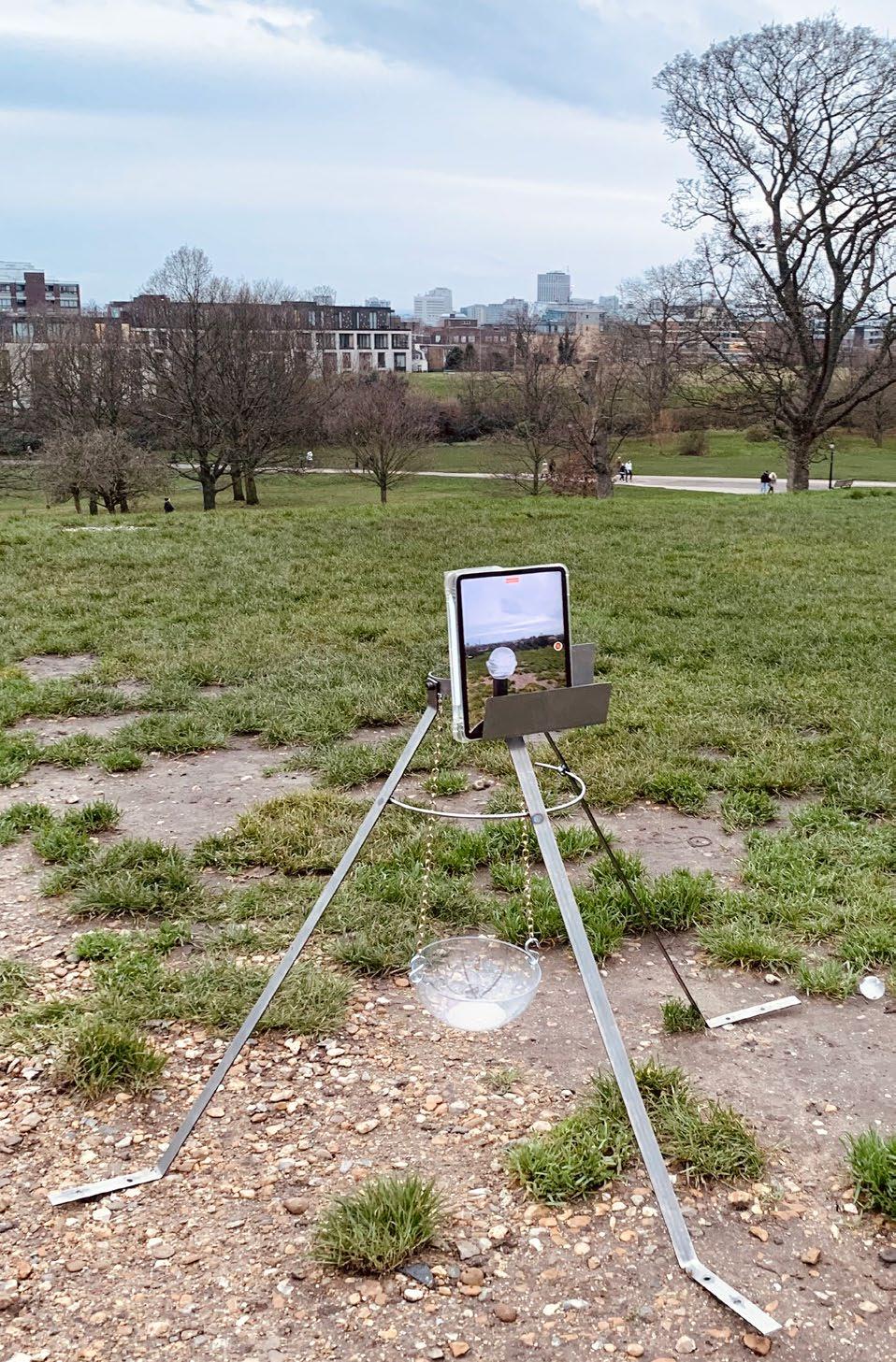

This site is located in Primrose Hill, London. At the circle is the location of the scan through the glass ball or the ice ball.
The next images are the result of a 3D scan of nearby objects and landscapes through the transparent part of the ice ball. As the ice ball melted, the view changed at any time, producing fantastic images, which were analyzed through technical representation.
The area scanned with the glass ball The area scanned in normal way The view the site


JAN 2022 - AUG 2022
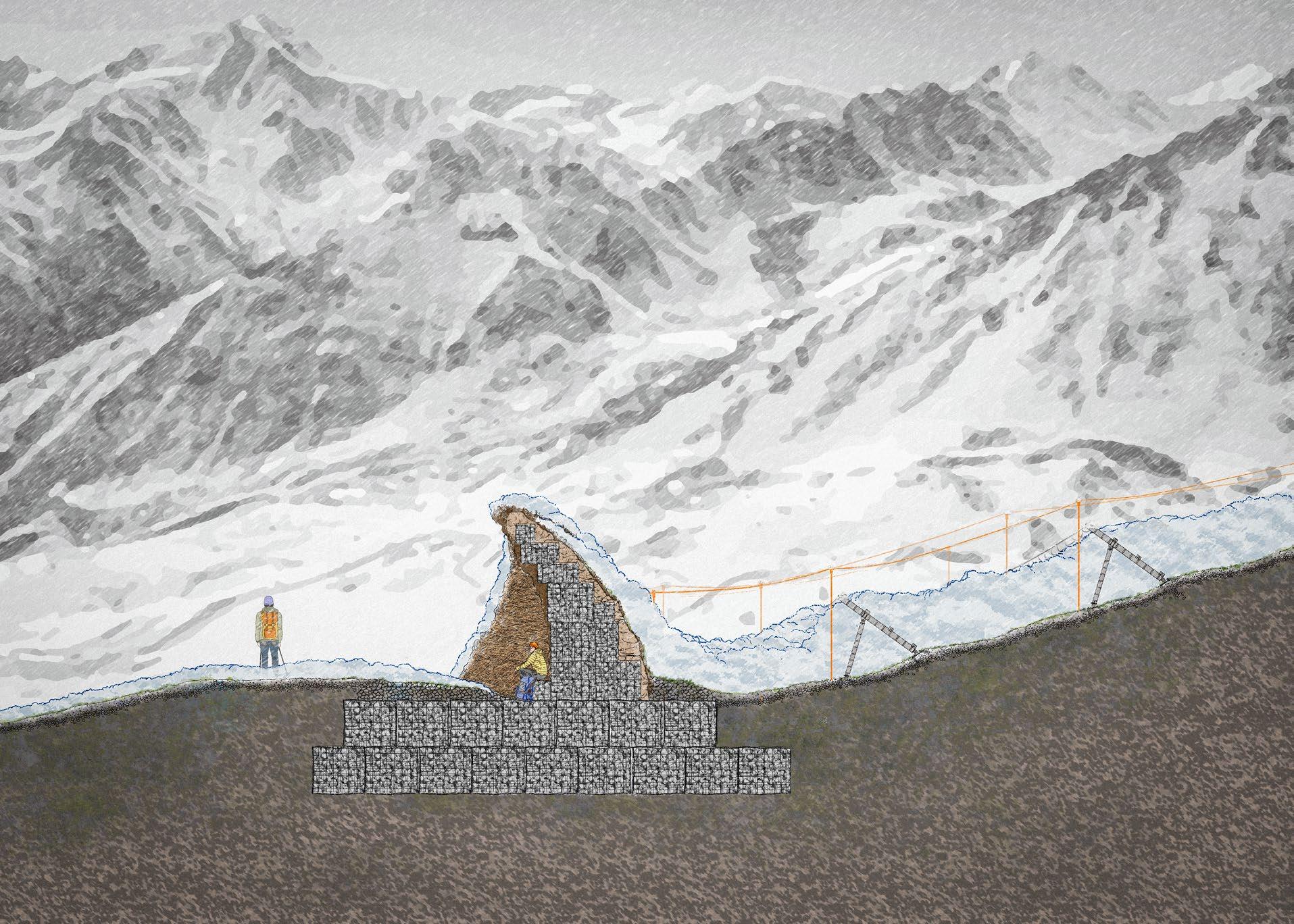
As Ben Nevis is the UK's highest peak and has a complex terrain, it attracts many tourists every year. In winter, the extreme weather conditions lead to a large number of accidents each year. On the one hand, the question of how to provide a safe and fun experience for visitors has become a worthwhile one. On the other hand, visitors boosts the local economy and at the same time puts some ecological pressure on Ben Nevis. The question of how to balance nature and tourism is therefore worth exploring.
Ecological issues such as climate change and global warming have had a range of irreversible effects on Ben Nevis, such as reduced snowfall, reduced snowpack, shorter snow periods, etc. Unpredictable and rapid changes in temperature also lead to natural disasters such as melt-water streams, avalanches and landslides. This puts nature, its inhabitants and visitors at risk.
This project responds to the environmental issues, like climate change. The project is dedicated to exploring how a landscape approach can ensure the safety of visitors and enhance their experience in extreme environments. At the same time, the project explores the dynamic changes and boundaries between the natural and the unnatural.

 Meall an t- Suidhe
Creag a' Chall
Allt Coire an Lochain
Meall an t- Suidhe
Creag a' Chall
Allt Coire an Lochain


 Lochan Meall an t-Suidhe


JAN 2021 - JUN 2021
This is an abandoned park re-construction project, which aims to explore the relationship between human and non-human users in urban area, and to create an urban idyllic landscape that promotes the coexistence of humans and non-human users through design strategies.
The project is located in Jiading District, Shanghai, China. This amusement park was opened in 1996, closed in 2000, and has been idle for almost 20 years. After that, the buildings in the park are dilapidated and overgrown with weeds.

In fact, Shanghai is a rapidly developing modern metropolis, the city is full of high-rise concrete buildings. The pace of life here is fast, bring convenient life to people at the same time, ignore people's desire for nature. On the premise of considering the needs of nonhuman users, this design project transforms the park into a urban pasture and urban farm, attracting citizens to participate in plant planting and maintenance, animal grazing and other activities, and creating a hybrid urban rural landscape.
Through the strong contrast between the urban landscape and the natural landscape, it reawakens people's interest in nature and triggers people's thinking about the relationship between man, non-human and nature. At the same time, a small urban farm could provide food for the city, provide a temporary habitat for migrating birds and enrich species diversity.
B
Natural slope Ditch
Gabions
Ditch Handrail: wooden
Planting hole: 5 cm dia
Hierarchic planting hole: 5 cm dia
The macadam road
This design principle of the park would consider both of human and non-human species. It would creat a diverse community, offer opportunities for human to get close to nature and achieve sustainable development.

The bridges are connected the main macadam road and the grazing area. It is noticeable that there are a lot of hierarchic holes with plants which is attractive to cows and keeping them away form the ditch. And the main macadam road would use the same design principle.
The ditch would collect rain water by the underground pipes which connected with water tanks. The ditch would also be the fence for the cows which is not visible fence and showing the equality of people and animals.

Handrail: wooden
1 10
T-profile: steel 5 mm thick

Screw hole
Planting hole Bridge: concret Drain hole: 3 cm dia Gabion: 40X40X50 CM
The bridge: concrete 20 CM thick
Soil
Screw: 100X8mm
Gravel aggregate 3: 12/42
Geotexitile fabric Perforated drain pipe: 30 cm dia
Soil
Screw: 80X8mm
Post: wooden 10x10x155 CM
The dith would be built by the soft engineering which could be better for the nature and animals. And the hard engineering part would use the MSE retainning wall which used geotexitile fabric and geotexitile grid to offer a strong structure.
The design of this area would follow the animal-friendly principle, like the animal tunnel and the stepping stones, which could increse the biological diversity.

The details of gabions 75 CM 40CM
Planting substrate
Soil-aggregate mix Geotexitile grid Gabion


Gravel aggregate 3: 12/42 Perforated drain pipe: 30 cm dia
Geotexitile fabric
Gravel aggregate 1: 2/16 Gravel aggregate 2: 0/42 Soil-aggregate mix
CM
CM 45CM 135CM
CM Gabion C 70 CM 40CM
CM 155 °
CM 135CM
% Gabion D

A

engineering
Wire mesh Ditch & Fence Ditch & Fence 27 28
Handrail: wooden (see detail 1)
Steel grid: 10x10x2 CM
Drain hole: 3 cm dia
Wooden
Screw hole: 8 mm dia
Handrail: wooden (see detail 1)
Fixing: steel / Post: wooden
Post: steel / 20 cm dia
Foundation: concrete (see detail 3)
Section A shows the skywalk above the ground which would offer tunnels for cows and the other animals. It would use the steel grid to help the water and sunshine flows to plants directly.
Fixing: steel / Post: wooden Fixing: steel / Post: wooden


Handrail: wooden (see detail 1)
Chair: wooden T-profile: steel (see detail 4)
Steel grid: 10x10x2 CM
Drain hole: 3 cm dia
I-profile: steel (see detail 2) I-profile: steel (see detail 2)
Wooden deck: 100x10x3 CM
Birds' shelter: wooden
Post: steel / 20 cm dia
Foundation: concrete (see detail 3)
Section C shows the possibilty of multi-function of the skywalk, like chair, platform, fitness equipments, entertainment equipments, etc.
1 :100 1 :100
Steel: 8 mm thick
I-profile: steel (see detail 2)
Wooden deck: 100x10x3 CM 70 CM 60 CM
Birds' shelter: wooden
Post: wooden / 10X10X110 CM
Foundation: concrete (see detail 3)
Section B shows the skywalk above water area which would offer shelters for water birds at under the deck which can decrease the disterb from human.

Handrail: wooden (see detail 1)
Drain hole: 3 cm dia Drain hole: 3 cm dia
Fixing: steel / Post: wooden
I-profile: steel (see detail 2)
Steel grid: 10x10x2 CM
Ditch: Gravel aggregate: 12/42 & Perforated drain pipe: 30 cm dia
Gravel aggregate Prefabricated structure
Perforated drain pipe: 15 cm dia
Post: steel / 20 cm dia Post: steel / 20 cm dia
Foundation: concrete (see detail 3)

1 : 15 1 : 20 1 : 25 1 : 10
Post: wooden / 10X10X110 CM
Steel: 8 mm thick
I-profile: steel / 10 CM thick
PART 1 and PART 2 are welded together.
Pillar: steel / 20 CM dia Nut: 16 mm dia
Steel
Threaded rods: 16 mm dia
Foundation: concrete / 60X60X100 CM


T-profile: steel / 8 mm thick
Screw hole: 16 mm dia
Section D shows the skywalk connected with the MSE retainning wall which and can protect the shoreline and collect water as well.


SEP 2019 - DEC 2019
In the context of sustainable development, this project explores resilient landscape strategies for islands to cope with sea-level rise and a series of problems caused by it and finds possible strategies to mitigate sea-level rise, to reduce risks to people, economy and society.
The project is located at Chongming District, Shanghai. Changxing island with citrus planting, Marine equipment manufacturing as the leading industries, rapid economic development. However, Changxing island is located in an ecologically sensitive area at the estuary of the Yangtze River, facing a series of problems such as severe water-logging, loss of bird habitat and serious industrial pollution.
Waterlogging The rectification river
Storm tide
Addition Widen
People and water coexist in harmony
Deepen Build watergate
STRATEGY 1: RECONSTRUCTION OF WATER NETWORKS

The reconstruction of the water network can greatly reduce the risk of waterlogging. The design strategy is to remove the original cement canal, to add, widen and deepen the canal according to the site characteristics, to construct
ecological slope protection, to repair the natural channel, to increase the capacity of the river, and to increase the affinity of the island water system for the islanders, to enrich the species diversity and to protect the ecosystem.
Sealevel rise
The reduce of bird habitat
Factory dumping FRAMEWORK
Provides great environment
Keep Protect Attract
Rebuild coastline Build islands for birds Build stakes for birds Plant reeds
Wetland restoration Build fruit orchards
Benthic protection Water purification
Aquaculture
Function reconstruction
Underwater sightseeing Science education
Biological conservation
Cement canals
Remove the cement canals
Original canals Birds' islands Original wetland
Build more canals
Devastated wetland
STAGE 1
Protect the wetland
STAGE 2 STAGE 2
New canals Birds' stakes
Shanghai is an important passage point for bird migration, especially the Changxing island. But as pollution has increased, more birds have disappeared. Through a series of analyses of bird food, living environment, and breeding
Build islands and stakes for birds
The shipbuilding industry in Changxing island is very developed, which not only brings economic benefits but also causes industrial pollution to a large extent, such as air pollution, soil pollution, and water pollution. The design strategy is to redesign some of the shipyards that will soon fail to meet the demand for use,
STAGE 1
Shipbuilding
Secondarycanals
STAGE 3 STAGE 3
Ecological slope protection channel network
Widen the canals Build a diverse ecosystem for birds
Deep water area
Shallow water area Fruit orchards
Main canals Macrophanerophytes & Reed Benthic flora
Macrophanerophytes Fish
STAGE 4 STAGE 4
conditions, the following strategic methods are obtained to protect birds, keep birds and attract birds.
Reed Emergent aquatic plant
Build ecological slope protection Offer a variety of foods for birds
to make them a place integrating the functions of water purification, science education, tourism, and ecological fishery, to upgrade functions the shipyard and realize sustainable development.
STAGE 2 STAGE 3 STAGE 4
Purification of sewage Ecological fisheries Science education
Changxing Island in Shanghai is based on current problems such as flood disasters, bird habitat loss, industrial pollution and so on, and the sustainable development of the island is realized from multiple dimensions. In the process of finding solutions to sea-level rise and a series of problems caused by it, landscape strategies have been adopted to reduce natural disasters and economic losses while creating new economic, tourism, social service opportunities and recreational space to help the future development of the island.

The salt in the soil dissolves in water, enters the hollow pipe to discharge the soil, reduces the soil salinization city, is advantageous to the crop planting.
Removal of existing cement channels and restoration of natural channels have increased the capacity of rivers and reduced waterlogging.
With the development of The Times, the old shipyard was left idle and transformed into a place integrating water purification, sightseeing.
In the replanning of Changxing island, the living habits of birds have been fully taken into account to attract birds to stay, protect birds and enrich species diversity.
Through a series of devices, increase the oxygen content of water, improve the water quality, to provide a healthy habitat for all kinds of organisms.
Rainwater filtration and collection devices are set up to collect and store rainwater as agricultural water for sustainable development.

1 year later
1 year later 2 years later 3 years later
The design of bird island provides the birds with a relatively independent and safe habitat, which is beneficial to the breeding of birds. The secondary recycling of resources is beneficial to the environment.
MODEL MATERIAL ANALYSIS
Recycling of cement and red bricks in river reconstruction.

Break red bricks and cement blocks.
Adjust the pH of the cement slurry to suit oyster growth.
Secondly, it also plays an important role in water purification, attached to the above animals and plants, microorganisms can purify harmful components in water.
At the same time, it can withstand wave erosion to some extent and slow the retreat of the coastline.


