
QUICK & EASY GUIDE TO 5 OF BOULDER'S TOP HIKES
https://www.wkre.com/blog/Trails-to-Train-for-the-BolderBoulder-10k - April 2022
Visiting Colorado? A free day and don’t know what to do? Well, the first day of Spring is right around the corner and what better way to celebrate than by putting on your hiking shoes and heading outdoors! Here’s a quick list of some of Boulder’s best hiking trails with the most rewarding views:
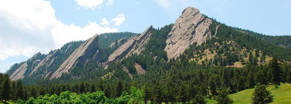
CHAUTAUQUA MOUNTAIN
By far the most famous hiking destination in Boulder is Chautauqua Mountain right off the corner of Baseline Road & 9th Street. Check out the Chautauqua Trail and the Bluebell-Baird Trail if you’re looking for an easy stroll with the kids and gorgeous views of the town of Boulder. Or if you’re up for the challenge, try one of the more famous trails known as the Royal Arch Trail. Starting at the end of Bluebell Road heading south, this trail passes the gorgeous Tangen Spring then sends you up a rockier road to bring you to the Royal Arch itself. This is a stunning and very rewarding sight after the .8-mile-long trail. Parking is free at the base of the mountain.
Find trail information here
https://bouldercolorado.gov/trail/chautauqua
MOUNT SANITAS
Located 0.5 miles west of 4th Street on Mapleton Avenue is the trail head for Mount Sanitas, a moderate hike that is both dog and kid friendly. Perfect for a sunny day, this 3.3-mile loop is surrounded by beautiful wildflowers and evergreens. You end with an amazing bird-eye view of Boulder surrounded by the sandstone quarried for the original buildings on the CU campus! Parking is free in the Centennial trail head on the south side of Mapleton Avenue.
Find trail information here
https://bouldercolorado.gov/trail/mount-sanitas
GREEN MOUNTAIN
Although on the more difficult side, this 6-mile loop offers amazing views of the Flatirons, Indian Peaks, and wide panoramas at the top of Green Mountain. For the scenic route, head up Bluebell Trail to Gregory Canyon trail head. Only 3-4 hours, this hike allows plenty of shade, wildflowers, and even some wildlife (although amazing to see, try staying on path to avoid any dangerous chances of crossing paths with our furry friends!) Parking is free at the base of Chautauqua Mountain, located at the corner of Baseline Road & 9th Street.
Find trail info here
https://bouldercolorado.gov/trail/green-mountain-west-ridge
wkre.com
• 303-541-1928
• wkrelo@wkre.com
REALIZATION POINT
Well-loved and very clearly named, this 3.4-mile loop is perfect for a quick get away from the city. This easy/moderate hike starts about 3.5 miles up Flagstaff Road at the corner of Flagstaff Summit Road. From the Realization Point off Flagstaff Summit Road, start with the Ute Trail and head toward the Range View Trail which offers views of the Front Range, Sugarloaf Mountain, and Boulder Mountain Parks. With these amazing views, you will be greeted by plenty of wildflowers and evergreens.
Find trail info here https://www.bouldercoloradousa.com/outdoors/hiking/realization-point-hikes/
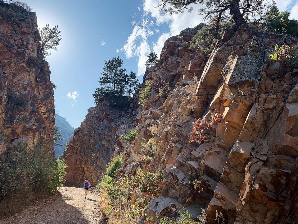
ELDORADO CANYON
Eldorado Canyon is an easy to moderate kid friendly hike that offers amazing views and some history! For the most scenic route, start with the Fowler Trail where you can spot rock climbers scaling the canyon walls. Fowler Trail will then lead you to the Rattlesnake Gulch Trail where you can explore the ruins of the old Crags Hotel built in 1908. It was accessed via an inclined railway from the canyon floor until it burned down in 1913. From the Rattlesnake Gulch Trail, you will travel to the continental divide overlook where numerous breath-taking views await. This 5-mile hike is located at 9 Kneale Road in Eldorado Springs, a short 20-minute drive from the heart of downtown Boulder. It can be accessed after paying an $8.00 parking fee which opens the door to many other trails in Eldorado Canyon!
Find trail info here https://bouldercolorado.gov/trail/eldorado-canyon
So, get your hiking shoes out and head outdoors this Spring and Summer. The mountains are calling and what better way to answer than by exploring mother nature herself!
wkre.com • 303-541-1928 • wkrelo@wkre.com
DENVER'SMILEHIGHMAGAZINE

Hike We Like: Gregory Canyon
This jaunt through the Flatirons offers vibrant autumn color, a great workout, and some wonderful views.
BY TERRI COOK | OCTOBER 17, 2017Length: 3.3 miles round trip
Difficulty: Moderate
Why we love it: It’s a classic Chautauqua-area loop hike with plenty of options for extending it for those who still crave more.
When to go: The trail is at its best from mid-spring through mid-to-late fall, before the ice accumulates.
Pre-hike buzz: At the Baseline and Broadway junction just west of U.S. 36, you can choose between Brewing Market, Starbucks, and Einstein Bros. Bagels. Less than a mile from the trailhead, the Chautauqua Dining Hall offers more upscale options.
Restrooms: Outhouses at the trailhead
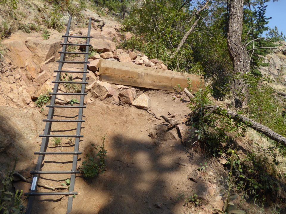
Dogs: Must be leashed or under voice and sight control along the trails. In addition, there is a ladder along this route that is not recommended for dogs.
Distance from Denver: 29 miles
One of the Boulder area’s best autumn hikes is this beautiful loop through the foothills on the northwest side of Boulder’s Chautauqua Park. Portions of the route parallel small streams with lush riparian corridors filled with trees and shrubs where foliage turns vibrant shades of yellow, orange, and red for an all-too-brief period each fall.
To minimize the steepness of the ascent, which totals about 1,300 vertical feet, I recommend hiking this loop counter-clockwise. From the Gregory Canyon trailhead, follow the Gregory Canyon trail along the creek, keeping a sharp eye out for poison ivy. Fortunately, this is much easier to spot in autumn, when its infamous “leaves of three” turn bright red.
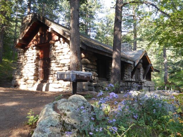
The vegetation soon becomes more open and the trail rockier as it climbs steadily uphill for about a mile through the sparkling, 1.7-billion-year-old granite. As you approach the top, the gradient briefly levels out, providing a welcome breather. After crossing a small creek, along which wildflowers linger long into the summer, you’ll arrive at a junction with the Ranger Trail. Turn left and follow it 0.2 miles to a large stone shelter, which has several welcoming picnic tables ideal for a trailside snack.
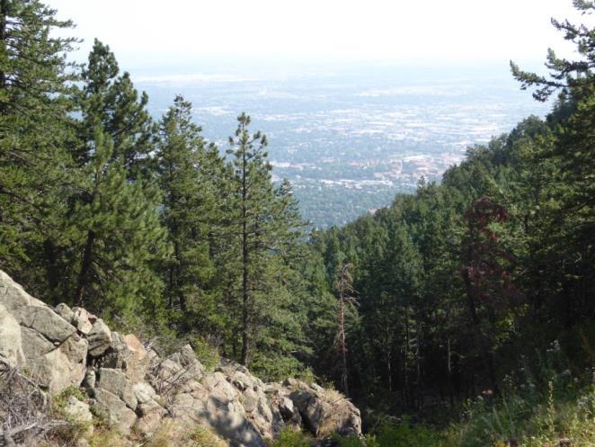
From the shelter, continue left on the Ranger Trail an additional 0.3 miles through the majestic ponderosa pine forest to the junction with the E.M. Greenman Trail. Veer left again here to climb another 0.6 miles to the junction with the Saddle Rock Trail and begin to follow this downhill. The openings between the trees near this junction offer nice views down to the city and the northern foothills, and there are even better views, including up to the Continental Divide, a short distance ahead.
Continue to descend the Saddle Rock Trail, which in places is quite steep. In one notable spot, there is a ladder that Boulder Open Space and Mountain Parks (OSMP) has installed to replace a section of the path damaged in the 2013 floods. Although tall, the ladder is inclined into the slope and easy to get on and off, so I had no difficulty navigating it even carrying hiking poles.
As you continue downhill, stay left at the next two junctions to remain on the Saddle Rock Trail, which will bring you back to the dense vegetation in the bottom of Gregory Canyon. Here you can enjoy one last look at the fall colors before reaching your vehicle.
To complete the Gregory Canyon loop, you must be willing to navigate this ladder. -Terri Cook
Getting there: From Denver head north on I-25 to U.S. 36. Follow the highway west for 25 miles and exit at Baseline Road in Boulder. Turn west (left) onto Baseline and continue straight for 1.8 miles, passing the junction with 9th Street. At the first right-hand bend (just after the stone bridge), turn left into the Gregory Canyon parking area. If this is full, turn around and park at one of the meters along Baseline Road. Trailhead parking for cars with out-of-county plates costs $5 per day.
wkre.com • 303-541-1928 • wkrelo@wkre.com
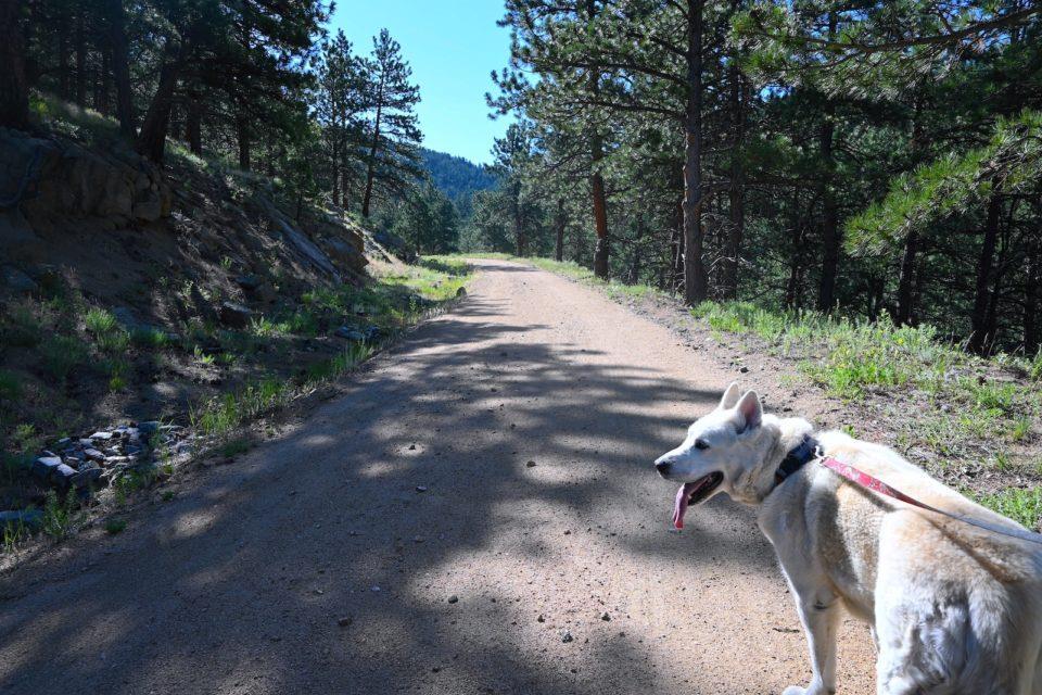
Boulder: Chapman Drive Trail
Bring Fido along for a romp through wildflowers while you enjoy gorgeous valley views.
DALIAH SINGER • AUGUST 18, 2020
Chapman Drive Trail in Boulder
Distance: 5.8 miles round-trip
Difficulty: Easy/moderate
Cost: Free
Chapman Drive Trail is a different way to access the dozen or so popular trails that spider out from Realization Point in Boulder Canyon. (It also has a gratis parking lot off CO-119, whereas there’s only paid parking at the Point.) The gravel path is wide great for social distancing and is uphill the whole way, but it’s a mild ascent. Along the way, as you pop in and out of the shade, you’ll spot a rainbow of wildflowers and cyclists grinding up the hill. Once at the top, for a truer hiking experience, make the outing a lollipop loop by heading downhill on the well-maintained Tenderfoot Trail, a gradual, 0.9-mile downgrade that connects back to Chapman and provides beautiful valley views and a soft dirt path underfoot along the way.
Who Will Love This Trail: Hikers with dogs; anyone who wants a broad trail for physical distancing
Cool Off: Reward tired feet with a dip in Boulder Creek, which burbles next to the trailhead parking lot.
Avoid Crowded Trails With These 3 Hikes Near Boulder
We mapped out under-explored routes by linking paths through Open Space and Mountain Parks and Eldorado Canyon State Park.
DOUGALD MACDONALD • 5280 MAY 2020
Much of the 155-mile trail network in Boulder’s Open Space and Mountain Parks went unexplored even before COVID-19-related restrictions limited Coloradans to their own communities. When those rules loosen, see the area’s unbeaten bounties on three hikes we created by linking existing trails.
wkre.com • 303-541-1928


