

Buckley Comprehensive Plan Update Credits
Beau Burkett City Council
Ron Smith
Mackenzie Anderson
Kenny Arsanto
Amanda Burbank
Denice Bergerson
Connie Bender
Brandon Green
Planning Commission
Lorna Anderson
Ashley Ferrero
Mel Garland
David Griffin
Matt McCollum
Mark McPhail
Robert Wohfeil
Staff
Courtney Brunell, City Administrator
Chris Farnsworth, Senior City Planner
Chris Banks, Director of Public Services
Erin Snodgrass, Parks & Recreation Director
Consultants
Framework Cultural Placemaking
Gray & Osborne
Blueline (Housing Action Plan, Appendix B)
Adopted December 10th, 2024
Introduction I.
Welcome To Buckley in 2044
Welcome to Buckley’s 2024 Comprehensive Plan Update. The comprehensive planning process is an opportunity to align Buckley’s internal needs and vision for the future with what is happening across Washington State more broadly. Since Buckley’s last Comprehensive Plan Update in 2015, many changes have occured in state and regional policies that impact how the city plans for the future. Simultaneously, the planning process gives the City and opportunity to consider what types of incentives, funding structures and capital investments it wants to develop to make the city a more liveable and vibrant place for residents.
Most of the time, the City operates at a day to day level of reviewing permits and administering plans. The Comprehensive Planning process is an opportunity to zoom out and view the City holistically and to ask some big questions, like whether the city’s land use pattern is supporting the economic development residents would like to see, or whether the city’s zoning and code allow a wide range of housing types to accomodate different types of households in different stages of life.
Buckley also experiences many of the housing and employment pressures felt in the region
more broadly. As discussed in the Planning and Policy Framework found in Chapter 2, the comprehensive planning process is governed by the Washington State Growth Management Act, a piece of legislation that was adopted to give the state strategic tools to focus growth in employment and housing across the state. Initially a key goal of that legislation was to preserve resource land by reducing sprawl. The Act does this by focusing growth around major transportation corridors and employment hubs which additionally reduces infrastructure needs and increases service administration efficiency and economic vibrancy.
Since the last plan update, the state legislature has updated the Growth Management Act in several key ways that have implications for Buckley’s plan. The biggest change is the adoption of HB 1220. a piece of legislation designed to increase the production of affordable housing across the state. Historically, the GMA triggered the creation of housing growth targets that cities needed to accomodate through their land use planning (for instance, Buckley might need to provide space for 500 new units), but there was no mandate to provide space for affordable housing. Affordable housing typically requires higher density allowances
to develop - single family residential development is typically not affordable to those making below area median income. To help rectify the housing shortage, HB 1220 disaggregates the city’s housing growth target into different income brackets so that it must provide space for apartments and middle housing types. This has large implications for Buckley’s future land use designations and the zoning and code decisions that stem from it. These changes are reflected in the Future Land Use Map found in the Land Use Element.
Because of Buckley’s small size and distance from a major employment center, the City is not subject to several other big housing requirement changes. However, many of the goals and policies in the housing and land use elements are modified to coordinate with state, regional and county goals.
This plan is the product of many different city efforts, including extensive community engagement, that inform the Plan’s vision, some significant changes to the Future Land Use Map and the city’s economic development strategy, and other priorities reflected in the Plan.
II.
Planning & Policy Framework
Background
Comprehensive planning is a fundamental method for calibrating state, regional, county, and municipal goals and objectives and linking them to strategic policies and actions to guide the City over a twenty-year planning period. Comprehensive plans are updated every twenty years with periodic updates every ten to ensure that the city is growing and changing in alignment with the Plan. Each planning effort includes significant community engagement, as well as coordination and participation between city agencies, boards and elected officials. Comprehensive planning is a rare opportunity for collaboration across departments and across the community that can result in positive and coordinated growth that respects and enhances community character.
State, Regional and County Context
Washington State Growth Management Act (GMA)
Although prepared and approved by the City,
Office of Financial Management (OFM) produces county growth projections
Counties and other member organizations within Puget Sound Regional Council collectively decide on regional growth target within OFM projected population range.
PSRC allocates growth to Counties
Pierce County work with constituent cities to allocate county job and housing growth.
Buckley allocates jobs and housing within the city based on existing land capacity (how much land is vacant or redevelopable).
Buckley is guided by Washington State planning requirements that are contained in state legal codes and the Growth Management Act (GMA), which is codified in RCW Chapter 36.70A and in other related and amended sections of the Revised Code of Washington (RCW). As the name indicates, the Growth Management Act was adopted in 1990 to ensure strategic growth in the state that preserves resource lands and coordinates density in jobs and housing within existing regional centers. This is based on the logic that strategic density reduces infrastructure and other costs and resource consumption while preserving Washington’s environmental assets.
Planning Purpose
The purpose of the Comprehensive Plan as articulated by state legislation, is to create a policy framework that guides subsequent planning efforts within city agencies, development regulations and daily actions of the city. It is intended to be a central resource linking goals and objectives, municipal policies, local standards, and implementation actions. Importantly, State legislation includes a requirement that zoning, capital expenditures and development regulations conform to the Goals, Policies and Actions articulated in the Comprehensive Plan.
Coordinating State, Region, County and Local Growth in Employment and Housing
In advance of planning efforts, the Office of Financial Management (OFM) provides a range of population projections for Washington Counties so that the Counties can plan appropriately to accommodate anticipated growth. For large metropolitan regions such as Puget Sound, a regional body acts as an intermediary for these growth allocations. In Puget Sound, Members of Puget Sound Regional Council (PSRC) including Snohomish, Kitsap, King and Pierce Counties as well as the region’s tribes, cities, transit agencies and port districts work together to set a regional growth target and then allocate growth to the respective counties. This ensures that large transit and other regional infrastructure investments are coordinated with growth in employment and housing. Finally, the counties work with their constituent cities to allocate jobs and housing, and each city allocates growth within its urban growth area.
Coordinating State, Region, County and Local Planning Policies
The GMA triggers comprehensive plans at the regional, county and city levels. Countywide Planning Policies must be consistent with the regional comprehensive plan, and city comprehensive plans must be consistent with both regional and county plans. For Buckley, this means that this Comprehensive Plan must conform to state requirements, PSRC’s Vision
BUCKLEY VISION
PIERCE COUNTYWIDE PLANNING POLICIES
BUCKLEY GOALS AND POLICIES
Framework, 2023
2050 and Pierce Planning Policies. In the last several years, major amendments to the Growth Management Act, Vision 2050 and Countywide Planning Policies include provisions to address deficits in affordable housing, climate adaptation and mitigation, and racially disparate impact.
For more context on the Growth Management Act, Vision 2050 and other upstream regulations that inform the Comprehensive Plan, please refer to the Existing Conditions report in Volume II.
Plan Components
The Buckley Comprehensive Plan follows the framework of Community Vision, Land use element which includes the Future Land Use Map, Plan Elements and Implementation Action Plan. Each Plan Element includes a series of Goals and Policies. Finally, a section on plan implementation includes concrete actions the city can take to advance the goals and policies.
For the purposes of this document, the terms "Goal," "Policy", and "Action" are defined as follows:
01. Goal – Goals are broad statements indicating a general aim or purpose to be achieved. A goal is a direction setter, an ideal future end, condition, or state related to the public health, safety, or general welfare toward which planning and implementation measures are directed.
02. Policy – Policies are topic-specific statements designed to address a specific objective, providing guidelines for current and future decisionmaking to make progress towards achieving that objective. A policy indicates a clear commitment of the local legislative body. A policy is an extension of a plan’s goals, reflecting topical nuance as well as an assessment of conditions.
03. Action – Actions are budget-able steps envisioned or undertaken to implement plan policies. Actions may include the development of more detailed and localized plans, work to implement policies, formal agreements, and regulations or other strategies.
All Goals, Policies and Actions are written to achieve compliance with the Growth Management Act (RCW 36.70A.070(1), PSRC Vision 2050, and Pierce County Planning Policies while furthering the vision articulated by community members found in the following chapter.
III.
Vision & Community Layout

Vision & Community Layout
Introduction
The Comprehensive Plan is the City’s framework for the future. It is the plan that directs the future our residents want. This plan identifies strategies to make the best possible town that we can make. Through this plan we assert that our City’s residents aren’t just numbers – we are family and friends.
Community Vision
The City is committed to ensuring that the components that contribute to its quality of life including affordable housing, a healthy natural environment, good schools, efficient government, and excellent infrastructure are available for all residents and for future generations. Buckley residents want this city to become a more vibrant and attractive place to live, work, and play by finding a balance between support for economic development and population growth while retaining and protecting the City’s small-town charm and amazing enirronmental assets.
Vision Statements
Sustaining and fostering town identity and character
In 2044, Buckley will...
01. Have a vibrant, compact and walkable downtown where people meet each other face-to-face, where small businesses can thrive, and with housing close at hand that support a high quality of life.
02. Have a denser Downtown and 410 Corridor that improves service administration while supporting the rural quality of life farther from City center.
03. Foreground the city’s unique history through retention of historic buildings, thoughtful community design, civic space and park system.
04. Have affordable and accessible housing that allows the city’s aging population to stay in the place they call home, while welcoming newcomers into the community.
05. Be a safe and inviting place to visit and reside.
06. Use public dollars strategically and efficiently to provide city residents with high quality roads, utilities, environmental amenities and services.
Economic development of the Downtown Core and State Highway 410
In 2044, Buckley will...
07. Have an enhanced 410 Corridor that creates a friendly gateway to our city with more retail, small businesses and housing that is community oriented and provides new places for residents and visitors to live, work and be together.
Promotion of outdoor recreational activities.
In 2044, Buckley will...
08. Be a destination and not a pass through for outdoor recreation enthusiasts availing themselves of our area’s natural beauty through concerted infrastructure and facility investment and support for recreation-oriented businesses.
Community Vision & Plan Element
Land Use & Community Design
Introduction
The term “land use” refers not only to the type of activities that can occur on a piece of land, but also which activities occur alongside others. Generally, land use refers to the plan for orderly and coordinated land development and uses for buildings and land within the city.
Background
Planning Framework GMA
Under the Growth Management Act (GMA) the land use element designates the general distribution and general location and extent of all land uses, including housing, commerce, industry, recreation, open spaces, public utilities, public facilities, and other land uses. The land use element includes population densities, building intensities, and estimates of future population growth. Every jurisdiction planning under the GMA needs to address several key topics in the goals and policies of the Land Use Element including groundwater protection, public health, environmental hazard and pollution mitigation, identification of open space corridors, and corridors useful for consolidated infrastructure (such as co-locating roads and utilities). As indicated in the planning policy framework, Buckley’s Comprehensive Plan must also adhere to policies found in Puget
Sound Regional Council’s (PSRC) Vision 2050 and Pierce Countywide Planning Policies.
PSRC
Key themes that must be included from Vision 2050 include supporting the development of compact urban communities and central locations that support walkability, using land use to reduce health disparities, promoting infill and counteracting historical policies and land use practices that resulted in racially disparate impact including racial exclusion and finally preserving cultural heritage.
Pierce Countywide Planning Policies
For land use, Pierce County’s primary interests include supporting public health through land use planning, including coordination of housing and retail uses, reducing greenhouse gas emissions and the impact of environmental hazards produced by climate change such as flooding and excessive heat and the production of high quality and community oriented places.
Population and growth Allocation
In 2020, Buckley’s population was 5,114 individuals within 1,854 households (average household size was three members). Buckley is anticipated to grow by around 3,121 individuals in the next 20 years. To accommodate new residents and better support existing residents, Buckley needs to add an additional 1,260 housing units and 1,080 jobs. Washington State faces a critical shortage of units, which has resulted in a lack of affordable housing particularly near major growth centers. In 2022, the Growth Management Act was amended to require that cities provide zoned capacity for affordable housing. Affordable housing typically requires higher density allowances, because land value and construction costs are usually too high to provide affordable single family homes. For households making 0-50% of area median income and particularly those that cannot live fully independently, the most feasible form of housing is low to mid rise apartments. For this reason, the future land use map that follows, will allow some higher density housing in certain parts of the city. For more information on housing, please see Housing Element.
Existing Population (2020): 5,114
Population Growth Target (2044): 8,235 (+3,121)
Existing Housing Supply (2020): 1,957 Units
Housing Growth Target (2044): 3,217 (+1,260)
Pierce County Buildable Lands Report 2022
Existing Employment (2020): 2,241 Jobs
Employment Growth Target (2044): 3,321 (+1,080)
Buildable Lands inventory summary based on current zoning
The table below shows the anticipated number of units and jobs that Buckley can accommodate with its existing zoning regulations (based on dwelling units/acre and jobs/acre). The numbers come from Pierce County’s buildable lands report which models development and redevelopment potential for parcels across the city. As the table shows, Buckley needs to allow more density to accommodate the number of housing units required by Pierce County (the existing zoning falls 507 housing units short). The Future Land Use Map and the zoning and development regulations that flow from it will allow the densities required to accommodate the housing target.
Figure LU-3 Buildable Lands Capacity Based on Existing Zoning
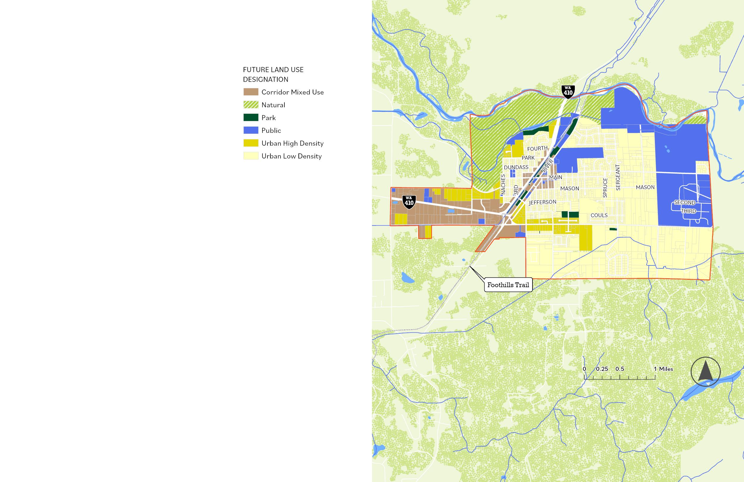
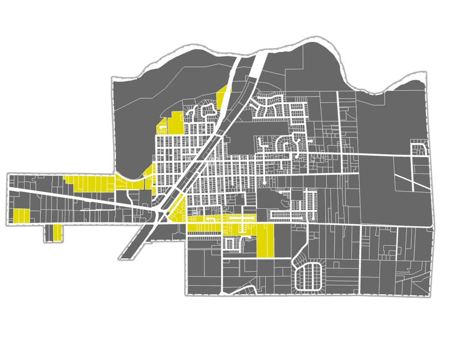
Future Land Use Map
The future land use map is divided into a number of different land use designations that develop an integrated planning approach. In the past, Buckley has emphasized separating industrial and manufacturing uses from the city’s predominantly residential areas using commercial and mixed use buffers.
Strategic Moves:
Distribution of the zones is partly based on city history, city vision, and utility. Some sites within the city are zoned because of their histories as an active industrial site that began before zoning was implemented.
In this iteration of the Plan, the intent is to regulate form more and land uses less particularly along the 410 corridor. We intend to emphasize form because traditional Euclidean zoning often produces areas with hard edges that feel incompatible. Many uses that occur in Buckley are fairly low intensity particularly in light industrial and commercial areas, but because of lot configuration and built form they create unsightly or unfriendly spaces with very little interaction with the street or integration with their neighboring environment. By intentionally regulating form, we can produce better built environments without significantly curtailing the types of businesses and residential uses that call Buckley home.
Key areas:
410 Corridor
Historically, zoning and land use regulations along Highway 410 have produced sprawling development with significant parking and diffuse uses like self storage and contractor yards that are extremely auto oriented and barely interact with the street. As a gateway to Buckley, these areas have a role to play in providing welcoming spaces for visitors and residents alike and in generating more revenue for the City. New development regulations will focus on creating a “commercial flex” zone along the western extent of Highway 410 to allow existing uses, while pushing the corridor towards a more interactive and city serving form.
Historic Commercial
Buckley’s Historic Main Street is a huge asset to the community as one of the few areas with complete sidewalks and access to the interurban trail, many parks, and civic spaces. Because of the existing built form, this area is key to producing a more walkable and accessible Buckley, and consequently, the area surrounding Historic Main Street allows higher density housing and mixed use development. Pairing higher density housing with existing services and high volume utilities reduces the costs of administering services in the city. This is part of the rationale of locating Buckley’s highest density housing along the eastern extent of the 410 corridor as well.
Residential Distribution Strategy
In 2024, Buckley has a mixture of residential zones and permits mixed use development in the majority of commercial areas in the city except for Historic Commercial. Buckley’s zoning permits
a wide range of multi unit dwellings in many residential zones. This includes expanded low-density multifamily development within the higher-density residential zones of R-6,000 and R-8,000 like duplexes, triplexes, and some types of multiplexes. Expanding multifamily uses within R-6,000 and R-8,000 zones follows the GMA directive to provide a diverse range of housing types, but retains Buckley’s small-town character (ability to walk from place to place, meet with other residents in safe environs and be socially aware of other residents - generally producing a neighborly place to live). In the future land use map these areas are denoted as “Neighborhood residential” indicating that this part of the city will include primarily detached residential uses while allowing some middle housing types to increase affordability. Changes to the development regulations which are modified in conjunction with the Comprehensive Plan are designed to reduce barriers for this type of housing development.
Pockets along 112th Street and Pearl Street are slated for Buckley’s highest density mixed use development. This provides the zoned capacity that the city needs in order to accommodate Pierce County’s low income housing allocation. This area will allow apartment buildings because households making 0-50% of area median income typically can only find housing in midrise apartments (3-4 stories). Allowing this higher density housing on the Southern edge of the city will reduce some of the impact of height on obscuring views of Mount Rainier while balancing access to a main transportation corridor, services and amenities for high density housing. Two land use designations are left in the Future Land Use map: the public (P) zone and the Natural (N) zone. Public zones include existing public properties, such as city hall, public parks, public schools, and public services. The N zone abuts the river and the city’s uplands and corresponds to areas regulated by the City’s Shoreline Management Program.
Pierce County Buildable Lands Report, 2022 (for calculations and assumptions see Appendix B)
The map is divided into land use designations within commercial, mixed use, residential, public and open space types. The FLUM should not be read as a zoning map – within each of the listed land use designations different types of zoning can occur so long as they fit under the umbrella of the designation.
Goal and Policy Themes:
The goals and policies in this chapter are designed to further the goals and mandates articulated in the Growth Management Act, Vision 2050 and the Pierce Planning Policies while balancing local needs and desires expressed in the Community Vision. One of the important functions of the Land Use element is to coordinate The key themes include:
Creation of a friendly, people centered city
One of the key goals of both Pierce’s Planning Policies, Vision 2050 and the City of Buckley is to create a built form that enhances public health and happiness by creating walkable and amenity rich spaces throughout the city. Because of Buckley’s size, it makes sense to focus those areas in existing hubs, and especially the historic city center. However, several neighborhood mixed use areas are defined in the future land use map to promote little community serving areas around the city. The city also intends to establish policies that incentivize community serving businesses such as groceries and pharmacies to establish in Buckley. Since the development of the last Comprehensive Plan, Buckley has passed design guidelines intended to enhance the city’s built form that have a strong fidelity to the city’s history as a railroad town.
Rectifying Racially Disparate Impact
At the state level, an important development since the last Comprehensive Plan update is a focus on rectifying policies and actions that have systematically diminished opportunities for people of color in Washington State over time. Depending on the place, this might look like active displacement, differential access to amenities, schools and services, disproportionate exposure to environmental hazards or, in Buckley’s case a large discrepancy in racial makeup (92% of Buckley residents identify as white (not Hispanic or Latino) as opposed to
63.7% of Pierce County residents). This type of discrepancy is usually indicative of racial exclusion. Factors that can contribute to racial exclusion include a lack of affordable housing (often produced by a heavy preponderance of single family zoned areas), and lack of transportation and economic opportunity. Buckley is remote, however even compared to neighboring cities Enumclaw and Bonney Lake, Buckley lacks diversity (Enumclaw and Bonney Lake are 79% and 76% White (not Hispanic or Latino) respectively). This plan focuses on what is most in Buckley’s control - decreasing barriers to affordable housing.
Resource protection, Environmental Hazard and Climate Mitigation
The area adjacent to the White River sustains healthy populations of fish, mammals, birds, insects, reptiles, amphibians and plant life. This biodiversity should be protected. It is important to consider long-term ecosystem health and work to maintain adequate habitat and ensure the continued viability of a diversity of species to ensure the waterfront is an ecologically thriving resource for future generations. The land use element is the only element in the Comprehensive Plan that discusses critical areas, storm water, and pollution controls. The city’s only flood plains are next to the river; the steepest slopes are on the north side between the residential areas and the river where the city’s Shoreline Management Program allows no residential or commercial development. Preventing development along the White River also reduces the potential for residential flooding brought whose risk is intensified by climate change. Pierce County Planning Policies highlight the importance of planning for climate resiliency and mitigation, and several policies have been added to comply with those mandates.
Intergovernmental coordination
Buckley’s success is linked to both its neighbors as well as regional and state governing bodies and agencies such as the Department of Transportation (WSDOT). Many land use decisions need to be made based on an understanding of what is happening outside the city. This is particularly true for coordinating development with transportation investment (not only highways, but also bike and pedestrian trails and pathways) as well as developing contiguous habitat corridors and managing watersheds. Buckley should communicate and work with these other agencies to maximize the impact of City investments.
Residential land use
Preserving the beneficial elements of Buckley’s historic rural character includes maintaining open spaces and view corridors to help encourage an outdoor aesthetic and access to nature. Encouraging clustering of development allows maintenance of open space and helps protect sensitive areas, while reducing the cost of providing utilities and services. Adding density and height allowances in certain locations is crucial for ensuring that housing types affordable to low income households can be built within the city, a need demonstrated by the Housing Action Plan, and mandated by the State of Washington.
Economic Development
Commercial uses in Buckley should enhance the quality of life for residents by providing needed services, employment, and tax revenues to finance public services. The “mix” of commercial services refers to both physical integration (among commercial and residential uses) and composition (type) of commercial establishments. Commercial and residential uses should be physically integrated with one another along the northeast SR 410 corridor, through adequate motorized and non-motor-
ized transportation connections. Locating denser housing and retail near each other provides the customer base for businesses to thrive.
Transportation
Land use and transportation policies address the relationship between the land use pattern and a multimodal transportation system. For instance, when jobs, shops and services are long distances from residential areas, it translates into additional vehicle or transit trips. Allowing residential and nonresidential uses to be located in closer proximity to one another make walking or bicycling more feasible and reduces stress on roadways. Coordinating land use and transit investments is incredibly important for mitigating greenhouse gas emissions as well as for improving quality of life by reducing the amount of time people need to spend in their cars in gridlock.
Parks Recreation and Open Space
One of the primary goals of Parks Recreation and Open space is to improve well being and public health in addition to supporting local habitat. To that end, many of the goals and policies below are about integrating parks and open spaces into the fabric of the city so that they are both easily accessible and improve access to other uses like connecting housing with retail. Buckley’s Foothills Trail is a major piece of this puzzle.
Public Facilities and Utilities
The purpose of this goal is to improve quality of life for existing and future development by establishing and maintaining level of service standards. The size and location of public facilities and utilities influence the pattern of land development; therefore, provision must be consistent with the policies described in all sections of the Comprehensive Plan. In addition to regular utilities and capital facilities, The State Growth Management Act requires local government comprehensive plans to include a process for identifying and siting essential public facilities, which are public or quasi-public facilities, such as airports, state educational facilities, state and local correctional facilities, solid waste handling facilities, mental health facilities, and group homes. No local comprehensive plan or development regulation may preclude the siting of essential public facilities.
Goals and Policies
LU 1 BUCKLEY SHOULD PURSUE LAND USE STRATEGIES THAT CONTRIBUTE TO THE HEALTH AND WELLBEING OF CITY RESIDENTS
LU 1.1 Buckley's land use decisions and subsequent housing, capital facilities and transportation planning should produce a dense, walkable historic town center and 410 corridor with safe and accessible housing, retail and open space that can be accessed by a robust bike and pedestrian network.
LU 1.2 The City should prioritize locating affordable housing in areas with access to services, amenities, sidewalks and trails and to the extent possible, transit.
LU 2 BUCKLEY SHOULD CONTINUE TO ENHANCE IT'S SMALL TOWN AND NEIGHBORLY CHARACTER BY PURSUING LAND USE AND DEVELOPMENT REGULATIONS THAT PRESERVE THE HISTORICAL HERITAGE OF THE COMMUNITY AND PRIORITIZE A HIGH QUALITY OF LIFE.
LU 2.1 In the historic downtown, balance preservation of historic buildings while pursuing design standards that create comfort and accessibility using sidewalk design, attention to the interface between the sidewalk and first floor retail and protection from the elements including street trees and awnings.
LU 2.2 Buckley should provide infrastructure, amenities and development regulations that enhance community life including programs to expand urban tree canopy coverage, civic spaces for connection and rest, and a vibrant and walkable downtown that feels safe and inviting to visitors and residents alike.
LU 2.3 In the historic downtown and 410 corridor, pursue strategies to create high enough density to support grocery stores and other needed amenities, alternate transportation options and civic spaces.
LU 2.4 Strategically expand non motorized access between Downtown, the 410 corridor and residential areas to reduce the need for cars in day to day life.
LU 2.5 Encourage mixed use development in commercial and mixed use zones to ensure that housing is collocated with services and amenities.
LU 2.6 Development in the city should promote livability by requiring developers to provide connections to pedestrian trails and/or sidewalks, encouraging development consistent with the city’s history and design standards, and by limiting stress factors such as noise, traffic, and damage to existing ecology through strategic land use planning and development standards.
LU 2.7 The city should continue to pursue strategies to preserve Buckley's historic buildings which contribute to the city's strong community identity and character.
LU 2.8 The city should formally designate the area between Ryan and Park, and between SR 410 and River the city’s center of local importance (CoLI).
LU 3 CONTINUE TO RECTIFY DISCREPANCIES BETWEEN BUCKLEY'S DEMOGRAPHIC PROFILE AND PIERCE COUNTY'S BY INCREASING AFFORDABILITY AND PURSUING POLICIES THAT WELCOME A DIVERSITY OF NEWCOMERS INTO THE CITY.
LU 3.1 Ensure that all planning efforts include an outreach component that targets underserved, minority and low income residents
LU 3.2 Prior to proposed land use and development regulation changes, evaluate whether those changes could adversely impact underserved, minority and low income residents. If so, pursue outreach activities to mitigate potential impacts and identify alternative solutions where possible.
LU 3.3 Alleviate historic housing inequality (Buckley's diversity in 2024 is significantly lower than Pierce County at large with 91% of City residents identifying as white not hispanic) by expanding access to affordable housing particularly for underserved and minority populations and by preserving existing affordable housing within the city.
LU 4 COORDINATE WITH PIERCE COUNTY, REGIONAL AUTHORITIES, NEIGHBORING JURISDICTIONS AND NONPROFITS TO CREATE OPPORTUNITIES FOR MUTUAL IMPROVEMENTS.
LU 4.1 The city councils and planning commissions of Buckley and its neighboring jurisdictions should conduct annual meetings to discuss growth directions and development on the plateau, to exchange information, to review common issues, to establish ad hoc working committees for resolution of any issues, and to serve as an education tool for the public.
LU 4.2 The Cities of Buckley and Bonney Lake should establish a joint planning area that allows city input in the development review process for areas located between the two city jurisdictions.
LU 4.3 The City should continue working with DSHS to increase the uses on leased properties that are part of the Rainier School and plan proactively in the event that the school is decommissioned.
LU 4.4 The City should work with the Pierce County Biodiversity Alliance to help develop the stewardship plan for the Lower White River Stewardship Plan.
LU 4.5 The City should work with the Mt. Rainier National Park Commission to research infrastructure improvements and media accessibility to transform the city into an active Carbon River Corridor, Sunrise, and the Chinook Pass gateway destination.
LU 4.6 The City should work with private or nonprofit organizations that aid low- and moderate-income families.
LU 4.7 The City should continue working with Pierce County, King County, WSDOT, Washington State Park and Recreation Commission and other local jurisdictions to complete the Foothills Trail to Enumclaw, South Prairie, Wilkeson, Carbonado, and Fairfax.
LU 4.8 The City to should continue work with neighboring communities to identify and implement measures designed to enhance tourism, recreational development and economic development through exploring and sharing historic knowledge and information about our common heritage.
LU 4.9 The city should continue joint use agreements with the school district to maximize the availability of facilities for recreational and other public uses.
LU 4.10 The city should establish or update an annexation policy to address immediate and long term plans for growth that creates logical boundaries and reasonable service areas on land that can physically accommodate development.
LU 5 PRESERVE, PROTECT AND ENHANCE BUCKLEY'S ENVIRONMENT INCLUDING WETLANDS, HABITAT CORRIDORS AND OTHER CRITICAL AREAS IN ORDER TO PREVENT FLOODING, EXPAND RECREATION OPPORTUNITIES AND SUPPORT LOCAL WILDLIFE.
LU 5.1 Encourage developers to use low impact development techniques to reduce pollution and mitigate other stresses on critical areas.
LU 5.2 Pursue zoning strategies that focus growth away from critical areas to reduce the risk of flooding and other environmental hazards.
LU 5.3 Preserve, protect and enhance wetlands.
a. Prioritize the protection of contiguous wetland corridors to provide habitat for local wildlife.
b. Some of Buckley’s farmland includes drained or altered wetlands. Where appropriate, restore historic wetlands in areas that are no longer used for farming.
LU 5.4 Periodically monitor drainage, flooding, and stormwater runoff within Buckley and as needed, address with development regulations that reduce pollution and retain water on site or as close to site as feasible.
LU 5.5 Identify and develop a program to designate open space corridors within Buckley that augment County efforts to support local wildlife and reduce flood risk, while providing new opportunities for outdoor recreation.
LU 5.6 Buckley should protect and restore native vegetation and encourage management of nonnative and invasive species. Assessment of existing urban tree canopy coverage and adopt strategies to expand tree canopy coverage that will help to alleviate the impact of summer heat events.
LU 5.7 Adopt appropriate sections of the wildland urban interface code developed by the International Code Council to mitigate wildfire risk. Support city residents in wildfire adaptation and preparedness.
LU 6 BUCKLEY SHOULD PURSUE LAND USE PLANNING THAT CO-LOCATES RESOURCE EFFICIENT MULTIFAMILY AND MIXED USE DEVELOPMENT WITH AMENITIES TO REDUCE RELIANCE ON CARS AND PER CAPITA GREENHOUSE GAS EMISSIONS.
LU 6.1 Buckley should promote infill development near the Historic Commercial area and along the 410 corridor to support existing and future business development and a more sustainable built environment.
LU 6.2 To enhance community understanding of Buckley's critical areas, Buckley should develop a publically accessible critical areas map that includes wildlife protection areas, frequently flooded areas, aquifer recharge areas and geologically hazardous areas according to best available science and as a supplement to the Critical Areas Ordinance.
HO 6.3 Provide development regulations and procedures that reduce cost barriers for the development of many types of housing to accommodate a wide range of accessibility and affordability needs.don
LU 6.4 Reduce lot size requirements in areas impacted by critical areas and in areas close to services and amenities.
LU 6.5 Develop regulations for planned unit developments that provide more flexibility around setbacks and other site development constraints especially for infill sites close to existing services.
LU 6.6 Zoning regulations should provide adequate land and densities to accommodate housing targets across all income brackets in accordance with allocations from Pierce County.
LU 6.7 Allow residential-based businesses that are compatible with other residential uses.
LU 7 HAVE A WELL-MAINTAINED, INTERCONNECTED SYSTEM OF MULTIFUNCTIONAL PARKS, RECREATIONAL FACILITIES AND OPEN SPACES THAT IS ATTRACTIVE, SAFE, AND AVAILABLE TO ALL SEGMENTS OF THE CITY’S POPULATION; AND SUPPORTS THE COMMUNITY’S ESTABLISHED NEIGHBORHOODS AND SMALL-TOWN ATMOSPHERE.
LU 7.1 Coordinate park activities with economic development activities to develop a coherent plan that links parks and trails to economic development.
LU 7.2 Connect parks, schools, recreation areas and open spaces using trails and an expanded sidewalk network to commercial and high density residential areas along highway 410 and Main Street.
LU 7.3 Identify open space corridors within Buckley that further cross jurisdictional habitat and recreation connectivity.
LU 8 THE CITY SHOULD PROMOTE A DIVERSE SET OF COMMERCIAL USES TO INCREASE THE CITY'S TAX BASE, PROVIDE FOR THE BASIC NEEDS OF THE COMMUNITY AND ENHANCE THE FRIENDLY AND NEIGHBORLY ATMOSPHERE OF THE CITY.
LU 8.1 Ensure adequate commercial land supply is zoned appropriately to support commercial uses.
LU 8.2 Encourage motorized and non-motorized connections between adjoining retail developments to create links to transportation. Also encourage links between retail, residential and civic uses. The city should consider establishing links through easements, impact fees, and development code.
LU 8.3 Encourage mixed use development where appropriate especially in and around Buckley's historic center
LU 8.4 Plazas and open space should be provided to link trails with commercial areas.
LU 9 COORDINATE AN ORDERLY PROVISION OF PUBLIC FACILITIES WITH PUBLIC AND PRIVATE DEVELOPMENT ACTIVITIES THAT COMPLEMENTS THE FISCAL RESOURCES OF THE CITY.
LU 9.1 Public facilities and utilities should be located to maximize the efficiency of services provided , to minimize the cost of services and to minimize impacts on the natural environment.
LU 9.2 Zoning densities should recognize existing utility locations, with higher densities closest to existing mains and lowest densities in areas away from existing facilities. When new utility services are installed, the city should reexamine the zoning to see if a higher density is warranted.
LU 9.3 To the extent feasible, development approvals should be contingent upon facilities already being in place as the development occurs in order to efficiently administer utilities. Provisions for development application review and the timing of the actual impacts caused by the different types of developments should be incorporated into the city's concurrency management system as part of the land development regulations.
LU 9.4 New development should pay for its proportional impact on city infrastructure except in instances where the city identifies that the development substantially forwards the mission and vision of the city.
LU 9.5 Impact fees should be calibrated to ensure that new development pays its share of costs for new and expanded facilities commensurate with its impact on Buckley's existing service distribution. This should direct growth towards Buckley's existing infrastructure by decreasing the cost of infill and new development in those locations. The Future Land Use Map should further this logic by allowing greater density in existing high volume locations.
LU 9.6 The City should carefully consider granting development permits in aquifer recharge areas where the wrong types of uses may result in compromising water quality or quantity.
LU 9.7 The City should further development regulations and zoning that reduces impermeable surface coverage in aquifer recharge areas and encourages groundwater infiltration.
LU 10 MANAGE AND STRATEGICALLY EXPAND UTILITY SERVICES TO ENSURE A HIGH LEVEL OF SERVICE THAT SUPPORTS COMMUNITY OBJECTIVES AND THE CITY'S LAND USE STRATEGY.
LU 10.1 The City should develop and regularly update a map of future infrastructure investments including utility corridors, transportation corridors, landfills, sewage treatment facilities, stormwater management facilities, recreation facilities, schools and other public uses to ensure that investments are sited and coordinated to decrease construction and administration costs.
LU 10.2 Support transportation and infrastructure projects that further community objectives including increasing walkability, improving access to green spaces and other amenities and lowering barriers for the development of affordable housing.
LU 11 DEVELOP TRANSPORTATION SYSTEMS THAT ENHANCE THE APPEARANCE, QUALITY, AND FUNCTION OF RESIDENTIAL AND COMMERCIAL DISTRICTS, PROVIDE CONNECTIVITY BETWEEN ADJACENT DEVELOPMENTS AND ENSURE SAFE AND EASY MULTIMODAL ACCESS TO GOODS AND SERVICES.
LU 11.1 The city should require vehicular and nonmotorized connections between adjacent developments through dedications of land and easements.
LU 11.2 The City should encourage walking and bicycling to work, school and on errands by providing safe and well marked bike and pedestrian paths.
Land Use Goals and the Community Vision
The diagrams on the next few pages illustrate how the land use goals articulated in this chapter connect to the community vision statements in Chapter 3.
VISION STATEMENTS
Sustaining and fostering town identity and character
In 2044, Buckley will...
01. Have a vibrant, compact and walkable downtown where people meet each other face-to-face, where small businesses can thrive, and with housing close at hand that support a high quality of life.
02. Have a denser Downtown and 410 Corridor that improves service administration while supporting the rural quality of life farther from City center.
03. Foreground the city’s unique history through retention of historic buildings, thoughtful community design, civic space and park system.
04. Have affordable and accessible housing that allows the city’s aging population to stay in the place they call home, while welcoming newcomers into the community.
05. Be a safe and inviting place to visit and reside.
06. Use public dollars strategically and efficiently to provide city residents with high quality roads, utilities, environmental amenities and services.
Economic development of the Downtown Core and State Highway 410
In 2044, Buckley will...
07. Have an enhanced 410 Corridor that creates a friendly gateway to our city with more retail, small businesses and housing that is community oriented and provides new places for residents and visitors to live, work and be together.
Promotion of outdoor recreational activities
In 2044, Buckley will...
08. Be a destination and not a pass through for outdoor recreation enthusiasts availing themselves of our area’s natural beauty through concerted infrastructure and facility investment and support for recreation-oriented businesses.
Buckley should pursue land use strategies that contribute to the health and wellbeing of city residents.
Buckley should continue to enhance it’s small town and neighborly character by pursuing land use and development regulations that preserve the historical heritage of the community and prioritize a high quality of life.
Continue to rectify discrepancies between Buckley’s demographic profile and Pierce County’s by increasing affordability and pursuing policies that welcome a diversity of newcomers into the City.
Coordinate with Pierce County, regional authorities, neighboring jurisdictions and nonprofits to create opportunities for mutual improvements.
Preserve, protect and enhance Buckley’s environment including wetlands, habitat corridors and other critical areas in order to prevent flooding, expand recreation opportunities and support local wildlife.
Buckley should pursue land use planning that colocates energy efficient multifamily and mixed use development with amenities to reduce reliance on cars and per capita greenhouse gas emissions.
Have a well-maintained, interconnected system of multi-functional parks, recreational facilities and open spaces that is attractive, safe, and available to all segments of the city’s population; and supports the community’s established neighborhoods and small-town atmosphere.
The city should promote a diverse set of commercial uses to increase the city’s tax base, provide for the basic needs of the community and enhance the friendly and neighborly atmosphere of the city.
Coordinate an orderly provision of public facilities with public and private development activities that complements the fiscal resources of the city.
Manage and strategically expand utility services to ensure a high level of service that supports community objectives and the City’s land use strategy.
Develop transportation systems that enhance the appearance, quality, and function of residential and commercial districts, provide connectivity between adjacent developments and ensure safe and easy multi-modal access to goods and services.
Housing Introduction
Housing is a mandatory comprehensive planning element for Growth Management. The GMA indicates that a housing element should be used to ensure the vitality and character of established residential neighborhoods, create a policy framework that decreases barriers to the production of a wide variety of housing types, and identify sufficient land for all types of housing so that households at all income levels can call Buckley home.
The future land use map in the Land Use Element in addition to the land use goals and policies, articulates a strategy to accommodate Buckley’s share of housing across all income brackets. Pierce County’s growth allocation is indicated in the table below.
Buckley should direct this growth in ways that benefit the community as a whole. Working creatively under the parameters of the GMA, Buckley can work to improve its housing stock, future housing developments, housing options and neighborhoods in ways that preserve and complement its historic and small town character.
Strategy
The main issues facing Buckley in terms of housing include the following: [based on HAP]
01. Buckley’s current low-density, single family development trend will not meet the 3,372 units needed by 2044.
02. The city’s current annual average rate of production of dwelling units is low and will need to be increased to 58 units/year to meet the 2044 growth target.
03. Buckley does not have enough affordable units for smaller families.
Housing Diversity: There is a lack of housing options that reflect the community’s demographics. There is also a lack of options for housing other than a traditional single-family home which are larger than what smaller households require. Increasingly, there is demand for multi-generational housing types
Housing Affordability: Increased housing within Buckley brings a need to promote a range of housing options that meet the criteria for affordable housing so that new residents are able to move into the community and current residents are able to remain. Dispersing affordable housing
throughout the community would ensure a mix of incomes within neighborhoods. Special incentives for low- and moderate-income housing should be used as a means to promote affordable housing units by private or nonprofit developers. In the past, the Growth Management Act did not disaggregate housing growth targets by income bracket, however, new legislation (HB 1220) now requires cities to plan for a wide variety of income levels. Generally speaking, lower income households cannot afford single family homes in Pierce County, so many cities including Buckley need to designate new areas that allow apartment buildings and other higher density housing types. Department of Commerce guidance indicates that households making between 0-50% area median income can most feasibly find housing in apartment buildings, while those making between 50-100% AMI can often find housing in moderate density middle housing which includes townhomes, duplexes, triplexes and other multi-unit dwelling types. Those making over 100% median income can usually afford single family homes. The future land use map found in the Land Use Element reflects changes that accommodate these new housing types.
Housing Needs Table
An inventory and analysis of existing and projected housing needs over the planning period, by income band, consistent with the jurisdiction’s share of countywide housing need, as provided by Commerce.
Figure H 1. Permanent Housing Needs by Income Level (% of Area Median Income)
AMI Estimated Housing Supply (2020)
Housing Connectivity: Ensuring that neighborhoods are well-connected to amenities and community services and facilities is another goal in the housing element. This goal rests on the premise that neighborhoods, which are physically connected and easily accessible by foot, bike and automobile, provide for a safer, healthier and more enjoyable environment. This goal is encouraged through policies that promote a street grid system (which is generally thought to be more conducive for improved accessibility and orientation) and by requiring developers to provide connections to other neighborhoods, paths and trails where possible.
Emergency Housing
Guidance from the Department of Commerce indicates that Buckley can fulfill most of its Emergency Housing allocation with existing hotels and motels. Buckley’s Econo Lodge located on Highway 410 has 40 rooms, and the Buckley Inn has 14 (44 rooms in all). Buckley’s code does not currently have guidelines to address emergency housing. The code will be updated to allow emergency housing in all zones that allow hotels and motels. Standards for emergency housing will not be more stringent than those allowed by RCW 35A.21.430 and RCW 35.21.683.
Area Median Income (AMI)
Area Median Income is based on Pierce County’s median income. The table below shows qualifying incomes for affordable housing for each income bracket by household size.
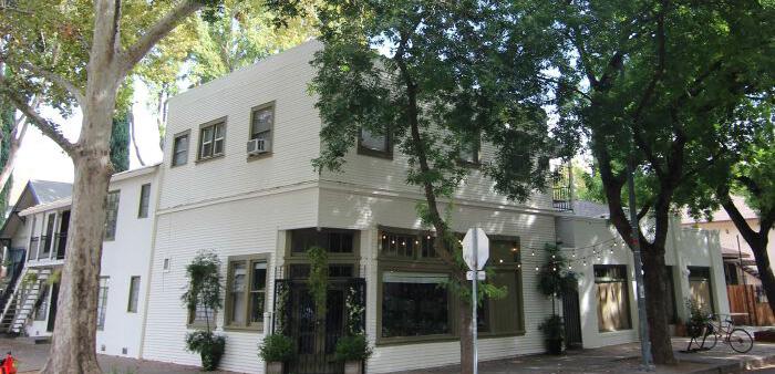
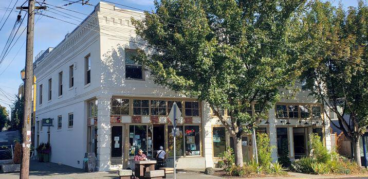
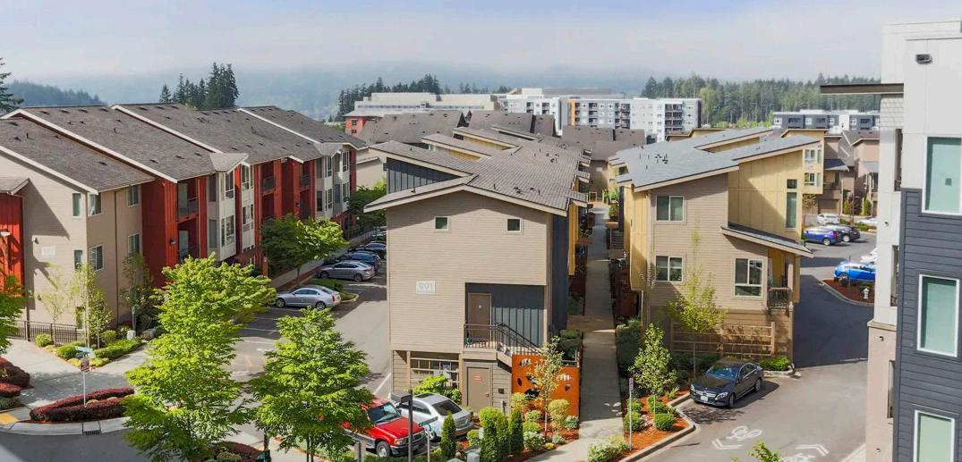
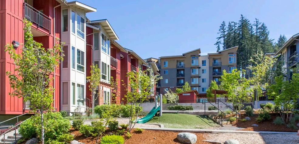
Housing Density: 12-18 DU/ Acre
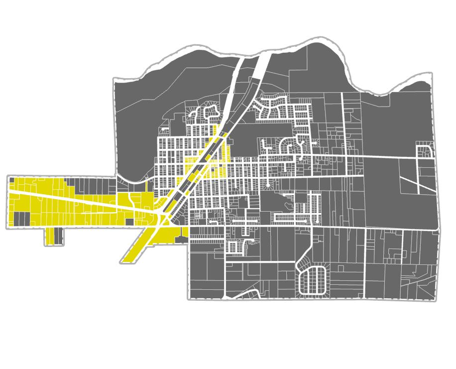
This is a new land use designation that will allow housing above retail, but no stand alone housing. The mixed use corridor designation should encourage collocating housing, service and businesses.
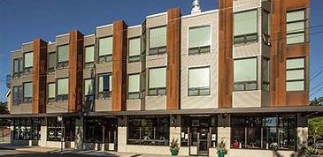
Housing Density: 15-40 DU/ acre
Most similar to existing High Density Residential Zoning, but with additional density allowances to ensure Buckley has enough zoned capacity to support its affordable housing allocation.
Corridor Mixed Use
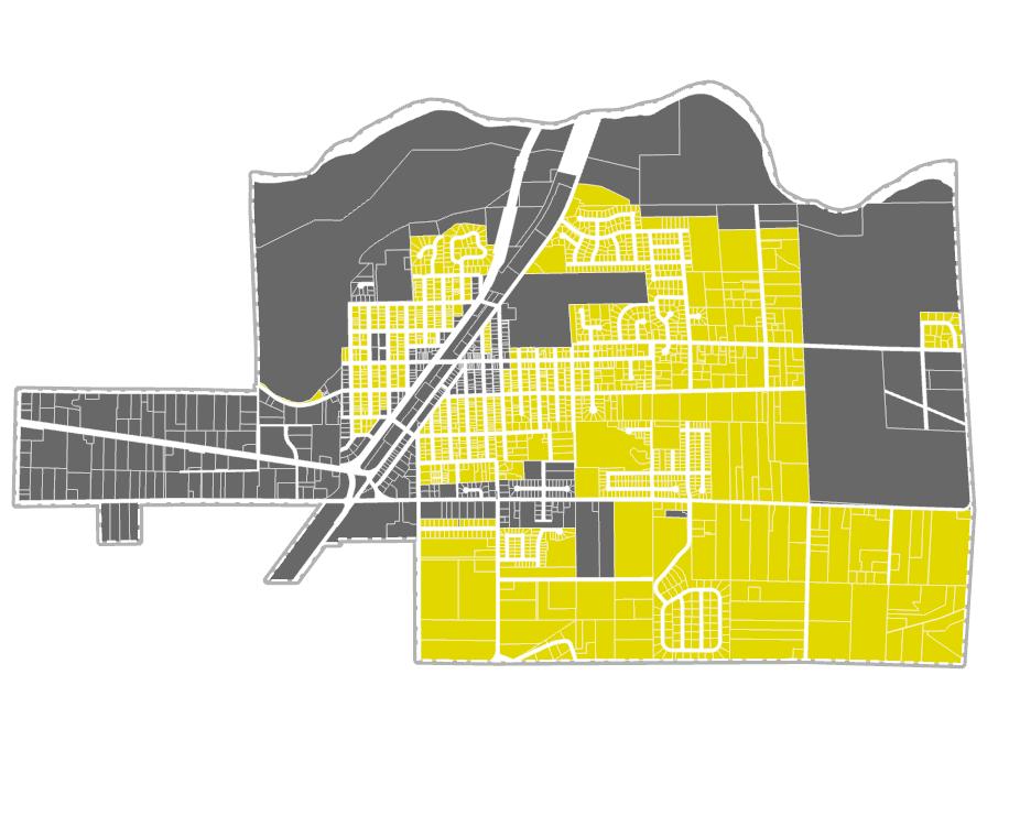
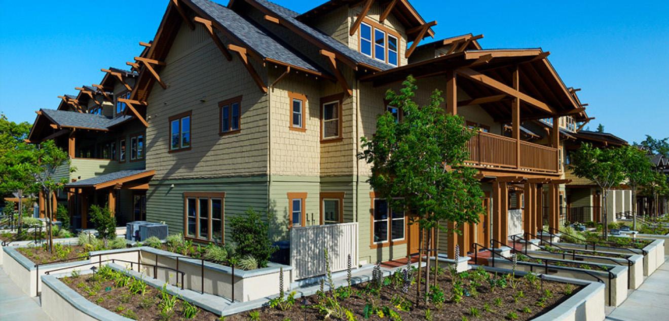
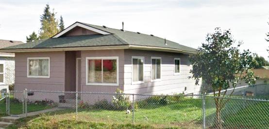
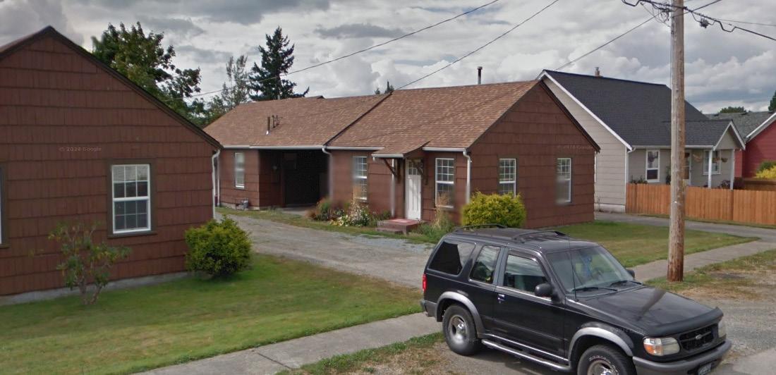
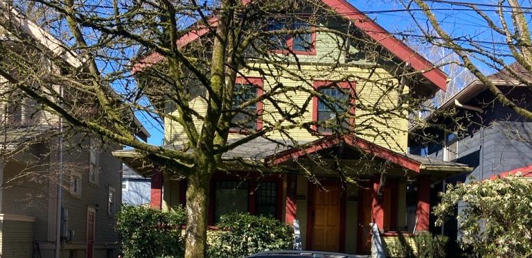
Housing Density: 1-3 Units per parcel
State passage of HB 1110 (Middle Housing) and HB 1337 (ADUs) allows more density in primarily single family neighborhoods.
Urban Low Density
Goals & Policies
HO 4 FOSTER EQUITABLE COMMUNITIES BY STRATEGICALLY INCREASING DENSITY, IMPROVING ACCESS TO VARIOUS HOUSING TYPES, AND CREATING AFFORDABLE HOUSING OPTIONS THROUGH MISSING MIDDLE HOUSING AND ADUS.
HO 4.1 Adopt strategic measures to overcome barriers for moderate density housing development.
HO 4.2 Encourage balanced urban growth by bridging the gap between singlefamily and multifamily housing options while focusing on creating more home affordable ownership and rental solutions.
HO 4.3 Adapt zoning codes to allow for ADUs to be accommodated in already developed lots.
HO 4.4 Update development regulations to reduce barriers for low density middle housing types such as ADUs, Duplexes and Triplexes.
HO 5 ENSURE A DIVERSE RANGE OF AFFORDABLE HOUSING OPTIONS CATERING TO ALL INCOME LEVELS AND DEMOGRAPHICS ACROSS THE REGION, INCLUDING IN UNINCORPORATED PIERCE COUNTY.
HO 5.1 Buckley should encourage affordable housing developments through financial incentives to developers in the form of tax reliefs, density bonuses, economic inducements, etc.
HO 5.2 Density bonuses should be considered for residential developments that meet minimum building standards and incorporate affordability initiatives as a specified community goal.
HO 5.3 The City should position itself to work collaboratively with Pierce County, PSRC and affordable housing agencies to accommodate affordable housing needs which are not met by the private market.
HO 5.4 Affordable housing should be prioritized in areas of Buckley with access to amenities, employment and transportation that will minimize household costs.
HO 6 CREATE INCENTIVES TO ENCOURAGE REHABILITATION AND/OR REDEVELOPMENT OF EXISTING HOUSING AND HISTORIC STRUCTURES.
HO 6.1 Identify opportunities for repurposing and redeveloping existing parcels where building rehabilitation is financially unfeasible, while ensuring compliance with historic, archeological, and cultural policies that prevent displacement.
HO 6.2 Adopt reasonable and innovative techninques to encourage the use of underutilized lots for moderate to high density affordable units
HO 6.3 Buckley should explore options to dedicate or make available below marketrate surplus land owned by the City in central locations for affordable housing projects.
HO 6.4 Manufactured housing should not be regulated differently from site-built housing and should be encouraged as an affordable housing option in Buckley.
HO 7 EVALUATE THE EFFECTIVENESS OF LOCAL HOUSING POLICIES BY MAINTAINING AND PERIODICALLY REVIEWING AN INVENTORY OF EXISTING AND PIPELINE HOUSING WITHIN THE CITY OF BUCKLEY AND PROJECTED HOUSING NEEDS OVER THE PLANNING PERIOD.
HO 7.1 Determine the demand for affordable housing across all income levels, especially for historically marginalized groups, both present and in the future.
HO 7.2 Periodically evaluate the efficacy of local housing policies and strategies in meeting housing objectives and affordability targets.
HO 7.3 Utilize diverse data sources to evaluate housing demand and report on the progress in developing new affordable housing.
HO 8 ENSURE EQUITABLE AND STRATEGICALLY DISTRIBUTED PROVISION OF DIVERSE SPECIAL NEEDS HOUSING OPTIONS THROUGH INTERJURISDICTIONAL COOPERATION AND PUBLIC-PRIVATE PARTNERSHIPS, IN ALIGNMENT WITH RCW REGULATIONS.
HO 8.1 Identify opportunities to participate in interjurisdictional cooperative efforts and public-private partnerships that identify land capacity for special needs housing including, but not limited to, government-assisted housing, housing for moderate, low, very low, and extremely low-income households, manufactured housing, multifamily housing, group homes, foster care facilities, emergency housing, emergency shelters, permanent supportive housing.
HO 8.2 Encourage development of and plan to accommodate for sufficient supply of special needs housing opportunities convenient to services.
HO 9 ENSURE FLEXIBILITY FOR DEVELOPMEMENT STANDARDS AND REGULATIONS IN ALIGNMENT WITH THE REGIONAL GROWTH STRATEGIES, TO FACILITATE FEASIBILITY IN HOUSING PRODUCTION.
HO 9.1 Review and amend development standards to reduce housing development barriers, enhance public benefit, and minimize costs
HO 9.2 Flexibility in development regulations should be provided to allow for clustered housing developments. This could be through planned unit developments, clustered housing developments, cottage housing, or adding flexible lot sizes in the subdivision regulations.
HO 9.3 Allow emergency housing and emergency shelters in all zones that allow hotels and motels, and ensure that requirements for occupancy, spacing and intensity are not so stringent as to prevent accommodating Buckley’s emergency housing allocation.
HO 10 PRESERVE BUCKLEY’S EXISTING HOUSING CHARACTER THROUGH INTEGRATION OF NEW DEVELOPMENT AND REDEVELOPMENT WITH THE CITY’S HISTORIC, SMALL-TOWN CHARACTER WHILE KEEPING UP WITH DESIGN BEST PRACTICES TO ENSURE SUSTAINABLE GROWTH FOR THE CITY.
HO 10.1 Incorporate design principles into zoning and design review standards to create more liveable and attractive new housing and infill housing.
HO 10.2 Encourage using green buildings by increasing lot coverage minimums and providing economic incentives for increased built density.
HO 10.3 Ensure building codes permit innovative housing designs, for instance that they encourage low impact development practices, siting to maximize passive solar exposure, clean energy installation and energy efficiency. Encourage existing building retro-fitting where possible by connecting residents to state and regional incentive programs.
HO 10.4 Encourage open space dedication and green building techniques in new construction while balancing the need for increased housing density.
HO 10.5 New development will prioritize connections to existing trails, paths and sidewalks to increase community health and walkability.
HO 10.6 Intense commercial activities, such as gravel extraction, automotive wrecking, hazardous materials handling, and other businesses that contain environmental risks should not be permitted near housing.
HO 11 PRIORITIZE THE DEVELOPMENT OF RESIDENTIAL AREAS, INCLUSIVE OF A RANGE OF HOUSING PRICES AND DENSITIES, TO MAXIMIZE ACCESS TO TRANSIT ROUTES, PEDESTRIAN-FRIENDLY AMENITIES, AND/OR DOWNTOWN BUCKLEY AND THE 410 CORRIDOR.
HO 11.1 Implement zoning regulations and incentives to promote the development and preservation of long-term affordable housing options at appropriate densities in Downtown Buckley and the 410 Corridor to maximize the benefits of transit, active transportation and other transportation investments.
HO 11.2 Formulate a plan for future residential and commercial developments that aim to strike a balance between the growth objectives for both job opportunities and housing.
HO 12 ADDRESS RACIALLY DISPARATE IMPACTS, DISPLACEMENT, AND EXCLUSION IN HOUSING BY IDENTIFYING AND RECTIFYING LOCAL POLICIES AND REGULATIONS (INCLUDING DISCRIMINATORY ZONING PRACTICES, DISINVESTMENT PATTERNS, AND DISPARITIES IN INFRASTRUCTURE AVAILABILITY), TO FOSTER EQUITABLE AND INCLUSIVE COMMUNITIES.
HO 12.1 Establish policies and regulations to address and begin to undo racially disparate impacts, displacement, and exclusion in housing caused by local policies, plans, and actions
HO 12.2 Prioritize policies and programs aimed at facilitating homeownership for low-income, moderate-income, and middle-income families and individuals, with particular attention to addressing historic disparities in access to homeownership for communities of color.
HO 12.3 Ensure equitable access to resources, financial assistance, and educational initiatives to support and encourage homeownership opportunities across diverse demographic groups.
HO 12.4 Ensure periodic assessment of displacement-prone areas (areas with high rates of renter occupied housing) due to market forces and update the inventory in order to make accurate data available to potential developers when needed.
HO 12.5 Mitigate impacts of physical, economic, and cultural displacement that might be caused due to planning, public or private investments and developments, or market pressure.
HO 12.6 Pursue policies that increase racial and economic diversity in Buckley by supporting multicultural programming, affordable housing development and live and work development.
HO 12.7 Evaluate and adopt techniques such as inclusionary or incentive zoning to increase affordability.
HO 12.8 To advance the provision of affordable and special needs housing, participate in interjurisdictional cooperative efforts and public-private partnerships with inclusive public platforms that elevate the voices of marginalized communities, ensuring their significant representation and active involvement in the decision making.
HO 12.9 Buckley will periodically evaluate its land capacity based on existing zoning in conjunction with Pierce County Buildable Lands analysis to ensure that the City is providing enough land for a diversity of housing types.
Housing Goals and the Community Vision
The diagrams on the next few pages illustrate how the housing goals articulated in this chapter connect to the community vision statements in Chapter 3. Weak Connection
VISION STATEMENTS
Sustaining and fostering town identity and character
In 2044, Buckley will...
01. Have a vibrant, compact and walkable downtown where people meet each other face-to-face, where small businesses can thrive, and with housing close at hand that support a high quality of life.
02. Have a denser Downtown and 410 Corridor that improves service administration while supporting the rural quality of life farther from City center.
03. Foreground the city’s unique history through retention of historic buildings, thoughtful community design, civic space and park system.
04. Have affordable and accessible housing that allows the city’s aging population to stay in the place they call home, while welcoming newcomers into the community.
05. Be a safe and inviting place to visit and reside.
06. Use public dollars strategically and efficiently to provide city residents with high quality roads, utilities, environmental amenities and services.
Economic development of the Downtown Core and State Highway 410
In 2044, Buckley will...
07. Have an enhanced 410 Corridor that creates a friendly gateway to our city with more retail, small businesses and housing that is community oriented and provides new places for residents and visitors to live, work and be together.
Promotion of outdoor recreational activities
In 2044, Buckley will...
08. Be a destination and not a pass through for outdoor recreation enthusiasts availing themselves of our area’s natural beauty through concerted infrastructure and facility investment and support for recreation-oriented businesses.
Foster equitable communities by strategically increasing density, improving access to various housing types, and creating affordable housing options through missing middle housing and ADUs.
Ensure a diverse range of affordable housing options catering to all income levels and demographics across the region, including in unincorporated Pierce County.
Create incentives to encourage rehabilitation and/or redevelopment of existing housing and historic structures.
Evaluate the effectiveness of local housing policies by maintaining and periodically reviewing an inventory of existing and pipeline housing within the City of Buckley and projected housing needs over the planning period.
Preserve Buckley’s existing housing character through integration of new development and redevelopment with the city’s historic, small-town character while keeping up with design best practices to ensure sustainable growth for the city.
Ensure equitable and strategically distributed provision of diverse special needs housing options through interjurisdictional cooperation and publicprivate partnerships, in alignment with RCW regulations.
Prioritize the development of residential areas, inclusive of a range of housing prices and densities, To maximize access to transit routes, pedestrianfriendly amenities, and/or Downtown Buckley and the 410 Corridor.
Ensure flexibility for development standards and regulations in alignment with the regional growth strategies, to facilitate feasibility in housing production.
Address racially disparate impacts, displacement, and exclusion in housing by identifying and rectifying local policies and regulations (including discriminatory zoning practices, disinvestment patterns, and disparities in infrastructure availability), to foster equitable and inclusive communities.

Economic Development
Economic Development
Introduction
The Economic Development Element of the Comprehensive Plan is intended to support the promotion of enterprise and commercial exchange in Buckley and reinforce the overall vision and values of the Comprehensive Plan. Economic development is one of the GMA’s thirteen mandated planning goals, and increasing employment capacity is part of Pierce County’s growth allocation to the City. Goals and policies presented in this element guide future City actions that, together with private sector actions, can produce a strong economy. The framework for this element is to retain and strengthen an economy that reinforces Buckley’s small town character and capitalizes on its assets, including its history, rural quality, and natural resources.
Key issues that the Economic Development Element addresses:
01. Buckley’s economic plan should strengthen the city’s neighborly and small town qualities.
02. Buckley’s economic plan should capture through traffic frequenting the area for outdoor pursuits.
03. The City needs to generate more revenue to support government functions. The City Council and Planning Commission want to forward policies that increase revenue by incentivizing business development that generates sales tax.
Existing Conditions
Buckley’s largest employment sector is Health Care and Health Care Assistance, employing about 41.1% of the people who work in Buckley (not to be confused with the jobs that are held by Buckley residents, many of whom commute elsewhere for work). Health Care employment is followed by Educational services, which represents around 25% of Buckley employment. In 2021, 987 individuals were employed in Health care related industries. Retail trade accounts for only 6 percent of Buckley jobs, and food services and accommodation around 4%. Surprisingly, only 0.3% Of Buckley workers are employed in agriculture (ACS, Longitudinal Employer-Household Dynamics, 2023). On the other hand, 11.4% of Buckley residents work in some facet of manufacturing, 9% in Retail and 7.3% in Education and Healthcare (ACS, Longitudinal Employer-Household Dynamics, 2023). In 2021, 789 workers commuted from outside the city to jobs in Buckley, 81 workers lived and worked in Buckley and 1,579 Buckley residents commuted to jobs outside of Buckley.
2,113 1,991 200
Workers who commute to Buckley Live & Work in Buckley Buckley Residents who work outside the city
On The Map, US Census Bureau 2021
Table of employment sectors:
The bar charts to the right compare the percentage of jobs in different industries for Buckley, Bonney Lake, Enumclaw and Pierce County. Buckley has far and away the most Health Care and Social Assistance jobs on a per capita basis (in part because the Rainier School remains a large employer in Buckley). The city is also competitive in educational services and construction. However, Buckley significantly underperforms in providing retail trade jobs, and accommodations and food services compared to its neighboring cities.
ED 3. Per Capita Employment by Industry: Buckley and Neighboring Cities
Buckley, WA
Pierce County, WA
Enumclaw, WA
Bonney Lake, WA
Economic Strategy:
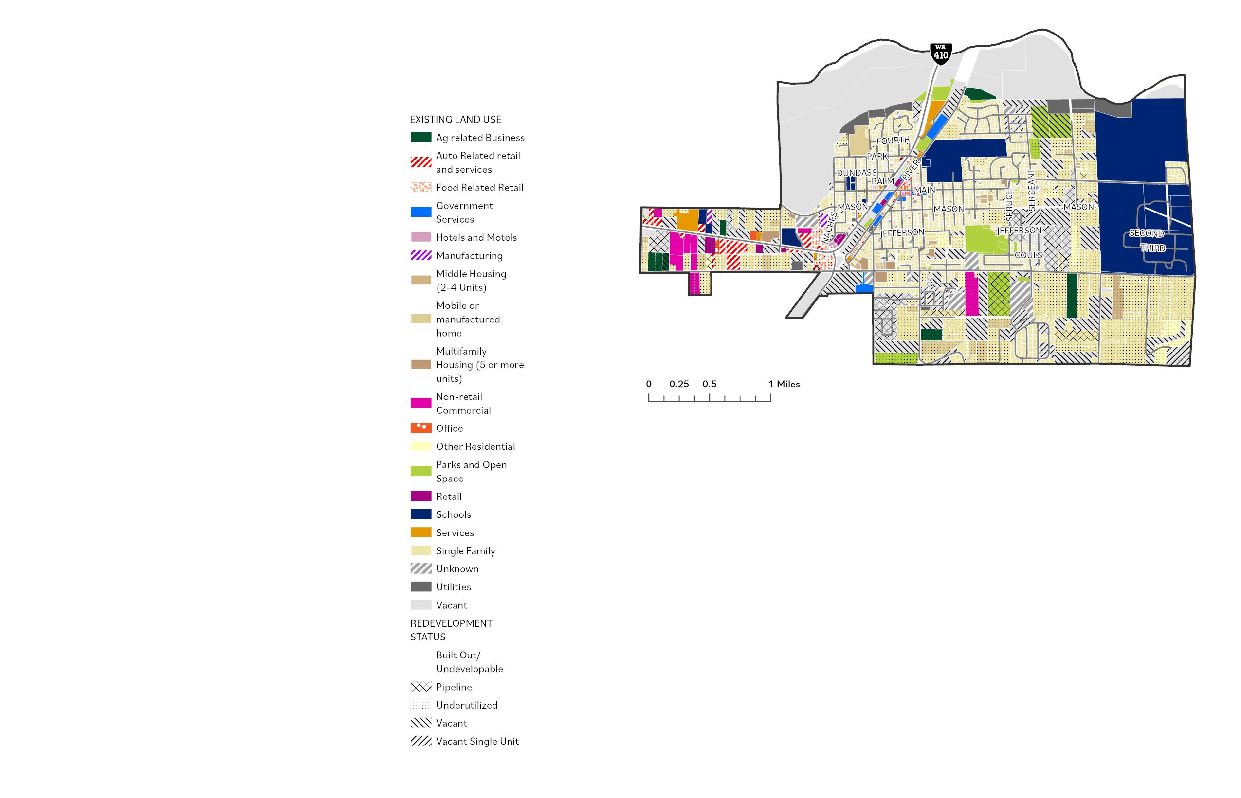
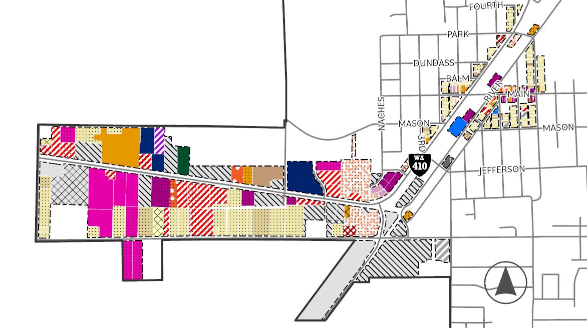
The map to the right shows Buckley’s distribution of existing land uses (Pierce County Buildable Lands, 2022, City of Buckley, 2024). As shown, a significant amount of land along the 410 Corridor that falls within the Corridor Mixed Use future land use designation consists of auto related retail (auto services, carwashes, and gas stations), and non-retail commercial such as contractors yards and mini storage. The City seeks to enhance the corridor so that businesses are increasingly community oriented and create a friendly and welcoming gateway into Buckley.
The challenge facing Buckley is to create an economic climate that produces a healthy economy for jobs and businesses without compromising the community’s desires to maintain its small town lifestyle and protect its natural amenities. The City is committed to pursuing actions that contribute to a high quality of life for residents and future generations including the provision of affordable housing, a pristine natural environment, good schools, efficient government and high quality infrastructure. Providing these amenities and services can also help the City to attract, retain and stimulate growth of local businesses which in turn will provide needed revenue to support the mission of the City. A strong tax base is essential to the City’s ability to deliver necessary public services and maintain infrastructure to serve the needs of the community. In order to establish a sustainable economy, this Comprehensive Plan recommends the following actions:
01. The City should promote existing businesses and concentrate new business development along Main Street and the Highway 410 corridor.
02. The City should continue to establish recreational infrastructure to attract tourism to Buckley. Despite its proximity to Mt. Rainier National Park and the presence of recreational vehicle services, Buckley lacks the services and amenities for national park visitors, such as outdoor equipment outlets. Buckley is one of a few “Gateway Communities'' in the Carbon River Corridor to Mt. Rainier and should attract a tourist base. Investment in Buckley’s historic and
picturesque Main Street will continue to attract visitors. Trail oriented development along the Foothills Trail can continue to strengthen Buckley’s outdoor recreation appeal.
03. The City should continue to incentivize businesses that contribute to Buckley’s quality of life including working to attract a grocery and pharmacy that will allow residents to access basic goods and services without leaving the city.
04. The City should work to improve conditions for retail and services that contribute sales tax revenue to the city. The City acknowledges that costs and benefits may be associated with economic activity. The costs include the direct provision of additional government services and also maintaining adequate infrastructure. Fiscal analysis that weighs the costs and the benefits of growth should be considered when developing regulations and procedures. Economic policies and regulations should remain flexible to ensure that the city can take advantage of opportunities and weather economic challenges.
Goals and Policies
ED
1
PROMOTE, DEVELOP, AND ENHANCE A STRONG AND SUSTAINABLE ECONOMIC CLIMATE.
ED 1.1 Contribute to the success of existing businesses through local business promotions and strategic investment in community infrastructure such as sidewalks and street trees in core commercial areas.
ED 1.2 The city’s regulations should provide the following to enhance sustainable economic development:
a. Economic disincentives for vacant buildings.
b. Overlay district design standards for mixed use areas and the Historic Downtown.
c. Procedures that are as streamlined and remove barriers to commerce while adhering to state requirements.
ED 1.3 The city should provide a visitor or information center that qualifies for a state tourist sign to attract and capture destination and pass-through tourist dollars.
ED 1.4 The city should provide spaces to host relevant community information such as events signage and materials for tourists in places like community parks and the Community Center.
ED 1.5 Produce and periodically update tourist materials such as maps and brochures that promote local businesses and points of interest.
ED 2 MAKE BUCKLEY AN ATTRACTIVE AND DISTINCTIVE PLACE FOR COMMERCE.
ED 2.1 Encourage home-based businesses that contribute to neighborhood vibrancy.
ED 2.2 Incentivize the preservation of historic buildings that contribute to Buckley's human scale downtown. Encourage infill development that complements historic building design.
ED 2.3 Use wayfinding and signage to direct visitors to Downtown and other commercial and mixed use areas and to contribute to the visual identity of the city.
ED 2.4 Partner with the business community to assist in the development and maintenance of signs for businesses within the Main Street downtown core.
ED 2.5 The city should pave, sign, and advertise public parking areas for business activities.
ED 2.6 Develop a distinctive marketing theme and visual identity for the City that contributes to the cohesion of civic spaces including parks, streets and signage and that references the city's history.
ED 2.7 Continue to host, support and promote events that attract a regional audience.
ED 3 GROW THE 410 CORRIDOR INTO A VIBRANT COMMERCIAL HUB THAT CONTRIBUTES TO THE CITY'S ECONOMIC VITALITY AND FISCAL SUSTAINABILITY.
ED 3.1 Host business trainers and other experts to support individuals interested in building a business in Buckley.
ED 3.2 Improve the connection between businesses and the corridor by regulating built form and site configuration.
ED 3.3 Encourage a welcoming interface between the Foothills Trail and Businesses abutting the Trail to attract trail users into the City.
ED 4 BUILD OFF OF THE "SMALL-TOWN" ATTRIBUTES THAT MAKE BUCKLEY A FRIENDLY AND NEIGHBORLY PLACE TO LIVE AND VISIT.
ED 4.1 Continue to encourage building designs that improve the pedestrian experience of commercial streets including the use of picture windows for retail businesses, historic facades, awnings and attractive signage.
ED 4.2 Improve street design by including street trees and providing pedestrian amenities such as benches.
ED 4.3 Consider the city’s “small-town attributes” in design review for permitting development. Site plans should consider vehicle and pedestrian flow, pedestrian and/or open space amenities, including vegetation and the interface between the business and the street.
ED 4.4 Uses in the downtown historic district should include only commercial with an emphasis on retail, except on the upper floor(s).
ED 4.5 Downtown buildings that must be upgraded to meet current building codes should use the International Existing Building Code, which is designed for historic buildings.
ED 5 RECREATIONAL INFRASTRUCTURE THAT SHOWS OFF THE CITY’S NATURAL FEATURES SHOULD BE USED TO ENHANCE ITS ECONOMIC DEVELOPMENT.
ED 5.1 The city should prioritize the enhancement of parks and open spaces adjacent to the Foothills Trail and downtown businesses.
ED 5.2 The city should reduce permit submittal requirements for businesses that serve the need of the outdoor enthusiast market, such as bike shops, camping stores, sporting goods, and ski shops. Minimal requirements should include traffic impacts, drainage, and pedestrian access.
ED 5.3 The city should pursue grants and partnerships to create and enhance natural amenities both in and around Buckley and promote outdoor activities, such as trails, and river rafting.
ED 6 ENSURE REGULATION BALANCES ECONOMIC GROWTH WITH THE QUALITY OF LIFE AND THE ENVIRONMENT.
ED 6.1 Recognize and consider the economic, social, and environmental impacts of proposed legislation during the legislative review process.
ED 6.2 To the extent possible, permit industrial uses in areas directly abutting major roads that minimally interact with residential areas.
ED 7 EXPAND AND DIVERSIFY FUNDING SOURCES TO ACHIEVE ECONOMIC GOALS.
ED 7.1 Identify potential funding sources for economic development though existing federal, state, and non-governmental organizations.
ED 7.2 Ensure that the funding options pursued are specific to the projects that the city intends to develop.
ED 8 ATTRACT BUSINESSES THAT CONTRIBUTE TO THE FISCAL HEALTH OF THE CITY.
ED 8.1 Decrease permitting and other procedural costs for businesses that will contribute substantial sales tax revenue to the City.
ED 8.2 Decrease permitting and other procedural costs for businesses that will provide a needed amenity to the community such as a grocery store and a pharmacy.
ED 8.3 Incentivize business development with high foot traffic rather than more passive uses.
Economic Development Goals and the Community Vision
The diagrams on the next few pages illustrate how the economic development goals articulated in this chapter connect to the community vision statements in Chapter 3.
VISION STATEMENTS
Statement 01
Weak Connection
Sustaining and fostering town identity and character
In 2044, Buckley will...
01. Have a vibrant, compact and walkable downtown where people meet each other face-to-face, where small businesses can thrive, and with housing close at hand that support a high quality of life.
02. Have a denser Downtown and 410 Corridor that improves service administration while supporting the rural quality of life farther from City center.
03. Foreground the city’s unique history through retention of historic buildings, thoughtful community design, civic space and park system.
04. Have affordable and accessible housing that allows the city’s aging population to stay in the place they call home, while welcoming newcomers into the community.
05. Be a safe and inviting place to visit and reside.
06. Use public dollars strategically and efficiently to provide city residents with high quality roads, utilities, environmental amenities and services.
Economic development of the Downtown Core and State Highway 410
In 2044, Buckley will...
07. Have an enhanced 410 Corridor that creates a friendly gateway to our city with more retail, small businesses and housing that is community oriented and provides new places for residents and visitors to live, work and be together.
Promotion of outdoor recreational activities
In 2044, Buckley will...
08. Be a destination and not a pass through for outdoor recreation enthusiasts availing themselves of our area’s natural beauty through concerted infrastructure and facility investment and support for recreation-oriented businesses.
Promote, develop, and enhance a strong and sustainable economic climate.
Make Buckley an attractive and distinctive place for commerce.
Grow the 410 Corridor into a vibrant commercial hub that contributes to the city’s economic vitality and fiscal sustainability.
Build off of the “small-town” attributes that make Buckley a friendly and neighborly place to live and visit.
Recreational infrastructure that shows off the city’s natural features should be used to enhance its economic development.
Ensure regulation balances economic growth with the quality of life and the environment.
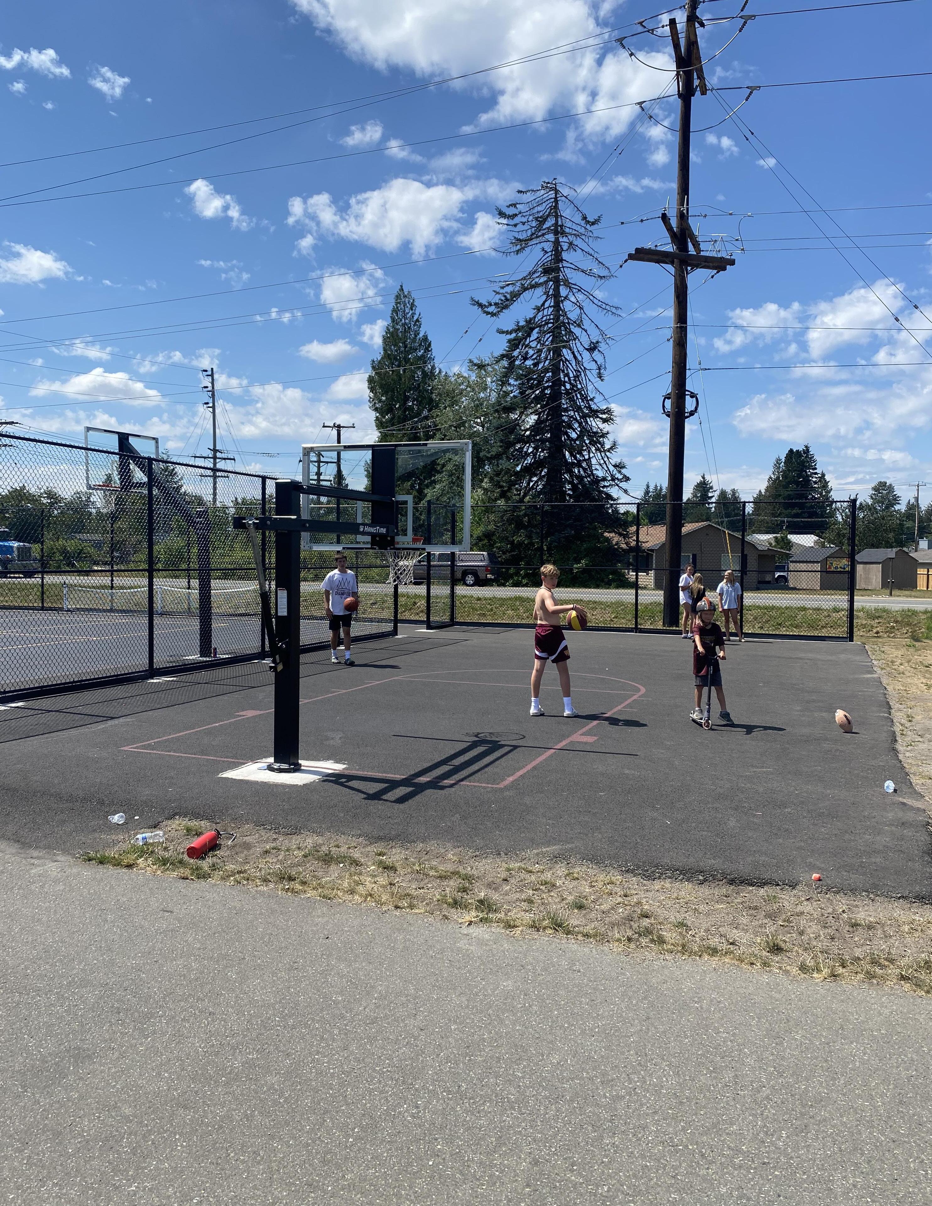
Parks & Recreation
Introduction
The parks and recreation system in Buckley is a vital network of parks, trails, and indoor spaces that provide residents and visitors with opportunities to play, exercise, socialize, and relax. They are public places where residents and visitors mix with each other, learn from one another, and exist outside of their homes and workplaces. They are places where the City communicates its history, celebrates holidays, and hosts performers for summer events. Parks also perform ecological functions that urban areas need such as helping to manage stormwater runoff, cleaning the air and water, and providing habitat for wildlife.
The Parks Element serves as a guide for growing Buckley’s park system as it grows in population. It looks at what is in the park system now, what people envision for the future, and how to get there. The basis for this element is the 2024 Parks, Recreation, and Trails Plan, which combined public feedback, guidance from City Council, and the expertise of park staff and consultants into a document that outlines a suite of project priorities and long term visions for Buckley’s parks and trails.
Buckley Parks Overview
The Buckley Parks Department maintains 16.67 acres of land, 14.8 of which is developed into parks. Of these developed parks, 13.4 acres are part of Heritage Park, a corridor of indoor and outdoor facilities along the Foothill Trails, bordering SR-410 and running perpendicular to downtown Buckley’s Main Street. There is a desire to both amplify the impact of Heritage Park and also to develop new park typologies in other areas of Buckley.
The name Heritage Park emerged during the PROS Planning process, as a way to create a recognizable brand that unifies facilities along the Foothills Trail into a cohesive park experience. The skate park, the Veterans Memorial, the Foothills Museum Grounds and more will all become elements of Heritage Park, which is positioned to welcome people to Buckley, whether they arrive via the Foothills Trail, SR410, or through downtown. The Heritage Park brand can be made visible through signage, site furniture, and art, creating a place that people know, love, and associate with Buckley.
The Foothills Trail is a focal point of Heritage Park and is an amenity beloved by Buckley residents. Currently the trail extends 20 miles, connecting northwest to Puyallup, and soon will extend to Enumclaw with the completion of
the Foothills Trail Bridge. The development of a Buckley Trailhead is currently in process, with a parking lot recently installed at the intersection of SR-410 and Wheeler Ave. The addition of a pavilion with interpretive signage will provide historical information about the trail, the first mile of which was in Buckley.
In addition to amplifying Heritage Park, there is a goal of developing parks in other parts of town, especially north of SR-410. Currently, residents in that area have to cross the busy road to access any of Buckley’s parks. Adding a park in this area will also contribute to better park access overall, the goal being to provide a Neighborhood Park within ½ mile of every household.
While not located north of SR-410, the development of Miller Park will be a significant addition of 3.4 acres of park space outside of the Heritage Park corridor. This project was described as a key priority in Buckley’s 2024 budget, which expressed the goal of fully funding the park by 2025. As it stands, 75% design for the park has been completed and the Parks and Recreation department is working with the Recreation Conservation Office (RCO) to apply for multiple grants to fund construction.
Parks Typologies
Buckley’s parks and recreation system consists of parks, trails, and facilities that are owned and operated by the City. These facilities are
broken into categories for the purposes of planning and calculating a Level of Service Metric that aims to ensure that people’s park needs are met. For this plan, Buckley’s parks are categorized as Community Parks, Neighborhood Parks, Indoor Facilities, Private Parks, and School Facilities.
Neighborhood Parks are meant to serve the surrounding neighborhood by offering a mix of passive and active amenities that allow people of all ages and abilities to use the park for recreation, relaxation, and socializing. These parks may include facilities such as a playground, a sports facility, open lawn or plaza space, shade trees or a structure, plantings, and benches and/or picnic tables. Elk Heights is an example of a Neighborhood Park in Buckley.
Community Parks are those that serve a larger swath of the population. This could be because they are larger and have more facilities, because they offer something that is not available elsewhere in the park system, or because they are centrally located. Main Street Park, for example, is located on downtown’s Main Street, right off the Foothills Trail. Mountain View Ave Community Garden offers the unique amenity of raised beds for gardening.
Parks can serve as both Community and Neighborhood Parks if they meet both criteria. The Buckley Youth Center Green, for example, has an array of sports courts, a playground, picnic
shelters, and benches that make it a place that the surrounding neighborhood can use for daily recreation. It also has a skatepark, which is an amenity not offered elsewhere in the City, meaning it draws people from the wider community.
Sports fields within the White River School District also contribute to recreation in Buckley, hosting sports leagues throughout the year. While these acres are not considered in the Level of Service metric, the fields and courts are taken into consideration when evaluating demand and needs for facilities.
Buckley also has indoor facilities that are publicly owned and operated using parks and recreation funding. These include the Buckley Youth Activities Center, Buckley Hall, the Senior Center, and the Foothills Museum. These facilities provide classes, education, and much needed services to several demographics in Buckley.
Finally, there are several private parks in Milton that residents in some neighborhoods have access to. Mapping these parks and quantifying the facilities they offer helps to shape not only the assessment of demands and needs for certain amenities, but also contributes to our understanding of where there is the greatest need for additional parks in Buckley.

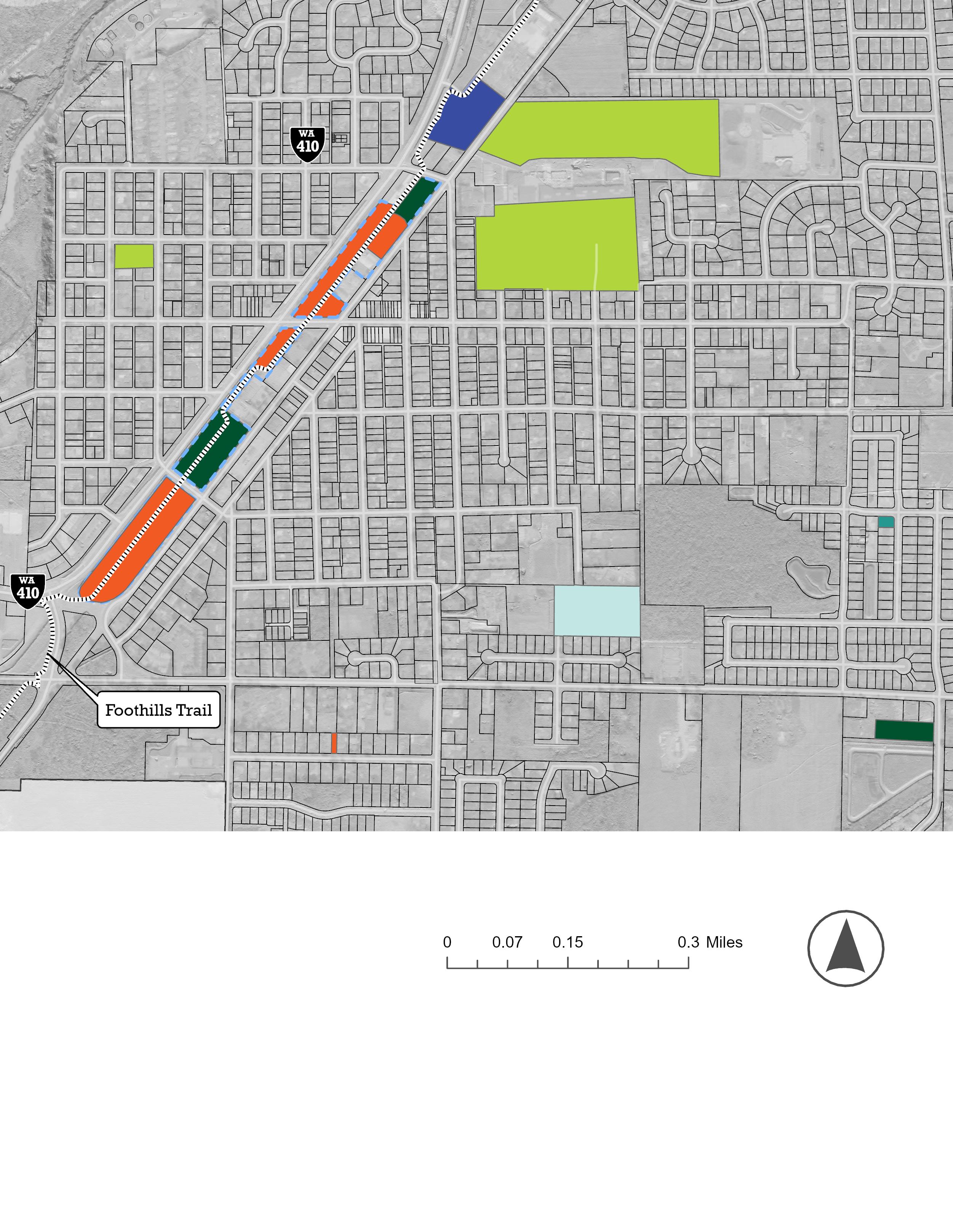
Park Access
The idea behind having a Neighborhood Park within .5 miles of each resident is that everyone should be able to walk or roll to a park that has playground equipment, sports courts or fields, and passive amenities such as benches and shade structures. While most transportation in Buckley is done by car, there are nondrivers and people with limited access to cars. Even those with access to vehicles benefit from being able to easily walk or roll to a park, and this aligns with statewide goals for reduced vehicle miles traveled.
The access map shows the ½ mile radius around Buckley’s Neighborhood Parks, revealing the areas of town that are outside of this service range. This calculation was done “as the crow flies,” and doesn’t take into account the roadway networks one would use, but provides a metric for measuring the Neighborhood Park service range. Given the current spread of housing density, 70% of Buckley residents are within this .5 mile range of a Neighborhood Park, which is a “B” rating according to RCO guidance.
Because SR-410 acts as a barrier to those who want to access Buckley’s parks on foot or wheels, the park coverage shown north of the busy road does not reflect true park walkability. Crossing fast-moving traffic, even at a stoplight, can be dangerous and is overall less
preferable to walking on local and collector streets. In that sense, residents who live north of SR-410 are outside of the service range of Buckley’s Neighborhood Parks, and parks in general. Providing park access to these households is a key goal of this plan, and is reflected in the Capital Improvement Project list.
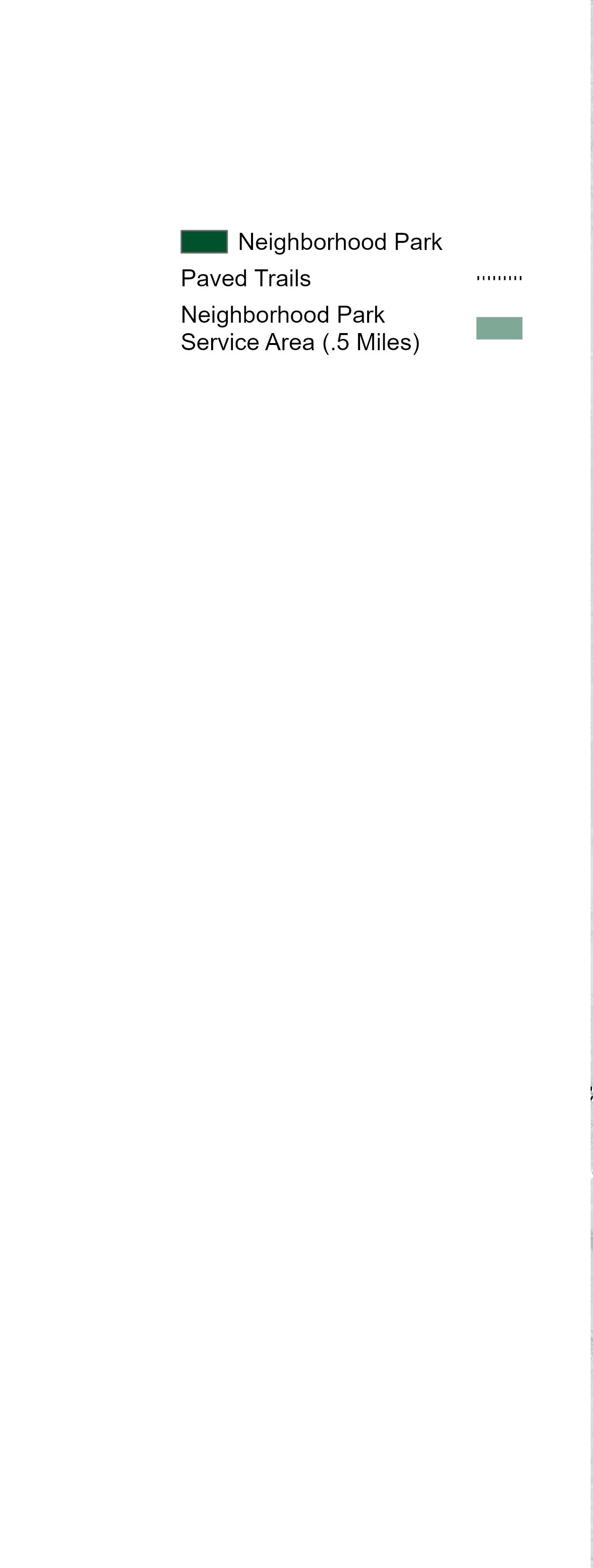
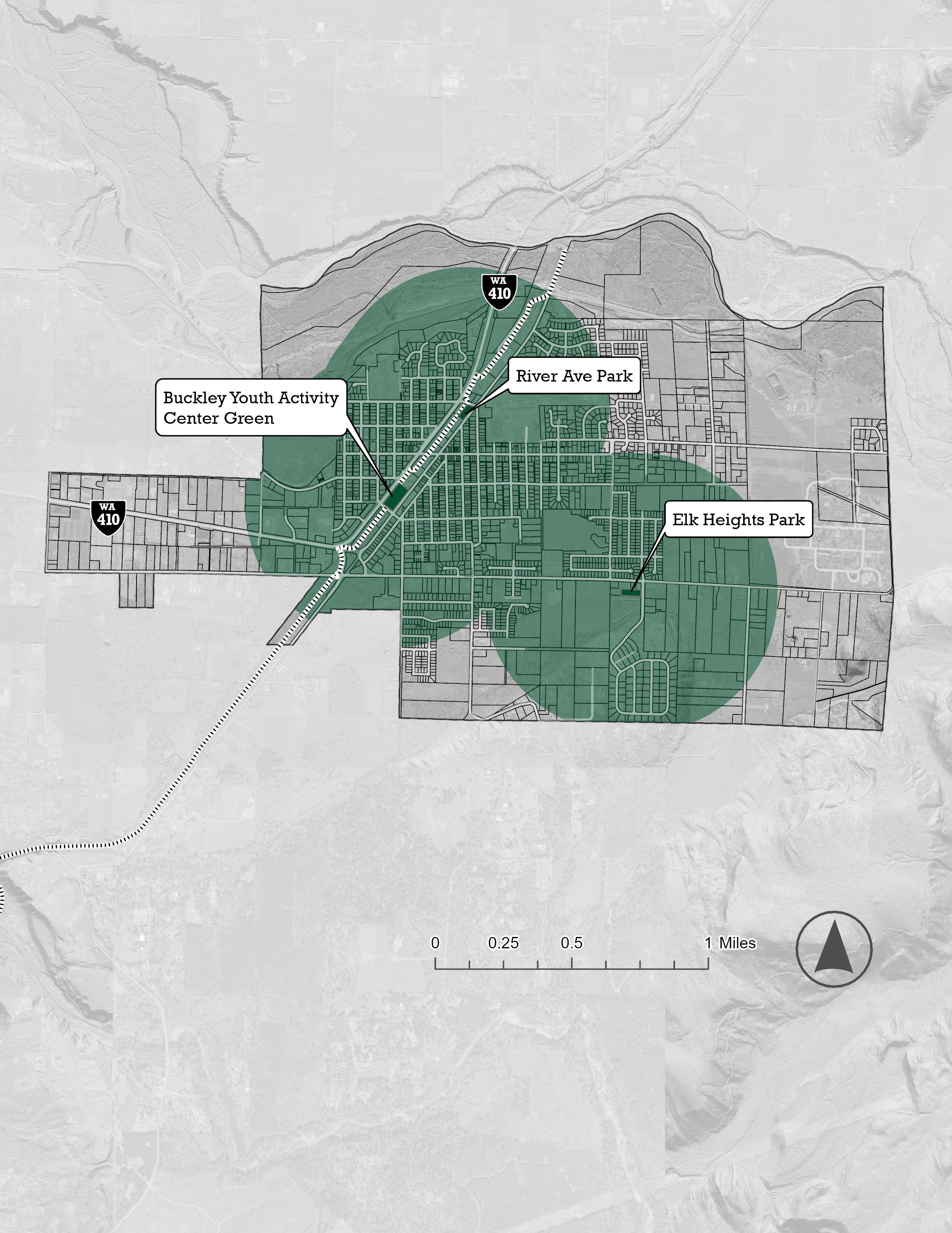
Demands and Needs Analysis
The Demands and Needs Analysis for this plan draws on the following:
• Public Engagement
• Facilities Inventory
• Guidance from City Council and Parks Department.
Public Engagement
To gather input for the 2024 PROS Plan, the Parks Department issued a survey that asked participants about their experiences with Buckley’s parks and what they wanted to see from the parks in the future. This survey was available online, distributed on Facebook, and accessible via QR codes posted on signs in the park and in utility mailers. It was also available in paper, distributed at community events and to the Buckley Senior Center. Survey data was collected from August 8 to September 14, 2023, and garnered 407 responses, which represents about 7% of Buckley’s population.
Survey responses were gathered from people across Buckley as well as nonresidents, as indicated by a question that prompted respondents to identify their neighborhood on a map. It was also answered by people from 60+ in age to under 18 years old, though 53% of respondents identified as parents of children aged 15 or younger at home.
A key survey question survey asked participants to rank their priorities for park investments given 7 items to choose from. A splash park, new/updated playgrounds, and trail expansion were chosen as the highest priori-
ties, while a pump track, dog park, community garden, and new sports facilities were selected as lower priorities. When asked to choose a sports/recreation facility for the City to prioritize, a pickleball court had the most votes, with 20.88%, followed by 14.25% of respondents who chose a soccer field.
The survey also asked two open-ended questions, including one that prompted respondents to express what they like about the current park and trail system in Buckley. Of those who took the survey, 246 wrote in answers to this question and 161 skipped it.
Themes emerged, such as the appreciation for Buckley’s portion of the Foothills Trail. The second most common theme was that people appreciate how clean and well-mainted the parks and trails were. People also appreciate the convenience of visiting their parks, how the parks feel safe, park events such as Tunes on the Trail, and the skate park.
When asked about their hopes and dreams for Buckley’s parks and trails, there was a wider variety of responses from the 241 people who answered. The most common response was, broadly, that people want a park where they can engage with nature. Currently, the bulk of Buckley’s park system is within Heritage Park, which abuts the city’s busiest road and downtown. Moving forward, Buckley residents want to see the wealth of nature surrounding the city to be incorporated into the park system.
Buckley residents also desire additional trails that connect local destinations, allow them to interact with nature, and required fewer roadway crossings. Given the lack of sidewalks in several neighborhods, the addition of multi-use or natural trails could be a strategy for improving walkability throughout the City.
Summary of Public Feedback:
Key needs/desires identified in the survey include:
1. Access to nature in parks.
2. Splash pad.
3. New/updated children’s playgrounds.
4. More events and programs.
5. More Community Trail and nature trails.
Volume II of this plan contains graphic summaries of the questions and responses to this survey.
Facilities Inventory
Level of Service
Goals and Policies
PR 1 THE CITY SHALL STRIVE TO PROVIDE A SYSTEM OF PARKS, TRAILS, AND FACILITIES THAT MEET THE NEEDS FOR ACTIVE AND PASSIVE RECREATION OF ALL RESIDENTS.
PR 1.1 The city should strive to provide a Neighborhood Park within 1/2 mile of all residents, where they may access it without crossing Highway 410.
PR 1.2 The City should provide ample opportunities for community input on decisions related to parks, trails, facilities, and open space.
PR 1.3 The City make decisions related to parks, trails, open spaces, and facilities based on regional guidance, industry best practices, and public feedback. Underserved, at-risk, or otherwise marginalized groups should be prioritized in park decisions.
PR 2 THE CITY SHOULD RECOGNIZE PARKS, TRAILS, AND OPEN SPACE AS PART OF A STRATEGY TO ACT AS A GATEWAY TO MOUNT RAINIER, OFFERING VISITORS OPPORTUNITIES TO EXPERIENCE LOCAL ECOLOGY, HISTORY, AND BUSINESSES.
PR 2.1 Heritage Park shall be recognized as a Center of Local Importance with opportunities for recreation, education, cultural expression, and local commerce.
PR 2.2 Parks and trails should showcase local ecology, including the White River.
PR 2.3 The City should highlight local wildlife, especially local elk populations, in the design of parks and trails.
PR 2.4 Parks and trails should incorporate public art such as murals, sculptures, and pavement treatments.
PR 3 PARKS SHALL BE DESIGNED AND MAINTAINED AS TO BE ACCESSIBLE AND INVITING FOR ALL.
PR 3.1 City parks and trails should be constructed in accordance with the city’s Development Guidelines and Public Works Standards, and any appropriate state or federal standard not addressed in city code to ensure park safety. Design should surpass requirements of the Americans with Disabilities Act and create spaces that encourage active and passive recreation for people of all ages and abilities.
PR 3.2 Parks and trails shall be maintained to ensure that they remain safe and functional for all users.
PR 3.3 The parks shall provide lighting in such a way that promotes human safety and considers ecological impact for local wildlife.
PR 4 REGIONAL AND COMMUNITY TRAILS SHOULD BE RECOGNIZED AS A VALUABLE RESOURCE FOR RECREATION, MULTI-MODAL TRANSPORTATION, ACCESS TO NATURE, AND AS A CONDUIT FOR SHOWCASING BUCKLEY’S LOCAL ECOLOGY, HISTORY, AND BUSINESSES.
PR 4.1 The City should strive to maintain a network of Community Trails that work with the Foothills Trail to provide connectivity between local destinations such as parks, schools, and other activity hubs.
PR 4.2 The City should develop and maintain a pedestrian trail along the White River to provide access to this local, natural resource.
PR 4.3 Park design and development should consider including cyclist amenities such as bike racks, tools, or bottle refilling stations.
PR 4.4 The City shall strive to provide safe pedestrian crossings to parks.
PR 5 ECOLOGICAL HEALTH SHOULD BE A CORE FACTOR IN THE PLANNING, DESIGN, AND MAINTENANCE OF PARKS, TRAILS, AND OPEN SPACES.
PR 5.1 The City should preserve lands identified within the Regional Open Space Network, incorporating recreational uses where appropriate based on ecological conditions and recreational needs.
PR 5.2 Park designs should consider native plants, rain gardens and other alternatives to lawn that provide ecological services such as supporting pollinators, providing habitat, and mitigating the impacts of stormwater runoff.
PR 5.3 Low-impact design including rainwater gardens should be installed where appropriate.
PR 5.4 Reduce the use of toxic pesticides, fertilizers, and other products used in park maintenance to the extent feasible and identify alternatives that minimize risks to human health and the environment.
PR 6 THE CITY SHALL PURSUE FUNDING STRATEGIES AND PARTNERSHIPS FOR THE DEVELOPMENT AND OPERATIONS OF PARKS, TRAILS, AND FACILITIES TO SERVE THE NEEDS OF BUCKLEY RESIDENTS.
PR 6.1 The City shall pursue grant funding where possible to help fund projects outlined in the PROS plan.
PR 6.2 The current program of proportionate cost-sharing through a mitigation fee for residential developments should be updated at least every odd year.
PR 6.3 The City shall consider options for generating funds through means such as program fees or fundraising, provided that it does not create a barrier to participation in park programs.
Parks & Recreation Goals and the Community Vision
The diagrams on the next few pages illustrate how the parks and recreation goals articulated in this chapter connect to the community vision statements in Chapter 3.
VISION STATEMENTS
Weak Connection
Sustaining and fostering town identity and character
In 2044, Buckley will...
01. Have a vibrant, compact and walkable downtown where people meet each other face-to-face, where small businesses can thrive, and with housing close at hand that support a high quality of life.
02. Have a denser Downtown and 410 Corridor that improves service administration while supporting the rural quality of life farther from City center.
03. Foreground the city’s unique history through retention of historic buildings, thoughtful community design, civic space and park system.
04. Have affordable and accessible housing that allows the city’s aging population to stay in the place they call home, while welcoming newcomers into the community.
05. Be a safe and inviting place to visit and reside.
06. Use public dollars strategically and efficiently to provide city residents with high quality roads, utilities, environmental amenities and services.
Economic development of the Downtown Core and State Highway 410
In 2044, Buckley will...
07. Have an enhanced 410 Corridor that creates a friendly gateway to our city with more retail, small businesses and housing that is community oriented and provides new places for residents and visitors to live, work and be together.
Promotion of outdoor recreational activities
In 2044, Buckley will...
08. Be a destination and not a pass through for outdoor recreation enthusiasts availing themselves of our area’s natural beauty through concerted infrastructure and facility investment and support for recreation-oriented businesses.
The city shall strive to provide a system of parks, trails, and facilities that meet theneeds for active and passive recreation of all residents.
The City should recognize parks, trails, and open space as part of a strategy to act as a gateway to Mount Rainier, offering visitors opportunities to experience local ecology, history, and businesses.
Parks shall be designed and maintained as to be accessible and inviting for all.
Regional and community trails should be recognized as a valuable resource for recreation, multi-modal transportation, access to nature, and as a conduit for showcasing Buckley’s local ecology, history, and businesses.
Ecological health should be a core factor in the planning, design, and maintenance of parks, trails, and open spaces.
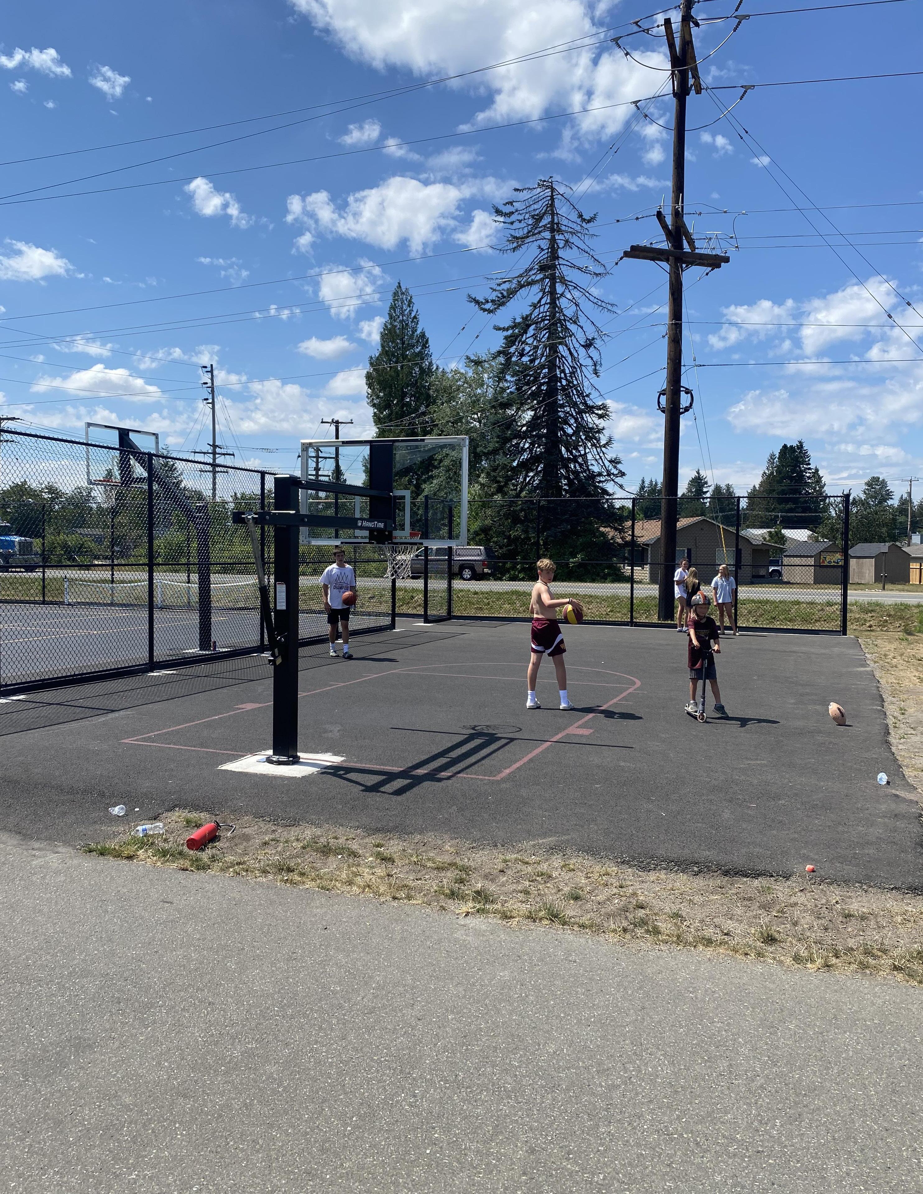
Capital Facilities & Utilities
Introduction
Purpose of the Capital Facilities Element
This Capital Facilities Element has been prepared in accordance with Section 36.70A.070 of the Growth Management Act (GMA) to address the need for and the financing of capital facilities in the City of Buckley and its proposed Urban Growth Area. The GMA requires all Comprehensive Plans to include a Capital Facilities Element, which analyzes the need for future capital improvements to support the development goals stated in the Land Use Element, as well as the funding mechanisms available for implementation.
The GMA requires cities to have a plan in place to ensure that capital facilities are developed concurrently with future development and the needs of the local population. This Comprehensive Planning effort is a required step of the process to assure the City of Buckley is fully compliant with GMA goals.
Toward this end, The Capital Facilities Element includes the following sections.
01. Inventory of existing capital facilities, showing location and capacities of all facilities
02. Forecast of future needs
03. The proposed locations and capacities of expanded or new capital facilities
04. A financing plan for the proposed capital facility improvements anticipated in the next ten years
05. At least a 6-year plan that will finance such facilities within projected funding capacities and identifies sources of public money for such purposes
06. Coordinate land use element, capital facilities element, and element plan
This chapter also demonstrates the city’s ability to provide concurrency in all utilities, roads, and capital facilities to support the anticipated population growth. The GMA also contains requirements pertaining to the concept of concurrency. Concurrency means that jurisdictions must be able to demonstrate that all utilities, including roads, can be made available for all new development at the time such development is constructed. Plans for making those utilities available when the development is built must include a financing plan. Thus, this Capital Facilities Element represents an important part of the plans needed to meet those requirements.
The Capital Facilities Element also has been developed in accordance with county wide planning policies, and has been integrated with all other planning elements to ensure consistency throughout the Comprehensive Plan. The Capital Facilities Element considers the general location, proposed location, and capacity of existing and proposed utilities, including water,
sewer, surface water drainage, natural gas, and other municipal services and facilities, such as fire and police protection services.
Proposed Urban Growth Area
The Proposed Urban Growth Area (UGA) boundary was selected to ensure that urban services, including utilities, can be provided to the residents of each development at an acceptable level of service. This includes the provision of utility and other capital facilities. The UGA is depicted on the following page. All development requiring urban services will be located in the UGA and will have these services extended in a timely feasible manner. For that portion of the UGA which is currently located outside City boundaries, annexation would need to occur prior to extension of most City services, with the exception of areas where existing service agreements may apply, or where services may be extended for public health and safety reasons.
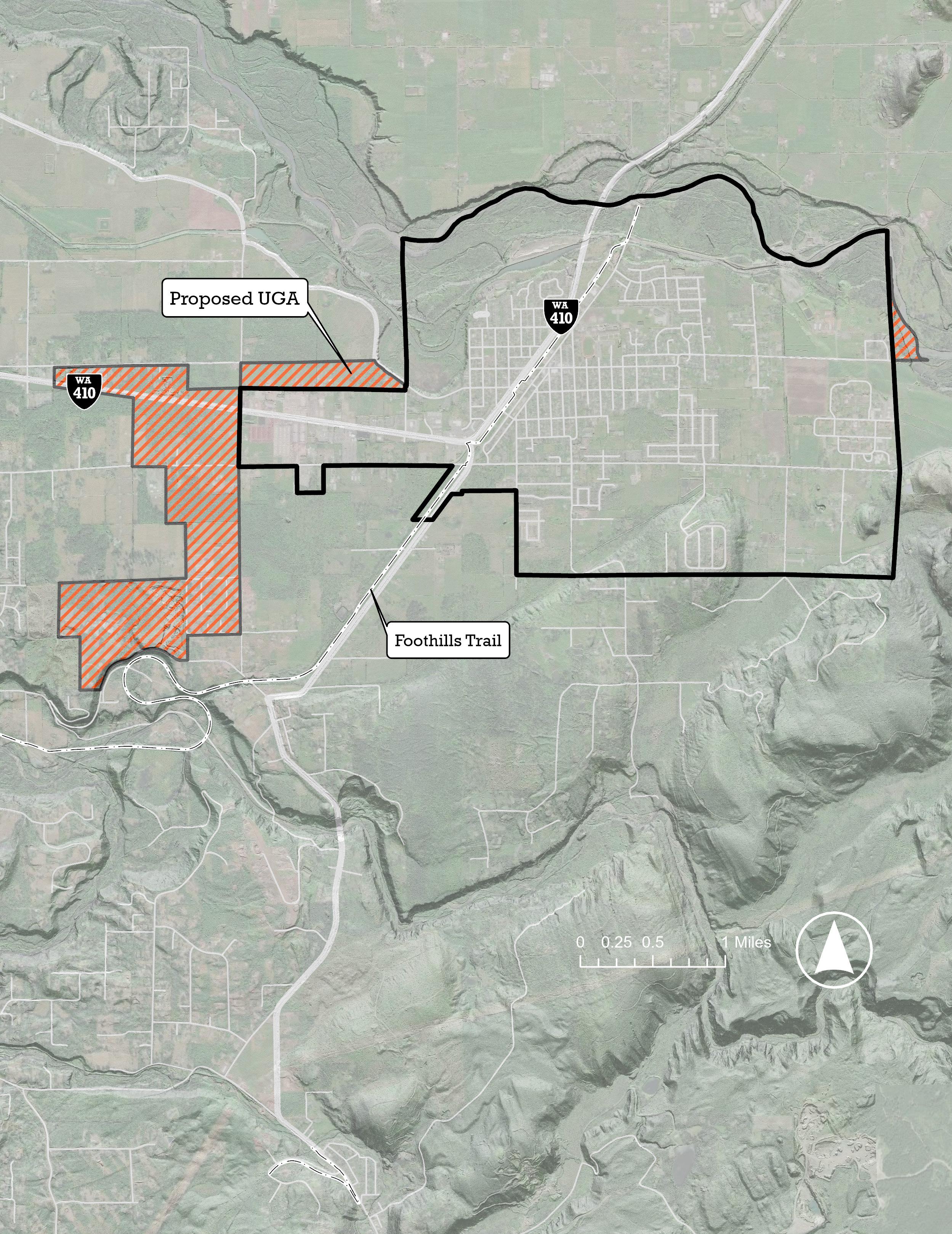
Existing Facilities
In 2018, an evaluation was conducted with three primary goals; 1) conduct a space needs assessment for all City functions for the present, as well as projections for space needs at six years and 20 years; 2) evaluate existing structures for present and future use in light of the results of the space needs assessment; and 3) develop a long-range plan for the Municipal Facilities in light of both the space needs assessment and the building evaluations. Since that time, the City has awarded a contract to remodel the existing City Hall with an anticipated opening date in early 2026. The new City hall will accommodate up to 19 staff members and is intended to provide a single location for customers completing business with the City.
To plan for future space needs, the City has evaluated the current number of staff and the anticipated number of staffing levels based on reviewing staffing levels of similarly sized jurisdictions (between 8,000-10,000). With this data, the City has created a needs assessment which has been integrated into the Capital Improvement Plan.
S-1
Slow Sand Filter Re-Sand Pilot Study to test the effectiveness of increasing the loading rate.
Re-Sand Slow Sand Filter at the Water Treatment Plant.
DSHS, 80%
Cap. Fund $180,000
S-3
Expand Slow Sand Filter Water Treatment Plant-construct additional filter bed area; expand filter building, additional inlet and under-drain piping, site piping and controls.
S-4
Hydro-Geologic Study for a New Wellcomplete a hydro-geologic study to obtain recommendations of locations that would be most likely to support productive wells
S-5 Drill and Test New Well. 2032 Water Capital Project Fund $184,000
T-4
Upgrade System Telemetry. This will allow the City to maintain more competitive service contracts for maintenance and repairs of its telemetry equipment.
Siting Study. Evaluate potential
Segment 6, End of Trenchless to North Slope-replace 2,440 LF of Raw Water Transmission Main between Segment 5 and Segment 7 with new 12-inch HDPE Raw Water Transmission Main.
Segment 8, Creek Crossing Restoration. The City installed a cable bridge across South Prairie Creek in 2016 to carry a segment of the transmission main. The old pipeline and concrete encasement requires removal and the disturbed banks along the creek require additional restoration.
Segment 13, Between Replacement Segments-replace 260 LF of Raw Water Transmission Main between Segment 14 and Segment 16 with new 12-inch HDPE Raw Water Transmission Main.
Segment 15, End of Cable Bridge to Replacement Segment-replace 1,135 LF of the Raw Water Transmission Main from the north end of the cable bridge to connect the south end of the Segment 14 with new 12-inch HDPE Raw Water Transmission Main.
30%
Annual Transmission Main Leak Detection-continue an annual leak detection program to determine if there are any additional sections of the pipeline in need repair.
Segment 16, Existing Cable Bridge. Replace 200 LF cable bridge across a creek gully.
Segment 19, Along Cliff Face. Replace 200 LF of transmission main, including a new cliff anchorage system.
Segment 21, Creek Bed to Headworks. Replace 1,000 LF of transmission main in the South Prairie Creek streambed near the headworks of the transmission main.
Edith from Park to Dundass, Balm from 4th to Ewing, Ewing from Dundass to Balm, 3rd from Main to Masin. Install 1,200 LF of 8-inch water main.
Heather between Whitmore and Elk Ridge Elementary School. Install 70 LF of 8-inch water main.
Mason from A to D, B south of Mason, Rainier from Main to Mason. Install 1,900 LF of 8-inch water main.
A from Park to Main. Install 850 LF of 8-inch water main. 2027
D-5 Division from Ryan to Fire Station. Install 360 LF of 8-inch water main. 2029
D-6
Jefferson from 3rd to Pearl, Pearl from Perkings to Ryan, Mill from Pearl to Jefferson. Install 2,080 LF of 8-inch water main. 2029
Ryan from Spiketon Road to east side of LDS Church. -Install 2,360 LF of 12-inch water main. 2030 Water Capital Project Fund $791,000
D-8
Fulton and 4th. Install 450 feet of 8-inch water main. 2031
D-9 Sheets, south of Ryan. Install 600 feet of 8-inch water main. 2032 Water Capital Project Fund $180,000
D-10
Klink, south of Ryan. Install 1,400 feet of 8-inch water main. 2032 Water Capital Project Fund $411,000
D-11
SR 410, west to Mundy-Loss. Install 1,100 feet of 8-inch water main. 2034 Water
D-12
Hinkleman Extension from SR 410 to 112th. Install 700 feet of 8-inch water main. 2034 Water Capital Project Fund $194,000
D-13
Hinkleman Road from Hinkleman Extension to Mundy-Loss. Install 2,200 feet of 8-inch water main. 2035 70% Loan, 30% Water
D-14 McNeely, north of Collins. Install 2,200 feet of 8-inch water main. 2036 Developer Extension
D-15 McNeely, south of Collins. Install 750 feet of 8-inch water main. 2036 Developer Extension $237,000
D-16 River, north of Dieringer. Install 450 feet of 8-inch water main. 2037 Developer Extension $148,000
D-17
Mason from Spruce to McNeely. Install 2,000 feet of 8-inch water main. 2037 Developer Extension $584,000
D-18
Dieringer from Sorenson to McNeely. Install 2,200 feet of 8-inch water main. 2038
Sewer Systems CIP
G-1
McNeely Street South, East on Mason to State School Property Line, South to Ryan Road to Klink Street-construct 4,800 LF of new 12” PVC.
As the number of staff grows, there will be more need for another person in the HR Department.
distribute duties appropriately for skill levels and to move more analytical duties and financial statement prep
court clerk to focus primarily on probation monitoring and customer service. .35 judicial hours to compensate for anticipated increase in caseload.
Provide both civil and building inspections for the city. May potentially provide some construction management.
Increased use of parks and facilities. Increase in number of maintianed acers of parks & trails.
parks maintance shed/grague for staff work area and equipment storage.
Coordinate and run increased participant numbers
remodled to create ADA accessable restrooms, more open recreation space, update kitchen, and 1 additional office space. At the youth center remodled for facility update and open entry up for accessability and better use of space.
will need
office
Expanding the current footprint is a posibility.
Department CurrentStaffbudgetedin2024Anticipated#ofstaff neededin2044Additionalpositions(listbycurrentjob class)
Reasonfor additional staff Facilityneeds/upgrades
1- Assistant PW Director/Engineer
1- Stormwater Specialist
2- Utility Workers
1- WWTP Operator
Assist PW Director- coordinates the Public Works portion of the development and updating of comprehensive plans including the City’s Comprehensive Plan, the Six-Year TIP, and utility comprehensive plans; supervises assigned staff; and acts as Public Works Director. Stormwater Specialist- Will perform implementation of the city's NPDES Stormwater Permit. WWTP Operator and Utility WorkersWith the projected city population and housing increase we will need to add additional utility staff to support growing utility infastructure and other services.
Public Works Office Building- Is currently 1,560 sq/ft. This building will need a 1,000 sq/ft addition to accomidate new office, larger break room and conference room. Public Works Shop- The shop was constructed in 1925 and is approximately 4,500 sq/ft. This building will need to be expanded and remodeled to accomidate for additional utility staff, equipment storage, and work stations.
Call volume will exceed the capacity of a predominant volunteer staffing model new roof and replacement of floor covering and major appliances
Goals and Policies
CF 1 PROVIDE, MAINTAIN, AND IMPROVE CITY FACILITIES TO ENSURE EFFICIENCY, SAFETY, AND PROVISION OF THE BEST POSSIBLE SERVICE TO RESIDENTS, EMPLOYEES, AND THE CITY WHILE ENHANCING THE PHYSICAL LANDSCAPE AND QUALITY OF LIFE.
CF 1.1 Provide a City Hall and other city facilities that are safe, functional, conducive to the provision of local governance, service provision, and operations, and that provide a positive model of the type of development desired in the city.
CF 1.2 Maintain adequate permanent facilities for police and fire functions, providing any additional or expanded facilities as needed.
CF 1.3 Provide and maintain cultural and civic facilities, such as a senior center, youth center, and museum.
CF 1.4 Address facility and service needs that are consistent with the comprehensive plan and city growth targets, updating existing facility plans if necessary.
CF 1.5 Require new development to fund a fair share of costs to provide service, utility, parks, and facilities needs generated by that development.
CF 1.6 Charge impact fees when the City Council determines that new development should pay its proportionate share of the capital facilities that it needs. Impact fees may spent on the following capital facilities:
a. Public streets and roads;
b. Publicly owned parks;
c. Open space and recreation facilities;
d. School facilities; and
e. Fire protection facilities.
CF 1.7 Work with counties, tribes, other cities, and special purpose districts to identify and fulfill capital facilities needs that support the Regional Growth Strategy.
CF 2 ENSURE THAT FACILITIES AND SERVICES PROJECTS ARE FINANCIALLY FEASIBLE, AND THAT PUBLIC FUNDING FOR INFRASTRUCTURE DEVELOPMENT IS ACCOUNTED FOR IN ANNUAL CITY BUDGETS.
CF 2.1 Establish a unified City CIP consisting of separate CIPs for each service or utility that lists planned capital improvements and establishes a priority and dedicated funding source for the capital improvements for a six-year period.
CF 2.2 Evaluate each service or utility CIP priority and funding sources at least once every two years, but not more than twice a year. Any amendment to the CIP must analyze the impacts the amendment will have on permits issued by the City based on concurrency.
CF 2.3 Evaluate concurrency for transportation based on only those capital improvements identified in the CIP as fully funded within the six-year period.
CF 2.4 The City shall not provide a capital improvement, nor shall it accept the provision of a capital improvement by others, if the City or the provider is unable to pay for subsequent annual operating and maintenance costs of the improvement.
CF 2.5 The City CIP shall constitute a separate adopted appendix to this plan.
CF 2.6 Update the City’s 6-year Capital Improvement Plan at least every two years in conjunction with the City’s budget development and approval process. If probable funding falls short of existing needs, evaluate whether the land use element should be updated to create consistency between the capital facilities element, CIP and Land use elements.
CF 2.7 Coordinate with public school providers for the provision of capital improvements.
CF 2.8 Incorporate the public school CIPs as appendices to the City CIP following review for consistency with this plan.
CF 2.9 Following review and adoption of a District master plan and CIP, coordinate with public schools for the collection, if applicable, of school impact fees as part of the project review process.
CF 3 COORDINATE WITH SERVICE PROVIDERS TO ENSURE CITYWIDE UTILITIES AND PUBLIC SERVICES ARE RELIABLE, COMPETITIVE, EQUITABLE, AND FINANCIALLY SUSTAINABLE.
CF 3.1 Work with all utility providers in the City of Buckley to integrate planning to ensure service delivery in accordance with this plan.
CF 3.2 Work with Marion Water District to transition all existing customers within the City of Buckley service area to City of Buckley provided service.
CF 3.3 Correct deficiencies where deficiencies in service are identified. If the City determines that a neighboring purveyor or provider is not responsive to service needs, the City shall consider all remedies within its authority to ensure the adequate provision of service.
CF 3.4 Ensure adequate funding and resources for public health and safety providers, including fire, emergency medical services, and police.
CF 3.5 Coordinate with school districts on facility siting and design to support safe, walkable access, including strategies to provide adequate urban capacity for new schools.
CF 4 ENSURE NEW DEVELOPMENT AND FACILITIES PLANNING INCORPORATES EQUITABLE ACCESS TO PARKS, TRAILS, OPEN SPACES, AND RECREATIONAL OPPORTUNITIES FOR ALL RESIDENTS.
CF 4.1 Provide City facilities and parks and recreation capital improvements in accordance with this plan and the Parks Recreation and Open Space (PROS) Plan.
CF 4.2 Review proposed land use permits and/or development permits or approvals for impacts to parks and recreation capacity.
CF 4.3 The City may consider public, on-site open space and recreational facilities provided at the developer's expense that are substantially in excess of those required by the City, or that provide a unique attribute to the city, as a full or partial substitute for a development's fair share of funding for parks and recreation.
CF 4.4 Coordinate with public schools for jointly funded parks and recreation capital improvements and inclusion of jointly funded projects in the parks and recreation CIP.
CF 5 PROTECT AND ENHANCE THE ENVIRONMENT AND PUBLIC HEALTH AND SAFETY WHEN PROVIDING SERVICES AND FACILITIES.
CF 5.1 Promote improved conservation and more efficient use of water, as well as the increased use of reclaimed water, to reduce wastewater generation and ensure water availability.
CF 5.2 Promote the use of renewable energy resources to meet the region’s energy needs.
CF 5.3 Reduce the rate of energy consumption through conservation and alternative energy forms to extend the life of existing facilities and infrastructure.
CF 5.4 Consider the potential impacts of climate change on public facilities, supporting the necessary investments to move towards low-carbon energy sources.
CF 5.5 Incorporate hazard mitigation measures into existing facilities maintenance, upgrading plans when necessary.
CF 6 TAKE INTO ACCOUNT POTENTIAL ECONOMIC, SOCIAL, AND HEALTH IMPACTS WHEN SITING PUBLIC FACILITIES.
CF 6.1 Locate community facilities and services, including civic places like parks, schools, and other public spaces, in centers and near transit.
CF 6.2 Promote affordable and equitable access of public utilities and services to all communities, especially populations that have historically experienced marginalization or are underserved.
UT 1 FACILITATE THE DEVELOPMENT AND MAINTENANCE OF ALL UTILITIES AT THE APPROPRIATE LEVELS OF SERVICE TO ACCOMMODATE GROWTH THAT IS ANTICIPATED TO OCCUR IN THE CITY OF BUCKLEY AND ITS URBAN GROWTH AREA.
UT 1.1 The City should plan for and deliver utilities and public facilities in advance of new development to the extent feasible. After occupancy, utility use should not cause a reduction in service levels below City of Buckley standards.
UT 1.2 The location, type, and size of all public facilities shall be determined and/or approved by the City. The extension and sizing of system components shall be based on the land use plan and proposed development.
UT 1.3 Facilities shall be designed, constructed, and maintained to reasonably minimize their impact on surrounding neighborhoods.
UT 1.4 Expand public utility service to unserved areas of the Urban Growth Area, including extensions into potential annexation areas under conditions consistent with the Growth Management Act. Work with service and utility providers to expand services to underserved areas.
UT 1.5 Coordinate with other jurisdictions and governmental entities in the planning and implementation of multi-jurisdictional utility facility additions and improvements.
UT 1.6 Coordinate with Pierce County to ensure that public utility facilities sited in potential annexation areas are designed and built in accordance with the City’s standards to reduce challenges and inefficiencies as they are incorporated into the city
UT 2 FACILITATE THE PROVISION OF UTILITIES THAT ARE ENVIRONMENTALLY SENSITIVE, SAFE AND RELIABLE, AESTHETICALLY COMPATIBLE WITH THE SURROUNDING LAND USES, AVAILABLE AT A REASONABLE ECONOMIC COST, AND CAN BE PROVIDED IN AN EFFICIENT MANNER.
UT 2.1 Require notification to the City prior to a utility’s maintenance or removal of vegetation in City right-of-ways.
UT 2.2 Require the reasonable screening and/or architecturally compatible integration of all new site-specific, above-ground facilities.
UT 2.3 The City and utility companies shall coordinate the acquisition, use, and enhancement of utility corridors for pedestrian, bicycle, and equestrian trails and for wildlife corridors and habitat provided such joint use does not compromise prudent utility practice.
UT 2.4 Facilitate the conversion to cost-effective and environmentally sensitive alternative technologies and energy sources.
UT 2.5 Facilitate and encourage conservation of resources.
UT 2.6 The City will encourage utility providers to ensure that all maintenance, repair, installation, and replacement activities by utilities are consistent with the City’s Critical Areas Ordinances (CAOs).
UT 2.7 Promote conservation and encourage development of conservation devices and programs.
UT 3 PROCESS PERMITS AND APPROVALS FOR UTILITY FACILITIES IN A FAIR AND TIMELY MANNER AND IN ACCORD WITH THE DEVELOPMENT REGULATIONS WHICH ENCOURAGE PREDICTABILITY AND CONSISTENCY.
UT 3.1 Encourage system design practices intended to minimize the number and duration of interruptions to customer service.
UT 3.2 Encourage the utilities to solicit community input on the siting of proposed facilities prior to seeking City approval for facilities, which may have a significant impact on the community.
UT 3.3 The City shall promote, when reasonably feasible and appropriate, colocation of new public and private utility distribution facilities in shared trenches/rights of way, and coordination of construction timing to minimize construction-related disruptions and reduce the cost of utility delivery.
UT 3.4 The City will provide timely effective notice to utilities to encourage coordination of public and private utility trenching activities for new construction and maintenance and repair of existing roads.
UT 3.5 The City shall encourage provision of an efficient, cost-effective, and reliable utility service by ensuring land will be made available for the location of utility lines, including location within transportation corridors.
UT 3.6 The City will utilize maps of the existing and proposed utility facility corridors to determine consistency of such designations with the elements of the comprehensive plan.
UT 3.7 The City will assure that the comprehensive plan designates areas available for the location of utility facilities.
UT 3.8 Encourage additions to and improvements of facilities that provide adequate capacity for future planned growth.
UT 4 ENSURE RELIABLE AND COST-EFFECTIVE ACCESS TO CITY WATER.
UT 4.1 Provide reliable water service for domestic use, fire flow, and emergencies.
UT 4.2 Improve the quality of the water supply to all customers.
UT 4.3 Encourage private well water users in the planning area to access the City’s or other water purveyor systems, provided that the fair share of costs are paid by the benefiting parties.
UT 4.4 Insure a cost-effective water supply that meets City needs.
UT 4.5 Continue to participate in and facilitate the development of a regional water supply system that effectively balances regional water resources and supply needs, while protecting the City’s interests.
UT 4.6 Develop agreements with other water purveyors in the Urban Growth Area to consult with the City before approving additional water hookups.
UT 5 REDUCE SEWER RELATED ENVIRONMENTAL AND PUBLIC HEALTH IMPACTS BY PROVIDING A COST-EFFECTIVE AND ACCESSIBLE MUNICIPAL SEWER SYSTEM.
UT 5.1 Ensure a cost-effective sewer system that meets the City’s needs and protects the environment.
UT 5.2 Continue to require sewer connections for all new developments, including single-family plats unless otherwise approved by the City.
UT 5.3 Encourage existing single-family homes with septic systems to connect to the sewer system where available. If an existing septic system poses a health or environmental problem the homeowner shall be required to connect to the sewer system, if practicable.
UT 6 PROTECT FRESHWATER RESOURCES THROUGH COORDINATED STORMWATER MANAGEMENT STRATEGIES.
UT 6.1 Coordinate management of the stormwater system with property owners to prevent property damage from flooding, protect water quality, maintain recharge of aquifers, provide for the safety and enjoyment of citizens, and preserve and enhance habitat and sensitive areas.
UT 6.2 Enforce surface water controls in order to protect surface and groundwater quality.
UT 7 PROMOTE AND SUPPORT THE SAFE DISPOSAL OF SOLID WASTE AND HAZARDOUS SUBSTANCES CONSISTENT WITH PIERCE COUNTY RULES AND REGULATIONS.
UT 7.1 Cooperate with other private and public agencies in the region to manage and control hazardous waste and moderate-risk waste, including hazardous household substances.
UT 7.2 Educate the public in the proper handling and disposal of hazardous household waste and on the use of alternative products or practices that result in reducing the use and storage of hazardous materials in the home and businesses.
UT 7.3 Hazardous wastes shall be properly disposed of according to procedures and standards set by federal, state, or regional agencies.
UT 7.4 Provide for the safe and convenient disposal of hazardous household waste through a conveniently located collection facility or cooperation with county facilities.
UT 7.5 Replace, as soon as practicable, the City’s old underground fuel storage tanks with new tanks that reduce the potential for groundwater degradation and meets the Washington Department of Ecology’s standards.
UT 7.6 Promote the recycling of solid waste materials by providing opportunities for convenient recycling, waste reduction, and source separation.
UT 7.7 Materials remaining after effective waste reduction and source separation shall be handled in accordance with the Tacoma-Pierce County Solid Waste Management Plan.
UT 7.8 The City shall develop recycling programs, including educational materials on recycling, composting, and other waste reduction methods.
UT 7.9 Encourage and actively participate in a uniform regional approach to solid waste management.
UT 7.10 Utilize the public review process in the selection and approval of any disposal facility, considering sensitivity to aesthetics, health effects, and environmental conditions.
UT 7.11 Manage solid waste collection to minimize litter and neighborhood disruption.
UT 7.12 Provide uniform collection service to areas annexed to the City as soon as can reasonably be arranged in accordance with service contracts.
Capital Facilities & Utilities Goals and the Community Vision
The diagrams on the next few pages illustrate how the capital facilities and utilities goals articulated in this chapter connect to the community vision statements in Chapter 3. Weak Connection
VISION STATEMENTS
Sustaining and fostering town identity and character
In 2044, Buckley will...
01. Have a vibrant, compact and walkable downtown where people meet each other face-to-face, where small businesses can thrive, and with housing close at hand that support a high quality of life.
02. Have a denser Downtown and 410 Corridor that improves service administration while supporting the rural quality of life farther from City center.
03. Foreground the city’s unique history through retention of historic buildings, thoughtful community design, civic space and park system.
04. Have affordable and accessible housing that allows the city’s aging population to stay in the place they call home, while welcoming newcomers into the community.
05. Be a safe and inviting place to visit and reside.
06. Use public dollars strategically and efficiently to provide city residents with high quality roads, utilities, environmental amenities and services.
Economic development of the Downtown Core and State Highway 410
In 2044, Buckley will...
07. Have an enhanced 410 Corridor that creates a friendly gateway to our city with more retail, small businesses and housing that is community oriented and provides new places for residents and visitors to live, work and be together.
Promotion of outdoor recreational activities
In 2044, Buckley will...
08. Be a destination and not a pass through for outdoor recreation enthusiasts availing themselves of our area’s natural beauty through concerted infrastructure and facility investment and support for recreation-oriented businesses.
Provide, maintain, and improve City facilities to ensure efficiency, safety, and provision of the best possible service to residents, employees, and the City while enhancing the physical landscape and quality of life.
Ensure that facilities and services projects are financially feasible, and that public funding for infrastructure development is accounted for in annual city budgets.
Coordinate with service providers to ensure citywide utilities and public services are reliable, competitive, equitable, and financially sustainable.
Facilitate the development and maintenance of all utilities at the appropriate levels of service to accommodate growth that is anticipated to occur in the City of Buckley and its Urban Growth Area.
Protect and enhance the environment and public health and safety when providing services and facilities.
Facilitate the provision of utilities that are environmentally sensitive, safe and reliable, aesthetically compatible with the surrounding land uses, available at a reasonable economic cost, and can be provided in an efficient manner.
Take into account potential economic,
and health impacts when siting public facilities.
Process permits and approvals for utility facilities in a fair and timely manner and in accord with the development regulations which encourage predictability and consistency.

Transportation Introduction
This Comprehensive Plan Transportation Element establishes goals, policies, and implementation strategies to guide future decisions affecting the City of Buckley’s transportation systems including pedestrian, bicycle, transit and vehicular facilities. This element is intended to reinforce Buckley’s overall vision of being a safe and friendly historic small town that is an attractive place to live, work, and play. Along with other elements in the Comprehensive Plan Transportation Element works to preserve Buckley’s small town character, efficient provision of services, support diverse housing opportunities, protect the natural environment, foster a strong economic base, ensure safe access to goods and services and develop high quality public spaces that foster community interaction. The focus of the transportation element is on ensuring safe and convenient access to goods and services through an efficient and environmentally sensitive multimodal transportation system. Pedestrian, bicycle, transit and vehicular facilities are all considered when answering the following questions:
01. What are the strengths and weaknesses of Buckley’s current transportation system?
02. What is Buckley’s projected transportation needs in the future?
03. What is Buckley’s overall strategy for meeting its future transportation needs?
04. What are Buckley’s goals, policies for improving its transportation system?
05. What specific actions can Buckley begin to take to implement its vision?
Planning Process
This Transportation Element update was prepared in the following series of steps:
01. Historical information was collected including Pierce County Transportation Plans, traffic counts, and street inventory information.
02. New traffic counts were taken in April 2013 and intersection approach volumes were determined.
03. Both population growth rates and traffic count trends were collected from the Puget Sound Regional Council. Both were reviewed and a 3 percent per year growth rate was selected.
04. Vehicle Levels of service (LOS) for 2013 and 2030 were calculated and analyzed using traffic model HCM2010 methods combined with Synchro, and HCS2010 models for high volume intersections.
05. Pedestrian LOS was calculated for 2013 and 2030 using a rating equation that incorporates vehicle volumes, pedestrian use and type, vehicle speeds, shoulder widths, and roadway widths.
06. Improvements were developed and
tested to ascertain a minimum LOS of “D” in 2013. Cost estimates of the selected improvements were then prepared.
07. Fair share mitigation fees were developed for each project using 2013 weekday total volumes.
Existing Conditions
Buckley’s historic neighborhoods are laid out in a traditional street grid pattern on approximately 320 feet by 550 feet street-blocks with alleys running down their middle. This street pattern provides strong pedestrian and vehicular connectivity within the community facilitating convenient access to goods and services. The alleys also enhance street aesthetics by providing alternative corridors for garbage pickup and utilities.
Some of Buckley’s more recent subdivisions are laid out in a loop and lollipop street pattern. This pattern discourages through traffic and increases out of direction travel. It consequently does not provide strong pedestrian or vehicular connectivity resulting in long circuitous routes to cover otherwise short distances. This street pattern developed after the advent of the automobile when accessibility by foot was thought to be no longer crucial. However, as a result of this pattern people’s transportation choices become severely limited. Children and the elderly were especially affected by the lack of safe and convenient pedestrian and bicycle access to activities, goods and
services. It was also less recognized how automobile dependence could affect our health. Our country’s obesity epidemic not to mention environmental and safety concerns over the burning of fossil fuels have all been tied to our nation’s heavy reliance upon the automobile. With the growing awareness of the adverse health, environmental and social impacts of automobile dependence, communities around the country are working to create more walk able and pedestrian friendly neighborhoods to loosen dependence upon the automobile by increasing transportation choices. As residential development continues to occur within Buckley, street patterns will continue to have strong effects upon accessibility and neighborhood character. Finding ways to ensure safe and convenient multi-modal access and preserve Buckley’s small town character is the primary goal of this Transportation Element.
Goals & Policies
TR 1 ENSURE ALL TRANSPORTATION MODES ARE DESIGNED FOR SAFETY.
TR 1.1 Buckley’s trails, sidewalks, bike paths, and roadways should provide safe and protected access to amenities, services, and schools and other civic institutions.
TR 1.2 Right-of-way improvements shall be done to the latest accepted design standards. If the design standards cannot be met, a deviation shall be prepared by the designer and shall be reviewed for possible approval by the City Engineer.
TR 1.3 Provide needed roadway striping and signing to maintain safe traffic operation service levels that are consistent with the most recent Manual of Uniform Traffic Control Devices (MUTCD).
TR 1.4 The City should ensure adequate visibility for automobiles, bicyclists and pedestrians by enforcing landscape and fence height standards.
TR 1.5 A code enforcement officer should be responsible for enforcing the vegetation height and breadth over sidewalks as well as beside roads to enhance accessibility and visibility
TR 1.6 The City should work with the Washington State Department of Transportation (WSDOT) to make State Route (SR) 410 safer for pedestrians
TR 1.7 The City should prepare a Local Road Safety Plan and Comprehensive Safety Action Plan to evaluate crash data, identify areas of emphasis and countermeasures and identify projects and strategies using the Safe System Approach to enhance safety for all transportation modes.
TR 1.8 The City should prepare a Sidewalk and ADA Transition Plan to inventory and evaluate existing pedestrian facilities and to develop a list of prioritized projects and funding sources to transition the City’s pedestrian facilities to full ADA compliance.
TR 2 ENHANCE THE APPEARANCE, QUALITY, FUNCTION AND ACCESSIBILITY OF THE TRANSPORTATION SYSTEM.
TR 2.1 Public art should be provided on public rights-of-way by new development to enhance the City’s sense of place
TR 2.2 All new transportation facilities shall meet current ADA guidelines. All existing facilities shall be inventoried for ADA compliance and prioritized for enhancement where necessary.
TR 2.3 Street patterns should be planned as grid systems to increase transit network resilience. Use of a grid system provides infrastructure redundancy; in the event of an emergency, a grid system can provide multiple routes to safety. Streets without through traffic including dead ends or long block and ; clustered development, such as planned unit developments, should provide
a trail system through the property and connect with adjacent rights-of-way or developed trails where possible.
TR 2.4 Future streets and their classifications should follow a regular distribution pattern that anticipates potential land uses and provides for orderly development.
TR 2.5 Alleys should be encouraged in new development to eliminate the need for placing overhead wires, garages, and garbage cans in front of residences.
TR 2.6 The sizes and capacities of transportation facilities should be appropriately matched to the surrounding land uses.
TR 2.7 The City should consider the costs and benefits of both construction and maintenance when setting guidelines for street dimensions and rights-ofway.
TR 2.8 Sidewalks should be designed to eliminate sheet flow and ponding on the walkway surface.
TR 2.9 Crosswalks should be paved differently to ensure visibility.
TR 2.10 Sidewalks that are likely to serve as parking areas or driveways should be designed as driveways to prevent the sidewalk from crumbling through use.
TR 2.11 Sidewalks should have standard curbs (not rolled curbs).
TR 2.12 Sidewalks should be sloped toward the street for drainage.
TR 2.13 Pavement materials and landscaping should be used to create visual connections between trails and other transportation infrastructure
TR 3 IMPROVE THE HEALTH AND WELLBEING OF CITY RESIDENTS BY PROVIDING MULTIPLE WAYS TO GET FROM ONE PART OF THE CITY TO ANOTHER PART OF THE CITY USING A VARIETY OF TRANSPORTATION MODES.
TR 3.1 Sidewalks should be an inventoried part of the City’s trail system, and should create contiguous and thoughtful pedestrian access to Downtown, schools, parks and other important city amenities and service locations
TR 3.2 Require that proposed dead-end streets and cul-de-sacs contain pedestrian links to the next street. Where possible, support the development of new pedestrian links at existing dead ends and cul-de-sacs.
TR 3.3 Developers should provide bike and pedestrian connections to adjoining properties.
TR 3.4 All new development should provide pedestrian and bicycle infrastructure, such as sidewalks, crosswalks, and bike paths.
TR 4 SUPPORT CITY GREENHOUSE GAS EMISSIONS REDUCTION
TR 4.1 Increase non-motorized trips within the City of Buckley and decrease vehicle miles traveled by providing alternatives to driving alone
TR 4.2 The City of Buckley should implement transportation demand management measures that provide incentives for walking, biking, and public transportation and disincentives for automobile use.
TR 4.3 Non-motorized links across SR 410 should be by signalized crosswalks or a pedestrian route that is grade separated.
TR 4.4 The City should ensure safe and secure access to non-motorized amenities.
TR 4.5 Crosswalk safety at major intersections should be enhanced through the addition of visual cues, such as paving and painting treatments, lighting, and/ or signage. Where crossing distances are long, i.e., across SR 410, raised medians should be constructed to serve as places of refuge for pedestrians.
TR 4.6 Future transit areas should include covered transit shelters.
TR 4.7 Provide information about Northwest ecology along bicycling and walking routes as well as the Foothills Trail to increase local ecological literacy
TR 4.8 The City should work with outside cycling and walking groups, such as Feet First or Cascade Cycling Group, to provide outreach and education regarding the different modes of transportation to schools and other public facilities.
TR 4.9 The City should create a continuous bicycle route system linked to the Foothills Trail and other City facilities not only as a way to reduce vehicle miles traveled but to enhance the city’s appeal as an ecotourism destination
TR 4.10 All new commercial and office developments and facilities shall include bicycle parking. Park-and-ride areas and areas for future transit facilities should include covered bicycle parking.
TR 4.11 The City should provide plug-in charging stations for electric vehicles.
TR 4.12 Ensure all federal and state air quality standards are met and reduce emissions of air toxics and greenhouse gases.
TR 5 TRANSPORTATION IMPROVEMENTS SHOULD BE CONSTRUCTED WITH REDUCED ENVIRONMENTAL IMPACTS.
TR 5.1 All transportation improvements should minimize impervious footprints and use current stormwater techniques as required in Title 14 of the Buckley Municipal Code.
TR 5.2 The City shall pursue low-impact street and parking lot design, construction, and maintenance techniques to minimize impervious surface, water pollution, and water runoff.
TR 5.3 New roads and trails should be designed in such a way that they will not affect wetlands, natural preserves, parks and recreation areas, significant historical and cultural resources, and areas identified as critical wildlife habitat.
TR 6 THE CITY SHOULD FINANCE IMPROVEMENTS THAT MAXIMIZE BENEFITS FOR CITY RESIDENTS, AND PARTICULARLY RESIDENTS WITH LIMITED MOBILITY
TR 6.1 The City should develop a list of transportation capital improvement projects, including roadway improvements, roadway maintenance, roadway preservation and non-motorized improvements to be accomplished within the next 6 years and next 20 years and updated annually. The list should include an updated project cost, adjusted for inflation. The list should include the planned funding sources for each project, including as applicable SS4A, WSDOT, PSRC, TIB, City Local funds and developer.
TR 6.2 The City should use both traditional and innovative methods for financing roadway improvements such as public/private partnerships, and impact fees.
TR 6.3 The City should explore funding tools such as road improvement districts (RIDs), local improvement districts (LIDs), and other local funding mechanisms to finance projects that provide a primary local benefit.
TR 6.4 WSDOT, Pierce County, and the City of Buckley should work together to share transportation resources and reduce overlap in transportation expenditures.
TR 6.5 The City should require maintenance agreements for private roads that are executed by the responsible landowners.
TR 6.6 The City should continue to compete for funds for transportation improvements and identify more funding opportunities to reduce the risk of underfunding the transportation system
TR 7 THE CITY SHOULD ENSURE DEVELOPERS PAY FOR IMPACTS TO THE ROADWAY SYSTEM, AS REQUIRED BY CONCURRENCY.
TR 7.1 Each development is responsible for paying to offset the development’s impact on the transportation system related to the development’s generation of trips, unless the City decides that waiving or reducing impact fees for particular developments will make a substantive impact to fulfill other goals of the City such as encouraging community serving businesses to locate in Buckley.
TR 7.2 A consistent level of service (LOS) should be provided across multiple transportation modes, including motorized vehicles, walking and biking.
TR 7.3 Transportation improvements needed to support new development shall be in place at the time of development to maintain transportation LOS standards.
TR 7.4 New commercial developments must provide roadway improvements as required by the future street map and the Development Guidelines and Public Works Standards .
TR 7.5 A concurrency management system should be developed.
TR 7.6 Alternatives for demand management should be explored.
TR 8 THE CITY SHOULD MINIMIZE FUTURE MAINTENANCE COSTS BY USING TECHNOLOGIES AND TECHNIQUES THAT INCREASE PAVEMENT LONGEVITY.
TR 8.1 Design and construct improvements in a manner that likely will require the least amount of maintenance.
TR 8.2 Create and periodically update an inventory that logs deficiencies and ongoing repairs of existing sidewalks and roadways.
TR 8.3 The City should budget for annual roadway paving improvements, such as potholes.
TR 9 ENSURE TRANSPORTATION CONSTRUCTION NEEDS ARE MET DURING AND AFTER CONSTRUCTION.
TR 9.1 Additional rights-of-way may be required for additional roads and pedestrian ways, as shown on adopted plans of the City.
TR 9.2 Public notice of traffic impacts that will occur during construction activities should be provided 2 weeks in advance of the traffic impact.
TR 9.3 Each transportation mode’s right-of-way needs should be addressed when roads are constructed or upgraded with the appropriate traffic control measure as outlined by the Buckley City Development Guidelines and Public Works Standards and MUTCD.
TR 9.4 Temporary erosion and sediment control measures shall be used in accordance with an approved stormwater pollution prevention plan. Final approval of the permit should depend on permanent stormwater detention and pollution prevention measures being in place.
Transportation Goals and the Community Vision
The diagrams on the next few pages illustrate how the transportation goals articulated in this chapter connect to the community vision statements in Chapter 3.
VISION STATEMENTS
Vision Statement 01
Weak Connection
Sustaining and fostering town identity and character
In 2044, Buckley will...
01. Have a vibrant, compact and walkable downtown where people meet each other face-to-face, where small businesses can thrive, and with housing close at hand that support a high quality of life.
02. Have a denser Downtown and 410 Corridor that improves service administration while supporting the rural quality of life farther from City center.
03. Foreground the city’s unique history through retention of historic buildings, thoughtful community design, civic space and park system.
04. Have affordable and accessible housing that allows the city’s aging population to stay in the place they call home, while welcoming newcomers into the community.
05. Be a safe and inviting place to visit and reside.
06. Use public dollars strategically and efficiently to provide city residents with high quality roads, utilities, environmental amenities and services.
Economic development of the Downtown Core and State Highway 410
In 2044, Buckley will...
07. Have an enhanced 410 Corridor that creates a friendly gateway to our city with more retail, small businesses and housing that is community oriented and provides new places for residents and visitors to live, work and be together.
Promotion of outdoor recreational activities
In 2044, Buckley will...
08. Be a destination and not a pass through for outdoor recreation enthusiasts availing themselves of our area’s natural beauty through concerted infrastructure and facility investment and support for recreation-oriented businesses.
Ensure all transportation modes are designed for safety.
Enhance the appearance, quality, function and accessibility of the transportation system.
Improve the health and wellbeing of city residents by providing multiple ways to get from one part of the City to another part of the City using a variety of transportation modes.
Transportation improvements should be constructed with reduced environmental impacts. The
The City should ensure developers pay for impacts to the roadway system, as required by concurrency.
The City should minimize future maintenance costs by using technologies and techniques that increase pavement longevity. Ensure transportation construction needs are met during and after construction.
A.

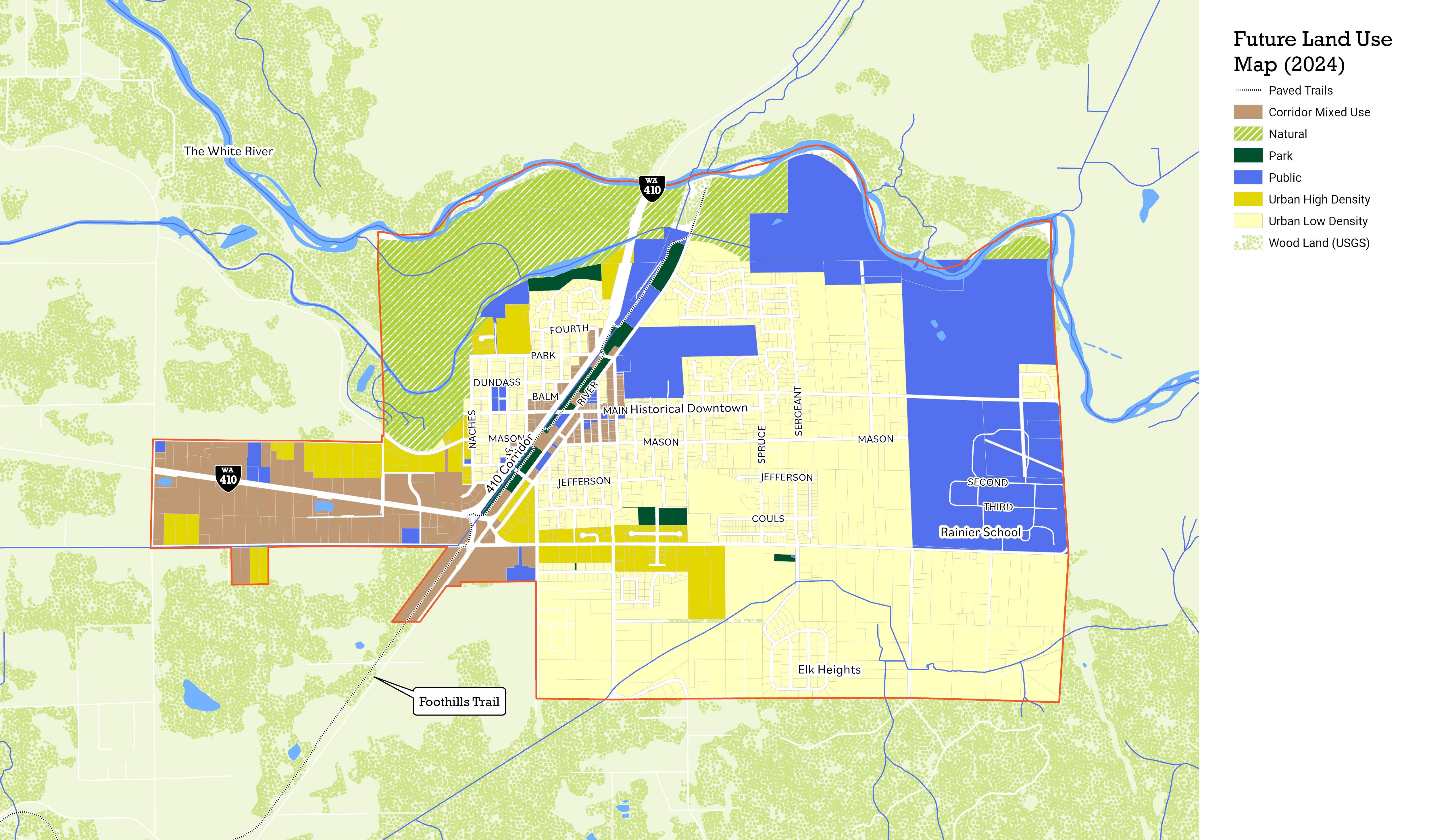
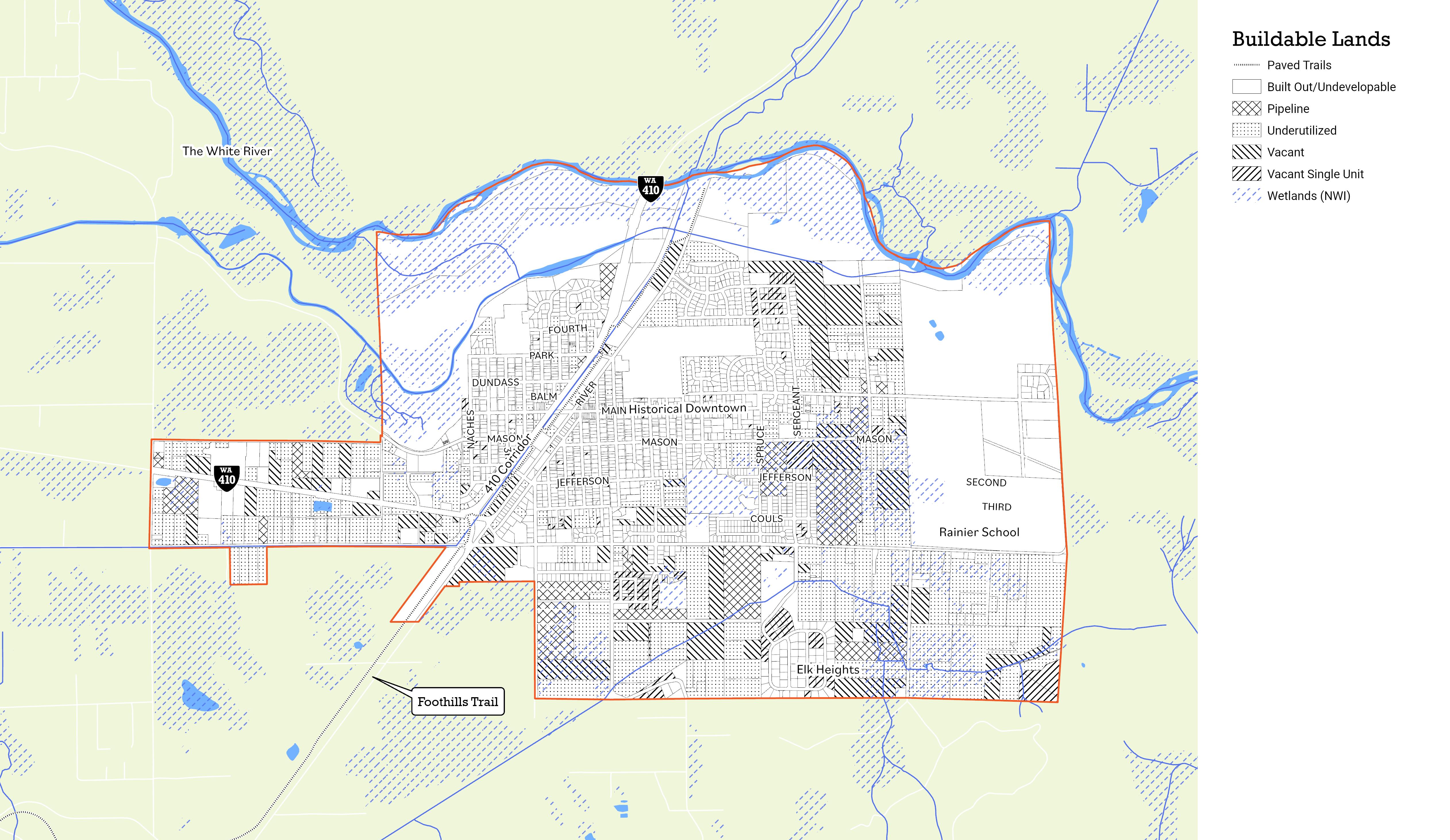
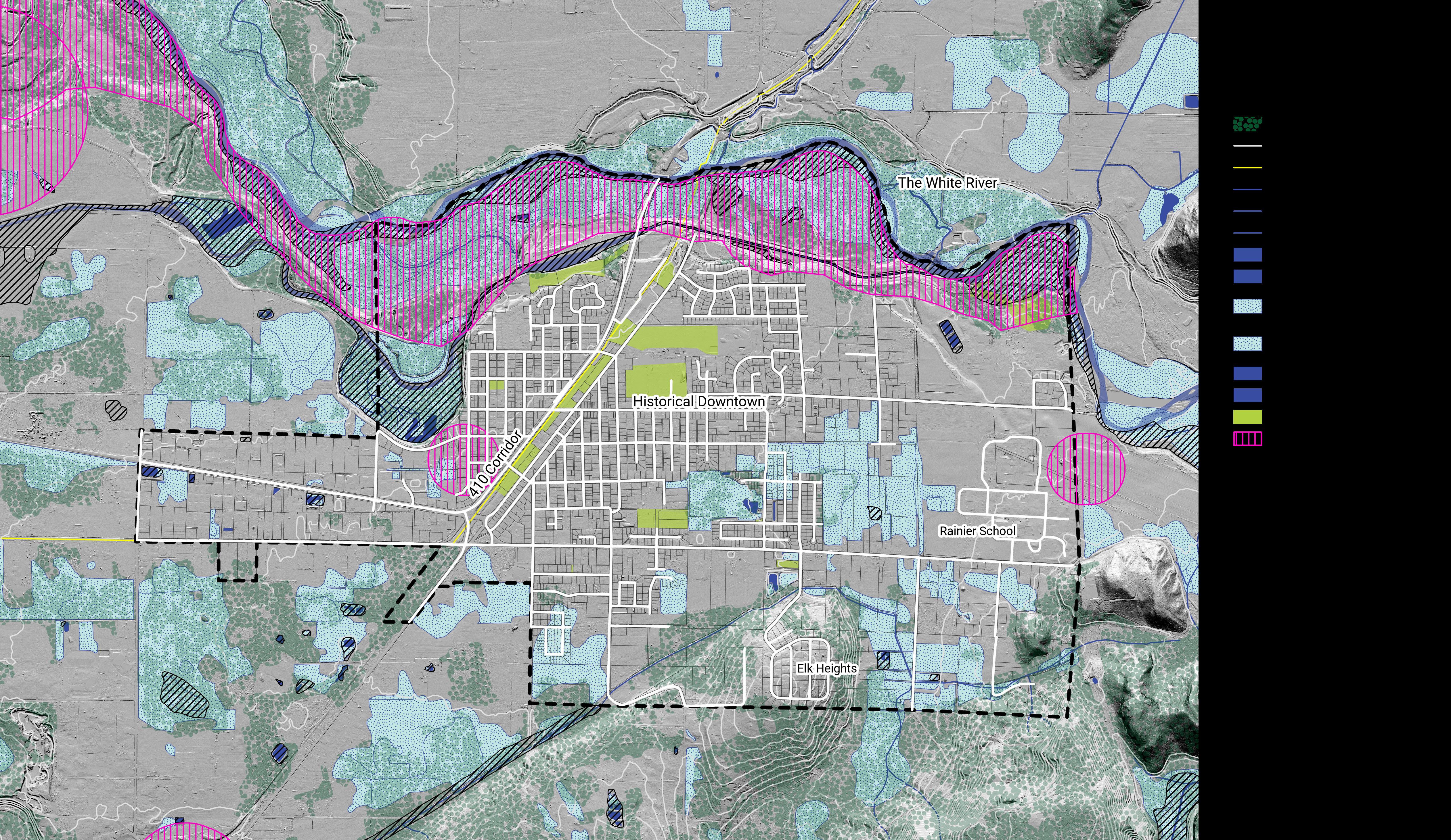
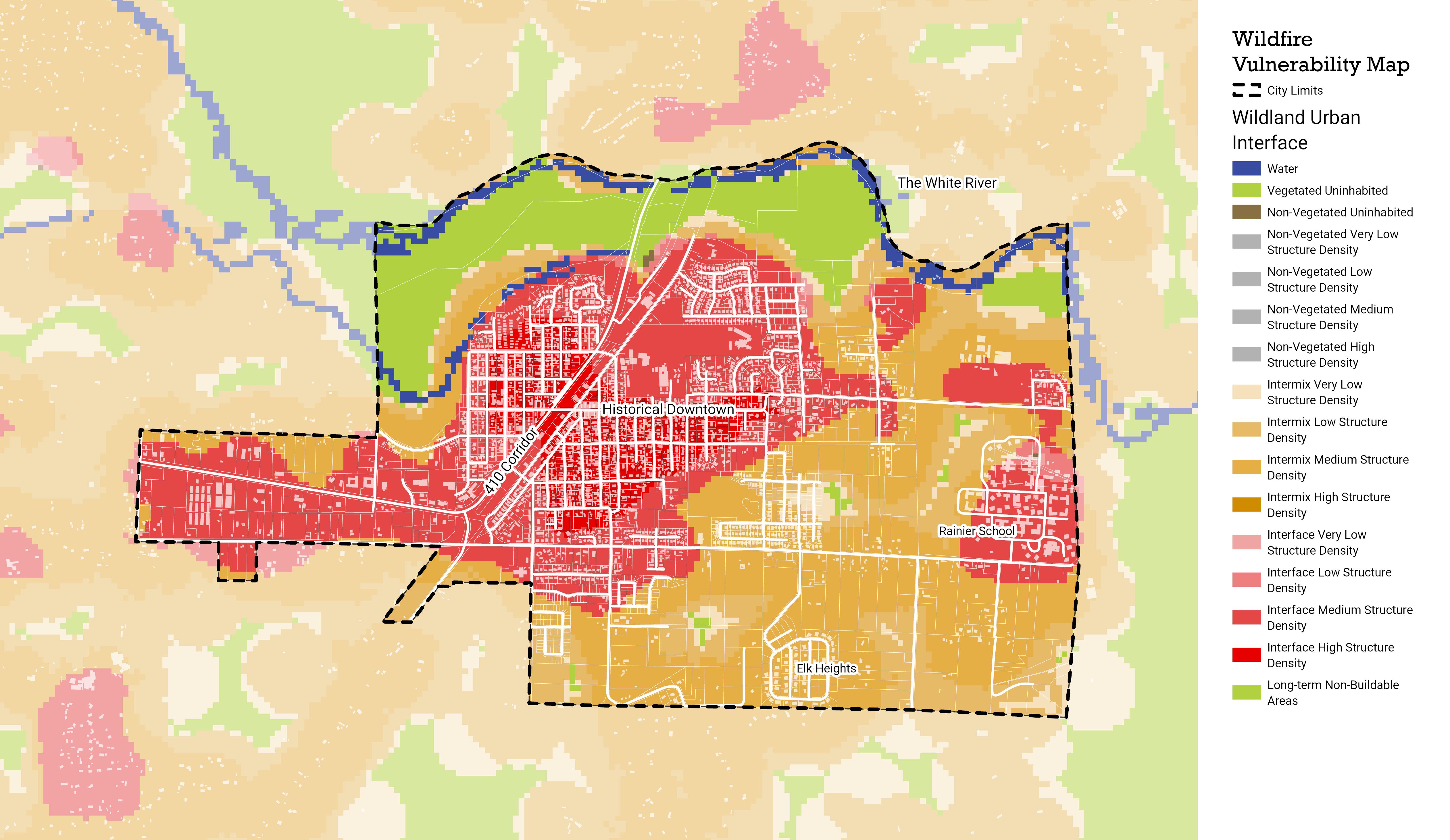
Glossary
Glossary Term Definition
Active Transportation
Accessory Dwelling
Area Median Income (AMI)
Refers to any form of human-powered transportation—walking, cycling, using a wheelchair, in-line skating or skateboarding.
“Accessory unit” means a second dwelling unit either in or added to an existing single-family detached dwelling, or in a separate accessory structure on the same lot as the main dwelling, for use as a complete, independent living facility with provision within the accessory apartment for cooking, eating, sanitation and sleeping. Such a dwelling is an accessory use to the main dwelling. Accessory units are also commonly known as “mother-in-law” units or “carriage houses.”
As opposed to the average income, AMI is the median of an income range in an area; half of the households make more than this, and half make less. Using a median rather than an average reduces the influence of small numbers of outliers, e.g. a few people making significantly more or less money than the general population.
Best Management Practices
These are defined by the Washington State Department of Ecology as physical, structural and/or managerial practices that, when used singly, or in combination, prevent or reduce pollution of water. The types of BMPs include source control, runoff treatment and stream -bank erosion control.
Character Community character is sum of all the attributes and assets that make a community unique, and that establish a sense of place for its residents. Factors that contribute to community character include parking and transportation, building design, natural features, other similar features.
City Pertains to the entirety of the city, emphasizing the population and activities within the city's geographical boundaries.
Climate Adaptation / Mitigation
Clustering
Community Refers to the full group of residents, workers, civil servants, and others who contribute to the city. Community is characterized by shared spaces, resources, and common goals that promote the well-being and development of the group. The Plan aims to create a supportive and collaborative community where everyone feels valued and included, and where everyone has access to opportunities and services that foster their participation and growth.
Compatible Land use compatibility means that uses can coexist in proximity to each other without resulting in undue negative impacts on either use. For example, an automobile assembly plant would be unlikely to be compatible with residential uses. Residential uses at varying densities, however, could be compatible with each other as could some residential and commercial uses. The standard for what is and is not compatible is determined by a number of factors, including the type of uses, the community’s historic development pattern and expectations and local development and design standards.
Comprehensive Plan A detailed document guiding the future actions of a community, covering land use, development, and infrastructure. The GMA establishes the comprehensive plan as the centerpiece of local long-range planning, which contains a vision, goals, policies, and strategies that are intended to guide day-to-day decisions by elected officials and local government staff. Each Washington city and county must periodically review and, if needed, revise its comprehensive plan and development regulations every 10 years.
Concurrency
Congestion
Climate adaptation refers to the process of adjusting infrastructure, policy, processes, and other systems to the new stresses and changing conditions induced by climate change. Mitigation refers to adjustments in our systems made with the intent to limit or avoid further emisions.
A development design technique that concentrates buildings or lots in specific areas on a site to allow remaining land to be used for recreation, common open space, or the preservation of historically or environmentally sensitive areas features.
Connectivity
Cottage Housing
Concurrency is a land use planning and implementation tool, introduced in the Washington State Growth Management Act (GMA), which is designed to ensure that necessary public facilities and services to support new development are available and adequate (based on adopted Level of Service standards) at the time of development.
Congestion results when traffic demand approaches or exceeds the available capacity of the system. While this is a simple concept, it is not constant. Traffic demands vary significantly depending on the season of the year, the day of the week and even the time of day. Also, the capacity, often mistaken as constant, can change because of weather, work zones, traffic incidents, or other non- recurring events.
The state or extent of being connected or interconnected for all modes of transportation.
Detached bungalow scale houses clustered around a common open space and/or private spaces aggregated together in a commons arrangement.
Critical Areas
Density Averaging
Include the following areas and ecosystems: (a) Wetlands; (b) areas with a critical recharging effect on aquifers used for potable water; (c) fish and wildlife habitat conservation areas; (d) frequently flooded areas; and (e) geologically hazardous areas (RCW 36.70A.030(5)).
Density averaging, also known as lot size averaging, allows the size of individual lots within a development to vary from the zoned maximum density, provided that the average density in the development as a whole meets that maximum.
Erosion Hazard Areas
Fair Housing
Erosion hazard areas means those areas in the City underlain by soils that are subject to severe erosion when disturbed. Such soils include, but are not limited to, those classified as having a severe or very severe erosion hazard according to the USDA Soil Conservation Service, the 1973 King County Soils Survey or any subsequent revisions or addition by or to these sources.
Fair Housing is the ability for all people to choose where they live without discrimination based on race, color, national origin, sex, family status, or disability—these are the “protected classes” under state and federal law. (Some places also protect age, sexual orientation, or having a Section 8 voucher). Cities may not make zoning or land use decisions or implement policies that exclude or otherwise discriminate against protected persons, including individuals with disabilities.
Floodplain
Functional Plans
Floodplain means the total area subject to inundation by the base flood, i.e., a flood having a one percent chance of being equaled or exceeded in any given year, often referred to as the 100- year flood.
“Functional plans” are detailed plans for facilities and services and action plans for other governmental activities such as parks, surface water, streets, etc. Functional plans should be consistent with the Comprehensive Plan.
Geologically Hazardous Areas
Growth Management Act (GMA)
Areas that because of their susceptibility to erosion, sliding, earthquake, or other geological events, are not suited to the siting of commercial, residential, or industrial development consistent with public health or safety concerns (RCW 36.70A.030(9)).
"The “Growth Management Act” (GMA) is the legislative act enacted by the Washington State legislature in 1990 and codified in RCW 36.70A. It requires certain counties and cities in the State to perform detailed and coordinated planning efforts to deal with rapid population growth and concerns with suburban sprawl, environmental protection, quality of life and related issues. “
Goal A general statement expressing a desired result consistent with the vision and towards which policies and objectives aim.
Habitat Area
HB 1110
An ecological or environmental area that is inhabited by a particular species of animal or plant. A place where a living thing lives is its habitat. It is a place where it can find food, shelter, protection and mates for reproduction.
This bill was adopted into law in 2023 by the Washington State Legislature. The goal of the bill is to allow middle housing development in residential areas across the state, by right. In short, smaller cities (25,000 - 75,000 people) are required to allow up to two or four units units on all lots zoned as primarily residential, depending on proximity to transit and affordability; and larger citys (at least 75,000 people) are required to allow up to four or six units on all residential lots, depending on proximity to transit and the affordability of the units.
HB 1220
This bill was adopted in 2021 by the Washington State Legislature. The bill mandates that cities plan for adaquate housing for all incomes when updating their comprehensive plans and other regulatory frameworks, and that cities strive to identify and undo disciminatory policies that have or could lead to displacement. Cities must designate sufficient land capacity for the required number of housing units at each income level, as determined by the Department of Commerse, rather than generic, unspecified units, as was previousely required.
Human Scale
Infill
Human scale means that the size of the building relates to the approximate dimensions of the human body.
Urban infill is defined as new development that is sited on vacant or undeveloped land within an existing community, and that is enclosed by other types of development. The term “urban infill” itself implies that existing land is mostly built-out and what is being built is in effect “filling in” the gaps. The term most commonly refers to building single-family homes in existing neighborhoods but may also be used to describe new development in commercial, office or mixed-use areas.
Intersection Transportation Level of Service
Level of Service (LOS) measures average peak hour delay for vehicles at key intersections. LOS is expressed qualitatively using letters A through F, with A representing very good operations and F representing undesirable operations.
Local Government Operations (LGO)
Location Efficient Housing
Areas potentially subject to risk of mass movement due to a combination of geologic, topographic and hydrologic factors. These areas are typically susceptible to landslides because of a combination of factors including: bedrock, soil, slope gradient, slope aspect, geologic structure, groundwater, or other factors.
Refers to facilities, staff, and programs under the direct control of the municipal government. While often synonymous with actions taken by the City, specific references like "City Staff" or "City Facilities" might still be used where appropriate.
Location-efficient housing refers to homes that have easy or inexpensive access to workplaces, schools, shopping and other necessary destinations. Housing locations are efficient to the most people when the ways to these destinations are easily walkable, don’t require the resident to own an automobile and can be reached in 20 minutes or less.
Low Impact Development
Manufactured Home
"Design concepts including a variety of strategies and techniques to address the negative impacts associated with stormwater runoff, such as, but not limited to
Reduce the street width and road network within a development.
Replace impervious roadways, driveways and sidewalks with more pervious materials where feasible.
Reduce lot size and setbacks/frontage requirements through cluster designs.
Increase retention of forested open space and better protect critical areas.
Direct stormwater runoff to vegetated bioretention areas where shallow storage is used to promote infiltration and evaporation.
Eliminate conventional pipe and catch basins to increase time of concentration by promoting sheet and shallow concentrated flow.
Enhance soil conditions on site by preservation of existing topsoil structure, soil amendments and protection from compaction during construction.
Reuse of runoff for non-potable application onsite."
A type of prefabricated housing that is largely assembled in factories and then transported to sites of use. Manufactured homes are built as dwelling units of at least 320 square feet in size with a permanent chassis to assure the initial and continued transportability of the home. The requirement to have a wheeled chassis permanently attached differentiates “manufactured housing” from other types of prefabricated homes, such as modular homes.
May When “may” is used in a policy, such language indicates the City has the option to take steps to accomplish the purpose of the policy.
Middle Housing
Multifamily Dwelling; Dwelling, Attached
"...a range of house-scale buildings with multiple units—compatible in scale and form with detached single-family homes—located in a walkable neighborhood." - Opticos Design. This typically includes multiplexes, townhomes, cottage housing, and small apartment buildings of three to five floors.
A one-family dwelling attached to one or more one-family dwellings by common roofs, walls, or floors.
Flat A residential building containing two (2) or more dwelling units which are attached at one or more common roofs, walls, or floors. Typically, the unit’s habitable area is provided on a single level. Unit entrances may or may not be provided from a common corridor.
Townhouse
Natural Area
A one-family, ground-related dwelling attached to one or more such units in which each unit has its own exterior, ground-level access to the outside, no unit is located over another unit and each unit is separated from any other unit by one or more vertical common walls. Typically the units are multi-story.
Natural areas are characterized as undeveloped landscapes containing vegetation, slopes, streams, lakes, pollinator habitat and other features that have developed through natural growth and evolution rather than planned development or construction.
Objective A statement establishing a measurable target or specific task to be accomplished for the purpose of achieving a goal’s desired result.
Passive Recreation
Outdoor recreational activities, such as nature observation, hiking and canoeing or kayaking, that require a minimum of facilities or development and that have minimal environmental impact on the recreational site.
Policy A statement giving guidance to decision makers for the purpose of achieving a goal’s desired result.
Priority Species
Those species considered to be priorities for conservation and management and identified in the Washington Department of Fish and Wildlife Priority Habitat and Species (PHS) List.
Salmonid A fish of the salmon family.
Sensitive Lake
Sensitive lakes are those lakes particularly prone to eutrophication from increased phosphorus loading, which can occur due to a combination of water quality characteristics and watershed land development. Eutrophication of a lake can result in increased vegetation and algae growth, depletion of oxygen in bottom waters, decreased visibility in the water and some impairment of recreational use. Taken to the extreme, hypereutrophic lakes are characterized by high algal productivity and intense algae blooms, fish kills due to oxygen depletion and frequent impairment of recreational uses. Land development and use contributes to increased phosphorus loadings to downstream water resources in several ways. Erosion of disturbed areas on construction sites can result in sediment transport to surface waters, which can cause algal blooms. Over-application of fertilizers and the discharge of detergents containing phosphates to the storm drainage system can also increase watershed loading of phosphorus.
Shall When “shall” is used in a policy, such language requires that the City take steps to accomplish the purpose of the policy.
Should When “should” is used in a policy, such language indicates the City has the option to take steps to accomplish the purpose of the policy.
Single Family
Dwelling
Special Needs
Housing
A building containing one dwelling unit which is not attached to any other dwelling by any means except fences, has a permanent foundation and is surrounded by open space or yards.
Special needs housing in this plan includes homes suitable for and occupied by people with one or more self-help limitations, such as physical or mental disability, long-term illness, or alcohol or drug issues. The housing may or may not incorporate supportive services, and may be permanent or transitional. Examples include adult family homes, assisted living facilities and group homes for people with developmental disabilities.
Sustainable Community
Stormwater
Water from rainfall and snow that runs off surfaces such as rooftops, paved streets, highways, and parking lots and flows into surface water including drainage facilities, rivers, streams, lakes, or Puget Sound. Stormwater can also come from hard grassy surfaces like lawns, play fields, and from graveled roads.
Surface Water Water found above the land, including oceans, estuaries, lakes, rivers, streams, and ponds.
Transfer of Development Rights
In a sustainable community, resource consumption is balanced by resources assimilated by the ecosystem. The sustainability of a community is determined by the availability of resources and by the ability of natural systems to process its wastes. A community is unsustainable if it consumes resources faster than they can be renewed, produces more wastes than natural systems can process or relies upon distant sources for its basic needs.
Transfer of Development Rights (TDR) means the transfer of the right to develop or build from sending sites to receiving sites. The sending site is the parcel of land from which development rights will be transferred. After transferring the development rights from the sending parcel, future development is limited. Receiving sites are sites to which development rights are transferred. Typically, these are parcels of land in urban areas where the existing services and infrastructure can accommodate additional growth. Development rights that are “sent” off of a sending site are placed on a receiving site.
Transit Oriented Development Transit-oriented development (TOD) describes a mix of housing, office, retail and amenities integrated into a walkable neighborhood and anchored by high quality public transit.
Total Maximum Daily Load A Total Maximum Daily Load (TMDL) is a regulatory term in the U.S. Clean Water Act, describing a value of the maximum amount of a pollutant that a body of water can receive while still meeting water quality standards
Universal Design Universal Design refers to a broad spectrum of ideas meant to produce products, buildings, or other built environments that are usable to the greatest extent possible by everyone, regardless of their age, ability, or status in life. Wheelchair ramps, essential for people in wheelchairs but also used by all, are a common example. There are also cabinets with pull-out shelves, kitchen counters at several heights to accommodate different tasks and postures and low-floor buses that “kneel” (bring their front end to ground level, rather than on-board lifts).
Vision A description of the community as desired. It serves as the keystone upon which goals, policies and objectives are based.
Volume to Capacity (V/C)
VISION 2050 is the region’s plan to provide an exceptional quality of life, opportunity for all, connected communities, a spectacular natural environment, and an innovative, thriving economy. Developed by the Puget Sound Regional Council, VISION 2050’s multicounty planning policies, actions, and regional growth strategy guide how and where the Puget Sound grows through 2050. The plan informs updates to the Regional Transportation Plan and Regional Economic Strategy. VISION 2050 also sets the stage for updates to countywide planning policies and local comprehensive plans done by cities and counties.
The rate of comparison of roadway demand (vehicle volumes) with roadway supply (carrying capacity).
Wetland or Wetlands
Areas that are inundated or saturated by surface water or ground water at a frequency and duration sufficient to support, and that under normal circumstances do support, a prevalence of vegetation typically adapted for life in saturated soil conditions. Wetlands generally include swamps, marshes, bogs and similar areas. Wetlands do not include those artificial wetlands intentionally created from nonwetland sites, including, but not limited to, irrigation and drainage ditches, grass-lined swales, canals, detention facilities, wastewater treatment facilities, farm ponds and landscape amenities, or those wetlands created after July 1, 1990, that were unintentionally created as a result of the construction of a road, street, or highway. Wetlands may include those artificial wetlands intentionally created from nonwetland areas created to mitigate conversion of wetlands (RCW 36.70A.030(20)).
Park system
Parking, offstreet
Permitted use
Planned unit development
“Park system” means the combined facilities and properties in the city that are dedicated to park, open space and recreational purposes.
“Off-street parking” means any space, specifically allotted to the parking of motor vehicles not located in a dedicated right-of-way, a travel lane, a service drive, nor any easement for public ingress or egress so as to block access.
“Permitted use” means any land use authorized in a specific zone and subject to the limitations of the regulation of such zone.
“Planned Unit Development” (PUD) means a zoning mechanism which allows for flexibility in the grouping, placement, size and use of structures on a fairly large tract of land. A PUD is developed as a single entity, using a public process which incorporates design review.
Planting strip A “planting strip” is a continuous or intermittent strip of land located between the curb and the sidewalk, so that visual separation between pedestrians and vehicles is provided.
Plat “Plat” means a map or representation of a subdivision showing the division of a tract or parcel of land into lots, blocks, streets and alleys or other divisions and dedications.
Policy A “policy” is a definite course or method of action, which guides and determines present and future decision-making.
Preservation “Preservation” means to keep in perfect or unaltered condition; maintain unchanged or intact.
Principal arterial “Principle arterials” primarily function to expedite through traffic between major traffic generators. Traffic generators include central business districts, regional shopping centers, cities, freeways and lower arterial systems.
Priority species “Priority species” are species that require protective measures for their perpetuation due to their population status, sensitivity to habitat alteration, and/or recreational, commercial, or tribal importance. Priority species include State Endangered, Threatened, Sensitive, and Candidate species; animal aggregations considered vulnerable; and those species of recreational, commercial, or tribal importance that are vulnerable.
Public benefit features
“Public benefit features” mean amenities, uses, and other features of benefit to the public, which are provided by a developer and which sometimes qualify for an increases in density. Examples include public open space, pedestrian improvements, housing, and provision of human services.
Public services “Public services” include fire protection and suppression, law enforcement, public health, education, recreation, environmental protection, and other governmental services.
Resource lands “Resource lands” are lands primarily devoted to the commercial production of agricultural, timber, or mineral products.
Restoration
Right-of-way
“Restoration” means a human activity that returns a wetland or former wetland from a disturbed or altered condition with lesser acreage or functions to a previous condition with greater wetland acreage or functions.
“Right-of-way” means the land held by the public for road and utility purposes. It usually refers to the land required for the traffic lanes plus the shoulders and drainage structures on both sides of highways, roadways, bikeways and alleys.
Riparian corridors
“Riparian corridors” include land located on the banks of rivers and streams that supports riparian vegetation and wildlife and performs important watershed functions.
Row house “Row house” means one of a row of identical houses situated side by side and sharing common walls
Rural “Rural” means sparsely settled or agricultural land.
Screening “Screening” means effectively obscuring the view of unsightly uses from the public right-of-way or private lots.
Shall, will, must When a goal, objective or policy states that the City “shall” or “will” do something, such language requires that the City take measurable steps to accomplish the purpose of the original policy.
Should, may, encourage When a goal, objective or policy states that the City “should”, “may”, or “encourage” to do something, such language requires that the City make an effort to accomplish the purpose of the original policy.
Through lot “Through lot” means a lot other than a corner lot with frontage on more than one street. Through lots abutting two streets may be referred to as double frontage lots.
Townhouse “Townhouse” means a type of attached multifamily dwelling in a row of at least three in which each unit has its own front and rear access to the outside, no unit is located over another unit, and each unit is separated from any other unit by one or more vertical common fire-resistant walls.
Transit-oriented development
Urban design
“Transit oriented development” means moderate to higher density development, located within an easy walk of a major transit stop, generally with a mix of residential, employment, and shopping opportunities designed for pedestrians without excluding the auto.
“Urban design” is architecture at the city scale; it considers the way buildings, streets, and the spaces between them relate to one another with the goal of creating vibrant, welcoming urban environments.
Urban forest “Urban forest” refers to land in urban areas that is managed for its production or for preservation of its forest characteristic.
Urban growth
“Urban growth” refers to growth that makes intensive use of land for the location of buildings, structures, and impermeable surfaces to such a degree as to be incompatible with the primary use of land for the production of food, other agricultural products, or fiber, or the extraction of mineral resources, rural uses, rural development, and natural resource lands designated pursuant to RCW 36.70A.170.
Urban growth area
Way-finding
“Urban growth areas” (UGAs) are those areas designated by a county in which urban growth is directed. “Urban growth should be located first in areas already characterized by urban growth that have adequate existing public facility and service capacities to serve such development, second in areas already characterized by urban growth that will be served adequately by a combination of both existing public facilities and services and any additional needed public facilities and services that are provided by either public or private sources, and third in the remaining portions of the urban growth areas.” RCW 36.70A.110
“Way-finding” means a coordinated system of off-premises directional signs incorporating general public information.
Wildlife habitat
Wildlife (habitat) corridor
Zero lot line
Zoning map
“Wildlife habitat” means the specific areas or environments in which a particular type of plant or animal lives. An organism’s primary and secondary habitat provides all the basic requirements for life of the organism.
“Wildlife (habitat) corridor” means the linear wildlife habitat area that allows for free movement of species through a geographic area.
“Zero lot line” means the positioning of a structure on a lot so that one side rests directly on the lot’s boundary line.
“Zoning map” means the map which illustrates the boundary lines of the particular zones within the City.
Zoning ordinance The “zoning ordinance” is that body of law which regulates the structure and use of buildings. Within each zone different development standards are applied to protect the health, safety and welfare of the community.

