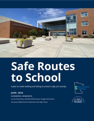
Safe Routes to School
A plan to make walking and biking to school a safe, fun activity.
JUNE, 2024
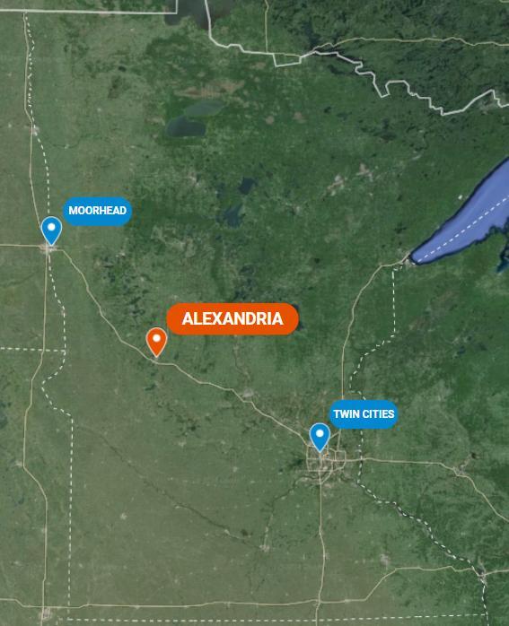
ALEXANDRIA, MINNESOTA
Lincoln Elementary, Woodland Elementary, Voyager Elementary,
Discovery Middle School, Alexandria Area High School
Acknowledgements
We gratefully acknowledge the participation of the following individuals and organizations in the development of the Alexandria Safe Routes to School (SRTS) Plan.
SRTS PLANNING TEAM
Lukas Gotto, Technology Integration Specialist
Alexandria Public School SRTS Team Chair
Tracy Von Bargen, Engineer Widseth
Brendan Bogart, Principal Lincoln Elementary
Rosemary Bruce, Principal Planner MnDOT District 4
Brody Buse, Student
Alexandria Public Schools
Jake Capistrant, Parent/Business Owner
Jake’s Bikes
Dana Christiansen, Principal Voyager Elementary School
Chad Duwenhoegger, Principal Alexandria Area High School
Kim Eggebraaten, Parent Alexandria Public Schools
Tim Eggebraaten, Parent Alexandria Public Schools
Tim Erickson, Engineer Douglas County
Prepared by West Central Initiative
Blaine Green, Engineer City of Alexandria, Widseth
Angie Hasbrouck, Health Educator Horizon Public Health
Maggie Johnson, Health Educator Horizon Public Health
Sarah Kosters, Assistant Principal Discovery Middle School
Amie Moos, Transportation Director
Alexandria Public Schools
James Ross, Police Officer Alexandria Police Department
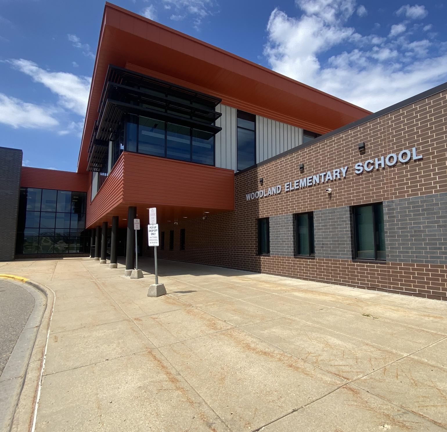
Stephanie Ruegemer, Principal Woodland Elementary School
Mary Safgren, Planning Director MnDOT District 4
Rick Sansted, Superintendent Alexandria Public Schools
Tim Schoonhoven, Engineer City of Alexandria, Widseth
Mike Weber, City Planner City of Alexandria
Principal Author – Mallory Jarvi, Transportation Planner with assistance from Wayne Hurley, Director of Transportation Planning and Aaliyah Helland, Minnesota GreenCorps Member


ORGANIZATION OF THIS REPORT
This report is designed to support and be accessible to multiple groups of people involved with Safe Routes to School in Alexandria, including students, caregivers, teachers, school administrators, city staff, elected officials, and county and state employees. This plan focuses on key information and recommendations, while the appendices document additional participation, analysis, resources, and deliberation that shaped the development of the plan.
The Vision
The City of Alexandria, along with the Alexandria Public Schools, are seeking to become a community where it is safe and convenient for all children to walk and bicycle to and from school. We will strive to be a place where our children can travel under their own power, explore, and play in their community safely, and where they learn life-long habits of incorporating physical activity into their daily lives. We will seek to achieve this vision through safety awareness, education, encouragement, and self-evaluation, all while building the infrastructure needed to make walking and bicycling safer and more convenient for all.
THE 6 E’S
Safe Routes to School (SRTS) programs rely on six core strategies, called the “Six Es”, to work towards their vision.
EQUITY – THE OVERARCHING E
Prioritizing positive outcomes for students from lower-income households; Black, Indigenous, and other students of color; students with disabilities; and other students who face disproportionate barriers to walking, biking, and rolling to school because of their group membership. This plan uses the term “priority populations” to refer to disproportionately impacted groups of students and other community members.
ENGAGEMENT
Working with students, families, school staff, and community members and organizations, especially those from priority populations, to identify needs, better understand barriers, and create solutions together for walking, biking, and rolling.
ENGINEERING
Developing Equity-focused changes to the built environment that support youth travel, designed and prioritized through community Engagement.
EDUCATION
Providing students and other community members, especially those from priority populations, with skills and knowledge about walking, biking, and rolling.
ENCOURAGEMENT
Normalizing a culture of walking, biking, and rolling through incentive programs, events, and activities that center priority populations.
EVALUATION
Measuring how Safe Routes to School initiatives are implemented (process evaluation) and what their impacts are (outcome evaluation), especially how initiatives Engage with and support priority populations.
Why Safe Routes to School?
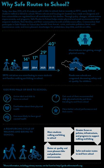
Equity in SRTS
Disparities in access to resources such as high-quality jobs, schools, parks, healthcare, food, and a full range of transportation choices impact the health and wellbeing of communities. These differences are not random they are the results of government policy and funding in the past and present, which has worked to the benefit of some and to the disadvantage of others.
Equity in Safe Routes to School is impacted by transportation system inequities such as limited access to high-quality walking and biking infrastructure or the presence of highways or busy roads in lowerincome neighborhoods and neighborhoods with more BIPOC (Black, Indigenous, and People of Color) individuals as well as inequities in related systems. For example, racial wealth inequities and racial discrimination in housing mean that BIPOC or lowerincome students may live further away from schools than their white peers and those from higher-income families.
Safe Routes to School works to improve walking and biking opportunities for all students, while addressing these inequities through programs, infrastructure, and policy improvements that specifically help priority populations. Priority populations include individuals, groups, and communities who are more likely to rely on walking, biking, or transit for transportation; are more vulnerable to unsafe traffic conditions; or have suffered historic disinvestment in safe, comfortable, walking and biking infrastructure. By looking at demographic data, examining existing transportation services and policies, and speaking with members of the community, the Boeckman Safe Routes to School team worked to develop recommendations that support equity in walking and biking to school.
Alexandria Community in Context
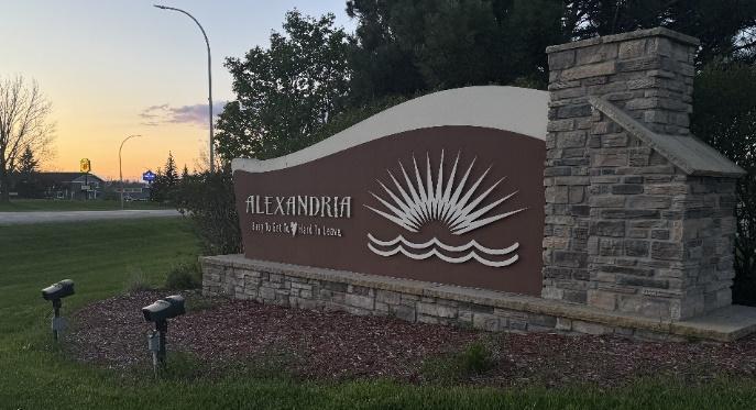
‘Easy to get to, hard to leave.'
-City of Alexandria
Alexandria is a regional hub in west central Minnesota located along I-94. Alexandria is located 60 miles northwest of St. Cloud and 100 miles southeast of the Fargo/Moorhead metro area Alexandria is located in the southeast corner of Douglas County.
Alexandria has a population of 14,335 The demographic makeup of the population is 90% White, 4.4% Hispanic or Latino, 2.4% two or more races, and 1% Asian or Pacific Islander. The community is well dispersed in age with 20.4% 17 years or younger, 57.3% between 18-64, and 22.3% 65-years and older.
The average household size is 1.6. The median household income is $57,309, and 50.5% of housing units are owned by the owner. Alexandria is an educated community, with 95% of residents having a high school degree or higher and 30.2% having a bachelor’s degree or higher.
Alexandria’s workforce mostly commutes within the city, with 37.5% commuting less than 10 minutes and 40.9% between 10-19 minutes. According to Alexandria’s 2040 Plan, 26.9% of Alexandria workers live within the city limits. To travel to work 12.9% walk, bike, or work from home, and 86.9% take a car, truck, or van. Alexandria has a high potential to increase its active transportation commuters due to the high percentage of commuters taking less than 10 minutes to arrive at their location if they are not using active transportation already.
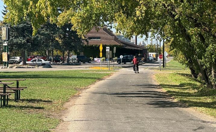
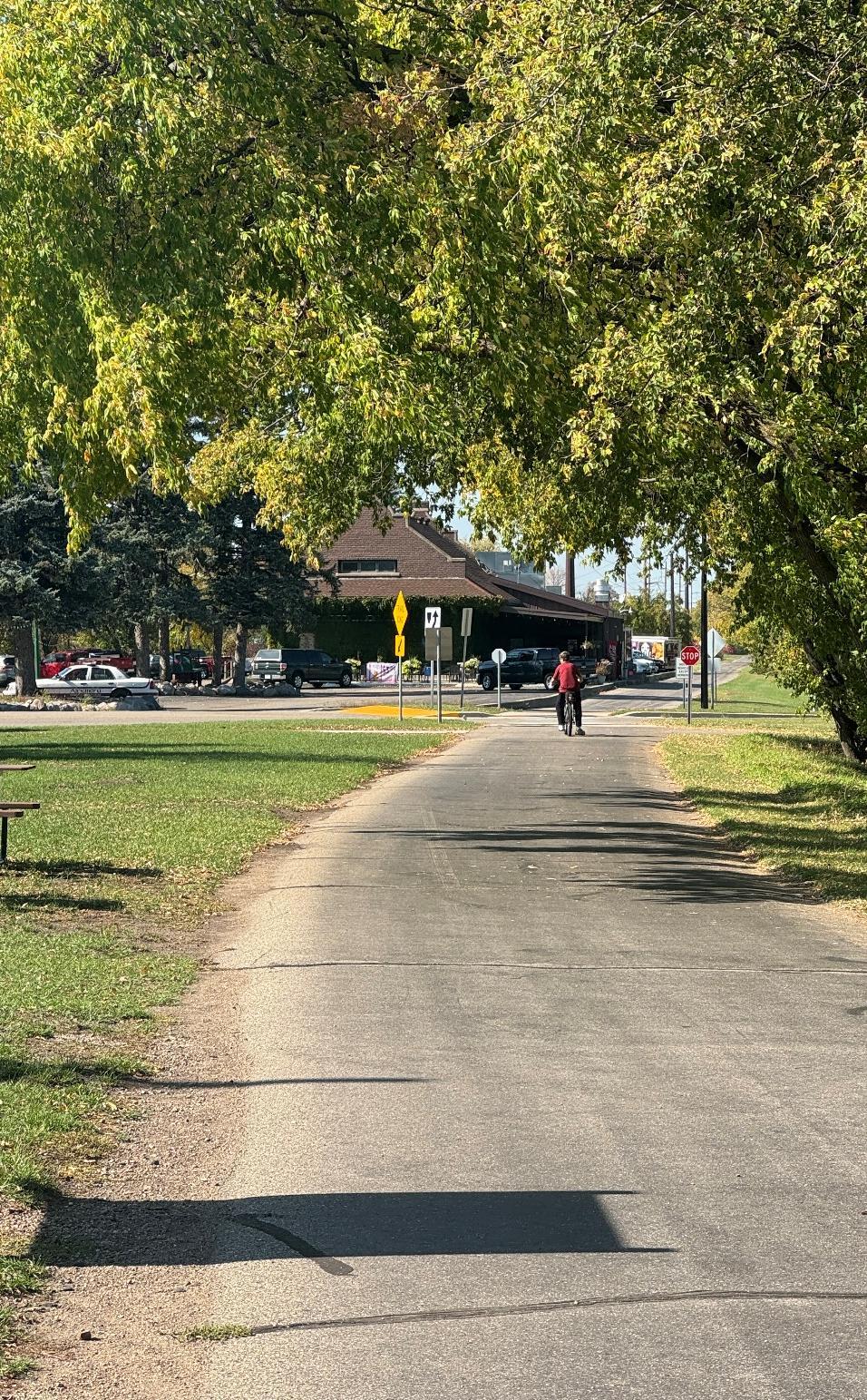
Alexandria is a community surrounded by natural resources and recreational opportunities. The Central Lakes Trail offers an east-west corridor through the heart of the community, with bike trails spurring off to different destinations. Additional biking amenities include mountain biking at Lake Brophy County Park and the nearby Kensington Runestone Park. Alexandria also has county and state parks where visitors can kayak, hike, and swim.
Alexandria is a city of lakes. With over 350 lakes in the area, residents and visitors have their choice of water recreation and enjoyment. Alexandria is also the regional hub and county seat. Multiple large industries and employers support the local economy, making the economy strong and the population growing.
Alexandria City Plans
SRTS COMPREHENSIVE PLANS –DISCOVERY, LINCOLN, VOYAGER
The City of Alexandria and Alexandria Public Schools completed a SRTS plan in 2011 for Discovery Middle School, Lincoln Elementary, and Voyager Elementary. Work in this current plan builds off past work and recommendations. Links to the plans can be found here: Discovery, Lincoln, Voyager
ALEXANDRIA PARKS AND TRAILS MASTER PLAN
The Alexandria Parks and Trails Master Plan comprehensively examines the Alexandria Park system and trail connections and provides detailed examples of how to enhance and expand parks throughout the city. Specific projects of note are:
• Lake View Park traffic garden
• Summer Meadows regional trail connection
• Lake Connie Park regional trail connection
The Alexandria Safe Routes to School team supports the Safe Routes to Parks movement, and thus the future development of the parks and trails presented in the Parks and Trails Master Plan for the City of Alexandria.

Excerpt from the Alexandria Parks and Trail Master Plan depicting the Lake View Park concept which includes a traffic garden.
ALEXANDRIA 2040
The Alexandria 2040 Comprehensive Plan was completed in 2020. Within the Transportation chapter of the plan, the non-motorized transportation network is evaluated, and recommendations are presented to create better network connectivity. Alexandria supports the use of the Complete Streets framework and creating infrastructure that is PROWAG compliant. The overarching vision for the Alexandria transportation system is that “The City of Alexandria will be a place where a local transportation network provides businesses, residents, and visitors with multiple options for mobility throughout the Community and connects the City regionally.”
Goals and Policies that support active transportation:
• The City’s transportation system will continue to diversify its mobility options to improve travel by automobile, pedestrian, bicycle and transit.
• Ensure existing infrastructure is maintained and upgraded in a cost effective and timely manner that provides optimum service to the community.
• Promote and sustain an affordable, safe and convenient transportation network including local, county and state roadways and amenities.
• Provide a transportation system that supports multi-modal transportation whenever and wherever feasible and advantageous.
Non-motorized transportation strategies:
• Identify new east-west and north-south trail connections in the City
• Fill gaps in the sidewalk and trail network, especially in the southern portion of the City
• Improve pedestrian safety and access throughout the City, including crossings of busy roadways
• Encourage biking and walking and incorporate ADA improvements
Alexandria Public Schools
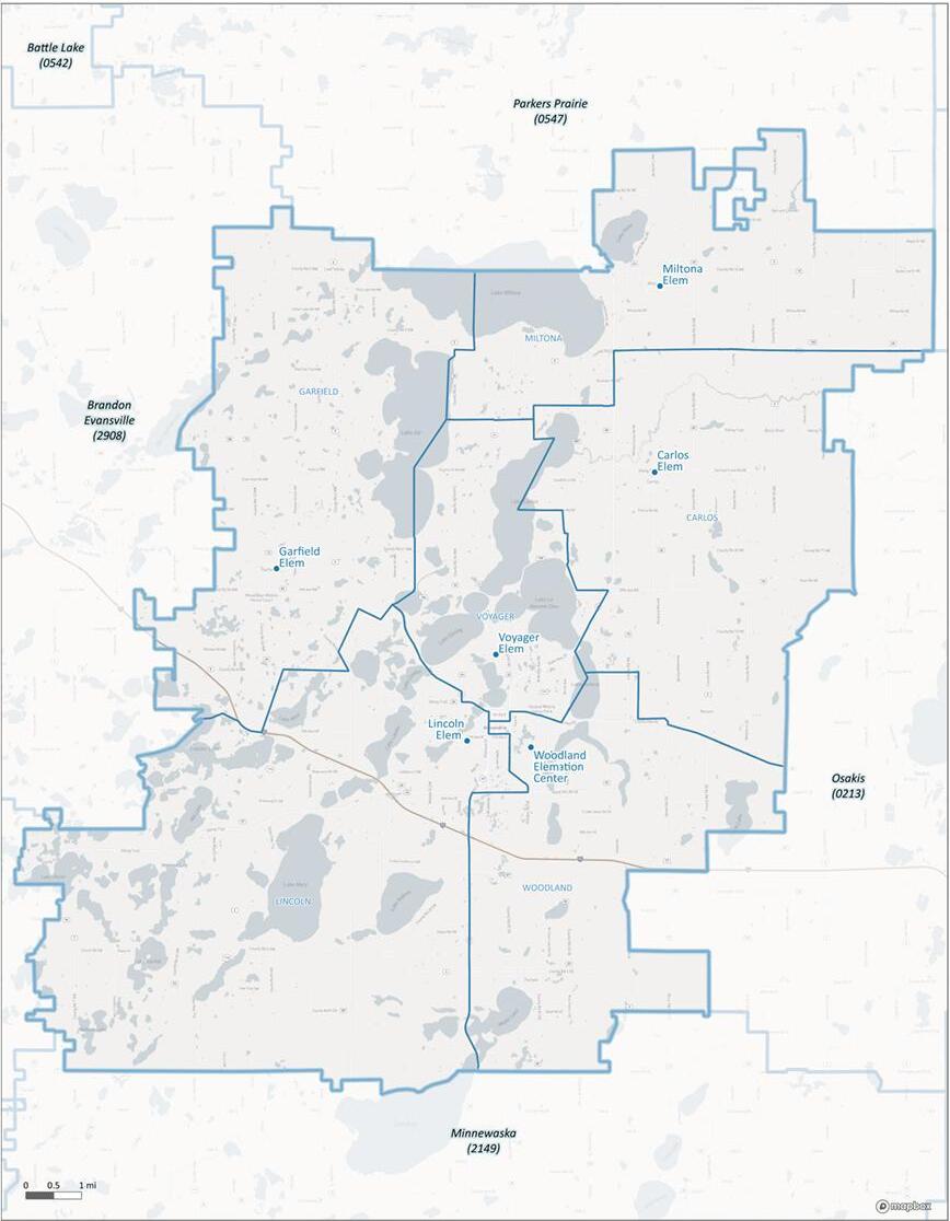
Map of the Alexandria School District boundaries courtesy of the Minnesota Department of Education.
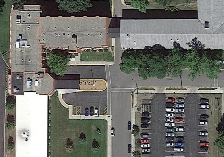
LINCOLN ELEMENTARY SCHOOL
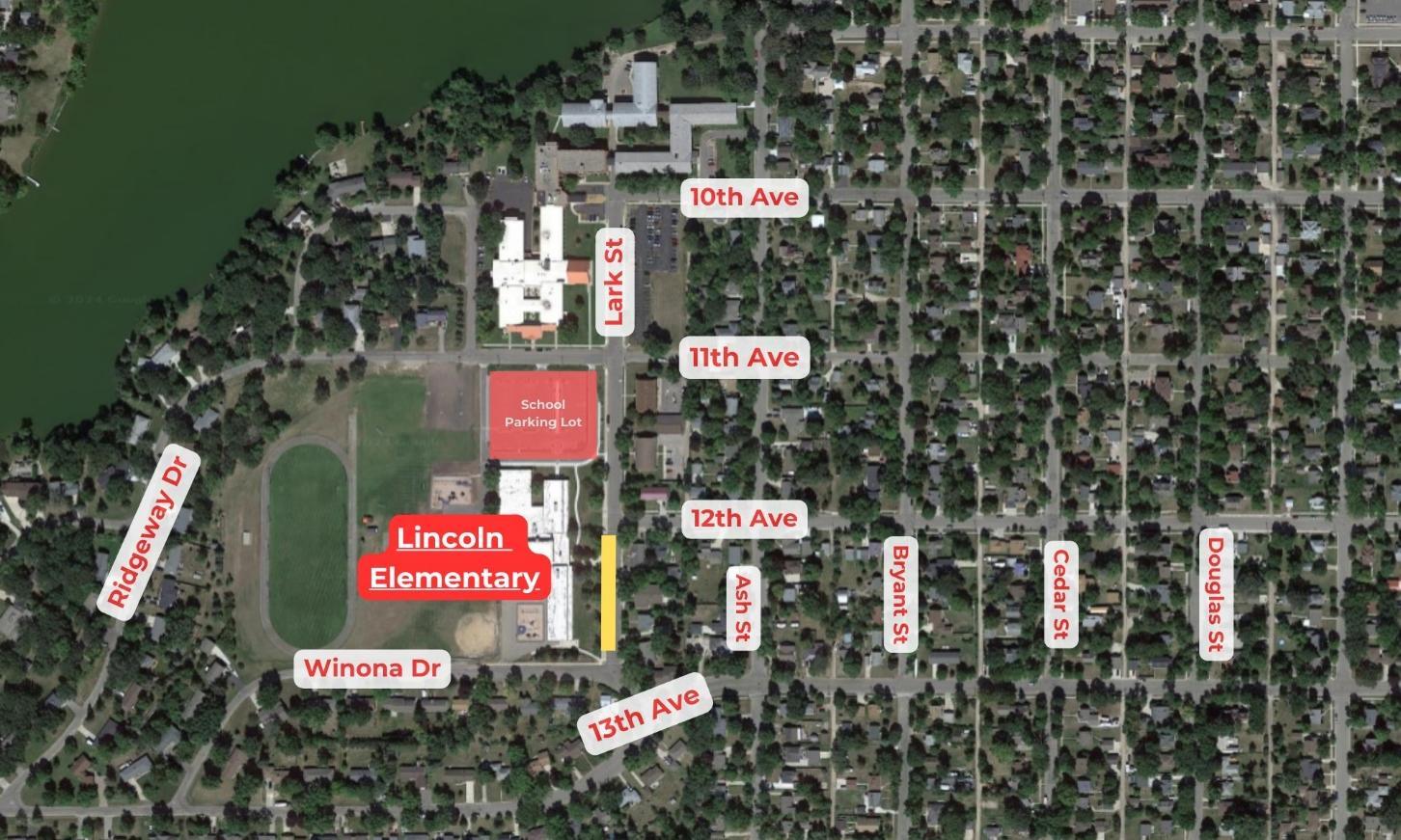
SITE CIRCULATION
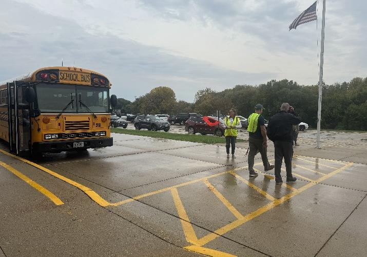
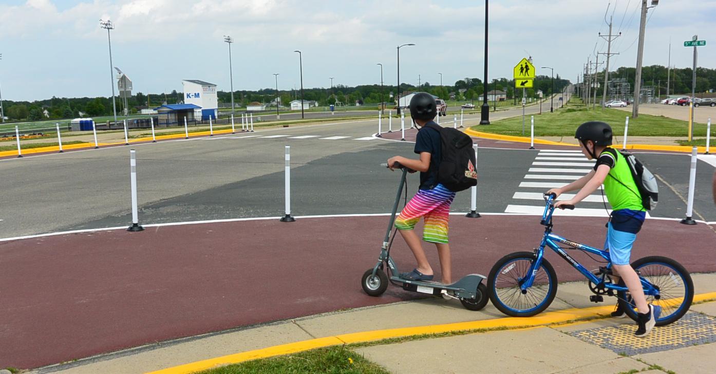
Pedestrians: In the morning students were observed traveling primarily from eastern Alexandria. Many students traveled down 12th Ave toward Lincoln to use the crosswalk which is monitored by student patrol. Students coming from the south would go towards the intersection of Ash, 13th Avenue, and Winona Drive where another set of student patrol monitor the crosswalks. A small group of students was observed walking from the southwest neighborhoods along Ridgeway and Winona Drives. Students coming from the south do not have accessible sidewalks and must walk in the street. There were many students who were dropped off a block from school and were then walked to the front of the school.
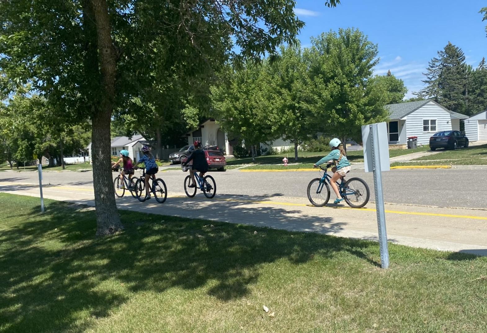
Bicyclists: There were a number of bicyclists biking to and from Lincoln. Eight bicyclists came from south of the school along Winona Drive, and another three from along 13th Avenue. A majority of bicyclists wore helmets, but at least three did not. Bicyclists' behavior was overall good, with some instances of biking in the wrong part of the road.
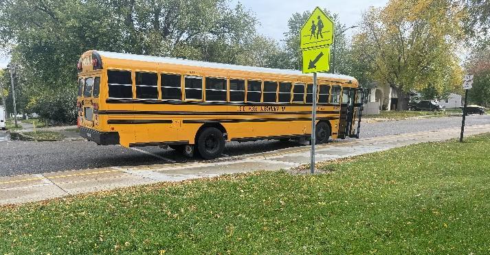
School Buses: Buses park along the west side of Lark Street in front of the school at their signed location. Buses leaving Lincoln can be used to transition to a new school. Many older students were observed arriving at the school to be dropped off at the middle or high school.
Transit: The Rainbow Riders bus service can be used to drop off students at school. No students were observed using the bus system.
Vehicles: Elementary drop-off and pick-up are located in the school parking lot north of the school. This student drop-off/pickup is a one-way, separated loop from the rest of the parking lot. The entrance to the parking lot is along 11th Avenue, which causes congestion at the intersection of 11th Avenue and Lark. There were observances of poor driver behavior with 15 not stopping for stop signs, 11 distracted drivers, 17 stopping outside designated space, and 7 instances where drivers did not yield to pedestrians.
More information on site circulation can be seen in Appendix A.
VOYAGER ELEMENTARY SCHOOL
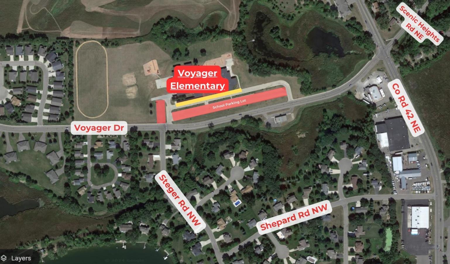
SITE CIRCULATION
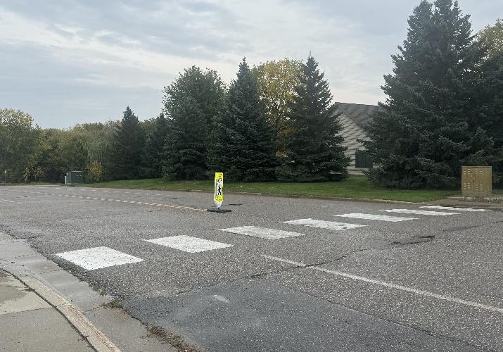
Pedestrians: In the morning, few students were observed walking to school. Two students were observed crossing Voyager Drive from Steger Rd NW from the neighborhood south of the school. This crossing has a pedestrian sign, crosswalk, and crossing guard. Two students were observed walking from the western neighborhoods along the sidewalk on Voyager Drive.
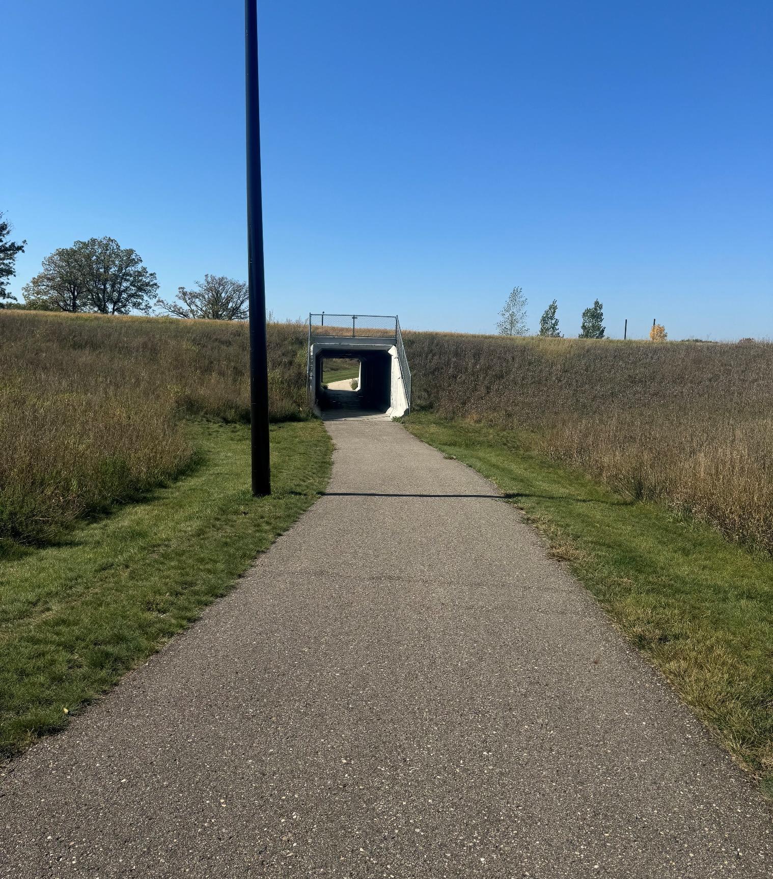
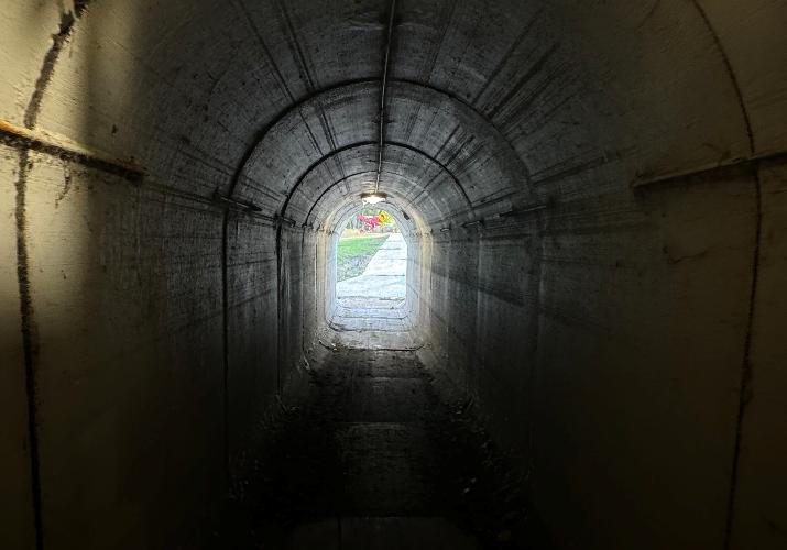
Bicyclists: Coming from the east, crossing Co Rd 42 NE, there is a pedestrian tunnel. Five bikers were observed using the tunnel in the morning. One biker was observed coming from the western neighborhoods on the sidewalk on Voyager Drive. Most bikers wore helmets, but two out of eight observed were not.
School Buses: School buses park in front of the school in the northern drive lane/parking lot adjacent
to the school. The parking lot is one-way, with cars and buses entering the eastern entrance and exiting the western side, almost intersecting Steger Rd NW.
Transit: The Rainbow Riders bus service can be used to drop off students at school. No students were observed using the bus system.
Vehicles: Elementary drop-off and pick-up are located in the school parking lot south of the bus parking. This parking lot is also a one-way. The student drop-off/pickup lane can be very busy requiring a crossing guard in the school parking lot for kids to reach their cars safely. Drivers tend to speed on Voyager Drive due to its wide lanes and connection to Co Rd 42 NE, which is a high-trafficked road. Drivers were observed eating/drinking, on the phone, and smoking while driving.
More information on site circulation can be seen in Appendix A.
WOODLAND ELEMENTARY SCHOOL
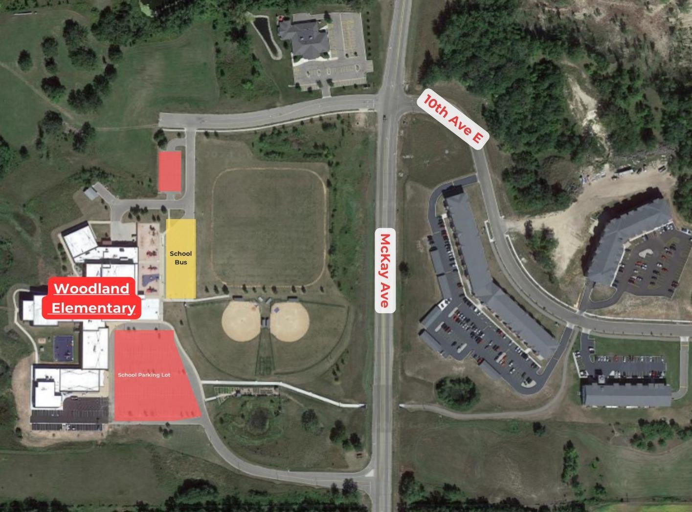
SITE CIRCULATION
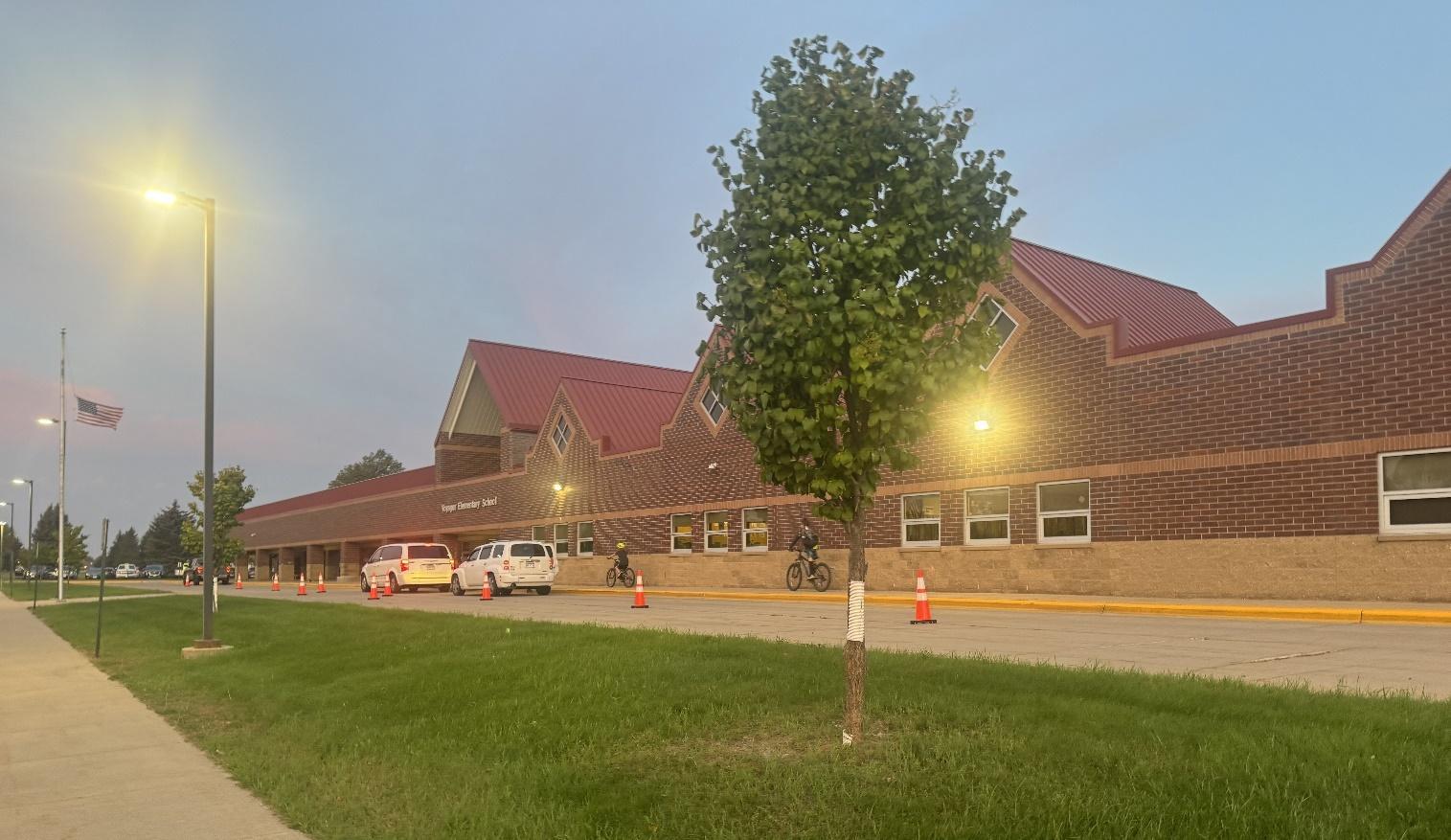
Pedestrians: Few pedestrians were observed walking to school due to the isolated location. The pedestrian tunnel underneath McKay Ave does connect neighborhoods east of the school and several large apartment complexes. There were three students observed walking to school using the tunnel.
Bicyclists: Bicyclists also have the ability to use the underpass to travel to school. During observation day no bicyclists were observed. This can be attributed to school location and the young age of students.
School Buses: Buses park adjacent to the playground in a separate bus parking lot and entrance north of the parent drop-off and pick-up entrance.
Transit: The Rainbow Riders bus service can be used to drop off students at school. No students were observed using the bus system.
Vehicles: Elementary drop-off and pick-up are located in the main school parking lot south of the school. This lot has two one-way loops during dropoff and pickup times and also serves the Early Childhood Center. In the parking lot there were 16 drivers observed to be distracted.
More information on site circulation can be seen in Appendix A.
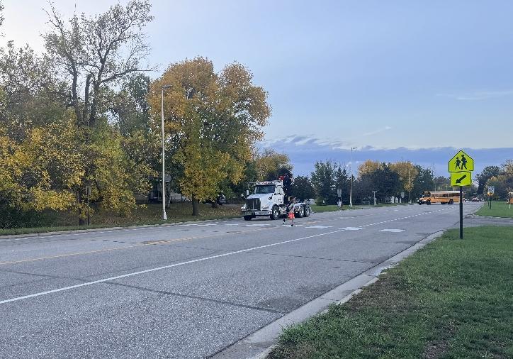
DISCOVERY MIDDLE SCHOOL
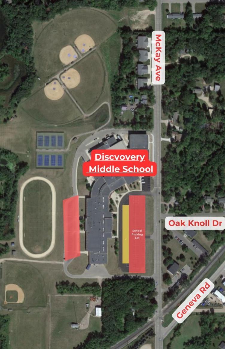
SITE CIRCULATION
Pedestrians: Students were observed walking and biking to and from around the neighborhood to Discovery. Three students were walking from behind the school on the connecting trail from a western neighborhood. Several students walked along McKay Avenue in the grass or on the shoulder of the road. There is a crosswalk connecting a sidewalk on the
school grounds across McKay, but there is no sidewalk or landing pad on the other side. There is a pedestrian sign, but not a crossing guard to help students cross.
Bicyclists: Several bicyclists were biking down McKay using the shoulder of the road and the trail behind the school. Most did not wear helmets
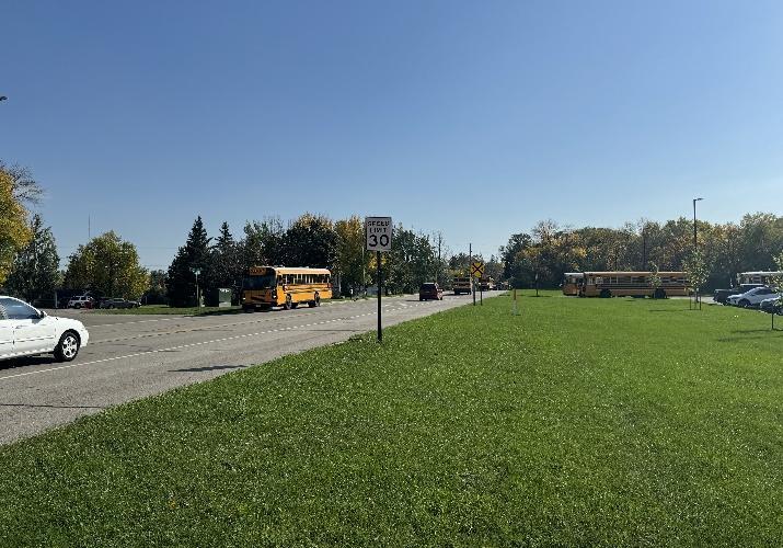
School Buses: Buses park on the western edge of the parking lot with the rest of the school staff and visitor parking.
Transit: The Rainbow Riders bus service can be used to drop off students at school. No students were observed using the bus system.
Vehicles: Drop-off and pickup is a one-way loop where vehicles enter on the south entrance on McKay to the parking lot west of the school by the track. Vehicles can then travel behind the school to the north exit back onto McKay. The entrance into the loop can become backed up for vehicles turning left into the parking lot. The center turn lane becomes stretched causing visual obstruction. There were many vehicles observed not using the drop-off pickup zone and parked instead on the shoulder of McKay, where kids would enter into the cars.
McKay Avenue is a truck route and the main thoroughfare through town. During the drop-off and pickup periods, over 150 cars were observed going at least five over the speed limit. This along with several instances of cars not yielding to pedestrians, distracted driving, and not driving in a designated space can become quite dangerous to pedestrians and bicyclists.
More information on site circulation can be seen in Appendix A.
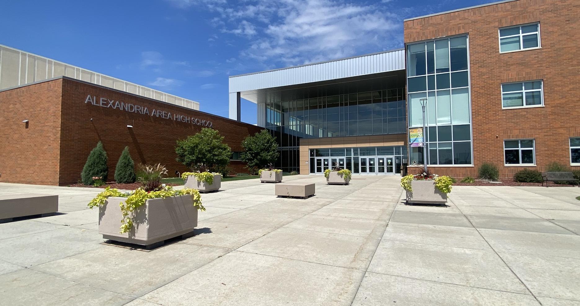
ALEXANDRIA AREA HIGH SCHOOL
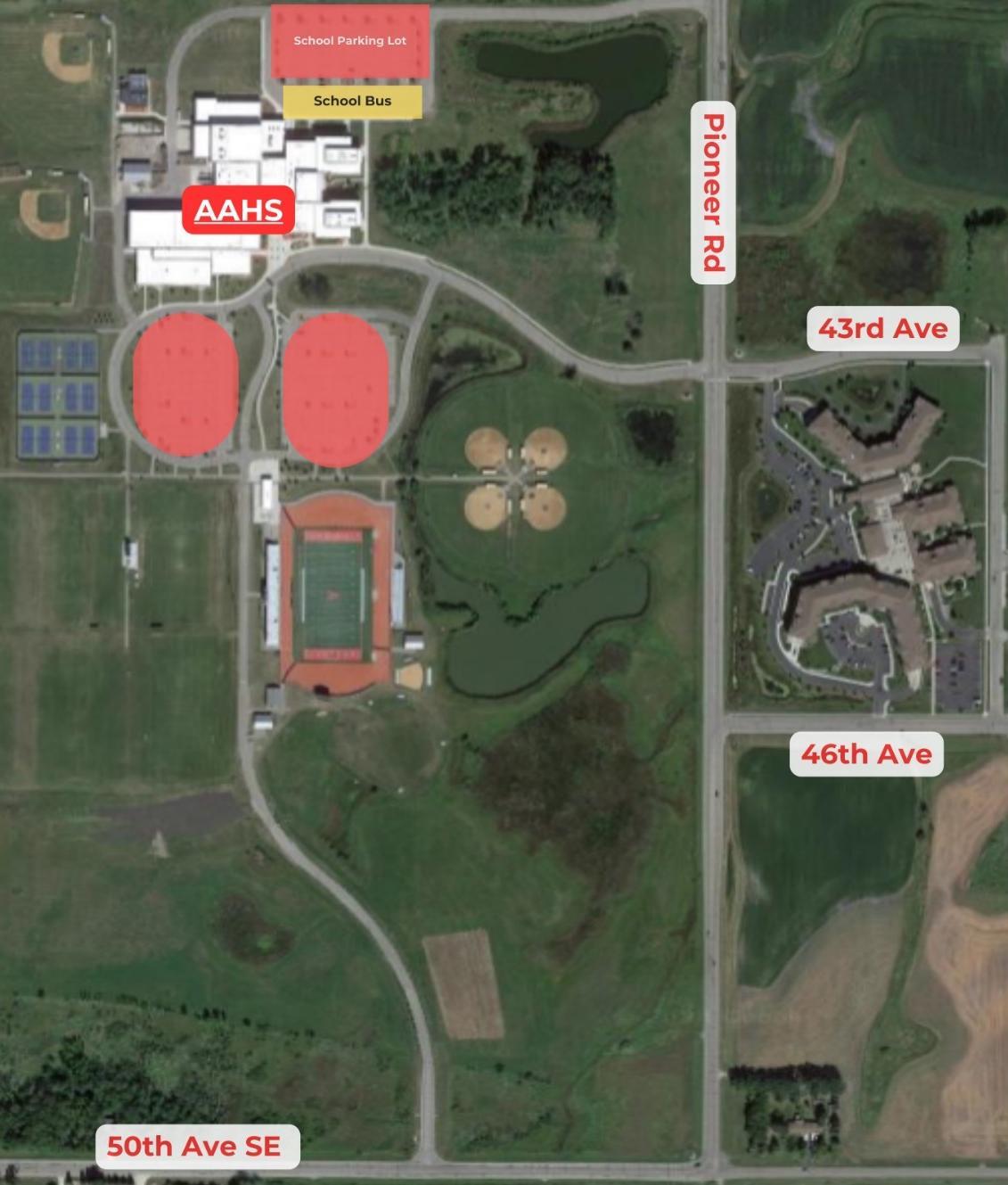
SITE CIRCULATION
Pedestrians: Alexandria Area High School is located along two higher-speed roadways with little pedestrian infrastructure. There were a couple of pedestrians observed walking across the crosswalk at Pioneer Road and 43rd Avenue.
Bicyclists: No bicyclists were observed biking to the high school. Bicyclists could bike in the middle of the road, but they should be advised to be cautious due to higher speeds.
School Buses: Buses park in the north school parking lot, separate from vehicle drop-off and pickup. Buses
use the north entrance and exit which decreases traffic at the pedestrian crosswalk at 43rd Avenue.
Transit: The Rainbow Riders bus service can be used to drop off students at school. No students were observed using the bus system.
Vehicles: Vehicle drop-off and pickup is a one-way loop. Vehicles enter the school entrance off Pioneer Road to the front entrance of the high school, where they then travel south to the exit off of 50th Avenue SE.
More information on site circulation can be seen in Appendix A.
SCHOOL CONTEXT*:
Alexandria Public Schools
SUPERINTENDENT:
Rick Sansted
PRINCIPALS:
Brendan Bogart, Lincoln Elementary
Stephanie Ruegemer, Woodland Elementary
Dana Christenson, Voyager Elementary
Heather Timm, Discovery Middle School
Chad Duwenhoegger, Alexandria Area High School
ENROLLMENT**:
Lincoln: 478
Woodland: 416
Voyager: 427 Discovery: 874
AAHS: 1,310
GRADES SERVED:
Lincoln | Woodland | Voyager: K-5
Discovery: 6-8 AAHS: 9-12
DEMOGRAPHICS**
White, non-Hispanic, 89%
Hispanic, 4.6%
American Indian/Alaska Native, <1%
Asian, 1%
Black/African American, <1%
Multiracial, 3%
OTHER
*This information does not include the entire APS system but only the APS schools within the city limits of Alexandria.
**Source: Minnesota Report Card
MISSION STATEMENT:
“Our mission is to achieve educational excellence and to inspire a life-long passion for learning.”
STUDENT DEMOGRAPHICS:
• Alexandria Public Schools enrolled population of 3,505 is spread across kindergarten through 12th grades. All students who are enrolled at Alexandria Public Schools are eligible for busing.
• Alexandria Public Schools student population encompasses children and families from a range of demographic groups. Around 18% of students are receiving special education and over 34% are eligible for free and reduced lunch. The student population is 89% white non-Hispanic, 4.6% Hispanic, less than 1% American Indian/Alaska Native, 1% Asian, less than 1% Black, and 3% multiracial
Infrastructure
Introduction to Infrastructure
Physical changes to the streetscape are essential to making walking, biking, and rolling to school safer and more comfortable.
An in-person walk audit and discussions with the Safe Routes to School Team, school and district staff, caregivers, students, community members, and city and county staff informed recommendations to address key barriers to walking and biking around Alexandria.
Recommendations are prioritized on the basis of community and stakeholder input, traffic and roadway conditions, cost, number of students impacted, and benefit to priority populations. This planning process was designed to address historical and contemporary inequities in who benefits from and who is burdened by transportation systems, and equity considerations accordingly played a central role in the prioritization of infrastructure recommendations. Especially in the winter months, improved maintenance and lighting can contribute to improving equitable access to walking and biking routes, even where a sidewalk or path is present.
WINTER MAINTENANCE
For students and community members with disabilities, winter maintenance is key to accessing sidewalks and trails during snowy months. This is also true for students and families who walk and roll as their primary means of transportation, either because they cannot afford or choose not to own a vehicle, or because other transportation options aren’t accessible to them. Cities can adopt policies that prioritize winter maintenance of existing infrastructure and make it easier for the most vulnerable users of our transportation system including students to get around in winter. These policies help to increase transparency and improve reliability for the active transportation network.
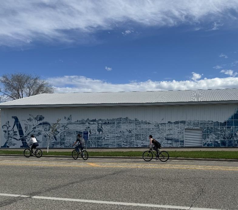
PUBLIC ART
To create outreach to a variety of populations, public art can be used to educate, encourage, and create a sense of place in a community. Public art can be used to demonstrate safe walking, biking, and rolling actions by being incorporated into infrastructure. Examples include enhancing crosswalks or bike lanes, sculptural art within roundabouts, or aesthetic streetlights. It can also be used to create a sense of place where people may be more encouraged to walk to their destinations than to drive. A mural depicting students walking may educate drivers that there are pedestrians in the areas and that they should be more careful.
Public art can be a quick-win solution to promoting Safe Routes to School efforts while beautifying the community. Cities, schools, and local advocacy groups should partner to create more vibrant, safe, and walkable areas within their neighborhoods or communities.
HOW TO USE THIS PLAN
This plan does not represent a comprehensive list of every project that could improve conditions for walking and bicycling, but rather community priorities, key conflict areas, and potential improvements identified in the planning process. Recommendations range from simple striping changes to more significant changes to streets, intersections, and school infrastructure.
For example, they can:
• Adopt policies that prioritize snow clearing and removal on active transportation facilities
• Prioritize clearing of routes that provide access to transit
• Develop and share information publicly regarding sidewalk and shared use pathway snow clearing and removal practices
• Hold a winter maintenance forum or conduct a survey around specific winter engagement concerns
• Work with schools to establish volunteer groups of residents to clear sidewalks on priority routes to school
Recommendations identified in this plan are not necessarily endorsed by MnDOT but planning-level concepts that will require additional engineering design. Additionally, all recommendations for pedestrian and bicycle crossings will be evaluated by the proper road authority’s guidelines.
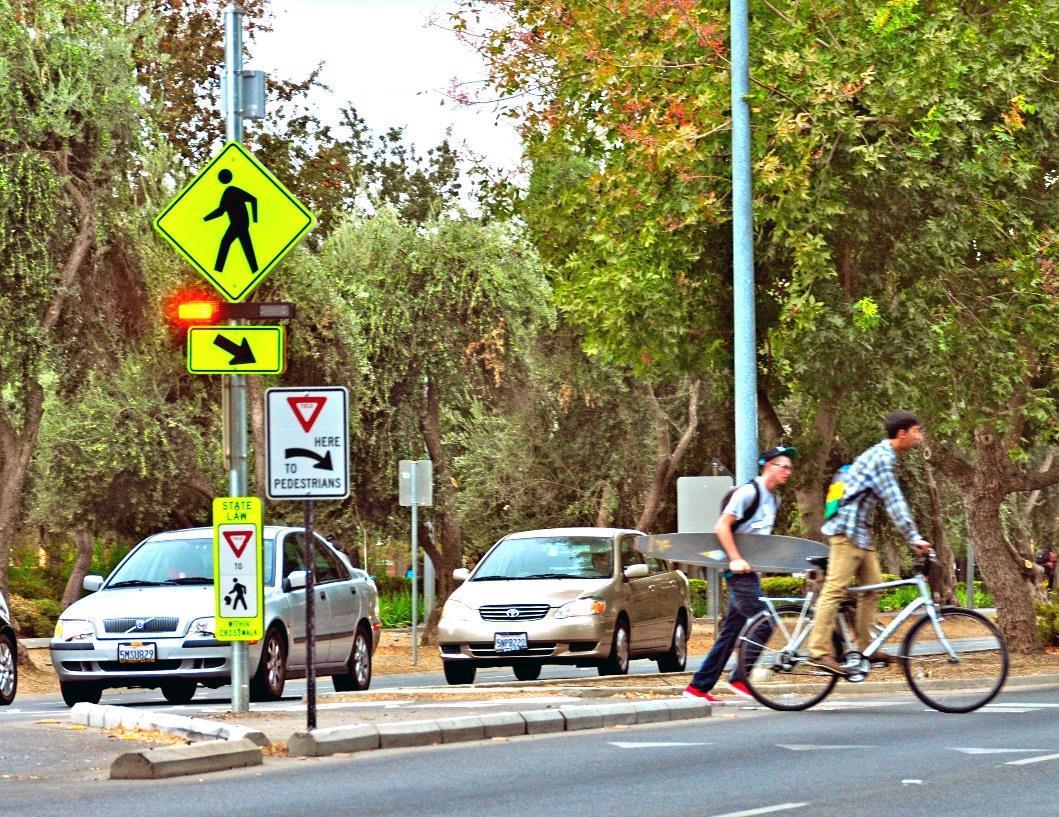
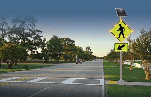
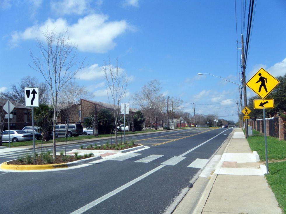
LIGHTING AND VISIBILITY
Similarly, lighting for people walking and biking is important for both actual and perceived sense of safety and security. In winter climates like Minnesota’s, where darker days mean school arrival and dismissal can occur in the dark, lighting is especially important for mitigating safety concerns and encouraging active transportation throughout the year.
While lighting can sometimes be seen as a costly investment, it is an important step for ensuring equitable access to walking and biking routes. Lighting should be seen as a necessary component of bicycle and pedestrian safety improvements, not seen as a potential add-on or “nice-to-have” feature.
ALEXANDRIA
Communities can consider:
• Creating a lighting plan for priority pedestrian routes to install trail or sidewalk lighting over time
• Partnerships with or requirements for private development to provide lighting
• Incorporating high-visibility safety vests into crossing guard and Walking School Bus events
• Giveaways that help kids access winter gear such as clothing or bike lights
Lighting in Alexandria is crucial for the safety of students and residents when traveling in the early mornings and evenings to and from school. High-traffic areas should have adequate lighting, especially when used as a major arterial to school.
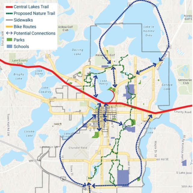
Alexandria Nature Trail
The Alexandria Nature Trail is a trail project that will connect the community through a north-south corridor. This proposed corridor is 13 miles long and will travel through a series of wetlands that are currently inaccessible and neighborhoods. The City of Alexandria and the Nature Conservancy are leading the project. The trail would also connect to the Central Lakes Trail which provides an east-west connection in the city.
The Alexandria Nature Trail has the potential to be the connection point between schools where there are currently gaps. Connecting Alexandria Area High School to Woodland Elementary and local neighborhoods would be instrumental to providing a safe and accessible route to both schools. The Nature
Trail also connects Woodland to Discovery and then Voyager. The Alexandria Safe Routes to School committee supports the Alexandria Nature Trail project as a viable network for students to walk, bike, and roll to school safely.
CURRENT PROGRESS
During the 2024 Transportation Alternatives Program solicitation the City of Alexandria was awarded funds to complete a 4.1-mile section of the Nature Trail adjacent to Woodland Elementary School, referred to as section 3 of the trail. This section would be the first portion of the trial constructed and open the door to future development both north and south of Woodland to the other schools in the district.
MN State Highway 29 Studies
State Highway 29 runs through the downtown and heart of Alexandria. This has created a high traffic route with 5 lanes of traffic for pedestrians to cross. This has divided the community, and efforts are currently underway to find solutions. Due to the studies being conducted, the focus of this Safe Routes to School plan will be on other areas in Alexandria.
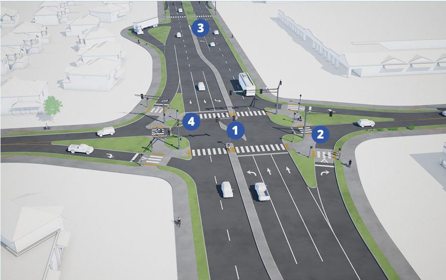
TRUNK HIGHWAY 29 – 3 RD AVENUE
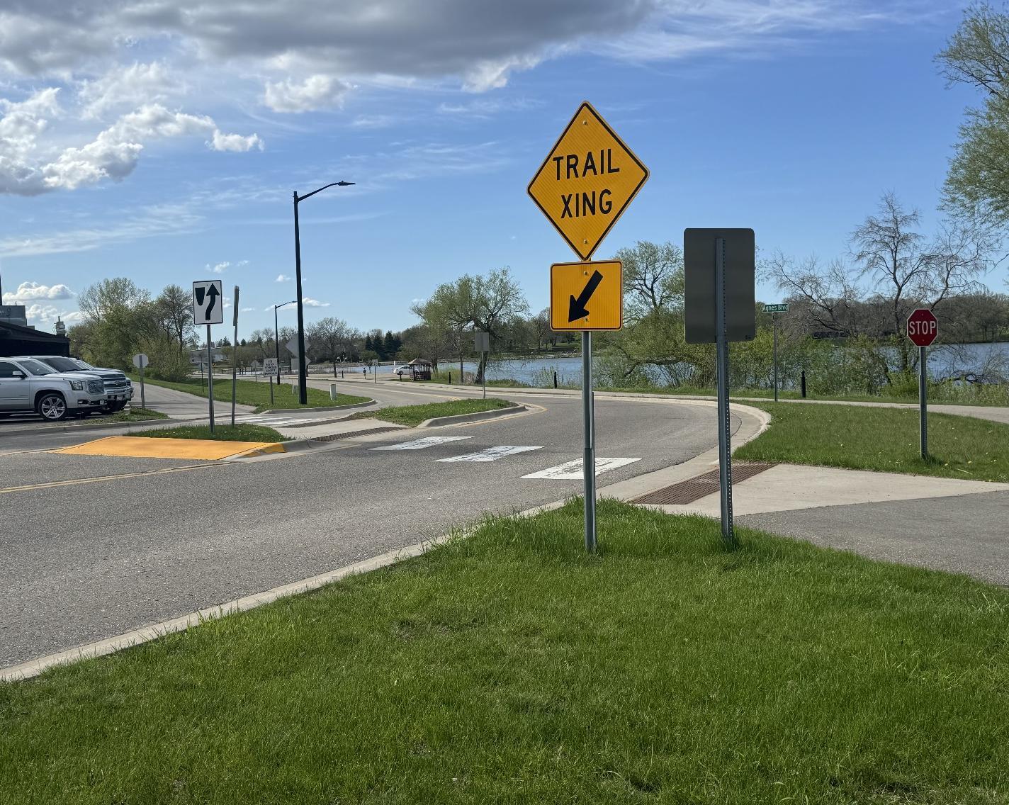
MnDOT conducted a study on Trunk Highway 29 on the 3rd Avenue section. This is a seven-block portion of Highway 29 between Nokomis and Broadway. It is south of Lake Agnes and separates the Central Lakes Trail from the downtown area. This corridor has one of the highest crash rates in the city; this study was conducted in part to find alternative infrastructure opportunities to make it safer for pedestrians and bicyclists to navigate.
The study analyzed three alternatives to the corridor and recommended option two. This includes raised medians with greenspace for pedestrians, enhanced pedestrian crossing signals, and a bikeway along Kenwood that connects with the Central Lakes Trail. All of the crossings are important for the safety of students crossing Trunk Highway 29 to reach the various schools and other destinations in the community. For more information check out the project website.

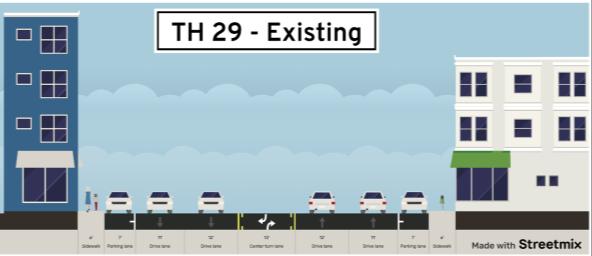
TRUNK HIGHWAY 29 – 8 TH TO 18 TH AVENUE
MnDOT conducted a study on a 9-block section of Trunk Highway 29 between 8th and 18th Avenue. This study included looking at corridor design, intersections, and driveway entrances. The current configuration is a 5-lane road with parking on both sides. There are 6’ sidewalks on each side of the road.
The current road is overbuilt for the vehicle miles traveled. The study presented several options to reduce the number of lanes. It also analyzed intersections, with a focus on the 17th and 18th Avenue intersections.
This study is crucial for students to feel safe traveling along and crossing Highway 29. Current road
construction is not a viable travel way for bicyclists and not comfortable for pedestrians due to the lake of a boulevard and high traffic speed. The findings of the study concluded that further analysis of the section needs to be conducted before change can occur. For more information check out the project website.
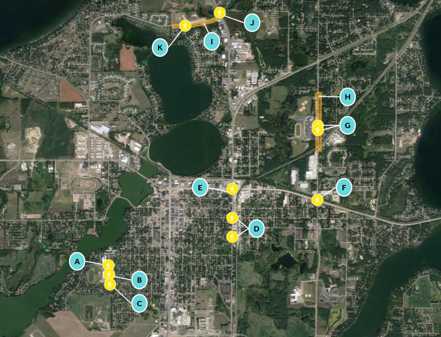
A: Lark St and 10th Ave W
PRIORITY: Low
RECOMMENDATION
Explore opportunities to improve pedestrian crossings. Suggestions include installing high-visibility crosswalks and curb extensions.
WHY IS THIS RELEVANT?
This road has local traffic for the elderly care facility and Lincoln Elementary.
WHO WILL MAKE THIS HAPPEN?
City and school leadership, using Safe Routes to School funding, and/or other local, state, or federal funding.
HOW WILL THIS ADDRESS EQUITY?
This intersection is close to an elderly care facility. All ages and abilities would be able to safely cross the road due to improved visibility and reduced crossing distance.
B: Lark St and 11th Ave W
PRIORITY: Medium
RECOMMENDATION
Explore opportunities to improve pedestrian crossings. Suggestions include installing colorful crosswalks, curb extensions, and Rectangular Rapidflashing beacon (RRFB) signs.
WHY IS THIS RELEVANT?
This intersection is a high-traffic area with pedestrian, bus, and family vehicle traffic before and after school.
WHO WILL MAKE THIS HAPPEN?
City and school, leadership, using Safe Routes to School funding, and/or other local, state, or federal funding.
HOW WILL THIS ADDRESS EQUITY?
All ages and abilities would be able to safely cross the intersection due to improved visibility and reduced crossing distance.
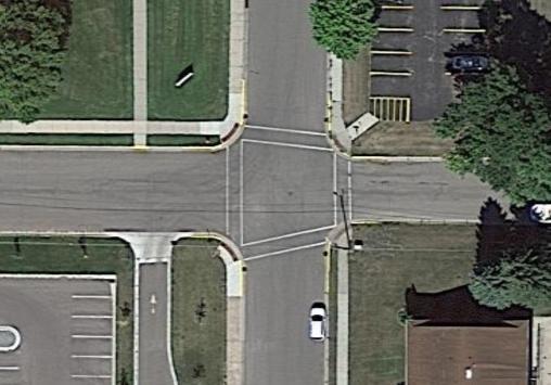
C: Lark St, Westwood Dr, and Winona Dr
PRIORITY: Medium
RECOMMENDATION
Explore opportunities to improve pedestrian crossings by installing enhanced crosswalks, curb extensions, or a traffic circle at this intersection. Demonstration project is encouraged at this intersection.
WHY IS THIS RELEVANT?
This intersection is a high-traffic area with pedestrian, bus, and family vehicle traffic before and after school.
WHO WILL MAKE THIS HAPPEN?
City and school leadership, using Safe Routes to School funding, and/or other local, state or federal funding.
HOW WILL THIS ADDRESS EQUITY?
All ages and abilities would be able to safely cross the intersection due to improved visibility and reduced crossing distance.
D: Nokomis St Crossings
PRIORITY: Medium
RECOMMENDATION
Explore safer connection opportunities crossing Nokomis Street. Suggestions include installing more visible RRFB signs with high-visibility crosswalks, pedestrian railroad crossings, and curb extensions at this intersection.
WHY IS THIS RELEVANT?
This is a high-traffic route with no PROWAGcompliant intersections south of 3rd Ave.
WHO WILL MAKE THIS HAPPEN?
City, school, and railroad leadership, using Safe Routes to School funding, and/or other local, state, or federal funding.
HOW WILL THIS ADDRESS EQUITY?
All ages and abilities would be able to safely cross the intersection due to improved visibility and reduced crossing distance
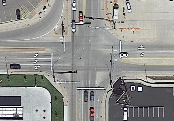
E: Nokomis St and State Hwy 29
PRIORITY: High
RECOMMENDATION
Explore safer connection opportunities crossing MN State Hwy 29 This intersection warrants further study to create a safer pedestrian and bicyclist crossing. Examples include a roundabout, a protected intersection, or a graded separated crossing.
WHY IS THIS RELEVANT?
This is a very high-traffic route, with the intersection of a State Highway. There is high semi, truck, local, and through traffic
WHO WILL MAKE THIS HAPPEN?
City, school, county, and state leadership, using Safe Routes to School funding, and/or other local, state, or federal funding.
HOW WILL THIS ADDRESS EQUITY?
All ages and abilities would be able to safely cross the intersection due to improved visibility and reduced crossing distance.
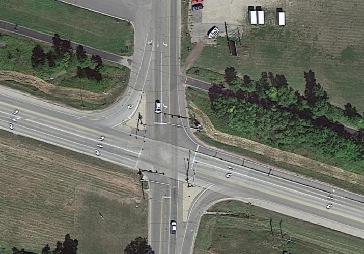
F: McKay St and CSAH 82
PRIORITY: High
RECOMMENDATION
Explore safer connection opportunities crossing CSAH 82 along McKay Avenue. This intersection warrants further study to create a safer pedestrian and bicyclist crossing. Examples include a roundabout, a protected intersection, or a gradeseparated crossing.
WHY IS THIS RELEVANT?
This is a high truck, local, and school traffic area. A Central Lakes Trail crossing point is located just north of the intersection and has limited crossing infrastructure.
WHO WILL MAKE THIS HAPPEN?
City, school, and county leadership, using Safe Routes to School funding, and/or other local, state, or federal funding.
HOW WILL THIS ADDRESS EQUITY?
All ages and abilities would be able to safely cross the intersection due to improved visibility and reduced crossing distance.
G: McKay Ave Crossings, Discovery
PRIORITY: High
RECOMMENDATION
Explore safer crossing opportunities across McKay Avenue in front of Discovery Middle School. Suggestions include installing more visible Rectangular Rapid-Flashing Beacon (RRFB) signs, high-visibility crosswalks, Hawk Signal, curb extensions, and connecting sidewalks to curb ramps. Explore realignment of crossing to a midblock crosswalk with bump-outs due to truck traffic.
WHY IS THIS RELEVANT?
This road has high traffic, with McKay Avenue separating Discovery Middle School from the surrounding neighborhoods.
WHO WILL MAKE THIS HAPPEN?
City, school, and county leadership, using Safe Routes to School funding, and/or other local, state, or federal funding.
HOW WILL THIS ADDRESS EQUITY?
All ages and abilities would be able to safely cross the road due to improved visibility and reduced crossing distance.
H: Speed Reduction – McKay
PRIORITY:MEDIUM
RECOMMENDATION
Explore speed reduction methods and practices to reduce speed and traffic in front of Discovery Middle School on McKay Avenue. Suggestions included curb extensions, lane narrowing, pinch points, and speed feedback signs. Explore the implementation of a school speed zone.
WHY IS THIS RELEVANT?
This is a high truck, local, and school traffic area. Speeding rates are high on this road, and students walk and bike on the shoulder due to the lack of sidewalks.
WHO WILL MAKE THIS HAPPEN?
City, school, and county leadership, using Safe Routes to School funding, and/or other local, state, or federal funding.
HOW WILL THIS ADDRESS EQUITY?
Reducing speed and traffic along McKay Avenue would make it more comfortable and safer for all road users to cross and walk along.
I: Speed Reduction – Voyager
PRIORITY: Medium
RECOMMENDATION
Explore speed reduction methods and practices to reduce speed and traffic in front of Voyager Elementary on Voyager Drive. Suggestions included curb extensions, lane narrowing, pinch points, and speed feedback signs
WHY IS THIS RELEVANT?
This is a high-traffic route with local traffic connecting to nearby highways.
WHO WILL MAKE THIS HAPPEN?
City, school, and county leadership, using Safe Routes to School funding, and/or other local, state, or federal funding.
HOW WILL THIS ADDRESS EQUITY?
Reducing speed and traffic along Voyager Drive would make it more comfortable and safer for all road users to cross and walk along.
J: N Nokomis NE and Voyager Dr Underpass
PRIORITY: Medium
RECOMMENDATION
Explore enhancing the current underpass with upgraded lighting, public art installation, and routine maintenance. Also, explore updating tunnel to become PROWAG compliant when entering and exiting.
WHY IS THIS RELEVANT?
This underpass is an integral connector to Voyager Elementary but due to current poor conditions, students may feel apprehensive towards use.
WHO WILL MAKE THIS HAPPEN?
City, school, and county leadership, using Safe Routes to School funding, and/or other local, state, or federal funding.
HOW WILL THIS ADDRESS EQUITY?
Enhancing the conditions will make all users feel safer and more comfortable when using the underpass. PROWAG updated infrastructure would make it safer for all ages and abilities.
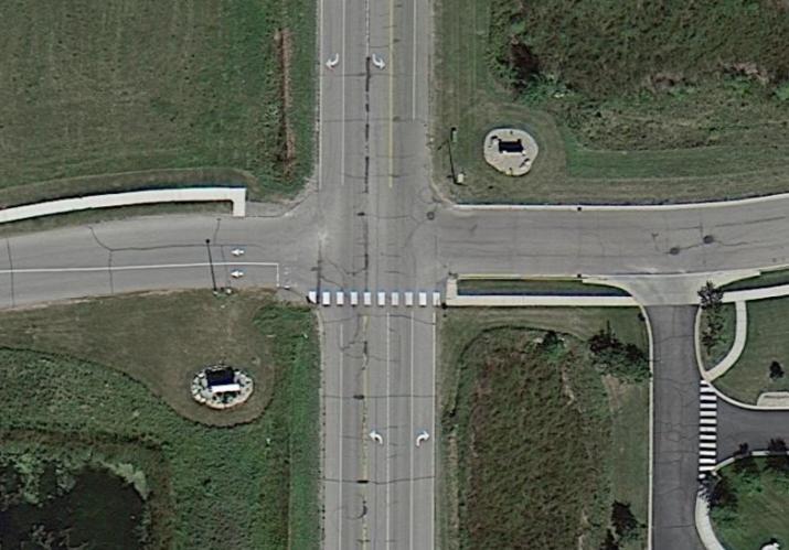
K: Voyager Dr and Steger Rd
PRIORITY: High
RECOMMENDATION
Explore the realignment of the Steger Road and Voyager exit intersection. Suggestions with realignment include curb extensions, enhanced crosswalks, and RRFBs. Possible
WHY IS THIS RELEVANT?
This is a high-traffic route and the main crossing to reach Voyager from southern neighborhoods. Additional parking lot creates further traffic conflict a the intersection. Slowing down traffic and making students more visible would make the crossing safer and more accessible.
WHO WILL MAKE THIS HAPPEN?
City, school, and county leadership, using Safe Routes to School funding, and/or other local, state, or federal funding.
HOW WILL THIS ADDRESS EQUITY?
All ages and abilities would be able to safely cross the intersection due to improved visibility and reduced crossing distance.
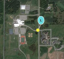
L: Pioneer Rd Crossing
PRIORITY: Medium
RECOMMENDATION
Explore safer crossing opportunities across Pioneer Road in front of Alexandria Area High School. Suggestions include installing more visible Rectangular Rapid-Flashing Beacon (RRFB) signs, high-visibility crosswalks, Hawk Signal, curb extensions, connecting sidewalks to curb ramps, and grade separated crossing.
WHY IS THIS RELEVANT?
This road is a high speed and high traffic route adjacent to AAHS that connects to a large apartment complex and nearby neighborhoods.
WHO WILL MAKE THIS HAPPEN?
City, school, and county leadership, using Safe Routes to School funding, and/or other local, state, or federal funding.
HOW WILL THIS ADDRESS EQUITY?
Reducing speed and traffic along Pioneer Road would make it more comfortable and safer for all road users to cross and walk along.
M: Sidewalk Network
PRIORITY: Medium
RECOMMENDATION
Explore installing sidewalks and trails in specific locations to increase the connectivity of Alexandria. This could involve working on infrastructure near roadways and the Alexandria Nature Trail.
WHY IS THIS RELEVANT?
Installing sidewalks in strategic locations will close current gaps in city sidewalk infrastructure and give sidewalk users more freedom and safety from road traffic.
WHO WILL MAKE THIS HAPPEN?
City, school, county, and state leadership, using Safe Routes to School funding, and/or other local, state, or federal funding.
HOW WILL THIS ADDRESS EQUITY?
Currently, there are neighborhoods in Alexandria that have incomplete sidewalk networks. Creating equitable access to all neighborhoods would create a safer and more resilient Alexandria.
SRTS Ordinance Change
ADOPT SUBDIVISION INFRASTRUCTURE ORDINANCE
A recently implemented Minnesota State Statute (174.40) requires local jurisdictions to adopt a SRTS infrastructure ordinance in order to qualify for state and federal SRTS funds. This ordinance requires all new subdivisions built within city limits to install infrastructure focused on the safety of pedestrians and bicyclists. This is commonly executed by installing sidewalks. An example city ordinance for reference is in Appendix K.
The Alexandria Public Schools Safe Routes to School committee recommends that the City of Alexandria adopt a city ordinance requiring all new subdivisions built in Alexandria city limits plan for and install pedestrian and bicycle safety infrastructure.
SRTS Policy Change
ADOPT SCHOOL AND CITY POLICIES TO SUPPORT SRTS EFFORTS
Currently, the Alexandria Public Schools Transportation Policies do not address supporting students walking and biking to and from school and school related activities. The City of Alexandria can also support SRTS efforts. An example is Battle Lake’s policy to remove snow and ice on designated safe routes to school.
The Alexandria Public Schools Safe Routes to School committee recommends that the City of Alexandria and Alexandria Public Schools review their current ordinances and polices, and to add or change ordinances and polices that better support and encourage students to walk, bike, and roll to school.
Examples of Potential Infrastructure Improvements
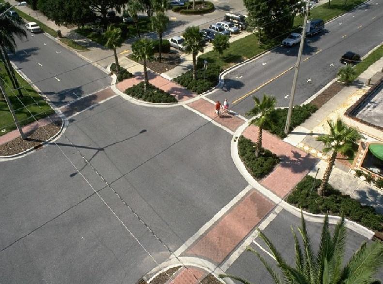
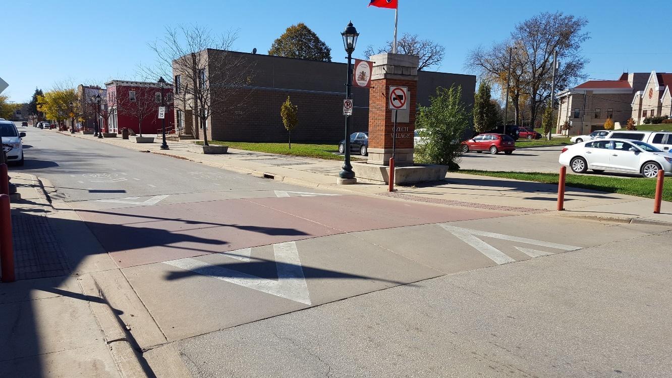
Curb extensions (sometimes called bump outs or bulb-outs) can improve safety by reducing crossing distances and improving visibility for both people driving and people walking. Image courtesy of the National Association of City Planning Officials (NACTO).
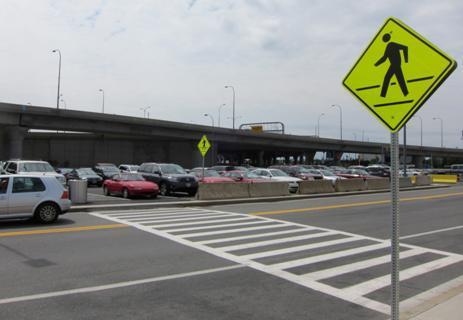
High visibility crosswalks such as this “ladder” style crosswalk “are preferable to standard parallel or dashed pavement markings. These are more visible to approaching vehicles and have been shown to improve yielding behavior” according to the NACTO. Image courtesy Federal Highway Administration.
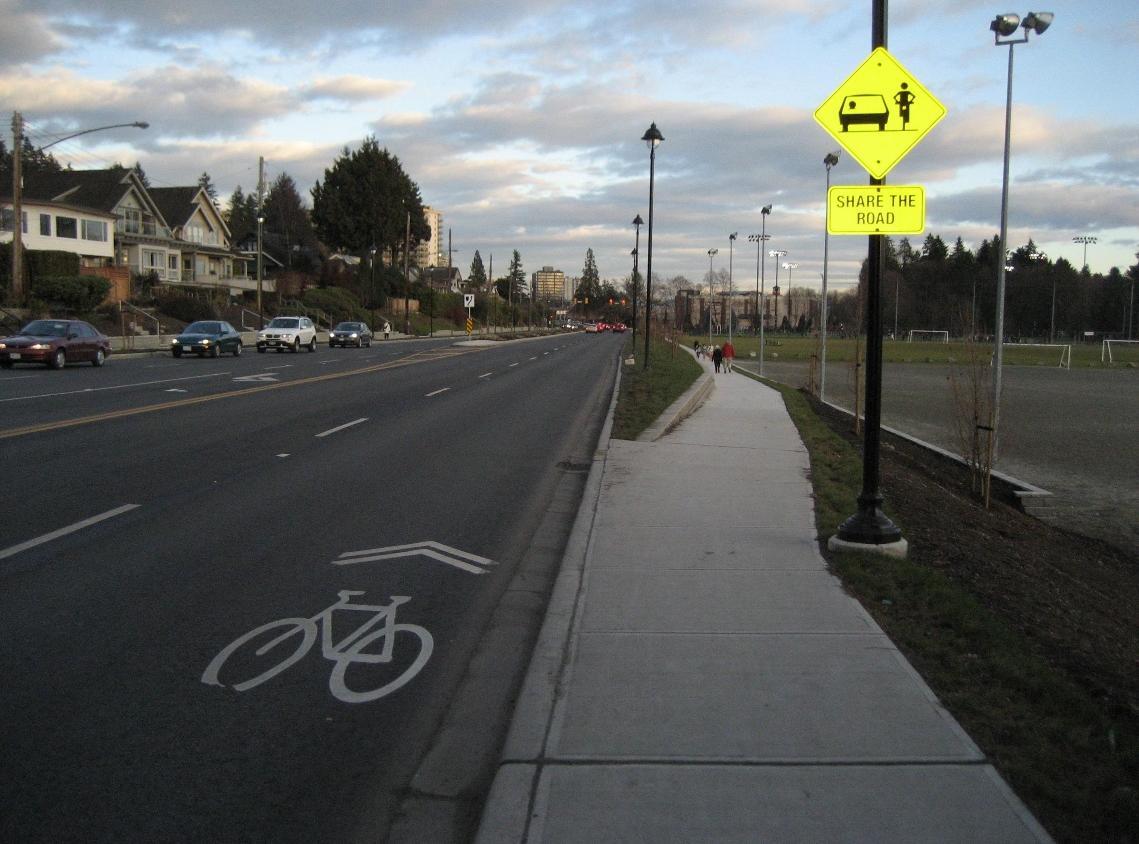
Sharrows, or Shared-Lane markings, are bicycle symbols indications that a bicyclist has the right to ride in the roadway and to warn drivers that bicyclists may be present. Image courtesy www.pedbikeimages.org / Margaret Gibbs.
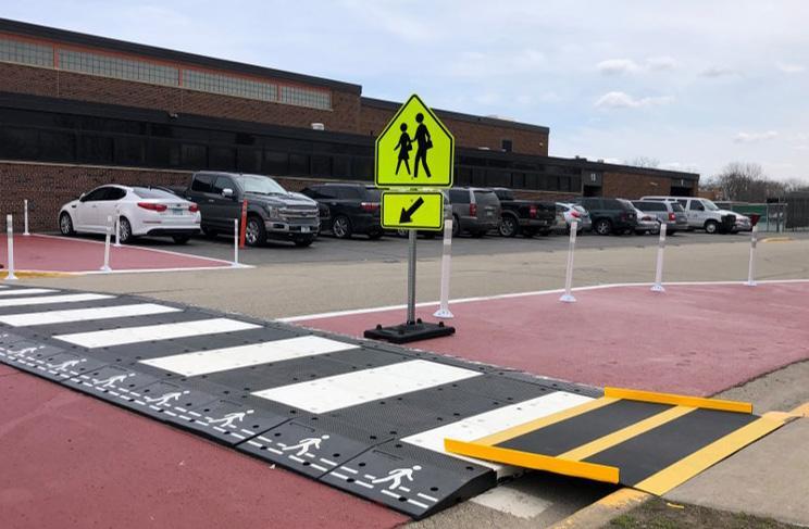
Speed tables, or raised crosswalks, are midblock gradual speed bumps that also function as a crosswalk for bicyclists and pedestrians. They help calm traffic speeds and provide more awareness for pedestrians and bicyclists crossing. Image courtesy www.pedbikeimages.org / Brandon Whyte.
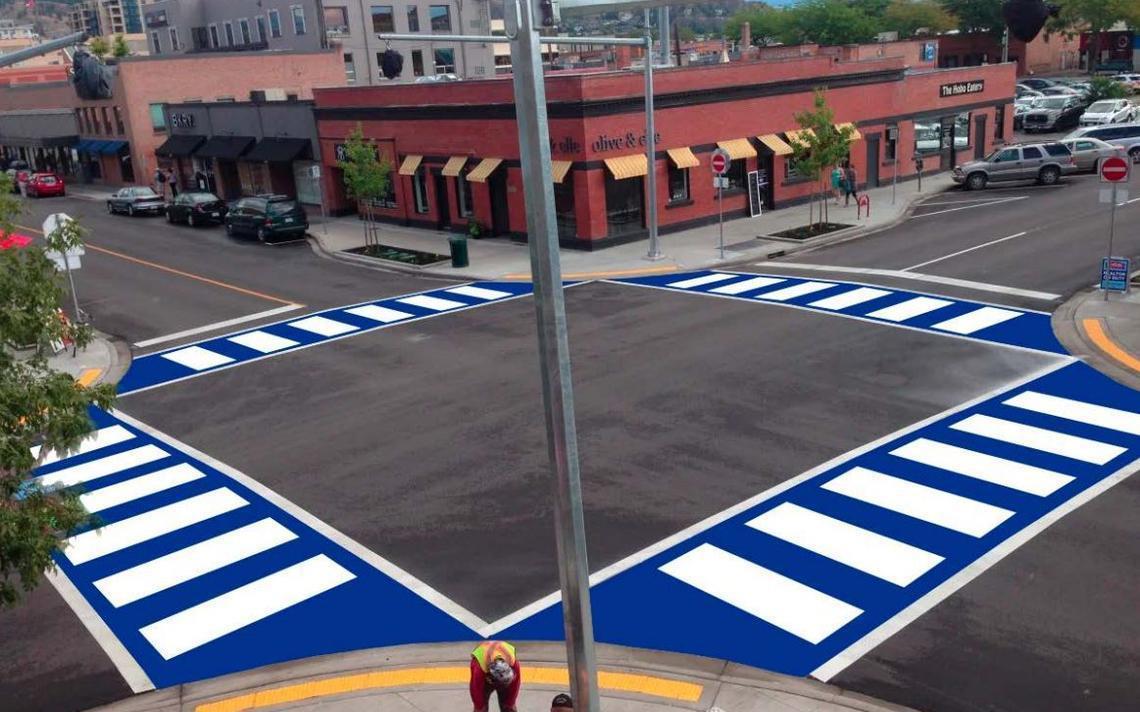
An alternate high-visibility crosswalk such as this color treated crosswalk could be installed near the school, utilizing school colors. This type of crosswalk can improve visibility and enhance student pride. This rendering is of a crosswalk being installed in Brainerd. Image courtesy City of Brainerd.
A “Rectangular Rapid Flashing Beacon” (RRFB) is an option to improve safety and visibility for students crossing the street. Image courtesy www.pedbikeimages.org / Lara Justine.
A
can provide a crossing option in areas with many people crossing the street to destinations that are not near an existing crosswalk. Image courtesy NACTO.
An LED sign like this is an option to improve safety and visibility for students crossing the street at crosswalks. Image courtesy of TAPCO.
mid-block crosswalk
A protected intersection can provide a crossing option in areas with high traffic and speeds. Image courtesy of Federal Highway Administration’s “Improving Intersections for Pedestrians and Bicyclists.”
a
A traffic circle can be used as
traffic calming device in high-traffic areas. Photo courtesy of Tim Schoonhoven.
A bicycle repair station like this one provides an opportunity for high school students (plus school staff and faculty) to make minor adjustments and repairs to their bicycles before riding. It can serve as an incentive for students to ride their bikes to school. The City of Alexandria can partner with the Alexandria Public Schools to determine the possible placement and installation of a bicycle repair station on the school or city grounds.
A pinch point can provide a mid-block crossing option which also acts as a speed reduction tool on high speed or traffic road. Pinch points can also add additional space to place amenities such as bike racks or benches. Image courtesy NACTO.
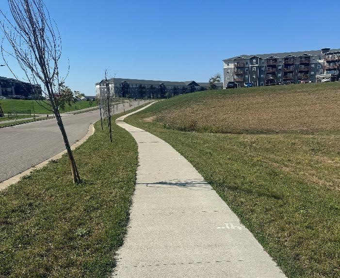
Sidewalks should be a minimum of five feet wide, and potentially wider closer to Alexandria Public Schools. Whenever possible, sidewalks should be set back from the street with boulevards. This is a good example from Alexandria along Winona Drive
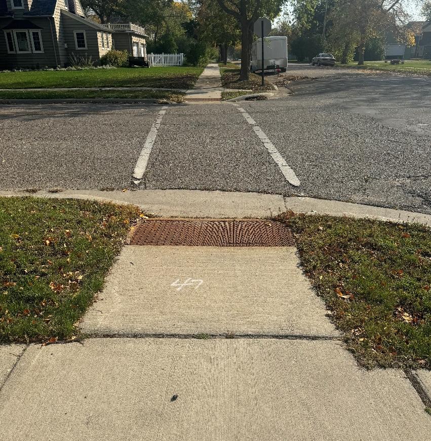
Curb ramps should be compliant with PROWAG. PROWAG-compliant curb ramps such as those pictured here improve safety for young children and people with disabilities or mobility issues to navigate the sidewalk network. This is a good example from Alexandria in front of Lincoln Elementary School
Programs
Introduction to Programs
Programs are opportunities to increase awareness, understanding, and excitement around walking, biking, and rolling to school.
Programs are focused on educating students, families, and the broader community about walking and biking, as well as on building a culture that supports and normalizes walking and biking to school and other destinations. Because programs are lowcost and can often be implemented quickly by an individual school or the school district, they represent an important Safe Routes to School strategy that complements longer-term strategies, including infrastructure improvements and policy changes
EXISTING PROGRAMS
The City of Alexandria and Alexandria Public Schools have been actively working towards providing safe and inviting spaces around school campuses for students. This foundation of encouraging student travel safety provides a valuable baseline for expanding programs to encourage more students to walk and bike.
PROGRAMS ALREADY ACTIVE AT ALEXANDRIA PUBLIC SCHOOLS:
• Automated Enforcement
• Bicycle Rodeo
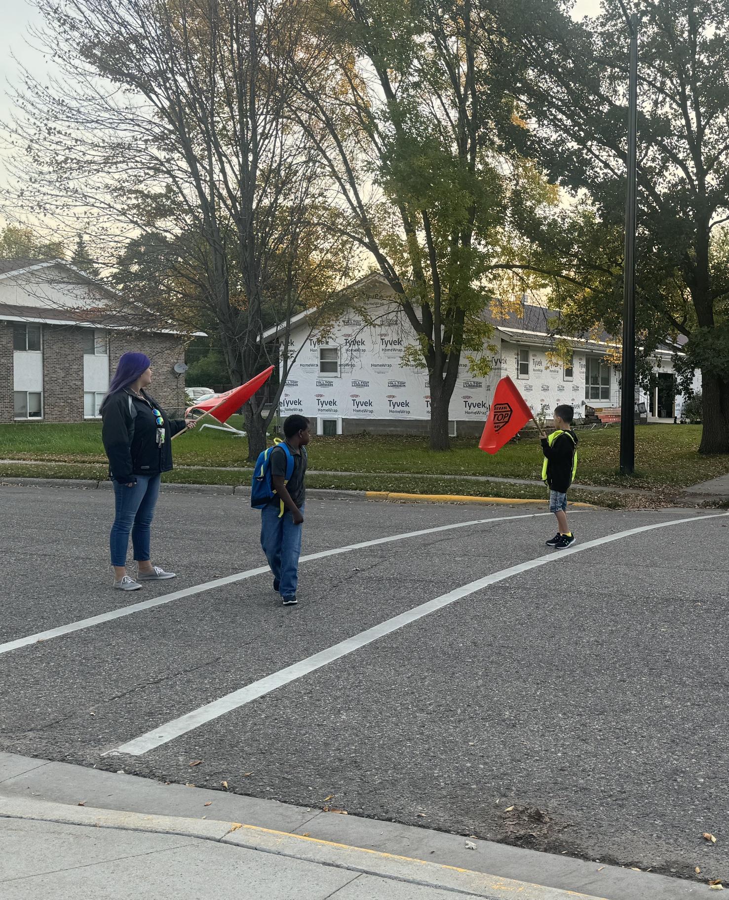
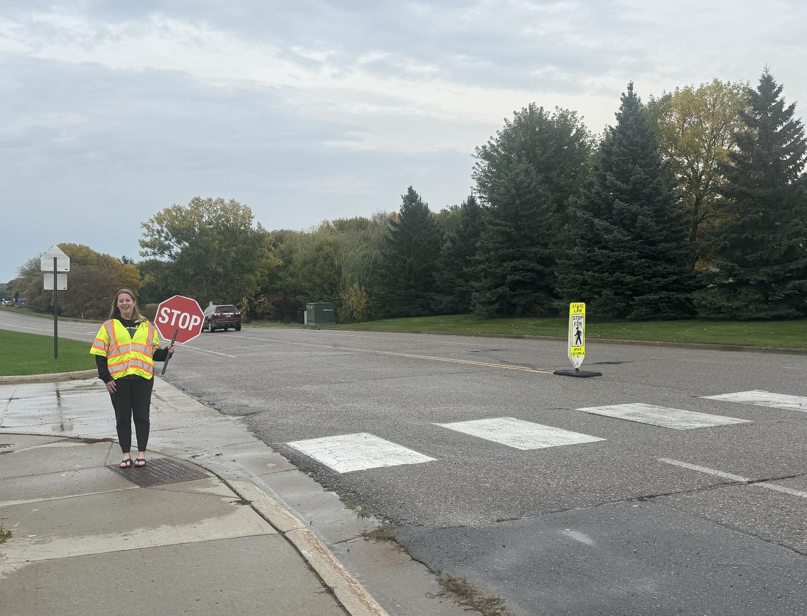
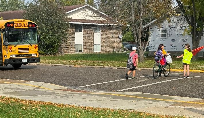
• Crossing Guards
• Student Patrol
• Walk/Bike to School Days
PROGRAM RECOMMENDATIONS
Conversations with school and district staff, caregivers, students, community members, and city and county staff led to the following program recommendations. Programs were tailored to meet the needs, capacities, and interests of the community and were prioritized based on existing programs, input from local stakeholders, the extent to which the program would serve priority equity populations, and the readiness of the school to launch the program.
RECOMMENDED PROGRAMS INCLUDE:
• Bike Fleet
• Bike Mechanic Classes
• Cocoa for Carpools
• Drop and Walk
• Educational Videos
• In-School Curriculum & Activities
• Inter-School Partnership
• School Communications
• Ongoing Evaluation
• Positive Ticket Program
• Rainbow Friends Toolkit
• School Streets
• School Curriculum
• Student Clubs
• SRTS Campaign
• Suggested Route Map
• Walk & Bike Field Trips
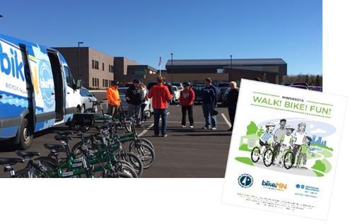
• Walk! Bike! Fun!
• Walking School Bus and Bike Train
EQUITABLE IMPLEMENTATION CONSIDERATIONS
Each of the recommended programs can be implemented to benefit priority populations. In some cases, programs are inherently beneficial, but other times they require intentional thought to make sure they are implemented equitably and reach students who could benefit the most from them.
When working to start a new or update an old program, school staff and partners should ask themselves:
• Who could benefit the most from this program?
• Are there any barriers to participating in this program, including cultural, social, or financial?
• Are there any school resources that can help reduce barriers to participation?
• Are there community partners who could help us spread the word about this program, or help make it more effective?
After an event, it is also important to think about what went well and what could be improved in the future. Helpful questions to consider include:
• Is this a one-off program, or is there a way to provide ongoing support for it?
• Were any student or family groups absent? Is there something that could help them participate in the future?
• What did students think of the event? Families? Staff?
Taking a few minutes before and after an event to check in on these questions can make a big difference in building a culture of walking and biking that is accessible to all students and families.
WALK/BIKE TO SCHOOL DAYS
National Walk to School Day and Bike to School Day attract millions of students and families to try walking, biking, and rolling to school every October and May. In addition, Minnesota celebrates Winter Walk to School Day in February. Additional education, encouragement, and enforcement programming can be used to promote the event, increase awareness, and expand participation. Walk/bike to school days can also take place more frequently (e.g., Walking Wednesdays) if there’s interest and capacity.
When, where, and how will this be implemented? Alexandria Public Schools leadership will promote and support Fall and Winter Walk to School Day and May Bike to School Day.
Why is this relevant and recommended? To show students and families that the Alexandria Public Schools encourages students to walk and bike to school.
How will this address transportation inequities? All children will be supported by the school district to participate in walk and bike to school day.
How will this be evaluated? School will tally how many students participate in the walk and bike to school days.
Who needs to be involved to make this happen? Students, school leadership, and parents.
What is the timeline for implementation? Beginning in the 2024/2025 school year.
DROP & WALK
During a drop and walk event (also called park and walk or remote drop-off) bus drivers and caregivers drop students at a designated off-campus location and students walk the rest of the way to school. Remote drop-off events can help reduce drop-off congestion on campus and provide students who live further from school with an opportunity to walk to school.
When, where, and how will this be implemented?
Alexandria Public Schools will hold drop and walk events in conjunction with bike and walk to school days
Why is this relevant and recommended? Many of the students attending Alexandria Public Schools live more than two miles from the school. This would give all students the opportunity to walk to school.
How will this address transportation inequities? Not all students have the ability to walk and bike to school due to the distance. A drop and walk allows all students to walk and bike to school as a group.
How will this be evaluated? This will be evaluated by a tally of students who participate.
Who needs to be involved to make this happen? School district leadership, city staff, and leadership, and parents
What is the timeline for implementation? Beginning in the 2024/2025 school year.
WALK! BIKE! FUN!
Walk! Bike! Fun! is a two-part curriculum designed specifically to meet Minnesota education standards. The program helps students ages five to thirteen learn traffic rules and regulations, the potential hazards to traveling, and handling skills needed to bike and walk effectively, appropriately, and safely through their community.
When, where, and how will this be implemented?
Alexandria Public Schools leadership will implement Walk! Bike! Fun! Curriculum in the school after teachers have attended training sessions.
Why is this relevant and recommended? Walk! Bike! Fun! curriculum can increase ridership in students by raising their confidence and teaching them how to bike in town safely.
How will this address transportation inequities? Not all students have access to bicycles at home or were taught how to ride by their caregivers. By teaching kids in school this ensures all students are given the same opportunities to learn how to ride a bike and walk safely on roadways.
How will this be evaluated? This will be evaluated by the number of students who pass the Walk! Bike! Fun! unit in their physical education class.
Who needs to be involved to make this happen? Physical Ed staff, local health organization, and school leadership.
What is the timeline for implementation? Beginning in the 2025/2026 school year.
RAINBOW FRIENDS TOOLKIT
The Rainbow Friends Toolkit was developed by a team at West Central Initiative along with artist Naomi Schliesman to encourage kids to walk and bike to school through the use of colorful animal footprints, art projects, and games.
When, where, and how will this be implemented?
The Alexandria Public Schools leadership will work with West Central Initiative to deploy the Rainbow Friends Toolkit on specific walk and bike-oriented days, such as walk/bike to school days or in conjunction with a bike rodeo.
Why is this relevant and recommended? The Rainbow Friends Toolkit makes active transportation more fun and interactive for younger students.
How will this address transportation inequities?
The artwork with the toolkit is includes a variety of methods for active transportation, such as a wheelchair, scooter, or bicycle.
How will this be evaluated?
The use of the Rainbow Friends Toolkit will be evaluated qualitatively by leadership who help with the implementation of the toolkit to see how students and families interact with the games, chalk footprints, and artwork.
Who needs to be involved to make this happen?
School, city, and county leadership, West Central Initiative staff, parents, and students
What is the timeline for implementation?
Beginning in the 2024/2025 school year.
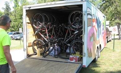
BIKE FLEET
Bicycle fleets are a set of bicycles that a school district, city, or independent entity owns that can be used by students, kids, and/or the general public. Having a bicycle fleet in a community allows students who do not have their own bicycles at home the opportunity to learn how to ride a bike in school or the community. Bicycle fleets should include bicycles of varying sizes, helmets, repair kits, and adaptive bikes.
When, where, and how will this be implemented?
Alexandria Public Schools leadership, along with support from local partners, will purchase a bike fleet for the school. The Alexandria Public Schools could explore a partnership with adjacent school districts.
Why is this relevant and recommended?
Not all students have access to a bicycle, and this would allow students the opportunity to ride in and possibly outside of school.
How will this address transportation inequities?
This ensures that all students have access to a bicycle regardless of their socioeconomic background, and the inclusion of an adaptive bicycle would ensure that students with disabilities can bike as well.
How will this be evaluated?
This would be evaluated by the completion of purchasing and deploying the bicycle fleet in the school.
Who needs to be involved to make this happen?
School district leadership, local health partners, West Central Initiative, and city staff and leadership.
What is the timeline for implementation?
Beginning in the 2024/2025 school year.
WALK AND BIKE FIELD TRIPS
A field trip made by foot or by bicycle gives students a supportive environment in which to practice their pedestrian safety or bicycling skills and showcases the many benefits of walking and bicycling for transportation, including health and physical activity, pollution reduction, and cost savings. The destination of the field trip may vary, or the field trip could be the ride itself.
When, where, and how will this be implemented?
Alexandria Public Schools leadership will hold a bicycle field trip either from the school or drive to a destination where students can then ride their bikes in a bike-friendly location. Alexandria Public Schools can reach out to local partners for resources and hands-on support during the bicycle field trips.
Why is this relevant and recommended?
Some kids do not have access to bikes at home, and this gives students the ability to take an enjoyable bike ride while practicing their cycling skills.
How will this address transportation inequities?
Alexandria Public Schools would provide standard and adaptive bicycles to all students who may not have access to bicycles at home.
How will this be evaluated?
This will be evaluated by the number of students who participate in the bicycle field trip.
Who needs to be involved to make this happen?
School District Leadership, physical education staff, and parents.
What is the timeline for implementation?
Beginning in the 2025/2026 school year.
ENHANCED SCHOOL COMMUNICATIONS
Existing communication channels can highlight the benefits of active school travel for students and families. Sharing regular SRTS updates and events throughout the school year will keep the benefits topof-mind for families, gradually shift perceptions about safety and convenience, and contribute to a school culture that supports walking and biking.
When, where, and how will this be implemented?
Alexandria Public Schools leadership will post Safe Routes to School updates and information on the school district webpage and supply handouts to families at the annual open house in the fall and parent-teacher conferences.
Why is this relevant and recommended? Caregivers feel uncomfortable with their children walking alone given safety concerns.
How will this address transportation inequities? Not all families have access to the same educational and informational materials. Having a variety of communication platforms allows for more equitable distribution.
How will this be evaluated?
This will be evaluated by the number of informational handouts given to district families and clicks/downloads on the district webpage.
Who needs to be involved to make this happen? School District leadership, local health partners, and teaching staff.
What is the timeline for implementation? Beginning in the 2024/2025 school year
Working for Change
Action Steps
This plan provides two critical ingredients for creating a more equitable transportation system in Alexandria: a prioritized set of infrastructure improvements and program recommendations, To make these recommendations a reality, all members of the Alexandria can play a role. The following text provides ideas for where to start.
Priority SRTS Initiatives
• Create a safe crossing and sidewalk network along McKay Avenue.
• Create a Safe Routes to School network and develop safe intersection crossings and sidewalks to create a safe and connected Alexandria.
• Reduce traffic speeds along major roads in front of schools with a focus on Discovery and Voyager.
• Develop an inclusive PE experience for students using a bike fleet and traffic garden for all ages and abilities.
• Incentivize walking, biking, and rolling to school by promoting Walk/Bike to School Days, Walking School Bus, and more.
IMPLEMENTING INFRASTRUCTURE CHANGES
DEMONSTRATION PROJECTS
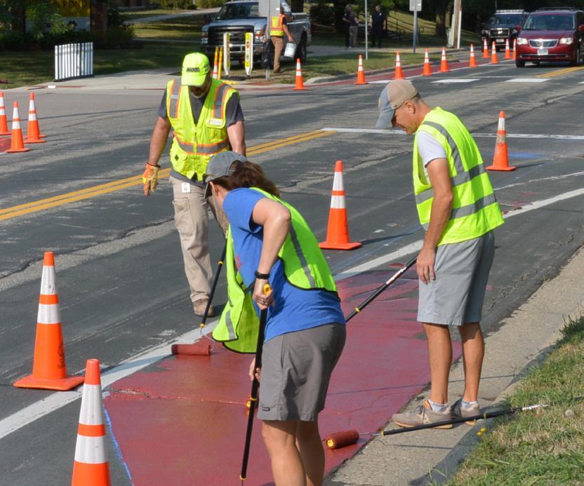
Before investing in a long-term infrastructure change, cities and partners may implement a demonstration project to test out an idea. These temporary projects are quick, have a relatively low installation cost, and build support for a long-term permanent change. Demonstration projects can also help engineers and designers make sure that design details are worked out before any new concrete is installed, such as making sure school buses have enough room to turn.
Demonstration projects can also be paired with programming or educational events to encourage additional behavior change. For example, new curb extensions may be paired with a crossing guard to bring additional attention to tricky crossing locations. Or a school may organize a Walk or Bike to School Day after installing a demonstration project to encourage students and families to try out the new infrastructure.
A demonstration project can include multiple components. The project shown here includes curb extensions and an on-street walking lane where there is currently a sidewalk gap.
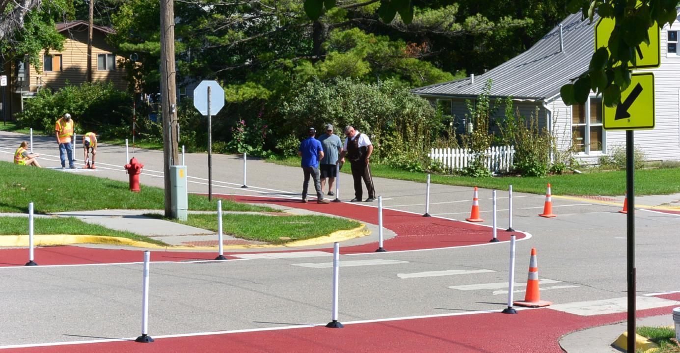
A demonstration project can include multiple components. The project shown here includes curb extensions and an onstreet walking lane where there is currently a sidewalk gap
This raised crosswalk connects to a school entrance and slows traffic on the adjacent road.
DEMONSTRATION PROJECT EXAMPLES
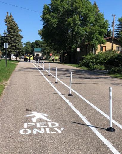
Demonstration projects can take many forms, with a few examples shown here. In previous SRTS efforts, communities have installed a shared use path on the street where there are no sidewalks (top left photo below), curb extensions at wide and uncomfortable intersections (top right and bottom photos below), and a number of other creative solutions.
Demonstration projects are typically installed in the spring or fall to have enough time to observe their effects before winter arrives. In some cases, a community may be specifically interested in a component of winter maintenance and may design the project to stay in place through the winter.
TAKING COMMUNITY ACTION
A more equitable transportation system that prioritizes safe, comfortable, and fun opportunities to walk, bike, and roll benefits everyone. While this plan is focused on addressing connections to schools, many improvements will benefit people with no relationship to the schools because we all share the same streets, sidewalks, and trails. Likewise, many needed changes, such as reducing speed limits and normalizing walking and biking, extend far beyond the school system.
Your number one role as a community member is to advocate for changes that make walking, biking, and rolling safer, more comfortable, and more fun. Speak to elected officials, show up to community meetings, talk about walking and biking at school events and with school administrators, and organize and vote for candidates who support walking, biking, and public transit.
I AM A STUDENT, CAREGIVER, OR COMMUNITY MEMBER
Students, families, neighborhood associations, advocacy groups, and local businesses can have incredible influence when advocating for change in their school and broader community. This is true both as individuals, as well as when community members come together into groups, such as a Parent Teacher Organization or disability advocacy groups. For example, students, caregivers, and community members can support and lead SRTS initiatives including:
• Advocating for policy change and funding at City Hall
• Developing campaigns to generate enthusiasm and improve social conditions for SRTS
• Volunteering time to lead a Walking School Bus or organize a bike drive
• Fundraising for SRTS programs and small infrastructure projects
I AM A SCHOOL DISTRICT EMPLOYEE
School district staff bring an important perspective and voice to advocating for a more equitable transportation system. By describing challenges and opportunities they see confronting their students and petitioning local elected officials for improvements, school district employees can support policy and infrastructure improvements that benefit their students and the broader community. Staff are also ideally positioned to implement the recommendations in this plan, whether it be a classroom-level curriculum or school district-wide policy around walking and biking.
I WORK FOR THE CITY OR COUNTY
As members of the governments that own, regulate, and maintain the roads, city and county staff can be instrumental in re-orienting transportation policies and infrastructure around walking and biking to schools and other destinations. City and county staff can leverage their expertise to identify, advocate for, and implement changes that contribute toward a more equitable transportation system. Key policies that staff can support include:
• Reducing lane widths and vehicular speed limits
• Eliminating minimum parking requirements
• Revising land use regulations to promote denser and more integrated land uses that promote walkable and bikeable trips
• Prioritizing municipal maintenance and snow clearing of all pedestrian and bike facilities
• Requiring complete streets infrastructure as part of all road resurfacing and reconstruction projects
City staff can also use this report to support Safe Routes to School funding applications to programs such as MnDOT SRTS grants, Federal SRTS grants, and the Statewide Health Improvement Program (SHIP)
Appendices
A. Visuals and Maps - 54
B. Student Travel Tally Results - 58
C. Caregiver Survey - 73
D. Observation Data - 89
E. Public Engagement Data – 95
F. Data Collection Instruments – 101
G. SMART Goals – 104
H. Team Notes – 105
I. School District and City Policies – 109
J. Alexandria Comprehensive Plan – 114
K. Crash Data – 117
L. Sample Subdivision Ordinance - 119
APPENDIX A: VISUALS AND MAPS
West Central Initiative has created online maps via Google My Maps for the use of the Alexandria Safe Routes to School committee. Visit the Google My Maps website at: https://tinyurl.com/3d3rdywv.
This map contains multiple layers for easy viewing, some of which have been manipulated to produce figures A –D. This map was created in May of 2023, based on visual assessments and data obtained during community walk audits.
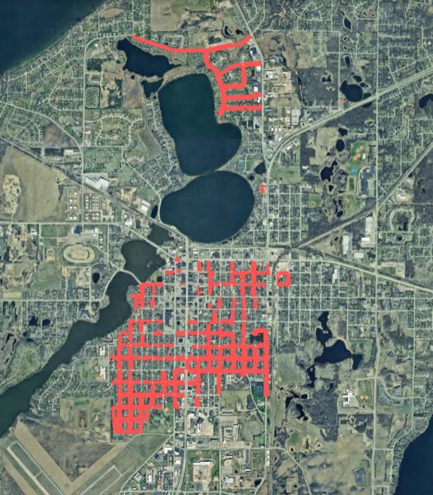
Figure A: Map of Alexandria where there are no existing sidewalks.
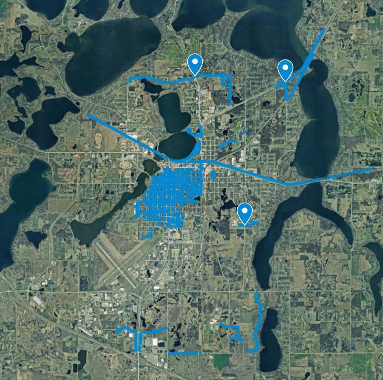
Figure B: City of Alexandria where there are existing sidewalks and underpasses denoted.
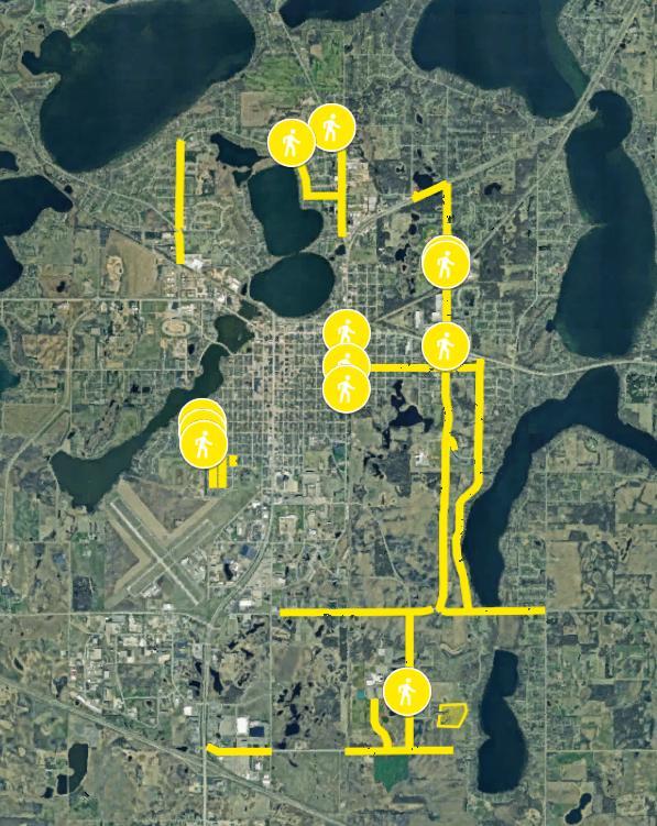
Figure C: City of Alexandria where sidewalks and enhanced crossing is recommended.
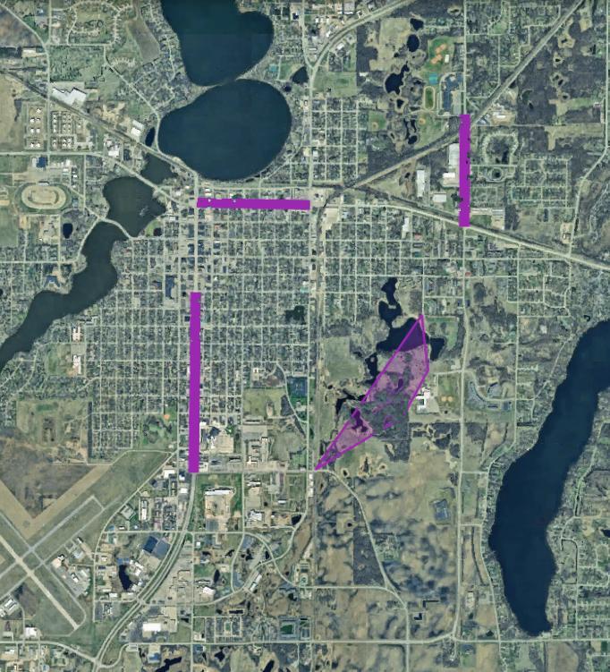
City
Alexandria where there are upcoming studies and transportation projects occurring in future years.
Figure D:
of
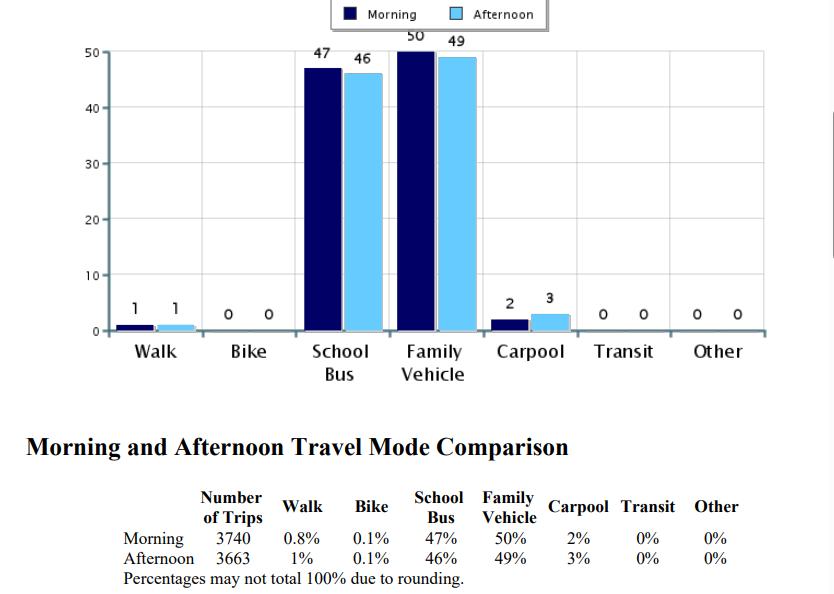
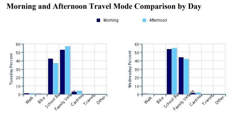
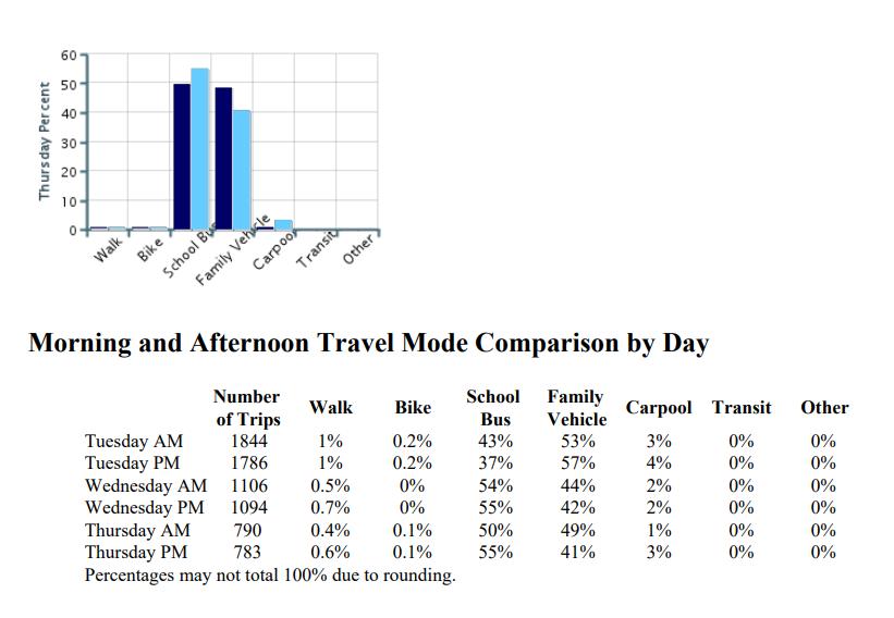
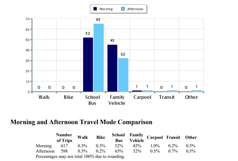
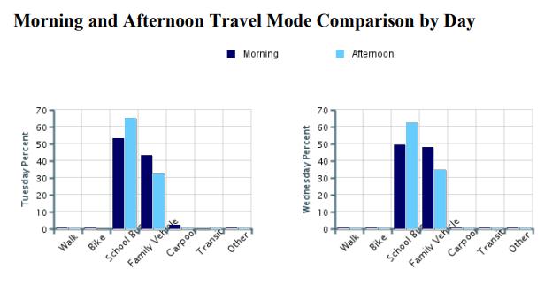
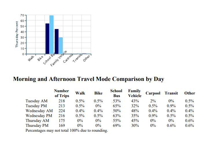
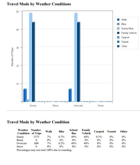
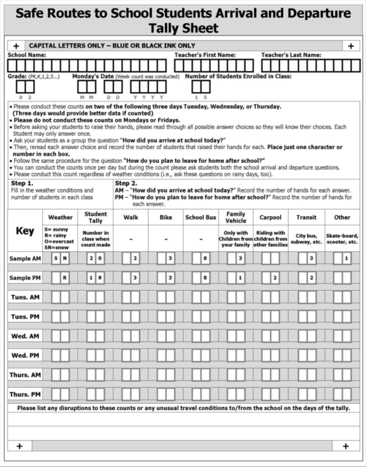
APPENDIX B: STUDENT TRAVEL TALLY RESULTS
Student Travel Tally Report: One School in One Data Collection Period
School Name: Alexandria High School
Set ID: 33139
School Group: Alexandria District 206 Month and Year Collected: October 2023
School Enrollment: 1,310
Number of Classrooms Included in Report: 41
Date Report Generated: 05/21/24
This report contains information from your school's classrooms about students' trip to and from school. The data used in this report were collected using the in-class Student Travel Tally questionnaire from the National Center for Safe Routes to School.
Student Travel Tally Report: One School in One Data Collection Period
School Name: Discovery Middle School
School Group: Alexandria District 206
School Enrollment: 874
Number of Classrooms Included in Report: 94
Set ID: 33161
Month and Year Collected: October 2023
Date Report Generated: 05/21/24
This report contains information from your school's classrooms about students' trip to and from school. The data used in this report were collected using the in-class Student Travel Tally questionnaire from the National Center for Safe Routes to School.
Student Travel Tally Report: One School in One Data Collection Period
School Name: Woodland School
School Group: Alexandria District 206
School Enrollment: 416
Number of Classrooms Included in Report: 6
Set ID: 33140
Month and Year Collected: October 2023
Date Report Generated: 05/21/24
This report contains information from your school's classrooms about students' trip to and from school. The data used in this report were collected using the in-class Student Travel Tally questionnaire from the National Center for Safe Routes to School.
Student Travel Tally Report: One School in One Data Collection Period
School Name: Voyager Elementary School
School Group: Alexandria District 206
School Enrollment: 427
Number of Classrooms Included in Report: 11
Set ID: 33152
Month and Year Collected: October 2023
Date Report Generated: 05/21/24
This report contains information from your school's classrooms about students' trip to and from school. The data used in this report were collected using the in-class Student Travel Tally questionnaire from the National Center for Safe Routes to School.
Student Travel Tally Report: One School in One Data Collection Period
School Name: Lincoln Elementary School
School Group: Alexandria District 206
School Enrollment: K-5
Number of Classrooms Included in Report: 17
Set ID: 33153
Month and Year Collected: October 2023
Date Report Generated: 05/21/24
This report contains information from your school's classrooms about students' trip to and from school. The data used in this report were collected using the in-class Student Travel Tally questionnaire from the National Center for Safe Routes to School.
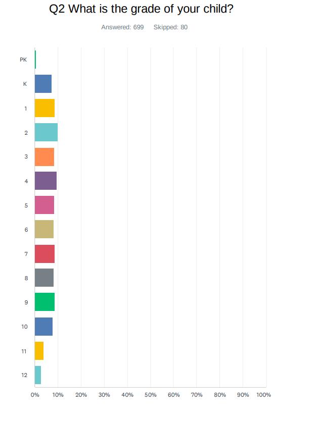
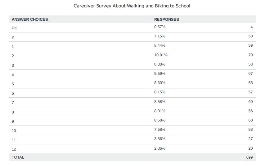
APPENDIX C: CAREGIVER SURVEY


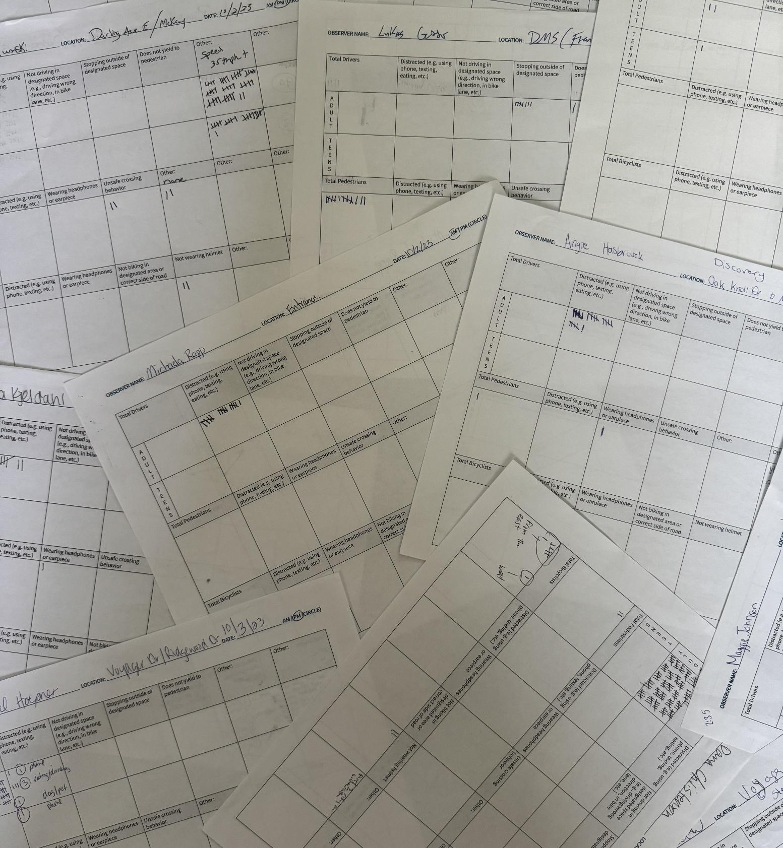
APPENDIX D: OBSERVATION DATA
SCHOOL NAME: Alexandria Public Schools (Woodland, Discovery, AAHS)
2. GRADE: Woodland K-5, Discovery 6-8, AAHS 9-12
3. ARRIVAL START TIME: 7:30AM END TIME: 8:20AM DISMISSAL START TIME: 2:55PM END TIME: 3:30PM
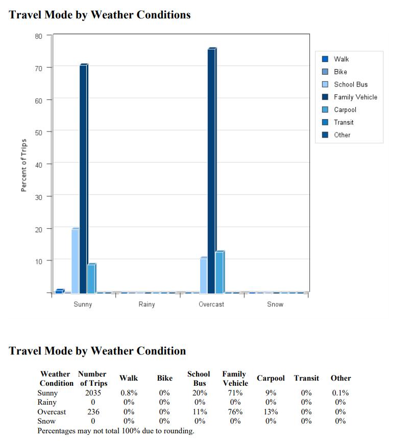
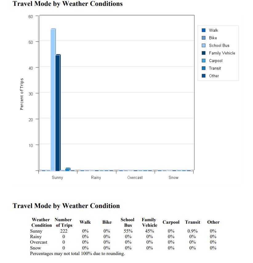
4. CIRCLE APPLICABLE WEATHER CONDITIONS: SUNNY, RAINY, OVERCAST, SNOW OTHER:
5. APPROXIMATE TEMPERATURE: 72-85 degrees
6. IS THERE AN APPOINTED SCHOOL STAFF MEMBER OR VOLUNTEER DIRECTING TRAFFIC FLOW? No
7. IS THERE A SPECIFIED DROP-OFF / PICK-UP AREA? Yes
8. IS THE DROP-OFF / PICK-UP ZONE SEPARATE FROM OTHER VEHICLES? Yes
9. IS THERE A SPECIFIED BIKE ARRIVAL / DISMISSAL AREA? No
Location Number Observer Name Which of the following traffic control devices are present at the observation area? Midblock or Intersection
Crosswalk Ped Crossing Signal Stop Sign Crossing Guard School Patrol Other Discovery Entrance Mallory, Lukas X X M
Oak Knoll Dr/McKay Angie X I
Trail behind Discovery Aaliyah
Trail Behind Discovery Maggie
McKay/Darling Ave Brandon Plumski X I
Woodland Entrance Michaela X X M
Woodland Tunnel Welle/Roers
Pioneer Rd SE/43rd Ave E Hawkinson X X X I
1. SCHOOL NAME: Alexandria Public Schools (Lincoln, Voyager)
2. GRADE: K-5
3. ARRIVAL START TIME: 7:10AM END TIME: 8:15AM
DISMISSAL START TIME: 2:10PM END TIME: 2:55PM
4. CIRCLE APPLICABLE WEATHER CONDITIONS: SUNNY, RAINY, OVERCAST, SNOW OTHER:
5. APPROXIMATE TEMPERATURE: 71-76 degrees
6. IS THERE AN APPOINTED SCHOOL STAFF MEMBER OR VOLUNTEER DIRECTING TRAFFIC FLOW? No
7. IS THERE A SPECIFIED DROP-OFF / PICK-UP AREA? Yes
8. IS THE DROP-OFF / PICK-UP ZONE SEPARATE FROM OTHER VEHICLES Yes?
9. IS THERE A SPECIFIED BIKE ARRIVAL / DISMISSAL AREA? No
Location Number Observer Name Which of the following traffic control devices are present at the observation area? Midblock or Intersection
Crosswalk Ped Crossing Signal Stop Sign Crossing Guard School Patrol Other
Lincoln: Behind School/Track Maggie
- not wearing helmet) 2- Distracted Angie Lincoln: 11th and Lark
1- not wearing helmet, wrong side of road
(2 not wearing helmets) (Group was biking down the middle of the road
(6 East, 1 West (2-not wearing helmet)
(1 youth on sidewalk, 1 adult in bike lane)
Kyra Kjeldahl Lincoln: 10th Ave/Lark
Eating/Drinking
On phone 1- Had pet 2- Smoking
Stopping outside designated space 15- Not stopping at stop sign 2 comments from drivers that this was the worst intersection in city.
APPENDIX E: PUBLIC OBSERVATION DATA
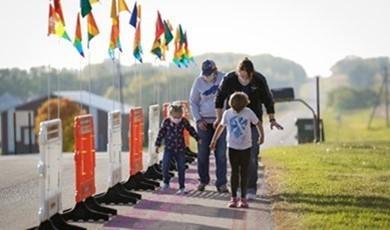
West Central Initiative staff held a tabling event on the day of the Alexandria Home Coming on September 15th , 2023. The staff member was located at the entrance of the football field. The staff members had poster boards where caregivers, students, and faculty could vote on what keeps children from walking or biking to school, and what would help students to walk or bike to school. Here are the results of the survey.
What would help children walk or bike to school
Encouragement/Rewards
More Crossing Guards
Slower Car Speeds
Less Traffic
Better Sidewalks/Paths
Safer Intersections/Crossings
Walk! Bike! Fun! Curriculum
Bus Stop and Walk Mileage Club
Bike Train
Walking School Bus
Figure E: A graph showing caregivers feedback to the question, “What would help children walk or bike to school?”
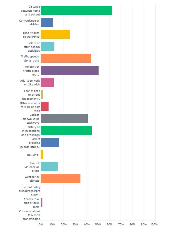
What keeps children from walking or biking to school
Weather/Climate
Lack of Crossing Guards Violence or Crime
Safety of Intersections/Crossings
Lack of Sidewalks/Paths
Speed of Cars or Traffic
Before/After School Activities Childcare
Lack of Adult Supervision
Convenience of Driving Time
Distance
Figure F: A graph showing caregiver feedback to the question, “What keeps children from walking to school?”
What would help children walk or bike to school
Encouragement/Rewards
More Crossing Guards
Slower Car Speeds
Less Traffic
Better Sidewalks/Paths
Safer Intersections/Crossings
Walk! Bike! Fun! Curriculum
Bus Stop and Walk Mileage Club
Bike Train
Walking School Bus
Figure G: A graph showing caregivers feedback to the question, “What would help children walk or bike to school?”
Weather/Climate
Violence or Crime
Lack of Crossing Guards
Safety of Intersections/Crossings
Lack of Sidewalks/Paths
Speed of Cars or Traffic
Childcare
Before/After School Activities
Lack of Adult Supervision
Convenience of Driving Time
Distance
Figure H: A graph showing caregiver feedback to the question, “What keeps children from walking to school?”
WOODLAND ELEMENTARY
What would help children walk or bike to school
Encouragement/Rewards
More Crossing Guards
Slower Car Speeds
Less Traffic
Better Sidewalks/Paths
Safer Intersections/Crossings
Walk! Bike! Fun! Curriculum
Mileage Club
Bus Stop and Walk
Bike Train
Walking School Bus
Figure I: A graph showing caregivers feedback to the question, “What would help children walk or bike to school?”
What keeps children from walking or biking to school
Weather/Climate
Violence or Crime
Lack of Crossing Guards
Safety of Intersections/Crossings
Lack of Sidewalks/Paths
Speed of Cars or Traffic
Childcare
Before/After School Activities
Lack of Adult Supervision
Convenience of Driving Time
Figure J: A graph showing caregiver feedback to the question, “What keeps children from walking to school?”
DISCOVERY MIDDLE SCHOOL
Encouragement/Rewards
More Crossing Guards
Slower Car Speeds
Better Sidewalks/Paths Less Traffic
Safer Intersections/Crossings
Walk! Bike! Fun! Curriculum
Mileage Club
Bus Stop and Walk
Bike Train
Figure K: A graph showing caregivers feedback to the question, “What would help children walk or bike to school?”
Weather/Climate
Violence or Crime
Lack of Crossing Guards
Safety of Intersections/Crossings
Lack of Sidewalks/Paths
Speed of Cars or Traffic
Childcare
Before/After School Activities
Lack of Adult Supervision
Convenience of Driving Time
Figure L: A graph showing caregiver feedback to the question, “What keeps children from walking to school?”
What would help children walk or bike to school
Encouragement/Rewards
More Crossing Guards
Slower Car Speeds
Less Traffic
Better Sidewalks/Paths
Safer Intersections/Crossings
Walk! Bike! Fun! Curriculum
Bus Stop and Walk Mileage Club
Bike Train
Walking School Bus
Figure M: A graph showing caregivers feedback to the question, “What would help children walk or bike to school?”
What keeps children from walking or biking to school
Weather/Climate
Violence or Crime
Lack of Crossing Guards
Safety of Intersections/Crossings
Lack of Sidewalks/Paths
Speed of Cars or Traffic
Childcare
Before/After School Activities
Lack of Adult Supervision
Convenience of Driving Time
Figure N: A graph showing caregiver feedback to the question, “What keeps children from walking to school?”
What would help children walk or bike to school
Encouragement/Rewards
More Crossing Guards
Slower Car Speeds
Less Traffic
Better Sidewalks/Paths
Safer Intersections/Crossings
Walk! Bike! Fun! Curriculum
Mileage Club
Bus Stop and Walk
Bike Train
Walking School Bus
Figure O: A graph showing caregivers feedback to the question, “What would help children walk or bike to school?”
What keeps children from walking or biking to school
Weather/Climate
Violence or Crime
Lack of Crossing Guards
Safety of Intersections/Crossings
Lack of Sidewalks/Paths
Speed of Cars or Traffic
Childcare
Before/After School Activities
Lack of Adult Supervision
Convenience of Driving Time
Figure P: A graph showing caregiver feedback to the question, “What keeps children from walking to school?”
APPENDIX F: DATA COLLECTION INSTRUMENTS
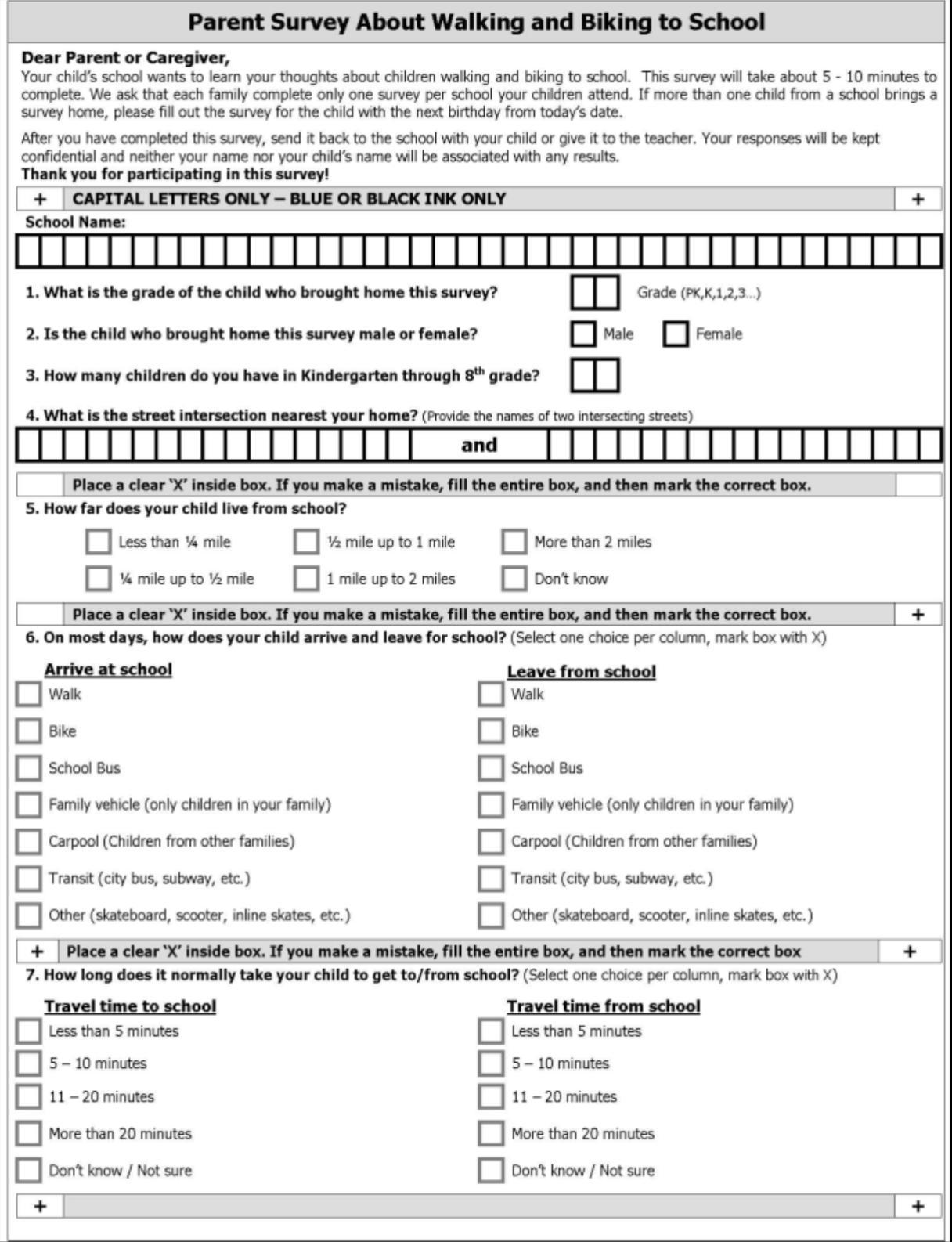
A high-quality and text readable version of this document can be found at Parent Survey. (chromeextension://efaidnbmnnnibpcajpcglclefindmkaj/https://saferoutesdata.org/downloads/Parent_Survey_English.pdf)
APPENDIX G: SMART GOALS
Education:
• Woodland Bike Rodeo hosted by community ed along with PD June 10-Aug 24, 2024.
• Walk! Bike! Fun! Curriculum implemented APS 2025/2026
• Woodland Elementary School will apply for Boost grant to fund a Bicycle Playground during the 2025 grant Solicitation.
Engagement:
• Alexandria Public School with help support and host a Family Bike Ride event for the Elementary Schools during the 2024/2025 school year.
• Destination Adventure, Student Wellness Committee, Great Outdoors, Green Team will support and run a student information campaign about walking and biking safety during the 2024/2025 school year.
Encouragement:
• Alexandria Public Schools will participate in the Walk and Bike to School days during the 2024/2025 school year.
Enforcement:
• Lincoln Elementary School will continue to support its youth crossing guard program.
• The Alexandria Police Department and Alexandria Public Schools will collaborate on conducting speed studies near Voyager, Lincoln, and Discovery schools with use of APD speed trailer during the 2024/2025 school year.
• The Alexandria Police Department will continue to implement its positive ticket program for kids who are wearing bicycle helmets.
Engineering:
• The City of Alexandria will work to further sidewalk connectivity around all of the schools
• The City of Alexandria and Discovery Middle School will continue to work to lower speeds and create safer crossings in front of the school
• Evaluation:
• Student travel tallies will be conducted by the APS wellness committee during the 2024/2025 school year.
• Walking and biking wellness survey conducted in the fall by PE teachers during the 2024 school year
Equity:
• Voyager Elementary School will work to expand and continue to develop the adaptive bikes program beginning in the 2024/2025 school year.
• The Alexandria School District will work to acquire a bike fleet program for its public schools in the 2024/2025 school year.
• Voyager Elementary will partner with Woodland Elementary to share a bike fleet to use on future playgrounds.
• Alexandria Public Schools will continue to use clear and simple language when providing walking and biking information to district families immediately.
• Alexandria Public Schools will work to acquire strider bikes for early ed center beginning in the 2024/2025 school year.
• Alexandria Public Schools in collaboration with Douglas County and the City of Alexandria will advocate for new infrastructure to meet PROWAG guidelines.
APPENDIX H: TEAM MEETING NOTES
On Alexandria Public School, SRTS Kickoff Meeting Notes
Tuesday, September 19th, 2023
In-Person
Lukas Gotto – SRTS Co-Chair
Jake Capistrant – Parent/Jake’s Bike Owner
Tim Christianson – Voyager Principal
Tim Erickson – Douglas County Engineer
Chad Duwenhoegger - High School Principal
Tim Shoonhoven: Alexandria City Engineer/Widseth
Stephanie Ruegemer – Woodland Elementary Principal
Tracy Von Bargen – Widseth
Maggie Johnson – Horizon Public Health
Sarah Kosters –Discovery Assistant Principal
Rick Sansted – APS Superintendent
Brendan Bogart – Lincoln Elementary Principal
Virtual:
Mike Weber – City of Alexandria City Planner
Mary Safgren – District 4 Planning Director
Tim and Kim Eggebraaten – Parents
Rosemary Bruce-White – District 4 Principal Planner
Welcome and Introductions:
Mallory Kicked off the meeting 3:30PM with an ice-breaker.
Overview:
Mallory mentioned that the Alexandria SRTS Team received an overview of the Safe Routes to School program last December. Mallory gave a presentation on Safe Routes to School 101. Planning Process
Mallory pulled up the stakeholder's poster and went through each role and what they bring to the table and take away from the planning process. The committee went over the scope of work, including project timeline and what deliverables will be due at each step. The group then went over a planning update, looking at data collected from Public Engagement dotmocracy session held at the Alexandria
Homecoming football game.
Determine Vision and Goals
The group went of the vision statement provided by West Central Initiative and discussed changes. The revised version is as follows:
The City of Alexandria and Alexandria Public Schools seek to become a community where it is safe and convenient for students to walk, bike, and roll to, from, and between schools; where our children can
travel, explore, and pay in their community safely under their own power; and where they learn life-long habits of incorporating physical activity unto their daily lives. We will seek to achieve this vision through safety awareness, education, encouragement, and self-evaluation, all while building the infrastructure needed to make walking, biking, and rolling safer and more convenient for all.
Group Discussion
1. What are the biggest barriers?
There is a perception that no one walks in Alexandria. Physical distance is difficult since Alexandira is a community fairly spread out. There is a perception that it is not safe to walk and bike. Parents and students have an attitude that walking is not a primary option or an option at all. Lifestyle choices in the community prefer driving over walking or biking. The creation of Compass resulted in no more latch-key kids. Kids do not have as much freedom. There is an inaccessibility to the trails within the community.
2. Areas of community where walking and biking is difficult. Rosewood Ave is a narrow road with fast car speeds. Agnes/3rd Ave is a very busy intersection. McKay has no sidewalks and fast car speeds. The High School has no pedestrian/bicyclist infrastructure and fast car speeds. Also far from town. All along HWY 29 is difficult.
3. What are biggest opportunities?
The Nature Trail, Central Lakes Trail, walking trails, Horizon Public Health, and walking routes. There is education that instructs kids where to walk and bike. The North/South artery connection.
4. Locations where connections should be prioritized. Playgrounds, city parks, and the beach on HWY 29 fishing pier.
5. What would encourage more people to walk and bike? Reducing speed and using law enforcement.
Action Items for Team
1. Mallory led a discussion on what day should be observation day. The group consensus decided that there would be two observation days. Monday, October 2 nd will be observation day for Alexandria Secondary, Woodland, and Discovery. Tuesday, October 3rd will be Voyager and Lincoln Elementary. Lukas G and Jake C will ask for volunteers on those dates.
2. The parent survey will be sent out by each principal in the following weeks. Principals will also include a link to an online mapping tool.
3. Mallory will email the school environment policy assessment later in the fall for each principal to complete.
Next committee meeting – January
Adjourn
The committee adjourned at 5:15PM. On Alexandria Public School, SRTS Meeting Notes Wednesday, January 17th, 2024
In-Person
Lukas Gotto – SRTS Co-Chair
Jake Capistrant – Parent/Jake’s Bike Owner
Maggie Johnson – Horizon Public Health
Sarah Kosters –Discovery Assistant Principal
Rick Sansted – APS Superintendent
Kim Eggebraaten – Parent
James Ross – Alexandria Police Dept
Brody Buse – Student
Blaine Green – Alexandria Engineer
Dana Christiansen – Voyager Principal
Virtual:
Aaliyah Helland – West Central Initiative
Welcome and Introductions:
Mallory kicked off the meeting at 3:30 PM with introductions.
Review Planning Process:
Mallory gave an overview of the timeline using the scope of work.
Discussion: Results of Data Gathering
Mallory gave an overview of several data gathering methods used so far. Gave update on the public engagement session during the parent-teacher conferences and observation day. Aaliyah then gave a presentation on the results from the student travel tally. There was discussion that the results from the online survey were inaccurate, and we could potentially redo Alexandria Area High School. There was discussion that the results were fairly accurate to what is expected and that there is no need to redo student travel tallies.
Action Items:
Mallory restated the online mapping platform is still open for community members to use.
SMART Goals:
Mallory led a discussion on the SMART Goals. She explained what SMART goals are, and gave everyone a hand out with SRTS options. Mallory took notes on the SMART goals sheet. The group covered Education, Engagement, Encouragement, Evaluation, and Enforcement.
Next Meeting:
Mallory mentioned that the Boost Grant is now open if the team would like to discuss applying. There was positive discussion about a bicycle playground at Woodland were the buses park. The team will meeting soon to look at the application. The next meeting will be scheduled soon after the meeting to look at finishing the SMART Goals.
Mallory adjourned at 4:40PM.
Alexandria Public School, SRTS Meeting Notes
Wednesday, February 12th, 2024
In-Person
Lukas Gotto – SRTS Co-Chair
Jake Capistrant – Parent/Jake’s Bike Owner
Maggie Johnson – Horizon Public Health
Blaine Green – Alexandria Engineer
Dana Christiansen – Voyager Principal
Tim Erickson – Douglas County Engineer
Mallory Jarvi – West Central Initiative
Aaliyah Helland – West Central Initiative
Sarah Kosters –Discovery Assistant Principal
Stephanie Ruegemer – Woodland Elementary Principal
Welcome and Introductions:
Mallory welcomed everyone to the meeting at 3:30PM.
SMART Goals:
Mallory jumped into conversations about the Engineering and Engineering and Equity SMART Goals.
Meeting adjourned at 4:30PM.
APPENDIX I: ALEXANDRIA SCHOOL DISTRICT AND CITY POLICIES
ALEXANDRIA PUBLIC SCHOOLS WELLNESS POLICY
I. PURPOSE
The purpose of this policy is to set forth methods promoting student wellness, prevent and reduce childhood obesity and assure that school meals and other food and beverages sold and otherwise made available on the school campus during the school day are consistent with applicable minimum local, state and federal standards.
II. GENERAL STATEMENT OF POLICY
A. The school board recognizes that nutrition promotion and education, physical activity and other school-based activities that promote student wellness are essential components of the educational process and that good health fosters student attendance and learning
B. The school environment should promote students’ health, well-being and ability to learn by encouraging healthy eating and physical activity.
C. The school district encourages the involvement of students, parents, representatives of the school food authority, teachers, school health professionals, the school board, school administrators and the general public in the development, implementation and periodic review and update of the school district’s wellness policy.
D. Children need access to healthy foods and opportunities to be physically active in order to grow, learn and thrive.
E. All students in grades PreK-12 will have opportunities, support and encouragement to be physically active on a regular basis.
F. Qualified food and nutrition services personnel will provide students with access to a variety of affordable, nutritious and appealing foods that meet the health and nutrition needs of students; try to accommodate the religious, ethnic and cultural diversity of the student body in meal planning and will provide clean, safe and pleasant settings and adequate time for students to eat.
III. WELLNESS GOALS
B. Physical Activity
1. Students need opportunities, support and encouragement to be physically active and to fully embrace regular physical activity as a personal behavior. Physical education and health instruction will be available for K-12, as per MDE requirements ;
2. Opportunities for physical activity will be incorporated into other subject lessons, where appropriate;
3. Classroom teachers will provide short physical activity breaks between lessons or classes, as appropriate;
4. The district is involved in active transportation initiatives for all K-12 students who live within walkable/bikeable distance;
5. School personnel will not withhold participation in recess or physical activity as a punishment for lack of work completion, unless mutually agreed upon by the parent/guardian;
6. School personnel will not use physical activity as a punishment;
7. Recess is not synonymous with physical education. Recess will not be used in place of physical education minutes;
8. The district will follow state standards for physical education exemption requirements for all students; and
9. All physical education educators receive continuing education annually.
C. Communications with Parents
1. The school district recognizes that parents and guardians have a primary role in promoting their children’s health and well-being.
2. The school district will support parents’ efforts to provide a healthy diet and daily physical activity for their children.
3. The school district encourages parents to pack healthy lunches and snacks and refrain from including foods and beverages without nutritional value.
4. The school district will provide information about physical education and other school-based physical activity opportunities and will support parents’ efforts to provide their children with opportunities to be physically active outside of school.
5. Families will be provided information about determining eligibility for free/reduced priced meals.
V. WELLNESS LEADERSHIP AND COMMUNITY INVOLVEMENT
A. Wellness Coordinator
1. The superintendent will designate a school district official to oversee the school district’s wellness-related activities (Wellness Coordinator). The Wellness Coordinator will ensure that each school implements the policy.
2. The principal of each school, or a designated school official, will ensure compliance within the school and will report to the Wellness Coordinator regarding compliance matters upon request.
B. Public Involvement
1. The Wellness Coordinator will permit parents, students, representatives of the school food authority, teachers of physical education, school health professionals, the school board, school administrators and the general public to participate in the development, implementation and periodic review and update of the wellness policy.
2. The Wellness Coordinator will hold meetings, from time to time, for the purpose of discussing the development, implementation and periodic review and update of the wellness policy. All meeting dates and times will be posted on the school district’s website and will be open to the public.
TRANSPORTATION OF PUBLIC SCHOOLS
Riding the school bus is a privilege, not a right. Safety is the first priority for the Transportation Department. Students are expected to follow the same behavioral standards while riding school buses as are expected on school property or at school activities, functions, or events.
The School District School Bus Safety Rules are posted on every bus. Enforcement of the rules is necessary for the safety of all passengers. It is the school bus driver’s responsibility to report unacceptable behavior to the Transportation Office and School Office. All school rules are in effect while a student is riding the bus or at the bus stop. Any student who violates the student conduct and/or school bus safety rules is subject to disciplinary action in accordance with the District Discipline Policy and may result in the denial of transportation privileges upon notification of the parent or guardian.
TRANSPORTATION ELIGIBILITY
Resident students who reside two miles or more from the school shall be eligible for transportation to and from school at the expense of the school district.
The school district will also seek to provide transportation service (at the expense of the school district) using the following guidelines up to: Kindergarten - .25 mile, Elementary - .5 mile, Middle School - 1.0 mile, High School - 1.5 miles.
The child's recognized residence will be located within the transportation boundary of the child's school of attendance.
Resident elementary students will be provided transportation services to their assigned school based on the district's elementary school boundaries. Exceptions to the assigned school are Miltona Elementary School and when approved by the superintendent.
Additional transportation services may also be provided to any student (at the expense of the school district) for other purposes deemed appropriate by the superintendent (i.e. safety concerns).
The take-home bus stop will be one location only because alternating from one take-home stop to another has caused students to become lost and confused.
ALEXANDRA CITY ORDINANCES
Public Transit
The City of Alexandria offers public transit through the Rainbow Rider Transit. Rainbow Rider provides public transit for Douglas, Grant, Pope, Stevens, Todd and Traverse Counties. The City of Alexandria is the only city within Rainbow Rider’s system that has a fixed deviated route and operates on Saturdays. Fixed deviated route bus service in Alexandria stops at various locations within the City at scheduled times. The service operates during weekdays from 11:00 am until 3:00 pm. Scheduled stops occur at the following locations: Wal-Mart Target Alexandria Clinic Viking Plaza Aagard (formerly Kmart) Cub Foods (formerly Pete’s County Market) Alexandria Technical & Community College Sanford Clinic Bethany on the Lake Vikings Towers The complete roundtrip on the route takes one hour and costs $1 for unlimited trips.
Rainbow Rider Transit provides door-to-door service with extra care provided for children and senior citizens. Door-to-door services enables drivers to assist passengers with a steadying arm between the bus and the exterior door of their pick-up and drop-off locations and carry up to three small packages (up to 25 pounds or what can be carried in one trip).
All Rainbow Rider buses are handicapped accessible and equipped with an infant safety seat, two-way radio, and cellular phone. This service is provided throughout Douglas County on weekdays from 6:30 am to 7:45 pm. Additional service for Alexandria is provided on Saturdays from 8:00 am until 4:00 pm. Rainbow Rider provides handicapped accessible buses through a volunteer driver program. The service is supported by passenger fares, service contracts, state and federal taxes, sales of advertising space, local county appropriations, and donations.
Rainbow Rider is governed by the Rainbow Rider Transit Board.
Private Transit Private transit service is also available to the City of Alexandria. Other services include Peoples Express, Greyhound, and Jefferson Lines. The Greyhound Bus Company has a daily route to Minneapolis/St. Paul and the Fargo-Moorhead, Grand Forks and Winnipeg areas. Taxi service within the City of Alexandria is offered by three private services, one of which has charter service and shuttle service to and from the Minneapolis International Airport and operates up to nine trips per day from Alexandria.
INTRODUCTION
The City of Alexandria finds that it is in the best interest of the residents for the City to do the maintenance of its City streets. An important part of street maintenance is the repair of potholes.
The City will repair potholes in a safe and cost effective manner, keeping in mind safety, budget, personnel, and environmental concerns.
The City will use City employees, equipment and/or private contractors to provide this service. Pothole repair is part of the City’s overall pavement management program.
APPLICATION
This policy applies to City streets. It does not apply to other governmental unit’s roads that go through the City unless there is a specific agreement between the City and that other governmental unit.
WHEN WILL THE CITY PERFORM STREET SWEEPING OPERATIONS?
The Public Works Coordinator will decide when to conduct pothole repairs. Repairs will consist of two elements:
Crew Repair: A crew will be assigned an area to inspect. It will repair any potholes it finds in that area. Each street will be inspected at a minimum of once a year depending on available resources and factors such as weather and other street work that needs to be done. The timing for the repairs will also be based upon those factors.
Response To Complaint Or Accident: A crew will be sent out to inspect any street when the City receives a complaint or notice of an accident or damage involving a pothole.
CRITERIA FOR POTHOLE REPAIR
Not every imperfection in a street surface is necessarily considered to be a pothole in need of repair. The general criteria for repair will be a pothole that is two (2) inches or more deep and over five (5) inches in diameter.
The Public Works Coordinator or his or her designated employee will have discretion to decide if a condition is a pothole in need of repair. How Will Potholes Be Repaired? Potholes will be repaired temporarily during cold weather with a cold asphalt mix or other means. During cold weather, the repairs will be limited to those determined to be hazardous for motor vehicles. In warmer weather and when hot asphalt mix is available, potholes will be filled with hot asphalt mix or other means for a more permanent repair. Date: May 8, 2012 2
Responsible Person: Public Works Coordinator
PRIORITIES & SCHEDULE FOR WHICH STREETS’ POTHOLES WILL BE REPAIRED
The City has classified City streets based on the street function, traffic volume, and importance to the welfare of the community. The City will repair those streets first that are high volume and high speed routes that connect major sections of the City and provide access for emergency fire, police, and medical services.
The second priority streets are those streets providing access to schools and commercial businesses. The third priority streets are low volume residential streets. The fourth priority areas are alleys and City parking lots.
WEATHER CONDITIONS
Pothole repairs will be conducted only when weather conditions do not limit the ability to perform the work or when such work would not endanger the safety of City employees and equipment. Factors that may delay repairs are cold temperatures, rain, snow, and ice conditions.
DOCUMENTATION
Workers will document all street repairs to potholes that are made under this policy. Records will not necessarily identify each individual pothole, but may show the general street location where repairs are made. WARNING SIGNS OR DEVICES If the City knows of a pothole in a street and it is not able to repair it, it will consider whether it
should use warning signs or devices. Factors that will be examined will be the location of the pothole, how dangerous it is, and whether a warning sign or device would be effective.
REVIEW & MODIFICATION OF POLICY
The Public Works Coordinator shall keep on file all comments and complaints received regarding this policy. The policy will be reviewed periodically. Any review will consider comments and complaints since the last review and any other factors affecting the policy or its implementation.
APPENDIX J: ALEXANDRIA 2040
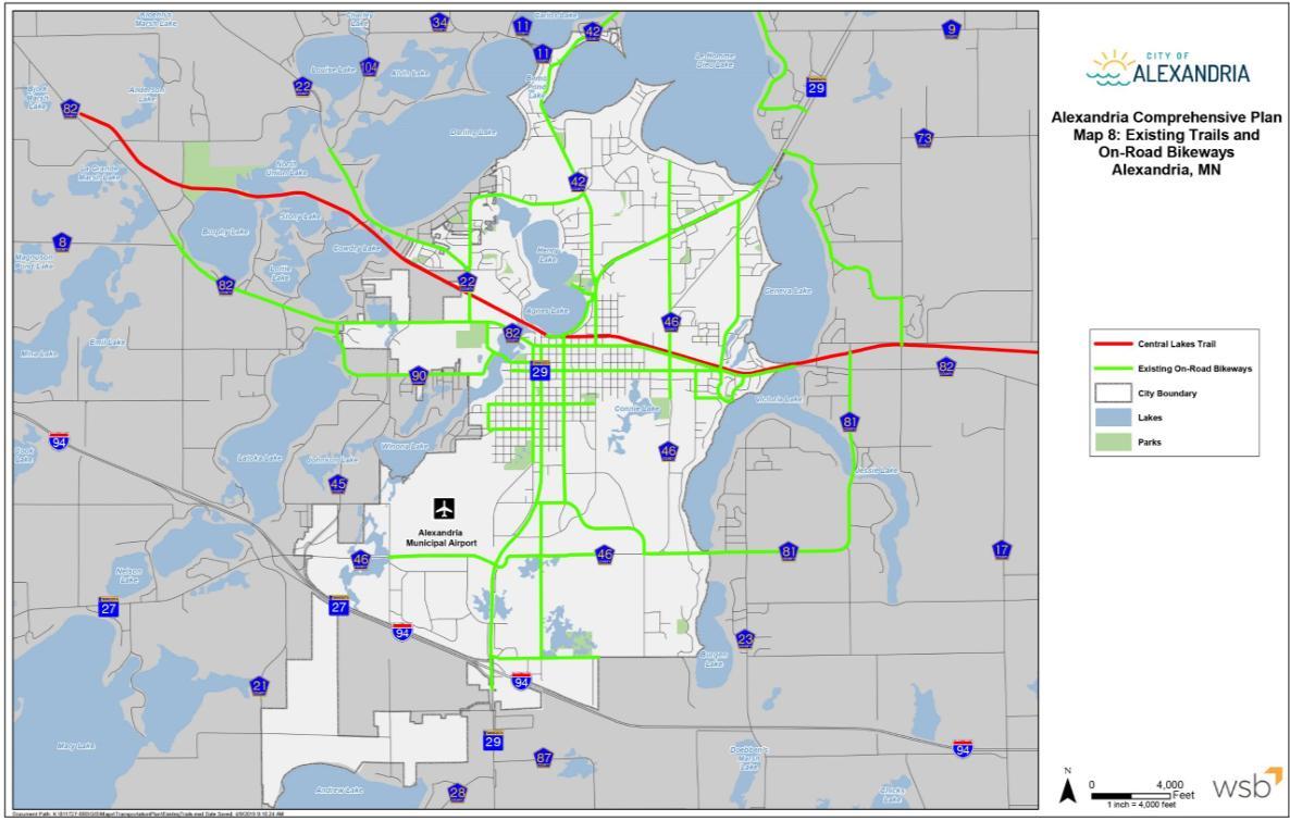
Figure P: A map from Alexandria’s Comprehensive Plan displaying existing trails and on-road bikeways.
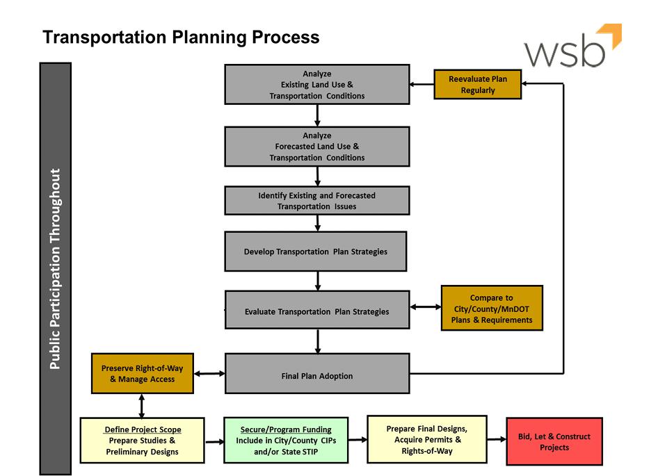
Figure Q: A flow chart showing how the transportation planning process will be conducted in Alexandria.
Vision:
The City of Alexandria will be a place where a local transportation network provides businesses, residents and visitors with multiple options for mobility throughout the Community and connects the City regionally.
Goals
- The City’s transportation system will continue to diversify its mobility options to improve travel by automobile, pedestrian, bicycle and transit.
- Existing Infrastructure will be maintained to meet the needs of residential diversification and economic growth within city limits.
Policies
1. Promote fiscally responsible infrastructure construction conducive to continued development and redevelopment.
2. Ensure existing infrastructure is maintained and upgraded in a cost effective and timely manner that provides optimum service to the community.
3. Promote and sustain an affordable, safe and convenient transportation network including local, county and state roadways and amenities.
4. Provide a safe and efficient transportation system that is cost effective.
5. Ensure that the transportation system, in the implementation phases, is as environmentally sensitive as possible.
6. Provide a coordinated transportation system with respect to regional and county plans.
7. Provide a transportation system that supports multi-modal transportation whenever and wherever feasible and advantageous.
General Strategies
• Hold an annual coordination meeting with State, County and Townships to better plan upcoming projects.
• Develop an “Active Transportation Plan” for the City including:
o Design standards (trails, crossing, signage)
o Routes and associated destinations – coordinate with transit
o Including accessibility standards o Consider complete streets
o Conduct a “walkability study” to identify areas where safety improvements, access and ADA upgrades are needed.
• Update the Capital Improvement Plan (CIP), looking 5 years out or more to identify timing and funding sources for the projects contained within this plan. Review the CIP on an annual basis to incorporate project budgets over the next fiscal year.
Roadway Strategies
Consider roadway extension projects to improve connectivity on city roads.
Possible locations include:
18th Avenue Easterly Extension to CSAH 46
Dakota Street/44th Avenue Extension
Wal-Mart Drive Extension between Hardee’s and Subway
Consider capacity expansion projects to improve safety and reduce delays. Possibly locations include:
CSAH 42 (3 Lane/4 Lane Expansion)
Nokomis Street (3 Lane Expansion)
Identify future Functional Classification changes to discuss with MnDOT
Work with Douglas County to establish an interconnected network of 10-ton roadways Identify road impacts if airport is relocated
Conduct a multimodal corridor study on MN Highway 29 (Currently Underway)
Conduct a Burgen Lake Rest Area Interchange Study, including an analysis of the Pioneer Trail Extension and I94 North Frontage Road (Currently Underway)
Conduct an Interchange Study at I-94 and MN Highway 27 (Currently Underway)
Evaluate intersection improvements at the following locations:
CSAH 22/Voyager Drive/Curt Felt Drive
Twin Boulevard and 50th Avenue
Non-Motorized Transportation Strategies
Identify new east-west and north-south trail connections in the City Fill gaps in the sidewalk and trail network, especially in the southern portion of the City
Improve pedestrian safety and access throughout the City, including crossings of busy roadways
Encourage biking and walking and incorporate ADA improvements
Transit Strategies
Continue to support Rainbow Rider Transit service Determine need for a park and ride facility near the I-94 interchange Aviation
Continue to analyze possible locations for the Alexandria Municipal Airport
APPENDIX K: CRASH DATA
Crash data from within the Alexandria city limits was gathered using the online Minnesota Crash Mapping Analysis Tool. (MCMAT2) (https://mncmat2.dot.state.mn.us/web) MCMAT2 is MnDOT’s crash database that includes all crashes involving a motor vehicle where a crash report was filed. It includes crash reports from the past ten years. However, a crash involving a solo cyclist, the most common type of bicyclist crash, would not be recorded even if emergency services responded because the crash did not involve a motor vehicle
Alexandria
Data available for this analysis is from January 1st, 2014, through September 30th, 2024, all of which were included in this analysis. Typically, the lag time between crash occurrence and data entry into the MCMAT2 database can be approximately 2-3 months with the data updated four times per year, approximately quarterly.
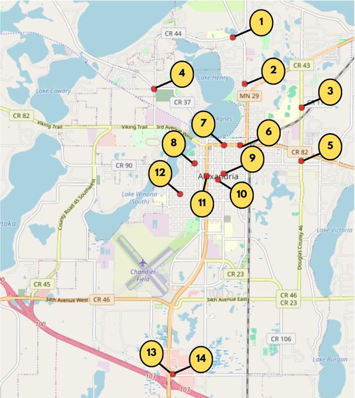
Figure R: Map of the City of Alexandria with marked locations of pedestrian and bicyclist crash sites.
The staff at WCI felt that collecting crash data within the city limits of Pelican Rapids would provide the most utility. There was a total of 1,644 vehicle crashes with 49 of those involving a bicyclist or pedestrian. The following analysis is for the 14 crashes involving youth, ages 18 and under who were involved in a pedestrian or bicyclist crash.
1. On May 29, 2018, at 2:30 PM under rainy conditions, an 11-year-old male pedestrian crossed Voyageur Drive at an unmarked crossing and collided with a 23-year-old male driving a sport utility vehicle heading westbound on Voyageur Drive. The pedestrian received a serious injury.
2. On May 28, 2015, at 5:20 PM under clear conditions, a 22-year-old male operating a pickup was heading north on N Nokomis when the tow line came loose, and a golf cart being transported fell off onto the shoulder and struck a 16-year-old male bicyclist from behind traveling north on the shoulder of N Nokomis Street. bicyclist. The bicyclist received a possible injury.
3. On December 8, 2014, at 3:08 PM, under wet and cloudy conditions, a 43-year-old female driving a sport utility vehicle driving slowly adjacent to Discovery Middle School struck a 12-year-old male crossing McKay Avenue. The driver had limited visibility due to bus in the left turn lane where the students crossed in front of the bus and then into the northbound travel lane. The pedestrian received a possible injury
4. On October 2, 2014, at 6:30 PM under clear conditions, a 16-year-old male on a skateboard was struck by an unknown vehicle turning right off County Road 22 onto Curt Felt Drive. The skateboarder received a possible injury.
5. On June 5, 2020, at 10:03 PM, under clear conditions, an 18-year-old female pedestrian attempted to cross McKay westbound at a midblock point and was struck by a 19-year-old male operating a passenger car traveling southbound on McKay. Noted that streetlights were not present. The pedestrian later died due to injuries.
6. On September 2, 2016, at 6:00 PM, an 15-year-old male bicyclist collided with a 46-year-old female driving a passenger van turning right onto 3rd Street from Maple Street The bicyclist received a possible injury.
7. On July 21, 2017, at 8:50 PM under wet and rainy conditions, a 10-year-old female bicyclist attempted to cross 3rd Avenue at the crosswalk at the intersection with Jefferson Street and was struck by a 46-year-old male driving a passenger car traveling eastbound on 3rd Avenue. The driver did not see the bicyclist as she was obstructed by left-turning cars. The bicyclist received a minor injury.
8. On August 13, 2022, at 8:33 PM under clear conditions, a 1-year-old female pedestrian ran into the side of a 39year-old female driving a passenger car who was traveling westbound on 6th Avenue West. The driver had stopped for a bicycle exiting an alley and the pedestrian was following the bike and did not stop for the vehicle. The pedestrian received a possible injury.
9. On April 23, 2016, at 7:40 PM under cloudy conditions, a 1-year-old male pedestrian was struck by a 41-year-old female driving a passenger car heading southbound on Jefferson Street. Alcohol may have been a contributing factor. The pedestrian received a serious injury.
10. On April 16, 2016, at 7:09 PM, under clear conditions, a 16-year-old male pedestrian jumped in front of and was then hit by a 16-year-old male driving a pickup heading northbound on Irving. The pedestrian knew the driver and believed the driver would stop in time. The pedestrian received a serious injury.
11. On March 29, 2021, at 5:10 PM, under clear conditions, a 16-year-old male bicyclist traveling eastbound on 8th Avenue collided with a 73-year-old male driving a passenger car when crossing Broadway. The driver did notice the car on the outside lane stopping at the crosswalk but did not stop due to view obstruction and not seeing the bicyclist. The bicyclist received a possible injury.
12. On July 22, 2017, at 7:45 PM, under clear conditions, a one-year-old male pedestrian was struck by a 45-yearold female driving a passenger car pulling into a driveway The pedestrian received minor a minor injury.
13. On November 18, 2018, at 1:00 PM under clear conditions, a 13-year-old female and 21-year-old female pedestrians attempted to cross 50th Avenue and were struck by a 20-year-old female in a passenger van traveling eastbound on 50th Avenue. Pedestrians began crossing when a westbound truck stopped, but travel lane of the driver did not stop and was not able to stop in time. The pedestrians received minor injuries.
14. On October 8, 2022, at 11:58 AM under clear conditions, a 14-year-old male pedestrian attempted to Sanibel Drive and was struck by a 46-year-old female driving a passenger van traveling westbound on Sanibel Drive out of Walmart. Pedestrians began crossing between two coach buses and believed the roadway was clear and did not see the driver. The vehicle sustained property damage.
APPENDIX L: SAMPLE SUBDIVISION ORDINANCE