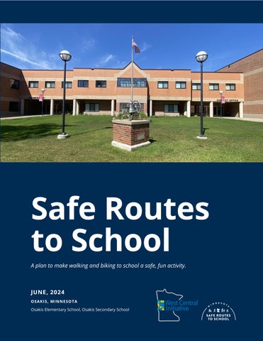
Safe Routes to School
A plan to make walking and biking to school a safe, fun activity.
JUNE, 2024
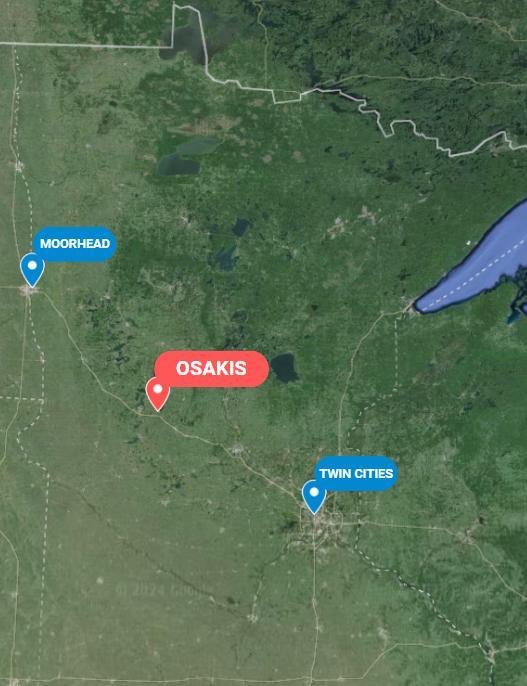
OSAKIS, MINNESOTA
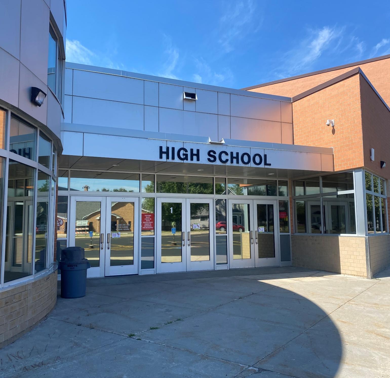
Osakis Elementary School, Osakis Secondary School
Acknowledgements
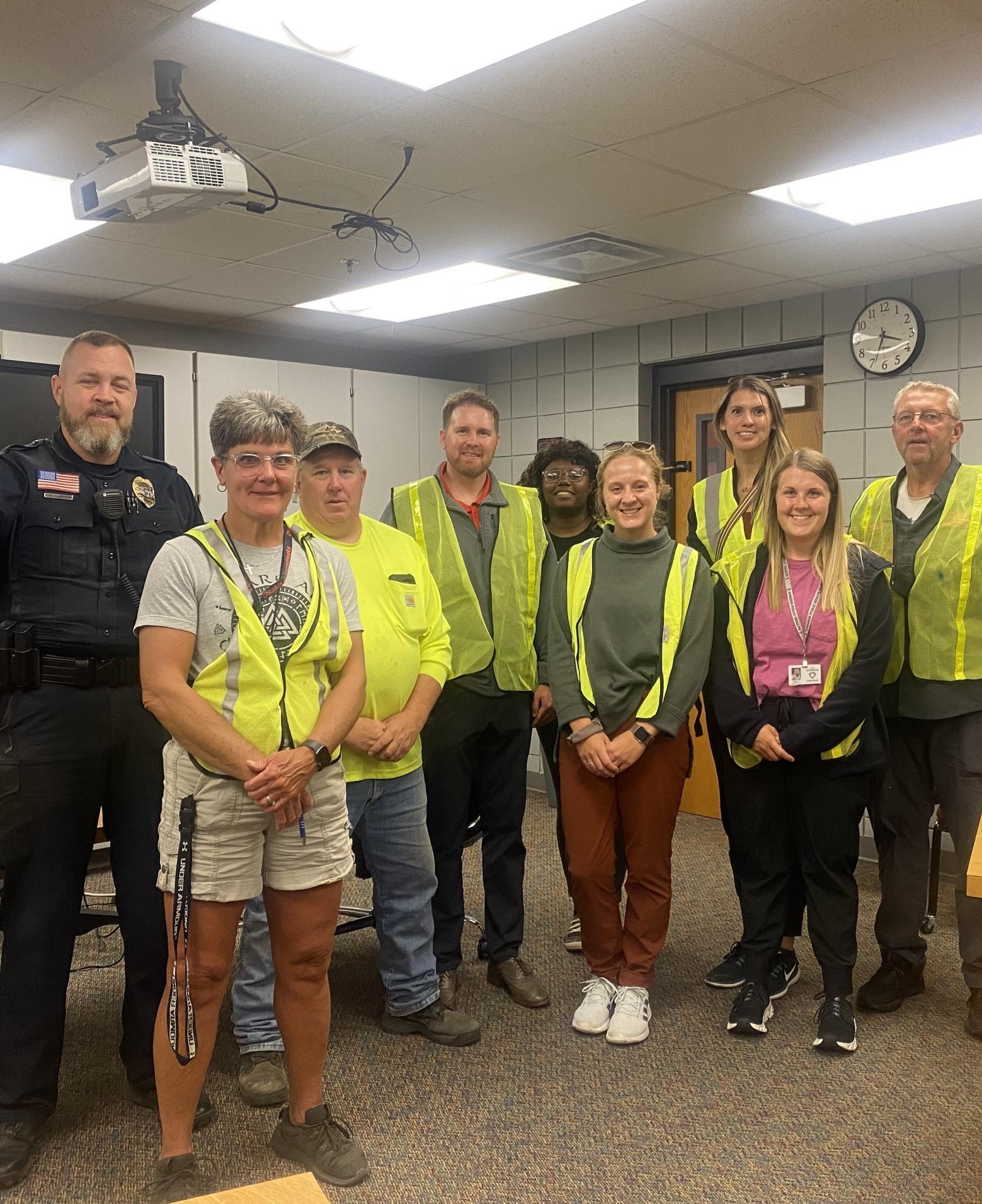
We gratefully acknowledge the participation of the following individuals and organizations in the development of the Osakis Safe Routes to School (SRTS) Plan.
SRTS PLANNING TEAM
Justin Dahlheimer, Superintendent Osakis School District
SRTS Team Co-Chair
Angela Jacobson, City Clerk City of Osakis
SRTS Team Co-chair
Brad Hoffarth, High School Principal Osakis School District
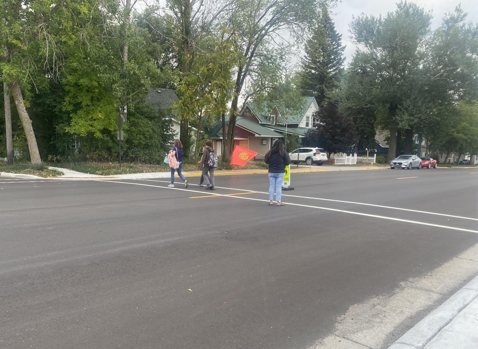
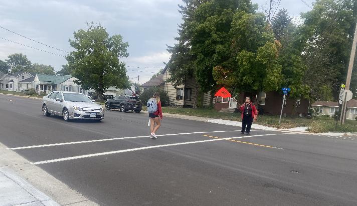
Amber Fiskness, Crossing Guard Osakis School District
Dan Wessel, Mayor City of Osakis
Prepared by West Central Initiative
Maggie Johnson, Health Educator Horizon Public Health
Linda Nack, Crossing Guard Osakis School District
Angie Hasbrouck, Health Educator Horizon Public Health
Mary Safgren, Planning Director MnDOT District 4
Shad Schmidt, Elementary Principal Osakis School District
Kirstin Wessel, P. E. Teacher Osakis School District
Principal Author – Mallory Jarvi, Transportation Planner with assistance from Wayne Hurley, Director of Transportation Planning and Aaliyah Helland, Minnesota GreenCorps Member


ORGANIZATION OF THIS REPORT
This report is designed to support and be accessible to multiple groups of people involved with Safe Routes to School in Osakis, including students, caregivers, teachers, school administrators, city staff, elected officials, and county and state employees. This plan focuses on key information and recommendations, while the appendices document additional participation, analysis, resources, and deliberation that shaped the development of the plan.
The Vision
The City of Osakis, along with the Osakis School District, are seeking to become a community where it is safe and convenient for all children to walk and bicycle to and from school. We will strive to be a place where our children can travel under their own power, explore, and play in their community safely, and where they learn life-long habits of incorporating physical activity into their daily lives. We will seek to achieve this vision through safety awareness, education, encouragement, and self-evaluation, all while building the infrastructure needed to make walking and bicycling safer and more convenient for all.
THE 6 E’S
Safe Routes to School (SRTS) programs rely on six core strategies, called the “Six Es”, to work towards their vision.
EQUITY – THE OVERARCHING E
Prioritizing positive outcomes for students from lower-income households; Black, Indigenous, and other students of color; students with disabilities; and other students who face disproportionate barriers to walking, biking, and rolling to school because of their group membership. This plan uses the term “priority populations” to refer to disproportionately impacted groups of students and other community members.
ENGAGEMENT
Working with students, families, school staff, and community members and organizations, especially those from priority populations, to identify needs, better understand barriers, and create solutions together for walking, biking, and rolling.
ENGINEERING
Developing Equity-focused changes to the built environment that support youth travel, designed and prioritized through community Engagement.
EDUCATION
Providing students and other community members, especially those from priority populations, with skills and knowledge about walking, biking, and rolling.
ENCOURAGEMENT
Normalizing a culture of walking, biking, and rolling through incentive programs, events, and activities that center priority populations.
EVALUATION
Measuring how Safe Routes to School initiatives are implemented (process evaluation) and what their impacts are (outcome evaluation), especially how initiatives Engage with and support priority populations.
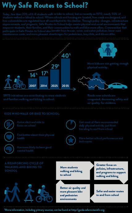
Why Safe Routes to School?
Equity in SRTS
Disparities in access to resources such as high-quality jobs, schools, parks, healthcare, food, and a full range of transportation choices impact the health and wellbeing of communities. These differences are not random they are the results of government policy and funding in the past and present, which has worked to the benefit of some and to the disadvantage of others.
Equity in Safe Routes to School is impacted by transportation system inequities such as limited access to high-quality walking and biking infrastructure or the presence of highways or busy roads in lowerincome neighborhoods and neighborhoods with more BIPOC (Black, Indigenous, and People of Color) individuals as well as inequities in related systems. For example, racial wealth inequities and racial discrimination in housing mean that BIPOC or lowerincome students may live further away from schools than their white peers and those from higher-income families.
Safe Routes to School works to improve walking and biking opportunities for all students, while addressing these inequities through programs, infrastructure, and policy improvements that specifically help priority populations. Priority populations include individuals, groups, and communities who are more likely to rely on walking, biking, or transit for transportation, are more vulnerable to unsafe traffic conditions, or have suffered historic disinvestment in safe, comfortable walking and biking infrastructure. By looking at demographic data, examining existing transportation services and policies, and speaking with members of the community, the Boeckman Safe Routes to School team worked to develop recommendations that support equity in walking and biking to school.
Osakis Community in Context
‘Our Mission: To Make a Positive Impact in our Community Where We Live and Work.'
-City of Osakis
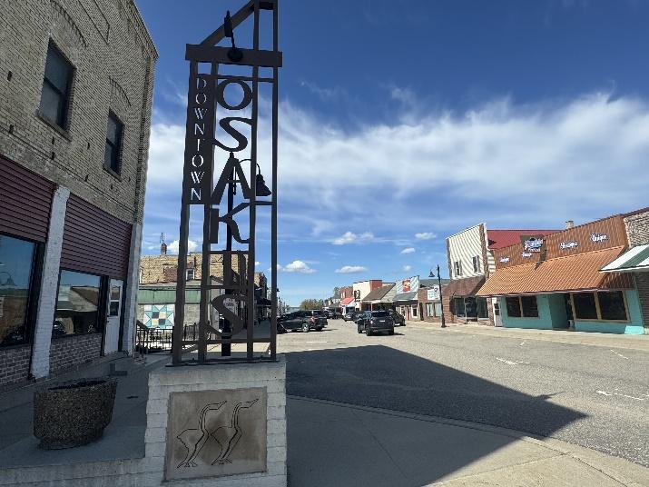
Osakis is a small rural community in west central Minnesota located along I-94. Osakis is located about 10 miles east of Alexandria and 60 miles northwest of St. Cloud. Osakis is located in the southeast corner of Douglas County, with parts in Todd County.
Osakis has a population of 1,771. The demographic makeup of the population is 98% White with less than 1% in all other demographic categories. The community is well dispersed in age with 20% 17 years or younger, 51.4% between 18-64, and 28.6% 65years and older.
The average household size is 1.9. The median household income is $46,290, and 50% of residents live in their own home. Osakis has a large seasonal residence population, with 20% of the housing considered vacant due to not being lived in yearround. Osakis is an educated community with 90.4% of residents having a high school degree or higher, and 18.1%a bachelor’s degree or higher.
Osakis has a high commuting population with 15% commuting 30 minutes or longer to work and 20.3% between 10-19 minutes, and 32.5% less than 10 minutes or longer. To travel to work 6.1% walk, bike, or work from home, and 93.9% take a car, truck, or van. The low amount of active transportation users can be attributed to distance from work, and the high percentage of residents owning at least one vehicle
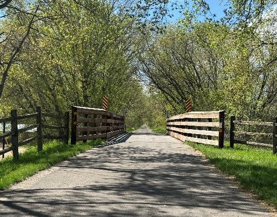
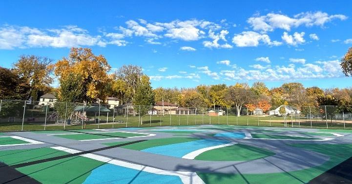
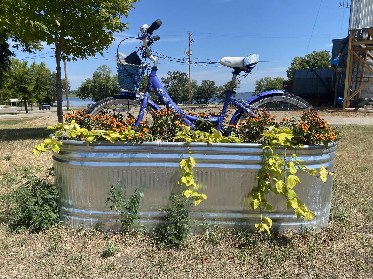
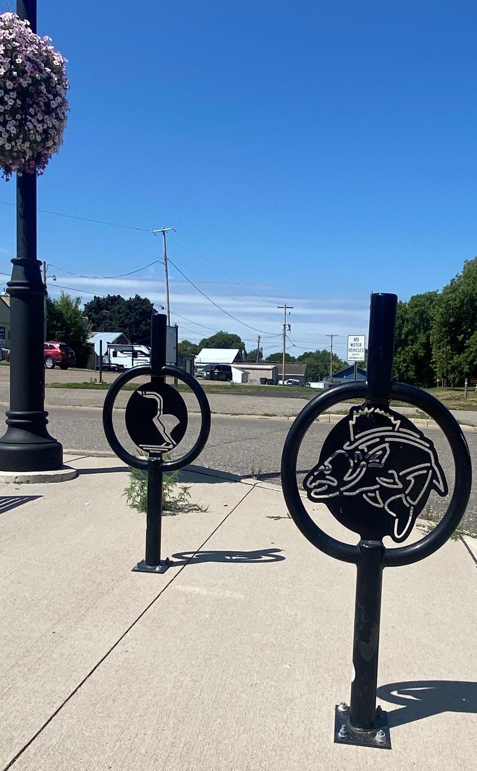
Osakis is located at the convergence of the Central Lakes Trail and the Wobegon Trail. It is on the south shores of Lake Osakis and is rich in natural resources, parks, and recreation opportunities. The community has beautiful bike infrastructure throughout the town, with decorative bike racks, bike maintenance stations, and a bike garden sculpture along the trail.
Osakis City Plans
PARKS AND TRAILS MASTER PLAN
The City of Osakis completed its Parks and Trails Master Plan in 2023. This plan provides recommendations for how community members and visitors could access the Osakis Park System and regional trails through active modes of transportation. The Osakis Safe Routes to School committee supports the Safe Routes to Parks movement and future endeavors to connect Osakis Public Schools to local parks and trails.
Osakis residents who responded to the survey conducted for the Parks and Trails plan came up with their top 5 values: 1. Access, 2. High-Quality Facilities/Variety, 3. Outdoors, 4. Kids/Family, and 5. Safety. The community has expressed a desire for
kids to safely travel within their community to highquality facilities. This can include the public school, which has a community playground and tennis courts that are used during the school year and summer.
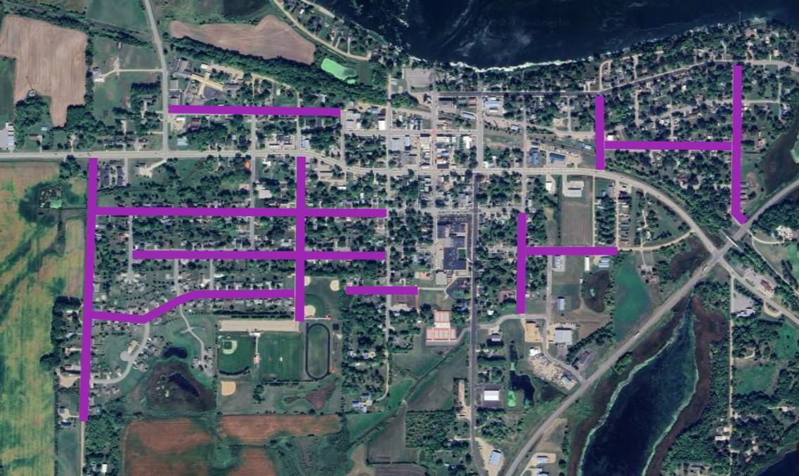
The proposed shared-use paths that are specifically supported in this Safe Routes to School plan include connecting Osakis Public Schools to parks and neighborhoods by developing along the highlighted routes:
• Queen Street
• West Pike Street
• East Pike Street
• 4th Avenue East
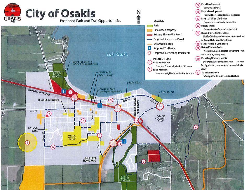


Figure 1: Map from Osakis Parks and Trail Master Plan showing recommendations to the community. The Blue dotted line indicates the proposed shared-use path network through the community.
OSAKIS: PLANNING FOR 2030
The City of Osakis completed its “Planning for 2030” comprehensive plan in 2021. This plan includes city goals regarding transportation, parks, and recreation. Osakis uses the Complete Streets approach in its planning as a guide for its recommendations.
A major theme of the plan is getting residents and visitors of all ages and abilities access to destinations and greenspaces in the community safely. Recommendations in the transportation category to create an equitable transportation network include:
• Construction of continuous pedestrian facilities along major streets and highways.
• Provide ramps and curb cuts throughout the pedestrian system for physically challenged persons.
• Require pedestrian facilities as land is developed based on standards for street classification.
As the converging point between the Central Lakes Trail and Wobegon Trail, Osakis is in a unique position where visitors from across the state visit. Within parks and recreation, there is a sub-theme of shared-use
path connectivity. This connectivity would allow bicyclists visiting to experience Osakis but make it safer for all ages and abilities to navigate their own community through active forms of transportation.
An action item under the category includes hosting an annual bike rodeo with the city council and planning commission as responsible entities
Goals and objectives of note include:
• Plan and promote walking and biking by working with local, state, and federal partners to plan, fund, and construct a network of trails to increase the nonmotorized transportation system.
• Plan for trail and sidewalk connections from neighborhoods to parks, linkages between parks, and existing trails.
• Continue working with Douglas and Todd counties and Osakis, Orange, and Gordon townships to ensure coordinated growth of transportation systems and regional recreational areas and trails.
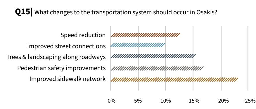
changes to the
Figure 2: Bar graph from Osakis: Planning for 2030 showing results from the public survey asking “What
transportation system should occur in Osakis.”
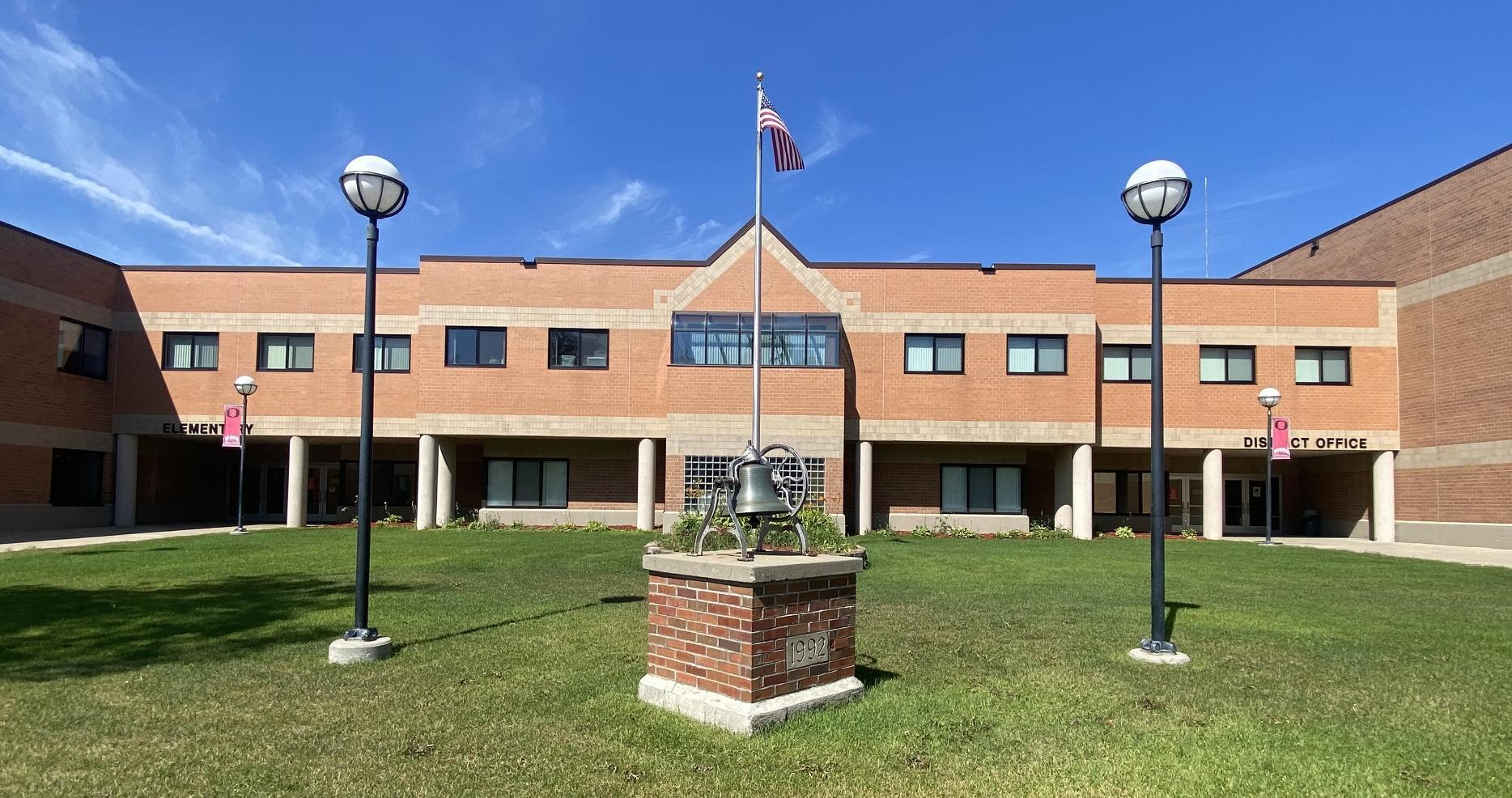
Osakis Public Schools
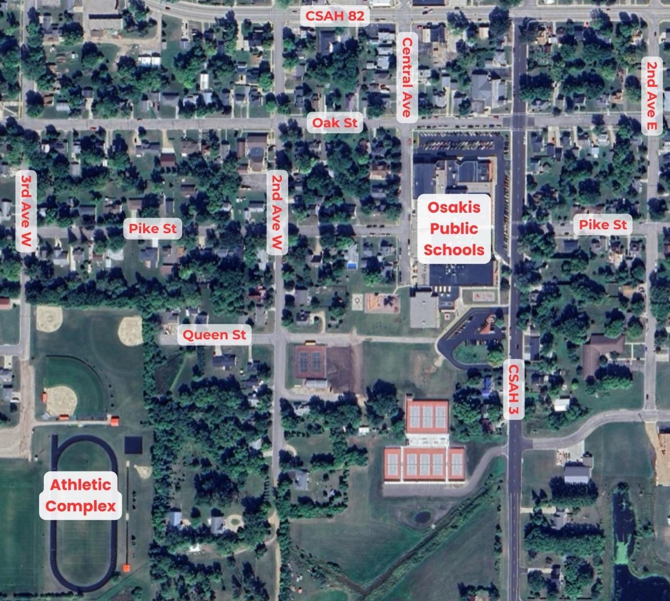
SITE CIRCULATION
Pedestrians: In the morning students were observed traveling from all parts of the community. There was a group coming down East Pike Street toward the school and a different group heading down West Pike. There were a few students traveling from the northern neighborhoods crossing Nokomis to reach the school. Another demographic of pedestrians was parents who would drop off their students and take a short walk to the school using the crossing guards in front of the District Entrance.
In the afternoon, there was a higher count of pedestrians either heading toward afternoon activities or heading toward the local ice cream
establishment, Tip Top. This creates a very short but high pedestrian traffic period right after school. Around 70 football athletes walk to the football field down Pike Street, and around 40 students walk to Tip Top. Vehicle-pedestrian encounters could improve, with 7 instances of cars not yielding to pedestrians and 24 instances of cars not stopping for a stop sign.
Bicyclists: On observation day, a few students were observed biking around the school area. Bikers came from the western and northern neighborhoods and parked by the bike racks at the elementary school entrance. Most bikers were not wearing helmets.
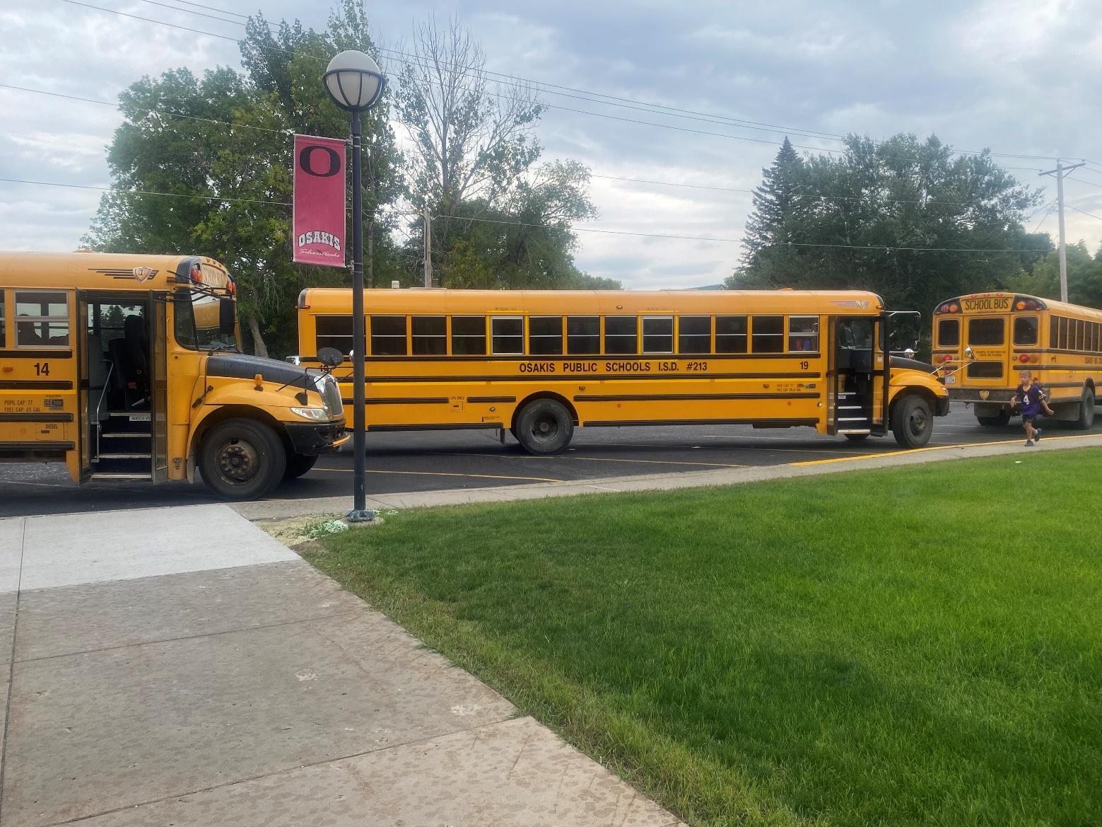
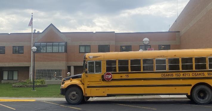
School Buses: Buses approach the school in the morning from both North and South along CSAH 3.
They enter the north entrance parking along CSAH 3 and park in front of the district office entrance. In the afternoon, all buses drive from the south due to the bus garage being located just ¼ miles south of the school.
Transit: The Rainbow Riders bus service can be used to drop off students at school. No students were observed using the bus system.
Vehicles: Elementary drop-off and pick-up are located in the south parking lot, which has a one-way
loop. Parents are highly encouraged to take a right when exiting the parking lot instead of a left to decrease traffic congestion. High school students are dropped off or can park in the north parking lot.
In the morning and afternoon, traffic heading north on CSAH 3 can back up due to vehicles turning left onto Nokomis.
More information on site circulation can be seen in Appendix A.
MISSION STATEMENT:
SCHOOL CONTEXT:
Osakis School District
SUPERINTENDENT:
Justin Dahlheimer
PRINCIPALS:
Shad Schmidt, Osakis Elementary
Brad Hoffarth, Osakis Secondary
ENROLLMENT:
Osakis Elementary: 456
Osakis Secondary School: 413
Total District Enrollment: 869
GRADES SERVED:
Osakis Elementary: K-6
Osakis Secondary: 7-12
DEMOGRAPHICS*
White, non-Hispanic, 93%
Hispanic, 4%
American Indian/Alaska Native <1%
Multiracial, <1%
Black/African American, 1%
OTHER DEMOGRAPHIC INFORMATION*
“The Osakis Public Schools' mission is to engage and support all students in building a solid foundation of knowledge, skills, and character.”
STUDENT DEMOGRAPHICS:
• Osakis School District’s enrolled population of 869 is spread across kindergarten through 12th grades. All students who are enrolled at Osakis Public Schools are eligible for busing. This is despite the fact that almost the entirety of the city limits is less than a mile distance from the centrally located public school.
• The Osakis student population encompasses children and families from a range of demographic groups. Around 16% of students are receiving special education and over 37% are eligible for free and reduced lunch. The student population is 93% white non-Hispanic, 4% Hispanic, and less than 1% for American Indian/Alaska Native, multiracial, and Black.
*Source: Minnesota Report Card

Infrastructure
Introduction to Infrastructure
Physical changes to the streetscape are essential to making walking, biking, and rolling to school safer and more comfortable.
An in-person walk audit and discussions with the Safe Routes to School Team, school and district staff, caregivers, students, community members, and city and county staff informed recommendations to address key barriers to walking and biking around Osakis.
Recommendations are prioritized on the basis of community and stakeholder input, traffic and roadway conditions, cost, number of students impacted, and benefit to priority populations. This planning process was designed to address historical and contemporary inequities in who benefits from and who is burdened by transportation systems, and equity considerations accordingly played a central role in the prioritization of infrastructure recommendations. Especially in the winter months, improved maintenance and lighting can contribute to improving equitable access to walking and biking routes, even where a sidewalk or path is present.
WINTER MAINTENANCE
For students and community members with disabilities, winter maintenance is key to accessing sidewalks and trails during snowy months. This is also true for students and families who walk and roll as their primary means of transportation, either because they cannot afford or choose not to own a vehicle, or because other transportation options aren’t accessible to them. Cities can adopt policies that prioritize winter maintenance of existing infrastructure and make it easier for the most vulnerable users of our transportation system including students to get around in winter. These policies help to increase transparency and improve reliability for the active transportation network.
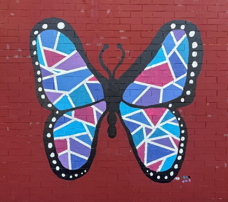
PUBLIC ART
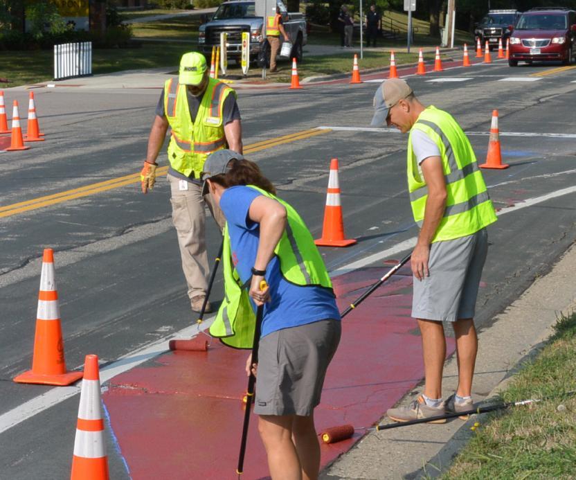
To create outreach to a variety of populations, public art can be used to educate, encourage, and create a sense of place in a community. Public art can be used to demonstrate safe walking, biking, and rolling actions by being incorporated into infrastructure. Examples include enhancing crosswalks or bike lanes, sculptural art within roundabouts, or aesthetic streetlights. It can also be used to create a sense of place where people may be more encouraged to walk to their destinations than to drive. A mural depicting students walking may educate drivers that there are pedestrians in the areas and that they should be more careful.
Public art can be a quick-win solution to promoting Safe Routes to School efforts while beautifying the community. Cities, schools, and local advocacy groups should partner to create more vibrant, safe, and walkable areas within their neighborhoods or communities.
HOW TO USE THIS PLAN
This plan does not represent a comprehensive list of every project that could improve conditions for walking and bicycling, but rather community priorities, key conflict areas, and potential improvements identified in the planning process. Recommendations range from simple striping changes to more significant changes to streets, intersections, and school infrastructure.
For example, they can:
• Adopt policies that prioritize snow clearing and removal on active transportation facilities
• Prioritize clearing of routes that provide access to transit
• Develop and share information publicly regarding sidewalk and shared use pathway snow clearing and removal practices
• Hold a winter maintenance forum or conduct a survey around specific winter engagement concerns
• Work with schools to establish volunteer groups of residents to clear sidewalks on priority routes to school
Recommendations identified in this plan are not necessarily endorsed by MnDOT but planning-level concepts that will require additional engineering design. Additionally, all recommendations for pedestrian and bicycle crossings will be evaluated by the proper road authority’s guidelines.
LIGHTING AND VISIBILITY
Similarly, lighting for people walking and biking is important for both actual and perceived sense of safety and security. In winter climates like Minnesota’s, where darker days mean school arrival and dismissal can occur in the dark, lighting is especially important for mitigating safety concerns and encouraging active transportation throughout the year.
While lighting can sometimes be seen as a costly investment, it is an important step for ensuring equitable access to walking and biking routes. Lighting should be seen as a necessary component of bicycle and pedestrian safety improvements, not seen as a potential add-on or “nice-to-have” feature.
OSAKIS
Communities can consider:
• Creating a lighting plan for priority pedestrian routes to install trail or sidewalk lighting over time
• Partnerships with or requirements for private development to provide lighting
• Incorporating high-visibility safety vests into crossing guard and Walking School Bus events
• Giveaways that help kids access winter gear such as clothing or bike lights
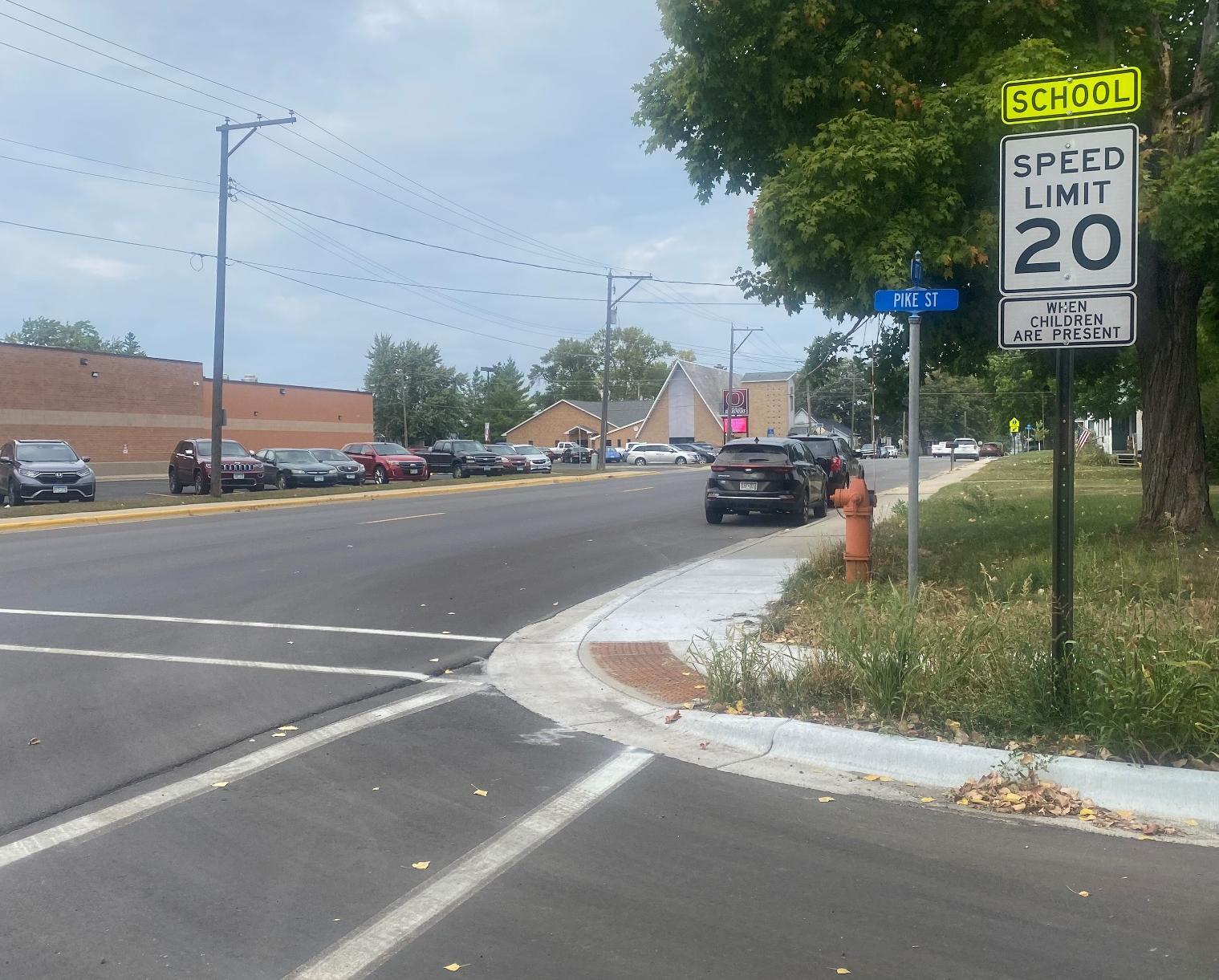
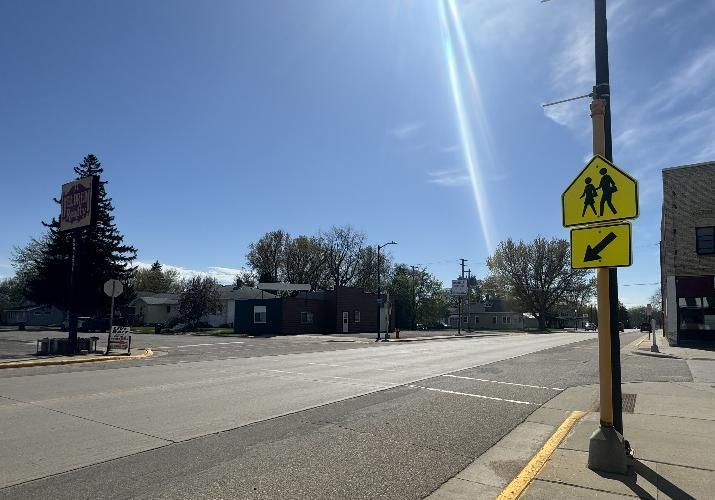
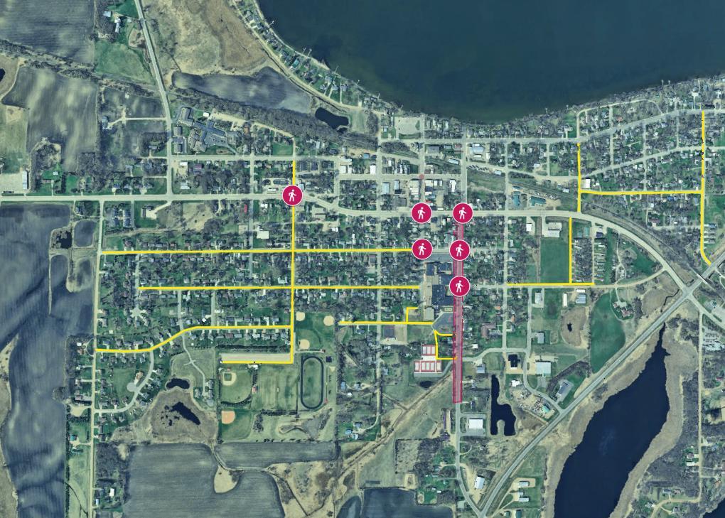
Lighting in Osakis is crucial for the safety of students and residents when traveling in the early mornings and evenings to and from school. High-traffic areas should have adequate lighting, especially when used as a major arterial to school. CSAH 82 and 3 both had adequate lighting. When entering the neighborhoods, community input has noted dark streets and unsafe walking conditions. Note that in some areas where lighting is recommended, there is currently some lighting infrastructure. However, spacing between streetlights or types of streetlights may still cause dark spaces. Lighting should be considered, but not limited to, the following highlighted areas
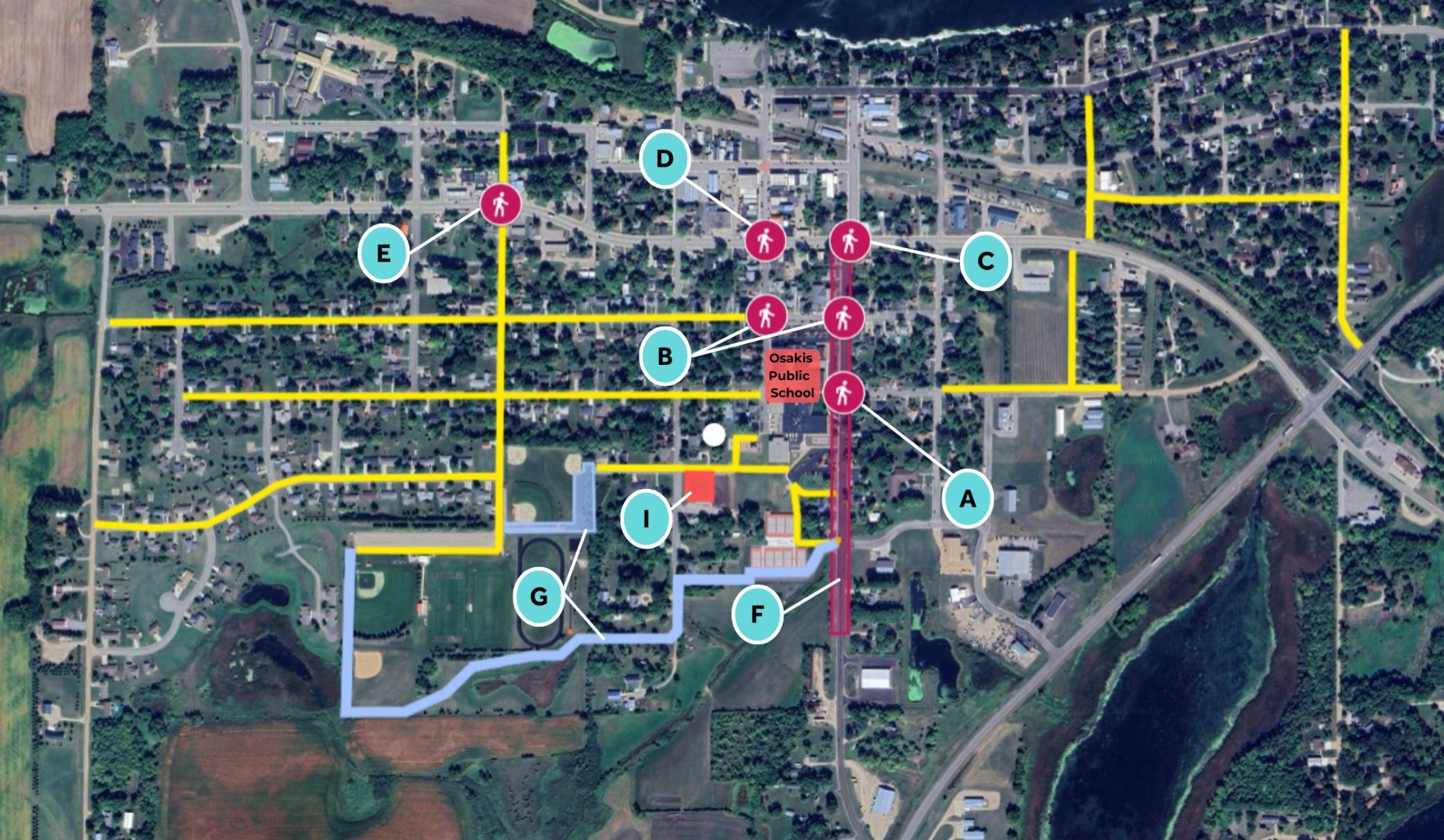
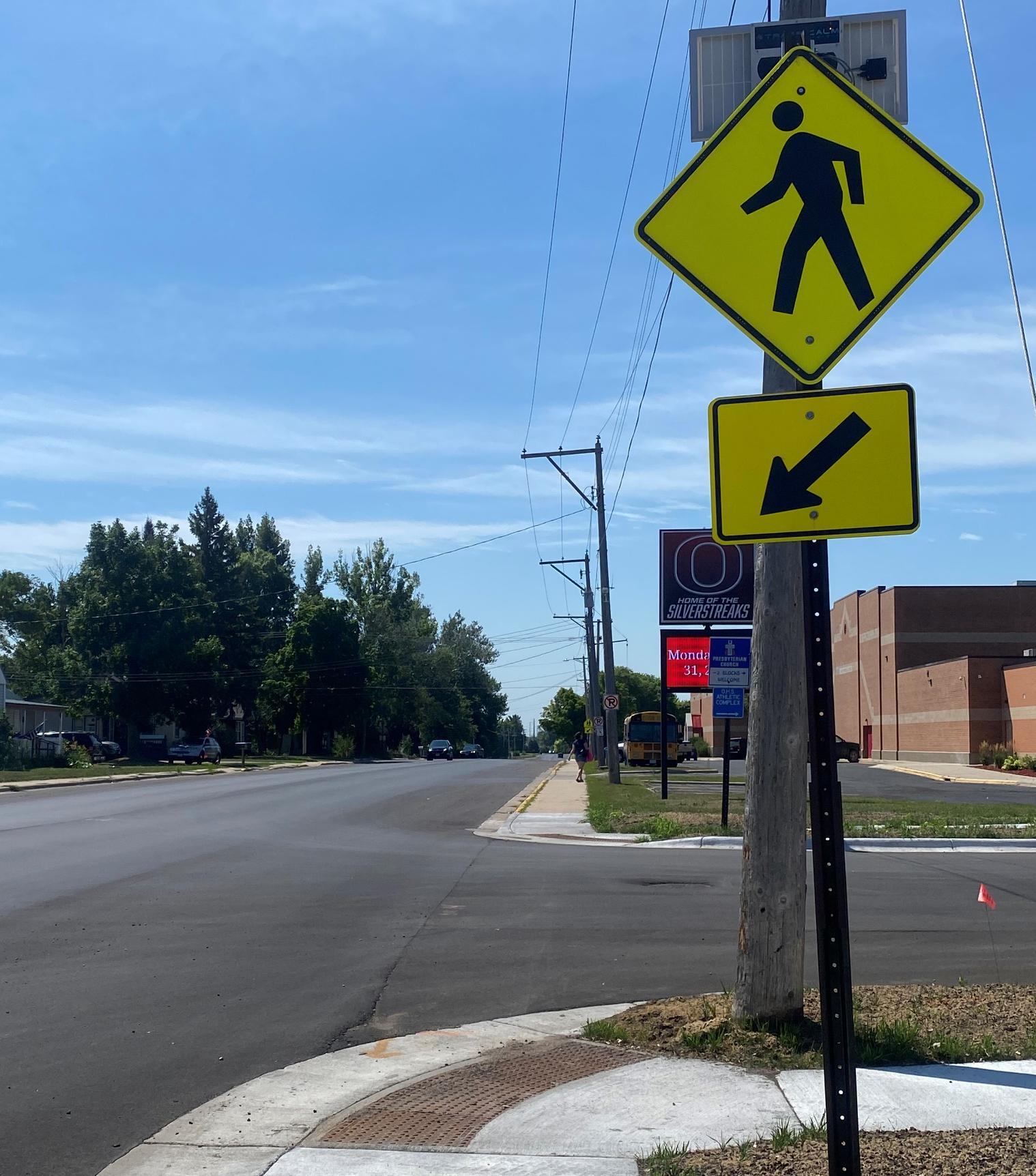
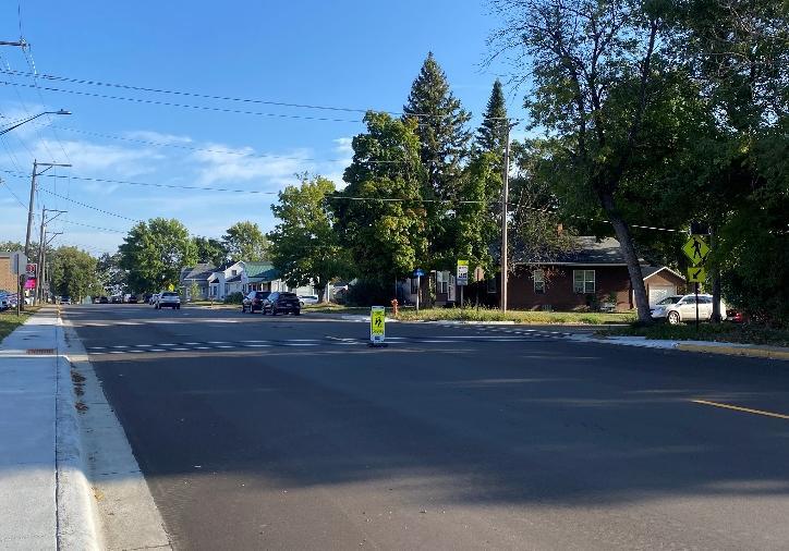
A: Pike St E and CSAH 3
PRIORITY: High
RECOMMENDATION
Explore safer connection opportunities between the Osakis Public Schools and East Pike Street. Suggestions include installing more visible Rectangular Rapid-Flashing Beacon (RRFB) signs with high-visibility crosswalks, curb extensions, speed table and a pedestrian overpass or skyline to connect with the existing sidewalks.
WHY IS THIS RELEVANT?
This intersection is a high traffic area with CSAH 3 separating the schools, and high bus and school traffic during arrival and dismissal.
WHO WILL MAKE THIS HAPPEN?
City, school, and county leadership, using Safe Routes to School funding, and/or other local, state, or federal funding.
HOW WILL THIS ADDRESS EQUITY?
All ages and abilities would be able to safely cross the intersection due to improved visibility and reduced crossing distance. The connection would also serve the mobile home community along Pike.
B: Oak St Intersections
PRIORITY: Low
RECOMMENDATION
Explore opportunities to improve pedestrian crossings by installing crosswalks and curb extensions at this intersection.
WHY IS THIS RELEVANT?
This intersection is a high-traffic area with pedestrian, bus, and family vehicle traffic before and after school.
WHO WILL MAKE THIS HAPPEN?
City and school leadership, using Safe Routes to School funding, and/or other local, state or federal funding.
HOW WILL THIS ADDRESS EQUITY?
All ages and abilities would be able to safely cross the intersection due to improved visibility and reduced crossing distance.
C: CSAH 82 and CSAH 3
PRIORITY: Medium
RECOMMENDATION
Explore opportunities to improve pedestrian crossings. Suggestions include installing crosswalks, curb extensions, RRFB signs, and reevaluating alignment of this intersection with a possible roundabout.
WHY IS THIS RELEVANT?
This is a very high traffic route with the intersection of two Doulgas County CSAHs. There is high semi, truck, local, and through traffic connecting to I-94.
WHO WILL MAKE THIS HAPPEN?
City, school, and county leadership, using Safe Routes to School funding, and/or other local, state, or federal funding.
HOW WILL THIS ADDRESS EQUITY?
All ages and abilities would be able to safely cross the intersection due to improved visibility and reduced crossing distance.
D: CSAH 82 and Central Ave
PRIORITY: Medium
RECOMMENDATION
Explore safer connection opportunities crossing CSAH 82. Suggestions include installing more visible Rectangular Rapid-Flashing Beacon (RRFB) signs with high-visibility crosswalks, in-road warning lights, and curb extensions at this intersection.
WHY IS THIS RELEVANT?
This is a very high traffic route with the intersection of two Doulgas County CSAHs. There is high semi, truck, local, and through traffic connecting to I-94. There is a high pedestrian volume after school and in the summer due to connection to downtown and local ice cream shop, Tip Top.
WHO WILL MAKE THIS HAPPEN? City, school, and county leadership, using Safe Routes to School funding, and/or other local, state, or federal funding.
HOW WILL THIS ADDRESS EQUITY?
All ages and abilities would be able to safely cross the intersection due to improved visibility and reduced crossing distance
E: CSAH 82 and 3rd Ave W
PRIORITY: Low
RECOMMENDATION
Explore safer connection opportunities crossing CSAH 82. Suggestions include installing more visible Rectangular Rapid-Flashing Beacon (RRFB) signs with high-visibility crosswalks, and curb extensions at this intersection.
WHY IS THIS RELEVANT?
This is a very high traffic route with the intersection of two Doulgas County CSAHs. There is high semi, truck, local, and through traffic connecting to I-94. This is a high pedestrian route with two gas stations on the north corners and connections to two senior living facilities.
WHO WILL MAKE THIS HAPPEN?
City, school, and county leadership, using Safe Routes to School funding, and/or other local, state, or federal funding.
HOW WILL THIS ADDRESS EQUITY?
All ages and abilities would be able to safely cross the intersection due to improved visibility and reduced crossing distance
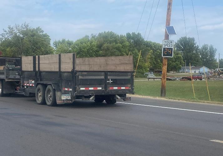
F: CSAH 3 Corridor
PRIORITY: High
RECOMMENDATION
Explore speed reduction methods or diverting traffic practices to reduce speed and traffic in front of Osakis Public Schools on CSAH 3. Suggestions include a lane shift, pinch points, medians, or restricting access to State Hwy 27.
WHY IS THIS RELEVANT?
This road is a high traffic route because it can be used as a cut off to I-94. During arrival and dismissal time periods this can create congested traffic and unsafe driver behavior.
WHO WILL MAKE THIS HAPPEN?
City, school, and county leadership, using Safe Routes to School funding, and/or other local, state, or federal funding.
HOW WILL THIS ADDRESS EQUITY?
Reducing speed and traffic along CSAH 3 would make it more comfortable and safer for all road users to cross and walk along.
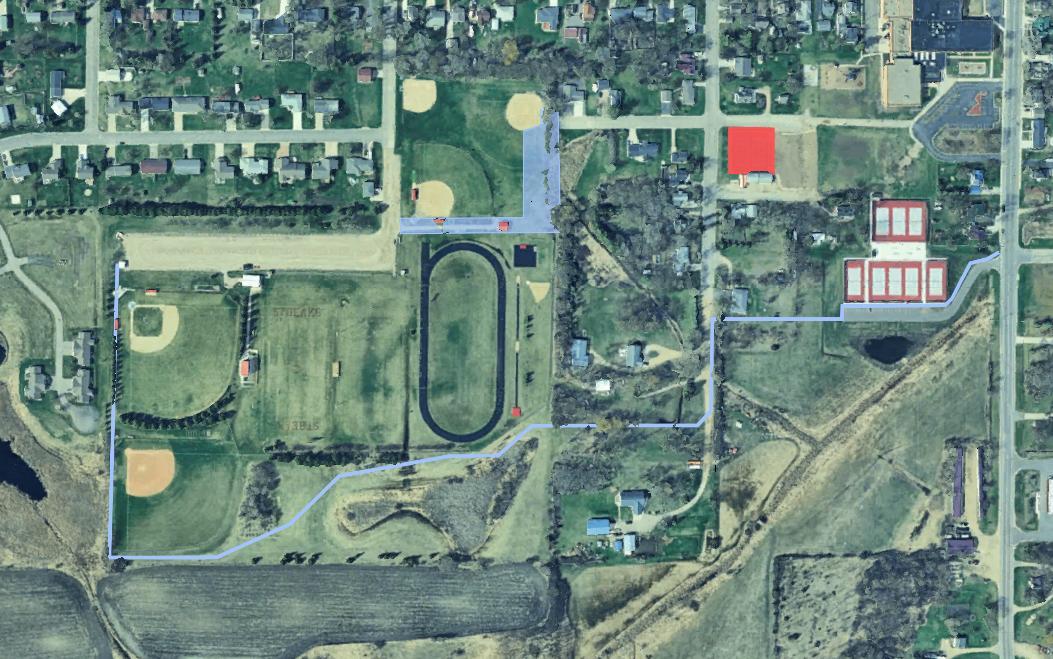
G: Athletic Complex Connections
PRIORITY: Medium
RECOMMENDATION
Explore connections along Queen St to 3rd Ave W through the athletic complex to create a more direct route for students and create a trail for students to the athletic complex. Another southern trail could connect the tennis courts to the west side of the athletic parking lot through school property.
WHY IS THIS RELEVANT?
This road is a high-traffic route because it can be used as a cut-off to I-94. During arrival and dismissal time periods, this can create congested traffic and unsafe driver behavior.
WHO WILL MAKE THIS HAPPEN?
City, school, and county leadership, using Safe Routes to School funding, and/or other local, state, or federal funding.
HOW WILL THIS ADDRESS EQUITY?
All ages and abilities would be able to safely cross the intersection due to improved visibility and reduced crossing distance.
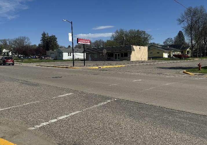
H: City Wide Sidewalk Development
PRIORITY: Medium
RECOMMENDATION
Explore installing sidewalks or multi-use trails in specific locations to increase the connectivity of Osakis.
WHY IS THIS RELEVANT?
Installing sidewalks in strategic locations will close current gaps in city sidewalk infrastructure and give sidewalk users more freedom and safety from road traffic.
WHO WILL MAKE THIS HAPPEN?
City, school, and county leadership, using Safe Routes to School funding, and/or other local, state, or federal funding.
HOW WILL THIS ADDRESS EQUITY?
Currently there are neighborhoods in Osakis that have incomplete sidewalk networks. Creating equitable access to mobile homes and assisted living communities would create a safer and more resilient Osakis.
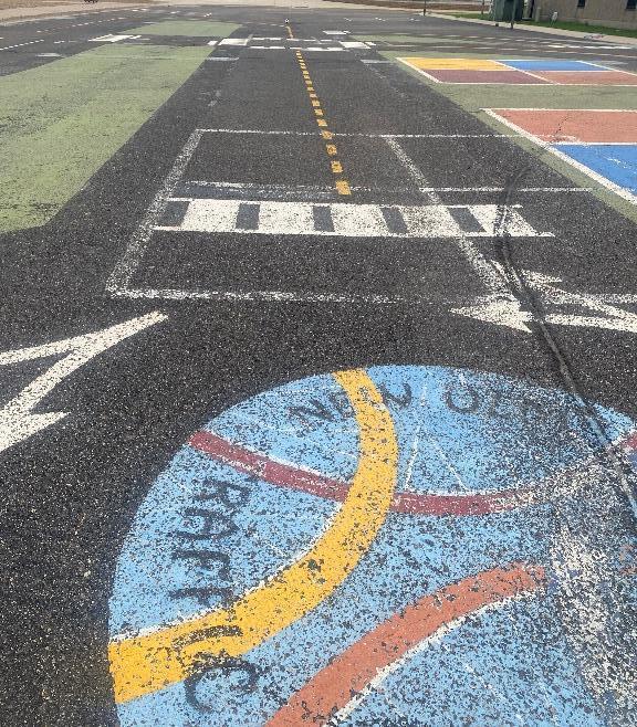
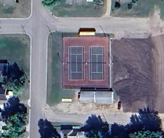
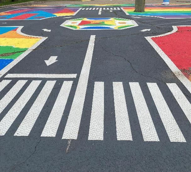
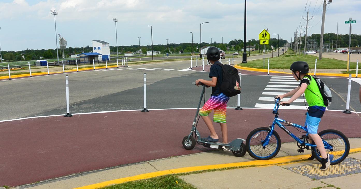
I: Traffic Garden
PRIORITY: Low
RECOMMENDATION
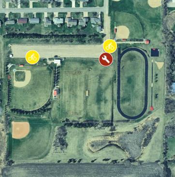
Explore installing a traffic garden, also called a bicycle playground, on the old tennis courts adjacent to the public school. Other locations within the community can be considered where possible.
WHY IS THIS RELEVANT?
A traffic garden is a skills area where kids can practice safe biking techniques. A traffic garden located near the school will provide a safe space for in-school bike curriculum and an opportunity for students to utilize it during the summer months.
WHO WILL MAKE THIS HAPPEN?
City and school, leadership, using Safe Routes to School funding, and/or other local, state, or federal funding.
HOW WILL THIS ADDRESS EQUITY?
This traffic garden will be free and open to the public to enjoy and utilize. All ages and abilities can practice safe biking techniques
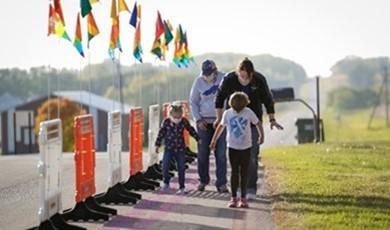
Examples of Traffic Gardens
Traffic gardens have become more well-known in Minnesota in the past decade. There are now traffic gardens spread across the state, and each has used its own designs and strategies to best suit its schools and communities.
New Ulm, MN – New Ulm Public Schools
St. Paul, MN – Johnson A. Johnson Elementary
Fergus Falls, MN – Athletic Park
SRTS Ordinance Change
ADOPT SUBDIVSION INFRASTRUCTURE ORDINANCE
A recently implemented Minnesota State Statute (174.40) requires local jurisdictions to adopt a SRTS infrastructure ordinance in order to qualify for state and federal SRTS funds. This ordinance requires all new subdivisions built within city limits to install infrastructure focused on the safety of pedestrians and bicyclists. This is commonly executed by installing sidewalks. An example city ordinance for reference is in Appendix K.
The Osakis Safe Routes to School committee recommends that the City of Osakis adopt a city ordinance requiring all new subdivisions built in Osakis city limits plan for and install pedestrian and bicycle safety infrastructure.
SRTS Policy Change
ADOPT SCHOOL AND CITY POLICIES TO SUPPORT SRTS EFFORTS
Currently, the Osakis School District Transportation Policies do not address supporting students walking and biking to and from school and school related activities. The City of Osakis can also support SRTS efforts. An example is Battle Lake’s policy to remove snow and ice on designated safe routes to school.
The Osakis Safe Routes to School committee recommends that the City of Osakis and Osakis School District review their current ordinances and polices, and to add or change ordinances and polices that better support and encourage students to walk, bike, and roll to school.
Examples of Potential Infrastructure Improvements
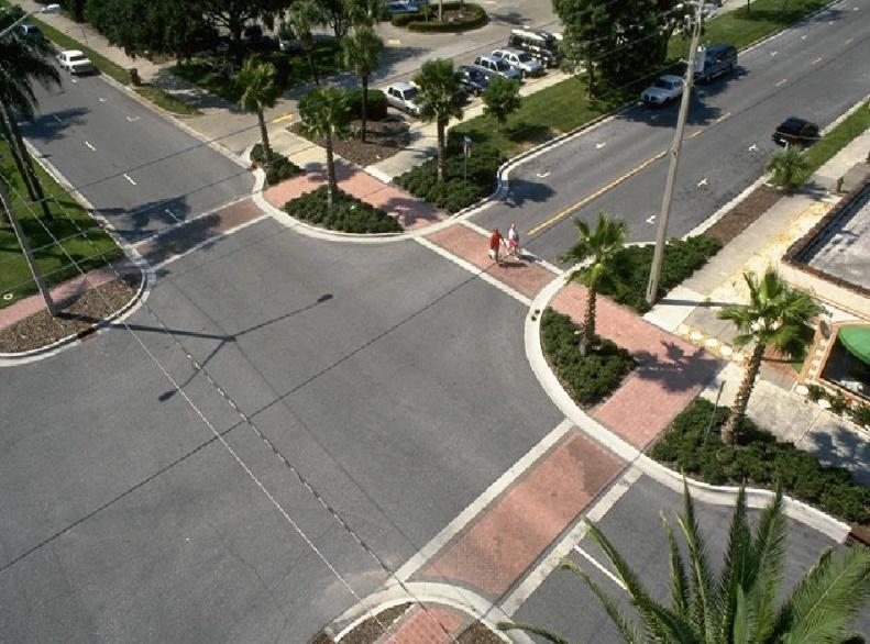
Curb extensions (sometimes called bump outs or bulb-outs) can improve safety by reducing crossing distances and improving visibility for both people driving and people walking. Image courtesy of the National Association of City Planning Officials (NACTO).
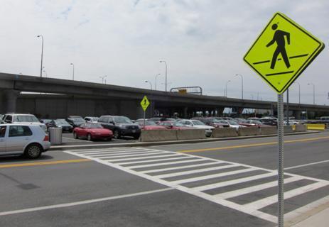
High visibility crosswalks such as this “ladder” style crosswalk “are preferable to standard parallel or dashed pavement markings. These are more visible to approaching vehicles and have been shown to improve yielding behavior” according to the NACTO. Image courtesy Federal Highway Administration.
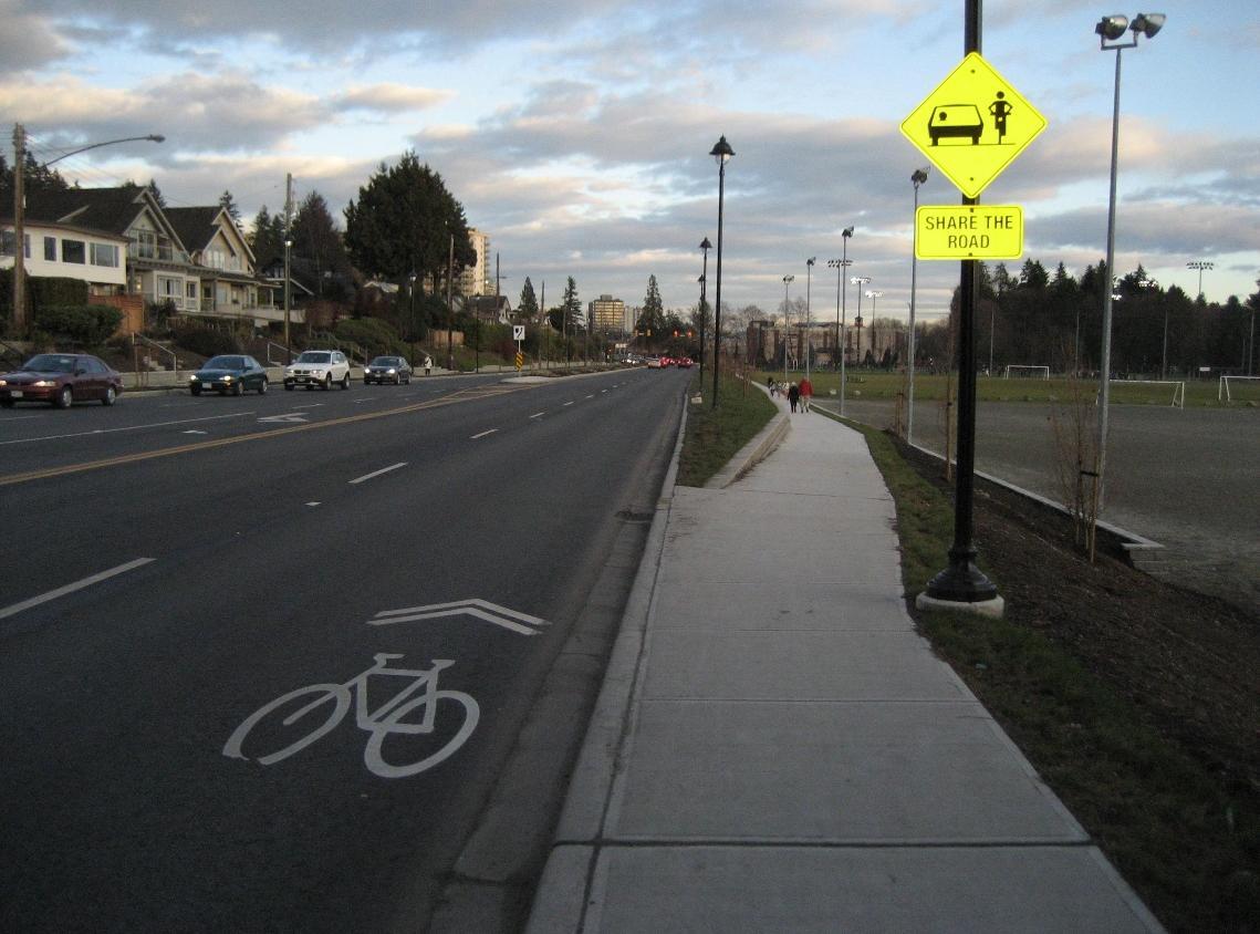
Sharrows, or Shared-Lane markings, are bicycle symbols indications that a bicyclist has the right to ride in the roadway and to warn drivers that bicyclists may be present. Image courtesy www.pedbikeimages.org / Margaret Gibbs.
Speed tables, or raised crosswalks, are midblock gradual speed bumps that also function as a crosswalk for bicyclists and pedestrians. They help calm traffic speeds and provide more awareness for pedestrians and bicyclists crossing. Image courtesy www.pedbikeimages.org / Brandon Whyte.
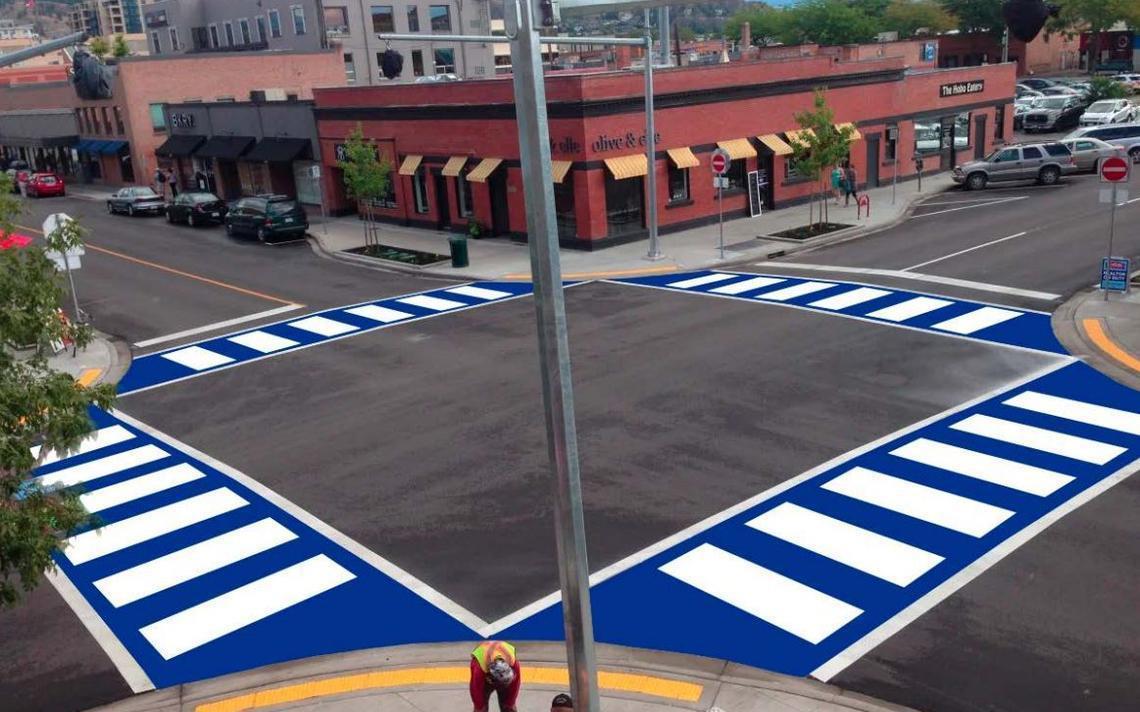
An alternate high-visibility crosswalk such as this color treated crosswalk could be installed near the school, utilizing school colors. This type of crosswalk can improve visibility and enhance student pride. This rendering is of a crosswalk being installed in Brainerd. Image courtesy City of Brainerd.
A “Rectangular Rapid Flashing Beacon” (RRFB) is an option to improve safety and visibility for students crossing the street. Image courtesy www.pedbikeimages.org / Lara Justine.
A
can provide a crossing option in areas with many people crossing the street to destinations that are not near an existing crosswalk. Image courtesy NACTO.
An LED sign like this is an option to improve safety and visibility for students crossing the street at crosswalks. Image courtesy of TAPCO.
mid-block crosswalk
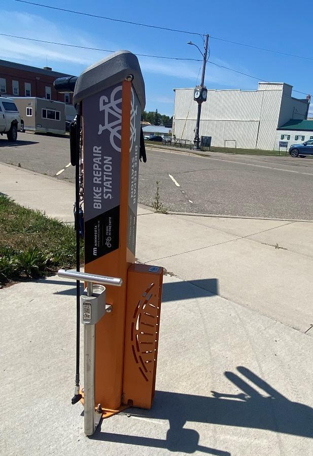
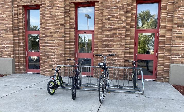
A bicycle repair station like this one provides an opportunity for high school students (plus school staff and faculty) to make minor adjustments and repairs to their bicycles before riding. It can serve as an incentive for students to ride their bikes to school. The City of Osakis can partner with the Osakis School District to determine the possible placement and installation of a bicycle repair station on the school or city grounds.
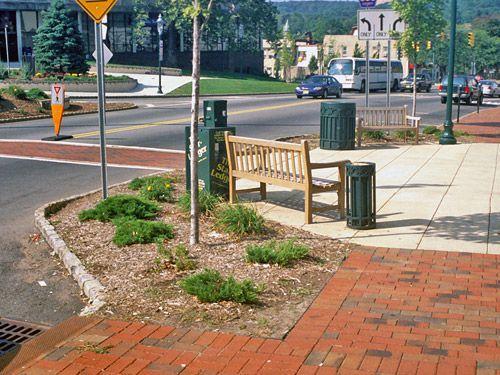
A pinch point can provide a mid-block crossing option which also acts as a speed reduction tool on high speed or traffic road. Pinch points can also add additional space to place amenities such as bike racks or benches. Image courtesy NACTO.
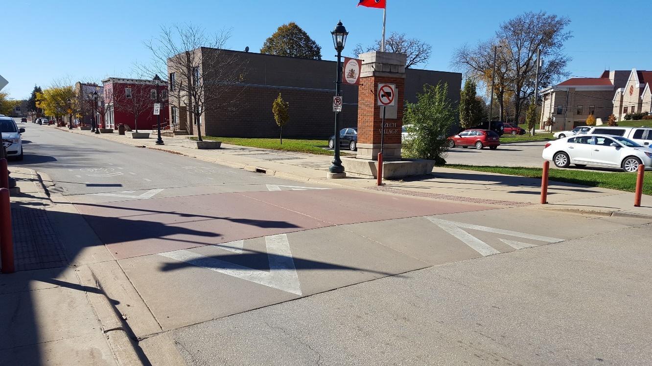
Sidewalks should be a minimum of five feet wide, and potentially wider closer to Osakis Public Schools. Whenever possible, sidewalks should be set back from the street with boulevards. This is a good example from Osakis along Lake Street.
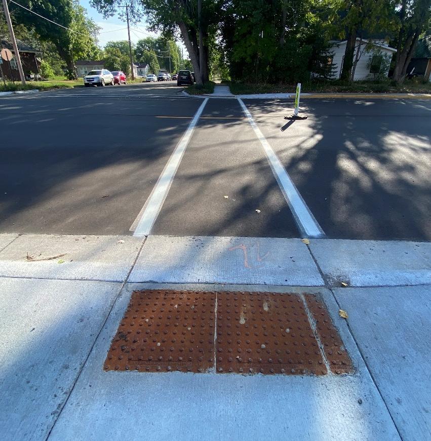
Curb ramps should be compliant with PROWAG. PROWAG-compliant curb ramps such as those pictured here improve safety for young children, people with disabilities, or mobility issues to navigate the sidewalk network. This is a good example from Osakis across CSAH 3 in front of Osakis Public Schools.
Programs
Introduction to Programs
Programs are opportunities to increase awareness, understanding, and excitement around walking, biking, and rolling to school.
Programs are focused on educating students, families, and the broader community about walking and biking, as well as on building a culture that supports and normalizes walking and biking to school and other destinations. Because programs are lowcost and can often be implemented quickly by an individual school or the school district, they represent an important Safe Routes to School strategy that complements longer-term strategies, including infrastructure improvements and policy changes
EXISTING PROGRAMS
The City of Osakis and Osakis School District have been actively working towards providing safe and inviting spaces around school campuses for students. This foundation of encouraging student travel safety provides a valuable baseline for expanding programs to encourage more students to walk and bike.
PROGRAMS ALREADY ACTIVE AT OSAKIS PUBLIC SCHOOLS:
• Automated Enforcement
• Positive Ticket Program
• Bicycle Rodeo
• Crossing Guards
• Walking School Bus
PROGRAM RECOMMENDATIONS
Conversations with school and district staff, caregivers, students, community members, and city and county staff led to the following program recommendations. Programs were tailored to meet the needs, capacities, and interests of the community and were prioritized based on existing programs, input from local stakeholders, the extent to which the program would serve priority equity populations, and the readiness of the school to launch the program.
RECOMMENDED PROGRAMS INCLUDE:
• Bike Fleet
• Bike Mechanic Classes
• Bike Train
• Cocoa for Carpools
• Drop and Walk
• Educational Videos
• In-School Curriculum & Activities
• Inter-School Partnership
• School Communications
• Ongoing Evaluation
• Rainbow Friends Toolkit
• School Streets
• School Curriculum
• Student Patrols
• Student Clubs
• SRTS Education Campaign
• Suggested Route Map
• Walk & Bike Field Trips
• Walk! Bike! Fun!
• Walk and Bike to School Days
EQUITABLE IMPLEMENTATION CONSIDERATIONS
Each of the recommended programs can be implemented to benefit priority populations. In some cases, programs are inherently beneficial, but other times they require intentional thought to make sure they are implemented equitably and reach students who could benefit the most from them.
When working to start a new or update an old program, school staff and partners should ask themselves:
• Who could benefit the most from this program?
• Are there any barriers to participating in this program, including cultural, social, or financial?
• Are there any school resources that can help reduce barriers to participation?
• Are there community partners who could help us spread the word about this program, or help make it more effective?
After an event, it is also important to think about what went well and what could be improved in the future. Helpful questions to consider include:
• Is this a one-off program, or is there a way to provide ongoing support for it?
• Were any student or family groups absent? Is there something that could help them participate in the future?
• What did students think of the event? Families? Staff?
Taking a few minutes before and after an event to check in on these questions can make a big difference in building a culture of walking and biking that is accessible to all students and families.
WALK/BIKE TO SCHOOL DAYS
National Walk to School Day and Bike to School Day attract millions of students and families to try walking, biking, and rolling to school every October and May. In addition, Minnesota celebrates Winter Walk to School Day in February. Additional education, encouragement, and enforcement programming can be used to promote the event, increase awareness, and expand participation. Walk/bike to school days can also take place more frequently (e.g., Walking Wednesdays) if there’s interest and capacity.
When, where, and how will this be implemented? Osakis School District leadership will promote and support Fall and Winter Walk to School Day, and May Bike to School Day.
Why is this relevant and recommended? To show students and families that the Osakis School District encourages students to walk and bike to school.
How will this address transportation inequities? All children will be supported by the school district to participate in walk and bike to school day.
How will this be evaluated? School will tally how many students participate in the walk and bike to school days.
Who needs to be involved to make this happen? Students, school leadership, and parents.
What is the timeline for implementation? Beginning in the 2024/2025 school year.
DROP & WALK
During a drop and walk event (also called park and walk or remote drop-off) bus drivers and caregivers drop students at a designated off-campus location and students walk the rest of the way to school. Remote drop-off events can help reduce drop-off congestion on campus and provide students who live further from school with an opportunity to walk to school.
When, where, and how will this be implemented? The Osakis School District will hold drop and walk events in conjunction with bike and walk to school days
Why is this relevant and recommended? Many of the students attending Osakis Public Schools live more than two miles from the school. This would give all students the opportunity to walk to school.
How will this address transportation inequities? Not all students have the ability to walk and bike to school due to the distance. A drop and walk allows all students to walk and bike to school as a group.
How will this be evaluated? This will be evaluated by a tally of students who participate.
Who needs to be involved to make this happen? School district leadership, city staff, and leadership, and parents.
What is the timeline for implementation? Beginning in the 2024/2025 school year.

WALK! BIKE! FUN!
Walk! Bike! Fun! is a two-part curriculum designed specifically to meet Minnesota education standards. The program helps students ages five to thirteen learn traffic rules and regulations, the potential hazards to traveling, and handling skills needed to bike and walk effectively, appropriately, and safely through their community.
When, where, and how will this be implemented? Osakis School District leadership will implement Walk! Bike! Fun! Curriculum in the school after teachers have attended training sessions.
Why is this relevant and recommended? Walk! Bike! Fun! curriculum can increase ridership in students by raising their confidence and teaching them how to bike in town safely.
How will this address transportation inequities? Not all students have access to bicycles at home or were taught how to ride by their caregivers. By teaching kids in school this ensures all students are given the same opportunities to learn how to ride a bike and walk safely on roadways.
How will this be evaluated? This will be evaluated by the number of students who pass the Walk! Bike! Fun! unit in their physical education class.
Who needs to be involved to make this happen? Physical Ed staff, local health organization, and school leadership.
What is the timeline for implementation? Beginning in the 2025/2026 school year.
RAINBOW FRIENDS TOOLKIT
The Rainbow Friends Toolkit was developed by a team at West Central Initiative along with artist Naomi Schliesman to encourage kids to walk and bike to school through the use of colorful animal footprints, art projects, and games.
When, where, and how will this be implemented?
The Osakis School District leadership will work with West Central Initiative to deploy the Rainbow Friends Toolkit on specific walk and bike-oriented days, such as walk/bike to school days or in conjunction with a bike rodeo.
Why is this relevant and recommended? The Rainbow Friends Toolkit makes active transportation more fun and interactive for younger students.
How will this address transportation inequities?
The artwork with the toolkit is includes a variety of methods for active transportation, such as a wheelchair, scooter, or bicycle.
How will this be evaluated?
The use of the Rainbow Friends Toolkit will be evaluated qualitatively by leadership who help with the implementation of the toolkit to see how students and families interact with the games, chalk footprints, and artwork.
Who needs to be involved to make this happen?
School, city, and county leadership, West Central Initiative staff, parents, and students
What is the timeline for implementation?
Beginning in the 2024/2025 school year.
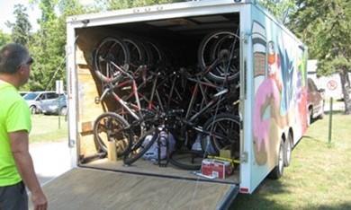
BIKE FLEET
Bicycle fleets are a set of bicycles that a school district, city, or independent entity owns that can be used by students, kids, and/or the general public. Having a bicycle fleet in a community allows students who do not have their own bicycles at home the opportunity to learn how to ride a bike in school or the community. Bicycle fleets should include bicycles of varying sizes, helmets, repair kits, and adaptive bikes.
When, where, and how will this be implemented?
Osakis School District leadership, along with support from local partners, will purchase a bike fleet for the school. The Osakis School District could explore a partnership with adjacent school districts.
Why is this relevant and recommended?
Not all students have access to a bicycle, and this would allow students the opportunity to ride in and possibly outside of school.
How will this address transportation inequities?
This ensures that all students have access to a bicycle regardless of their socioeconomic background, and inclusion of an adaptive bicycle would ensure that students with disabilities can bike as well.
How will this be evaluated?
This would be evaluated by the completion of purchasing and deploying the bicycle fleet in the school.
Who needs to be involved to make this happen?
School district leadership, local health partners, West Central Initiative, and city staff and leadership.
What is the timeline for implementation?
Beginning in the 2024/2025 school year.
WALK AND BIKE FIELD TRIPS
A field trip made by foot or by bicycle gives students a supportive environment in which to practice their pedestrian safety or bicycling skills and showcases the many benefits of walking and bicycling for transportation, including health and physical activity, pollution reduction, and cost savings. The destination of the field trip may vary, or the field trip could be the ride itself.
When, where, and how will this be implemented?
Osakis School District leadership will hold a bicycle field trip either from the school or drive to a destination where students can then ride their bikes in a bike-friendly location. Osakis School District can reach out to local partners for resources and handson support during the bicycle field trips.
Why is this relevant and recommended?
Some kids do not have access to bikes at home, and this gives students the ability to take an enjoyable bike ride while practicing their cycling skills.
How will this address transportation inequities?
Osakis School District would provide standard and adaptive bicycles to all students who may not have access to bicycles at home.
How will this be evaluated?
This will be evaluated by the number of students who participate in the bicycle field trip.
Who needs to be involved to make this happen?
School District Leadership, physical education staff, and parents.
What is the timeline for implementation?
Beginning in the 2025/2026 school year.
ENHANCED SCHOOL COMMUNICATIONS
Existing communication channels can highlight the benefits of active school travel for students and families. Sharing regular SRTS updates and events throughout the school year will keep the benefits topof-mind for families, gradually shift perceptions about safety and convenience, and contribute to a school culture that supports walking and biking.
When, where, and how will this be implemented? Osakis School District Leadership will post Safe Routes to School updates and information on the school district webpage, along with supplying handouts to families at the annual open house in the fall and parent teachers conferences.
Why is this relevant and recommended? Caregivers feel uncomfortable with their children walking alone given safety concerns.
How will this address transportation inequities? Not all families have access to the same educational and informational materials. By having a variety of communication platforms, this allows more equitable distribution.
How will this be evaluated?
This will be evaluated by the number of informational handouts are given to district families and clicks/downloads on the district webpage.
Who needs to be involved to make this happen? School District leadership, local health partners, and teaching staff.
What is the timeline for implementation?
Beginning in the 2024/2025 school year
Working for Change
Action Steps
This plan provides two critical ingredients for creating a more equitable transportation system in Osakis: a prioritized set of infrastructure improvements and program recommendations. To make these recommendations a reality, all members of the Osakis community can play a role. The following text provides ideas for where to start.
Priority SRTS Initiatives
• Reduce speed and traffic along CSAH 3 in front of the school district and elementary school entrances.
• Develop a more inclusive PE experience for students, including developing a multi-use trail to the athletic complex, a traffic garden, and adding a bike fleet with adaptive bicycles.
• Create a Safe Routes to School network and develop safe intersection crossings and sidewalks to complete the network.
IMPLEMENTING INFRASTRUCTURE CHANGES
DEMONSTRATION PROJECTS
Before investing in a long-term infrastructure change, cities and partners may implement a demonstration project to test out an idea. These temporary projects are quick, have a relatively low installation cost, and build support for a long-term permanent change. Demonstration projects can also help engineers and designers make sure that design details are worked out before any new concrete is installed, such as making sure school buses have enough room to turn.
Demonstration projects can also be paired with programming or educational events to encourage additional behavior change. For example, new curb extensions may be paired with a crossing guard to bring additional attention to tricky crossing locations. Or a school may organize a Walk or Bike to School Day after installing a demonstration project to encourage
students and families to try out the new infrastructure.
A demonstration project can include multiple components. The project shown here includes curb extensions and an on-street walking lane where there is currently a sidewalk gap.
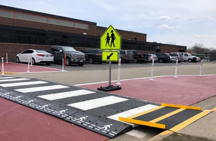
A demonstration project can include multiple components. The project shown here includes curb extensions and an onstreet walking lane where there is currently a sidewalk gap
1his raised crosswalk connects to a school entrance and slows traffic on the adjacent road.
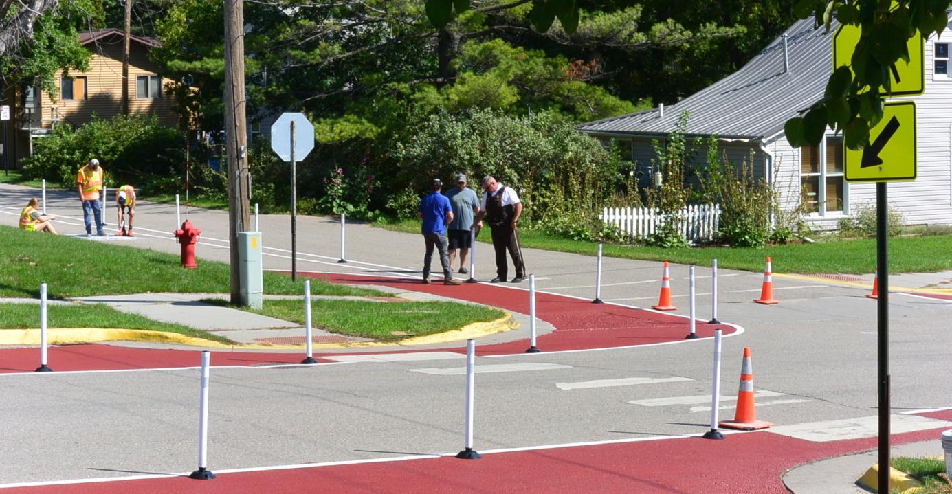
DEMONSTRATION PROJECT EXAMPLES
Demonstration projects can take many forms, with a few examples shown here. In previous SRTS efforts, communities have installed a shared use path on the street where there are no sidewalks (top left photo below), curb extensions at wide and uncomfortable intersections (top right and bottom photos below), and a number of other creative solutions.
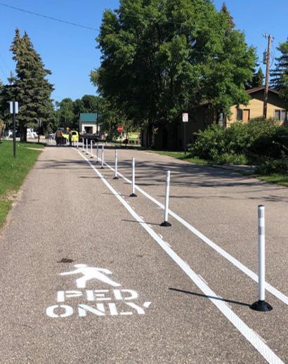
Demonstration projects are typically installed in the spring or fall to have enough time to observe their effects before winter arrives. In some cases, a community may be specifically interested in a component of winter maintenance and may design the project to stay in place through the winter.
TAKING COMMUNITY ACTION
A more equitable transportation system that prioritizes safe, comfortable, and fun opportunities to walk, bike, and roll benefits everyone. While this plan is focused on addressing connections to schools, many improvements will benefit people with no relationship to the schools because we all share the same streets, sidewalks, and trails. Likewise, many needed changes, such as reducing speed limits and normalizing walking and biking, extend far beyond the school system.
Your number one role as a community member is to advocate for changes that make walking, biking, and rolling safer, more comfortable, and more fun. Speak to elected officials, show up to community meetings, talk about walking and biking at school events and with school administrators, and organize and vote for candidates who support walking, biking, and public transit.
I AM A STUDENT, CAREGIVER, OR COMMUNITY MEMBER
Students, families, neighborhood associations, advocacy groups, and local businesses can have incredible influence when advocating for change in their school and broader community. This is true both as individuals, as well as when community members come together into groups, such as a Parent Teacher Organization or disability advocacy groups. For example, students, caregivers, and community members can support and lead SRTS initiatives including:
• Advocating for policy change and funding at City Hall
• Developing campaigns to generate enthusiasm and improve social conditions for SRTS
• Volunteering time to lead a Walking School Bus or organize a bike drive
• Fundraising for SRTS programs and small infrastructure projects
I AM A SCHOOL DISTRICT EMPLOYEE
School district staff bring an important perspective and voice to advocating for a more equitable transportation system. By describing challenges and opportunities they see confronting their students and petitioning local elected officials for improvements, school district employees can support policy and infrastructure improvements that benefit their students and the broader community. Staff are also ideally positioned to implement the recommendations in this plan, whether it be a classroom-level curriculum or school district-wide policy around walking and biking.
I WORK FOR THE CITY OR COUNTY
As members of the governments that own, regulate, and maintain the roads, city and county staff can be instrumental in re-orienting transportation policies and infrastructure around walking and biking to schools and other destinations. City and county staff can leverage their expertise to identify, advocate for, and implement changes that contribute toward a more equitable transportation system. Key policies that staff can support include:
• Reducing lane widths and vehicular speed limits
• Eliminating minimum parking requirements
• Revising land use regulations to promote denser and more integrated land uses that promote walkable and bikeable trips
• Prioritizing municipal maintenance and snow clearing of all pedestrian and bike facilities
• Requiring complete streets infrastructure as part of all road resurfacing and reconstruction projects
City staff can also use this report to support Safe Routes to School funding applications to programs such as MnDOT SRTS grants, Federal SRTS grants, and the Statewide Health Improvement Program (SHIP)
Appendices
A. Visuals and Maps - 46
B. Student Travel Tally Results - 51
C. Caregiver Survey - 57
D. Observation Data - 58
E. Public Engagement Data – 59
F. Data Collection Instruments – 62
G. SMART Goals – 65
H. Team Notes – 67
I. School District and City Policies – 70
J. Osakis City Plans – 77
K. Crash Data – 80
L. Sample Subdivision Ordinance - 81
APPENDIX A: VISUALS AND MAPS
West Central Initiative has created online maps via Google My Maps for the use of the Osakis Public School Safe Routes to School committee. Visit the Google My Maps website at: https://tinyurl.com/yc8p34f6.
This map contains multiple layers for easy viewing, some of which have been manipulated to produce figures A –G. This map was created in May of 2023, based on visual assessments and data obtained during community walk audits.
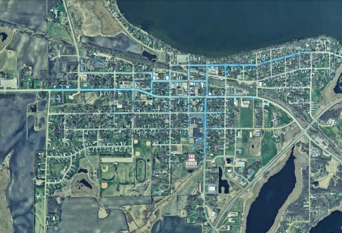
Figure A: A map of the city of Osakis showing where there are existing sidewalks
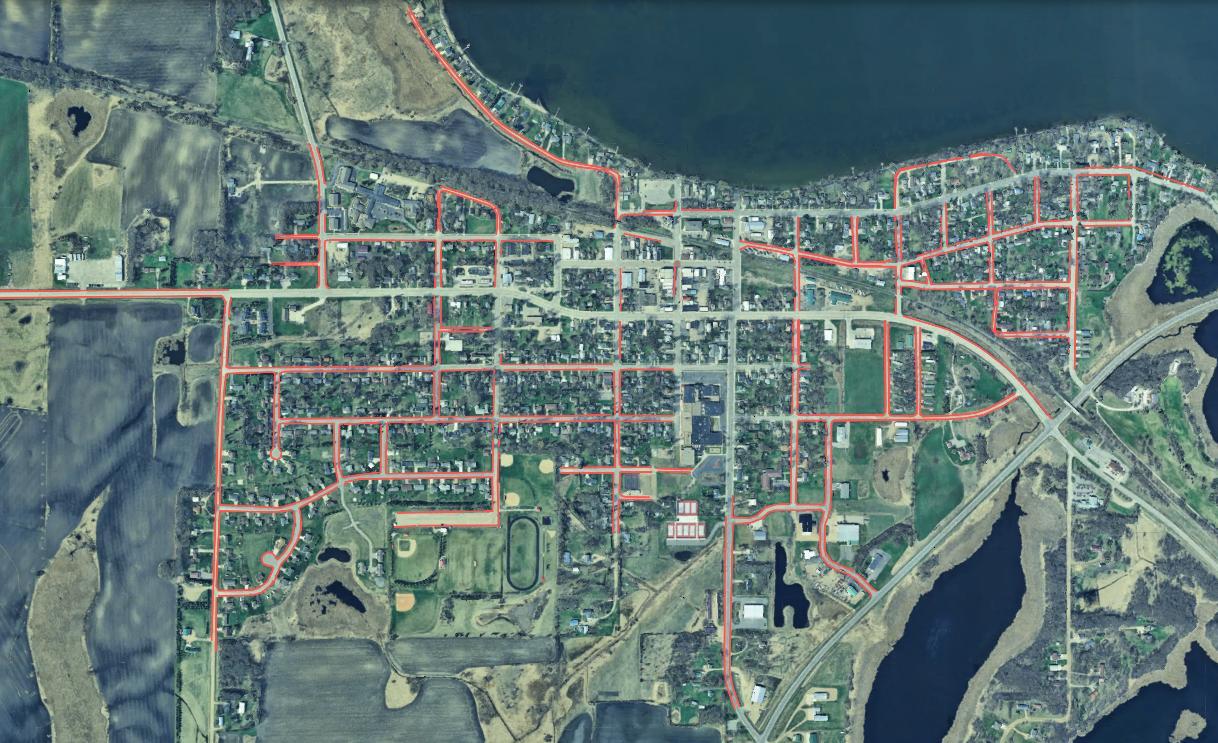
C: A map of the city of Osakis showing where there are sidewalk recommendations and enhanced crossing recommendations
Figure B: A map of the city of Osakis showing where there are no existing sidewalks
Figure
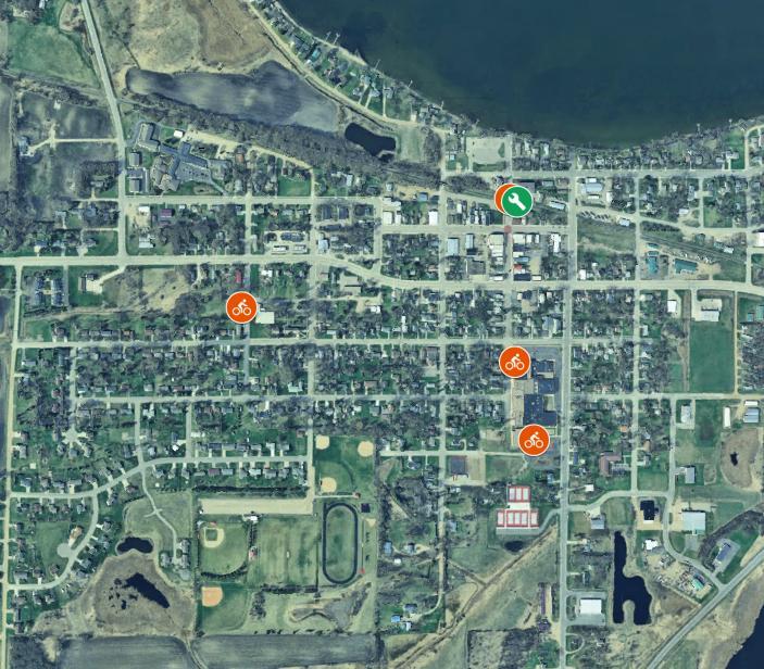
Figure D: A map of existing bicycle infrastructure.
of a highlighted connection opportunities to put a trail or sidewalk.
Figure E: A map showing recommended bicycle infrastructure.
Figure F: A map

Figure G: A map of recommendations from the Osakis Parks and Trails Plan that align with SRTS goals.
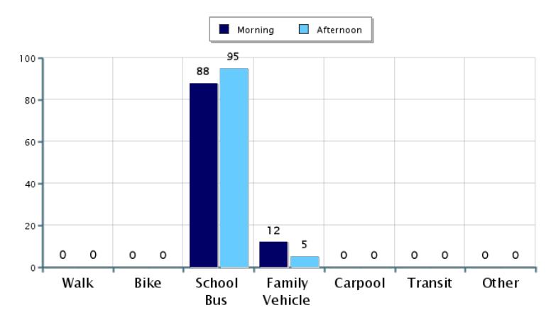
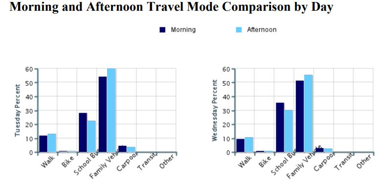
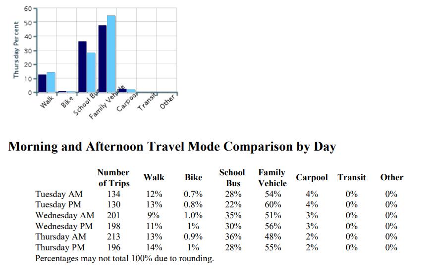
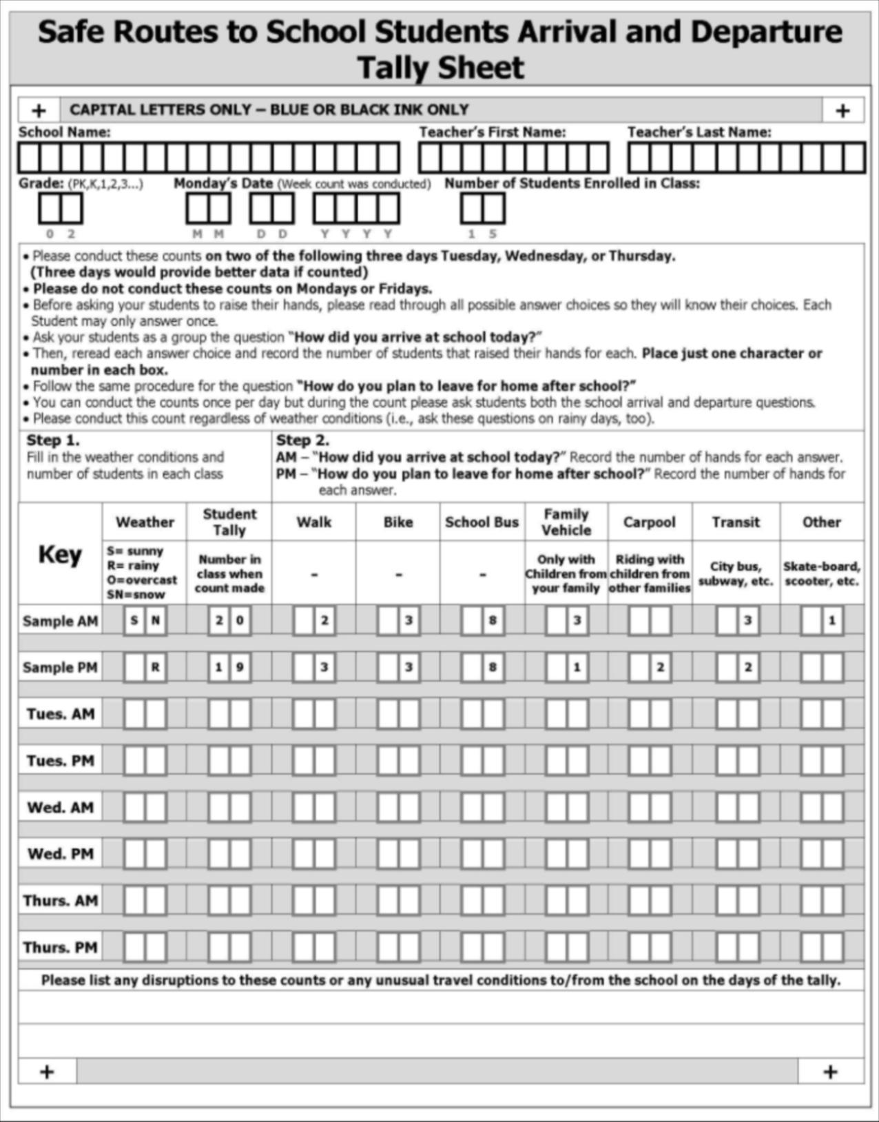
APPENDIX B: STUDENT TRAVEL TALLY RESULTS
Student Travel Tally Report: One School in One Data Collection Period
School Name: Osakis Elementary Set ID: 33129
School Group: Osakis Public Schools
School Enrollment: 456
Number of Classrooms Included in Report: 22
Month and Year Collected: October 2023
Date Report Generated: 05/21/24
This report contains information from your school's classrooms about students' trip to and from school. The data used in this report were collected using the in-class Student Travel Tally questionnaire from the National Center for Safe Routes to School.
Student Travel Tally Report: One School in One Data Collection Period
School Name: Osakis Secondary Set ID: 33129
School Group: Osakis Public Schools
School Enrollment: 456
Number of Classrooms Included in Report: 22
Month and Year Collected: October 2023
Date Report Generated: 05/21/24
This report contains information from your school's classrooms about students' trip to and from school. The data used in this report were collected using the in-class Student Travel Tally questionnaire from the National Center for Safe Routes to School.
APPENDIX C: CAREGIVER SURVEY
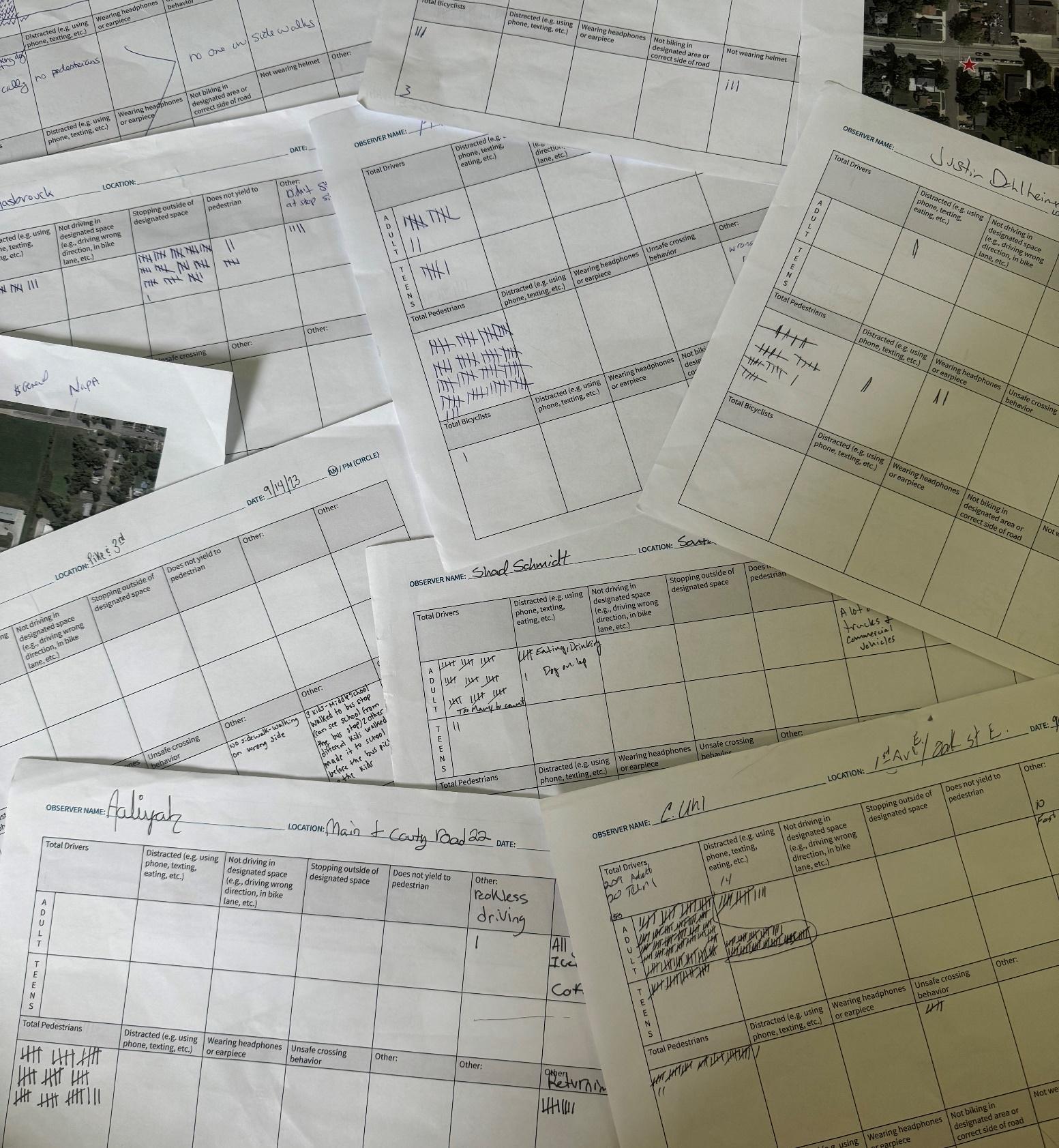
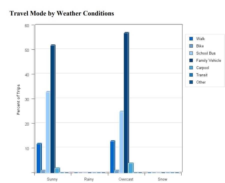
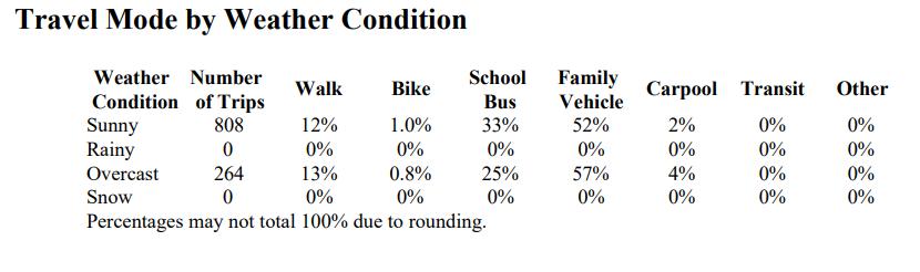
APPENDIX D: OBSERVATION DATA
not stop at stop sign
Stopped in crosswalk
turning car on right
On curb when turning
SCHOOL NAME: Osakis Public Schools
2. GRADE: K-12
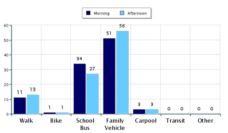
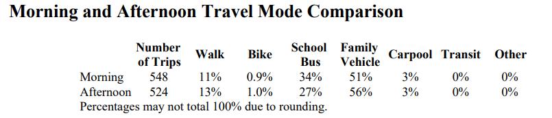
3. ARRIVAL START TIME: 7:40AM END TIME: 8:30AM DISMISSAL START TIME: 2:55PM END TIME: 3:30PM
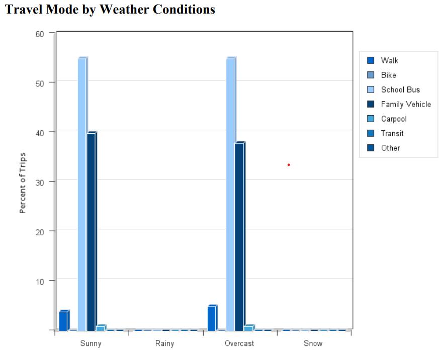
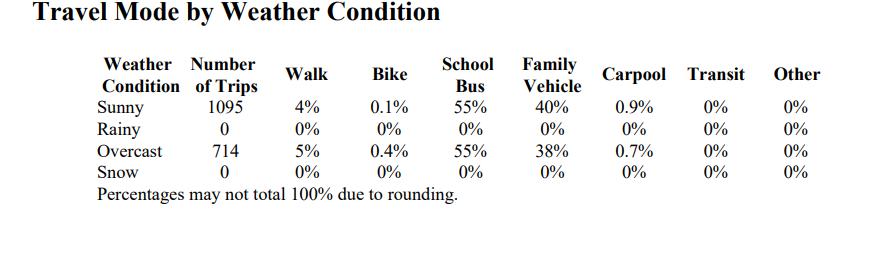
4. CIRCLE APPLICABLE WEATHER CONDITIONS: SUNNY(AM), RAINY(PM), OVERCAST SNOW OTHER:
5. APPROXIMATE TEMPERATURE: 50 degrees
6. IS THERE AN APPOINTED SCHOOL STAFF MEMBER OR VOLUNTEER DIRECTING TRAFFIC FLOW? No
7. IS THERE A SPECIFIED DROP-OFF / PICK-UP AREA? Yes
8. IS THE DROP-OFF / PICK-UP ZONE SEPARATE FROM OTHER VEHICLES? Yes
9. IS THERE A SPECIFIED BIKE ARRIVAL / DISMISSAL AREA? No
Location Number Observer Name
Which of the following traffic control devices are present at the observation area? Midblock or Intersection
Crosswalk Ped Crossing Signal Stop Sign Crossing Guard School Patrol Other
Pike St / CSAH 3 Mallory, Justin X X X
CSAH 3 / Nokomis Angie X X
Main / 1st Ave E Aaliyah
Pike St E / 3rd Ave W Maggie
Oak St W / 3rd Ave W Chad X
Nokomis/ 3rd Ave W Dan X X
Oak St E / CSAH 3 Calvin X X
Nokomis / 4th Ave E Rebecca
Pike St W / Central Kirsten X
Oak St W / Central Alan X
South Parking Lot Shad
APPENDIX E: PUBLIC ENGAGEMENT DATA
West Central Initiative staff held a tabling event on the day of the Osakis Open House on August 30th, 2023. The staff member was located at the entrance of the school. The staff members had poster boards where caregivers, students, and faculty could vote on what keeps children from walking or biking to school, and what would help students to walk or bike to school. Here are the results of the survey.
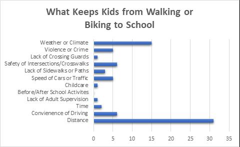
Figure H: A graph with the answers from the question “What keeps kids from walking or biking to school.
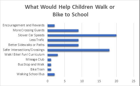
Figure I: A graph with answers from the question “What would help children walk or bike to school.”
APPENDIX F: DATA COLLECTION INSTRUMENTS
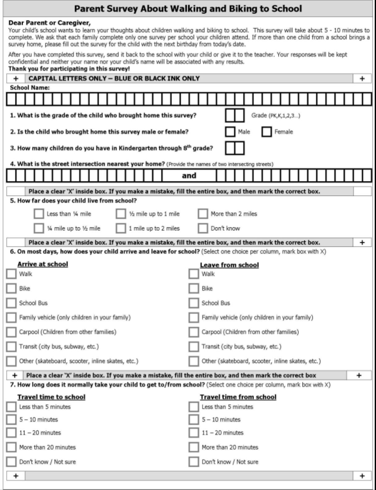
A high-quality and text readable version of this document can be found at Parent Survey. (chromeextension://efaidnbmnnnibpcajpcglclefindmkaj/https://saferoutesdata.org/downloads/Parent_Survey_English.pdf)
APPENDIX G: SMART GOALS
Education:
• The Osakis School District and Osakis Police Department will continue to support and host the annual bike rodeo.
• The Osakis School District will host a parent workshop to teach families how to walk and bike with their students safely beginning in 2024/2025 school year.
• The Osakis School District with implement the Walk! Bike! Fun! Curriculum in the PE classes in the 2024/2025 school year.
Engagement:
• The Osakis School District will deploy the Rainbow Friends Toolkit in correlation with a walking/biking event at the school beginning in the 2024/2025 school year.
• The Osakis School District will include SRTS information in their school newsletter for the 2024/2025 school year.
• The Osakis School District will share SRTS information at their Open House Festival on Aug 28, 2024.
Encouragement:
• The Osakis School District will continue to work to expand and support a walking school bus program immediately.
• The Osakis School District and City of Osakis will collaborate to host walk or bike to school day events in 2024.
• The Osakis School District will work to develop a walk/bike-to-school competition during the 2024/2025 school year.
Enforcement:
• The Osakis Police Dept will continue to support and implement the positive ticket program for kids practicing safe walking and biking techniques immediately.
• The Osakis School District will continue to support and work to expand the crossing guard program in the 2024/2025 school year.
Engineering:
• The City of Osakis will work to reduce traffic and speed along County State-Aid Highway 3 using traffic calming devise immediately.
• The City of Osakis and Osakis School District will pursue funding for a multi-use Trail through athletic complex to Queen St in 2024.
• The City of Osakis will look to enhance crossing 82 potentially using RRFBs in 2025.
• The City of Osakis will look at the feasibility of timed lights at 27/3, and 3/82 in 2025.
• The City of Osakis will work to enhance crossing 82/Central Avenue immediately.
• The Osakis School District and the City of Osakis will collaborate to create public art that enhances the community and centers on walking/biking in 2024.
Evaluation:
• The Osakis School District will conduct Student travel tallies annually
• The Osakis School District will conduct parent/student survey annually regarding walking and biking safety, strategic planning
• The Osakis School District along with the city and county will conduct traffic counts and a speed study in 2025/2026.
• The Osakis School District will use the infrared counter on Queen Street to determine trail feasibility in 2025.
Equity:
• The Osakis School District will work to obtain a Bike Fleet with adaptive bike in 2024/2025 school year.
• The Osakis School District will work to develop adaptive programming for special needs and disabled students during the 2024/2025 school year.
APPENDIX H: TEAM NOTES
Osakis Safe Routes to School Kick-Off Meeting
September 13, 2023
Osakis Public School
In-Person
Justin Dahlheimer – Superintendent
Mallory Jarvi – West Central Initiative
Aaliyah Helland – West Central Initiative
Amber Fiskness – Crossing Guard
Kirstin Wessel – P.E Teacher
Brad Hoffarth – High School Principal
Linda Nack – Crossing Guard
Dan Wessel – Osakis Mayor
Shad Schmidt – Elementary Principal
Virtual:
Angela Jacobson – Osakis City Clerk
Wayne Hurley – West Central Initiative
Welcome and Introductions:
Mallory kicked off the meeting at 4:35 PM with an icebreaker, and introductions were made.
Overview:
Mallory shared Safe Routes Partnership’s video on SRTS 101. Mallory then presented an overview of the SRTS program. There was discussion about the number of people who ride the bus and how it has gone way down post covid. Committee members also mentioned there was a bicycle accident two weeks ago by Tip Top.
Planning Process:
Mallory referenced a Minnesota SRTS document showing the strengths of each different committee member’s roles, and what they would receive from the SRTS program.
Mallory then went over the project schedule as listed in the Scope of Work. Afterwards Mallory gave a planning update based on the information collected from the Public Engagement session conducted at the Osakis Open House back in August. Graphs where presented listing the main reasons community members did not want students walking and biking to school, and what would encourage community members to allow student to walk and bike to school. Committee members was surprised by the number of parents who were worried about crime and violence in Osakis. There were a few questions on understanding the distance category. Mallory explained that is was based on if students lived within city limits due to Osakis being a smaller community. The committee would like to have slower speeds in front of the school if possible.
Committee members mentioned that if the crossing guards don’t hold out their flag, traffic doesn’t stop for them or anyone else. There is one crossing Guard in the morning and there are two in the afternoon. The student crossing guard program stopped because it was unsafe and only staff kids were doing it. The kids were tired of doing it because it was too much for a small cohort to do every day. A committee member mentioned that they don’t believe that more crossing guards would get more kids to walk.
Committee members mentioned County Road 3 is the worst problem because people use it as a short cut from Alexandria to the interstate. When semis turn left onto Nokomis, they block the roads and it takes 10 mins to get
across. The City Council did obtain a permit to get flashing lights at the 4-way stop. The city wanted to conduct a speed study, but they were told they needed a strong argument to have one done.
On County Roads 82 & 3 there are a lot of vehicles cutting the conner so bad that you can see marks on the retaining wall.
The school is interested in the Bike MN bike fleet. There were comments about the police in Osakis, but they were talked to and seem to be getting better. Pike Street and Queen Street are scary was said by lots of people. They loved the draft vision statement.
What are the biggest barriers to walking and bicycling to school?
- Sidewalk and snow is a big problem.
- Mn State 82 & Co Rd 3 are both barriers
- Looking to change the flow of traffic on 3.
- Semis are a problem in front of the school. On Oct. 2 there is meeting on truck traffic
- There is a new sign on I-94
What are the biggest opportunities for walking and biking?
- If you build it they will come. More walking and biking facilities.
- Reward students for walking and biking.
- Bike rodeo every year in May
- Good group of people coming together
- Newspaper people to put a story in the newspaper to raise awareness
- Grant funding/ Applying for grants
- Residential streets have no sidewalks
Action Items:
The committee discussed observation day and the process.
Mallory adjourned the meeting at 6:25p.m.
Osakis Team Meeting
Thursday, February 14th, 2024
Circle of Life Library
Attendees
Justin Dahlheimer – Superintendent
Mallory Jarvi – West Central Initiative
Aaliyah Helland – West Central Initiative
Wayne Hurley – West Central Initiative
Dan Wessel – Osakis Mayor
Kirstin Wessel – P.E Teacher
Mallory kicked off the meeting at 4:00PM with a welcome and introductions.
Mallory gave a short presentation on the current data collected in the planning process.
Mallory then went over SMART goals and how we will make SMART goals for each of the 6 E’s. The rest of the meeting notes were taken within the SMART goals worksheet.
Meeting adjourned at 5:30 PM
APPENDIX I: SCHOOL DISTRICT AND CITY POLICIES
WELLNESS POLICY REVISED 1-9-12
I. PURPOSE The purpose of this policy is to assure a school environment that promotes and protects students’ health, well-being, and ability to learn by supporting, health eating and physical activity.
II. GENERAL STATEMENT OF POLICY
A. The Osakis Public Schools recognizes that nutrition education and physical education are essential components of the educational process and that good health fosters student attendance and education.
B. The school environment should promote and protect students’ health, well-being, and ability to learn by encouraging healthy eating and physical activity.
C. The Osakis Public Schools encourages the involvement of students, parents, teachers, food service staff, and other interested persons in implementing, monitoring, and reviewing school district nutrition and physical activity.
D. Children need access to healthy foods and opportunities to be physically active in order to grow, learn and thrive. E. All students in grades preK-12 will have opportunities, support, and encouragement to be physically active on a regular basis.
F. Qualified food service personnel will provide students with access to a variety of affordable, nutritious, and appealing foods that meet the health and nutrition needs of students; try to accommodate the religious, ethnic, and cultural diversity of the student body in meal planning; and will provide clean, safe and pleasant settings and adequate time for students to eat.
III. GUIDELINES A. Foods and Beverages 1. The goal of the Osakis Public Schools is to make available foods and beverages on campus (including concessions and ala-carte items) that are consistent with the current USDA Dietary Guidelines for Americans. Food Portion Sizes of foods and beverages will be age-appropriate. Ala-carte foods will include a variety of choices of nutritious foods, such as fruits, vegetables, whole grains, and low-fat or non-fat dairy items. Osakis Public Schools will limit classroom celebrations that involve food during the school day to no more than one party per class per month. Classroom snacks and celebrations will reinforce the importance of healthy choices. All snacks that are to be shared among classmates during classroom celebrations will be store bought and pre-packaged with ingredients listed. Osakis Public Schools will limit the use of foods with minimal nutritional value as learning incentives and will encourage healthy food choices or non-food items instead. Beverages Drinking water will be conveniently available for student at all times. Carbonated beverages will not be available to elementary school students during the school day. Only milk (preferably low fat), flavored milk, water, and beverages containing 50-100% fruit juice (preferably 100%) with no added artificial sweeteners may be sold or provided on school grounds prior to and throughout the instructional day. Vending 1. The Osakis Public School will research health choice options to replace candy and foods of minimum nutritional value that are available through vending machines in the school.
2. Food service personnel will take every measure to ensure that student access to foods and beverages meet or exceed all federal, state, and local laws and guidelines.
3. Food service personnel shall adhere to all federal, state, and local food safety and security guidelines.
4. The Osakis Public Schools will make every effort to eliminate any social stigma attached to, and prevent the overt identification of, students who are eligible for free and reduced price school meals.
5. The Osakis Public Schools will make every effort to provide students with sufficient time to eat after sitting down for school meals and will schedule meal periods at appropriate times during the school day.
6. The Osakis Public Schools will discourage tutoring, club, or organizational meetings or activities during mealtimes, unless students may eat during such activities.
7. The Osakis Public Schools will ensure that advertising of foods or beverages in the areas accessible to students during mealtime will be consistent with established nutrition environment standards.
8. For the safety and security of the food and facility access to the food service operations are limited to food service staff and authorized personnel.
B. School Food Service Program/Personnel
1. The Osakis Public Schools will provide healthy and safe school meal programs that strictly comply with all federal, state, and local statutes and regulations.
2. The Osakis Public Schools shall designate an appropriate person to be responsible for the school district’s food service program, whose duties shall include the creation of nutrition guidelines and procedures for the selection of foods and beverages made available on campus to ensure food and beverage choices are consistent with the current USDA Guidelines for Americans.
3. As part of the school district’s responsibility to operate a food service program, the school district will provide continuing professional development for all food service personnel in schools.
C. Nutrition Education and Promotion 1. The Osakis Public Schools will encourage and support healthy eating by students and engage in nutrition promotion that is: a. offered as part of a comprehensive program designed to provide students with the knowledge and skills necessary to promote and protect their health.
b. Part of health education classes as well as classroom instruction in subjects such as math, science, language arts, social sciences, and elective subjects, where appropriate; and
c. Enjoyable, developmentally appropriate, culturally relevant, and includes participatory activities, such as contests, promotions, taste testing, and field trips.
2. The Osakis Public Schools will encourage all students to make age appropriate, healthy selections of foods and beverages, including those sold individually outside the reimbursable school meal programs, such as through alacarte lines, vending machines, fundraising events, and concession stands.
3. The Osakis Public Schools will limit the use of food or beverages as rewards for academic performance or good behavior as deemed appropriate by staff members (unless this practice is allowed by a student’s individual education plan or behavior intervention plan) and will not withhold food or beverages as punishment.
4. Students will receive nutrition messages throughout the school that are consistent and reinforce each other and nutrition education will specifically occur in FACS class in 7th grade, health education, and in the 9th elective nutrition class.
5. Staff primarily responsible for nutrition education will be properly trained and will regularly participate in professional development activities to effectively deliver quality nutrition education.
D. Physical Activity
1. The Osakis Public Schools recognizes that students need opportunities for physical activity and to fully embrace regular physical activity as a personal behavior. Toward that end, health education will reinforce the knowledge and self-management skills needed to maintain a healthy lifestyle and reduce sedentary activities such as watching television.
2. A state certified physical education instructor will teach all physical education classes where students will receive a minimum: • 25 minutes per day, 5 days a week in grades K-6 • 50 minutes per day, 1 semester a year in grades 7-10
3. Opportunities for physical activity will be incorporated into other subject lessons, where appropriate
. 4. Students will be given age-appropriate opportunities for physical activity before and after school by making available the weight/exercise room and the gym as appropriate and when supervised.
5. The Osakis Public Schools will provide adequate equipment for all students to participate in physical education. Physical activity facilities on school grounds will be safe.
6. The school provides a physical and social environment that encourages safe and enjoyable activity for all students, including those who are not athletically gifted.
7. The Osakis Public Schools will provide extra-curricular opportunities for students to participate in.
8. The Osakis Public Schools will encourage parents to support their children’s participation in physical activity.
E. Communicating with Parents
1. The school district recognizes that parents and guardians have a primary and fundamental role promoting and protecting their children’s health and well-being.
2 The school district will support parents’ efforts to provide a healthy diet and daily physical activity for children.
3. The school district encourages parents to pack healthy lunches and snacks and refrain from including beverages and foods without nutritional value.
4. The school district will provide information about physical education and other school-based physical activity opportunities and will support parents’ efforts to provide their children with opportunities to be physically active outside of school.
IV. IMPLEMENTATION AND MONITORING
A. After approval by the school board, the wellness policy will be implemented throughout the school district.
B. School food service staff, at the high school level, will ensure compliance within the school’s food service areas and will report to the food service program administrator, the building principal, or the superintendent’s designee, as appropriate.
C. The school district’s food service program administrator will provide an annual statement to the superintendent setting forth the nutrition guidelines and procedures for selection of all foods made available on campus.
D. The superintendent or designee will ensure compliance with the wellness policy and will provide an annual report of the school district’s compliance with the policy to the school district.
709 STUDENT TRANSPORTATION SAFETY POLICY
PURPOSE The purpose of this policy is to provide safe transportation for students and to educate students on safety issues and the responsibilities of school bus ridership.
II. PLAN FOR STUDENT TRANSPORTATION SAFETY TRAINING A. School Bus Safety Week The school district may designate a school bus safety week. The National School Bus Safety Week is the third week in October.

B. Student Training
1. The school district shall provide students enrolled in grades kindergarten (K) through 10 with ageappropriate school bus safety training of the following concepts: a. transportation by school bus is a privilege, not a right;
b. school district policies for student conduct and school bus safety;
c. appropriate conduct while on the bus; d. the danger zones surrounding a school bus; e. procedures for safely boarding and leaving a school bus;
f. procedures for safe vehicle lane crossing; and g. school bus evacuation and other emergency procedures.
2. All students in grades K through 6 who are transported by school bus and are enrolled during the first or second week of school must receive the school bus safety training by the end of the third week of school. All students in grades 7 through 10 who are transported by school bus and are enrolled during the first or second week of school must receive the school bus safety training or receive bus safety instruction materials by the end of the sixth week of school, if they have not previously received school bus training. Students in grades K through 10 who enroll in a school after the 709-2 second week of school, are transported by school bus, and have not received training in their previous school districts shall undergo school bus safety training or receive bus safety instructional materials within 4 weeks of their first day of attendance.
3. The school district and a nonpublic school with students transported by school bus at public expense must provide students enrolled in grades K through 3 school bus safety training twice during the school year.
4. Students taking driver’s training instructional classes must receive training in the laws and proper procedures for operating a motor vehicle in the vicinity of a school bus as required by Minn. Stat. § 169.446, Subd. 2.
5. The school district and a nonpublic school with students transported by school bus at public expense must conduct a school bus evacuation drill at least once during the school year.
6. The school district will make reasonable accommodations in training for students known to speak English as a second language and students with disabilities.
7. The school district may provide kindergarten students with school bus safety training before the first day of school.
8. The school district may provide student safety education for bicycling and pedestrian safety for students in grades K through 5.
9. The school district shall adopt and make available for public review a curriculum for transportation safety education.
10. Nonpublic school students transported by the school district will receive school bus safety training by their nonpublic school. The nonpublic schools may use the school district’s school transportation safety education curriculum. Upon request by the school district superintendent, the nonpublic school must certify to the school district’s school transportation safety director that all students enrolled in grades K through 10 have received the appropriate training.
STREET EXCAVATIONS
92.01 PERMIT REQUIRED.
(A) No person, except an authorized city employee or a contractor performing work under a contract with the city, shall make any excavation in a street, alley, sidewalk or public ground without first having secured a permit therefor from the city.
(B) The fee for the permit shall be set annually by the Council for each location covered by the permit but no fee shall be required for excavation made pursuant to a permit for sewer or water construction.
92.25 REPAIR OF SIDEWALKS AND ALLEYS.
(A) Duty of owner. The owner of any property within the city abutting a public sidewalk or alley shall keep the sidewalk or alley in repair and safe for pedestrians. Repairs shall be made in accordance with the standard specifications approved by the Council on file in the office of the City Clerk/Treasurer.
(B) Inspections; notice. The designated official shall make the inspections as are necessary to determine that public sidewalks and alleys within the city are kept in repair and safe for pedestrians or vehicles. If he or she finds that any sidewalk or alley abutting on private property is unsafe and in need of repairs, he or she shall cause notice to be served, by registered or certified mail or by personal service, upon the record owner of the property and the occupant, if the owner does not reside within the city or cannot be found therein, ordering the owner to have the sidewalk or alley repaired and made safe within 30 days and stating that if the owner fails to do so, the city will do so on behalf of the city, that the expense thereof must be paid by the owner, and that if unpaid it will be made a special assessment against the property concerned.
(C) Repair by city. If the sidewalk or alley is not repaired within 30 days after receipt of the notice, the designated official shall report the facts to the Council and the Council shall by resolution order the Clerk/Treasurer to repair the sidewalk or alley and make it safe or order the work done by contract in accordance with law. The Clerk/Treasurer shall kept a record of the total cost of the repair attributable to each lot or parcel of property and record the information to the City Clerk/Treasurer.
92.21 SNOW, ICE, DIRT AND RUBBISH.
(A) Duty of owners and occupants. The owner and the occupant of any property adjacent to a public sidewalk shall use diligence to keep the walk safe for pedestrians. No like owner or occupant shall allow dirt or rubbish to remain on the walk longer than 72 hours after its deposit thereon
(B) Duty of owners and occupants regarding removal of snow and ice. The owner and the occupant of any property adjacent to a public sidewalk shall use diligence to keep the walk safe for pedestrians by removing snow and ice. No like owner or occupant shall allow snow or ice to remain on the sidewalk longer than 72 hours after its deposit thereon on the following streets:
(1) All of Nokomis Street, also known as Douglas County Road 82.
(2) Main Street, between Second Avenue West and First Avenue East.
(3) Oak Street, between Central Avenue and Second Avenue East.
(4) Pike Street, between First Avenue East and Second Avenue East.
(5) All of First Avenue East.
(6) All of Central Avenue.
(7) All of First Avenue West.
(8) All of Second Avenue West.
(9) All of Third Avenue West.
(C) Removal by city
(1) The City Council shall designate officials who shall remove from all public sidewalks identified in division (B) above, all snow and ice as soon as possible, beginning 72 hours after any like matter has been deposited thereon or after the snow has ceased to fall. The City Council shall also designate officials who shall remove dirt and rubbish from all public sidewalks, including but not limited to, those identified in division (B) above. The cost for such removal by the city shall be assessable pursuant to this section and § 90.01.
(2) The city officials shall keep a record showing the cost of the removal adjacent to each separate lot and parcel, and shall deliver the information to the City Clerk/Treasurer.
(1986 Code, § 302.02) (Am. Ord. 93, passed 11-4-2013; Am. Ord. 94, passed 5-5-2014; Am. Ord. 98, passed 12-12014)
70.31 PEDESTRIANS.
Pedestrians shall cross any street in the City of Osakis only at the intersection thereof with another street and shall pass over the portion of the street as it included within the lines of the sidewalk, projected, and not diagonally nor in the middle of block.
72.01 GENERAL RIGHTS AND REGULATIONS.
Every person riding a bicycle upon the streets or alleyways of the city shall have all the rights and duties of the rights of a vehicle except as to provisions of this chapter, which by their nature, cannot have application to bicycles and shall have bicycle equipped with reflectors, brakes and other equipment as may be required by state law.

APPENDIX J: OSAKIS CITY PLANS
Osakis
Planning for 2030
Transportation - Pedestrian and Bicycle Recommendations (p.29):
• Construct continuous pedestrian facilities along all major streets and highways; these should be direct and interconnect with all other modes of transportation.
• Provide safe, secure, and convenient facilities for pedestrians into and within commercial developments (downtown).
• Relate sidewalk design to the function and the anticipated amount of pedestrian traffic. Locate sidewalks to take advantage of views and other amenities when appropriate.
• Require pedestrian facilities as land is developed based on standards for the street classification.
• Provide ramps and curb cuts throughout the pedestrian system for physically challenged persons.
Transportation Goals and Objectives (p.30):
Goal 1: Provide a roadway system that supports the efficient movement of people and goods.
Objectives:
1. Coordinate with all appropriate local, regional, state, and federal agencies, regarding the location, classification, planning, and construction of needed transportation system improvements within the city.
2. Promote Highway 27, County Road 82 , and CSAH 3 entrances to Osakis as high-quality, aesthetically pleasing corridors.
3. Upgrade gravel roads to local street standards.
4. Explore traffic-calming measures on highly traveled roadways to ensure people can safely cross the roadways.
Goal 2: Develop a safe and balanced multimodal network.
Objectives:
1. Maintain a street network that is compliant with the Americans with Disability (ADA) Act.
2. Plan and promote walking and biking by working with local, state, and federal partners to plan, fund, and construct a network of trails to increase the nonmotorized transportation system.
3. Expand the sidewalk network and prioritize existing gaps in the network.
4. Plan landscaping along the transportation system to promote walking and enhance city beautification.
5. Review the existing sidewalk and trail network to ensure people can safely travel to destinations.
Goal 3: Pursue funding strategies to implement a balanced and safe transportation system.
Objectives:
1. Continue to fund transportation improvements, operation, and maintenance costs for local, pedestrian, and bicycle facilities through available sources of revenue, which include, but are not be limited to:
a. State and federal funds
b. General revenue funds
c. Special grants
d. The city may jointly fund projects with other entities as appropriate
2. Participate in regional transportation planning efforts in order to pursue funding for the city’s transportation system.
3. Maintain partnerships with the state and counties to ensure transportation needs are incorporated into future projects.
Parks and Recreation – Goals and Objectives (p.67)
Goal 3: Continue to develop an integrated system of trails and walkways that promotes active living. and provides efficient links to neighborhoods, community destinations, parks, schools, and regional trails in the area.
Objectives:
1. Plan and promote walking and biking by working with local, state, and federal partners to plan, fund, and construct a network of trails to increase the non-motorized transportation system.
2. Support downtown biking amenities that connect trail users from the Central Lakes and Lake Wobegon trails to the downtown core.
3. Plan for trail and sidewalk connections from neighborhoods to parks, linkages between parks, and existing trails.
4. Continue working with Douglas and Todd counties and Osakis, Orange, and Gordon townships to ensure coordinated growth of transportation systems and regional recreational areas and trails.
Goal 4: Serve the needs of all park and trail users and ensure equitable access to these facilities.
Objectives:
1. Provide parks with playgrounds or natural play areas that are within walking distance of residential neighborhoods.
2. Incorporate ADA into park designs to ensure they serve residents of all ages and abilities.
3. Respond to the desires and needs of residents, visitors, and tourists with regards to developing park facilities.
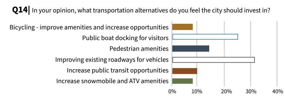
Implement a Capital Improvement Program (CIP) to manage existing future transportation needs.
Study the existing and proposed motorized and non-motorized transportation network.
Identify and implement on-street bicycle lanes along major thoroughfares, when feasible.
Develop a Complete Streets pilot program.
Identify key locations to facilitate safe pedestrian crossings.
Upgrade and pave all roads within city limits
Work to include CSAH 3 on the County’s Capital Improvement Plan to address needed reconstruction to an urban design and potential trails along the roadways, when improved.
Explore traffic calming options along Highway 27 and CR 82.
Conduct a sidewalk inventory.
Identify priority trail improvements.
High City Council, PW Dept, City Administration
Form a new committee to study walkability and bikeability within the city and identify action items and further planning needs
Medium City Council, PW Dept
City Council, collective department effort
Pass a complete streets resolution
Paint and maintain the curb and crosswalk signage
Continue to improve and maintain roadways in a timely manner, such as 8th Ave W
Ongoing City Council, PW Dept
High PW Dept
Ongoing PW Dept
High PW Dept, City Administration
Work with MN DOT on installation of speed feedback and pedestrian crossing signage.
Prioritize expansions in areas that are high density residential or are gaps in the network.
High City Council, PW Dept
Medium City Council, PW Dept, Planning Commission
APPENDIX K: CRASH DATA
Crash data from within the Osakis city limits was gathered using the online Minnesota Crash Mapping Analysis Tool. (MCMAT2) (https://mncmat2.dot.state.mn.us/web) MCMAT2 is MnDOT’s crash database that includes all crashes involving a motor vehicle where a crash report was filed. It includes crash reports from the past ten years. However, a crash involving a solo cyclist, the most common type of bicyclist crash, would not be recorded even if emergency services responded because the crash did not involve a motor vehicle
OSAKIS
Data available for this analysis is from January 1st, 2014, through September 30th, 2024, all of which were included in this analysis. Typically, the lag time between crash occurrence and data entry into the MCMAT2 database can be approximately 2-3 months with the data updated four times per year, approximately quarterly.
J: Map of Osakis with marked locations of pedestrian and bicyclist crash sites.
The staff at WCI felt that collecting crash data within the city limits of Osakis would provide the most utility. There was a total of 84 vehicle crashes with 3 of those involving a bicyclist or pedestrian.
1. On June 26, 2016, at 1:55 PM, under dry and clear conditions, a 32-year-old male driving a Shriner car in a parade struck a 20-year male parade watcher. The tie rod of the vehicle broke causing it to strike a pedestrian. The pedestrian received a minor injury.
2. On January, 28, 2022at 2:00 PM, under snowy and clear conditions, a 58 -year olf male pedestrian traveling southbound on 2nd Avenue against traffic was stuck by a 32-year old male in a passenger car also traveling southbound on 2nd Avenue. The passenger car stated that they saw the pedestrian and tried to swerve, but struck him from behind. No contributing factors were noted.
3 On December 3, 2021 at 6:57 Pm, under dry and dark conditions, a 79-year old female driving a SUV struck a 12-year old male pedestrian. The driver was westbound on Oak Street and stopped at the intersection of Oak and Central Avenue when it made contact with the pedestrian crossing southbound along Central Avenue in the crosswalk. A obscured windshield may have been a contributing factor, but a witness statement says pedestrian darted into the crosswalk and did not appear to have seen the vehicle.
Figure
APPENDIX L: SAMPLE SUBDIVISION ORDINANCE