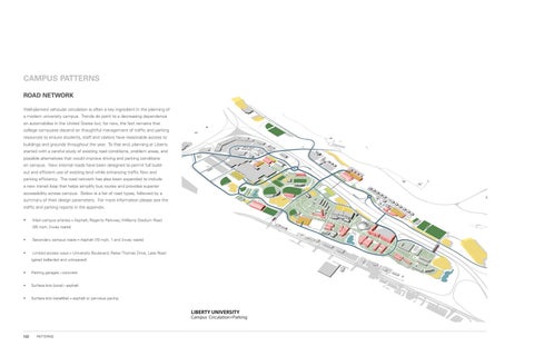
CAMPUS PATTERNS ROAD NETWORK Well-planned vehicular circulation is often a key ingredient in the planning of a modern university campus. Trends do point to a decreasing dependence on automobiles in the United States but, for now, the fact remains that college campuses depend on thoughtful management of traffic and parking resources to ensure students, staff and visitors have reasonable access to buildings and grounds throughout the year. To that end, planning at Liberty started with a careful study of existing road conditions, problem areas, and possible alternatives that would improve driving and parking conditions on campus. New internal roads have been designed to permit full buildout and efficient use of existing land while enhancing traffic flow and parking efficiency. The road network has also been expanded to include a new transit loop that helps simplify bus routes and provides superior accessibility across campus. Below is a list of road types, followed by a summary of their design parameters. For more information please see the traffic and parking reports in the appendix. •
Main campus arteries – Asphalt; Regents Parkway; Williams Stadium Road (35 mph, 2-way roads)
•
Secondary campus roads – Asphalt (10 mph, 1 and 2-way roads)
•
Limited access ways – University Boulevard; Reber Thomas Drive, Lake Road (gated bollarded and unit-paved)
•
Parking garages - concrete
•
Surface lots [core] - asphalt
•
Surface lots [satellite] – asphalt or pervious paving
122
PATTERNS