Lantern Heights
Kirtland Corner
Nob Heights
South Carlisle Neighborhood
Community Planning Concepts
Design Planning Assistance Center
School of Architecture and Planning
University of New Mexico
Spring 2002
Carlisle Village
Blank

Lantern Heights
Kirtland Corner
Nob Heights
South Carlisle Neighborhood
Community Planning Concepts
Design Planning Assistance Center
School of Architecture and Planning
University of New Mexico
Spring 2002


The following pages suggest design ideas and propose ways to enhance the community identity and well-being of the Carlisle Village Neighborhood. They are intended to encourage discussion and lead to activity by area residents and business owners in order to improve public safety, provide for enhanced pedestrian, recreation and education opportunities and achieve objectives identified by community members.


prepared by the
School of Architecture and Planning
University of New Mexico
Spring 2002


The Design Planning Assistance Center (DPAC) is a community service center of the School of Architecture and Planning at the University of New Mexico. DPAC works with community groups and not-for-profit organizations throughout New Mexico on architectural, planning and landscape projects. DPAC was established in 1969 and is staffed by students in the architecture, planning and landscape degree programs.
The information contained in this document is intended to generate further discussion on the future of the neighborhood studied. This document contains no copyright restrictions and its duplication and dissemination for use in the community is encouraged.
For additional full-color, bound copies please contact: Mark Childs, DIrector DPAC, UNM email: mchilds@unm.edu
In memory of our friend and colleague Matt Smilovitz

The design ideas in this document are presented by members of the DPAC studio. They are the product, however, of a community effort and would not have been possible without the involvement of many concerned and dedicated individuals.
Jeff Books
Daniel Erdman
Kevin Fickel
Norman Liss
Steve & Gail Miller
Sandi Radnovich
Keith & Kelly Vlastos
Joe Brawley, Brawley and Company
Mark Childs, Director, Design Planning Assistance Center, UNM
Paul Lusk, Associate Professor, Studio Mentor, UNM
George Radnovich, Principal, Sites Southwest
Chris Wilson, J.B. Jackson Lecturer
We would like to thank the City of Albuquerque for providing the initiative and associated support for this project as well as their contribution of both professional and informational resources.
Lou Colombo, Deputy Director City Council Services
Marg Elliston, Family & Community Services
Jim Hamel, City Transit Department
Tom Menicucci, Policy Analyst, City Council Services
This document resulted from a collaboration between the City of Albuquerque, Family and Community Services Department, and the Design Planning Assistance Center of the School of Architecture and Planning at the University of New Mexico.
The purpose of this study was to generate a set of strategies for potential urban improvements in the South Carlisle neighborhood (herein referred to as the Carlisle Village neighborhood). It is intended that the results of this study may initiate discussion on the future of the neighborhood within the community and within public agencies and departments of the City of Albuquerque. The ideas presented here are design concepts and are not intended to be design guidelines.
The area of study for this project includes the area within approximately one quarter mile radius of the intersection of Carlisle Blvd. and Thaxton Ave. in Albuquerque, New Mexico. The Carlisle Village neighborhood is part of the City of Albuquerque’s Near Heights Community PlanningArea.
The following set of design ideas represent initial concepts and strategies in response to issues and concerns raised by members of the Carlisle Village community. These ideas are the result of a four week investigation. The project team researched the area, conducted interviews, met with local planning officials and held a community meeting in order to gain some understanding of the needs and concerns in the neighborhood. The culmination of the process was a two day design charrette, a quick concept study, consisting of three teams of DPAC students led by UNM faculty and local design professionals. The charrette produced a set of strategies for the physical redesign of the neighborhood.
Organization of this study:
The design charette identified three areas of focus. The first team, Carlisle Village Design Concepts, examined the area relative to its urban context and connections to the surrounding community. The second team, NeighborhoodCenter, focused on the neighborhood core and new residential development. The third team, Open Space / West Edge, investigated the possibilities of the undeveloped properties on the western edge of the neighborhood.
This document contains four major sections reflecting the process of our investigation. These four sections are:
Community Profile
Background Research and Analysis
Carlisle Village Design Concepts
Neighborhood Identity
Neighborhood Center
Development of neighborhood core
Open Space / West Edge
Development of western edge
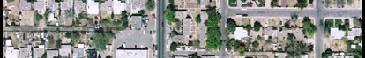
 Aerials: Bernallilo County Geographic Information Systems
Neighborhood Core
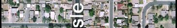
Aerials: Bernallilo County Geographic Information Systems
Neighborhood Core
The area adjacent to South Carlisle Blvd. roughly bounded by Kathryn, Carlisle, Gibson, and Wellesley was originally known as the Knob Heights Neighborhood.
This 160 acre area was deeded by the United States government to Joseph H. Kuhns on November 18, 1891. In 1925 the property was still nearly intact. The Andersons and the Glasebrooks owned all but the Northwest corner.
In 1943 the Andersons with the Thaxtons filed a replat named Torreon. Most of the cross-street names of Knob Heights were on the 1923 Torreon plat.
Over the years developers purchased different blocks. In total, they filed more than a dozen plats of lots. Even now a small part is still unplatted.
Carlisle’s value as a means to get about the city was one reason why the east half developed. In addition, Wellesley was open to Gibson. Girard did not extend south of Smith until the late 70’s.
The area between Kathryn and Thaxton did not develop until after WWII. The earliest homes appear to have been built on Kathryn by 1949.-


Many homes on Smith and Thaxton had been completed by 1950 and by 1953 on Anderson.
Southeast Heights residents appreciated the convenience of having a neighborhood service center on Carlisle until the late 1970’s.
By 1953 the Thrift Super Market had opened at 1019 Carlisle. The rest of the center was in Mesa Court just across Carlisle.
Source : “A History of Southeast Heights”
-Higher percentage of renters than to owners.
- High rental turnover. People of a shared cultural background move into neighborhood for a period of time and then move on. Then a new cultural group moves in.
-Average household size: 2-3 persons
-Median Income ranges from: $14,000-$30,000
-The Median Age of adult residents: 25-40
-Percent of Persons Under 5 Yrs Old make up 5%-18% of population
Professor
Paul Lusk
Mark Childs
Charette Guests
George Radnovich
Joe Brawley
Students
John Carriere
Cory Collins
Christine Coonen
Christel Haught
Meriah E. Heredia
Tanya Johnson
Shelley Maynard
Steve Miller
Beate Ortley
Michael Safrany
Matt Smilovits
Keith J. Vlastos
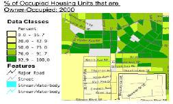
Source: 2000 Census

Safe or unsafe?
SmithAve=safe, AndersonAve.=unsafe
How do you get to school? Parents drive them
Where do you buy your groceries?
Raley’s,Smith’s, Circle K

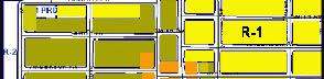
The neighborhood core, near the intersection of Carlisle and Thaxton, is zoned C-1 and is designed to provide suitable sites for office, service, institutional and neighborhood commercial uses to satisfy the day to day needs of residential areas.
The neighborhood east of carlisle is primarily R-1. This zone provides sites for single family homes with some accessory uses.
R-2
This zone provides suitable sites for houses, townhouses and medium density apartments.
R-3
The zone applies to the marjority of the neighborhood west of Carlisle and provides suitable sites for the highest density housing outside of urban centers.
What would you like to see in your community?
Daycare, Community Center, More youth Programs. Paces to eat-Pizza and Restaurants, Arcade, Skate Park, Parks,More Trees, Slower Traffic, More Lights
source: Resident Interviews
PROBLEMS:
Undeveloped Airport Property Property maintenance and car overflow from the auto repair business
No access to the Golf Course Bus Routes
Bad Lighting
External Church congregations
Lack of recreation facilites(youth and community)
Residents feel unsafe on streets at night
Sidewalks are not convenient for pedestrians due to curb height and driveway ramps
Lack of recreation facilities
Lack of community identity
Identity-Name, Location, Place
Recreation-sports, community center, game room, soccer, mini-golf, skate park, baseball, xeriscape, Americorp
Pedestrian-Night Safety:Lights, Improve conditon of street fronts, add trees
Square/Neighborhood Center Grocery, Farmer’s Market, Restaurant, Pharmacy, Laundry, Pizza
Place, Theatre, Arcade, Coffee Shop/Soda
Shop,Dollar Store / Chrift Store, Public Library, Street Vendors
Base Land- housing development
Golf Course-Access
WellesleyMove Road, Community Park/Utilities?
Cul-de-sac/Through Flow
Street Right of Way-create spaces with trees, sidewalks
-Urban Context / Topography
-Gateways / Connnections
-Neighborhood Street Design
-Carlisle Street Design
URBAN CONTEXT:
This community has been known as Knob Heights, Kirtland Corner, and even South Carlisle Shopping Center. It seems the neighborhood is known more for what is next to it than having an identity of its own. Lying just eight blocks south of Central, it overlooks the popular Nob Hill shopping blocks. It has, however, failed to capitalize on business or attract much interest from the Nob Hill regulars.
South of the neighborhood lies Kirtland Air Force Base. The base is walled off on Thaxton and Hermosa Drive. There has been discussion on the possibility of the Base making some of this property more accessible to the CIty by opening access from Thaxton. This could
benefit the community immensely by increasing area population by 30% and bring a potential source of new revenuefor businesses.
Directly on the west edge of Wellesley lies the City of Albuquerque Golf Course. Burton well and reservoir with adjacent park area crosses on Kathryn along the north edge. This supplies attractive views to the neighborhood and can be used to its advantage. Such surroundings do well in creating potential jogging and walking routes, and could supply safe trails for children attending the Kirtland Elementary School across Gibson Blvd.
The Carlisle Village neighborhood is surrounded by community oriented neighborhoods such as Parkland Hills and Ridgecrest. These areas are considered safe and clean within the City, and the Carlisle Village neighborhood could easily benefit from that reputation. This could help attract consumers and interest to the Carlisle Village Center from just a few blocks away.
TOPOGRAPHY:
The neighborhood surrounding the Thaxton and Carlisle intersection lies on the crest of the highest point in the southeast heights. At 5323 ft. above sea level, the site offers a unique location which is attrative for both commercial and residential interests.
5300 ft.
5321 ft.
5323 ft.
Using landmarks as gateways into the “Carlisle Village” community helps give the area a unique identity that sets it apart from other neighborhoods in the city. Such gateways could attract passersby into the area because it creates an inviting atmosphere. Adding identity to the neighborhood may also help the community develop an appropriate name. “Carlisle Village” is only one example.. The use of landmarks to create borders are an attractive sight and can also arouse curiosity. These landmarks could, for example, be an abstract representation of the tower presently on the Life Tabernacle building. The creation of wide landscaped medians on Carlisle at the intersection of Gibson could serve two functions. First, it is an attractive gateway into the community. Second, it is consistent with the medians on Carlisle just north of Kathryn, tying the neighborhood to the surrounding community.
Carlisle with four lanes and a 10’ median in the center. With widened sidewalks and a planter on the median, an attractive gateway is created.
A wide median of 22’ with grass and trees creates a likeness to Carlisle north of Kathryn. By removing one turning lane on Carlisle, space for such a wide median can be made.
On this example all five lanes on Carlisle are maintained, with a 10’ median down the center of the road. This island could be at street level, acting as a drain for water runoff in the street.
Raised planter in median Full grassed medianThe north entrance to the neighborhood currently consists of an awkward intersection where Carlisle Blvd narrows. This intersection could be made more attractive and efficent by creating a small traffic circle. This would allow for traffic calming upon entering the neighborhood as well as creating an attractive, landscaped entrance.

- Possible integration of sculpture and infrastructure in order to create a memorable gateway to the neighborhood.
- Brick paved crosswalks in order to emphasize the pedestrian nature of the neighborhood.
- The landscaped median is widened in order to pick up on the wide medians of Carlisle Blvd north of Kathryn, tying the neighborhood together. Street trees are added for shade as well as to emphasize the entrance.
Community Room proposed at the intersection of Carlisle and Kathryn.


In order to decrease automotive traffic through the neightborhood, we propose to discontinue portions of Wellesley. These portions would then be redesigned for pedestrian and bicycle access. This would allow increased pedestrian and bicycle access while decreasing automotive traffic. Amherst could also be discontinued south of Crest, making Carlisle the collector for the neighborhood.
Bumpouts are added where neighborhood streets meet Carlisle. This defines the area for on-street parking on the residential streets as well as provides added area on the corner for landscaping. By adding trees to these enhanced corners, the entire length of Carlisle becomes more defined.


Based on community members and other comments from a meeting at Kirtland Elementary School January 22, 2002
-To create an identifiable place
-To increase economic activity
-To provide every-day and periodic services to the neighborhood
-Emphasize Key landmarks; job centers and public facilities in area
-Provide memorable spaces and symbols that identify the Carlisle VIllage
-Provide small scale commercial, retail, and office space
-Expand housing choices to allow enough buying power for small businesses
Leader
Joe Brawley
Students
Tanya Johnson
Shelley Maynard
Steve Miller
Beate Ortley

- Provide a neighborhood center with needed amenities
- Utilize the existing building by providing 4 points of access at each side, allowing customers to enter from multiuse plaza space and street
- Recognize the special identity the tower provides to this neighborhood, add light treatment for tower to read as a “night lantern” for neighborhood
WEST ELEVATION
EAST ELEVATION
- Bring your own chair and enjoy a movie with family and fiends in the neighborhood center
- Fresh produce is offered every Saturday, from the community for the community
- Interactive novelty activities for young and old
- The Sculpture can reflect seasonal themes
- The water gathered may be used to sustain trees and plant life in this area
- Residential overview of the street and plaza area


- Street and lot parking are optimized SIMMSAVE.
of baseland north of Gibson
- New housing developement while retaining the DOE area in the center
- Create a community that helps support local businesses
- Provide new community developement containing a park area and single as well as multi family housing


There are many advantages to creating an educationalaswellasarecreationalspaceintheCarlisle Villagecommunity. Formostoftheyouthinthisneighborhood,learningissomethingthatonlyexistsacross Gibson, at Kirtland Elementary. An experiential learningopportunityintheirneighborhoodwouldfoster social awareness, community value, pride, activism and leadership. When a relationship is developed between youth and a particular urban space, a sense of ownershipandpersonalresponsibility to that space is acquired. This provides the opportunityforyouthtohavepositiveinteractionwith their neighborhood and the adults around them.
Leader George Radnovich Students
Cory Collins
Christel Haught
Meriah E. Heredia
Keith J. Vlastos
 GATEWAY


- A safe walkway for youth
- Connect the school bridge to the neighborhood park
- Develop commercial buildings to the South of the alley on Gibson, between Amhurst and Wellesley
- Businesses will provide visibility for the Pedestrian Alley
- Good spot for a restaurant that is open to the park and overlooks the golf course
- Provide a business that will also serve the children that use the alley
- A place for outdoor activities such as picnics and barbeques
- Includes a field that can be used for soccer, baseball, football, etc.
- Also in close proximity to basketball courts

- Provides parking for community mem bers and visitors who use the park
- Allows for quick access to facilities
- Invites people who are driving by to use the park
Based on 60’ right-of-way
PROPOSED NEW STREET SECTION - THAXTON (PARALLEL PARKING)
PROPOSED NEW STREET SECTION - THAXTON (ANGLED PARKING)
Proposed Street Scheme - B
Based on 40’ right-of-way
GULL-APRON
STREET SECTION - AT INTERSECTION TYPICAL (40’) STREET SECTION - EXISTING 4’ 18’ 18’ 4’ 32’ 4’ 6’ 6’ 4’ 28’ 4’ 6’ 6’ 4’ 34’This document suggests design ideas and proposes ways to enhance the community identity and well-being of the Carlisle Village Neighborhood. It is intended that the results of this study may initiate discussion on the future of the neighborhood within the community and within public agencies and departments of the City of Albuquerque. The future development of the Carlisle Village neighborhood is dependent upon discussion and effective action by area residents and business owners in order to improve public safety, provide for enhanced pedestrian, recreation and education opportunities and achieve objectives identified by community members.
Form and support a Neighbohood Association including neighborhoods to the east and west of Carlisle.
Meet with adjacent neighbohood associations to discuss the future of the area.
Meet with City Councilors to discuss forming a Sector Plan for the area.