
Transit Oriented Development: Place and Identity
Achieving a TOD Without Compromising Identity
UNIVERSITYOFNEWMEXICO,SCHOOLOFARCHITECTUREANDPLANNING,MASTERSOFCOMMUNITYAND REGIONALPLANNINGCAPSTONESTUDIO,CRP597


Instructor: Moises Gonzales
OmegaDelgado,BethEliseForman,ErinGanaway,MarcusC.,AdamMoffett,Gabriela Ochoa,SharlynnRosales,andJackieZamoraEXECUTIVESUMMARY
ThisdocumentisintendedtoinformandadviseCityofAlbuquerque’spolicymakersabouttheneedforplanning explorationintotransitorienteddevelopmentfocusedaroundtheprogressionofAlbuquerque’sRapidTransit (knownasARThenceforth)system.Althoughtaskedwithasignificantmissionofimprovingtransportationfor Albuquerqueans,ARThascreatedpotentialforrelinquishingaprojectthatlacksconsiderationandrespectfor establishedcommunityidentityandsenseofplacethuscreatinganotherhomogenousplaceasanoutcomeofbus rapidtransit(BRT)development.Itiswithinthefollowingdocument,thatthisissuebealleviatedthroughthe incorporationofaTransitOrientedDevelopment(knownasTODhenceforth)modelthatexhibitkeyelementsto maintainasenseofplaceandidentitywithinfourdistinctcasestudyareas.
CentralAve.maybedescribedasNewMexico’smostinfluentialroad,encompassingalonghistoryofuseand playingasignificantroleineconomicdevelopment.LocatedwithintheheartofCityofAlbuquerque,NewMexico, CentralAve.isthelengthofthecityitself,stretchingapproximately19milesfromEasttoWest.Theroadwasonce aportionofthehistoricRoute66roadfrom1937until1985.Overtime,growthinvariousareasalongCentral Avenuecontrastedwithconflictingculturalandarchitecturalvaluesthatendowedthecommunitieswithasenseof placeandidentity.Today,asnewplanningmethods,theories,andpracticescontinuetoevolveandbecome popularduetonumerouspositivebenefits,itcouldbearguedthatthesepopularmethodshavealsocreate homogeneitybetweenplacesbydismissinganyincorporationofexistingcommunityidentitywithintheplanning process.InthecaseoftheCentralAve.,theCityofAlbuquerquehasdecidedtoupdatethecurrentpublic transportationsystembyestablishingART.Thishastytransportationprojectpushedbylocalofficialshascreated issuesimmediatelywithintheparallelingneighborhoodsalongCentralAve.Highvolumesofpublicconcernsthat thedevelopmentwouldimpacttheseneighborhoodsnegativelywere,insomecases,intentionallydismissed.
ThefollowingfourARTstationswereselectedascasestudies;OldTown,Atrisco,University,andSanPedro becauseoftheirlocationswithinfourverydistinctneighborhoods.ThedecisionstoimplementTODsasan overarchingdevelopmentplanarebasedontheprovenbenefitsasseeninotherlocationsaroundthenation.Itis understoodthatTOD’sdohavesomenegativeimpacts;howeverthefollowingplanwillprovidefurther recommendationstosubsidethosesideeffects.AlthoughthecontroversyplacedaroundARTisverysignificant, theoverallobjectivesofART’sgoalsarenoteworthy.
TheoverallgoalsofthisdocumentistoestablishfourTODlocationsalongtheARTroute,basedonthecasestudy sites,onCentralAvenuewithoutcompromisingexistingcommunitycontextandidentity.Thisdocumentisdivided intofourmainsections:existingconditionsanalysis,infillstrategiesandpossibilities,recommendationsand conclusion.Thefirstsectionincludesanalysisofeachlocationbasedonthefollowingtopics:
● Identificationofidentityandhistory
● Demographics
● Healthindicators
● Housingcharacteristics
● Landuseandzoning
● Economicconditions(housingandcommercial)
● Drainage
● Transportationnetworks
Thesecondsectionincludesinfillpossibilitiesandstrategieswhichoutlinesareaswithinthestudyareasthatshow potentialforinfilldevelopmentthroughfiguregroundanalysis.Otherdevelopmentpossibilitiesincludeareaof potentialredevelopment.
Thefinalsectionpresentsrecommendationsbasedonthefollowing:
● Drainagerecommendations
● Identity
● Completestreets
● Openspaceandtrails
● Economicincentives
● Bicycletransportationimprovement
Allrecommendationsubsectionsarespecifictoeachareaandarebelievedtobethebestapproachfordeveloping methodsinwhichtheapplicationofTODswillserveARTstationswithoutcompromisingasenseofplaceand identity.
ALBUQUERQUERAPIDTRANSIT
ABQRIDE,Albuquerque’spublictransitdepartmentbeganstudyingrapidtransitfeasibilityinAlbuquerquein 2011.TheAlbuquerqueRapidTransitwasapprovedin2015andbeganconstructioninMay2016.Accordingto theARTwebsite,thistransitsystemismeanttobecomethe“mostcost-effectivetechnologyfortheCityof Albuquerque’scurrentpopulationandfutureridershipestimates”(n.d.,2017).Oneofthemostsignificantchanges thisnewtransitsystemprovidesisadedicatedroad,laneormixedtrafficrouteforthebuses.Thelocations indicatedonFigure1:MapofAlbuquerqueRapidTransitarethestudy’sareasoffocus.Eachstationwillbe encapsulatedbya½mileradius.This½mileradiusindicatesthemaximumwalkableareacenteredonatransit stationtoestablishaTOD.

TRANSITORIENTEDDEVELOPMENT
ATransitOrientedDevelopmentorTODcommonlyemploysmixed-usedevelopmenttomaximizeaccesstoand promoteuseofpublictransportation,withemphasesonthepedestrianandcreatingwalkableenvironments,with ahighdegreeofconnectionsandaccess.ThereareeightstandardsinwhichaT.O.D.mustincorporate.These standardsinclude:
● WALK-Developneighborhoodsthatpromotewalking.
● CYCLE-Prioritizenon-motorizedtransportationnetworks.
● CONNECT-Createdensenetworksofstreetsandpathsthatareeasilyaccessible.
● TRANSIT-locatedevelopmentnearhigh-qualitypublictransport.
● MIX-Planformixedusebuilding,structures,andopenspaces.
● DENSIFY-Optimizepopulationdensityandtransitcapacity.
● COMPACT-Createregionswithshortcommutes.
● SHIFT-Increasemobilitybyregulatingparkingandroaduse.
Overall,themaingoalsofaTODistobecome‘locationefficient’whichmeansthephysicalinfrastructurecreates bettertransitoptionsandhasthepotentialofreducinghouseholdtransportationcosts.Lessdrivingequatestoless
traffic,lesscarbonemissions,andlesspersonalvehiclemaintenance.Theconceptof‘locationefficient’isfurther supportedthrough‘mixeduses’ofbuilding,structures,andopenspacesinwhichavarietyofusescanallowfor employmentandleisurewithinwalkingdistanceofaplaceofresidence.ThebenefitsofTOD’s,asdisplayed throughstatisticsprovidedbyHNTBCompanies(2016)inFigure2:BenefitsofTransitOrientedDevelopment, showsthepossibilityforfutureadaptation,centeredalongmultipleARTstationsinAlbuquerque.

Althoughthebenefitsof establishingaTODare considerable,thistypeof developmentdoescome withchallenges.These challengesincludelackof incorporationofexisting historicorcommunity context;poorly connectedtoautoorientedsurroundings; increaseinrentsforboth businessesand apartmenttenantswhich canleadtogentrification; andincreaseofcar ownershipwithinan established½mileTODradiusduetoanincreaseofaffluentpeoplewhodonotmakethetransitiontowardsother modesoftransportation.
ATRISCO
TheAtriscoStudyAreaisnestledintheheartoftheAtriscoLandGrant.DuringtheSpanishcolonialperiodinthe 1700’s,thisareawasoccupiedforitscloseproximitytotheRioGrandeRiver,makingitprimeagriculturalland. Today,AtriscoremainstruetoitsHispanicandagriculturalrootsandcontinuesastrongrelationshipwiththe manmadearroyosandacequias.

 TRANSIT ORIENTED DEVELOPMENT: PLACE AND IDENTITY PAGE 6
HISTORY/BACKGROUND
Figure 2: Benefits of Transit Oriented Development
Figure 4: Earliest Map of the Area. Photo provided by Office of the NM State Historian
Figure 3: "Youth Sembrando Semillas" Photo provided by NM Acequia Association
TRANSIT ORIENTED DEVELOPMENT: PLACE AND IDENTITY PAGE 6
HISTORY/BACKGROUND
Figure 2: Benefits of Transit Oriented Development
Figure 4: Earliest Map of the Area. Photo provided by Office of the NM State Historian
Figure 3: "Youth Sembrando Semillas" Photo provided by NM Acequia Association


ElValledeAtrisco,ortheValleyofAtrisco,iswellknownaslandgivenbytheNewSpaniardsinthe1600’sto merchantsandbusinessmenthattraveledthroughtheCaminoRealdeTierraAdentro.Thispassageservedasthe maingatewayofagriculturalcommercebetweenthecitiesofChihuahua,RioGrandedelNorte(presentdayEl Paso),areasofAlbuquerque,LaBajadaandSantaFe.
OldTownTODstudyareasitsinoneofthecity’smosticonictouristicandtraditionalspotsforNativeartand culturalmusicalheritageinNewMexico. The“PlazaVieja”asiscommonlyknownbythearealocals,wasfounded in1706byorderofGovernorFranciscoCuervoyValdes. OldTown’stenblocksofadobeSpanisharchitecture continuestobetheheadquartersforcommunitylifeinAlbuquerquebyfeaturingHispanicthemedevents throughouttheyearthatmaintainsthetraditionofbeinganAlbuquerqueculturalhubdestination.Withits locationclosetoDowntownAlbuquerqueanditsconnectionandproximitywiththeoriginalRoute66highway,the OldTownneighborhoodidentityhasbeenlinkedtothelowriderculture,NewMexicohistorylandmarkslikethe SanFelipedeNerichurch
architecturethatcontinuetoinspirecontemporaryplanninganddesign.


UNIVERSITY
TheTODstudyarealocatedintheUniversityareaishometotheUniversityofNewMexicoandUniversityofNew MexicoHospital,thelargestpost-secondaryeducationalandresearchinstitutioninNMandfeaturesadiverseand eclecticpopulation. Ithasbeenformerlybeendescribedasthe“studentghetto”duetoitslargeportionofstudents livinginthesurroundingresidentialareas
TheUniversityTODstudyareaoccupiestheareainwhichUNMresides.Becauseofthis,theUniversityTODstudy areaisuniqueinthatitservesayounger,moremobiledemographic.TheUniversityareahasarichstudenthistory andisperhapsthemostdenseareaofAlbuquerque.ThismakesitanideallocationforaTODdistrict.

SANMATEO
TheSanMateoTODstudyareastraddlesbetweentheNobHillandtheInternationaldistrict Theintersectionof CentralAve.andSanMateoBlvd.hasbeenacenterforhightraffic,bicycleandpedestriandensitywithsporadic businessdevelopment. Itisconsideredtobeoneofthecity’sbusiestandmostdangerousintersectionswiththe highestrateofbicycleandpedestriancrashes.
Becauseofitshighpedestrianandvehiculardensity,thisintersectionwasthelocationwiththemostneedfor transportationimprovement. Theareaiswellknownforhavingahighpopulationofhomelessanddisabled individualsasthisiswithinahalfmileradiusofStateVocationalRehabilitationprograms,Psychosocialrehab organizationsandSocial SecurityDisabilitypayoffices.

EXISTINGCONDITIONSANALYSIS
Aspreviouslymentioned,TODdesignatedareasoperatesuccessfullywithina½mileradiuscenteredarounda transitstation.Thedemographicprofilesectionofthisdocumentisintendedtoanalyzeseveralaspectsabouteach ARTlocationinordertounderstandhowaTODcouldbetterservethepopulation.Thissectionincludesanalysisof eachlocationbasedonthefollowingtopics.
● Demographicscharacteristics
● HealthIndicators
● Landuseandzoning
● Economicconditions(housingandcommercial)
● Drainage
● Transportationnetwork
DEMOGRAPHICCHARACTERISTICS
Thedemographiccharacteristicssectionisarrangedbythefollowingtopicsofanalysis:
● Population
● Housing
● Economics
● Employment
● CommuteTime
● MeansofTransportation
● Education
Theseparticulardemographictopicsofanalysiswerechosenbasedontheirabilitytobeimprovedupon.Asthe mainintentofaTODistoincreasedensity,anunderstandingofhowtheareacurrentlyoperatesisneeded.All topicsanalyzedthroughgeographicalmapsanddatadependononeanotherforstabilitywithinthe½mileradius. Forexample,householdsdependonemploymentwhichinturndependsonsecondaryeducation.Aresident locatedwithinthisareawouldbenefitfromahomelocatedwithinwalkingdistanceofatransitstation.Theperson wouldnotneedtopayforandmaintainavehiclewhichwould
1)allowforhim/hertoretainmoneyand2)receive dailyexercisewhichimprovesbrainfunctionality.Gaininganunderstandingof,notonlyhowtheoverallareas operatewithineachofthesetopics,buthowthesetopicsrelatetooneanotherisbeneficialtounderstandinghow particularareacouldbeapproveduponifneedbe.


Figure10through13depictmapsthatproducethreetypesofinformation.Thefirstislocationsofclustering populationswithineachTODstudyarea.Figure10:TODStudyArea:Atriscodepictsascenariowherethe populationisspreadthroughoutthearea.Nosignificantclusteringoccurswithinthisareawiththeexceptionthat thepopulationislesspredominatewestoftheAtriscoDr.andCentralAve.intersection.Figure11:TODStudy Area:OldTown,incomparisonwithAtriscoindicatedthatthepopulationislessinthisarea.Althoughpopulation intheareaissparselyspreadout,morepeopleresideintheareassouthofCentralAve.andnorthofMountainRd. Figure13:TODStudyArea:Universitydisplaysaclearindicationthat alargepercentageofthepopulationlivein thesoutheastportionwithinthe½mileradius.Otherthanthissignificantclusteringofresidentstherestofthe areaisspreadoutsimilartoAtriscoTODstudyareaalthoughnotasintense.Figure12:StudyArea:SanMateo displayssomewhatofapopulationdifferencebetweeneastofSanMateoBlvd.andwestofSanMateoBlvd.There isagreaterpopulationlocatedwestofSanMateoBlvd.inwhichtheseparationnorthandsouthofCentralAve. doesnotplayafactor.
Thesecondisacalculationoftheoverallpopulationofeachcasestudyarea.Thedotsonthemapareanindication ofonedotequalingfivepeople.Figure13:TODStudyArea:Universityestimatesatotalof3,457peopleliving withina½mileradiusoftheAtriscoARTstation.Ofthispopulationitisestimatedthat51%arefemaleand49% aremalesandthemedianageis36yearsold.Figure11:TODStudyArea:OldTownestimatesthatthe
populationwithintheareais3,169people.Ofthispopulation51%arefemaleand49%aremale.Theestimated medianageoftheareais42yearsofagewhichissixyearsolderthantheAtriscoTODStudyArea.Figure13:TOD StudyArea:UniversityestimatestheUniversityTODStudyAreatohaveapopulationof6,508peoplewiththe½ mileradius.ThispopulationistwicetheamountofbothAtriscoandOldTown.TheUniversityTODStudyAreais estimatedtocontain47%femalesand53%malesandamedianageof30yearsold.Notonlyistheareahigherin thepercentageofmalesbutquiteyoungerthanallotherareas.Figure12:TODStudyArea:SanPedrocontainsthe secondhighestestimatedpopulationof4,438people.SimilartotheAtriscoandOldTownstudyareas,SanPedro TODstudyareacontainsahigherpercentageoffemalesthanmaleswith56.5%comparedto43.5%.Themedian ageforthisareais39yearsold.
ThethirdtypeofinformationFigure10through13depictsaretheracialprofileofeachstudyarea.Alongwith depictingonedotforeveryfivepeople,thedotsalsodepicttheraceofthosefivepeople.Thefollowingracesare included:White,BlackorAfricanAmerican,Asian,NativeHawaiianandOtherPacificIslander,AmericanIndian andAlaskaNative,SomeOtherRace,andTwoorMoreRaces.ThesemapsdonotincludeHispanicorLatinowhich furtherincludes“Cuban,Mexican,PuertoRican,SouthorCentralAmerican,orotherSpanishcultureororigin regardlessofrace.”(n.d.,HispanicOrigin,2017)IthasbeenestimatedthatthemajorityofeachareaareHispanic orLatino.Figure10:TODStudyArea:AtriscoindicatesthatthemajorityofthepopulationisWhitefollowedby SomeOtherRace.86%ofthetotalpopulationinthisareaisHispanicorLatino.Figure11:TODStudyArea:Old TownindicatesthatthehighestpercentageofNon-HispanicorLatinoraceisalsoWhitefollowedbySomeOther Race.Althoughnotasignificantportionofthepopulation,theHispanicorLatinopopulationaccountsfor55%of thetotalpopulationwithinthearea.BothUniversityandSanMateostudyareashavethelowestpopulationof HispanicorLatinopopulationswith28%(UniversityTODstudyarea)and26%(SanPedroTODStudyArea).
Figure13:TODStudyArea:UniversityestimatesthehighestNon-HispanicorLatinopopulationtobeWhite followedbysomeotherrace.Unlikeallotherstudyareas,SanPedroTODstudyareaestimatesTwoorMoreRaces tobethesecondhighestpopulationofNon-HispanicorLatinorace,afterWhites.
Theestablishmentand/orincreaseofhousingunitswithinaTODareaareaprimarygoalinordertobesuccessful. Itiswithanincreaseofhousingunitsthatestablishesabasisforpopulationincrease.TheAtriscoTODstudyarea currentlycontains3.32%ofAlbuquerqueCity’stotalhousingunits.Thisequatestoatotalof8,013housingunits. Themajorityoftheseunitswerebuiltbetween1950and1980.BycomparisoninTable1:HousingCharacteristics, 2015,theAtriscoTODstudyareahasthehighestpercentageoftotalhousingunits.TheOldTownTODstudyarea
hasthelowestpercentageoftotalhousingunitsat1.57%.Themajorityofthehomeslocatedwithinthisareawere builtbetween1940and1960.TheUniversityTODstudyareacontains2.21%ofAlbuquerqueCity’stotalhousing unitsandtheSanMateoTODstudyareacontains1.88%.
Withthemajorityofhousingunitsbuiltbetweenthe1940sand1960s,theSanMateoTODstudyareacontainsthe lowestpercentageofvacanthousingunits.OldTownTODstudyareahasthehighestpercentageofvacantunits with17.43%ofAlbuquerqueCity.Thisamountequatesto3,352vacantunitsoutof19,228.Thissignificant percentageofvacantunitsdoesnotcomparetoallotherstudyarea.AsOldTownTODstudyareahasthehighest percentageofvacantunitsitalsohasthelowestpercentageofoccupiedhousingunitsat.69%outofAlbuquerque City’soveralloccupiedhousingunittotal.ThisamountiffollowedbySanMateoTODstudyareawith1.87%and UniversityTODstudyareawith2.02%.TheAtriscoTODstudyareahasthehighestpercentageofoccupiedhousing at3.30%.
With222,098totaloccupiedunits,accordingtotheU.S.Census5-yearestimatesfor2015,24.21%ofthosewere owner-occupiedinAlbuquerqueCity,whichequatesto131,264units.36.44%or90,834wererenter-occupied units.Oftheowner-occupiedtotalunits,theAtriscoTODstudyareaaccountsfor3.77%whichisthehighestofthe fourstudyareas.TheUniversityTODstudyareacontainsthelowestowner-occupiedunitswith.79%.The majorityofthesehomeswerebuiltinthe1930’sandearlier.TheUniversityTODstudyarea,whilehasthelowest owner-occupiedhousingunits,hasthehighestrenter-occupiedhousingunitsat3.81%.Thispercentisfollowedby SanMateoTODstudyareaat3.00%;AtriscoTODstudyareaat2.62%;andfinallyOldTownTODstudyareaat 1.99%.Overall,11.42%ofthehousingunitswithintheseareascombinedarerenter-occupiedcomparedto6.81% owner-occupiedunits.


Theeconomiccharacteristicsofthefourstudyareasincludemedianincomeperhouseholdandemployment.As TOD’sdensifybothinhousingunitsandpeople,theincreaseofbusinessesisencouragedtoensureeconomic resiliencewithinthe½mileradius.Figures14throughFigure17displaymapsofthemedianhouseholdincome withinthefourstudyarea.Eachmapisbasedon2015U.S.CensusACS5-yearestimatesbycensustracts.Giventhe variousshapesandsizesofthecensustracts,eachmaponlyincludesaportionofalargerarea.Figure14:TOD StudyArea:Atriscocontainsanestimatedhouseholdmedianincomeof$33,544.ComparedtotheCityof Albuquerque’shouseholdmedianincome($47,030),Atriscoislowerby$13,486.Althoughthismedianincomeis lowerby$13,486,AtriscoTODstudyareaisnottheareawiththelowestmedianhouseholdincome.The UniversityTODstudyareahasamedianincomeof$30,804.DuetoitsproximityneartheUniversityofNewMexico campus,thehighpopulationofresidentsthatarefulltimestudentswithnoemploymentorpart-timeemployment couldbecontributingtothisestimate.ThisamountisfollowedbySanMateoTODstudyareamedianhousehold incomeof$31,006andOldTownTODstudyarea$34,664.NotonlydoestheSanMateostudyareaconsistofa largeportionofbusinesses,italsocontainsAlbuquerque’sInternationalDistrict.Thisdistrictiscomprisedmostly offirstgenerationAmericans,sonsanddaughtersofimmigrantsfromplacesaroundtheworldthatareinthe processoffindingstabilityinAlbuquerqueCity.Themedianhouseholdincomeforthisareaisbetween$21,321 and$25,000.


TheemploymentcharacteristicsofthefourstudyareasaretakenfromtheU.S.CensusACS5-yearestimatesin 2015.Figures18throughFigure21indicatetheunemploymentpercentageofeacharea.Theneedofmore employmentwithineacharea,determinedbythisanalysis,cansupporttheeconomicdevelopmentwithinmixed use,denseareas.Overall,9,361peopleresidingwithinthe½mileradiuscomposetheactivelaborforceinthis area.Figure18:TODStudyArea:Atriscoindicatestheemploymentstatusoftheareabetween7.1%to10%ofthe overallpopulationisunemployed.Thereare3,433activelaborforcepopulationresidingintheOldTownarea. AccordingtoFigure19:TODStudyArea:OldTowntheareacontains3.1%to13%unemployedpopulation.There are3,433activelaborforcepopulationresidingintheOldTownarea.Thereare6,342activelaborforce populationresidingintheUniversityarea.AccordingtoFigure20:TODStudyArea:Universityhasatotal7% unemployment.


Aspreviouslymentioned,eachareacontainsahighpercentageofemployedresidents.Astherearefewpeople wholiveandworkwithinthe½mileradiusofeachtransitstop,commutetimeswereassessed.Eachareawas analyzedtogainanunderstandingofhowfarresidentscommutetoworkfromtheirhomes.WithintheAtrisco TODstudyareaindicatedbyFigure25,anestimated21.1to22.5minutesistakenforresidentslivingwithinthis areatotravelfromhometowork.AccordingtoTable2:MeansofTransportationtoWorkalargeportionofthe Atriscoresidentstravelaloneinapersonalvehicle.9,361employedpopulationdriveatruck,car,orvan.The secondhighestmeansoftransportationiscarpoolingforasmallportionofthispopulation.ComparedtotheOld TownTODstudyareawherethereisa3,433activelaborforcepopulation,3.1%to13%areunemployed.The remainingpopulationtravel16.1to22.5minutesfromtheirplaceofresidentstotheirplaceofwork.Similartothe AtriscoTODstudyareaalargeportionofthepopulationtravelsbypersonalvehicle,howeverthispopulationonly accountsforlessthanhalfoftheAtriscoTODstudyarea.
AccordingtoFigure23:TODStudyArea:Universitythemeantraveltimetoworkisbetween15.1to20minutes. Withanestimated6,342activelaborforcepopulationresidingintheUniversityareathemajorityofthemtravel bypersonalvehicle.Itisestimatedthatthispopulationdrivesalone.However,thesecondhighestmeansoftravel withintheUniversityTODstudyareaisbyfoot,walkingwithanestimatedpopulationofjustunder1,000.Asthe UniversityTODstudyareacontainsthesecondhighestpopulationofemployedpeopledrivingaloneinpersonal vehicles,theSanMateoTODstudyareaisthethirdhighestpopulationwithinthiscategory.AccordingtoFigure22: TODStudyArea:SanMateotheaveragetimespenttravelisbetween18.1to20minutesfromhometowork.

Asthemajorityofallareastraveltoworkfromtheirresidentsbypersonalvehicle,walkingandcarpoolingis anotheroptionresidentsarechoosingtoengagein.Giventhepopulation,employmentstatus,education,and medianhouseholdincomeofeachoftheareas,itcouldbedeterminedthattheseothermeansoftransportationare utilizedbecauseofalackofapersonalvehicleorasimplyapersonalchoice.


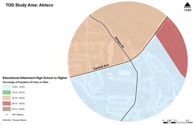
Figures27through30showthepercentageofpopulation25yearsorolderwhoseeducationalattainmentisa HighSchooldiplomaorequivalency,andhigher.TheAtriscoTODstudyarea’spopulationindicatedthroughtheUS 2015ACS5-yearestimatethat74.5%ofthepopulationhaveahighschooldiplomaorpost-secondarydegree.This percentageiscalculatedbycombiningallcensustractareas.ThelowestpercentagerangewithintheAtriscoTOD studyareaisbetween70.8%and76%.ComparedtoallotherTODstudyarea,theAtriscoTODstudyareahasthe lowestpercentageofpopulationofhighschooldiplomasorpost-secondarydegrees.TheOldTownTODstudyarea isestimatedtohaveanestimated90%populationwithahighschooldiplomaorequivalency,orpost-secondary educationdegree.TheportionwithintheOldTownTODstudyarea½mileradiuswiththelowestpercentageof highschooldegreeorhigherisbetween82.1%and88%.TheUniversityTODstudyareacontainsthehighest populationwithahighschooldegreeorhigherat93.5%.Asthemajorityoftheresidentsarecurrentlypostsecondarycollegestudentinpursuitofadegree,partofthisareawithahighschooldegreeisestimatedbetween 92.1%and98%.ThishighpercentageisfollowedbytheSanMateoTODstudyareawithanestimated92.1%ofthe populationwiththe½mileradiustohaveahighschooldiplomaorequivalencyorpost-secondaryeducation degree.
CHILDRENWEIGHTASSESSMENT

ChildrenWeight Assessmentgraph describestheproportion rateofelementaryschool agechildrenabovethe overweightmark. The areasofAtriscoandthe Internationaldistrictare thetwoareasmostly affectedbychildhood obesity. TheareasofOld TownandUniversityshow slightlylowerrates,this couldbeexplainedbythe demographics,the populationintheOldTown Transportationstationhas fewerschoolagechildren, sameisthecaseortheUniversityareawhichcountswithahighstudentpopulationofsinglestatuswithno children.
POVERTYRATE
Povertygraphshow theareasthatare mostaffectedwitha belowpovertylevel mark,theareas affectedwitha populationlivingin poverty. Thearea mostlyaffectedisthe beginningofthe Internationaldistrict intheSanMateo Transportation station.


ECONOMICCONDITIONS
FoodAccessibility graphshowsthat SNAPbenefit recipientsishigher inthe transportation areasofUniversity andSanMateo.
HealthInsurance
Coverageisthelowest intheUniversityarea, duetothehighstudent population,whilethe SanMateo Transportationarea showsanequityin healthinsurance coveragedespitethe disparityinpoverty levelandchildobesity rates.
OneprimarybenefitofTODisthereductioninpersonalvehiclecosts.Thefollowingeconomicconditionsanalysis isseparatedbyresidentialandcommercialcosts.Knowingthatthemarketforresidentialandcommercialcosts fluctuate,theanalysisprovidedisasnapshotofthecurrentmarketvaluesinAprilof2017.Furtheranalysisof thesetwocategoriesofeconomicconditionsisdividedbyallfourTODstudyareas.
TheAtriscoTODStudyAreacontainsanaverageLandLPof$38,000.SingleFamilyHomeinthisareaarelocated on.28-.34acrelotswhicharelargerthantheotherTODStudyAreas.Themajorityofthehomeswerebuiltinthe 40’s-50’s.Therearecurrently14singlefamilyhomesforsalewithinamileandahalffromtheAtriscoARTstation.
TheAVGLPis$160,167.66.Whichbringsthe Price/SQ FT to $92.66.TheAVGSPis $115,000.Thisisa32.9% discountinordertosellahouseinthe93DOMaverage.Theaveragerentinthisareais$774.


Themostdensesite,withthemostdevelopmentpotentialtherearelotsonlandthatavailablefordevelopment. Theacreagetheysitonis.12-.14.TheaverageLPforSFDis$243,500thePrice/SqFtis $156.00. TheaverageSP is $209,000,thisequatesto15%decreasetosellahousein100DOMaverage.TheAVGMarketRentis$1,500for aSFDandforanapartmentitis$900.Twobedroomapartmentsrentfor$1100.


ThemostexpensiveofthefourTODstudyareaanalyzedwiththeaverageLPof$246,000,Thistranslatesinto $172.33Price/SqFtTheaverageSPis$200,142.Thisisa20%decreaseinpriceinordertosellinthe200DOM average.TheaveragerentinthisareaforaSFDHomeis$1460,Whiletheaverageapartmentrentis$595.15.The typicallotinthisneighborhoodis.15ofanacre.Twobedroomapartmentsinthisarearentfor$915


TheaverageLPforthisareais$210,517.14thetypical Price/ Sq Ft is $112.00 TheaverageSPis $175,105.26, whichequatestoa18.40percentdecreaseinordertosellahouseinaverageDOMof75.Averagehomessitona .15lotandwerebuiltinthelate30’sand40’s.Theaveragerentis$1082.50.Thetypicalapartmentrentsat $502.62.Twobedroomapartmentsrentfor$675.00


COMMERCIAL
ATRISCOTODSTUDYAREA


TheAtriscoTODstudyareacontainsalargeareaofcommercialparcels.Theacreagesofthecommercialplots variesimmenselyfrom.5acresto13acres.Thevalueofcommerciallandistieddirectlytoplotsizeand improvements. Theaveragesquarefootpriceforcommercialis $6.74/sq. ft. O

ThecommercialparcelsintheOldTownTODstudyareaarelocatedalongCentralAve.,RioGrandeblvd,Mountain Rd.,andspreadthroughouttheOldTownPlaza.Fromthefourparcelsanalyzed,theareahasanaveragepriceof $16.21/sq.ft.


ThecommercialparcelsintheUniversityTODstudyareaaresmallerinsizeandtendtostaybelow1.5acres. Fromthefourcommercialparcelsanalyzed,theaveragepricepersquarefootis$15.56/sq.ft.


TheSanMateoTODstudyareacontainsavarietyofcommercialparcelsizesandalsovacantparcels. Theaverage pricepersquarefootis $10.04/sq.ft. ThisparticularareahasasmallerpricetagthanotherTODstudyareas.


Oneofthemainconcernsofeachstudyarea,isthepotentialtoincreasethefloodingduetoincreasedimpervious hardscapesfromdevelopmentsinthearea.Knowingthattwoofthefourstudyareaswereeitherinafloorzoneor incloseproximity,itwouldbebeneficialthatanalyzetheareasanddetermineascenariothatwouldalleviateany potentialforflooding.ThefollowingsectionentitledDrainageAnalysisanalyzeseachstudyareabyuseofAMAFCA mapsandinterviewingAMAFCAProjectManager,BradBingham.Eachstudyareaisanalyzedindividuallytogaina clearunderstandingofthefloodingsituations.
ATRISCOTODSTUDYAREA
TheArenalCanalisthemaindrainagechannelcollectingstormwaterflowsfortheAtriscoarea.Thechannelisa softchannelthatisoperatedbytheMiddleRioGrandeConservancy(knownasMRGCDhenceforth). Stormwater flowsheadwesttothischannelbecausethereisanearthenleveethatwasconstructedonbothsidesoftheriverto controlforflooding(seeFigure31:DrainageNetworkoftheAtriscoTODStudyArea). TheAtriscoareawasonce partoftheRioGrandeRiver’sfloodplainwhichwasdefinedbyitsnaturalmeander,buthassincebeen straightenedthroughtheuseofchannelsoperatedbytheMRGCD.Therearestillafewareaswherepondingoccurs (SeeAHareaonFigure31:DrainageNetworkoftheAtriscoTODStudyAreabelow)andthusrequirecompliance withproperraisingupofnewdevelopmentstomeettheBaseFloodElevation(BFE)asrequiredbythefloodplain manager.TheothermajorportionoftheAtriscoareaflowstowardsthebaseballfieldssouthofCentralAve.where theCity-operatedOsagepumpredirectsflowsnorthandouttotheriver.Themajorproblemforthisareaisthat theArenalcanalisanirrigationcanalthatwasnotdesignedtohouselargestormflows(Bingham,2017)

InOldTown similartoAtrisco themajordrainistheAlamedaDrainwhichisasoftchanneloperatedbythe MRGCD.This18-inchdrainismuchtoosmallforthisareaandconsequentlythereareproblemswithflooding.This isexacerbatedbytheflattopographyinthisarea,whichlikeAtrisco,wasoncethefloodplainfortheriver.The AlamedaDrainflowsalongtheriverdowntotheAlcaldeTriangleParkPumpStationandtherestofdowntownto thewestisservedbythe8THStreetPumpStationatthecornerof8thSt.SWandBridgeAve.asseeninFigure32: DrainageNetworkoftheOldTownTODStudyArea.Thispumpstationdesperatelyneedstobereplacedor repairedandonmostdaysyoucansmelltheodorfromthisstationinyourcarwhendrivingovertheriver.Inthe future,thisareawouldbewell-servedbythereplacementoftheAlamedaDrainwitha60-inchpipe,especially withtheadditionofanytypeofmajordevelopmentwhichwouldgreatlyaddtotheamountofimpervioussurface (Bingham,2017).

UNIVERSITYTODSTUDYAREA
TheUniversityareaisanareaofminimalfloodhazard(SeeFigure33:
UniversityTOD StudyArea),butwhenfloodingdoesoccurintheUniversityareaCentralAvenuefunctionsasthemajorchannel andstormwaterisdivertedfromherewithstormdrainsoperatedbytheCityofAlbuquerquetotheSouth DiversionChannel.ThestreetsinAlbuquerqueareofficiallyconsideredpartofthedrainagenetworkaswritten intoCityOrdinance.ArepresentativefromtheAlbuquerqueMetropolitanArroyoFloodControlAuthority (AMAFCA)explainedthisarrangementtousandelaboratedonthisfact,explainingthatmostrainstormsareshortlived,lastingnomorethanfifteenminutes,thereforestormwatersmayinhibittrafficfrombeingabletopass,but onlyforashortperiodoftime.AmissingcomponentfortheUniversityareaisthecontinuationofthehardchannel alongYaleinordertoconnecttotheSouthDiversionChanneltoCentralAve(Bingham,2017).

IntheSanMateoarea,thereisastrongneedforabiggerorparallelstormdrainthatrunsnorthwiththeSan MateoStormDrain,whichisahardchannelstormdrainoperatedbytheCityofAlbuquerque.Additionaldetention pondsareneedednexttoWherryElementaryandatthecornerofEastern&Maderastreets.Biggerdetention pondsarealsoneededattheStateFairgrounds.TheSanMateoareaisinundatedwithlargestormflowsthatcome outoftheKirtlandDetentionPond(RefertoFigure34:DrainageNetworkoftheSanMateoTODStudyArea)foran imageoftheentiredrainagenetwork),whichsometimesflowsatmorethan500cubic-feetpersecond(Bingham, 2017).

TRANSPORTATIONNETWORKS
AsthecenterofallTODareasarecreatedtobetterenhancethetransitusage,thefollowingsectionisdedicatedto theexistingtransitandpedestrianoperations.Thefollowingsectionincludes
● Trafficflows
● Busnetworks
● Existingbikeandpedestrianroutes
● PedestrianCompositeIndex
● BICIBikeShareStationsandreach
● Bikeandpedestrianaccidents


TheAtriscoARTStudyAreaisavehicle-centricareawithhightrafficcountsalongCentralAveandpoorbicycle andpedestriannetworks.Figure38:TrafficFlows2014AtriscoTODStudyAreashowsthearterialroadways withinthearea.ModeratelyhightrafficflowsalongCentralAveaverage31,467vehiclesperdayin2014.The bridgecrossingitselfexperienceshighaveragetrafficflowof34,453vehiclesaday.Theonlyothermajorroad usedinthisareaisAtriscoDrivewhichaverages10,211vehiclesperdayin2014.UnlikeCentralAvenue,this transitionsfromsevenlanestosixlanesthroughout,AtriscoDrivetransitionsfromfivelanestotwolanesa quartermilepasttheintersectionatCentralAvenueandAtriscoDrive.Asthemajorityoftheroadswithinthisarea arecul-de-sacs,AtriscoDriveandCentralAvenuearetheprimarythroughwayroadsresidentsutilizetocommute
outsidetheareaandnonresidentstopassthroughthearea.
ThetransportationnetworkintheOldTownTODcanbecharacterizedbyeffectivetransitcoverage,minimal bicycleandpedestriantrailsandnetworksandtwoBICIbikesharestationsthatprovidemoderatecoverage. Figure37:TrafficFlows-OldTownT.O.D.showsthearterialroadwayswithinthearea.Thismapshows moderatelyhightrafficflowsalongCentralAve,whichaveraged30,620vehiclesperdayin2014.Thebridge crossingitselfexperiencedhighaveragetrafficflowsof33,658vehiclesaday.TrafficflowsalongCentralAvesplit betweenLomasBlvdandCentralAvenearthecenteroftheTOD.TheothermajorroadusedinthisareaisRio GrandeBlvdwhichhastrafficflowsof23,411vehiclesperday.CentralAvetransitionsfrom6lanesto4lanesin thisarea.
TheUniversityARTStudyAreaisavehicle-centricareawithmediumtrafficcountsalongCentralAveandgood bicycleandpedestriannetworks.Figure35:TrafficFlows-UniversityT.O.D.showsthearterialroadwayswithin thearea.ThismapshowsmediumtrafficflowsalongCentralAve,whichaveraged23,327vehiclesperdaywestof universityblvdand29,514to33,220vehiclesperdayeastofUniversityblvdin2014.Theothermajorroadusedin thisareaisUniversityBlvdwhichaveraged22,046vehiclesperday.Universityblvd.isa6lanestreetwhileCentral blvdmaintainsits4lanedesignation.
TheSanMateoARTStudyAreaisavehicle-centricareawithmediumtrafficcountsalongCentralAveandSan MateoBlvd.Therearealsopoorbicycleandpedestriannetworks.OfallfourTOD’sbeingstudied,theSanMateo TODtakesthemostadvantageofAlbuquerque’sstreetgridlayout.Figure36:TrafficFlows-SanMateoT.O.D. showsthearterialroadwayswithinthearea.ThismapshowsmoderatelyhightrafficflowsalongCentralAvewith 26,542vehiclesperdayin2014.TheothermainarterialisSanMateoBlvd,whichaveraged30,153vehiclesper daynorthofcentraland25,855vehiclesperdaysouthofcentralin2014.


San
transit
ABQRidebusnetwork.Inadditiontothe766and777RapidRidelines,the66,97and140locallines intersectthisTODprovidinggoodaccesstotransit.AccordingtoFigure38,east/westbusrapidroutesareonly availablecomparedtotheOldTownTODstudyareathe766and790RapidRidelines,aswellas,twoconcurrent locallines,the66and11.ThisindicatedthatthebusrapidroutesservicethenorthernareasalongRioGrande Blvd.Figure41:illustratesthattheOldTownTODenjoysgoodaccesstotransitviatheABQRidebusnetwork.This areahasaccesstotworapidserviceroutes,
Figure40:showsthattheUniversityTODenjoysgoodaccesstotransitviatheABQRidebusnetwork.Busservices providedbyABQRide,includingthe766,777and790RapidRidelines,aswellas,the66,97and16/18locallines, intersectthisTOD.Figure42:BusRoutesRapidServiceinAtriscoTODStudyAreadepictsonlytwobusroutes withintheAtriscoARTStudyArea.ThefirstisalongAtriscoDrivewhichonlyextendsnorthtoCentralAvenue.The secondrouteislocatedonCentralAvenue.BusservicesprovidedbyABQRide,include766RapidRideline,66and 51locallines.


Figure43:indicatestheexistingbicycleandpedestriannetworksintheAtriscoARTstudyarea,whichconsist primarilyofbicyclelanesalongCentralAveandnorthAtrisco.Asmentionedpreviously,CentralAvenueand AtriscoDriveprovidetheonlythroughwaysforthearea.Theseroadsareusedforbicyclingandwalkingin conjunctionwithvehiclesfortheiraccessibility.SouthofCentralAvenueonAtriscoDriveisfrequentlyusedfor bicyclinghoweverthereisnodedicatedlanesforthebicyclistopposedtonorthofCentralAvenueonAtriscoDrive, asindicatedbytheredlinesinFigure43.AnotheroptionforbicyclesandpedestriansisSunsetRdlocatedwestof theRioGrandeandparallelsAtriscoDrive.Althoughabicycletrailisestablishedonpartofthisroad,indicatedby thebluelinesinFigure43,thereisacleardisconnectbetweenSunsetRdandtheBosquetrails,AtriscoDrive,and CentralwestoftheintersectionatAtriscoDrive.
Figure44:showsthattheexistingbicycleandpedestriannetworksintheOldTownTOD.ThisTODhasastrong bicycleboulevardpresencealongMountainStreetand14thstreet.Un-markedbicycleroutessurroundtheABQ BioparkandZooandcontinuealong15thstreet.SharedbicyclelanesexistalongCentralAveeastoftheLomas Blvdsplit.TherearenumerousinformalandundocumentedpedestriannetworkswithinOldTownandbetween RioGrandeBlvdandtheBosque.
45:
SilverStreetbicycleboulevardstretchesacrosstheentiretyoftheTOD.Additionally,theUNMcampusprovides manynon-traditionalbicycleandpedestriannetworks.
forbicycletraffic,buthavenoactualseparationorroadway signage.ThefinaleasternstretchoftheSilverSt.BicycleBoulevardterminateswithintheSanMateoTODaswell.
P


ThePCIisatooltohelpprioritizeroadwaysforpedestrianimprovements.ThePCIusesregionaldatatocompare aspectsthatdeterpedestriantravel(speed,trafficvolume,crashes)toaspectsthatgeneratepedestriantravel (transit,landuse,householdswithnomotor-vehicles).Roadwayswithbothhighdeterrentandhighgenerator scoresindicatethattheyhavepedestriantraveldemand,buttheyarelousyplacestowalk,thusmakingthem prioritycandidatesforpedestrianimprovements.Thistoolhelpstocompareroadwaysanditprovidesawide varietyofpedestrian-relateddata.However,itdoesnotprovidedetailssuchasthepresenceandwidthof sidewalks,whichisnecessarytocalculatepedestrianlevelofservice.Nordoesitprovideinformationonfuture demandforwalking(www.mrcog.gov).
(transit,landuse,householdswithnomotor-vehicles).Roadwayswithbothhighdeterrentandhighgenerator scoresindicatethattheyhavepedestriantraveldemand,buttheyarelousyplacestowalk,thusmakingthem prioritycandidatesforpedestrianimprovements.TheentiresectionofCentralAvewithinthisTODhasamongthe highestPCIscoresinAlbuquerquerangingfrom153to177.UniversityBlvd.alsohashighPCIscoresrangingfrom 122to154.ThedatarepresentedherebasicallyshowsthattheUniversityTODandUNMareaingeneralisahighly walkedareawithpoorsidewalkinfrastructure ThesectionofCentralAvewestofRioGrandehasaPCIscoreof 144,whichisveryhigh.OtherpartsofCentral,aswellas,LomasBlvd andRioGrandeBlvd havePCIscores between98and114.
BICIBIKESHARESTATIONSANDREACH


ThelackofaBICIbicyclestation,locatedwestofAtriscoDrive,hasresultedinadisconnectoftrailsfromCentral AvenueeastofSunsetRdandCentralAvenuewestofAtrisco.Figure51:BICIBikeShareStationsandReachAtriscoTODindicatesthedistancewithinthisstudyareathatbicyclistandpedestrianscantravel.Accordingto thisfigure,thefurthestBICIuserscanwalkfromaBICIbicyclestationistotheintersectionofAtriscoDr.and CentralAve.ThebicyclenetworkwithintheOldTownTODiscomplimentedbytheexistenceoftwoBICIbike sharestations,themostBICIbikesharestationsofalltheTOD’sbeingstudied.Figure52:showsthetwoBICI stations,aswellas,theconsiderablebikeandwalkreachthatthesestationscreatewithintheOldTownTOD.As Figure53indicatestheUniversityTODhasnoBICIbikesharestationsandisbarelyreachablebybikefromthe nearestBICIstation,locatedinOldTown.AsFigure54:illustrates,theSanMateoTODhasnoBICIstationsandis outofwalkingorbicyclingreachfromallotherBICIstations.


Figure54:indicatesthenumberofbicycleandpedestrianrelatedaccidentsthathaveoccurredintheAtriscoART StudyArea.Givepreviousdatathatindicatedalargepercentageofresidentswithinthisareadrivetheirpersonal vehicles,wecanseethisareacontainsthefewestnumberofbicycleandpedestrianrelatedaccidentsamongall ARTstudyareas.ThemajorityoftheseaccidentshaveoccurredonCentralAve.Thenumberofaccidentsoccurring onlocalroadwaysissignificantlyhigherthanaccidentsonAtriscoDr.
Figure55:indicatesthenumberofbicycleandpedestrianrelatedaccidentsthathaveoccurredintheOldTown ARTStudyArea.Givepreviousdatathatindicatedalargepercentageofresidentswithinthisareadrivetheir personalvehicles,wecanseethisareacontainsthefewestnumberofbicycleandpedestrianrelatedaccidents amongallARTstudyareas.ThemajorityoftheseaccidentshaveoccurredonCentralAve.Thenumberofaccidents occurringonlocalroadwaysissignificantlyhigherthanaccidentsonAtriscoDr.
Figure56:indicatesthenumberofbicycleandpedestrianrelatedaccidentsthathaveoccurredintheUniversity TODStudyArea.Givepreviousdatathatindicatedalargepercentageofresidentswithinthisareadrivetheir personalvehicles,wecanseethisareacontainsthefewestnumberofbicycleandpedestrianrelatedaccidents amongallARTstudyareas.ThemajorityoftheseaccidentshaveoccurredonCentralAve.Thenumberofaccidents occurringonlocalroadwaysissignificantlyhigherthanaccidentsonAtriscoDr.
Figure57:indicatesthenumberofbicycleandpedestrianrelatedaccidentsthathaveoccurredintheSanMateo TODStudyArea.ThisareahasamongthehighestratesofpedestrianrelatedaccidentsinAlbuquerque.The majorityoftheseaccidentshaveoccurredonCentralAve.Thenumberofaccidentsoccurringonlocalroadway
otherthanCentralAveisalsohigh.
LANDUSEANDZONING
ForthepurposeofestablishingaTOD,zoningmustbetakenintoconsideration.Ifthezoningdoesnotallowfor mixedusedevelopment,thepossibilityofachievingmediumorhighdensityisunlikely.Thiswouldalsoprevent theabilitiesofthepopulationtoworkandlivewithinthe½mileradiusofthetransitstation.Opportunitiesfor Albuquerquetomaximizetheuseofland,anewzoningcodeisintheprocessofcompletioninwhichfocusison allowingformixedusedevelopment.Thefollowingsectionisdividedbyexistinglanduse,existingzoning,andthe proposedIntegratedDevelopmentOrdinancezoningforeacharea.
EXISTINGLANDUSE


TheAtriscoStudyArealargelyconsistsofsinglefamilyresidentialparcels.Theseresidentialareasencapsulatea varietyoflongnarrowlotsthatarenotseeninotherareasalongCentralAvenue.Historicallytheselots,were establishedperpendiculartotheacequiasystemtogainaccesstothewaterforfarming. Today,theselonglots consistofoneormultiplehousingunitsandlargeopenspacewhichareirregularlyusedforfarming.Thetypeof housingstructuresincludesinglefamilyhomes,mobilehomes,andsinglefamilyhomeswithsecondarydwelling units(SDU)onasinglelot.Aestheticallymanyofthebuildingsarenomorethantwostoriesandmadeofadobeor stuccoandhavenaturalearthtonesfortheexteriorfinish.Thistransitionfromfarmingtoresidentiallotscreated
anenvironmentoflowdensitysuburbanandagriculturalthatabutsthelimitedcommercialareaslocatedparallel toCentralAvenue.Thesecommercialareasrangefromsmallcommercialretailandservices,aswellaslargelots developedwithbigboxretailandstripcommercial.Thecommercialareasconsistofsinglestoryandaresimilarto theresidentialtypologies.Theproximityofthecommercialandresidentialcreatesminimalareasofbufferandin manycasesthebufferzonesconsistofonlyawallorfence.FigureX.IndicatestheexistinglanduseoftheAtrisco StudyArea.
SimilartotheAtriscoStudyArea,theOldTownStudyAreaconsistsofprimarilysinglefamilyresidentialparcelsin avarietyoflottypes.Theseresidentialareasconsistoflargerlotswithsingledwellingsandmorelandfor agriculturetosmallerlotswithsingledwellings.Thenon-residentiallandusesconsistsofcommercial,industrial, wholesale/manufacturing,andInstitutional.TheHistoricOldTownplazahascreatedalargemixofthenonresidentialandtheresidentialduetothegrowthpatternsovertheyears.Thisareaunliketheothershasmoreofa mixtureoflandusesratherthandirectseparation.
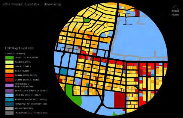
TheUniversityStudyArea,asitsnameimplies,isprimarilyinstitutionallandusesduetoproximityandinclusion oftheUniversitywithsmallstretchesofcommercialalongtheprimaryroadways.Theresidentialportionsare morevariedherethantheotherareasandincludemoreMulti-Familyresidentialthantheotherareas.Manyof thesedevelopmentsoriginatedassinglefamilyunitsandhavebeenconvertedovertheyearsintostudenthousing.
TheSanMateoStudyAreaisprimarilyCommercialRetail/Services,theprimaryresidentialareasareSinglefamily withamixtureofMulti-family.Thesecommercialareasallowforshopping,restaurants,offices,entertainment,and services.Thisareaisthehomeofmanypublichealthserviceshousedwithinitstowerofficebuildings.


AsfigureXlandusereflects,thezoningissimilarinthetypesofuseidentifiesinfigureX.Currentzoningis primarilyC-2CommercialandR-1Residential.C-2Commercialzoningallowsalltypesofretailandserviceuses
andfurtherallowshigh-impactestablishmentssuchasvehiclesales,liquorsales,hotelsandmotels,adultoriented establishments,largersignsandbillboards,outdooractivities,anddrive-inrestaurants. R-1Residentialzoning coversthemajorityoftheARTAtriscoandOldTownStudyArea.Thiszoneallowsforsingle-familydwellingsand incidentalaccessoryuses,whichincludedetachedgarages,greenhousesandstoragesheds.Theresidentialzones allowforsinglefamily,townhouses,andmobilehomes.Thebuildingtypologies,lotsizesandshapesvarywithin theresidentialzones.TheARTUniversityStudyAreaiszonedprimarilysinglefamilyresidentialandcommercial regardlessofthevaryinglanduses.TheARTSanMateoStudyAreaconsistsprimarilyofcommercialandofficeas showninthelanduse.Thereislittledeviationfromthelandusetothezoning.
INTEGRATEDDEVELOPMENTORDINANCE


TheIntegratedDevelopmentOrdinancewoulddirectlyconvertthecurrentzoningdesignationstotheproposed zoningdesignations.InthecaseofAtriscothelargestimpactoftheIDOistheconversionoftheC-2zonetothe proposedMX-M(MixedUseMedium)zone.TheMX-Mzoneallowsforhigherdensityandthemixofresidentialand commercial.TheOldTownandUniversityStudyAreahasbeenprimarilyconvertedtoMX-L/MX-M(MixedUse Low/Medium)similartotheAtriscoarea.TheresidentialareasareproposedtoconverttoSinglefamily,MultifamilyLow,townhouse,andportionsofMulti-FamilyHighdensity.Allowingformoreinfillpossibilities.TheSan MateoStudyAreaconvertsfromamixofC-2andC-3commercialtoMX-L/M/H(MixedUseLow/Medium/High) thisallowsforthepreviouscommercialareastobecomeamorespecificmixedusezone.TheStudyAreaisthe onlyonethatincludestheTransitionzonetoallowforsmallcommercialandmoreresidentialoptions.The residentialareasareconvertingtoSinglefamilyandMulti-familyHigh.
INFILLSTRATEGIESANDPOSSIBILITIES
ATRISCOTODSTUDYAREA


Atrisco TOD Study Area


ThecurrentAtriscoTODstudy areaislocatedwestofthe intersectionatAtriscoDr.and CentralAve.Theimpending ARTStationisdepictedtohave sevenlanesoftrafficwith4ft. bikelanes.Theexisting sidewalkswillremaintheir currentwidth.Althoughthe lanewidthsizewillbereduced whichwillslowtraffic,there arenosafeguardsforeither bicyclistsorpedestrians.To ensuresafety,BicycleDesign
Treatment,PedestrianDesign
Treatment,andTrafficand SpeedControlsare recommendedfor implementation.By eliminatingavehiclelane, betterbicycleaccesswillbe providedwhichcouldpotentiallyallowtwowaylanesforbicyclist.Treelinedbufferwillbeaddedtoensuresafety forbicyclistandpedestriansononesideofthestreet.Theeliminationwillallowmorebicyclistbutwillalsoallow forthroughtraffic,giventhatthisisamajorarterialforthearea.Treesarerecommendedtobeplacedparallelto thetrafficbetweentheroadandsidewalksforaddedsafetyandtocreateamorepleasantwalkingexperience.
Old Town TOD Study Area


TheOldTownTODStudyAreacontainsthe onlyARTstationthatisnotlocatedwithin closeproximityofanintersection.TheOld TownARTstationislocatedbetweentwo majorroads,RioGrandeandSanPasquale AvealongCentralAve.Theimpending designofthisstationiscurrently6lanes across.Withtheaddedpedestrian movementwithintheareacombinedwith thecurvatureoftheroadasignificant vehiclespeeddecreasecouldbe accomplishedwithOperational ComponentsandTrafficandSpeedControls.Astheshiftfromtwodedicatedbuslanestoonededicatedbuslanes occurinthisarea,itwouldbehighly beneficialtoalsoimplementaTransit DesignTreatmentstrategy.Treesare recommendedtobeplacedparalleltothe trafficbetweentheroadandsidewalksfor addedsafetyandtocreateamorepleasant walkingexperience.
University TOD Study Area


TheUniversityTODStudy Areaalreadyconsistsofthe largestpercentageof populationwhowalksand biketoworkfromtheirplace ofresidence.Currently,the designoftheUniversityTOD stationconsistsof6lanes,one platformlocatedinthemiddle landandwidenedsidewalks. Thisdesigncouldcreatea veryunsafeenvironmentfor pedestrianscrossingatthe nearbyintersectionofCentral Ave.andUniversityBlvd.The recommendationforthisarea istoreducethebuslanesto 11ft.onbothsidesofthe platformtoreducethespeed oftrafficandtodesignateone laneforonstreetparking.By includingonstreetparking, thedriverswillneedtoslow downevenmoretoavoidany accidents.Onstreetparkingwillalsoofferaddedsafetybyactingasabufferbetweenthetrafficandpedestrians whichareoftenwalkingfromtheUniversityofNewMexicocampus.Thestrategiesneededtobeimplemented includeTrafficandSpeedControls,PedestrianDesignTreatment,andTransitDesignTreatment.Treesare recommendedtobeplacedparalleltothetrafficbetweentheroadandsidewalksforaddedsafetyandtocreatea morepleasantwalkingexperience.
San Mateo TOD Study Area


Althoughcontainingthehighest pedestriantrafficamongallthe TODstudyareas,theSanMateo TODStudyAreaistheleast pedestrianandbicyclefriendly. TheARTstationdesignwill establish7lanesofvehicle trafficwithtwodedicatedlanes forbusesandoneplatform.As thisstationislocatedwestof theintersectionsofCentralAve. andSanMateoBlvd. thereare littlesafetybarriersfor pedestriansandnoindications thattrafficspeedsshouldbe reduced.Thislocationisthe mostusedbecauseitservesasa majortransferbetweenbusses. Thefollowingstrategiesinclude TrafficandSpeedControls, PedestrianDesignTreatment, BicycleDesignTreatment,andOperationalComponents.Onelandshouldbeconvertedtoabicyclelandwithan addedbufferforsafetybetweenthetrafficandbicyclistandpedestrians.Alongwithreducedspeedtrafficsigns,all lanesshouldbereducedinwidth.Treesarerecommendedtobeplacedparalleltothetrafficbetweentheroadand sidewalksforaddedsafetyandtocreateamorepleasantwalkingexperience.
RECOMMENDATIONS
Thefollowingrecommendationsarebasedofftheanalysisofeach.Therecommendationscoincidewithachieving theeightstandardsforsuccessfulT.O.Dsimplementation.
completestreetsrecommendation
openspaceandtrailsrecommendation
drainagerecommendation
transportationbicibikesharenetworkimprovements
economicrecommendation
COMPLETESTREETS
Indesigningfortheuser,thecompletestreetstrategytakestheapproachforconnectingtransittodestinations suchaswork,stores,home,school,andrestaurantssafelyandeasilyaccessibleforpedestrians.Byensuring enoughwalkingspace,safecrossing,andaccessibility,thecompletestreetstrategyenableshumanscaleplanning foralltoengagewith.“Completestreetsaredesignedandoperatedtoenablesafeaccessforallusers,including pedestrians,bicyclists,motorists,andtransitridersofallagesandabilities.”(NationalCompleteStreetCoalition). Byalleviatingtrafficthroughthereductionofpersonalvehicles,completestreetsenablepublictransittobecome moreefficientandallowtheareatoprioritizealternativemodesoftraffic.Thedesignelementsneededtobe prioritizedinclude:
● Sidewalks
● Bicyclelanes
● Shared-usepaths
● Designatedbuslanes
● Safeandaccessibletransitstops
● Frequentandsafecrossingsforpedestrians
TheseelementsarefurthersecuredthroughdesignstrategiesknownasTransportationSystemsManagementand Operations(TSMO)thatoverlaysectionsofaroad,walkingpath,orbicycleroute.Byengaginginthefollowing designstrategies,extraprecautionandplanningistakentoensuresafetyfortheusers.
● TrafficandSpeedControls
● PedestrianDesignTreatment
● BicycleDesignTreatment
● TransitDesignTreatment
● OperationalComponents
OveralltheplanningofthesestrategiesrelyonansweringthefollowingquestionstakenfromtheNational CompleteStreetCoalition:
● CanthemultimodalsafetyandaccessibilitygoalsfortheCompleteStreetprojectbebetterachievedwith lowerspeeds,fewerlanes,andnarrowermotorvehicletravellanes?
● Cansomeofthepotentialadverseimpactsoffewerlanesandnarrowlanesbepartiallyorcompletely mitigatedthroughtheapplicationoftransportationsystemmanagementandoperations(TSMO) strategies?Ifso,whichTSMOstrategiesarethemostcost-effectiveatachievingtheprojectgoals?
● Whichenhancementstothetransitaccessibility,bikeability,andwalkabilityofastreetcanbestachieve short-andlong-termsafety,accessibility,andlivabilitygoalsfortheprojectandforthestreetsystem?
TRANSPORTATIONBICIBIKESHARENETWORKIMPROVEMENTS
The2040MTP(MetropolitanTransportationPlan)hasproposedpavingportionsofthebosquetrailonthewest sideoftheriver,designatingabicyclelanealongAtriscoandCentralAvetothebridge,andamulti-purposetrail alongOldCoorsRd.
Duetotheexistingdensityoftheareaandthefewamountofvacantland,theproposalistodevelopaGreenway thatwillcirculatethroughouttheareausinglocalstreets.Thistypeofopenspaceshouldbeatleast**feetwide
andshouldincludenaturallandscapethat...(moredetailoncharacteristics). Thispathwillbededicatedfor pedestrianandbicyclists,andaimstoprovideamorewalkableenvironmentandahigherconnectivityforthe existingaproposedtrailsinthisarea.

OPENSPACEANDTRAILS
Theincorporationofparks,openspaceandtrailsintoaTransitOrientedDevelopmentisanimportantaspect sincetheyprovideavarietyofbenefitsforthecommunityindifferentareas.Aswell,theseamenitiescontributeto achievesomeofthedifferentbenefitsofimplementingT.O.D.suchaspromotewalkingandprioritizenonmotorizedtransportationnetworks.
AccordingtotheHealthySpacesandPlacesorganization,parksandopenspace“referstolandthathasbeen reservedforthepurposeofformalandinformalsportandrecreation,preservationofnaturalenvironments, provisionofgreenspaceand/orurbanstormwatermanagement”.WhiletheMichiganDepartmentof Transportationdefinestrailsasa“rangeoffacilities,includingacoarse,unpavedhiking/bikingrouteorapaved urbanizedfacility”.Theavailabilityoftrailsandopenspacerepresentsanopportunityforthepopulationto exerciseandexperiencethenaturalenvironment.Additionally,theseamenitiesshouldreinforceconnectivityand safetyforpedestrians,transitusersandbicyclistswithinaT.O.D.Figurex:Benefitsofparksandopenspace, summarizesthesocial,environmental,andeconomicbenefitsofincludingparksinahigherdensitydevelopment (Milleretal.,2012).
InrelationtotheamountoflandthatshouldbedesignatedtoopenspaceandparksintoaTransitOriented Developmenttherearesomevariations.Somestatethat25to50%ofthetotallandshouldbeallocatedtoopen space,includingpublicrealmandcommunalareas(Milleretal.,2012).Othersmentionthattypicallytentofifteen percentoflandwithintheTODshouldbededicatedtoparksandopenspace(WinnipegTODHandbook,2011). WhiledesignstandardssuggestthatthetotalamountofopenspacewithinaT.O.D.shouldbeadequatetomeet the
needsoftheprojectedpopulation,includingthepopulationthatwillwork,shopandrecreateintheTOD(Design Standards TODdistrictandTODcorridor,2010).Somegeneralrecommendationsincludelocatingparkswithin walkingadistanceandinareasthatcanbeeasilyandsafelyaccessedbypedestriansandbicyclists.Aswellopen spaceshouldbevisiblefromnearbyresidences,storesorofficesforsecuritypurposes.Lastly,theopenspacehas toreflecttheheritage,culturalandlandscapefeaturesofthearea.
Finally,andaspartoftheanalysis,datafromTheTrustforPublicLandParkScoreindexwasutilized.Thisisa programthatanalyzestheaccesstoexistingparksandopenspaceinthelargestU.S.citiesandmeasureshowwell theymeettheneedforparks.Themethodologyforevaluatingthecitiestakesintoconsiderationthetotalacreage ofopenspace,thefacilitiesandinvestmentonthem,andtheaccessibilitybasedona½mileservicearea,whichis arounda10minutewalkingdistance.
TheFigureX:LevelofParkNeed,showstheParkScore2016analysisfortheCityofAlbuquerqueandrepresents theneedforparksdividedintothreecategories:moderate,high,andveryhigh.Asthemapshows,thereisavery highneedforopenspaceintheUniversityarea.However,isimportanttomentionthattheParkScoreanalysisdoes nottakeintoconsiderationtheopenspaceandparksthatarenotmanagedbythecity.Inotherwords,theopen spacewithinthecampusisnotconsideredintheanalysis.Yet,theanalysisshowsneedforparksinthesoutheast partoftheUniversityarea,intheeastpartoftheSanMateoarea,andinthewestsideoftheAtriscoArea.The incorporationofparks,openspaceandtrailsintoaTODisanimportantaspecttoincludebecausetheyprovidea varietyofbenefitsforthecommunityindifferentareas.Aswell,theseamenitiescontributetoachievesomeofthe differentbenefitsofimplementingTODsuchaspromotewalkingandprioritizenon-motorizedtransportation networks.
According to the Healthy Spaces and Places organization, parks and open space “refers to land that has been reserved for the purpose of formal and informal sport and recreation, preservation of natural environments, provision of green space and/or urban stormwater management”. While the Michigan Department of Transportation definestrailsasa “rangeoffacilities,includinga coarse,unpaved hiking/ biking route or a paved urbanized facility”. The availability of trails and open space represents an opportunity for the population to exerciseandexperiencethenaturalenvironment.Additionally,theseamenitiesshouldreinforceconnectivityand safety for pedestrians, transit users and bicyclists within a T.O.D. Figure x: Benefits of parks and open space, summarizesthe social,environmental,and economic benefitsof including parksina higherdensity development (Miller et al., 2012) Based on the previous ParkScore data and the analysis of the existing conditions of the four T.O.D.areas,thefollowingpartincludestherecommendationsforimprovingtheavailabilityofopenspace,parks andtrailsbyT.O.D.area.


The Atrisco area is considered well served by parks according to the ParkScore analysis. Currently, the existing parksandopen space occupy20.7% of the totalarea.Yet,theAtrisco areahashighlevelsofchildhood andadult obesity. Therefore, improvements in the trail network and an increase of more open space is important for this area.TheFigureX:ProposalforparksandtrailsintheAtriscoarea,showstheproposedelementstoimprovethis aspect.


The first proposal is to expand the bike network in the area in order to provide a higher connectivity in the area. The proposed trails should be developed using the acequia network. This represents an opportunitytousetheexistingpathsonthe acequias to create a nicely connected trail systemthatatthesametimewouldprovide access to the river. The second proposal is toredevelopthebigboxplazaandincludea central public plaza that represents the opportunity to create a town center and gathering place for the community. This in addition, enhances the Hispanic identity of theAtriscopopulation.
TheOldTownareaisalsoanareawellservedbyparks.Theexistingparksandopenspaceoccupy22%ofthetotal TOD area. The proposed trail networks in the Long Range Transportation Plan provide a higher connectivity for thearea.TheFigureX:ProposalforparksandtrailsintheOldTownarea,showstheproposedelementstoaddin thisarea.

Theproposalforthisareaistotransforman underutilized path between the Rio Grande Boulevard and the Panmunjon road into a pedestrian and bicycle corridor. This space willallowtodevelopacorridorwithawidth of around 40 feet and will create a safe environmentforpeoplethatwishtoexercise or travel by non-motorized means of transport.
According to the level of park need analysis, this is the area that has a higher need for parks. The existing park occupy only 1.9% of the totalTOD area. However,as previously mentioned the ParkScore analysis doesnot take intotheconsiderationtheopenspacethatiswithinthecampusarea. Yet,thereisstillaneedforopenspaceand parkinthesoutheastpartofthisarea.TheFigureX:ProposalforparksandtrailsintheUniversityarea,showsthe proposedelementstoimprovethisaspectinthearea.

The first proposal is to create a park in the southeast area in one of the identifiedvacantlotsonCornellDrive and Silver Avenue. This area can fit a pocketparkwhichoccupiesanareaof 0.5 acres or less. This type of park serves the immediate neighborhood and its service area is a maximum of ½ mile radius (Winnipeg TOD Handbook, 2011). The second proposal is to improve one of the green areas that is located within the campus in the corner of Central
AvenueandUniversityBoulevardinordertoprovidemorevitalitytothisspaceandcreatemoreactivity.Thefinal proposalisto create a bike route in the westarea of the TOD thatwillprovide a higher connectivity in thiszone andinadditionwillconnecttootheroftheAlbuquerqueRapidTransitstations.
SANMATEOTODSTUDYAREA
The San Mateo area has in general a good park service with some exceptions in a portion of the east side of the TODarea.Currentlytheexistingparksandopenspaceoccupyonly1.4%ofthetotal area,whichmakesitthearea withthelowestamountofopenspace.Aswellthetrailconnectivitydoesnotseemasstrongasintheotherareas, even considering the proposalsof the Long Range Transportation plan.Figure X: Proposalfor parksand trails in theSanMateoarea,showstheproposedelementstoimprovethisaspectinthearea.

Duetotheexistingdensityoftheareaandthefewamountof vacantland,theproposalisto developa Greenway thatwillcirculate throughouttheareausinglocalstreets.Thistypeofopenspaceshouldbe atleast20feetwide and should include natural landscape. It has to provide access to the streets and should preferably link to other parks or open space (Winnipeg TOD Handbook, 2011). This path will be dedicated for pedestrian and bicyclists, and aimsto provide a more walkable environmentand a higher connectivity for the existing a proposed trailsin thisarea.
DRAINAGERECOMMENDATIONS
Basedonouranalysis,thecurrentdrainagesysteminallfourstudyareasisnotaseffectiveasitcouldbe.Allofthe studyareascouldbenefitfromconstructingtheneededinfrastructurechangesdiscussedearlierinthisreport,
whichincludestheadditionofdetentionpondsandlargerandmorestormwaterdrains.Additionally,we recommendotherimprovementsthatarepossiblebywayofimplementingcreativesolutionsthataremore environmentallysensitiveonsite.Besidestheadditionofneededinfrastructure,practicesthatreducestormwater runoffwillhelptominimizetheseverityoffloods,thusreducingthedemandonanovertaxedsystem.Dr.Fleming callsthesepractices,“slowingtheflow,”bywhichhemeanskeepingstormwateronsiteforlongertoallowwaters toinfiltratenaturallyinsteadofrushingdownroadwaysandcollectingpollutantstobedepositedintheriver, scouringriverinehabitatsalongtheway(Fleming2016).
Over1,000reportsweremadein2016alonerelatingtoissueswithstormwaterandseweroverflows(Inspection ofPublicRecordsActRequest#16-29082016).TheapplicationofLowImpactDevelopments(LID)attemptsto makeuseofnaturallandscapefeaturestomanagerunoffandmaximizeonsitestorageandinfiltration.Some examplesofLIDdesignsincluderaingardens(SeeFigureX),rainbarrels,curbcutsandguttersthatdirect rainwatertolandscaping,theuseofporouspavements,androofgardens.LIDsreducefloodingandincrease groundwaterrecharge,improvewaterquality,andaddaestheticvaluetothearea(Ahiablame,Engel,&Chaubey 2012).IfwedonotasDr.Flemingcallsit,“slowtheflow,”thenstormwaterrunoffwillcontinuetocauseproblems inourstreetsandcarrynonpointsourcepollutionintotheRioGrandeRiver.TheEPAnotesthat“nonpointsource pollutionistheleadingremainingcauseofwaterqualityproblems”(USEPA2017).Therefore,itwillbeimportant

toapplycreativesolutionsonsitetoreducethe damagingeffectsofstormwater.

ECONOMICINCENTIVES
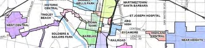
EachofthefourTODstudyareasarelocatedin/orborderaMetropolitanRedevelopmentAgency(MRA)which opensthedoorsformultiplefundingsourcesandofferspracticalrecommendationsspecifictoeacharea.AMRA promotesredevelopmentinbothresidentialandcommercialdistressedneighborhoods.Thisisaccomplished throughstrategicplanning,creatingmetropolitanredevelopmentdistricts,communityoutreachtolocalgroups andleaderstoestablishpriorities,purchaseofpropertyforprojectsthatactasananchorforfuturedevelopment, issuerequestsforproposals(RFPs)todevelopcityownedpropertythoughprivate-publicpartnerships.MRAs utilizeresourcesestablishedbyMetropolitanRedevelopmentFundsandFederalCommunityDevelopmentBlock Grants,aswellasotherfundsthatincludelocalandstatecapitalfunds.Thefollowingrecommendationsforthe fourTODstudyareasestablishonespecificfundingprogram,incentiveand/ortooleachareacanutilizetowards futureimprovements.FigureX:MapoftheCityofAlbuquerque’sRedevelopmentAreasoutlinesthemultipleareas withMRAoverlays.
ATRISCOTODSTUDYAREA
InaccordancewiththeAtriscoTODstudyareaitisimportanttoconsidertheagriculturalrootsandhistoryofthe existingneighborhood.Generationalfarmersstillconnectedtothisareawouldbeencouragedtoexplore incentives
developmentintheareainaccordancewiththeexistingculturalidentityitwouldbebeneficialtostrategizefuture developmentaroundagriculture.California’sUrbanAgriculturalZoneActisdefinedby“farminginallitsbranches including,butnotlimitedto,thecultivationandtillageoftheproductionandharvestingofanyagriculturalor horticulturalproducts,theraisingoflivestock,bees,fur-bearinganimals,dairyproducinganimalsandpoultry, agriculturaleducation,saleofproducethroughfieldretailandfarmstands.
Theactdefines“Farminginallitsbranchesincluding,butnotlimitedto,thecultivationandtillageofthesoil,the production,cultivation,growing,andharvestingofanyagriculturalorhorticulturalproducts,theraisingof livestock,bees,fur-bearinganimals,dairy-producinganimals,andpoultry,agriculturaleducation,thesaleof producethroughfieldretailstandsorfarmsstandsasdefinedbyArticle5(commencingwithSection47030)of Chapter10.5ofDivision17oftheFoodandAgriculturalCode,andanypracticesperformedbyafarmerorona farmasanincidenttoorinconjunctionwithfarmingoperations”(Zigas,2015)Withapracticalityguideonhowto implementtheactqualificationsincludeminimumlotsizes,achangeintaxassessment,andhowtocreateitwithin localjurisdiction.Thiseconomiczonecreatesplaceandidentitybyhonoringtheexistingcultureintheareaand deterringfocusonnewpropertydevelopment.
OLDTOWNTODSTUDYAREA
● TheOldTownareaisthemostdensesite,andisrichinculturalsignificancewithhistoricalcontext.The HistoricCentralMRAPlanlaidoutthefollowinggoalsforthefutureofthearea.
○ RedevelopmentofElVadoMotel(WorkbeganinFebruary2017).
○ Redevelopmentof 5parcelsontheN.sideofCentralAve.betweenRioGrande&SanFelipe (withprivatedeveloperpartnership).
○ Streetscapeimprovements(wayfinding&streetfurniture).
○ Implementationofafacadeimprovementprogram.
○ CreationofaTIFdistrictifownerswantit.
Thefewvacantlotsinthisneighborhoodwouldallowfornewresidentialunitstobecreatedbut thepreservationofpropertyinthisneighborhoodisthemostcrucialtopreserveplaceandidentity. To instillasenseofpreservationanewzonewillbedevelopedthatwillencouragepreservationand redevelopmentofexistingpropertiestohistoricalcontextwithnewuses.TheFederalHistoric PreservationTaxIncentiveisaderivativeofpublicandprivatepartnership.Itencouragesrehabilitation ofhistoricproperty.There-usementalityimproveseconomicfactorsandcommunityrevitalization.Ithas leveraged84billiondollarsandpreserved42,293historicpropertiessince.Theincentivecomesinthree differentforms.20%TaxCredit,10%TaxCredit,andHistoricEasementCredit. TheOldTownTaxincentivezonewouldcreditcurrentpropertyownerswhomaintainhistoric propertiestoastandarddeterminedbythecity.VacantLotownerswillalsobecreditbytheelimination ofparkingrequirements,build-to-lotzoningareas,andtaxcreditstoincreasedensityintheoldtown area,byincreasinghabitablespace,theOldTownTaxincentivezonewouldfocusonincreasingthe amountofresidentialspace.(n.p)
UNIVERSITYTODSTUDYAREA
TheUniversityareahasauniquepotentialtodevelopinthemostcontemporaryway,Theurbanfabricofthis neighborhoodisintertwinedwiththeUniversityofNewMexico.ThecurrentMRAplanisreferredtoasthe SycamoreplanthegoalsareToimprovetheexisting‘mixeduse’characteroftheareabyutilizing“transition”areas tobufferincompatibleuses,toimprovepedestrian,transitandbicyclecirculationbyprovidingbetterinternal connectionstonearbyurbancenters,andtopreventneighborhooddeclinebystimulatingprivatereinvestment, whileprovidingsufficientcontrolsandguidancetoensuremutuallybeneficialrelationshipsbetweenexistingand newdevelopment.TheMRAwillcovertheexistingresidentialspacesandneighborhoodsthatexistsbehindthe streetwayfacade.ToincreasedensityandheightsofbuildingsinthecentralcorridortheUniversityEconomiczone willfocusonincreasingresidentialdwellingunitswhileincorporatingmixedusemediumscaleurbancenters.The uniquecommercialactivityintheareameansthatapartnershipbetweentheuniversityandemergingbusiness cantakeplaceintheneighborhood.START-UPNYINCENTIVE:“offersnewandexpandingbusinessesthe opportunitytooperatetax-freefor10yearsonorneareligibleuniversityorcollegecampusesinNewYorkState. Toparticipateyourcompanymustmeetthefollowingrequirements:
1. BeanewbusinessinNewYorkState,oranexistingNewYorkbusinessrelocatingtoorexpanding withinthestate.
2.PartnerwithaNewYorkStatecollegeoruniversity.
3.Createnewjobsandcontributetotheeconomicdevelopmentofthelocalcommunity”(n.p.).
SANMATEOTODSTUDYAREA
Thisisthemostdynamicanddiverseareaofall.ReferredtoastheInternationalDistrictitishometomany culturallysignificantsites.TherearetwoMRAplansforthisarea,thefirstonewascreatedin2005isknownas Central/Highland-UpperNobHillanditEstablishesaformbasedmasterplanemphasizingamixedusedesign character,withwalkableshoppingopportunities.Improvingpublicimageofplanareaviaroute66 strengths/touristattractions.ImprovestreetscapesfromCarlisletoSanMateo,withmoreshadeandmoreneon. Includemoreaffordablehousinginthearea.In2010anewNearHeightsMRAExpansionhappenedwhichtriedto strengthenedBuilduponexistingethnicbusinessesandpopulationtomakeareaintoaninternational multicultural“destination”.DevelopneighborhoodretailalongSanMateo,Attractmoreemployees,help
businessesexpandandutilizelocaltalentstocreatenewbusinessesandDesignateareaaTIF.Thiscorridorhasa planthatcoincideswithcreatingandestablishingidentity.
CONCLUSION
Asdescribedthroughoutthedocument,Albuquerque’sCentralAve.isadiversecorridorthathasthepotentialto offermoretoitsnearbyresidents.TheCityofAlbuquerquehasdecidedtoupdatethecurrentpublic transportationsystembyestablishingART.Thishastytransportationprojectpushedbylocalofficialshascreated issuesimmediatelywithintheparallelingneighborhoodsalongCentralAve.Highvolumesofpublicconcernsthat thedevelopmentwouldimpacttheseneighborhoodsnegativelywere,insomecases,intentionallydismissed.The continuationofARTpresentsasignificantmissionofimprovingtransportationforAlbuquerqueans,butcreates potentialforrelinquishingaprojectthatlacksconsiderationandrespectforestablishedcommunityidentityand senseofplacethuscreatinganotherhomogenousplaceasanoutcomeofbusrapidtransit(BRT)development. Withanalysisinhistory,identity,demographics,trafficanddrainagethisdocumentpresentedseveralwaysto incorporateTransitOrientedDevelopmentmodelthatexhibitkeyelementstomaintainasenseofplaceand identitywithinfourdistinctcasestudyareas.Asfundingforprojectsisachallengealone,fundingtomaintaina senseofplaceandidentityisthetruehurdleformanycommunities.Thesignificanttakeawayfromthisdocument istheestablishmentofMRA’swithinthestudyareas.IncorporationofaMRAalongwithspecificrecommendation forTODdevelopmentshouldbecontinued.
ThisdocumentisintendedtoinformandadviseCityofAlbuquerque’spolicymakersabouttheneedforplanning explorationintotransitorienteddevelopmentfocusedaroundtheprogressionofAlbuquerque’sRapidTransit (knownasARThenceforth)system.Althoughtopicswithinthisdocumentwillneedfurtheranalysis,CentralAve. stillremainsalocationthathasthepotentialtosettheexampleofhowidentityandsenseofplacecanremain withinlocationsalongarapidbustransitsystemthatbenefitsfromtransitorienteddevelopment
Figures35-39:
February20, 2017fromhttp://mrmpo.maps.arcgis.com/home/webmap/viewer.html?webmap=262ef9ee37f44bb2920759445
Figures40-43:
(Feb.2,2017).GISData.RetrievedFebruary20,2017from https://www.cabq.gov/gis/geographic-information-systems-data
Figures44-47:ExistingBikeandPedestrianRoutes.Mid-RegionCouncilofGovernments(Feb.2,2017).GISData. RetrievedFebruary20,2017from http://www.arcgis.com/home/webmap/viewer.html?webmap=8b0ca82275eb441eac65f080d7240d8d
Figures46-50:PedestrianCompositeIndex.Mid-RegionCouncilofGovernments(Feb.2,2017).GISData. RetrievedFebruary20,2017from http://www.arcgis.com/home/webmap/viewer.html?webmap=0d77a8ff7db64eaca9c15737089e0df8
Figures51-54:BICIBikeShareStationsandReach.CABQOpenMapsPortal(Feb.2,2017).GISData.Retrieved February20,2017fromhttps://www.cabq.gov/gis/geographic-information-systems-data
Figures55-58:BikeandPedestrianAccidents.UNMTrafficResearchUnit(Feb.2,2017).GISData.Retrieved February20,2017fromhttps://tru.unm.edu/
Figuresx:BICIBikeShareStationsandReach.CABQOpenMapsPortal(Feb.2,2017).GISData.RetrievedFebruary 20,2017fromhttps://www.cabq.gov/gis/geographic-information-systems-data
Figuresx-x:ProposedBikeandPedestrianRoutes.Mid-RegionCouncilofGovernments(Feb.2,2017).GISData. RetrievedFebruary20,2017from http://www.arcgis.com/home/webmap/viewer.html?webmap=8b0ca82275eb441eac65f080d7240d8d
References:
CityofCentralPoint(2010).DesignStandards TODdistrictandTODcorridor.CentralPoint,Oregon.Retrieved May15,2017,from http://www.codepublishing.com/OR/CentralPoint/html/CentralPoint17/CentralPoint1767.html#17.67.060
HealthySpacesandPlaces(2009). Design Principle – Parks and Open Space.Australia:AustralianGovernment DepartmentofHealthandAgeing.
OpenSpaceandRecreationOffice(2012). Best Practice Open Space in Higher Density Developments Summary report. CityofCharlesSturt.
PB’s PlaceMaking Group (2011) Winnipeg Transit-Oriented Development Handbook. Winnipeg, Canada: Planning, Property,andDevelopmentDepartment.
TheTrustforPublicLand(n.d.). ParkScore. RetrievedMay5,2017,fromhttp://parkscore.tpl.org/
U.S.CensusBureau(2015). Table DP05: Demographic and Housing Estimates, 2011-2015 American Community Survey 5-Year Estimates.
U.S.CensusBureau(2015). Table S1901: Income in the past 12 months (in 2015 inflation-adjusted dollars), 20112015 American Community Survey 5-Year Estimates.
U.S.CensusBureau(2015).Table DP04: Selected Housing Characteristics, 2011-2015 American Community Survey 5Year Estimates.
U.S.CensusBureau(2015).Table DP03: Selected Economic Characteristics, 2011-2015 American Community Survey 5-Year Estimates.
U.S.CensusBureau(2015).Table S1701: Poverty Status in the past 12 months, 2011-2015 American Community Survey 5-Year Estimates.