


OTHER SHOWS WE HAVE IN THE WORKS


OTHER SHOWS WE HAVE IN THE WORKS
As a child, I would often gaze at surveyors on the job, intrigued by their mysterious appearance and curious about the work they did. With their walkie-talkies and strange machines, they seemed like outdoor detectives, uncovering secrets hidden in the landscape. As I grew older, my curiosity only deepened. I longed to understand the principles behind surveying and the vital role it plays in construction.
In this issue, we delve into the fascinating world of surveying, tracing its roots back thousands of years. While techniques may evolve, surveying remains an essential step in the building process. By meticulously recording the facts on the ground, surveyors provide the foundation for informed planning and construction. Only by understanding the land itself can we build upon it with precision and

accuracy. Join us as we explore the ancient art of surveying and uncover its enduring importance in modern construction.
“ONLY BY UNDERSTANDING THE LAND ITSELF CAN WE BUILD UPON IT WITH PRECISION AND ACCURACY.”
On a side note, I would also like to take this opportunity to express my gratitude for the valuable feedback we’ve received. It’s essential for our growth and reassuring to see that our readers understand the concept of our magazine. We’re also thrilled to note that our publication has sparked an interest in construction among young readers and nonindustry professionals, eager to learn more. To cater to this interest, we’ll be introducing fun projects every month specifically for our young readers.
Kids, check out this month’s Floor Plan Contest, and keep learning!
Jacob Surkis Founder & Publisher THE NYGC MAGAZINE


In the business world of surveying, Mount Rushmore has been described as “3 Surveyors and another guy.” The 3 they refer to are Washington, Jefferson, and Lincoln who were all surveyors over their lifetime. Let’s take a deeper look into the details of these famous surveying careers!
The Washingtons were a wellestablished family who could trace their lineage in the Virginia Colony back to 1630 when Mary gave birth to George in 1732. The family was considered to be a part of the “middle gentry” with prominent land holdings, including several plantations. George’s older step-brother, Lawrence, fought alongside the British against Spain in the “War of Jenkins Ear” in the late 1730s and he’d share his stories with Georgelighting the spark of adventureseeking in his brother’s heart. In 1746, when George was only 14 years old, the two tried to convince George’s mother to allow him to join the British Navy. After initially consenting to their plan, Mary had second thoughts and ultimately rejected the idea. Yearning for excitement after not being allowed to go to sea, George turned to Land Surveying. He didn’t possess what would be
deemed a formal education by today’s standards but had studied mathematics and trigonometry and was considered a talented draftsman with an affinity for mapping. It appears that John Love’s surveying manual, “Geodesia: or the Art of Surveying and Measuring of Land Made Easy” (published in 1731), exposed him to the profession.
According to the Mt. Vernon Historical Society, “Washington’s big break as a surveyor came in 1748 when he was invited to join a survey party organized by his neighbor and family friend, George William Fairfax of Belvoir.” The job entailed subdividing a large parcel of land Mr. Farifax had acquired along the wild western border of Virginia. One year after his first surveying expedition, George was appointed to the position of County Surveyor of Culpeper County, Virginia at the age of 17. Over the next 3 years, he completed an astounding number of surveys, around 200 for

a total of approximately 60,000 acres surveyed and mapped. Land was a form of currency at this time in the Colonies. As the County Surveyor, George was privy to the best parcels and acquired them as payment for his services. In 1752, at the age of 20, he gave up his post as County Surveyor. Some speculate that he resigned because he felt that the best parcels of land had all been taken. Others believe that the death of his brother Lawrence was the cause. Most likely it was a combination of the two. Although Washington never surveyed again in an official capacity, Surveying & Mapping seemed to be something he genuinely enjoyed doing. During his post“professional” career, he completed around 50 private surveys, mainly for acquiring new land, defending himself against boundary disputes, and subdividing his land into farms for sale or lease. The last survey he performed was completed 5 weeks before he died in 1799.
In 1743, Thomas Jefferson was born about 100 miles east of the Washington plantation in Shadwell, Virginia Colony, the third child of Peter Jefferson, a “Land Surveyor for the Crown.” Peter was a substantial land owner and prolific surveyor who helped produce the first accurate map of the Colony of Virginia and surveyed the boundary between North Carolina and Virginia. Thomas studied natural sciences, Latin, Greek, French, law, and philosophy and was eventually admitted to the Virginia Bar in 1767 at the age of 24. Six years later, he was commissioned as the County Surveyor of Albemarle County in the Virginia Colony in 1773. However, he seemed to take little interest in the position and discharged his duties through deputy surveyors. He resigned the post one year after accepting it.
According to the Thomas Jefferson Encyclopedia, land surveying for the “younger Jefferson was primarily a tool for imposing order on his
farms.” As the son of a surveyor, he respected the profession and in his later years taught his grandchildren the finer points of land surveying. Jefferson’s passions were farming, linguistics, and inventions, but his early years spent surveying proved invaluable when he made one of the greatest contributions to Land Surveying in American history. With the signing of “The Treaty of Paris” in 1783, the British Crown not only recognized the independence of her former colonies but also relinquished the unsettled area of British America known as the “Northwest Territory” to them. This essentially doubled the size of the fledgling nation.
At this point in US history, the country was bankrupt and desperately needed to add to its Federal Reserves. The federal taxation of land was prohibited in the “Articles of Confederation,” so to generate revenue for the federal government it had to be sold. Thomas Jefferson was appointed to a committee tasked with creating a
standardized system to break down the newly acquired “Northwest Territory” into saleable units. Jefferson recommended a rectilinear system comprised of Townships, which were to be 6-mile squares. It was thought that the large Townships would be too difficult to sell, so the committee subdivided the Townships into 36 sections. Each section would be a 1 mile square, containing 640 acres, with Section 16 being reserved for public education. On May 20, 1785, the Federal Congress passed the “Land Ordinance of 1785,” which was the basis of the Public Land Survey System we know today. 16 years later, Thomas Jefferson was elected to his first term as President of the United States of America. His main concern was their neighbor to the West: France, who controlled a large swath of the central portion of the continent between the Mississippi River and the Rocky Mountains known as the “Louisiana Territory.” Jefferson strategized that if the United States could control the port city of New Orleans, it would
“On May 20, 1785, the Federal Congress passed the “Land Ordinance of 1785,” which was the basis of the Public Land Survey System we know today”
be in a better position to defend itself against French expansion. In 1802, he sent future president James Monroe to Paris to make an offer to purchase the city of New Orleans. After initially being ignored, the French, to Monroe’s great surprise, not only offered to sell New Orleans but all of the “Louisiana Territory,” an area over 2,400 times larger than what he had asked for. Despite opposition by much of the citizenry and some members of Congress, the “Louisiana Purchase Treaty” was approved on April 30, 1803, and the United States of America doubled in size again. One year later, President Jefferson commissioned Captain Meriwether Lewis and William Clark with the “Corps of Discovery Expedition” to explore and map the newly acquired “Louisiana Territory.”

If you see something, say something
Say


Shortly after Lewis and Clark completed their expedition and as Jefferson was finishing up his second term as President, Thomas and Nancy Hicks Lincoln had their second child in 1809, a baby boy named Abraham. Thomas Lincoln was illiterate and held a variety of ill-paying jobs in several different areas of Kentucky. By 1811, he had acquired title to 816 acres in different areas of Kentucky. By 1815, he had lost all but 200 acres as a result of land title disputes. Discouraged by the land title system in Kentucky, Thomas moved the family to Indiana, a state that
he felt had a more honest land title system in place. The family bounced around Indiana from 1816 to 1829, then moved to Illinois. In 1832, at the age of 23, Abraham was part owner of a general store in New Salem, Illinois after serving as a captain in the Illinois militia. That year he also threw his hat into the political ring for the first time and ran for the Illinois General Assembly. Despite receiving 277 of the 300 votes from his district, he lost the race. After the defeat, Abraham’s friend, Pollard Simmons, a Democratic politician and farmer living near New Salem, spoke to the Sangamon County Surveyor and suggested that he take on Abraham as his assistant. There was one problem, though, Lincoln knew nothing about surveying.
Aided by Mentor Graham, the local schoolmaster of New Salem, Abraham studied A System Of Geometry And Trigonometry With A Treatise On Surveying by Abel Flint and The Theory And Practice Of Surveying by Robert Gibson. Six weeks later he was hired and sent to work.
Surveyors in that era were paid by the area of land they surveyed and mapped. Lincoln’s wages were set at $2.50 per quarter section, $2.00 per half-quarter, and 25 cents to 37.5 cents for each small town lot.
According to the historian Kenneth Winkle, “Lincoln divided at least five new towns into lots for various speculators. He thus became involved in the buying and selling of land, rather than simply working it with an axe or hoe, and he began to invest in local real estate.” Lincoln’s career as a surveyor was short-lived. He held the position for 1 year and eventually sold his surveying equipment to pay a debt. It can be argued that Lincoln’s surveying job benefited his political career. According to the US Census Bureau, the US population had increased by 33% from 1820 to 1830. The vast majority of immigrants were looking to own and work their own land. The surveyor, especially in the undeveloped parts of the country, was in a position to interact personally with every member of the community.

It might strictly be coincidental, but one year after his County land surveying job, Lincoln ran his first successful political campaign for state legislature in 1834.
While Lincoln was running for the Illinois Senate and engaged in the final round of the “Great Debates of 1858,” Martha and Theodore Roosevelt, Sr. welcomed their second child, Theodore Jr., into the world. The young Theodore was a sickly child who suffered from asthma. To combat his ailments, he became obsessed with physical activity and with pushing his limits as far as he could. Throughout his life, he believed in the “virtues of a strenuous life.”
Although he never surveyed professionally, Roosevelt indirectly contributed to the profession by creating jobs through his role in the greatest engineering project of the century, the Panama Canal, and conserving Public Lands by creating National Parks, the boundaries of which had to be surveyed and mapped. Theodore Roosevelt served 2 terms as President of the United States from 1901 through 1908. In 1912, he ran for a third term as the candidate for the Progressive Party, also known as the “Bull Moose Party,” eventually losing to Woodrow Wilson. After his defeat, in typical TR fashion, he turned his vigorous energies to an Amazonian adventure: navigating and mapping the limits of the unknown “River of Doubt.”
The expedition was led by Roosevelt and Candido Mariano, a Brazilian military officer, engineer, and surveyor. Although Candido was the surveyor in charge and had his own survey crew, both Theodore and his son, Kermit, helped out with many of the surveying tasks during the expedition. The “Roosevelt-Rondon Scientific Expedition” proved to be disastrous and entailed disease, starvation, and even murder. Theodore’s health never fully recovered after the adventure. He died five years later in his sleep at his home in Oyster Bay, New York.

Roosevelt, vintage illustration
The 3 surveyors memorialized on Mt. Rushmore combined for a total of 5 years of Surveying and Mapping experience in an official capacity. Washington was certainly the most prolific surveyor, as Jefferson contributed the most to the profession. For Lincoln, surveying seemed to be a well-paying stop-gap job and Roosevelt’s only experience on a survey crew almost killed him.


The need for land surveys dates back to ancient times. According to William Gillespie’s Treatise on Land-Surveying, it “is perhaps the oldest of the mathematical arts. Indeed, Geometry itself, as its name ‘Land-measuring’ implies, is said to have arisen from the efforts of the Egyptians to recover and to fix the land-marks annually swept away by the inundations of the Nile”.
Throughout history, a vast array of tools were invented to engineer marvels like the Great Pyramids and Stonehenge, and to delineate pieces of land for ownership purposes. Although a variety of tools has been used over the centuries, the focus of this brief article is to provide a sampling of several instruments that were important in the development of surveying in the United States.
In colonial North America, there was tremendous demand for both
surveyors and equipment as early settlements (especially in Virginia and Maryland) evolved into small communities. Boundaries needed to be established for land grants, villages, roads, and common property. Additionally, the coastal waters and the vast network of inland rivers, where most of these land grants were located, needed surveying. Complicating the situation was the fact that the American continent was completely wild and filled with dense virgin forests. According to Silvio Bedini’s Thinkers and Tinkers – Early American Men of Science, “Land had to be cleared for settlements and roadways and rivers opened up for navigation, and surveying required techniques and instruments quite different from those traditionally used in England where the majority of areas were open” (p. 52).
Many of the land grants in the colonies required the individual
owner to stake their own property, which led to a host of errors in both location and measurement.
Early on there was little text available to the untrained surveyor, but in 1688 John Love published the very popular Geodaesia: or, The Art of Surveying and Measuring Land Made Easier. He states in the preface, “I have seen Young men, in America, often nonplussed so, that their Books would not help them forward, particularly in Carolina, about Laying out Lands, when a certain quantity of Acres has been given to be laid out five or six times as broad as long.” Love had surveyed in both North Carolina and Jamaica and took a practical, rather than scientific, approach to land surveying techniques. For the North American continent with its vast wooded regions, he recommended two tools: Gunter’s chain and a surveyor’s compass.

Gunter’s chain was developed in 1620 and consisted of 100 links, each measuring 7.92 inches, for a total of 66 feet of measurement. The chain included brass rings at every 10 links to facilitate partial measurements. In practice, the chain is stretched out along a defined path and secured to the ground with steel pins. The measurement is then recorded and the process is repeated until the surveyor reaches the final endpoint.
The surveyor’s compass, also known as the circumferentor, was a tool used to measure horizontal angles. The compass consists of a circular box housing a magnetic needle floating above a compass marking 360 degrees. A wooden arm extends from the compass and includes sights located at north and south. By sighting two points from the same location, a surveyor could determine the interior angle. This approach was commonly used for establishing the corner boundaries of a given parcel.
During the majority of the 18th century, the surveyor’s toolset did not change significantly. George Washington, who had considerable training and experience surveying Lord Fairfax’s property and the western frontier of Virginia, owned a surveying compass, a Jacob’s staff (essentially a tripod), and a set of chains and poles. It was not until the conclusion of the Revolutionary War that significant advances in surveying were developed, no doubt in large part due to the formal establishment of the new United States and the need to finalize its borders.
Leading the charge was Andrew Ellicott, who participated in many important surveys of the time including the southern boundary of the United States and the western boundary of Pennsylvania. This later survey was of particular importance as it was the beginning point of the Public Land Survey System, where land west of the Pennsylvania/Ohio border was systematically divided into square townships. Ellicott employed several sophisticated tools in the process, but none were more important than the zenith telescope, which “was the most accurate and sophisticated scientific instrument on the North American continent in that period, and the only instrument then known having sufficient accuracy to trace a parallel of latitude” (Bedini, p. 323).
Bedini explains that this instrument was “used to determine the parallels of latitude by observing six or seven stars near the zenith as they crossed the meridian at different hours of the night” (p. 324).
...These instruments and their dedicated surveyors played an invaluable role in the development of today’s boundaries and the establishment of land ownership in the United States.
Among the many other tools utilized by Ellicott were pole chains, an astronomical clock for accurate timing, and three sextants which were used to determine the position of stars.
It is worth noting that several other important and accurate instruments were produced during this time (primarily in Europe), including Jesse Ramsden’s great theodolites, which were used in the Principal Triangulation of Great Britain. However, the size, weight and cost of these instruments made them impractical for field surveys in the young United States.
At the beginning of the 19th century, with Jefferson’s authorization, the Army Corp of Engineers was established. This highly trained group was responsible for surveying the new territory in the West and required precision tools to provide accurate surveying and mapping. This demand was made possible by the dividing machine, which was invented by Ramsden in the 1770s but was not widely available in the United States until the early 19th century. A dividing engine is a device that marks graduations, or indicators of measurement, on various mathematical instruments. By shifting from hand “dividing” to mechanized markings, the accuracy of surveying equipment improved drastically. This process started out only on small pieces of equipment, but by the middle of the 19th century, even the large astronomical telescopes were scaled with dividing machines.


One final piece of equipment that had a significant impact on surveying public lands and the rich mineral sources within was the solar compass. Invented by United States Deputy Surveyor William Austin Burt in 1836, it “was designed to overcome the difficulties experienced with magnetic declination in areas where iron deposits were prevalent.
The solar compass…[had] a solar apparatus which enabled the surveyor to determine the meridian from the declination of the sun instead of by means of the magnetic needle” (Bedini, p. 371). Burt’s invention received a medal at the Crystal Palace Exhibition in 1851 and was also responsible for locating the Calumet and Hecla Mine in the upper peninsula of Michigan, which became one of the largest copper-producing mines of its time.
In today’s world of GPS and 3-D scanning, these tools might seem insignificant. However, these instruments and their dedicated surveyors played an invaluable role in the development of today’s boundaries and the establishment of land ownership in the United States. Without them, the country’s extensive infrastructure, resource management, and western settlement would not have been possible.
References:
Jon Dotson, Old World Auctions
Bedini, Silvio, Thinkers and Tinkers – Early American Men of Science, Charles Scribner’s Sons, New York, 1975.
Delaney, John, Nova Caesarea, Princeton University Library, Princeton, New Jersey, 2014.
Gillespie, William, Treatise on Land-Surveying, D. Appleton & Co., New York, 1865. Available on Google Books.
L’Estrage Turner, Gerard, Scientific Instruments, 1500-1900: An Introduction, University of California Press, Oakland, California, 1998.
Love, John, Geodaesia: or, The Art of Surveying and Measuring Land Made Easier, John Taylor, London, 1688. Available on Google Books.
“Surveying”, George Washington’s Mount Vernon website, Mount Vernon Ladies’ Association. < http://www.mountvernon.org/ research-collections/digital-encyclopedia/article/surveying/> (accessed August 3, 2015)


You’ve probably seen a land surveyor on a property peeking through a strange-looking device (theodolite) resting on a tripod.
If you’re like the average Joe, only one thought crossed through your mind, “What exactly is this person doing under this scorching sun?”.
Now’s the time to find out what they’re really busy with. Let’s join the surveyor’s journey and delve into this little-known field!
Aland surveyor uses special equipment to measure and evaluate sites for private, public and government properties. These measurements involve determining the 3-dimensional positions of points and distances, as well as the angles between them.
Their evaluation helps to establish points on maps that are used to determine boundaries for ownership, location and more.
Land surveys are required when selling or buying a property, when fencing or adding on to your home, when subdividing a property, and when refinancing or obtaining a mortgage. Sometimes, it will also be required for insurance purposes.
In all these instances it is necessary to provide accurate, reliable information regarding property lines.
Although land surveys differ based on need, we will explore the steps specifically applicable to a survey being done prior to a new land development project.
You have the property, you have the plans, you called the surveyor- now what?

Existing Conditions Review

Issue Resolvement Design Review

Boundary Planning Field Survey performance
Existing Conditions Plan Prep
Survey Review


The start of a new land development project requires a base survey plan (also referred to as the existing conditions plan) showing the existing conditions of the land to be developed. These existing conditions would include the existing property boundary lines of the land parcel, the boundary lines of adjoining properties, and any existing agreement and easement documents that could impact the proposed development.
This information would be found in existing property deeds and other legal documents that would be obtained and reviewed by the land surveyor involved with your project.


The next step would involve the land surveyor using specialized survey equipment to do the fieldwork to obtain the data required to develop the rest of the base survey plan. The data obtained would be used to verify the placement of any existing property markers (such as pins and monuments), to locate existing buildings and other structures, to locate edges of existing paved areas and other impervious areas, and to obtain existing elevation information for the site.
If the project involves any wetlands that have been delineated by an environmental scientist, the land surveyor might also have to survey the delineation so that an accurate boundary for the existing wetlands area can be shown on the base survey plan so that any potential impacts on the existing wetlands from the proposed land development can be properly evaluated.
Once all of the applicable documents have been obtained and reviewed, the start of the base survey plan would be prepared using computer-aided drafting software that shows a lot of the information contained within these documents. This information would include boundary line distances, boundary line orientations, parcel areas, right-of-way areas, and easements.

Once the field survey work is completed, the results of that work would then have to be added to the base boundary plan to create the existing conditions plan for the site.
The existing conditions plan for your site would include the existing property boundaries and topography including contours showing the elevation differences within the site.


Throughout the design of your project, the design engineer might discover that additional survey information is required for the approval of the land development plans. The extra information could include such items as additional topography data for the site and the location of individual trees.
Once the land surveyor has been able to obtain this additional information, the existing conditions plan would have to be revised accordingly.
Another step of the land surveying process is to compare the boundary lines of your site (that were drawn using the information found in existing deed documents) with existing property markers found during the field survey.
Once any discrepancies related to the boundaries have been resolved, then the existing conditions plan should be ready to pass on to the land development engineer who would be designing the proposed conditions of your land development plan.

After your land development plan has been designed and approved for construction, the surveyor might be asked to do a construction stake-out survey. This involves surveying and marking with stakes the various parts of the proposed project so that it is constructed correctly.
These parts could include building corners, edges of paving, and stormwater management basin components.

The final step of the land surveying process for a full land development project would be the preparation of as-built survey plans showing what was actually constructed. This is something that could be required by a municipality after the construction of a project to compare to the approved design plans.
If a significant difference is found between the as-built plans and the design plans, the construction contractor might have to go back out to the site to correct the issue. Once the issue has been fixed, the surveyor would most likely have to do a survey of the corrected area again to be sure that what is in the as-built plans matches what is in the design plans.
A surveyor has to do the entire evaluation in accordance with New York State Standards & Procedures for Surveying and Mapping.
Once you complete your survey, it’s considered valid for the next 10 years. But why 10? According to the law, this is the duration in which the surveyor will be considered liable for the survey.

...and you thought all they did was stand around looking busy?:)


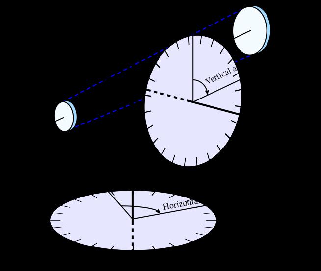
There are two different kinds of theodolites: digital and non-digital. Non-digital theodolites are rarely used anymore. Digital theodolites consist of a telescope that is mounted on a base, as well as an electronic readout screen that is used to display horizontal and vertical angles. Digital theodolites are convenient because the digital readouts take the place of traditional graduated circles and this creates more accurate readings.
Like other leveling instruments, a theodolite consists of a telescope mounted on a base. The telescope has a sight on top that’s used to align the target. The instrument has a focusing knob that is used to make the object clear. The telescope contains an eyepiece that the user looks through to find the target being sighted. An objective lens is also located on the telescope but is on the opposite end as the eyepiece. The objective lens is used to sight the object, and with the help of the mirrors inside the telescope, allows the object to be magnified. The theodolite’s base is threaded for easy mounting on a tripod.

From these readings a plan can be drawn, or objects can be positioned in accordance with an existing plan.
A theodolite works by combining optical plummets (weights hanging from a string), a spirit (bubble level), and graduated circles to find vertical and horizontal angles in surveying. An optical plummet ensures the theodolite is placed as close to exactly vertical above the survey point. The internal spirit level makes sure the device is level to the horizon. The graduated circles, one vertical and one horizontal, allow the user to actually survey for angles.
Since the telescope is movable from the base, surveyors can rotate around horizontal and vertical axes while the theodolite stays in the same position. From these readings a plan can be drawn, or objects can be positioned in accordance with an existing plan.

The theodolite became a modern, accurate instrument in 1787, with the introduction of Jesse Ramsden’s famous great theodolite, which he created using a very accurate dividing engine of his own design. Ramsden’s instruments were used in England. Later the first practical German theodolites were made. In the early 19th century the mechanism used to measure star positions was incorporated into what became the standard theodolite design.
Development of the theodolite was spurred on by specific needs. For example, in the 1820s progress on national surveying projects such as the Ordnance Survey in Britain required theodolites capable of providing sufficient accuracy for large-scale triangulation and mapping. Surveying of India at this time required more rugged and stable instruments such as the Everest pattern theodolite
which has a lower center of gravity. The 1840s was the start of a period of rapid railway building in many parts of the world which resulted in a high demand for theodolites wherever railways were being constructed. It was also popular with American railroad engineers pushing west, and it replaced various tools used prior to that such as the railroad compass.
Theodolites were later adapted to a wider variety of mountings and uses. In the 1870s, an interesting waterborne version of the theodolite (using a pendulum device to counteract wave movement) was invented by Edward Samuel Ritchie. It was used by the U.S. Navy to take the first precision surveys of American harbors on the Atlantic and Gulf coasts.
The intricacies of the design were further refined in the early 1920s by the Swiss. The instrument became not only easier to use and more accurate than before but was now also protected from rain and dust by a seal.


With continuing refinements, instruments steadily evolved into the modern theodolite used by surveyors today. By 1977 theodolites were already being offered with total stations, meaning it combined angular measurements- from the original theodolite- together with electronic distance measurement ability and microchip function, all in a single unit.
In modern electronic theodolites, the readout of the horizontal and vertical circles is usually done with a rotary encoder. These produce signals indicating the altitude and azimuth of the telescope which are fed to a microprocessor. CCD sensors have been added to the focal plane of the telescope allowing both auto-targeting and the automated measurement of residual target offset. All this is implemented in embedded software of the processor.
Many modern theodolites are equipped with integrated electro-optical distance measuring devices, generally infrared-based, allowing the measurement in one step of complete three-dimensional vectors—albeit in instrument-defined polar coordinates, which can then be transformed to a preexisting coordinate system in the area by means of a sufficient number of control points.
This technique is called a resection solution or free station position surveying and is widely used in mapping surveying.
Such instruments are “intelligent” theodolites called self-registering tacheometers or colloquially “total stations”, and perform all the necessary angular and distance calculations, and the results or raw data can be downloaded to external processors, such as ruggedized laptops, PDAs or programmable calculators.


we are so excited to give you a chance at creating your very own floor plan! So, what are you waiting for? Read on to see how you can get started...
You may be wondering:
What even is a floor plan?
Well, a floor plan visually shows the layout of a property. It can be drawn by hand in 2D or created by computer in 2D and 3D view.
Who creates floor plans?
It is often created by architects and designers.
Why is it made?
Its main purpose is to act as a blueprint for the designers and architects, giving them a bird’s-eye view of the structure’s interior layout.
Floor plans can also show the orientation of the home to help figure out where sunlight will shine etc. In such a case it would include the Compass symbol at the side to indicate which way the structure is or will be facing.
Sometimes floor plans are created for existing homes when they are for salemainly by realty agents to help potential buyers see all the home details -, but we will be focusing on creating something new!
How do they actually go about it?
When there is already a home or building standing, and you need a floor plan of the details, all you do is measure every single nook and cranny, mark it down on a graph, and wallah you have your plan!
However, when it comes to making something entirely new, a lot of thought can be put into it. From deciding how many floors and rooms will be included, to what shape the house will form, and exactly which rooms will lead where, everything is taken into account to come up with the best and most convenient build for that specific situation.
Although you may not be an architect (yet!), you can try to picture the backstory of the plan you’ll be creating. Whom are you making it for? Is it a young family with lots of little kids (who may need a large playroom and lots of bedrooms)? An older couple with occasional visitors (who may need everything to be handicap accessible plus guest rooms and a large dining room?)
Today, you are the boss! So, be real, be creative and be curious!
Now turn the page and keep reading...

Contest guidelines:
Draw your own floor plan for a singlefamily, one-floor home.
Requirements:
• The plan should include at least two bedrooms, at least one bathroom, a kitchen, a dining room, and a proper entrance. You’re welcome to add any additional rooms you’d like!
• You must label the rooms, and mark basic dimensions(feet/inches). (tip: you can start with the overall outer shape and then subdivide, or work by adding one room at a time and then adding up the total length & width afterward.)
Some points to remember:
Supplies you will need:
• graph paperyou can use the included sheet, or get your own
• a pencil
• an eraser (tip: start with lighter lines, and darken once you are sure about them, so you don’t need to overdo the erasing.)
• a ruler- for help with drawing perfectly straight lines
• Make sure your rooms are accessible from the main hallway and have openings or doors.
• Large or built-in basic furniture should be included to ensure it all fits with the dimensions.
• Doors and windows that are opened by swinging are drawn with a curved line showing the direction and area where the door will be opened - furniture should not be placed in these areas.
• Draw outer walls thicker than inner walls.
• Bonus: include a short paragraph describing what type of family you’ve created your plan for and which features or parts of the layout were specially made that way for a specific reason.
• Although you can use the symbols provided on the next page, you may also add your ownas long as they’re simple and clearly labeled.
36’ 5 1/2”

KIDS BEDROOM
DINING ROOM

important furniture & appliances:
SINGLE SINK
windows:
SINK
BAY WINDOW SINGLE SWING WINDOW
WINDOW
Doors:
SINGLE DOOR
OPEN DOORWAY
SLIDING DOOR
DOUBLE DOOR
POCKET DOOR

When you’re done
have an adult email your submission to: submissions@thenygc.com - remember to include your name, age, and address in the email.
Our two lucky winners will get to have their plans featured in the magazine with comments and critique by: Silverlock Design Group! We can’t wait to see what you’ll come up with!

Submissions Deadline: August 30’th


The way we design our living spaces has a profound impact on our day-to-day lives.

Join us in exploring different trends and issues in today’s Architectural Design Field, and how the world has evolved in architectural design throughout the ages!
Contributed
by:
Silverlock Design Group

Land surveying, a critical practice in the development and management of land resources, involves the precise measurement and mapping of the earth’s surfaces. Its importance spans various sectors, including construction, real estate, environmental management, and urban planning. This article delves into the methods, and modern advancements in land surveying, highlighting its indispensable role in shaping the built environment.
The primary goal of land surveying is to establish and record the boundaries, dimensions, and position of land parcels. This involves several key principles:
1. Measurement Accuracy:
Precision is paramount, as even minor errors can lead to significant legal and financial disputes.
2. Mapping and Documentation:
Creating detailed maps and records that reflect the surveyed data accurately is also very important to understand land and structure specifics.
3. Use of Coordinates:
This refers to the establishment of a coordinate system to reference all points accurately on a map or plan - which goes back to historical times when the Egyptians used simple geometry to re-establish farm boundaries after the annual flooding of the Nile. The Romans then further advanced surveying techniques with the introduction of standardized instruments and methods, such as the Groma for layout and alignment.
Over the centuries, these techniques evolved, integrating more sophisticated tools and scientific principles, culminating in the comprehensive practices seen today.

Advancements in technology have revolutionized land surveying, introducing methods that offer higher precision and efficiency vs. past methods.
Chain Surveying
One of the oldest methods, chain surveying involves measuring distances with a chain or tape. While simple, it is limited by terrain and distance.
Compass Surveying
This method employs a magnetic compass to determine directions and measure angles, suitable for areas where a high degree of accuracy is not crucial.
Plane Table Surveying
In plane-table surveying, a drawing board is mounted on a tripod, allowing surveyors to draw the surveyed area directly in the field. This method is useful for quick and relatively accurate results.

Total Station
A total station integrates an electronic theodolite with an electronic distance meter (EDM). It allows for the measurement of both angles and distances, providing highly accurate data for mapping and construction.
Global Positioning System (GPS)
GPS technology has transformed surveying by allowing precise location determination anywhere on the globe. Surveyors use GPS receivers to gather data that can be processed into accurate geographical information.
Laser Scanning
Laser scanning, or LiDAR (Light Detection and Ranging), uses laser beams to create detailed 3D models of the surveyed area. This method is particularly useful in complex terrains and for creating high-resolution topographic maps.
Drones and UAVs
Unmanned Aerial Vehicles (UAVs) equipped with cameras and sensors can capture aerial images and data over large areas quickly. Drones are increasingly used for topographic surveys, construction site monitoring, and environmental assessments.
“The primary goal of land surveying is to establish and record the boundaries , dimensions , and position of land parcels.”


Land surveying has different diverse applications across various fields:


Construction
Ensuring accurate placement of structures and infrastructure.
Real Estate
Determining property boundaries and legal descriptions.
Environmental Management
Mapping natural features and assessing environmental impact.
Urban Planning
Designing and developing urban areas efficiently.
Mining
Mapping mineral deposits and planning extraction operations.
Land surveying remains a cornerstone of modern development and management practices. From ancient Egypt to today’s advanced technologies, surveying has continuously evolved to meet the demands of an ever-changing world. As technology advances further, land surveying will undoubtedly become even more precise and efficient, continuing to play a vital role in shaping our physical world.
By understanding the principles, and modern techniques of land surveying, we can appreciate its critical contribution to various sectors and the overall development of society.

“As a seasoned contractor who has weathered downturns in the construction industry, I can attest that businesses prioritizing quality are better equipped to thrive.”
Recently, I was impressed to learn about the upcoming exclusive Boh show event, guided by the motto ‘quality over quantity.’ As a seasoned contractor who has weathered downturns in the construction industry, I can attest that businesses prioritizing quality are better equipped to thrive. The focus on quality over quantity is a testament to the event’s commitment to substance over flash.
I believe that a smaller, exclusive event like Boh will provide a much more productive and conducive environment for meaningful connections, compared to larger, noisier events that can be overwhelming. If you’re looking to showcase your company in a serious and intimate setting, I highly recommend participating in the Boh event. The relaxed atmosphere will allow for genuine one-on-one interactions, making it an invaluable opportunity for networking and advancement.
Together we can grow the industry and create lasting change for the better!
- Jacob Surkis


