This Functional Planning Study has been prepared by McElhanney Ltd. for the benefit of Sturgeon County. The information and data contained herein represent our best professional judgement based on knowledge and information available at the time of preparation. Any use of this information in a manner not intended, or with knowledge that situations have changed, shall not be the responsibility of McElhanney Ltd. or the undersigned.
McElhanney Ltd. denies any liability whatsoever to other parties who may obtain access to this report for any injury, loss or damage suffered by such parties arising from their use of, or reliance upon, this document or any of its contents without the expressed written consent of McElhanney Ltd. or County
Prepared by:
Elaine Lau, PEng, PTOE
Senior Transportation Engineer
Tel: 780-809-3234
Email: EKLau@mcelhanney.com
Reviewed by:
2023-07-26
Ryan Betker, PEng
Project Manager / Branch Manager, Edmonton
Tel: 780-619-1986
Email: RBetker@mcelhanney.com
List of Figures
List of Tables
Table
Appendices
Appendix A - Traffic Data & Analysis Results
Appendix B – Conceptual Design Drawings
Appendix C – Additional Cost Estimate Information
Appendix D – Environmental, Geotechnical & Historic Resources Report
Appendix E – 127 Street Functional Planning Study (2012, ISL Engineering)
Executive Summary
Project Purpose and Objectives
This Functional Planning Study (FPS) identifies the updated recommended interim and ultimate plan for the 127 Street extension from the City of Edmonton boundary to Highway 2 at Township Road 544 in of St. Albert, including the recommended intersection treatments and access management strategy. The previous plan developed as part of the 127 Street Functional Planning Study (August 2012, ISL) was approved by County Council on June 15, 2012. Since that time, County Council approved the Sturgeon Valley South and Core Area Structure Plans, which initiated the need to review and update the previous recommended plan to ensure that it continues to align and support anticipated growth in Sturgeon Valley.
Findings from this study will guide the County in working towards project implementation and establishing project funding through capital budgets, off-site levies and potential cost-sharing opportunities. The scope of this Functional Planning Study update is to:
• Confirm future traffic projections for the 127 Street corridor and connecting roadways.
• Confirm and refine (as needed) the recommended interim and ultimate plans and alignment for the 127 Street corridor.
• Confirm and refine (as needed) the required intersection treatment and access management options along the corridor.
• Conduct a desktop review for environmental and geotechnical assessment.
• Identify requirements for utility protection and/or reallocation.
• Update functional-level cost estimates to current dollars.
Traffic Review Findings
Traffic projections based on updated planning initiatives, land use and demographic data indicate that the 127 Street extension is critical in facilitating growth in Sturgeon Valley With its full extension to Highway 2, 127 Street is also expected to alleviate some regional travel and congestion on other key north-south routes such as Starkey Road and St. Albert Trail.
The implementation of 127 Street is dependent on the rate of development in Sturgeon Valley. Overall, a two-lane cross-section with dedicated turn lanes at key intersections along 127 Street would have capacity to support growth to at least 10,000 people in Sturgeon Valley – approximately 5,500 additional people from today. This growth is estimated to occur sometime between 2037 (high growth of 2% per year of the total county population), 2050 (moderate growth of 1% per year) and 2077 (low growth rate of 0.5% per year)
As growth continues towards a total Sturgeon Valley population of approximately 26,000 people, or as the two-lane corridor approaches 15,000 vehicles per day, 127 Street will likely need to be upgraded to a fourlane cross-section with dedicated turn lanes at key intersections to maintain acceptable levels of service.
This is estimated to occur sometime between 2053 (high growth of 2% per year), 2082 (moderate growth of 1% per year) and beyond 2100 (low growth rate of 0.5% per year)
Recommended Functional Plan
Building from the previous recommendations and based on the traffic review, the updated recommendations in this FPS are intended to be implemented in multiple stages to facilitate improved connections to future planned developments in the Sturgeon Valley area, as well as future growth in St. Albert and the surrounding region. Features of the recommended interim and ultimate plan include:
• 2-lane semi-urban cross-section for the interim (will operate as a collector and can be classified as a collector until 4-lanes) and 4-lane urban arterial for the ultimate.
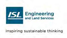
• Nine (9) at-grade intersections with Corriveau Avenue (signalized), Poundmaker Road (signalized), Valour Avenue (signalized), New East-West Arterial (signalized), Sturgeon Road (signalized), Bellerose Drive (signalized), Coal Mine Road (unsignalized), New North-East Arterial (unsignalized) and Highway 2 (signalized).
• Two major structural components including a CN rail grade-separate crossing (in Stage 1) as well as the Sturgeon River Crossing (in Stage 2 and Stage 4).
• A 3.0m shared use path is designed on the north/east side of the roadway as well as pedestrian crossings at all the cross-sections. ROW is protected for optional future active modes if required.
• The introduction of an underground stormwater system to provide a future-ready urbanized environment.
• 127 Street corridor should be implemented in four stages as outlined in Table ES-1
Table ES-1: Proposed Staging and Horizon of 127 Street Extension
Stage
Stage 1 (Interim)
Corriveau Ave to Sturgeon Rd
Stage 2 (Interim)
Sturgeon Rd to Highway 2
Stage 3 (Ultimate)
Corriveau Ave to Sturgeon Rd
Stage 4 (Ultimate)
Sturgeon Rd to Highway 2
• Construct 2-lane semi-urban collector (future arterial) to Sturgeon Road, with 3.0m shared use path and illumination
• Complete full CN rail underpass if funding is available
• Construct stormwater main and north curb line catch basins
• Construct Stormwater Management Facility East of Sturgeon River
• Complete all utility relocations required for ultimate cross-section
• Construct 2-lane semi-urban collector (future arterial) to Highway 2, with 3.0m shared use path and illumination
• Complete bridge crossing over the Sturgeon River
• Construct stormwater main and north curb line catch basins
• Construct Stormwater Management Facility West of Sturgeon River
• Complete all utility relocations required for ultimate cross-section
• Construct 4-lane divided arterial cross-section to Sturgeon Road with additional turn lanes at intersections
• Complete south curb line catch basins and all stormwater tie-ins
• Construct 4-lane divided arterial cross-section to Highway 2 with additional turn lanes at intersections
• Complete remaining bridge deck construction over the Sturgeon River
• Complete south curb line catch basins and all stormwater tie-ins
Initiate Construction in 2037 (high growth), 2050 (moderate growth), 2077 (low growth)
2050 to 2100+ (Depending on growth)
2050 to 2100+ (Depending on growth)
Beyond 2050 to 2100+ (Depending on growth and County priorities)
Project Costs & Funding Strategy
A planning-level cost estimate was prepared for the four proposed construction stages based on 2023 dollars and are summarized in Table ES-2 below. The overall cost of the project is estimated to be $157.7M (2023 dollars), including construction, contingency and ROW acquisitions.
Table ES-2: Class A Cost Estimates (2023 Dollars) Stage
Stage 1 Improvements
• 2-lane semi-urban cross-section
• Corriveau Ave to Sturgeon Rd
Stage 2 Improvements
• 2-lane semi-urban cross-section
• Sturgeon Rd to Highway 2
Stage 3 Improvements
• 4-lane urban cross-section
• Corriveau Ave to Sturgeon Rd
Stage 4 Improvements
• 4-lane urban cross-section
• Sturgeon Rd to Highway 2
TOTAL PROJECT COST
Class A Cost Estimates (2023 Dollar)
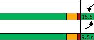
Transportation Infrastructure = $16.5M
Stormwater Infrastructure = $10.4M
Utility Relocations = $5.0M
Construction Contingency (25%) = $8.0M
Engineering Cost (12%) = $4.8M
ROW Acquisition = $10.6M
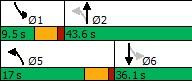
Total Stage 1 Cost: $55.3M
Transportation Infrastructure = $24.3M
Stormwater Infrastructure = $11.8M
Utility Relocations = $3.0M
Construction Contingency (25%) = $9.8M
Engineering Cost (12%) = $5.9M
ROW Acquisition = $10.4M
Total Cost: $65.0M
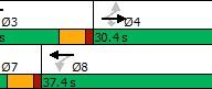
Transportation Infrastructure = $10.2M
Stormwater Infrastructure = $0.6M
Construction Contingency (25%) = $2.7M
Engineering Cost (12%) = $1.6M
Total Cost: $15.1M
Transportation Infrastructure = $15.3M
Stormwater Infrastructure = $0.7M
Construction Contingency (25%) = $4.0M
Engineering Cost (12%) = $2.4M
Total Cost: $22.4M
Total Overall Project Cost = $157.7M
The successful completion of 127 Street will require a collaborative approach among various stakeholders. It will also require the County to explore cost-sharing opportunities that leverages various funding sources while maintaining fiscal responsibility.
1. Introduction
McElhanney Ltd. (McElhanney) was retained by Sturgeon County to complete the updated functional planning of the 127 Street extension from the City of Edmonton boundary to Highway 2 at Township Road 544 in of St. Albert. The primary focus of this assignment is to confirm and update (as required) the ultimate cross-section and access requirements along 127 Street to support future growth and development as well as to determine the staging of improvements to address existing and interim needs.
1.1. PROJECT BACKGROUND
In 2012, Sturgeon County completed a functional planning study for a new 127 Street connection through the Sturgeon Valley. This study identified a recommended plan and alignment for the extension of 127 Street extending from the City of Edmonton to Highway 2, north of St. Albert, including a new arterial crossing of the Canadian National Railway (CNR) and the Sturgeon River
Since the 2012 study was completed, Sturgeon County approved the Sturgeon Valley South and Core Area Structure Plan in addition to continued and planned growth in neighbouring municipalities. Due to the anticipated growth in the Sturgeon Valley, the County has identified a need to update the 2012 functional study to ensure the recommended plan and alignment continues to support anticipated growth in Sturgeon Valley and to address key design elements that were not considered in the previous study. In addition, functional planning cost estimates are to be updated to 2023 dollars, which will guide the development of future capital budgeting and off-site levies.
1.2. PROJECT SCOPE
The scope of this Functional Planning Study update is to:
• Confirm future traffic projections for the 127 Street corridor and connecting roadways.
• Confirm and refine (as needed) the recommended interim and ultimate plans and alignment for the 127 Street corridor.
• Confirm and refine (as needed) the required intersection treatment and access management options along the corridor.
• Conduct a desktop review for environmental and geotechnical assessment.
• Identify requirements for utility protection and/or reallocation.
• Update functional-level cost estimates to current dollars.
1.3. PREVIOUS 127 STREET PLAN
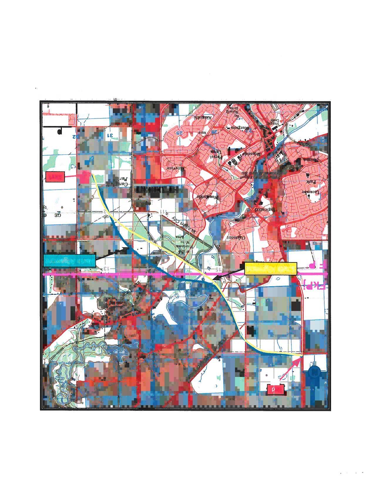
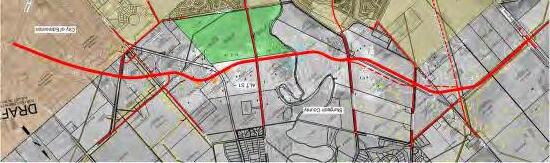
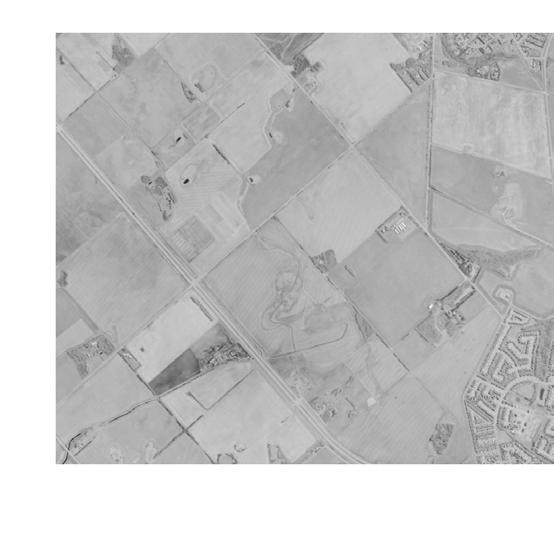
The recommended 127 Street plan was approved by County Council on June 15, 2012, and was recommended as an arterial roadway with a cross-section that transitions from semi-urban to the City of Edmonton urban cross-section approaching the City limits. The findings of the study recommended that the County plan and protect for the ultimate plan and alignment of 127 Street in the short-term.
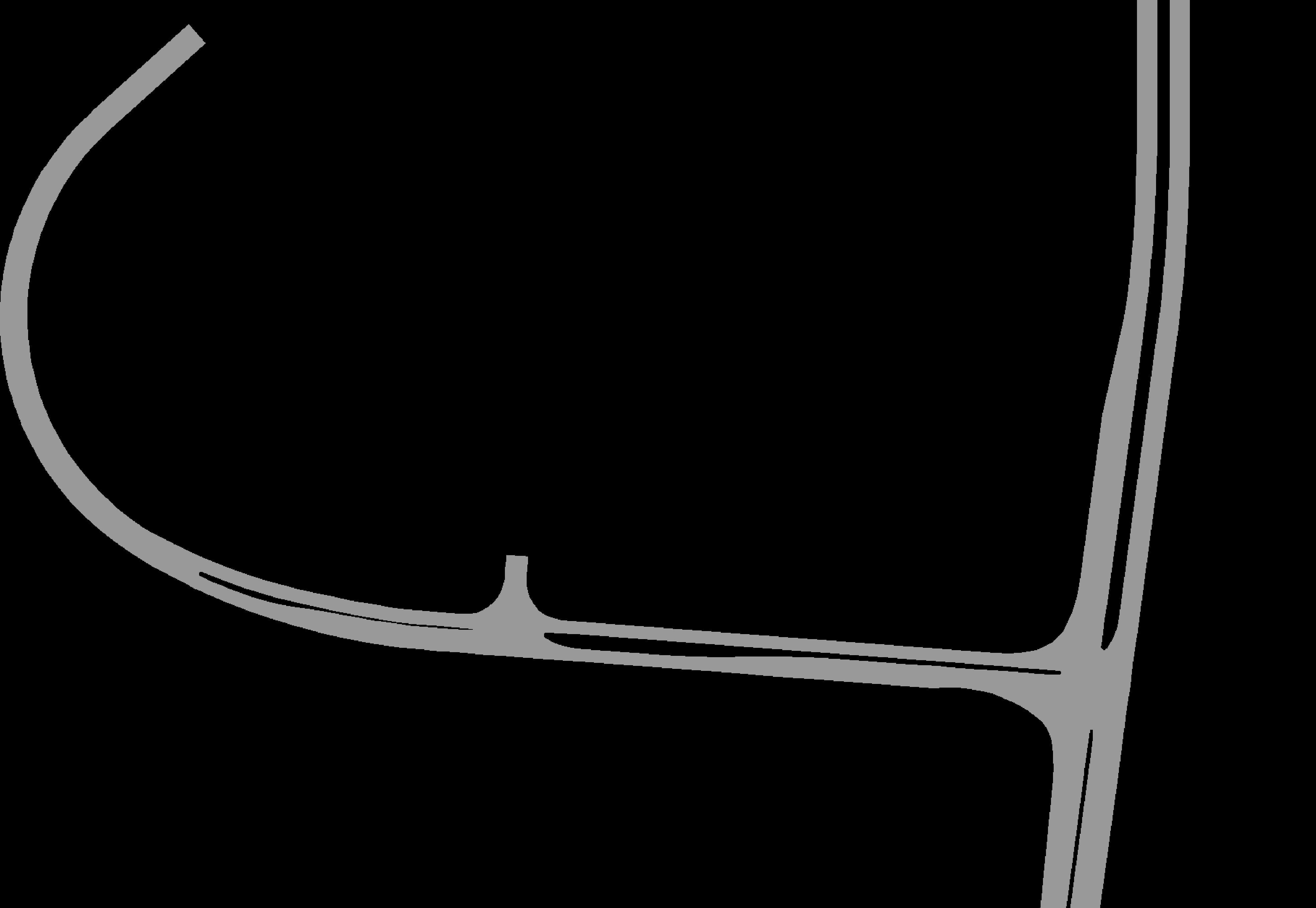
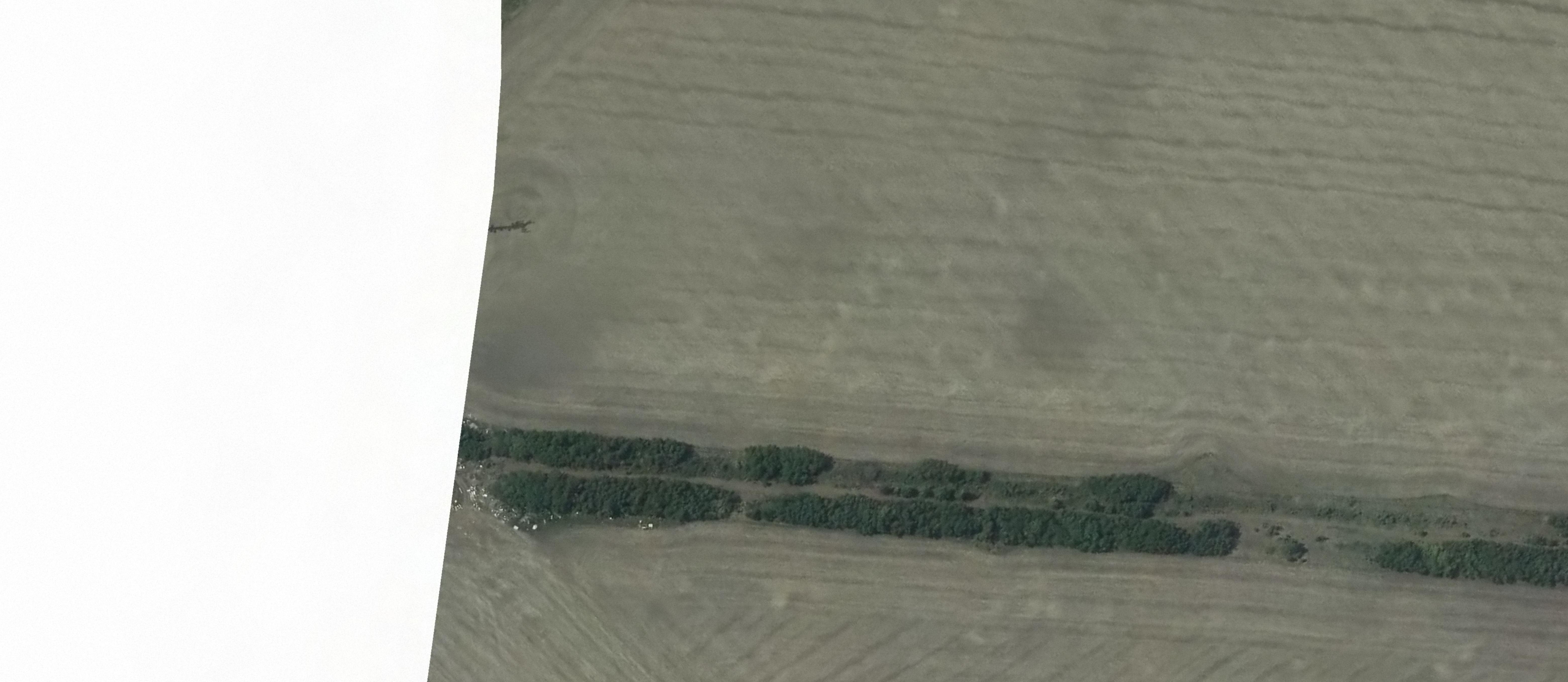
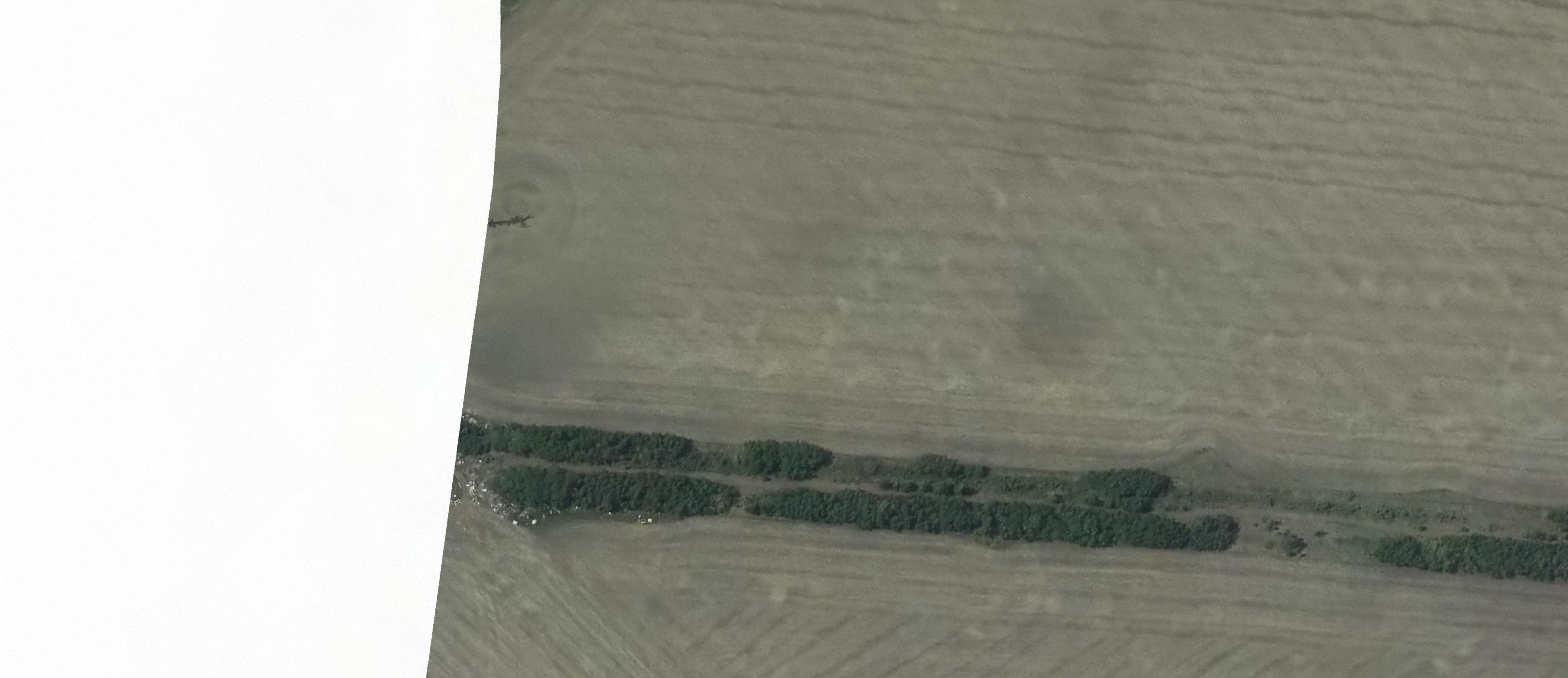
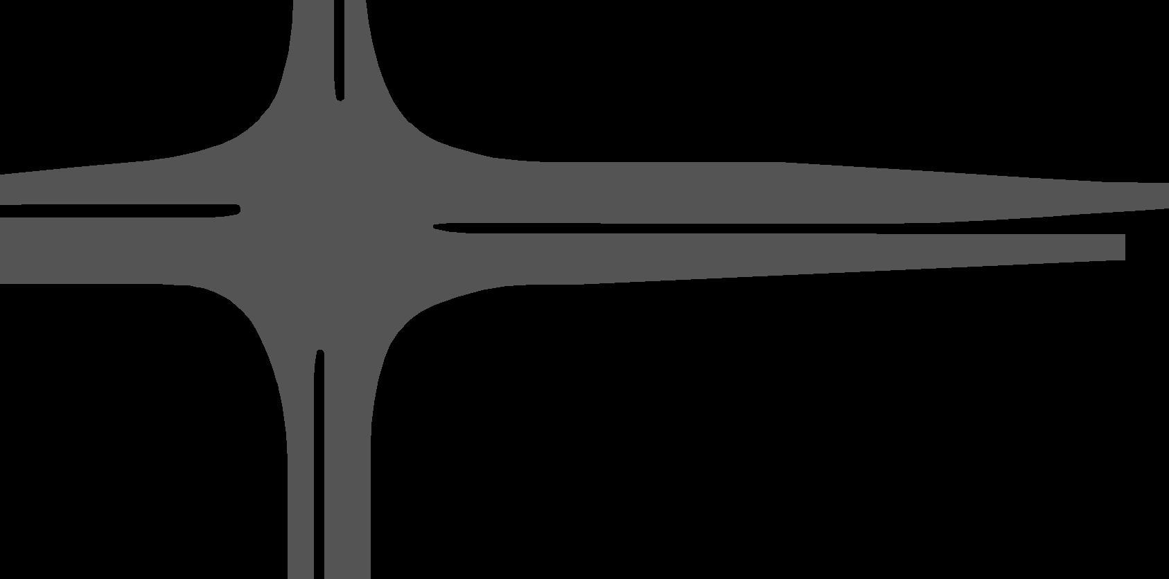
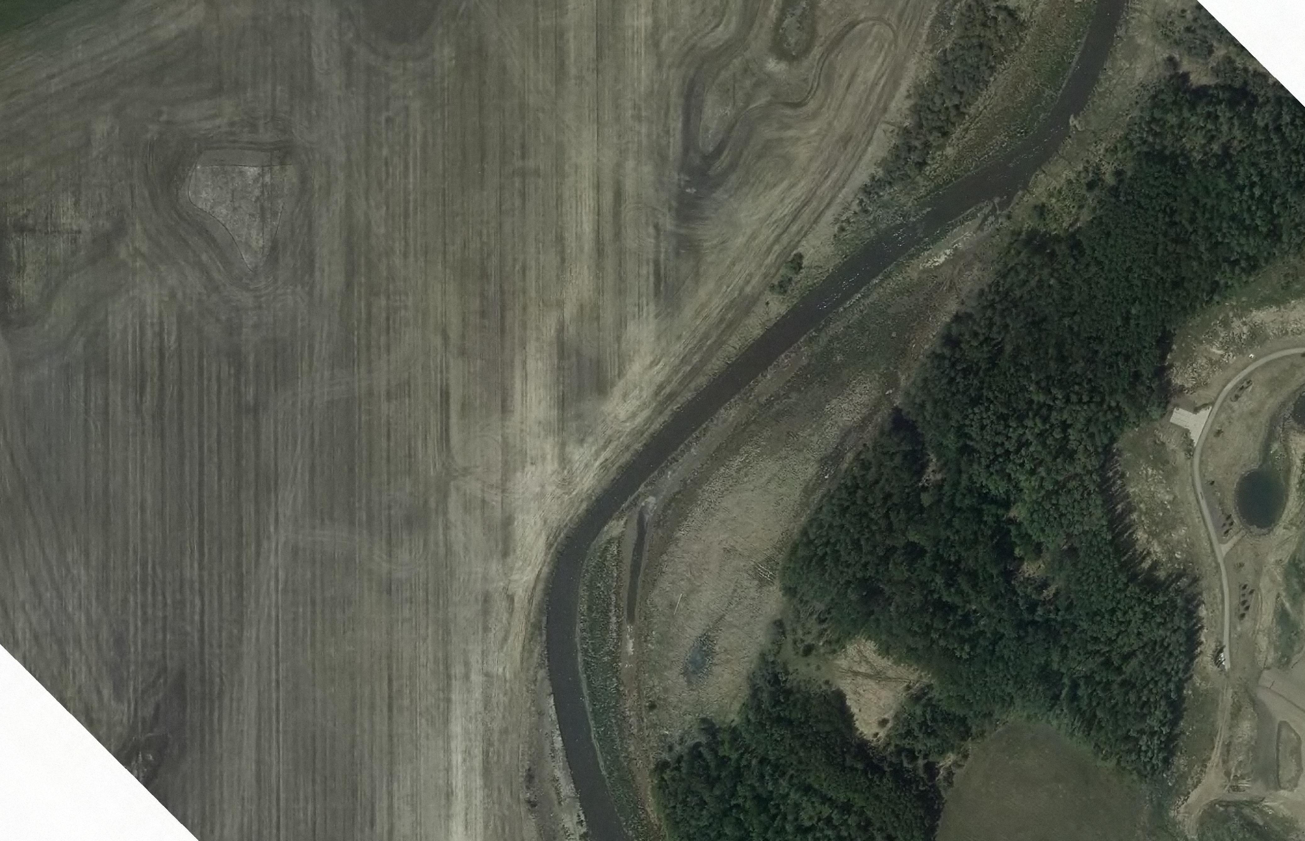
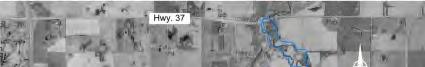
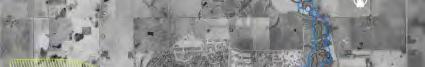
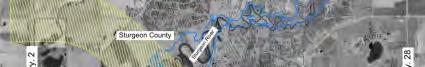
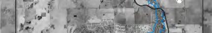
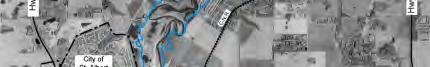
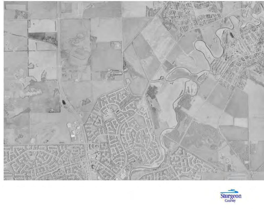
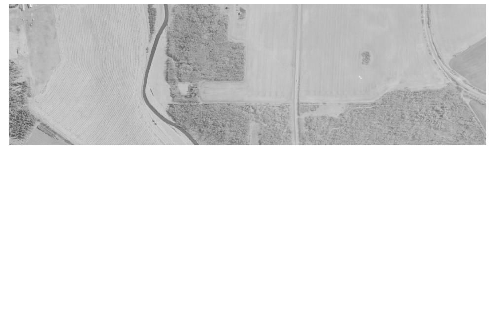
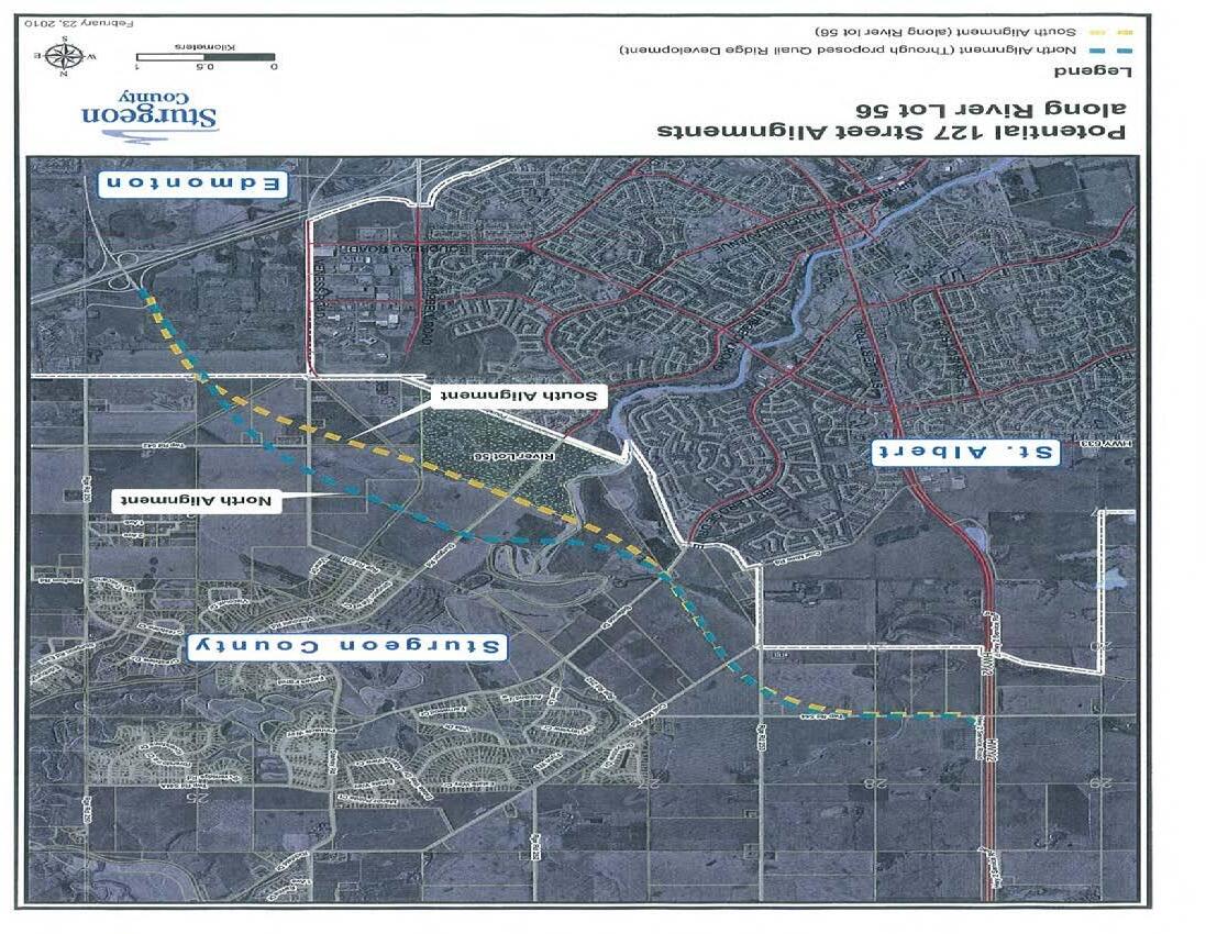
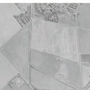
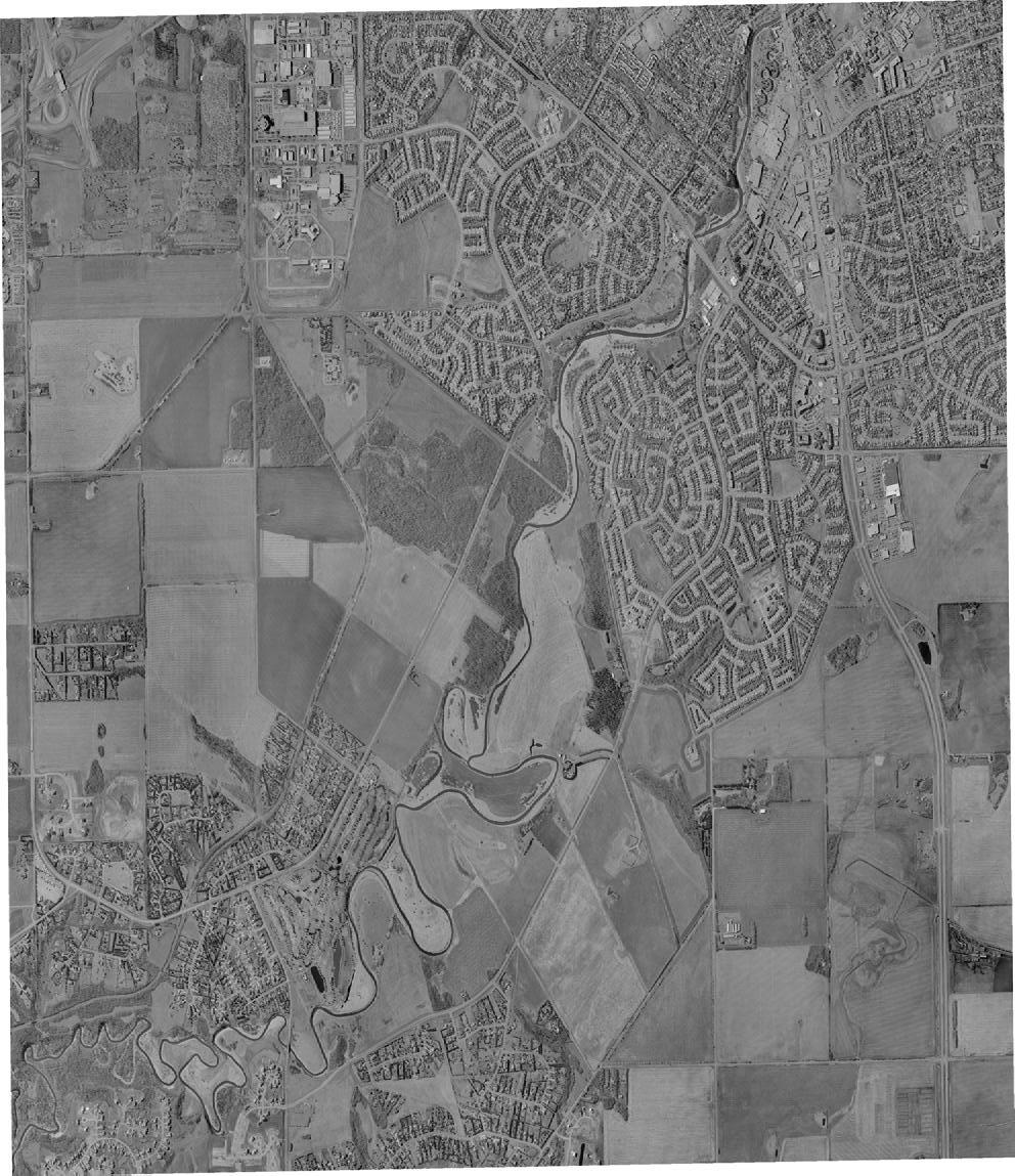
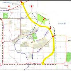
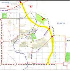
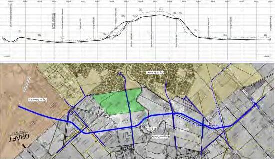
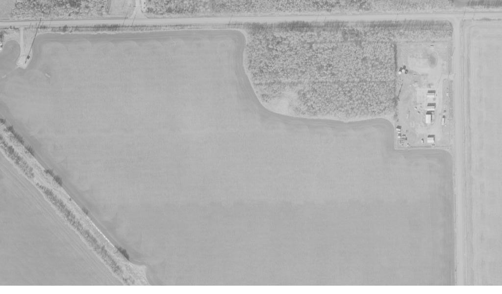
As illustrated in Figure 1, the proposed general alignment of 127 Street begins at the 127 Street extension in Edmonton and connects to Highway 2 in the north and features the following:
• Extension of 195 Avenue/Township Road 542 (stop-controlled) and Poundmaker Road (stopcontrolled).
• Grade-separated CNR crossing
• The Sturgeon River Bridge includes a multi-use trail on the south side of the structure for pedestrians to cross the river, as well as allowance for pedestrian and wildlife passage under the bridge on both sides of the river.
• Trail crossings of 127 Street will occur on the north side of Sturgeon Road, and south side of Bellerose Drive.
• Realigned accesses to two existing residences on Riverlot 38.
The 127 Street corridor is proposed to be constructed as a two-lane roadway and ultimately to a four-lane arterial with a posted speed of 70 km/h, and is anticipated to be staged as follows:
1. 2 lanes from the City of Edmonton limits to Sturgeon Road
2. Extension of 2 lanes from Sturgeon Road to Bellerose Drive
3. Extension of 2 lanes from Bellerose Drive to Highway 2
4. Completing the 4-lane semi-urban cross-section from the City of Edmonton limits to Bellerose Drive
5. Completing the 4-lane semi-urban cross-section from the Bellerose Drive to Highway 2
The total cost of the proposed improvements was estimated to be $136.6M (2012 dollars), including construction, property acquisition, engineering and contingency.
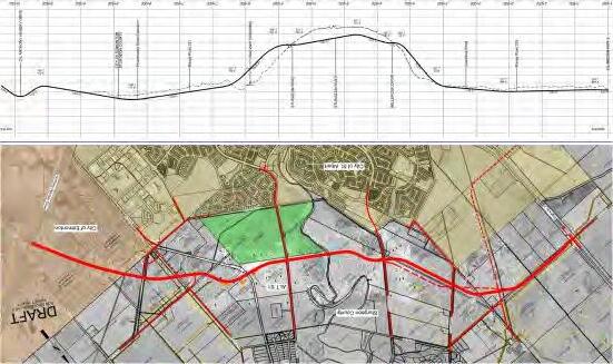
Figure 1: Proposed 127 Street Alignment
2. Background Context
2.1. SURROUNDING ROADWAY NETWORK
The preferred alignment of the 127 Street extension will connect to several key County arterials and likely alter local and regional travel patterns on the following roadways:
Sturgeon Road
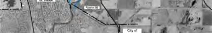
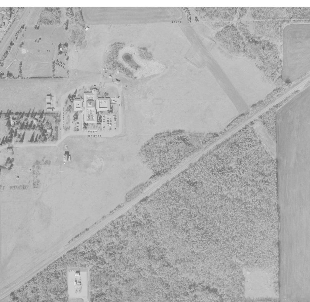
Sturgeon Road is a key east-west link within the Sturgeon Valley that facilitates local travel as well as regional connections between Sturgeon County, St. Albert and the City of Edmonton. The corridor is currently a two-lane undivided arterial that connects from Sturgeon County / St. Albert limits to the west and Highway 28 to the east. Sturgeon Road is a vital link in accommodating growth in the Sturgeon Valley over the next 25 years, as the area is anticipated to grow to approximately 26,000 people in Stage 1 of the Valley’s development. The Sturgeon Road Functional Planning Study (2022, McElhanney), which was completed in parallel with this 127 Street FPS update, recommended that the existing two-lane road cross-section be maintained with the addition of intersection improvements along with some other minor upgrades to accommodate future traffic demand This recommendation assumed that at a minimum, 127 Street would be extended to Sturgeon Road. It is also noted that a 4-lane cross-section from Essex Point to Highway 28 may be required to facilitate the ultimate build out of the Sturgeon Valley however it is not anticipated until well into the long-term horizon.
Bellerose Drive
Bellerose Drive is a key-west link that facilitates commuter travel between Sturgeon County and St. Albert. Primarily serving access to the adjacent residential developments, the corridor is currently a twolane undivided arterial that connects Starkey Road in the east to St. Albert Trail (in St. Albert) in the west. The previous 127 Street FPS recommended an at-grade signalized intersection at Bellerose Drive.
195 Avenue / Township Road 542
Within Sturgeon County, Township Road 542 is currently a two-lane rural roadway that provides access to adjacent agricultural lands, the Cattail Crossing Golf & Winter Club as well as to the Canadian Forces Base (CFB) Edmonton. The 2012 FPS recommended an extension of Township Road 542 to connect to the 127 Street extension as a stop-control at-grade intersection.
Anthony Henday Drive
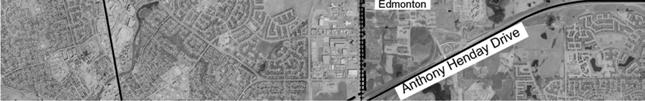
The final (northeast) leg of Anthony Henday Drive was completed in 2016, which allows full access to Sturgeon County at 127 Street from both the east and west directions, particularly into the Sturgeon Valley area Enhanced network connections to and from the Sturgeon Valley promotes development and contributes to community well-being and is expected to attract more regional traffic through the area.
Highway 2/Township Road 544
Highway 2 is currently a four-lane divided highway under the jurisdiction of Alberta Transportation. The highway provides a vital link between the Capital Region and Northern Alberta, and serves as an important connector for commuters, goods and services for the communities in Sturgeon County, St. Albert and Edmonton Through the recent annexation agreement, the intersection of Highway 2/Township Road 544 is now under St. Albert’s authority. However, any improvements to this intersection should include the province as a stakeholder to ensure the upgrades align with provincial plans for Highway 2.
2.2. LOCAL AND REGIONAL PLANS
The 127 Street connection plays a vital role in facilitating growth and development within Sturgeon County, as well as the surrounding region Since the 2012 FPS was completed, several transportation planning initiatives have been initiated or implemented. The future 127 Street extension will need to support and align with these initiatives to ensure an efficient and integrated network is established within the County:
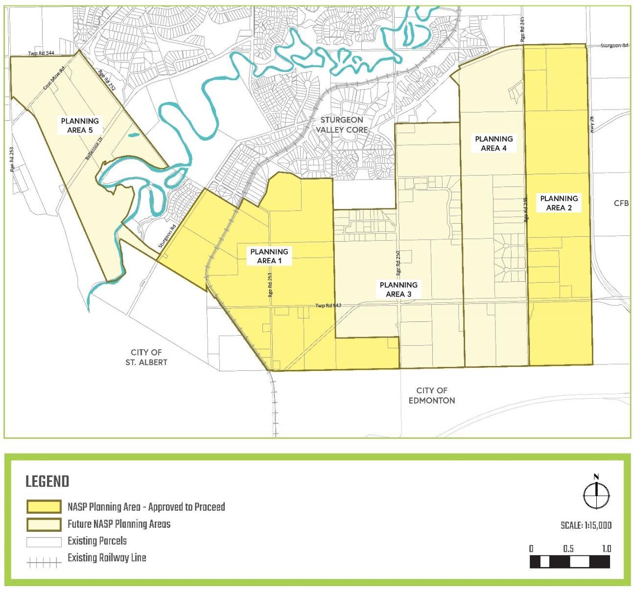
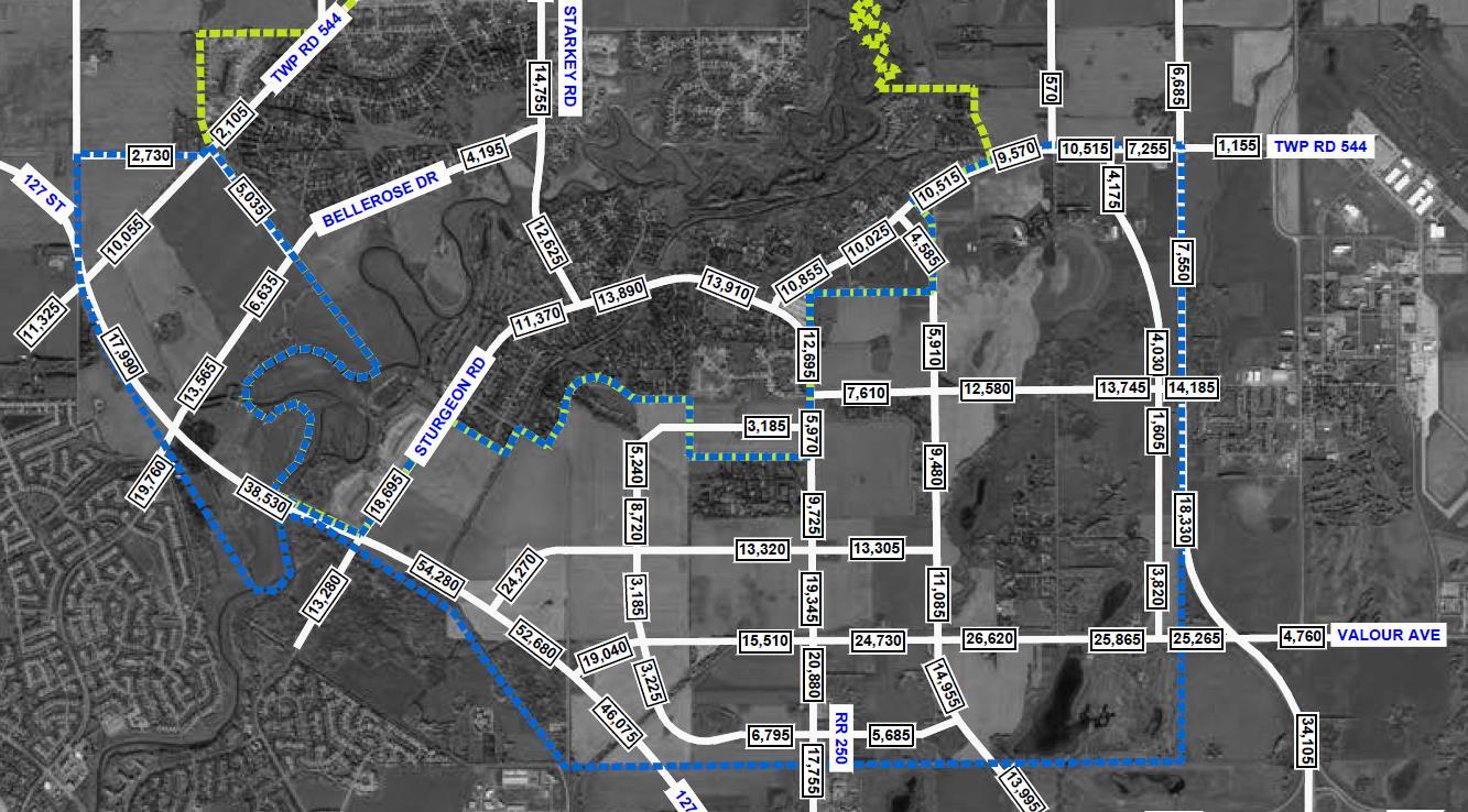
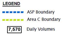
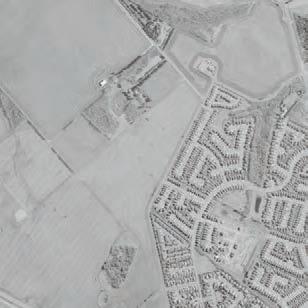
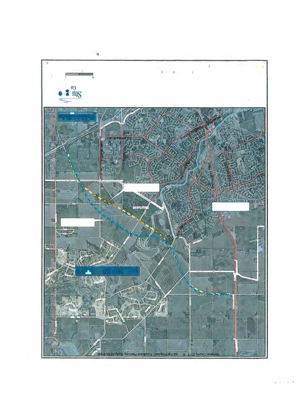
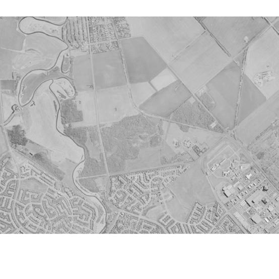
• Sturgeon Valley Area Structure Plans - In 2021, Sturgeon County approved the Sturgeon Valley Core and South Area Structure Plans (ASPs), which includes a mix of residential, industrial and commercial development. A majority of the development in the Sturgeon Valley will occur in the Valley South area, where at full build-out, the area will accommodate over 61,000 people. The Valley South planning area is anticipated to be completed in five phases over the next 60 years as illustrated in Figure 2, with Planning Area 1 advancing development within the next five years and continuing over the next 25 years. Development in the designated commercial area within Planning Area 2 is also anticipated to commence within the next five years. These first stages of development are expected to add approximately 21,000 more people in the Valley area over the next 25 years. Overall, the proposed growth in the Sturgeon Valley in addition to continued growth in the surrounding region is expected to generate a significant volume of traffic through the Sturgeon Valley Area, placing increasing pressures on the transportation network particularly on Sturgeon Road. 127 Street will serve as a key north-south connector for Sturgeon Valley, facilitating the movement of people and goods in that area.
• Sturgeon Road Functional Plan (2022) – The Sturgeon Road Functional Planning Study recommended a two-lane cross-section to be maintained along with the addition of protected turn bays at various intersections to improve the safety and operations along the corridor. A 3.0m shared use path is also recommended along the south side of Sturgeon Road west of Township Road 543B and on the northside of the corridor east of Essex Point/Township Road 543B. With the full build-out of Sturgeon Valley, a four-lane cross-section on Sturgeon Road between Essex Point and Highway 28 is anticipated. The extension of 127 Street will help alleviate pressures on Sturgeon Road as the Valley develops and help defer the need for ultimate upgrades.
• Edmonton Metropolitan Regional Planning – The Edmonton Metropolitan Region Growth Plan (January 2020) provides a vision and direction for responsible growth while identifying and enhancing economic opportunities within the Region. The Plan includes policies for the development of the Sturgeon Valley Special Study Area and specifies the following policy for the extension of 127 Street:
“The future extension of 127 Street will be in general accordance with the outcomes of the Edmonton Metropolitan Region Board’s Integrated Regional Transportation Master Plan. The future corridor for the extension of 127 Street will be further refined and protected as determined by Area Structure Planning across the entire planning area with input from Edmonton, St. Albert and Sturgeon County.”
The extension of 127 Street will become an integral link in connecting Sturgeon Valley and the region while fostering growth and development in the Edmonton Metropolitan Region.
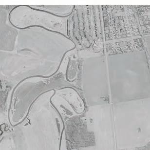
Figure 2: Sturgeon Valley South Planning Areas (Sturgeon Valley South Area Structure Plan, Figure 10)
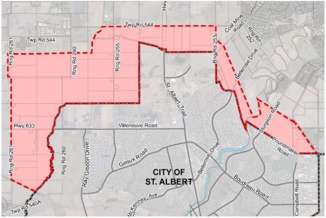
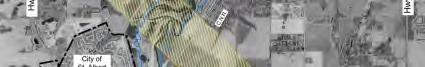
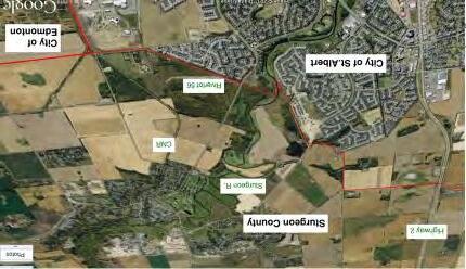
• St. Albert Annexation – On December 8, 2021, the Provincial Government approved the City of St. Albert’s application to annex 1,558 hectares of land from Sturgeon County. The annexation includes land to expand St. Albert’s boundary mostly to the north and the west as shown below in Figure 3. The City has plans for continued development in these areas while preserving agricultural land, including the proposed Northeast St. Albert ASP. The City will prioritize the northern section for development, which is divided at the midway point between Range Road 255 and St. Albert Trail. 127 Street will serve as a key connector to and from the annexation area in the long-term horizon and provide an alternative entry point into St. Albert along the existing northeast part of the city.
• Sturgeon Valley Offsite Levy Assessment (Draft, December 2022) – The County is currently in progress of finalizing an offsite levy assessment for the Sturgeon Valley area. The purpose of the assessment is to review the water and sanitary 25-year servicing requirements to support development in the Valley. The findings will be used to determine the staging of improvements and the appropriate levy rates for developers. One of the primary roles of the 127 Street extension is to facilitate direct connections to Sturgeon Valley from the west. Therefore, it is important for the County to understand the benefitting areas of this project so that offsite levies for transportation within the Valley can be assigned appropriately.
Image Source: City of St. Albert
Figure 3: St. Albert Annexation Area
2.3. TRAFFIC PROJECTIONS & REVIEW
Traffic projections from the 2012 FPS estimated 12,000 vehicles per day (vpd) south of Bellerose Drive and 3,000 vpd north of Bellerose Drive under the 2044 horizon. The ultimate traffic projections indicate that a four-lane divided cross-section is required up to Bellerose Drive. While a four-lane cross-section is not required beyond Bellerose Drive, 127 Street is a critical link that connect several neighbourhoods to Highway 2 and will likely require a four-lane cross-section to facilitate efficient and safe traffic flow.
Since 2012, population in Sturgeon County have grown by approximately 3.5% in addition to subdivisions building out in the Sturgeon Valley. To ensure the traffic projections completed in 2012 are still relevant, the following sources of traffic projections based on updated planning initiatives, land use and demographic data were reviewed.
EMRB Model
Traffic projections obtained from the Regional Travel Model (RTM) developed by the Edmonton Metropolitan Regional Board (EMRB) indicates that moderate growth is expected on the corridor over the next 10 years as development occurs in the Sturgeon Valley. Sturgeon Road is assumed as a two-lane roadway under both the 1.25M (~2032 horizon) and 1.5M (~2045 horizon) scenarios. The 1.5M scenario also includes the four-lane 127 Street connection from the City of Edmonton to Township Road 544 and a new cloverleaf interchange at Highway 28 and Sturgeon Road.
Daily two-way vehicle volumes on the 127 Street extension are estimated to range from approximately 4,200 vpd (north end) to 39,500 vpd (south end). Daily volumes along the section of 127 Street through the Sturgeon Valley ranges between 17,000 vpd to 19,500 vpd, while AM and PM peak directional volumes are approximately 1,100 veh/hr and 1,400 veh/hr respectively. While these traffic projections are based on a total population of 12,930 people by 2045 in the Sturgeon Valley, which is significantly lower than what is being planned as identified in the Sturgeon Valley ASPs, the proposed four-lane crosssection can adequately support the volumes generated by approximately 13,000 people and have the capacity to accommodate more traffic.
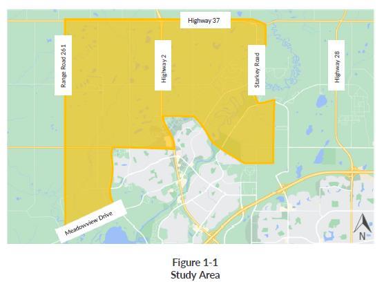
The St. Albert EMME Travel Demand Model (EMME) was updated and used to project future travel patterns and traffic volumes to support the TNIS study. The purpose of this study was to evaluate the network as a result of adjacent growth in both municipalities and to identify the prioritization of network improvements.
Several future scenarios that incorporate different network improvement assumptions were evaluated for the PM peak hour under the 2030 and 2045 horizon. Within Sturgeon County, Sturgeon Road is assumed to remain as a two-lane roadway under all the scenarios. The future scenarios reflect a land use (population) assumption of 10,249 people (2030) and 26,688 people (2045) in Sturgeon County, which is mostly comprised of the Sturgeon Valley growth area.
Image Source: TNIS, April 2022
The TNIS scenarios relevant to this FPS and considered in the future traffic projections include: 1. 2030 Ultimate
• Key network improvements include twinning of Ray Gibbon Drive to Fowler Way, Fowler Way (2lanes), St. Albert Trail (6-lanes), Neil Ross Road (2-lanes) and 127 Street extension to Sturgeon Road (4-lanes, No Corriveau Avenue Extension). Sir Winston Churchill Ave is also twinned from Sturgeon Road to City of St. Albert limits.
• 127 Street includes five signalized intersections: Corriveau Avenue, Poundmaker Road, Valour Avenue, a new East-West Arterial and Sturgeon Road.
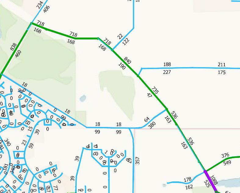
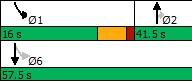
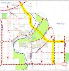
• The 127 Street extension to Sturgeon Road is projected to carry between 500 and 1,000 vehicles/hr in the PM peak direction (northbound). As shown in Figure 5, the segment north of the Anthony Henday Drive/127 Street interchange is projected to carry just over 1,000 vehicles/hr. Peak hour volumes then taper off to approximately 700 to 800 vehicles/hr moving north towards Sturgeon Road.
Figure 4: TNIS Study Area
Figure 5: 2030 Ultimate Scenario PM Peak Hour Link Volumes
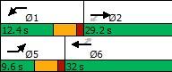
2. 2045 Base
• 2030 Base network + Neil Ross Road (2-lanes) + Fowler Way Widening (4-lanes) + 127 Street Extension to Sturgeon Road (With Corriveau Avenue Extension) + Starkey Road Realignment + Campbell Road Extension to Poundmaker Road.
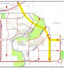
• The 127 Street extension to Sturgeon Road is projected to carry between 850 and 1,550 vehicles/hr in the PM peak direction (northbound) under the 2045 Base scenario, with the segment approaching Corriveau Avenue carrying the highest volumes. The segment north of Poundmaker Road is projected to carry just over 1,200 vehicles/hr in the northbound direction. Traffic volumes then reduces to almost 850 vehicles/hr approaching Sturgeon County.
Figure 6: 2045 Base Scenario PM Peak Hour Link Volume
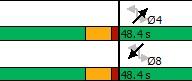
3. 2045 Ultimate
• 2045 Base network + Fowler Way extension to Highway 2 + 127 Street Extension to Highway 2.
• 127 Street includes seven signalized intersections: Corriveau Avenue, Poundmaker Road, Valour Avenue, Range Road 250, Sturgeon Road, Bellerose Avenue, Coal Mine Road, Range Road 253 and Highway 2.
• As shown in Figure 7, the full extension of 127 Street to Highway 2 is projected to carry between 900 and 1,850 vehicles/hr in northbound direction during the PM peak hour. The segment between the AHD/127 Street interchange and Sturgeon Road will accommodate between approximately 1,300 and 1,600 vehicles/hr while the new Sturgeon River Crossing will accommodate about 1,850 vehicles/hr in the peak direction. It is also worth noting that the bridge crossing in the southbound direction is in the range of 1,300 vehicles/hr. Traffic volumes then decreases to approximately 900 vehicles/hr approaching Highway 2.
Figure 7: 2045 Ultimate Scenario PM Peak Hour Link Volumes
Sturgeon Valley South and Core Area Structure Plans
A traffic review was conducted as part of the overall planning process for the Sturgeon Valley South and Core ASPs. Traffic estimates were established for two stages of development and are described as follows:
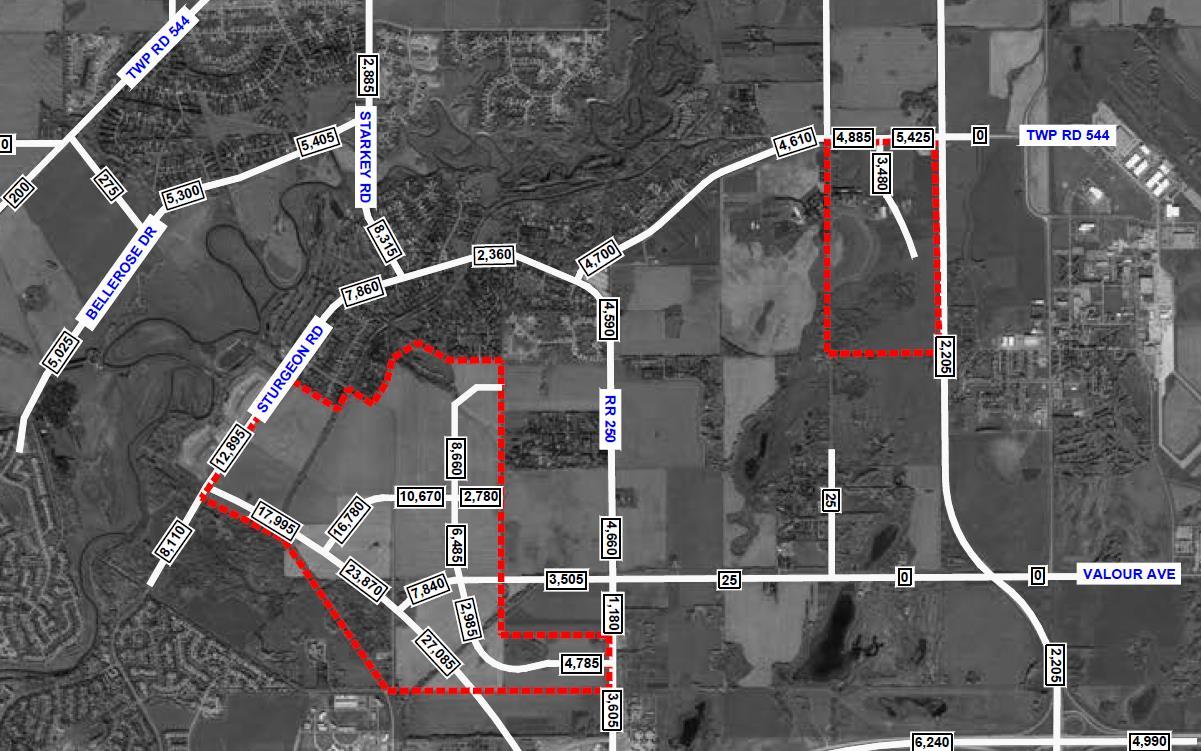
• Stage 1 Development – This scenario includes the completion of the areas within the red border (over 26,000 total Sturgeon Valley population) as shown in Figure 8 and the completion of 127 Street to Sturgeon Road. Stage 1 development (Planning Area 1 and part of Planning Area 2 in ASP) is projected to build-out in 30 years and is estimated to generate between approximately 18,000 to 27,000 vehicles per day on 127 Street. The northern section approaching Sturgeon Road is anticipated to accommodate lower volumes of development traffic than the southern section as a result of a new east-west connection into the development site.
• Full-Build – This scenario assumes full build of the ASP (over 61,000 population) and completion of 127 Street to Highway 2. Full build-out of the Sturgeon Valley is anticipated to occur in 2063 (2% County growth rate) or beyond 2100 (1% or 0.5% County growth rate). Daily development traffic volumes are expected to increase significantly under the full build-out scenario, with the southern section of the corridor accommodating as much as 54,000 vehicles per day as shown in Figure 9 Site-generated volumes decreases moving east and reduces to 7,255 vehicles per day at Highway 28. Overall, total traffic (background + development) on Sturgeon Road will increase to almost 22,000 daily trips on the west end and 10,000 daily trips on the east end.
Figure 8: Stage 1 Development Trip Generation
Sturgeon Valley Population Projections
Based on the County’s recent Offsite Levy assessments, a low (0.5% per year, compounded) moderate (~1% per year, compounded) and high (~2% per year, compounded) population growth rate was used to estimate future population growth and to determine the staging of construction for the infrastructure upgrades. Building from these assumptions, Figure 10 illustrates the Valley’s population growth projections to the year 2067
The Sturgeon Valley currently has a population of almost 4,500 residents and is projected to grow by almost 5,500 residents by 2037 based on the high growth scenario of 2% per year, which generally aligns with the average growth rate of the Edmonton Region. Under a moderate growth scenario of 1%, population in the Valley would reach approximately 10,000 people by 2050. This growth will occur during a horizon beyond 2067 assuming the low growth rate of 0.5% per year. The population projections also suggest that the completion of Planning Area 1, which corresponds to a total of about 26,000 people in the Valley, is estimated to occur between 2053 and well beyond 2067. The full build-out of the Valley (~61,000 people) can be reached just beyond 2067 with the high growth rate assumption.
All population horizons were maintained from the land use and density assumptions within the most recent ASPs. Additional trip generation information within the TNIS was checked against the ITE trip generation procedures to validate the EMME model projections. In conjunction with the Sturgeon Road Functional Planning Study, each study was evaluated using Synchro to produce the expected traffic operations along the corridor.
Figure 9: Full Build-Out Trip Generation
For the purpose of staging the future construction of 127 Street, the population projection and corresponding horizon year for each key phase of the Sturgeon Valley development (as per the ASP) was estimated based on the information noted above and are summarized in Table 1.
Table 1: Sturgeon Valley Population by Estimated Horizon Year
It should be noted that, since the planning horizon year for Sturgeon Valley varies among the sources of background information, all the traffic analysis and project staging from herein will be based on the 10,000-population and the 26,000-population horizon. This will maintain consistency between all the recent planning work completed to-date for Sturgeon Valley.
Figure 10: Sturgeon Valley Population Growth Projections
Traffic Review
The Level of Service (LOS) is a performance metric used to assess operating conditions of intersections and their respective approaches. LOS reported in the analysis scenarios are based on the methodology outlined in the 2010 Highway Capacity Manual. For unsignalized intersections, the LOS is based on the computed delays on each of the critical movements. LOS ‘A’ represents minimal delays for minor street traffic movements, and LOS ‘F’ represents a scenario with an insufficient number of gaps on the major street for minor street motorists to complete their movements without significant delays. For signalized intersections, the methodology considers the intersection geometry, traffic volumes, the traffic signal phasing/timing plan, as well as pedestrian and cyclist volumes. The average delay for each lane group is calculated, as well as the delay for the overall intersection. The operating conditions can also be expressed in terms of volume-to-capacity (v/c) ratio. The signalized and unsignalized LOS criteria as summarized in HCM are also shown in Table 2
A Represents free flow. Individual users are virtually unaffected by others in the traffic stream.
B Stable flow, but the presence of others begins to be noticeable. Occasionally minor delay due to conflicting traffic.
C Stable flow, but occasionally some delay due to conflicting traffic. Delay is noticeable, but not inconveniencing.
D Represents high-density, but stable flow. Delay is noticeable and irritating.
E Represents operating conditions at or near the capacity level. Delay approaching tolerance levels.
F Traffic demand exceeds capacity of intersection, very long queues, and delays. Represents forced or breakdown flow. Delay exceeds tolerance level.
> 80
For planning purposes, an overall intersection of LOS D or better and v/c ratio of less than 0.90 are considered acceptable operational standards for Sturgeon County roadways.
In addition to the LOS criteria, AADT is another metric that can be used to evaluate corridor capacity and determine whether corridor or intersection treatment upgrades are warranted based on AADT thresholds set for various road classifications. Table 3 summarizes the daily volume thresholds assumed for this study. These thresholds were established based on the County’s 2022 General Municipal Servicing Standards and Alberta Transportation’s Highway Geometric Design Guide
Table 3: Volume Threshold by Road Classification
Table 2: 2010 Highway Capacity Manual Level of Service Criteria
Based on the review of the traffic projection sources described in Section 2.3, the 127 Street extension is required to support both Planning Area 1 and Full Build-Out growth in Sturgeon Valley. The extension will also serve to reduce traffic along Sturgeon Road, allowing the Sturgeon Road corridor to continue to function as a two-lane roadway as Sturgeon Valley grows beyond 10,000 people While the phasing of the 127 Street extension is dependent on development, the first phase of the extension should be completed to Sturgeon Road, at a minimum. The projected peak hour volumes suggest that a two-lane cross-section with dedicated turn lanes along the 127 Street would have capacity to support growth to at least 10,000 residents in Sturgeon Valley.
Since the timelines for the developments north of the Sturgeon River were not clearly defined as the time this FPS was completed, detailed traffic operations analysis for the study intersections up to Sturgeon Road was completed while a high-level traffic review of the intersections north of the river was undertaken. Utilizing Synchro 11 and based on the traffic projections provided in the TNIS1, the analysis confirms that acceptable intersection levels of service can be achieved by providing one travel lane with dedicated left turn and/or right turn lanes in both directions on 127 Street under the 10,000-population horizon. The intersections at Corriveau Avenue and Sturgeon Road are assumed to be signalized. The intersections at Poundmaker Road, Valour Avenue and the New East-West arterial should be signalized however, it is noted that these intersections are dependent on new development therefore, signals are only needed if warranted by the development in the interim timeframe.
As growth continues towards the 26,000-population horizon or as traffic conditions warrant, 127 Street will likely need to be upgraded to a four-lane cross-section. By the 26,000-population build-out, the study intersections will require two travel lanes in each direction on 127 Street in addition to dedicated turn lanes to continue maintaining acceptable intersection levels of service The traffic analysis reports provided in the TNIS show that once the full extension of 127 Street to Highway 2 is required (2045 Ultimate scenario, TNIS), some of the study intersections will likely require dual left-turn lanes (on 127 Street and/or cross-street) to maintain acceptable intersection levels of service, including the intersection at Corriveau Avenue, Sturgeon Road, Bellerose Drive and Highway 2.
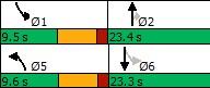
Building from the traffic analysis completed in the TNIS, the detailed Synchro reports prepared for this FPS are provided in Appendix A.
1 Traffic volumes at Sturgeon Road and the New East-West Arterial were adjusted to reflect the recommended improvements on Sturgeon Road as per the Sturgeon Road Functional Planning Study (McElhanney, July 2023)
3. Preliminary
Assessment
The update of the 127 Street Functional Plan considered several physical constraints along the project limits that would impact the design and construction of potential upgrades. The following section summarizes the key constraints as it relates to utilities, drainage, right-of-way, environmental and geotechnical as well as the CN Rail crossing.
3.1. UTILITIES
A OneCall was completed to identify all the utilities within the vicinity of the recommended future alignment of 127 Street from Anthony Henday Drive to Highway 2. Table 4 below outlines the various companies that were identified, which include companies for oil and gas, water and sewer and communications and electricity.
Table 4: Utility Company Summary
Oil & Gas
Oil & Gas
Atco Gas
Atco Pipelines
Oil & Gas Canadian Northwest Energy
Oil & Gas
Water & Sewer
Water & Sewer
Regco Petroleums Ltd.
Alberta Capital Region Wastewater Commission
EPCOR Water Services
Water & Sewer Sturgeon County Utilities
Water & Sewer
Communications & Electricity
Communications & Electricity
Communications & Electricity
Communications & Electricity
Town of Morinville Utilities
Bell West Inc.
TELUS Communications Inc.
EPCOR Distribution
FORTIS Alberta
It is anticipated that some utilities may need to be relocated for both the interim and ultimate staging. It is recommended that as many utility relocations as possible, be completed during the first stage of implementation to mitigate any future impacts and wasted construction efforts at later stages of the implementation. Extensive coordination with each utility company will be required to determine the efforts required to relocate or avoid each utility.
3.2. DRAINAGE
Existing drainage in this area is typical overland drainage for greenfield areas and eventually drains towards the Sturgeon River. Some ditch drainage is currently present along Sturgeon Road and Bellerose Drive. A full urban cross-section will require an underground storm drainage system be implemented along with stormwater management facilities on either side of the Sturgeon River to handle surging, water quality and the flow rate in advance of out letting into the river. An underground storm sewer and urban cross-section is recommended as a result of the additional information that was provided that indicated other developments in the region may intend to drain into the 127 Street storm system, in addition to realistic stormwater conveyance to reach the river. An overland drainage system is not recommended because it will be challenging to grade the roadway cross-section and ditches in a way that permits water to travel by gravity from one end of the corridor, all the way to the sturgeon river. With the expected number of people that the nearby development expects, it is encouraged that a full urban system be developed to provide a logical connection for the future storm systems within the developed areas.
Interim Stormwater Design - (2-lane semi-urban cross-section from Corriveau Ave to Sturgeon Rd)
• Crown of roadway at centerline draining to the curb line to the north and ditch to the south.
• North curb line catch basins installed and tied into stormwater main along ultimate centerline (interim ditch alignment).
• Manhole frame and grates on stormwater main to be permeable to water (i.e. F-38) and elevation set at interim cross-section ditch invert elevation.
• Stormwater management facility (storm pond) east of Sturgeon River should be constructed and tied into underground storm system.
The same process should be used for the interim cross-section west of the Sturgeon River, mirroring the infrastructure described above.
Ultimate Stormwater Design - (4-lane urban cross-section from Corriveau Ave to Sturgeon Rd)
• Roadway milled and resurfaced to drain to outside of roadway towards catch basins.
• South curb line catch basins installed and tied into stormwater main along centerline
• Manholes on stormwater main to be adjusted to surface elevation and converted to typical manhole frame & grate (i.e. F-39)
The same process should be used for the ultimate cross-section west of the Sturgeon River, mirroring the infrastructure described above.
Design Constraints
It is noted that the suggested stormwater pond location (west of Sturgeon Road before out letting to the Sturgeon River) is quite constrained by the current River’s Gate development (Planning Area 1E) to the north, the suggested road/bridge alignment to the south and the river valley/flood plain boundary to the west. As part of the River’s Gate development, a storm pond system was developed along the west side of the development. This existing stormwater pond could be connected with the new storm pond required for the 127 Street stormwater needs, however it is understood that the existing storm pond was designed
only to handle flow from the existing development, therefore there would be no significant benefit to linking the facilities. Once the storm water management facility (SWMF) designs are refined and finalized during the future design stages, opportunities to connect the pond for aesthetic or functional purposes may be explored. However, at this time, it should be assumed that a new stormwater facility will be required to carry the full stormwater conveyance from 127 Street. The 127 Street SWMF is expected to be at a lower elevation than the River’s Gate storm pond system therefore during the design of the 127 Street SWMF the outlet features (ie. Emergency Spillway) should be assessed to ensure that the new facility either does not interact with the River’s Gate storm pond outlet or effectively receives the flow from the River’s Gate outlet and discharges through a common outlet to the Sturgeon River.
At this time, it is understood that the River’s Gate Emergency spillway discharges in the direction of the 127 Street SWMF. To avoid impeding the emergency spillway, the spillway can be extended to discharge into the 127 Street SWMF. Detailed grade analysis should be performed at the preliminary design stage to ensure positive drainage to the 127 Street facility and that flow is channeled sufficiently. The 127 Street SWMF should be oversized to account for the additional overflow from the River’s Gate pond. The existing assumed footprint is expected to be adequate to account for this additional flow. The River’s Gate pond discharges from a single pipe outlet that is expected to be within typical acceptable release rates. The location of the outlet may result in a potential conflict with the footprint of the 127 Street SWMF. Options to address this potential conflict include tying in the outlet to the 127 Street SWMF, altering the shape of the 127 Street SWMF to avoid impacting the outlet or rerouting the outlet around or underneath the 127 Street SWMF.
The catchment area and regional storm expectations have not changed significantly since the 2012 Functional Planning Study. A review of the modelling completed as part of the 2012 FPS was conducted and the information is still considered valid. Specifically, as it pertains to the SWMFs, the details outlined in Table 5 below remain valid. The total required land area confirms that the locations identified within the functional plans are suitable with a minimum of 2.6 hectares available in both areas.
Notes:
a Storage Volume is based on a 1:100 year, 24-Hr Huff Design Storm event less a 2.5L/s/ha release rate. Values confirmed using rational method.
b Total land area required includes SWMF area, earth berm (2m wide by 3.5m tall) and all slopes around the SWMF (4:1). Difference between normal water level and high-water level is 2m.
Table 5: Summary of SWMF requirements
3.3. ENVIRONMENTAL
An environmental desktop review was conducted for the study corridor. No major changes were observed from the 2012 FPS. The summary of the major affected features is summarized in Table 6 and further discussed below.
Table 6: Environmental Impact Summary
Effected Areas
Woodlands
Wetlands
River/Floodplain Crossing
Storm Ponds
Impacts
• Ultimate construction removes approx. 5.3 ha (25%) of woodland west of RR 251.
• Removes the southern extension of Riverlot 57 (woodland) but otherwise avoids any major impacts.
• Roadway will be very close to the north margin of Riverlot 56 but avoids physical impact to the protected area.
• Partially or completely removes up to 12 small, isolated wetlands along the corridor.
• No impact to oxbow wetland in Sturgeon River floodplain.
• Introduction of new bridge crossing will have some impact to the hydrology of the Sturgeon River.
Storm ponds on the east and west side of Sturgeon River will be introduced as part of the roadway construction It is recommended that naturalized recreation areas tie into the ponds to provide valuable wildlife habitat as well as an area that can be utilized by local residents.
Riverlot 56
There has been no change in expectations for Riverlot 56 since the 2012 FPS. Riverlot 56 is a Provincial Natural Area, administered by Alberta Tourism, Parks and Recreation (TPR), Alberta Sustainable Resources Development (SRD) and the Riverlot 56 Society. As previously mentioned in the 2012 FPS, these lands are legally protected and controlled and therefore there shall be no impacts to these lands as a result of the expected roadway works in the region.
Sturgeon County Environmental Protection Area
Similar to Riverlot 56, the County has identified Riverlot 57 and 58 as protected lands and therefore all efforts should be made to avoid any impacts to these local natural areas. It may be possible to tie-in a trail or active modes system to enhance the area during the more detailed design stages.
3.4. GEOTECHNICAL
The 2012 FPS completed a thorough geotechnical analysis and the findings within those reports remain valid. With the refined alignment and cross-section design, no major changes to the report are expected with the most significant geotechnical impact being the bridge structure to cross the Sturgeon River. Further geotechnical analysis should be completed at a later design stage to determine bridge design, road and pavement structures, and trail and sidewalk structures.
3.5. HISTORICAL RESOURCES
No major historical resources updates were identified from the 2012 FPS. The same considerations remain for the Sturgeon River as well as the Poundmaker lodge site. The Poundmaker site should not be impacted by the 127 Street corridor, however as previously mentioned, other crossroads may impact the site and should be carefully considered in advance of any further design or construction.
The next section discusses the design criteria and other specific details of the proposed interim and ultimate design.
4. Recommended Functional Plan
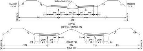
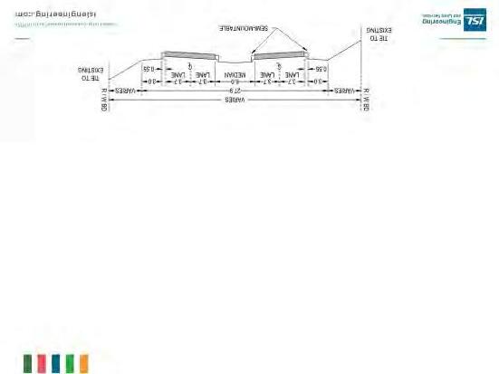
4.1. DESIGN CRITERIA
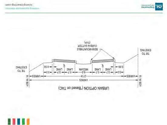
127 Street is anticipated to ultimately, become an urban 4-lane arterial roadway with a posted speed of 70km/h. Some sections of the corridor may not be widened to the full cross-section until well beyond the 25-year horizon, however, it would be best practice to protect for the future needs of the area and maintain consistent design criteria throughout the corridor as reasonably possible.
The ultimate cross-section design criteria for the recommended functional plan are outlined in Table 7 Staged implementation of the roadway from the City of Edmonton limits to Highway 2 may result in some interim design criteria, as specified in Table 8
In addition to the design criteria, the functional design process accounted for the following key considerations.
Right-of-Way
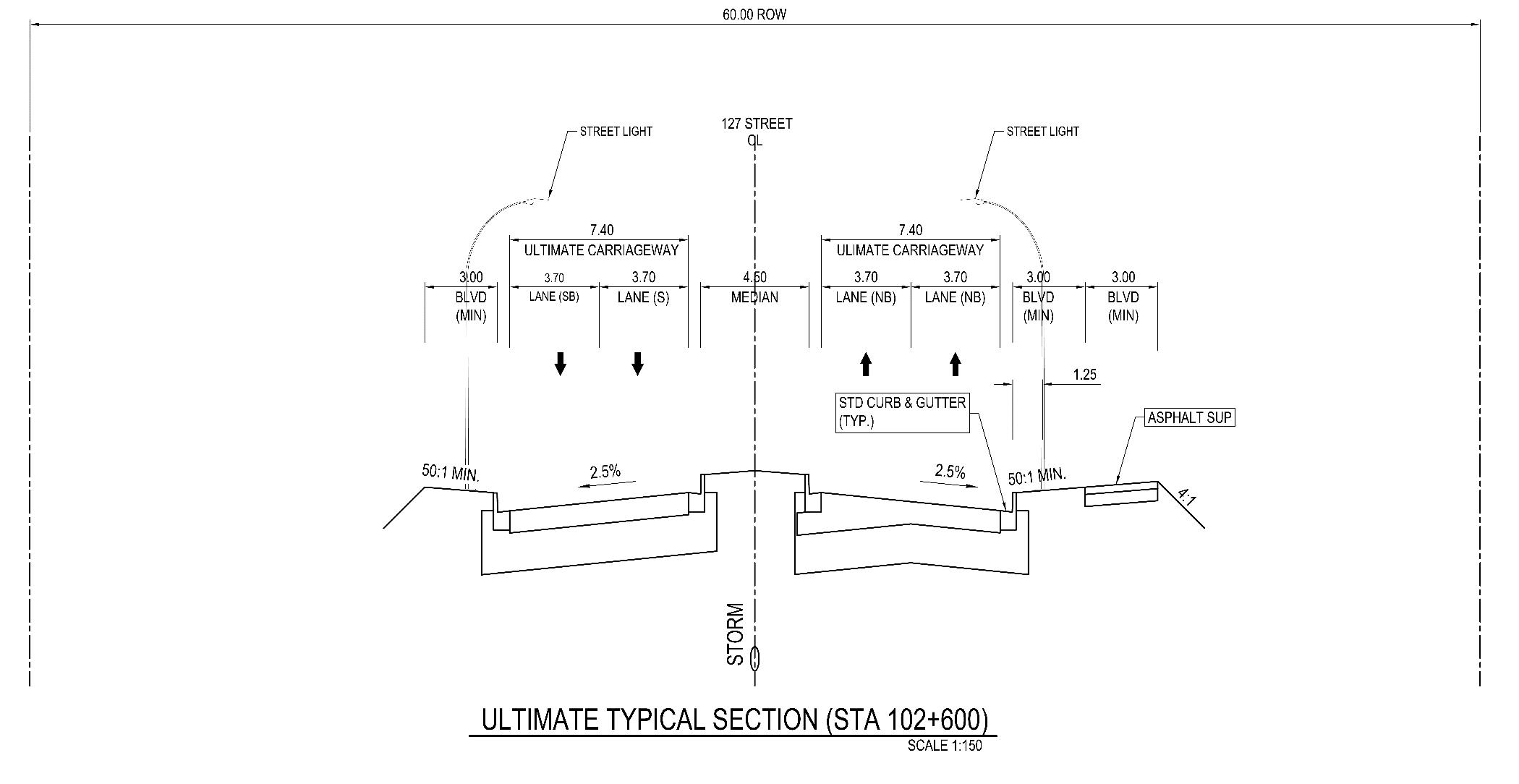
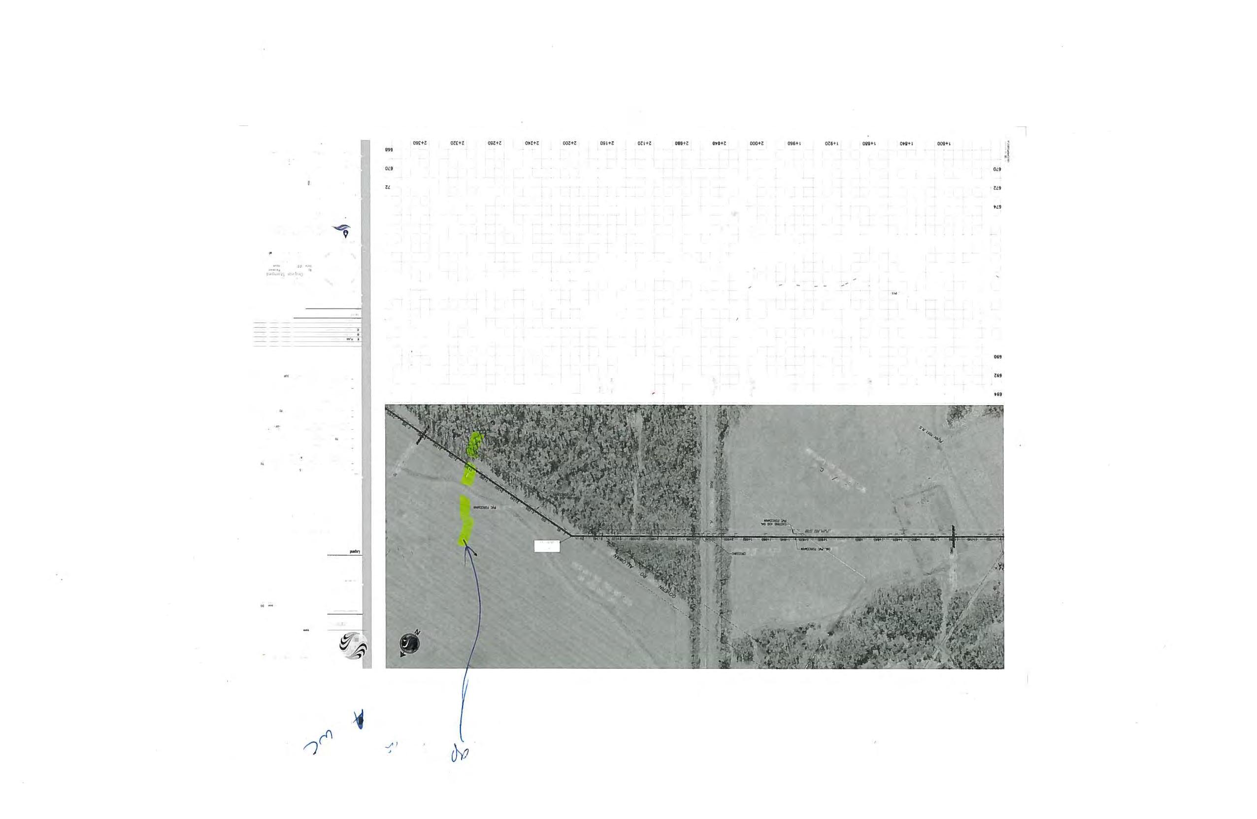
It is recommended that right-of-way be acquired and protected to allow for future growth and the ultimate cross-section of a 4-lane urban arterial. In this FPS, it is recommended that a full urban cross-section is incorporated to match the density and long-term development of the area as well as to allow for future storm connections from developments to the 127 Street storm main. For the majority of the 127 Street corridor, it is recommended that a 60m ROW be protected to allow for all urban cross-section elements. It is noted that at locations where significant grade changes are required, additional right-of-way or construction easement will be required to provide safe slopes to the existing topography. This is specifically relevant near the CN Rail crossing where steep grades as well as a grade separated crossing will require additional ROW be protected to properly construct the roadway. At this time, a 90m ROW is recommended adjacent to the CN rail crossing to allow for safe slopes back to the proposed property line.
This ROW will also provide ample area for noise attenuation should it be required at a later date. At each intersection, additional ROW (corner cuts for example) will be required to provide adequate clearance distance for turn bays, utilities and other intersection design features. The ROW for intersecting roadways is recommended to be at minimum 40m to accommodate the typical urban cross-section.
CN Rail Considerations
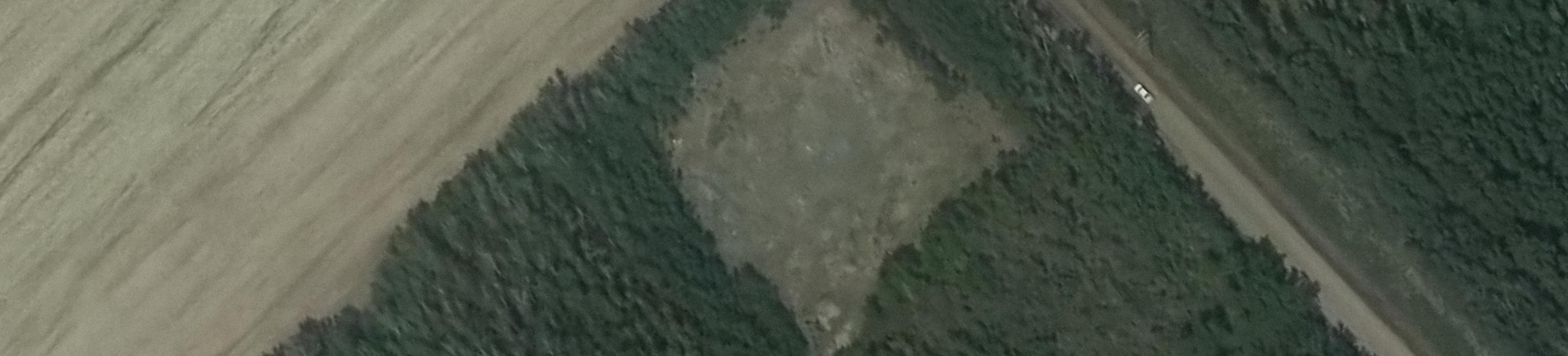
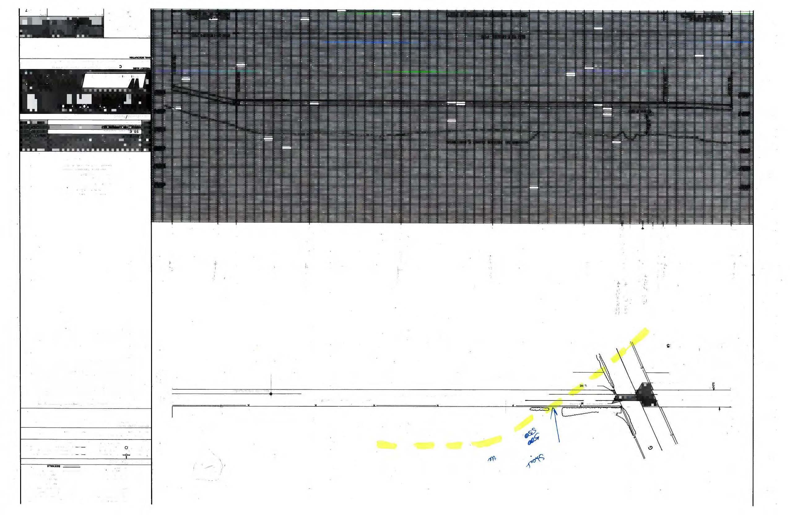
There is one CN Rail crossing that will be required along 127 Street approximately 650m east of Sturgeon Road. The rail crossing will play a major factor in the design and construction timelines for the overall construction of 127 Street. The ultimate design should account for grade separation whether it is an underground or overground structure – at this time, it has been determined that the most feasible option is for the road to pass under the rail line due to the vertical geometry of the existing topography. This should be confirmed and refined at the preliminary design stage in coordination with CN Rail.
During the interim stage, it may be possible to negotiate with CN Rail to allow for a short term at grade crossing if another crossing is closed, such as the existing crossing at Poundmaker Road and Veness Road. These discussions should begin early in the preliminary design stage to determine what is possible and feasible from an engineering perspective of all affected parties. Should an at-grade crossing be permitted in the interim stage, there will be throwaway costs incurred to convert the full 4-lane arterial to grade separation, however if this allows the project to move forward and provide a key connection within the Sturgeon Valley, it may be the most practicable option.
It is noted that structural drawings for this component were not updated as part of this functional plan. The structural drawings however are still valid from the original functional study (ISL, 2012). The span and cross-section remain largely the same with the only significant change being the addition of a trail on the north side of the roadway that can be accommodated under the existing span of the bridge. As mentioned on the structural drawings, details of the structural drawings should be refined at the preliminary design stage.
Sturgeon River Bridge Crossing
The sturgeon river bridge drawings were retained for concept purposes from the original functional planning study (ISL, 2012). The only change to the drawings that was deemed relevant was that the trail in the existing plans was shown on the south side of the bridge deck while it is recommended as part of this plan that the trail is provided on the north side of the bridge to match the trail alignment and staging within this plan.
Access Management
Access management will play an important role in maintaining 127 Street as a safe and efficient arterial roadway. Private accesses should not access directly onto the roadway if at all possible. Private accesses can be a significant safety risk to the corridor as it essentially functions as an uncontrolled intersection, where vehicles enter the roadway at a very slow rate of speed and may not be clearly visible to traffic that is travelling at higher speeds (e.g., 70km/h) The recommended plan includes several key intersections, any additional minor intersections should be limited to reduce the number of conflict areas and potential congestion zones The purpose of the 127 Street corridor is to facilitate regional traffic and
connections to the local network and there is a need to ensure the movement of people (including vulnerable users) and services is efficient and safe.
Active Modes
As the Sturgeon Valley is developed out, it will quickly become a major urban center within the County. Urban communities require effective active modes connections to due to the density and to provide an alternate mode choice for all ages and abilities. Active mode accommodations do not only include sidewalks and trails but also includes other aspects such as safe and comfortable road crossings, connections to parks and other community services and protection for each type of active mode such as cycling, pedestrian, micro-mobility users.
A 3.0m multi-use trail is proposed to be implemented along the northside of 127 Street, where the majority of the development is expected to occur. Crossings should be limited to intersections as much as possible with the potential for mid-block crossings to specific areas only if unavoidable. The trail is proposed to be separated from the roadway by a landscape boulevard to allow for active mode users to feel comfortable and protected from traffic. Within the proposed cross-section, there is space protected within the ROW for future active modes needs such as bus stops, monowalk connections or any other potential need that arises while the Valley is developed.
It is encouraged as part of the stormwater facility design that the area is accessible to the public by active modes to maintain a natural connection to the Sturgeon River, which can be enjoyed by all people, regardless of physical ability. This will also help to enhance the sense of belonging and encourage residents to be active and engaged within the community.
Signage
Informational signage along with regulatory signage should be installed at all intersections, ensuring messaging is clearly conveyed to all users. Any commercial, advertising or other private signs should be carefully reviewed prior to being installed within the ROW to ensure sightlines are maintained between both traffic and active modes along the corridor.
Noise Attenuation
While a formal acoustic study was not completed within the scope of this study, the recommended crosssection allows for noise attenuation barriers should it be required. It is not recommended that earth berms are used as the exclusive noise control method as the area is expected to be an urban environment. It is understood, that at the time of this study the County has noise attenuation policy that indicates the maximum noise level should be 65 dBA Leq (equivalent continuous sound level). Should noise levels in nearby residential areas exceed this level, noise attenuation features should be considered.
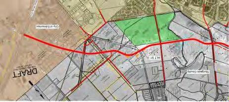
4.2. RECOMMENDED PLAN
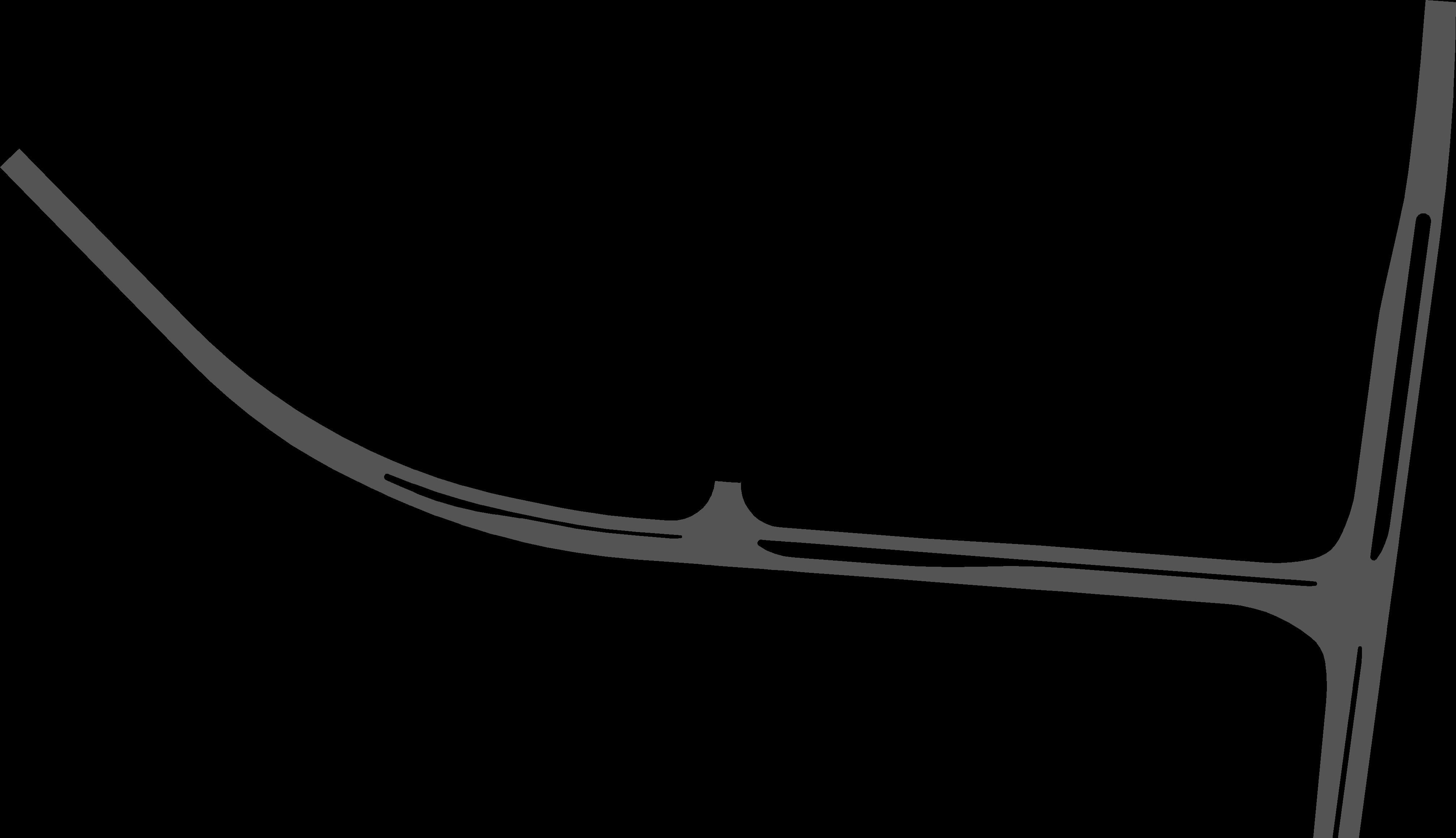
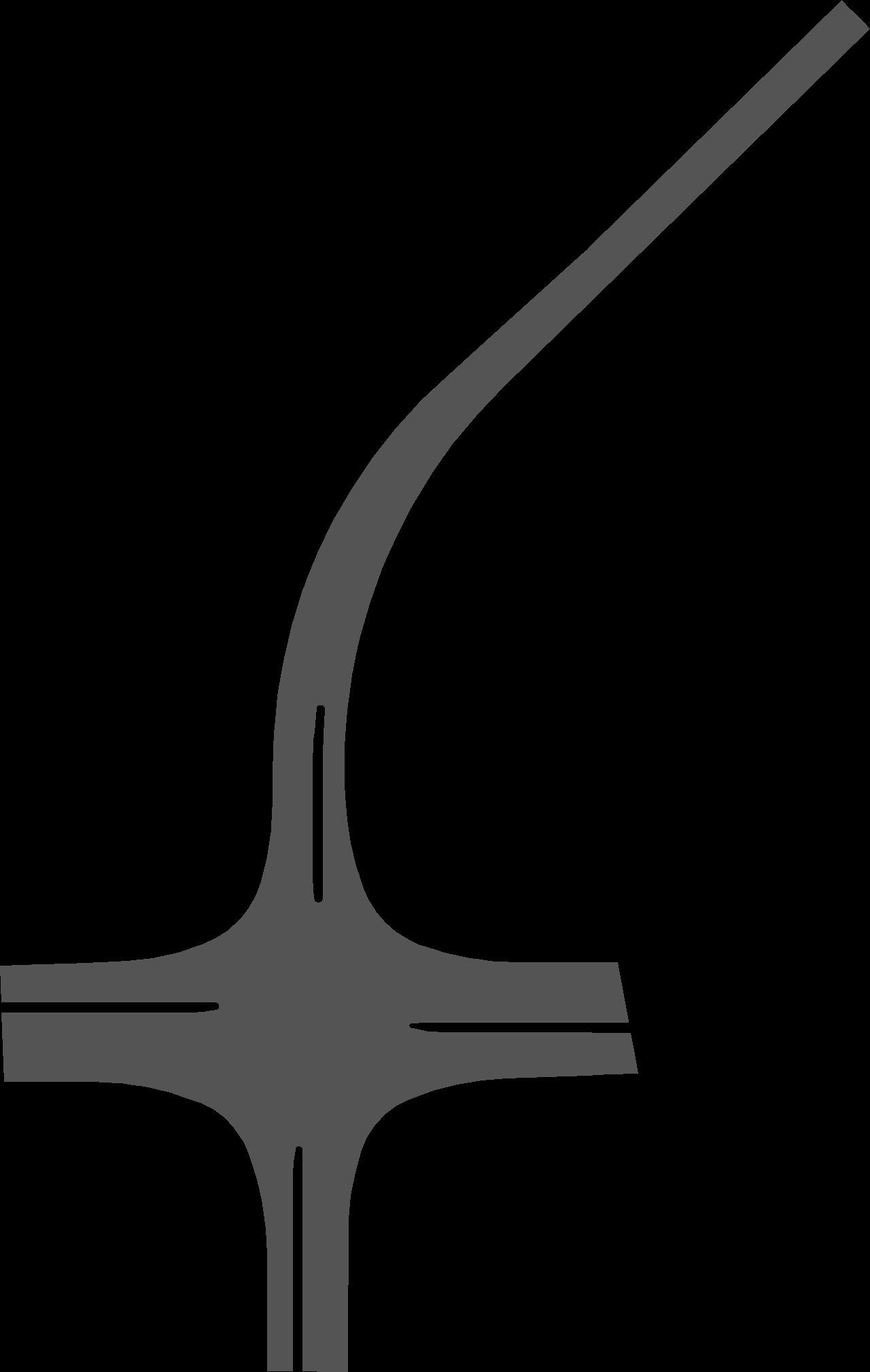
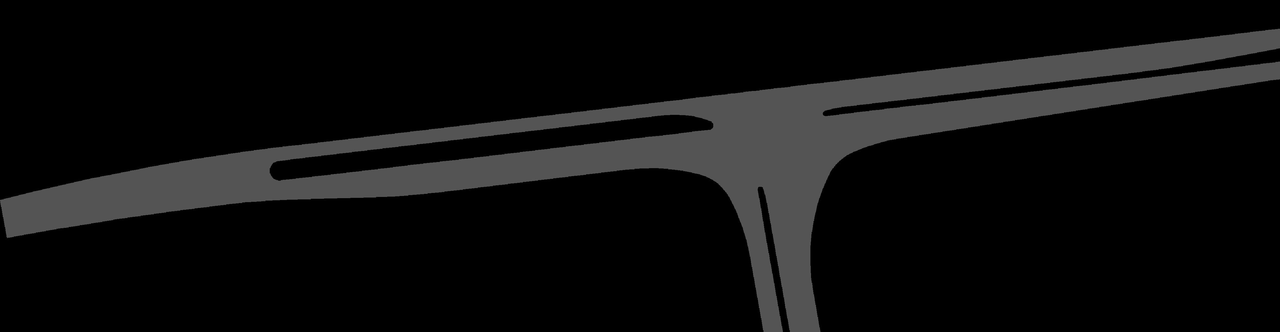
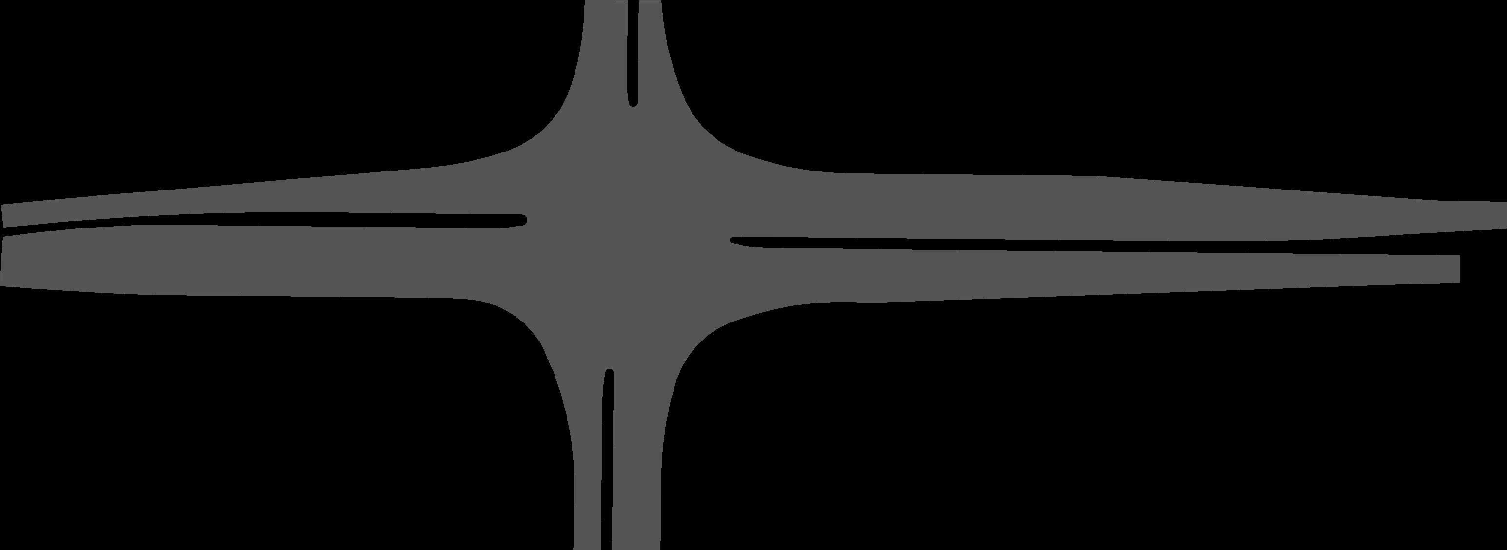
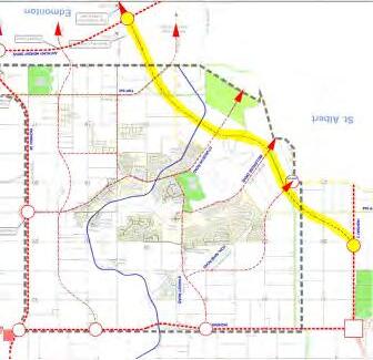
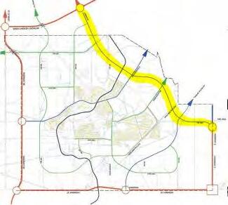
Building from the previous recommendation, the interim and updated ultimate functional plan for the 127 Street extension has been developed as part of this FPS. In the interim, a 2-lane semi-urban crosssection is proposed for the entire length of the proposed corridor while the ultimate build out of the roadway is recommended to be a divided 4-lane urban arterial roadway. Under both phases, nine atgrade intersections are recommended along the corridor as highlighted in Figure 11
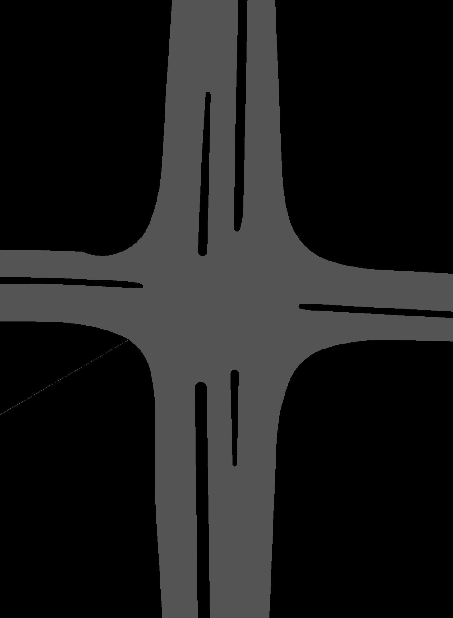
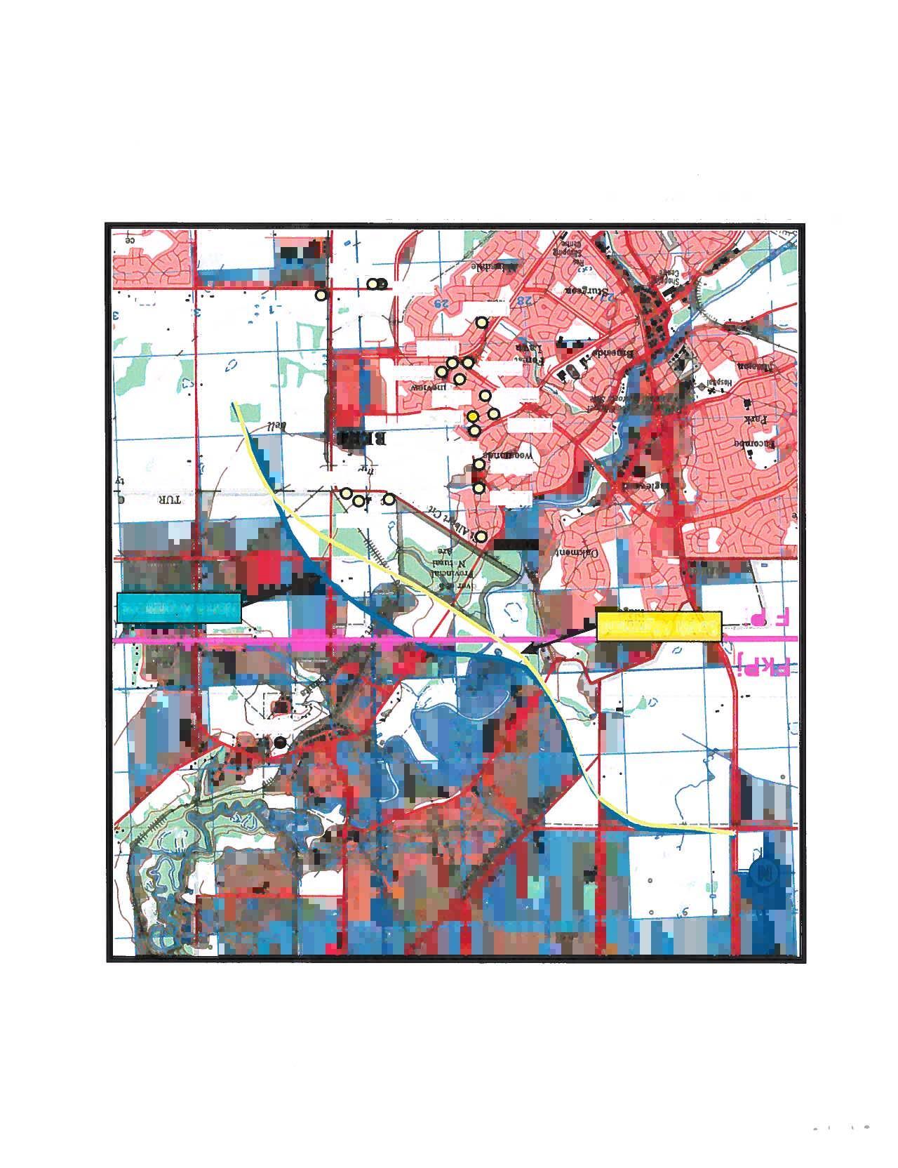
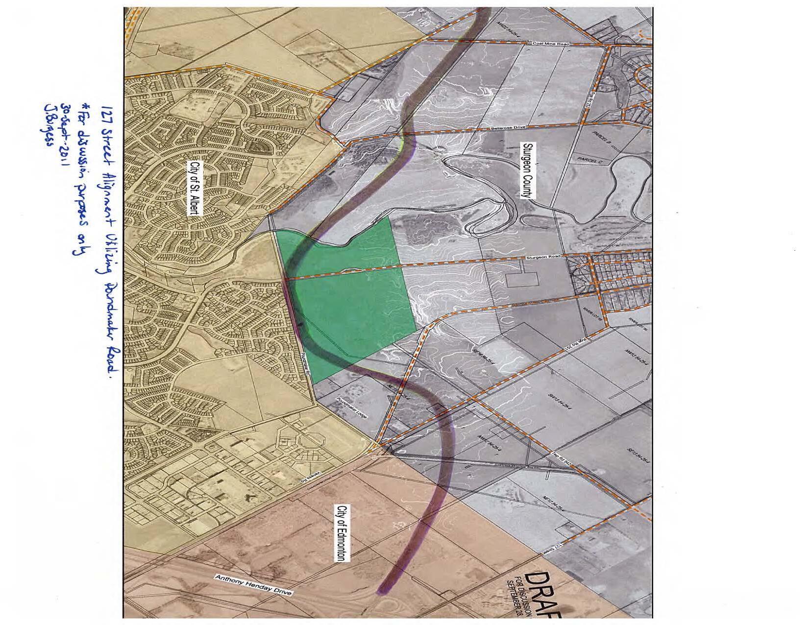
The majority of the intersections are anticipated to be signalized and provide direct connections into the Sturgeon Valley area and other local and regional connections. The proposed lane configuration and traffic control of the study intersections are summarized in Table 9 It is recommended that these lane configurations are further refined during the detailed design stage and/or when development plans are more definitive. For clarity, 127 Street is considered the northbound/southbound corridor from Corriveau Avenue to Coal Mine Road, then transitions eastbound/westbound from the New North-East Arterial to Highway 2.
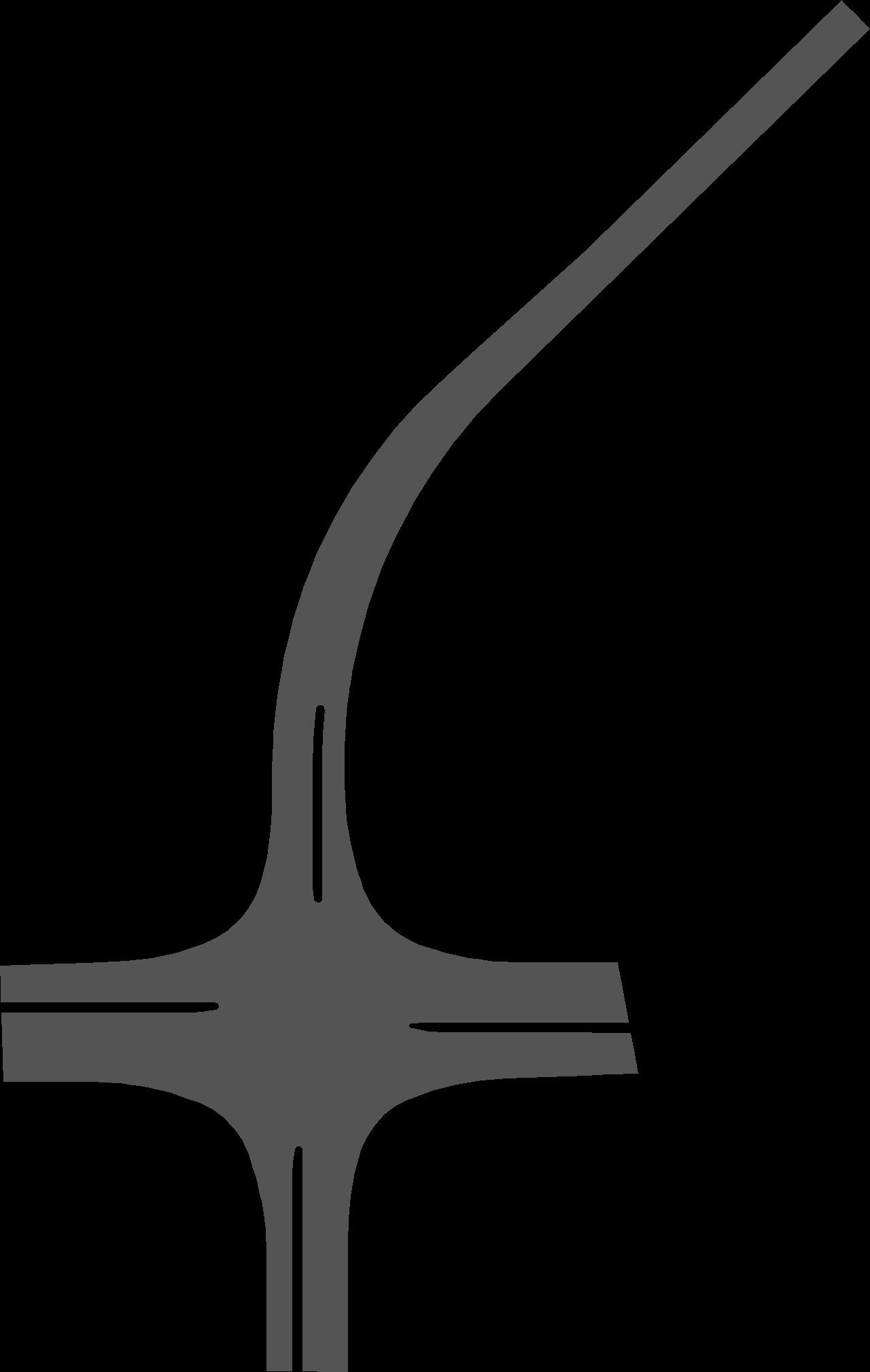
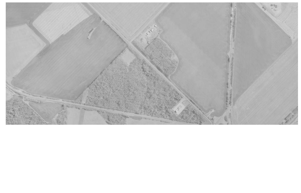
Figure 11: Proposed 127 Street Extension Alignment and Intersections
Table 9: 127 Street Proposed At-Grade Intersections
1. Corriveau Avenue Four-Legged Signal
2. Poundmaker Road T- Intersection Signal
3. Valour Avenue Four-Legged Signal
4. New EastWest Arterial Four-Legged Signal
5. Sturgeon Road
T-Intersection (Interim) Four-Legged Signal
6. Bellerose Drive Four-Legged Signal
7. Coal Mine Road Four-Legged Unsignalized
8. New NorthEast Arterial Four-Legged Unsignalized
9. Highway 2 Four-Legged Signal
Notes:
NB (127 St): 2 Left, 2 Thru, 1 Right
SB (127 St): 1 Left, 2 Thru, 1 Right
EB (Poundmaker): 1 Left, 1 Right
NB (127 St): 1 Left, 1 Thru
SB (127 St): 1 Right, 1 Thru
WB (Valour): 1 Left, 1 Thru/Right
NB (127 St): 1 Left, 1 Thru, 1 Right
SB (127 St): 1 Left, 1 Thru, 1 Right
WB (E/W Arterial): 1 Left, 1 Thru/Right
EB (E/W Arterial): 1 Left, 1 Thru/Right
NB (127 St): 1 Left, 1 Thru, 1 Right
SB (127 St): 1 Left, 1 Thru, 1 Right
NB (127 Street): 1 Left, 1 Right
EB (Sturgeon): 1 Thru, 1 Right
WB (Sturgeon): 1 Left, 1 Thru
Interim design lane configuration to be confirmed once development timelines confirm trip generation.
Interim design lane configuration to be confirmed once development timelines confirm trip generation.
Interim design lane configuration to be confirmed once development timelines confirm trip generation.
WB (127 St): 2 Left, 2 Thru, 1 Right
NB: 2 Left, 2 Thru, 1 Right
SB: 1 Left, 2 Thru, 1 Right
NB (Poundmaker): 1 Left, 1 Right
WB (127 St): 1 Left, 2 Thru
EB (127 St): 1 Right, 2 Thru
SB (Valour): 1 Left, 1 Thru/Right
WB (127 St): 1 Left, 2 Thru, 1 Right
EB (127 St):1 Left, 2 Thru, 1 Right
WB (E/W Arterial): 1 Left, 1 Thru/Right
EB (E/W Arterial): 1 Left, 1 Thru/Right
NB (127 St): 1 Left, 1 Thru, 1 Right
SB (127 St): 1 Left, 1 Thru, 1 Right
NB (127 Street): 2 Left, 2 Thru, 1 Right
SB (127 Street): 2 Left, 2 Thru, 1 Right
1EB (Sturgeon): 2 Left, 1 Thru, 1 Right
1WB (Sturgeon): 2 Left, 1 Thru, 1 Right
WB (Bellerose): 1 Left, 1 Thru/Right
EB (Bellerose): 1 Left, 1 Thru/Right
NB (127 St): 1 Left, 2 Thru, 1 Right
SB (127 St): 1 Left, 2 Thru, 1 Right
WB (Coal Mine): 1 Left, 1 Thru/Right
EB (Coal Mine): 1 Left, 1 Thru/Right
NB (127 St): 1 Left, 2 Thru, 1 Right
SB (127 St): 1 Left, 2 Thru, 1 Right
NB (NE Arterial): 1 Left, 1 Thru/Right
SB (NE Arterial) 1 Left, 1 Thru/Right
WB (127 St): 1 Left, 2 Thru, 1 Right
EB (127 St): 1 Left, 2 Thru, 1 Right
WB (127 St): 2 Left, 2 Thru, 1 Right
1 Sturgeon Road & 127 Street ultimate intersection lane configuration to be confirmed during detailed design to determine if dual turn bays are required based on updated traffic volumes.
The intersections north of the river (Intersection 6,7,8,9) also provide key connections to existing and growth neighbourhoods in northeast St. Albert. The interim configuration of these intersections will also depend on St. Albert’s plans for the annexed area at the north end of the City and once the plans are defined, the interim design can be refined. The County should continue to work with the City to ensure both municipalities’ objectives and priorities for the intersections along 127 Street are met.
Other key features that are incorporated in the updated functional plans include:
• A 3.0m shared use path on the north/east side of the roadway as well as pedestrian crossings at all intersections.
• An underground stormwater system in both the interim and ultimate design.
• The interim design was planned with the intention of minimizing throwaway costs during the upgrade to the ultimate cross-section.
• No significant changes are expected from the 2012 FPS structural drawings, therefore these drawings were retained as part of this update
Overall, it is important that the ultimate ROW be protected so that all the features of the roadway can properly be constructed. Within the design drawings the ultimate ROW is suggested to be 60m in width to allow for all roadway features, active modes features as well as utility alignments. The ROW near the CN Rail crossing will need to be much wider, 90m, as a result of steep grades and grade separation design requirements.
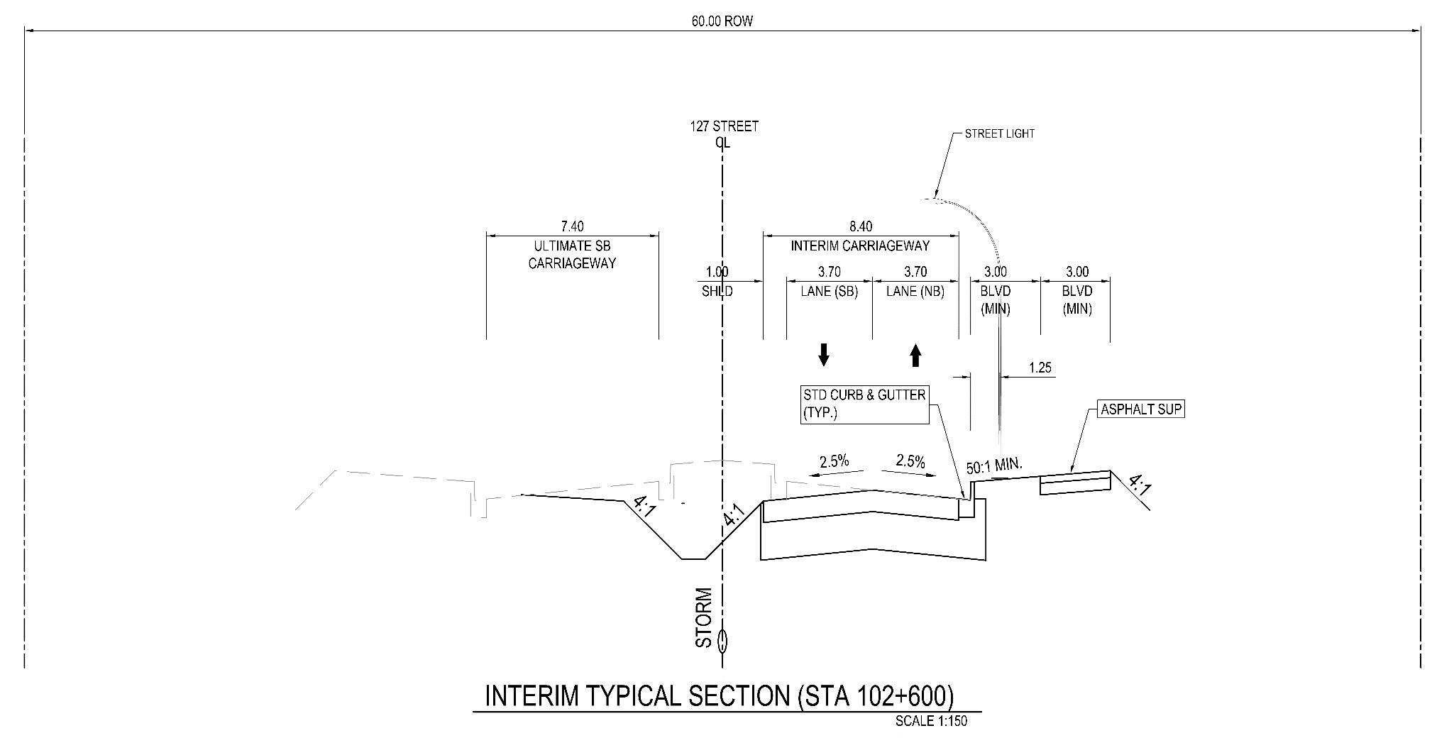
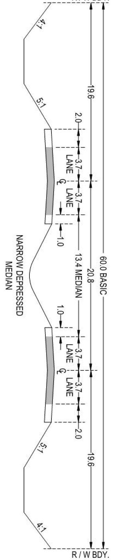
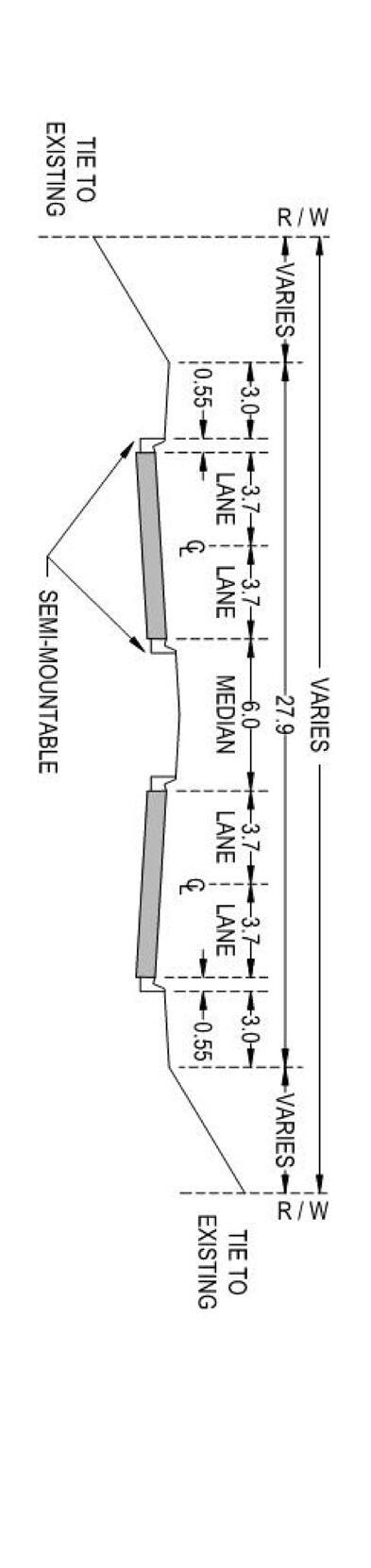
The typical cross-sections of the recommended interim and ultimate plans are highlighted in
Figure 12 and Figure 13, respectively. The recommended corridor improvements are presented with more detailed concept drawings in Appendix B.
Sturgeon Road Functional Planning Study
Final Report | Prepared for Sturgeon County Page 31
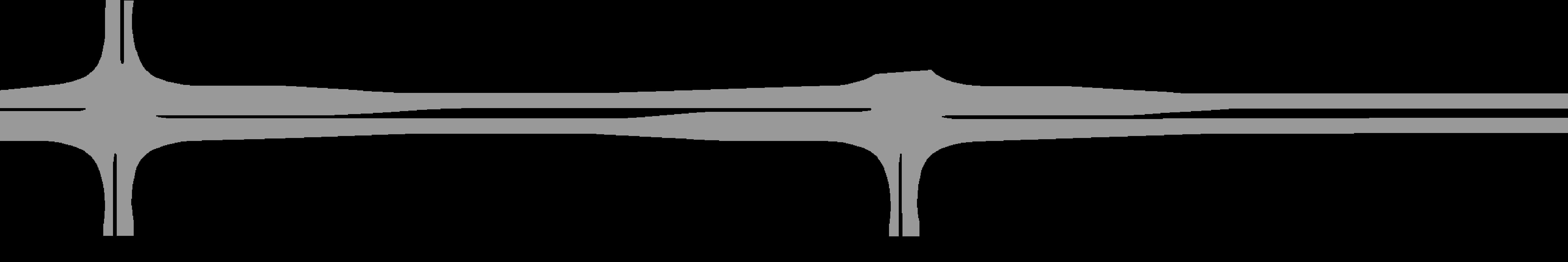
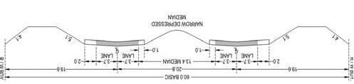
Figure 12: 127 Street Corridor Typical Recommended Interim Cross-Section
127 Street Functional Planning Update Study
Final Report | Prepared for Sturgeon County Page 32
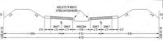
Figure 13: 127 Street Corridor Typical Recommended Ultimate Cross-Section
4.3. STAGING AND IMPLEMENTATION
The 127 Street extension is critical in facilitating connections to and from the Sturgeon Valley and therefore, the staging of construction should align with the progression of development in the Valley so that adequate connections are maintained. The staging of construction is recommended to be maintained from the 2012 FPS with the triggers for each implementation stage be driven by the development in the Valley. A summary of the recommended stages to efficiently build the 127 Street corridor are presented below.
Stage 1 – Interim Cross-Section from Corriveau Avenue to Sturgeon Road
The first phase of construction will provide the initial connection into the Valley and play a key role in providing access for the new neighbourhoods in the Sturgeon Valley. The first stage of implementation is anticipated to be a 2-lane semi-urban cross-section from Corriveau Avenue to Sturgeon Road, which generally includes 2 travel lanes, shared use path, stormwater infrastructure and illumination. The interim stage of the 127 Street extension will require a CN Rail grade separation or at-grade crossing (if permitted) however it is recommended to complete the full 4-lane arterial cross-section road underpass during Stage 1 if funding is available The first stage of stormwater implementation should include the construction of the stormwater main and north curb line catch basins. This will minimize throw-away costs during the subsequent stages and allow the twinning to occur in smaller sections, if required. All utility relocations that are required for both the interim and ultimate cross-sections are expected to take place during this stage of construction.
It is recommended that Stage 1 of construction is initiated in 2037 (assuming the high growth scenario) to support the early stages of development in the Valley. It is noted that first stage of development within Planning Area 1 is possible without 127 Street as access can be provided from Sturgeon Road. Following the completion of Stage 1 improvements, 127 Street is anticipated to operate well until the Sturgeon Valley reaches a population of approximately 26,000 people, which is estimated to occur in 2053 (based on 2% growth rate), 2082 (based on 1% growth rate) or beyond 2100 (based on 0.5% growth rate). Widening of 127 Street will be warranted as the daily traffic (AADT) on 127 Street approaches 15,000 vpd, at which point Stage 3 improvements should be completed.
Stage 2 – Interim Cross-Section from Sturgeon Road to Highway 2
Stage 2 of implementation will complete the 2-lane cross-section through to Highway 2. Depending on available funds, it may be logical to complete the connection from Sturgeon Road to Bellerose Drive followed by the remaining section from Bellerose Drive to Highway 2. No significant advantage is expected from the separation of this stage into two smaller stages other than financial staging. The overall completion of this stage will include the majority of the bridge works across the Sturgeon River, as well as the 2-lane roadway works to Highway 2. Similar to Stage 1, the ultimate stormwater main should be constructed along with the associated north curb line catch basins. Utility relocations should also be completed during this stage.
The completion of Stage 2 is required to provide an additional river crossing and facilitate alternate connections to the northern part of Sturgeon Valley (Planning Area 5 in ASP) and beyond The trigger for the Stage 2 improvements is dependent on a number of variables including future development in the recently annexed area within the City of St. Albert It is anticipated that Stage 2 will not be required until
the completion of Planning Area 1, which is expected to occur sometime between 2053 (2% growth) and beyond 2100 (1.0% growth). It is understood that development in Planning Area 5 will likely begin beyond the 2050 horizon. However, by this time, Starkey Road may reach near or at capacity conditions which may trigger the need for road widening. Through the traffic analysis, the 127 Street extension to Highway 2 was found to alleviate a significant volume of traffic from Starkey Road, therefore, as Starkey Road nears the AADT threshold of 15,000 vpd, it may be a suitable to extend 127 Street across the river. This will also help defer corridor upgrades on Starkey Road, improve traffic operations along Sturgeon Road and existing residential areas all while supporting development in the northern parts of Sturgeon Valley.
Stage 3 – Ultimate Cross-Section from Corriveau Avenue to Sturgeon Road
As development progresses in the Valley and population grows beyond 10,000 people, there will be a need to expand 127 Street to meet the anticipated traffic demands. The Stage 3 improvements include the completion of the 4-lane urban cross-section to Sturgeon Road, which would also include additional turn lanes at the various intersections.
One possible variance to this stage could be to extend the 4-lane cross-section across the Sturgeon River to Bellerose Drive and construct the associated bridge works. This additional upgrade will be driven by the availability of funding as well as existing traffic operations along the existing bridge.
Stage 3 of the 127 Street corridor upgrade is recommended as the AADT of the two-lane corridor reaches approximately 15,000 vpd The traffic projections indicate that this is expected to occur when Planning Area 1 of the Sturgeon Valley is completed (total Valley population of about 26,000 people), which is estimated to occur sometime between 2053 (2% growth), 2082 (1% growth) and beyond 2100 (0.5% growth)
Stage 4
–
Ultimate
Cross-Section from Sturgeon Road to Highway 2
Finally, the 4-lane urban cross-section should be completed for the remainder of the study corridor as feasible. Traffic projections for this section of the corridor indicate that the need for a 4-lane cross-section is not required when population in Sturgeon Valley reaches approximately 26,000 people. However, the need for this stage of improvement will become more defined as development progresses in the Valley and in northeast St. Albert. In addition to Planning Area 5 of the ASP, it is anticipated that growth in St. Albert will play a significant part in the role of this section of 127 Street and therefore, should be considered a key stakeholder in the planning and design process.
Stage 4 of the 127 Street corridor upgrade is recommended as the AADT of the two-lane corridor reaches approximately 15,000 vpd or considered a Sturgeon County priority Under the current assumptions, this is expected well beyond the 2053 horizon. Further refinement of Stage 4 should be completed as the Stage 2 improvements are designed.
4.4. COST ESTIMATES & FUNDING STRATEGY
Cost Estimates
Class A cost estimates were developed for the corridor upgrades and are summarized in Table 10 Quantities were developed by simple linear and area-based measurement take-offs. The construction costs are estimated using 2023 dollars and unit rates and include lump sum estimates of third-party utility relocations and include a 25% contingency. Engineering costs are assumed to be 12% of the total construction cost (excluding ROW acquisition costs). The overall cost of the project is estimated to be $157.7M (2023 dollars).
2 Stormwater Infrastructure includes: Manhole and Storm main installation, Catch basin and Catch basin lead installation and storm ponds. Stage 1 & 2 also includes a high-level cost estimate for an outlet structure to the Sturgeon River. It is noted that there are several environmental and other factors that may impact this cost.
3 ROW assumed to be $300,000 per hectare x 70ha. ( 41.3ha for road, 18.8ha for remnant parcels and 9.91ha for storm ponds, it is noted that an additional 3ha within the City of Edmonton is anticipated to be required to complete the 127 Street connection to Corriveau Avenue)
4 Additional Assumptions and a detailed cost estimate breakdown is provided within Appendix C.
Stage
Class
Additional Cost Information
To provide some additional cost information that may be useful for discerning cost sharing amongst affected stakeholders, a breakdown of per linear meter by cross-section is outlined below. It should be noted that additional costs were allocated to each stage of the recommended corridor to account for stage specific considerations such as stormwater management facilities, bridge/structural works, additional intersection works, utility constraints and relocations or additional earthworks requirements due to steep grades.
New 2 – Lane Semi-Urban Cross-Section
Generalized linear metre (lm) costs for the first 2-lane cross-section outlined within this functional planning study can be represented as follows:
• $4,000/lm – excludes specific intersection configurations and traffic signals, structural elements (rail crossing, sturgeon river bridge), stormwater infrastructure, utility relocations, ROW acquisition and engineering costs.
• $7,500/lm – same assumptions as above except stormwater infrastructure included.
Twinning from 2-Lane Semi-Urban Cross-Section to 4-Lane Urban Cross-Section
Generalized linear metre costs for twinning of the 2-lane cross-section to the 4-lane cross-section outlined within this functional planning study can be represented as follows:
• $3,750/lm – excludes specific intersection configurations and traffic signals, structural elements (rail crossing, sturgeon river bridge), stormwater infrastructure, utility relocations, ROW acquisition and engineering costs
• $4,000/lm – same assumptions as above except stormwater infrastructure included.
Funding Strategy
The 127 Street extension, depending on the implementation stage, will have varying travel benefits for local and regional traffic. Therefore, it is recommended that the County explore various funding and project coordination opportunities throughout each stage of project implementation. The level of contribution and partnership opportunities should be further explored and confirmed through the County’s Offsite Levy Assessment process.
5. Conclusions and Next Steps
Building off the recommended design completed within the 2012 FPS, this study update further refines the details of the 127 Street corridor design and recommended plan. This FPS confirms the recommended alignment within the previous study, provides an interim and ultimate cross-section for the staged implementation and provides the updated high-level construction and engineering cost estimates. The recommended design and implementation are as follows:
• 127 Street corridor should be implemented in the following four stages:
1. Stage 1: 2-lane semi-urban cross-section from Corriveau Avenue to Sturgeon Road
2. Stage 2: 2-lane semi-urban cross-section from Sturgeon Road to Highway 2
3. Stage 3: 4-lane urban divided arterial from Corriveau Avenue to Sturgeon Road
4. Stage 4: 4-lane urban divided arterial from Sturgeon Road to Highway 2
• Nine (9) at-grade intersections with Corriveau Avenue (signalized), Poundmaker Road (signalized), Valour Avenue (signalized), New East-West Arterial (signalized), Sturgeon Road (signalized), Bellerose Drive (signalized), Coal Mine Road (unsignalized), New North-East Arterial (unsignalized) and Highway 2 (signalized).
• Two major structural components including a CN rail grade-separate crossing (in Stage 1) as well as the Sturgeon River Crossing (in Stage 2)
• A 3.0m shared use path is designed on the north/east side of the roadway as well as pedestrian crossings at all the cross-sections. ROW is protected for optional future active modes if required.
• The introduction of an underground stormwater system to provide a future-ready urbanized environment.
The overall cost of the project is estimated to be $157.7M (2023 dollars), including construction, contingency, engineering costs and ROW acquisitions. The next steps towards project implementation include:
• Confirm development timelines.
• Confirm and secure funding for the first stages of the project
• Complete the preliminary design of the Stage 1 improvements, including utility relocation or protection requirements, detailed environmental, geotechnical and historical resources assessment specific to the project limits within Stage 1.
• Complete detailed design of the Stage 1 improvements with construction to start in 2024.
• Regular updates to the long-term plan of the corridor and design criteria are also recommended, as industry standards evolve, and the needs of the community are further defined as development progresses in the Sturgeon Valley and surrounding region.
APPENDIXA TRAFFICDATA&
ANALYSISRESULTS
Lane GroupEBLEBRNBLNBTSBTSBR
Lane Configurations
Traffic Volume (vph)238141375062125
Future Volume (vph)238141375062125
Ideal Flow (vphpl)190019001900190019001900 Lane Width (m)3.73.73.73.73.73.7 Grade (%)0%0%0%
Storage Length (m)0.00.060.060.0
Storage Lanes1111
Taper Length (m)7.67.6
Satd. Flow (prot)178916011789188318831601
Flt Permitted0.9500.742
Satd. Flow (perm)178916011398188318831601
Right Turn on RedYesYes
Satd. Flow (RTOR)15327
Link Speed (k/h)484848
Link Distance (m)203.0191.4210.7 Travel Time (s)15.214.415.8
Confl. Peds. (#/hr)
Confl. Bikes (#/hr) Peak
Blockages (#/hr)000000
Parking (#/hr)
Mid-Block Traffic (%)0%0%0%
Shared Lane Traffic (%)
Lane Group Flow (vph)259153405502327
Turn TypePermPermPermNANAPerm
Protected Phases26
Permitted Phases4426
Detector Phase442266
Switch
Total Lost Time (s)4.54.54.54.54.54.5
Lead/Lag
Lead-Lag Optimize?
Time Before Reduce (s)0.00.00.00.00.00.0
Time To Reduce (s)0.00.00.00.00.00.0
Recall ModeNoneNoneMinMinMinMin Walk Time (s)7.07.07.07.07.07.0
• Includes first half of 4-lane divided arterial cross section per interim cross-section included in report/drawings from Corriveau Avenue to Sturgeon Road. Includes all infrastructure within the cross-section including roadway works, concrete, trail, landscape features (Boulevard trees ~8m spacing), illumination (assumes ~100m spacing).
• Includes structural elements of CN rail grade separated crossing.
• Includes additional details on individual intersections shown within the plan to improve accuracy of cost estimate (turn bays, medians, etc)
• Stormwater infrastructure includes north curb line catch basins (~100m spacing) as well as Manhole installation (~100m spacing). Includes 1 Stormwater management facility east of sturgeon river however does not include estimate for river outlet structure
o Storm main assumed to be an average 900mm diameter. It is anticipated that a larger size will be required at the downstream end and smaller size on the upstream side. Minor system design confirmed with high-level rational method analysis.
• Includes costs for signalization of necessary intersections. A cost for signalization for the Corriveau Avenue intersection is not included as this would be City of Edmonton jurisdiction
Stage 2:
• Includes first half of 4-lane divided arterial cross section per interim cross-section included in report/drawings from Sturgeon Road to Highway 2. Includes all infrastructure within the crosssection including roadway works, concrete, trail, landscape features, illumination.
• Includes structural elements of Sturgeon River Bridge Crossing. This stage includes the majority of the bridge works however only the bridge deck for 2 lanes and trail to be completed at this stage.
• Includes additional details on individual intersections shown within the plan to improve accuracy of cost estimate (turn bays, medians, etc).
• Stormwater infrastructure includes north curb line catch basins (~100m spacing) as well as Manhole installation (~100m spacing). Includes 1 Stormwater management facility west of sturgeon river however does not include estimate for river outlet structure
o Storm main assumed to be an average 900mm diameter. It is anticipated that a larger size will be required at the downstream end and smaller size on the upstream side. Minor system design confirmed with high-level rational method analysis.
• Includes costs for signalization of necessary intersections.
Stage 3:
• Includes completion of 4-lane divided arterial cross section per ultimate cross-section included in report/drawings from Sturgeon Road to Highway 2 Includes all infrastructure within the crosssection including roadway works, concrete, landscape features, second line of illumination.
• Includes additional details on individual intersections shown within the plan to improve accuracy of cost estimate (turn bays, medians, etc).
• Stormwater infrastructure includes south curb line catch basins (~100m spacing) as well as Manhole adjustments to ultimate elevation and appropriate frame & grate.
• Includes costs for adjustments to signals to align with ultimate intersection configuration.
Stage 4:
• Includes completion of 4-lane divided arterial cross section per ultimate cross-section included in report/drawings from Sturgeon Road to Highway 2. Includes all infrastructure within the crosssection including roadway works, concrete, landscape features, second line of illumination.
• Includes structural elements of completion of Sturgeon River Bridge Crossing including bridge deck for ultimate cross-section.
• Includes additional details on individual intersections shown within the plan to improve accuracy of cost estimate (turn bays, medians, etc).
• Stormwater infrastructure includes south curb line catch basins (~100m spacing) as well as Manhole adjustments to ultimate elevation and appropriate frame & grate.
• Includes costs for adjustments to signals to align with ultimate intersection configuration.
127th Street, Sturgeon County, Functional Planning Study
Environmental Overview
Final Report
Prepared for:
ISL Engineering and Land Services Edmonton, Alberta
Prepared by:
Spencer Environmental Management Services Ltd. Edmonton, Alberta
Project Number EP 492
May 2012
Figure
List of Tables
List of Plates
Plate 1. Distance view of eastern parcel of Riverlot 56, May 2011, looking southwest from Sturgeon Road .................................................................................................. 14
Plate 2. Trembling aspen and balsam poplar dominated stand, west section of Riverlot 56, May 2011 ............................................................................................................ 15
Plate 5. Woodland Wo3 with well-developed understory, 02 June 2011 ........................ 18
Plate 6. Woodland Wo3 (to left) and floodplain along Sturgeon River.......................... 18
Plate 7. Woodland Wo4, looking east from Bellrose Drive, 05 May 2011 ..................... 19
Plate 8. Woodland Wo5, terminal ravine (background), looking E from Rge Rd 253. Standing water in foreground abuts the ravine and may be the result of blocked drainage. .................................................................................................................... 20
Plate 9. Typical degraded potential wetland in farm field along TWP Rd 544 ............... 21
Plate 9. Floodplain along east bank of Sturgeon River, looking east, June 2011 ............ 22
Plate 10. Oxbow looking N, riparian zone to left and Wo3 to right, June 2011. ............. 22
1.0 INTRODUCTION
1.1 Background
Sturgeon County (the County) is undertaking functional planning for a proposed realignment of 127th Street that would link Anthony Henday Drive, in the City of Edmonton, to Highway 2 north of St. Albert. The majority of the alignment is situated in Sturgeon County. Two alignments are under consideration as a result of a previous study by CH2MHill in 2010. The County has retained ISL Engineering and Land Services (ISL) as prime consultant for the functional planning study. Terms of Reference (TOR) issued by Sturgeon County indicated that an environmental program should form part of the functional planning exercise. Accordingly, ISL retained Spencer Environmental Management Services Ltd. (Spencer Environmental) to act as environmental consultant. During early planning stages, the County determined an Environmental Overview in support of final alignment selection to be the appropriate at this time.
This report describes the scope, results and conclusions of the environmental exercise to date and identifies some of the additional environmental information that will be necessary to support environmental permit applications that may be required in future project planning phases.
1.2 Objectives
The objectives of this Environmental Overview were as follows:
Assemble available environmental information for all alignments under consideration.
Identify the primary environmental considerations/issues associated with the two alignments that must be addressed.
Determine if there are any known environmental issues or resources associated with alternative alignments that may render them unviable options.
Determine, from an environmental perspective, which route is preferred, based on existing information and identifiable permitting considerations.
Identify any alignment modifications that would result in reduced environmental impacts.
Identify any additional investigations that should be undertaken in order to generate new environmental information that will be required for environmental assessment and permitting requirements or to make an assessment of the relative merits of the alternative routes.
1.3 Study Area
The Environmental Overview study area was delineated so as to encompass all lands crossed by and all features potentially affected by the two alignments under consideration for this study, excluding the section of the alignment to be situated in the City of Edmonton, in the developing Goodridge Corners Neighbourhood. That segment was excluded for the following reasons. The Goodridge Corners NASP (Stantec 2009), although not yet approved, shows only one 127 Street alignment through that
neighbourhood. Environmental studies undertaken in support of the Goodridge Corners NASP appear to have considered all existing natural features in the NASP lands and shows that all natural features to be retained are well to the southwest of the new 127 Street. The study area delineated for this Environmental Overview is shown in Figure 1..
1.4 Report Organization
This Environmental Overview comprises eight chapters. Chapter 1 (Introduction) provides background information related to the proposed project and the report structure. Chapter 2 (Description of Future 127 Street and Alignments under Consideration) briefly describes the new roadway and proposed alignments. Chapter 3 (Assessment Methods) outlines the assessment methodology used in the Environmental Overview exercise. Chapter 4 (Existing Conditions) details existing environmental resources within the study area. Chapter 5 (Environmental Issues) introduces key environmental concerns related to the proposed alignments. Chapter 6 (Alignment Comparison) discusses potential impacts associated with each proposed alignment. Chapter 7 (Summary/Conclusions) summarizes the Environmental Overview results and provides justification for alignment preference. Chapter 8 (References) provides a complete listing of all references used in preparation of this report.
2.0 DESCRIPTION OF FUTURE 127 ST AND ALIGNMENTS UNDER CONSIDERATION
Long-term regional roadway planning shifts 127 Street (known in Sturgeon County as Range Road 250) to the west of its current alignment. The existing Range Rd 250 (127 Street) terminates at the Tuscany Hills subdivision, linking to the northern terminus of Sturgeon Road. The new 127 Street realignment will begin at the 127 Street/Anthony Henday Drive interchange, move in a northwesterly direction, cross the Sturgeon River Valley, veer west and follow TWP 544 to connect with Highway 2 (Figure 1). The total roadway length is approximately 7.5 km.
The ultimate design for the new 127 Street is a four-lane, paved arterial roadway. Regardless of final alignment, important physical features influencing technical road design and precise alignment location are: the river valley crossing, the CNR rail crossing west of Range Road 251, crossings at existing roadways and the need to be consistent with existing planning for 127th Street at the City of Edmonton boundary. West of Range Rd 251, the new 127 Street will be depressed to travel under the CNR tracks, will cross Sturgeon Road at grade and then travel over the Sturgeon River by way of a bridge. The new 127 Street will not be a designated truck route.
At the time of this Environmental Overview exercise (in 2011), little additional detail was available regarding road design. Although the precise footprint of the roadway will be determined during the detailed functional planning exercise, this was not yet done at the time of assessment. Although the ultimate paved roadway surface is assumed to be 32 m, the final ROW width will be determined by the cross section used (rural, urban or a mix) and the road plan/profile. ISL has indicated that the final ROW width could be as wide as 100m in some locations. This Environmental Overview, therefore, assumed a standardized 100m ROW. In certain locations there may be a need to temporarily disturb additional lands (up to 20 m in width) to achieve final grades and accommodate construction, however, those locations are not known at this time. This was not, therefore, accounted for in our assessment. Our assessment also assumed that runoff from the bridge and the approaches will not drain directly into the Sturgeon River and thus four stormwater ponds are assumed to be required in the river valley (Figure 1). For this exercise, pond location and size shown were conceptual only. Future stormwater pond planning can be flexible to some degree, to accommodate environmental considerations.
Presently, there is no schedule for future planning and construction. Construction would likely be staged, with a two-lane roadway being constructed in the first stage.
During this functional planning study, two alignments are under consideration, S-1 and N1-A, (hereafter referred to as South and North alignments) (Figure 2) (CAD data provided to us on 15 2011 June by ISL). Although the two proposed alignments become distinct just north of the City of Edmonton boundary and remain separate from there to Bellerose Drive, they are identical for the remainder of the route. Where common, the two alignments are shown as one alignment on Figure 2. Two versions of the north
alignment (N-1A and N-1A-2) are under consideration, with the difference between the two limited to the river valley crossing location (Figure 2).
3.0
ASSESSMENT METHODS
Commensurate with the level of design detail available during functional planning, this environmental overview could not include a detailed comparative analysis of environmental impacts. Rather, the exercise was focused on identifying the preferred alignment from an environmental perspective, by considering the direct, physical and biological effects associated with each option. The exercise focused on identification and reconnaissance level investigation of natural features and resources in the study area. Considerations related to existing buried and surface infrastructure (such as pipelines and residences, respectively) were addressed by others under separate cover. At this point in planning, indirect effects associated with the presence of the new roadway (such as the effects of traffic noise), were considered but not to the same degree. While indirect impacts associated with a new roadway are expected to occur with both alignments, these were not the focus of this exercise. The specific type and magnitude (severity) of indirect impacts are much more difficult to accurately identify with the level of information available at this time. Indirect impacts vary with design detail, vertical roadway profile, precise roadway location, traffic volumes etc., whereas direct effects such as encroachment on a woodland or removal of a wetland can be more accurately identified. Direct effects were, therefore, the focus of this exercise.
The following tasks were undertaken to identify key environmental considerations associated with the two proposed 127 Street alignments proposed by ISL and Sturgeon County:
Review of proposed alignments provided to us in CAD format, by ISL, in June 2011.
Review of all relevant planning documents associated with proposed development in the immediate area of the proposed alignments.
Review of aerial photography covering the alignments, noting physical features, such as wetlands and woodland patches, situated along or near the proposed alignments.
Site reconnaissance surveys on 04 May 2011 and 02 June 2011.
Determination of the approximate length of the floodplain crossing required by each of the proposed alignments.
A search of the Alberta Conservation Information Management System (ACIMS) for any known occurrences of special status plant species or plant communities in the immediately vicinity of the proposed alignments, conducted 31 May 2011.
A search of the Fish and Wildlife Information Management System (FWMIS) for records of any special status wildlife species in the immediate vicinity of the proposed alignments, conducted 31 May 2011.
Review of other relevant reports and documentation provided by Sturgeon County.
Limited access to lands crossed by the alignments influenced our assessment methods and limited our ability to view all natural features at close range.
3.1 Detailed Methods
3.1.1
Literature Review
Numerous documents were provided by Sturgeon County in support of this project. These reports were reviewed for their relevance both in terms of environmental resource information and geographic proximity to the proposed alignments. Based on this review, the following documents were considered most relevant to this preliminary assessment.
Sturgeon Valley Trails Plan (EDA 2004)
Sturgeon Valley Vision Transportation Planning Study (Stantec 2009)
Sturgeon Valley Area Structure Plan (Armin A Preiksaitis & Associates 1999)
o Quail Ridge Outline Plan (Stantec 2010)
Goodridge Corners Neighbourhood Area Structure Plan (Stantec 2009)
Phase I ESA, River Lot 57 (Hoggan 2007)
Phase I ESA, River Lot 58 (Hoggan 2007)
Preliminary Geotechnical Investigation, River Lot 58 (J.R. Paine & Associates 2006)
Preliminary Geotechnical Investigation, River Lot 57 (J.R. Paine & Associates 2006)
Vegetation Analysis of the Athabasca University Site, Preliminary Analysis (Achuff and Talbot 1971).
Information in these documents was used to identify natural resources/biophysical features in the vicinity of the proposed alignments and assess their value and potential future status.
3.1.2 Identification of Wetland and Woodland Features
Potential wetlands and natural woodlands in the study area were first identified through a desktop analysis of aerial photography and GoogleEarth satellite imagery and/or from the roadside. The aerial photography review utilized City of Edmonton and City of St. Alberta regional images from 2005-2009. Since no detailed fieldwork was undertaken for this analysis, and visibility from the roadside for small features was limited, wetland features are listed as potential. For the purposes of this exercise, we defined potential wetlands as any areas prone to water retention and having no significant (mappable) shrub or tree cover (and therefore readily visible on the aerial photographs as having standing water or stained (wet) soils). These features were typically identified in agricultural lands, clearings and along roadsides. In future planning stages, additional ground truthing will be required to conclusively determine the presence of wetlands.
3.1.3 Site Reconnaissance
Site reconnaissance (ground truthing) was limited in scope by permission to access privately held lands. Unroaded lands investigated on foot included: all proposed river crossing locations (but viewed from the southeast riverbanks only); portions of Riverlot 56 Natural Area; and portions of the riparian woodland in Riverlot 57, southeast of the river. In addition, all identified natural features situated alongside existing roads were
viewed from the roadside. Where feasible, we recorded dominant plant species and wildlife species observed; however, no systematic wildlife or vegetation surveys were conducted.
3.1.4 Alignment Comparison
Direct physical effects of each alignment were determined by overlaying the ISL CAD files on the most recently available aerial photographs, establishing a 100 m buffer (50m either side of each alignment) and examining the overlap with identified physical features. Assessment of additional associated direct and indirect effects was done on the basis of our professional experience and familiarity with ecological theory and road impact literature. Indirect impacts were considered in a more general way as they require more detailed design information to be comprehensively and confidently assessed.
4.0 EXISTING CONDITIONS
4.1 Regional Setting/Natural Region
The proposed route for 127 Street is located within the Central Parkland Subregion of the Parkland Natural Region (Natural Regions Committee 2006). Two forest types predominate within this subregion. Trembling aspen (Populus tremuloides) is characteristic over much of the area, whereas balsam poplar (P. balsamifera) is common on poorly drained sites. Both forest types usually have a well-developed and diverse shrub understory, which is typically dominated by species such as snowberry (Symphoricarpos albus), saskatoon (Amelanchier alnifolia), beaked hazel (Corylus cornuta), chokecherry (Prunus virginiana), red-osier dogwood (Cornus stolonifera) and willow (Salix spp.). Dark brown and dark gray chernozems and luvisolics are the typical soils. However, native vegetation is uncommon over much of this subregion because of extensive agriculture and other types of human development. As a result, forested habitat is often limited to rough terrain or areas with solonetzic soils (Natural Regions Committee 2006).
Mean annual temperature in the subregion is 2oC with an average summer temperature of 13oC (Achuff 1994). Annual precipitation averages 350 to 450 mm of which 300 mm falls during the summer months.
4.2 Study Area
In June 2011, six (6) woodlands were situated in the study area; nine (9) potential wetlands were identified during field exercises and an additional two (2) were identified through satellite imagery analysis (Figure 3). The following are very brief descriptions of each identified feature.
4.2.1 Woodlands
4.2.1.1 Riverlot 56
Riverlot 56 is a protected, provincial Natural Area, covering a total of 108 ha. The area is situated southeast of and adjacent to the Sturgeon River and is within the study area but also extends south to the boundaries of the City of St. Albert. Ownership was transferred from the federal government to the provincial government in 1965 and the area has been informally and formally used for recreation since that time. In 1984, the provincial government granted a recreational lease for this Crown land to the Riverlot 56 Natural Area Society for the sole purpose of recreation, conservation and environmental education (Holland pers. comm.) Today, Riverlot 56 Natural Area is managed by Sustainable Resource Development, Public Lands Division, under the Wilderness Areas, Ecological Reserves, Natural Areas and Heritage Rangelands Act, with direct input from Alberta Tourism Parks and Recreation (TPR) and final management approval residing with the TPR Deputy Minister. The Province notes that many user groups and individuals currently use this area.
At present, Riverlot 56 Natural Area is split into two parcels by Sturgeon Road and thus is, in effect, two woodlands: the larger parcel, approximately 75 ha in area, is situated to the east of Sturgeon Road and given it’s separation from the remainder, can be considered an upland forest, despite being situated on the upper river valley slopes; the smaller parcel (approximately 33 ha) is consider to be riparian forest as it is situated to the west of Sturgeon Road and extends uninterrupted down to the river’s edge. The total length of Sturgeon Road situated between the eastern and western parcels is approximately 780 m (Plate 1). The canopy of Riverlot 56 is dominated by mature trembling aspen and balsam poplar with paper birch found on moister slopes and white spruce found occasionally throughout (Plate 2). Mature trees reach up to 20 m in height. The western parcel has a substantial hayfield at its centre. The northern edge of the western parcel is demarcated by a recently cleared, narrow corridor that appears to be the result of installation of a new fence. Numerous formal trails are located throughout Riverlot 56; the western parcel contains a single loop trail, while the larger eastern parcel has a network of trails throughout, including ones along the perimeter and through the centre of the woodland.
Plate 1. Distance view of eastern parcel of Riverlot 56, May 2011, looking southwest from Sturgeon Road
Plate 2. Trembling aspen and balsam poplar dominated stand, west section of Riverlot 56, May 2011
4.2.1.1
Woodland Wo1
Woodland Wo1 is a small (approximately 2.7 ha), balsam poplar/aspen woodland situated immediately east of Range Road 251. The patch is of mixed age, with young regrowth at the edges and more mature trees at the centre.
4.2.1.2
Woodland Wo2
This woodland is a larger (20.5 ha) triangular stand bounded on the east by Range Road 251, the north by cultivation, the west and southwest by a CNR rail line and on the southern tapered tip, by the intersection of a rail line and Veness Road (Plate 3) (Figure 2). This area is an intact balsam poplar/aspen forest with a well-developed understory (Plate 4). Satellite imagery suggests the woodland may include one or two small wetlands (unmapped). The woodland is intact except for the small clearings near edges created for: 1) a telecommunications tower, 2) a pipeline and 3) what appears to have formerly been a residence. The woodland shape and size suggests it may comprise habitat that would support birds dependent on interior habitat (i.e., specialist species that are less tolerant of human disturbance). After Riverlot 56 Natural Area, this forest stand is the most significant block of upland forest habitat in the area. It currently supports no trails or formal recreational use. The Sturgeon Valley ASP does not recognize this area as a natural feature, instead, classifying it as agricultural land, likely based on now outdated natural areas mapping undertaken by the County in 1981. At that time, as a rule, only very large features were recognized as natural areas, owing to the scale of the survey area and the planning values and goals in place at that time. Applying today’s values, which
Plate 3: View of south tip of Woodland Wo2.
Plate 4: Shrubby understorey at edge of Woodland Wo2
account for natural features as a diminishing resource and tend to value smaller habitat patches, we would identify this as a feature worth retaining in a developed landscape. In addition, the woodland’s proximity to Riverlot 56 increases its habitat and overall ecological value. At present, there are no NASPs for these lands, thus there is potential for this forest community to be recognized in future plans as worth retaining.
4.2.1.3 Woodland Wo3
This 10.7 ha, riparian forest community, situated immediately east of the Sturgeon River, is dominated by mature balsam poplar, with younger aspen clones throughout. It has a well-developed shrubby understorey that includes some young white spruce (Picea glauca), red-oiser dogwood (Cornus stolonifera), Wood's rose (Rosa woodsii), prickly rose (Rosa acicularis), western snowberry (Symphoricarpos occidentalis), black gooseberry (Ribes lacustre), Manitoba maple (Acer negundo) and occasional white spruce saplings interspersed throughout (Plate 5). The understory includes some herbaceous species that indicate moist soils, such as common horsetail (Equisetum arvense). Like the riparian lands up and downstream, this woodland is noted in the Sturgeon Valley ASP as an environmental protection zone that will remain as undeveloped Environmental Reserve in future. The woodland is bounded by the Sturgeon River on the west, a river oxbow to the north, and a cultivated field on the east and south.
To the south, a narrow (85 m) rectangular extension of a cultivated field separates Wo3 from the western parcel of Riverlot 56; however, adjacent to the active floodplain (Plate 6), the Wo3 woodland extends south to connect with Riverlot 56. The extension comprises a regenerating mixedwood stand approximately 0.9 ha in area (Figure 2), with a small wetland component (labeled on Figure 2). This small, young community consists of a canopy of young white spruce and balsam poplar (Populus balsamifera) with willows (Salix spp.), alders (Alnus spp.) and aspen poplars (Populus tremuloides) interspersed throughout the shrub layer and wetland species, particularly reed canary grass (Phragmites australis), dominate the herbaceous layer. This riparian area may have been cleared at one time by the landowner but appears to have been left to regenerate, possibly because it is often too wet to reliably farm. In June of 2011, the area was actively flooded. This regenerating area is equally connected to Riverlot 56 and to Wo3; however, it is included in Wo3 because it is north of the formally defined, fenced, administrative boundary of Riverlot 56.
Plate 5. Woodland Wo3 with well-developed understory, 02 June 2011
Plate 6. Woodland Wo3 (to left) and floodplain along Sturgeon River
4.2.1.4
Woodland Wo4
Woodland Wo4, situated northwest of the river, on the upper valley slope, and immediately east of Bellerose Drive, (Figure 2; Plate 7) is a 6.9 ha mixedwood stand. It was not possible to examine the interior of this stand but it appears on imagery to be relatively homogenous and as viewed from the roadside is dominated by mature white spruce.
4.2.1.5
Woodland Wo5
This woodland occupies a short, terminal ravine situated just northwest of Bellerose Drive and stretching west to Range Road 253. Without permission to access land, only the westernmost area was visible from a distance the roadside. The raven woodland canopy appears from a distance to be dominated by trembling aspen and balsam poplar but mature white spruce may occur in some areas. A short, secondary drainage was situated on the westernmost extreme. In May 2011, an area of open water was present in that drainage, extending west from the ravine and abutting Range Road 253 (Plate 8) (see also wetland section). Satellite imagery suggests this is the result of a laneway blocking drainage.
Plate 7. Woodland Wo4, looking east from Bellrose Drive, 05 May 2011
Plate 8. Woodland Wo5, terminal ravine (background), looking E from Rge Rd 253. Standing water in foreground abuts the ravine and may be the result of blocked drainage.
4.2.2 Wetlands
Most of the potential wetlands situated in the study area were small and isolated and appeared to be degraded (Plate 9). The wetlands were too small to delineate at the mapping scale used for other features but general locations are shown on Figure 2. Eight potential wetlands are situated west of Coal Mine Road, primarily along Township Road 544. An engineered drainage channel is also situated to the south of Township Road 544. The channel is obvious on some aerial photographs but is a more subtle feature in the field. A ninth mapped potential wetland is situated immediately east of the Sturgeon River and noted above as part of an extension of woodland Wo3. Analysis of satellite imagery suggests the presence of two small wetlands east of Range Road 251 (Figure 2). In addition, field investigations revealed standing water in the westernmost extreme of a ravine noted on Figure 2 as Wo5. This appears to be a wetland but it may not be naturally occurring. Satellite imagery suggests that this is a short, blocked drainage to the mainstream of the ravine.
Each of the above potential wetlands will require additional investigation during future planning and if natural wetlands are present and affected by development, they will require approval for removal, in accordance with the Alberta Water Act and the Province’s Interim Wetland Management in the Settled Area of Alberta. All of these wetlands should be investigated further in future planning phases.
4.2.3
Active River Floodplain
In the study area, the Sturgeon River is situated in a wide, U-shaped valley, characterized by long, gentle slopes on both sides. Much of the valley has been altered for cultivation. Mapped floodplain limits were not available to us for this study. The river channel and naturally vegetated floodplain are relatively narrow. A narrow zone dominated by wetland grasses, such as reed canary grass, likely represents the frequently flooded zone (Plate 10; Figure 2). Lands that we assume to be in the 1:100 year floodplain have been altered for agricultural purposes. In May and June 2011, when the river was very high, cultivated parcels west of the river were flooded to their upslope margin (Figure 2). Spring 2011 observations suggest that in the study area, the floodplain is wider to the west of the river than the east. The floodplain occupies the majority of the agricultural field to the west of the Sturgeon River, while occupying a comparatively narrow riparian zone to the east of the river. Deer tracks and a muskrat were observed in the floodplain on 02 June 2011.
East of the river and immediately north of woodland Wo3, the active floodplain widens significantly and is occupied by a classic river oxbow (Figure 2; Plate 11), extending north beyond the study area. The oxbow channel, which was fully flooded in June 2011 measures approximately 940 linear m. At that location, the floodplain measures approximately 300 m wide, from the east river bank east to the wooded floodplain margin. In June 2011, the oxbow and adjacent lands were flooded and appeared to function much like a wetland. This oxbow and adjacent open riparian lands appear to be in good condition (non-degraded) and during our reconnaissance survey several bird species were noted, including red-winged black bird, yellow warbler, blue-winged teal,
Plate 9. Typical degraded potential wetland in farm field along TWP Rd 544
American robin, song sparrow, sora and clay-coloured sparrow. Two species of frogs (boreal chorus and wood frog) and an active beaver colony were also observed.
Plate 9. Wider floodplain east of Sturgeon River, near oxbow, June 2011
Plate 10. Oxbow looking N, riparian zone to left, wooded buffer to right, June 2011.
4.2.1
Ecological Connectivity
The Sturgeon River Valley is assumed by us to be an important regional wildlife movement corridor. This assumption is based on the known importance of river valleys as regional movement corridors. The valley in the study area is assumed to be a high functioning movement corridor on the basis of the relatively flat valley terrain, which poses no constraints to wildlife movement, the significant natural features present east of the river and the lack of barriers in both the study area and downstream reaches. Upstream, the corridor function is likely reduced for some species in the urbanized riparian areas of the City of St. Albert. The floodplain wildlife movement corridor function is one that should be protected during roadway development.
4.2.2 Fish
The Sturgeon River is known to be a slow-moving, fish-bearing, Class C river (Spencer Environmental 2004). Fisheries investigations were not included in the scope of the current study. Fish and fish habitat will have to be considered in detail when an alignment has been selected and bridge design is underway. Based on apparent similarities in superficial character, such as river width and overall appearance and the maximum separation of only 325 m between alignment crossings, at this point, fish and fish habitat issues were assumed to be common to both alignments.
4.2.3
Special Status Plant and Wildlife Species
The ACIMS database holds no special status plant species or plant community records within the study area (Alberta Parks, Tourism and Recreation 2011).
The FWMIS database holds two recent records of wildlife species in the study area, both listed as Sensitive. A Swainson’s hawk was recorded on lands north of Township Road 544, between St. Alberta Trail and Range Road 253 (Alberta Sustainable Resource Development 2010). There is one record of a bald eagle observed in the F1 forest stand situated along Range Road 251 and south of Township Road 542 (Alberta Sustainable Resource Development 2010). Neither of these species is listed by the federal government under the Species at Risk Act. This sighting was likely a bird passing through rather than in residence.
5.0 ENVIRONMENTAL ISSUES
The presence of the above-described features in proximity to, or traversed by, one or both alignments identifies certain potential environmental issues that were considered when comparing the environmental implications of each alignment. Following is a listing of the potential issues associated with the new 127 Street, regardless of alignment, organized by subject area and expressed as questions. These relate primarily to direct impacts but do capture some indirect impacts. This list is not intended to be an exhaustive list of issues, rather it represents the issues most closely associated with the objectives of this environmental overview exercise.
5.1 Hydrology
Will the installation of a bridge, including piles, piers and abutments over the Sturgeon River, adversely affect flows or the ability of the Sturgeon River to provide flood storage?
Will road construction result in the disturbance or alteration of any surface water drainage or features including wetlands and ephemeral drainages?
Would construction activities or road operation result in sedimentation of or introduction of hazardous substances into the Sturgeon River?
5.2 Vegetation
Will the project result in the removal of upland native plant communities?
Will wetland plant communities be affected by the project?
Does the project have the potential to affect rare, threatened or endangered plants or unique vegetation communities?
Will construction activities or the presence of a road potentially introduce weedy species to nearby agriculture and naturally vegetated areas?
Is there potential for vegetation changes in natural habitat patches as a result of altered drainage patterns caused by the proposed roadway?
5.3 Wildlife
How much existing wildlife habitat will be removed? Is there any critical habitat that will be affected?
Will any federally or provincially-ranked special status wildlife species be affected by construction activities?
Will construction activities result in alienation of wildlife from the remaining natural habitat patches in the area?
Will disturbance from moving vehicles and traffic noise displace wildlife species, including avifauna from existing habitat patches?
Is there potential for road lighting to adversely affect avian use of lands adjacent to the roadway?
Will wildlife movement be blocked or impeded by roadway construction activities, or by roadway operation?
Is there increased potential for animal mortality from wildlife-vehicle collisions?
5.4 Fish and Aquatic Resources
Will fish habitat be affected or removed for bridge construction?
Will bridge construction activities introduce deleterious substances into the Sturgeon River, either directly or through the stormwater management system, thereby affecting fish and fish habitat?
Will any rare or sensitive fish species be affected by the project footprint?
Will new outfalls to the river be required and will that discharge affect fish and fish habitat?
5.5 Noise
Will construction-related noise adversely affect residents or local recreationists?
Will road noise affect nature appreciation activities at Riverlot 56?
5.6 Heritage Resources
Will previously undiscovered artifacts be disturbed as a result of construction activities?
6.0 ALIGNMENT COMPARISON
In the following report sections, the common alignment segments are discussed first, and the unique alignment segments second. The reader can refer to Figure 3 for an illustration of alignment overlap with physical features.
6.1 Common Alignment Segments
6.1.1 City of Edmonton Limits to North and South Alignment Bifurcation
This segment of the alignment crosses through cultivated field. In this area, one potential wetland may be affected by the alignment.
6.1.2 Immediately south of Bellerose Drive West to Hwy 2
This leg of the alignment passes through cultivated lands until it joins Township Road 544 and then ties into Hwy 2. Eight potential wetlands and an ephemeral drainage are situated west of Coal Mine Road along this segment. The drainage and the wetlands may be affected by construction. Just northwest of Bellerose Drive, the alignment ROW edge would intersect with the downslope end of woodland Wo5 by approximately 20 m at its furthest extent. Design may have to consider slopes and hydrology in this area. Shifting the ROW to avoid creating new woodland edge may be called for.
At present, as concepts, the ponds are shown as common to both alignments. If this is the case, regardless of the alignment selected, two of the four potential stormwater management ponds for the Sturgeon River crossing will likely also affect small areas of riparian forest. The southeast pond is shown as located in the margin of the Wo3 woodland. The southwest pond is shown as located within the margin of the forested Riverlot 56 Natural Area. It may be that these ponds, as yet unsized, could be located so as to minimize their impact on these woodland communities. If the North alignment would necessitate placing two ponds rather than one, in the main area of Wo3, this would make the North alignment less desirable.
6.1.3
Summary
of
Common Alignment Segments
With the possible exception of the stormwater ponds that may be located in the river valley, the alignment segments common to both alternatives have low potential to adversely affect valuable resources.
6.2 Unique Alignment Segments
6.2.1 Alignment S-1 (South Alignment)- East of Range Rd 251 to Bellerose Drive
East of Range Rd 251, the South alignment crosses through Wo1, the smallest local woodland, cutting through the southern half of this patch. This would effectively remove almost half of this woodland and would likely alter the character of the remaining woodland.
The South alignment then crosses Range Road 251 and enters the larger woodland (Wo2). The alignment would cut through the north portion of this woodland for a length of approximately 400 m, removing approximately 5.3 ha (approximately 25%) of the woodland. At this reduced size and new shape, the woodland may no longer be suitable habitat for interior avian species. This incursion would also create a new north edge on the remaining woodland. A new edge creates potential for weed invasion, changes in plant community composition within the northern portion, future loss of trees to windthrow, an increase in edge tolerant wildlife and plant species (Foreman et al. 2003). As noted above, one or two small wetlands located within woodland Wo2 may also be affected.
As it exits woodland Wo2, the alignment veers north then southwest to allow for a perpendicular crossing at the CNR tracks. From there it crosses Sturgeon Road and traverses farmed land, following the north margin of both east and west parcels of Riverlot 56 Natural Area for a length of approximately 1 km. Along the western parcel, the alignment follows an existing cultivated parcel between Riverlot 56 and Wo3, for approximately 600 m. The ROW would not physically encroach on the Natural Area boundary but would effectively form the new northern boundary of the majority of this Natural Area. The alignment may require removal of a narrow (less than 5 m) strip off the south margin of woodland Wo3 and would require removal of all of the southern regenerating extension of Wo3 (approximately 0.9 ha) at the river’s edge, including the wetland component. All other riparian forest in W03 would remain intact. The minimal effect of this alternative on the riparian forest is the most significant positive aspect of this route.
Conversely, the proximity of the new roadway to Riverlot 56 Natural Area has potential to lead to some adverse indirect effects, such as higher vehicle/wildlife collisions and vehicle noise that interferes with nature-based recreational activities. New roads have been found to render many indirect effects on bordering Natural Areas, however the specifics relate to the type and design of the road, the type of Natural Area, the former adjacent land uses, whether or not new edge is created, the fauna using the Natural Area, the landscape setting of the Natural Area, etc. To identify which indirect effects might occur in this case, more detail must first be known about the road and its precise location, such as the distance between the road surface and the Natural Area and the nature of the ROW. For example, the introduction of a road in this location does create potential for vehicle-wildlife collisions; however, the potential would depend on a number of factors including the land uses in place north of the roadway, traffic volumes, posted speed limit, ROW landscaping. The potential for collisions may be greatest along the western parcel of the Natural Area, where woodland would remain both north and south of the roadway, making the area more attractive for wildlife movement. Weed incidence in the Natural Area may also increase relative to today, although this may not be the case, since new edge would not be created and the new ROW, if well maintained may be less weedy than the edge of the existing bordering cultivated field. It may be prudent to undertake a baseline weed inventory for the northern portion of Riverlot 56 in the next planning phase. The increase in traffic noise in Riverlot 56, an area that is currently considered by
most to be a peaceful, natural setting, is a potential adverse effect that should be investigated, with special regard for how far the increased traffic noise would penetrate. Upon crossing the river and the expansive west floodplain, the alignment climbs out of the valley through agricultural lands, bends around Woodland Wo4 – a mixedwood forested area east of Bellerose Drive – and ties into Bellerose Drive. At 100 m in width, the ROW will encroach on the northeast corner of Woodland Wo4 by approximately 20 m. This woodland should be investigated further and the need for and feasibility of avoidance considered. Mixedwood stands are less common than deciduous woodlands in this area and provide specialist habitat and habitat functions for a variety of wildlife species (e.g., winter thermal cover for ungulates).
6.2.2 Alignment N1-A (and N-1- A2) (North Alignment) - East of Range Rd 251 to Bellerose Drive
This alignment includes two river crossing options, one represented by the solid yellow line (N-1-A) and the other represented as a broken line (N-1A-2) (Figure 3). East of Range Road 251, this alignment veers north and then northwest, traversing agricultural lands and crossing Range Road 251, the CNR tracks and Sturgeon Road. This alignment avoids woodlands Wo1 and Wo2 completely. West of Sturgeon Road, the first natural feature encountered is woodland Wo3. Both options cross through that woodland in close proximity to the oxbow feature; however, the alternate river crossing, N1-A-2, is closer to the oxbow (Figure 3) and would remove virtually all woodland habitat adjacent to the oxbow’s south boundary. In fact, the 100m buffer shows that the N1-A-2 option would likely also directly affect the oxbow. Oxbow wetlands are relatively uncommon and typically are valued and productive habitat. This oxbow is likely to be owned by the Crown, necessitating one approval more than would the other crossing options. Considering all of the above, the N1-A-2 river crossing is the least preferred option.
While N1-A would have a lesser impact on the oxbow than would N1-A-2, it would also remove much of the existing woodland habitat that currently buffers the wetland and directly contributes to the oxbow wetland functions and values, leaving only a very narrow strip of trees if any. Wetland upland buffers are known to contribute significantly to a wetland’s functions and values (D. A. Westworth and Associates 1993, Fischer and Fischenich 2000, North American Wetlands Conservation Council 2000; Connecticut Rivers Joint Commission 2000; Environment Canada 2001). Further, this alignment would fragment the Wo3 woodland, leaving two smaller patches and creating two new forest edges. At least 1/3 of the woodland patch would be removed.
West of the river, the north alignment climbs out of the valley through cultivated lands to join S-1 just south of Bellerose Drive. This North alignment would avoid woodland Wo4, completely.
Many of the indirect impacts that may occur in Riverlot 56 as a result of the South alignment also have potential to occur in Wo3 as result of the North alignment. The exception is the potential for increased traffic noise to adversely affect recreation activities. There are currently no recreational activities in woodland Wo3, which is
situated on a privately –owned parcel and, unlike Riverlot 56, has no formal recreational mandate.
6.3 Other Considerations
With respect to special status species records (plants and animals), there is no known difference between alignment options. However, is this case, an absence of records may indicate an absence of studies, which would provide little assurance of no impact. Sitespecific vegetation and wildlife surveys of all affected natural features are recommended for future planning stages as there is potential for any one of the natural features in the study area to support special status species.
Other than directly adjacent to the oxbow, with respect to hydrology, fisheries and active floodplain impacts, there is little to distinguish the three proposed river crossing alignments. All crossings under consideration involve occupying the river’s floodplain, in some form, for similar lengths and working in the immediate vicinity of the river and possibly in the river channel. All three crossings traverse the wide, cultivated floodplain west of the river. There are no precipitous riverbank or valley slopes or significant differences in terrain associated with any crossing. Coarsely assessed, the frequently flooded floodplain (defined as supporting shallow marsh and wet meadow plant communities) is similar in width among the three options, as may be the active river channel. All three crossings would introduce a new barrier to wildlife movement in what is presumed to be a regionally-significant wildlife movement corridor. Bridge abutments and approaches should be designed to minimize adverse impacts on the movement corridor. Roadway lighting within the river valley and in the vicinity of large patches of woodland, such as Riverlot 56 Natural Area and Wo2, should be carefully designed to minimize trespass lighting.
It is possible that site-specific fish habitat information would point to a preferred bridge location; however, this was beyond the scope of our assessment. Depending on bridge design, a fish habitat assessment may be required in future planning phases in support of an Authorization under the Fisheries Act. It may also be required in compliance with the Province’s Code of Practice for Watercourse Crossings.
In accordance with Alberta’s Historical Resources Act, the potential for historic resources should be assessed for all directly affected lands. Riparian areas are typically considered to have high potential to support such resources.
7.0 SUMMARY AND CONCLUSIONS
The South alignment potentially affects two to four wetland features that Alignment N-1A does not. Since the additional wetland features are isolated and small in nature, the overall potential impacts on wetlands (with the exception of the oxbow) for the two alignments remains relatively equal. Again, with the exception of the oxbow, the approval process to remove wetlands would be similar for both alignments. See Table 7.1 for a summary of these impacts.
With respect to upland impacts, the most significant difference between the alignments is that the South alignment cuts through the Wo2 forest community on Range Road 251, whereas the North alignment avoids that woodland. Woodland Wo2 has high conservation value, owing to its size, shape and location and has potential to be retained during future development. On that basis, east of Sturgeon Road, the North alignment is the preferred alignment. West of Sturgeon Road, the South alignment follows an existing clearing to the narrowest band of intact riparian habitat, and has relatively little direct impact on riparian woodland. In contrast, west of Sturgeon Road, the North alignment would result in greater riparian fragmentation by introducing a new clearing, fragmenting an intact wetland/upland complex, and depending on the option selected, encroaching on an intact oxbow wetland that is likely Crown-owned. Conversely, the South alignment has greater potential to indirectly and adversely affect the existing, highly valued Riverlot 56 Natural Area, most likely through the introduction of a new source of traffic noise. Both routes have potential to result in increased animal-vehicle collisions.
Proposed ponds for the Sturgeon River crossing were given little weight in this assessment because: their placement is seen to be more flexible, they have not yet been sized and pond locations for the alternative Sturgeon River crossing of N1-A were not provided. That notwithstanding, the ponds associated with the North alignment appear to have potential to be more intrusive than those associated with the South alignment. Table 1 summarizes the most significant effects discussed in this overview.
On balance, considering the importance of riparian habitat in general and the largely intact nature of the band of riparian habitat east of the Sturgeon River - from Riverlot 56 north to the oxbow but particularly between Riverlot 57 and the oxbow - and the presumed importance of the Sturgeon Valley corridor as a regional wildlife movement corridor, the alignment that least affects those lands, the South alignment, is the preferred alignment. That alignment does, however, have more potential to indirectly affect Riverlot 56, owing to its proximity to that Natural Area and the high recreational use that the area receives. If the North alignment is selected, the alignment should be shifted as far south as possible to provide the widest possible buffer between the oxbow and the roadway and reduce fragmentation of woodland Wo3.
Table 7.1: Summary of most signific ant potential effects, by alignment
River/Floodplain Crossing
Wetland Ef fect
Removes part or all of up to 12 small, isolated wetlands
Woodland Effects
Removes approximately 5.3 ha (25%) of woodland Wo2, a large ecologically well-connected woodland, creates new edge
May involve removal of a narrow strip off south edge of Wo3, and removes the southern extension of that woodland but otherwise avoids most of Wo3 by using existing clearing
Introduces road close to north margin of Riverlot 56, which may adversely affect recreational use
Based on available data, no detectable difference betwee n options
Removes part or all of approximately 9 small, isolated wetlands
Removes part of oxbow wetland wooded buffer reducing function
Introduces a barrier between remaining woodland and oxbow
Potentially encroaches directly on oxbow wetland
Avoids effects on oxbow wetland area and function
Fragments and removes much of middle portion of woodland Wo3, important riparian woodland, creates new edge
Avoids woodland Wo2
Locates road away from Riverlot 56
Removes a larger area of woodland Wo3, creates new edge
Removes all of southern woodland buffer from oxbow wetland
Avoids woodland Wo2
Avoids fragmentation of Wo3
Avoids creating new woodland edge
Moves road away from boundary of east parcel of Riverlot 56
Alignment
SouthS1
NorthN1-A
North –N1-A-2 (pertains only to lands southeast of and crossing the Sturgeon River)
Recommended Merged/Modified Alignment
From an environmental resource perspective, a preferred alignment is one that merges the two options currently under consideration. The preferred alignment follows the N-1-A alignment from Goodridge Corners until an unspecified location between Range Road 251 and Sturgeon Road, and then merges with alignment S-1. This alignment would ensure that impacts on both woodland Wo3 and the riparian environment immediately east of the Sturgeon River would be avoided and/or minimized. It would also allow for the road to be more removed from the east parcel of Riverlot 56 but still allow it to take advantage of the clearing in place between Riverlot 56 and the Wo3 woodland. A conceptual rendering of one such alignment is shown in Figure 4.
Summary of Recommendations
Following is a brief summary of the recommendations made throughout this report, with respect to future planning stages:
Further investigate all features identified as potential wetlands affected by selected alignments, in compliance with the interim wetland policy and the Water Act.
Conduct wildlife and vegetation surveys for all features affected by selected alignment.
Minimize adverse impacts on wildlife movement, by identifying corridors and designing to avoid impacts. Protect the wildlife movement corridor(s) in the Sturgeon River Valley.
Undertake fisheries investigations at the selected river crossing.
If introduction of weeds in Riverlot 56 Natural Area becomes an identified impact, establish a baseline weed condition for the northern potentially affected portions of the Natural Area.
8.0 REFERENCES
Achuff, Peter L.; Talbot, Stephen S. 1971. Vegetation Analysis of the Athabasca University Site, A Preliminary Report. University of Alberta Department of Botany. Edmonton, Alberta.
Alberta Sustainable Resource Development. 2010. Fish and Wildlife Management Information System (FWMIS). http://xnet.env.gov.ab.ca/imf/imfAlbertaUserAgreeSubmit.jsp?site=fw_mis_pub.
Alberta Parks, Tourism and Recreation. 2011. Alberta Conservation Information Management System (ACIMS). http://tpr.alberta.ca/parks/heritageinfocentre/datarequests/searchdata.aspx.
Armin A. Preiksaitis & Associates. 1999. Sturgeon Valley Area Structure Plan. Prepared for Sturgeon County. Edmonton, Alberta.
D. A. Westworth and Associates. 1993. Functions and values of Alberta’s wetlands. Prepared for Wetlands Management Steering Committee. Edmonton, Alberta. 93pp.
Fischer, R. A. and J. C. Fischenich. 2000. Design recommendations for riparian corridors and vegetated buffer strips. EMRRP Technical Notes Collection; ERDC TN-EMRRP-SR-24. U.S. Army Engineer Research and Development Center, Vicksburg, MS. (URL: www.wes.army.mil/el/emrrp). 17pp.
North American Wetlands Conservation Council (Canada). 2000. Wetland Mitigation in Canada, A Framework for Application. Edited by Kenneth W. Cox and Allison Grose. Issues Paper No. 2000-1. North American Wetlands Conservation Council (Canada), Ottawa, Ontario.
Connecticut River Joint Commissions, Charlestown, NH. 2000. Riparian buffers for the Connecticut river valley. (URL: httpL//www.crjc.org/riparianbuffers.htm).
EDA Collaborative Inc. 2004. Sturgeon County Trails Plan, 2004 Report. Edmonton, Alberta.
Environment Canada. 2001. Wetlands Environmental Assessment Guideline. (URL: http://www.cws-scf.ec.gc.ca/eass/wetl/intro_e.html). Prepared by Canadian Wildlife Services.
Foreman, R.T.T.; Sperling, D.; Bissonette, J.A.; Clevenger, A.P.; Cutshall, C.D.; Dale, V.H.; Fahrig, L.; France, R.; Goldman, C.R.; Heanue, K.; Jones, J.A.; Swanson, F.J.; Turrentine, T.; Winter, T.C. 2003. Road Ecology: Science and Solutions. Island Press: Washington D.C.
Hoggan Engineering & Testing (1980) Ltd. 2007. Environmental Site Assessment Phase I, River Lot 57. Prepared for Beaverbrook Management. Edmonton, Alberta.
Hoggan Engineering & Testing (1980) ltd. 2007. Environmental Site Assessment Phase I, River Lot 58. Prepared for WAM Development Group. Edmonton, Alberta.
J.R. Paine & Associates Ltd. 2006. Pre-Purchase Assessment, River Lot 58. Prepared for WAM Development Group. Edmonton, Alberta.
J.R. Paine & Associates Ltd. 2007. Pre-Purchase Assessment, River Lot 58. Prepared for Beaverbrook Development Ltd. Edmonton, Alberta.
Spencer Environmental Management Ltd. 2004. West Regional Road, Environmental Impact Assessment. Prepared for City of St. Alberta, Planning and Engineering. Edmonton, Alberta.
Stantec Consulting Ltd. 2009. Goodridge Corners Neighbourhood Area Structure Plan. Prepared for the City of Edmonton, Asset Management & Public Works. Edmonton, Alberta.
This report presents the results of a preliminary geotechnical assessment conducted by Thurber Engineering Ltd. (Thurber) in support of a Functional Planning Study undertaken by ISL Engineering and Land Services (ISL) for Sturgeon County, for the 127 Street Arterial Roadway connecting the north boundary of City of Edmonton to Highway 2 at Township Road 544, Alberta.
The study reported herein is based on a "desktop" review and a site reconnaissance carried out in general accordance with our proposal to Mr. Hassan Shaheen, P.Eng. of (ISL) dated January 28, 2011.
This study did not include a geotechnical drilling program or drilling for soil and groundwater environmental contamination assessment.
Use of this report is subject to the Statement of Limitations and Conditions which is included at the end of the text of this report. The reader’s attention is specifically drawn to these conditions as it is considered essential that they be followed for the proper use and interpretation of this report.
2. PROJECT DESCRIPTION
Sturgeon County has a well-developed roadway network within the Sturgeon River valley. The addition of 127th Street through the valley will provide connection with north Edmonton where it will tie into Anthony Henday Drive and with Highway 2 north of St. Albert. The major features of the roadway will include the crossing of the Sturgeon River and intersections with Sturgeon Road and Bellerose Drive, along with a grade separation at the CNR rail line.
Two main alignments with subsidiary elements were originally considered for the development by ISL; at the time of report preparation a single alignment had been chosen as indicated on the Site Plan, Drawing 19-598-362-1, included in Appendix A. The alignment profile is also shown on the drawing, indicating cut requirements of up to about 11 m just north of Bellrose Drive and also near the proposed rail crossing located south of Sturgeon Road. Fill heights within the bottom of the river valley up to about 6 m are identified between the two cuts.
It is understood that back slopes are in general proposed to be 4H:1V or flatter, except in areas where the deep cuts are proposed. The back slope angles at the deep cut locations are proposed to be 3H:1V. Side slope angles are proposed at 5H:1V throughout the project. The ditches are designed to have a minimum bottom width of 1 m.
Client: ISL Engineering and Land Services Ltd.
File: 19-598-362
Date: June 7, 2012
e-file: \\H\19\598-362 rpt- Edm Page 1 of 12
3. METHODOLOGY
The desktop study and site reconnaissance consisted of the following tasks:
A review of existing information consisting of available geological maps, topographic maps, geotechnical reports and Thurber’s in-house files;
An Air Photo Interpretation using stereo aerial photography (1:30,000 from 1982 and 1:20,000 from 2008); and
A site reconnaissance of the area of the two originally proposed alignments was carried out by Mr. Don Law, P. Eng. and Mr. Jude Loi, P. Eng. of Thurber accompanied by Ms. Jenny Burgess, P. Eng. of ISL on June 2, 2011. A second site reconnaissance was undertaken by Mr. Law on November 3, 2011 specifically to view the area adjacent to the existing ACRWC waterline/sewer force main at a location to the north of Bellerose Drive.
The following provides a summary of the information gathered and preliminary geotechnical recommendations for the proposed development.
4. SUMMARY OF INFORMATION GATHERED
4.1
Literature Review
A total of ten geotechnical reports have been identified with information specific to the area of interest; eight of which include test hole logs. A list of these references is included at the end of the text of this report and their locations are plotted on Drawing 19-598-362-2, Appendix A. A summary of the findings from the test hole logs reviewed is provided in Section 5.3 of this report.
In addition, published geological mapping was reviewed and used to supplement the results of the aerial photograph review. A list of the reference maps used in the assessment is also included in the reference section at the end of the report.
4.2 Air Photo Interpretation
The aerial photography from 1982 (scale 1:30,000) and from 2008 (scale 1:20,000) were used for the geomorphological interpretation. The air photographs were compared with the field reconnaissance data and existing published map information. Drawing 19-598-362-3,
Client: ISL Engineering and Land Services Ltd.
File: 19-598-362
e-file: \\H\19\598-362 rpt- Edm
Date: June 7, 2012
2 of 12
Appendix A, presents the results of the air photo interpretation, and a brief description is provided below. More detail is provided in Section 5.2.
Glaciolacustrine deposits are expected over most of the alignment, including silt and clay interbedded with minor sand zones. Within the bottom of the valley adjacent to the Sturgeon River, resent fluvial and glaciofluvial deposits consisting of stream alluvium (silt, clay and sand) may be expected near surface. The extents of the fluvial deposits determined from the review are shown on Drawing 19-598-362-3. Organics (peat) are also expected adjacent to the river in low lying areas, typically in the order of 1 m thick or less.
The results of the air photograph interpretation indicate no signs of active or ancient slope instability along the proposed alignment. Further, the slopes of the Sturgeon River Valley appear stable in the vicinity of the alignment at the scale viewed.
4.3 Coal Mining Activity
There is no known current coal mining activity in the local region. Information available through Energy and Utilities Board (EUB) of Alberta was reviewed, which indicated historical coal mining activity in the area. This included a small underground mine located approximately 1 km south of the proposed roadway alignment, and a larger underground coal mine in Sections 35 and 36 of Township 54, Range 25 W4M, with its boundary located approximately 2.5 km northeast of the proposed alignment.
The approximate location of these historical mines is shown on Drawing 19-598-362-4, Appendix A. Due to the distance from the proposed alignment, historical mining activity is not expected to have a negative impact on the roadway development.
4.4 Site Reconnaissance
The results of the site reconnaissance undertaken on June 2, 2011 indicate that the surface conditions along most of the proposed alignment consist primarily of cleared flat to gently rolling farmland. Trees are present in small groves along the edges of the proposed alignment at a few locations, and also ringing a few of the low lying (potential organic) areas. Organic materials (including peat and/or organic silt and clay) can be expected in low lying, poorly drained areas and adjacent to water courses with low flow environments such as the Sturgeon River.
The slope adjacent to the Sturgeon River on the southeast side of the proposed crossing location are subdued, and is presently uncultivated for a distance of about 200 m from the
Client: ISL Engineering and Land Services Ltd.
File: 19-598-362
e-file: \\H\19\598-362 rpt- Edm
Date: June 7, 2012
Page 3 of 12
river edge. The area has been cleared at some time in the past, however some brush and trees have regrown in the area. Low relief of up to about 6 m at a slope of 12° to the horizontal was noted on the southeast bank at a location about 500 metres to the northeast of the proposed alignment. The northwest side of the river is flat, and is presently in cropland. There are no signs in the area of active slope instability (leaning trees, scarps, bulges) and no seepage was observed from the slopes.
The second site reconnaissance was undertaken on November 3, 2011 to view the area adjacent to the existing ACRWC waterline/sewer force main located north of Bellerose Drive. It is understood that the chosen alignment is located to the east of the roadway and sewer line; there is no evidence of slope instability at this location. Consideration was previously given to a roadway alignment located to the west of the existing road and sewer line, where a ravine feature is present. The ravine appears to be an intermittent watercourse with no defined outlet (spills into cropland with no drainage course evident). The side slopes of the ravine are relatively flat (less than 15° to the horizontal) near its outlet at a location approximately 70 m west of the existing road, and no signs of significant slope instability are evident.
Selected photographs taken during the two site visits are presented in Appendix B. The locations of the photos are shown on Drawing 19-598-362-1, Appendix A.
5. SITE DESCRIPTION
5.1 Overview
The Sturgeon River Valley was formed during and after the drainage of the glacial Lake Edmonton (Urban Geology of Edmonton). The valley is approximately 40 m deep at this location, and is approximately 2.5 km wide. The current valley is inserted in glacial deposits in general following the thalweg of the “Sturgeon Buried Valley,” located approximately as shown on Drawing 19-598-362-3 in Appendix A.
The current Sturgeon River is considered a misfit stream that meanders in the bottom of the much larger valley connecting Big Lake located upstream to the southwest and the North Saskatchewan River downstream to the northeast. The land use in the area in general consists of mixed farmland with some extensive undeveloped lowland areas.
Client: ISL Engineering and Land Services Ltd.
File: 19-598-362
e-file: \\H\19\598-362
Date: June 7, 2012
5.2 Geology
5.2.1
Surficial Geology
There are two major surficial geological units in the area of interest; alluvium and glacial deposits:
Alluvium: The alluvium is located in the bottom of the valley along the current Sturgeon River, and is typically composed of silt, clay and fine sand. The alluvium is in total only a few meters thick and in most of the area is covered by a thin layer of organic material. The abandoned river meanders are now visible as oxbow lakes. Most of the oxbow lakes are partially filled by organic material.
Glacial Deposits: In the study area the surficial deposits are typically expected to be between 20 m and 40 m thick, with some areas less than 10 m and others potentially deeper than 50 m. The surficial deposits will generally be composed of silt and sand, clay till, and sand/gravel. The uppermost layer of these deposits include glaciolacustrine materials mostly composed of clays with some silt and sand layers, which were deposited at the time of glacial Lake Edmonton. The glaciolacustrine deposits are typically underlain by clay till and granular deposits. The bottom of the buried valley is typically filled with sand and gravel deposits which in general are expected to become coarser with depth.
Based on recent (2011) geological mapping, the depth to bedrock in the vicinity of the proposed river crossing is expected to be between 20 m and 30 m below existing ground surface. The thalweg of a pre-glacial buried channel however is located near to the proposed crossing location, as shown on Drawing 19-598-362-3; depths to bedrock of up to 85 m have been reported in the Sturgeon Valley area within the buried channel.
The clay is typically firm to stiff and is often significantly wet of its Optimum Moisture Content. Thick silt deposits have also been encountered in the area. The groundwater levels in the glaciolacustrine deposits are typically encountered at a depth of 3 m to 5 m below ground surface except in the low lying areas and flat plain zones adjacent to the river, where water levels may be expected to approach the ground surface or are potentially artesian. The clay till is often stiff to very stiff, and contains occasional cobbles and boulders. Wet sand layers can also be found within the till deposits.
Client: ISL Engineering and Land Services Ltd.
File: 19-598-362
e-file: \\H\19\598-362 rpt- Edm
Date: June 7, 2012
5.2.2
Bedrock
Bedrock in the study area consists of the Horseshoe Canyon formation, which typically consists of clay shale with sandstone and coal layers. The upper portions of the formation are in general highly weathered, and are typically hard to very hard in soils mechanics terms. The coal layers and fractured bedrock zones are often water bearing and hence are aquifers in this region.
5.3 Summary of Geotechnical Information
The information from the available test hole logs reviewed for this study are summarized in Table 5.1 following. The locations of the study areas from which the information was gathered are shown in plan on Drawing 19-598-362-2, Appendix A. The report references are included at the end of the text of the report. The results of the drilling are in general consistent with the surficial geology description provided previously.
TABLE 5.1
SUMMARY OF EXISTING GEOTECHNICAL INFORMATION
Ref. No. Area
1
Bellerose Drive, Between River Lane and Starkey Rd.
Test Hole Information (Numbers represent soil zone thicknesses unless noted)
6 test holes (Max. 7m deep)
Topsoil – 0.1 to 0.3m
Clay – 2 to 7m (CH, firm to very stiff)
Silt/Clay – 0 to 4m (stiff to very stiff)
Water at 6.3 m (at completion)
3 test holes (Max. 6.6m deep)
Topsoil – 0.3 to 0.75m
2
Bellerose Drive and Oakmont Drive.
3 Erinwood Subdivision
4 SW1/4-15-54-25
Silt – 0 to 6.6m (ML, compact)
Clay – 2.2 to 3.7m and 4.6 – 6.1 m (CI, stiff)
(>6.6 m BGS), dry after 13 days
19 Test Holes – up to 8.5m deep
Clay – 0 to 1.5m
Clayey Silt – 1.5 to 8m
2 Test Holes – 9.5m and 22.5m deep
Topsoil – 0 to 0.05m
Clay – 2.5 to 5 m (very stiff)
Silt/Clay – 1.5 to 5m (firm to stiff)
Clay Till – 0.2 to 0.8m (stiff to very stiff)
Clay Shale/Sandstone – at 6.5 and 8.3m BGS
Client: ISL Engineering and Land Services Ltd.
File: 19-598-362
e-file: \\H\19\598-362
Date: June 7, 2012
Ref. No. Area
TABLE 5.1 CONTINUED…
SUMMARY OF EXISTING GEOTECHNICAL INFORMATION
Test Hole Information (Numbers represent soil zone thicknesses unless noted)
15 test holes (Max. 19.5m deep)
Topsoil – 0.08 to 0.3m
Clay – 0.3 to 19.5 m (CI/CH, firm to very stiff)
5
Oakmont Reservoir to 167 Avenue and 142 Street
6
St. Albert/Sturgeon Pump Station to ACRWC near 127 Street and Township Road 542
7 Regency Heights Subdivision, Sec. 10 and 11-54-25-W4
8 NW12-54-25-W4, SE of 142 St. extension and 195 Ave.
Silt – 17.1 to 19.5m (ML, compact)
Clay shale/Sandstone encountered at 5 – 8.3 m BGS at northwest of Oakmont Reservoir
Water at 2.2 – 5.8 m BGS west of river, 0.4 – 5.8 m BGS east of river, and up to 1.0 m artesian near river
9 test holes (Max. 8.5m deep)
Topsoil – 0.05 to 0.3m
Clay – 0.3 to 8.5 m (CI-CH, firm to very stiff)
Clay/Silt – 3.8 to 8.2m (CL-ML, firm to very stiff)
Silt/Sand – 5.0 to 8.2m (SM-ML, compact)
Water at 3.2 m to >8.3 m BGS
21 test holes – up to 7 m deep
On floodplain, CH Clay over Clayey Silt - >7m (stiff to very stiff)
Remainder of site, Clayey Silt - >7m (stiff to very stiff) seepage at 6 m to >7 m (Dry)
4 test holes to 5 m
Topsoil/Fill – 0.5m
Clay – 1.5m (CI/CH)
Clay – 3.5m (CL/ML)
Dry after 10 days
3 test holes (Max. 13.4 m deep)
Topsoil and organic clay – up to 1.4 m
9
10
St. Albert Odour Control, NW and NE of SEC12-54-25W4M
127 Street, between 167 Avenue and 190 Avenue
BGS - Below Ground Surface
Clay – 1.4 to 7.9 m (CI, firm to very stiff)
Silt/Clay – 7.9 to 11.4 m (ML/CL, loose to compact)
Clay Till – 11.0 to 13.4 m (CL, very stiff to very hard)
Sand – 11.3 to 12.8 m (SM & SC, dense)
Sandstone – 12.5 to 13.4 m (Dense)
Water at 5.8 to 6.7 m BGS
10 test holes (Max. 4.7 m deep)
Clay – 1.0 to 4.7 m (CL/CH, firm to stiff)
Silt – 4.0 to 4.7 m (ML)
Water at 4.0 to >4.7 m BGS
Client: ISL Engineering and Land Services Ltd.
File: 19-598-362
e-file: \\H\19\598-362
Date: June 7, 2012
6. PRELIMINARY GEOTECHNICAL ASSESSMENT
6.1 Overview
The results of the review of existing information including aerial photographs and published surficial geology mapping indicate there are no significant geotechnical constraints that cannot be addressed for the alignment being considered. The current alignment is located away from existing watercourse features such as oxbow lakes and ravines within the valley area, which will reduce potential complications during detailed design and construction.
In general, the clay subgrade for roadway construction is expected to be somewhat wet of optimum moisture content and will likely require moisture conditioning to achieve adequate compaction levels. Pile foundations for bridge structures along the alignment (river crossing) will likely be deep, necessitated by the significant depth to bedrock or dense buried channel deposits. Deep cuts will likely encounter groundwater that will need to be addressed during construction, and fills in the bottom of the valley will be subject to settlement and potential stability concerns driven by excess pore pressure generated during embankment construction. The following sections provide specific comment on impacts that the expected soil conditions may impose on the proposed development.
6.2 Cut Areas
6.2.1
General Comments
As noted previously, two major cut areas up to about 11 m deep are proposed for the development; north of Bellrose Drive adjacent to the existing ACRWC waterline/sewer force main, and at the proposed rail crossing located south of Sturgeon Road.
The major road cuts along the alignment are expected to extend through glaciolacustrine clay and silt, and into clay till material. Groundwater may be encountered during excavation; borehole drilling should be undertaken to confirm the stratigraphy and depth to the water table. A permanent subdrain system will be required to lower the water table to a target depth of at least 2 m below final grade to reduce the potential for frost heave where roadway and ditch profiles involve cut below the water table. Subdrains (slot or French drains) may also be required to reduce the water level within the lower portions of the back slope in a controlled manner to maintain slope stability.
Provided that dewatering is implemented in areas below the water table, the proposed 3H:1V slopes are in general expected to be stable. Some local slope instability may occur during
Client: ISL Engineering and Land Services Ltd.
File: 19-598-362
\\H\19\598-362
Date: June 7, 2012
construction in zones where perched water tables and/or flowing sand or silt are encountered; local slope flattening and/or subdrainage may be required to deal with these zones. Benching should be provided within back slope cuts above a height of about 8 m to reduce the surface erosion potential.
Erosion control measures including vegetative cover should be implemented on all exposed cut slopes as soon as practical after excavation to avoid slope erosion which may impact stability.
6.2.2 North of Bellrose Drive
It is understood that the existing water/sewer lines located north of Bellrose Drive are buried at depths ranging from about 2 m to 3 m, and are set back at least 8 m (horizontal distance) from the proposed crest of the roadway back slope.
It is understood that concern has been raised regarding the potential for a water line break to negatively impact the cut slopes in this area. It is not considered practical to design the roadway cut slopes for the potential of a water/sewer line break. The negative effect of a line break on back slope stability can be somewhat mitigated by providing as much distance as possible between the line and the slope. Where the lines are in proximity to the slope, a line break would likely raise the water table in such a manner as to cause local slope instability. At high flow rates, internal erosion may occur which could cause sinkholes to develop at the ground surface and in the slope face. At the proposed slope angle of 3H:1V or flatter, such a failure is expected to be relatively slow moving; slumping of material into the ditch could be expected however it is likely that most of the slumped material would be captured in the ditch. Provided that repair measures were undertaken in a timely manner, road closure would typically not be expected to be necessary.
It is further understood that storm sewer line(s) are proposed under the roadway and/or ditch through the cut section. Based on a 50 year return period, frost penetration may be expected to depths in the order of 2.4 m where the cover material is clay. Where granular material is encountered, frost depths up to about 3.2 m should be designed for. Insulation may be considered to reduce the depth of frost penetration to mitigate frost heave potential, and over pipe lines to protect from frost damage.
6.3 Fill Areas
As noted previously, fill depths of up to about 6 m are expected along the proposed alignment. Subexcavation and replacement of organic materials and soft soils will be required to provide a firm base for roadway construction. Slope stability is in general not expected to be a concern
Client: ISL Engineering and Land Services Ltd.
File: 19-598-362
e-file: \\H\19\598-362 rpt- Edm
Date: June 7, 2012
9 of 12
at the proposed side slope angles of 5H:1V, however in cases where embankment heights are greater than about 3 m depth and where side slopes are designed steeper than 5H:1V, site specific assessment of slope stability should be undertaken.
In areas where high plastic, compressible clays or silts are encountered, excess pore pressures can develop during fill placement that can cause slope failure during construction. These conditions should be assessed and mitigative measures imposed, which may consist of the installation of wick drains prior to embankment construction and/or restriction of the pace of fill placement. Approach fills to bridges should be constructed in advance of the bridge to reduce the different settlement between the fills and the bridge structure.
7. FURTHER STUDY
A geotechnical investigation should be conducted along the alignment including field drilling to confirm the subsurface soil and groundwater conditions along the alignment. This should include site specific investigations for the deep cut areas to address slope stability, groundwater and frost heave issues. In addition, fill areas should be investigated to assess peat/soft soil thickness, the potential for settlement of the roadway arising from fill placement, and the need for wick drains to reduce excess pore pressure development. Drilling should also be undertaken at the proposed river crossing location to provide input to recommendations for the design of bridge foundations and approach fills.
Standard soil survey test holes should be drilled along the alignment at a typical interval of no greater than about 200 m to provide soil characterization for roadway design and construction. Additional test holes may be required at the major intersections to provide more detail for the extended development at these locations. Investigation of potential supplemental borrow areas (test holes or test pits) may also be required, depending on the distribution of cut and fill along the alignment.
8. LIMITATION AND USE OF THIS REPORT
There is a possibility that this report may form part of the design and construction documents for information purposes. This report was issued before any final design or construction details have been prepared or issued. Therefore, differences may exist between the report recommendations and the final design, in the contract documents, or during construction. In such instances, Thurber Engineering Ltd. should be contacted immediately to address these differences.
Client: ISL Engineering and Land Services Ltd.
File: 19-598-362
e-file: \\H\19\598-362
Date: June 7, 2012
REFERENCES
1. Thurber Engineering Ltd., (File 14-184-1). “Sewage Lift Station and Pipeline, St. Albert, Alberta – Geotechnical Investigation”. Report submitted to Sturgeon County”. June 2002.
2. Thurber Engineering Ltd., (File 19-1618-7). “St. Albert Oakmont Subdivision Bellerose Drive and Oakmont Drive – Preliminary Geotechnical Investigation”. Report submitted to Focus Intec”. June 2000.
3. J.R. Paine and Associates Ltd.,” Foundation Report, Erin Ridge Subdivision, St. Albert. Report submitted to IMC Consulting Group Inc., August, 1987.
4. EBA Engineering Consultants Ltd., 1994.” Preliminary Geotechnical Reservoir and Pump Station, St. Albert. Report submitted to Stanley Associates Engineering Ltd. and contained in Preliminary Design Report submitted to City of St. Albert, March 1994.
5. Thurber Engineering Ltd., (File 17-123-485). “Oakmont Water Line Twinning from Oakmont Reservoir to 167 Avenue and 142 Street – Geotechnical Investigation”. Report submitted to AEAL”. December 2008.
6. Thurber Engineering Ltd., (File 17-308-507). “St. Albert 3rd Forcemain –St. Albert/Sturgeon Pump Station to ACRWC Combination Chamber – Geotechnical Investigation”. Report submitted to Stantec Consulting Ltd.”. August 2007.
7. Hardy Associates Ltd., “Regency Heights Subdivision Development, St. Albert. Geotechnical Report”. Report submitted to Brycon Consulting Group, April, 1986.
8. Thurber Engineering Ltd., (File 19-598-91). “St. Albert Transmission Main Rehabilitation – Geotechnical Investigation in NW12-54-25-W4.”, December, 2000.
9. Thurber Engineering Ltd., (File 19-3485-33). “St. Albert Odour Control – Geotechnical Investigation.” Report submitted to Earth Tech (Canada) Inc., November, 2002.
10. City of Edmonton, “Proposed Waterline – 127 Street, between 167 Avenue and 190 Avenue”, May, 1986.
Client: ISL Engineering and Land Services Ltd.
File: 19-598-362
e-file: \\H\19\598-362
Date: June 7, 2012
REFERENCE CONTINUED…
Maps:
Surficial Geology Map, NTS 83H, Kathol and McPherson, 1972
Urban Geology of Edmonton, Kathol and McPherson. Alberta Research Council Bulletin 32, 1975.
Drift Thickness of the Edmonton Area, NTS 83H. L.D. Andriashek, Alberta Research Council, 1967.
Bedrock Map, Alberta Geological Survey, Map 216.
EUB Albert Coal Mine Map 405425.
Client: ISL Engineering and Land Services Ltd.
File: 19-598-362
e-file: \\H\19\598-362
Date: June 7, 2012
STATEMENT
OF LIMITATIONS AND CONDITIONS
1. STANDARD OF CARE
This study and Report have been prepared in accordance with generally accepted engineering or environmental consulting practices in this area. No other warranty, expressed or implied, is made.
2. COMPLETE REPORT
All documents, records, data and files, whether electronic or otherwise, generated as part of this assignment are a part of the Report which is of a summary nature and is not intended to stand alone without reference to the instructions given to us by the Client, communications between us and the Client, and to any other reports, writings, proposals or documents prepared by us for the Client relative to the specific site described herein, all of which constitute the Report.
IN ORDER TO PROPERLY UNDERSTAND THE SUGGESTIONS, RECOMMENDATIONS AND OPINIONS EXPRESSED HEREIN, REFERENCE MUST BE MADE TO THE WHOLE OF THE REPORT. WE CANNOT BE RESPONSIBLE FOR USE BY ANY PARTY OF PORTIONS OF THE REPORT WITHOUT REFERENCE TO THE WHOLE REPORT.
3. BASIS OF REPORT
The Report has been prepared for the specific site, development, design objectives and purposes that were described to us by the Client. The applicability and reliability of any of the findings, recommendations, suggestions, or opinions expressed in the document, subject to the limitations provided herein, are only valid to the extent that this Report expressly addresses proposed development, design objectives and purposes, and then only to the extent there has been no material alteration to or variation from any of the said descriptions provided to us unless we are specifically requested by the Client to review and revise the Report in light of such alteration or variation or to consider such representations, information and instructions.
4. USE OF THE REPORT
The information and opinions expressed in the Report, or any document forming part of the Report, are for the sole benefit of the Client. NO OTHER PARTY MAY USE OR RELY UPON THE REPORT OR ANY PORTION THEREOF WITHOUT OUR WRITTEN CONSENT AND SUCH USE SHALL BE ON SUCH TERMS AND CONDITIONS AS WE MAY EXPRESSLY APPROVE. The contents of the Report remain our copyright property. The Client may not give, lend or, sell the Report, or otherwise make the Report, or any portion thereof, available to any person without our prior written permission. Any use which a third party makes of the Report, are the sole responsibility of such third parties. Unless expressly permitted by us, no person other than the Client is entitled to rely on this Report. We accept no responsibility whatsoever for damages suffered by any third party resulting from use of the Report without our express written permission.
5. INTERPRETATION OF THE REPORT
a) Nature and Exactness of Soil and Contaminant Description: Classification and identification of soils, rocks, geological units, contaminant materials and quantities have been based on investigations performed in accordance with the standards set out in Paragraph 1. Classification and identification of these factors are judgmental in nature. Comprehensive sampling and testing programs implemented with the appropriate equipment by experienced personnel, may fail to locate some conditions. All investigations utilizing the standards of Paragraph 1 will involve an inherent risk that some conditions will not be detected and all documents or records summarizing such investigations will be based on assumptions of what exists between the actual points sampled. Actual conditions may vary significantly between the points investigated and the Client and all other persons making use of such documents or records with our express written consent should be aware of this risk and this report is delivered on the express condition that such risk is accepted by the Client and such other persons. Some conditions are subject to change over time and those making use of the Report should be aware of this possibility and understand that the Report only presents the conditions at the sampled points at the time of sampling. Where special concerns exist, or the Client has special considerations or requirements, the Client should disclose them so that additional or special investigations may be undertaken which would not otherwise be within the scope of investigations made for the purposes of the Report.
b) Reliance on Provided Information: The evaluation and conclusions contained in the Report have been prepared on the basis of conditions in evidence at the time of site inspections and on the basis of information provided to us. We have relied in good faith upon representations, information and instructions provided by the Client and others concerning the site. Accordingly, we cannot accept responsibility for any deficiency, misstatement or inaccuracy contained in the Report as a result of misstatements, omissions, misrepresentations, or fraudulent acts of the Client or other persons providing information relied on by us. We are entitled to rely on such representations, information and instructions and are not required to carry out investigations to determine the truth or accuracy of such representations, information and instructions.
INTERPRETATION OF THE REPORT (continued. . . )
c) Design Services: The Report may form part of the design and construction documents for information purposes even though it may have been issued prior to the final design being completed. We should be retained to review the final design, project plans and documents prior to construction to confirm that they are consistent with the intent of the Report. Any differences that may exist between the report recommendations and the final design detailed in the contract documents should be reported to us immediately so that we can address potential conflicts.
d) Construction Services: During construction we must be retained to provide field reviews. Field reviews consist of performing sufficient and timely observations of encountered conditions to confirm and document that the site conditions do not materially differ from those interpreted conditions considered in the preparation of the report. Adequate field reviews are necessary for Thurber to provide letters of assurance, in accordance with the requirements of many regulatory authorities.
6. RISK LIMITATION
Geotechnical engineering and environmental consulting projects often have the potential to encounter pollutants or hazardous substances and the potential to cause an accidental release of those substances. In consideration of the provision of the services by us, which are for the Client's benefit, the Client agrees to hold harmless and to indemnify and defend us and our directors, officers, servants, agents, employees, workmen and contractors (hereinafter referred to as the "Company") from and against any and all claims, losses, damages, demands, disputes, liability and legal investigative costs of defence, whether for personal injury including death, or any other loss whatsoever, regardless of any action or omission on the part of the Company, that result from an accidental release of pollutants or hazardous substances occurring as a result of carrying out this Project. This indemnification shall extend to all Claims brought or threatened against the Company under any federal or provincial statute as a result of conducting work on this Project. In addition to the above indemnification, the Client further agrees not to bring any claims against the Company in connection with any of the aforementioned causes.
7. SERVICES OF SUBCONSULTANTS AND CONTRACTORS
The conduct of engineering and environmental studies frequently requires hiring the services of individuals and companies with special expertise and/or services which we do not provide. We may arrange the hiring of these services as a convenience to our Clients. As these services are for the Client's benefit, the Client agrees to hold the Company harmless and to indemnify and defend us from and against all claims arising through such hirings to the extent that the Client would incur had he hired those services directly. This includes responsibility for payment for services rendered and pursuit of damages for errors, omissions or negligence by those parties in carrying out their work. In particular, these conditions apply to the use of drilling, excavation and laboratory testing services.
8. CONTROL OF WORK AND JOBSITE SAFETY
We are responsible only for the activities of our employees on the jobsite. The presence of our personnel on the site shall not be construed in any way to relieve the Client or any contractors on site from their responsibilities for site safety. The Client acknowledges that he, his representatives, contractors or others retain control of the site and that we never occupy a position of control of the site. The Client undertakes to inform us of all hazardous conditions, or other relevant conditions of which the Client is aware. The Client also recognizes that our activities may uncover previously unknown hazardous conditions or materials and that such a discovery may result in the necessity to undertake emergency procedures to protect our employees as well as the public at large and the environment in general. These procedures may well involve additional costs outside of any budgets previously agreed to. The Client agrees to pay us for any expenses incurred as the result of such discoveries and to compensate us through payment of additional fees and expenses for time spent by us to deal with the consequences of such discoveries. The Client also acknowledges that in some cases the discovery of hazardous conditions and materials will require that certain regulatory bodies be informed and the Client agrees that notification to such bodies by us will not be a cause of action or dispute.
9. INDEPENDENT JUDGEMENTS OF CLIENT
The information, interpretations and conclusions in the Report are based on our interpretation of conditions revealed through limited investigation conducted within a defined scope of services. We cannot accept responsibility for independent conclusions, interpretations, interpolations and/or decisions of the Client, or others who may come into possession of the Report, or any part thereof, which may be based on information contained in the Report. This restriction of liability includes but is not limited to decisions made to develop, purchase or sell land.
APPENDIXE
127STREETFUNCTIONALPLANNINGSTUDY
(ISLENGINEERING,2012)
Executive Summary
1.0 Introduction
Following identification for the need to plan for a future 127 Street corridor from the City of Edmonton boundary to Highway 2, ISL Engineering and Land Services Ltd. was retained by Sturgeon County in 2011 to undertake a Functional Planning Study for the new arterial roadway. This report outlines the study process and findings.
Major changes in the regional transportation network over the last few years, especially with the construction of Anthony Henday Drive, have accelerated the interest in development in the Sturgeon Valley. Proximity to major transportation routes, the Sturgeon County river valley, and local amenities make the area attractive for residential subdivisions and potential commercial developments in the inter-municipal fringe area. Along with growth in the County and the Capital Region comes increased traffic; therefore, land development must be combined with the expansion of the transportation network to accommodate future growth.
Previous transportation studies have identified the need and general alignment for a new north-south arterial connection in the Sturgeon Valley - the extension of the new 127th Street from the City of Edmonton to Highway 2, north of St. Albert, which would include a new arterial crossing of the CNR and the Sturgeon River. Previous work has identified two feasible route options – the North and South Options. This functional planning study is to identify the preferred option and develop functional plans for the alignment.
2.0 Development of a Recommended Plan
Over the course of this study the preliminary options were refined through consultation with the Technical Review Committee and stakeholders to improve geometry, reduce impacts to sensitive environmental areas, and to minimize impacts to adjacent development. The recommended alignment was identified as alternative S-1, shown on Exhibit 3, and Figures 001 to 004. Features include:
Arterial roadway that will accommodate future traffic that the current roadway network will not be able to carry and support future growth in the Sturgeon Valley and surrounding areas while minimizing traffic impacts on existing neighborhoods.
Meets the projected needs of Sturgeon County, the City of St. Albert, and the Region, with connections to the local road network and provisions for future intersection requirements.
Arterial alignment that meets design criteria, while minimizing impact to developable land, land severance and parcel sterilization.
Cross-section transition from semi-urban with a 6m median width to meet the proposed City of Edmonton urban cross-section with a 4m median (including curb and gutter) approaching the City Limits.
At-grade intersections at:
• Existing Highway 2 (signalized);
• Northeast Arterial (stop-controlled);
• Coal Mine Road (stop-controlled);
• Bellerose Drive (signalized);
• Sturgeon Road (signalized);
• Extension of 195 Avenue/Township Road 542 (stop-controlled); and
• Extension of Poundmaker Road (stop-controlled).
A new CNR underpass structure and bridge over the Sturgeon River.
County 127 Street Functional Planning Study – Final Report
The Sturgeon River Bridge includes a multi-use trail on the south side of the structure for pedestrians to cross the river, as well as allowance for pedestrian and wildlife passage under the bridge on both sides of the river.
Trail crossings of 127 Street will occur on the north side of Sturgeon Road, south side of Bellerose Drive.
Realigned accesses to two existing residences on Riverlot 38.
Though the minimum access spacing along 127 Street is 400m, in some areas the grades may be too high to permit major accesses in the future due to safety:
• CNR underpass to Sturgeon Road
• Bellerose Drive to Coal Mine Road
The recommend plan was approved by County Council on June 15, 2012.
3.0 Staging
The proposed staging for the 127 Street extension is outlined below. Though the timing of construction is not known at this time, the procurement of 127Street right-of-way is flexible and can be based on development, funding availability and County priorities.
Stage 1: Construction 2 lanes from City of Edmonton Limits to Sturgeon Road, including: 2-lane rural section placed on ultimate southbound lanes, 2.0m shoulders; Full construction of the CNR underpass, including temporary track detour; Ultimate stormwater management pond south of the Sturgeon River, with ditch drainage from Sturgeon Road to pond; Utilizing surplus material for pre-grading the ultimate Sturgeon River Bridge approach fills;
Extension of Poundmaker Road and 195 Avenue/Township Road 542 to 127 Street;
Associated pipeline and utility relocations, lowering and protection works; and Ultimate ditching and illumination along west side of 127 Street.
The timing of Stage 1 is dependent on City of Edmonton 127 Street construction progress and traffic needs within the County.
Stage 2A: The extension of 2 lanes from Sturgeon Road to Bellerose Drive, including: 2-lane rural section placed on ultimate southbound lanes, 2.0m shoulders; Initial state Sturgeon River Bridge construction of 2 lanes with 2.0m shoulders, including the 4.2m multi-use trail and the piers to the Ultimate Stage; Ultimate stormwater management pond north of the Sturgeon River; Signals at existing Highway 2, Sturgeon Road and Bellerose Drive (though these are not anticipated to be needed on opening day, it may be most reasonable to assume that they are installed at the outset of Stage 2A due to the strong traffic draw to the new river crossing and Anthony Henday Drive); Associated pipeline and utility relocations, lowering and protection works; and Ultimate ditching and illumination along west side of 127 Street.
The timing of Stage 2A is dependent on traffic needs within the County and as necessitated by development.
Stage 2B: The extension of 2 lanes from Bellerose Drive to Highway 2, including: 2-lane rural section placed on ultimate southbound lanes, 2.0m shoulders; Associated pipeline and utility relocations, lowering and protection works; and Ultimate ditching and illumination along the south/west side of 127th Street.
Sturgeon County 127 Street Functional Planning Study – Final Report
The timing of Stage 2B is flexible and can be completed at any time before, after or along with Stage 2A, depending on County priorities and development pressures.
Stage 3: Completing the 4-lane semi-urban cross section from the City of Edmonton Limits to Bellerose Drive, including:
Removal of east shoulder, construct median and provision of 2 additional lanes; Expansion of the Sturgeon River Bridge to the ultimate cross-section; and Ultimate ditching and illumination along the east side of 127 Street.
The timing of Stage 3 is as necessitated by area development.
Stage 4: Completing the 4-lane semi-urban cross section from the Bellerose Drive to Highway 2, including:
Removal of north/east shoulder, construct median and provision of 2 additional lanes; and Ultimate ditching and illumination along the north/east side of 127 Street.
The timing of Stage 4 is as development necessitates its 4-laning or if it is deemed a Sturgeon County priority.
4.0 Opinion of Probable Costs
A 2012 planning-level estimate was prepared for each of the five proposed stages. Table 1 below summarizes the opinion of probable costs:
Table 1: Opinion of Probable Costs for 127 Street
Item
Stage 1 Construction
Stage 2A Construction
Stage 2B Construction
Dollars (2012)
$ 23.8M
$ 17.6M
$ 21.2M Stage
Right-of-Way (Road & SWMFs)
Right-of-Way (Remnant Parcels) ROW Assume $100,000 per Ac $ 1.0M
5.0
Conclusions and Recommendations
This functional planning study has defined the final alignment for 127 Street between the City of Edmonton boundary and Highway 2, based on the refinement of the previous alternatives and input from stakeholders, landowners, and interested residents. The County can now move forward with future development planning, confident that the necessary right-of-way and long-term access locations will be protected.
In the short term, the County should plan and protect for the recommended 127 Street corridor and footprint as depicted on Figures 001 to 004. All future land use plans should stay outside of the road right-of-way, and respect the recommended access points identified in the functional plans.
Considerations for the future design stage:
Sturgeon County
Street Functional Planning Study – Final Report
Conduct more detailed geotechnical investigation in future design stages to confirm the backslopes.
In areas of cut greater than 8m, provide benching of sideslopes.
Conduct detailed environmental work, such as wildlife surveys, rare plant assessment, vegetation surveys.
Conduct a Historical Resource Impact Assessment, as detailed in the response letter provided by Alberta Culture and Community Spirit.
Contact utility and pipeline companies to discuss design details and designspecific requirements for protection, lowering or relocation of their facilities. This will include a confirmation of requirements near the ACRWC Sewer Forcemain to Gravity Manhole Structure; and
Confirm the feasibility of installing earth berms near Riverlot 56 to provide a physical separation between the roadway and the natural area. Where right-ofway is limited, culverts for localized drainage, instead of ditches, should be assessed.
Appendices
Appendix A Recommended Plans (including bridges)
Appendix B Opinion of Probable Costs
Appendix C Options Reviewed
Appendix D Evaluation Matrix
Appendix E Subconsultant Reports
Appendix F Traffic Analysis
Appendix G Public Involvement Report
Appendix H Poundmaker Road Option Overview
Appendix I 127 Street Cross-Section (within City of Edmonton)
Appendix J Utilities Sketches and Summary
Appendix K Stormwater Management Calculations Tables
Table
1.0 Introduction
Following identification for the need to plan for a future 127 Street corridor from the City of Edmonton boundary to Highway 2, ISL Engineering and Land Services Ltd. was retained by Sturgeon County in 2011 to undertake a Functional Planning Study for the new arterial roadway. This report outlines the study process and findings.
1.1 Background and Context
1.1.1
Overall Need to Protect for 127 Street
Major changes in the regional transportation network over the last few years, especially with the construction of Anthony Henday Drive, have accelerated the interest in development in the Sturgeon Valley. Proximity to major transportation routes, the Sturgeon County river valley, and local amenities make the area attractive for residential subdivisions and potential commercial developments in the inter-municipal fringe area. Along with growth in the County and the Capital Region comes increased traffic; therefore, land development must be combined with the expansion of the transportation network to accommodate future growth.
The Sturgeon Valley has two major physical constraints that impact the County and its residents east of the City of St. Albert, namely there is only one arterial road crossing of the Canadian National Railway (CNR) along Sturgeon Road, and only one crossing of the Sturgeon River via Starkey Road. These constraints limit opportunity for access to new developments and pose limited corridor options through the County. Adding to this, due to construction and configuration of the 127 Street/Anthony Henday Drive interchange, 127 Street within the City of Edmonton will be realigned to the northwest and adjustments to Range Road 250 in Sturgeon County will be necessary.
Previous transportation studies have identified the need and general alignment for a new north-south arterial connection in the Sturgeon Valley - the extension of the new 127 Street from the City of Edmonton to Highway 2, north of St. Albert, which would include a new arterial crossing of the CNR and the Sturgeon River. Traffic model projections from the Regional Transportation Model anticipate 12,000 vehicles per day crossing the river on the new road. The existing roadway network was not planned with this type of growth in mind, and will not be able to carry these future traffic volumes anticipated in the Valley.
As mentioned, development in the Valley is proceeding and pressures in the area require the new 127 Street to be identified and protected for. Impending development in the area will need to accommodate the future roadway, and cannot proceed until the ultimate road right-of-way is known. By completing this 127 Street Functional Planning Study, Sturgeon County is being pro-active in its transportation planning to avoid poorly planned networks that dampen development, actively moving toward a County transportation system where ease of access is achieved and encourages development to meet the extent and quality of its potential.
1.1.2 Regional Collaboration
The need for 127 Street is anticipated at a Regional level, providing a connection from the north to 127 Street and AHD in Edmonton, and also may alleviate some congestion on St. Albert Trail, as much traffic is projected to be originating from St. Albert.
In other planning documents, the 127 Street extension has also been included in: City of St. Albert Transportation Master Plan;
County 127 Street Functional Planning Study – Final Report
Capital Region Board Future Roadway Network Plans; and City of Edmonton Area Structure Planning, which has set 127 Street alignment north of AHD within the City Limits.
Also, development in this “Inter-Municipal” area also requires Capital Region Board (CRB) Approval. The CRB has stipulated that development cannot proceed until both the Sturgeon Valley Vision Area Structure Plan is finalized and a Functional Planning Study is completed for the future 127 Street within the County. The CRB approved a motion “That Sturgeon County will work with the City of Edmonton and the City of St. Albert to resolve outstanding issues related to the alignment of 127 StreetH”. As such, an agreement was struck between Sturgeon County, the City of Edmonton and the City of St. Albert, to work together to complete the study, which was administered by Sturgeon County.
1.1.3
Impending Development
The most imminent development within Sturgeon County and the study area is Quail Ridge, located south of the Sturgeon River between Riverlot 56 and the Sturgeon Valley Golf Course. Future lands for this residential subdivision include up to and beyond the CNR tracks as well.
Directly adjacent to the study area, the Goodridge Corners Neighborhood within the City of Edmonton is currently undergoing the City’s ASP process. This neighborhood will develop the lands north of Anthony Henday Drive to the City Boundary.
Within the study area, there are numerous other developments that are conceptual in nature or currently proposed in the County:
Lands located between Township Road 544 and the Sturgeon County/City of St. Albert boundary;
Riverlot 37 (north of Bellerose Drive and on the west Sturgeon County boundary);
Lands immediately north of 195 Avenue in the study area;
Lands located between 195 Avenue and the Sturgeon County/City of Edmonton boundary; and
Nearby subdivisions of Sturgeon Heights and Green Hennessey.
As stated above, developments immediately within the vicinity of the new 127 Street cannot proceed until the 127 Street footprint is identified and can be protected for during the land development processes.
1.1.4
Sturgeon Valley Vision Transportation Study
Originally, a Transportation Study was completed in 2008/2009 to support the development of a Sturgeon Valley Vision (SVV) Area Structure Plan. Though this report remains in draft form, it assessed the existing roadway network and considered future changes (such as new Anthony Henday Drive, etc.), included public participation, identified future road needs including a specific need for a new north-south connection through the County.
The SVV Transportation Study considered several options for the new north-south roadway/127 Street extension, including utilizing Starkey Road, however, it indicated little room to widen the roadway and identified safety concerns with the sight lines at the Highway 37 intersection, therefore, utilizing Starkey Road was not considered feasible. The SVV Transportation Study concluded that options for 127 Street would need to cross
Sturgeon County
127 Street Functional Planning Study – Final Report
river between R.L.56 and Sturgeon Golf Course on a greenfield alignment. The proposed general alignment for the new road is shown below in Exhibit 1:
Exhibit 1: General Alignment for 127 Street
This general alignment was the first step in identifying the routes alternatives under study in this report.
Overall, identifying and protecting the ultimate road footprint of 127 Street is a critical input to the future completion of the SVV Area Structure Plan.
1.1.5 Refinement of the 127 Street Corridor Options
In preparation for the 127 St Functional Planning Study, Sturgeon County hired a separate consultant to review the conceptual route identified in the SVV Study and determine feasible options. Two alternative alignments, termed the “North” and “South” options were identified (see Appendix C).
These two general alignments formed the second step in identifying the routes alternatives under study in this report and are used as the base options of this Functional Planning Study.
1.1.6 127 Street Functional Planning Study
In early 2011, an Engineering Terms of Reference for 127 St Functional Planning Study was released to evaluate the “North” and “South” potential alignments and develop a road plan for the future 127 Street. ISL Engineering and Land Services was the successful consultant and retained by Sturgeon County to complete the work.
1.2 Study Area
Sturgeon County 127 Street Functional Planning Study – Final Report
The Study Area encompasses two proposed alignments for the future 127 Street, which was identified as feasible alternatives. Generally, the area is north of the Sturgeon County/City of Edmonton boundary at the Goodridge Corners neighborhood, across the Sturgeon River around the east side of the City of St. Albert to Township Road 544 and to Highway 2.
An overview of the area is shown below in Exhibit 2.
1.3 Key Objectives
The key objectives of the study are:
Assess the two alternative routes for 127 Street from the City of Edmonton boundary to Highway 2
Gather input from stakeholders, landowners and interested residents
Define the optimal 127 Street alignment and cross-section
Identify road requirements, right-of way needed, intersection locations, and connections to the existing roadway network, in order to assist with future development planning
Gather and review background documents and information
Assess major constraints to develop preliminary plan/profiles for each of the two alternatives
Identify cross-section alternatives
Begin preliminary geometry, drainage, bridge, environmental, geotechnical, historical resources reviews
Consult with stakeholders and the general public:
• Landowner Meeting #1 was held June 22, 2011
• Landowner Meeting #2 was held September 13, 2011
• Riverlot 56 Stakeholders was held October 5, 2011
• Public Open House #1 was held October 5, 2011
Comparative analysis of alignments
Evaluate the alignment and cross-section alternatives
Select a preferred alignment and cross-section
Develop functional plan drawings, identifying 127 Street requirements and rightof-way
Present functional plans to stakeholders and the public:
• Landowner Meeting #3 was held on April 10, 2012
• Riverlot 56 Stakeholders was held April 13, 2012
Prepare cost estimates and report
Sturgeon County Council was kept up to date on the study progress and findings, and provided direction at key points in the study.
A Technical Review Committee (TRC) was also formed for the purposes of this study and included representatives from Sturgeon County, Alberta Transportation, City of Edmonton, City of St. Albert, and ISL Engineering and Land Services Ltd. The TRC met several times throughout the study to review the study findings and provide direction as necessary. Meetings were held on:
May 5, 2011
June 21, 2011
October 17, 2011
March 8, 2012
2.0 Background Information
2.1 Surrounding Roadway Network
2.1.1 County Roadway Network
Major roadways within the study area include: Sturgeon Road carries upward of 10,000 vehicles per day and is well used as a connection from the Sturgeon Valley into the Cities of St. Albert and Edmonton, for travelers heading northwest of the City, and as a commuter route for residents in St. Albert connecting to the Canadian Forces Base (CFB) Edmonton. Sturgeon Road to the east of the study area has the only major crossing of the CNR railway for the County; Bellerose Drive is an important linkage between Valley residents north of the Sturgeon River and the City of St. Albert; 195 Avenue/Township Road 542; and Starkey Road is the only existing north/south connector route through the Valley and provides the only current option to cross the Sturgeon River.
Other minor roadways include: Coal Mine Road, linking the Valley residents with northeastern St. Albert; and Connections into St. Albert via Veness Road/Range Road 251 and Poundmaker Road.
2.1.2 Anthony Henday Drive
The northwest portion of Anthony Henday Drive has been completed, with an interchange constructed at 127 Street. The 127 Street extension through Sturgeon County will be a major traffic draw from Sturgeon County and the City of St. Albert to Anthony Henday Drive.
2.1.3 Highway 2
Highway 2 exists as a four lane divided major highway under the jurisdiction of Alberta Transportation. The highway provides a vital link between the Capital Region to Northern Alberta, and serves as an important connector for commuters, goods and services for residents of Sturgeon County and the Town of Morinville to the cities of St. Albert and Edmonton.
In the future, Highway 2 will be relocated to a new alignment approximately 2 miles west of its current location in the vicinity of Township Road 544. While the existing roadway will remain, the new route will be developed as a freeway to connect with Ray Gibbon Drive and Anthony Henday Drive.
2.2 Future Regional Transportation
Anthony Henday Drive is a major regional transportation and utility corridor for the Capital Region. Alberta Transportation began a study in 2011 to conceptually develop a plan for a second outer regional transportation and utility corridor; however, this study has been put on hold at the time of writing this report due to opposition from area municipalities and the Capital Region Board. For the purposes of this study, the second outer regional ring road has not been assumed to be in place.
The City of St. Albert has also completed planning for the future Northeast Arterial Road, which will ultimately connect to 127 Street and extend northward to Highway 37.
2.3 Future Traffic
Sturgeon County 127 Street Functional Planning Study – Final Report
Traffic projections for the new 127 Street corridor were obtained from the Regional Model for the 2044 horizon. Estimated daily two-way traffic volumes along 127 Street are 12,000 vehicles per day south of Bellerose Drive and 3,000 vehicles per day north of Bellerose Drive. Section 5.3 provides additional details on the traffic projections along the corridor.
3.0 Requirements and Constraints
General overall constraints are depicted in the Major Constraint in the Area figure in Appendix C, and discussed in greater detail in this section and in Section 4.0.
3.1 Two Preliminary 127 Street Options Developed
Previously, CH2M Hill reviewed the general alignment proposed by the SVV Transportation Study and prepared two feasible route options – the North and South Options. This functional planning study is to identify the preferred option and develop functional plans for the alignment.
3.2
Design Criteria
3.2.1 General
127 Street will ultimately be a 4-lane arterial roadway, with a posted speed of 70km/h. North of Bellerose Drive, a need for 4-lanes may never be realized, however, they are being protected for in the eventuality that they are required or built for strategic purposes.
127 Street will be a paved arterial roadway, approximately 7.25km in length from the City of Edmonton Limits to Highway 2. At-grade intersections will be stop-controlled or signalized as necessary to manage traffic flow safely, and include trail crossings where required.
The road will likely be developed in stages as growth occurs along the corridor or as Sturgeon County strategic priorities evolve.
3.2.2 Specific Geometric Design Criteria
The following were utilized as a basis of design for the 127 Street mainline. Where not noted below, the Transportation Association of Canada (TAC) guide was referenced:
Design Speed
80 km/h
Posted Speed 70 km/h
Maximum Gradient 4.0%
Minimum Horizontal Radius: 250m
Maximum Super-elevation: 0.06m/m
Minimum Crest Curve K 36
Minimum Sag Curve K 32
Desirable Intersection Angle 90 degrees
Minimum Intersection Angle 70 degrees
Basic Lane Construction: 4 lanes (2 each direction)
Lane Widths: 127 Street 3.7m
Crossroads 3.5m
Shoulder Width 2.0m
Minimum Median Width 6.0m
Sturgeon County
127 Street Functional Planning Study – Final Report
Minimum Length of Turn Bay Storage 60m
Design Vehicle WB-21
Width of Multi-Use Trail (on bridge) 4.2m
Minimum Width of Ditch 1.0m
Minimum separation between intersections 400m
Minimum separation between the mainline and a crossroad intersection 200m
The following were utilized for the Major Cross-Streets:
Design Speed (Bellerose Drive and Sturgeon Road) 80km/h
Posted Speed (Bellerose Drive and Sturgeon Road) 70km/h
3.3 Canadian National Railway (CNR) Crossing
The CN Railway, Westlock Subdivision, traverses through the study area, and the new 127 Street alignment cannot avoid a crossing. There are an estimated 2 trains per day on average at this location, travelling at an estimated train speed of 20mph (32km/h).
A preliminary review of the vertical grade from the top of the CN Railway down to Sturgeon Road shows that excessively steep roadway grades in the order of 8.0% would be required for at-grade intersections at both Sturgeon Road and the CNR tracks. Therefore, a CNR grade separation (underpass/subway) is required to reduce the grade of 127 Street to an acceptable level.
3.4 Riverlot 56
Riverlot 56 is a Provincial Natural Area, administered by Alberta Tourism, Parks and Recreation (TPR), Alberta Sustainable Resources Development (SRD) and the Riverlot 56 Society. As Public Land, Riverlot 56 dispositions and recreational lease to the Riverlot 56 Society are the responsibility of SRD, while administration of the Natural Area falls to TPR. Riverlot 56 is a legally protected area and controlled land, and as such, all roadway requirements must fall outside the Natural Area boundary and no right-of-way will be available from the Natural Area.
As government agencies, both departments are approaching this from the perspective of protecting the Natural Area for its users and all Albertans.
3.5 Sturgeon County Environmental Protection Area
South of the Sturgeon River, the County has outlined an Environmental Protection Area in Riverlots 57 and 58, which is highlighted on Figure 003 in Appendix A.
3.6 Existing Residences
Three residences currently exist along the corridor; one on Riverlot 38, south of Bellerose Drive; one on Riverlot 38, north of Bellerose Drive; and one in the northeast corner of NE21-54-25-W4.
3.7 Utilities
Sturgeon County typically runs water and sanitary trunk lines in support of development alongside their road corridors. The ultimate 127 Street cross-section will need to be able to accommodate County sanitary sewer and water mains, which are typically provided on opposite sides of the roadway.
A number of high pressure oil/gas pipelines traverse the study area and will need to be considered in the future road plans. Also, three wellsites are active in the study area (two in SW22-54-25-W4, and one in NE21-54-25-W4), which require a minimum separation of 100m from any future roadway. In addition to the pipelines, major utilities also pass through the study area, including the Morinville Water Trunk Line and Alberta Capital Region Wastewater Commission (ACRWC) sewer forcemains. Also, a major manhole structure exists approximately 300m north of the City of Edmonton Limits, where the ACRWC Sewer Forcemain transitions to a gravity sewer.
For water quality, drainage ponds are needed on each side of the river. Locations of the ponds are to be determined once a preferred alignment is selected.
Right-of-way is not being protected for power transmission lines alongside 127 Street.
3.8 Goodridge Corners Neighborhood
The Goodridge Corners development lands are located immediately north of Anthony Henday Drive along both sides of 127 Street, and extend north to the Sturgeon County/City of Edmonton boundary. The City of Edmonton has planned the 127 Street alignment and cross section within the neighborhood, so any work planned for 127 Street within the County must transition to meet City’s cross section and alignment.
Four intersections along 127 Street are planned between Anthony Henday Drive and the City Limits. In general, 127 Street is anticipated to be extended, intersection by intersection, as development proceeds.
The 127 Street cross-section within the City of Edmonton is shown in Appendix I.
3.9 Trail Connections and Crossings
Sturgeon County has developed a plan of proposed trail connections within the Sturgeon River Valley, including a crossing of the river just west of the Sturgeon Valley Golf and Country Club. The 127 Street bridge crossing of the Sturgeon River will include a multiuse path on the structure to provide a pedestrian connection across the river, while minimizing impacts to the Sturgeon River. 127 Street will also have trail crossings at intersections consistent with trails shown in the Sturgeon County Trails Plan.
3.10 Other
Other general constraints or guiding principles for the study are outlined below: General desire to minimize land impacts and severance to developable land. Minimize the creation of remnant sterilized parcels.
4.0 Development and Analysis of Alignment Options
4.1 Development of Alignment Alternatives
In general, the 127 Street alignment extends into Sturgeon County from the Edmonton Goodridge Corners neighborhood, crosses the CNR tracks and Sturgeon River, follows the Morinville Water Line, then turns westward along Township Road 544 to meet Highway 2. The two alternative alignments under consideration are termed North Option and the South Option and are shown in Appendix C. The following describes each option and any notable modifications to the proposed preliminary alignments provided to ISL at the beginning of the study:
North Option
The North Option essentially travels more northward out of the City of Edmonton and follows the Riverlot 57/Riverlot 58 boundary across the CNR and towards the River. It then angles away from the Sturgeon River oxbow and travels up to Bellerose Drive. It crosses the CNR squarely and is generally more centralized on developable lands south of the river.
From a cursory environmental review early on in the study, it was apparent that the oxbow and upland riparian forest was an important environmental feature, and it would be important to have the North roadway option located as far away from this feature as possible in order to maintain the connectivity between them. The alignment was adjusted away from the oxbow and termed alternative “N1-A”.
South Option
The South Option essentially travels northeasterly from the City of Edmonton, curves to travel across the curve in the CNR and transitions to follow alongside Riverot 56 towards the River and up to Bellerose Drive. The South option crosses the CNR on a curve in the tracks and generally follows the edge of developable lands south of the river. This was termed alternative “S-1”.
S-1 differs from the originally proposed south route to correct the 65 degree skew angle between the roadway and CNR as shown previously. This crossing of the CNR was rejected as an unfeasible alternative as it would likely not be acceptable to CNR even in the case of grade separation. To compound the issue, the subway structure would be partially on a spiral horizontal alignment.
North of Bellerose Drive, both options are similar approaching Highway 2.
4.2
Preliminary CNR Grade Separation Review
In both the South and North Options, excessively steep roadway grades in the order of 8.0% would be required for at-grade intersections at both Sturgeon Road and the CNR tracks. Therefore, a CNR grade separation (underpass/subway) is required to reduce the grade of 127 Street to an acceptable 4.0%.
North Option
A subway of 127 Street under the CNR is a viable alternative at this site. It would be on a square, right angle crossing in addition to being on a tangent section of the railway track. From a technical standpoint, an at-grade crossing could also be constructed at this site as an interim stage, if required and if acceptable to CNR, however, it is noted that an at-
grade railway crossing is not desirable due to the 8% roadway grade it would require north of the tracks.
A structure cost estimate based on a rural narrow depress median (Highway Geometric Design Guide Figure C-6.2c.1) is estimated $4.1 Million (including a temporary rail detour), based on a 2.9m structure depth, a vertical clearance of 5.4m and an out to out length of 70.4m.
South Option
The subway Railway structure proposed is a square crossing but would be located partially on a spiral curve and partially on a horizontal curve, which makes this crossing undesirable due to constructability issues. The likelihood that a structure on a spiral/curve would be unacceptable to CNR representatives is high. Providing CNR did approve the crossing, the costs would be expected to be $1.5M to $2.0M dollars more than the tangent crossing which is associated with alternative N-1A.
A variation in the crossing location of the South Option was considered as follows: By shifting the roadway alignment to the southwest by approximately 50m to remove the spiral curve off the structure entirely and have the subway structure fully on an approximate 365m radius horizontal curve makes this alternative more viable then having the structure on a partial spiral.
At the present time, CNR has subway structures with tighter curvature in their system. For example, the West Leg of the Wye subway structure over Highway 16 is on a 292m radius horizontal curve whereas with the East Leg of the Wye subway structure on Highway 16 is on an approximate 175m radius horizontal curve. Therefore, a structure on a 365m radius curve could be acceptable to CNR. At the time of writing, feedback from CNR concerning a proposed structure on a R365 horizontal curve has not been received.
The South Option structure cost associated with the bridge being entirely on a horizontal curve has approximate savings of $750,000 over the bridge on a spiral/curve.
Due to the above notations, the South Option (S-1) alignment was adjusted by shifting it south at the CNR to a location where the entire railway underpass structure will be on the horizontal curve (approximate shift of 50m to the south) and maintaining a crossing angle of as close to a right angle as possible. With these modifications, the estimated additional cost of the South Option over the cost of the North Option is between $0.75M and $1.25M.
Conclusions
In summary, both the North and South Options as shown in the preliminary alternatives are considered feasible. The North Option is technically preferred from a bridge perspective as it is on a tangent portion of the rail line, and based on past experience with CNR owner preferences.
In terms of project timelines, coming to a resolution/agreement with CNR and subsequent design of a railway structure entirely on a horizontal curve (South Option) would take a greater amount of time than a subway on tangent (North Option), though the difference may not be significant.
4.3
Preliminary Sturgeon River Structure Review
North Option
The solid blue alignment shown on Figure 127St Alt N1A in Appendix C crosses the Sturgeon River on a 31o skew. The crossing of the Sturgeon River at this location appears to be excellent except for the 31o skew.
A structure cost estimated based on a rural narrow depressed median (HGDG Figure C-6.2c and a 31o skew is in the order of $10 Million)
A crossing about 40m north of the dotted line would square up the crossing and at the same time be located on an approximate tangent section of the river, as shown in green on the attached partial mosaic of the crossing.
With regard to the gradeline across the proposed structure, the 0.50% grade doesn’t provide adequate drainage across the structure. An absolute minimum grade of 0.7% across the structure is recommended to provide adequate drainage.
A preliminary highwater level is in the order of 4.75m above streambed at this location. In addition a freeboard allowance of 1.0m and a preliminary structure depth of 2.0m should be considered to produce a preliminary gradeline at this site. A complete hydrotechnical study needs to be completed for this site.
South Option
The solid red alignment shown on Figure 127St Alt S1 in Appendix C crosses the Sturgeon River where the channel is at the end of a curved section of the river. It would be desirable to shift the crossing at least 50m to the north, if possible, to clear the curved channel.
A preliminary highwater level is in the order of 4.75m above streambed at this location. In addition a freeboard allowance of 1.0m and a preliminary structure depth of 2.0m should be considered to produce a preliminary gradeline at this site. A complete hydrotechnical study needs to be completed for this site.
The proposed 0.72% gradeline across the river structure is considered to be an absolute minimum grade from a drainage perspective. A 1.0% grade across a structure is desirable to accommodate drainage.
4.4
Environmental Overview
The two alignment options were assessed from an environmental perspective. The scope of environmental analysis included a review of existing information, aerial photograph interpretation and reconnaissance level inspection and was limited to a comparison of direct impacts of each proposed alternative. Detailed information about features crossed by each route was not available. The assessment considered wildlife habitat, upland vegetation, wetlands and applicable regulatory approval processes
The most significant environmental features identified include:
Oxbow wetland in Sturgeon River floodplain
Sturgeon River riparian forest
Triangular forested woodland between R.R. 251 and the CNR
Wooded ravine north of Bellerose Drive
Riverlot 56 Natural Area
Table 4.4.1 compares the impacts of the two alignments under consideration.
Table 4.4.1:
Effected Areas
Woodlands
127 Street Functional Planning Study – Final Report
Potential Environmental Impacts along Alignment Options
Alignment Options
South – S1 North – N1A
Removes approximately 5.3ha (25%) of woodland west of RR 251, a large ecologically wellconnected woodland, and creates new edge May involve removal of a narrow strip off south edge of the woodland within RL 57, and removes the southern extension of that woodland but otherwise avoids most of the woodland within RL 57 by using existing clearing Places new road close to north margin of RL 56, which may adversely affect recreational use
Wetlands Removes part or all of up to 12 small, isolated wetlands
Fragments and removes much of middle portion of woodland within RL 57, important riparian woodland, and creates new edge
Avoids woodland west of RR 251
Locates road away from RL 56
Removes part or all of approximately 9 small, isolated wetlands
Removes part of oxbow wetland wooded buffer reducing function River/Floodplain Crossing
Based on available data, no discernible difference between the options
It should be noted that from an environmental point of view, a preferred, hybrid alignment was identified in the full report, however, was not considered to be one of the two alignment options under consideration, and it would not be geometrically feasible based on the design criteria.
Discounting the hybrid alignment mentioned above, the environmental review indicating a preference for the South Alignment which follows adjacent to Riverlot 56 due to the high value it placed on maintaining the connectivity of the oxbow and upland riparian forest feature (identified by Sturgeon County as Environmental Protection Area. By selecting the South Alignment, the major environmental issue of maintaining connectivity between the oxbow and upland riparian forest feature, is addressed.
However, stakeholders of the Riverlot 56 Natural Area identified a number of concerns associated with the South-S1 Alignment:
Social impacts caused by a roadway in close proximity to the Natural Area (likelihood of an adverse impact on the quality of the Riverlot 56 user experience) Indirect biological impacts to Riverlot 56, likely to result from placing a road immediately adjacent to the Natural Area, including increased sedimentation/dust in the Natural Area, pollution (exhaust deposition), invasion of the area by weeds, vehicle/wildlife collisions and potential to change the wildlife community and habitat uses within the riverlot.
Neither route physically encroaches on Riverlot 56 lands; and indirect impacts, social impacts, and detailed environmental investigations have not been conducted. In general, environmental considerations have been evidence based but at a coarse level. More
detailed environmental work, such as wildlife surveys, rare plant assessment, vegetation surveys, will need to be conducted in future design stages. The findings will also be used in any future Environmental Assessment prepared pursuant to the Canadian Environmental Assessment Act.
For protection of water quality, drainage ponds are required on both sides of the river (locations to be determined once a preferred alignment is selected)
Please see Appendix E for the full Environmental report.
4.5
Geotechnical Review
The geotechnical component of the study included a desktop review of available reports/information and site reconnaissance to provide input into the selection and comparison of alternatives.
Overall, there are no significant geotechnical constraints that cannot be worked around for the alignments being considered. An alignment that further away from existing watercourse features such as oxbow lakes and ravines will typically reduce potential complications during detailed design and construction. However if desired, issues arising from alignments through or close to watercourse features can be mitigated with additional dewatering and/or erosion protection along with water course realignment as necessary. Further recommendations can be explored during the design phase of the work.
In areas of large cut, water could be encountered during excavation; borehole drilling should be undertaken in the design phase to confirm the stratigraphy and depth of water. If the roadway and ditch design requires cut below the water table, a permanent subdrain system would be required to lower the water table to a target depth of at least 2 m below final grade to reduce the potential for frost heave. Subdrains may also be required to reduce the water level within the lower portions of the back slope in a controlled manner to maintain slope stability. Provided that dewatering is implemented in areas below the water table, the proposed 3H:1V slopes are in general expected to be stable. Some local slope instability may occur during construction in zones where perched water tables are encountered; local slope flattening and/or subdrainage may be required to deal with these zones. Benching should be provided within back slope cuts above a height of about 8 m to reduce the surface erosion potential.
Please see Appendix E for the full geotechnical report.
4.6 Historical Resources
A Historical Resources Overview (Statement of Justification) was completed for the two alignments under consideration. The major features along the corridors are: Sturgeon River, which could have been a source of food and a travel route (if the surrounding area was forested) in the past. People may have lived there or potentially stopped for a short time or camped near the river. The potential is low in the upland areas of the corridor. Poundmaker Lodge site, including the Poundmaker School, lodge and farm. This is designated a Provincial Historic Resource.
In future stages of the project, a Historical Resources Impact Assessment (HRIA) will need to be conducted for the lands on the north/west side of the river in the floodplain, regardless of which alignment is proposed. Historical reviews have previously been
Sturgeon County
127 Street Functional Planning Study – Final Report
completed south/east of the Sturgeon River. Also, should the South Option be pursued, an archeological consultant is to comment on the relationship of the proposed 127 Street to the Poundmaker Lodge site.
Please see Appendix E for entire Statement of Justification submitted to the Historical Resources Management Branch of Alberta Culture and Community Spirit, and the Provincial response.
4.7 Poundmaker Road Option
In completing the 127 Street Functional Planning Study within Sturgeon County, the consideration of Poundmaker Road as a potential alignment for the future arterial has been raised. This option has been deliberated in the past, but is considered a non-starter as this alignment garners major concerns with land impacts to Riverlot 56; proximity to the cemetery, and Provincial Historic Resource sites; and requires lengthy road construction through floodplain areas. ISL has taken a cursory review of this alignment and has provided an overview in Appendix H.
4.8 Comparative Analysis of Alternatives
Table 4.8.1 below shows a summary of the highlights of each option comparatively.
Table 4.8.1: Comparison of North and South Alignments – Highlights Summary Alignment Summary of Features/Issues
North Option (N1-A)
More central alignment between Riverlot 56 and existing development Best CNR crossing, 127 Street crosses squarely under CN Railway (least costly)
Least desirable Sturgeon River Bridge (skewed, est. +$1M)
Land impacts: Greater development flexibility between 127 Street and CNR
• Less flexibility for development and access near Sturgeon Road Riverlot 56 stakeholder preference for road away from Natural Area
No impact to woodland north of Edmonton
Greater direct impact to oxbow/forest feature at river *If selected, road to be realigned away from the oxbow, increasing land severance near Sturgeon Road 17 HP pipeline crossings (est. +$2M)
South Option (S-1)
CNR bridge on curve (est. +$1.25M)
Less direct impact to oxbow/forest feature at river and utilizes existing cleared area south of Sturgeon River
Bisects woodland north of Edmonton
Major concerns from Riverlot 56 Stakeholders to road along RL56
Land impacts: Maximizes development flexibility between CNR and river
• Less flexibility for development between 127 Street and CNR 7 HP Pipeline Crossings
The complete detailed evaluation matrix can be viewed in Appendix D.
4.9 Additional Option Near Utility Corridor – North of Bellerose Drive
North of Bellerose Drive, both the North and South options are common and either route across the river can follow either side of the utility right-of-way housing the 500mm ACRWC sewer forcemain and 550mm Morinville Water Line. The option to follow either side of the water line was considered and depicted on the alternative plans in Appendix C.
Planning for 127 Street along the east side of the utility corridor is not desirable due to its proximity to an existing residence. However, following the east side of the utilities is technically preferable from a pure roadway perspective as it garners a better intersection angle with Coal Mine Road and requires substantially less impact to water/sewer lines. If 127 Street is proposed along the west side, both major utilities will require substantial relocation, potentially over 500m in length at an estimated cost of between $1M and $2M.
4.10 Preferred Alignment Option
The discussed in this section show how complex the route selection is, with a number of factors to be taken under consideration. The best of all worlds cannot be achieved and there are trade-offs to be made. For example, the alignment near the Morinville Water Line (as discussed in Section 4.9) and the issue of direct versus indirect environmental impacts arises, where if the North Alignment is selected, the road would need further realignment away from the oxbow to reduce impact and support future permitting, however, it creates increased land severance of Riverlot 57. If the South Alignment is selected, there is less severance of Riverlot 57 but could be significant opposition from Riverlot 56 users and stakeholder. In this case, there are some measures that can be considered in future studies to mitigate the Riverlot 56 concerns. For example, there may be some potential for an earthen berm and ditch or culvert treatment in the vicinity of 127 Street and Sturgeon Road, to provide a barrier between the roadway and the Natural Area. Consideration of a culvert for localized drainage, instead of a ditch, may be required where space is limited. All lands between 127 street and Riverlot 56 should be landscaped carefully to minimize potential for vehicle /wildlife collisions. Where feasible, lands between the 127 Street margin and the Riverlot boundary could be naturalized through landscaping to provide a visual screen and a buffer that transitions to the Natural Area habitat. Future design studies should look for opportunities to dedicate orphaned lands situated between the new ROW and the Riverlot boundary as part of the Natural Area.
Though there are not a number of distinguishing features between the North and South Options, the technical merits of the South Alignment are greater than the north alignment, and the South Alignment was selected as the preferred alignment for the future 127 Street extension, as depicted in Figure 127 St Alt S1 in Appendix C. This alignment featured the greatest technical advantages for the Sturgeon River bridge location, geotechnical considerations, least amount of high pressure pipeline crossings, and the road is the furthest from the sensitive oxbow, which best preserves the connectivity between the oxbow and adjacent forest. The plan follows the East side of the Morinville Water Line/ACRWC utility corridor. Stormwater management ponds will also be required on either side of the Sturgeon River to control the discharge rate and to preserve water quality.
4.11 Cross Section Alternatives Reviewed
Three cross-sections were developed for review along the 127 Street corridor, as shown in Appendix C, and Table 4.11.1 below provides a qualitative comparison each.
Table 4.11.1: Comparison of the 127 Street Cross-Section Alternatives Rural
Long Term Maintenance Low Low Most costly (sewers and snow removal)
Accommodates County Utilities on Roadside? Yes Yes Yes
Other
Greater impact to existing pipelines**
* These widths apply in areas where the road is roughly the same elevation as the surrounding terrain. Over much of the 127 Street length, the road is elevated or depressed, which will require wider segments of land.
** Pipelines may need to be lowered to a deeper level to accommodate the underground gravity storm sewer, which would be more costly.
At the required 80km/h design speed, both the Semi-Urban and Urban cross-sections require the use of semi-mountable curbs for safety reasons.
4.12
Preferred Cross Section
The Semi-Urban cross-section was selected as the preferred cross-section for the following reasons:
Moderate right-of-way width (55m basic right-of-way, but wider in areas where the road is elevated or depressed)
Least long-term maintenance costs as Sturgeon County can continue to use their current methods and equipment for plowing and snow removal. Also, this crosssection requires no underground storm sewer maintenance or replacements.
This cross-section will be used for the majority of the 127 Street corridor, then transition to meet the City of Edmonton’s urban cross-section at the Sturgeon County South Limits.
5.0 Development of Functional Plan
5.1 Alignment Refinements
The development of the functional plans was an iterative process, and refinements were made to zero in on the optimal 127 Street plan. Refinements made through the development of the functional plans are described below:
1. The alignment along the Morinville Water Line/ACRWC Sewer Forcemain was adjusted slightly to reduce the amount of remnant land between 127 Street and the utility corridor.
2. The alignment at the Sturgeon River crossing was optimized to a more desirable bridge crossing of the Sturgeon River, by shifting the bridge approximately 80m downstream from the previous single-line concept. The original crossing location along the edge of RL57 placed the bridge directly on a curve in the river, which would require additional capital construction costs for bank protection, and additional ongoing maintenance over the lifespan of the crossing to prevent overscouring. Also, shifting the bridge further downstream may also slightly reduce the bridge length, as the river is straight/tangent in this section.
3. Late in the process the Sturgeon River bridge was raised to accommodate the passage of large animals under the bridge, along both sides of the bank.
4. An alignment shift was incorporated between the ACRWC Manhole Structure and the CNR (north of the City of Edmonton) to improve access and development opportunities between 127 Street and the CNR. The alignment and accesses shown were developed through consultation with adjacent landowners, with the understanding between all parties that there is the opportunity for future refinements through the ASP process. If refinements are requested, they should be reviewed by a transportation engineer to ensure that the modifications are technically sound.
5.2
Ultimate Roadway Network Traffic Analysis
Ultimate traffic volumes were based on the 2044 (32 Year) Regional Transportation model. The analysis was done assuming a variety of traffic control conditions and number of lanes, based on the minimum standard which would sufficiently accommodate anticipated traffic volumes. The resulting traffic control required at each intersection to accommodate future ultimate traffic flows are shown below.
Table 5.2.1: Traffic Control Conditions on 127 Street
127 Street at Traffic Control*
Highway 2
Northeast Arterial*
Coal Mine Road
Bellerose Drive
Sturgeon Road
Traffic Signals
2-Way Stop
2-Way Stop
Traffic Signals
Traffic Signals
Township Road 542 SWB Stop
Poundmaker Road NEB Stop
* Traffic analysis for 127 Street, west of Bellerose Drive, is based on a 2-lane cross-section.
Certain intersections required either channelized right turn lanes or left turn lanes, however, along 127 Street left turn bays have been provided standard at every intersection to remove stopped vehicles waiting to turn left out of the through lanes. Left turn bays were shown on the functional plans to accommodate a minimum of 60 m of
County 127 Street Functional Planning Study – Final Report
storage, except where queuing results indicated that a longer left turn bay was necessary.
Based on the ultimate traffic projections, a 4 lane divided cross section is required up to Bellerose Drive. Although a 4 lane cross section is not needed beyond Bellerose Drive it would, however, be prudent to plan for it as represented in the ultimate recommended functional plans. 127 Street will be a critical link which connects Highway 2 to many area neighbourhoods and will likely, at some point need to be improved to a four lane crosssection.
In general, 127 Street operates as free flow facility except at the three major signalized intersections: 127 Street and Highway 2; 127 Street and Bellerose Drive; and 127 Street and Sturgeon Drive. All other intersection will function with a stop sign on the minor road.
The full traffic analysis, including staging scenarios and Synchro output reports, are included in Appendix F.
5.3 Stormwater Management
5.3.1 Introduction
Sturgeon County is proposing to extend the 127 Street roadway from the City of Edmonton boundary to Highway 2 at Township Road 544. As part of the Capital Region Growth Plan, the 127 Street extension has been identified as a road of regional significance and a major collector as this roadway is central to the development within the Sturgeon Valley. As such, Sturgeon County is looking to construct the first stage of this roadway. The first stage of the 127 Street roadway is to extend northwesterly from the City of Edmonton boundary about 2.7 km to Sturgeon Road and will consist of a 2 lane rural cross-section. As development in the area grows, the Ultimate Stage of the 127 Street roadway will run all the way to Highway 2 at Township 544 and will consist of a 4 lane semi-urban cross-section.
As this project involves the planning and design of a new arterial road, roadway drainage needs to be addressed.
5.3.2 Site Topography
Currently, the lands along the route of the northern portion of the proposed 127 Street extension from the future connection with Highway 2 east for about a mile drain south into St. Albert through the highway ditch system and other surface drainage courses. However, the proposed roadway will be graded to drain towards the Sturgeon River.
Runoff from the proposed 127 Street roadway is to be directed to typical roadway drainage systems comprised of ditch/culvert conveyance systems and stormwater management facilities (SWMFs). Stormwater quantity control, water quality treatment and spill containment is to be provided within these facilities. Stormwater quantity control is to be provided by storage in the SWMFs with a continuous discharge rate based on the maximum allowable release rate of 2.5 L/s/ha. This rate is based on the maximum allowable release rate for Big Lake. Stormwater quality treatment is to be provided through an engineered wet pond/wetland design, where treatment is provided through the
County
Street Functional Planning Study – Final Report
action of settlement. Spill containment is to be provided through a submerged outlet type design, where floatable materials are retained and do not flow through. In addition, some water quality treatment will be provided by the vegetated ditch system through the actions of settlement, filtering and plant uptake.
5.3.4 Site Drainage
Drainage of the 127 Street roadway is to be provided by ditch/culvert conveyance systems, designed to convey runoff from the 1:100 year design event. The ditches are to be vegetated with natural grasses to prevent erosion and provide some water quality treatment benefits. Where the road grade steepens, additional erosion control devices such as check dams will be used in the ditch to slow the flows down.
For the Ultimate Stage of the 127 Street roadway extension, the site is generally divided into two main catchment areas with one area draining from the City of Edmonton Boundary to the south side of the Sturgeon River and the other area draining from Highway 2 at Township Road 544 to the north side of the Sturgeon River. The total catchment area is 51.0 ha. Each main catchment area was further subdivided for a total of 30 sub-catchments, based on the right and left sides of the road, and generally in 500m long blocks. For Stage 1 of the roadway the total catchment area is 10.4 ha as Stage 1 consists of a 2 lane rural cross-section extending from the City of Edmonton Boundary to Sturgeon Road. All catchment areas take into account the roadway with little or negligible areas contributing outside as the land is graded towards the river.
5.3.5
Options Considered
The south side of the river has a number of environmental features that could be impacted by the placement of a stormwater management pond on that side of the river. As such, two options were considered to combine the North and South ponds into one on the North side, where there are less environmental restrictions. These included pumping the south stormwater across the Sturgeon River Bridge to the North Pond, and linking a larger pond on the north side to a smaller pond on the south side via a sewer pipe under the Sturgeon River that works by equalization. These options did not carry forward as they were considered cost prohibitive due to the increased maintenance requirements.
Also, an extensive bioswale system was also considered to accommodate drainage along 127 Street south of the river for water quality and storage, however, this was also deemed cost prohibitive and would require a significant amount of maintenance.
5.3.6 Computer Modeling
XP-SWMM computer simulation modeling was conducted to estimate the peak runoff flows and volumes for the 1:100 year design storm events from the proposed development for the purposes of designing conveyance systems and storage facilities. Both Ultimate Stage and Stage 1 of the proposed roadway were simulated. A summary of the model runoff results are located in Appendix K.
For the Ultimate Stage, drainage from the roadway will be designed to drain into two SWMFs at or above the high water level (HWL) to prevent backup of the roadway drainage system from HWLs in the pond during large storm events. The proposed preliminary design water level elevations, storage volumes and areas for the two SWMFs are given in Table 5.3.1.
Sturgeon County 127 Street Functional Planning Study – Final Report
Table 5.3.1: Ultimate Stage Proposed Pond Water Levels and Storage Volumes
South
2 Storage Volume based on the 1:100 year, 24-hr Huff Design storm less a continuous discharge based on the maximum allowable release rate of 2.5 L/s/ha (governs over the Chicago event).
3 Required land area is the area at high water level + freeboard.
4 This is the total land area required. This includes the SWMF area + a 2.0 m wide (top width) and 3.5 m high berm at 4:1 side slopes around the perimeter of the SWMF.
It should be noted that these SWMFs are located within the flood plain boundary as indicated on Figure 003 in Appendix A. As such flood protection (i.e. berm) will need to be provided for the SWMFs. Further studies and regulatory approvals may be required for development within the flood plain and is to be confirmed during detail design of the roadway.
For Stage 1, drainage from the roadway will be designed to drain into one SWMF located in the same location as the Ultimate Stage South SWMF. It is proposed that the Ultimate Stage South SWMF pond be constructed for Stage 1. The reason being is that these SWMFs are designed to be engineered wet ponds/wetlands and by constructing the ultimate pond for Stage 1 it will create fewer disturbances to wetland vegetation that are planted for the pond. As well, it will also minimize construction within flood plain boundary. The proposed preliminary design water level elevation, storage volume, and area for Stage 1 of the South SWMF are given in Table 5.3.2.
Table 5.3.2: Stage 1 Proposed Pond Water Levels and Storage Volumes
5.3.7
2 Storage Volume based on the 1:100 year, 24-hr Huff Design storm less a continuous discharge based on the maximum allowable release rate of 2.5 L/s/ha (governs over the Chicago event).
3 Required land area is the area at high water level + freeboard.
4 This is the total land area required. This includes the SWMF area + a 2.0 m wide (top width) and 3.5 m high berm at 4:1 side slopes around the perimeter of the SWMF.
Staging
Depending on how development progresses within the Sturgeon Valley, staging of the North SWMF may also be necessary. At the time of this report there are plans to extend the 127 Street roadway to Highway 2 at Township Road 544, however the details of the staging can be determined at the time of development.
5.3.8
County 127 Street Functional Planning Study – Final Report
Stormwater Management Recommendations
Figure 003 in Appendix A shows the conceptual stormwater management pond locations. In order to accommodate the 1:100 year events for the road itself, each pond will require approximately 2.6 Ha of land, including berms around the pond higher than the 1:100 year flood level. Prior to finalizing the locations it is recommended that the floodplain extents be confirmed and that the size of the ponds be minimized as much as possible to reduce impact to the: Floodplain area;
The treestand on the south side of the Sturgeon River, and the adjacent oxbow feature; and
The County’s Environmental Protection Area South of the river.
In order to reduce impact of the ponds on the floodplain and environmental features, it is recommended that the following be employed through the development of 127 Street (in order of preference):
1. Minimize the size of the ponds adjacent the Sturgeon River by accommodating drainage from 127 Street into adjacent development stormwater management facilities along the corridor.
2. Locate the South Pond away from the oxbow feature as much as possible. The further away the pond is the better; however, a minimum of 100m should be maintained of the upland riparian forest.
3. Locate the South Pond out of the Environmental Protection Area as much as possible.
All of the above will require coordination with adjacent developers to confirm the size and location of the 127 Street drainage accommodation.
5.4
Bridge Structure over the Sturgeon River (New Bridge File at 5+100)
Plans for the Sturgeon River Bridge are provided on Figure 13235 B1 in Appendix A.
5.4.1
Proposed Structure (Square)
The proposed structure is based on a preliminary out to out length of 73.1m associated with the ultimate four lane facility and sidewalk of 127 Street over Sturgeon River. Refer to the preliminary structure outline drawing 13235 B1 which illustrates the Ultimate Stage. Assuming that the structure will consist of a three-span arrangement of 20m-24m-20m with a 2.0m pedestrian passage under on both sides, a tentative structure depth of 1.6m may be used for preliminary design purposes. There is a major wildlife corridor along both sides of the Surgeon River, and this design protects for large animal crossings under the bridge on both sides by:
10m of bank on either side of the river. The 2m pedestrian path is in addition to the 10m allocated for wildlife; and
4.0m minimum clearance from the river bank to the underside of the bridge for moose crossing.
The preliminary length may be revised as requires upon obtaining field survey information and an accurate reading on the skew angle during the design phase of the project.
5.4.2
Proposed Construction
The preliminary structure outline drawing shows the Ultimate Stage facility while the bridge will most likely be constructed in two stages. Stage 1 would consist of only the
County 127 Street Functional Planning Study – Final Report
south portion of the bridge including the 4.2m sidewalk with one lane of traffic in each direction, whereas the Ultimate Stage would be built as shown on the preliminary structure outline drawing.
Piers will be required to construct the proposed three-span bridge; therefore, the need for in stream work is required. A tentative structure depth of 1.6m for the proposed 24.0m centre span is preliminary and will need to be verified at the preliminary engineering phase of this project. Adjustments to the span arrangement may be required to provide the optimum solution while still maintaining the 1m freeboard minimum.
The following staging sequence will likely apply at this river structure:
Initial Stage (Stage 2A from Section 5.7) – will consist of a two lane arrangement on 127 Street using only the lanes on the south portion of the Ultimate Stage as well as the sidewalk. This stage will involve the construction of the piers to the Ultimate Stage, so as to conduct all the in-stream work at once.
Ultimate Stage (Stage 3 from Section 5.7) – the Initial Stage facility of 127 Street is expanded to the north by two lanes as shown on the preliminary structure outline drawing.
Structure costs for the Initial Stage are estimated to be $7.4M while costs for the expansion to the ultimate structure are estimated to be $1.9M. Each of these estimated costs are before contingency and engineering fees and are based on 2012 dollars and a 2.5:1 headslope.
5.4.3 Sight Distance
Sight distance is adequate at the proposed structure for all stages of construction for the design speed of 80km/h.
5.4.4 Geotechnical
The proposed out to out length of the structure is based on 2.5:1 headslopes with a 12.0m bench on both sides for pedestrian and wildlife passage. However, a geotechnical assessment will need to be undertaken during the preliminary engineering phase to verify the 2.5:1 assumption. A detailed geotechnical assessment will be required prior to establishing the final slope.
5.4.5 Deck Drainage
The preliminary 0.75% grade on the structure and approach road provides adequate drainage on the structure.
5.4.6 Environmental
Environmental approvals will be required from Transport Canada (NWPA), DFO, Alberta Environment (Code of Practice) and Alberta Sustainable Resource Development.
Future environmental considerations in the next design stages of the project:
The river bank area and pedestrian crossing under the bridge should be kept natural and flat or gently sloped;
Maintain a natural appearance to the underpass approaches; Allow for bat roosting by incorporating vertical crevices 0.25 to 3cm wide and 30cm deep, located at least 3m above ground. Expansion joints between 1.9 and 2.5cm wide may also serve as bat roosts; and Minimize use of sharp vertical sidewalls and riprap.
5.5 Bridge Structure under CNR (New Bridge File at 6+393, 15 degree skew)
The proposed CN subway will be located at 6+393 over 127 Street. The proposed railway structure is super-elevated on a curvilinear alignment with an approximate radius of 350m. Currently, there is not an at-grade crossing at Westlock Subdivision CNR Mile 5.7.
Plans for the CNR Bridge are included on Figure 13235 B2 in Appendix A.
5.5.1
Proposed Construction
The proposal is to construct a subway grade separation with a preliminary theoretical length of 40.0m on square from centerline to centerline of bearings. An out to out length is to be confirmed during the preliminary engineering phase. The subway structure will need to accommodate an ultimate four lane urban facility.
Maintaining rail traffic on the CN mainline track during construction of the subway will be essential. Consequently, a shoofly (railway diversion) around the site will be required to accommodate the construction of the subway structure. The alignment of this diversion will need to be confirmed prior to detailed design of the subway commencing.
The proposed subway structure will be a single span structure arrangement. Based on this arrangement, the preliminary overall depth of structure from the top of rail to the underside of the girder is estimated at 2.6m. CNR will need to be contacted to determine their requirements prior to more detailed plans being developed. Refer to the preliminary structure outline drawing 13235 B2.
Costs for the structure, the railway detour, and the relocation of the at-grade crossing is estimated to be $ 3.15M before contingency and engineering fees, based on 2012 dollars.
5.5.2
Possible Cost Apportionment with CNR
At the present time, CNR is senior at the crossing; therefore, the Road Authority would be 100% responsible for all the grade separation costs unless an at-grade crossing can be closed and the seniority transferred to this site. Maintenance costs of the structure will also rest with Sturgeon County.
5.5.3
Project Approvals
A notice of works must be forwarded to the Railway, Transport Canada, the Canadian Transportation Agency, and the existing landowners in the four quadrants, the County, and Alberta Transportation.
Lance Pepper, an AECOM representative, has reviewed the alignment of the structure and has stated that a structure in the past has been located entirely on the curve and therefore this alignment should be constructible.
Also, an agreement must be executed between the Railway and the Road Authority prior to construction of the grade separation commencing. A copy of the agreement must be filed with the Canadian Transportation Agency in Ottawa.
5.6 Recommended Plans/Profiles
Exhibit 3 and Figures 001 to 004 in Appendix A show the recommended ultimate 127 Street corridor. Features include:
Arterial roadway that will accommodate future traffic that the current roadway network will not be able to carry and support future growth in the Sturgeon Valley and surrounding areas while minimizing traffic impacts on existing neighborhoods.
Meets the projected needs of Sturgeon County and City of St. Albert, with connections to the local road network and provisions for future intersection requirements.
Arterial alignment that meets design criteria, while minimizing impact to developable land, land severance and parcel sterilization.
Cross-section transition from semi-urban with a 6m median width to meet the proposed City of Edmonton urban cross-section with a 4m median (including curb and gutter) approaching the City Limits.
At-grade intersections at:
• Existing Highway 2 (signalized);
• Northeast Arterial (stop-controlled);
• Coal Mine Road (stop-controlled);
• Bellerose Drive (signalized);
• Sturgeon Road (signalized);
• Extension of 195 Avenue/Township Road 542 (stop-controlled); and
• Extension of Poundmaker Road (stop-controlled).
A new CNR underpass structure and bridge over the Sturgeon River.
The Sturgeon River Bridge includes a multi-use trail on the south side of the structure for pedestrians to cross the river, as well as allowance for pedestrian and wildlife passage under the bridge on both sides of the river.
Trail crossings of 127 Street will occur on the north side of Sturgeon Road, south side of Bellerose Drive.
Realigned accesses to two existing residences on Riverlot 38.
Though the minimum access spacing along 127 Street is 400m, in some areas the grades may be too high to permit major accesses in the future due to safety:
• CNR underpass to Sturgeon Road
• Bellerose Drive to Coal Mine Road
In areas where the cut is 8m or greater, benching of the backslopes will be required. Figure XS01 in Appendix A shows a sample cross-section for areas in 8m or greater cut.
5.7 Staging
The proposed staging for the 127 Street extension is outlined below in Table 5.7.1. Though the timing of construction is not known at this time, the procurement of 127 Street is flexible and can be based on development, funding availability and County priorities.
Table 5.7.1: Proposed
Construction Staging
Stage 1 Construction 2 lanes from City of Edmonton Limits to Sturgeon Road, including: 2-lane rural section placed on ultimate southbound lanes, 2.0m shoulders; Full construction of the CNR underpass, including temporary track detour; Ultimate stormwater management pond south of the Sturgeon River, with ditch drainage from Sturgeon Road to pond; Utilizing surplus material for pre-grading the ultimate Sturgeon River Bridge approach fills; Extension of Poundmaker Road and 195 Avenue/Township Road 542 to 127 Street;
Associated pipeline and utility relocations, lowering and protection works; and Ultimate ditching and illumination along west side of 127 Street.
The timing of Stage 1 is dependent on City of Edmonton 127 Street construction progress and traffic needs within the County.
Stage 2A The extension of 2 lanes from Sturgeon Road to Bellerose Drive, including: 2-lane rural section placed on ultimate southbound lanes, 2.0m shoulders; Initial state Sturgeon River Bridge construction of 2 lanes with 2.0m shoulders, including the 4.2m multi-use trail and the piers to the Ultimate Stage; Ultimate stormwater management pond north of the Sturgeon River; Signals at existing Highway 2, Sturgeon Road and Bellerose Drive (though these are not anticipated to be needed on opening day, it may be most reasonable to assume that they are installed at the outset of Stage 2A due to the strong traffic draw to the new river crossing and Anthony Henday Drive);
Associated pipeline and utility relocations, lowering and protection works; and Ultimate ditching and illumination along west side of 127 Street.
The timing of Stage 2A is dependent on traffic needs within the County and as necessitated by development.
Stage 2B The extension of 2 lanes from Bellerose Drive to Highway 2, including: 2-lane rural section placed on ultimate southbound lanes, 2.0m shoulders; Associated pipeline and utility relocations, lowering and protection works; and Ultimate ditching and illumination along the south/west side of 127 Street.
The timing of Stage 2B is flexible and can be completed at any time before, after or along with Stage 2A, depending on County priorities and development pressures.
Stage 3
Stage 4
Completing the 4-lane semi-urban cross section from the City of Edmonton Limits to Bellerose Drive, including:
Removal of east shoulder, construct median and provision of 2 additional lanes; Expansion of the Sturgeon River Bridge to the ultimate cross-section; and Ultimate ditching and illumination along the east side of 127 Street.
The timing of Stage 3 is as necessitated by area development.
Completing the 4-lane semi-urban cross section from the Bellerose Drive to Highway 2, including:
Removal of north/east shoulder, construct median and provision of 2 additional lanes; and Ultimate ditching and illumination along the north/east side of 127 Street.
The timing of Stage 4 is as development necessitates its 4-laning or if it is deemed a Sturgeon County priority.
5.8 Opinion of Probable Costs
A 2012 planning-level estimate was prepared for each of the five proposed stages. Table 5.8.1 below summarizes the opinion of probable costs:
Sturgeon County 127 Street Functional Planning Study – Final Report
Table 5.8.1: Opinion of Probable Costs for 127 Street
Stage 1 Construction
Stage 2A Construction
Stage 2B Construction
Stage 3 Construction
Stage 4 Construction
Right-of-Way (Road & SWMFs)
Right-of-Way (Remnant Parcels) ROW Assume $100,000 per Ac
23.8M
17.6M
Due to the amount of excavation there could be an issue with surplus material and the associated cost for hauling. Overall project costs could be reduced if this excess material can be utilized on nearby transportation projects or developments.
See Appendix B for a detailed breakdown of costs.
6.0
Public and Landowner Consultation
Feedback was solicited throughout the study in the form of landowner meetings and public Open Houses, held the following dates:
Landowner Meeting #1 – June 22, 2011
Landowner Meeting #2 – September 13, 2011
Public Open House #1 – October 5, 2011
Landowner Meeting #3 – April 10, 2012
At each, study information/progress was presented and team members were available to answer questions and discuss the project.
Attendance was not high (less than 50%) at the Landowner Meetings and mixed feedback was received. There was an indication that some landowners did not want 127 Street to traverse the area at all, along with a desire for future traffic to use existing roadways. There were also concerns with previous planning processes completed regarding 127 Street, which would be considered predecessors to this study. Some landowners are considering development of their lands and expressed an appreciation that the study is moving forward to identify the new 127 Street route.
Public Open House #1 was successful with over 137 attendees. General feedback themes included:
Wish to see alternatives to new 127 Street; unaware of previous studies & public consultation
Want to protect Riverlot 56 wildlife / environment
Desire to reduce impact on existing development (traffic & noise)
127 Street support (“Just get it done! Soon Please”) Verbally, most attendees did not show strong opinions Based on the results of the written feedback received, residents showed slightly more support for the South Alignment option over the North Alignment (52% support and 37% support, respectively).
Overall, the public consultation process on the study was considered successful. Feedback and suggestions were considered and incorporated into the plans where possible throughout the study. The full Public Involvement Report is included in Appendix G.
7.0 Conclusions and Recommendations
7.1 Conclusions
This functional planning study has defined the final alignment for 127 Street between the City of Edmonton boundary and Highway 2, based on the refinement of the previous alternatives and input stakeholders, landowners, and interested residents. The County can now move forward with future development planning, confident that the necessary right-of-way and long-term access locations will be protected.
7.2 Recommendations
This report identifies the tasks needed for the County to construct 127 Street. In the short term, the County should plan and protect for the recommended 127 Street corridor and footprint as depicted on Figures 001 to 004 in Appendix A. All future land use plans should stay outside of the road right-of-way, and respect the recommended access points identified in the functional plans.
Considerations for the future design stage:
Conduct more detailed geotechnical investigation in future design stages to confirm the backslopes.
In areas of cut greater than 8m, provide benching of sideslopes. Conduct detailed environmental work, such as wildlife surveys, rare plant assessment, vegetation surveys.
Conduct a Historical Resource Impact Assessment, as detailed in the response letter provided by Alberta Culture and Community Spirit.
Contact utility and pipeline companies to discuss design details and designspecific requirements for protection, lowering or relocation of their facilities. This will include a confirmation of requirements near the ACRWC Sewer Forcemain to Gravity Manhole Structure; and
Confirm the feasibility of installing earth berms near Riverlot 56 to provide a physical separation between the roadway and the natural area. Where right-ofway is limited, culverts for localized drainage, instead of ditches, should be assessed.
Recommended Plans (including bridges)
Utilities
Drainage(DitchSystem,Wetland&OutletStructure)
* Stripping between Sturgeon Road and Sturgeon River included in Stage 1
* Surplus excavation from Stage 1 to be stockpiled on the south side of the Sturgeon River and used in Stage 2A (north of the Sturgeon River)
* Does not include construction/ROW/etc for Northeast Arterial Roadway south of 127 St (assumed St. Albert)
* Sturgeon River Bridge piers built to ultimate stage in Stage 2A
* Sturgeon River Bridge in Stage 2A is a two lane bridge with 2m shoulders and includes multi-use trail
* Sturgeon River bridge Stage 3 is remove 2m shoulder and construct median and additional 2 lanes
* Ultimate pond on south side of river constructed in Stage 1 (drainage costs in Stage 3 are for ditching)
* Ultimate pond on north side of river constructed in Stage 2A (drainage costs in Stage 4 are for ditching)
* ROW assumed $100,000 per acre x 192.8 Ac. (162.27ac. for the road, 20.26ac. for the storm pond, and 10.28ac. for remnant parcels)
City of Edmonton Limits to Sturgeon Road (2 lanes) Sturgeon Road to Bellerose Drive (2 lanes) Bellerose Drive to Highway 2 (2 lanes)
City of Edmonton Limits to Bellerose Drive (4 lanes) Bellerose Drive to Highway 2 (4 lanes) Stage 2A
Major Constraints in the Area
127 Street Functional Planning Study - Matrix Comparison of Alternative Alignments
Factor
Road Geometry & Network Connections
Sturgeon River Bridge
CN Railway Bridge
Geotechnical
Stage 1 Environmental Overview
• 7.3km length
Land & Development Impacts
Historical Resources Overview (HRO)
Utilities & Pipelines
Drainage/Stormwater Management
Total Cost
Riverlot 56
Stakeholder Feedback
Landowner Feedback
Public Feedback
South Alignment (ALT S1)
• River crossing is at the end of a curved section of the channel Marginal Advantage
• Road underpasses at a curve in the railway; less desirable to CNR (+$1.25M)
• This route reduces potential complications near oxbow during design and construction Marginal Advantage
• Maintains the connectivity between the oxbow / riparian forest (highest value feature)
• Utilizes the existing cleared ROW S of Sturgeon River
• Bisects triangular woodland near CNR, N of Edmonton Significant Advantage overall
• 158Ac required*
• Minimal land severance and sterilized land
• Maximizes development flexibility near Sturgeon Rd
• Less development flexibility south of CNR
Minimal Advantage
• Potential historical resources may be present on the west/north side of the Sturgeon River
• Also, closer proximity to Poundmaker site (designated Provincial Historic Resource)
• 7 high pressure pipelines to protect/lower
• 5 ACRWC sewer forcemain crossings and Morinville Water Line crossing to protect/lower Moderate Advantage
• n/a
• Estimated +$3.75M & 11Ac overall (or +$1.25M only with residential lands along RL56)
• Major concerns identified for the Provincially administered Natural Area, particularly:
1. Social impacts caused by a road in close proximity
2. Indirect biological impacts on RL56 (increased sedimentation/dust, exhaust pollution, weed invasion, and potential to change the types of wildlife in the area, etc)
• May require buffer and +landscaping between road and RL56 (+$2.5M & 11Ac land); OR potential to realign 127 St to allow residential development along RL56
• One directly affected owner south of the river indicated preference for this option
• 57% of respondents identified this route as “Excellent” or “Good”
• General concern for protecting environment / wildlife in RL56 Marginal Advantage
* Rural cross-section assumed (worst case)
• 7.4km length
North Alignment (ALT N1-B)
• Higher skewed crossing (25 degrees, +$1M)
• Most desirable CNR underpass on tangent portion of railway Moderate Advantage
• n/a
• Creates a barrier between oxbow and adjacent riparian woodland
• Avoids the triangular natural woodland near CNR, N of Edmonton
Comments
Both meet identified divided arterial standards and minimum 400m intersection spacing. Negligible difference.
Both require temporary rail detour during construction.
Both require benching and permanent subdrains in deep cut areas
Stage 1 EO is based on direct impacts.
• 160Ac required*
• Greater land severance near Sturgeon Rd
• Less flexibility for development and access near Sturgeon Rd
• Maximizes development flexibility south of CNR
• Potential historical resources may be present on the west/north side of the Sturgeon River
• 17 high pressure pipelines to protect/lower (+$2M)
• 5 ACRWC sewer forcemain crossings and Morinville Water Line crossing to protect/lower
• n/a
• Estimated +$3M overall
• Preference for this alignment, locating the roadway further away from the Natural Area
Significant Advantage over S Option with road along RL56 Minimal Advantage over S Option with a potential mitigation alongside RL56
Both in proximity to 3 existing residences; none directly impacted.
Full HRIA required during design
• At least one directly affected owner south of the river indicated preference for this option
• 38% of respondents identified this route as “Excellent” or “Good”
These counts reflect those crossings along the 127 Street mainline only.
Stormwater Management Facilities required on both sides of the river; difference between options are negligible
Negligible difference overall
This is from RL 56 Stakeholder perspective Detailed study of indirect impacts was not conducted.
Between North and South Alignments, a clear preference has not been obtained.
Photo 1: Looking northwest. Flood plain of Sturgeon River in the foreground.
2, 2011
Photo 2: Looking southeast along proposed alignment.
2, 2011
Photo 3: Looking northwest, alignment to the right of the existing road. November 3, 2011
127 STREET FUNCTIONAL PLANNING STUDY
TRAFFIC ANALYSIS – February 23, 2012
1.0 Introduction
The operational analysis was performed in Synchro 7. This software is used to evaluate the performance of intersections on the roadway network using the Highway Capacity Manual (HCM) techniques. Using the HCM methodology, intersection performance is categorized by its “Level of Service”, or LOS. There are six levels of service as follows:
• LOS A represents the highest level of service, or generally “free flowing conditions”
• LOS F generally represents a “breakdown” or “gridlock” condition in vehicular flow. At signalised intersections drivers will experience waits of two or more cycles.
• Levels of service B, C, D and E are intermediate levels of performance between each extreme
• LOS D reflects “normal” peak hour congestion, generally accepted criterion for design analysis.
• LOS E reflects an intersection or movement experiencing congestion and high delays. It may be accepted for certain movements only (such as low volume or low v/c ratio movements). Typically, LOS D or better is the accepted standard for peak hour operations of all movements at an intersection.
Table 1.1 shows average delay per vehicle values that correspond with the six service levels.
Table 1.1 – LOS Criteria for Signalized and Unsignalized Intersections (sec/vehicle)
Signalized Delay Unsignalized Delay LOS
< 10 < 10
10 – 20 10 – 15
Synchro also calculates each movement’s volume to capacity ratio (v/c). A v/c ratio of 1.0 represents an intersection or movement at full capacity with no ability to accommodate additional traffic. Typically, a v/c ratio of 0.85 or lower for all intersection movements is the accepted standard for peak hour operations. Finally, Synchro also calculates the 95th percentile vehicle queue length for each intersection movement. This allows the determination of left and right turn storage requirements. Use of the 95th percentile vehicle queue length criterion is accepted practice for normal peak hour operation; it means that the queue length is exceeded 5% of the time.
2.0 Traffic Analysis: Ultimate Scenario
Ultimate traffic volumes were based on the 2044 (32 Year) Regional Transportation model. The analysis was done assuming a variety of traffic control conditions and number of lanes, based on the minimum standard which would sufficiently accommodate anticipated traffic volumes. Certain intersections required either channelized right turn lanes or left turn lanes. The resulting traffic control and lane configurations required at each intersection to accommodate future ultimate traffic flows are shown below.
Table 2.1 – 127 Street, Traffic Control Conditions
127 Street Traffic Control Highway 2 Traffic Signals
Northeast Arterial 2-Way Stop
Coal Mine Road 2-Way Stop
Bellerose Drive Traffic Signals
Sturgeon Road Traffic Signals
TWP Road 542 SWB Stop
Pound Maker Road NEB Stop
Table 2.2 – 127 Street, Lane Configuration
As shown in the above table a 4 lane divided cross section is required up to Bellerose Drive in the ultimate scenario. Beyond Bellerose Drive the cross section can be reduced to 2 lanes undivided. Where left turn bays are required, these should be constructed to accommodate a minimum of 60 m of storage. At the intersection of Bellerose Drive and 127 Street a channelized NEB right turn bay is
required. The is coupled with a NWB left turn bay as traffic volumes between Sturgeon Road and 127 Street are expected to be relatively heavy. Also shown in the above table, 127 Street operates as free flow except at the three major intersections, where these are traffic controlled. These are:
1. 127 Street and Highway 2
2. 127 Street and Bellerose Drive
3. 127 Street and Sturgeon Drive
All other intersection will function with a stop sign on the minor road. The above traffic control devices were used in the operational analysis as these represent the minimum required.
It should be noted that although a 4 lane cross section is not needed beyond Bellerose Drive it would, however, be prudent to plan for it. 127 Street will be a critical link which connects Highway 2 to many area neighbourhoods and will likely, at some point need to be improved to a four lane cross-section.
The following tables provide a summary of analysis at each of the study intersections in the AM and PM peak hours, assuming the intersection configurations previously described.
Table 2.3 – 127 Street and HWY 2, Operational Analysis Summary
Table 2.4 – 127 Street and NE Arterial, Operational Analysis Summary
St/NE Arterial
Table 2.5 – 127 Street and Coal Mine Road, Operational Analysis Summary
St/Coal Mine Road
Table 2.6 – 127 Street and Bellerose Drive, Operational Analysis Summary
127 St/Bellerose Drive
*Channelized Right Turn lane
Table 2.7 – 127 Street and Sturgeon Road, Operational Analysis Summary
127
Table 2.8 – 127 Street and TWP 542, Operational Analysis Summary
Table 2.9 – 127 Street and TWP 542, Operational Analysis Summary 127 St/TWP 542
As shown in the above tables all intersections operate with the acceptable operating conditions. The level of service is D or better for all movement with v/c ratios below 0.85. This was done applying the intersection configurations previously discussed. These were based on the minimum standard required to accommodate ultimate traffic volumes based on the 2044 Regional Transportation Model.
3.0 Traffic Analysis: Staged Construction
It is expected that 127 Street will be constructed in stages, leading up to the ultimate configuration as previously described. The following staged construction is expected:
Table 3.1 – 127 Street Staging
Stage Road Construction
1 127 Street construction as a 2 lane undivided roadway up to Sturgeon Road
2 127 Street construction as a 2 lane undivided roadway beyond Sturgeon Road, up to Highway 2
3 127 Street upgrade to a 4 lane divided cross section (Ultimate Stage)
Traffic patterns for each stage of construction will differ from the ultimate flows as the network configuration will vary. Therefore, ultimate traffic volumes needed to be adjusted to reflect anticipated traffic patterns at each stage. The following assumptions were applied to ultimate traffic volumes to determine stages traffic volumes:
Table 3.2 – 127 Street Staging, Traffic Volumes Adjustments
Stage Volume Adjustment
1 75 % of Traffic to/from West of Sturgeon removed from Ultimate Traffic Volumes
2 Assume ultimate traffic volumes, Reduced as required
As shown in the above table traffic volumes for the stage 1 analysis are equal to the ultimate traffic volumes with 75 % of the traffic to/from the west leg of the Sturgeon Road/127 Street intersection removed. This is because without the bridge crossing being constructed between Sturgeon Road and Bellerose Drive traffic volumes will be significantly reduced. 25% of those volumes have been retained to account for traffic which may travel to/from the west along 127 Street but cross there river via an internal road south of Sturgeon Road (Boudreau Road).
Stage 2 traffic volumes will not be reduced at first as ultimate traffic volumes will be applied assuming a 2 lane undivided network. It is anticipated that ultimate traffic volumes will overwhelm this network configuration. Therefore, network volumes will be reduced by a percentage until the network operates within acceptable limits. This will give a good indication of how long the network will function as 2 lane undivided. Intersection delay will dictate the requirement for improvements.
Stage 3 analysis has already been completed and can be found in the previous sections.
3.1 Stage 1 Analysis
In stage 1, 127 Street is constructed as a 2 lane undivided road up to Sturgeon Road. Traffic volumes include 25% of the volumes anticipated to traffic to/from the west plus ultimate traffic volumes for this section. A summary of the traffic analysis is shown in the tables below.
Table 3.1.1 – 127 Street and Sturgeon Road, Stage 1 Analysis Summary 127 St/Sturgeon Road
Table 3.1.2 – 127 Street and TWP 542, Stage 1 Analysis Summary
St/TWP 542
Table 3.1.3 – 127 Street and TWP 542, Stage 1 Analysis Summary
542
As shown in the above tables the network will operate at a LOS C or better in stage 1. As discussed, 75 % of the traffic anticipated to/from the west leg of the Sturgeon Road/127 Street intersection have been removed as this connection will not be constructed. The 25 % remaining has been applied to account for suspected traffic which may travel to/from the west on 127 St by cross the river via an internal road south of Sturgeon Road (Boudreau Road). There are no operational issues in this scenario. No additional turn lanes were required and the following traffic control configurations are sufficient to accommodate anticipated traffic volumes in stage 1:
Table 3.1.4 – 127 Street, Traffic Control Configurations
127 Street Traffic Control
Sturgeon Road 3-Way Stop TWP Road 542 SWB Stop
Pound Maker Road NEB Stop
As shown in the above table, rather low cost traffic control requirements are needed to accommodate anticipated stage 1 traffic.
It should be noted that ultimate traffic volumes were used with 75% of traffic to/from the west removed. It is not likely that stage 1 will remain up to ultimate traffic conditions therefore this analysis is conservative.
3.2 Stage 2 Analysis
3.2.1 Stage 2 (A)
In stage 2, 127 Street is extended beyond its terminus, at Sturgeon Road, to Highway 2. With this construction a new river crossing will be added between Sturgeon Road and Bellerose Drive. This will provide area traffic a “new” river crossing and will attract significant new traffic volumes. For this analysis a two lane configuration was assumed with traffic control devices no more complex than stop signs. If required traffic volumes were reduced by a percentage until the network performed within acceptable operational conditions. This will illustrate how long this stage will acceptably perform compared to the ultimate timeline.
Also for this analysis, only results at the Sturgeon Road/127 Street intersection were reviewed. It was found that this intersection will fail before any other intersection; therefore it was not necessary to review others as well. However, detailed results are given in the appendix for the other intersections.
The results indicated that this configuration can accommodate up to 55% of ultimate traffic volumes before upgrades are required. The traffic analysis at the Sturgeon Road/127 Street intersection as a four way stop is shown below.
Table 3.2.1.1 – 127 Street and Sturgeon Road 4 Way Stop, Stage 2 Analysis Summary, 55% of Ultimate
As shown in the above analysis the intersection operates at a LOS of D or better with a v/c ratio of 0.83 or better. This analysis was done assuming 55% of the ultimate traffic volumes expected. All other intersections operate within acceptable operating conditions.
3.2.2 Stage 2 (B)
Beyond the 55% timeline upgrades will be required. Therefore, traffic signals were applied as required and the percentage of ultimate traffic on the network was increased. The results indicated that this configuration can accommodate up to 70% of ultimate traffic volumes before further upgrades are required (Ultimate Configuration). The traffic analysis at the Sturgeon Road/127 Street intersection and Bellerose Drive as a signalized intersection are shown below.
Table 3.2.2.1 – 127 Street and Sturgeon Road Signalized Intersection, Stage 2 Analysis Summary, 70% of Ultimate
127 St/Sturgeon Road
Table 3.2.2.2 – 127 Street and Bellerose Drive, Signalized Intersection, Stage 2 Analysis Summary, 70% of Ultimate
127 St/Bellerose Drive
As shown in the above table traffic signals have been implemented at the 70% scenario for both the Bellerose and Sturgeon intersections. Therefore, constructing traffic signals at the 55% scenario will increase the service life of the 2 lane undivided roadway to up to 70% of ultimate traffic volumes. Beyond this point further upgrades are required. The traffic control configurations in required in stage 2 are as follows:
Stage 2 (A)
127 Street Traffic Control
Stage 2 (B)
Coal Mine Road 2-Way Stop 2-Way Stop
Bellerose Drive 4-Way Stop Traffic Signals
Sturgeon Road 4-Way Stop Traffic Signals
TWP Road 542 SWB Stop SWB Stop
Pound Maker Road NEB Stop NEB Stop
As shown in the above table the intersections of 127 Street at Bellerose and Sturgeon are 4-way stop controlled in stage 2 (A) and signalized in stage 2 (B). Adding signals to these intersections prolongs the life of the stage 2 configuration before additional improvements are needed.
4.0 Traffic Analysis Summary
Traffic was analyzed at three different stages of 127 Street. Approximate service life of each stage was determined based on what percentage of ultimate traffic volumes could be accommodated. The results of the analysis are shown in the table below.
Stage Configuration
1 2 Lane Undivided up to Sturgeon Road
2 (A) 2 Lane Undivided up to Highway 2
2 (B) 2 Lane Undivided up to Highway 2
3 4 Lane Divided up to Bellerose Drive
Service Life
Up to ultimate traffic volumes (2044)
Up to 55% of ultimate traffic volumes (2030)
Up to 70% of ultimate traffic volumes (2034)
100 % of Ultimate traffic volumes (2044)
Traffic Control Devices
All intersections stop controlled
All intersections stop controlled
All intersections stop controlled except (1) Sturgeon (2) Bellerose (signalized)
No change from stage 2 (B) except turning lanes required, refer to lane requirements in Table 2.2
At each stage all intersections will perform within the acceptable operating criteria. Years given for stage (A) and (B) are based on the difference between the ultimate year and todays year multiplied by the percentage of ultimate traffic volume accommodated. This is only given as an approximate timeline as it assumes that growth is linear and is for information only.
It should be noted that although a 4 lane cross section is not needed beyond Bellerose Drive it would, however, be prudent to plan for it. 127 Street will be a critical link which connects Highway 2 to many area neighbourhoods and will likely, at some point need to be improved to a four lane cross section.
Lane Configurations Volume (veh/h)36332605152391 Sign
Peak
Hourly flow rate (vph)39361658162599
Pedestrians
Lane Width (m)
Walking Speed (m/s)
Percent Blockage
Right turn flare (veh)
Median typeNoneNone
Median storage veh)
Upstream signal (m)
pX, platoon unblocked
vC, conflicting volume674924337
vC1, stage 1 conf vol
vC2, stage 2 conf vol vCu, unblocked vol674924337
tC, single (s)4.16.86.9 tC, 2 stage (s)
Lane Configurations
Volume (veh/h)280759550511582
Hourly flow rate (vph)3048210354912589
Pedestrians
Lane Width (m)
Walking Speed (m/s)
Percent Blockage
Right turn flare (veh)
Median typeNoneNone
Median storage veh)
Upstream signal (m)
pX, platoon unblocked
vC, conflicting volume386826193
vC1, stage 1 conf vol
vC2, stage 2 conf vol vCu, unblocked vol386826193
tC, single (s)4.16.86.9 tC, 2 stage (s) tF (s)2.23.53.3
p0
Executive Summary
Sturgeon County, with ISL Engineering and Land Services, conducted a functional planning study for the future extension of 127 Street from the City of Edmonton boundary to Highway 2 north of St. Albert. During the consultation process the design team presented various roadway options, outlined the various stages of the study process, presented issues and constraints that impact the road, and provided an opportunity for stakeholders and interested residents to give feedback on the project.
Public involvement is an important component of the development process and it consists of three levels:
1. Information Sharing – sharing information to build awareness,
2. Consultation – testing ideas or concepts to build knowledge and collaborating to develop solutions to build commitment,
3. Active Participation – sharing decision making to build ownership and delegating decision making to build responsibility.
The level of public involvement for the 127 Street Functional Planning Study was Information Sharing with the public and stakeholders, and it also incorporated an element of Consultation through the Landowner meetings.
Involving the public in the matters that affect them and/or their community is vital to the project’s completion and success. Providing them with information, presenting concepts and gathering their feedback is a powerful tool to gain their acceptance and buy-in regarding the proposed changes in their community.
Stakeholders affected by the 127 Street Functional Planning Study were provided with a number of formal and informal public involvement opportunities to obtain information and to provide feedback throughout the project. The opportunities included meetings with landowners immediately adjacent to the road alignment and a public open house.
The details regarding the public involvement activities conducted throughout the 127 Street Functional Planning Study project are included in the following pages.
Appendices
Appendix 1 Communication Action Plan
Appendix 2 June 22, 2011 Landowner Meeting
Appendix 3 September 13, 2011 Landowner Meeting
Appendix 4 Other Landowner Meetings
Appendix 5 October 5, 2011 Public Open House
1.0 Landowner Meetings Summary
There were a number of landowner meetings conducted throughout the duration of the project. Some of the meetings included all adjacent landowners impacted by the roadway. Other landowner meetings were held with individual landowner groups.
Feedback was collected at the Landowner Meeting on June 22, 2011 through a comment form and via email sent to the project manager. One comment form; three emails and three letters were received from this meeting (Appendix 2). Some respondents completed all the sections of the comment form, some only made comments about the proposed alignments for 127 Street.
Common themes from the comments, emails and letters were:
The South alignment is preferred
The County should reconsider using Poundmaker
Feedback was collected at the Landowner Meeting September 13, 2011 through a comment form and via email sent to the project manager. For the September 13 Landowner meeting one comment form and five emails were received (see Appendix 3). Some respondents completed all the sections of the comment form, some only made comments about the proposed alignments for 127 Street.
Common themes from the comments, emails and letters were:
The County should reconsider the use of Poundmaker Road
Reducing impact on existing residential developments
The South Alignment is prefer but only slightly
2.0 Public Open House Summary
A public open house was held on October 5, 2011 to present roadway options, the study process to date, issues and constraints that impact the road, and to provide an opportunity to gather feedback from stakeholders and interested residents.
Feedback was collected at the public open house through comment forms and via email sent to the project manager. 137 people attended the Public Open House and 35 comment forms were received at the event. Some respondents completed all the sections of the comment form, some only made comments about the proposed alignments for 127 Street. All comments received via the comment forms and emails sent to the project team can be viewed in Appendix 4.
SturgeonCounty127th St.
CommunicationActionPlan
Activity
Materials
Timeline
First Landowner Meeting Completed Completed – June 22, 2011
127 Street Functional Planning Study Landowner Meeting
You are invited to discuss the 127 Street Functional Planning Study at a Landowner Meeting held by Sturgeon County and ISL Engineering and Land Services.
ISL Engineering has been retained by Sturgeon County to complete a functional planning study that will identify the future 127 Street extension from the City of Edmonton boundary to Highway 2. This will include a new bridge crossing of the Sturgeon River.
As part of the study, two alternative alignments are being considered. As we analyze each option, we would like to gather feedback from adjacent landowners such as yourself. Please join us at the 127 Street Functional Planning Study Landowner Meeting:
Wednesday, June 22, 2011
Cardiff Room, Sturgeon County Centre
9613 100 Street, Morinville
4-7pm
This will be an informal, drop-in meeting. You are welcome to view displays, speak with project team members, and share your views.
A public open house is planned for early fall 2011 and the study is expected to be complete by the end of the year. The completed study will identify the recommended 127 Street route plan and will determine whether it is to be a paved rural or urban roadway. The right-of-way needs of the 127 Street extension will also be identified to assist with future planning within the County.
For more information about the project, please contact Jenny Burgess of ISL Engineering and Land Services at 780.438.9000.
Comment Form
Surgeon County is considering two alignment alternatives for the extension of 127 Street from the Edmonton city boundary to Highway 2 at Twp. Rd 544. The input of landowners who may be affected by one or both proposals is an important consideration in a final recommendation to Sturgeon County Council. Please take a moment to fill out this form, as your written feedback will be considered before finalizing the 127 Street Functional Planning Study.
I am a landowner □ I represent a landowner □ whose name is
Other (please specify)
Contact Info
Phone
E-mail
5. ABOUT TODAY’S MEETING
Please respond to the items below with a checkmark (√) to indicate your level of satisfaction with the information and feedback opportunities provided as part of this project.
The information presented was useful and informative.
The information was easy to understand. I was able to find answers to my questions I have a better understanding of the project because of my attendance tonight.
I feel that I have been heard tonight.
Please complete and return this form by June 27, 2011 to Gayleen Froese, ISL Engineering and Land Services, 7909 –51 Avenue, Edmonton, AB T6E 5L9, fax (780) 438-3700 or email info@islengineering.com Your comments are being collected for a summary report to Sturgeon County regarding views expressed about the 127 Street Functional Planning Study. Your personal information WILL NOT be released to third parties without your express consent. This information is being collected under the authority of Section 33(c) of the Freedom of Information and Protection of Privacy Act.
Comment Form Response
There was one comment form received at this meeting.
1. SouthAlignmentS1
1.1. Overall impression of Alignment: Good
This alignment allows for our lands to be developed in a more contiguous manner is generally preferred
1.2. Impact on development potential: Good
This alignment generally allows for our holdings to be developed in a more contiguous manner as noted in 1.1. However, there are several areas in the proposed alignment that will leave slivers of lands undevelopable as noted in the attached blow up of the S1 plan.
We would suggest that along with the confirmation of the alignment that the roadway be centered on existing property lines to the greatest extent possible. This will avoid small, orphan, slivers of undevelopable land created and permit a more efficient community design. Additionally, and in order to give a more detailed response on the “Impact on Development” questions, we do require further information on the following:
• When will the right of way be purchased by Sturgeon County?
• What is the planned method of funding the construction of this roadway?
• What will the access spacing criteria for this roadway be?
• What will the interface criteria be for residential development backing onto this roadway? Wood screen fence? Berm and fence?
• What is the preferred right of way width and road cross section?
1.3. Connections with existing road network: Good Need to understand what the intersection spacing will be along 127 and Sturgeon Rd.
1.4. Impact on Natural Features: Excellent Makes use of a previously cleared path and provides a good buffer/interface between development and RL 56 natural Area.
1.5. Other Comments on Alternative S1: none
2. NorthAlignment-N1A
2.1. Overall impression of Alignment: Not as favored as S1
2.2. Impact on development potential: This alignment bisects our land holdings and, although workable, offers less contiguous and more broken up development pattern
2.3. Connections with existing road network: N/C
2.4. Impact on Natural features: Requires more clearing of existing trees.
2.5. Other comments on Alternative N1A: none
Sturgeon County
127 Street Functional Planning Study – Public Involvement Report
3.1. Rural: We are unable to comment until there is more information no how this road will be funded. How will R-O-W be acquired? These factors will determine our preference for a less R-O-W intensive urban cross section or a less expansive, more land intensive rural cross section.
3.2. Semi-urban: We are unable to comment until there is more information no how this road will be funded. How will R-O-W be acquired? These factors will determine our preference for a less R-O-W intensive urban cross section or a less expansive, more land intensive rural cross section.
3.3. Urban: We are unable to comment until there is more information no how this road will be funded. How will R-O-W be acquired? These factors will determine our preference for a less R-O-W intensive urban cross section or a less expansive, more land intensive rural cross section.
In addition to the one comment form received, there were also three emails and three letters received.
Subject: 127 Street Functional Planning Study
To Whom it may Concern:
The proposal of the 127 Street alignment routes is devastating to myself, my livelihood, my investment, my future and my family. The impact is catastrophic and major. There is no benefit to this proposal in my opinion. It will devalue my investment, my future potential and the valley.
As I do respect future growth and the painful steps that need to be taken, I appreciate that this project is probably be inevitable. To acquire this goal, i feel the proposal is negligent in its fairness to the people affected. I would need full assurance from all governing bodies, near term, a priority growth area status (PGA) for my lands. I would need assurance that this is not a regional road, no power lines. As I strongly feel the 127 street proposal will destroy my investment, livelihood and future, I believe this compensation is fair.
Sturgeon County
127 Street Functional Planning Study – Public Involvement Report
I prefer alternative S?1 (red). I feel this route is less destructive to the people, valley, natural features and wildlife. It is a more direct route of the two with less intrusion.
I favour the urban cross section.
I would also request that the existing grade change at the crest. I would like to see this portion below grade. I would also expect a brim and a generous treed buffer zone parallel to my property. I would also expect a new paved entrance and paved road as mine will be destroyed.
Please allow me to make myself clear. I believe there are other possibilities for routing that perhaps could be less destructive to everyone involved and the environment. The presentation of the 127 Street Functional Planning Study not only took me by surprise but astonished me. Please accept this letter as my comment form as requested by you by June 27, 2011. In only a few short days since your June 22, 2011 presentation I have tried to understand what you are proposing, and my letter serves as my current opinion only because I have not had the time to become up to speed with all that is involved.
I am curious to know why PoundMaker Road is addressed in this study which is for Sturgeon County. I am also curious as to why it is proposed to be closed and why it is not being given consideration as a selected route.
Subject: RE: Our response to 127th
Hi Jenny,
Letter: My records show it being sent at 6:42 pm on Monday. For your convenience, I’ve attached a copy of the letter to this document.
To clarify point (5) supporting the Red route over the Blue on the basis of minimizing lot fragmentation: Land value is derived by of a number of factors. Land value is discounted when site features negatively impact future development (i.e., parcel shape, right?of?way constraints, etc.). As such, parcels with site constraints are subject to a discounted market value (and purchase price). Similarly, the value of parcels with little if any site constraints are not discounted, and have higher market values (and purchase price). While it is commendable to design the roadway alignment to minimize its impacts on all properties, it is our opinion that the Blue route tends to favor parcels with existing site constraints at the expense of those parcels with few site constraints. (I hope that makes sense).
Sturgeon County
127 Street Functional Planning Study – Public Involvement Report
Subject: Re: Response to June 29th letter re Committee of the Whole Meeting
July 5, 2011
First of all, I was not advised of the June 22nd meeting. Please check with your engineering group to confirm whether they ever mailed me any notice. I can assure that had I would have attended had I received such a notice, like the notice I received June 30th. I have attended several of the earlier meetings you note in your e?mail and was never advised that the roadways would be across my property and that there would be consultations with affected landowners before any decision was made. This is the first notice I have received that my properties could be so detrimentally affected,
Sturgeon County
127 Street Functional Planning Study – Public Involvement Report
I believe that the development of the exit ramp in question relates to providing access for all residents in the area and, for that matter, the general populations of the area. It benefits all, and the costs, inconveniences and should be borne by all. I know Poundmaker Road is part of the City of St. Albert. I can't understand why it can't be used to provide the access needed for the benefit of all. Surely, the residents of Sturgeon County alone do not need this roadway ?they have done well without it until now. It seems to an affected observer who has owned land in the area for over 25 years that any potential development of land in the area is always opposed by the City of St. Albert and the City of Edmonton as they want all development and benefits within their boundaries so they can reap the benefits. The management of the intermunicipal fringe boundary is a good example of this. When it comes to needing other none revenue producing infrastructure, they are more than happy to have the surrounding areas provide it at their cost and to the detriment of the rate payers of the surrounding areas. If we are all interested in saving agricultural lands, minimizing the impact on surrounding areas, and reducing costs consideration of access via Poundmaker Road would make sense. Highway 2 runs through the Cities of Edmonton and St. Albert ?why can't the road from the Henday similarly pass through them as well? Why should it and River lot 56 be exempt? If it can affect my land for the benefit of all, why can't land that is supposed to benefit the general public be used to benefit the public in a different manner. Design of the road was done in conjunction with a set of constraints provided the designers ? obviously, one of them was to avoid St. Albert and River lot 56. Other alternatives might also be relevant ?but might require adopting different constraints.
On 4-Jul-11, at 9:49 AM, Ian McKay wrote:
I understand you will be attending the Committee of the Whole Meeting on July 5. The purpose of the functional planning study is to consult and determine the technical and landowner implications to various alignments. Your feedback is an important part of the process any you are encouraged to attend.
The Sturgeon Valley Transportation Plan was presented to the public and various options for 127th Street were shown to the public on October 27, 2008, and again on November 27, 2008 and the draft Sturgeon Valley ASP was made public on January 5, 2009. Notifications for the directly affected landowner meeting held June 22 were mailed to all landowners in early June by our consultant ISL Engineering.
Poundmaker Road is in the City of St. Albert and not Sturgeon County, and is road construction is severely restricted by the adjacent Riverlot56 Natural Area.
Subject: Response to June 29th letter re Committee of the Whole Meeting
July 5, 2011
I am in receipt of the above letter which I received June 30th. It provides little time to properly address the issue. Given that the Anthony Henday has been in planning and construction for several years, I wonder why the affected land owners were not consulted long before now. For the record, I was not advised of the June 22, 2011 meeting and never had the opportunity to appear then to express my concerns. Given that my property is dissected by both plans in a manner that will materially affect its value, I would have thought the County would have wanted my input. Over the years, I have made several presentations to the County for the development of my lands and have always had to give a fair amount of notice and provide information they believe is necessary for them to make an informed decision. It appears that the converse is not the same ?the County can do as it wishes with little or no notice to its land owners and rate payers.
From looking at the maps provided, I believe there are other more viable alternatives, using existing roads and easements that would likely enable the County to achieve its
Sturgeon County 127 Street Functional Planning Study – Public Involvement Report
objective with no more cost than those proposed. Engineers sometimes take the most convenient way from an engineering perspective without regards to other constraints, like minimizing the impact on land owners. For example, why can't the road be curved so that it ties into Poundmaker Road on the east end by following the property line separating the City of Edmonton from the County? It would use exiting roads, avoid building a bridge to cross the railway tracks as this approach already exists, and would use an exiting road system. The additional road that would be required to be built would be significantly less than either of the proposed routes. A rough sketch of this possible route will be forwarded separately.
I will attend the meeting tomorrow.
Displays
127 Street Functional Planning Study
June 22, 2011
Landowner Meeting
The purpose of tonight’s Open House is to discuss the 127 Street Functional Planning Study. Two alignments are being considered. As we analyze each option, we would like yourfeedback. The completed study will identify the recommended 127 Street route plan and will determine whether it is to be a paved rural or urban roadway. The right-of-way needs of the 127 Street extension will also be identified.
Thank you!
Key Study Objectives
• Assess two alternative alignments for 127 Street (City of Edmonton Boundar y to Highway 2)
• Define the optimal alignmen t for 127 Street and identify requirements for the roadway
• Define cross sec tion(s)rural vs. urban
• Stakeholder and Public I nvolvement
• Identify connec ting roadway network and intersections
• Evalua te options and select preferred alignment (end June 2011)
• Prepar e functional plans and profiles
• Public Open House (Sept . 2011) & refine plan
• Final repor t
• Completion anticipa ted November 2011
Alternative Alignments
4-Lane divided arterial roadway with at-grade intersections
General:
• North out of Goodr idge Corners Neighbourhood (CoE)
• Across CN r tracks
• Bridge across the S turgeon r iver
• Follow M orinville water line
• Tur n west along Twp r d 544 to Hw y 2
Next Steps
Compare each option and select preferred alignment based on:
• r oad geometrics
• Landowner feedback
• Environmen tal factors
• Geotechnical issues
• Land impacts
• r oadway net work connections
• Bridge requir ements
• Drainage fact ors
• Utilities
• Cost Select cross-section along route and prepare functional plans
Open House (Sept 2011) to present preferred plan
r efine plan based on feedback
Pr epare study report
September 13, 2011 Landowner Meeting
Invitation
Comment Form
Comment Form Responses
Meeting Minutes
Displays
Invitation
127 Street Functional Planning Study Landowner Meeting
As a landowner who may be affected by the 127 Street Functional Planning Study, you are invited to a Landowner Meeting hosted by Sturgeon County and ISL Engineering and Land Services.
ISL Engineering has been retained to complete a functional planning study that will identify the alignment of the future extension of 127 Street from the City of Edmonton boundary to Highway 2. This will include a new bridge crossing of the Sturgeon River.
As part of the study, two alternative alignments are being considered. The project team is continuing with landowner consultation on the possible alignment alternatives and is seeking further feedback from adjacent landowners such as you. Please join us at the 127 Street Functional Planning Study Landowner Meeting:
Tuesday, September 13, 2011
Cardiff Room, Sturgeon County Centre
9613 100 Street, Morinville
8:00-9:30pm
There will be a formal presentation on the project commencing at 8:00pm followed by an opportunity to ask questions of the project team.
It is anticipated that after feedback is received at this meeting, a recommendation of the proposed 127 Street alignment will be made to the County; this will be followed by the development of the roadway functional plan. A public open house will be held before the end of 2011 and the study is expected to be completed by the end of March 2012.
The completed study will identify the recommended 127 Street route plan and will determine whether it is to be a paved rural or urban roadway. The right-of-way needs of the 127 Street extension will also be identified to assist with future planning within the County.
For more information about the project, please contact Jenny Burgess of ISL Engineering and Land Services at 780.438.9000.
Comment Form
Surgeon County is considering two alignment alternatives for the extension of 127 Street from the Edmonton city boundary to Highway 2 at Twp. Rd 544. The input of landowners who may be affected by one or both proposals is an important consideration in a final recommendation to Sturgeon County Council. Please take a moment to fill out this form, as your written feedback will be considered before selecting a preferred route for the future 127 Street.
1. SOUTH ALIGNMENT – S1 (red)
Please rate the South Alignment? (√)
Excellent Good Fair Poor Don’t Know/ Not Sure
Please provide your comments on the South Alignment (i.e. land impacts, impact on development potential, the connections with the existing road network, the impact on natural features, any other benefits/concerns you wish to share, etc)
Please rate the North Alignment? (√) Excellent Good Fair Poor Don’t Know/ Not Sure
Please provide your comments on the North Alignment (i.e. land impacts, impact on development potential, the connections with the existing road network, the impact on natural features, any other benefits/concerns you wish to share, etc.)
I am a landowner □ I represent a landowner □ whose name is
Other (please specify)
Contact Info
Phone E-mail
5. ABOUT TODAY’S MEETING
Please respond to the items below with a checkmark (√) to indicate your level of satisfaction with the information and feedback opportunities provided as part of this project.
The information presented was useful and informative.
The information was easy to understand. I was able to find answers to my questions I have a better understanding of the project because of my attendance tonight. I feel that I have been heard tonight.
Please complete and return this form by September 20, 2011 to Becky Machnee, ISL Engineering and Land Services, 7909 – 51 Avenue, Edmonton, AB T6E 5L9, fax (780) 438-3700 or email info@islengineering.com
Your comments are being collected for a summary report to Sturgeon County regarding views expressed about the 127 Street Functional Planning Study. Your personal information WILL NOT be released to third parties without your express consent. This information is being collected under the authority of Section 33(c) of the Freedom of Information and Protection of Privacy Act.
Comment Form Responses
1. South Alignment –S1 (red):
1. Please rate the South Alignment
i. Excellent:
ii. Good:
iii. Fair:
iv. Poor:
v. Don’t Know:
2. Please provide your comments on the South Alignment:
• My comments relate to impact on RL 37, so both alternatives are the same in that respect. I strongly prefer the easterly (dashed) alternative between RL 37 and RL [38]
2. North Alignment –N1A(blue):
1. Please rate the North Alignment
i. Excellent:
ii. Good:
iii. Fair:
iv. Poor:
v. Don’t Know:
2. Please provide your comments on the North Alignment:
3. Is there one alignment that you prefer? Why?
1. South
2. North
3. No preference
4. North of Bellerose Dr, do you have a preference whether 127 Street follows the water/sewer lines to East or West? Why?
1. East
2. West
3. No Preference
5. Cross?Section options:
1. Which cross?section (or combination of cross?sections) do you think should be used?
i. Rural
ii. Semi?Urban
iii. Urban: 1
Less land required and less environmental impact
6. About you:
1. I am a landowner
2. I represent a landowner: 1
3. Other
7. About today’s meeting
There were 4 emails received following the meeting.
Subject: 127 Street Functional Planning Study
September 19, 2011
As this process continues, I have had many mixed thoughts. I have chosen to view this project as a partnership, with all parties seeking only the most positive outcome. That being said, I wish to share with you that I conduct myself, both personally and in business, with honesty, integrity and decency and expect the same in return.
I fully appreciate that given the scope of the work involved with this project that you have made your best efforts to be sensitive to the concerns of all effected landowners. I realized that my neighbors to the west are strongly pursuing that this proposal be located on my property, and not theirs, as per the original proposal. I wish to have the newly proposed routing removed in its entirety from my property for the following reasons:
1) I believe that my landscaping will pose a lot more challenges and will be more difficult to work with.
2) I do not believe it was factored into the equation the cost of rebuilding my road, moving my trees, etc.
3) My utilities run along the property line and will have to be moved.
4)I believe the proposal would put the 4 lane roadway less than 30 meters from my home.
5) My neighbors to the west have “raw” land with no development and can work around the proposed road. I have had my property for over 10 years and cannot stress strongly enough the thousands of hours and great deals of money that has been invested.
6) My property was purchased for investment. All due diligence was conducted at the time of purchase, and the IDP stipulated ”future urban density”. My investment will not be viewed any differently than my neighbors.
Sturgeon County
127 Street Functional Planning Study – Public Involvement Report
Of the two proposed routes, I still prefer the South(red), and not on my property. I must stress that this procedure needs to be handled in a proper and fair order. I believe that not only consulting with all landowners is necessary but so are discussions of density, compensation and future planning. This speaks volume of the intentions of the proposed project and elevates all of the undue stress and hardship to the landowners. We are all investors, and business?minded people and the way this has been handled to date has left us unable to secure our interest in our investment. It is simply not fair nor professional.
It is my belief that the proposed roadway remain on the west side. I fully believe the further west the better as it will somewhat preserve the valley, perhaps be less noisy and not trap the pollution within the banks of the valley.
I also believe that Poundmaker Road is a viable option. It is a known arterial road and has been for a long time. Truly, this is where, in my opinion, makes the most sense and Poundmaker then serves the purpose of its existence. Why create a new arterial road when we have one? I do not believe that the major implications of this project have been fully contemplated. This proposal is not primarily for Sturgeon Valley, so why are we being burdened with it? Again, this is not fair.
In summary, I believe Poundmaker Road is a viable option. The proposal of the four lane roadway has now changed the dynamics of the future use of the lands, therefore I would like to be guaranteed urban density and services before the completion of this study. I would also like to know the compensation sooner rather than later, and have input of the future planning and design of the Sturgeon Valley.
Thank You Kindly,
Subject: RE: 127 Street Functional Planning Study - Public Open House Jenny, I am a landowner in Sturgeon County. We would prefer the road be aligned with the east side of the Morinville waterline and the blue route. We also want it to be an urban roadway. And lastly we need the County to make a decision on all the land use around the proposed road. The county should have a plan for the land use so homeowner/landowner’s can make proper decisions before you decide on the proposed route.
Subject: 127 Street Study
Hi Hassan:
We would like to make a brief response to the questions on the comment form that we received at your presentation on the evening of September 13 at Sturgeon County.
We are in the process of preparing preliminary land use concept plans for the Marrakesh site with the intention of selecting one to use as the basis of an outline plan. This document would be produced to support future applications to Sturgeon County for approval of amendments to the MDP and the Sturgeon Valley ASP. We are contemplating urban densities with the predominant land use being residential in accordance with the draft area structure plan amendment completed by County administration almost three years ago called "The Valley Vision". We believe that the land use designation for these lands of "clustered country residential" in the CRB Growth Plan is totally inappropriate at this location for many reasons which we will not describe in this email.
Sturgeon County
127 Street Functional Planning Study – Public Involvement Report
In the context of our preliminary work related to the Marrakesh properties, let me briefly answer the questions posed on your comment form. The South (Red) Alignment is Poor and the North (Blue) Alignment is Good with respect to the 127 Street extension south of the railway tracks. We think the alignment north of the track has no impact on the Marrakesh site. The Blue route should provide us with more access options and better exposure for other potential community land uses such as neighbourhood commercial, public transit (park and ride), schools, parks and other institutional facilities. We believe that it would be appropriate to maintain an urban cross?section for the 127 Street extension through our client's lands because we expect an urban cross?section as 127 Street enters Sturgeon County a half?mile to the south from the Goodridge Corners Neighbourhood in Edmonton.
With reference to Question 5, we would rate each of the five statements with at least a "4" rating. The information received in this meeting was far more extensive than what we heard in the July meeting.
We received an invitation to attend another Public Open House on October 5th. Will the content be the same as the September 13th meeting and do you plan to hold more of these meetings in the next few months.
Regards
Subject: Sept 13th Landowner Meeting
Hi Jenny,
We believe that all parties can agree that the impact of the proposed 4 lane roadway will be considerable, and will permanently change the nature of Valley through which it is routed. Regardless of the timing or staging of the proposed roadway, the reality is that the area between St. Albert and the existing acreage developments will be no longer be a tranquil rural setting, with unimpeded views.
From ISL’s projections, we understand that the proposed 4 lane roadway at build?out is expected to handle traffic volumes comparable to that of Highway 2. Obviously the majority of the traffic will not be generated from the lands in the vicinity of the roadway, but will be generated primarily by the City of St. Albert.
However, while inter?municipal cooperation is vital, so too is ensuring the rights and privileges of those who reside and have in good faith, made substantial land investments in our community.
We believe that Sturgeon County plan the roadway in the context of establishing the future land?use in the Valley. Moving forward and approving a roadway design prior to establishing future land?use will jeopardize the success of the Sturgeon Valley ASP Amendment.
In the interests of utilizing existing infrastructure, we request that the Scope of Work be expanded to include the existing arterials (i.e., Poundmaker/Old Bellerose Drive). While this route was apparently dismissed early on in the process, perhaps it would be prudent to re?examine the roadway prior to establishing an entirely new arterial. From a pure cost perspective, there could be significant savings by avoiding land acquisition costs, as well as providing an at?grade rail crossing rather than an underpass as proposed for the 2 current options. While an alignment must be sensitive to impacted landowners, an argument might be made that homeowners who willing constructed homes in the proximity of a known arterial are no more worthy of consideration than Sturgeon County landowners who acquired valuable development lands identified by a Statutory Plan as
Sturgeon County 127 Street Functional Planning Study – Public Involvement Report
future urban expansion (i.e., Sturgeon/St. Albert Intermuncipal Development Plan). Of the two options posed by ISL at the Sept 13th open house, we provide the following input:
We prefer the south alignment as it appears to be less invasive on the river valley, treed areas, and is marginally closer to the principal beneficiary of the roadway (i.e., namely St. Albert). With respect to the parcel on the southern portion of the alignment, we found it confusing that one option is to facilitate future development of those lands, while the other option is to preserve treed areas. One might speculate that the development of the parcel would result in most (if not all) trees being cleared, which negates any argument in favor of the blue or north route. Again, we reiterate that the existing arterial(s) be re? examined in the context of utilizing existing infrastructure, cost savings, and minimizing disturbance of the otherwise highly developable lands identified as future urban expansion in the (former?) IDP.
North of Bellerose Sewer/Water Lines: Regarding the preference as to the east or west of the water/sewer lines, we’ve been told that new services will accompany any alignment, and thus, infrastructure may be expected to be disturbed/upgraded regardless of the route. Moreover, if money is a factor in selecting whether the roadway should go on the east or west side, we reiterate that the existing arterials be reintroduced for a more detailed study.
Cross?Section Options: As stated earlier, the Statutory Plan in effect up until last summer identified the lands as future urban expansion, which is consistent with materials approved recently by the CRB. I am no expert in these roadway design, but we recommend that efforts be made to preserve the develop ability of these lands, and mitigate any negative impacts on the surrounding lands, including ensuring that elevations (profiles?) are minimized, sound levels mitigated, and cross?sections minimized.
Compensation: We believe that this issue should be clarified in detail to the benefit of the landowners who have one or both of the options crossing their lands.
About Today’s Meeting:
The meeting was informative insofar that the consultant provided background on how we got from here to there. As evident from our comments, we wish to expand the Scope of Work, and postpone the work until the long?term land use acceptable to the impacted landowners (and consistent with the IDP) has been established via an approved Sturgeon Valley ASP Amendment. The information by ISL was presented in a clear manner, and was easy to understand.
We regret that there was very limited input from Sturgeon Administration. We were glad that we attended the project. We cannot comment if we were heard (or if they comments were even considered) since there was very limited feedback from Sturgeon County at the meeting.
We were pleased to have Council attend the meeting (especially given their long day in Council Chambers).
Thank you for your consideration and this opportunity to present our views on this very important matter.
Respectfully yours,
Meeting Minutes
Project: 127 Street Functional Planning Study
Client: Sturgeon County
Location: Sturgeon County Centre - Cardiff Room
Purpose: Landowner Meeting & Presentation
Record of Meeting
Project No: 13235
Meeting Date: September 13, 2011 Meeting Time: 7:00 PM Meeting No: 2 Written By: Becky
Machnee
In Attendance: Hassan Shaheen, Jenny Burgess, Becky Machnee, Sturgeon County representiatives, Landowners
Distribution:
The subjects discussed and decisions reached are summarized in the following record. Please notify the author of any errors or omissions. If no comments are received within 7 days this record is considered correct.
1.0 Welcome & Presentation: Hassan and Jenny
2.0 Question and Answer session
2.1 Q: What was the process that transferred the previously recommended Option 5 to the options currently under review?
A: An independent engineering consultant reviewed the area and proposed two feasible alternatives that were consistent with the general Option 5 alignment. These are the alternatives under review in this study.
2.2 Q: Which route has the least amount of impact on residents?
A: The impact of each route may be viewed differently by different residents. The routes currently do not affect urban development. There are three houses in proximity to the alternatives. All landowners that the alignment crosses will be affected.
2.3 Comment: RL 37 owners north of Bellerose Drive prefer the road to follow the east side of the water/sewer lines (the dashed line). A plan/profile drawing with crosssections was developed by their Consultant and discussed. Note: Scheffer Andew will provide a copy of the plan for ISL for consideration.
2.4 Q: What amount of the estimated cost is allocated to land acquisition?
A: The preliminary cost estimate developed indicated the road could cost in the order of $75M, but the land component is not readily available. Note: based on the previous preliminary cost estimates, land was estimated at roughly 10% of total cost.
2.5 Q: What about a recommendation for cross section?
A: The cross-section hasn’t been decided upon yet, however, 127 Street within the City of Edmonton will be urban. A transition to the Edmonton cross-section will be incorporated. Along the 127 Street corridor, there could be a variety of cross sections used.
2.6 Q: What are options for road allowance acquisition?
A: After the planning study is complete, the County will determine their plan for moving ahead, but developments will need to respect the required road right of way.
Project No: 13235 Meeting Date: September 13, 2011
The road will be development driven and built to support development, not built before development occurs.
2.7 Q: Immediately north of Edmonton why doesn’t the road go through the middle of the quarter, like shown on the previous Option 5?
A: The City of Edmonton has proceeded to lay out the alignment within their jurisdiction. Their alignment has already evolved so 127 Street within the County is affected by their plan. Also impacting this design is the future Northeast Arterial (Villeneuve Road extension) from the City of St. Albert which is already planned and will intersect the future 127 Street.
2.8 Comment: Urban v. Rural cross-section – balancing factors are the right of way required; I disagree that the rural section requires less maintenance. Ditches are not easily maintained, the urban section is easier to maintain.
2.9 Comment: I am concerned that the road way is being designed without considering the end land use of the property owners. This plan is not sensitive to the potential land use but rather is sensitive to what is there now.
Response: Ideally, the preferred option will be sensitive to both what is there now and what will be. Specifically, the area 127 Street travels through is not designated a Priority Growth Area (PGA) by the Capital Region Board.
2.10 Comment: It will be easier for landowners to accept if there is a designation. People will feel more comfortable knowing what will be proposed.
Response: The process is for landowners to initiate any changes to the land use designation of their properties.
2.11 Various comments regarding using Poundmaker Road as an alternative route: It would appear to take less land, and would be a reasonable compromise for all parties so that development in the area is not held up.
Response: Poundmaker Road is too narrow as it is and if that route was developed, it would require significant lands from Riverlot 56. This option is not under review in this study. The City of St. Albert has jurisdiction over Poundmaker Road, and there have been previous discussions with them regarding this option. It was determined it was not feasible.
2.12 Comment: We should go back and look at all the alternatives again, and do this right. Response: The previous work done to date has considered optional alignments, and they have been narrowed down to the two currently under review.
2.13 Comment: This area is very complicated, and not everyone will be happy. Council will have to make a hard decision.
3.0 ISL to email a copy of the presentation to landowners in attendance. Jenny
Displays
127 Street Functional Planning Study
September 13, 2011
Landowner Meeting
The purpose of tonight’s Meeting is to discuss the 127 Street Functional Planning Study. Two alignments are being considered. As we analyze each option, we would like your feedback.
The completed study will identify the recommended 127 Street route plan and will determine whether it is to be a paved rural or urban roadway . The right-of-way needs of the 127 Street extension will also be identified.
Please sign in and take a comment form.
Thank you!
127 Street Functional Planning Study
City of Edmonton Boundary to Highway 2
WELCOME
Landowner Presentation
September 13, 2011
127 Street Functional Planning Presentation Outline
•Project Background
•History of How We Got Here
•Key Study Objectives
•Traffic Projections
•Constraints in the Area
•Alternative 127 Street Alignments
•Alternative Road Cross-Sections (rural vs. urban)
•Next Steps Moving Forward
127 Street Functional Planning Study Area & Need
•Due to construction of Anthony HendayDr, 127 St within CoEwill be realigned and R.R.250 will no longer be classified as an Arterial
•Growth in the County and Capital Region = increased traffic
•Development pressures in area require the road to be identified and protected for
127 Street Functional Planning Study Area
•ISL was retained to complete 127 Street FPS
•Approx. 7.5km of new Arterial roadway from the City of Edmonton (CoE) Boundary to Highway 2
127 Street Functional Planning How Did We Get Here?
•Originally, a Transportation Study was completed in 2008/2009 to support the development of a Sturgeon Valley Vision Area Structure Plan:
•Assessed the existing roadway network and considered future changes (such as new Anthony HendayDrive, etc.)
•Identified future road needs
•Specific need for north-south connection was identified
•Due to realignment of 127 St in CoE, it identified need for new 127 Street through the County
127 Street Functional Planning How Did We Get Here?
•Sturgeon Valley Vision (SVV) Transportation Study considered Starkey Road:
•SVV concluded that options for 127 Street would need to cross river between R.L.56 and Sturgeon Golf Course
127 Street Functional Planning
Sturgeon Valley Vision Transportation Study
•Two options were first presented to the public:
OPTION1
127StalongGolfCourse& existingresidential
OPTION2
127Stnorth/eastofR.L.56
127 Street Functional Planning
Sturgeon Valley Vision Transportation Study
•After public meeting, Options 3 & 4 developed to connect with Highway 37 only
•Only difference is Hwy 37 connection, no difference north/east of R.L.56
127 Street Functional Planning
Sturgeon Valley Vision Transportation Study
•A design workshop was then held, with a final Option 5 developed
•A public meeting was once again held
127 Street Functional Planning
Sturgeon Valley Vision Transportation Study
•After the meeting Option 5 was refined shown as Conceptual Road Network released in 2009
•127 Street is located east/north of R.L.56, connecting to Hwy 2 on TwpRd 544
127 Street Functional Planning Project Background
•A general alignment was proposed by the SVV Study
•Need for 127 St is anticipated at a Regional level:
•Connection from north to 127 St and AHD in Edmonton
•Also, may alleviate some congestion on St. Albert Trail
•127 Street extension also included in:
•City of St. Albert Transportation Master Plan
•Capital Region Board Future Roadway Network Plans
•City of Edmonton has set 127 Street alignment north of AHD
127 Street Functional Planning Need for Study
•Impending development in the area will need to accommodate the future roadway, and cannot proceed until the ultimate road right-of-way is known
•Also, development in this “Inter-Municipal” area also requires Capital Region Board (CRB) Approval
•CRB stipulated that development can not proceed until:
•SVVAreaStructurePlanisfinalized
•FunctionalPlanningStudyiscompletedforthefuture127 St
127 Street Functional Planning
How Did We Get Here?
•In preparation for the 127 St Functional Planning Study, Sturgeon County hired a consultant to review the conceptual route in the SVV Study to determine feasible options
•Two alternative alignments were identified
•Agreement between:
•Sturgeon County
•City of Edmonton
•City of St. Albert to conduct a planning study of these two alignments
127 Street Functional Planning
How Did We Get Here?
•Engineering Terms of Reference for 127 St Functional Planning Study released in 2011 to evaluate these 2 potential alignments and develop a road plan
•ISL was the selected firm
127 Street Functional Planning Key Study Objectives
•Assess the two alternative alignments for 127 Street (CoE Boundary to Hwy 2)
•Define the optimal alignment and identify requirements for the roadway
•Define the cross-section (rural vs. urban)
•Stakeholder, Landowner and Public Involvement
•Identify connecting roadway network and intersections
•Prepare a cost estimate
127 Street Functional Planning Study Process
•Gather background information and traffic analysis
•Cross-sections allow for typical County water and sewerlines
127 Street Functional Planning Utilities
•Right-of-way is not being protected for power transmission lines
•Other underground utilities may benefit the area and are under separate discussions (i.e. potential shared storm sewer for Sturgeon County & City of St. Albert). If an agreement is made, this study will protect for them.
127 Street Functional Planning Timing of Construction
•127 St Functional Planning Study will:
•Identify the road requirements and right-of-way needed, which will assist in future development planning
•Include recommended plans and cost estimates
•Timing of construction is unknown
•Construction may proceed in stages and likely won’t be extended until Edmonton portion is built
127 Street Functional Planning
Next Steps
•Compile landowner feedback (comments & comment forms received)
•More stakeholder consultation –Province of Alberta & R.L.56
•Evaluate the alternatives to identify a preferred 127 St route
•Council will be asked to approve continuing with the selected route
•Commence detailed functional planning (winter 2011/12) to include:
•Refine plan based on comments & finalize report (early April 2012)
127 Street Functional Planning
•The input of the impacted landowners is a valuable consideration into the selection of a preferred alignment
•Comments you provide here will be compiled but also… Please fill out the comment form (leave it in the box provided or return to ISL), so we have a record in your own words
Questions?
127 Street Functional Planning South Option
127 Street Functional Planning North Option
127 Street Functional Planning Study Cross Section Options
Other Landowner Meetings
October 5, 2012 Landowner Meeting: Record of Meeting
April 13, 2012 Landowner Meeting: Agenda
April 13, 2012 Landowner Meeting: Record of meeting
May 30, 2012 Landowner Meeting: Record of Meeting
Project: 127 Street Functional Planning Study
Client: Sturgeon County
Location: ISL Engineering Offices - Boardroom B
Project No: 13235
Meeting Date: October 5, 2011
Meeting Time: 1:30 PM
Purpose: Review Alignments with Riverlot 56 Board & Provincial Agencies
In Attendance: Wayne Holland (Sustainable Resource Development); Jolene Shannon and Bill Richards (Tourism, Parks and Recreation); Glen Semenchuk (Riverlot 56 Board); Roy Lidgren (Sturgeon County); Lynn Maslen (Spencer Environmental); Hassan Shaheen and Jenny Burgess (ISL)
Distribution: All Attendees, Ian McKay (Sturgeon County), Matthew Wheatley (Tourism, Parks and Recreation), Donald Thompson (Riverlot 56 Board)
The subjects discussed and decisions reached are summarized in the following record. Please notify the author of any errors or omissions. If no comments are received within 7 days this record is considered correct.
Item Description
1 Provincial Interest and Organization
As a Public Land, Riverlot 56 dispositions and recreational lease to the Riverlot 56 Society are the responsibility of SRD, while administration of the Natural Area falls to Tourism, Parks and Recreation (TPR). As government agencies, both departments are approaching this from the perspective of protecting the Natural Area for its users and all Albertans. Riverlot 56 (RL56) is a legally protected area and controlled land. Information
2
Study Scope and Process to Date
An overview of the study process to date was shared. Previous studies and reviews narrowed down the options to the two alignments currently under review. An option for carrying the corridor down Poundmaker Rd is still brought up by residents; however, the study is not considering it an option. An alignment that crosses the river along the golf course was taken off the table based on public consultation and river crossing considerations in the previous work.
127 St will be depressed as it travels under the CNR tracks, will cross Sturgeon Rd atgrade, then travel over the Sturgeon River. The footprint of the roadway will be determined during the detailed functional planning stage. The right-of-way (ROW) could be up to 100m in width in some areas, but is dependent on the cross section used and the plan/profile (note: the road surface itself would be approx. 32m max.) In this complex study area, there are a number of factors to be taken into consideration, and one single factor will not determine the preferred alignment.
The environmental analysis to date was based on a review of existing information, aerial photograph interpretation and reconnaissance level inspection and was limited to a comparison of direct impacts of each proposed alternative Detailed information about features crossed by each route was not available. Neither route physically encroaches on RV Lot 56 lands. Indirect impacts, social impacts and detailed environmental investigations have not been conducted. In general, environmental considerations have been evidence based but at a coarse level. In summary, the environmental review placed a high value on maintaining the connectivity of the oxbow and upland riparian forest feature (identified as Environmental Reserve),
Project No: 13235
Meeting Date: October 5, 2011
Meeting No: 1
indicating a preference for the alignment which follows adjacent to RL56 However from an environmental point of view, a preferred, hybrid alignment was identified.
3 Summary of Discussions
RL56 and the Province indicated an overall concern that more detailed environmental and social study would not be completed at this stage, when two routes are still under consideration and indicated a strong preference at this point for the roadway to be located away from RL56 lands, as shown in the North Alignment option.
The stakeholders identified a number of concerns associated with the South Alignment:
• Social impacts caused by a roadway in close proximity to the Natural Area (likelihood of an adverse impact on the quality of the RL56 user experience)
• Indirect biological impacts to RL 56, likely to result from placing a road immediately adjacent to the Natural Area, including increased sedimentation/dust in the Natural Area, pollution (exhaust deposition), invasion of the area by weeds, and potential to change the types of wildlife using the area, etc.
A number of additional items were also discussed by the group as a whole, such as, the amount of clearing of riparian forest associated with each proposed river crossing General summaries of some of the issues discussed are provided below:
• The Stakeholders were of the opinion that other potential future land uses might have less adverse impact on RL56 Could the likely future residential use that would occur if the road were further from RL56 have a greater or lesser impact on the RL? Concerns associated with residential development could include encroachment of residents into the Natural Area The Stakeholders indicated a preference for residential land use abutting the Natural Area, over a road.
• Should a higher emphasis be placed on reducing impact to a currently, formally protected area than on protecting an area that is currently less well protected (the oxbow/riparian forest feature) which has been identified in as ASP as a future ER? Spencer Environmental indicated that only a broader scope Environmental Assessment could objectively answer that.
• Is it best to cluster disturbance by utilizing an existing cleared area approaching the river, or sever the oxbow/forest connectivity as the northern alignment would do? Severing the oxbow/forest feature could impact the oxbow; conversely, it’s possible that with the north alignment, a connection between RL56 and the riparian forest could be strengthened, depending on development.
• The South option could exert an adverse indirect effect over an area m uch larger than the riparian area that would be directly affected by the North Option
• There is potential for additional lands to be dedicated to RL 56 if the roadway is located away from its current property boundary. In the stakeholders
Project No: 13235
Meeting Date: October 5, 2011
Meeting No: 1 Item Description
opinion, the ideal would be an extension of RL 56 to the road if the North Alignment was taken, or creation of an Municipal Reserve buffer between future residential and RL 56.
It was agreed that many of the decisions regarding the preferred route are valuebased. Different stakeholders might value certain features differently and might assign different weighting to select adverse impacts. For example, the stakeholders present indicated that based on the information at hand, they place a higher weight on the adverse indirect effects that might be associated with a road directly adjacent to RL56 than they do on the adverse impact of riparian habitat fragmentation associated with the northern alignment. Spencer Environmental indicated that in the absence, of more site-specific data, or a more broadly scoped Environmental Assessment, the benefits of one route over another cannot be completely assessed.
As shown, the North Alternative could directly impact the oxbow. All agreed that if this route is selected, the alignment should be reviewed to determine how the roadway can be shifted away from the oxbow, while still considering the impacts on other factors, such as roadway safety and developability of any severed land
It was noted that County Council can also play a key role in assisting to protect the integrity of the RL56 Natural Area in its approvals of the preferred 127 St route, and during approvals for future subdivisions that could abut RL 56
4 Next Steps Information
A public Open House is being held October 5, 2011 to gather public feedback on the alignment alternatives. Subsequent to that, Council will be presented with a preferred route for the roadway at the October 25, 2011 Council Meeting. It is not confirmed whether this is an in-camera session or not. Should anyone wish to speak directly to Council at this meeting or informally, a request can be submitted.
ISL would welcome any further formal correspondence regarding this issue, in particular regarding the social impacts of the southern alignment along RL 56 Natural Area, which has not been discussed prior to this meeting.
Meeting Date: April 13, 2012
Time: 1:30 PM
Project: 127 Street Functional Planning Study
Client: Sturgeon County
Location: ISL Engineering Offices & Boardroom B
Purpose: Review Alignments with Riverlot 56 Board & Provincial Agencies
In Attendance: Wayne Holland (Sustainable Resource Development); Bill Richards (Tourism, Parks and Recreation); Don Thompson (Riverlot 56 Board), Glen Semenchuk (Riverlot 56 Board); Ian McKay (Sturgeon County); Lynn Maslen (Spencer Environmental); Hassan Shaheen and Jenny Burgess (ISL)
Distribution:
The subjects discussed and decisions reached are summarized in the following record. Please notify the author of any errors or omissions. If no comments are received within 7 days this record is considered correct.
Item Description
1 Meeting Purpose
HS provided an overview of the meeting purpose: the primary objectives are to share with Riverlot 56 representatives and the Province the results of the alignment selection process and results. The meeting with Riverlot 56 representatives was also to seek their input on potential refinements to the preferred alignment that could be undertaken to address concern.
2 Study Progress / Recommended Alignment and Plan
JB provided an overview of the progress of all phases of the project as well as the process and factors considered in selecting the recommended alignment, the South Alignment.
A detailed description of all aspects of the recommended alignment was provided. This included description of the horizontal and vertical alignment, river crossing, stormwater drainage features and right of way requirements. The recommended route will lie directly adjacent to Riverlot 56, but will not encroach on it. It was noted that the alignment will be depressed for a significant portion of its length along the Riverlot. This will provide a physical buffer space that will provide both visual and acoustical buffering.
A summary of other stakeholder activities and feedback was provided by Jb.
3 Feedback and Discussion of Issues of Concern
• GS indicated disappointment about selection of South alignment and reiterated previously expressed concerns about noise and dust impacts as well as concern that more detailed environmental and social studies were not undertaken.
• GS requested that efforts be made to provide noise and dust mitigation. HS
ISL
Meeting Date: April 13, 2012
indicated that since alignment was vertically at different elevation from the majority of the Riverlot, dust and noise mitigation are intrinsically built in, but that surplus dirt will exist and could be used in areas where the grade between Riverlot and the roadway were similar and therefore allow for placement of material to act as a noise buffer.
• GS, DT and WH requested that consideration be given to protecting right of way for such use of surplus dirt.
• Considerable discussion on how to address potential berming in light of the drainage ditch that runs along the roadway edge. ISL suggested that drainage could be accommodated via along culvert running alongside the roadway to allow berming to be placed on top. ISL to explore and incorporate in final plans and report. Spencer to address opportunities to protect the woodlot
4 Next Steps
Information was provided on project completion as well as opportunity for public comment at last Open House, potentially as part of Sturgeon Valley ASP process.
Project No: 13235
Meeting Date: April 13, 2012
Meeting Time: 1:30 PM
Meeting No: 2
Project: 127 Street Functional Planning Study
Client: Sturgeon County
Location: ISL Engineering and Land Services - Boardroom B (7909-51 Avenue)
Purpose: Meeting with Riverlot 56 Stakeholders
1. Purpose of the Meeting
• Review study progress and discuss rationale for selection of preferred alignment
• Discuss potential refinements that may improve the plan
2. Planning Study Progress
a. Selection of Preferred Alignment - factors considered:
• Road Geometrics
• Environmental
• Geotechnical
• Land Impacts
• Stormwater drainage
• Utilities
b. Recommended Plan Features:
• Consultation with landowners, stakeholders & public
• Bridge structure requirements at Sturgeon River & CNR tracks
• Bridge Structures – Underpass of CN Railway, Overpass of Sturgeon River
• Stormwater Management Ponds
c. Stakeholder meetings and Public Open House
3. Discussion of Corridor Issues and Feedback
a. Riverlot 56 Natural Area
b. Environmental scope/component for roadway
c. Concerns/requirements
d. Considerations for future stages of the project
4. Going Forward
Record of Meeting
Project No: 13235
Meeting Date: May 30, 2012
Meeting Time: 3:30 PM
Meeting No:
Written By: S. Moulds/H. Shaheen
Project: 127 Street Functional Planning Study
Client: Sturgeon County
Location: Sturgeon County Center
Purpose: Discuss Refinements to 127 Street Alignment proposed by Marakesh Holdings Inc.
In Attendance: Jim Webb (Marakesh), Bill Minnes (Bradwill Consultants), Dallas Karhurt (BUNT and Assoc.), Ray Davis (BUNT and Assoc.), Ian McKay (Sturgeon Cty), Collin Steffes (Sturgeon Cty), Hassan Shaheen (ISL), Shelly Moulds (ISL)
Distribution: Attendees
The subjects discussed and decisions reached are summarized in the following record. Please notify the author of any errors or omissions. If no comments are received within 7 days this record is considered correct.
At the April 10, 2012 Land Owner meeting for the 127 Street Functional Planning Study, Marrakesh Holdings representatives expressed concerns regarding the alignment of 127 Street and its impact on the development potential of Marakesh lands. Sturgeon County committed to looking at alternative alignments to address Marakesh’s concerns. Following the Landowner meeting, ISL prepared an alignment alternative that was forwarded to landowners on April 23, 2012 for their review and comment. On May 17, 2012 Bunt and Associates, Marakesh’s consultant, contacted ISL by e/mail expressing appreciation for the changes that ISL made to the 127 Street alignment and indicated that the changes represented an improved alignment and offered more flexibility and more opportunities for development for their client. Bunt also indicated that upon their client’s direction they had produced an additional two options (Options “A” and “B” that they wished to discuss at a meeting with Sturgeon County. ISL arranged for a meeting between Marakesh, Bunt and Associates, Bradwill Consultants, Sturgeon County and ISL on May 30, 2012.
Discussion of 127 Street Alignment Options
Ray Davis initiated discussion of alignments by thanking Sturgeon County and ISL for arranging the meeting and for making efforts to address Marakesh’s concerns. Ray indicated that Bunt and Associates had been requested to prepare additional alignment alternatives (Sent by email on May 17; designated as Options A and B) that met the following objectives:
• Maintain large development parcels;
• Maintain good intersection spacing on 127 Street;
• Ensure good geometry on 127 Street; and
• Are not restricted by the abandoned well sites and pipelines (easements will be removed prior to development and sites will be incorporated into the proposed land uses).
ISL indicated that Bunt’s two options had been reviewed prior to the meeting. With regard to Option A, ISL expressed the following concerns:
Bunt
Record of Meeting
Project No: 13235
Meeting Date: May 30, 2012
Meeting No:
• This proposal realigns 127 Street further east of ISL’s Option 1 and ties Rge Rd 542 into a realigned Rge Rd 251 some 140m northeast of the intersection of Rge Rd 251 with 127 Street.
• The newly created intersection that is 140m away from the 127 Street intersection does not meet the project’s access and intersection spacing objectives.
• The alignment imposes impacts on new landowners and creates multiple orphaned parcels with poor access opportunities.
With respect to Bunt Option B, ISL indicated that the option does have some positive attributes that include good roadway geometry and addresses Marakesh’s desire for improved development opportunities. ISL also indicated that while Bunt Option B did include some positive features, it also imposed negative impacts and burdens on other land owners that ISL’s original and Revised (Option 1) options do not. Specifically,
• Bunt’s Option B imposes impacts on new landowners and creates numerous small remnant parcels on adjacent properties that will be difficult to develop and provide access to.
• Bunt’s Option B requires that one adjoining landowner be forced to gain property access off Rge Rd 542 across an active gas pipeline at a like considerable and possibly prohibitive cost.
There was significant discussion amongst meeting participants about the advantages and disadvantages of the various alignments. However, following this wide/ranging discussion, Sturgeon County expressed the view that it was not prepared to accept either of the Marakash options as presented at the meeting.
Next Steps
As a follow/up to the discussion on Marakesh’s alignment options, Sturgeon County indicated that it remained open to consideration of any further refinements that met Marrakesh’s interests so long as such options do not impose impacts or burdens on other land/owners.
It was agreed that Marakesh and its consultant would consider further the opportunity for alignment refinements and would provide any such proposals to Sturgeon County by June 6, 2012. This timeline would allow any additional options to be considered as part of the functional planning study which was being finalized.
It was also agreed that there are a number of alignment possibilities available in this area and that further refinements could be considered as part of the Sturgeon Valley Area Structure Plan (ASP) in the context of a clearer understanding of land use proposals.
October 5, 2011 Public Open House
Invitation
Comment Form
Comment Form Responses
Open House Materials
Invitation
You’re Invited!
127 Street Functional Planning Study
Public Open House
Sturgeon County, with ISL Engineering and Land Services, is conducting a functional planning study for the future extension of 127 Street from the City of Edmonton boundary to Highway 2 north of St. Albert. Alternative routes for this four-lane arterial road are currently under consideration, which will include a new crossing of the Sturgeon River between Riverlot 56 and the Sturgeon Valley Golf & Country Club.
The completed study will recommend the 127 Street alignment and road right-of-way needs in order to assist with future planning within the County. It is anticipated that the study will be finalized in the Spring of 2012.
You are invited to attend the Public Open House regarding the 127 Street Functional Planning Study:
Wednesday, October 5, 2011
6:00 PM-8:00 PM Valley Lounge
Sturgeon Valley Golf & Country Club
25114 Sturgeon Road, Sturgeon County
The purpose of this Public Open House is to provided stakeholders and interested residents with an opportunity to discuss project plans and provide feedback. Your attendance and participation in this process is very important to the development of the Study. For those unable to attend this open house, information will be available at www.sturgeoncounty.ab.ca following the event.
Thank you for your anticipated participation.
For more information regarding the project please contact:
Jenny Burgess
ISL Engineering and Land Services (780) 438-9000 jburgess@islengineering.com
Ifyoucannotcompletethisformattonight’sOpenHouse,pleasereturnthisformby October 13, 2011 to BeckyMachnee,ISLEngineeringandLandServices,7909–51Avenue,Edmonton,ABT6E5L9,fax(780) 438=3700oremailinfo@islengineering.com
Comment Form Responses
Sturgeon County
127 Street Functional Planning Study – Public Involvement Report
35 comment forms and one letter were received at this open house.
Please rate the 127 Street alternatives under consideration:
a. North Alignment N1A (blue)
i. Excellent ?8
ii. Good?2
iii. Fair ?10
iv. Poor ?7
v. Unknown ?1
a. South Alignment S1 (red)
i. Excellent ?5
ii. Good ?8
iii. Fair?5
iv. Poor ?6
v. Unknown ?
Comments:
The information presented was extremely poor. The maps are unreadable without a larger context. People are questioning where the road alignment actually travels. This is not an open house designed to solicit any information nor is it a forum to educate the residents. A presentation and a question and answer session would enable the residents to be better informed. Sturgeon County and ISL have committed to a single option without ever identifying how or why other options were discarded. How can two options which transverse the same property (Sturgeon River Ranch) on the North side of the Sturgeon river be considered alternative routes. A true alternative to what is proposed might be Poundmaker Rd./Bellerose Dr. to the West of the single proposed route or RR 252 to the East of the proposed route. Just get it done. Soon. Please.
I would like to see this done ASAP and get going with construction. I am unable to rate the alignments without the inclusion of a Poundmaker Rd. Alignment. I question your rationale for “not considering” the Poundmaker Road Alignment (PR) for the following reasons: 1)Narrow width –only approx.. 17m extra width required to obtain ROW (I think 52.6). Therefore take 17m from RL 56. 2) Impact on RL 56 –extend further N/E to make up for loss of 17m –perhaps even growing the size of RL 56 if not keeping same area. Owners of land N/E of RL 56 likely happy to give (sell) up land rather than lose 60m or 100m to a new road ROW and have busy rd. running through property. 3) Proximity to cemetery –I don’t get this one. I don’t think that road noise bothers a cemetery. 4) Proximity to Provincial Historic Site –what is this about? 5) Length of rd. construction through flood plain –do not NA1 and S1 have great lengths through flood plain? Please let me know. Neither –Why do we need this? This is a bad plan!
I have a general idea what is happening however very difficult to get the whole picture as maps were very small. Looks like the South route would be better.
The process to obtain approval is long and arduousPWe wonder if a lower standard road would suffice.
Prefer to maximize distance from Lot 56
As a taxpayer, I am concerned about impact on assessments. How is this road being financed? Hopefully taxes in Sturgeon Valley will not increase. As much as possible environment should be considered. Save the forest! Save
County 127 Street Functional Planning Study – Public Involvement Report
the animals! Save the Valley! For future open houses/info sessions –please have alternate days as people are generally busy and may not be available on one day.
Either –we just need access from 127 St. Traffic is heavy. It would be beneficial to have the 2 routes on an overlay. Totally unwanted; eyesore; close to our acreage; damage to environment; disrupt lifestyles; Uproot families; many acreage areas not occupied or developed in Sturgeon County and developers want more!
In a 2 hour session it is difficult to understand all of the various issues (terrain cost of bridges for CN and Sturgeon River, impact on wildlife, etc.) My husband and I live just south of Sturgeon valley golf course parking lot. I have never walked through the fields to ascertain the terrain of flow of drainage water. As such I could not comment on which would be a better option. The plan is to build a road between the golf course parking lot and the edge of St. Albert that will accommodate 12,000 vehicles per day. The footprints of the N and S alignments are RELATIVELY the same. This concept seems ridiculous –tie 127st (a north south st.) north west to tie into highway 27! (What about streets in between ?142st etc.) Why?; Seems to me that upgrading 127st in its present location would be better and cheaper; This new road plan looks just like a bypass around St. Albert and really is no benefit to Sturgeon Valley Residents and we’re stuck paying for it and being inconvenienced.
Environmental footprints need to be considered –appears this was done. If these are the only 2 alignments available, then N1A is the only option. To have a main bypass hwy that close to RL 56 is horrible to the least. When the province set that natural area aside, I am sure they did not imagine a hwy passing within a stone’s throw of this area. The North alignment is the only possible choice given the 2 options offered. For some reason I did not hear about any other public consultation regarding 127 realignment or an eastern bypass route for hwy 2? I first heard of the 127 st realignment when I noticed how flatiron (northwest connect) was constructing the 127 St. overpass over AHD. That is when the nightmare of a possible eastern bypass for Hwy #2 came to light. N1A is the only logical choice given that this road has to be built, which is too bad (Progress).
Would prefer to keep the road away from RL 56 There should be over/under passes at Bellerose and Sturgeon Rds. Intersections are not safe; as it is drivers do not stop at stop signs or ever yield to the right of way; drivers constantly exceed the posted speed limits; intersections are not safe on these roads; Need to keep cyclists and joggers off these roads as they don’t understand that they are on a freeway/highway and need to be more considerate of drivers/vehicles.
South alignment seems more conservative in land use; as mentioned and more subdivisions arise in the area of the road, different concerns may be a problem; The new road should provide better traffic flow.
Use of Poundmaker Rd. along sewer lines is a better option.
S1 = least disruptive; N1A = most disruptive. We need to ensure this 4 land road is as far away from the RL 56 natural area as possible. This protected space provides residents and visitors alike with exposure to natural areas, plenty of birds, animals –a 4 lane road near the RL would be devastating to this area; The roar of 15,000 vehicles today would destroy the River lots pristine nature.
North alignment is too close to residential development. South alignment boarders RD 56 –least disruption to existing and future residential; Poundmaker Rd. should be an option.
Sturgeon County
127 Street Functional Planning Study – Public Involvement Report
Both options seem good but I prefer the South. Less disruption to future development by being close to RL 56. It seems like a rather large road for the projected traffic counts?12,000 south of Bellerose Dr. and 3000 north of Bellerose Dr.
A) N1A will divide housing development and thus will require additional traffic lights (3) vs. perhaps only (2) on Sturgeon Rd. Less traffic interruption and more free flow should be considered. B) S1 will separate housing from RL 56 –less intrusion to the green space and keeping the present RL 56 entrances as they stand.
In my opinion, these are poor choices. Why not consider a Poundmaker Rd. option or an alignment with the old existing 127 Street/Sturgeon Rd and then widen these and place intersections as required.
We don’t believe that the projected traffic volumes warrant the need for an arterial roadway.
Either alignment option is unacceptable to Sturgeon Valley. We are only accommodating traffic flow from Anthony Henday Drive to Highway 2 and vice versa. This is a poor choice of roadway alignment with little or no reason to accommodate residents of the valley or the county as a whole. When the west bypass Ray Gibbon Drive is completed, it will be adequate to access AHD. Please just give us back 127 st which will allow us to access both the city and AHD adequately. There seems to be little reason to build this road other than to accommodate the City of Edmonton in their completing their proposed four lane road through a proposed subdivision just north of AHD. I prefer the Red option over the Blue. Either option could possibly create a “short cutting” situation for travellers coming from areas North of St. Albert wanting to avoid St. Albert Trail.
1. Please share any comments you have on the 127 Street cross section options shown (ie: rural, semi?urban, and urban)
Hard to understand between these three options
No comment –until we have legitimate routes on the table for discussion. The city will expand to meet the roadway regardless.
No provision for multi?use trails; 7.4 m wide urban cross section should be wider for urban?regardless of snow removal efforts, effective width will be reduced to 7.3m or less; type of cross section dependent upon type of adjacent land use –no limits for location of each type of cross section were shown.
Is 127 open from Sturgeon County to 137th Ave?
Develop Starkey Rd. to connect to Hwy 37 and widen both and leave the beautiful Sturgeon valley as is; some people would like to retire in a pristine area and not a 4 lane hwy area.
It would have been useful to have had general preliminary road drawn and publically available years ago when city and county [ ] this idea was in plans; we are not in favor of this at all.
My main comment is to plant numerous seedlings (evergreens) on both sides of this road to cut down on noise pollution and maintenance. Seedlings do not cost much and will grow faster than anyone can imagine. No or little grass cutting required as a result. Berms preferred where residential areas are impacted.
I would prefer an urban cross section
In spite of efforts made to control it otherwise this area will end up semi? urban.
County
Street Functional Planning Study – Public Involvement Report
Prefer rural roads as less maintenance and thus less cost to the County and County tax payers.
Proposals will increase noise pollution, air pollution, visual pollution; close residents will suffer drastic reductions in property value with no compensation
Prefer the rural.
I don’t have any understanding of this –but long term low maintenance and lower cost is better. Semi?urban has the most positive features –I like the narrower medians and good long term maintenance. Urban preferred.
This looks like it will be a very expensive road with train crossings, river crossings, large and substantial grade differences, sensitive site reclamation, expensive land costs, and locations too close to residential/country residential housing.
I prefer the semi?urban cross section. I hope a multi?use trail would be included for the entire length of the corridor.
2. Do you have any additional comments about the study you would like to share? Please specify below.
Maps were difficult to understand No comment –this presentation is a sham. The county has pre?determined this study.
Benefit of Poundmaker Rd. –in addition to previous –a)already has designated an arterial rd. b) does not disrupt the serenity of the valley within the county. I don’t believe an alignment should be selected without resolving the PGA designated lands within the county as well as resolving all other land use designations.
Why not widen old 127th St., widen sturgeon Rd. into St. Albert and put traffic lights at Sturgeon and Starkey Rd.? Would this no be cheaper, also better and wouldn’t tear up the valley!
Bigger maps covering a larger area would be helpful. What kind of traffic will this road encourage? Will big heavy trucks be banned? Future studies should include: sound barriers, trees planted/ landscaping to absorb noise and exhaust pollution. It’s good to see that Poundmaker Rd Area and RL 56 will not be considered for realignment. The drawings are hard to read and decipher. They should be included in handouts provided and also available at your website. It was confusing at first but now we understand the plan.
There should have been much more public consultation much earlier in this process. I would not have built my house where I did 8 years ago if I knew this road was going where it is proposed. This situation will probably push my family back to Edmonton. I am a realist but I am not happy.
Financing should be the next concern.
A speaker led presentation with Q and A after would have been a more efficient use of time.
We need always to look for the lowest impacts of development on Sturgeon County.
Start as soon as possible –do not delay –we have too much traffic congestion and not enough forward thinking about traffic flow. Let’s be ahead instead of always trying to catch up because of poor planning.
Poor maps (too small and inadequate labeling. Would like a Q & A. Process is extremely long for a road that barely qualifies as an arterial road way, is very long term (if it gets constructed at all), and all the engineering work being done now will be out of date by the time it gets built – the
County
standards will have changed. If the road is of regional significance, the best route (technically) should be chosen, and the individual land owners should not influence the decision.
I thought the study was very one sided and that the County and engineer had already made up their minds that a road was going to be built and they were just looking for an endorsement from residents as to which option to use. This road is an expensive, unnecessary, noise polluting, environmentally disturbing proposition that should be stopped now!
Support the SOLID route, following the west side of the Morinville Water Line. Do not want the dashed line as it is closer to owned property. Desire for the County to consider more of a mixed use zoning in the area of the roadway (for example commercial, light commercial or business areas). Truly appreciate the opportunity to have input. Look forward to future open house session regarding this project.
Comments provided on behalf of a developer of lands along 195 Avenue: Preference for the North option over the South option as it is in closer proximity the proposed development site, which would decrease backtracking for people destined for the site from AHD.
3. Please tell us about yourself:
a. I live and work in sturgeon County: 6
b. I only work in Sturgeon County
c. I only live in Sturgeon County: 15
d. I neither live nor work in Sturgeon County: 1
e. Other
i. Landowner in Sturgeon valley
ii. I work in the development industry.
iii. I live one block away from Sturgeon County
iv. Resident of St. Albert: 2
v. Landowner/developer
4. About today’s meeting: Please respond to the items below with a checkmark to indicate your level of satisfaction with the information and feedback opportunities provided as part of this project.
a. The clarity of information provided about the study:
i. Very satisfied: 5
ii. Generally satisfied: 13
iii. Dissatisfied: 7
b. The adequacy of information provided about the study:
i. Very satisfied: 4
ii. Generally satisfied: 12
iii. Dissatisfied: 8
c. The project team’s response to my questions:
i. Very satisfied: 9
ii. Generally satisfied: 10
iii. Dissatisfied: 5
Comments regarding alignment options:
Let us be very clear that we are not against as roadway through the Sturgeon Valley, but we strongly believe that Council’s decision to select a route for the current study should be put on hold, pending a satisfactory resolution of the following issues:
1) Scope of Work: We believe the current scope of work should be expanded to include a detailed evaluation of utilizing the existing designated arterial right of way, Poundmaker
Road. If for no other reason that the roadway is largely for the benefit of St. Albert residents, it makes sense to construct the roadway (which we’re told it must), surely Sturgeon County has an obligation to select a route with minimal costs. It is reasonable to expect that by utilizing an existing arterial, there will be significant cost savings attributed to minimizing right?of?way acquisition. Of the two current options presented by ISL, the estimated railing crossings are $5 million, and $4.1 million for the ‘south/red’ and ‘north/blue’ options, respectively. This is attributed to the fact that an underpass is required due to steep slopes near the rail line. Yet, a rail crossing for a Poundmaker Road option (near Twp Rd 542) can be undertaken at grade, which ISL estimates at $0.5 million. This translates into a cost savings of $3.6 million to $4.5 million savings for Poundmaker over the current options. Furthermore, consideration should be given to the qualitative benefits of avoiding the construction of a new 4 lane highway through the middle of the Sturgeon River Valley.
2) Sturgeon Valley ASP: We believe that Sturgeon County plan the roadway in the context of establishing the future land?use in the Valley. Approving a roadway design prior to establishing future land?use will jeopardize the success of the Sturgeon Valley ASP Amendment. Despite comments to the contrary by the Project Team at the September 13 landowner meeting, landowners now have very little control over the ultimate land use designation of their property in the Sturgeon Valley. As most of us are quite aware, the powers bestowed upon the CRB has ensured that is has the ultimate say regarding future land use within the Sturgeon Valley. Rather than the landowner or the local municipality, land use planning is now hugely influenced (if not controlled) by the CRB member municipalities, of which Sturgeon County has been allocated merely one vote.
3) Fiscal Reality vs Density of Undeveloped Sturgeon Valley Lands: We’re told by the Project Team that the roadway staging is to be driven, by and largely funded by development of the currently undeveloped area adjacent to St. Albert. Both Council and Administration have recently voiced concerns that off?site levies must be increased to accommodate future infrastructure (including that subject roadway), and question the sustainability and economic feasibility of the CRB designated densities in the Valley. That being the case, surely it would be prudent for Sturgeon County to first determine and secure the future land use of the subject lands prior to proceeding any further with the 127 street project. Since that density is the key to sustainability (as well as generating off? site levies to fund the roadway), common sense would dictate that Sturegon County should be focusing on maximizing allowable densities of the lands within the area of the roadway.
4) Intermunicipal Cooperation: While inter?municipal cooperation is vital, so too is ensuring the rights and privileges of those who reside and have in good faith, made substantial land investments in our community, Surely a roadway project of this scale, to be routed through the Sturgeon Valley, must first and foremost be sensitive and accountable to the landowners whose lands are most impacted (namely the owners of the undeveloped lands identified east of Highway 2 in the former IDP_.
Cross?Section Options: As stated earlier, the Statutory Plan in effect up until last summer identified the lands as future urban expansion, which we believe to be consistent with densities identified and approved most recently by the CRB. We recommend that efforts be made to conform with and preserve the develop ability of these lands. We recommend that design measures be taken to mitigate negative impacts on the surrounding lands, including ensuring that roadway elevations, sound levels and cross?sections are minimized.
Sturgeon County 127 Street Functional Planning Study – Public Involvement Report
Compensation: We believe that this issue should be clarified in detail to the benefit of the landowners who have one or both of the options crossing their lands.
‘Who am I?’ We live and work in Sturgeon County, and own over 220 acres of prime developable land directly impacted by the proposed project.
‘About Today’s Meeting’: For the reasons stated above, we have grown frustrated with the process to date, and are therefore dissatisfied with the study, adequacy of information and the Team’s response to our questions. It is our perception that stakeholder feedback is not being seriously considered nor substantially incorporated into the recommendations being provided to the public and/or Sturgeon Council.
Thank you for your consideration and this opportunity to present our views on this very important matter.
Open House Materials
127StreetFunctionalPlanningStudy
PublicOpenHouse
Sturgeon County has retained ISL Engineering and Land Services to complete a functional planning study for the future extension of 127 Street from the City of Edmonton boundary to Highway 2 north of St. Albert. Alternative routes for this four-lane arterial road are currently under consideration, which will include a new crossing of the Sturgeon River between Riverlot 56 and the Sturgeon Valley Golf Course.
The functional planning study is anticipated to be complete in the Spring of 2012.
To provided stakeholders and interested residents with an opportunity to discuss project plans and provide feedback, you are invited to a Public Open House on:
Wednesday,October5,2011
6:00PM-8:00PM ValleyLounge
The session will be an informal drop-in event. Project representatives will be in attendance to discuss the project and answer questions. For those unable to attend this open house, information will be available at www.sturgeoncounty.ab.ca following the event.
For more information about the Public Open House, please contact Amanda Kaiser, ISL Engineering and Land Services at 780-438-9000 or by emailing akaiser@islengineering.com
127 Street Functional Planning Study
Public Open House
Project Information Sheet
Sturgeon County, with ISL Engineering and Land Services, is conducting a functional planning study for the future extension of 127 Street from the City of Edmonton boundary to Highway 2 north of St. Albert. This Open House is being held to present roadway options, the study process to date, issues and constraints that impact the road, and to provide an opportunity to gather feedback from stakeholders and interested residents.
Study Need & Background
The extension of 127 Street will support future growth in the Sturgeon Valley and surrounding area while minimizing traffic impact on existing neighborhoods. 127 Street will accommodate traffic that the current roadway network will be unable to carry.
With the construction of Anthony Henday Drive, 127 Street within the City of Edmonton will be realigned north to the City Limits. A conceptual alignment for 127 Street through the County
Future 127 Street
The future 127 Street will travel north from Edmonton, pass under the Canadian National Railway (CNR), travel over the Sturgeon River, and continue north until the road turns along Township Road 544 to Highway 2. Projected traffic volumes are 12,000 vehicles per day south of Bellerose Drive and 3,000 vehicles per day north of Bellerose Drive. This will be a 70 km/h arterial road with up to four lanes. Intersections will be signalized as necessary and be spaced no closer than 400m apart. The timing of construction is not currently known.
127 Street Alignment Options
Two preliminary 127 Street alignment alternatives have been developed and are currently under consideration, each crossing the Sturgeon River between Riverlot 56 and the Sturgeon Valley Golf & Country Club. Three cross section options are also being considered (rural, semiurban or a full urban roadway).
Next Steps
One preferred alignment will be selected based on an evaluation of the following factors:
• Road geometry
• Stakeholder and public feedback
• Environmental factors
• Geotechnical issues
• Road network connections
• Land Impacts
• Bridge requirements at the Sturgeon River & CNR tracks
• Stormwater management/drainage
• Utilities
• Right-of-way required
• Cost
Following the selection of a preferred alignment and cross-section, detailed functional plans will then be prepared showing the recommended roadway alignment and needs. A second Public Open House is anticipated to be held in January 2012 to present the plans. The 127 Street Functional Planning Study is anticipated to be complete in April 2012.
For more information regarding the project please contact Amanda Kaiser, ISL Engineering and Land Services, at (780) 438-9000 or via email at akaiser@islengineering.com
127 Street Functional Planning Study (City of Edmonton boundary to Highway 2) Public Open House October 5, 2011
127 Street Functional Planning Study
Please sign-in and take a comment form. Completed comment forms can be dropped off in the box provided. Thank you!
Need for Study
• The extension of 127 Street will support future growth in the Sturgeon Valley and surrounding areas while minimizing traffic impacts on existing neighbourhoods.
• 127 Street will accommodate future traffic that the current roadway network will not be able to carry.
• Major changes in the road network are being introduced with the construction of Anthony Henday Drive (AHD). 127 Street within the City of Edmonton will be realigned to the City Limits and R.R.250 will no longer be an arterial road.
127 Street Functional Planning Study
• Sturgeon County made commitments to the Cities of Edmonton and St. Albert as well as to the Capital Region Board overall, to complete a Functional Planning Study for 127 Street to ensure effective transition in this inter-municipal fringe area. This Open House is a key step in meeting this commitment.
• Identifying and protecting the ultimate road footprint of 127 Street is a critical input to future development and completion of the Sturgeon Valley Area Structure Plan.
How Did We Get Here?
A transportation study was completed in 2009 to support the preparation of the Sturgeon Valley Vision ASP. This draft study:
• Identified the need for a future 127 Street north-south connection through the County
• Included public participation
• Considered several options for the 127 Street extension, including utilizing Starky Road
• Proposed a general alignment for the new road (shown below)
127 Street Functional Planning Study
Utilizing Poundmaker Rd was also reviewed, but was not considered feasible due to its narrow width, impact on Riverlot 56 lands, proximity to a cemetery and designated Provincial Historic Resource sites, and lengthy road construction through floodplain areas.
In 2011, ISL Engineering was selected to undertake the 127 Street Functional Planning Study to identify a recommended 127 Street plan.
Key Study Objectives
• Assess the alternative routes for 127 Street from the City of Edmonton boundary to Highway 2
• Gather input from stakeholders, landowners and interested residents
• Define the optimal alignment & cross-section (rural vs. urban)
• Identify road requirements, right-of way needed, intersection locations, and connections to the existing roadway network
• Evaluate options and select preferred alignment (October 2011) based on:
• Land impacts
• Road network connections
• Road geometry
• Stormwater management
127 Street Functional Planning Study
• Bridge requirements at Sturgeon River &CNR tracks
• Utilities
• Right-of-way required
• Cost
• Stakeholder & public feedback
• Environmental factors
• Geotechnical Issues
• Prepare detailed functional plans
• Second Public Open House (January 2012) & refine plan
• Final report Study is anticipated to be completed in April 2012. The timing of construciton is unknown at this time.
• 4-lane Divided Arterial Roadway
• 70 km/h posted speed limit
• Projected Traffic Volumes:
• 12,000 vehicles/day south of Bellerose Dr
• 3,000 vehicles/day north of Bellerose Dr
• Intersections will be signalized as needed; minimum separation between intersections is 400m
• Pedestrian crossing over Sturgeon River bridge
Street Functional Planning Study
• 127 Street will accommodate trail/path crossings at intersections, where necessary
• Land is not being protected for power transmission lines
Major Constraints in the Area
Environmental Considerations
• Two alignment options were assessed from an environmental perspective. The findings will also be used in any future Environmental Assessment prepared pursuant to the Canadian Environmental Assessment Act.
• The assessment considered wildlife habitat, upland vegetation, wetlands and applicable regulatory approval processes.
• The most significant environmental features identified include:
• Oxbow wetland in Sturgeon River floodplain
• Sturgeon River riparian forest
• Triangular forested woodland between R.R. 251 & the CN Railway
127 Street Functional Planning Study
• Wooded ravine north of Bellerose Dr
Natural Area
• Riverlot 56
• For protection of water quality, drainage ponds are required on both sides of the river (locations TBD once an alignment is selected)
• More detailed environmental work, such as wildlife surveys, rare plant assessment, vegetation surveys, will be conducted in future design stages.
127 Street Functional Planning Study
North Alignment (N1-A)
• 127 Street crosses sqarely under CN Railway (least costly)
• More central alignment between Riverlot 56 and existing development
• Greatest flexibility for future development between 127 Street and CNR
• May affect oxbow wetland
• Creates barrier between oxbow and adjacent riparian woodland
• Avoids woodland near CNR, North of Edmonton
127 Street Functional Planning Study
South Alignment (S1)
• 127 Street crosses under a curve in the CN tracks (additional $1.5-2M)
• Less flexibility for future development between 127 Street and CNR
• Maintains the connectivity between the oxbow and riparian forest
• Utilizes existing cleared Row south of Sturgeon River
• Bisects woodland near CNR, north of Edmonton
Road Cross-Section Options
Rural
• Ditch drainage
• Greatest width
• Low long term maintenance
Semi-Urban
• Ditch drainage
• Moderate width
• Low long term maintenance
Urban
• Underground sewer system for drainage
• Greater impact to existing pipelines (more cost)
• Least width
• More costly long term maintenance (sewers and snow removal)
127 Street Cross Section Options PAGE 1 OF 1
Note: Where the road is elevated or depressed, wider segments of land will be required.
Next Steps
• Compile public, stakeholder and landowner feedback
• Evaluate the alternatives to identify a preferred 127 St. route and cross-section
• Commence detailed functional planning (winter 2011/2012) to include:
• Roadway plan/profiles
• Bridge planning
• Drainage and stormwater pond planning
• Right-of-way required
• Other road/bridge requirements
• Second Public Open House (anticipated January 2012)
127 Street Functional Planning Study
• Refine plan as necessary and finalize report (early April 2012)
To: Sturgeon County
Attention: Ian McKay
Reference: Consideration of Future Arterial along Poundmaker Road
From: Jenny Burgess
Date: September 30, 2011
Project No: 13235
In completing the 127 Street Functional Planning Study within Sturgeon County, the consideration of Poundmaker Road as a potential alignment for the future arterial has been raised. ISL has taken a cursory review of this alignment and can provide the following overview.
Potential Alignment: 127 Street would travel out of the City of Edmonton, cross the CNR beyond the Poundmaker Lodge, turn to travel along Poundmaker Road, then angle across the Sturgeon River floodplain to approach Bellerose Drive. A schematic is attached.
Major Issues and Constraints:
• Proximity to Poundmaker School, Lodge and Farm and St. Albert Cemetery: This alignment can only be considered provided that the road can traverse the public lands west of the railway. These lands hold the Poundmaker site which is a designated Provincial Historic Resource. A cemetery is located along Poundmaker Road between Poundmaker Lodge and Riverlot 56, from which no lands could be utilized.
• Crossing of Sturgeon River: Geometry is of concern to angle a tangent bridge toward the Riverlot 37/38 property line on the north side of the Sturgeon. North of Sturgeon River, the road requires lengthier construction through the floodplain, translating into a longer, higher road through the valley.
• Road Network: Due to the road curvature, there will be limited opportunity to provide intersections for access into County lands, north of Edmonton. Also, this route will increase travel distance and time for County residents accessing 127 Street.
• Land Required from Riverlot 56: The existing Poundmaker Rd right>of>way (ROW) is insufficient for a 4>lane arterial. Assuming the narrowest road cross>section (urban), at least 21Ac of land will be required from RL56, of which 14Ac is treed area. It is expected that the area required will be greater due to profile modifications to existing Poundmaker Rd and other road profile needs through greenfield RL56.
• Additional Environmental & Stakeholder/Public Concerns with Impacts on Riverlot 56 Natural Area.
Other Issues and Constraints:
• CN Railway Crossing: An at>grade crossing could be possible at this location, as there is more length available between the tracks and Sturgeon Road. If an at>grade crossing is not possible due to grades or geometry, a CNR underpass will necessitate a substantially wider overall road ROW, which will need to take into account the surrounding historical resource features.
• Status of Poundmaker Road: The City of St. Albert has indicated at Technical Review Committee Meetings that Poundmaker Road is eventually planned to be closed south of Sturgeon Road.
• Utilities: Major utilities (550mm water line and 500mm sanitary forcemain) would need to be relocated to new utility ROWs. Estimated water line relocation length is 1000m; 600m for the sanitary forcemeain.
Conclusion:
This alignment garners major concerns with land impacts to Riverlot 56, proximity to the cemetery and Provincial Historic Resource sites, and lengthy road construction through floodplain areas. These issues, compounded by weakened service levels to County residents and future developments, produce an alignment inferior to the 127 Street options currently under consideration east of Riverlot 56.
Limitations and Assumptions: This is a cursory review and detailed plan/profiles were not developed. An urban cross section has been assumed for this exercise to determine the minimum effects of the alignment; use of a semi> urban or rural cross>section will increase ROW requirements further.
J. Burgess, P.Eng. ISL Engineering and Land Services
Sturgeon County 127 Street Functional Planning Study – Final Report
127 Street Cross-Section (within City of Edmonton)