
‘A remarkable achievement’ Tom Chesshyre
‘His writing is utterly enticing’ Country Walking


‘A remarkable achievement’ Tom Chesshyre
‘His writing is utterly enticing’ Country Walking
‘Christopher Somerville is a great wordsmith and could write about mud and make it interesting.’
The Times
‘Like all the best nature writers, he’s able to evoke an entire landscape with the lightest of touches.’
Daily Mail
‘He has the enviable power of noticing and describing details so beautifully.’
Country Life
‘Somerville’s thoughtful, occasionally poetic prose hits the spot.’
Countryfile
‘Christopher Somerville’s writing is utterly enticing.’
Country Walking
Christopher Somerville is the walking correspondent of The Times. He is one of Britain’s most respected and prolific travel writers, with fortytwo books, hundreds of newspaper articles and many TV and radio appearances to his name. He lives in Bristol.
Also by Christopher Somerville
The Road to Roaringwater: A Walk Down the West of Ireland
Coast: A Celebration of Britain’s Coastal Heritage
The Golden Step: A Walk through the Heart of Crete
Somerville’s 100 Best British Walks
Britain and Ireland’s Best Wild Places: 500 Essential Journeys
Greenwood Dark: A Traveller’s Poems
The Living Coast: An Aerial View of Britain’s Shoreline
Somerville’s Travels: Journeys through the Heart and Soul of Britain
Never Eat Shredded Wheat: The Geography We’ve Lost and How to Find It Again
Where to See Wildlife in Britain and Ireland
The January Man: A Year of Walking Britain
Ships of Heaven: The Private Life of Britain’s Cathedrals
The View from the Hill: Four Seasons in a Walker’s Britain
Keep penguin website logo from previous proof
A 3 Billion Year Journey from the Outer Hebrides to the Thames Estuary
A Journey from the Outer Hebrides to the Thames Estuary
CHRISTOPHER
SOMERVILLE
A 3 Billion Year Journey from the Outer Hebrides to the Thames Estuary
CHRISTOPHER
SOMERVILLE
Keep Doubleday logo from previous proof
PENGUIN BOOK S
TRANSWORLD PUBLISHERS
Penguin Random House, One Embassy Gardens, 8 Viaduct Gardens, London sw11 7bw www.penguin.co.uk
Transworld is part of the Penguin Random House group of companies whose addresses can be found at global.penguinrandomhouse.com
First published in Great Britain in 2023 by Doubleday an imprint of Transworld Publishers Penguin paperback edition published 2024
Copyright © Christopher Somerville 2023
Christopher Somerville has asserted his right under the Copyright, Designs and Patents Act 1988 to be identified as the author of this work.
The credits on p. 388 constitute an extension of this copyright page.
Every effort has been made to obtain the necessary permissions with reference to copyright material, both illustrative and quoted. We apologize for any omissions in this respect and will be pleased to make the appropriate acknowledgements in any future edition.
A CIP catalogue record for this book is available from the British Library.
isbn 9781804991060
Typeset in Minion Pro by Jouve (UK), Milton Keynes. Printed and bound in Great Britain by Clays Ltd, Elcograf S.p.A.
The authorized representative in the EEA is Penguin Random House Ireland, Morrison Chambers, 32 Nassau Street, Dublin d02 yh68.
Penguin Random House is committed to a sustainable future for our business, our readers and our planet. This book is made from Forest Stewardship Council® certified paper.
For Matilda, Arthur, Sam, Mina, Vincent and Rufus, hoping that they will enjoy hunting for rocks and fossils, and trusting that they will look after this extraordinary, irreplaceable world.
2. Purple, Red and Black: Isle of Skye
3. Strikes and Thrusts: Coigach Geotrail and Knockan Crag
4. The Famous Highland Drove: Isle of Skye to the Great Glen
5. Plutons, Volcanoes and Military Roads: Great Glen to Rannoch Moor
6. Whinstone and Wheel: Kirkintilloch to the Kelpies
7. Volcanic Lumps and Lightbulb Moments: Edinburgh to the Border
8. Saint, Dragon and Devil: Holy Island to Hadrian’s Wall
9. Mighty Wall, Black Nazis and Leaden Ore: Hadrian’s Wall to Garrigill
10. Hill Farmers and Teesdale Jewels: Garrigill to Tan Hill
11. Scars and Faults: Tan Hill to Gargrave
12. True Grit: Gargrave to Edale
13. White Peak and ‘Black to Green’: Mam Tor to the National Forest 255
14. Bands of Bright Colours: Leicestershire Wolds to the Chiltern Hills 281
15. Through the Chalk: Chiltern Hills to the River Thames 305
16. Concrete and Clay: River Thames to Canvey Island 327
17. Breaking the Wall: Wallasea Island 353
Today, out walking, I considered stones. It used to be said that I must know each one on the road by its first name, I was such a dawdler, such a head-down starer.
I picked up a chunk of milk-seamed quartz, thumbed off the clay, let the dry light pervade it and collect, eliciting shifting gleams, revealing how the specific strength of a stone fits utterly into its form and yet reflects the grain and tendency of the mother-lode, the mass of a vanished rock-sill tipping one small stone slightly askew as it weighs upon your palm, and then I threw it back towards the sun to thump down on a knoll where it may move a foot in a thousand years.
Extract from ‘Evening Alone at Bunyah’ by Les Murray
At school I was bored by geology – so, so bored. The drama and colour of the story passed me by completely. I would droop half-asleep at my desk, watching the sun illuminate the hairs in Mr Watson’s ears as he stood at the blackboard and droned on and on. Volcanoes held a brief excitement, like a firework. But deposition of sediment in a river system? Andesitic sheets of laminated rhyolites and tuffaceous breccias? Yawn. How boring it must be to be a teacher. Whatever I do when I leave school, it’s not going to be that.
I became a teacher. And one lucky day, flicking through a tattered copy of the Philip’s Modern School Atlas, my glance snagged on the geological map of Britain. The sheer beauty of that little illustration, its swirls of colour that bent in parallel like the ribs of a skeleton, beguiled me. I stole the map. Ripped it out and took it home. Mea culpa, mea maxima culpa. There I studied it with guilty pleasure. Scotland’s bright pink face was spotted with scarlet like a teenager’s, its neck scarfed in a random spatter of colours. The icy-blue shoulders of England gave way to an orderly simplicity further south, where gracefully sinuating stripes of chocolate, lemon, blueberry mauve and mint green all converged on the Dorset coast a dozen miles from where I was standing at that moment.
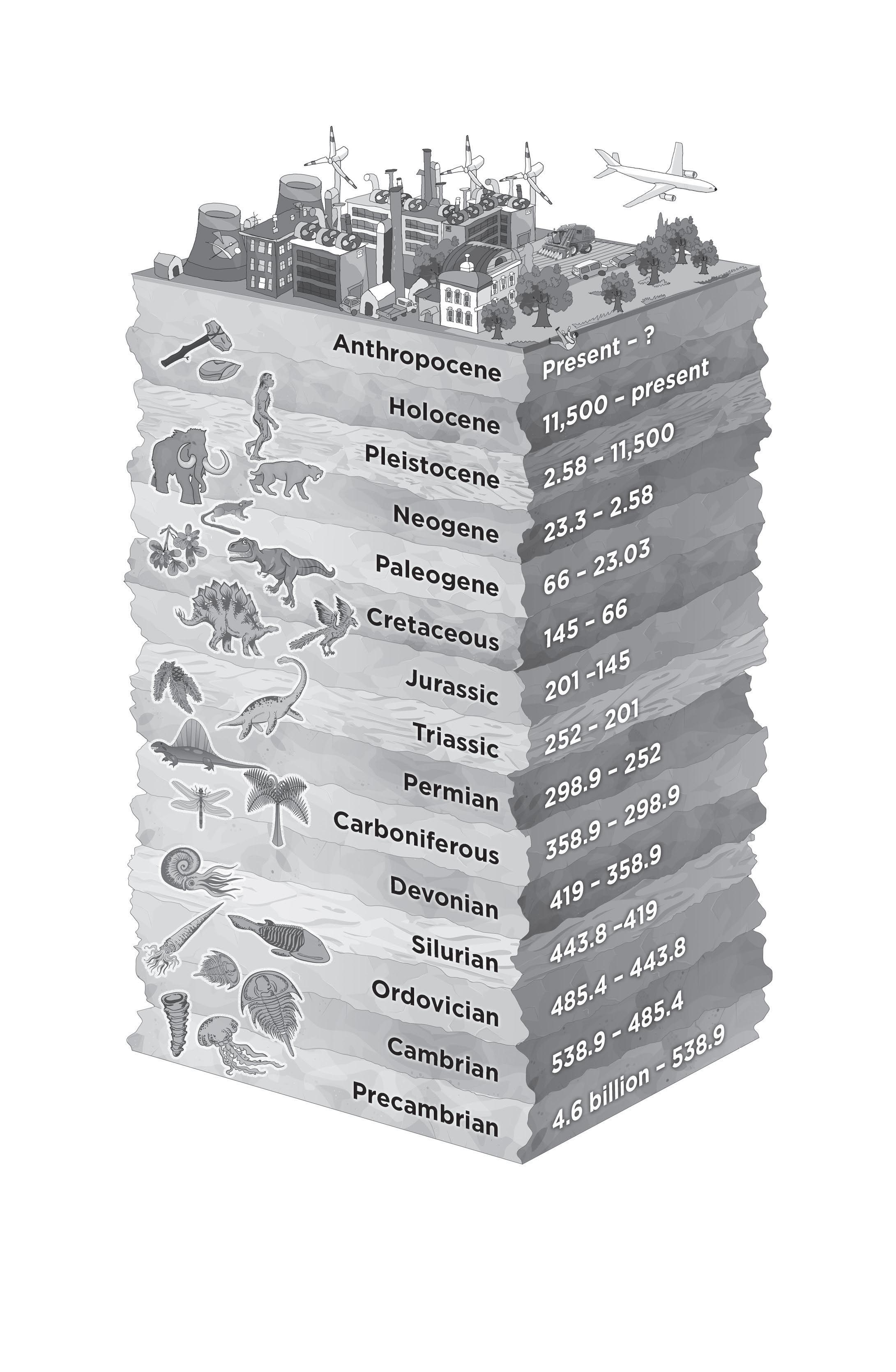
This crude map for schoolchildren told a tale, the remarkable story of the rocks that lay unseen beneath these islands, the bones of Britain from their first formation 3,000 million years ago all the way through to the present day. That was evident at first glance. And something else struck me as I studied the torn-out map. The oldest rocks were at top
left, the youngest at bottom right; northwest to southeast, Outer Hebrides to Thames Estuary. Couldn’t one simply take a walk through this story from beginning to end, starting in the Scottish Isles among the hot red volcanics of the ancient rocks, and finishing among the grey clays and moody marshes still being created by the sea along the Essex coast? The story was there, first to be understood, then to be told, if one could unwrap it from its coat of many colours and prise it away from the intimidating technical vocabulary which scared off most sentient beings if they tentatively lifted the stone under which geology lurked.
Couldn’t I do that? Not now, not with my young family and my mortgage and my increasingly unremarkable teaching career. But one day, maybe, when I had written my way out of the classroom. Yes, and that day pigs would become airborne, I thought as I put the map into a folder marked ‘Ideas’ and stuck it in a drawer.
There it stayed while teaching gave way to writing. I walked over every corner of Britain, trying to put into words my curiosity and excitement about its hills and valleys, birds and animals, its vivid and violent history, how East Anglian farmers grow their wheat, why Yorkshire lead mines lie up on the moors and Lancashire cotton mills stand down in the dales. I found that everywhere I walked, the bones of Britain kept calling from under the ground. A hand-flaked flint in a Lincolnshire field, bent-up cliffs in Dorset, 1,500 feet of Chiltern chalk, volcanic ash baked hard in Glencoe, Hadrian’s Wall surfing the wave of the Whin Sill. This country enjoys, for its size, the most varied geology in the world, and that impinges on the variety of wildlife in any one place, on soils, on human activity from farming to steel-making, on buildings and what they’re made of. I came to see that our lives and ways of going about things are profoundly affected by what happened ten thousand, or a million, or a thousand million years ago under the ground we walk on.
I didn’t grasp the scale of geology’s influence over our daily lives till I had walked and written about these islands for forty years or so. I got the drama, the fiery upheavals below and above ground, the epic floods and mountain-building, the incredible timescales, the fabulous colours
of rocks, a child’s excitement at unearthing a fossil. Though most geological phenomena lay tucked away underground and out of sight, I saw for myself the layers of rock exposed in cliffs and quarry faces, horizontal from bottom to top in chronological order, or mixed and contorted beyond immediate understanding. But it was like picking at a plate of starters in the geological restaurant. There was a whole gourmet meal waiting for me if I could learn how to savour it, if I could get over myself and look geology and its technicalities squarely in the face.
Various things helped to rob geology of its terrors. The internet, for one. No need to travel to Berwick-upon-Tweed public library to locate, unearth and burrow around in the Proceedings of the Northumberland Geological Society, Volume XXXVII, Issue 7 (October 1889), when it was available (if really wanted) at the click of a keyboard. Likewise, the technical terminology, so daunting to the uninitiate. ‘The Whin Sill’s petrographical affinities are dominantly tholeiitic, but geochemically transitional between alkaline and tholeiitic’ is a sentence that would have sent me screaming for cover before I found the excellent website of the BGS (British Geological Survey), which enabled me to interpret it as follows: ‘Thin segments of this rock studied under a specialist microscope reveal that its volcanic magma was rich in iron and picked up plenty of magnesium as it formed into the hard grey basalt called dolerite.’
Another advantage was that I was seeing this stuff every time I went for a walk. I’d met the Whin Sill in great rock waves and cliffs along Hadrian’s Wall, out at the Farne Islands off the Northumbrian coast, and down in Upper Teesdale. To know that it had been a vast hot tongue of viscous magma that rose up from the depths 290 million years ago and pushed its way sideways between layers of limestone and sandstone, cooling into a wedge of hard dark dolerite rock that still lies there beneath nearly 2,000 square miles of northern Britain, was a feast for the imagination. Geology seemed to sneak its way into every conversation I had during my wanderings on foot. I crouched on a narrow ledge above the River Tees in Upper Teesdale while a patient and friendly
National Nature Reserve manager showed me how the dolerite magma had baked the rocks, among which it so rudely intruded, into crunchy crystals called sugar limestone that met the nutritional needs of the valley’s beautiful and rare spring gentians and bird’s-eye primroses. That gave geology an immediacy and relevance, and an ecological value.
I bought the BGS’s big two-part geological map of Britain and stuck it on the wall. I stood in front of the great multicoloured chart and compared it with the ripped-out page from the Philip’s Modern School Atlas that I’d retrieved from its folder. Oh Lord, the real thing is more complicated than this little schoolroom map led me to believe. But even more fascinating. On the BGS map I marked all the walks I’d done, on the gneiss and the basalt, the sandstone and limestone, the dolerite and gritstone and greensand. Britain’s greatest national treasure, in my view, is the country’s network of public footpaths. Without the benefit of these rights of way, open to all and ramifying out, root and branch, for 140,000 miles, I’d hardly have been able to set foot to earth anywhere in these islands. But here like a gift across the geological map were hundreds of walks I’d done and hundreds more I planned to do, travelling over dozens of rock types, all carved and ground up by the Ice Age glaciers and smeared across the landscape as clay and rubble when those great ice behemoths rumbled away into history. What a hell of a story. I had to try to tell it.
Checking with the admirable website of the Long Distance Walkers Association, I puzzled out a succession of long-distance paths running for 1,000 miles with scarcely a break from the Isle of Lewis to the River Thames. For anyone inspired to follow my Bones of Britain route, they go like this:
Scotland. In the Isle of Lewis, from the Butt of Lewis to Callanish along the clifftops, then to Stornoway along the Pentland Road. The Skye Trail from top to bottom of the Isle of Skye. The ‘Famous Highland Drove’ route from Skye going east to the Great Glen. The Great Glen Way to Fort William, followed by the West Highland Way to the outskirts of Glasgow. East from here along the Forth & Clyde Canal, then
the John Muir Way and the North Sea Trail round the coast of southeast Scotland as far as the English border.
England: St Cuthbert’s Way from Lindisfarne west to the Cheviots, then the great wild Pennine Way running south along the backbone of Britain as far as Edale in the Peak District. The Limestone Way through the White Peak, the National Forest Way through the regenerated landscapes of the industrial Midlands. The Midshires Way running south across the Leicestershire Wolds, and from the outskirts of Northampton the Grand Union Canal towpath to the River Thames at Kew. From there a boat ride east through London, shadowed by the Thames Path; a muddle of short paths along the built-up Essex shore of the lower Thames; and finally the Roach Valley Way from Rochford out to the moody shores of Wallasea Island.
I threaded the walks along this route like beads on a string, and I found that with a few sidesteps and detours they crossed a sequence of terrain that followed the geological story, more or less. Most were on public footpaths, but there were some roads to follow, too, some sea passages to cross at the start, and a couple of inland stretches by boat that looked like fun. I wasn’t going to try to take in every star in the geological firmament of Britain: that would result in just another addition to the bulging library of general books on the ‘Geology of Britain’. It might be possible to devise a swerving, snaking course hither and yon across the UK map that included every variant and location of terrain and geology, but how exhausting, long-winded and ultimately boring that would be. I’d be in my grave before I completed it, too. No – I wanted to pick a route it would be possible for ordinary mortals to explore, a journey on which they could see for themselves what shaped the landscape and the lives lived there.
I got out my old notebooks and refreshed my memory and my appetite. I waited as impatiently as a dog shut indoors for Covid restrictions to ease. And then, at last, I set off for the Butt of Lewis and the oldest rocks in Britain.
Over the course of a couple of years I revisited the places I’d already walked along my Bones of Britain route, picking the walks that best showed up the geology. I found the gaps and filled them in, travelling south and east across Britain, mostly on foot but also in places by boat and bus and car, piecing the story together, talking to geologists and drystone wallers, farmers and canal enthusiasts, coal miners, musicians, local historians and random folk I met along the way. I learned about the fragility of these islands, their unsettled foundations, the never-ending cycles of creation and destruction that are so bound up with their processes. Theirs was a story so dynamic, so immediate, that I knew I’d never see them in the same light again.
At Wallasea Island on the Essex shore the journey of 1,000 miles and 3,000 million years through the bones of Britain came to an end on a bitter winter’s day. I’d brought with me the stolen geological map that had kicked the whole adventure off some forty years before. Standing on the flood wall where humans and nature were conspiring to build a new geology, I got out the tattered page and traced the path by which I’d come here across those layers of bright primary colours. It still looked as magical and mysterious as the day I tore it out and took it home with me.
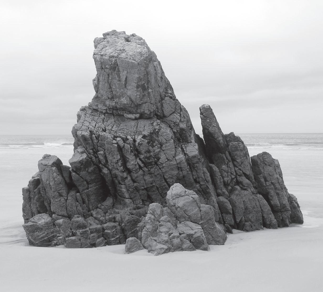
On Garraidh beach, a rock stack of gneiss 3 billion years old.


Garenin Blackhouse Village
Carloway Broch


Butt of Lewis Eoropie Bay Cunndal Bay

West Side Coastal Walk
Callanish Standing Stones Hushinish


Tolsta to Port of Ness Europie Walk


Tolsta Bay/ Garraidh beach


Liurbost Barabhas


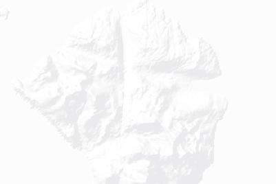
You jump out of your car at the Butt of Lewis, most northerly point of the Outer Hebrides, and a geology bombshell goes off in your face. Not a tweedy lecture or an incomprehensible page of strange words and facts, but a proper gasp moment. You stand by the tall brick stalk of the lighthouse, and the seaward view is of a riot of strikingly coloured cliffs and sea stacks, as naked and contorted as when they first formed in the nascent Earth’s crust 2,000 million years ago.
It looks as though a toddler giant has been at work with a box of plasticine, a toddler with a penchant for oranges and greys, whites and blacks. These rocks at the northernmost tip of the Isle of Lewis have been jammed together in layers and thoroughly squeezed out of the horizontal and out of kilter. Directly opposite the lighthouse, bands of orange, grey and brown bend in a tight arch among fellow layers all canted out of the sea at 45 degrees. The neighbouring stack appears to be similarly slanted until you look down near the roots and see how the toddler’s fists, pushing from both ends, have caused the rock to crumple and sinuate, each roller-coaster wave outlined in white quartz. To the right a fat stubby stack as treacle brown as newly dug peat has been turned inside out and upside down, the edges bent vertical, the flanks swooping over and down in extravagant arcs. The violence of the contortions, the implication of gigantic heat and force and pressure, are mind-boggling.
This Lewisian gneiss was formed when the world was young. It’s twice as old as the oldest forms of life ever discovered in Europe. Yet there are rocks not far away on Lewis, even more sensationally shaped and coloured, that came into being more than 1,000 million years before these sea stacks at the Butt of Lewis.
I sat on the rabbit-nibbled turf in the sunshine and wind, staring. Last time I’d been here it had been in a week of solid rain and mist, conditions that seem to love the Outer Hebrides island chain, and particularly the Isle of Lewis. They had clung to its dour moors, its wide flat bogs and thousands of tiny lochans and skimpy coastal settlements as though reluctant to part company. In those days the lighthouse had still had a keeper living on site, and he’d allowed me to climb the tower and gaze on many miles of rainswept moor and white-capped sea. For all that, back then I hadn’t taken any account of the wild and ancient geology on display right under my nose.
It’s not only easy but almost obligatory to fall into conversation with anyone you meet in the open air of the Outer Hebrides. Just along the road from the lighthouse I fell in with one of the Morrison clan. ‘They’re all Morrisons round here,’ he said. ‘I was born here, and I love the place.’ I remarked on the number of elongated fields into which the land either side of the road was divided, narrow strips 6 or 7 strides wide and up to 400 metres long. ‘Those are the crofts, and they go with the house, each one belonging to a family. People in the old days would farm sheep and cattle, corn and vegetables on their crofts. Potatoes in the ridge beds – you’ll see those down on the cliffs. And peat from the moors. Everyone had their peat bank, and we’d cut them and dry them and use them for heat in the kitchen and in the fireplaces.’ Morrison smiled diffidently. ‘I have the electricity now, but I still like to have the peat fire. The smell of it, and the warmth and light it gives off.’
I mentioned the cliffs, the banded colours, the aeons of their infinitely slow formation. ‘No, no, it is the Higher Power that has created them,’ said Morrison. ‘Don’t you believe in a Higher Power? I used to be an
evolutionist, but’ – he spread his hands for emphasis – ‘no way! Everything in this universe is so finely balanced, don’t you think? There has to be a Higher Power that has ordered it.’ There was total sincerity in his voice.
A screaming posse of Arctic terns saw me off on my journey, graceful red-beaked flyers with long streamer tails and fishwife voices, apt to divebomb and try to peck your brains out. A squadron of gannets flew south in strict line astern a mile out to sea, their sharp black wing-tips beating regularly. Far out beyond them fifty of their fellows splashed and plunged soundlessly after an invisible shoal of fish.
The fissuring of the ancient rock has given the cliffs a multitude of ledges, crevices and hollows. Guillemots had built tuffet nests out of seaweed and cliff plants. The tubby little seabirds were tucked away in the shadows, but their location was betrayed by a generous whitewash of guano immediately below each nest. A shag with an iridescent green neck squatted above them in a little rock garden of thrift, painstakingly pulling out plants, assessing and then rejecting them. One by one he dropped them down the cliff past the guillemot tenement, until at last he succeeded in pulling out a lump the size of his head with a long root attached. It must have exactly fitted his nest design, for he flew off clumsily, unbalanced by the root dangling from his beak. It swung like a pendulum, causing him to flap his wings frantically.
The cliff path led across short springy turf created by the nibbling of sheep and rabbits, a delight to walk on. It ran round the rim of a deep dark geo or narrow inlet where each successive wave sucked hungrily with an echoing thump and hiss at the converging black rock walls. This west coast of Lewis, open to the full force of Atlantic gales and stormy seas, has few seabirds nesting on its cliffs. The turf may be short and springy, but the peaty soil underneath is meagre, in most places only a couple of inches thick over the acid, impermeable gneiss. The underlying geology forbids flowers to flourish in quantity, trees to grow,
food-rich scrub for birds and insects to take hold. But man, forever hunted by necessity, has tried for centuries to wrest a living here. The silent witnesses to the endeavour are the potato drills or ridges, known as lazybeds – what a misnomer! – laboriously scraped together and moulded out of peat, sooty thatch, sand, seaweed, and human and animal excrement. They still lie, grassy green in parallel ridges, sloping down gentle declivities towards the cliff edge where they end at a transverse ditch running the length of the lazybed patches. To lose a cow or a sheep over the cliff was a tragedy for a family’s home economy, and anything that could be made by way of a barrier to prevent that mishap was worth a try.
Only the fulmars braved these Atlantic-facing cliffs today, a few pairs tucked in out of the weather, chubby birds with snow-white breasts and prominent ‘nostrils’ called naricorns that exude a saline dribble to help the bird keep desalinated after its fishing in the salty ocean. Fulmars can spit a foul orange fish oil at anything or anyone they deem a threat. If this vile substance gets on your clothes its ‘fragrance’ will cling there through many washes; if it gets on the plumage of a predator such as a great black-backed gull it glues the feathers together, crippling and sometimes killing the aggressor. Despite this, the fulmar is a very endearing bird, fond of indulging in neck-to-neck frottage with its partner, and apt to cruise past on stiff wings glancing sideways at you with a round black eye as though weighing you up.
A skylark overhead trilled out its seamless ecstatic song as I walked on round Cunndal Bay, a segment of untouched sand dipping through pale green shallows to clear steely blue water. In the shallows, rafts of black seaweed rippled with each wave, smoothly and heavily, as though oiled. Soft turf led on down to Eoropie Bay and a poignant cliff-top memorial to a fishing tragedy on 5 March 1885. Two boatloads of fishers from the tiny community of Eoropie were lost in a storm here; and the worst aspect of this catastrophe was that it took place close inshore under the eyes of the fishermen’s families and their friends and neighbours who had gathered on the shore. The surf and undertow made it
impossible to save anyone, even the last man who clung to his wrecked boat for over two hours, looking shoreward and hoping for rescue, before being washed away.
The Highland News commented:
For the most part, our fisher-folk pursue their toilsome and dangerous occupations unthought of beyond their own limited circle. When most of us are sound asleep these stalwart fellows are tossing in their open crafts on the broad Atlantic, cold and wet, with their lives in their hands, earning what is at best but poor fare for those dependent on them . . . The Ness crews have left nine widows and twenty-two children. All these poor creatures are totally without means, a number of the families being landless.
The addresses of the drowned men are given on the memorial, along with their names and ages. ‘Angus Morrison, 36 Eoropie, age 28; John Murray, 34 Eoropie, age 29; Donald Macleod, 23 Eoropie, age 24; John Macleod, 23 Eoropie, age 29 . . .’ Almost all young men in their prime, and all from a community so small and close-knit that no street names were needed. In fact there were no streets at all in the island villages back then; only footways that edged around the close-packed houses. The dark colour of their drystone walls and the smoke-blackened thatch of their roofs gave the dwellings the name of ‘blackhouses’.
A few miles down the coast the rough cliff path reached the reconstructed blackhouse village of Garenin. The houses were built close together to block out the brutal island weather, their windows and doors small, their corners rounded to deflect the wind and rain. Each roof, thatched with barley straw or rushes from the stream or marram grass from the dunes, was held down by a chain of woven ropes, each rope kept taut and vertical by an anchoring stone of heavy gneiss. These roofs were not expected to last more than a year. In summer the smokepickled thatch would be stripped off, broken up and spread in due course on the crops as fertilizer and as a protective layer against
frost. The house, meanwhile, was thatched afresh to combat another year of wind and weather.
The blackhouses of Garenin looked cosy and neighbourly in their tight community. The design did not really change for thousands of years – double walls with straw or turf in the gap for insulation, rounded corners, a communal door for people and animals, and a beaten earth floor with a central fire in the single long room inside. Animals occupied a separate compartment or byre at one end. No house in Garenin boasted a chimney; the smoke from the peat fire in the hearth was left to drift up through the thatch or out of the door.
With cattle and pigs, sheep and hens in the byre, up to twenty adults and children sharing the rest of the building, no privacy and masses of pungent peat smoke, winter must have been particularly ‘snug’. You’d have needed a strong constitution to survive it. Coughs, lung complaints and itchy eyes were endemic. What a relief it must have been when the stormy weather finally relented and everyone could spend the day outside, in the fresh air and away from one another. Out above Poll Domhain Meadhonaich their lazybed strips still run down to the cliff edge. Looking around, there seems just about everything at hand for a subsistence life: fresh water from a stream that plunges over the pink and grey cliff, grazing for animals, the outlines of old peat banks further up the hill, and the trace of a hazardous path leading down to the beach and the fishing.
A little further up the coast at Dail Mòr beach, twin cemeteries occupy opposing grassy headlands. Here Macdonalds, Mackeys, Macleans and Macleods lie peaceably in each other’s company. Late on this spring evening with a northwest wind pounding the waves onshore under a blue sky, each headstone cast a long eastward shadow. Rimming the dunes at the back of the beach, a litter of striped and faded boulders of gneiss lay around the stream-gully. I walked the soft coarse sand towards the eastern cliffs, and was brought to a standstill by the extraordinary spectacle of the mother rock. This Lewisian gneiss, 3,000 million years old, was formed when the Earth’s crust was still fighting
itself and being torn by the violent turmoil below. Magma under huge pressure from below pushed up and out, freeing itself to burst through the still solidifying crust of the Earth at a temperature of a couple of hundred degrees centigrade. The seabed stretched, broke and fragmented in epic slow-motion collisions, and the magma twisted and wriggled as it cooled, the minerals from deep in the mantle staining it in delicate colours.
All this showed itself in vivid exhibition at Dail Mòr. A great dyke or finger of black volcanic rock, long since liberated from the gneiss it originally penetrated, gave the impression of having only just shot out of the sea and across the beach. It diminished to a pipe in the sand, the size and shape of a conger eel, then rose up the cliffs as a narrow rockwalled channel quite distinct from the surrounding rock.
Beyond the dyke a litter of boulders lay at the foot of the cliff – boulders strikingly banded, much more vividly than those at the back of the beach, the stripes canted this way or that as chance dictated when they fell from the cliff. As for the cliff, that gave the appearance of a living organism convulsing in a sheet of fire, its normally spaced bands squeezed vertical, others snaking off horizontally towards the sea in pale green tendrils before turning back on themselves – this movement only one of a hundred opposing and colliding streams of solidified magma. Nearer to the sea a detached stack was shot with veins of quartz, of deep orange matrix and of black gneiss that might have been polished marble.
If you wanted a visual introduction to the epic violence of ancient geology, this was it.
The Morrison, Macleod and Murray fishers and crofters of bygone Lewis may have pondered on the origins of these native rocks of theirs, and they may have appreciated their dramatic beauty, but they didn’t put such thoughts on paper for posterity. As their successors do today, as did their distant ancestors, they recognized the usefulness of what lay to hand. Heavy, rounded stones of gneiss held down their thatch, ground
their corn, anchored their boats and built their blackhouses. Two thousand years ago the inhabitants of Carloway, a few miles along the west coast from Garenin, felt so much oppressed by some unrecorded threat that they built themselves a broch of gneiss, a hollow defensive tower with a winding staircase embedded in the double walls. I’d somehow expected the broch to be no more than a circle of boulders, but arriving there on a wet evening I found it rising from its rock outcrop like a great stony tree, splintered off 10 metres above the ground. The now familiar stripy patterns in the individual stones, green, pink and grey, split along their lines of banding, showed up as though varnished under the polishing effect of the rain. The doorway was hip-high; any attacker would have had to crawl inside, giving the defenders a golden opportunity to remove head from neck.
According to local tales, however, Donal Cam MacAuley of Uig, a one-eyed and hot-tempered warrior, did manage to breach the defences. During one of many episodes of clan fighting and feuding early in the seventeenth century, the Morrisons of Ness made away with the MacAuleys’ cattle. Pursued by Donal Cam, his sidekick Big Smith and a posse of MacAuleys, the Morrison rustlers took refuge in Carloway broch. On arrival Donal Cam blocked up the doorway. Then this formidable man scaled the outer wall of the broch, hauling himself up by means of a pair of dirks which he dug in between the stones, and helped by the slight inward batter or slope of the wall. Upon summiting he threw clumps of burning heather into the open top of the broch. The Morrisons inside were either smothered by the smoke or burned to death. Donal Cam ordered the broch to be slighted. The MacAuleys got their cattle back. On they went.
Lewisian weather was reverting to type. It was still raining next day when I came to Callanish. The crowd of tall slim figures that occupied the ridge, coming and going through the murk, took some time to resolve itself into an assemblage of standing stones, and longer still to assume an orderly resolution into a stone circle and associated avenues
of stones. In every direction the field walls, sheds and old houses of Callanish were built of the convenient gneiss in boulders, blocks or roughly shaped cobbles. And the stones on the ridge, though erected long before any of these mundane buildings, were carved from the same material, all that was at hand for the job.
The central circle has thirteen stones standing erect around a central monolith about two and a half times the height of a man. It was constructed some time between 2,900 and 2,600 bc, nearly a thousand years before the use of metal was known in the islands. The builders had tools of stone and of animal bone; they could utilize heat and gravity. But what hard repetitive labour it must have taken to shape these monoliths, some with sloping ‘shoulders’ and protuberant ‘heads’ that give them the appearance of ancient grey figures, motionless watchers. The masons split them almost exclusively along the lines of the gneiss’s bedding planes so that the grey and white bands stand vertical, and that must have helped the work, though a couple are shaped against the grain with angled stripes that contrast bravely with the adjacent stones. The northerly edge of the king stone features streaks and surface coils, as though held still between one movement and the next.
When you consider the perfection of most prehistoric stone alignments the world over, the meticulous calculation of the dimension of the circle, the straightness of the flanking avenues, the orientation with solstice sunrises, the Callanish stones seem endearingly wonky. The circle, centrepiece of the whole creation, is rather too small to show off the height and bulk of its standing stones to best advantage, and it’s squashed flat along its east side. The central monolith isn’t quite in the centre. It shares the space with a chambered tomb which looks a bit too close to the nearest stones, as if it was squeezed in by a builder’s mate who didn’t really understand his instructions. The stone rows that march towards the circle aren’t quite aligned with the cardinal points of the compass, and they all aim a little off the exact centre of the monument.
These eccentricities notwithstanding, there’s something truly compelling about the Callanish stones, especially when cloaked in drizzle
on an icy wind. They dominate their ridge, soldierly figures that have endured five millennia of this sort of weather. When they were erected the climate of Lewis was calmer and drier, and the peat had spread no further than the damp hollows of the gneiss. A farming community could make the most of the land in the interior of the island to grow grain and graze their herds. But slowly things got windier and wetter, and the peat and heather moorland crept on upwards and outwards to smother all the interior and drive the people out to the coasts, to hazardous fishing and poorer farming.
Next day I set out along the Pentland Road, a narrow ribbon that straggles 16 miles across the waist of Lewis from Carloway to Stornoway. If there is a more desolate, more barren stretch of land in these islands than the interior moors of Lewis, I’ve yet to see it. The name of Lewis may have Norse origins, but it’s tempting to connect it to the Gaelic leogach, which means ‘boggy’. This is by far the largest island in the Outer Hebrides, with the highest population. Yet it has very little arable land. Away from the coast, it’s the blanket bog known as the Black Moor that takes up the space. It overwhelms the interior, feeding on rainwater and moisture in the air. From the Pentland Road it is blanket bog as far as you can see. And it’s all due to the geology.
During the last peak of the Ice Age some 22,000 years ago, extensive sheets of ice covered all but the highest summits of the Outer Hebrides. As they moved out into the Atlantic Ocean they scoured away loose rocks and projections and dug out shallow basins in the gneiss. Over these the ice dragged sheets of glacial till or rubble, glued together with sticky deposits of boulder clay. This was the landscape that emerged around 11,500 years ago as the glaciers receded and the climate began to turn warmer and wetter. Heather, juniper and grass arrived to colonize the thin stony soil, followed by trees – birch and hazel, pine, then oak woodland. By 7,000 bc human settlers were well established, hunting and gathering their food in this forested land. But the climate continued to warm and to moisten. More rain fell, flushing away minerals and
salts from the soil. The underlying gneiss is hard acid rock. It doesn’t erode, and doesn’t drain well. Fallen trees, dying heather and juniper couldn’t rot down into good productive soil. The bacterial activity needed to promote such activity could not get going. So the hollows scraped out by the ice filled with peat, organic material that never decayed, but became thicker and more compressed. The peat lined the hollows where, unable to drain away through the impermeable gneiss, rainwater soon formed lochans or stagnant lakelets.
Around five thousand years ago, when the inhabitants of Callanish built their stone monument, there was a period, a brief flash of geological time, when the climate dried off, trees began to return, and agriculture became more viable. The boulder clay exposed by digging through the peat could be teased into fertile soil if mixed with shell sand and seaweed. But the climate soon turned warmer and wetter again. The peat spread in an ever-widening and thickening blanket across the low hills and ridges shaped by the glaciers. The classic Outer Hebridean landscape of ‘knock and lochan’ came into being – small, rounded hillocks interspersed with lakelets and smothered with heather moorland rooted in a blanket of peat. As for the trees of Lewis: those that escaped the axes of the early farmers couldn’t find the nutrients they needed, and their decline continued. What the Mesolithic inhabitants started, Viking settlers finished after their arrival late in the eighth century ad. Within three hundred years the island had been all but denuded of trees. But the peat prospered. These days the average thickness of the peat across the Black Moor is over 2 metres. At its maximum you can dig 6 metres down and still not hit the gneiss that lies beneath.
The houses of Carloway are widely scattered, and once the few trees associated with them had fallen behind me, it was knock and lochan all the way. The Carloway River, a shallow rush of peat-stained water, soon curled away from the road. The Black Moor stretched away on all sides, not flat, but undulating in long drab-coloured crumples, swelling like a heavy brown sea. Spits of rain came across on a cold north wind. The Pentland Road ribboned eastward, rising and falling in front of me
between outcrops of gneiss striped in orange and black. Big mountains marched on the southern skyline where Lewis and Harris met on their mysterious, undefined border. But they seemed a world away from the low and sodden moor I had entered.
The saga of building the Pentland Road stands for all the problems and failures encountered down the years in Lewis by ‘improvers’. By the 1890s a decent road already existed a little way south. What was really wanted was a railway to bring the newly established Loch Roag fisheries’ catch from nearby Carloway, with its natural harbour and good fishing grounds, across the island to Stornoway. But no one in the island was prepared to subscribe towards the cost of a railway. A new road was the next best thing, and would shave 7 miles off the journey – an important saving of time when dealing with fish, considering their rapid rate of decomposition.
Work started in 1894, but the local engineer had underestimated the amount of work needed. He and two contractors were dismissed. ‘This work has been unsatisfactory from the very beginning,’ scolded the 1898 Report of the Congested Districts Board for Scotland. The original grant of £15,000 from the Scottish Office was nowhere near enough; £13,000 of it had been spent for no real results by the time of the report. And it took another sixteen years for the road to be fully ready. Opened on 6 September 1912, it was named after John Sinclair, Lord Pentland, Secretary of State for Scotland. ‘A gold-lettered day,’ announced the Highland News. But Neil M. Macleod, writing in the same paper only three weeks later, grumbled, ‘For the development of fishing in the west of Lewis the Pentland Road, when all is said and done, is little better than a cart without a horse.’ And as things have turned out, rather than boosting the fishing industry of Lewis, the main benefit of the Pentland Road has been a more modest one: the transport of cut and dried peats from the moor to domestic hearths around Carloway.
The Black Moor of Lewis is a sullen landscape, for sure, but a compelling one. You cannot imagine ever getting on terms with such a monotony of blanket bog, of strolling or picnicking here in the same
way as on chalk downland or the limestone dales. There’s nothing pretty or comforting about the Black Moor. Impressions of this landscape are directly attuned to the weather, generally wet and often challenging. But it is massively impressive all the same. Its peat can be dug for fuel, its lochans fished. But it can’t be tamed for agriculture. Its sheer extent, its sogginess and sourness, are indefeasible. It possesses what could be described as strength of character. Like the island itself, the Black Moor has rejected the best endeavours of a succession of well-meaning outsiders to turn it to account.
In 1844 Sir James Matheson, an East India merchant who’d dabbled in the Chinese opium trade and grown rich, bought the Isle of Lewis from the Mackenzie family for £190,000. He built the opulent Lews castle at Stornoway, cleared the land for his park by paying for about five hundred residents to emigrate to Canada, and imported soil for growing trees and shrubs. Those were desperate years, with a disastrous potato blight hitting Scotland in 1846 and lasting on and off for the next decade. The potato was the chief source of nourishment in western Scotland, and over half the population of Lewis became reliant on the Destitution Fund, largely made up of contributions from Sir James and Lady Matheson. In the first winter of the potato famine the Mathesons spent £40,000 on flour for their poverty-stricken tenants. There were no sheep evictions in Lewis, unlike most of the other isles. Sir James spent altogether about a quarter of a million pounds on improvement schemes in the island, including establishing a lobster fishery, building new harbours and roads, draining wetlands and reclaiming peat moorland for agriculture. He seems on the whole to have done his best for the island, including paying the passages of 1,800 islanders to Canada when times were at their toughest. But the islanders, independent in mind and inclination if not financially, weren’t over-enthusiastic, and the death of Sir James in 1878 was not mourned with universal wailing in Lewis. Another essentially benevolent despot and ‘improver’ was Lord Leverhulme, the ‘Sunlight Soap Baron’, who bought Lewis in 1918. He,
too, had grand designs for the island, including turning Stornoway into a major fishing port with fish-processing and canning factories and an ice plant. New harbours were to be founded at the end of new roads. And Lewis-caught fish was to be sold all over the UK through the nationwide chain of Mac Fisheries fish shops – the one solid gain, as it turned out, from all this planning. Leverhulme aimed to establish dairy farms, encourage the weaving industry and connect up remote parts of the island with a road-building scheme. What he didn’t want his tenants doing, and did his damnedest to discourage, was crofting, the traditional part-time husbandry of a small piece of land. As a tremendously successful industrialist, Leverhulme saw crofting as an inefficient industry, distracting people from the work they should be concentrating on. He was right about the viability of crofting as a full-time occupation, especially on land as poor as that in Lewis. But experience told the islanders that the croft was a necessary plank in their domestic economy, something to fall back on when times were hard.
Lord Leverhulme badly misread the mood among many of the islanders. He failed to appreciate the cultural and emotional hold of crofting on the community of Lewis. The islanders were cautious about adopting new trades and new ways, and they proved reluctant to dance to a rich man’s tune. And it was the new laird’s bad luck to be riding his hobby horses at the end of the First World War. The social upheavals brought about by ordinary folks’ service in the war, during which Jock felt he had proved himself as good as his master, reached as far as the Isle of Lewis. Returning servicemen didn’t want to work for and be beholden to Lord Leverhulme. Instead, they believed that the government had promised to allot them land for crofting. When they found this was not forthcoming, some of the ex-servicemen began a series of ‘land raids’, seizing farms that Leverhulme had created by amalgamating crofts, and redistributing the land to former crofters.
The tide of history, and the mood of the Scottish Office and of Parliament, were against Lord Leverhulme. In 1922, after a four-year stand-off, the Board of Agriculture stepped in and compulsorily purchased enough
tenanted farmland to provide a hundred crofts. The following year Leverhulme, stymied in all his schemes, decided to quit Lewis. In a final act of magnanimity he offered the islanders as a gift the freehold of their crofts. Some individuals accepted, but Lewis District Council, excessively cautious and thinking the sums would never add up, rejected the opportunity. Lord Leverhulme was left with no alternative but to sell to whoever would buy. No one wanted to possess a large remote island of peat bog and poor land with sitting crofter tenants, so Lewis was sold off piecemeal as small estates to mostly absentee landlords. No one really benefited, in the end, from all those good intentions.
Thirty years had passed since I last trod the Pentland Road. Back then there was no tarmac underfoot. It was a rough track that crossed the Black Moor, stony and hard on the feet. Rain had lashed at me all day, soaking through every stitch I wore. It was the Sabbath in this stern stronghold of the Free Presbyterian Church, a day for furtive boozing in the corrugated huts of peat cutters along the way. I heard the clink of bottles and the phlegmy chuckling of smokers as I squelched by. The pages of my notebook for that day are crisp and yellow now, smeared with peat and blurred with rain, but they still set the scene before me:
A day of continuous drizzle, mist and wind. A landscape scarred and riddled with peat workings. Banks, ramparts, pools. The plastic bags of the peat cutters – white, blue, green – the only colour in the dreich rainy landscape. Empty carry-out cans line the roadside ditches.
An exposed place, the low-lying shape of the land allowing free play to wind and rain. The blue and red tin shacks of the peat cutters, each with its single black chimney and whiff of peat reek, have iron rings let in above the windows, through which cables are passed to anchor the hut to its rock foundation. A stiff windstorm can bowl an unsecured hut clean over.
I step aside on to the moor and the peat quivers beneath me. Sphagnum loose underfoot, gurgle of water settling as my weight
transfers to next tuffet. Back to the Pentland Road. An old bridge of rusty box girders, only 5 yards long, with neatly shaped and curved abutments, allows a little brown burn to go under the road. A lorry full of stones trundles across and the whole structure trembles, the bog on either side shivering from the shock waves like jelly in an earthquake.
Four shepherds drive their flock across the moor, the sheep seething like a pack of white maggots, while the black-and-white dots of their seven collies whirl round the flock. All the shepherds in working blue overalls, carrying big crooks, as they corral the sheep towards a pen for shearing. Each dog crouches, quivering with tension, tongue out, head held low, then at a whistle from its master races away, belly to the heather, bounding over pools and tussocks, sending up a splatter of peat particles as it heads off escapers. Energy on tap. Skylarks and golden plover the only other animated beings in this utterly drab and downbeat landscape.
Halfway along the Pentland Road large mountains began to loom again to the south through the moisture-laden air. On the opposite side of the road a long, gently sloping bank of peat rose away. I trudged up to where the view opened northward to a skyline barred with dark cloud that trailed a ragged hem of rainfall. Out there stood a black dome that the map named ‘Stacashal’, a low hummock of a hill, but at 700 feet the highest point on the moor for many miles. I took aim and set off among soft tuffets of sphagnum and deep channels of sloppy peat. From the cotton grass larks ascended singing over Loch nan Geadh, little slivers of joy in a bleak place.
The back of Stacashal was a maze of peat hags 7 and 8 feet tall. I stumbled and slithered my way up between them. The northward view from the summit was hidden till the last moment. Then the badlands of Lewis lay suddenly open, a glimpse of sandy machair on the west coast perhaps 10 miles off, ruined shielings or summer bothies of ancient stone dotted across the vast plain, a thousand watery eyes of peat pools
winking. A prospect of the Black Moor stripped to its basic elements of bog and lochan, bog and lochan, all the way out to the Butt of Lewis 20 miles away.
Ten miles north of Stornoway on the east coast of Lewis, the circle of the forgotten improvers’ roads is closed. Here from Tolsta Bay the coast road, already narrow and wriggly, crosses a handsome concrete bridge and winds on north for a mile or so before petering out, as if in recognition of its own futility. It was one of Lord Leverhulme’s pet projects, intended to connect the northern port of Ness with Stornoway for the rapid transport of fish to the processing plants at the capital town. But it fell by the wayside, along with Leverhulme’s other schemes of improvement, when he sold the island in 1923 and removed to Harris to lick his wounds. Now a rough coast path meanders the 10 miles north to Ness, a ghost road that sketches out what might have been.
Tomorrow I would be leaving Lewis, crossing the Minch on a ferry bound for the Isle of Skye. Today was for a final immersion in the ancient geology of the island, on Garraidh Beach at the foot of the road that never was. As I clicked the gate by the little loch above the beach, a delegation of sheep came to see if I had sandwiches – one subduedlooking ewe, and four curly-horned rams intent on pushing the fence over by leaning on it with their muscular thighs.
Once past the welcoming committee, I found a perfect semicircle of untrodden sand between dark cliffs, with the sharp profiles of stacks as tall as churches standing out on the sands. That was one’s first impression of the rocks. Down in the stream at the back of the beach lay a tumble of sea-sculpted boulders of gneiss, some squared, others rounded, all shot through with those telltale bands of light and dark. Not just two shades of grey, though. Here were salmon pink, white and a veneer of green so intense and milky it looked like gloss paint.
The sand was table-smooth, though the individual grains quarried by the sea from the gneiss were large and glassy, streams of them hastening seaward, blown by the wind, others settling with dark peat
particles in ribs along the stream bed, an object lesson in the fluid dynamics of deposition.
As for the cliffs and sea stacks – their true colours and shapes only revealed themselves to close inspection. At the base they were black from sea-washing and thickly furnished with barnacles, but above head height they wore coats of many colours. These rocks emerged from the Earth’s crust as it was still cooling and hardening 3,000 million years ago, metamorphosed by heat and pressure, squeezed against other nascent rocks, crystallized and hardened. There were bands as black and shiny as freshly cut coal, shot with molten-looking streaks of fiery orange and enamel green. The face of one blank stack had cracked and a big fragment fallen away, like a square window opening to expose a block of multifaceted quartz, a creamy orange-grey.
The sea stacks were tremendously jagged, looking as though they had been jammed together as shards in white heat by some impatient smith. Looking at these colours and fluid shapes, cooking words came to mind – boiled, baked, roasted, melted. They felt as cold as glass under my trailing fingers. No fossils, no sediments, just the mother rock, now teeming with sea life – brilliant emerald-green leaf worms, bunches of mussels, mats of algae, millions of barnacles, seaweed and anemones. I stood and stared my fill as fulmars planed across the sky and the sea washed round my feet.
Incredibly, though, rocks older still were lying not far away. ‘I can tell you where the oldest dated sample on the Outer Hebrides was collected,’ Dr Kathryn Goodenough, Principal Geologist at the British Geological Survey, had advised me, ‘and that is in North Harris, near Hushinish. The sample was collected at roughly NA990124, just by the jetty at Hushinish . . . Some of the zircon crystals in the rock had cores (the oldest parts) that were dated at 3125 mya [million years ago].’
Before catching the Skye ferry at Tarbert, down in North Harris, I drove a very long and winding road to reach the tiny landing place of Hushinish. From the end of the road a sandy track led on across the
machair and down to a concrete jetty that sloped into the calm waters of the Strait of Scarp. Four men were unpacking a rubber rib at the seaward end. Their collie dog pattered between them and the stranger, uncertain which to herd.
It seemed perfectly obvious which were the oldest rocks. They lay just to the east of the jetty in heaps, spectacularly striped and coloured, glittering with crystals, eye-catching and beautiful. I scrambled down and filled my camera. But something nagged at the corner of my mind. Kathryn Goodenough had mentioned cores being taken, and here there was an absence of boreholes. Rugged Scarp island, boats and the sparkling evening sea made an alluring picture, but still I had the feeling I was settling for the spectacular rather than the true.
It wasn’t till I had turned for home that I glanced over the rail on the west side of the jetty and spotted the hole in a rock down there, a modest cylinder a couple of inches across. I slithered down and saw a dozen or so neat holes in a cluster of rocks, humped and smooth, their surfaces eroded by the aeons, but still distinctive with their bands and swirls careering seaward. I patted and stroked their rough surfaces. Here they were, the oldest rocks in all the isles, survivors through 3,125 million years of this planet’s existence.


Rubha Bhatairnis
Dunvegan Head


Stein Lower Milovaig
The Quiraing


Idrigill Point
Loch Snizort


Lub Score Kilmaluag Uig


Flodigarry
Fiskavaig
Portree

Skye Trail –Flodigarry to the Storr

Old Man of Storr
Redpoint Melvaig


Isle of Raasay Rona Inner Sound

Glamaig
Glen Sligachan


Kyle of Lochalsh Kyleakin
Broadford

Marble quarries
Strath Suardal

Ardvasar
Ardvasar
Mallaig


The ferry trod a smooth if not a speedy path across the sea to Skye. This is the way to approach, crossing the Minch from the Outer Isles with the harbour of Uig on Skye’s craggy north coast gradually growing nearer. There’s something fundamentally disappointing about arriving in Skye the other way by driving over the bridge from the mainland at Kyle of Lochalsh. The sea loch is so narrow that Skye hardly looks like a separate island. Once on the bridge, you’re there in half a minute. And there’s that pesky earworm about a bonny boat speeding over the sea to Skye that diminishes the impact of the real island by reinforcing the notion of a remote isle far out in the ocean.
The Minch, the sea channel between the Outer and Inner Hebrides, is not always as benign as it was today. ‘White the Minch is,’ goes the Mingulay Boat Song, and when I last crossed it in a summer gale it was white with driven spume and extremely lumpy, tossing the ferry around like a bully. This spring morning it deposited me as gently as a kindly hand on the jetty at Uig. I leaned on the rail and pondered what the British Geological Survey had to say about the Isle of Skye. Its rocks were younger by some 2,700 million years than those I’d left on Lewis earlier that day. It’s a hell of a jump to make through deep time from those to these. But age was not the only criterion on this journey through the bones of Britain. On previous visits to Skye I’d been more interested in sampling malt whiskies and trying to play the bagpipes.
Now I was going to be immersed in the story of the younger rocks that built this island’s remarkable landscape, at first with trillions of light-asa-feather depositions over millions of years, then in sudden fire and brimstone.
During the Permian (298 mya–252 mya; mya = million years ago) and Triassic (252 mya–201 mya) eras, what is now Scotland sat in the centre of a large continental mass, hot and dry. The Minch was a broad shallow basin into which rivers flowed from higher ground, depositing masses of sand and pebbles from older eroding mountains round its rim. At the start of the Jurassic (201 mya–145 mya), the Minch basin was flooded by shallow seas. Thick layers of sediment – mudstone, sandstone and limestone – built up on its bed. Corals grew there; oysters embedded themselves; ammonites with spiral shells and bullet-shaped belemnites multiplied. Plesiosaurs as long as minke whales swam and hunted in the warm tropical waters.
The oldest rocks on Skye’s Trotternish peninsula, the most northerly projection of the island, date from this time of slow submarine accretion. Driving from Uig towards the tip of the peninsula, I passed the rocky shore of Lub Score and crossed the level plain of Kilmaluag, underpinned by these sedimentary layers. The proper drama, however, was waiting just beyond the turn of the road at Flodigarry. The first full sight of the 700-foot curtain of purple-black basalt that hangs in folds from the spine of the peninsula jump-started my imagination forward to a fiery time, the last of Britain’s major volcanic cataclysms.
Sixty million years ago the tectonic dance entered a new phase, rotating and fracturing old partnerships. The lands that had been jammed together for nearly 300 million years to form the supercontinent of Pangaea were in the final phase of their break-up. Was this convulsive movement caused by an upward gush of hot matter from deep below the Mid-Atlantic Ridge, the boundary between the Eurasian and North American tectonic plates? Or were the plates moving apart anyway, allowing shallow ‘melt’ to push its way between rocks already stretched