ENHANCING VISITOR EXPERIENCE AND CONSERVATION: SUSTAINABLE DEVELOPMENT OF DIENG’S HIDDEN GEOSITES
W. Ulfa1, D. Srigutomo2, I. Permana3, & D. Nastiti4
1Shirvano Consulting, Indonesia
2Shirvano Consulting, Indonesia
3Shirvano Consulting, Indonesia
4Shirvano Consulting, Indonesia
Correspondence email: contact@shirvano.co.id
Abstract
Located in Wonosobo Regency, Central Java, the Dieng Plateau is characterized by a high-altitude volcanic landscape with diverse geological and ecological value, designated as a National Geopark. Within this area, Mount Bisma, Mount Pakuwaja, and Mount Prambanan, have been immersed as potential geosites with distinct characteristics suited for nature-based tourism. Despite their limited exposure, they demonstrate significant potential to enhance visitor experiences and diversify tourism in the Dieng Plateau
These geosites encounter challenges, including agricultural expansion, limited infrastructure and risks from increasing visitor numbers. Limiting large-scale tourism and low-impact experiences targeting niche markets aligns sustainable tourism that emphasizes environmental stewardship.
The geosites are envisioned to provide a pleasant hiking and observation experience to enrich the quality of tourism at the national level. Accordingly, this study employs site observation, contextual analysis, and iterative design development to formulate strategic recommendations. Therefore, three overarching strategies are proposed: enhancing infrastructure, incorporating local materials and indigenous knowledge, and conserving nature. These strategies emphasize inclusive infrastructure, engaging local communities, incorporating vernacular architectural elements, and strengthening preservation by implementing recovery periods.
Six strategies are recommended: 1) Preventing environmental degradation education, seasonal pricing and construction limits; 2) Waste management pre-hike, during-hike, and post-hike; 3) Site recovery seasonal closures, and mountain clean-up; 4) Sustainable planting alternative model for local farmers; 5) Conserving endemic species; and 6) Disaster mitigation safe routes and gathering points.
This framework supports a sustainable tourism model for the untapped potential of geosites in Wonosobo, emphasizing small-scale, environmentally responsive interventions that are not only ecologically based but also experiential.
Keywords: geosite, tourism, preservation, sustainability, environment
1. INTRODUCTION
The Dieng Plateau, officially designated as a National Geopark through the Decree of the Ministry of Energy and Mineral Resources No. 172.K/GL.01 MEM.G/2025 dated May 7, 2025, encompasses 31,935.74 hectares across the Wonosobo and Banjarnegara Regencies in Central Java. This recognition affirms the plateau’s exceptional geological diversity, distinctive volcanic landscape, rich biodiversity, and enduring culturalenvironmental harmony. Its development as an aspiring National Geopark is pursued through an integrated and participatory planning framework that emphasizes cross-regional coordination, acknowledging the interlinked ecological and administrative dynamics between the two jurisdictions.
The geopark is envisioned not only as a platform for conservation and education but also as a strategic driver for sustainable regional development, particularly through geoscience advancement and nature-based tourism. The initiative is rooted in the theme “Plataran Kahyangan Nusantara,” reflecting the spiritual and cultural essence of the region. Guided by seven core principles derived from key strategic issues, UNESCO Global Geopark focus areas, and the Sustainable Development Goals, the vision is to establish Dieng as a historical, sustainable, and globally recognized tourism destination. This vision will be realized through five mission pillars: education, economic development, conservation, and enabling mechanisms.
The Dieng National Geopark comprises 40 recognized heritage sites, including 23 geosites distributed across Wonosobo and Banjarnegara Regencies. While many have been integrated into the regional tourism network, several officially designated geosites such as Puncak Bisma, Pakuwaja, and Prambanan remain largely undeveloped. Despite their strong geological and ecological potential, these sites receive limited visitor engagement due to gaps in spatial planning, infrastructure, and community involvement. This highlights the need for a more inclusive and phased development strategy to ensure balanced growth and optimize the geopark’s overall functionality.
This development strategy addresses a persistent challenge in the Dieng Plateau: the opportunity to enhance tourist retention and short average length of stay. By encouraging more immersive and diverse visitor experiences through structured geotrails with geosites serving as anchor points the geopark aims to increase visitor engagement, extend overnight stays, and generate a more substantial multiplier effect for the local economy. Consequently, the geosites as anchor points play a significant role in enhancing the visitor experiences. Thus, from that, the improvement of facilities in each selected geosite needs to be planned, as the geosite has distinctive and sensitive site characteristics, even in its surrounding areas which faces many challenges.
Dieng Geopark faces a range of environmental and management challenges that threaten its long-term sustainability. Unregulated agricultural expansion into ecologically sensitive highlands has increased the risk of landslides, erosion, and habitat loss, undermining both biodiversity and the geopark’s conservation function. In parallel, geohazards such as volcanic gas emissions particularly near sites like Puncak Bisma pose serious safety risks in the absence of adequate warning systems or emergency protocols. Furthermore, while current tourism levels remain modest, unplanned growth in the future could result in environmental degradation, overcrowding, and diminished site authenticity. These issues underscore the need for integrated risk management and preventive planning measures, including zoning, visitor caps, and environmental capacity assessments, to ensure that development remains both equitable and ecologically responsible.
2. LITERATURE REVIEW AND HYPOTHESIS FORMULATION
2.1. Guidelines of Geopark
Geopark development in Indonesia generally follows the guidelines established by the UNESCO Global Geoparks (UGGp), which emphasize three fundamental pillars: conservation, education, and sustainable local economic development (UNESCO, 2021). These principles guide geoparks to function not only as conservation
zones but also as educational platforms and engines for empowering local communities and fostering inclusive economic growth.
At the national level, geopark development is legally supported by Presidential Regulation No. 9 of 2019 on Geopark Development. This regulation provides a framework to ensure cross-sectoral and institutional coordination for the integrated and sustainable development of geopark areas. In alignment with UNESCO’s principles, Ministerial Regulation of the Ministry of Energy and Mineral Resources (ESDM) No. 31 of 2021 on the Designation of National Geoparks mandates that geopark management must extend beyond conservation to include educational programs and sustainable community-based economic initiatives. These efforts require active participation from local communities and regional governments to ensure that geodiversity, biodiversity, and cultural diversity are managed in a balanced and integrated manner.
Further governance and evaluation mechanisms are outlined in the Regulation of the Coordinating Ministry for Maritime and Investment Affairs No. 3 of 2021, which stresses the importance of collaboration between central and local governments, communities, and private stakeholders in preserving geological and cultural heritage (Lestari & Indrayati, 2022). This collaborative approach is essential to ensure that geopark management aligns with both national strategies and local needs.
In the case of the Dieng Plateau, many geosites remain without clear legal protection, making it difficult to ensure their long-term sustainability. As noted by Sari and Nugroho (2020), robust legal and governance frameworks are critical to the success of geoparks, especially in geologically rich regions like Dieng. Legal clarity helps prevent the overexploitation of geological assets, supports environmental conservation, and ensures that geotourism development is both responsible and sustainable.
These principles are echoed in global discourse on geopark development. According to Zouros and Martini (2020), the core pillars of geoparks, conservation, education, and sustainable development, are integral to conserving geologic resources, improving public geoscience literacy, and strengthening local economies. A geopark should therefore be seen not only as a conservation instrument but also as a space for education and community empowerment (Farsani et al., 2011).
In this context, Dieng’s diverse geological heritage, ranging from craters and hot springs to unique rock formations, offers strong potential for geotourism but remains underutilized in terms of interpretation and educational value. As Kusumayudha et al. (2019) argue, active local community participation and the use of geotourism interpretation methods, such as storytelling and site stewardship, can significantly enrich visitor experiences while promoting local ownership and long-term preservation. Equally important is the provision of adequate infrastructure to support accessibility, safety, and visitor comfort. The urgency of infrastructure development is recognized in national standards and regulations, such as Ministry of Tourism and Creative Economy Regulation No. 2/2020 and Ministry of Public Works Regulation No. 14/PRT/M/2017 on accessibility in public buildings, which emphasize that basic facilities, such as signage, toilets, parking, and information centers, are essential components of geopark planning. Ensuring that infrastructure development aligns with these standards is critical not only for enhancing the visitor experience but also for supporting the long-term viability and sustainability of geopark initiatives.
2.2. Local Regulation
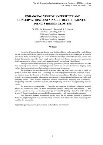
The development of Dieng Geopark is increasingly directed toward becoming a strategic tourism area. Presidential Regulation No. 50 of 2011 on the National Tourism Development Master Plan (Ripparnas) designates Dieng and its surroundings as part of the National Strategic Tourism Area (KSPN) within the Borobudur–Yogyakarta–and surrounding areas National Tourism Destination (DPN). This directive is further translated into aligned provincial and district-level policies prioritizing tourism zones.
At the district level, Wonosobo District Regulation No. 8 of 2017 establishes the Dieng Sub-Regional Tourism Area (DPK Dieng) as a priority zone, focusing on nature-based, agro-, heritage, educational, and special interest tourism. It includes Kejajar, Garung, Watumalang, and parts of Mojotengah sub-districts. Within DPK Dieng, two Priority Tourism Development Areas (KSPK) are designated: Kejajar–Garung and part of Mojotengah–Watumalang. Local regulations are key to translating national tourism goals into effective management, reinforcing Dieng’s role as a tourism growth hub and increasing the need to anticipate impacts on trade and services.
Stronger regulations on spatial use and zoning are essential. Spatial planning should be guided by the Regional Spatial Plan (RTRW) and the more detailed Detailed Spatial Plan (RDTR) to ensure sustainable land use (Misbach & Aman, 2023). Furthermore, the Dieng Plateau’s disaster vulnerability must be addressed. The Dieng Geopark Master Plan outlines policies supporting geopark development, emphasizing the role of the Geopark Management Agency, collaboration with academic institutions, and community engagement, critical to fostering long-term sustainability and resilience (Widiastuti & Risandewi, 2020).
2.3. Benchmark Study
Benchmarking was conducted to ensure that the quality of the design and development plan on the geosites meets international standards comparable to those of renowned geosites worldwide.
2.3.1 Rinjani National Park - Lombok, West Nusa Tenggara, Indonesia
With an area spanning 413.3 km² and situated at 3726 m above sea level, Rinjani National Park offers a range of amenities, including signage, information boards, public toilets, resting shelters along hiking routes, camping sites, and water facilities throughout the hiking routes. Facilities such as base camps, prayer rooms, and a parking center are also provided on the mountain base, near the entrance to the hiking routes. Base camps are fully supplied with the necessary amenities for hiking. Activities may vary depending on the routes taken to hike the mountain, with some offering lake views (Danau Sagara Anak), waterfalls (Sandang Gila, Tilu Kelep), gentle trekking, and even access to hot springs.
Despite all the amenities, the national park manages to conserve a variety of biota through minimal intervention during the development of the minor infrastructures. Additionally, to boost the local economy, locals near Mount Rinjani offer their homes as homestays for hikers (rinjaninationalpark.id, 2023).
2.3.2 Ijen Crater - Ijen Geopark, East Java, Indonesia
World-renowned for its Blue Fire phenomenon, the geopark's facilities feature amenities such as information boards, signage, and hiking railings along the routes leading to the crater. The railings are designed to keep tourists safe and prevent them from trespassing, thereby avoiding disruptions to the traditional sulfuric stone mining activities of the locals. Sometimes on hiking routes, the locals would offer trishaw services for tourists to ascend or descend the crater. At the base of the mountain, the geopark provides public bathrooms, prayer rooms, parking, and camping sites. The geopark not only offers hiking towards the crater but also other activities, such as sunrise observation, Ijen Crater Milky Way observation, coffee plantation observation, and crossing bridges above rivers at the base camp.
To protect the natural characteristic and tourists, the park management regulated the site to limit daily visitors to only less than a thousand (1000) hikers, closing the point of interest on Fridays of the first week of the month for nature’s recovery time (Ijen Rijik), and mandating tourists to use respiratory mask to avoid poisoning (geopark-ijen.jatimprov.go.id, 2023)
2.3.3 Daisen Oki National Park - Daisen Mountain, Tottori, Japan
Located at 1,729 meters above sea level, Daisen Mountain offers beginner-friendly trekking routes, providing facilities such as wooden trail paths to ease the summit-reach experience, shelter huts, resting benches, information boards, signage, and a toilet along the hiking routes. On the foothills, the park offers parking facilities and camping sites. Most of the materials used for the facilities were sourced from local areas near the mountain, aiming to minimize carbon footprints and waste.
Daisen Oki was once believed to be a sacred mountain, but it faced environmental degradation due to the increasing number of hikers. Therefore, as an effort to recover the environment, the Daisen Mountain Conservation group pitched a “One Tree, One Stone” Project in 1985. This project instructs hikers to bring one non-disruptive tree or plant seed and one stone to help the mountain’s recovery (Ministry of the Environment, Government of Japan, 2023).
2.3.4 Kinabalu National Park - Kinabalu Mountain, Malaysia
The UNESCO-accredited national park offers top-notch facilities for hikers to enjoy an exciting yet comfortable hiking experience, complete with resting pit stops, sleeping accommodations every 1 km of the hiking routes, information boards, signage, toilets, wooden trail paths, shelter huts, water refill stations, and resting benches. On the foothills, facilities such as an information center, a parking area, and lockers are provided for hikers.
Trailing as far as 4095 km to reach the summit, hikers are programmed to hike for 2 days and one night. In addition to a far more exciting experience, the national parks offer a variety of activities during the hike based on the route, such as rock climbing via ferrata and crossing a suspension bridge at extreme heights (sabahparks.org.my, 2023).
In summary, there are four significant points that contribute to offering good quality geotourism, as outlined by the benchmarks. The first point is to provide decent supporting infrastructure and facilities. The second is to program the development of the infrastructures and facilities that are non-disruptive to the natural landscape. The third is to offer a variety of activities on the geosite. The last one is to develop a program or a plan to ensure the sustainability of the environment and the safety of the visitors.
3. RESEARCH METHODS
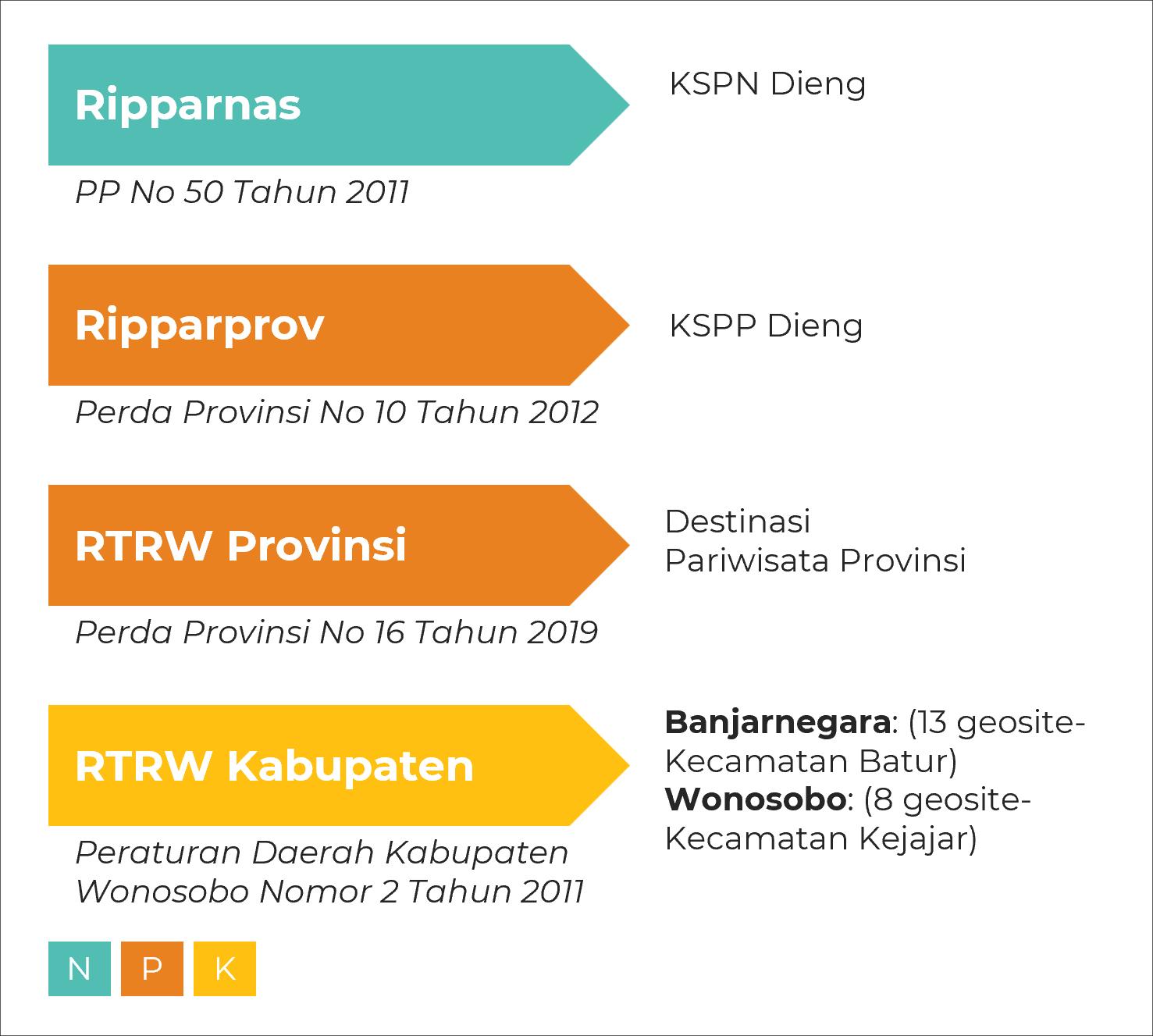
The design framework for the selected geosites primarily employed a qualitative methodological approach, structured around an iterative design development process. This qualitative, iterative design approach served as the central methodological framework for generating strategic and context-sensitive design interventions for the geosites. This process involved comprehensive field surveys, direct observations, spatial and non-spatial analyses, as well as SWOT analysis. This process also emphasizes data triangulation, combining primary and secondary data with feedback from relevant stakeholders through discussion forums.
Primary data were collected through in-depth interviews with key stakeholder groups, including local government officials, community leaders, and tourism actors. The inclusion of diverse local perspectives was essential to capturing contextual information. Field assessments evaluated the condition of amenities, infrastructure, accessibility, and development potential, complemented by tools such as GPS for geospatial
mapping and digital documentation. Additional resources included printed topographic maps, regional spatial plans, and thematic GIS layers. Secondary data supported the analysis through a combination of spatial assessments (accessibility mapping, disaster risk, land suitability, ecological capacity, visitor thresholds and spatial structure) and non-spatial profiling (assessments of the site’s history, economic potential and site character). A complementary desk study was conducted to review relevant literature, perform benchmarking comparisons, and ensure regulatory compliance.
The entire analytical process employed triangulation to enhance data validity and reliability by cross-verifying multiple sources and methods. Insights generated from these analyses informed the development of an initial design concept, which was subsequently refined through iterative cycles incorporating ongoing site assessments and stakeholder feedback in the Focus Group Discussion (FGD) forum. This adaptive and inclusive process ensured the resulting geosite design interventions were responsive to local dynamics, development goals, and conservation imperatives. Ultimately, the geosite designs were actualized in the vision, concept, design principles and infrastructure design guidelines.
1. Methodological Framework
Source : Team Formulation, 2023
4. RESULTS AND DISCUSSION
4.1. Findings
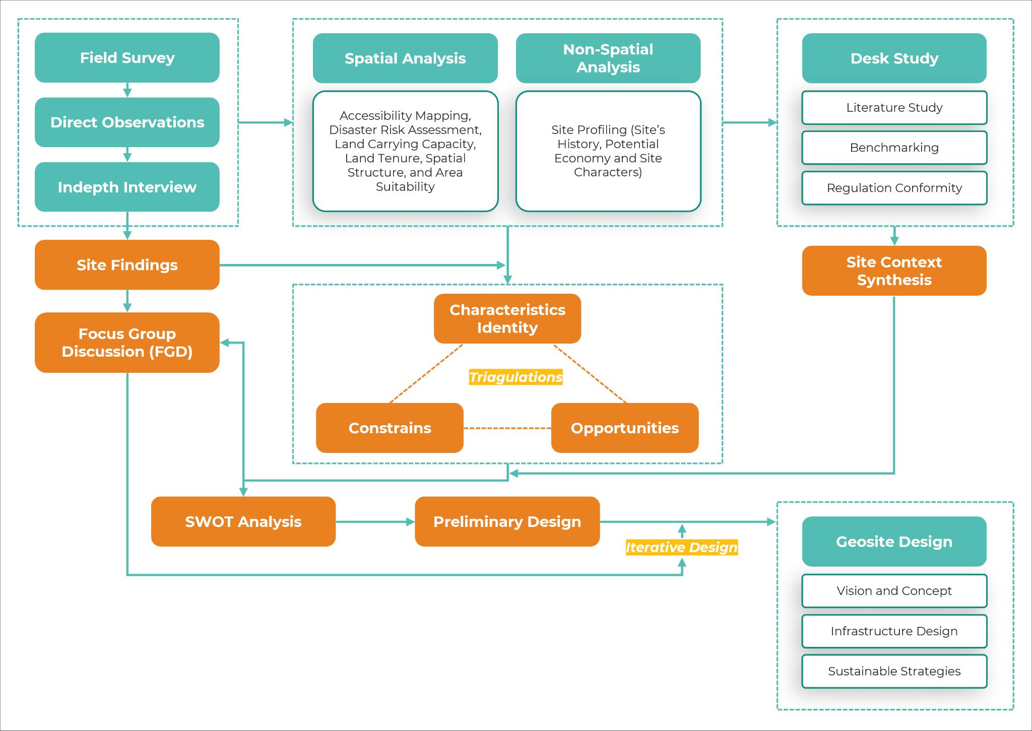
The Dieng Geopark, shaped by volcanic activity since the Pleistocene, holds significant geological and ecological value, with high biodiversity, including 59 flora and 164 fauna species like Carica and Volvariella volvacea, supported by annual rainfall of 3,000–4,000 mm. Recognized by UNESCO in 1964–1965 for its geothermal potential, the area also faces serious natural hazards such as landslides, CO₂ emissions, and phreatic eruptions, including the deadly 1979 Sinila-Timbang event that killed 149 people (Priatna, 2014). The 7.27hectare Pakuwaja geosite lies in a high-risk zone (KRB III) due to mud eruptions and base surges (PVMBG, 2023). Consequently, tourism development must account for environmental risks through spatial regulation and infrastructure planning. Zoning divides the area into five categories, with only horticultural zones suitable for cultivation, and development is constrained by rules such as a 60% Building Coverage Ratio (KDB) and restrictions on cut-and-fill activities.
GIS-based analysis (ArcGIS) identifies three main zones (image a): potential (731.85 ha), indicates that the zone can be considered safe for development based on its natural characteristics, constraint (731.66 ha), remains developable, though several limitations need to be carefully considered, and limitation (99.65 ha) which designated as a no-development zone due to significant constraints. The three zones serve as the basis for evaluating development potential and tourism suitability using Physical Carrying Capacity (PCC) calculations (Pertiwi et al., 2021; Saputra Hasanuddin & Rahman, 2022; Saputra et al., 2020; Saut et al., 2024; Rimbunita Salusu et al., 2023).
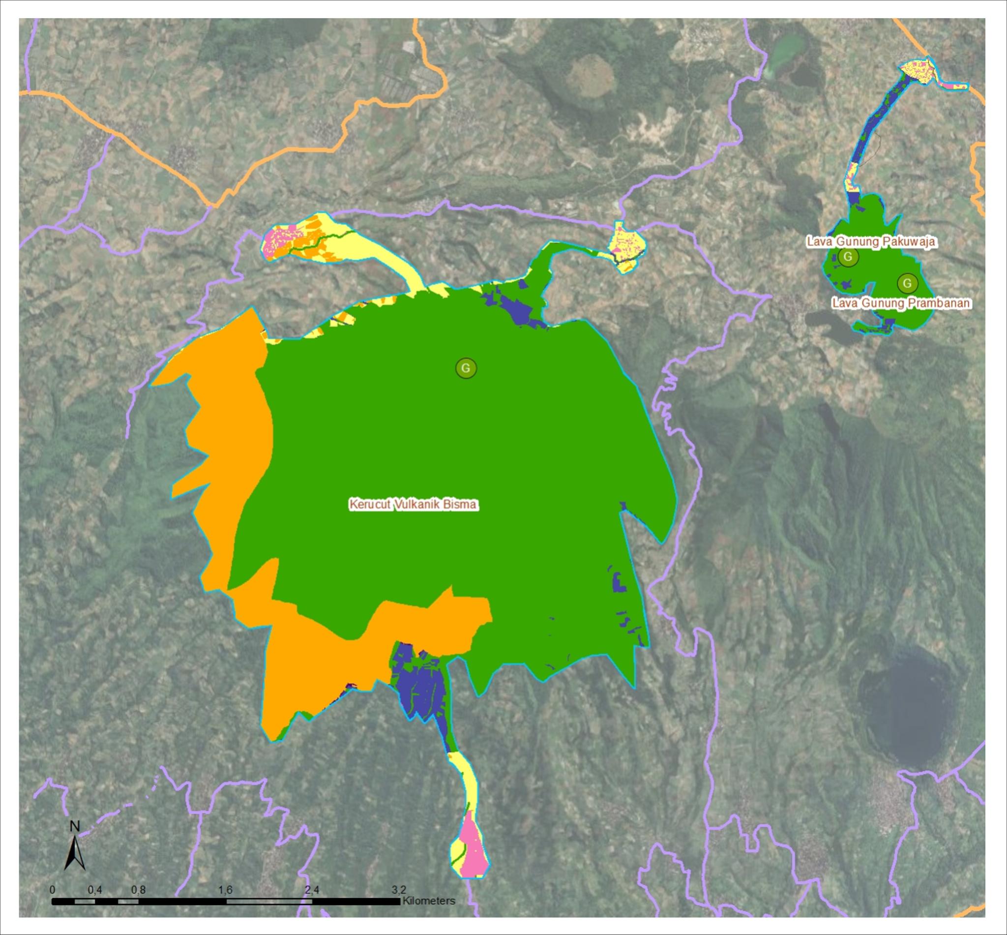
Figure 2. Overlay Map of Carrying Capacity and Spatial Plan
Source : Team Analysis, 2023
The Carrying Capacity Map presents a refined analysis based on land capability, classifying the area into limitation, constraint, and potential zones. Complementing this, the Overlay Map of Carrying Capacity and Spatial Plan illustrates the alignment between physical land capability and existing spatial planning regulations, highlighting areas of synergy and potential conflict.
Based on the Physical Carrying Capacity (PCC) analysis, the estimated monthly visitor capacities are: Bisma Volcanic Cone at 552 people/day (16,560/month), Mount Pakuwaja Lava Flow at 31 people/day (930/month), and Mount Prambanan Lava Flow at 15 people/day (450/month). These figures set a threshold for limiting visitors, especially as each geosite lies within protected, constraint zones.
Source: Team Analysis (2023)
However, assessing buildable areas requires more than physical data alone; it is also necessary to consider the legal status of land ownership (Sukriah & Dede, 2023). Therefore, a further overlay analysis was conducted, combining the carrying capacity and spatial plan maps with cadastral data obtained from the Ministry of Agrarian Affairs and Spatial Planning/National Land Agency (ATR/BPN). The results produced a classification of land suitability, including areas that are fully buildable; areas buildable under certain legal conditions (such as land acquisition processes); areas that are conditionally buildable; privately owned land located within Limited Production Forests (HPT); privately owned land within protected zones; and areas entirely non-developable due to their status as conservation areas.
The final calculation indicates that approximately 18.94 hectares of land are classified as fully buildable. This means that, according to spatial planning regulations and legal land ownership, these areas can be managed directly by the local government. Strategically located near rural settlements and at the mountain foothills, these lands are suitable for supporting infrastructure such as parking areas, basecamps, or designated entry points to the mountain trail systems.
Beyond these areas, there are lands that remain potentially buildable but require specific legal or procedural conditions, such as being converted into private or waqf (endowment) ownership, before any formal development or management can occur. In contrast, other zones are designated as non-developable conservation areas, where preservation of the natural landscape must take precedence over cultivation or construction (Alfarizi et al., 2020).
In addition to carrying capacity assessments, a Basic Infrastructure Analysis was conducted. This included the evaluation of essential visitor amenities: worship facilities, toilets, parking spaces, waste disposal systems, and directional or informational signage. Using national planning and facility standards, such as Regulation of the Ministry of Tourism and Creative Economy No. 2/2020, Ministry of Public Works Regulation No. 14/PRT/M/2017 on Accessibility in Public Buildings, and SNI 33-1733-2004 on Urban Housing Environmental Planning, each of the three sites was assessed. The findings were consistent: none of the sites currently meet the required infrastructure standards. Of the three, the Bisma Volcanic Cone shows the most complete existing facilities, while Mount Pakuwaja Lava and Mount Prambanan Lava lack adequate basic infrastructure.
Table 2. Basic Infrastructure Analysis
Infrastructure Type Standard Requirement Existing Condition Assessment Regulatory Reference
Prayer Room Minimum 45 m² floor area and 100 m² land area within 100m radius
Bisma: Available only at basecamp
Pakuwaja: Not available
Prambanan: Available near Sikunir site
Not compliant
Public Toilet Minimum dimension 80 cm x 155 cm; separate access for safety
Parking Area Car: 250x500 cm; Motorcycle: 200x70 cm; Bus/Truck: 1250x340 cm. Provision based on area per 100 m²
Bisma: Limited to basecamp
Pakuwaja: Not available
Prambanan: Available near Sikunir site
Bisma: Limited in several basecamps, unsuitable for large vehicles
Pakuwaja: On multifunctional community field
Prambanan: Near Sikunir site only
Not compliant
Permenparekraf No. 2/2020; SNI 33-17332004
Waste Management Facility
Mobile cart: 2 m³; Small bin (TPS): 6 m³; Large bin (TPS): 12 m³. Min. clearance: 30m
Bisma: Only at basecamp, no clearance
Pakuwaja: Not available
Not compliant
Permenparekraf No. 2/2020; Permen PUPR No.14/PRT/M/2017
Not compliant
Permenparekraf No. 2/2020; Technical Guidelines from MoT (No.272/HK.105/DRJD/ 96)
Permenparekraf No. 2/2020; SNI 33-17332004
Information Board, Signage & Wayfinding
Visible color, size, font within line of sight, lit at night, inclusive (braille/audio)
Prambanan: Limited and no spacing standard
Bisma: Present at select basecamps
Pakuwaja: Limited signage
Prambanan: Not available, No inclusive features at any site Not compliant
Source: Team Analysis (2023)
Permenparekraf No. 2/2020; Permen PUPR No.14/PRT/M/2017
In conclusion, the Bisma Volcanic Cone, Mount Pakuwaja Lava Flow, and Mount Prambanan Lava Flow each possess exceptional geological value and strong potential for educational and recreational geotourism. However, current conditions reveal that these sites lack adequate infrastructure and basic hiking facilities in accordance with national tourism and conservation standards. To fully harness their potential and ensure safe, sustainable visitor experiences, it is imperative that supporting infrastructure, such as access trails, safety signage, rest areas, and interpretation points, be developed and upgraded. Such improvements will not only elevate the quality of tourism but also reinforce the sites’ roles in education, conservation, and local economic development
4.2. SWOT Analysis
A SWOT analysis is conducted to investigate in greater depth the strengths, weaknesses, opportunities, and threats of each geosite. This analytical framework enables a comprehensive understanding of both the internal attributes and external factors influencing each site. The insights derived from the SWOT analysis are then used as the foundation for formulating context-specific design strategies. These strategies are intended not only to leverage the site's strengths and available opportunities but also to address existing weaknesses and anticipate potential threats, ensuring that the proposed interventions are responsive, sustainable, and place-sensitive.
Table 3. SWOT Analysis for Each Geosite
Geosite Pros (Strength and Opportunity)
Bisma Situated in the already wellknown Dieng Highlands; Transportation availability to the Dieng highlands via the Mendolo terminal, with adequate road access for vehicles.
Numerous alternative hiking routes with nearby natural tourist attractions are available in its surroundings.
Larger tourist capacity, with 552 people per day, could be potentially beneficial for larger
Cons (Weakness and Threat) Design Strategies
Lack of basic infrastructure and facilities to support the hiking activities (no toilets, lackluster basecamps, minimal information, signage, etc).
There is no water source for activities on the mountain.
Risk of environmental degradation due to infrastructure developments and tourism enhancement.
Threat of toxic gas on the Sikunang route.
As the largest geosite out of three, the design strategies focus on completing infrastructures and facilities for hiking activities (includes signage) - while also increasing the local community involvement for development and management, clearing entrance gate with contextual design, establish recovery program with periodical closing and mountain cleaning, and protect the conservation zone with minimal intervention with the nature.
festivities, such as the Dieng Festival Run. Porters available.
Pakuwaja Situated in the already wellknown Dieng Highlands.
Transportation availability to the Dieng highlands via the Mendolo terminal, and adequate road access for vehicles.
The daily visitor capacity is at 31 people per day.
Inclusive tourism is due to the availability of porters. Unique landscapes and characteristics are used for observation and research.
Prambanan Situated in the already wellknown Dieng Highlands.
Transportation availability to the Dieng highlands via the Mendolo terminal, along with adequate road access for vehicles.
The daily visitor capacity is at 15 people per day.
Unique landscapes and characteristics are used for observation and research.
The ongoing development of the neighboring tourist attraction, Sikunir Hill, can have a positive impact on the mountain through infrastructure upgrades.
Lack of physical base camps and supporting facilities, such as toilets, parking areas, and prayer rooms. The current base camp is located far from the starting point of the hiking route..
Lack of information near the tracking route.
Located near the fertilizer industry
Some of the areas are inside the toxic gas site zone.
Potentially degrading the environmental quality due to tourism activities.
The design strategy focuses on providing essential infrastructure and facilities for hikers, such as a base camp. It also emphasizes the importance of educational and informative signage, particularly in areas near toxic gas zones, ensuring that these features are accessible and inclusive. The infrastructure will be integrated with the neighboring Sikunir site. Additionally, the development process must involve the local community to ensure effective management and community engagement. A recovery program will be established that includes periodic closures and mountain clean-up initiatives to protect the conservation zone with minimal intervention in the natural environment.
The unavailability of public hiking routes.
Lack of information, including supporting infrastructures for hikers (toilets, base camps, parking area, signage, etc).
Some areas are inside the toxic gas site zone.
Potentially degrading the environmental quality due to tourism activities.
Source: Team Analysis, 2023
The design strategies focus on conserving Mount Prambanan as a conservation and research site, while also providing basic infrastructure and facilities for visitors, such as a base camp. The infrastructure design is contextualized with educational and informative signage and integrated with the neighboring Sikunir site.
The development must also involve the local community to ensure its effective management and implementation. A recovery program will be established that includes periodic closures and mountain clean-up initiatives to protect the conservation zone with minimal intervention in the natural environment.
In summary, most of the geosites are easily accessible by an adequate transportation mode, featuring decent road access and unique landscapes. However, a significant drawback of these geosites is the lack of basic infrastructure to support tourism activities. Additionally, the goal to upgrade geotourism quality comes with a
prediction and consideration of increased activities and visitors to the sites, potentially exceeding the carrying capacity, which could lead to adverse environmental impacts. Therefore, the design strategies aim to bridge the gap by providing infrastructure with a focus on sustainability, while also actively engaging the local community.
4.3. Vision and Concept
To improve the quality of geotourism, it is essential to establish a clear and well-articulated development vision informed by the preceding analyses. Accordingly, the overarching vision for the three geosites is defined as: “Creating enjoyable and well-maintained hiking experiences”. This vision serves as a guiding framework for future interventions and is supported by three strategic missions: upgrading the overall infrastructure and user experience, preserving the integrity of natural and landscape features, and optimizing the use of local materials and indigenous knowledge. Furthermore, to highlight the distinct character of each geosite, tailored visions, conceptual frameworks, and design principles have been formulated, as outlined in the following section:
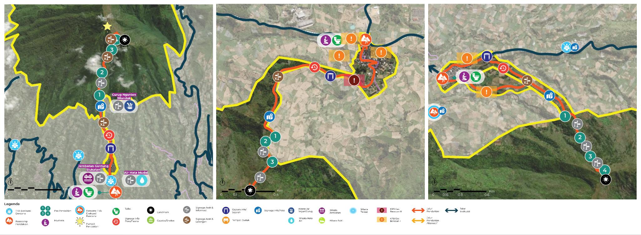
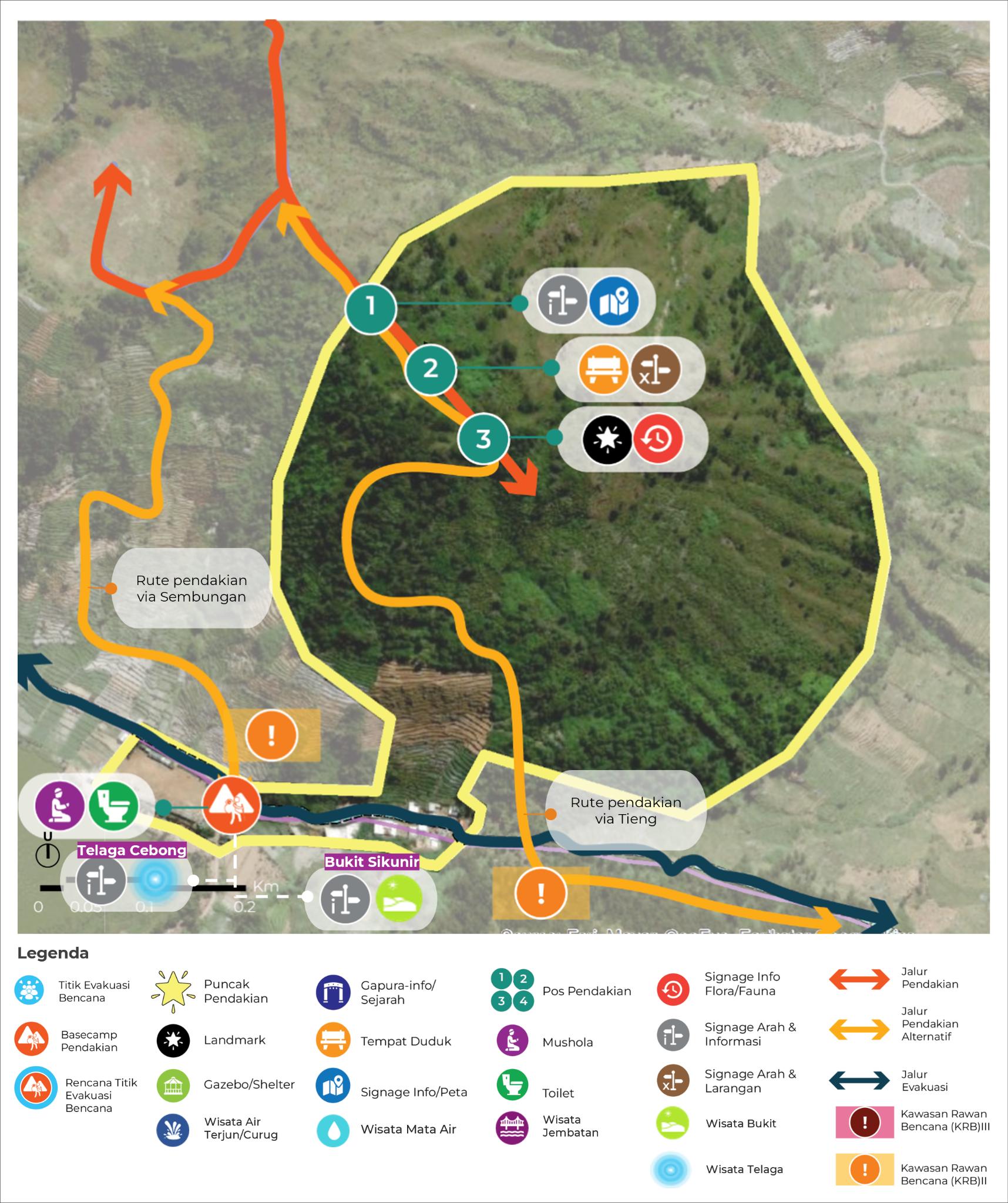
The vision for Mt. Bisma is “An Adventure to 1001 Summits”. As the mountain already has several hiking routes and summits, each route offers a unique hiking experience, ranging from landscapes to breathtaking views. The concept and design principles for mt. Bisma is to establish an impressive hiking route that offers a challenge with slopes nearing 90 degrees, complete with beautiful landscapes, and integrates the surrounding natural water attractions with the mountain.
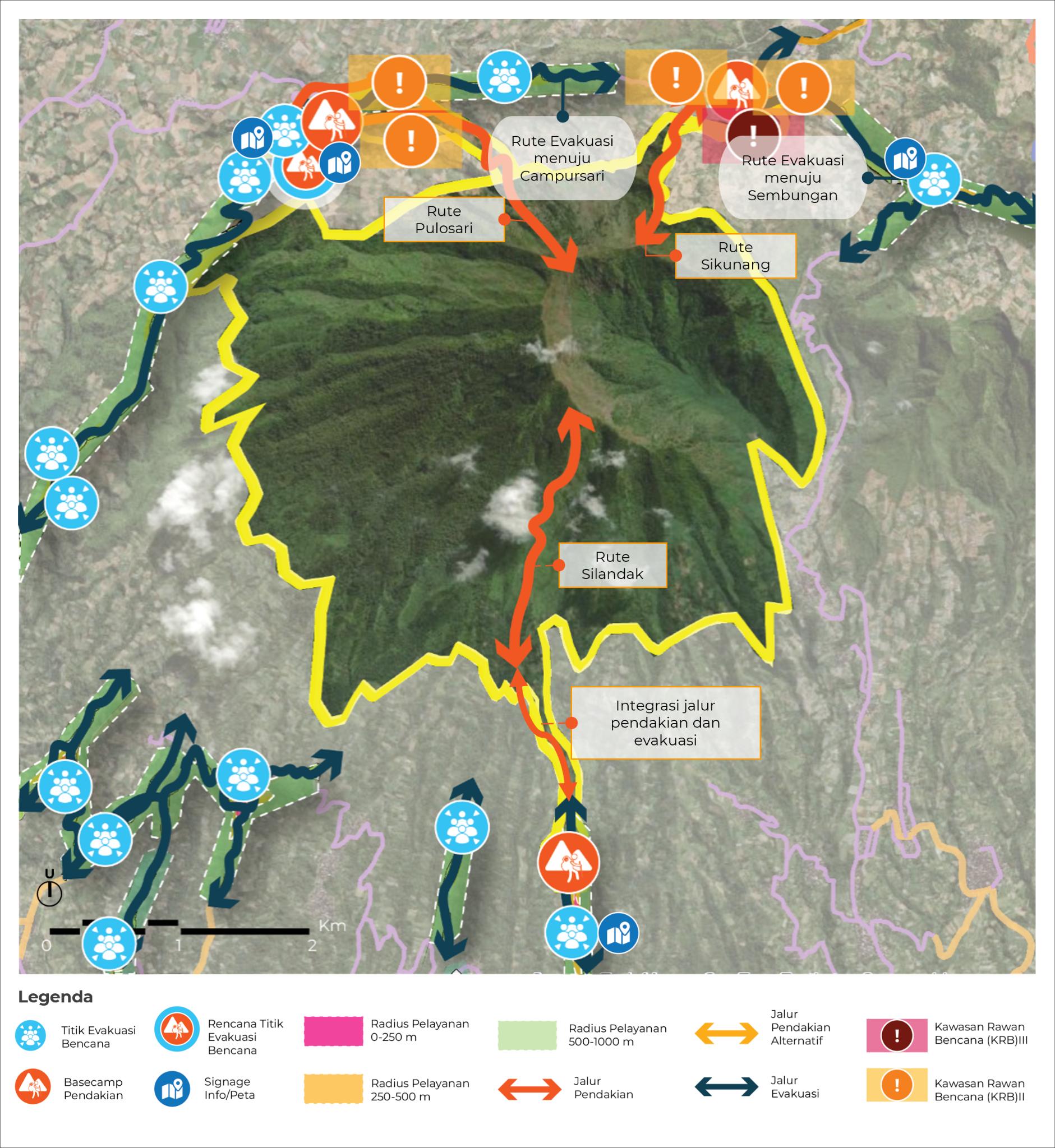
Figure 5. Mitigation Plan of Mountain Bisma
Source : Team Analysis and Design, 2023
Each route is equipped with tailored facilities and complemented by base camps, designed to match its natural characteristics and the needs of its users. In total, there are four hiking posts, of which the last one is located near two summits. The routes are also marked with signage to inform hikers and visitors about the nearby natural attractions along the hiking route.
Additionally, to ensure the safety of visitors, hiking routes are ideally located within a 250-1000 m radius of the evacuation route. The Sikunang hiking route is connected to the evacuation route. However, the route is outside the minimum radius for the disaster evacuation point (DEP); therefore, there is a need to establish a new DEP, ideally near the base camp for a larger and more accessible space. For the Pulosari route, the evacuation route is connected to the hiking route and remains within the service radius of the Department of Emergency Preparedness (DEP). Lastly, for the Silandak route, the hiking route is quite distant from the evacuation route; however, the base camp is located inside the DEP service radius.
4.3.2 Mountain Pakuwaja
The vision for Mt. Pakuwaja is “A short hike to rest on a savannah above the clouds”. The relatively shorter hiking route, Mount Pakuwaja, offers a rich hiking experience. Hikers can witness and experience the savannah, craters, and even the neighboring Mount Prambanan views throughout the journey. The concept and design principles for mt. Pakuwaja is creating an enjoyable and impressive hiking experience through main attractions: iconic giant rock, savannah, crater (observation only), and green fields, establishes a safe hiking route away from the craters, and integrates hiking routes with neighbouring Mount Prambanan.

6. Site Plan of Mountain Pakuwaja Source : Team Analysis and Design, 2023
Each route is equipped with tailored facilities and complemented by base camps, designed to match its natural characteristics and the needs of its users. In total, there are three hiking posts, one of which is integrated with the neighboring Prambanan geosite from the previous post.
Additionally, to ensure the safety of visitors, the hiking route should ideally be connected and located within a 250-1000 m radius of the evacuation route.
4.3.3 Mountain Prambanan
The vision for Mt. Prambanan is “The experience of unveiling two sides of a hill”. Mount Prambanan offers two hiking routes, each providing a distinctive experience. The north hiking route offers a hiking experience through the neighboring mountain, Mount Pakuwaja. On the other side, the south hiking route offers observational and sightseeing activities near Sikunir Hill and Cebong Lake. The concept and design principles for mt. Prambanan integrates the north part of the mountain with the Pakuwaja mountain for hiking and research activities, and optimizes the south part of the mountain for observation and research activities, integrating it with its surrounding natural attractions.
8. Site Plan of Mountain Prambanan
Source : Team Analysis and Design, 2023
In total, there are three hiking routes: via integration of Pakuwaja-Prambanan, via Sembungan, and Tieng. At the integration route, facilities are provided in accordance with their natural characteristics. For posts, there are three hiking posts in the last post, which are near the summit. Provided with signage to inform hikers or visitors to the surrounding/nearby natural attractions alongside the hiking route.
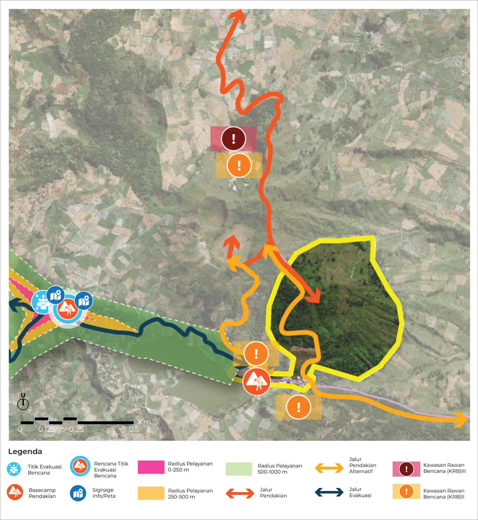
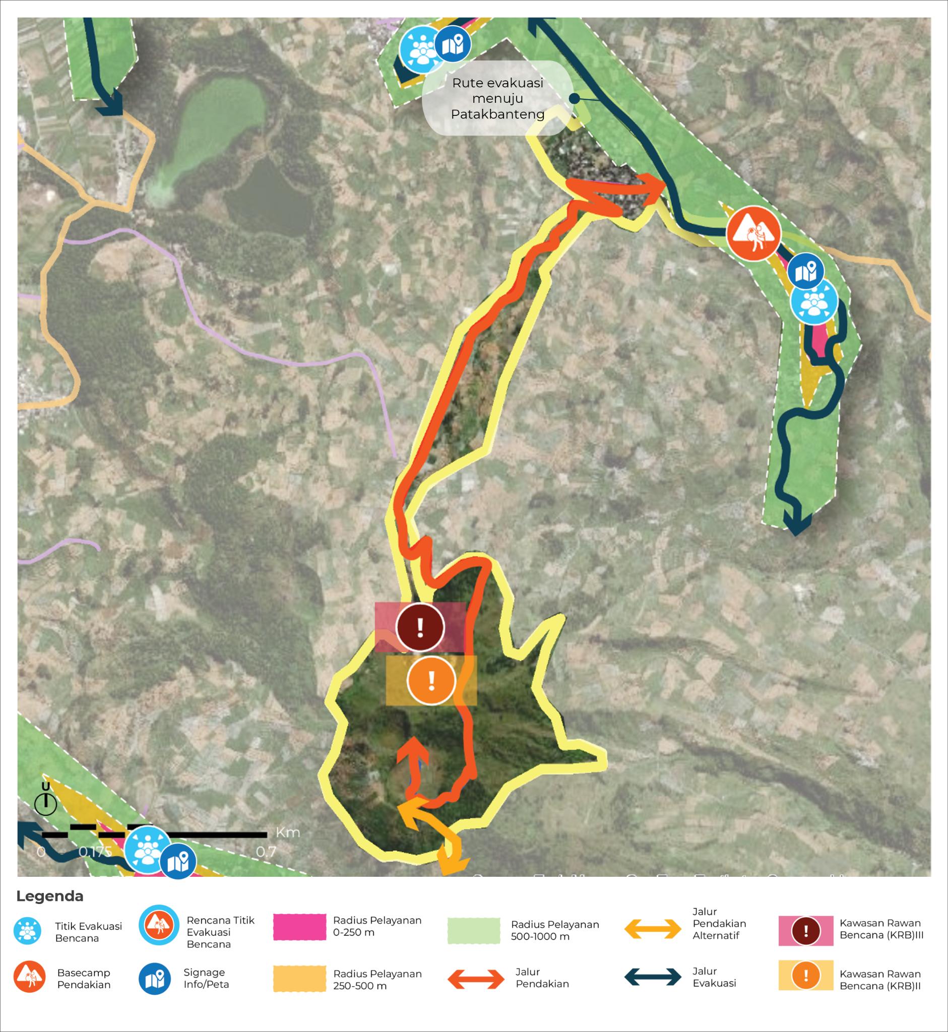
Figure 8. Mitigation Plan of Mountain Prambanan
Source : Team Analysis and Design, 2023
Additionally, to ensure the safety of visitors, the hiking route should ideally be connected and located within a 250-1000 m radius of the evacuation route. The evacuation route in Mt. Prambanan is connected to the hiking route through the integrated Mt. Pakuwaja-Prambanan hiking route. The observation route is also connected with the evacuation route (near Cebong Lake and Sikunir Hill). The Basecamp is located within a 1,000 m radius of the DEP service.
In summary, to further support the concept pillars of the geosites, all geosites are ensured to provide rich information and context about each site, infusing local culture and context into the design of the tourism experience, not only to support and enhance the quality of geotourism activities, all through the provision of the basic infrastructure and facilities. Below, the details of each infrastructure and facility are provided:
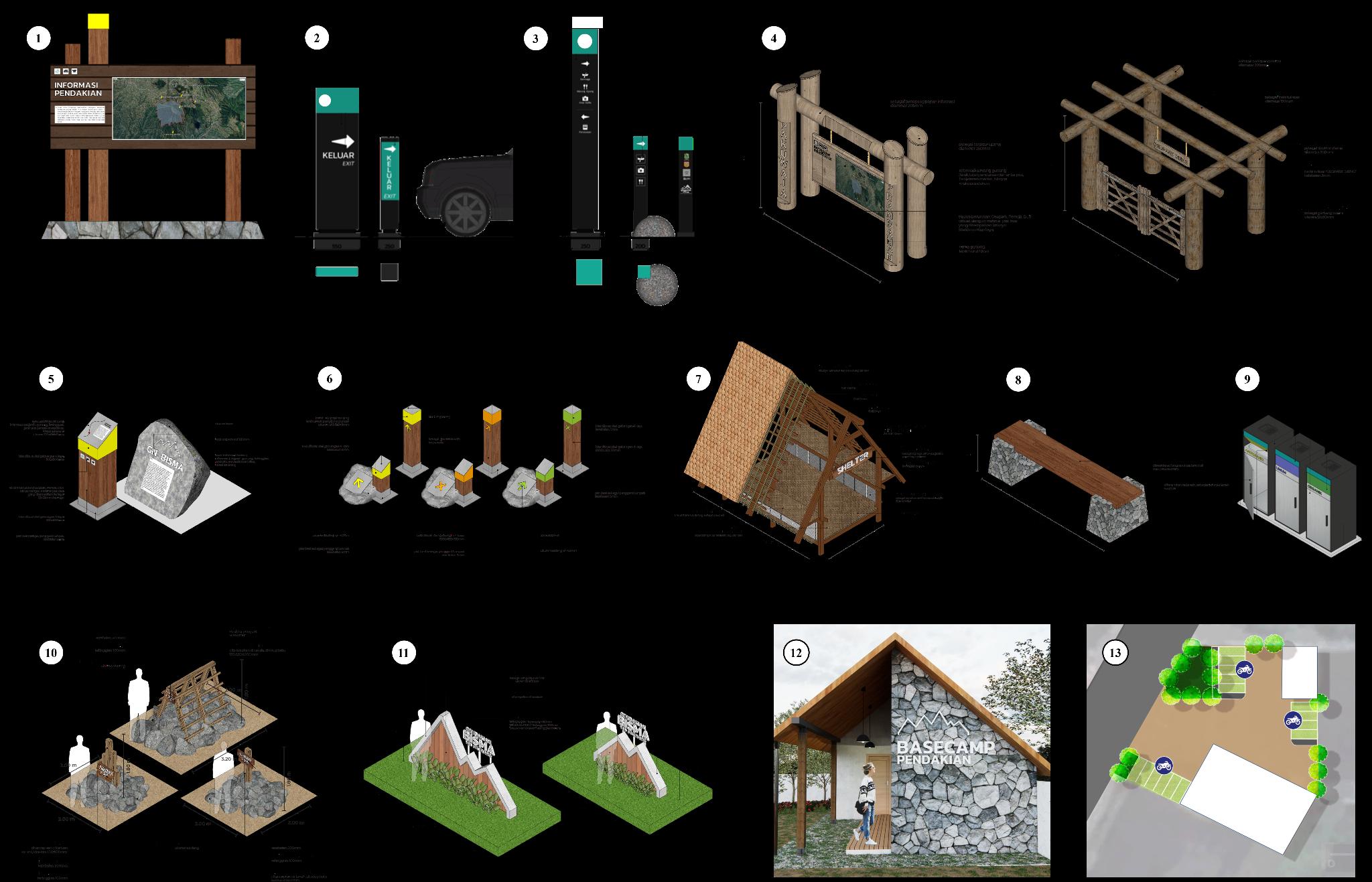
Figure 8. Basic Infrastructure Design
Source : Team Analysis and Design, 2023
Table 4. Recommendation of Basic Infrastructure Plan
No Infrastructure Function Principles
1 Basecamp Information Board
2 Basecamp Signage for Vehicles
3 Basecamp Signage for Humans
4 History Information
Informing the basic context of each site (history, area scope, educational information, evacuation route, route map)
Way-finding and context clues purposes
Way-finding and context clues purposes
Way-finding and context clues for purposes, enriched
The information boards at base camps combine natural aesthetics with sustainable materials, such as locally sourced acacia wood, for added durability. The design features a modern metal plate accent, and a stone platform serves as a sturdy foundation, blending seamlessly with the environment.
The signage is tailored according to the Dieng Geopark Grand Design. Designed to have high visibility, located near vehicle access or parking areas.
The signage is tailored according to the Dieng Geopark Grand Design. Designed to have high inclusivity and accessibility, while located near pedestrian roads.
The structure is situated near the hiking entrance and serves as the main sign indicating the start of the
Board / Entrance Arch with educational information, before the hike
5 Hiking Route SignageInformation Way-finding and context clues, enriched with educational information during the hike
hike for visitors and hikers. It should be constructed from acacia wood due to its durability and sustainable sourcing. Additionally, metal plates will be incorporated as accents, with text printed on them in bright colors to enhance readability both during the day and at night.
The infrastructure focuses on convenience and functionality. Materials used should be acacia wood for its close sourcing, and metal plates with bright colors should be used to increase visibility for hikers. In an alternate version, the signage can use stone as its base material, with metal plates added to display text. This signage shall provide information regarding the history, elevation, and position of hikers within the mountain.
6 Hiking RouteWayfinding Way-finding and context clues for a hike
7 Gazebo Shelter from extreme weather and a resting area
The infrastructure prioritizes convenience and functionality, utilizing acacia wood for sourcing and bright-colored metal plates for enhanced visibility. An alternative design incorporates stone platforms for a natural look. A 25-degree angle on the metal plates enhances readability based on terrain, with each color conveying different meanings.
Gazebo is designed with high accessibility, functionality, and sustainability sourcing in mind. The materials include acacia wood and clay for rooftops. The vast space inside the structure can also be used to keep hikers' items or equipment, and allows hikers to stand inside it.
8 Resting Seat Resting purposes
The sitting platform is supported by a stone foundation on its ends. The cushion for the seat is made of acacia wood, which is sourced sustainably and boasts sturdy characteristics. It is designed for hikers to rest, while also incorporating a blend of aesthetic elements into its surroundings.
9 Trash Can Waste collection and separation pre- and post-hike
The trash can is designed to have a sterile and minimalist design, while also contrasting in sight to ease its visibility for the public.
10 Summit Landmark Serves as a monumental spot for hikers
Constructed from acacia wood and stone, each geosite features significant landmarks. Mt. Bisma mimics a monumental building from Hastinapura, marking the end of the journey. Mt. Pakuwaja's design represents a large rock, symbolizing its name as the foundational peg of Wonosobo. Mt. Prambanan's design is simple, preserving the originality of the landscape.
11 Basecamp Photo Spot Serves as a monumental spot for visitors and hikers
Designed to be as wide as possible, using natural elements such as wood and plants mixed with concrete on its outer outlines. Ideally, the installation should be 2 meters in height or adjusted based on the available space.
12 Basecamp (Prayer rooms and Toilets)
Registration, information center, checkpoint, and education point for hikers
13 Parking Area Parking area for 4-wheeled or 2-wheeled vehicles
4.4. Sustainable Strategies
Completed with prayer rooms, a terrace, and toilets, the building's design is compact and aligned with natural aesthetics. Built with local materials and Acacia wood. The capacity for each base camp is matched to the space availability at each site route.
Designed with a paving block or porous pavement for better water flow. The capacity for each parking area is matched to the space availability at each site route.
Source: Team Elaboration, 2023
To enhance the sustainability of Dieng Geopark, five integrated strategies are proposed, focusing on ecological conservation, community engagement, and visitor management. Preserving the site's natural authenticity is essential to ensure long-term tourism viability and prevent environmental risks to nearby communities.
4.4.1. Preventing Environmental Degradation
Educational programs on waste awareness delivered through social media campaigns and on-site engagement play a critical role in fostering responsible tourism behavior among visitors. Complementing these efforts, seasonal pricing strategies and restrictions on new construction are implemented to manage visitor pressure and protect fragile landscapes from overuse and degradation. Furthermore, the promotion of a 'zerowaste mountain' initiative encourages hikers to minimize their environmental footprint through conscious behavior and sustainable practices. Collectively, these integrated measures contribute to preserving the ecological integrity and natural character of the geosites, while supporting their long-term viability as sustainable tourism destinations.
4.4.2. Implementing Effective Waste Management
Waste management should be structured across three key phases: pre-hike, during the hike, and post-hike. Each phase requires clear procedures supported by targeted education. All stakeholders both site managers and visitors must be properly informed and committed to complying with waste protocols throughout their activities. This integrated approach reinforces environmental responsibility, reduces pollution risks, and supports the overall quality of the visitor experience.
4.4.3. Managing Site Recovery
Periodic site closures are essential for natural recovery and long-term conservation. Ideally, these closures align with critical ecological cycles such as the breeding season of endemic fauna and periods of extreme weather (January–February) to minimize human disturbance and ensure safety. Additionally, recurring environmental campaigns like Sapu Jagat (mountain clean-up events) can reinforce a culture of care and shared responsibility among stakeholders. Building mutual collaboration between site managers, communities, and visitors is key to preserving the authenticity of geosites while supporting the development of high-quality, sustainable tourism.
4.4.4. Promoting Sustainable Planting
Sustainable agroforestry models offer dual benefits by supporting local livelihoods and contributing to environmental resilience. Specifically, they help stabilize soil structures, enhance biodiversity, and reduce disaster risks in erosion-prone and ecologically sensitive areas. As such, integrating agroforestry into geosite management presents a strategic approach to balancing conservation objectives with socio-economic development.
4.4.5. Conserving Local Biota
Protecting endemic species is vital to sustaining the ecological and tourism value of the geopark. Strategies include designating conservation zones, restoring habitats, and implementing seed banking and breeding programs to prevent extinction. These efforts must be reinforced with community education and clear on-site
signage to promote awareness and prevent destructive behavior. Together, they help preserve the area's biodiversity and natural character for future generations.
The proposed strategies for the development of Dieng Geopark are anticipated to generate multidimensional impacts encompassing environmental, economic, and social aspects. Environmentally, the prioritization of conservation and integrated landscape management supports the protection of geological heritage, biodiversity, and ecological functions. Economically, the enhancement of sustainable tourism infrastructure and services is expected to stimulate local economic growth through increased employment opportunities and diversified income sources. Socially, the incorporation of community participation, educational initiatives, and cultural heritage preservation fosters social cohesion, strengthens local identity, and improves public awareness regarding the value of natural and geological assets. Collectively, these impacts reinforce the geopark’s core mandates of conservation, education, and sustainable development.
5. CONCLUSION
The development of Dieng Geopark faces both practical and systemic challenges. Unregulated agricultural expansion in sensitive highlands has increased the risks of landslides, erosion, and habitat loss, undermining conservation goals. Local livelihoods particularly farming and informal tourism often conflict with environmental regulations, while mass tourism exerts growing pressure on poorly equipped geosites. Community engagement remains limited, with low awareness of geological and ecological values. Efforts to integrate conservation, education, and local development are fragmented, and the absence of standardized site management guidelines results in inconsistent implementation. These issues collectively hinder the geopark’s potential as a sustainable and inclusive territorial model.
These complexities were also reflected in the limitations of this study. A lack of micro-scale data on geosite use, ecological conditions, and community perceptions constrained the depth of analysis, rendering the findings indicative rather than conclusive. Addressing these gaps will require more extensive fieldwork, participatory approaches, and scenario-based planning. At the governance level, adaptive and inclusive strategies are essential to improve risk management, enhance community involvement, and ensure long-term sustainability.
The strategic development of Dieng Geopark presents a valuable opportunity to align natural heritage conservation with inclusive community development and sustainable tourism. By integrating geoconservation principles, participatory planning, and educational outreach, the proposed approaches aim to safeguard the geological and ecological uniqueness of the region while enhancing the socioeconomic well-being of its communities. The anticipated environmental, economic, and social impacts demonstrate the transformative potential of geopark-based development when guided by clear governance, intersectoral collaboration, and long-term vision. As such, the Dieng Geopark can serve not only as a model for sustainable territorial management but also as a catalyst for promoting awareness, resilience, and pride in local natural and cultural assets.
BIBLIOGRAPHY
Alfarizi, M.S., Suganda, B.R. & Barkah, M.N., 2020. Kesesuaian lahan dalam rangka pengembangan permukiman berdasarkan aspek geologi lingkungan daerah Hantara dan sekitarnya, Kecamatan Hantara, Kabupaten Kuningan, Provinsi Jawa Barat. Padjajaran Geoscience Journal, 4(4), pp.2597–4033.
Farsani, N.T., Coelho, C. & Costa, C., 2011. Geotourism and geoparks as novel strategies for socio-economic development in rural areas. International Journal of Tourism Research, 13(1), pp.68–81.
Ijen Geopark Management, 2023. Ijen Geopark Geosites. [online] Available at: https://geoparkijen.jatimprov.go.id/page-geosite.html [Accessed August 2023].
Kautsar, E., Dwina, M., Sobba, I., Pertiwi, N. & Agustine, T., 2020. Analysis of land capability unit for the development of tourism areas in Tabalong Regency. Ruang, 6(1), pp.19–27. Available at: http://ejournal2.undip.ac.id/index.php/ruang/
Kinabalu Geopark Management, 2023. Sabah Park : Kinabalu Park.[online] Available at: https://www.sabahparks.org.my/kinabalu-park [Accessed August 2023].
Kusumayudha, S.B., Sutikno, S., Widiyantoro, S. & Asikin, S., 2019. Geological heritage of the Dieng Plateau, Central Java, Indonesia: Potential geosites and geotourism development. Indonesian Journal on Geoscience, 6(1), pp.1–14.
Lestari, F. & Indrayati, I., 2022. Pengembangan kelembagaan dan pembiayaan geopark di Indonesia: Tantangan dan strategi. Journal of Regional and Rural Development Planning, 6(2), pp.102–122. Available at: https://doi.org/10.29244/jp2wd.2022.6.2.102-122
Lestari, T. & Indrayati, R., 2022. Tata kelola geopark dan partisipasi masyarakat dalam pengembangan geopark nasional di Indonesia. Jurnal Pengelolaan Sumberdaya Alam dan Lingkungan, 12(3), pp.387–398.
Ministry of Energy and Mineral Resources, 2025, Decree of the Ministry of Energy and Mineral Resources No. 172.K/GL.01 MEM.G/2025, https://jdih.esdm.go.id/dokumen/view?id=2578.
Ministry of The Environment of Japan, 2023. Daisen-Oki National Park. [online] Available at: https://www.env.go.jp/en/nature/nps/park/daisen/guide/view.html [Accessed August 2023].
Misbach, A. & Aman, M., 2023. Rencana tapak (siteplan) sebagai persyaratan mutlak penerbitan persetujuan bangunan gedung (PBG) di Kabupaten Tangerang (studi kasus: proses permohonan siteplan lapangan basket). Jurnal Ilmiah Universitas Batanghari Jambi, 23(3), p.2796. Available at: https://doi.org/10.33087/jiubj.v23i3.4058
Misbach, I.H. & Aman, M., 2023. Perencanaan ruang dan pengembangan kawasan wisata berkelanjutan: Studi kasus Dieng. Jurnal Tata Ruang, 19(1), pp.24–37.
Pertiwi, N., Dewanti, N. & Kadri, K., 2021. Analysis of the settlement carrying capacity in Manggar Baru SubDistrict, Balikpapan City, East Kalimantan. Ruang, 7(1), pp.9–21. Available at: http://ejournal2.undip.ac.id/index.php/ruang/
Priatna, D., 2014. Geopark Dieng: Potensi dan Strategi Pengembangannya sebagai Geowisata Berkelanjutan. Bandung: Pusat Penelitian dan Pengembangan Geologi, Badan Geologi, Kementerian ESDM.
PVMBG (Pusat Vulkanologi dan Mitigasi Bencana Geologi), 2023. Peta Kawasan Rawan Bencana Gunungapi Dieng. Bandung: Badan Geologi, Kementerian Energi dan Sumber Daya Mineral.
Rimbunita Salusu, F., Khairunnisa, A., Amalia, A., Anggi Zidany, N., Febriawan, T. & Furqan, A., 2023. Evaluasi kerangka konseptual daya dukung ekowisata (studi kasus: Taman Nasional Karkheh dengan Taman Nasional Indonesia). Jurnal Nasional Pariwisata, 13, ISSN: 1411–9862.
Rinjani National Park Management, 2023. [online] Available at: https://rinjaninationalpark.id/ [Accessed August 2023].
Saputra Hasanuddin, A. & Rahman, R., 2022. Analisis pengembangan kawasan Kota Baru Pattallasang. Emil Salim Rasyidi: Journal of Urban and Regional Spatial, 2(3), pp.230–241. Available at: https://ejournalfakultasteknikunibos.id/index.php/jups
Sari, D.N. & Nugroho, I., 2020. Analisis kebijakan pengelolaan geopark sebagai kawasan konservasi dan pariwisata berkelanjutan. Jurnal Ilmu Lingkungan, 18(2), pp.233–242.
Saut, T., Jocom, S.G. & Memah, M.Y., 2024. Analisis kemampuan lahan untuk pengembangan pemukiman di Kecamatan Kalawat Kabupaten Minahasa Utara.
Sukriah, E. & Dede, M., 2023. Kapitalisasi lahan dan pengembangan pariwisata.
UNESCO, 2021. Statutes of the International Geoscience and Geoparks Programme. Paris: UNESCO.
UNESCO, 2021. UNESCO Global Geoparks: Celebrating Earth Heritage, Sustaining Local Communities. [online] Available at: https://www.unesco.org/en/geoparks [Accessed 11 Jun. 2025].
Widiastuti, R. & Risandewi, A., 2020. Penguatan tata kelola geopark melalui kolaborasi multi pihak: Studi di Geopark Dieng, Jawa Tengah. Jurnal Pariwisata Berkelanjutan, 4(2), pp.91–105.
Zouros, N. & Martini, G., 2020. UNESCO Global Geoparks: A tool for geoconservation and sustainable development. Episodes, 43(4), pp.605–611.